Glebe Mid-Rise Development
64
Glebe Mid-Rise Development Preliminary Heritage Impact Assessment Planning Proposal Stage1 Prepared for NSW Land and Housing Corporation May 2020 – FINAL v2
Transcript of Glebe Mid-Rise Development
Glebe Mid-Rise Development
Preliminary Heritage Impact Assessment
Planning Proposal Stage1
Prepared for NSW Land and Housing Corporation
May 2020 – FINAL v2

Document information
Document control
Extent Heritage project no.:
#20190428
Client: NSW Land and Housing Corporation
Project: Preliminary Heritage Impact Assessment PP Stage 1
Site location:
17-31 Cowper Street (Lot 17, DP 244897)
2A-2D Wentworth Park Road (Lot 18, DP244897)
Heritage advisor(s): Gabrielle Harrington
Eleanor Banaag
Author(s): Gabrielle Harrington
Eleanor Banaag
Version Internal reviewer Date Review type
Draft 1.0 Eleanor Banaag 07/02/2020 QA Review
Draft 2.0 Eleanor Banaag 14/04/2020 HCA recommendations
Draft 3.0 Eleanor Banaag 24/04/2020 Updated proposal plans
FINAL Eleanor Banaag 29/04/2020 Client comments
FINAL v2 Eleanor Banaag 19/05/2020 Client comments
Extent Heritage Pty Ltd | Glebe Mid-Rise Development: Planning Proposal Stage1 i
Contents
1. Introduction .................................................................................................................. 1
1.1 Project Description ............................................................................................. 1
1.2 Approach and Methodology ............................................................................... 1
1.3 Limitations .......................................................................................................... 2
1.4 Authorship .......................................................................................................... 2
1.5 Ownership .......................................................................................................... 2
1.6 Terminology ....................................................................................................... 2
2. Site Location ................................................................................................................ 3
3. Heritage Listings and Controls ..................................................................................... 6
3.1 Heritage Status .................................................................................................. 6
3.2 Heritage Items in the Vicinity .............................................................................. 6
4. Historical Context ......................................................................................................... 8
5. Physical Description .................................................................................................. 16
5.1 17-31 Cowper Street ........................................................................................ 16
5.2 2A-2D Wentworth Park Road ........................................................................... 18
5.3 Views and Settings .......................................................................................... 20
6. Heritage Significance ................................................................................................. 22
6.1 LAHC Heritage and Conservation Register ...................................................... 22
6.2 St Phillips Conservation Area ........................................................................... 22
6.3 Gradings of Significance .................................................................................. 23
7. Proposal .................................................................................................................... 25
8. Preliminary Assessment of Heritage Impact ............................................................... 43
8.1 Built Heritage ................................................................................................... 43
8.2 Curtilage and Subdivision ................................................................................ 45
8.3 Views and Settings .......................................................................................... 45
8.4 Heritage Items in the Vicinity ............................................................................ 45
8.5 Historical Archaeological Potential ................................................................... 46
8.6 Aboriginal Archaeological Potential .................................................................. 46
9. Statutory Controls ...................................................................................................... 47
9.1 Heritage Act 1977 ............................................................................................ 47
9.2 Environmental Planning and Assessment Act 1979 ......................................... 51
9.3 State Environmental Planning Policy (Affordable Rental Housing) 2009 .......... 51
9.4 City of Sydney Local Environmental Plan 2012 ................................................ 52

Extent Heritage Pty Ltd | Glebe Mid-Rise Development: Planning Proposal Stage1 ii
9.5 Sydney Development Control Plan 2012 .......................................................... 52
10. Conclusion and Recommendations ........................................................................... 57
10.1 Conclusion .................................................................................................... 57
10.2 Recommendations ........................................................................................ 58
11. References ................................................................................................................ 60
Extent Heritage Pty Ltd | Glebe Mid-Rise Development: Planning Proposal Stage1 1
1. Introduction
1.1 Project Description
Extent Heritage Pty Ltd (Extent Heritage) has been commissioned by NSW Land and Housing
Corporation (LAHC) to prepare a Preliminary Heritage Impact Statement for Stage 1 - Planning
Proposal for 17-31 Cowper Street and 2A-2D Wentworth Park Road, Glebe.
The purpose of the report is to analyse this Planning Proposal to rezone 17-31 Cowper Street
and 2A-2D Wentworth Park Road, Glebe and assess the preliminary impacts to the site. It will
also discuss the opportunities and constraints with regards to the site’s specific context as a
semi-developed inner Sydney block within a conservation area and containing several listed
items on a State Agency Heritage and Conservation Register.
1.2 Approach and Methodology
The methodology used in the preparation of this report is in accordance with the principles and
definitions as set out in the guidelines to The Burra Charter: The Australia ICOMOS Charter for
Places of Cultural Significance (the Burra Charter) (Australia ICOMOS 2013). This Preliminary
Heritage Impact Statement will also review the relevant statutory heritage controls.
In this assessment, the degree of the potential impacts on the site’s heritage significance is
modelled on ICOMOS’s Guidance on Heritage Impact Assessments for Cultural Work Heritage
Properties (2011). This document supports the evaluation of developmental impacts on the
outstanding universal value (OUV) of World Heritage properties, but its definitions and
evaluation matrix can be applied when assessing the values of any significant heritage place.
The definitions used in this assessment to grade the impacts are modelled on those provided
in Appendix 3B of the ICOMOS guidelines (see Table 1), which provides an ‘example guide’ for
assessing the magnitude of impact to built heritage and historical urban landscapes.
Table 1. Impact gradings (Source: ICOMOS 2011: 16).
Impact grading Built heritage or historical urban landscape attributes
Major Change to key historic building elements that contribute to OUV, such that the resource is totally altered. Comprehensive changes to the setting.
Moderate Changes to many key historic building elements, such that the resource is significantly modified. Changes to the setting of an historic building, such that it is significantly modified.
Minor Change to key historic building elements, such that the asset is slightly different. Change to setting of an historic building, such that it is noticeably changed.
Negligible Slight changes to historic building elements or setting that hardly affect it.
No Change/No Impact No change to fabric or setting.

Extent Heritage Pty Ltd | Glebe Mid-Rise Development: Planning Proposal Stage1 2
1.3 Limitations
The site was inspected and photographed by Extent Heritage representatives Anita Yousif and
MacLaren North on 29 November 2019. They were accompanied by Fred Chan of NSW Land
and Housing Corporation. The inspection was undertaken as a visual study only.
The historical overview provides sufficient historical background to provide an understanding of
the place in order to assess the significance and provide relevant recommendations, however,
it is not intended as an exhaustive history of the site.
1.4 Authorship
The following staff members at Extent Heritage have prepared this preliminary heritage impact
assessment:
▪ Gabrielle Harrington, Research Assistant, and
▪ Francesca McMaster, Heritage Advisor.
The report was reviewed by Eleanor Banaag, Senior Heritage Advisor.
1.5 Ownership
The site is owned and managed by NSW Land and Housing Corporation.
1.6 Terminology
The terminology in this report follows definitions presented in the Burra Charter. Article 1
provides the following definitions:
Place means a geographically defined area. It may include elements, objects, spaces and
views. Place may have tangible and intangible dimensions.
Cultural significance means aesthetic, historic, scientific, social or spiritual value for past, present
or future generations.
Cultural significance is embodied in the place itself, its fabric, setting, use, associations, meanings,
records, related places and related objects.
Places may have a range of values for different individuals or groups.
Fabric means all the physical material of the place including elements, fixtures, contents and
objects.
Conservation means all the processes of looking after a place so as to retain its cultural
significance.
Maintenance means the continuous protective care of a place, and its setting.
Maintenance is to be distinguished from repair which involves restoration or reconstruction.
Preservation means maintaining a place in its existing state and retarding deterioration.

Extent Heritage Pty Ltd | Glebe Mid-Rise Development: Planning Proposal Stage1 3
Restoration means returning a place to a known earlier state by removing accretions or by
reassembling existing elements without the introduction of new material.
Reconstruction means returning a place to a known earlier state and is distinguished from
restoration by the introduction of new material.
Adaptation means changing a place to suit the existing use or a proposed use.
Use means the functions of a place, including the activities and traditional and customary
practices that may occur at the place or are dependent on the place.
Compatible use means a use which respects the cultural significance of a place. Such a use
involves no, or minimal, impact on cultural significance.
Setting means the immediate and extended environment of a place that is part of or contributes
to its cultural significance and distinctive character.
Related place means a place that contributes to the cultural significance of another place.
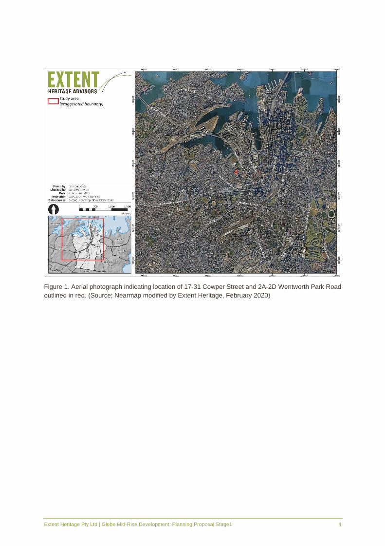
2. Site Location
The study area is located at 17-31 Cowper Street and 2A-2D Wentworth Park Road is legally
defined as Lot 18 DP 244897 and Lot 17 DP 244897 and is located within the City of Sydney’s
Local Government Area (LGA).
The study area comprises two blocks with Park Lane running between the two. Wentworth Park
Road is to the north, Cowper Street to the east, Wentworth street to the south and Mitchell Lane
East to the west. The northern block, Lot 18 DP 244897 or 2A-2D Wentworth Park Road,
comprises four two-storey terrace houses. The southern block, Lot 17 DP 244897 or 17-31
Cowper Street, comprises a two-storey block of fifteen one-bedroom units.
Extent Heritage Pty Ltd | Glebe Mid-Rise Development: Planning Proposal Stage1 4
Figure 1. Aerial photograph indicating location of 17-31 Cowper Street and 2A-2D Wentworth Park Road
outlined in red. (Source: Nearmap modified by Extent Heritage, February 2020)

Extent Heritage Pty Ltd | Glebe Mid-Rise Development: Planning Proposal Stage1 5
Figure 2. Aerial Photograph indicating the location of 17-31 Cowper Street and 2A-2D Wentworth Park
Road outlined in red. (Source: Nearmap modified by Extent Heritage, February 2020)

Extent Heritage Pty Ltd | Glebe Mid-Rise Development: Planning Proposal Stage1 6
3. Heritage Listings and Controls
3.1 Heritage Status
The following table outlines the heritage status of both 17-31 Cowper Street and 2A-2D
Wentworth Street Road.
Register/listing Item listed Item name Item no.
Statutory registers
National Heritage List N/A - -
Commonwealth Heritage List N/A - -
State Heritage Register N/A - -
LAHC Section 170 Heritage and Conservation Register
Yes
17-31 Cowper Street 3620709
2A Wentworth Park Road 3621264
2B Wentworth Park Road 3621265
2C Wentworth Park Road 3621266
2D Wentworth Park road 3621267
Sydney Local Environmental Plan 2012
Yes St Phillips Conservation Area C32
Non-statutory registers
Register of the National Trust (NSW)
TBA - -
3.2 Heritage Items in the Vicinity
There are two heritage items listed on the Sydney LEP 2012 that located within the immediate
vicinity of the study area (Figure 3).
▪ Street trees, (Item No. I670), and
▪ House Group (Item Nos I666 and I667).

Extent Heritage Pty Ltd | Glebe Mid-Rise Development: Planning Proposal Stage1 7
Figure 3. Sydney LEP 2012 Heritage Map showing the study area (outlined in green), with locally listed
heritage items in brown and conservation areas in red hatching. (Source: Sydney LEP 2012, HER_008)

Extent Heritage Pty Ltd | Glebe Mid-Rise Development: Planning Proposal Stage1 8
4. Historical Context
Cadigal are recognised as the traditional owners of the study area. In 1788 the land surrounding
the study area consisted of a harbourside mixture of sandy, sandstone slopes and swampy mud
and sand where the freshwater Blackwattle Creek emptied into the harbour. The swamp
extended as far as the present William Henry Street (Fitzgerald & Golder 1994, 12).
At the onset of European settlement in 1789 the Sydney Glebe lands were granted to the Church
of England. This followed a decree by British Authorities to allocate 400 acres in each township
to support a Church of England clergyman. This land remained largely unused until 1828 when
the Church and School Corporation subdivided Glebe into 28 allotments (Figure 4). Lots 7 and
8 of this subdivision were handed over to the trustees of St Phillip’s with the income derived to
be used for diocesan purposes. The study area of 17-31 Cowper Street and 2A-2D Wentworth
Park Road is located within this 1828 subdivision which became known as St Phillip’s Estate
subdivision.
Figure 4. Detail of 1837 Plan of Sydney showing portion of land known as St Phillips. (Source: National
Library of Australia, Call No. MAP T 1551)
In 1842 St Phillip’s Estate was further subdivided with lots being offered on 28-year leases.
Within this subdivision, allotments were leased at low rates on the condition that the lessee built
at his own expense a house or houses of substantial character, with not more than two dwellings
per allotment and that at the expiration of the lease the property became that of the ground
landlord (NSW OEH n.d.). By 1844, sixty cottages had been constructed on the St. Phillips
Estate and were likely to be of timber weatherboard construction (Solling 2007, 97). An 1870s
photograph of the area does not show any indication of structures being built on the study area
(Figure 5).

Extent Heritage Pty Ltd | Glebe Mid-Rise Development: Planning Proposal Stage1 9
Figure 5. 1873 photograph overlooking Black Wattle Cove and the Glebe area. (Source: City of Sydney
Archives, Town Hall clock tower view 1873.
Between the 1830s and 1860s noxious industries developed along the shore of Black Wattle
Cove, including abattoirs and boiling down works. These industries pumped pollution down
Blackwattle Creek into the cove beyond. These industries were eventually moved out of Glebe
following public petition, however, even after departure the stench from the pollution continued
to arise from the water and mud. In 1868 Blackwattle Creek was recorded as an “open sewer”
(Thorp 1990, 8), and in 1876 the Sydney Health Board concluded that the streams of filth and
sewage that ran down Glebe’s lanes near Blackwattle Swamp made the precinct ‘positively
sickening’. This led to calls for the area to be infilled to remove the pollutants and stench.
By 1873 the Blackwattle Bay Reclamation Act was passed, however, infilling of the creek and
head of the swamp did not commence until 1876 (Thorp 1990, 2). By 1880 silt deposits dredged
from the harbour bed had been used to fill the swamp, with dykes and seawalls created as part
of the process (Thorp 1990, 10). The transformation was incredible, with claims that the once
“fertile source of miasmic disease” had taken on a healthy character (Gibbs and Shallard 1882,
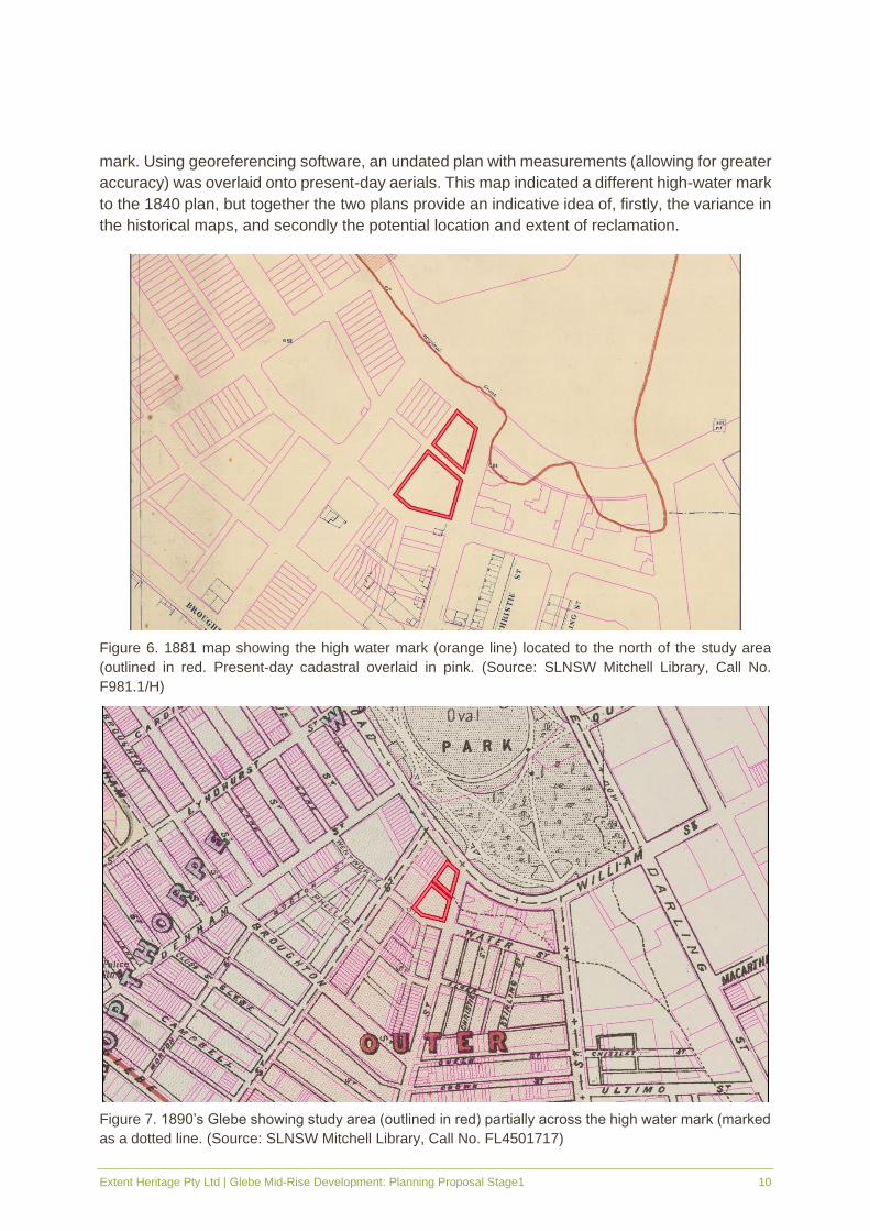
35). Varying high water marks across parish and metropolitan plans make it difficult to ascertain
the location of the study area in relation to the original shoreline and the 1876-1880 reclamation
of Black Wattle Bay. The 1881 plan (Figure 6) suggests the study area sits to the south of the
high-water mark, while the 1890 plan (Figure 7) shows the study area partially across the high-
water mark. Similarly, estate plans for Lyndhurst and Glebe estates both show the high-water
mark in varied positions. The 1840 Glebe detail plan is considered to be a highly reliable
historical plan and indicates that the study area sits half below and half above the high-water
Extent Heritage Pty Ltd | Glebe Mid-Rise Development: Planning Proposal Stage1 10
mark. Using georeferencing software, an undated plan with measurements (allowing for greater
accuracy) was overlaid onto present-day aerials. This map indicated a different high-water mark
to the 1840 plan, but together the two plans provide an indicative idea of, firstly, the variance in
the historical maps, and secondly the potential location and extent of reclamation.
Figure 6. 1881 map showing the high water mark (orange line) located to the north of the study area
(outlined in red. Present-day cadastral overlaid in pink. (Source: SLNSW Mitchell Library, Call No.
F981.1/H)
Figure 7. 1890’s Glebe showing study area (outlined in red) partially across the high water mark (marked
as a dotted line. (Source: SLNSW Mitchell Library, Call No. FL4501717)

Extent Heritage Pty Ltd | Glebe Mid-Rise Development: Planning Proposal Stage1 11
In c.1870 St Phillip’s Estate was subdivided and redeveloped from the 1842 lease and had a
combination of commercial and residential buildings. The next 20 years were the most intensive
period of building in which the terrace became the most dominant style of building in the area.
In c.1880s the Metropolitan Mutual Permanent Building and Investment Association acquired
new leases for fifty-year terms from the Church of England and set out to redevelop St Phillip’s
Estate including Cowper Street and Park Road (now Wentworth Park Road) (Solling 2007, 102).
As a result, between 1877 and 1885 rows of one and two-storey terraces were constructed
along Cowper Street and Park Road. These are visible in the 1888 Map of Glebe (Figure 8). In
1892 it appears that a corner store was located at the subject site in the terrace on the corner
of Wentworth Park Road and Cowper Street (Solling 2007, 113).
Figure 8. 1888 map of Glebe Municipality showing terraces established within the study area (outlined in
red) along Cowper Street. (Source: Historical Atlas of Sydney)
Glebe Council, established in 1859, undertook its own sewerage works in 1886 in response to
soaring disease and people leaving the suburb in favour of more sanitary residences.
Contractors began laying pipes by 1886, but only 200 houses were connected with cess pits
reportedly remaining the main form of sanitation (Solling 2007, 93). By 1901 the suburb had
22.8km of sewerage pipes compared to a mere 5.4km in 1892. Disease, however, continued to
be an issue into the 20th century with the outbreak of the bubonic plaque in 1900. Middle class
families moved to Sydney’s newer suburbs, with Glebe increasingly becoming home to people
on lower incomes, especially blue-collar workers who had to remain close to the city to pick up
work. For the next decade a zone embracing Redfern, Newtown, Surry Hills, Camperdown,
Paddington, Glebe, and Balmain became more industrialised and overtly working class in their
demographic profile (Solling 2011). This demographic remained relatively unchanged up until
the 1950s.
A panoramic image of Wentworth Park dating between c.1910 and 1930 shows rows of terraces,
including those at 31 Cowper and 2A-2D Wentworth Park Road (Figure 9). The corner store,

Extent Heritage Pty Ltd | Glebe Mid-Rise Development: Planning Proposal Stage1 12
noted as present in 1892, is visible in this photograph. The Sands Directory indicates that these
terraces were occupied until at least 1933, however, by 1939, mapping shows the study area
as vacant (Figure 9). Based on this mapping from the 1930s and aerial photography from the
1940s, many terrace houses built in the area were demolished by this time and the lots were
left vacant until further development in the mid-20th Century.
Figure 9. Detail of panoramic photograph of Wentworth Park c. 1910 -1930, terraces are visible within
the study area (outlined in red). (Source: State Library of NSW, Call No. DL PX 165, Photograph No. 65-
66)
Extent Heritage Pty Ltd | Glebe Mid-Rise Development: Planning Proposal Stage1 13
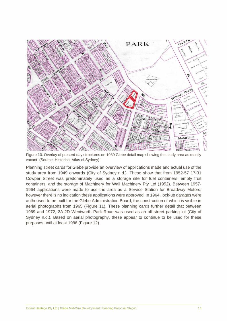
Figure 10. Overlay of present-day structures on 1939 Glebe detail map showing the study area as mostly
vacant. (Source: Historical Atlas of Sydney)
Planning street cards for Glebe provide an overview of applications made and actual use of the
study area from 1949 onwards (City of Sydney n.d.). These show that from 1952-57 17-31
Cowper Street was predominately used as a storage site for fuel containers, empty fruit
containers, and the storage of Machinery for Wall Machinery Pty Ltd (1952). Between 1957-
1964 applications were made to use the area as a Service Station for Broadway Motors,
however there is no indication these applications were approved. In 1964, lock-up garages were
authorised to be built for the Glebe Administration Board, the construction of which is visible in
aerial photographs from 1965 (Figure 11). These planning cards further detail that between
1969 and 1972, 2A-2D Wentworth Park Road was used as an off-street parking lot (City of
Sydney n.d.). Based on aerial photography, these appear to continue to be used for these
purposes until at least 1986 (Figure 12).

Extent Heritage Pty Ltd | Glebe Mid-Rise Development: Planning Proposal Stage1 14
Figure 11. Aerial photograph, 1965 with study area outlined in pink. Note the construction of the lock-up
garages in progress on the southern lot. (Source: NSW Department of Finance and Spatial Services)
Figure 12. Aerial photograph, 1986 with study area outlined in pink. The lock-up garages remain on the
southern lot. (Source: NSW Department of Finance and Spatial Services)
In 1974, the Commonwealth acquired the Glebe Estate from the Church of England to undertake
urban renewal of the area. This was a notably large-scale project that retained a tract of land in
Glebe inhabited largely by low income families, and was being dubbed the first example of
government acquisition of property to rehabilitate rather than redevelop (Solling 2011). Due to

Extent Heritage Pty Ltd | Glebe Mid-Rise Development: Planning Proposal Stage1 15
a change in the political environment, this rehabilitation project suffered a series of funding cuts
with only 230 of the proposed 710 buildings having been upgraded. A strategy plan was
prepared by the Urban Renewal Group, which proposed the that vacant sites would be used for
infill accommodation (NSW Department of Housing 1998, 15). A Strategy Plan Report for the
Glebe Estate maps the study area as a proposed location for infill housing with new residential
development proposed (NSW Department of Housing 1998, 16-17).
The extant terrace style apartments at 17-31 Cowper Street and 2A-2D Wentworth Park Road
were constructed as a result of this Glebe Rehabilitation Project with 17-31 Cowper Street
completed in 1989 and 2A-2D Wentworth Park Road completed in 1990. Presently, the
apartments remain in use as private residences.
Extent Heritage Pty Ltd | Glebe Mid-Rise Development: Planning Proposal Stage1 16
5. Physical Description
Extent Heritage carried out a physical assessment of the exterior of both 17-31 Cowper Street
and 2A-2D Wentworth Park Road on 29 November 2019. The analysis involved an investigation
into the built form and landscape setting. It does not provide a detailed investigation of all fabric
but an overview of the elements of the place to assist in determining significance. The interiors
of either building were not inspected as part of this assessment.
The study area is divided into two lots each consisting of a block of apartments that were
constructed as infill housing as a part of the Glebe Rehabilitation Project.
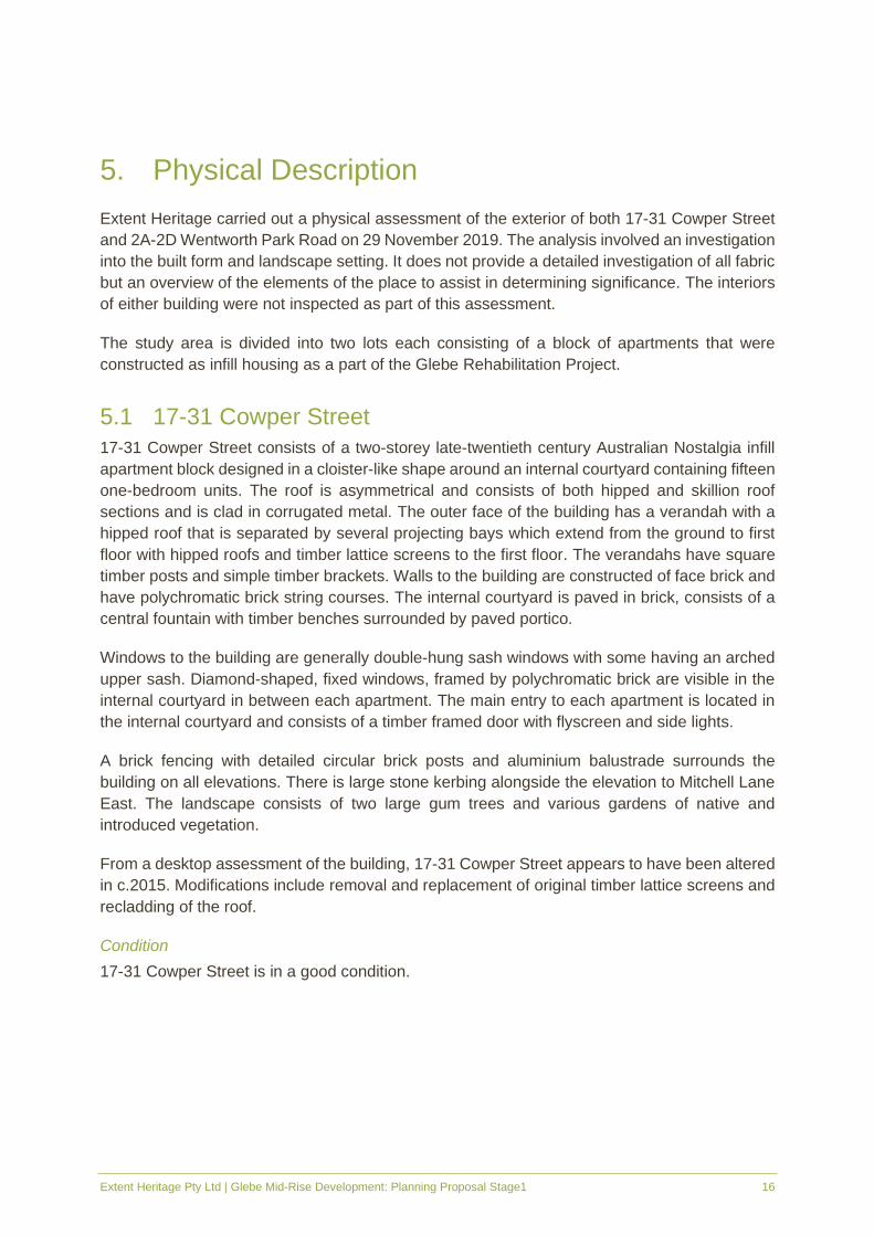
5.1 17-31 Cowper Street
17-31 Cowper Street consists of a two-storey late-twentieth century Australian Nostalgia infill
apartment block designed in a cloister-like shape around an internal courtyard containing fifteen
one-bedroom units. The roof is asymmetrical and consists of both hipped and skillion roof
sections and is clad in corrugated metal. The outer face of the building has a verandah with a
hipped roof that is separated by several projecting bays which extend from the ground to first
floor with hipped roofs and timber lattice screens to the first floor. The verandahs have square
timber posts and simple timber brackets. Walls to the building are constructed of face brick and
have polychromatic brick string courses. The internal courtyard is paved in brick, consists of a
central fountain with timber benches surrounded by paved portico.
Windows to the building are generally double-hung sash windows with some having an arched
upper sash. Diamond-shaped, fixed windows, framed by polychromatic brick are visible in the
internal courtyard in between each apartment. The main entry to each apartment is located in
the internal courtyard and consists of a timber framed door with flyscreen and side lights.
A brick fencing with detailed circular brick posts and aluminium balustrade surrounds the
building on all elevations. There is large stone kerbing alongside the elevation to Mitchell Lane
East. The landscape consists of two large gum trees and various gardens of native and
introduced vegetation.
From a desktop assessment of the building, 17-31 Cowper Street appears to have been altered
in c.2015. Modifications include removal and replacement of original timber lattice screens and
recladding of the roof.
Condition
17-31 Cowper Street is in a good condition.

Extent Heritage Pty Ltd | Glebe Mid-Rise Development: Planning Proposal Stage1 17
Figure 13. Overview of 17-31 Cowper Street.
Figure 14. Corner of Wentworth Street and Cowper Street.
Figure 15. View south along Mitchell Lane East.
Figure 16. View north along Mitchell Lane East.
Figure 17. Sandstone kerbing along Mitchell Lane East.
Figure 18. View to internal courtyard at 17-31 Cowper Street.

Extent Heritage Pty Ltd | Glebe Mid-Rise Development: Planning Proposal Stage1 18
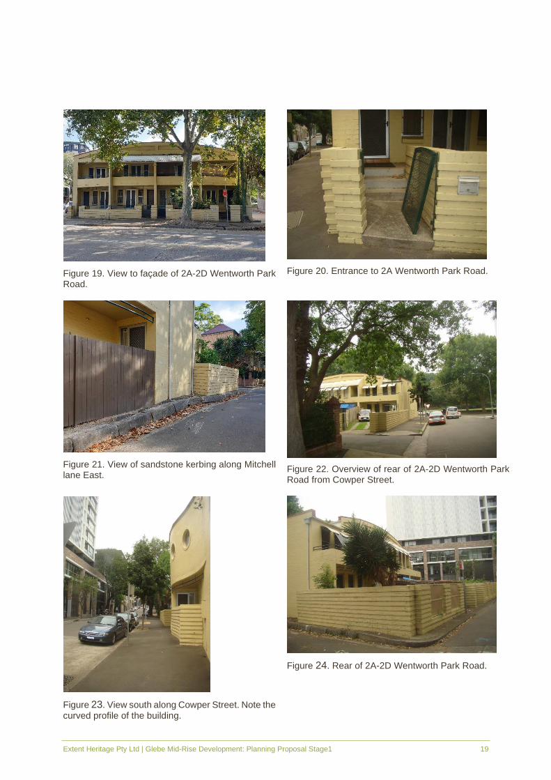
5.2 2A-2D Wentworth Park Road
2A-2D Wentworth Park Road consists of a group of four late twentieth century Post Modern
two-storey semi-detached terraces constructed of rendered brick. It is designed as sensitive
infill to match the surrounding historic vernacular landscape. The building features a curved
parapet to the façade and rear elevations and is curved in profile to the east and west elevations.
The terraces feature a curved brick balcony, curved corrugated steel roof and steel framing.
Each terrace has a French door and two double-hung windows arranged symmetrically on the
first floor with the same arrangement on the ground floor with the addition of a front door. All
windows and doors have flyscreens, and some have security grates. Each terrace is accessed
by a set of concrete stairs and has a rendered brick fence with steel railing and metal screen
gate.
Circular fixed windows are located on the side elevations to the ground and first floors. To the
rear, windows are double hung with curved corrugated metal awnings. The rear is surrounded
by a high brick fence with expressed string courses which resembles the front fencing and
separates the small rear yard of each terrace. There is large stone kerbing alongside the
elevation to Mitchell Lane East and a mature eucalyptus trees to the front of the building along
Wentworth Park Road.
Condition
2A-2D Wentworth Park Road is generally in a good condition, although the front gate is broken
at apartment 2A.
Extent Heritage Pty Ltd | Glebe Mid-Rise Development: Planning Proposal Stage1 19
Figure 19. View to façade of 2A-2D Wentworth Park Road.
Figure 20. Entrance to 2A Wentworth Park Road.
Figure 21. View of sandstone kerbing along Mitchell lane East.
Figure 22. Overview of rear of 2A-2D Wentworth Park Road from Cowper Street.
Figure 23. View south along Cowper Street. Note the curved profile of the building.
Figure 24. Rear of 2A-2D Wentworth Park Road.

Extent Heritage Pty Ltd | Glebe Mid-Rise Development: Planning Proposal Stage1 20
5.3 Views and Settings
The study area is situated within the residential portion of Glebe and comprises of two blocks
with Park Lane running between the two. To the north of the study area across Wentworth Park
Road is Wentworth Park which is a large open park space with many mature trees, a greyhound
racing track, soccer fields and playground. To the east, along the western side of Cowper Street
are a row of street trees, that form part of a local heritage item ‘Street Trees’ which consists of
rainforest species including Grevillea robusta, Flindersia australis and Castanospermum
australae planted in c.1950. On the eastern side of Cowper Street are high rise apartments, and
along western side of Cowper Street to the south of the study area are a row of single-storey
terraces. To the west of the study area is another row of two-storey social housing terraces
which sit to the north of MJ Doherty Reserve.

Extent Heritage Pty Ltd | Glebe Mid-Rise Development: Planning Proposal Stage1 21
Figure 25. View to Wentworth Park from 2A-2D Wentworth Park Road.
Figure 26. View towards Wentworth Park from 17-31 Cowper Street
Figure 27. View to Street trees along Cowper
Street.
Figure 28. View north along Mitchell Lane East towards M.J. Doherty Reserve.
Figure 29. View south along Cowper Street.

Extent Heritage Pty Ltd | Glebe Mid-Rise Development: Planning Proposal Stage1 22
6. Heritage Significance
6.1 LAHC Heritage and Conservation Register
The following Statement of heritage significance has been taken from the NSW Land and
Housing Corporation’s listing sheet for the study area. There are five individual listing sheets,
with 2A-2D Wentworth Park Road listed as 4 individual items - 2A, 2B, 2C and 2D Wentworth
Park Road. It should be noted that the four listing sheets for 2A-2D Wentworth Park Road have
the same significance listed in each listing sheet. For the purposes of this discussion, this report
will group the four individually listed terraces at 2A-2D Wentworth Park Road together, as
opposed to discussing significance on an individual level.
▪ The heritage significance of 17-31 Cowper Street Glebe is recognised as: ‘Of marginal
heritage significance as an example of infill public housing in an older residential area.
Records the historic development pattern of Glebe. Representative of last major period of
development.’
▪ The heritage significance of 2A-2D Wentworth Park Road is recognised as: ‘Significant as
a record of the Glebe Rehabilitation Project and an example of good contextual design in
an historic townscape. Representative of late 20th century infill.’
6.2 St Phillips Conservation Area
The study area is located within the St Phillips Conservation Area. The following Statement of
Significance for the has been quoted from the State Heritage Inventory Listing Sheet for ‘St
Phillips Conservation Area’:
St Phillip's Conservation Area has historic significance for its subdivision of St. Phillip's Estate c.
1870, following redevelopment of 1842 leases. The area has a number of important layers: The
early retail and commercial developments developed to serve the residential estates of St Phillips;
The speculative working class terrace development dating from 1870s; housing development carried
out by the church in the Inter - war period; and the extent of public housing on the Glebe Estate
dating from the 1970s and 1980s. The speculative working class terrace development by Building
Companies dating from 1870s reflect the historic association with important local identities, notably
builder David Elphinstone and financer George Wigram Allen.
The post 1974 public housing development and rehabilitation programs reflect the protection of
Glebe due to resident action.
St Phillips has aesthetic significance for its predominant Victorian character, supported by several
other important historic layers and building types. The area is rare for its extraordinary degree of
architectural intactness, and for the survival of early 1870s commercial and residential development
so close to the city centre. The high level of integrity reflects the long history of church and
government ownership.
Extent Heritage Pty Ltd | Glebe Mid-Rise Development: Planning Proposal Stage1 23
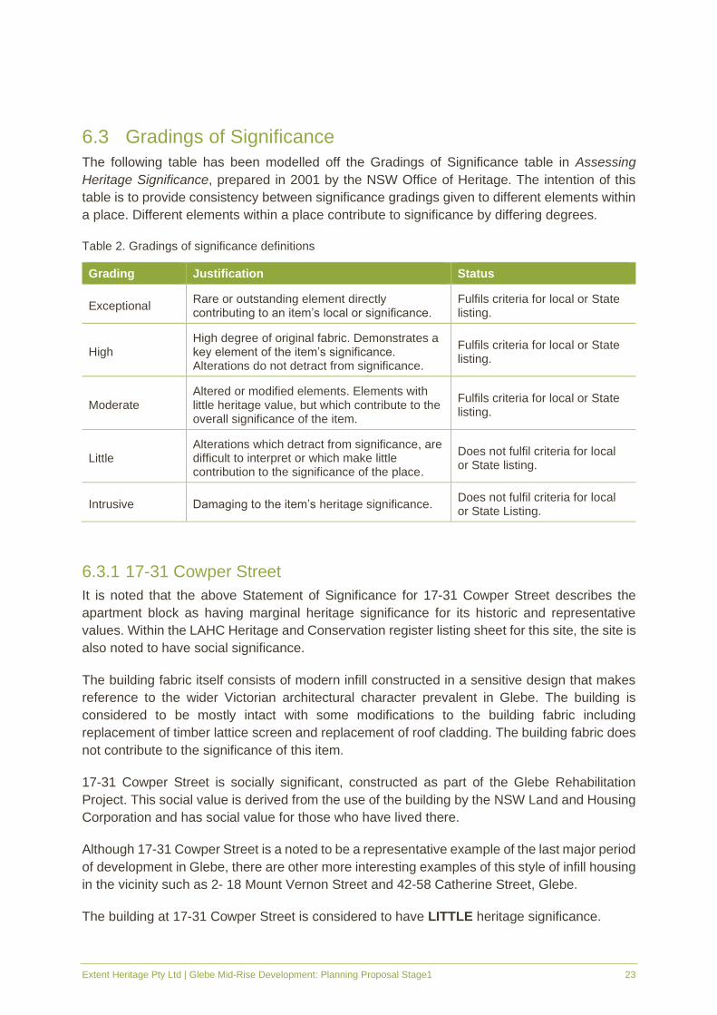
6.3 Gradings of Significance
The following table has been modelled off the Gradings of Significance table in Assessing
Heritage Significance, prepared in 2001 by the NSW Office of Heritage. The intention of this
table is to provide consistency between significance gradings given to different elements within
a place. Different elements within a place contribute to significance by differing degrees.
Table 2. Gradings of significance definitions
Grading Justification Status
Exceptional Rare or outstanding element directly contributing to an item’s local or significance.
Fulfils criteria for local or State listing.
High High degree of original fabric. Demonstrates a key element of the item’s significance. Alterations do not detract from significance.
Fulfils criteria for local or State listing.
Moderate Altered or modified elements. Elements with little heritage value, but which contribute to the overall significance of the item.
Fulfils criteria for local or State listing.
Little Alterations which detract from significance, are difficult to interpret or which make little contribution to the significance of the place.
Does not fulfil criteria for local or State listing.
Intrusive Damaging to the item’s heritage significance. Does not fulfil criteria for local or State Listing.
6.3.1 17-31 Cowper Street
It is noted that the above Statement of Significance for 17-31 Cowper Street describes the
apartment block as having marginal heritage significance for its historic and representative
values. Within the LAHC Heritage and Conservation register listing sheet for this site, the site is
also noted to have social significance.
The building fabric itself consists of modern infill constructed in a sensitive design that makes
reference to the wider Victorian architectural character prevalent in Glebe. The building is
considered to be mostly intact with some modifications to the building fabric including
replacement of timber lattice screen and replacement of roof cladding. The building fabric does
not contribute to the significance of this item.
17-31 Cowper Street is socially significant, constructed as part of the Glebe Rehabilitation
Project. This social value is derived from the use of the building by the NSW Land and Housing
Corporation and has social value for those who have lived there.
Although 17-31 Cowper Street is a noted to be a representative example of the last major period
of development in Glebe, there are other more interesting examples of this style of infill housing
in the vicinity such as 2- 18 Mount Vernon Street and 42-58 Catherine Street, Glebe.
The building at 17-31 Cowper Street is considered to have LITTLE heritage significance.

Extent Heritage Pty Ltd | Glebe Mid-Rise Development: Planning Proposal Stage1 24
6.3.2 2A-2D Wentworth Park Road
It is noted that the above Statement of Significance for 2A-2D Wentworth Park Road describes
it as having local heritage significance for its historical, aesthetic, social and representative
values.
It should be noted that the aesthetic significance of the terraces is attributed to its overall form
which has been designed as a row of semi-detached terraces that make reference to the earlier
historic building stock of the Glebe area but also reflect the Post Modern influences of the late
twentieth century. It is a representative example of the late 20th Century infill built in 1990.
Although there appears to be a high degree of original fabric remaining on the building, besides
recent repainting of the building, it is the general form and scale of the building rather than the
building fabric which contributes to the overall significance of 2A-2D Wentworth Park Road.
2A-2D Wentworth Park Road is also socially significant, constructed as part of the Glebe
Rehabilitation Project. This social value is derived from the use of the building by the Land and
Housing Corporation and has social value for those who have lived there.
The building at 2A-2D Wentworth Park Road is therefore considered to have MODERATE
significance.

Extent Heritage Pty Ltd | Glebe Mid-Rise Development: Planning Proposal Stage1 25
7. Proposal
Presently, the study area is zoned R1 General Residential under City of Sydney LEP 2012 and
is subject of a max height of buildings of 9m and a max floor space ratio of 1.25:1.
The Planning Proposal involves the application to City of Sydney Council to make amendments
to its environmental planning instrument (Sydney Local Environmental Plan 2012) that will
support a mid-rise development on this site. More specifically, the planning proposal has drafted
a number of amendments to enable additional housing to be delivered on the site. These
amendments consist of:
Control Existing Proposed amendment
▪ 2A-2D Wentworth Park Rd ▪ 17-31 Cowper Street
Zoning R1 General residential No change No change
Height 9m RL36 (approx. eight-storeys) RL36 (approx. eight-storeys)
Floor Space Ratio
1.25:1 4:3:1 3:1:1
Car parking
Category B No change No change
Affordable Housing
Pending:
Draft Affordable Rental Housing Planning Proposal: 3% of residential floor space plus 12% of new residential GFA
Introduce a new site specific provision to Part 6 Division 5 as follows:
(1) This clause applies to 2A-2D Wentworth Point Road (Lot 18, DP244897).
(2) The consent authority must not consent to development involving construction of one or more dwellings on land at 2A-2D Wentworth Street Point Road unless it is satisfied that 10% of the residential gross floor area of will be used for the purposes of affordable housing.
Note: Under Sydney LEP 2012 affordable housing has the same meaning as in the Act.
Design Excellence
Clause 6.21 applies requiring a design competition
Introduce a new local provision Part 6 Division 5 as follows:
(1) This clause applies to 2A-2D Wentworth Point Road (Lot 18 DP244897) and 17-31 Cowper Street, Glebe (Lot 17 DP244897).
(2) Clauses 6.21 (5-7) of this LEP do not apply to land at 2A-2D Wentworth Street Point Road and 17-31 Cowper Street, Glebe.
Heritage The site is within a Heritage Conservation Area
It is proposed to remove the site from the Heritage Conservation Area, by amending the heritage map.

Extent Heritage Pty Ltd | Glebe Mid-Rise Development: Planning Proposal Stage1 26
Control Existing Proposed amendment
Figure 30. Proposed Heritage map amendment, showing the Heritage Conservation Area (in red hatching), with the study area excluded. (Source: JPW, LEP Diagrams, dwg. A-6400 rev. 00, dated 28/04/2020
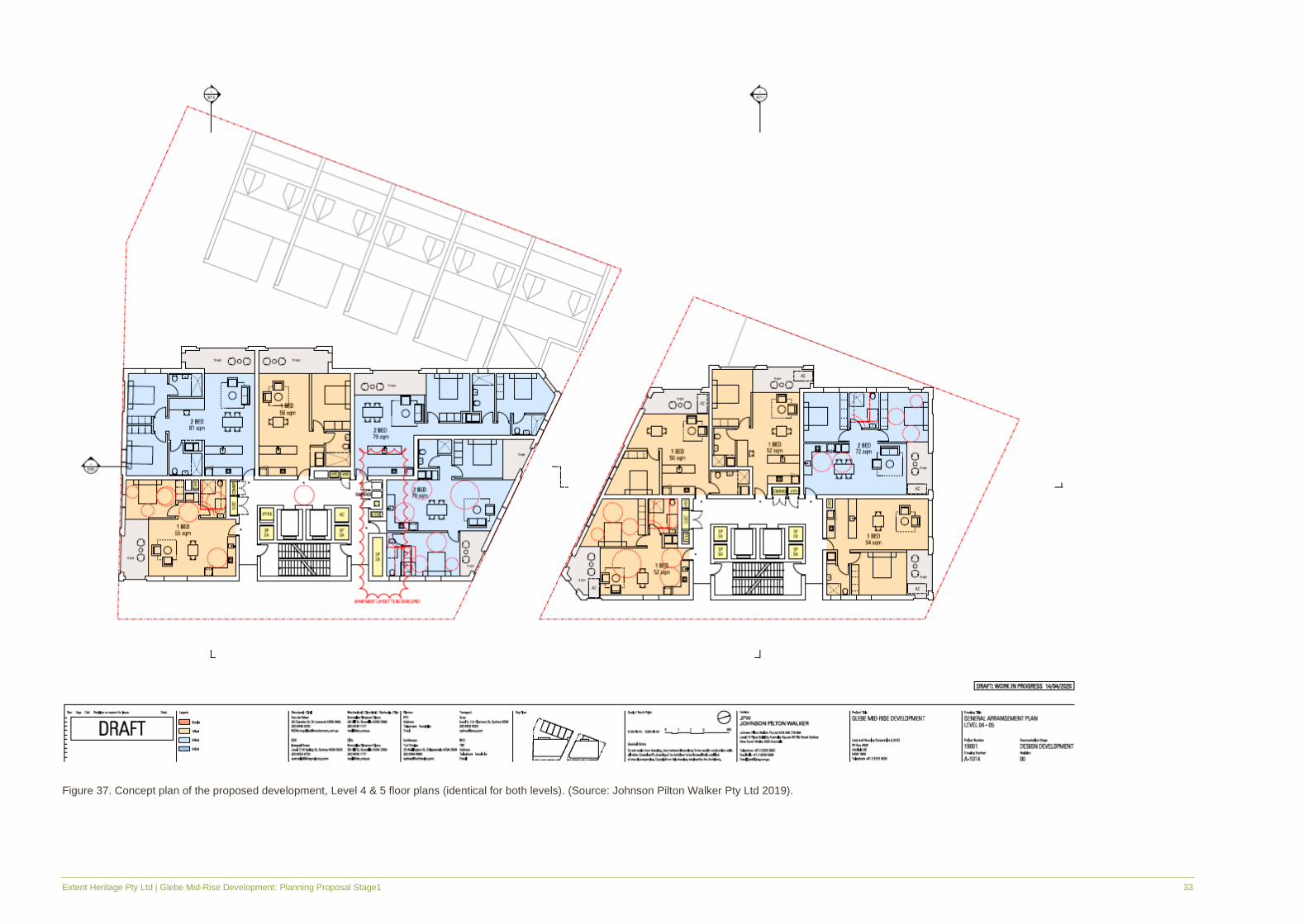
As part of the planning proposal, an illustrative structure plan has been developed to
demonstrate a type and look of a building development on the site that would meet the
requirements of the amended development.
To meet the requirements of the proposed controls, the illustrative structure plan has indicated
a two eight-storey apartment blocks as well as detached row of five terrace-style residences,
with the potential to yield approximately 74 new dwellings in total with a mix of social and market
housing (FDP Pty Ltd 2019). The apartment block on the southern portion of the site, 17-31
Cowper Street, will have a two-level basement carpark, while 2A-2D Wentworth Street will have
only one basement level. This proposed development includes the demolition of all existing
structures on site however ensures the retention of the heritage listed ‘Street Trees’ along
Cowper Street.
Figure 31 to Figure 46 show the illustrative structure plan of the proposed development dated
14 April 2020.

Extent Heritage Pty Ltd | Glebe Mid-Rise Development: Planning Proposal Stage1 27
Figure 31. Concept plan of the proposed development. The lower basement level carparking at 17-31 Cowper Street is shown in this plan (Source: Johnson Pilton Walker Pty Ltd April 2020).

Extent Heritage Pty Ltd | Glebe Mid-Rise Development: Planning Proposal Stage1 28
Figure 32. Concept plan of the proposed development. The upper basement level carparking at 17-31 Cowper Street is shown in this plan, as well as the basement level of 2A-2D Wentworth Street Street. (Source: Johnson Pilton
Walker Pty Ltd April 2020).

Extent Heritage Pty Ltd | Glebe Mid-Rise Development: Planning Proposal Stage1 29
Figure 33. Concept plan of the proposed development, Ground floor plan (Source: Johnson Pilton Walker Pty Ltd 2019).
Extent Heritage Pty Ltd | Glebe Mid-Rise Development: Planning Proposal Stage1 30
Figure 34. Concept plan of the proposed development, Level 1 floor plan (Source: Johnson Pilton Walker Pty Ltd 2019).

Extent Heritage Pty Ltd | Glebe Mid-Rise Development: Planning Proposal Stage1 31
Figure 35. Concept plan of the proposed development, Level 2 floor plan (Source: Johnson Pilton Walker Pty Ltd 2019).

Extent Heritage Pty Ltd | Glebe Mid-Rise Development: Planning Proposal Stage1 32
Figure 36. Concept plan of the proposed development, Level 3 floor plan, roof plan for the five terraces facing Mitchell Lane (Source: Johnson Pilton Walker Pty Ltd 2019).
Extent Heritage Pty Ltd | Glebe Mid-Rise Development: Planning Proposal Stage1 33
Figure 37. Concept plan of the proposed development, Level 4 & 5 floor plans (identical for both levels). (Source: Johnson Pilton Walker Pty Ltd 2019).

Extent Heritage Pty Ltd | Glebe Mid-Rise Development: Planning Proposal Stage1 34
Figure 38. Concept plan of the proposed development, Level 6 floor plan (Source: Johnson Pilton Walker Pty Ltd 2019).

Extent Heritage Pty Ltd | Glebe Mid-Rise Development: Planning Proposal Stage1 35
Figure 39. Concept plan of the proposed development, Level 7 floor plan (Source: Johnson Pilton Walker Pty Ltd 2019).
Extent Heritage Pty Ltd | Glebe Mid-Rise Development: Planning Proposal Stage1 36
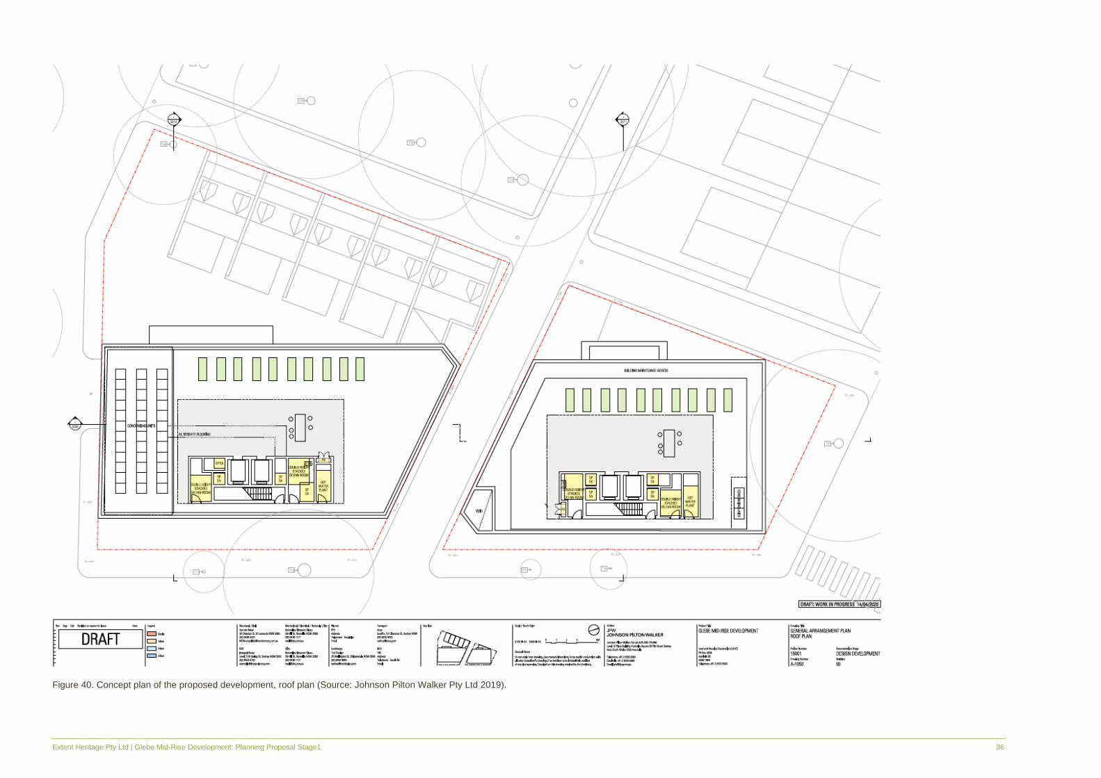
Figure 40. Concept plan of the proposed development, roof plan (Source: Johnson Pilton Walker Pty Ltd 2019).
Extent Heritage Pty Ltd | Glebe Mid-Rise Development: Planning Proposal Stage1 37
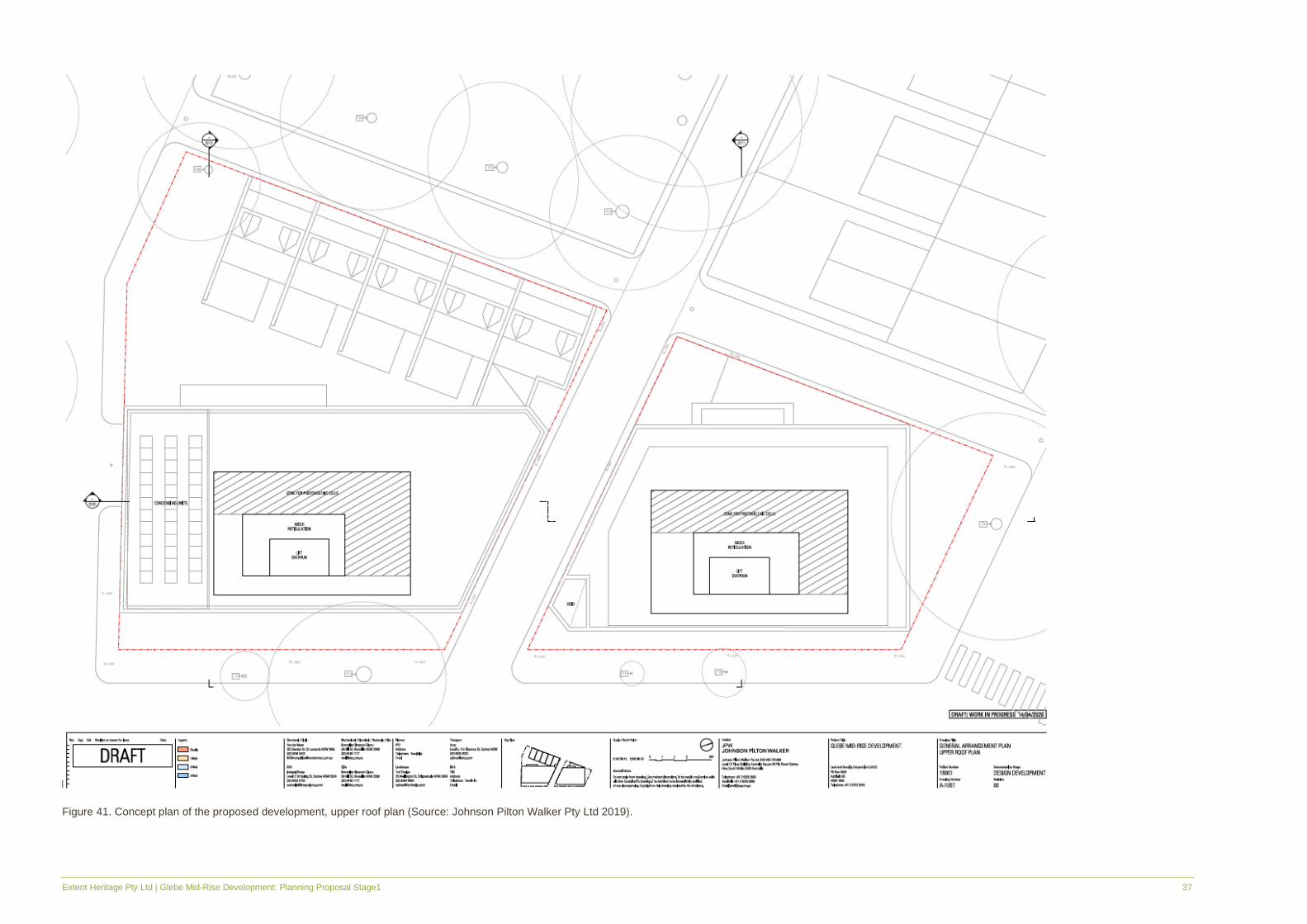
Figure 41. Concept plan of the proposed development, upper roof plan (Source: Johnson Pilton Walker Pty Ltd 2019).

Extent Heritage Pty Ltd | Glebe Mid-Rise Development: Planning Proposal Stage1 38
Figure 42. Concept plan of the proposed development, north elevation (Source: Johnson Pilton Walker Pty Ltd 2019).

Extent Heritage Pty Ltd | Glebe Mid-Rise Development: Planning Proposal Stage1 39
Figure 43. Concept plan of the proposed development, east elevation (Source: Johnson Pilton Walker Pty Ltd 2019).

Extent Heritage Pty Ltd | Glebe Mid-Rise Development: Planning Proposal Stage1 40
Figure 44. Concept plan of the proposed development, south elevation (Source: Johnson Pilton Walker Pty Ltd 2019).

Extent Heritage Pty Ltd | Glebe Mid-Rise Development: Planning Proposal Stage1 41
Figure 45. Concept plan of the proposed development, west elevation (Source: Johnson Pilton Walker Pty Ltd 2019).
.
Extent Heritage Pty Ltd | Glebe Mid-Rise Development: Planning Proposal Stage1 42
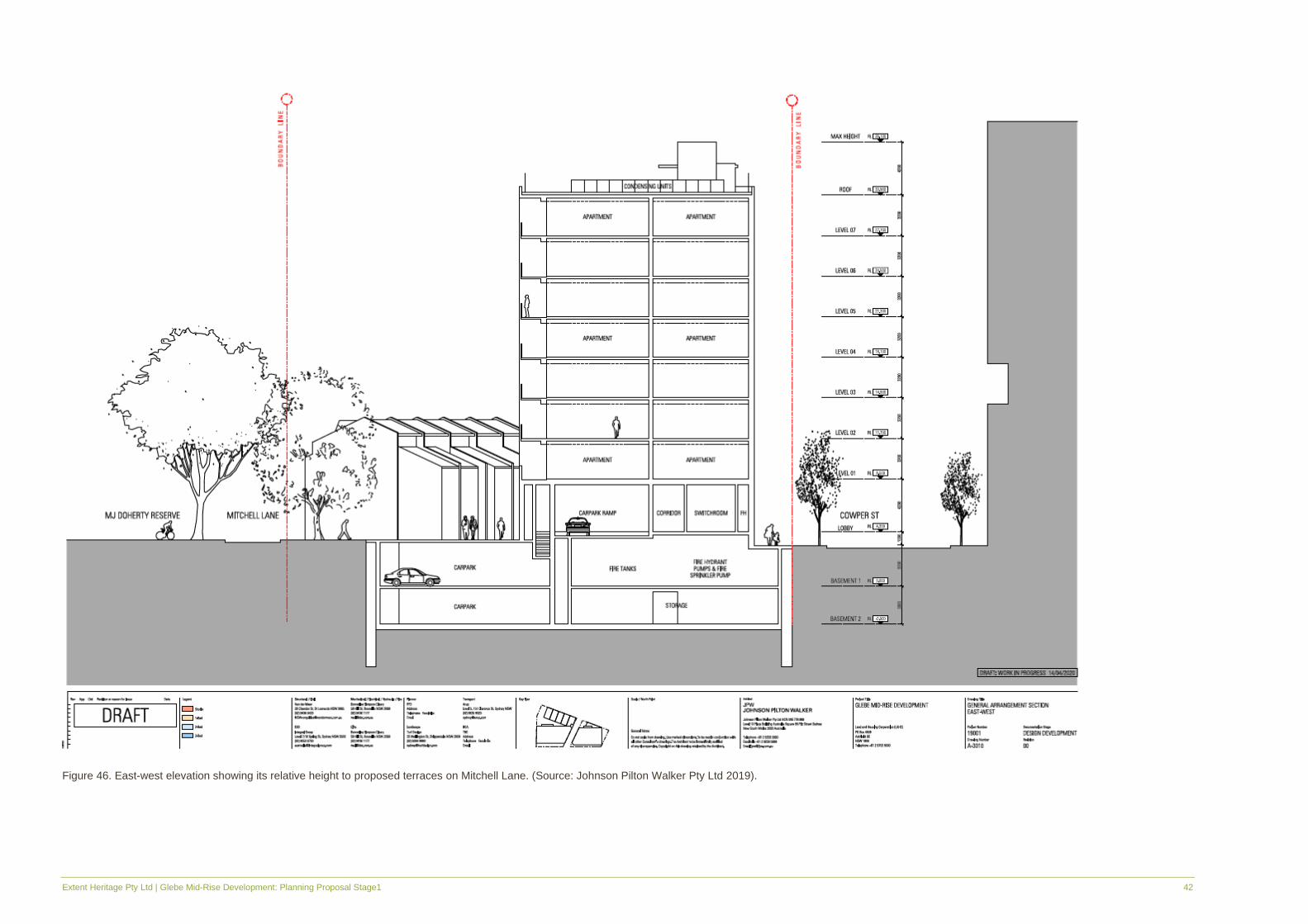
Figure 46. East-west elevation showing its relative height to proposed terraces on Mitchell Lane. (Source: Johnson Pilton Walker Pty Ltd 2019).

Extent Heritage Pty Ltd | Glebe Mid-Rise Development: Planning Proposal Stage1 43
8. Preliminary Assessment of Heritage Impact
8.1 Built Heritage
Planning Proposal
The planning proposal seeks to amend some controls in the Sydney LEP 2012 which would
allow for the redevelopment of the study area with the construction indicatively consisting of two
eight-storey apartment blocks and a row of five attached terrace residences, with the potential
to yield approximately 74 new dwellings with a mix of social and market housing. The continued
use of the original historic function of the site as social housing is a positive outcome of this
planning proposal considering the importance of the social heritage significance of the site as
social housing. It is important that this fundamental function is retained in any future
development.
The planning proposal will allow for a structure that is substantially taller in height to the major
significant character of the area, which is dominated by large blocks of low-scale residential
housing. Due to this increased height alone, the scale of the development will have some impact
on the character of the surrounding area. However, some effort has been made to step the
heights of development, with a lower three-storey development facing west towards the centre
of the St Phillips Conservation Area. Here, the illustrative scheme emulates the surrounding
historic character with the three-storey terraces that front Mitchell Lane, ensuring that area of
the development does not overwhelm the opposite block of single-storey Victorian terraces. The
illustrative scheme also references a common Victorian-period architectural feature through the
arched window and door portal on the façade. The proposed bulk of the development can further
be mitigated in the detailed design, which could use lightweight, translucent or transparent
materials and finishes so as to no create an overwhelming and ‘heavy’ presence in its immediate
area. In summary, while the impacts of the new building would be substantial in terms of form,
bulk and scale, the impacts can be mitigated through materiality and finishes.
The major part of the development, fronting Cowper Street, is opposite an existing, modern
seven-storey apartment building as well as several other substantial high-rise apartment
buildings in that block. In this respect, from this primary frontage and approach of the new
development, the proposal simply compliments this existing urban environment.
The planning proposal to redevelop the study area with mid-rise apartments is consistent
already existing development impacts on the opposite site of Cowper Street and throughout
other areas of Glebe, and as such will have a NEGLIGIBLE impact on the significance of the
conservation area.
Removal of Study area from the St Phillips Conservation Area
The study area is included within the St Phillips Conservation Area which is representative of
the original St Phillips Estate that underwent a major subdivision in the 1870s and contributing
to much of the existing characteristic landscape of the suburb of Glebe today. This major
subdivision is historically significant as a key event in the developmental history of the suburb,
and also in its social significance as a catalyst for speculative workers cottage and terrace

Extent Heritage Pty Ltd | Glebe Mid-Rise Development: Planning Proposal Stage1 44
housing, which still dominates the area. Other layers that contribute to the Conservation Areas
social significance include inter-war period residences and apartment blocks, to post-1970s
modern social housing.
A quality of the character of the St Phillips Conservation Area is through its level of architectural
intactness fully maintained within the original street alignments and subdivisions. Portions and
allotments that are incohesive with the striking pattern and uniformity of the Conservation Area
are the exception to the architectural quality of Conservation Area, rather than commonplace
and frequent.
The study area is recognised as contributory buildings to the St Phillip’s Conservation Area as
evidence of the late 20th Century infill that demonstrates the historic development of the area.
However, the study area’s spatial relationship within the Conservation Area as a whole to its
immediately surrounding environment diminishes the contributory quality of the buildings in the
study area. The buildings themselves, while marginally sympathetic infill styles, are not
exemplary of their type and can potentially confuse interpretation of the mostly Victorian
architectural values of the Conservation Area. Spatially, it is located at the outer edges of the
Conservation Area where the qualities and architectural values of the Conservation Area are
not as evident or as obvious as it would be within the central core. In considering the immediately
adjacent landscapes bordering the study area; the open recreational area of Wentworth Park to
the north and the modern twenty-first century high-rise apartment buildings to the east, coupled
with the study area’s modern-style terrace and Australian nostalgia style infill. This pocket of
varied architectural styles and densities of development further enforces the fact that
interpreting the existing buildings within the study area as cohesive with the values of the
Conservation Area are less applicable.
The planning proposal to remove the study area from the St Phillips Conservation Area, given
its marginal contribution to the historic and aesthetic values of the conservation Area, is
considered to have a NEGLIGIBLE impact on the significance of conservation area.
Given this assessment of a negligible impact on significance, the proposal to amend the Sydney
LEP Heritage Map to remove the study area from the St Phillips Conservation Area curtilage
would be an acceptable heritage outcome.
Demolition
Both 17-31 Cowper Street and 2A-2D Wentworth Park Road have been individually listed in the
LAHC Heritage and Conservation Register.
The planning proposal seeks to demolish all existing structures within the study area. This
includes the two LAHC-listed heritage items at 17-31 Cowper Street and 2A-2D Wentworth Park
Road. As demonstrated in Section 6.3, the building fabric at 17-31 Cowper Street is considered
to have LITTLE heritage significance and the building fabric at 2A-2D Wentworth Park Road is
considered to have MODERATE significance. As part of the heritage conservation area, both
buildings are representative examples of sensitive infill demonstrative of the evolution of the
historic character of the area.

Extent Heritage Pty Ltd | Glebe Mid-Rise Development: Planning Proposal Stage1 45
Based on its existing heritage status, the demolition of both 17-31 Cowper Street and 2A-2D
Wentworth Street Street would be considered a major and irreversible change to the building
fabric with a moderate adverse impact on the overall heritage value of the place. However, our
assessment of significance can be used to demonstrate that these buildings are not exceptional
examples of 20th Century infill development representative of the values that they are listed for.
Note that there is large stone (sandstone or trachyte) kerbing along Mitchell Lane East that is
close to the edge of the current building that would be at risk of damage during demolition
activities. This material would also be considered historic fabric within the public domain.
8.2 Curtilage and Subdivision
The planning proposal will have no impact on the study area’s curtilage or subdivision.
8.3 Views and Settings
The study area is located within the St Phillips Conservation Area and fronts Wentworth Park
Road, Cowper Street, Wentworth Street and Mitchell Street with Park Lane separating the two
Lots. Wentworth Park sits to the north of the site. There are a number of high-rise buildings to
the west and one to the east of the study area that have blocked views to and from the area.
The planning proposal seeks to increase the height of the buildings in the area and will therefore
have a minor impact on views within the St Phillips Conservation Area. The illustrative scheme
is stepped with a lower level of development facing the west, which will ensure the streetscape
character and quality of the main part of the Conservation Area is maintained in that direction.
Other measures to ensure that the development is sympathetic to the historic character of the
area will include sensitive considerations around the materiality of façade finishes.
8.4 Heritage Items in the Vicinity
The study area is in the vicinity of several heritage items which are listed on the Sydney LEP
2012 including:
▪ ‘Street trees’ (Item No. I670); and
▪ ‘House Group’ at 4-24 Broughton Street (Item Nos I666 and I667).

Extent Heritage Pty Ltd | Glebe Mid-Rise Development: Planning Proposal Stage1 46
Figure 47. Sydney LEP 2012 Heritage Map showing the study area (outlined in green), with locally listed
heritage items in brown and conservation areas in red hatching. (Source: Sydney LEP 2012, HER_008)
The planning proposal seeks to retain the locally listed ‘Street Trees’ along Cowper Street and
proposes that parking and driveway crossovers will be designed so as to minimise impact on
the item.
Overall, the planning proposal has a minor impact on the heritage in the vicinity. It is clear that
there is a conscious effort to retain the listed ‘Street Trees’ in the vicinity.
8.5 Historical Archaeological Potential
A Preliminary Historical Archaeological Assessment for the Stage 1 - Planning Proposal has
been prepared by Extent Heritage in February 2020. Please refer to this report for an
assessment of Historical Archaeology.
8.6 Aboriginal Archaeological Potential
A Preliminary Aboriginal Archaeological Assessment for the Stage 1 - Planning Proposal has
been prepared in has been prepared by Extent Heritage in February 2020. Please refer to this
report for an assessment of Aboriginal Archaeology.

Extent Heritage Pty Ltd | Glebe Mid-Rise Development: Planning Proposal Stage1 47
9. Statutory Controls
9.1 Heritage Act 1977
As none of the structures in the study area are listed on the State Heritage Register, the
proposed demolition and redevelopment are not subject to notification and approval by the
Heritage Council. However, as the planning proposal seeks to amend statutory controls which
will ultimately see the demolition of items listed on the Heritage and Conservation Register,
appropriate heritage assessment to works within the Land and Housing Corporation (NSW)
Heritage and Conservation Register heritage curtilage is necessary by the government
instrumentality responsible in accordance with the management provisions under Section 170A
of the Heritage Act 1977.
According to Section 170A(1)(a) of the Act,
A government instrumentality must give the Heritage Council not less than 14 days written
notice before the government instrumentality (a) removes any item from its register under
section 170.
This notification requirement would therefore apply prior to demolition of the structures at 17-31
Cowper Street and 2A-2D Wentworth Park Road.
Under the provisions of Section 170A (2) of the Heritage Act:
Each governmental instrumentality is responsible for ensuring that the items entered on its
register under section 170 and items and land to which a listing on the State Heritage Register
applies that are under its care, control or management are maintained with due diligence in
accordance with State Owned Heritage Management Principles approved by the Minister on
the advice of the Heritage Council and notified by the Minister to government instrumentalities
from time to time.
The following sections address the proposal’s compliance with the State-Owned Heritage
Management Principles (SOHMP) and the State Agency Heritage Guide (SAHG) in light of the
existing heritage listing of the structures on the site. However, should these items be removed
from the LAHC Heritage and Conservation register, management in accordance with these
guidelines will no longer apply.
9.1.1 State-Owned Heritage Management Principles
17-31 Cowper Street, 2A 2B, 2C and 2D Wentworth Park Road are government owned assets
listed as having local significance on the LAHC Heritage and Conservation Register. As such,
works must be managed and the site maintained in accordance with the SOHMP.
Principle No. 4 – Conservation Outcomes
Heritage assets should be conserved to retain their heritage significance to the greatest extent feasible. State agencies should aim to conserve assets for operational purposes or to adaptively reuse assets in preference to alteration or demolition.
Extent Heritage Comment

Extent Heritage Pty Ltd | Glebe Mid-Rise Development: Planning Proposal Stage1 48
The planning proposal seeks to demolish all heritage items within the subject area. The redevelopment of the study area for the purpose of mixed social and market housing is a positive outcome of this planning proposal as this retains the social values of the site. However, as the items are still in use and still heritage-listed, demolition is considered inconsistent with the principles of this heritage and conservation outcome and will be detrimental to the historic and representative values (and aesthetic values for 2A-2D Wentworth Park Road) of the study area.
Principle No. 7 - Appropriate Uses
Heritage Assets should, where feasible continue to be maintained in their operational role. Where they are surplus to operational requirements, State agencies should aim to ensure that items are adaptively re-used for a purpose sympathetic to their heritage significance.
Extent Heritage Comment
While the planning proposal will demolish the existing heritage items within the study area, the continued use of part of this site (limited to development on 2A-2D Wentworth Park Road) for social housing is considered an appropriate use of the study area.
Conclusion:
The planning proposal seeks to demolish items of heritage significance and proposed to build two eight-storey mixed social and market housing apartments in replacement. The continued use of the site as a residential area is a positive outcome that retains the social value of the heritage items within its curtilage. However, in order for the planning proposal to proceed, the heritage items located within the study area must be removed from the LAHC Heritage and Conservation register and notification of this removal is made to the NSW Heritage Council.
9.1.2 State Agency Heritage Guide
Additionally, the SAHG details the following principles relating to managing change and
managing demolition of heritage items. The below principles are applicable to the study area:
Principle Extent Heritage Comment
3.19
Principles of Managing Change
Change is undesirable where it reduces heritage significance. The amount of change to a heritage asset should be guided by the heritage significance of the heritage asset, by its heritage management policies, and by its appropriate interpretation.
For the most part, changes proposed will have a moderate/major adverse impact on significance.
The demolition of the building will result in a major impact to building fabric with a moderate adverse impact to significance.
Prior to demolition the site must be appropriately recorded and consideration given towards mitigative measures such as effective interpretation.
Allowance for this should be made in the detailed design.
3.20
Recording an Asset in its Existing Situation
Existing fabric, use, associations and meanings should be adequately recorded before any changes are made to the heritage asset.
The Concept Design proposes the demolition of heritage assets. In accordance with the SAHG, these assets should be recorded prior to change.
Extent Heritage Pty Ltd | Glebe Mid-Rise Development: Planning Proposal Stage1 49
Principle Extent Heritage Comment
Allowance for this should be made in the detailed design.
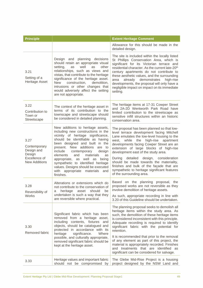
3.21
Setting of a Heritage Asset
Design and planning decisions should retain an appropriate visual setting, as well as other relationships, such as views and vistas, that contribute to the heritage significance of the heritage asset. New construction, demolition, intrusions or other changes that would adversely affect the setting are not appropriate.
The site is included within the locally listed St Phillips Conservation Area, which is significant for its Victorian terrace and residential character. As the current late-20th century apartments do not contribute to these aesthetic values, and the surrounding area already demonstrates high-rise developments, the proposal will only have a negligible impact on impact on its immediate setting.
3.22
Contribution to Town or Streetscape
The context of the heritage asset in terms of its contribution to the townscape and streetscape should be considered in detailed planning.
The heritage items at 17-31 Cowper Street and 2A-2D Wentworth Park Road have limited contribution to the streetscape as sensitive infill structures within an historic conservation area.
3.27
Contemporary Design and Design Excellence of New Additions
New additions to heritage assets, including new constructions in the vicinity of heritage significance, should be identifiable as having been designed and built in the present. New additions are to include contemporary design elements and materials as appropriate, as well as being sympathetic to identified heritage values. Designs should be executed with appropriate materials and finishes.
The proposal has been planned so that low-level terrace development facing Mitchell Lane emulates the low-level housing to the west, while the high-rise apartment developments facing Cowper Street are an extension of large blocks of high-rise development east of the study area.
During detailed design, consideration should be made towards the materiality, finishes and bulk of the façade that are sympathetic to heritage significant features of the surrounding area.
3.28
Reversibility of Works
Alterations or extensions which do not contribute to the conservation of a heritage asset should be undertaken is such a way that they are reversible where practical.
Based on the planning proposal, the proposed works are not reversible as they involve demolition of heritage assets.
As such, appropriate recording in line with 3.20 of this Guideline should be undertaken.
3.30
Removed fabric
Significant fabric which has been removed from a heritage asset, including contents, fixtures and objects, should be catalogued and protected in accordance with its heritage significance. Where possible, and culturally appropriate, removed significant fabric should be kept at the heritage asset.
The planning proposal seeks to demolish all heritage items within the study area. As such, the demolition of these heritage items is considered inconsistent with this principle. Adequate recording is required to identify significant fabric with the potential for retention.
It is recommended that prior to the removal of any element as part of this project, the material is appropriately recorded. Finishes and treatments that are identified as significant can be considered for salvage.
3.33 Heritage values and important fabric should not be compromised by
The Glebe Mid-Rise Project is a housing project designed by the NSW Land and

Extent Heritage Pty Ltd | Glebe Mid-Rise Development: Planning Proposal Stage1 50
Principle Extent Heritage Comment
Inappropriate Short-Term Management
short-term decisions which allow inappropriate development, use, maintenance or refurbishment.
Housing Corporation and The Prince’s Trust. Its design process has involved consultation with LAHC and Sydney City Council to achieve the best project outcomes.
3.55
Establishing Significance
A State Agency needs to confirm the heritage significance of an item prior to deciding whether it should be demolished.
Prior to demolition, LAHC is required to confirm the significance of the place and notify its intent to delist the heritage assets at 17-31 Cowper Street and 2A-2D Wentworth Park Road from the LAHC Heritage and Conservation Register.
3.56
Demolition and Irreversible Changes to Heritage Assets
Demolition of any heritage asset, or a substantial portion of the asset, should only be considered in exceptional circumstances, and only after establishing there is no prudent or feasible alternative to demolition. This option should be considered as the last resort. The following management options for heritage assets should be considered and demonstrated not to be viable prior to a decision to demolish a heritage asset:
▪ continue use of the asset in it present role;
▪ adaptive re-use by the instrumentality or another public or private sector user;
▪ transfer of the asset to a new owner;
▪ use or custodianship by a community group;
▪ stabilisation and mothballing for future use or conservation;
▪ stabilisation of a building, structure, work or landscape in a safe condition.
This assessment of alternatives should be included in project feasibility, assessment and approval documentation. Note that the Heritage Act places restrictions on the total demolition of a heritage assets listed on the State Heritage Register – refer to section 63 of the Act.
The planning proposal will continue the original use for social housing on part of the site (limited to 2A-2D Wentworth Park Road). This is considered an acceptable heritage outcome.
Prior to progressing the planning proposal involving the demolition of the heritage items at 17-31 Cowper Street and 2A-2D Wentworth Park Road, LAHC must determine to delist these items from the LAHC Heritage and Conservation Register and notify the Heritage Council of its intent to delist the items, prior to demolition.
3.57
Recording Prior to Demolition
A State agency should record the asset prior to commencing demolition, in accordance with Heritage Office guidelines (see How
It is recommended that prior to works commencing, an archival recording is undertaken of the entire study area in order to document the major changes proposed.

Extent Heritage Pty Ltd | Glebe Mid-Rise Development: Planning Proposal Stage1 51
Principle Extent Heritage Comment
to Prepare Archives Records of Heritage Items and Guidelines for Photographic Recording of Heritage Sites, Buildings and Structures) and should lodge the record with the State Library and the local council library.
Extent Heritage Comment: Based on the assessment of impacts made above, the proposed demolition and redevelopment of the heritage assets at 17-31 Cowper Street and 2A-2D Wentworth Park Road are inconsistent with the management principles relative to the current recorded heritage significance for the existing buildings. The planning proposal is not in accordance with the conservation management principles set out in the State-Owned Heritage Management Principles and the State Agency Heritage Guide. As the structures are currently listed on the LAHC Heritage and Conservation Register, alternative options to demolition must be considered in accordance with principle 3.56 of the State-Owned Heritage Management Principles and the State Agency Heritage Guide. However, the site may be removed from the LAHC Heritage and Conservation Register, providing the notification requirements are met by LAHC in accordance with Section 170A(1)(a) of the Heritage Act. This notification requirement must be undertaken prior to demolition of any structures. Delisting from the LAHC Heritage and Conservation Register will allow for the redevelopment of the site, including demolition of the existing structures, without requirement to meet the principles and guidelines of the State-Owned Heritage Management Principles and the State Agency Heritage Guide.
9.2 Environmental Planning and Assessment Act 1979
For environmental assessment purposes under Part 5 Division 5.1 of the NSW Environmental
Planning and Assessment Act 1979, Section 5.5 of the Act requires that a determining authority:
“examine and take into account to the fullest extent possible all matters affecting or likely to
affect the environment” with respect to the proposed works. The Land and Housing Corporation
(NSW) is a determining authority under Part 5 of the EP&A Act with respect to works for which
it is a proponent. The specific requirements of what must be contained in an environmental
assessment are set out in Schedule 2 of the Environmental Planning and Assessment
Regulations 2000. Heritage matters fall within the scope of ‘environment’ in relation to this Act.
Extent Heritage Comment: This Statement of Heritage Impact complies with the assessment requirements set out in the EP&A Act.
9.3 State Environmental Planning Policy (Affordable Rental
Housing) 2009
The State Environment Planning Policy (Affordable Rental Housing) (SEPP) provides that
certain types of construction activities related to affordable rental housing be undertaken without

Extent Heritage Pty Ltd | Glebe Mid-Rise Development: Planning Proposal Stage1 52
development consent, subject to certain conditions. Environmental and/or heritage assessment
is still required as a part of the self-determination process under the SEPP.
Clause 40 of the SEPP states that residential development for the Land and Housing
Corporation may be carried out without consent applies to:
b) demolition of dwellings and associated structures, but not if the dwelling or structure is on
land that—
i. contains a heritage item that is identified in an environmental planning instrument or
an interim heritage order or on the State Heritage Register, or
ii. is identified in an environmental planning instrument as being within a heritage
conservation area,
Extent Heritage Comment: This proposed works as set out in the Planning Proposal cannot be considered development without consent due to the proposal to demolish buildings that are heritage items, and being within a conservation area. Consent from the City of Sydney will be required for this proposal.
9.4 City of Sydney Local Environmental Plan 2012
While 17-31 Cowper Street and 2A-2D Wentworth Park Road are not listed on Schedule 5 -
Environmental Heritage on the Sydney Local Environmental Plan 2012, they form a part of the
locally listed St Phillips Conservation Area (Item No. C32).
Extent Heritage Comment: As the development is contained within land that is identified as a Conservation Area, the requirements for environmental assessment in accordance with the EP&A Act apply. This Preliminary Heritage Impact Statement fulfils that requirement.
9.5 Sydney Development Control Plan 2012
The proposed works require assessment against the heritage controls set out in the City of
Sydney Development Control Plan (DCP). Because the site is currently included within the St
Phillips Conservation Area, the controls and provisions relevant to the conservation area and
heritage controls in general have been outlined and considered below, specifically Sections
2.6.9 and 3.9.6 of the DCP. Should the study area be removed from the curtilage of the St
Phillips Conservation Area, general controls relating to development adjacent to heritage items
and conservation areas will still apply.
This report considers only heritage matters and the development application will still need to
comply with the additional relevant sections of the DCP.

Extent Heritage Pty Ltd | Glebe Mid-Rise Development: Planning Proposal Stage1 53
Provisions and Controls Extent Heritage Comment
Complies
Y/N/TBC (pending detailed design)
2.6.9 St Phillips Locality Statement
St Phillips will remain a predominantly residential area with a predominant one to two storey building scale to respect the heritage character of the area. Community, cultural and educational facilities are encouraged in the area with a strengthened neighbourhood node around the intersection of Cowper and Broughton Streets.
The intact townscape, including the building form, scale, architectural elements and relationship to the street is to be retained and enhanced. New development that is introduced is to be sympathetic to its surrounds.
a. Development must achieve and satisfy the outcomes expressed in the character statement and supporting principles.
The planning proposal is not consistent with the character statement for the St Phillips Conservation Area which describes residences of a one- to two-storey scale. It is however consistent in use in that it will continue to be used for residential purposes.
The detailed design should express consistency with the character statement through sympathetic infill design, materials and finishes.
TBC
b. Development is to respond to and complement heritage items and contributory buildings within heritage conservation areas, including streetscapes and lanes.
The proposed new development is higher in scale than the majority of housing in the conservation area.
The detailed design should respond to and complement the values of the conservation area through sympathetic design, materials and finishes.
TBC
c. The siting, massing and height of new development is to retain the visual prominence of the tree canopy.
The proposed new development is higher in scale than the majority of housing in the conservation area.
The detailed design should respond to and complement the visual prominence of the tree canopy through design that is sympathetic in terms of bulk and scale, and complementary materials and finishes with a presence of lightweight or transparency.
TBC
d. Ensure new development is carefully designed to protect the vegetation on the skyline and of natural features including the sandstone cliffs.
The planning proposal is designed to protect the street trees in the vicinity of the area and is carefully designed to ensure this.
Y
e. Buildings on elevated lots are to be set back or screened by planting to ensure they do not dominate the outlook from public spaces including streets and footpaths,
The proposed new development is not set on an elevated lot and does not need to comply with this provision.
N/A

Extent Heritage Pty Ltd | Glebe Mid-Rise Development: Planning Proposal Stage1 54
Provisions and Controls Extent Heritage Comment
Complies
Y/N/TBC (pending detailed design)
f. Retain the vertically proportional facades rhythm characteristic of the narrow terrace form.
The proposed new development is higher in scale than the majority of housing in the conservation area, however there is a small component of the new development consisting of a row of three-storey terrace housing.
This part of the development takes direct cues from the characteristic Victorian terrace form.
Additional details should respond to and complement the values of the conservation area through sympathetic design, materials and finishes.
TBC
3.9.5 Heritage Items
(4) Development in the vicinity of a heritage item is to minimise the impact on the setting of the item by:
b. retaining original or significant landscaping (including plantings with direct links or association with the heritage item);
In the vicinity of the proposed works are ‘Street Trees’ listed as an item on the City of Sydney LEP 2012. The planning proposal will retain these plantings.
Y
d. Retaining and respecting significant views to and from the heritage item.
No significant views will be impacted by the proposed development.
Y
3.9.6 Heritage Conservation Areas
Buildings and sites within heritage conservation areas are identified on the Building contributions map as being contributory, neutral or detracting to the character and heritage significance of the heritage conservation area.
New development in heritage conservation areas must be designed to respect neighbouring buildings and the character of the area, particularly roofscapes and window proportions. Infill development should enhance and complement existing character but not replicate heritage buildings.
(1) Development within a heritage conservation area is to be compatible with the surrounding built form and urban pattern by addressing the heritage conservation area statement of significance and responding sympathetically to:
a. Topography and landscape The planning proposal is compatible with the topography and landscape.
Y
b. Views to and from the site No significant views will be impacted by the proposed development.
Y
c. Significant subdivision patterns and layout, and front and side setbacks
The planning proposal will not impact any significant subdivision patterns and layout.
Y
d. The type, siting, form, height, bulk, roofscape, scale, materials and details
The detailed design should respond to and complement the values of the conservation
TBC

Extent Heritage Pty Ltd | Glebe Mid-Rise Development: Planning Proposal Stage1 55
Provisions and Controls Extent Heritage Comment
Complies
Y/N/TBC (pending detailed design)
of adjoining or nearby contributory buildings
area through sympathetic design (siting, bulk, scale), materials and finishes.
e. The interface between the public domain and building alignments and property boundaries
The detailed design should respond to and complement the values of the conservation area through sympathetic design (siting, bulk, scale), materials and finishes.
TBC
f. Colour schemes that have a hue and tonal relationship with traditional colour schemes.
The detailed design should respond to and complement the values of the conservation area through sympathetic design (siting, bulk, scale), materials and finishes.
TBC
(2) New infill buildings and alterations and additions to existing buildings in a heritage conservation area are not to be designed as a copy or replica of other buildings in the area, but are to complement the character of the heritage conservation area by sympathetically responding to the matters identified in (1)(a) to (e) above.
The new infill buildings appear to be modern in design and architectural style, however take some cues from the Victorian period such as the arched portals. However, further detailed designs would further develop these efforts to complement the character of the conservation area.
The detailed design should respond to and complement the values of the conservation area through sympathetic design (siting, bulk, scale), materials and finishes.
Y
(3) New infill development is not to include garages and car access to the front elevation of the development where these are not characteristic of the area.
The garage and car access proposed in the planning proposal will not be located on the front elevation of the development.
Y
3.9.8 Neutral and appropriate infill buildings
Neutral buildings are buildings that do not contribute nor detract from the significant character of the heritage conservation area.
(1) Demolition of neutral buildings will only be considered where it can be demonstrated that:
a. restoration of the building is not reasonable, and
The restoration of the building is not being considered as the increased yield of occupancies as a result of full redevelopment will provide a greater amenity to the community.
Y
b. the replacement building will not compromise the heritage significance of the heritage conservation area.
As the present buildings do not significantly contribute to the significance of the heritage character of the St Phillips Conservation Area, the planning proposal should not
Y
Extent Heritage Pty Ltd | Glebe Mid-Rise Development: Planning Proposal Stage1 56
Provisions and Controls Extent Heritage Comment
Complies
Y/N/TBC (pending detailed design)
compromise the significance of the Conservation Area.
(2) Where demolition of a neutral building is allowed, a photographic record of the building may be required to be submitted to the City.
It is recommended that prior to works commencing, an archival recording is undertaken of the entire study area in order to document the major changes proposed.
TBC
3.9.10 Building materials for heritage items and buildings within heritage conservation areas
(7) Solar collector or photovoltaic panels may be located on buildings in a heritage conservation area. Where solar collector or photovoltaic panels are proposed on the principal roof plane of a contributory building in a heritage conservation area, the panels are to be removable, parallel to the pitch of roof and preferably integrated with the roof. The panels must make minimal intrusive change to significant roof fabric.
Extent to provided detail on this element for detailed design, to ensure a methodology with minimal impacts to significant fabric.
TBC
3.9.11 Conservation of public domain features in heritage conservation areas
(1) The following elements of streets, lanes, parks and other areas of the public domain are to be retained if they contribute to the heritage significance of the heritage conservation area:
b. stone kerbing, guttering and paving; There is stone kerbing located along Mitchell Lane East within the study area. This is to be retained it contributes to the heritage significance of the heritage conservation area.
TBC
Conclusion
As the site is currently included in the St Phillips Conservation Area, any new development needs to consider mitigations that reduce impacts to the historic character of the surrounding area. Mitigations could include the use of sympathetic infill design in terms of bulk, scale, materials and façade presentation.

Extent Heritage Pty Ltd | Glebe Mid-Rise Development: Planning Proposal Stage1 57
10. Conclusion and Recommendations
10.1 Conclusion
This Preliminary Heritage Impact Statement has considered the preliminary impacts to heritage
for the Stage 1: Planning Proposal to amend the site development controls around 17-31
Cowper Street and 2A-2D Wentworth Park Road. This planning proposal seeks to amend
controls around the FSR, building heights, and the remove the study area from the St Phillips
Conservation Area, which will ultimate see all existing buildings within the study area
demolished and replaced with two eight-storey apartment blocks and one row of three-storey
terraces with the potential to yield approximately 74 new dwellings with a mix of social and
market housing.
This report has assessed the Planning Proposal against the heritage significance of 17-31
Cowper Street and 2A-2D Wentworth Street Road which are currently listed on the LAHC
Heritage and Conservation Register. We find that the demolition of the structures within the area
would be considered a major change to the building fabric with a moderate adverse impact on
the overall heritage value of the place. The significance of the buildings themselves, however
are considered little/moderate and therefore could be considered for removal from the Heritage
and Conservation Register at LAHC’s discretion.
Although the illustrative structure plan shows an increase in the scale of buildings in the area,
the continued use of the original historic function of part of the site as social housing is a positive
outcome of this planning proposal considering the social significance values of the site. It is
important that the connection to this social significance values through some continued use of
the site for social housing, be maintained in the future development. With further detailing of the
planning proposal and consideration of sympathetic design with regards to use of materials and
finished, and retention of mature vegetation, the impacts can be mitigated to achieve an
acceptable outcome.
The study area is included within St Phillips Conservation Area which holds its significant historic
and aesthetic values in its highly intact architectural stock. Our assessment of the contributory
value of these buildings to that significant aesthetic considers that the demolition of the buildings
will have only a negligible impact on the significance of the Conservation Area. With that in mind,
the proposal to remove the study area from the St Phillips Conservation Area curtilage would
be an acceptable heritage outcome.
Based on the current heritage listings applied to the site, this assessment has found the works
are currently not compliant with the Heritage Act 1977 as it seeks to demolish heritage items
listed on the Land and Housing Corporation (NSW) Heritage and Conservation Register. In
order to be compliant with the Heritage Act 1977, the properties must be removed from the
LAHC Heritage and Conservation Register and notification is made to the Heritage Council. The
proposal seeks to be compliant with the heritage controls and guidelines outlined in the Sydney
Local Environmental Plan 2012 and Sydney Development Control Plan 2012 through further
consideration in the detailed design.
Extent Heritage Pty Ltd | Glebe Mid-Rise Development: Planning Proposal Stage1 58
10.2 Recommendations
In detailing the Planning Proposal for 17-31 Cowper Street and 2A-2D Wentworth Park Road,
we make the following recommendations in regards to the demolition of the structures present
within the study area:
▪ LAHC must determine the significance of the heritage items at 17-31 Cowper Street and 2A-
2D Wentworth Park Road in order to remove the items from the LAHC Heritage and
Conservation Area.
▪ If the determination is to remove the items from the register, notification of the removal must
be made to the Heritage Council of NSW, prior to demolition works.
▪ Prior to the demolition of any structures within the study area, an archival photographic
recording should be completed and that effective interpretation is considered to further
understand the site.
▪ Any significant heritage fabric relating to the St Phillip’s Conservation area, such as the
stone kerbing along Mitchell Lane East should be conserved. Measures should be put in
place to protect these significant items.
▪ Any heritage items in the vicinity, in particular the ‘Street Trees’ along Cowper Street, should
have measures put in place to ensure their retention. This has been addressed in the
planning proposal and should be continued through to detailed design.
▪ With regard to excising the study area from the St Phillips Conservation Area, this
assessment can be included to inform any process by which Sydney Council use to
determine the proposal and amend their statutory planning instrument (Sydney LEP, 2012,
Schedule 5). This will likely involve some community notification, and publication in the NSW
Government Gazette.
Following finalisation of the Planning Proposal, new development and detailed design should
make consideration of the following opportunities:
▪ While the illustrative scheme references historic façade elements through the use of brick,
integration (where feasible) of other materials and finishes of a lightweight, translucent or
transparent nature will reduce the sense of bulk and body to the building so as to not
overwhelm and prevail over the character of contributory buildings in the HCA including the
row of terraces at 33-61 Cowper Street south of the study area and the terraces at 2C-12
Wentworth Park Road.
▪ Visual impacts should be reduced to contributory buildings in the St Phillips Conservation
Area including more immediate blocks of low-level residential buildings such as the row of
terraces at 33-61 Cowper Street south of the study area and the terraces at 2C-12
Wentworth Park Road.
▪ To provide Extent Heritage with in-depth detailed design including elevations of the
proposed new structures to effectively assess the impact of the changes to the heritage

Extent Heritage Pty Ltd | Glebe Mid-Rise Development: Planning Proposal Stage1 59
assets on the historic setting of Glebe. We would be happy to contribute any design advice
as to how to achieve the most positive heritage outcome including the use of materials,
interesting sympathetic building design.
▪ The new development must be designed to respect the neighbouring buildings and reduce
visual impacts to the character of the area, particularly roofscapes, window proportions,
setbacks and use of materials.
▪ The continued use of the original historic function of the site as social housing is a positive
outcome of this planning proposal considering the importance of the social heritage
significance of the site as social housing. It is important that this function of the place be
retained in any future development.
▪ To develop a Heritage Interpretation Strategy for the Glebe Mid-Rise Project. This will
ensure a holistic approach towards to the interpretation implementation so that the
significant values of the site, ranging from various themes including natural, Aboriginal,
colonial, and twentieth-century heritage, are appropriately represented and enhance each
other cohesively. This could further explore the history of social housing in Glebe and would
help retain the social values of the site. The Strategy would typically be subject to internal
and external consultation to guide the final implementation.

Extent Heritage Pty Ltd | Glebe Mid-Rise Development: Planning Proposal Stage1 60
11. References
Australia ICOMOS. 2013. The Burra Charter: The Australia ICOMOS Charter for Places of
Cultural Significance. Burwood, Vic.: Australia ICOMOS.
City of Sydney. n.d. Planning street cards: Glebe 1949 to 1999, accessed February 2020,
https://www.cityofsydney.nsw.gov.au/learn/search-our-collections/house-and-building-
histories/planning-street-cards/glebe-1949-1999-streetcards
Gibbs and Shallard. 1882. An Illustrated Guide to Sydney, Sydney: Angus & Robertson.
Fitzgerald, S. Golder, H. 1994 Pyrmont and Ultimo Under Siege, Sydney: Hale & Iremonger.
FDP Pty Ltd. 2019. Background report: Glebe Mid Rise Development Project, prepared on
behalf of Land and Housing Corporation.
Heritage Office and Department of Urban Affairs and Planning. 1996. NSW Heritage Manual.
Sydney: Department of Urban Affairs and Planning.
Heritage Office. 2001. Assessing Heritage Significance. Parramatta, NSW: Heritage Office.
https://www.environment.nsw.gov.au/resources/heritagebranch/heritage/listings/assessingheri
tagesignificance.pdf.
NSW Office of Environment and Heritage. n.d. Listing sheet for ‘St Phillips Conservation Area’
accessed January 2020,
https://www.environment.nsw.gov.au/heritageapp/ViewHeritageItemDetails.aspx?ID=2427857
NSW Department of Housing. 1998, Public Housing, Assets & People, Liverpool: New South
Wales Department of Housing.
Solling, M. 2011. Glebe, accessed January 2020, https://dictionaryofsydney.org/entry/glebe
Solling, M. 2007. Grandeur & Grit: A History of Glebe, Ultimo: Halstead Press.
Thorp, W. 1990 Historical Context Report: Wentworth Park Sydney.