Glacier recession and human vulnerability in the Yanamarey...
28
Climatic Change DOI 10.1007/s10584-010-9870-1 Glacier recession and human vulnerability in the Yanamarey watershed of the Cordillera Blanca, Peru Jeffrey T. Bury · Bryan G. Mark · Jeffrey M. McKenzie · Adam French · Michel Baraer · Kyung In Huh · Marco Alfonso Zapata Luyo · Ricardo Jesús Gómez López Received: 7 April 2009 / Accepted: 18 March 2010 © The Author(s) 2010. This article is published with open access at Springerlink.com Abstract Glaciers in the Cordillera Blanca, Peru, are undergoing rapid retreat, in large part due to climate change. These changes are significantly altering water availability in the region and pose critical risks to local populations that are highly dependent on these resources for livelihoods. We examine these issues through an interdisciplinary and linked evaluation of hydrological change and livelihood vulnerability in the Yanamarey watershed. Physical observations of the Yanamarey glacier show acceleration in frontal retreat at a rate of 8 m decade −1 since 1970, accompanied by total volume loss on the order of 0.022 km 3 . Hydrological and hydrochemical analyses document a possible transformation of stream flow over the past decade as the seasonal storage capacity of the glacier has degraded. Recent stream discharge measurements from the proglacial lake below the glacier are more coincident with the highly variable seasonal precipitation than they were during the 1998–1999 hydrological year. Local household perceptions of glacier recession and seasonal hydrological variability agree with this trend, which is increasing human vulnerability in the watershed. Household case-study survey results demonstrate that J. T. Bury (B ) · A. French Department of Environmental Studies, University of California, Santa Cruz, 1156 High Street, Santa Cruz, CA 95064, USA e-mail: [email protected] B. G. Mark · K. I. Huh Department of Geography, The Ohio State University, 1036 Derby Hall, 154 North Oval Mall, Columbus, OH 43210-1361, USA J. M. McKenzie · M. Baraer Earth and Planetary Science, McGill University, 3450 University Street, Montreal, PQ H3A 2A7, Canada M. A. Zapata Luyo · R. J. Gómez López Autoridad Nacional del Agua, Unidad de Glaciología y Recursos Hídricos, Avenida Confraternidad Internacional Oeste 167, Huaraz, Peru
Transcript of Glacier recession and human vulnerability in the Yanamarey...

Climatic ChangeDOI 10.1007/s10584-010-9870-1
Glacier recession and human vulnerabilityin the Yanamarey watershedof the Cordillera Blanca, Peru
Jeffrey T. Bury · Bryan G. Mark · Jeffrey M. McKenzie · Adam French ·Michel Baraer · Kyung In Huh · Marco Alfonso Zapata Luyo ·Ricardo Jesús Gómez López
Received: 7 April 2009 / Accepted: 18 March 2010© The Author(s) 2010. This article is published with open access at Springerlink.com
Abstract Glaciers in the Cordillera Blanca, Peru, are undergoing rapid retreat, inlarge part due to climate change. These changes are significantly altering wateravailability in the region and pose critical risks to local populations that are highlydependent on these resources for livelihoods. We examine these issues throughan interdisciplinary and linked evaluation of hydrological change and livelihoodvulnerability in the Yanamarey watershed. Physical observations of the Yanamareyglacier show acceleration in frontal retreat at a rate of 8 m decade−1 since 1970,accompanied by total volume loss on the order of 0.022 km3. Hydrological andhydrochemical analyses document a possible transformation of stream flow over thepast decade as the seasonal storage capacity of the glacier has degraded. Recentstream discharge measurements from the proglacial lake below the glacier are morecoincident with the highly variable seasonal precipitation than they were during the1998–1999 hydrological year. Local household perceptions of glacier recession andseasonal hydrological variability agree with this trend, which is increasing humanvulnerability in the watershed. Household case-study survey results demonstrate that
J. T. Bury (B) · A. FrenchDepartment of Environmental Studies, University of California, Santa Cruz,1156 High Street, Santa Cruz, CA 95064, USAe-mail: [email protected]
B. G. Mark · K. I. HuhDepartment of Geography, The Ohio State University,1036 Derby Hall, 154 North Oval Mall, Columbus, OH 43210-1361, USA
J. M. McKenzie · M. BaraerEarth and Planetary Science, McGill University,3450 University Street, Montreal, PQ H3A 2A7, Canada
M. A. Zapata Luyo · R. J. Gómez LópezAutoridad Nacional del Agua, Unidad de Glaciología y Recursos Hídricos,Avenida Confraternidad Internacional Oeste 167, Huaraz, Peru

Climatic Change
shifting water resources, increasing weather extremes and climate-related threats totourism are all new vectors of vulnerability for household livelihoods.
Keywords Climate change · Glacier recession · Hydrology · Vulnerability ·Peru · Cordillera Blanca
1 Introduction
Climate change is significantly affecting high elevation mountain areas acrossthe planet and is occurring much faster than was previously predicted (Bradleyet al. 2009; Dyurgerov 2003; IARU 2009; IPCC 2007a; Nogues-Bravo et al. 2007;Stewart 2009; Thompson et al. 2009; Viviroli et al. 2007; WMO 2009). Globally, asignificant percentage of humanity is dependent upon the ecological services andwater resources that mountain glaciers provide to downstream populations and theirrapid recession has widespread implications for future water availability, agriculturalproduction and human vulnerability (Alcamo et al. 2007; Barnett et al. 2005; Barryand Seimon 2000; Fagre et al. 2003; IPCC 2007a; Kundzewicz et al. 2008; Milneret al. 2009; Morton 2007; Orlove 2009; Rosenzweig et al. 2004; Thompson et al.2006; Viviroli et al. 2007; Xu et al. 2009). Mountains often support complex anddeeply interdependent natural and social systems that are extraordinarily sensitiveto environmental and social change and provide compelling examples of the rapidlyadvancing impacts of global warming as they are harbingers of the possible globalenvironmental and social consequences of climate change.
The tropical Peruvian Andes are situated at the confluence of these natural andsocial changes related to climate change. Between 1970 and 1997, glacial coverageacross the country declined by 22% and average temperatures have increasedsignificantly since 1939 (CONAM 2001; Georges 2004; Kaser and Osmaston 2002;Vuille and Bradley 2000; Vuille et al. 2008b). Because over 80% of freshwateravailable for downstream populations and ecosystems of the semi-arid tropicsand subtropics originates in mountains, the recession of glaciers in these areas isparticularly significant for the social and ecological systems that depend on thesevital components of the hydrological regime (Messerli 2001). In Peru, 70% of thecountry’s 28 million people live along the Pacific Coast, yet only have access to 1.8%of the total water resources in the country (CONAM 2001). These water resourcesare seasonally variable as well and during the dry season glacial melt water frommountain catchments provides a vital buffer for the extremely arid desert coastallowlands (Vuille et al. 2008a). This unique hydraulic interdependence across theAndean escarpment is why Peru is considered to be one of the most vulnerablelocations to water stress and climate change related problems in the world and whyit will be strongly impacted by the accelerating glacier recession that has been takingplace in the high Andean watersheds over the past several decades (Brooks andAdger 2003; Carey 2010; Magrin et al. 2007; Mark 2006; Mark et al. 2010; Painter2007; Vergara 2009).
This paper presents the findings from research examining the combined rela-tionships between glacier recession, hydrologic change and human vulnerability inthe Cordillera Blanca, Peru, the most extensively glacierized mountain range inthe tropics. We examine these dynamics in one area of the mountain range, the

Climatic Change
Yanamarey watershed. The linked hypotheses guiding the research are that climatechange is accelerating glacier recession in the watershed, hydrological variability isbeing altered, and that the vulnerability of local household livelihoods is increasingdue to new vectors of natural and social change. The paper is structured to system-atically examine these relationships and begins with an overview of recent climatechange in the Cordillera Blanca and the natural and social context of the region. Thenext section presents an analysis of multi-decadal measurements of the recessionof the Yanamarey glacier and the seasonal to interannual impact of this recessionon stream flows in the watershed. The paper then integrates these findings intocurrent vulnerability research efforts and subsequently turns to a short discussionof the human case-study context and research methods utilized in the study. Finally,the paper presents an evaluation of increasing vectors of human vulnerability in theregion, which is organized around shifting household access to water resources,the social and natural impacts of increasing weather extremes in the region and theconsequences of recent climate-related threats to tourism on household livelihoods.The paper concludes with a synthetic discussion of the research findings.
2 Glacier recession in the Cordillera Blanca, Peru
The Cordillera Blanca, Peru, contains the largest concentration of tropical glaciersin the world (Fig. 1). In the early 1970’s, 722 glaciers covered more than 723 km2
of the range and accounted for 35% of Peru’s total glacierized area and 40% ofthe country’s glacial reserves by volume. Nearly 70% (506 km2) of these glaciersform the crest of the Pacific watershed, which includes the country’s highest sum-
Fig. 1 The Peruvian Cordillera Blanca, the Yanamarey watershed and recession (1948–2008) of theYanamarey glacier

Climatic Change
mit (Huascaran 6,768 m.a.s.l.), glacial lakes, perennial and intermittent streams,and springs that flow into the Rio Santa valley and eventually the Pacific Ocean(Ames et al. 1989). The climate of the region varies significantly across the steepaltitudinal gradients of the Central Andes and the humid highlands are relativelymoist compared to the extremely arid desert coastal lowlands. Average precipitationrates in the upper Rio Santa basin, where the Yanamarey case-study is located,range from between 800 and 1,200 mm year−1 and greater than 80% of precipitationfalls between October and May. Monthly average stream discharge is higher duringthese months, which reflects the seasonal variability of precipitation typical in theouter tropics (Mark and Seltzer 2003). Average annual temperatures range from0◦C to 9◦C with an annual range that is much smaller than the diurnal variation(Kaser et al. 1990).
Glaciers in the Cordillera Blanca have been rapidly receding over the past severaldecades. Recent studies indicate that glacier coverage has declined by more than25% since 1970, average temperature has increased 0.35–0.39◦C/decade between1951 and 1999 and that these changes are accelerating in a nonlinear fashion (Bradleyet al. 2009; Mark 2002; Mark and Seltzer 2005; Racoviteanu et al. 2008; Urrutiaand Vuille 2009; Vuille et al. 2008b). Glacial melt water is critical to the diverseecosystems of the region and supports unique landscape mosaics that are the resultof millennia of complex biophysical, ecological and human interaction (Young 2009).At least ten biological life zones have been identified in the region, which includesubtropical and tropical zones, and puna, or high alpine tundra (Pulgar Vidal 1981).The high watersheds support grassland ecosystems and fragmented concentrationsof trees and shrubs along watercourses and the edges of the highest valleys. Morethan 50 groundcover and 18 tree and shrub species have been identified in the region(including four Polylepis species and the rare Puya raimondii) as well as more than70 different animal species (CCC 2006).
The retreating glaciers of the Cordillera Blanca have supported the activitiesof Andean societies for millennia (Pearsall 2008; Pozorski and Pozorski 2008).Currently, the 267,000 human inhabitants of the upper Rio Santa, which is oftenreferred as the Callejón de Huaylas, are distributed across hundreds of small ruralsettlements and more than half of the population is concentrated in major urbanand peri-urban clusters along the Rio Santa, including the cities of Caraz (13,000),Yungay (8,000), Carhuaz (7,200), Recuay (2,700), Catac (2,400), and in the city ofHuaraz (96,000), which is the largest urban center in the region and the capital of theDepartment of Ancash (INEI 2007; Mark et al. 2010).
Historically, glaciers in the Cordillera Blanca have provided continual melt waterto sustain river discharge through droughts and the dry-season (Mark et al. 2005).Inhabitants of the region have become increasingly dependent on this perennialavailability of water resources for human consumption and a host of economic ac-tivities, including natural resource based livelihood activities that principally revolvearound livestock and seasonal agriculture as well as agroforestry, tourism services,dairy production and artisanal crafts. Recent economic and social change has furtherintensified this reliance on water resources. While nearly 50% of the population ofthe region lives in conditions of extreme poverty and most small-scale livelihoodactivities are directed towards basic survival, since the late 1990’s large-scale agri-cultural production activities have been shifting towards water intensive, irrigated,high-value crop production in the Callejón de Huaylas and along the arid costal shelf

Climatic Change
in new agro-export zones such as Chavimochic (INEI 2007; Painter 2007). A numberof Peruvian and transnational mining companies have also begun operations in theregion as well, which now account for approximately 40% of all economic productionin the region (BCRP 2009; Bebbington and Bury 2009; Bury 2005). Finally, thewatershed is a critical source of water for several hydroelectric power plants thatcurrently account for approximately 10% of the country’s hydroelectric capacity(MEM 2008).
These recent social and economic shifts have placed significant new pressures onwater resources in the region, while at the same time that glacial recession rates havebeen increasing. Recent research suggests that once glacial replenishment beginsto disappear, glacial fed rivers and streams will have smaller dry season flows anddisplay increasing variability (Francou and Coudrain 2005; Juen et al. 2007). Thecombined nature of these changes could lead to even further water stress throughoutthe region, which would have significant social and economic consequences.
3 Observations of physical change: quantifying Yanamarey glacier recession andhydrologic impact
The Yanamarey glacier and Querococha watershed (See Fig. 1) comprise one of themost studied sites of glacier hydrology in the Peruvian Cordillera Blanca. Regularobservations of glacial extent and climate variables associated with hydropowerproduction by the Huaraz-based Peruvian Office of Glaciology and Lake Securitydate back to the 1970s (Carey 2005). While observations prior to this period arerare or discontinuous for the region, compilations of historical glacier maps andphotographs quantify glacier mass balance changes over time (Ames et al. 1989;Georges 2004; Kaser et al. 1990; Kinzl 1942; Kinzl et al. 1964; Morales Arnao andHastenrath 1998). A program of routine surveying was established in 1968, and fourtarget glaciers, including Yanamarey, were selected to monitor the magnitude ofchanges to these frozen reservoirs, providing a particularly important geographicdatabase (Ames 1998; Francou et al. 1995).
The Yanamarey glacier was visited annually in May and September, at the endof the wet and dry seasons respectively, beginning in 1998. A network of massbalance stakes were maintained, mostly in the lower ablation zone of the glacier.The amount of stake exposed was measured during the biannual visits, and thesedata were combined with snow pit measurements of accumulation, which alloweda net mass balance to be generalized for the entire glacier. Topographic maps ofthe glacier surface were made from terrestrial surveys in 1973, 1982, 1988, and1995, and by aerial photogrammetry for 1948 and 1962. Between 1981 and 1995totalizing rain gauges recorded precipitation, and temperature and relative humiditywere measured with a wind-up analogue thermograph located next to the left-lateral terminus. About 8 km downstream from the Yanamarey glacier, a weatherstation and stage (stream height) recording discharge station were installed in 1965at the effluent of Querococha, the second largest lake in the Cordillera Blanca.The mechanical float and recording drum instrumentation to record stage provedsurprisingly robust, and regular measurements of discharge (i.e., the volume of waterflowing per unit time) provided a rating curve that was updated and maintaineduntil the Office of Glaciology and Lake Security was closed in the late 1990’s, when

Climatic Change
Electro Peru privatized the hydroelectric production at Cañon del Pato and closedthe Huaraz office of glacier-hydrology operations. A review of discharge and climateat Querococha provided an insight into the nature of ENSO impact on the glaciers(Francou et al. 1995).1 Monthly observations for a complete hydrological year weremade by B. Mark between 1998 and 1999, and were used to estimate the hydrologicalbalance at the Yanamarey glacier lake outlet and relative contribution of glaciermelt to Querococha (Mark and Seltzer 2003). Subsequent observations of glacierrecession and glacier lake discharge have been maintained by a renewed Office ofGlaciology and Water Resources (UGRH) under INRENA, which is now locatedwithin the new National Water Authority (ANA). New instrumentation includescontinuous data logging of climate variables and discharge from the proglacial lakeat YAN (Fig. 1).
3.1 Yanamarey glacier recession and climate sensitivity
The terminus of the Yanamarey glacier has receded over 800 m since the earliestphotogrammetry position of 1948, and it is continuing to recede rapidly (Fig. 1,inset). While the terminus had some small advances and the annual rate of recessionis variable, the late-twentieth century featured dramatic overall glacier recession,consistent with other tropical glaciers (Kaser 1999) and pervasive wastage of glaciersglobally (Dyurgerov 2003). After 1970, decadal-average recession rates define ahighly significant (p < 0.005) acceleration of 8 m decade−2. The rate averaged overthe last 6 years is greater than 30 m year−1 (See Fig. 1). Such strong and persistentrecession is consistent with glaciers throughout the Cordillera Blanca that have beenreceding since the end of the Little Ice Age (Georges 2004). Accelerated recessionrates have also been observed in other Andean locations, which imply a high degreeof glacier sensitivity to interannual climate variability (Brecher and Thompson 1993;Casassa et al. 1998; Juen et al. 2007; Thompson 2000). However, deciphering theimpact of glacier changes on water resources requires accounting for melt watervolume fluctuations measured directly or captured by the basin hydrologic balance(Kaser et al. 2003; Mark 2006).
The relatively extensive history of observations on the Yanamarey glacier permit-ted a quantitative assessment of mass-loss rates (Hastenrath and Ames 1995a), andformed the basis for sensitivity studies of the climatic forcing and hydrologic impact(Hastenrath and Ames 1995b). The semi-regular glacier mass balance and surfacevelocity measurements from surveys of the stake displacement allowed for a massflux to be computed. A combination of increased humidity, cloudiness, and increasedtemperature were determined to be the factors forcing the twentieth century massloss. These climatic trends would be consistent with anthropogenically forced globalwarming. Projecting from the computed average mass-loss rate, the receding glacierwas predicted to disappear within 50 years. Moreover, when all other mass fluxesin and out of the glacier watershed were accounted for, the authors concluded thathalf of proglacial lake discharge (YAN in Fig. 1) had to come from net glacier melt.However, seasonal differences in the glacier melt supply were not computed, and
1The monthly operations ended just before the 1998 El Nino event, the largest in the twentiethcentury.

Climatic Change
these differences are important to understand given the large contrast between wetand dry season precipitation supply.
3.2 Seasonal glacier melt water contribution to stream flow
Tracing the inter-seasonal variations in glacier melt water contribution, not onlyat the glacier outlet, but downstream where human society utilizes stream flow,requires various hydrologic methods. These include detailed field observations,stream gauging, and hydrochemical modeling over successively larger watershedscales. Starting at the upper, first-order glacier watershed defined by YAN, monthlymeasurements of discharge, precipitation and hydrochemistry over the 1998–1999hydrological year (measured between 1 July and 30 June) allowed for the seasonalmelt contribution to stream discharge to be calculated by Mark and Seltzer (2003).Incorporating a two-component mixing model based on the chemical properties ofwater from different sources (i.e. glacier melt and precipitation runoff), the totalannual contribution of glacier melt to YAN was computed to be on the same orderof magnitude as the previous estimation from decadal observations (45 ± 5%).However, during the dry season months, glacier mass loss accounted for up to 100%of stream flow.
Further downstream, the glacier-fed stream (Q2) from YAN and the neighboringglacier valley reaches a confluence with a stream from a non-glacierized watershed(Q1) at Querococha, providing a site to estimate end-member mixing at a larger spa-tial scale. Monthly measurements of hydrochemistry at each inflow and the combinedeffluent from Querococha (Q3) (Fig. 1) were averaged over the entire hydrologicalyear. This yielded a chemical mixing estimation that 35% of Q3 discharge originatedfrom Q2 (Mark et al. 2005). Proportionately, this meant 10–20% of annual Q3was comprised of glacier melt. Since the Q3 watershed has the same magnitude ofglacierized area (∼10%) as the entire Callejón de Huaylas watershed capturing theRio Santa drainage of the Cordillera Blanca, it suggests that this same estimate ofrelative glacier melt contribution might apply to this larger spatial scale.
More recently, estimates of relative hydrologic end-member contributions havebeen improved using a three component hydrochemical mixing model to show sea-sonal differences (Baraer et al. 2008). Results for the year 1998–1999 at Q3 suggestthat glacier melt water represented 25% of the annual outflow while the remainderwas comprised of both short residence time sources (mainly surface runoff) andlonger residence time sources (mainly groundwater), respectively contributing 60%and 15% of the annual Q3 discharge. When this model analysis is applied only to the1998 dry season (June, July and August), the relative contributions of end membersdescribe another hydrological situation whereby glacial melt water comprises 50%,longer flows 47% and the shorter flows only 3% of the Q3 discharge.
Although subsequent monthly sampling of hydrochemistry has not been carriedout, the low flow hydrochemistry has been measured annually at different samplingpoints along the basin since 2004, giving some insight into the inter-annual variabilityof low flow end-member mixing. The refined mixing model suggests that between2004 and 2008, annual glacier melt water contribution downstream is variable, andthat groundwater contributions predominate (Baraer et al. 2009). For example, atthe Q2 sample site, glacier melt reached a maximum relative contribution of 54% in2005 and a minimum of 24% in 2008. The average Q2 discharge was approximately

Climatic Change
35% glacier melt, implying that groundwater contributes over half of the dry-seasondischarge.
3.3 Interannual changes in hydrology and climate
While measurements of discharge and precipitation have not been maintainedcontinuously, the available monthly observations collected in the Yanamarey glaciercatchment provide an opportunity to compare decade-scale changes in the seasonalglacier hydrology since the measured hydrological balance year (1998–1999). Dur-ing this year, monthly measurements of inputs (total precipitation) and outflows(discrete monthly discharge from YAN) permitted a simplified hydrologic massbudget to describe glacier storage changes. Because monthly measurements ofprecipitation exist for the prior decade (1980–1991), the relationship between theseasonal hydrograph of monthly discharge can be related to precipitation. Likewise,availability of monthly precipitation and continuous discharge data beginning withthe 2001 installation of automated discharge and precipitation recording devices atYAN give another period of model comparison (2001–2008).
The budget model assumes that the total volume of water discharging from thecatchment is equal to the volume of water entering the catchment plus a change instorage. This model can be expressed to isolate the glacial melt water contribution tostream discharge as the change in the glacial storage term (�storage):
�storage = precipitation − discharge
It is assumed that the primary outflow consists of the total discharge leaving theproglacial lake at YAN, from the stage recorder, whereas the only input is pre-cipitation into the watershed. Precipitation was measured from a totalizing gaugelocated at the southern glacier margin (4,764 m.a.s.l.) during monthly visits to the sitewhen the stream stage recording data were also retrieved. A uniform distribution ofprecipitation falling over the 1.35 km2 Yanamarey catchment is assumed.
As shown in Fig. 2 the mass balance is no longer positive, even during theheight of the wet season of 1998–1999. Discharge has increased, and has becomemore coincident with maximum precipitation. Furthermore, when the water balanceterms are taken as annual totals (Fig. 3), the rising trend of total annual dischargeshows a highly significant (p = 0.001) anti-correlation with annual loss of glacierstorage, while there is no trend in total annual precipitation. Average storage changesin 1998–1999 indicated that glacier melt from Yanamarey contributed 35 ± 10%of the annual discharge. The error estimate accounts for precipitation and runoffuncertainty (Mark and Seltzer 2003). Over the more recent interval, the total loss ofglacier storage has not shown uniform change, but varied both in absolute magnitudeand relative percentage of discharge. The average relative melt contribution estimateis 59 ± 10% of YAN discharge over the last 7 years (2001–2008), with the maximumrelative contribution (67%) occurring during the lowest absolute flow (2005).
Despite inherent sampling limitations, our physical measurements of changes tothe Yanamarey glacier and downstream hydrology represent a relatively unprece-dented quantification of tropical glacier-hydrologic transformations over time. Ourextensive Yanamarey data set features discrete periods of monthly observationsto explore changes in seasonality. Comparisons of area-normalized precipitation

Climatic Change
Fig. 2 Monthly hydrologic mass balance at YAN, showing constant release of glacier storage(negative �storage) since 2002, as well as higher peak discharge more coincident with maximumprecipitation. All terms in (millimeters) as normalized for glacier watershed surface area (1.35 km2)
Fig. 3 Annual hydrologic mass balance at YAN computed as sum of monthly terms shown in Fig. 2

Climatic Change
Fig. 4 Composite graph showing annual march of monthly total precipitation and discharge atYAN measured monthly during a single hydrological year (July 1998–June 1999). The monthly totalprecipitation is shown both as averaged values over the 1981–1991 interval (shown in light blue barswith 1 standard deviation range) and also as the measured values for the same single 1998–1999hydrological year (dark blue line with triangles). Monthly discharge values shown with red diamondsjoined by red line
over the two near-decadal spans of measurements with the 1998–1999 reconstructedhydrograph data (Fig. 4) and the measured 2003–2008 data (Fig. 5) indicate a possiblechange in seasonality of available water flowing from YAN. The YAN discharge in1998–1999 reached a maximum during September, before the precipitation maxi-mum in February. Yet by 2003–2008, total discharge is enhanced, with maximumprecipitation coincident with maximum discharge in January. Without additionaldata before 1998, it is difficult to determine if the 1998–1999 data are anomalous.However, because the monthly 1998–1999 precipitation was not distinct from the1981–1991 decadal average, is appears more likely that a change in mass balance
Fig. 5 Composite graph showing monthly total precipitation and discharge for YAN, averaged over2003–2008 range of measurement; error bars represent 1 standard deviation range

Climatic Change
seasonality explains the shift in discharge seasonality. The constantly negative massbalance of the glacier could have both increased discharge and also made the contrastbetween dry and wet season discharge higher in more recent time.
Over the 2003–2008 interval, the Yanamarey glacier has lost considerable mass,and the rate of loss continues to accelerate. The hydrological balance results suggestthat the Yanamarey glacier could have lost 22.5 million cubic meters of ice over thistime, resulting in shifts in seasonal hydrology.
4 Bridging traditions: evolving approaches to vulnerability science
The changes taking place in the Yanamarey watershed illustrate how, in part,anthropogenically-induced global climatic change is fundamentally transforming thebiosphere. Human vulnerability to these changes has become an important focus foran array of researchers and institutions concerned with environment–society rela-tions, global change dynamics, and sustainability science (Adger 2006; IPCC 2007b;Turner et al. 2003). Vulnerability, as defined by the Intergovernmental Panel on Cli-mate Change (IPCC 2007b), refers to the “degree to which a system is susceptible to,and unable to cope with, adverse effects of climate change” (p. 15). Much recent workon vulnerability focuses on the exposure, sensitivity and resilience of human systemsto various forms of climate-related risk and argues that the strengthening of adaptivecapacity and livelihood security must be a central concern of development efforts(UNDP 2007; USAID 2007; Vergara 2009; WorldBank 2008). Vulnerability researchhas conceptual roots in risk and natural hazards studies focused on the predictionand monitoring of specific and uncertain biophysical threats, the identification ofthresholds of harm, and the engineering of responses to impacts (Burton et al. 1978;White 1973). Theoretical approaches from political economy and political ecologyhave also contributed significantly to the development of vulnerability research byemphasizing the importance of underlying socioeconomic, cultural and institutionalfactors that produce varying levels of resource access and risk exposure amongdistinct groups as well as differential abilities to respond to the impacts of hazards(Bohle et al. 1994; Hewitt 1983; Peet and Watts 2004).
Studies integrating important elements of both the natural hazards and politicaleconomic frameworks have become increasingly common as vulnerability researchhas evolved to address growing concerns about how natural disasters and climate-related risks intersect with other global change processes. These hybrid approachesinclude the pressure-and-release model, which describes disasters as the productof natural events occurring in specific social, political, and economic environmentsthat generate differential levels of vulnerability (Blaikie 1994; Wisner et al. 2004),the analysis of cases of “double exposure” in which human systems are subject toimpacts and events linked to climate change as well as to the transformative forcesof globalization (Leichenko and O’Brien 2008), and as vulnerability to multipleexposures, or combinations of biophysical, political, economic and institutionalconditions (Eakin 2006; Eakin and Wehbe 2009; Liverman 1990). This increasingattention to interacting causal factors highlights vulnerability’s multi-faceted anddynamic nature as well as the need for detailed analyses of specific social–ecologicalsystems and their linkages to global change processes across scales (Clark et al. 2000;Cutter 2003).
Climatic Change
Vulnerability research has emerged across a range of disciplines including globalchange and sustainability science, geography, development studies and disastermanagement. Each of these disciplines has developed its own conceptual modelsand methodological approaches, which has frequently resulted in confusion anddisagreement over key concepts and definitions and has created challenges forresearchers seeking to generate conclusions from the findings of these studies (Adger2006; Cutter 1996). Recent research bridges these disciplinary divides throughclarifications of frequently used terms and expanded conceptual frameworks (Füssel2007; Polsky et al. 2007; Thomalla et al. 2006), and focuses on the critical importanceof interdisciplinary perspectives, diverse methodological approaches, and attentionto specific contexts and outcomes in addressing the complexity of vulnerability(Eakin and Luers 2006; Turner et al. 2003; Turner and Robbins 2008).
This article builds upon these emerging trends in vulnerability studies throughintensive interdisciplinary engagement utilizing methods and theoretical approachesfrom glaciology, hydrology, geochemistry, geographic information science, sustain-ability science and environment–society and development studies. Our analysis ofhuman vulnerability to climate change and hydrologic variability in the centralPeruvian Andes integrates analyses of biophysical changes with an in-depth, multi-scalar investigation of the underlying socioeconomic, political and institutional con-ditions that contribute to significantly varying degrees of risk exposure in differentsegments of the population. Specifically, we evaluate the ways in which shiftinghydrologic regimes in the region are enhancing the vulnerability of local populationsby focusing on household access to resources and livelihood production. Our selec-tion of water resources as the key nexus for the biophysical and social components ofthe research reflects both the magnitude of changes taking place in these resources inthe Andes as well their critical importance to a variety of local livelihood productionstrategies.
Our analysis also contributes to research focused on the influence that climatechange has had on the historical development of the region as well as on theemergence of new political and economic conflicts over access to and governanceof natural resources. Research focusing on these issues highlights the historical roleof changing climate patterns for the region (Dillehay and Kolata 2004) as wellas the potential for climate change to exacerbate conflicts over water resourcesat the regional scale (Barry and Seimon 2000; Bradley et al. 2006; Orlove et al.2008), in Ecuador (Rhoades et al. 2006) and for large urban centers (Francou et al.1995; Painter 2007). In the Cordillera Blanca, Young and Lipton (2006) provide anoverview of the impacts of climate change on glaciers, livelihoods, and governanceand recent studies focus more specifically on the history of glacier-related hazards(Carey 2010; Hegglin and Huggel 2008).
Overall, we seek to bridge current vulnerability research efforts by focusing onthe linkages between biophysical and social change in a single watershed in theCordillera Blanca in order to evaluate their impacts on the livelihood security oflocal residents. Our grounded and detailed analysis of the effects of glacial recessionand climatic variability on local household livelihoods provides for the generationof a broad set of empirical data that illustrates how household vulnerability toshifting natural resources is distributed across the spatial and sociocultural landscapeof the study area. In addition, we emphasize the speed at which human vulner-ability is being affected in the region and the potential consequences of glacier

Climatic Change
recession and climate change for the livelihood activities that households currentlypursue.
4.1 Case study community context and methods
The inhabitants of the Yanamarey region are concentrated in the town of Catacand several dozen small household clusters distributed along the high mountainwatersheds. In 1965 the town of Catac was recognized as a municipality underPeruvian law, but the lands surrounding the town and many of its 2,200 inhabitantsbelong to one of Peru’s 5,818 peasant communities, the Campesino Community ofCatac (INEI 2006). Campesino Communities have been granted special status underPeruvian law as native descendents of Peru and they often engage in communalnatural resource management activities and are afforded unique rights of self-governance (CEPES 1996; Del Castillo 2005). These organizations currently controlnearly 39% of the land in Peru, most of which is located in the rural high mountainareas of the country (PETT 2002).
While Catac is just one of 345 Campesino Communities in the Department ofAncash, it is one of the most organized and has some of the largest landholdingsas it controls approximately 66,000 ha of land in 18 high valleys of the Santa Riverbasin. The community traces its historical roots to two Incan settlements (ayllus),but it has only been formally recognized by the Peruvian state for less than a century.In 1941 community leaders secured recognition as an independent community andin 1963 they reclaimed lands seized by hacienda owners under the land reform ofPresident Belaunde.2 In 1975 the Peruvian government created Huascaran NationalPark, which was superimposed on 62% of the community’s territories and accountsfor 12% of the total area of the park (CCC 2006). While the community still hasaccess to lands in the park for grazing and other uses (which are often limited by parkmanagement protocols) based on historical precedent, the designation of communitylands as part of the National Park has been a source of constant conflict between thecommunity’s approximately 1,000 members, park representatives and the nationalgovernment. Disputes over access to and management of natural resources, terri-torial development, conservation and tourism have all been persistent focal pointsaround which political and economic relations have converged.3
In order to evaluate how climate change induced glacier recession is affectingthe vulnerability of livelihoods in the region and as a way of linking the social andgeophysical components of our interdisciplinary investigation, we conducted case-study research in the town of Catac, in small neighboring settlements and among themembers of the Campesino Community of Catac. Beginning in 2006 we conductedseveral sets of key interviews and household surveys in the Yanamarey watershedin order to examine the linkages between glacier recession, hydrologic shifts and
2In 1993, Catac was recognized formally as a Campesino Community under the Peruvian Constitu-tion during Alberto Fujimori’s presidency. Since then many of the lands belonging to the communityhave been granted titles by the Peruvian Ministry of Agriculture (PETT 2002).3Young and Lipton (2006) provide a much more extensive and thorough coverage of HuascaranNational Park and larger regional issues than we can provide in our discussion.

Climatic Change
Fig. 6 Location of the Catac case study area and household sample distribution
livelihood practices and to assess the vectors through which vulnerability might beincreasing.
The research design for the project is based on a purposive case-study of theYanamarey catchment. Yanamarey is one case-study example from a multi-yearcomparative research project that is designed to assess how social and environmentaldynamics are changing across a range of watersheds with different glacierizedpercentages. This methodological framework is intended to provide for a maximumdistribution of observable natural and social impacts related to recent glacier reces-sion in the region (King et al. 1994). The Yanamarey watershed was selected in orderto investigate the nature of impacts taking place in a catchment with little glacialcover remaining and in order to illustrate the temporal character of these changes ina comparative fashion across all of the case study watersheds. We refer to this as a“space for time swap” selection strategy (Mark et al. 2010).
In 2007 we conducted a preliminary set of key interviews and household surveysto evaluate human perceptions of ecological change in the region and the impactsof recent glacier recession on resources that households depend upon for livelihoodproduction. We then designed a sampling method to limit potential selection biasesand in 2008 we conducted a more extensive set of key interviews and semi-structuredhousehold surveys utilizing a stratified random sample drawn from the city ofCatac and 12 small neighboring settlements (See Fig. 6).4 The surveys were thenfield tested and questions were carefully worded to avoid respondent prompting
4The spatially-based random household sampling strategy utilizes a GIS polygon-based technique.The polygon encompasses all of the land in the Yanamaray basin and the sample was stratified toaccommodate the uneven distribution of urban and rural households along the vertical axis of thewatershed.
Climatic Change
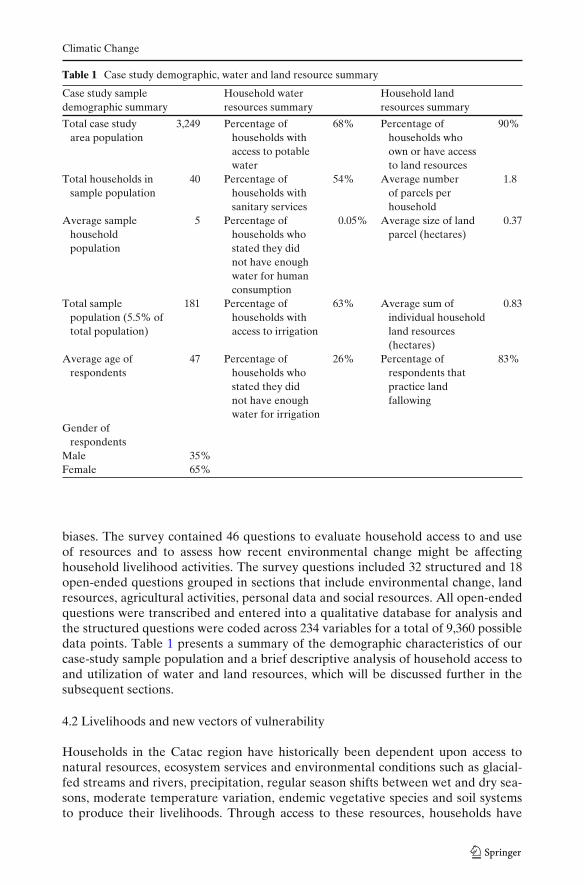
Table 1 Case study demographic, water and land resource summary
Case study sample Household water Household landdemographic summary resources summary resources summary
Total case study 3,249 Percentage of 68% Percentage of 90%area population households with households who
access to potable own or have accesswater to land resources
Total households in 40 Percentage of 54% Average number 1.8sample population households with of parcels per
sanitary services householdAverage sample 5 Percentage of 0.05% Average size of land 0.37
household households who parcel (hectares)population stated they did
not have enoughwater for humanconsumption
Total sample 181 Percentage of 63% Average sum of 0.83population (5.5% of households with individual householdtotal population) access to irrigation land resources
(hectares)Average age of 47 Percentage of 26% Percentage of 83%
respondents households who respondents thatstated they did practice landnot have enough fallowingwater for irrigation
Gender ofrespondents
Male 35%Female 65%
biases. The survey contained 46 questions to evaluate household access to and useof resources and to assess how recent environmental change might be affectinghousehold livelihood activities. The survey questions included 32 structured and 18open-ended questions grouped in sections that include environmental change, landresources, agricultural activities, personal data and social resources. All open-endedquestions were transcribed and entered into a qualitative database for analysis andthe structured questions were coded across 234 variables for a total of 9,360 possibledata points. Table 1 presents a summary of the demographic characteristics of ourcase-study sample population and a brief descriptive analysis of household access toand utilization of water and land resources, which will be discussed further in thesubsequent sections.
4.2 Livelihoods and new vectors of vulnerability
Households in the Catac region have historically been dependent upon access tonatural resources, ecosystem services and environmental conditions such as glacial-fed streams and rivers, precipitation, regular season shifts between wet and dry sea-sons, moderate temperature variation, endemic vegetative species and soil systemsto produce their livelihoods. Through access to these resources, households have

Climatic Change
predominantly pursued a mix of agricultural and pastoral activities, which are oftenvertically dispersed across altitudinal zones, spatially concentrated around access towater resources and embedded within complex networks of communal and privateland management practices. However, because most of the communal lands of Catacare located at elevations above 4,000 m, grasslands dominate the landscape as mostfood crops are difficult to cultivate. Consequently, while many households engage inagricultural activities, livestock production is the most important livelihood pursuitfor the majority of households. Cattle and sheep are the most important livestockfor households and the Campesino Community has pursued cattle improvementstrategies with some success as it has won many awards in regional livestock compe-titions. Households also engage in several other types of livelihood activities, whichoften depend on access to extra-communal political, economic and social networksin addition to natural resources. Table 2 summarizes the most prevalent livelihoodactivities in the case-study communities.
Though households pursue a variety of strategies in their livelihood activities,the cumulative results of their efforts are frequently insufficient to meet even basichousehold needs. Catac has some of the highest levels of household poverty inthe region due to the scarcity of agriculturally productive soils and poor climaticconditions linked to the high elevation of the region. Consequently, the livelihoodactivities that many households pursue are primarily directed towards survival andauto-consumption. This is a critical factor for any attempt to evaluate new vectors
Table 2 Major livelihood activities in Catac
Activity Prevalence Description and variety (% of respondents)(of total n)(%)
Livestock 85 Cattle (74%), sheep (71%), horses (47%),guinea pigs (35%) burros (18%) pigs (67%)
Agriculture 68 Tubers: potatoes—Solanum tuberosum (63%);oca—Oxalis tuberosa, olluco—Ullucus tuberosus (41%);mashua—Tropaeolum tuberosum (15%)
Grains: wheat—Triticum aestivum (52%);barley—Hordeum vulgare (44%);oats—Avena sativa (7%),quinua—Chenopodium quinoa (4%)
Beans—Vicia faba (15%)Tarwi—Lupinus mutabilis (4%)Corn—Zea mays (1%)
Agroforestry 68 Eucalyptus—Eucalyptus globulus (78%);uses—firewood, construction, wind break
Quenual—polylepis (33%);uses—firewood, construction, planting
Other: pine—Pinus radiata; Capuli—Prunus serotina,Colle—Buddleja coriacea
Commercial 45 Livestock, agricultural products, market, prepared foodManual labor 38 Temporary agricultural labor, carpentry, manufacturingTourism 25 Guiding, animal caretaker, burro rental, cook, boat rentalDairy products 15 Milk, cheeseArts/crafts 15 Hand spun fabrics, clothing, ceramics
Climatic Change
of vulnerability as households are already very marginalized which significantlyweakens their resilience and ability to adapt to rapid shifts in the natural resourcesupon which they depend for their livelihoods.
4.3 Emerging human vulnerabilities
The hydrology research presented in the previous section demonstrates throughan instrument-based analysis that glacial recession in the Cordillera Blanca hasincreased rapidly in the latter half of the twentieth Century and that it is currentlyaffecting the composition of water resources and seasonal glacial discharge rates. Weconducted a complementary social evaluation of the ways in which the people of theYanamarey watershed perceive these changes through their daily experiences andduring the recent past. Household perceptions of glacier recession in the region arevery strongly correlated with our instrument-based findings. Case-study respondentsindicated unanimously that significant glacier recession has taken place in the region.Interviewees consistently indicated that there is much less snow and ice in the upperwatersheds than in the past and that the glaciers are disintegrating continuously,often collapsing in the form of “giant blocks” (YS6 2008, Household interview,Yanamaray. 30 July 2008), and that the changes are, as one respondent indicated,“strong and obvious” (YS17 2008, Household interview, Yanamaray. 5 August 2008).
Household accounts also confirmed that the glaciers have been receding for atleast the past several decades. On average, interviewees noted that the glaciersbegan to recede very quickly around 15 years ago. Most responded that before thisperiod the “mountains were covered in snow” (YS15 2008, Household interview,Yanamaray. 5 August 2008), but since then it has been disappearing “year by year”(YS21 2008, Household interview, Yanamaray. 5 August 2008). Consequently, asone person suggested, the white peaks of the range are becoming “black” with barerock (YS13 2008, Household interview, Yanamaray. 31 July 2008). Several olderrespondents, who recall changes from the past 50 years, stated that glacier recessionin the region began early in their lives. These accounts by older respondents are par-ticularly salient as they cover a period of time before any instrumentation or satelliteswere in place and are thus the only observational record we are likely to establish.For example, one 50 year-old male respondent stated “when I was nine years oldthe quantity of ice was 100% today the snow has receded considerably, uncoveringrocks where ice existed before” (YS39 2008, Household interview, Yanamaray. 5August 2008). In addition households also indicated that the rate of glacier recessionin the watershed has increased substantially in the past few years. One respondentindicated, for example, “when it gets warm it [the snow] now disappears twice asfast” (YS27 2008, Household interview, Yanamaray. 5 August 2008).
That households are able to discuss these changes in great detail and over rela-tively long temporal scales of time is not surprising given the importance of glaciersin their lives. Household respondents confirmed that glaciers occupy a unique andimportant nexus of social and cultural meaning in the Andes and therefore theiractivities are closely monitored by people living beneath their expanses, similar tothe findings of other recent research (Bolin 2001; Cruikshank 2005; Orlove et al.2008). In addition, because glaciers dominate the most precipitous terrain in theregion, ablation events are often very loud and the sound of falling ice, rocks orsnow reverberates long distances through the high glaciated canyons. While glaciers

Climatic Change
in the Yanamarey watershed are not directly threatening to local human populations,the Cordillera Blanca’s history of devastating natural disasters linked to glacialrecession has clearly had an important psychological impact on residents throughoutthe region. Sudden rock and ice avalanches or many other types of hazards posegreat risks to a large percentage of the human population of the region and over thecourse of the past half century these events have had disastrous impacts on humanpopulations.5
Overall, household perceptions of glacial shifts in the region strongly confirm thatcurrent rates of glacier recession have been increasing. Interviewees also indicatedthat the rapid disappearance of many glaciers is deeply worrying. As one 55 yearold male interviewee stated, the cascading set of problems facing the region are“total deglaciation, irreversible warming, [and] negative changes for humanity”(YS23 2008, Household interview, Yanamaray. 5 August 2008). Overall, 91% ofrespondents indicated that they are deeply preoccupied by recent climate changetaking place in the region.6 Interviewees stated that they were very concerned aboutthe impacts of climate change on family and livestock health (44%), agriculturalproductivity (42%), water availability (25%) and fish stocks (8%).7 Respondents alsoindicated that many of these factors are already negatively affecting their lives. Forexample, more than 94% of interviewees from households engaged in agriculture,livestock production or tourism activities indicated that they have noted significantchanges in their activities due to recent climate change.8 These include shifts inwater availability and increasingly extreme variability in seasonal weather patterns,temperature and rainfall.
4.3.1 Shifting water variability
As described above, primary livelihood production strategies in the Yanamareyvalley are highly dependent on water resources, which are provided partly by glacialmelt during the dry season. While our instrumental analyses of hydrological shifts inthe region are still tentative (See Section 2), our case-study household respondentsstated very strongly that they are witnessing substantial shifts in water resources inthe watershed. A majority of interviewees indicated that, despite some inter-annualvariation, dry season water availability is in an overall state of decline and many
5Glacier hazards are a critically important factor affecting human vulnerability in the region. Thisresearch was not specifically directed towards evaluating the risks that the increasingly unstable andrapidly melting glaciers pose for inhabitants, though they were often discussed with interviewees.Since 1702, more than 22 catastrophic glacial-related disasters have occurred in the region resultingin the deaths of thousands of people and the destruction of entire urban centers including Huaraz.This includes one of the largest glacier-related disasters in recorded history. In 1970, an earthquakeprecipitated a huge avalanche down the face of Huascaran. The rock and ice buried the town ofYungay and approximately 23,000 people perished (Morales Arnao 1998). See Carey (2007, in press),Hegglin and Huggel (2008), Klimeš et al. (2009), Silverio and Jaquet (2003), and Vilímek et al. (2005)for more extensive discussions of glacier hazards in the region and the political economy of glacialhazards.6The confidence interval for this response is ±4.3% (95% level).7Respondents often mentioned more than one concern so the cumulative percentage is morethan 100.8The confidence interval for this response is ±3.66% (95% level).

Climatic Change
respondents stated that in recent years during the dry season they have experiencedwater shortages relative to the quantities available in the past.
Historically the glaciers of the region have generally offered human populationsa relatively abundant and regular supply of water.9 Case-study households utilizewater resources from several different watersheds based on their vertical location.The Yanamarey watershed supports hundreds of water users, though householdsbelow Lake Querococha also access water flowing from the Cotush and Queshquewatersheds. Nearly all of the case-study interviewees (93%) noted that over thecourse of the past decade (ranging from between 3 and 10 years) water supplies havebeen decreasing in these watersheds during the dry season.10 In addition, householdsalso reported significant drops in the dry-season levels of nearby lakes (includingQuerococha) and reduced water flows from many springs towards the final monthsof the dry season.
While households overwhelmingly indicated that water supplies are decliningthroughout the Catac region during the dry season, there still appears to be sufficientquantities of water for human consumptive needs (See Table 1). Nevertheless, inthe Yanamarey watershed and in the town of Catac, interviewees did indicate thataccess to these water resources is becoming increasingly difficult during the dryseason and that many of the smaller streams and seasonal springs have become moreintermittent than in the past. Additionally, in the town of Catac, recent urban growthhas been placing increasing pressure on the water system that is managed by themunicipality. Municipal authorities are seeking to expand the water delivery system,which is likely to put even more pressure on water supplies throughout the regionduring the dry season.
The reported decline of water resources during the dry season has had the mostsignificant impacts on agricultural and livestock activities. As Table 1 illustrates,a majority of households depend on seasonal irrigation to cultivate agriculturalproducts on small parcels of land. A number of interviewees reported that canalwater levels have been dropping steadily over the past few years and it has becomeincreasingly difficult to access enough water to maintain crop production levels. Inand around the municipality of Catac, access to irrigation water during the dry seasonhas become an acute problem. Because it is widely recognized that water supplieshave been decreasing, the municipality recently instituted a water rationing systemthat has nearly eliminated most agricultural production during the dry season.
Declining water resources during the dry season have also negatively affectedlivestock production. In the upper Yanamarey watershed, which is controlled by theCampesino Community, only 15 user groups (monadas) are granted grazing accessto the zone per year and grazing activities are monitored by community authorities.Despite community management efforts to curtail overgrazing and pasture degra-dation, households and community watershed managers indicated that the seasonal
9Water resources have never been shared equally as control of water resources and water governancehaw always been a key source of contention and struggle in the region. Furthermore, water resourcesare not distributed evenly throughout the region. The Cordillera Negra, for example, which formsthe western half of the Callejon de Huaylas drainage has very few sources of water.10The confidence interval for this response is ±3.61 (95%) level. In addition to noting significantdecreases in the flow of water, 85% of households indicated that overall there was less water, while13% noted there had been no significant changes and only 2% noted that there are actually morewater resources. The confidence interval for this response is ±5.06 (95%).
Climatic Change
decline of stream and spring flows have negatively affected pasture health and grassproductivity. In addition, because some smaller streams have recently begun todisappear during certain periods of the year, access to sufficient water for livestocknow requires more frequent and greater daily vertical movement of animals, whichhas increased the intensity of herding and negatively affected livestock growth rates.Finally, respondents along the length of the watershed indicated that fish stocks haveeither declined precipitously or have completely disappeared in many streams. Thisis possibly due, in part, to seasonal reductions of fish habitat in the upper watershed.
Overall, new stress on water resources from irrigation, livestock production andhuman consumption are escalating not only within the Catac region, but also alongthe entire drainage system below the town of Catac. In 2008, the Peruvian NationalSoil and Water Conservation Agency (PRONOMACH) began to construct newdownstream water diversions from Lake Querococha in response to new water rightsclaims by several downstream communities. Several case study respondents indicatedthat conflicts within the community and around the region over access to irrigationwater have been increasing and that they expect them to become more prevalent aswater resources continue to decline. These conflicts are likely to be exacerbated evenfurther by growing urban water demand in Huaraz and other urban centers.
4.3.2 Increasing weather extremes
Recent research demonstrates that climate change is shifting average temperaturesupwards throughout the tropical Andes and that these alterations will be enhancedat the highest elevations by the end of this century (Bradley et al. 2004, 2009; Urrutiaand Vuille 2009; Vuille and Bradley 2000). A number of climatic shifts are alsotaking place across the Amazon Basin, which is the primary source of most of therainfall in the Cordillera Blanca during non-El Niño years (Avissar and Werth 2005;Betts et al. 2008; Cox et al. 2008). While this research informs our understanding ofthese processes at a broad scale of analysis for the region, it is not always useful forevaluating shifts at more local and human scales of analysis. In the Cordillera Blanca,even regional-based research efforts are complicated by the fact that meteorologicaldata for the region are temporally and spatially sporadic and that climatic conditionsare highly diverse across the rugged topography of the entire mountain range.11
Even less research has engaged with local populations to evaluate their under-standing of the ways in which meteorological transformations might be affectinglivelihoods and human capabilities (though see Rhoades et al. 2006). Because shiftsin precipitation and temperature are often very short-term in nature and specific tocertain places, human perceptions of these changes are frequently very difficult todeduce from regional models, in situ instrumentation or remotely sensed data. Inthe Andes, human perception of meteorological events are also dependent on a hostof factors such as coincidental co-location, temporal factors such as time of day andseason, clothing, shelter, human sensory perception and cultural factors (Orlove et al.2008; Strauss and Orlove 2003). Despite these limiting factors, 95% of our case-studyrespondents responded that significant and often extreme shifts in temperature vari-ation, precipitation patterns and seasonal change have been occurring with greater
11Recent research addressing meteorological shifts in the Andes include (Aguilar et al. 2005; Diazet al. 2003; Quintana-Gomez 1999; Vincent et al. 2005).

Climatic Change
frequency and intensity across the region.12 Many of these factors are interactingin complex and nonlinear ways with the more gradual hydrological and ecologicalchanges discussed in previous sections such that they often intensify vulnerabilityand risk factors for livelihoods and are often the most critical issues for extremelymarginal natural resource based livelihoods.
In the Yanamarey area, the largest impacts of increasing climatic extremes arefalling upon the most susceptible households that lack adequate shelter and clothing.In the town of Catac, housing structures are often built with cement floors, tin ortile roofs, single pane windows and cement or adobe walls. In rural areas, structuresmore frequently have earthen floors, adobe or natural rock walls and either tinor grass roofing. Internal heating is virtually nonexistent throughout the regionand households often cook with firewood or manure. Clothing often consists ofhandspun woolen ponchos and footwear may be little more than sandals fashionedfrom recycled tires (llanquis). Interviewees in both areas repeatedly noted thatcold spells and freezes have increased in frequency at night which is leading to anincrease in respiratory illnesses, particularly during the rainy season. As severalinterviewees noted, freezes are now accompanied by “cold until the bones hurt”(YS27 2008, Household interview, Yanamaray. 5 August 2008) and intense stormsnow descend upon the community that bring with them “gusts that are not in theirseason, that are strong blows to the health, and that come with sickness” (YS29 2008,Household interview, Yanamaray. 31 July 2008). Many households also noted thatcolder temperatures in the pre-dawn hours increasingly limit their ability to herdlivestock long distances as the extreme cold prevents them from leaving their sheltersuntil after sunrise.
Weather extremes are also significantly affecting agricultural production in thecommunity. Respondents indicated that periods of intense heat and sunlight aredrying out the grasslands and crops. These events are often punctuated by intenseconvective precipitation events, powerful winds and hail that damage crops. Inter-viewees also indicated that the frequency and intensity of low temperature frostshave increased during both the rainy and dry seasons, which regularly damages cropsas well. Of the households that reported some form of agricultural activity, 91%reported that recent freezes have affected their crops, which include wheat, corn andpotatoes. Households also indicated that rainfall patterns have shifted significantlyand that it is raining more frequently during the dry season and less consistentlyduring the traditional rainy season. Interviewees stated that these precipitation shiftshave confused the traditional agricultural calendar and that they are increasinglyuncertain when to plant or harvest their crops. These shifting seasonal patterns havealso come with great risk to household food security as interviewees reported ahigher frequency of failed or damaged crops in recent years relative to the past.
Livestock production has also been affected both directly and indirectly byincreasing weather extremes, which was widely noted by households. Respondentsindicated that increases in frost events have weakened livestock and increased thefrequency and severity of animal disease. Households also noted that the grassesin grazing areas are increasingly stunted in growth or prematurely dry, changeswhich were attributed to less regularity in rainfall patterns, more frequent and severe
12The confidence interval for this response is ±3.61 (95% level).
Climatic Change
frosts, more intense solar radiation, as well as increasing grazing pressure in someareas. Respondents reported that a lack of high quality fodder was contributingto low weight gain in their livestock and to increasing susceptibility to disease.Finally, households also noted that new animal diseases have appeared in the region.While this research was not able to confidently evaluate the relationship betweenanimal diseases and shifting climatic variables, a wide variety of animal diseaseswere inventoried which include anthrax, liver flukes and other parasites, respiratorydiseases, insect infestations, and a variety of infections.
4.3.3 Threats to tourism
Glacier recession also poses serious threats to tourism activities in the region as theCordillera Blanca is a well known global tourist destination for climbers, backpackersand other outdoor adventurers. Several locations are also visited frequently byPeruvian tourists from Lima as part of school trips and during holiday periods.Tourist destinations in Catac are concentrated in a few locations that include LakeQuerococha, which is on the route to the pre-Incan archaeological site of Chavin,and the Pastoruri glacier. Pastoruri is one of the most accessible glaciers in theentire range and hosts a number of rare endemic plant species such as the Puyaraimondii. Tourism visits to the region have increased significantly over the pastdecade. Between 1997 and 2006, tourist visits to the highlands of the Departmentof Ancash increased 57%. In 2006, Pastoruri was the second most visited location inHuascaran National Park and, according to park records, 42,404 people visited thearea (INEI 2006). These flows of tourists are critical sources of income for residentsin the Catac region. As Table 2 indicates, 25% of surveyed households are engaged insome form of tourism-based activity, which includes the production of arts and crafts,animal rentals, guide services and food and refreshment preparation at both touristsites and along the main thoroughfare of town, where busloads of tourists often stopto dine.
Over the course of the past few years, households have been affected by a numberof climate-change induced shocks to tourism. In late 2007, the Pastoruri glacierbecame the first tourism destination in Peru to be closed due to “adverse climaticconditions” The glaciological office in Huaraz announced that the glacier was rapidlydisappearing due both to the impacts of too many people degrading its surface andclimate change (INRENA 2008). The closure of the glacier had profound negativeconsequences for the residents of Catac which resulted in a number of heatedconflicts, protests and road blockades by the Campesino Community. After tenseand protracted negotiations, the creation of new visitor guidelines, the prohibition ofany further glacier crossings and the rerouting of a trail to the base of the glacier, thearea was re-opened to tourists. However, the glaciological office estimates that thesemeasures are only temporary as the glacier will still disappear by 2015 as a resultof rapidly increasing temperatures (Flores 2008). Tourism throughout the range issimilarly threatened by glacier recession, particularly because many of the popularclimbing routes are becoming more dangerous as icefalls and avalanches are increas-ing in frequency. Overall, aside from the occasional sales of animals, tourism is oneof the most important sources of cash income for many of the case-study households.As such it represents a particularly important livelihood activity as households havefew opportunities to generate critically important financial resources to purchasedurable goods, housing materials, clothing and other vital materials. Consequently,
Climatic Change
the threats that glacier recession pose to tourism, and the manner in which they mightbe managed, have intensified conflicts between conservationists, park managers andcommunity members seeking different solutions and are likely to be a source ofcontinuous contention in the future.
5 Conclusions
As the previous sections suggest, recent glacier recession and shifts in climate in theCordillera Blanca have been increasing the vulnerability of household livelihoods inthe Yanamarey watershed through threats to tourism related activities, the occur-rence of extreme weather events and increasingly variable access to water resources.While these particular vectors are most salient for households and communities in thewatershed, further comparative research will enable a more comprehensive evalua-tion of how households situated across different elevation gradients and productionnetworks along the entire mountain range are being affected. However, these are notthe only factors driving social and environmental change. Consequently, they mustalso be understood to be historically contingent on and mutually constitutive withbroader social and environmental processes. This includes the historical legacy ofexploitation and inequality that has fostered the very high extreme poverty rates forthe region, new economic growth in the mining and tourism sector and the presenceof a host of other actors throughout the country and downstream that are alsobeing affected by these changes, which include very powerful urban, hydroelectricand export-led agricultural interests. In addition, as debates over the current andfuture distribution and management of these water resources begin to intensify, thepotential for conflicts between these actors will also increase significantly. Finally,while this research focuses on new forms of household livelihood vulnerability in theCordillera Blanca, we have not yet evaluated the potential capabilities of householdsto adapt to these changes or how household activities might already be changing.This is particularly important for future development efforts that might supportadaptation and capacity building activities in the region and something that we willaddress in future work.13
Our case study also provides an important example of the scale-dependent com-plexity of climate–environmental impacts on tropical glacier-hydrology that is botha problem and opportunity for integrated research. Detailed glacier-specific Andeanresearch has shown that while temperature may correlate regionally with overallglacier recession, the tropical glacier surface energy budget is not predominantlyresponsive to sensible heat (Vuille et al. 2008b). Other variables like humidityand precipitation play critical roles in moderating the local radiation balance thatdominates mass balance. Likewise, while the mass changes to the Yanamarey glacierhave shown sensitivity to climate consistent with “enhanced greenhouse” forcing
13During the summer of 2009 the authors participated in a multi-disciplinary conference withresearchers, policy makers and civil society organizations focused on human adaptation to glacierrecession in the region. This event, “Adapting to a World without Glaciers” received support froma variety of organizations including the The Mountain Institute, the National Science Foundation,USAID and several Peruvian institutions (Recharte et al. 2009). A number of research goals and alarger USAID funded project have emerged from these activities.

Climatic Change
related to anthropogenic warming, our dataset does not have long enough continuousrecords to permit meaningful trend analyses or explore other relationships withprecipitation. For example, an earlier analysis has shown a positive correlationbetween annual temperature and precipitation anomalies at YAN (Mark 2006).Mean monthly temperature traces a statistically significant decreasing trend over thepast 5 years while glacier recession has reached maximum rates, yet this record is tooshort to include ENSO events that have been demonstrated to impact glacier massbalance and precipitation inconsistently in this region (Francou et al. 1995; Vuilleet al. 2008a). In addition, currently measurements do not have adequate resolutionto document the relative magnitude of the specific extreme weather events that arereported to impact livelihoods, which is also one of the major limitations of mostclimate change modeling efforts and why coupled analyses of human–environmentdynamics that include spatially distributed social analyses as well as hydroclimaticmeasurements and monitoring are critically important for future policy and scientificresearch. We recently designed new methodological tools to begin to address thesemonitoring and measurement concerns as they constitute a key bridging factor forhuman-relevant climate modeling change research in the future.
Acknowledgements This research was supported by a National Geographic Explorer Grant anda Collaborative NSF Geography and Spatial Sciences Grant (BCS 0752175). Additional supportfor the research was provided by NASA and The University of California, Santa Cruz, FacultySenate. The authors would like to thank the anonymous reviewers for their efforts, the staff of Peru’sGlaciological Office in Huaraz, the community of Catac, and our Peruvian field research team.
Open Access This article is distributed under the terms of the Creative Commons AttributionNoncommercial License which permits any noncommercial use, distribution, and reproduction inany medium, provided the original author(s) and source are credited.
References
Adger W (2006) Vulnerability. Glob Environ Change 16:268–281Aguilar E, Peterson TC, Ramírez Obando P, Frutos R, Retana JA, Solera M, Soley J, Gonzalez
Garcia I, Araujo RM, Rosa Santos A (2005) Changes in precipitation and temperature extremesin Central America and northern South America, 1961–2003. J Geophys Res 110:D23107
Alcamo J, Dronin N, Endejan M, Golubev G, Kirilenko A (2007) A new assessment of climatechange impacts on food production shortfalls and water availability in Russia. Glob EnvironChange 17:429–444
Ames A (1998) A documentation of glacier tongue variations and lake developments in theCordillera Blanca. Z Gletsch kd Glazialgeol 34:1–26
Ames A, Dolores S, Valverde A, Evangelista P, Javier D, Gavnini W, Zuniga J, Gómez V (1989)Glacier inventory of Peru, part 1. Hidrandina, SA, Huaraz, p 105
Avissar R, Werth D (2005) Global hydroclimatological teleconnections resulting from tropicaldeforestation. J Hydrometeorol 6:134–145
Baraer M, McKenzie JM, Mark B, Bury J (2008) Climate change related evolution of water resourcesin the Cordillera Blanca, Peru. The Andes: challenge for the geosciences. In: EGU topicalconference series, 4th Alexander von Humboldt international conference, Santiago, Chile
Baraer M, McKenzie JM, Mark BG, Bury J, Knox S (2009) Characterizing contributions of glaciermelt and ground water during the dry season in the Cordillera Blanca, Peru. Adv Geosci 22:41–49
Barnett TP, Adam JC, Lettenmaier DP (2005) Potential impacts of a warming climate on wateravailability in snow-dominated regions. Nature 438:303–309
Barry RG, Seimon A (2000) Research for mountain area development: climatic fluctuations in themountains of the Americas and their significance. Ambio 29:364–370
BCRP (2009) Economic synthesis for Ancash, January 2009. Central Bank of Peru, Lima
Climatic Change
Bebbington AJ, Bury JT (2009) Institutional challenges for mining and sustainability in Peru. ProcNatl Acad Sci U S A 106(41):17296–17301
Betts RA, Malhi Y, Roberts JT (2008) Review. The future of the Amazon: new perspectives fromclimate, ecosystem and social sciences. Philos Trans R Soc Biol Sci 363:1729–1735
Blaikie P (1994) At risk: natural hazards, people’s vulnerability, and disasters. Routledge, LondonBohle H, Downing T, Watts M (1994) Climate change and social vulnerability. Toward a sociology
and geography of food insecurity. Glob Environ Change 4:37–48Bolin I (2001) When Apus are losing their white ponchos environmental dilemmas and restoration
efforts in Peru. Dev Coop 6:25–26Bradley RS, Keimig FT, Diaz HF (2004) Projected temperature changes along the American
cordillera and the planned GCOS network. Geophys Res Lett 31:L16210Bradley RS, Vuille M, Diaz HF, Vergara W (2006) Climate change: threats to water supplies in the
tropical Andes. Science 312:1755–1756Bradley RS, Keimig FT, Diaz HF, Hardy DR (2009) Recent changes in freezing level heights in the
Tropics with implications for the deglacierization of high mountain regions. Geophys Res Lett36:L17701
Brecher HH, Thompson LG (1993) Measurement of the retreat of Qori Kalis glacier in the tropicalAndes of Peru by terrestrial photogrammetry. Photogramm Eng Remote Sensing 59:1017–1022
Brooks N, Adger WN (2003) Country level risk measures of climate-related natural disasters andimplications for adaptation to climate change. Working paper 26, Tyndall Center for ClimateChange Research
Burton I, White G, Kates R (1978) The environment as hazard. Oxford University Press, New YorkBury J (2005) Mining mountains: neoliberalism, land tenure, livelihoods, and the new Peruvian
mining industry in Cajamarca. Environ Plann A 37:221–239Carey M (2005) Living and dying with glaciers: people’s historical vulnerability to avalanches and
outburst floods in Peru. Glob Planet Change 47:122–134Carey M (2007) The history of ice: how glaciers became an endangered species. Environ Hist 12:497Carey M (2010) In the shadow of melting glaciers: climate change and Andean Society. Oxford
University Press, New YorkCasassa G, Espizua LE, Francou B, Ribstein P, Ames A, Alean J (1998) Glaciers in South America.
Stud Rep Hydrol 56:125–146CCC (2006) Biodiversity conservation plan for the Campesino community of Catac–Huascaran
National Park. Campesino Community of Catac, CatacCEPES (1996) Agrarian law and Campesino communities. Center for Peruvian Social Studies, LimaClark W, Parson E, Research, Project ASfS, Science BCf, Affairs I, Environment, Program NR
(2000) Assessing vulnerability to global environmental risks. Belfer Center for Science andInternational Affairs, John F Kennedy School of Government, Harvard University, Cambridge
CONAM (2001) National communication of Peru to the United Nations climate change convention.National Council on the Environment, Lima
Cox PM, Harris PP, Huntingford C, Betts RA, Collins M, Jones CD, Jupp TE, Marengo JA,Nobre CA (2008) Increasing risk of Amazonian drought due to decreasing aerosol pollution.Nature 453:212–215
Cruikshank J (2005) Do glaciers listen?: local knowledge, colonial encounters, and social imagina-tion. Univ of British Columbia Press, Vancouver
Cutter S (1996) Vulnerability to environmental hazards. Prog Hum Geogr 20:529–539Cutter S (2003) The vulnerability of science and the science of vulnerability. Ann Assoc Am Geogr
93:1–12Del Castillo L (2005) Campesino communities in the 21st century: status and normative changes.
Center for Peruvian Social Studies, LimaDiaz HF, Eischeid JK, Duncan C, Bradley RS (2003) Variability of freezing levels, melting season
indicators, and snow cover for selected high-elevation and continental regions in the last 50 years.Clim Change 59:33–52
Dillehay T, Kolata A (2004) Long-term human response to uncertain environmental conditions inthe Andes. Proc Natl Acad Sci 101:4325–4330
Dyurgerov M (2003) Mountain and subpolar glaciers show an increase in sensitivity to climatewarming and intensification of the water cycle. J Hydrol 282:164–176
Eakin HC (2006) Weathering risk in rural Mexico: climatic, institutional, and economic change. Univof Arizona Press, Tucson
Eakin H, Luers AL (2006) Assessing the vulnerability of social–environmental systems. Annu RevEnviron Resour 31:365–394

Climatic Change
Eakin HC, Wehbe MB (2009) Linking local vulnerability to system sustainability in a resilienceframework: two cases from Latin America. Clim Change 93:355–377
Fagre DB, Peterson DL, Hessl AE (2003) Taking the pulse of mountains: ecosystem responses toclimatic variability. Clim Change 59:263–282
Flores AC (2008) Impacts, vulnerability, mitigation and adaptation to the effects of climate changeon water resources. National Institute of Natural Resources, Huaraz
Francou B, Coudrain A (2005) Glacier shrinkage and water resources in the Andes. EOS Trans AmGeophys Union 86:415
Francou B, Ribstein P, Semiond H, Portocarrero C, Rodriguez A (1995) Balances de glaciares yclima en Bolivia y Peru: impacto de los eventos ENSO. Bull Inst Fr Etudes Andines 24:661–670
Füssel H (2007) Vulnerability: a generally applicable conceptual framework for climate changeresearch. Glob Environ Change 17:155–167
Georges C (2004) The 20th century glacier fluctuations in the tropcial Cordillera Blanca, Peru. ArctAntarct Alp Res 36:100–107
Hastenrath S, Ames A (1995a) Diagnosing the imbalance of Yanamarey Glacier in the CordilleraBlanca of Peru. J Geophys Res 100:5105–5112
Hastenrath S, Ames A (1995b) Recession of Yanamarey glacier in Cordillera Blanca, Peru, duringthe 20th century. J Glaciol 41:191–196
Hegglin E, Huggel C (2008) An integrated assessment of vulnerability to glacial hazards. Mt ResDev 28:299–309
Hewitt K (1983) Interpretations of calamity. Allen & Unwin, BostonIARU (2009) Rising sea levels set to have major impacts around the world. In: Conference on climate
change: global risks, challenges and decisions, 10–12 March, International Alliance of ResearchUniversities, University of Copenhagen, Copenhagen
INEI (2006) Ancash statistical compendium. National Institute of Statistics and Information, LimaINEI (2007) The 2007 national census: XI of population and VI of houses. Institute of National
Statistics and Information, LimaINRENA (2008) INRENA closes pastoruri peak due to adverse climatic conditions. Peruvian Insti-
tute of Natural Resources, LimaIPCC (2007a) Climate change 2007: the physical science basis. Intergovernmental Panel on Climate
Change, GenevaIPCC (2007b) Impacts, adaptation and vulnerability. Working group II contribution to the fourth
assessment report of the IPCC. Cambridge University Press, CambridgeJuen I, Kaser G, Georges C (2007) Modelling observed and future runoff from a glacierized tropical
catchment (Cordillera Blanca, Peru). Glob Planet Change 59:37–48Kaser G (1999) A review of the modem fluctuations of tropical glaciers. Glob Planet Change 22:93–
103Kaser G, Osmaston H (2002) Tropical glaciers. Cambridge University Press, CambridgeKaser G, Ames A, Zamora M (1990) Glacier fluctuations and climate in the Cordillera Blanca, Peru.
Ann Glaciol 14:136–140Kaser G, Juen I, Georges C, Gómez J, Tamayo W (2003) The impact of glaciers on the runoff and the
reconstruction of mass balance history from hydrological data in the tropical Cordillera Blanca,Peru. J Hydrol 282:130–144
King G, Keohane R, Verba S (1994) Designing social inquiry. Princeton University Press, PrincetonKinzl H (1942) Gletscherkundliche Begleitworte zur Karte der Cordillera Blanca (Peru). Z Glestch
28:1–19Kinzl H, Ebster F, Gotthardt E, Heckler K, Schneider E (1964) Begleitworte zur Karte 1:100.000 der
Cordillera Blanca (Peru) Sudteil. Wissenschaft Alpenvereinshefte, 17 edn. UniversitätsverlagWagner, Innsbruck
Klimeš J, Vilímek V, Omelka M (2009) Implications of geomorphological research for recent andprehistoric avalanches and related hazards at Huascaran, Peru. Nat Hazards 50:193–209
Kundzewicz Z, Mata L, Arnell N, Döll P, Jimenez B, Miller K, Oki T, Sen Z, Shiklomanov I (2008)The implications of projected climate change for freshwater resources and their management.Hydrol Sci J 53:3–10
Leichenko RM, O’Brien K (2008) Environmental change and globalization: double exposures.Oxford University Press, USA
Liverman D (1990) Drought impacts in Mexico: climate, agriculture, technology, and land tenure inSonora and Puebla. Ann Assoc Am Geogr 80:49–72
Climatic Change
Magrin G, Gay C, Cruz D, Giménez J, Moreno A, Nagy G, Nobre C, Villamizar A (2007) LatinAmerica, climate change 2007: impacts, adaptation and vulnerability. Contribution of workinggroup II to the Fourth Assessment Report of the IPCC, pp 581–615
Mark BG (2002) Hot ice: glaciers in the tropics are making the press. Hydrol Process 16:3297–3302Mark BG (2006) Quantifying the significance of recent glacier recession in the Cordillera Blanca,
Perú: a case study of hydrological impact and climatic control. In: Knight P (ed) Glacier scienceand environmental change. Blackwell, Oxford, pp 242–245
Mark BG, Seltzer GO (2003) Tropical glacier meltwater contribution to stream discharge: a casestudy in the Cordillera Blanca, Peru. J Glaciol 49:271–281
Mark BG, Seltzer GO (2005) Evaluation of recent glacier recession in the Cordillera Blanca,Peru (AD 1962–1999): spatial distribution of mass loss and climatic forcing. Quat Sci Rev24:2265–2280
Mark BG, McKenzie JM, Gómez J (2005) Hydrochemical evaluation of changing glacier meltwatercontribution to stream discharge: Callejon de Huaylas, Peru. Hydrol Sci J 50:975–987
Mark BG, Bury J, French A, McKenzie J, Baraer M, Huh K (2010) Climate change and tropicalAndean glacier recession: evaluating hydrologic changes and livelihood vulnerability in theCordillera Blanca, Peru. Ann Assoc Am Geogr (in press)
MEM (2008) Electrical statistics 2008. Ministry of Energy and Mines, LimaMesserli B (2001) The International Year of the Mountains (IYM), the Mountain Research Initiative
(MRI) and PAGES, editorial. PAGES News 9:2Milner AM, Brown LE, Hannah DM (2009) Hydroecological response of river systems to shrinking
glaciers. Hydrol Process 23:62–77Morales Arnao B (1998) Glaciers of South America–glaciers of Peru. In: Williams RS, Ferrigno JG
(eds) Satellite image atlas of glaciers of the world, 1386 edn. United States Government PrintingOffice, Washington
Morales Arnao B, Hastenrath S (1998) Glaciers of South America–glaciers of Peru. In: WilliamsRS, Ferrigno JG (eds) Satellite image atlas of glaciers of the world, 1386 edn. United StatesGovernment Printing Office, Washington
Morton JF (2007) The impact of climate change on smallholder and subsistence agriculture. ProcNatl Acad Sci U S A 104:19680–19685
Nogues-Bravo D, Araujo MB, Errea MP, Martinez-Rica JP (2007) Exposure of global mountainsystems to climate warming during the 21st century. Glob Environ Change 17:420–428
Orlove B (2009) Glacier retreat: reviewing the limits of human adaptation to climate change.Environment 51:22–34
Orlove B, Wiegandt E, Luckman BH (2008) Darkening peaks: glacier retreat, science, and society.Univ of California Press, Berkeley
Painter J (2007) Deglaciation in the Andean Region. United Nations Development Programme,New York
Pearsall DM (2008) Plant domestication and the shift to agriculture in the Andes. In: Silverman H,Isbell WH (eds) The handbook of South American Archaeology. Springer, New York, pp 105–120
Peet R, Watts M (2004) Liberation ecologies: environment, development, social movements. Rout-ledge, London
PETT (2002) Special land titling and rural cadastral project (PETT). Ministry of Agriculture, LimaPolsky C, Neff R, Yarnal B (2007) Building comparable global change vulnerability assessments: the
vulnerability scoping diagram. Glob Environ Change 17:472–485Pozorski S, Pozorski T (2008) Early cultural complexity on the coast of Peru. In: Silverman H, Isbell
WH (eds) The handbook of South American Archaeology. Springer, New York, pp 607–631Pulgar Vidal J (1981) Geografía del Perú. Las ocho regiones naturales del Perú. 8va. edición.
Editorial Universo, LimaQuintana-Gomez RA (1999) Trends of maximum and minimum temperatures in northern South
America. J Climate 12:2104–2112Racoviteanu A, Arnaud Y, Williams M (2008) Decadal changes in glacier parameters in Cordillera
Blanca, Peru derived from remote sensing. J Glaciol 54:499–510Recharte J, Zapata F, Postigo J, Avellaneda L, Tarazona J (2009) Adapting to a world without
glaciers. The Mountain Institute, LimaRhoades RE, Rfos XZ, Aragundy J (2006) Climate change in Cotacachi. In: Rhoades R (ed) De-
velopment with identity: community, culture and sustainability in the Andes. CABI, Cambridge,pp 64–74
Climatic Change
Rosenzweig C, Strzepek KM, Major DC, Iglesias A, Yates DN, McCluskey A, Hillel D (2004) Waterresources for agriculture in a changing climate: international case studies. Glob Environ ChangePart A 14:345–360
Silverio W, Jaquet JM (2003) Mapping by remote sensing of glacier-induced natural hazards,Cordillera Blanca, Peru. Arch Sci 56:39–58
Stewart I (2009) Changes in snowpack and snowmelt runoff for key mountain regions. HydrolProcess 23:78–94
Strauss S, Orlove BS (2003) Weather, climate, culture. Berg, New YorkThomalla F, Downing T, Spanger-Siegfried E, Han G, Rockstrom J (2006) Reducing hazard vul-
nerability: towards a common approach between disaster risk reduction and climate adaptation.Disasters 30:39–48
Thompson LG (2000) Ice core evidence for climate change in the Tropics: implications for our future.Quat Sci Rev 19:19–35
Thompson LG, Brecher HH, Mosley-Thompson E, Hardy DR, Mark BG (2009) Glacier loss onKilimanjaro continues unabated. Proc Natl Acad Sci U S A 106:19770–19775
Thompson LG, Mosley-Thompson E, Brecher H, Davis M, León B, Les D, Lin PN, Mashiotta T,Mountain K (2006) Abrupt tropical climate change: past and present. Proc Natl Acad Sci U S A103:10536
Turner B, Robbins P (2008) Land-change science and political ecology: similarities, differences, andimplications for sustainability science. Annu Rev Environ Resour 33:295–316
Turner B, Kasperson R, Matson P, McCarthy J, Corell R, Christensen L, Eckley N, Kasperson J,Luers A, Martello M (2003) A framework for vulnerability analysis in sustainability science.Proc Natl Acad Sci U S A 100:8074–8079
UNDP (2007) Fighting climate change: human solidarity in a divided world. United Nations Devel-opment Program, New York
Urrutia R, Vuille M (2009) Climate change projections for the tropical Andes using a regional climatemodel: temperature and precipitation simulations for the end of the 21st century. J Geophys Res114:D02108
USAID (2007) Adapting to climate variability and change. USAID, Washington, DCVergara W (2009) Assessing the potential consequences of climate destablization in Peru. The World
Bank, Latin American and the Caribbean Region, LCSSD, Washington, DCVilímek V, Zapata M, Klimeš J, Patzelt Z, Santillán N (2005) Influence of glacial retreat on natural
hazards of the Palcacocha Lake area, Peru. Landslides 2:107–115Vincent LA, Peterson TC, Barros VR, Marino MB, Rusticucci M, Carrasco G, Ramirez E, Alves
LM, Ambrizzi T, Berlato MA (2005) Observed trends in indices of daily temperature extremesin South America 1960–2000. J Climate 18:5011–5023
Viviroli D, Durr HH, Messerli B, Meybeck M, Weingartner R (2007) Mountains of the world, watertowers for humanity: typology, mapping, and global significance. Water Resour Res 43:13
Vuille M, Bradley RS (2000) Mean annual temperature trends and their vertical structure in thetropical Andes. Geophys Res Lett 27:3885–3888
Vuille M, Kaser G, Juen I (2008a) Glacier mass balance variability in the Cordillera Blanca, Peruand its relationship with climate and the large-scale circulation. Glob Planet Change 62:14–28
Vuille M, Francou B, Wagnon P, Juen I, Kaser G, Mark BG, Bradley RS (2008b) Climate changeand tropical Andean glaciers: past, present and future. Earth-Sci Rev 89:79–96
White G (1973) Natural hazards research. In: Chorley RJ (ed) Directions in geography. Methuen,London
Wisner B, Blaikie PM, Cannon T (2004) At risk: natural hazards, people’s vulnerability and disasters.Routledge, London
WMO (2009) The state of polar research: a statement from the international council for sci-ence/WMO for the International Polar Year 2007/2008. WMO, Geneva
WorldBank (2008) Development and climate change: a strategic framework for the World BankGroup. World Bank, Washington, DC
Xu J, Grumbine R, Shrestha A, Eriksson M, Yang X, Wang Y, Wilkes A (2009) The meltingHimalayas: cascading effects of climate change on water, biodiversity, and livelihoods. ConservBiol 23:520–530
Young KR (2009) Andean land use and biodiversity: humanized landscapes in a time of change. AnnMo Bot Gard 96:492–507
Young K, Lipton J (2006) Adaptive governance and climate change in the tropical highlands ofwestern South America. Clim Change 78:63–102
![Randolph Glacier Inventory: A Dataset of Global Glacier ... · Zheltyhina. 2012, Randolph Glacier Inventory [v2.0]: A Dataset of Global Glacier Outlines. Global Land Ice Measurements](https://static.fdocuments.net/doc/165x107/5f1037d37e708231d448062a/randolph-glacier-inventory-a-dataset-of-global-glacier-zheltyhina-2012-randolph.jpg)


![MOTION OF CAMPBELL GLACIER, EAST ANTARCTICA, …sar.kangwon.ac.kr/paper/apsar2011_hyangsun.pdf · REFERENCES [1] R. Rignot, “Fast recession of a west Antarctic glacier,” Science,](https://static.fdocuments.net/doc/165x107/5f58271199d289673e43b803/motion-of-campbell-glacier-east-antarctica-sar-references-1-r-rignot-aoefast.jpg)