
GIS STRATEGIC PLAN - Federal Geographic Data … Strategic Plan ... Geographic Information Systems...
33
GIS STRATEGIC PLAN Approved by the Arizona Geographic Information Council Date Approved: 25 February 2010
Transcript of GIS STRATEGIC PLAN - Federal Geographic Data … Strategic Plan ... Geographic Information Systems...
GIS STRATEGIC PLAN
Approved by the Arizona Geographic Information Council
Date Approved: 25 February 2010

Arizona Geographic Information Council (AGIC) Strategic and Business Planning Project
This page intentionally left blank.
Contract # LAND-2009-808 Applied Geographics, Inc.
ii
Arizona Geographic Information Council (AGIC) Strategic and Business Planning Project
Advancing Statewide Spatial Data Infrastructure in Arizona
GIS Strategic Plan
With Input from Stakeholders in the Arizona Geospatial Community
Produced for the Arizona Geographic Information Council (AGIC) with funding assistance from the Federal Geographic Data Committee’s (FGDC) Cooperative
Agreements Program (CAP), Category 3: Fifty States Initiative
Contract Number: LAND-2009-808
Prime Contractor:
Subcontractor:
Contract # LAND-2009-808 Applied Geographics, Inc.
iii
Arizona Geographic Information Council (AGIC) Strategic and Business Planning Project
Foreword The Strategic and Business Planning Process was initiated by the Arizona Geographic Information Council (AGIC) to promote innovative thinking and discussion on solutions that meet the geospatial requirements and needs of Arizona. The planning process set out to help define the organizational structure and business model that helps meet those needs, and for this purpose, relied heavily on outreach to the geospatial community in Arizona. It also set out to identify how an Arizona Geospatial Clearinghouse can share geospatial data and GIS services in ways that help the state and its constituents benefit. Stakeholders from around the state expressed what they thought was important in these matters, and this plan reflects their input. Input was captured though multiple means during the second half of 2009, primarily relying on a series of Workshops held around the state, and an online survey. The planning process was open and transparent, but not rigidly scientific in terms of guaranteeing that all possible perspectives were equally represented. Nonetheless, a broad and diverse spectrum of the GIS stakeholder community was invited to advocate for their views, and a variety of perspectives are certainly represented. Full details of the Strategic Planning Methodology are in Appendix A of this Strategic Plan document. Planning Impetus:
• February 2009: Federal Geographic Data Committee (FGDC) National Spatial Data Infrastructure (NSDI) Cooperative Agreement Partnership (CAP) Grant Award for Arizona to support GIS Strategic & Business Planning
• July 2009: Governor Jan Brewer signed Senate Bill 1318 into law on July 10, 2009, effective Sept. 30, which includes:
– Establishing AGIC in legislation
– The requirement to establish a clearinghouse of information and a central repository for Geospatial Data and Statewide GIS Services
– Focus on developing Enterprise GIS (shift away from project focus)
– Facilitating data sharing
Acknowledgments
The Strategic Planning Process was coordinated by the Arizona Geographic Information Council (AGIC), with administrative and leadership support from the State Cartographer’s Office, and funding assistance from the Federal Geographic Data Committee’s (FGDC) Cooperative Agreements Program (CAP), Category 3: Fifty States Initiative. The planning process was greatly facilitated by the following individuals:
• Steering Committee:
o Gene Trobia, Arizona State Land Department
o Nicole Brown, Arizona Game & Fish Department
Contract # LAND-2009-808 Applied Geographics, Inc.
iv
Arizona Geographic Information Council (AGIC) Strategic and Business Planning Project
o Jana Hutchins, Arizona State University
o Tim Smothers, City of Peoria
o Kevin Blake, Yavapai County
o Tom Sturm, USGS Arizona Geospatial Liaison
• AGIC Workshop Coordinators:
o Workshop 1 (Flagstaff): Kevin Blake
o Workshop 2 (Kingman): Bruce Schneider
o Workshop 3 (Phoenix/Peoria): Tim Smothers
o Workshop 4 (Tucson): Manny Rosas, Steve Whitney
The Strategic Plan is a living document, meaning that AGIC should periodically update it to incorporate discovery during the process of implementation. The intention is for the strategic goals to last for the duration of the planning horizon (i.e., the next 2-3 years), but the implementation details may change due to shifting priorities and operating realities. Version changes should be tracked in the Document History at the end of the plan.
Contract # LAND-2009-808 Applied Geographics, Inc.
v
Arizona Geographic Information Council (AGIC) Strategic and Business Planning Project
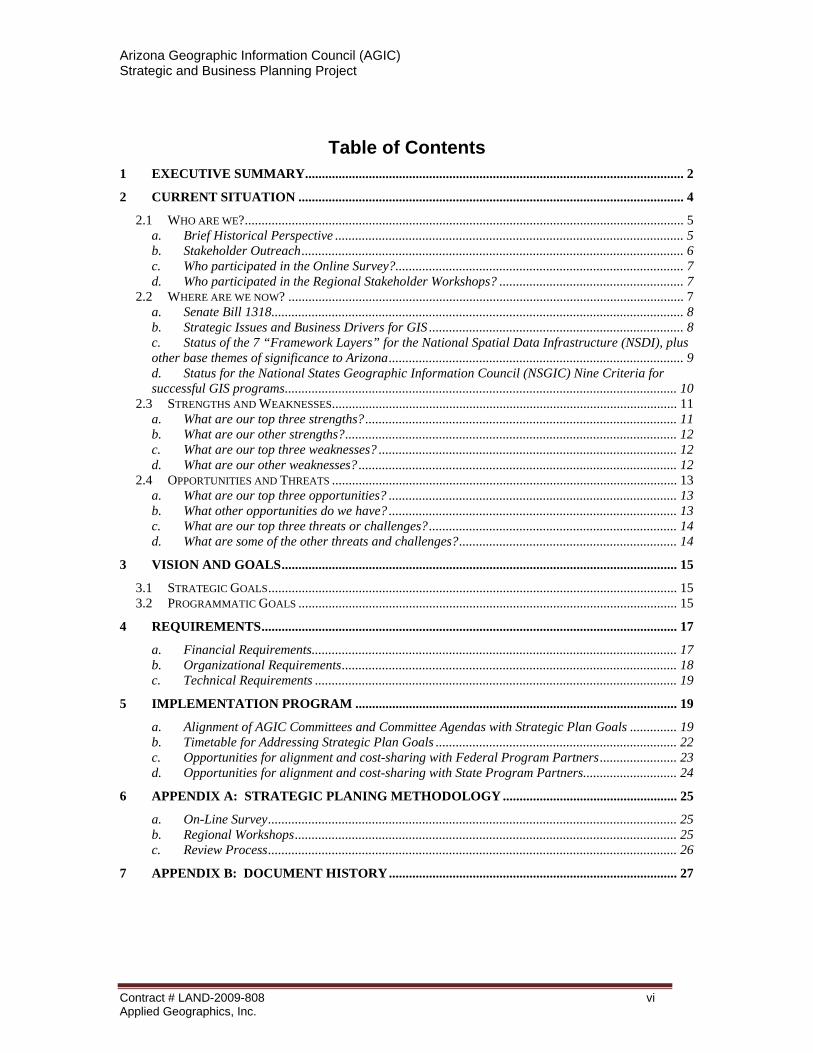
Table of Contents 1 EXECUTIVE SUMMARY................................................................................................................. 2
2 CURRENT SITUATION ................................................................................................................... 4
2.1 WHO ARE WE?................................................................................................................................... 5 a. Brief Historical Perspective ........................................................................................................ 5 b. Stakeholder Outreach.................................................................................................................. 6 c. Who participated in the Online Survey?...................................................................................... 7 d. Who participated in the Regional Stakeholder Workshops? ....................................................... 7
2.2 WHERE ARE WE NOW? ...................................................................................................................... 7 a. Senate Bill 1318........................................................................................................................... 8 b. Strategic Issues and Business Drivers for GIS ............................................................................ 8 c. Status of the 7 “Framework Layers” for the National Spatial Data Infrastructure (NSDI), plus other base themes of significance to Arizona........................................................................................ 9 d. Status for the National States Geographic Information Council (NSGIC) Nine Criteria for successful GIS programs..................................................................................................................... 10
2.3 STRENGTHS AND WEAKNESSES....................................................................................................... 11 a. What are our top three strengths?............................................................................................. 11 b. What are our other strengths?................................................................................................... 12 c. What are our top three weaknesses? ......................................................................................... 12 d. What are our other weaknesses?............................................................................................... 12
2.4 OPPORTUNITIES AND THREATS ....................................................................................................... 13 a. What are our top three opportunities? ...................................................................................... 13 b. What other opportunities do we have? ...................................................................................... 13 c. What are our top three threats or challenges?.......................................................................... 14 d. What are some of the other threats and challenges?................................................................. 14
3 VISION AND GOALS...................................................................................................................... 15
3.1 STRATEGIC GOALS.......................................................................................................................... 15 3.2 PROGRAMMATIC GOALS ................................................................................................................. 15
4 REQUIREMENTS............................................................................................................................ 17
a. Financial Requirements............................................................................................................. 17 b. Organizational Requirements.................................................................................................... 18 c. Technical Requirements ............................................................................................................ 19
5 IMPLEMENTATION PROGRAM ................................................................................................ 19
a. Alignment of AGIC Committees and Committee Agendas with Strategic Plan Goals .............. 19 b. Timetable for Addressing Strategic Plan Goals ........................................................................ 22 c. Opportunities for alignment and cost-sharing with Federal Program Partners....................... 23 d. Opportunities for alignment and cost-sharing with State Program Partners............................ 24
6 APPENDIX A: STRATEGIC PLANING METHODOLOGY .................................................... 25
a. On-Line Survey.......................................................................................................................... 25 b. Regional Workshops.................................................................................................................. 25 c. Review Process.......................................................................................................................... 26
7 APPENDIX B: DOCUMENT HISTORY...................................................................................... 27
Contract # LAND-2009-808 Applied Geographics, Inc.
vi

Arizona Geographic Information Council (AGIC) Strategic and Business Planning Project
11 EEXXEECCUUTTIIVVEE SSUUMMMMAARRYY The Arizona Geographic Information Council (AGIC) initiated a planning process to more effectively meet the geospatial needs and requirements of Arizona. AGIC applied for funding assistance through the Federal Geographic Data Committee (FGDC), as part of the Fifty States Initiative to advance the National Spatial Data Infrastructure (NSDI). In February 2009, Arizona was selected as a grant recipient, specifically to support Strategic and Business Planning for Geographic Information Systems (GIS). When Senate Bill 1318 (SB1318) was signed into law by Governor Brewer in July of 2009, it became a key focal point for the AGIC Steering Committee leading the planning process.
There is an active and knowledgeable stakeholder community of GIS professionals across the state, involved in many different aspects of government and the economy. Expertise in the technology is a prerequisite for many jobs that depend on the availability of geospatial data. The productivity-related benefits of GIS are generally recognized in the professional community, and geospatial data is used in many jobs and business processes related to the generation of revenue and the delivery of services, such as taxation, utilities, permitting, public safety and many other daily operations.
Outreach was conducted and input was collected from the diverse community of geospatial stakeholders throughout the state during 2009, including a series of Regional Workshops held in Flagstaff, Kingman, Phoenix (Peoria), and Tucson. In addition, an online survey was conducted to gather input from GIS users and managers. Based on the input from the workshops and survey, preliminary findings and recommendations were compiled and presented at the Annual AGIC Conference, which was held in Tucson, in November 2009. As a result of these efforts, the following goals were developed:
Strategic and Programmatic Goals of this Plan
Strategic Goal #1: Facilitate the productive application and sharing of geospatial data and GIS and location-based services to address the needs of Arizonans by establishing a Clearinghouse with statewide accessibility.
Programmatic Goals a. Develop a Business Plan for implementing a Clearinghouse. b. Collect information on user requirements on matters related to geographic information
systems, geospatial data, technologies, products, services, standards, programs and activities and prioritize those requirements to inform decision-making for the implementation of the Clearinghouse.
c. Get necessary support from stakeholder, decision-makers, and funding agents for GIS and geospatial data.
d. Tie into GITA State IT Plan which mentions GIS as a priority for shared use (i.e. IT Goal #3: Standardization and Reuse – 3.2 Geographic Information Systems).
e. Assess where geospatial data spending is redundant, where a Clearinghouse could satisfy the needs for access to data without duplicate spending. f. Design and build a Clearinghouse with statewide accessibility and use data from the original source where possible.
Contract # LAND-2009-808 Applied Geographics, Inc.
2
Arizona Geographic Information Council (AGIC) Strategic and Business Planning Project
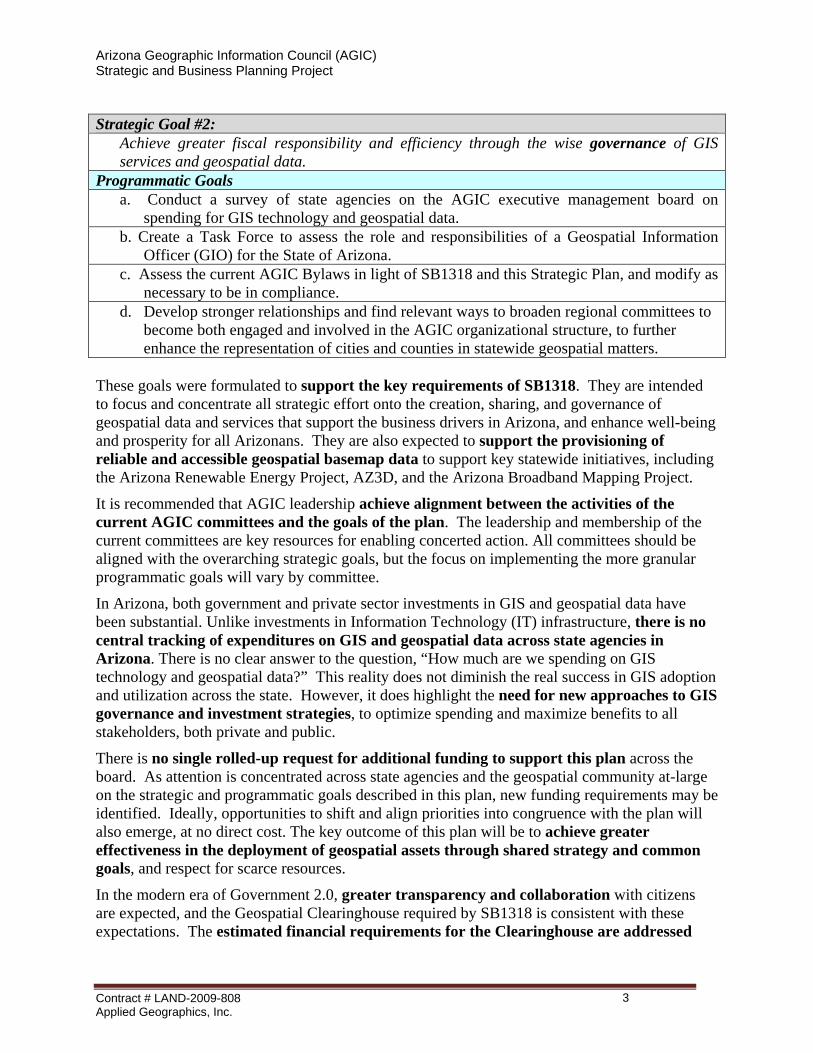
Strategic Goal #2:
Achieve greater fiscal responsibility and efficiency through the wise governance of GIS services and geospatial data.
Programmatic Goals a. Conduct a survey of state agencies on the AGIC executive management board on
spending for GIS technology and geospatial data. b. Create a Task Force to assess the role and responsibilities of a Geospatial Information
Officer (GIO) for the State of Arizona. c. Assess the current AGIC Bylaws in light of SB1318 and this Strategic Plan, and modify as
necessary to be in compliance. d. Develop stronger relationships and find relevant ways to broaden regional committees to
become both engaged and involved in the AGIC organizational structure, to further enhance the representation of cities and counties in statewide geospatial matters.
These goals were formulated to support the key requirements of SB1318. They are intended to focus and concentrate all strategic effort onto the creation, sharing, and governance of geospatial data and services that support the business drivers in Arizona, and enhance well-being and prosperity for all Arizonans. They are also expected to support the provisioning of reliable and accessible geospatial basemap data to support key statewide initiatives, including the Arizona Renewable Energy Project, AZ3D, and the Arizona Broadband Mapping Project.
It is recommended that AGIC leadership achieve alignment between the activities of the current AGIC committees and the goals of the plan. The leadership and membership of the current committees are key resources for enabling concerted action. All committees should be aligned with the overarching strategic goals, but the focus on implementing the more granular programmatic goals will vary by committee.
In Arizona, both government and private sector investments in GIS and geospatial data have been substantial. Unlike investments in Information Technology (IT) infrastructure, there is no central tracking of expenditures on GIS and geospatial data across state agencies in Arizona. There is no clear answer to the question, “How much are we spending on GIS technology and geospatial data?” This reality does not diminish the real success in GIS adoption and utilization across the state. However, it does highlight the need for new approaches to GIS governance and investment strategies, to optimize spending and maximize benefits to all stakeholders, both private and public.
There is no single rolled-up request for additional funding to support this plan across the board. As attention is concentrated across state agencies and the geospatial community at-large on the strategic and programmatic goals described in this plan, new funding requirements may be identified. Ideally, opportunities to shift and align priorities into congruence with the plan will also emerge, at no direct cost. The key outcome of this plan will be to achieve greater effectiveness in the deployment of geospatial assets through shared strategy and common goals, and respect for scarce resources.
In the modern era of Government 2.0, greater transparency and collaboration with citizens are expected, and the Geospatial Clearinghouse required by SB1318 is consistent with these expectations. The estimated financial requirements for the Clearinghouse are addressed
Contract # LAND-2009-808 Applied Geographics, Inc.
3
Arizona Geographic Information Council (AGIC) Strategic and Business Planning Project
later in this Strategic Plan, and a more detailed Business Plan to support implementation of the Clearinghouse has been developed as a highly-congruent companion to this Strategic Plan.
22 CCUURRRREENNTT SSIITTUUAATTIIOONN The strategic planning process that resulted in this plan was conducted by the Arizona Geographic Information Council (AGIC) during 2009. AGIC was originally formed in 1989 by a Governor’s Executive Order (EO 89-24). Twenty years later, AGIC was legislatively authorized by Arizona Senate Bill 1318 (SB1318), which was signed into law by Governor Brewer in July 2009. AGIC’s longstanding goal has been to achieve coordination of statewide GIS and geospatial matters. The mission statement for AGIC is as follows:
The mission of the AGIC is to coordinate the development and management of geographic information in Arizona. AGIC supports the use of GIS and geospatial technologies to address problems and better manage the natural infrastructure and economic resources of the state. (See AGIC website at: http://agic.az.gov/ )
Arizona has a long and productive history in advancing Geographic Information Systems (GIS) and geospatial data for the benefit of citizens and organizations across the state. As defined in SB1318, GIS “means computer-based technologies for storing, manipulating and analyzing geospatial data,” and geospatial data “means digital data using geographic or projected map coordinate values, identification codes and associated descriptive data to locate and describe boundaries or features on, above or below the surface of the earth or characteristics of the earth's inhabitants or its natural or human-constructed features.”
There is an active and knowledgeable community of GIS professionals across the state, involved in many different aspects of government and the economy. Expertise in the technology is a prerequisite for many jobs that depend on the availability of geospatial data. The productivity-related benefits of GIS are generally recognized, and geospatial data is used in many jobs and business processes related to the generation of revenue and the delivery of services, such as taxation, utilities, permitting, public safety and many other daily operations.
While both government and private sector investment in GIS and geospatial data has been substantial, no one can put an accurate figure on the amount. This is not surprising in terms of the private sector, where such information is closely-held. However, government agencies should be able to report how much they are spending in this regard, but GIS is often so intertwined with the job of government, that it is not measured on its own. Unlike investments in Information Technology (IT) infrastructure, there is no central tracking of expenditures on GIS and geospatial data in Arizona, and there is no assurance of best value for the money spent across all levels of government.
This reality does not diminish the real success in GIS adoption and utilization across the state. However, it does highlight the need for new approaches to GIS governance and investment strategies, to optimize spending and maximize benefits to all stakeholders, both private and public. Also needed is a renewed effort to leverage existing geospatial data, knowledge, and collaboration technologies. New legislation (i.e. SB1318), signed into law by Governor Brewer, has enabled a platform for even greater success in the modern era of Government 2.0, and established a requirement for a clearinghouse for GIS services and geospatial data.
Contract # LAND-2009-808 Applied Geographics, Inc.
4
Arizona Geographic Information Council (AGIC) Strategic and Business Planning Project
2.1 Who are we? The GIS and geospatial data community has a long history in Arizona, dating back more than 30 years. When AGIC was formed in 1989, it started as a state-agency-centric organization. Over the years, it has achieved broader participation beyond state agencies, but the job of becoming a true statewide entity is still underway. Nonetheless, it is evident from the diversity of the current AGIC executive and committee rosters that the Council’s reach and influence is statewide, as follows:
AGIC Executive Board Officials:
• President: Kevin Blake, Yavapai County, and the Northern Arizona Geographic Information Forum
• President Elect: Jana Hutchins, Arizona State University
• Secretary: Gary Irish, Arizona State Land Department
• Past President: Timothy Smothers, City of Peoria
AGIC Committees:
• Administrative and Legal Committee: Chair, Tim Smothers (City of Peoria, and the League of Arizona Cities and Towns)
• Data Committee: Co-Chairs, Gene Trobia (Arizona State Land Department, State Cartographer), Tom Sturm (USGS Arizona Geospatial Liaison)
• Conference Committee: Co-Chairs: Jami Garrison (Maricopa Association of Governments), Steve Whitney (Pima County, and the Tucson Area GIS Cooperative)
• Outreach Committee: Chair, Adam Iten (Arizona Department of Administration, State 9-1-1 Coordinator)
A key AGIC objective for this planning project was to reach out to GIS and geospatial data stakeholders, regardless of formal involvement in AGIC. Another objective was to build on the foundation of activities that have led the state to this moment of opportunity.
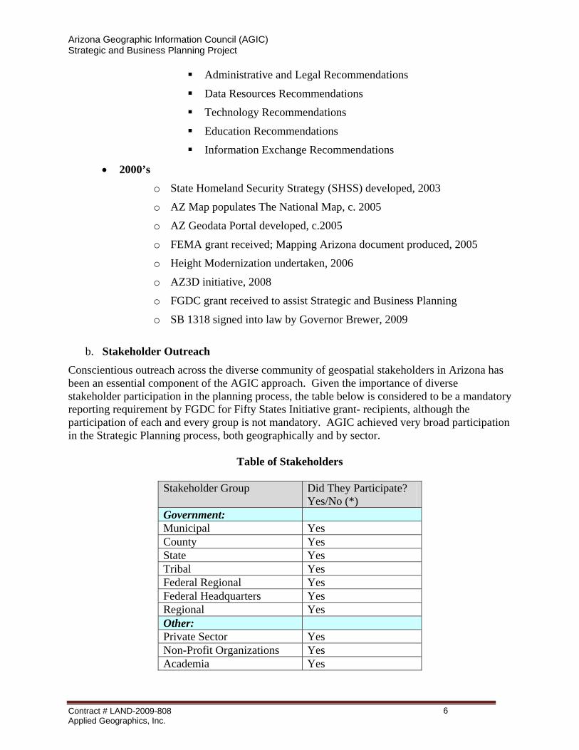
a. Brief Historical Perspective
• 1980’s o Arizona Mapping Advisory Council (AZMAC) established by Executive
Order 1982-10, by Governor Babbitt
o Arizona Land Resource Information System (ALRIS) in 1982, and the State Cartographer’s Office established under state statute, in 1988
o AGIC formed to replace AZMAC by Executive Order 1989-24, by Governor Mofford
• 1990’s o Regional GIS consortia added to AGIC by Executive Order 1992-17, by
Governor Symington
o AGIC Strategic Plan developed in 1992
Contract # LAND-2009-808 Applied Geographics, Inc.
5
Arizona Geographic Information Council (AGIC) Strategic and Business Planning Project
Administrative and Legal Recommendations
Data Resources Recommendations
Technology Recommendations
Education Recommendations
Information Exchange Recommendations
• 2000’s o State Homeland Security Strategy (SHSS) developed, 2003
o AZ Map populates The National Map, c. 2005
o AZ Geodata Portal developed, c.2005
o FEMA grant received; Mapping Arizona document produced, 2005
o Height Modernization undertaken, 2006
o AZ3D initiative, 2008
o FGDC grant received to assist Strategic and Business Planning
o SB 1318 signed into law by Governor Brewer, 2009
b. Stakeholder Outreach
Conscientious outreach across the diverse community of geospatial stakeholders in Arizona has been an essential component of the AGIC approach. Given the importance of diverse stakeholder participation in the planning process, the table below is considered to be a mandatory reporting requirement by FGDC for Fifty States Initiative grant- recipients, although the participation of each and every group is not mandatory. AGIC achieved very broad participation in the Strategic Planning process, both geographically and by sector.
Table of Stakeholders
Stakeholder Group Did They Participate? Yes/No (*)
Government: Municipal Yes County Yes State Yes Tribal Yes Federal Regional Yes Federal Headquarters Yes Regional Yes Other: Private Sector Yes Non-Profit Organizations Yes Academia Yes
Contract # LAND-2009-808 Applied Geographics, Inc.
6

Arizona Geographic Information Council (AGIC) Strategic and Business Planning Project
Stakeholder Group Did They Participate? Yes/No (*)
General Public No (*) NOTE: There is a project record of actual respondents to the online survey and actual participants in regional stakeholder workshops.
c. Who participated in the Online Survey?
• 151 responses (early August through mid October 2009) • 137 in-state • 14 out-of-state or no state given • Overall, most responses came from counties (27%), followed by municipal
(20%), and private sector (18%) • Out of 15 counties in the states, all but 3 (Navajo, Greenlee, and Pinal) had
respondents to the survey • 73% of in-state responses from two counties
o Maricopa (68 responses) o Pima (32 responses)
• Large percentage (70%) either GIS analysts or managers
d. Who participated in the Regional Stakeholder Workshops? WORKSHOP LOCATION
Date Actual Attendees Predominant Sector in Attendance
Flagstaff 9/23/09 15 Private Sector Kingman 9/24/09 17 County Government Phoenix (Peoria) 9/30/09 30 State Government Tucson 10/01/09 14 Municipal Government
Total (*) 76 (*) NOTE: Two workshops were also conducted at the Annual AGIC Conference on 11/05/09, in Tucson – one was held to present and validate preliminary findings from the Survey and Regional Workshops, and the other was to gather additional input. Attendance was not taken at the two workshops conducted at the Conference, but there was a similar diversity and number of participants when compared to the Regional Stakeholder Workshops; and for some, it was their second workshop.
2.2 Where are we now? Arizona is well-positioned to leverage its GIS investments and geospatial resources if it can concentrate the right level of attention on the strategic issues and business drivers identified in this plan. There are some key building blocks in place, and a need to focus on strategic goals
Contract # LAND-2009-808 Applied Geographics, Inc.
7
Arizona Geographic Information Council (AGIC) Strategic and Business Planning Project
and priorities. This section sets the stage for action by identifying key drivers as well as the strengths, weaknesses, opportunities and threats that represent both success factors and obstacles.
a. Senate Bill 1318 For the Arizona geospatial community, this is a significant piece of legislation. Governor Jan Brewer signed the bill (SB1318) into law on July 10, 2009, effective September 30, 2009. This law establishes AGIC as a legislatively mandated council, and:
o Includes provisions for sharing geospatial data among public agencies. A written agreement among public agencies will not be required.
o Allows a public agency to share geospatial data for which it is the custodian. The public agency also would retain custodial ownership of the data it shares.
o Allows a public agency to prohibit the redistribution of its data by other public agencies if notification of the prohibition is given.
o Permits a public agency to exempt shared geospatial data from fees that would otherwise be prescribed by public records law (A.R.S. § 39-121.03, Subsection A, Paragraph 3).
o Exempts a public agency that shares geospatial data from liability for errors, inaccuracies or omissions in the data. Furthermore, the public agency will be held harmless from all damage, loss or liability arising from the use of shared data.
o Allows a public agency that receives or shares geospatial data to withhold the data from public disclosure if it is critical infrastructure information. Critical infrastructure is defined in statute as the systems and assets that are so vital to Arizona and the U.S. that destruction of them would have a debilitating effect on security, economic security, public health or safety.
o Requires that a clearinghouse and a central repository for geospatial data and GIS services be established.
b. Strategic Issues and Business Drivers for GIS An initial list of strategic issues and business drivers for GIS was developed by the Steering Committee. Subsequently, the list was expanded upon during the Regional Stakeholder Workshops. These issues and drivers are more widely known as compared to GIS-specific topics, and they provide the context for how and why GIS is needed and utilized. There is a strong belief amongst stakeholders at-large that the wise use of GIS strengthens fiscal responsibility and efficiencies in government. And, the Arizona Government Information and Technology Agency (GITA) has included GIS in the “State IT Strategic Plan.”
The consolidated list of issues and drivers, with ranking results from the AGIC conference, follows:
Ranked List of Strategic Issues and Business Drivers for GIS
Rank Strategic Issue and Business Driver for GIS Score
(*)
Contract # LAND-2009-808 Applied Geographics, Inc.
8
Arizona Geographic Information Council (AGIC) Strategic and Business Planning Project
1 Emergency Response & Planning; Public Safety & Disaster Planning 28
2 Environmental Management 26
3 Renewable Energy Development/Smart Grid 25
4 Services for “Prosumers” (i.e. professional consumers/citizens) 23
5 Health Care 22
6 Visualizing Information (i.e. Health Stats); Public Communications & Social Awareness of Issues 22
7 Smart Growth; Proactive/ Reactive Response to Change 21
8 Water Management 21
9 Broadband 20
10 Special Districts / Tax Districts for Utility Allocation (Property & Sales) 20
11 Economic Development 20
12 Integration into/with IT 18
13 Capital Improvements 17
14 Stimulus Transparency 16
15 Highway Planning 15
16 Facility Management / Preventative Maintenance 14
17 Academic Research Support 12
18 Base Realignment And Closure (BRAC) / Western Regional Partnership (WRP) 10
(*) NOTE: The consolidated list of issues and drivers was ranked as higher, medium, or lower importance during a facilitated consensus ranking exercise at the AGIC Annual Conference in Tucson in early November 2009.
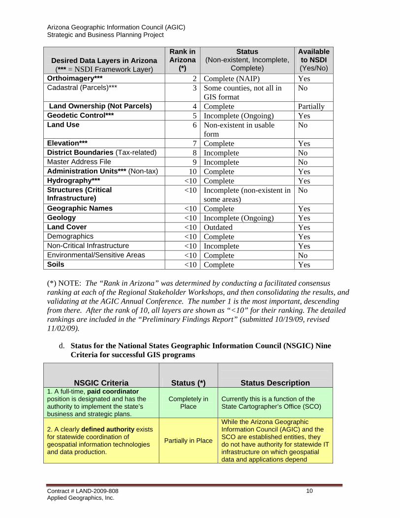
c. Status of the 7 “Framework Layers” for the National Spatial Data Infrastructure (NSDI), plus other base themes of significance to Arizona
In the following table, the 14 layers in bold are the a priori “AGIC Core Geospatial Layers List.” This list was compiled based on earlier stakeholder survey work, independent of the strategic planning process. During the current planning process, the list has been expanded into 19 layers, and prioritized in anticipation of building the geospatial Clearinghouse pursuant to SB1318. The seven layers with three asterisks [***] next to their names are the NSDI Framework Layers. Core Geospatial Data Layers
Desired Data Layers in Arizona
(*** = NSDI Framework Layer)
Rank in Arizona
(*)
Status (Non-existent, Incomplete,
Complete)
Available to NSDI (Yes/No)
Transportation*** 1 Some complete (TIGER), some not
Yes
Contract # LAND-2009-808 Applied Geographics, Inc.
9
Arizona Geographic Information Council (AGIC) Strategic and Business Planning Project
Desired Data Layers in Arizona
(*** = NSDI Framework Layer)
Rank in Arizona
(*)
Status (Non-existent, Incomplete,
Complete)
Available to NSDI (Yes/No)
Orthoimagery*** 2 Complete (NAIP) Yes Cadastral (Parcels)*** 3 Some counties, not all in
GIS format No
Land Ownership (Not Parcels) 4 Complete Partially Geodetic Control*** 5 Incomplete (Ongoing) Yes Land Use 6 Non-existent in usable
form No
Elevation*** 7 Complete Yes District Boundaries (Tax-related) 8 Incomplete No Master Address File 9 Incomplete No Administration Units*** (Non-tax) 10 Complete Yes Hydrography*** <10 Complete Yes Structures (Critical Infrastructure)
<10 Incomplete (non-existent in some areas)
No
Geographic Names <10 Complete Yes Geology <10 Incomplete (Ongoing) Yes Land Cover <10 Outdated Yes Demographics <10 Complete Yes Non-Critical Infrastructure <10 Incomplete Yes Environmental/Sensitive Areas <10 Complete No Soils <10 Complete Yes (*) NOTE: The “Rank in Arizona” was determined by conducting a facilitated consensus ranking at each of the Regional Stakeholder Workshops, and then consolidating the results, and validating at the AGIC Annual Conference. The number 1 is the most important, descending from there. After the rank of 10, all layers are shown as “<10” for their ranking. The detailed rankings are included in the “Preliminary Findings Report” (submitted 10/19/09, revised 11/02/09).
d. Status for the National States Geographic Information Council (NSGIC) Nine Criteria for successful GIS programs
NSGIC Criteria Status (*)
Status Description 1. A full-time, paid coordinator position is designated and has the authority to implement the state’s business and strategic plans.
Completely in Place
Currently this is a function of the State Cartographer’s Office (SCO)
2. A clearly defined authority exists for statewide coordination of geospatial information technologies and data production.
Partially in Place
While the Arizona Geographic Information Council (AGIC) and the SCO are established entities, they do not have authority for statewide IT infrastructure on which geospatial data and applications depend
Contract # LAND-2009-808 Applied Geographics, Inc.
10
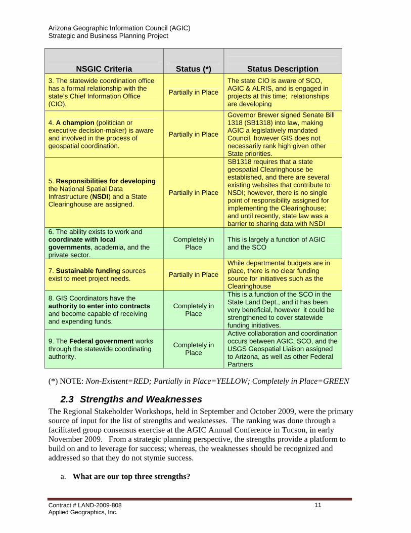
Arizona Geographic Information Council (AGIC) Strategic and Business Planning Project
NSGIC Criteria Status (*)
Status Description 3. The statewide coordination office has a formal relationship with the state’s Chief Information Office (CIO).
Partially in Place
The state CIO is aware of SCO, AGIC & ALRIS, and is engaged in projects at this time; relationships are developing
4. A champion (politician or executive decision-maker) is aware and involved in the process of geospatial coordination.
Partially in Place
Governor Brewer signed Senate Bill 1318 (SB1318) into law, making AGIC a legislatively mandated Council, however GIS does not necessarily rank high given other State priorities.
5. Responsibilities for developing the National Spatial Data Infrastructure (NSDI) and a State Clearinghouse are assigned.
Partially in Place
SB1318 requires that a state geospatial Clearinghouse be established, and there are several existing websites that contribute to NSDI; however, there is no single point of responsibility assigned for implementing the Clearinghouse; and until recently, state law was a barrier to sharing data with NSDI
6. The ability exists to work and coordinate with local governments, academia, and the private sector.
Completely in Place
This is largely a function of AGIC and the SCO
7. Sustainable funding sources exist to meet project needs. Partially in Place
While departmental budgets are in place, there is no clear funding source for initiatives such as the Clearinghouse
8. GIS Coordinators have the authority to enter into contracts and become capable of receiving and expending funds.
Completely in Place
This is a function of the SCO in the State Land Dept., and it has been very beneficial, however it could be strengthened to cover statewide funding initiatives.
9. The Federal government works through the statewide coordinating authority.
Completely in Place
Active collaboration and coordination occurs between AGIC, SCO, and the USGS Geospatial Liaison assigned to Arizona, as well as other Federal Partners
(*) NOTE: Non-Existent=RED; Partially in Place=YELLOW; Completely in Place=GREEN
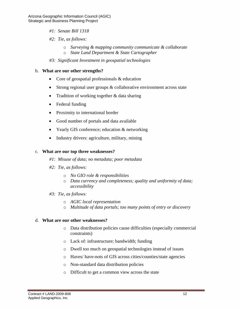
2.3 Strengths and Weaknesses The Regional Stakeholder Workshops, held in September and October 2009, were the primary source of input for the list of strengths and weaknesses. The ranking was done through a facilitated group consensus exercise at the AGIC Annual Conference in Tucson, in early November 2009. From a strategic planning perspective, the strengths provide a platform to build on and to leverage for success; whereas, the weaknesses should be recognized and addressed so that they do not stymie success.
a. What are our top three strengths?
Contract # LAND-2009-808 Applied Geographics, Inc.
11
Arizona Geographic Information Council (AGIC) Strategic and Business Planning Project
#1: Senate Bill 1318
#2: Tie, as follows:
o Surveying & mapping community communicate & collaborate o State Land Department & State Cartographer
#3: Significant Investment in geospatial technologies
b. What are our other strengths?
• Core of geospatial professionals & education
• Strong regional user groups & collaborative environment across state
• Tradition of working together & data sharing
• Federal funding
• Proximity to international border
• Good number of portals and data available
• Yearly GIS conference; education & networking
• Industry drivers: agriculture, military, mining
c. What are our top three weaknesses?
#1: Misuse of data; no metadata; poor metadata
#2: Tie, as follows:
o No GIO role & responsibilities o Data currency and completeness; quality and uniformity of data;
accessibility
#3: Tie, as follows:
o AGIC local representation o Multitude of data portals; too many points of entry or discovery
d. What are our other weaknesses?
o Data distribution policies cause difficulties (especially commercial constraints)
o Lack of: infrastructure; bandwidth; funding
o Dwell too much on geospatial technologies instead of issues
o Haves/ have-nots of GIS across cities/counties/state agencies
o Non-standard data distribution policies
o Difficult to get a common view across the state
Contract # LAND-2009-808 Applied Geographics, Inc.
12
Arizona Geographic Information Council (AGIC) Strategic and Business Planning Project
o Awareness of GIS and value to organization by management/elected officials/ public
o Large rural footprint; difficulty getting GIS resources to rural areas
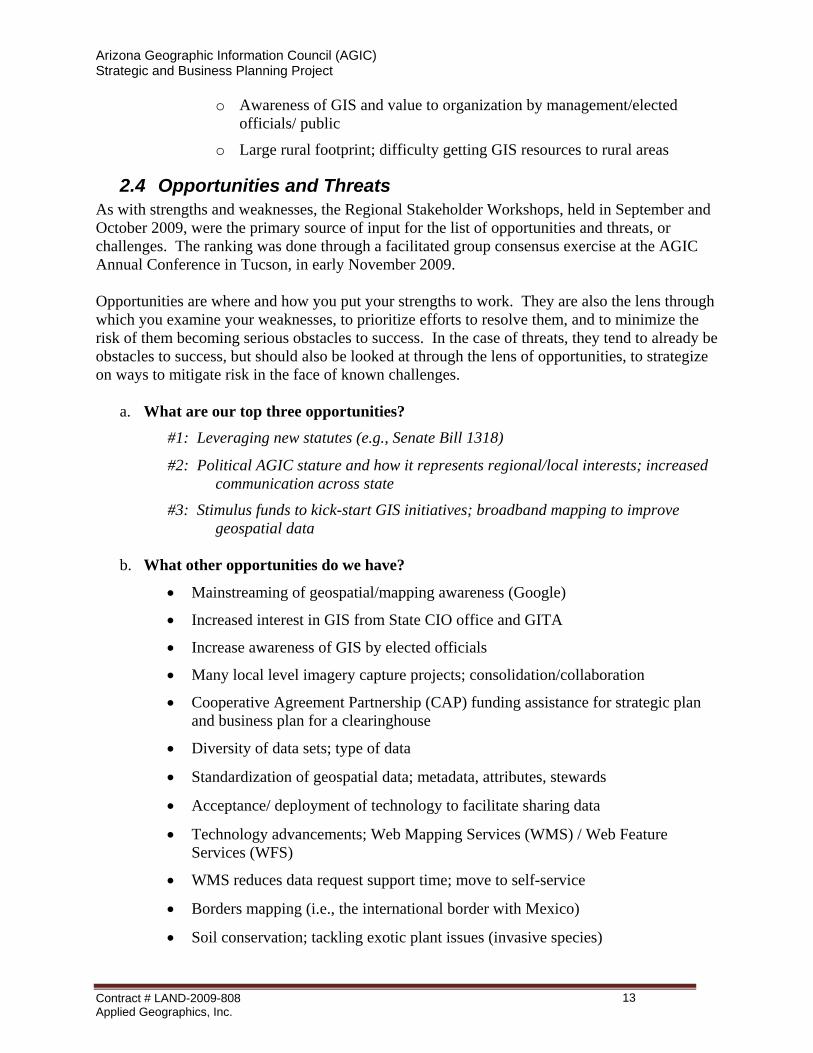
2.4 Opportunities and Threats As with strengths and weaknesses, the Regional Stakeholder Workshops, held in September and October 2009, were the primary source of input for the list of opportunities and threats, or challenges. The ranking was done through a facilitated group consensus exercise at the AGIC Annual Conference in Tucson, in early November 2009. Opportunities are where and how you put your strengths to work. They are also the lens through which you examine your weaknesses, to prioritize efforts to resolve them, and to minimize the risk of them becoming serious obstacles to success. In the case of threats, they tend to already be obstacles to success, but should also be looked at through the lens of opportunities, to strategize on ways to mitigate risk in the face of known challenges.
a. What are our top three opportunities?
#1: Leveraging new statutes (e.g., Senate Bill 1318)
#2: Political AGIC stature and how it represents regional/local interests; increased communication across state
#3: Stimulus funds to kick-start GIS initiatives; broadband mapping to improve geospatial data
b. What other opportunities do we have?
• Mainstreaming of geospatial/mapping awareness (Google)
• Increased interest in GIS from State CIO office and GITA
• Increase awareness of GIS by elected officials
• Many local level imagery capture projects; consolidation/collaboration
• Cooperative Agreement Partnership (CAP) funding assistance for strategic plan and business plan for a clearinghouse
• Diversity of data sets; type of data
• Standardization of geospatial data; metadata, attributes, stewards
• Acceptance/ deployment of technology to facilitate sharing data
• Technology advancements; Web Mapping Services (WMS) / Web Feature Services (WFS)
• WMS reduces data request support time; move to self-service
• Borders mapping (i.e., the international border with Mexico)
• Soil conservation; tackling exotic plant issues (invasive species)
Contract # LAND-2009-808 Applied Geographics, Inc.
13
Arizona Geographic Information Council (AGIC) Strategic and Business Planning Project
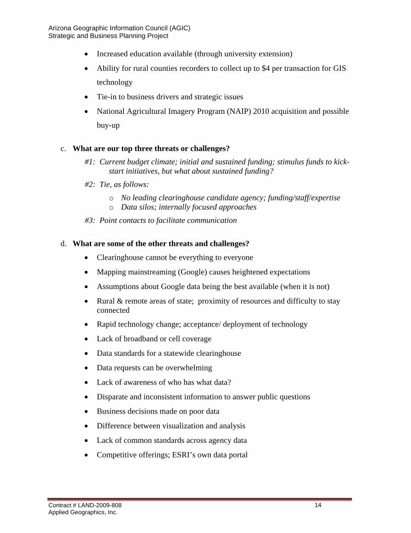
• Increased education available (through university extension)
• Ability for rural counties recorders to collect up to $4 per transaction for GIS
technology
• Tie-in to business drivers and strategic issues
• National Agricultural Imagery Program (NAIP) 2010 acquisition and possible
buy-up
c. What are our top three threats or challenges?
#1: Current budget climate; initial and sustained funding; stimulus funds to kick-start initiatives, but what about sustained funding?
#2: Tie, as follows:
o No leading clearinghouse candidate agency; funding/staff/expertise o Data silos; internally focused approaches
#3: Point contacts to facilitate communication
d. What are some of the other threats and challenges?
• Clearinghouse cannot be everything to everyone
• Mapping mainstreaming (Google) causes heightened expectations
• Assumptions about Google data being the best available (when it is not)
• Rural & remote areas of state; proximity of resources and difficulty to stay connected
• Rapid technology change; acceptance/ deployment of technology
• Lack of broadband or cell coverage
• Data standards for a statewide clearinghouse
• Data requests can be overwhelming
• Lack of awareness of who has what data?
• Disparate and inconsistent information to answer public questions
• Business decisions made on poor data
• Difference between visualization and analysis
• Lack of common standards across agency data
• Competitive offerings; ESRI’s own data portal
Contract # LAND-2009-808 Applied Geographics, Inc.
14
Arizona Geographic Information Council (AGIC) Strategic and Business Planning Project
33 VVIISSIIOONN AANNDD GGOOAALLSS The current AGIC vision is stated below, and it is directly congruent with the requirement in SB1318 to “establish a clearinghouse and central repository for geospatial data and statewide GIS services.” Furthermore AGIC is required by SB1318 to “identify federal, state, regional, tribal and local government and private sector geospatial data and GIS services to include in the clearinghouse.” The Current AGIC Vision:
“The vision of AGIC is to facilitate the provision of credible, timely and accurate geographic information for widespread use by decision-makers and the citizens of Arizona.” (From AGIC website)
3.1 Strategic Goals The following goals have been formulated to support the AGIC vision and the key requirements of SB1318. They are intended to focus and concentrate all strategic effort onto the creation, sharing, and governance of geospatial data and services that support the business drivers in Arizona, and enhance well-being and prosperity for all Arizonans. Strategic Goal #1:
Facilitate the productive application and sharing of geospatial data and GIS and location-based services to address the needs of Arizonans by establishing a Clearinghouse with statewide accessibility.
Strategic Goal #2: Achieve greater fiscal responsibility and efficiency through the wise governance of GIS services and geospatial data.
3.2 Programmatic Goals To help drive the successful implementation of the strategic goals, each one is divided into a subset of programmatic goals, or success factors. They are included, below, for each of the two overarching strategic goals.
a. Strategic Goal #1 and Associated Programmatic Goals:
Strategic Goal #1: Facilitate the productive application and sharing of geospatial data and GIS and location-based services to address the needs of Arizonans by establishing a Clearinghouse with statewide accessibility.
Programmatic Goals a. Develop a Business Plan for implementing a Clearinghouse.
Contract # LAND-2009-808 Applied Geographics, Inc.
15
Arizona Geographic Information Council (AGIC) Strategic and Business Planning Project
b. Collect information on user requirements on matters related to geographic information systems, geospatial data, technologies, products, services, standards, programs and activities and prioritize those requirements to inform decision-making for the implementation of the Clearinghouse.
c. Get necessary support from stakeholder, decision-makers, and funding agents for GIS and geospatial data.
d. Tie into GITA State IT Plan which mentions GIS as a priority for shared use (i.e. IT Goal #3: Standardization and Reuse – 3.2 Geographic Information Systems).
e. Assess where geospatial data spending is redundant, where a Clearinghouse could satisfy the needs for access to data without duplicate spending. f. Design and build a Clearinghouse with statewide accessibility and use data from the original source where possible.
b. Strategic Goal #2 and Associated Programmatic Goals:
Strategic Goal #2:
Achieve greater fiscal responsibility and efficiency through the wise governance of GIS services and geospatial data.
Programmatic Goals a. Conduct a survey of state agencies on the AGIC executive management board on
spending for GIS technology and geospatial data. b. Create a Task Force to assess the role and responsibilities of a Geospatial Information
Officer (GIO) for the State of Arizona. c. Assess the current AGIC Bylaws in light of SB1318 and this Strategic Plan, and modify
as necessary to be in compliance. d. Develop stronger relationships and find relevant ways to broaden regional committees to
become both engaged and involved in the AGIC organizational structure, to further enhance the representation of cities and counties in statewide geospatial matters.
Contract # LAND-2009-808 Applied Geographics, Inc.
16
Arizona Geographic Information Council (AGIC) Strategic and Business Planning Project
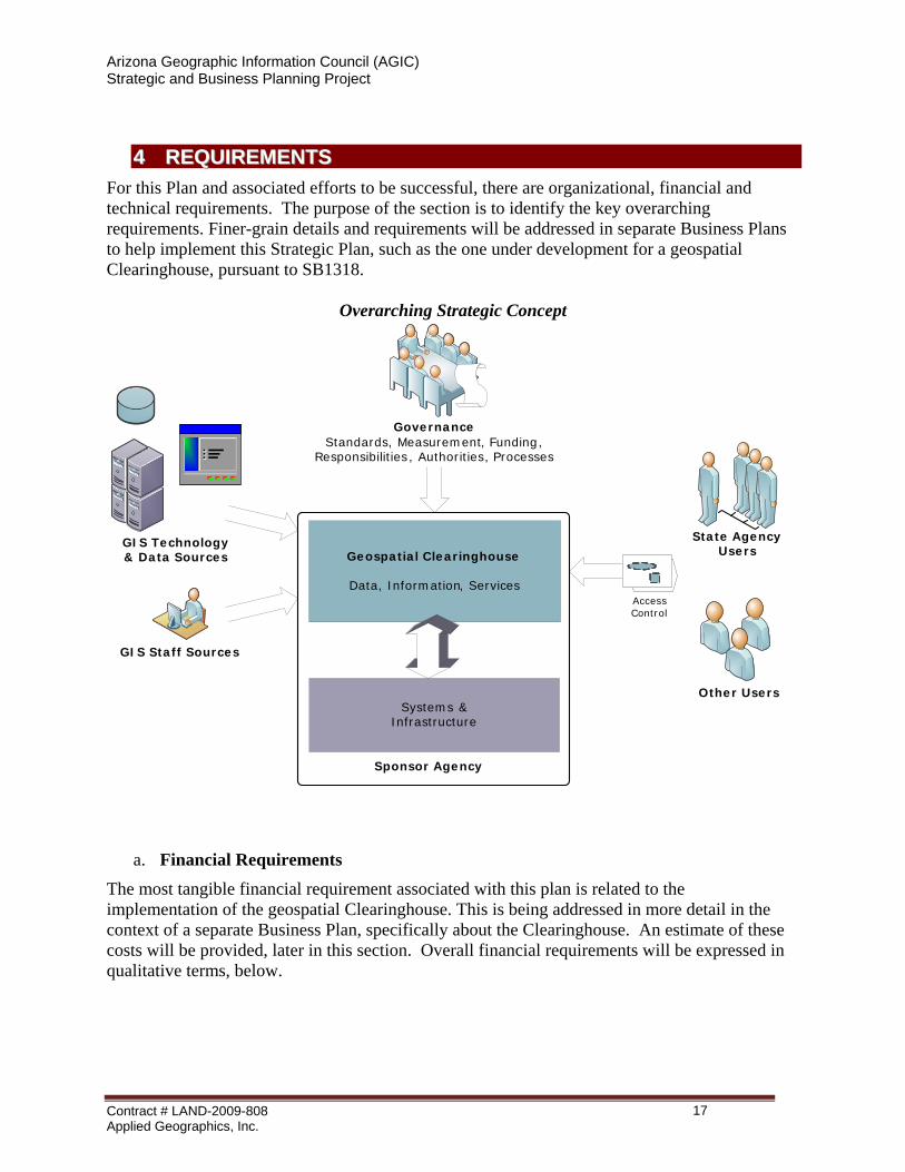
44 RREEQQUUIIRREEMMEENNTTSS For this Plan and associated efforts to be successful, there are organizational, financial and technical requirements. The purpose of the section is to identify the key overarching requirements. Finer-grain details and requirements will be addressed in separate Business Plans to help implement this Strategic Plan, such as the one under development for a geospatial Clearinghouse, pursuant to SB1318.
Overarching Strategic Concept
Geospatial Clearinghouse
Data, Information, Services
GovernanceStandards, Measurement, Funding,
Responsibilities, Authorities, Processes
GIS Staff Sources
Systems &Infrastructure
GIS Technology & Data Sources
Access Control
State AgencyUsers
Other Users
Sponsor Agency
a. Financial Requirements
The most tangible financial requirement associated with this plan is related to the implementation of the geospatial Clearinghouse. This is being addressed in more detail in the context of a separate Business Plan, specifically about the Clearinghouse. An estimate of these costs will be provided, later in this section. Overall financial requirements will be expressed in qualitative terms, below.
Contract # LAND-2009-808 Applied Geographics, Inc.
17
Arizona Geographic Information Council (AGIC) Strategic and Business Planning Project
i. Overall Financial Requirements
One desired outcome of this plan is to achieve greater effectiveness in the deployment of geospatial assets through shared strategy and common goals. There is no single rolled-up request for additional funding to support this plan across the board. Rather, by concentrating attention across state agencies and the geospatial community at-large on the strategic and programmatic goals described in this plan, discovery of unfunded requirements may emerge. Ideally, opportunities for shifting priorities into alignment with the plan will emerge, at no direct cost.
The spirit of this plan includes an overall financial impetus, with certainty. Of the two main strategic goals, one is devoted to the following imperative: Achieve greater fiscal responsibility and efficiency through the wise governance of GIS services and geospatial data. This is “Strategic Goal #2” in this Plan. A key programmatic goal in this context, which is a requirement for establishing a financial baseline, is as follows: Conduct a survey of state agencies on the AGIC executive management board on spending for GIS technology and geospatial data. The results of this survey will help the state answer the question, “How much is being spent for GIS technology and geospatial data?” The answer to that question will help determine future financial requirements in quantitative terms.
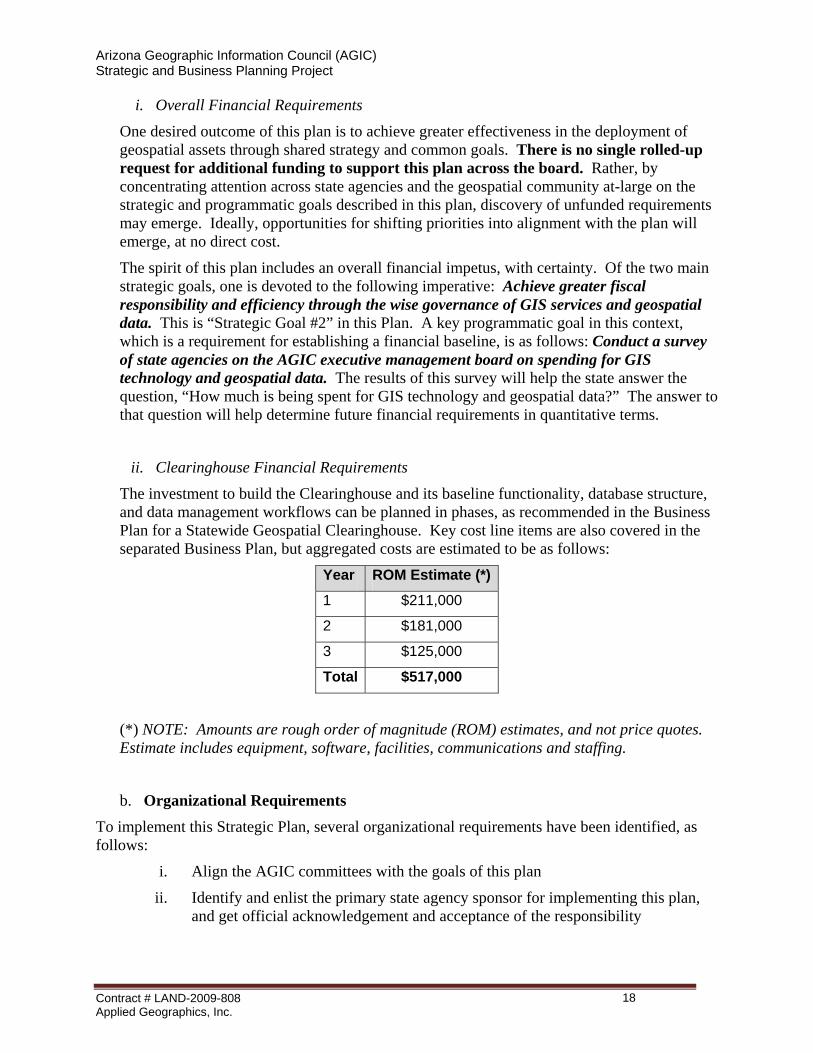
ii. Clearinghouse Financial Requirements
The investment to build the Clearinghouse and its baseline functionality, database structure, and data management workflows can be planned in phases, as recommended in the Business Plan for a Statewide Geospatial Clearinghouse. Key cost line items are also covered in the separated Business Plan, but aggregated costs are estimated to be as follows:
Year ROM Estimate (*)
1 $211,000 2 $181,000 3 $125,000 Total $517,000
(*) NOTE: Amounts are rough order of magnitude (ROM) estimates, and not price quotes. Estimate includes equipment, software, facilities, communications and staffing.
b. Organizational Requirements
To implement this Strategic Plan, several organizational requirements have been identified, as follows:
i. Align the AGIC committees with the goals of this plan
ii. Identify and enlist the primary state agency sponsor for implementing this plan, and get official acknowledgement and acceptance of the responsibility
Contract # LAND-2009-808 Applied Geographics, Inc.
18
Arizona Geographic Information Council (AGIC) Strategic and Business Planning Project
iii. Identify and validate the state official primarily responsible for managing the implementation process, and establish appropriate levels of authorization and agreement for this to happen
iv. Identify an official role and designate an individual to represent GIS and geospatial requirements as part of the ongoing state IT planning and implementation process
c. Technical Requirements These requirements are developed in detail as part of the separate Business Plan, whereby the priority is to establish a Statewide Geospatial Clearinghouse. The Clearinghouse requires initial and on-going hardware and software technical support resources such as networking, communications, storage, backup, retrieval, and disaster recovery. To the extent feasible, building upon and extending existing infrastructure makes sense, but this depends on what agency provides sponsorship for the Clearinghouse. For more detailed functional and technical requirements, see the Business Plan for a Statewide Geospatial Clearinghouse.
An important business and technical driver is the requirement to support existing statewide initiatives, including the Arizona Renewable Energy Project, AZ3D, and the Arizona Broadband Mapping Project.
55 IIMMPPLLEEMMEENNTTAATTIIOONN PPRROOGGRRAAMM This section defines the overall framework for implementation. Within the context of this Strategic Plan, implementation details will be kept relatively high-level and relatively brief. A separate Business Plan is being developed for the Clearinghouse.
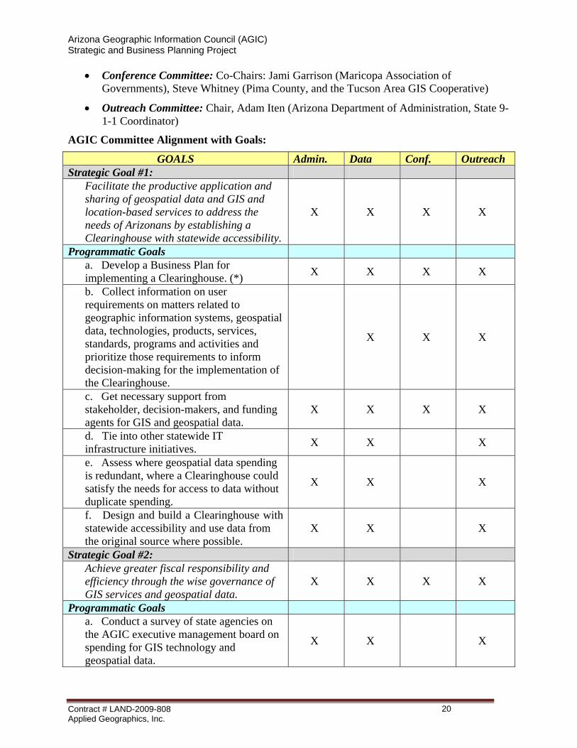
a. Alignment of AGIC Committees and Committee Agendas with Strategic Plan Goals An important aspect to Implementation Program is to ensure alignment between the activities of the current AGIC committees and the goals of the plan. The leadership and membership of the current committees are key resources for enabling concerted action. All committees should be aligned with the overarching strategic goals, but the focus on implementing the more granular programmatic goals will vary by committee. Ultimately, it is up to AGIC to determine how this alignment should be best achieved, and whether or not committee charters need to be revisited in this context.
The current committees are relisted, below, followed by a table that shows one view of how they might align with the goals of this plan.
Current AGIC Committees:
• Administrative and Legal Committee: Chair, Tim Smothers (City of Peoria, and the League of Arizona Cities and Towns)
• Data Committee: Co-Chairs, Gene Trobia (Arizona State Land Department, State Cartographer), Tom Sturm (USGS Geospatial Liaison)
Contract # LAND-2009-808 Applied Geographics, Inc.
19
Arizona Geographic Information Council (AGIC) Strategic and Business Planning Project
• Conference Committee: Co-Chairs: Jami Garrison (Maricopa Association of Governments), Steve Whitney (Pima County, and the Tucson Area GIS Cooperative)
• Outreach Committee: Chair, Adam Iten (Arizona Department of Administration, State 9-1-1 Coordinator)
AGIC Committee Alignment with Goals:
GOALS Admin. Data Conf. Outreach Strategic Goal #1:
Facilitate the productive application and sharing of geospatial data and GIS and location-based services to address the needs of Arizonans by establishing a Clearinghouse with statewide accessibility.
X X X X
Programmatic Goals a. Develop a Business Plan for implementing a Clearinghouse. (*) X X X X
b. Collect information on user requirements on matters related to geographic information systems, geospatial data, technologies, products, services, standards, programs and activities and prioritize those requirements to inform decision-making for the implementation of the Clearinghouse.
X X X
c. Get necessary support from stakeholder, decision-makers, and funding agents for GIS and geospatial data.
X X X X
d. Tie into other statewide IT infrastructure initiatives. X X X
e. Assess where geospatial data spending is redundant, where a Clearinghouse could satisfy the needs for access to data without duplicate spending.
X X X
f. Design and build a Clearinghouse with statewide accessibility and use data from the original source where possible.
X X X
Strategic Goal #2: Achieve greater fiscal responsibility and efficiency through the wise governance of GIS services and geospatial data.
X X X X
Programmatic Goals a. Conduct a survey of state agencies on the AGIC executive management board on spending for GIS technology and geospatial data.
X X X
Contract # LAND-2009-808 Applied Geographics, Inc.
20

Arizona Geographic Information Council (AGIC) Strategic and Business Planning Project
GOALS Admin. Data Conf. Outreach b. Create a Task Force to assess the role and responsibilities of a Geospatial Information Officer (GIO) for the State of Arizona.
X X
c. Assess the current AGIC Bylaws in light of SB1318 and this Strategic Plan, and modify as necessary to be in compliance.
X
d. Develop stronger relationships and find relevant ways to broaden regional committees to become both engaged and involved in the AGIC organizational structure, to further enhance the representation of cities and counties in statewide geospatial matters.
X X X X
(*)NOTE: A Business Plan is currently under development for the Clearinghouse.
Contract # LAND-2009-808 Applied Geographics, Inc.
21
Arizona Geographic Information Council (AGIC) Strategic and Business Planning Project
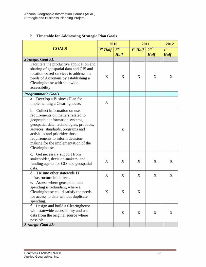
b. Timetable for Addressing Strategic Plan Goals
2010 2011 2012 GOALS 1st Half 2nd
Half 1st Half 2nd
Half 1st Half
Strategic Goal #1: Facilitate the productive application and sharing of geospatial data and GIS and location-based services to address the needs of Arizonans by establishing a Clearinghouse with statewide accessibility.
X X X X X
Programmatic Goals a. Develop a Business Plan for implementing a Clearinghouse. X
b. Collect information on user requirements on matters related to geographic information systems, geospatial data, technologies, products, services, standards, programs and activities and prioritize those requirements to inform decision-making for the implementation of the Clearinghouse.
X
c. Get necessary support from stakeholder, decision-makers, and funding agents for GIS and geospatial data.
X X X X X
d. Tie into other statewide IT infrastructure initiatives. X X X X X
e. Assess where geospatial data spending is redundant, where a Clearinghouse could satisfy the needs for access to data without duplicate spending.
X X X
f. Design and build a Clearinghouse with statewide accessibility and use data from the original source where possible.
X X X X
Strategic Goal #2:
Contract # LAND-2009-808 Applied Geographics, Inc.
22
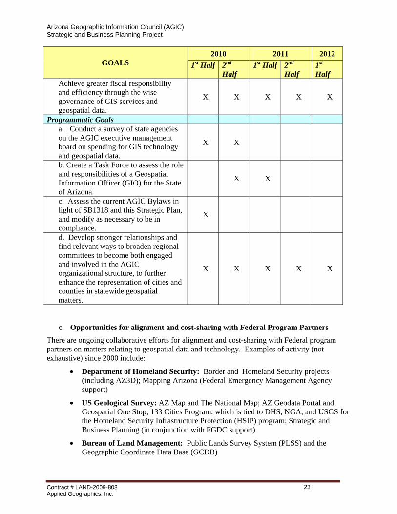
Arizona Geographic Information Council (AGIC) Strategic and Business Planning Project
2010 2011 2012 GOALS 1st Half 2nd
Half 1st Half 2nd
Half 1st Half
Achieve greater fiscal responsibility and efficiency through the wise governance of GIS services and geospatial data.
X X X X X
Programmatic Goals a. Conduct a survey of state agencies on the AGIC executive management board on spending for GIS technology and geospatial data.
X X
b. Create a Task Force to assess the role and responsibilities of a Geospatial Information Officer (GIO) for the State of Arizona.
X X
c. Assess the current AGIC Bylaws in light of SB1318 and this Strategic Plan, and modify as necessary to be in compliance.
X
d. Develop stronger relationships and find relevant ways to broaden regional committees to become both engaged and involved in the AGIC organizational structure, to further enhance the representation of cities and counties in statewide geospatial matters.
X X X X X
c. Opportunities for alignment and cost-sharing with Federal Program Partners There are ongoing collaborative efforts for alignment and cost-sharing with Federal program partners on matters relating to geospatial data and technology. Examples of activity (not exhaustive) since 2000 include:
• Department of Homeland Security: Border and Homeland Security projects (including AZ3D); Mapping Arizona (Federal Emergency Management Agency support)
• US Geological Survey: AZ Map and The National Map; AZ Geodata Portal and Geospatial One Stop; 133 Cities Program, which is tied to DHS, NGA, and USGS for the Homeland Security Infrastructure Protection (HSIP) program; Strategic and Business Planning (in conjunction with FGDC support)
• Bureau of Land Management: Public Lands Survey System (PLSS) and the Geographic Coordinate Data Base (GCDB)
Contract # LAND-2009-808 Applied Geographics, Inc.
23
Arizona Geographic Information Council (AGIC) Strategic and Business Planning Project
• National Geodetic Survey: Arizona Height Modernization Program (AZHMP)
• Federal Geographic Data Committee: Strategic and Business Planning
• National Telecommunications Information Agency: Broadband Mapping
• Department of Energy: Energy Efficiency
d. Opportunities for alignment and cost-sharing with State Program Partners
There are ongoing programs within state government in Arizona that have a synergistic relationship with the Clearinghouse, from both the supply and demand perspectives. For example, the State IT Plan (http://www.azgita.gov/planning) mentions GIS as a priority for shared use (i.e. IT Goal #3: Standardization and Reuse – 3.2 Geographic Information Systems). Specific state programs with a federal relationship, statewide purview, and requirements for a consistent framework of geospatial data include:
• Arizona Renewable Energy Project: To support coordinated approaches and analysis for potential energy sites (e.g. wind and solar farms) and transmission corridor selection to increase clean, renewable energy sources and decrease dependence on foreign oil.
• AZ3D: To support law enforcement and emergency first responders in situation awareness and a common operating picture for emergency response planning and homeland security applications.
• Arizona Broadband Mapping Project: To support the assessment of broadband infrastructure and services throughout the state, to help increase and improve high-speed Internet connectivity for all citizens, including those living in rural areas.
Contract # LAND-2009-808 Applied Geographics, Inc.
24
Arizona Geographic Information Council (AGIC) Strategic and Business Planning Project
66 AAPPPPEENNDDIIXX AA:: SSTTRRAATTEEGGIICC PPLLAANNNNIINNGG MMEETTHHOODDOOLLOOGGYY AGIC followed the methodology outlined in the Strategic Planning Guidelines produced for the Fifty States Initiative by the Federal Geographic Data Committee (FGDC). A Steering Committee was formed to provide oversight and direction, and the members are acknowledged in the Foreword to this document. The following list includes the major milestones for the project:
• June 2009: Project Initiation Meeting
• July 2009: Project Initiation Report (Submitted 07/17/09)
• July-Oct. 2009: Online Survey
• Sept-Oct. 2009: Regional Workshops
• October 2009: Preliminary Findings Summary Report (Submitted 10/19/09, revised
11/02/09)
• November 2009: AGIC Annual Conf. (Prelim. Findings and Additional Input)
• December 2009: Submit Draft Plans
• January 2010: Make Plan Revisions
• February 2010: Present Plans to AGIC Board
a. On-Line Survey
An on-line survey was conducted between early August and mid-October 2009 (closed on 13 Oct 2009). A complete summary of the results was included in the Preliminary Findings Report (submitted 10/19/09, revised 11/02/09). GIS stakeholders from a wide variety of organizations responded. GIS is used to support many government functions in Arizona, and across all levels of government. Most respondents were involved in GIS operations, producing or using GIS on a daily basis.
b. Regional Workshops Regional workshops were held in four locations around the state at the end of September and beginning of October 2009. Presentation slides were developed, and a full report was submitted as part of the project record. Background information was presented on the Fifty States Initiative, as well as information on AGIC activities and initiatives, to provide a context for the GIS Strategic and Business Planning effort; and input was solicited from diverse stakeholders through facilitated discussion. Each workshop had a different mix of stakeholders. NOTE: Sign-in sheets were captured for each location, as part of the project record.
Contract # LAND-2009-808 Applied Geographics, Inc.
25
Arizona Geographic Information Council (AGIC) Strategic and Business Planning Project
c. Review Process The reports and plans that have been presented to AGIC have all been reviewed by the AGIC Strategic and Business Plan Steering Committee. The Steering Committee is comprised of:
• Gene Trobia, Arizona State Land Department
• Nicole Brown, Arizona Game & Fish Department
• Jana Hutchins, Arizona State University
• Tim Smothers, City of Peoria
• Kevin Blake, Yavapai County
• Tom Sturm, USGS Arizona Geospatial Liaison
• Gary Irish, Arizona State Land Department (reviewer)
In addition, draft plans were distributed for finalization and approval to AGIC Board and committee members. And, individuals who participated with AGIC in this planning process and requested to review the draft documents were involved. Comments and revisions from AGIC members and other involved participants were included in the development and finalization of these Strategic Planning documents.
Contract # LAND-2009-808 Applied Geographics, Inc.
26
Arizona Geographic Information Council (AGIC) Strategic and Business Planning Project
77 AAPPPPEENNDDIIXX BB:: DDOOCCUUMMEENNTT HHIISSTTOORRYY .
Date
Description
Responsible Party
12/12/09 Preliminary Draft AppGeo 01/12/10 Revised Draft AppGeo 02/05/10 Revised Draft AppGeo
02/10/10 Preliminary Final Draft AppGeo 02/12/10 Final Contractor Version AppGeo
Contract # LAND-2009-808 Applied Geographics, Inc.
27

Arizona Geographic Information Council (AGIC) Strategic and Business Planning Project
THIS PAGE INTENTIONALLY LEFT BLANK
Contract # LAND-2009-808 Applied Geographics, Inc.
28


![Geographic Information System [GIS]](https://static.fdocuments.net/doc/165x107/56813e57550346895da84a4e/geographic-information-system-gis-568e78fe5e678.jpg)


