GIS Solutions for Wildland Fire Suppression · incident operations. Incident management teams...
6
GIS Solutions for Wildland Fire Suppression Wildland Fire
Transcript of GIS Solutions for Wildland Fire Suppression · incident operations. Incident management teams...

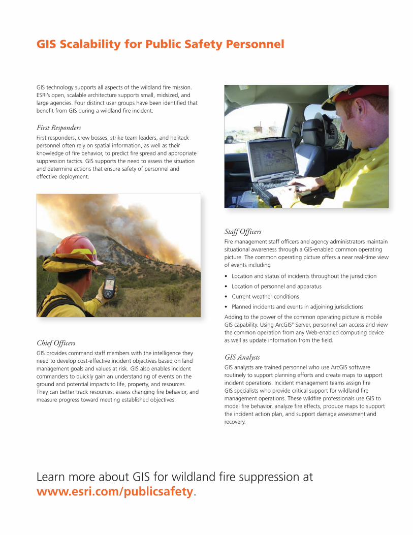
GIS technology supports all aspects of the wildland fire mission. ESRI’s open, scalable architecture supports small, midsized, and large agencies. Four distinct user groups have been identified that benefit from GIS during a wildland fire incident:
First Responders First responders, crew bosses, strike team leaders, and helitack personnel often rely on spatial information, as well as their knowledge of fire behavior, to predict fire spread and appropriate suppression tactics. GIS supports the need to assess the situation and determine actions that ensure safety of personnel and effective deployment.
GIS Solutions for Wildland Fire Suppression
Wildland Fire
Staff OfficersFire management staff officers and agency administrators maintain situational awareness through a GIS-enabled common operating picture. The common operating picture offers a near real-time view of events including
• Locationandstatusofincidentsthroughoutthejurisdiction
• Locationofpersonnelandapparatus
• Currentweatherconditions
• Plannedincidentsandeventsinadjoiningjurisdictions
Adding to the power of the common operating picture is mobile GIS capability. Using ArcGIS® Server, personnel can access and view the common operation from any Web-enabled computing device as well as update information from the field.
GIS AnalystsGIS analysts are trained personnel who use ArcGIS software routinely to support planning efforts and create maps to support incident operations. Incident management teams assign fire GIS specialists who provide critical support for wildland fire management operations. These wildfire professionals use GIS to model fire behavior, analyze fire effects, produce maps to support the incident action plan, and support damage assessment and recovery.
GIS Scalability for Public Safety Personnel
Chief OfficersGIS provides command staff members with the intelligence they needtodevelopcost-effectiveincidentobjectivesbasedonlandmanagement goals and values at risk. GIS also enables incident commanders to quickly gain an understanding of events on the ground and potential impacts to life, property, and resources. They can better track resources, assess changing fire behavior, and measureprogresstowardmeetingestablishedobjectives.
LearnmoreaboutGISforwildlandfiresuppressionatwww.esri.com/publicsafety.
Copyright©2009ESRI.Allrightsreserved.ESRI,theESRIglobelogo,ArcGIS,ArcMap,ArcInfo,ArcToolbox,3DAnalyst,ArcView,StreetMap,@esri.com,andwww.esri.comaretrademarks,registeredtrademarks,orservicemarksofESRIintheUnitedStates,theEuropeanCommunity,orcertainotherjurisdictions.Othercompaniesandproductsmentionedhereinmaybetrademarks or registered trademarks of their respective trademark owners.
116159XXX7.5M6/09tk PrintedinUSA
About ESRI
For four decades, ESRI has been
helping people make better
decisions through management and
analysis of geographic information.
Ourculturallydiversestaffwork
with our business partners and
hundreds of thousands of people
who use GIS to make a difference
in our world.
A full-service GIS company, ESRI
offers support for implementing
GIS technology from the desktop
to enterprise-wide servers, online
services, and mobile devices.
GISsolutionsareflexibleand
customizable to meet the needs of
all our users.
Our Focus
At ESRI, we focus on promoting
the value of GIS and its applications
throughout the world and pay close
attentiontoourusers’needs.Our
software development and services
respond to our customers with
productsthatareeasytouse,flexible,
andintegrated.Ourtechnologyis
multidisciplinary, productive, and
valuable to our users.
We have a strong commitment to
educating our customers through
ESRI’s various training programs. ESRI
is a socially conscious business and
invests heavily in issues regarding
education, conservation, sustainable
development, and humanitarian affairs.
Contact ESRI
1-800-GIS-XPRT(1-800-447-9778)
Phone:909-793-2853
Fax:909-793-5953
www.esri.com
Officesworldwide
www.esri.com/locations
ESRI 380NewYorkStreet
Redlands,California
92373-8100USA

Applying GIS Technology to Wildland FireHaving the Right Information when You Need It Most
ResponseSuccessful response starts with a map. Today, first responders have access to intelligent maps—maps built using databases and powerful modeling capabilities. GIS provides first responders with detailed information when and where they need it for a faster and safer response.
Forexample,withlittletechnicalskillrequiredfromfire personnel, a GIS application on a dispatcher’s console, vehicle-mounted computer, or handheld PDAwillprovidedetailedinformationtoanswerquestions such as the following:
• Whereisthefirelocated?
• Whatisthebestwaytoaccessthefire?
• Whatistheterrainandfueltype?
• Wherearetheevacuationroutes?
• Whatarethehazardstorespondingunits?
• Whatarethevaluesatrisk?
• Whosejurisdictionistheincidentwithin?
Fire Decision Support ToolsIncreasing Situational Awareness and Providing Firefighter Safety
In addition to providing first responders with detailed initial response information, GIS supplies incident commanders with overall situational awareness including
• Currentweatherconditions
• Locationofon-sceneandrespondingunits
• Vegetationconditions
• Predeterminedprotectionpriorities
• Evacuationrequirements
• Suitablelocationsforstagingandincidentcommand posts
Incident commanders use dynamic, real-time datacombinedwithincidentdatatoexpandoperations and respond to changing conditions.
RecoveryGIS enables fire personnel to conduct rapid and accurate damage assessment and rehabilitation requirements after an emergency. Wildfire staff members use GIS integration platforms for the collection, analysis, and display of various types of postincident data. GIS andGPS-enabledlaptopsandPDAscan be used to collect accurate damage information from the field. This data is integrated into a central GIS database for comprehensive analysis and display.
The GIS map provides an overall view of damage and recovery needs with location-specific photos and reports including
• Severityofdamagetobuildings
• Statusofinfrastructureandutilities
• Conditionoflandscapes
• Impactonnaturalresources
This data can be analyzed for recovery and rehabilitation funding requests. It can also be quickly shared with other agencies and organizations.
When it comes to wildfire protection local, state, and federal agencies must be able to respond at a moment’snotice.Protectinglife,property, and natural resources requires comprehensive planning, mitigation, coordination, response, and recovery. Agencies must continually improve service levels without increasing budgets.
ESRI and its public safety partners understand the unique challenges you face—from simple fire suppressiontocomplex,large-scale incident response involving numerous agencies. ESRI’s geographic information system (GIS)platformisdesignedtomeetthe needs of the wildfire protection mission. It gives you the right tools to make accurate decisions under any conditions.
Wildfire agencies use GIS to
• Determineareasvulnerabletointensefirebehavior.
• Identifycriticalvaluesatrisk.
• Predeterminefiretacticsandstrategies.
• EstablishsituationalawarenessthroughaGIS-basedcommon operating picture.
• Producekeymapsandanalysistosupportfiresuppression operations.
• Identifyandanalyzefiredamagetodeveloprehabilitation plans.
• Informthepublicofchangingconditionssuchasroadclosures and threatened areas.
After the Australia bush fires of 2009, this Internet map viewer was used to identify parcels searched during recovery.
This mountain forest crown closure map was derived from light detection and ranging (lidar) data and verified by Casper Mountain Fire Protection District and Wyoming Forestry Division staff.
ArcGIS shows lightning strike activity over the western United States. First responders use this data to determine ignition points.
The Fire Incident Mapping Tool extension for ArcGIS is used to manage and support wildfire incidents.
ArcGIS Explorer illustrates information collected in the field
identifying damaged structures and includes the terrain profile
and site-specific photos.
PlanningGIStechnologyprovideseasy-to-usetoolsformaximizingalltypesof information and data for planning requirements. GIS stores spatial information in a digital mapping environment that allows fire managers to quickly select and view data that can influence fire behavior. Factors such as vegetation types, slopes, aspects, natural or man-made barriers, and historical weather patterns can be overlaid to determine fire hazards based on modeling potential fire behavior. The likelihood of wildfire ignitions can be predicted by locating historical fire locations and identifying potential ignition sources (e.g.,powerlines,roads,industrialareas,housingareas).Additionalactions, such as vegetation modification, fire prevention programs, and code compliance, can be planned and modeled using GIS.
MitigationGIS allows you to analyze, visualize, and prioritize values at risk, such as housing developments, utility infrastructure, wildlife, and natural orculturalresources.ManycommunitiesuseGIStoanalyzetheirvulnerability to wildfire. Information-rich maps help determine the actions necessary for developing effective wildfire protection.
PDA’s and GPS enabled digital cameras were used to document properties searched after the Australia bush fires.
GIS technology supports all aspects of the wildland fire mission. ESRI’s open, scalable architecture supports small, midsized, and large agencies. Four distinct user groups have been identified that benefit from GIS during a wildland fire incident:
First Responders First responders, crew bosses, strike team leaders, and helitack personnel often rely on spatial information, as well as their knowledge of fire behavior, to predict fire spread and appropriate suppression tactics. GIS supports the need to assess the situation and determine actions that ensure safety of personnel and effective deployment.
GIS Solutions for Wildland Fire Suppression
Wildland Fire
Staff OfficersFire management staff officers and agency administrators maintain situational awareness through a GIS-enabled common operating picture. The common operating picture offers a near real-time view of events including
• Locationandstatusofincidentsthroughoutthejurisdiction
• Locationofpersonnelandapparatus
• Currentweatherconditions
• Plannedincidentsandeventsinadjoiningjurisdictions
Adding to the power of the common operating picture is mobile GIS capability. Using ArcGIS® Server, personnel can access and view the common operation from any Web-enabled computing device as well as update information from the field.
GIS AnalystsGIS analysts are trained personnel who use ArcGIS software routinely to support planning efforts and create maps to support incident operations. Incident management teams assign fire GIS specialists who provide critical support for wildland fire management operations. These wildfire professionals use GIS to model fire behavior, analyze fire effects, produce maps to support the incident action plan, and support damage assessment and recovery.
GIS Scalability for Public Safety Personnel
Chief OfficersGIS provides command staff members with the intelligence they needtodevelopcost-effectiveincidentobjectivesbasedonlandmanagement goals and values at risk. GIS also enables incident commanders to quickly gain an understanding of events on the ground and potential impacts to life, property, and resources. They can better track resources, assess changing fire behavior, and measureprogresstowardmeetingestablishedobjectives.
LearnmoreaboutGISforwildlandfiresuppressionatwww.esri.com/publicsafety.
Copyright©2009ESRI.Allrightsreserved.ESRI,theESRIglobelogo,ArcGIS,ArcMap,ArcInfo,ArcToolbox,3DAnalyst,ArcView,StreetMap,@esri.com,andwww.esri.comaretrademarks,registeredtrademarks,orservicemarksofESRIintheUnitedStates,theEuropeanCommunity,orcertainotherjurisdictions.Othercompaniesandproductsmentionedhereinmaybetrademarks or registered trademarks of their respective trademark owners.
116159XXX7.5M6/09tk PrintedinUSA
About ESRI
For four decades, ESRI has been
helping people make better
decisions through management and
analysis of geographic information.
Ourculturallydiversestaffwork
with our business partners and
hundreds of thousands of people
who use GIS to make a difference
in our world.
A full-service GIS company, ESRI
offers support for implementing
GIS technology from the desktop
to enterprise-wide servers, online
services, and mobile devices.
GISsolutionsareflexibleand
customizable to meet the needs of
all our users.
Our Focus
At ESRI, we focus on promoting
the value of GIS and its applications
throughout the world and pay close
attentiontoourusers’needs.Our
software development and services
respond to our customers with
productsthatareeasytouse,flexible,
andintegrated.Ourtechnologyis
multidisciplinary, productive, and
valuable to our users.
We have a strong commitment to
educating our customers through
ESRI’s various training programs. ESRI
is a socially conscious business and
invests heavily in issues regarding
education, conservation, sustainable
development, and humanitarian affairs.
Contact ESRI
1-800-GIS-XPRT(1-800-447-9778)
Phone:909-793-2853
Fax:909-793-5953
www.esri.com
Officesworldwide
www.esri.com/locations
ESRI 380NewYorkStreet
Redlands,California
92373-8100USA