
GIS Mapping Website Guide
16
GC_236594 Guide to Mapping Website (Public) May 2015
-
Upload
legolas55569 -
Category
Documents
-
view
236 -
download
0
description
GIS Mapping Website Guide
Transcript of GIS Mapping Website Guide

GC_236594
Guide to Mapping Website (Public)
May 2015

GC_236594
Table of Contents Guide to Mapping Website (Public) ................................................................................. 1
May 2015 ........................................................................................................................ 1
Quick Start ...................................................................................................................... 3
Map Layers ..................................................................................................................... 4
How do I…? .................................................................................................................... 5
Draw on the Map ......................................................................................................... 5
Make Measurements on the Map ................................................................................ 6
Create a Printable Map ................................................................................................ 7
Export a Map Image .................................................................................................... 8
Find Data ..................................................................................................................... 9
A – Parcels / Addresses ........................................................................................... 9
B – Lots and Concessions ..................................................................................... 10
C – Other Information ............................................................................................. 10
Search by Selecting Features on the Map ................................................................. 11
Filter and Query Data ................................................................................................ 12
Refine Searches ........................................................................................................ 13
Display Coordinates ................................................................................................... 14
Open Third-Party Maps ............................................................................................. 15

GC_236594
Mapping Instructions
Quick Start
Click on the map to find more information on the features that are displayed.
Double Click on the map to zoom in.
Click & Drag mouse on map to move the map image.
Opens and closes the toolbar which offers additional tabs and features.
Returns to the home screen. Use the "<" and ">" icons at the top left corner of the map to toggle visibility of this panel.
Use this button at the bottom left of your screen to explore the different layers available in this map. Light grey text indicates the layer is not visible at this scale.
Use the search bar in the top right of your screen to search for features.
Click to find your location.
Zoom Out
Zoom In
Creates a bookmark for the current map extent. The bookmark is stored on your computer and can be found here any time you load this map.

Page 4
Grey County: Colour It Your Way
Map Layers
To view the list of available map layers,
click this icon (located in the bottom left of your map).
(1) Use the check boxes to turn layers on
or off. Press the “+” and “-“ symbols to
expand group layers.
Light grey layer names indicate the layer
will not currently draw on the map. Either
the parent group is not toggled on, or the
layer will not draw at the current scale,
most draw when the map is zoomed in.
(2) The slider next to layer groups will
change the opacity of the layers in that
group from 0-100%.
(3) Themes, pre-configured groups of map
layers, are available from the pull-down at
the top of the layer list.
(4) The Show Legend option will display a
legend of the map symbology for any layer
that is turned on and drawing at the
current scale. This is what will be used in
the print templates.
You can also quickly toggle
between basemaps with the
button on the bottom left of
the map face.
Notes:
1. Water features are under Planning > Conservation Authorities.
2. The county official plan map data is organized according to the official plan
document.

Page 5
Grey County: Colour It Your Way
How do I…?
Draw on the Map
Open the Draw and Measure tab on the toolbar.
The first set of tools is used for drawing mark-up on the map. If you click on a tool, and
then click Styles, you can choose pre-selected styles for each of the different tools, i.e.
different point size and color.
You can change a drawing after adding it to the map. Click the Edit tool, and then select
the drawing you wish to edit. Click the center, hold and drag to move the shape.
Click the square toggle at the top (1) to rotate the drawing. Click one of the square
toggles at the corner of the dotted bounding box (2) to make the drawing larger or
smaller while preserving proportions, or (3) change the shape of the drawing by clicking
and dragging the circles at each vertex and line midpoint.
Use the Erase button to remove individual drawings, or remove them all with the Clear
All button.
Your drawings will appear on printed maps but have no perimeter or area
measurements associated with them.

Page 6
Grey County: Colour It Your Way
Make Measurements on the Map
Open the Draw and Measure tab on the toolbar.
Note: The default Preserve option keeps measurements on the map. Otherwise they will
be cleared when you make additional measurements or change tools.
Select a measurement style from the pull down labelled Measure.
The line, polygon and rectangle tools create a table displaying the coordinates of
vertices, the lengths of each segment, and the angle and bearing between segments.
You can change the units for linear and area measurements in the options beside the
tools. You can change the units either before or after the shape has been added to the
map.
If you are using the Line or Polygon measurement tools, you can navigate the map
while the tool is active:
The mouse wheel zooms the map in and out;
Pressing both the left mouse button allows you to drag the map to pan, keeping
the measurement tool active in the background.

Page 7
Grey County: Colour It Your Way
Create a Printable Map
Open the print dialog through either the I Want To Menu, or from the toolbar, under
Tasks.
The print dialog allows you to:
1) Choose a layout (letter or legal; portrait or landscape);
2) Choose a file format (pdf or image – jpg, png,
gif);
3) Choose the resolution;
4) Apply a map grid;
5) Change the scale (note: change the scale from
current may have undesired effects – some
layers may not draw);
6) Add a title, which will appear in the top of the
map; and
7) Add a description which will appear in the bottom right hand corner of the map, below the legend.
Troubleshooting: The webpage will attempt to open the new map file. If your browser
is set to block popups it will suppress the file from being opened. In Chrome, you will be
notified in the address bar that the browser has blocked pop ups:
Internet Explorer notifies you with a yellow banner at the very top of the webpage.
You can click the notification, and choose to allow the image to pop up.

Page 8
Grey County: Colour It Your Way
Export a Map Image
You can export an image of the current map, including geo-referencing information so
the image can be used in desktop GIS software. Choose the Export tool from the Tasks
tab on the toolbar:
You can choose which image format to create, and export the associated
georeferencing information.

Page 9
Grey County: Colour It Your Way
Find Data
A – Parcels / Addresses
I) You can search for addresses and roll numbers in the search bar at the top of the
page, for best results keep it as simple as possible (i.e. limit the search to a 6-digit
civic number or roll number).
II) Use the advanced parcel search tool available on the toolbar under the Find and Query Data tab. As you start to enter a roll number, or a street address, matching records will populate the list. Choose one, select OK and the map will pan and zoom to the result.
To see multiple addresses listed against a
single assessment parcel, click on the
parcel result on the left hand pane, or
additional details on the pop up, then select
the Addresses tab. Additional addresses are
listed in table format.
If you are viewing records in the list view
(i.e. the left hand panel) you can click on roll
numbers under “addresses” to see the
associated address.

Page 10
Grey County: Colour It Your Way
B – Lots and Concessions
I) Lots and concessions can be found using the Lots and Concessions tool under the
Find and Query Data tab. As you begin to type a lot number, matches will appear. When
you select a lot the concessions box will populate with matching concessions. When
you’ve chosen one and selected OK, a list of matching records will appear in the left
hand panel, displaying the Lot, Concession and Township. Choose one and hit next to
pan and zoom to the result.
C – Other Information
If there is other information you are looking for on the map, try searching for it in the
search bar (again, keep it simple).
Examples:
I want to find a… Example search term
Town (i.e. Eugenia) Eugenia Park (i.e. Harrison Park) Harrison Park Trail (i.e. Massie Hills Ski Trail) Massie1
Boat Launch Boat Launch 1You would find Massie Hills Ski Trail if you searched for it, but you wouldn’t find results for Massie AND ski, or
massie ski trail, etc. Keep the searches simple.

Page 11
Grey County: Colour It Your Way
Search by Selecting Features on the Map
If features are visible on the map (i.e. turned on in the table of contents, and visible at
the current scale), and you have no tools currently selected, you can click on most
features to see more information about them. Selected features are returned in the left
hand panel as search results (see above for more information).
You can also use the identify tools found under the Find and Query tab of the toolbar in
a similar manner. Results will be returned for any visible features that intersect the
shape you draw on the map.

Page 12
Grey County: Colour It Your Way
Filter and Query Data
You can find data in the map based on specific attributes using the Find or Query tools.
The Filter tool will modify a map layer so only records matching your selection are
shown. For example, imagine you wanted to see only the lands zoned as Rural in the
Municipality of Grey Highlands. Make sure that layer is turned on in the Table of
Contents, and currently visible. Using the filter tool, select the Zoning – Grey Highlands
layer, and construct a selection statement as Zone = ‘RU’(see example below). Press
the Filter button to apply the filter.
You can add additional conditions with the
Add Another Condition button, or limit the
results to the specific extent using the
Spatial Filter options (the options are None,
Current Extent, or any polygon drawings
you have added).
Some values will appear in the right hand
box, but not necessarily all. You may have
to explore the data by looking (clicking on)
features in the map and seeing the
attributes.
You can use the ‘contains’ operator to find
multiple, similar results (i.e. Final Type Contains Agricul would return Agriculture,
Restricted Agriculture, etc).
The Query tool works similarly, except that rather than limit the display on the map,
records matching your query are returned as results.

Page 13
Grey County: Colour It Your Way
Refine Searches
Normally search results appear as a list in the left hand panel. You can more easily
search through results by switching to table view, which automatically sorts by map
layers. This button is the table icon at the bottom of the search results.
Page 14
Grey County: Colour It Your Way
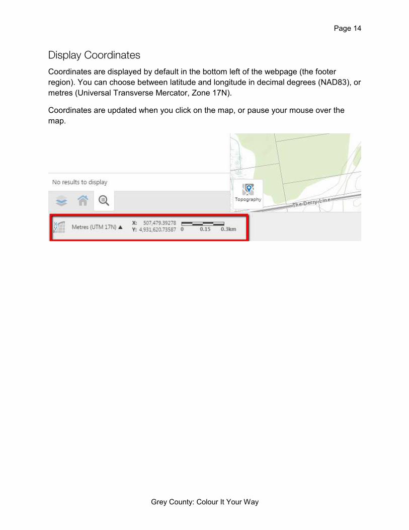
Display Coordinates
Coordinates are displayed by default in the bottom left of the webpage (the footer
region). You can choose between latitude and longitude in decimal degrees (NAD83), or
metres (Universal Transverse Mercator, Zone 17N).
Coordinates are updated when you click on the map, or pause your mouse over the
map.

Page 15
Grey County: Colour It Your Way
Open Third-Party Maps
You can open viewers to load Bing and Google maps at the location corresponding to
your current Grey County maps view.
Controls:
1. Choose which third party map to display
2. Drag this icon on the Grey County map to update the corresponding third-party
map (Bing only).
3. Press the target button to centre the third party map on the current Grey County
map location.
4. Undock this window.
You can open Google street view at the corresponding location, if available, but the
synchronization tools have not yet been enabled.

Page 16
Grey County: Colour It Your Way


