
GIS for Public Works -...
12
GIS for Public Works Building a Public Works Information System • Roads and Streets • Solid Waste • Traffic • Engineering • Parks and Grounds
Transcript of GIS for Public Works -...

GIS for Public WorksBuilding a Public Works Information System
•RoadsandStreets•SolidWaste•Traffic•Engineering•ParksandGrounds

GIS Improves Your Work
On a day-to-day basis, public works employees rely on a variety of information systems to plan work, complete tasks, and update databases. They must engage with work order systems, asset management systems, permitting systems, 311 systems, complaint center systems, and so on, with each system offering a different array of interfaces and data. When geographic information system (GIS) technology is integrated with these systems, geography becomes the focal point for service and data, linking databases together, consolidating workflows,
and presenting a common operating picture for the end user. For example, a supervisor can quickly find the location of a site, access the work orders pertaining to the site, visualize the site in 3D, generate detailed maps, and spatially analyze the problem before scheduling and routing field crews.
The ArcGIS® suite of software is interoperable with the many data formats public works departments use each day. Stand-alone tools work with the different data types, which allow you to build data and workflow models that automate common tasks. These tools and models can be shared throughout an organization to create efficient and uniform solutions.
An ESRI GIS improves• Facility maintenance
• Trash collection
• Fleet management
• Roadway upkeep
• Engineering
• Landscaping
• Infrastructure management
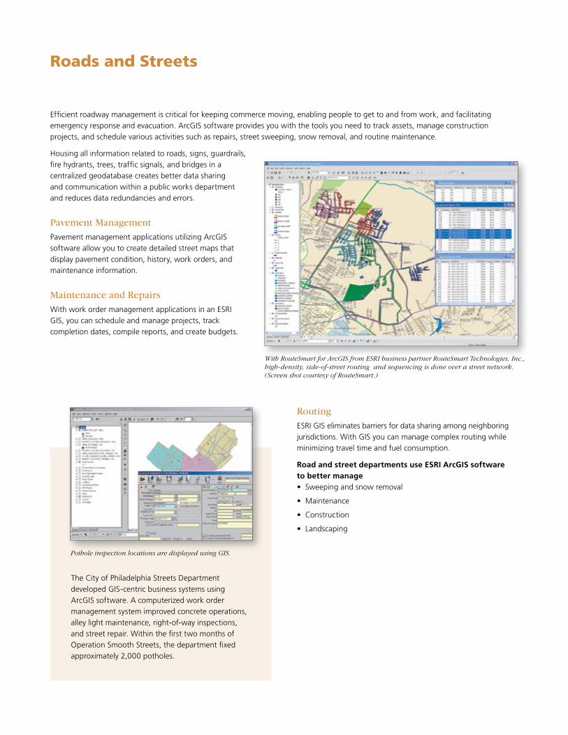
Other Corporate Databases
Geodatabase
ArcGIS Desktop ArcGIS Server Work OrderManagement
TreeInventory
Road RepairScheduling
Solid WasteCollectionRouting
Traffic Flowand Modeling
Map BookProduction
Web and Mobile ApplicationsGIS for Work Order Management• Empower field and office staff to efficiently
manage workload.
• Read and edit work orders from the field.
• Provide real-time tracking updates for managers.
GIS for Asset Management• Track history, condition, and location of assets.
• Schedule preventive and predictive maintenance.
• Provide accurate financial summary information of repairs.
GIS for Data Sharing• Streamline workflow.
• Enrich decision making.
• Save time and money.
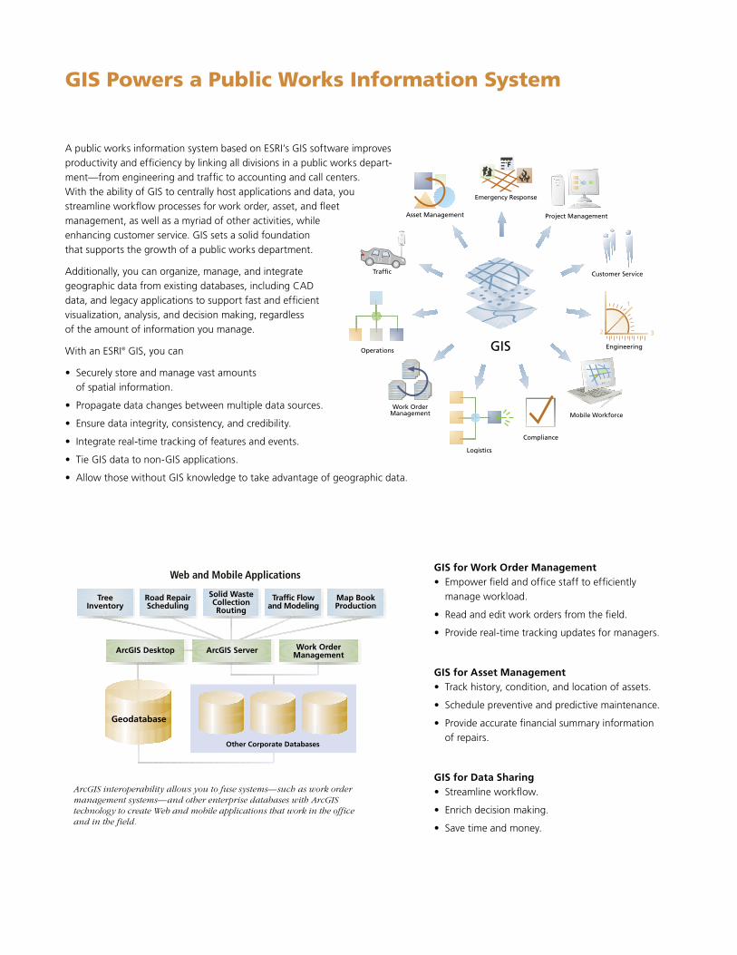
GIS Powers a Public Works Information System
ArcGIS interoperability allows you to fuse systems—such as work order management systems—and other enterprise databases with ArcGIS technology to create Web and mobile applications that work in the office and in the field.
A public works information system based on ESRI’s GIS software improves productivity and efficiency by linking all divisions in a public works depart-ment—from engineering and traffic to accounting and call centers. With the ability of GIS to centrally host applications and data, you streamline workflow processes for work order, asset, and fleet management, as well as a myriad of other activities, while enhancing customer service. GIS sets a solid foundation that supports the growth of a public works department.
Additionally, you can organize, manage, and integrate geographic data from existing databases, including CAD data, and legacy applications to support fast and efficient visualization, analysis, and decision making, regardless of the amount of information you manage.
With an ESRI® GIS, you can
• Securely store and manage vast amounts of spatial information.
• Propagate data changes between multiple data sources.
• Ensure data integrity, consistency, and credibility.
• Integrate real-time tracking of features and events.
• Tie GIS data to non-GIS applications.
• Allow those without GIS knowledge to take advantage of geographic data.
Emergency Response
Work OrderManagement
Project Management
Operations
Traffic
Efficient roadway management is critical for keeping commerce moving, enabling people to get to and from work, and facilitating emergency response and evacuation. ArcGIS software provides you with the tools you need to track assets, manage construction projects, and schedule various activities such as repairs, street sweeping, snow removal, and routine maintenance.
Housing all information related to roads, signs, guardrails, fire hydrants, trees, traffic signals, and bridges in a centralized geodatabase creates better data sharing and communication within a public works department and reduces data redundancies and errors.
Pavement Management
Pavement management applications utilizing ArcGIS software allow you to create detailed street maps that display pavement condition, history, work orders, and maintenance information.
Maintenance and Repairs
With work order management applications in an ESRI GIS, you can schedule and manage projects, track completion dates, compile reports, and create budgets.
Routing
ESRI GIS eliminates barriers for data sharing among neighboring jurisdictions. With GIS you can manage complex routing while minimizing travel time and fuel consumption.
Road and street departments use ESRI ArcGIS software to better manage• Sweeping and snow removal
• Maintenance
• Construction
• Landscaping
Roads and Streets
The City of Philadelphia Streets Department developed GIS-centric business systems using ArcGIS software. A computerized work order management system improved concrete operations, alley light maintenance, right-of-way inspections, and street repair. Within the first two months of Operation Smooth Streets, the department fixed approximately 2,000 potholes.
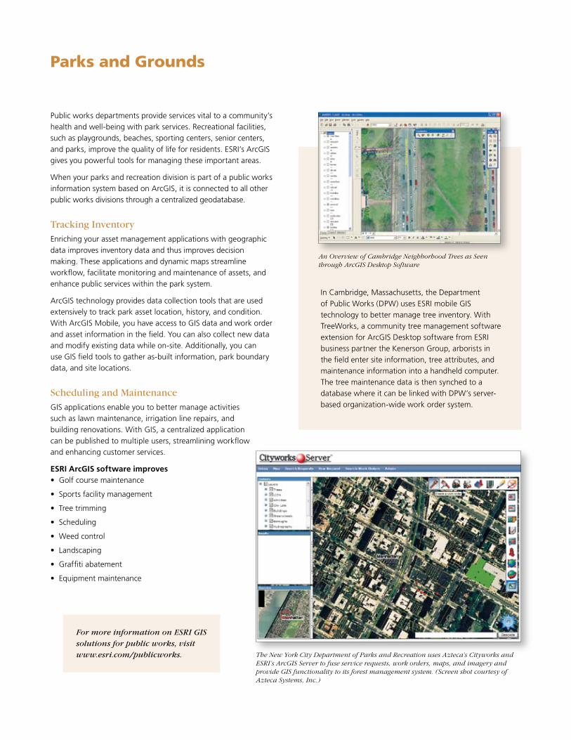
Pothole inspection locations are displayed using GIS.
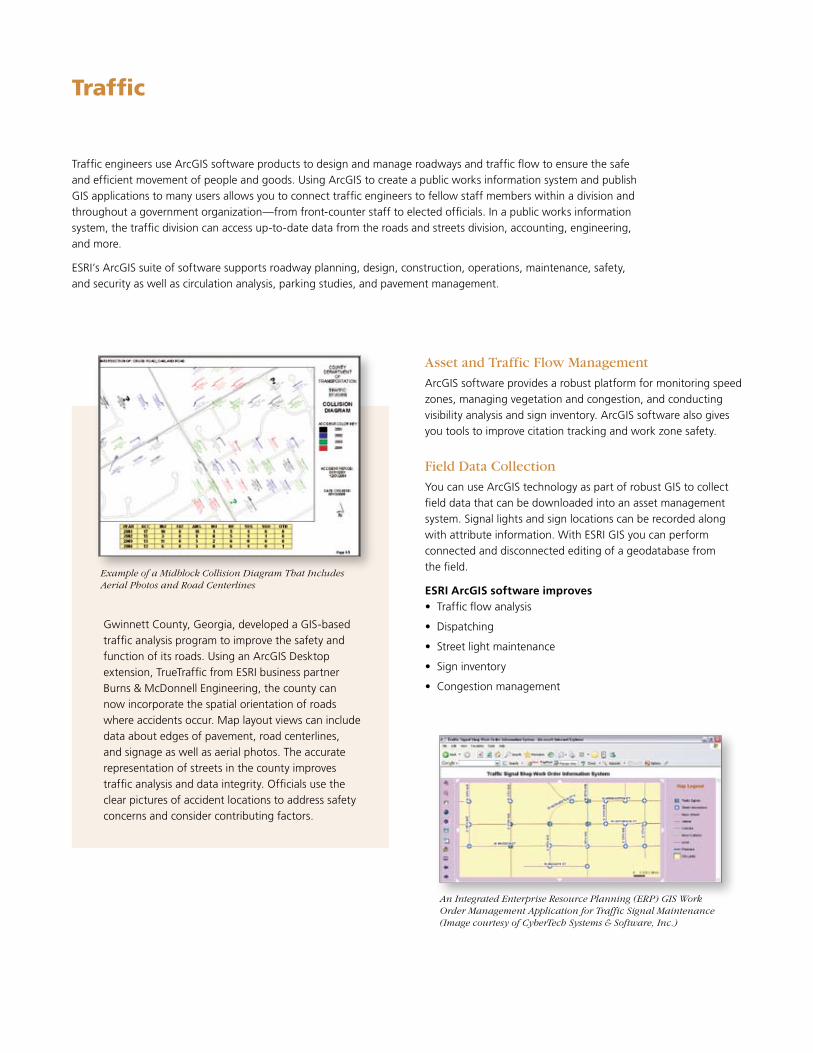
With RouteSmart for ArcGIS from ESRI business partner RouteSmart Technologies, Inc., high-density, side-of-street routing and sequencing is done over a street network. (Screen shot courtesy of RouteSmart.)

Public works departments use ArcGIS software to manage landfills, vehicle routing, waste collection, recycling, hazardous materials, code enforcement, and community improvements.
When a solid waste department is part of a public works information system based on ArcGIS software, it has access to a centralized geodatabase that houses information from all departments in the organization. Reducing data collection redundancies and providing fast access to current data files improves workflow, customer service, and productivity.
Routing
Use ArcGIS software to optimize collection routes and create improved schedules and reports. GIS can also deliver routing applications to multiple users via the Web. ESRI’s routing tools determine the optimal stop sequences to minimize fuel costs and drive times.
Site Location
ArcGIS helps you select the best location for landfill sites. Using the geoprocessing tools in ArcGIS, you can create suitability models to assess the various factors that need to be considered when determining the optimum location for a new landfill site.
Solid Waste
Using ArcGIS software, solid waste departments enhance• Landfill management
• Trash collection
• Environmental monitoring
• Routing
• Asset management
The Miami-Dade Department of Solid Waste Management uses ArcLogistics Route to increase the efficiency of special-ized routing.
The Miami-Dade Department of Solid Waste Management uses ESRI software to increase the efficiency of specialized routing. Data that was once managed using paper forms and static maps is now seamlessly integrated. GIS is also used by the Citizen Call Complaint system that manages reports of illegal dumping.
“We had a goal to cut the time it takes between a customer call with a request and our fulfilling that request,” says Karen Grassi, senior systems analyst, Miami-Dade County, Applications Consulting Services Division. “We were able to meet that goal with the ArcLogistics™ Route application because we had an automated, efficient method for getting trucks routed quickly and relatively easily. The improvements were dramatic.”
The City of Moreno Valley, California, uses GIS to map trash collection boundaries and schedule collection.
Traffic engineers use ArcGIS software products to design and manage roadways and traffic flow to ensure the safe and efficient movement of people and goods. Using ArcGIS to create a public works information system and publish GIS applications to many users allows you to connect traffic engineers to fellow staff members within a division and throughout a government organization—from front-counter staff to elected officials. In a public works information system, the traffic division can access up-to-date data from the roads and streets division, accounting, engineering, and more.
ESRI’s ArcGIS suite of software supports roadway planning, design, construction, operations, maintenance, safety, and security as well as circulation analysis, parking studies, and pavement management.
Traffic
Gwinnett County, Georgia, developed a GIS-based traffic analysis program to improve the safety and function of its roads. Using an ArcGIS Desktop extension, TrueTraffic from ESRI business partner Burns & McDonnell Engineering, the county can now incorporate the spatial orientation of roads where accidents occur. Map layout views can include data about edges of pavement, road centerlines, and signage as well as aerial photos. The accurate representation of streets in the county improves traffic analysis and data integrity. Officials use the clear pictures of accident locations to address safety concerns and consider contributing factors.
Example of a Midblock Collision Diagram That Includes Aerial Photos and Road Centerlines
Asset and Traffic Flow Management
ArcGIS software provides a robust platform for monitoring speed zones, managing vegetation and congestion, and conducting visibility analysis and sign inventory. ArcGIS software also gives you tools to improve citation tracking and work zone safety.
Field Data Collection
You can use ArcGIS technology as part of robust GIS to collect field data that can be downloaded into an asset management system. Signal lights and sign locations can be recorded along with attribute information. With ESRI GIS you can perform connected and disconnected editing of a geodatabase from the field.
ESRI ArcGIS software improves• Traffic flow analysis
• Dispatching
• Street light maintenance
• Sign inventory
• Congestion management
An Integrated Enterprise Resource Planning (ERP) GIS Work Order Management Application for Traffic Signal Maintenance (Image courtesy of CyberTech Systems & Software, Inc.)

Field Data Collection
ArcGIS technology allows you to take GIS functionality and data to the field. You can retrieve maps and infrastructure information, edit existing data, and enter new as-built data. Databases are updated in near real time from the field, which improves decision making throughout the organization.
An ESRI GIS enhances• Data accuracy
• Data sharing
• Workflow
• Communication
Practical applications include
• Design
• Survey and inspection
• Homeland security
• Environment
• Mapping/GIS
• Real estate
Engineering
You can visualize spatially referenced engineering data in 3D and share it within and among government departments.
With ArcGIS you can overlay computer-aided drafting data on aerial photography from a geodatabase.
Engineering divisions use GIS for capital improvement projects, subdivision development, infrastructure improve-ments, and more. With the ArcGIS suite of software, you can integrate disparate databases, enrich designs with spatial references, and visualize real-world conditions surrounding a project site. Additionally, a GIS gives you archived information about the history of assets as well as upcoming maintenance schedules and work orders. With ArcGIS products, you will improve asset management, infrastructure design, and data sharing.
Data Sharing
Engineering data is important to many government depart-ments, from homeland security to accounting. With a public works information system, you can easily share important data within and among departments for improved efficiency, productivity, and critical decision making.
When all public works divisions participate in a public works information system, you can access data from a myriad of databases to manage projects, operations, and budgets.
Interoperability
ArcGIS software is interoperable with more than 40 data formats. Incorporat-ing all data, regardless of type, into a GIS makes it easier for you to leverage all the information you have when working on a project. The ability to merge design drawings with GIS data immediately increases the integrity of the data and promotes better and more accurate decisions.
With ArcGIS solutions, you can improve computer-aided drafting by displaying GIS mapping and geoprocessing capabilities in the drafting environment. This gives you the cartographic and computing power you need to better manage development projects and infrastructure maintenance.
Parks and Grounds
Public works departments provide services vital to a community’s health and well-being with park services. Recreational facilities, such as playgrounds, beaches, sporting centers, senior centers, and parks, improve the quality of life for residents. ESRI’s ArcGIS gives you powerful tools for managing these important areas.
When your parks and recreation division is part of a public works information system based on ArcGIS, it is connected to all other public works divisions through a centralized geodatabase.
Tracking Inventory
Enriching your asset management applications with geographic data improves inventory data and thus improves decision making. These applications and dynamic maps streamline workflow, facilitate monitoring and maintenance of assets, and enhance public services within the park system.
ArcGIS technology provides data collection tools that are used extensively to track park asset location, history, and condition. With ArcGIS Mobile, you have access to GIS data and work order and asset information in the field. You can also collect new data and modify existing data while on-site. Additionally, you can use GIS field tools to gather as-built information, park boundary data, and site locations.
Scheduling and Maintenance
GIS applications enable you to better manage activities such as lawn maintenance, irrigation line repairs, and building renovations. With GIS, a centralized application can be published to multiple users, streamlining workflow and enhancing customer services.
ESRI ArcGIS software improves• Golf course maintenance
• Sports facility management
• Tree trimming
• Scheduling
• Weed control
• Landscaping
• Graffiti abatement
• Equipment maintenance
The New York City Department of Parks and Recreation uses Azteca’s Cityworks and ESRI’s ArcGIS Server to fuse service requests, work orders, maps, and imagery and provide GIS functionality to its forest management system. (Screen shot courtesy of Azteca Systems, Inc.)
In Cambridge, Massachusetts, the Department of Public Works (DPW) uses ESRI mobile GIS technology to better manage tree inventory. With TreeWorks, a community tree management software extension for ArcGIS Desktop software from ESRI business partner the Kenerson Group, arborists in the field enter site information, tree attributes, and maintenance information into a handheld computer. The tree maintenance data is then synched to a database where it can be linked with DPW’s server-based organization-wide work order system.
An Overview of Cambridge Neighborhood Trees as Seen through ArcGIS Desktop Software
For more information on ESRI GIS solutions for public works, visit www.esri.com/publicworks.

Learn from the World Leader in GIS
ESRI offers many types of training including instructor-led classes in both traditional classrooms and online as well as self-study online courses. Courses cover a variety of topics related to ESRI software, the theory underlying GIS technology, and applying GIS tools to find solutions in the government field. ESRI combines hands-on experience, interactivity, and instructional support to create an effective learning environment. For more information, visit www.esri.com/training.
ESRI also has books and workbooks published by ESRI Press to supplement your learning. Our extensive library, the largest GIS library on the Internet, gives you access to the latest conference proceedings and publications. For more information, visit www.esri.com/esripress.
Additionally, ESRI professionals can help you evaluate your organization’s needs, decide which products will help your department reach its GIS goals, and support your efforts after implementation.
Professional Services
ESRI GIS professionals offer consulting, design, program-ming, and implementation services as well as database design and assistance in data publishing. For more infor-mation, visit www.esri.com/consulting.
ArcGIS Maintenance Program
The ArcGIS maintenance program is a cost-effective program that includes software updates, technical support, and many other benefits. Maintenance is offered as an annual subscription, making it easy to plan for the cost of support and software updates. You can subscribe to maintenance to receive 12 months of technical support and all software updates occurring during those 12 months. For more information, visit www.esri.com/maintenance.
Technical Support
ESRI offers a rich array of technical support and user community resources to help you meet your GIS challenges. From 24/7 technical support to online user groups and a variety of self-help resources, ESRI has the tools to make you successful. For more information, visit www.esri.com/support.
Getting Started
ESRI instructors teach classes at company headquarters in Redlands, California, and around the world.
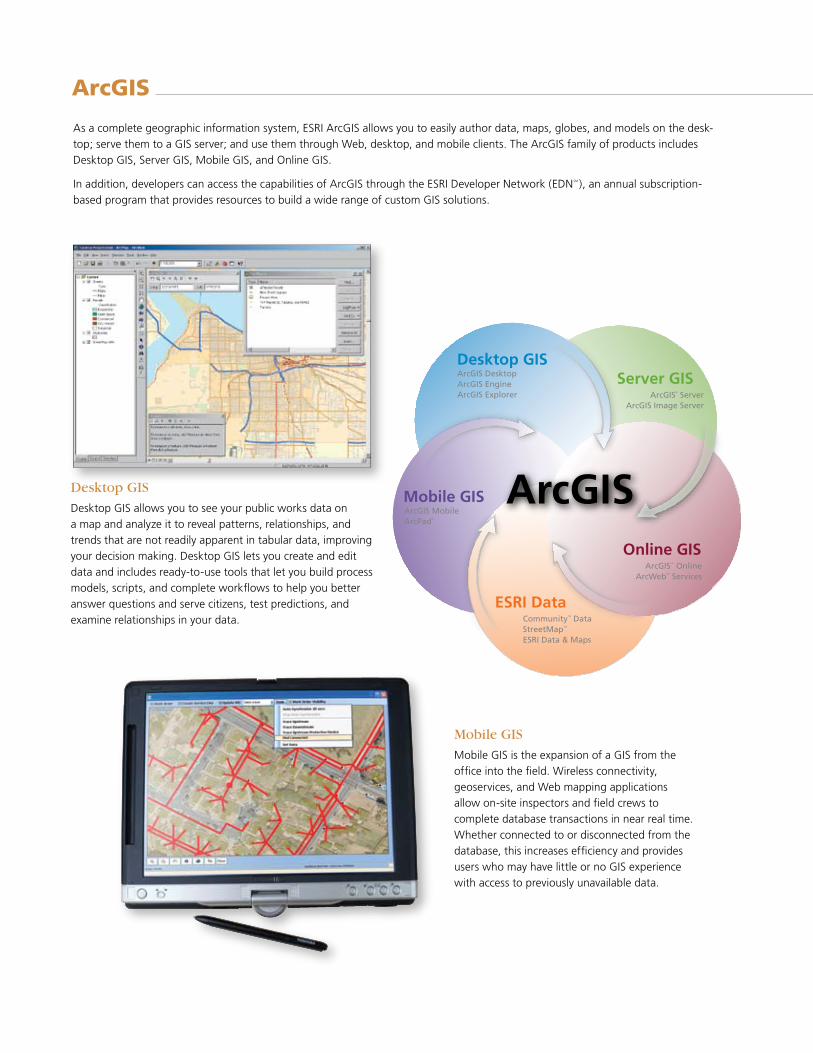
Desktop GIS
Desktop GIS allows you to see your public works data on a map and analyze it to reveal patterns, relationships, and trends that are not readily apparent in tabular data, improving your decision making. Desktop GIS lets you create and edit data and includes ready-to-use tools that let you build process models, scripts, and complete workflows to help you better answer questions and serve citizens, test predictions, and examine relationships in your data.
ArcGIS
As a complete geographic information system, ESRI ArcGIS allows you to easily author data, maps, globes, and models on the desk-top; serve them to a GIS server; and use them through Web, desktop, and mobile clients. The ArcGIS family of products includes Desktop GIS, Server GIS, Mobile GIS, and Online GIS.
In addition, developers can access the capabilities of ArcGIS through the ESRI Developer Network (EDNSM), an annual subscription-based program that provides resources to build a wide range of custom GIS solutions.
Mobile GIS
Mobile GIS is the expansion of a GIS from the office into the field. Wireless connectivity, geoservices, and Web mapping applications allow on-site inspectors and field crews to complete database transactions in near real time. Whether connected to or disconnected from the database, this increases efficiency and provides users who may have little or no GIS experience with access to previously unavailable data.
ArcGIS
Desktop GISServer GIS
Online GIS
ESRI Data
Mobile GIS
ArcGIS® ServerArcGIS Image Server
ArcGISSM OnlineArcWebSM Services
CommunityTM DataStreetMapTM
ESRI Data & Maps
ArcGIS MobileArcPad®
ArcGIS DesktopArcGIS EngineArcGIS Explorer
Learn more about ArcGIS at www.esri.com/arcgis.
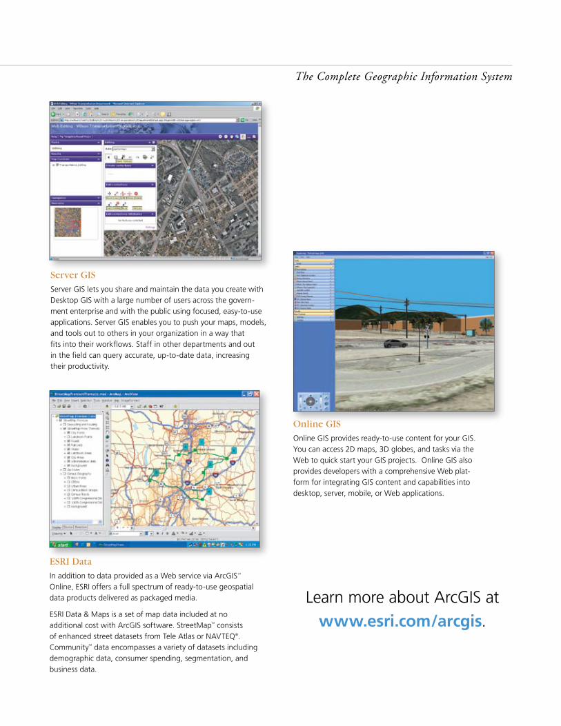
Online GIS
Online GIS provides ready-to-use content for your GIS. You can access 2D maps, 3D globes, and tasks via the Web to quick start your GIS projects. Online GIS also provides developers with a comprehensive Web plat-form for integrating GIS content and capabilities into desktop, server, mobile, or Web applications.
Server GIS
Server GIS lets you share and maintain the data you create with Desktop GIS with a large number of users across the govern-ment enterprise and with the public using focused, easy-to-use applications. Server GIS enables you to push your maps, models, and tools out to others in your organization in a way that fits into their workflows. Staff in other departments and out in the field can query accurate, up-to-date data, increasing their productivity.
ESRI Data
In addition to data provided as a Web service via ArcGISSM Online, ESRI offers a full spectrum of ready-to-use geospatial data products delivered as packaged media.
ESRI Data & Maps is a set of map data included at no additional cost with ArcGIS software. StreetMap™ consists of enhanced street datasets from Tele Atlas or NAVTEQ®. Community™ data encompasses a variety of datasets including demographic data, consumer spending, segmentation, and business data.
The Complete Geographic Information System

No. GS-35F-5086H
Printed in USA
ESRI International Offices
ESRI Regional Offices
Olympia 360-754-4727
St. Louis 636-949-6620
Minneapolis 651-454-0600
Boston 978-777-4543
Washington, D.C. 703-506-9515
Charlotte 704-541-9810
San Antonio 210-499-1044
Denver 303-449-7779
California 909-793-2853 ext. 1-1906
106105UBS5M6/07st
Copyright © 2007 ESRI. All rights reserved. ESRI, GIS by ESRI, the ESRI globe logo, ArcGIS, ArcMap, ArcView, ArcLogistics, StreetMap, Community, ArcPad, ArcWeb, EDN, www.esri.com, and @esri.com are trademarks, registered trademarks, or service marks of ESRI in the United States, the European Community, or certain other jurisdictions. Other companies and products mentioned herein may be trademarks or registered trademarks of their respective trademark owners.
1-800-GIS-XPRT (1-800-447-9778)
www.esri.com
Locate an ESRI value-added reseller near you at
www.esri.com/resellers
Outside the United States, contact your local ESRI distributor. For the number of your distributor, call ESRI at 909-793-2853, ext. 1-1235, or visit our Web site at
www.esri.com/distributors
For More Information
ESRI 380 New York Street Redlands, California 92373-8100 USA
Phone: 909-793-2853Fax: 909-793-5953 E-mail: [email protected]
For more than 35 years, ESRI has
been helping people make better
decisions through management
and analysis of geographic
information. A full-service GIS
company, ESRI offers a framework
for implementing GIS technology
and business logic in any
organization from personal GIS on
the desktop to enterprise-wide GIS
servers (including the Web) and
mobile devices. ESRI GIS solutions
are flexible and can be customized
to meet the needs of our users.
Philadelphia 610-644-3374
Australia www.esriaustralia.com.au
Belgium/Luxembourg www.esribelux.com
Bulgaria www.esribulgaria.com
Canada www.esricanada.com
Chile www.esri-chile.com
China (Beijing) www.esrichina-bj.cn
China (Hong Kong) www.esrichina-hk.com
Finland www.esri-finland.com
France www.esrifrance.fr
Germany/Switzerland www.esri-germany.de www.esri-suisse.ch
Hungary www.esrihu.hu
India www.esriindia.com
Indonesia www.esrisa.com.my
Italy www.esriitalia.it
Japan www.esrij.com
Korea www.esrikr.co.kr
Malaysia www.esrisa.com.my
Netherlands www.esrinl.com
Northeast Africa 202-516-7485
Poland www.esripolska.com
Portugal www.esri-portugal.pt
Romania www.esriro.ro
Singapore www.esrisa.com
Spain www.esri-es.com
Sweden www.esri-sweden.com
Thailand www.esrith.com
United Kingdom www.esriuk.com
Venezuela www.esriven.com


