Girringun National Park and surrounds map - parks.des.qld ... · Goold Island National Park...
1
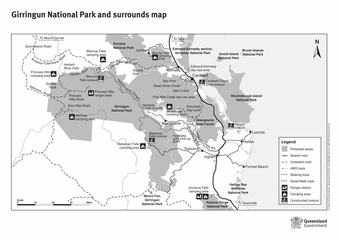
Brook Islands National Park Goold Island National Park Edmund Kennedy section, Girramay National Park Halifax Bay Wetlands National Park Hinchinbrook Island National Park Kirrama National Park Mount Fox, Girringun National Park Paluma Range National Park Abergowrie State Forest Girringun National Park Blencoe Falls camping area Murray Falls camping area Blencoe Falls lookout Broadwater camping area Princess Hills camping area Jourama Falls camping area Princess Hills ranger base Wallaman Falls lookout Herbert River Falls Wairuna camping area Emu Vale Road Princess Hills Road Greasy Track Gunnawarra Road Society Flat Wallaman Falls camping area Edmund Kennedy day-use area Five Mile Creek day-use area Dalrymple Gap track Yamanie pick-up point Henrietta gate pick-up point Spa Pool Dead Horse Creek Attie Creek Cardwell Forest Drive lookout Panjoo lookout Trebonne Abergowrie Forrest Beach Cardwell Ingham Halifax Lucinda Kennedy Jumbun To Tully To Mount Garnet To Townsville K ir r a m a –C a s h m e r e R oa d H e r b e r t R i v e r H erb e r t R i v e r G or g e A b e r g o w r i e R d H a w k i n s C r e e k R d W a iru n a R o a d K i r r a ma R a n g e R o a d Legend Protected areas Sealed road Unsealed road 4WD track Walking track Great! Walk track Ranger station Camping area Constructed lookout Girringun National Park and surrounds map © State of Queensland. Queensland Parks and Wildlife Service. MA289 February2018 10 20 30 40km Scale 0
Transcript of Girringun National Park and surrounds map - parks.des.qld ... · Goold Island National Park...
Brook IslandsNational ParkGoold Island
National Park
Edmund Kennedy section,Girramay National Park
Halifax BayWetlands
National Park
Hinchinbrook IslandNational Park
KirramaNational Park
Mount Fox,Girringun
National Park Paluma RangeNational Park
AbergowrieState Forest
GirringunNational Park
Blencoe Fallscamping area Murray Falls
camping area
BlencoeFalls lookout
Broadwatercamping area
Princess Hillscamping area
Jourama Fallscamping area
Princess Hillsranger base
WallamanFalls lookout
HerbertRiver Falls
Wairunacamping area
Emu Vale Road
PrincessHills Road
GreasyTrack
Gunnawarra Road
SocietyFlat
Wallaman Fallscamping area
Edmund Kennedyday-use area
Five Mile Creek day-use area
DalrympleGap track
Yamanie pick-up point
Henriettagate pick-up point
Spa Pool
Dead Horse Creek
Attie Creek
Cardwell ForestDrive lookout
Panjoo lookout
Trebonne
Abergowrie
Forrest Beach
Cardwell
Ingham
Halifax
Lucinda
Kennedy
Jumbun
To TullyTo Mount Garnet
To Townsville
Kirrama–Cashmere Roa
d
Herbert River
Herbert
River Gorge
Abergow
rie Rd
Hawk
ins Creek R d
Wairuna Road
Kirrama Range Road
Legend
Protected areas
Sealed road
Unsealed road
4WD track
Walking track
Great!Walk track
Ranger station
Camping area
Constructed lookout
Girringun National Park and surrounds map
© S
tate
of Q
ueen
slan
d. Q
ueen
slan
d Pa
rks
and
Wild
life
Serv
ice.
MA2
89 F
ebru
ary2
018
10 20 30 40kmScale0