Gidea Park Conservation Area
33
1 London Borough of Havering Gidea Park Conservation Area Character Appraisal and Management Proposals prepared by The Paul Drury Partnership
Transcript of Gidea Park Conservation Area
1
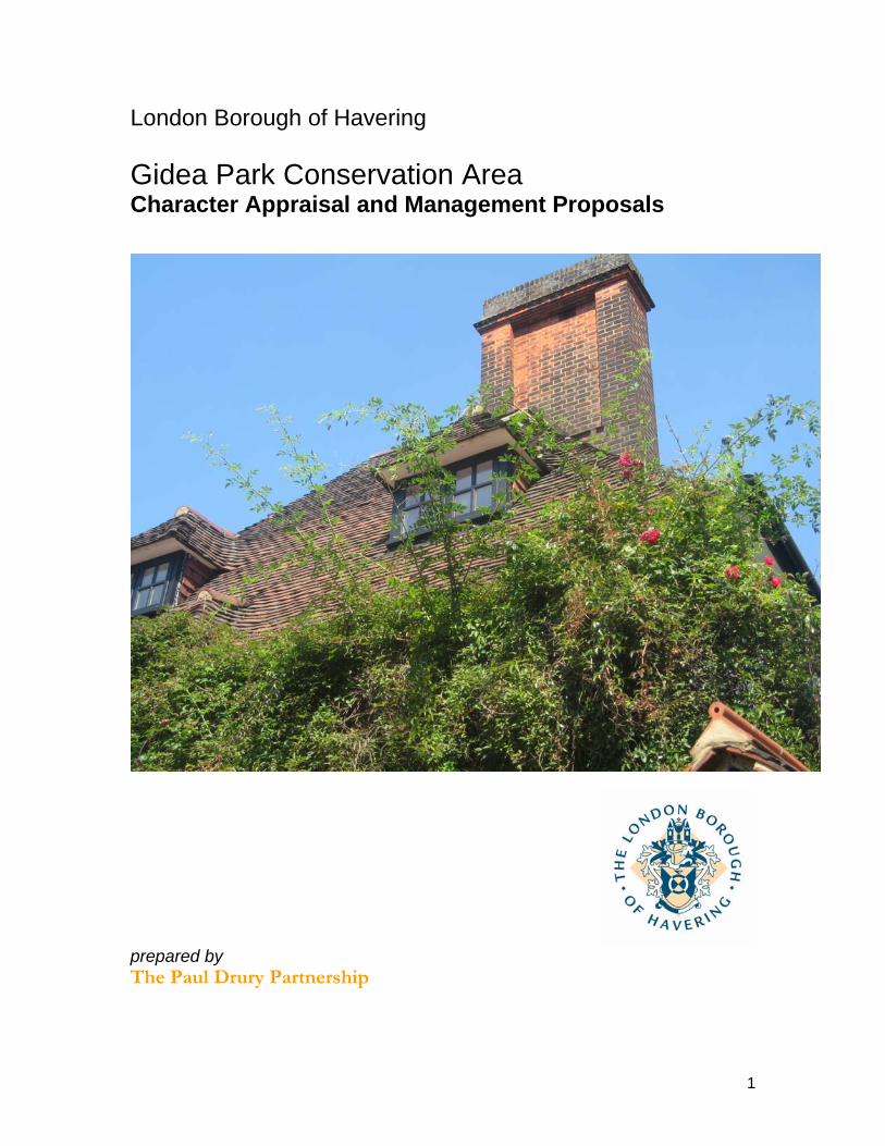
London Borough of Havering
Gidea Park Conservation Area Character Appraisal and Management Proposals
prepared by The Paul Drury Partnership
2
Gidea Park and Railway Extension Conservation Area Character Appraisal and Management Proposals
Contents 1.0 Introduction and background 4 2.0 Planning policy framework 6 3.0 Summary of special interest: Gidea Park Conservation Area 8 4.0 Assessment of special interest 11 5.0 Community involvement 30 6.0 Summary of issues 30 7.0 Contact details 30 8.0 Management proposals 30 Appendix A Extract from Guidance on conservation area appraisals (English Heritage, 2006) Appendix B Designation report for the Gidea Park Conservation Area Appendix C Article 4 directions for Gidea Park Maps Map 1 Location and context 11 Map 2 Historical development 13 Map 3 Townscape analysis 19 Map 4 Planning controls 29 Illustrations Preface from the 1911 Exhibition catalogue 12 Bird’s eye view of the site from the 1911 Exhibition catalogue 15
3
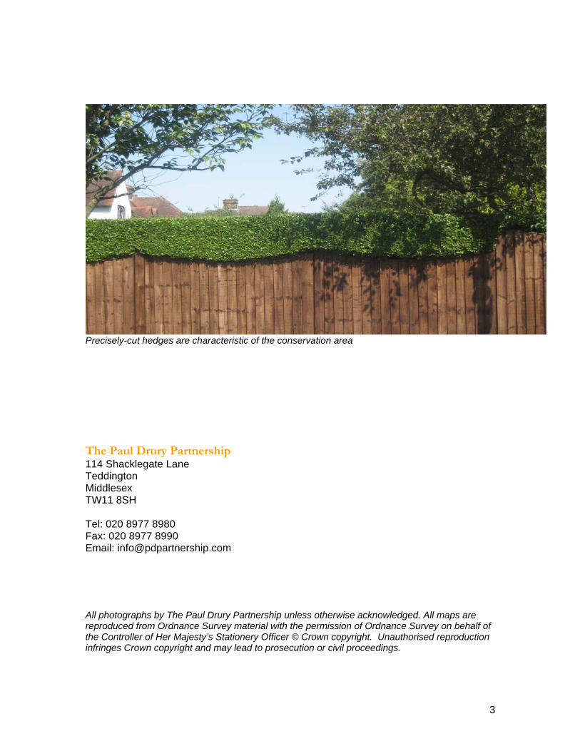
Precisely-cut hedges are characteristic of the conservation area
The Paul Drury Partnership 114 Shacklegate Lane Teddington Middlesex TW11 8SH Tel: 020 8977 8980 Fax: 020 8977 8990 Email: [email protected] All photographs by The Paul Drury Partnership unless otherwise acknowledged. All maps are
reproduced from Ordnance Survey material with the permission of Ordnance Survey on behalf of the Controller of Her Majesty’s Stationery Officer © Crown copyright. Unauthorised reproduction infringes Crown copyright and may lead to prosecution or civil proceedings.
4
Gidea Park Conservation Area Character Appraisal 1.0 Introduction and background
1.1 The historical development of Havering The London Borough of Havering, the second largest London borough, has a
population of about 225,000 and covers an area of 11,227 hectares (approximately 40 square miles), half of which lies within the Green Belt. To the north and east, the borough is bordered by the Essex countryside and, to the south, by a three mile River Thames frontage; but although the M25 defines its outer edge, the character of the Essex landscape and its villages extends into the borough well within both the motorway and the administrative boundary between Greater London and Essex. Pevsner1 remarks of Havering that “the character of its buildings is shared equally between the suburbia of its western neighbours and the rural vernacular of the Essex countryside. This mix is unique in East London, comprising still remote medieval parish churches along the Thames marshlands, tiny rural villages, farmhouses set in open fields, a scattering of mansions, leafy Edwardian suburbia, and at its heart the brash commercialism of Romford.” This summary is also an appropriate description for the range of conservation areas in Havering.
1.2 The London Borough of Havering was created in 1965 from Romford Borough
and Hornchurch Urban District, reviving the name of the medieval Liberty of Havering, to which they once belonged. The administrative origins of Havering are in the medieval parishes which were grouped together to form the administrative units of Chafford Hundred in the south, and the Royal Manor and Liberty of Havering in the north and west. The Liberty consisted of three large parishes2: Romford, as the market town; Havering atte Bower, where the royal palace stood till the 17th century; and Hornchurch. Chafford Hundred had a cluster of much smaller parishes of isolated farms and hamlets, and included Cranham, North Ockendon and Upminster, of which Corbets Tey was part, and Rainham, a little port on higher land above the marshes where the Ingrebourne River meets the Thames. Topography has naturally dictated most administrative boundaries and the pattern and chronology of settlements - from the grazing lands of Rainham marshes and the alluvial Thames floodplains, to the siting of the royal palace at Havering atte Bower on the high northern ridge; and in the 20th century the location of the RAF airfield at Hornchurch.
1.3 For most of its history, the villages and manors of Havering were part of the agricultural life of Essex, with many manor houses set within parkland. From the later 17th century and through the 18th century, the area gained popularity as a rural retreat for merchants from the east end of London, who often became active benefactors, their manorial role extending – as with the Benyon family at Cranham and North Ockendon – to the funding of new churches and schools.
1 Cherry, O’Brien, Pevsner: The Buildings of England: London 5: East (Penguin, 2005) 2 A parish is understood to mean the smallest administrative unit in a system of local government, having its own church.
5
Trade focused on Romford and Hornchurch, important towns on the road to London, and on Rainham, transporting local produce and passengers to London and the continent along the Thames.
1.4 Development of Havering in the 19th century followed the broad pattern of most outer London boroughs, particularly those to the north and east of London, which absorbed expansion from the crowded east end of London. The establishment by a Shoreditch parish of the Cottage Homes for destitute children and orphans at Hornchurch, now St Leonards Conservation Area, is a reminder of the acute problem of poverty and poor living conditions in the east end in the late 19th century and the contrast with then-rural villages such as Hornchurch. The extension of the railway network during the second half of the 19th century initiated suburban development around station locations, both in established centres, or at new locations such as Gidea Park. Gidea Park was a late example of the local landowner as entrepreneur; the social ideals of the garden city and late Arts & Crafts movement combining with shrewd land investment to establish a discrete high quality suburb. But it was only in the 1930s, with the combined circumstances of the sale of most of the large estates, new arterial roads, the Underground, low interest rates, cheap buildings material (and the opportunism of building societies in encouraging a desire for the light and air of rural suburbia), that speculative development flooded into the spaces between settlements. This blurring of the boundaries between village and countryside was only halted by Green Belt legislation in the 1930s and the post-war planning acts.
1.5 Background to the conservation area appraisal Conservation areas Conservation areas are areas of ‘special architectural or historic interest, the
character or appearance of which it is desirable to preserve or enhance’3 and were introduced by the Civic Amenities Act 1967. Designation imposes a duty on the Council, in exercising its planning powers, to pay special attention to the desirability of preserving or enhancing the character or appearance of the area4. In fulfilling this duty, the Council does not seek to stop all development, but to manage change in a sensitive way, to ensure that those qualities which warranted designation are sustained and reinforced, rather than eroded. Designation also imposes a duty on the Council to draw up and publish proposals for the preservation and enhancement of its conservation areas and to consult the local community about these proposals.5 These duties have been emphasised by BV 219 (see below).
1.6 Conservation area designation introduces a general control over the demolition
of unlisted buildings, the display of advertisements, and the lopping or felling of trees with a trunk diameter of more than 7.5cm.6 It does not, however, control all forms of development. Some changes to family dwelling houses (known as ‘permitted development’) do not normally require planning permission. These
3 Planning (Listed Buildings and Conservation Areas Act) 1990 section 69 4 ibid, section 72 5 Planning (Listed Buildings and Conservation Areas Act) 1990, section 71 6 More details of the effects of conservation area designation and property owners’ obligations can be found on the Havering Council website, www.havering.gov.uk

6
include minor alterations such as the replacement of windows and doors or the alteration of boundary walls. Where such changes would erode the character and appearance of the area, the Council can introduce special controls, known as Article 4(2) directions. The result is that some or all permitted development rights are withdrawn and planning permission is required for such alterations.7 Character appraisals
1.7 A conservation area character appraisal aims to define the qualities that make an area special. This involves understanding the history and development of the place and analysing its current appearance and character - including describing significant features in the landscape and identifying important buildings and spaces and visible archaeological evidence. It also involves recording, where appropriate, intangible qualities such as the sights, sounds and smells that contribute to making the area distinctive, as well as its historic associations with people and events. An appraisal is not a complete audit of every building or feature, but rather aims to give an overall impression of the area. It provides a benchmark of understanding against which the effects of proposals for change can be assessed, and the future of the area managed. It also identifies problems that detract from the character of the area and potential threats to this character, and makes recommendations for action needed to address these issues.
1.8 The present programme of conservation area character appraisals, of which this
forms part, supports Havering Council’s commitment in its Unitary Development Plan policy ENV 3 to preserve and enhance the character and appearance of its conservation areas. The assessment in the character appraisals of the contribution made by unlisted buildings to the character of the Conservation Area is based on the criteria suggested in the appendix of the English Heritage Guidance on conservation area appraisals (February 2006), reproduced in Appendix A to this document.
1.9 Best Value Performance Indicator BV 219 A local authority’s performance in defining and recording the special architectural
or historic interest of its conservation areas through up-to-date character appraisals is currently monitored through a culture-related Best Value Performance Indicator (BV 219). This measures annually, based on the total number of the authority’s conservation areas, the percentage with up-to-date character appraisals.
2.0 Planning Policy Framework
2.1 National planning policy framework
The legal basis for conservation areas is the Planning (Listed Buildings and Conservation Areas) Act 1990. National policy guidance is provided by Planning Policy Guidance note (PPG) 15 Planning and the Historic Environment and PPG 16 Archaeology and Planning.
7 Where applicable, listed building consent may still be required even if works benefit from being permitted development.
7
2.2 Regional policy Havering’s planning policies operate within the broad framework of the London
Plan (published in February 2004 and now amended), prepared by the Mayor of London. The London Plan also includes Sub-Regional Development Frameworks for all areas of London, as an intermediate step between the London Plan and the boroughs’ Local Development Frameworks. Havering is within the East London Sub-Regional Development Framework.
2.3 Conservation policy and guidance in Havering Unitary Development Plan policies
Havering’s current policy framework is provided by the Unitary Development Plan (UDP), adopted in 1993. The UDP is the development plan for the borough and serves two purposes: to bring forward proposals for the development and use of land in the borough, and to set out the Council’s policies for making decisions on planning applications. UDP policies can be read on the Council’s web-site. The UDP policy on conservation areas, ENV 3, explains how the Council will implement planning legislation and preserve or enhance the character or appearance of its conservation areas. The UDP also contains a specific policy, ENV 23, for the Gidea Park Conservation Area. The UDP will be replaced in due course by the new Local Development Framework (LDF), explained below.
2.4 Existing supplementary planning guidance To assist residents and developers, the Council has also issued design guidance, which remains a material consideration when planning applications are being assessed until replaced in new Supplementary Planning Documents (see below). Gidea Park has its own design guide to assist in the detailed interpretation of Policy ENV 23, Article 4(2) directions, and the Gidea Park Special Character Area.8 There is a Shopfront Design Guide for the Rainham Conservation Area, whose principles are applicable in other conservation areas.
2.5 Environmental Strategies
Within the UDP policy framework, the Council approved in September 1993 a Heritage Strategy for the Borough. In April 2000, a more detailed Heritage Strategy for Romford and Hornchurch was agreed, which is due to be adopted by December 2007. These strategies emphasise that heritage conservation, which was once limited to listed buildings, scheduled monuments and conservation areas, now extends to all aspects of the environment which contribute to a sense of place and a sense of history and are of lasting value to the community. In July 2005, the Council approved the Romford Urban Strategy to provide the key partners in central Romford with an economic and physical vision for the future. This and the Hornchurch Urban Strategy will be adopted as Area Action Plans within the Local Development Framework.
8 London Borough of Havering: Gidea Park Conservation Area, Romford: Planning Policies and Design Guide, July 1986
8
2.6 Local Development Framework The Local Development Framework (LDF) will replace the current UDP in due course .The LDF will consist of a portfolio of Local Development Documents (LDD), which collectively will guide development in the borough up to 2020. Supplementary Planning Documents (SPD) will expand policies set out in the Development Plan Documents (DPD) and the Council intends in due course to prepare a SPD for heritage issues, including local heritage. This will be supported by the adopted and published conservation area character appraisals and related management proposals.
2.7 Conservation areas in Havering
There are nine conservation areas in Havering, representing a variety of survivals from different periods of its past. Although all are distinctly individual in character, some share common characteristics because of their location or origins. The southern group of Corbets Tey, Rainham, Cranham and North Ockendon, for example, share medieval administrative origins in the Chafford Hundred, and three of them also maintain their strong focus on the parish church; some retain their manor or manorial farm, which reinforces the surviving village character, even when the modern settlement is partially engulfed by suburbia or closely pressed by industrial development. Havering atte Bower in the north of the borough also strongly retains this impression, with all the above components present. St Leonards, RAF Hornchurch, and Gidea Park, although totally different from each other, are all survivals of single historical periods and their particular ideas and architectural style. Romford, although originating with its parish church, today represents the evolution of the shopping function - from market to parade to arcade to modern mall - which defines its special interest as much as its medieval core.
3.0 Summary of special interest of Gidea Park Conservation Area 3.1 Designation of the conservation area NB The term ‘Gidea Park Conservation Area’ used in this appraisal should be
read as including the Gidea Park Station extension. The original Gidea Park Conservation Area was designated in June 1970, and an
extension to include Gidea Park Station was designated in February 1989. The Conservation Area comprises a large part of the residential suburb known as Gidea Park; those roads initially laid out in 1910 on the Gidea Hall and Balgores Estates, to the north and south of Main Road. It includes part of Main Road, with earlier buildings from the hamlet of Hare Street, part of Romford Golf Course to the east, and Raphael Park to the west.
3.2 The committee report at designation on 10th June 1970 relied on a very detailed
report and survey carried out by Gidea Park & District Civic Society (GP&DCS) for the Council. The GP&DCS had facilitated the process of designation by undertaking this survey in October 1968, the Council having been unable to do so due to staffing difficulties. The Council officers’ report recommending designation referred to the GP&DCS detailed survey and summarised its conclusions by stating that, as far as special interest was concerned:
9
o The area has its unique character as a result of the works of Sir Herbert Raphael in the early part of the 20th century
o Although the major criterion of the company was cost per unit, the most delightful variety of houses was produced, contrary to what might have been expected.
o Included in the scheme for the Garden Suburb were shopping centres, and parts of two of these were built and still remain.
o A second exhibition in 1934 produced houses in a different genre, but which blend with the original houses in an agreeable relationship and form important historical records of the architecture of the period
o Despite the lack of full realisation of the project, there are a great many houses which combine with the mature landscape to make a suburban residential area with a unique history and character.
The GLC Architect’s Department commented that what Gidea Park lacked in coherence of architectural theme, it made up for in the number of houses of significance by well-known architects of the day.
3.3 In 1986, an Article 4 direction was made to control permitted development in the
conservation area. This distinguished between the 1910 ‘exhibition houses’ and subsequent building by delineating two levels of control: ‘control level 1’ for the whole conservation area, requiring planning permission for the construction of dormer windows9 and hard-standings; and ‘control level 2’ for the 1911 exhibition houses, and others contributing to the group’s identity, requiring planning permission for all enlargements, improvements and other alterations. These provisions are explained in a Council publication, Gidea Park Conservation Area Planning Policies and Design Guide (1986). The Article 4 direction was supplemented by an Article 4(1) direction in February 2003, which extended ‘control level 2’ to an additional 107 properties (the full extent of this is shown on map 4). In the Unitary Development Plan adopted in 1993, there is a specific policy ENV 23 for Gidea Park to protect its character. This has explicit requirements concerning plot subdivision, protection of tree cover, works of street and park maintenance and works to the rail station, in order to ensure sympathy with the original design of the estate. The Design Guide mentioned above became Appendix 7 to the UDP.
3.4 The following buildings are statutorily listed at grade II: 16 & 27 Meadway; 36 &
38 Reed Pond Walk and the sundial at No. 36; 41, 43, 64 Heath Drive; boundary walls, railings, gate piers and gates to the former Gidea Hall in Heath Drive and Mead Close; The Ship public house in Main Road, Blacks Bridge and 198/200 Main Road. Raphael Park is included in the London Parks & Gardens Trust’s London Inventory of Historic Green Spaces for Havering, and the entry gives a detailed history of the Gidea Hall estate from medieval times to the present day. Romford Golf Course and St Michael and All Angels Church Gidea Park are on the Council’s Local Historic Parks and Gardens List at Category 2, and the open space at Reed Pond Walk is registered as a Village Green and on the Local Parks and Gardens Register in Category 1. Romford Golf Course contains archaeological evidence of road construction, which was originally considered to be from the Roman road to Colchester; but, more recently, it has been
9 No longer permitted development, following revisions to the General Development Order
10
suggested10 that it is from the 16th century Gidea Hall. The line of the road is a scheduled monument and the Local Development Framework maps show the Archaeological Priority Zone. There are locally listed buildings at the following locations: 75 Main Road, 202-210 (even) Main Road, 224 Main Road, 40 Parkway, 23,29, 33 and 37 Reed Pond Walk.
3.5 Additional special interest
The special interest identified at designation, both in the Council officers’ summary and in the GP&DCS’s survey and report, remains substantially intact. A summary of the main features of special interest now could include the following more detailed elements.
o There are distinct areas of different provenance and character within the
Conservation Area: the competition and exhibition areas of 1910/11 and of 1933/34; Hare Street village; the Main Road artery; the housing areas north and south of Main Road; and the railway station and shopping area to the south.
o The variety of designs in the original exhibition range means that no two houses are exactly the same, apart from two same pairs. In the northern part of the conservation area, the relative generosity of plots and the control of subdivision through planning policy mean that individuality has been maintained.
o For most of the areas developed after 1910, houses have remained in single family occupation, which has limited the need for parking forecourts and minimised alterations to properties.
o Mature gardens, trees and boundary hedges form an integral part of the area’s character. There are some exceptionally fine large individual trees, notably that outside No. 10 Parkway which was reputed to be the largest London plane tree in Essex when Havering was still part of that county.
o Recreational and leisure spaces provide actively-used open spaces o There is surviving evidence in the landscape of the ‘layers’ of previous use
and occupation, all integrated into the design of the area – such as the Fish Ponds, the Gidea Hall walls, and the tennis courts within the Spoon Pond outline.
10 Evidence quoted by Pamela Greenwood in consultation response – more details to be provided
11
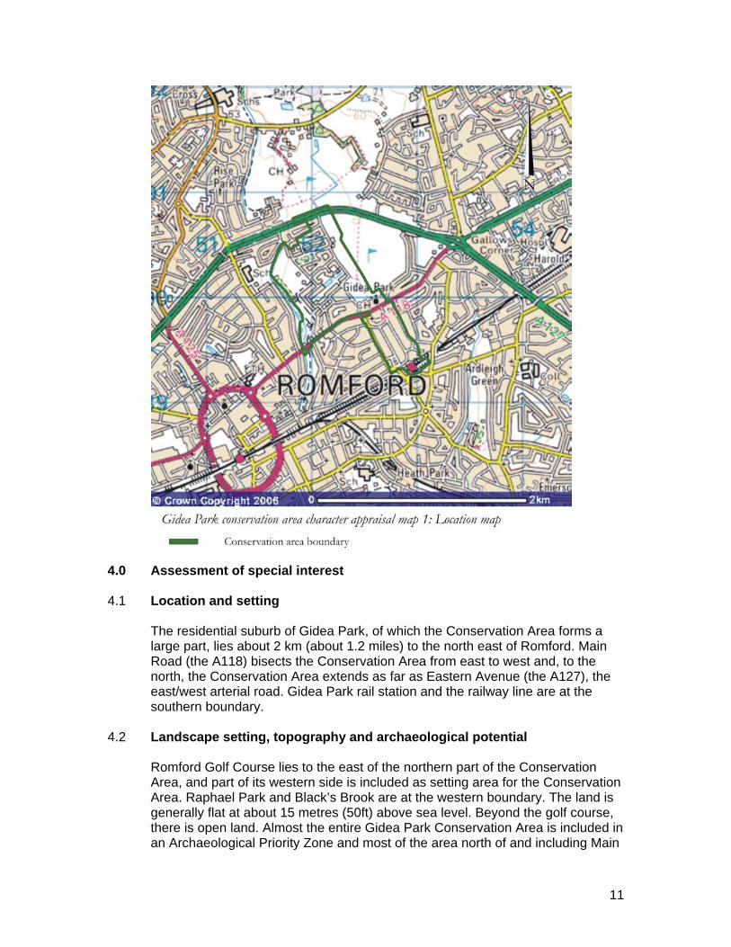
4.0 Assessment of special interest 4.1 Location and setting
The residential suburb of Gidea Park, of which the Conservation Area forms a large part, lies about 2 km (about 1.2 miles) to the north east of Romford. Main Road (the A118) bisects the Conservation Area from east to west and, to the north, the Conservation Area extends as far as Eastern Avenue (the A127), the east/west arterial road. Gidea Park rail station and the railway line are at the southern boundary.
4.2 Landscape setting, topography and archaeological potential
Romford Golf Course lies to the east of the northern part of the Conservation Area, and part of its western side is included as setting area for the Conservation Area. Raphael Park and Black’s Brook are at the western boundary. The land is generally flat at about 15 metres (50ft) above sea level. Beyond the golf course, there is open land. Almost the entire Gidea Park Conservation Area is included in an Archaeological Priority Zone and most of the area north of and including Main
12
Road is also an Archaeological Priority Area. The Greater London Archaeological Advisory Service must be consulted about any applications involving 0.4ha or more in the former and all applications in the latter.11
4.3 General character
The Conservation Area is principally a residential area, except for the shops and commercial services on Main Road and Balgores Square and around the rail station. Gidea Park was originally intended to be a garden suburb similar in conception to Hampstead Garden Suburb and based on that experience, and although it never achieved this goal in terms of extent, formal layout, consistency of design or community facilities, it nevertheless bears evidence of the architectural and social ideals of the time in its layout, plot arrangement and architectural concepts. Nearly all the houses are detached and the roads generous; the variety of designs and the mature planting in streets, gardens and open spaces now contribute to a residential environment of high quality. The generous open spaces of the golf course and Raphael Park emphasise the edge-of-town location.
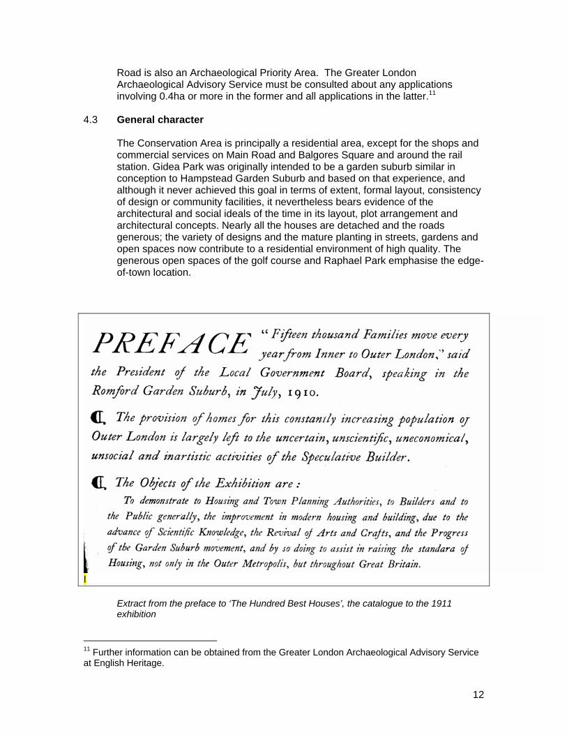
I Extract from the preface to ‘The Hundred Best Houses’, the catalogue to the 1911
exhibition
11 Further information can be obtained from the Greater London Archaeological Advisory Service at English Heritage.
13
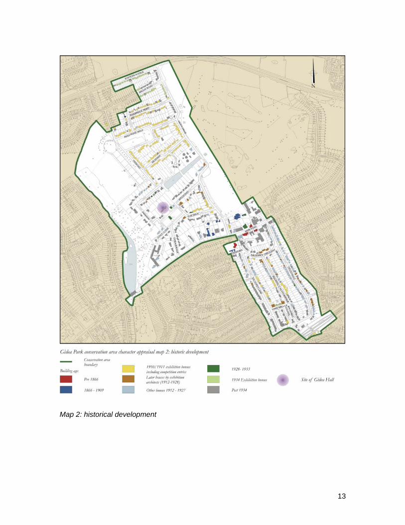
Map 2: historical development
14
4.4 Origins and historic development 12
Gidea Park was the first major suburb to be developed outside the market town of Romford, where 19th century residential development had mainly stayed within a radius of about a mile from the town centre. The adjoining Raphael Park was the first public park to be opened in the Borough. Gidea Hall was a late medieval mansion, rebuilt in 1720 by Sir John Eyles, who created the lake and improved the park; its moat was retained and incorporated into a formal layout shown on a map of 1777 by Chapman and Andree, with radiating avenues and there was also the Spoon Pond (so called for its shape, which still survives as tennis courts) and fish ponds. The estate was owned between 1745 and 1802 by the Benyon family, who also owned land at (and left their mark on) North Ockendon and Cranham Conservation Areas. Richard Benyon enlarged the park in about 1776, creating a less formal layout and serpentine canal, and commissioning James Wyatt to design the bridge now known as Black’s Bridge.
4.5 The Gidea Hall estate north of Main Road was purchased in 1897 by Sir Herbert
Raphael; he had founded Romford Golf Club in 1894 and, in 1902, donated 15 acres of land (including Black’s Canal, and now Raphael Park) to Romford Urban District Council for a public park on the west side of the estate. The Council later bought the Spoon Pond and another 16 acres, and Raphael Park retains other features of the 18th century park, including the Pleasure Grounds and the site of the former vineyards.
4.6 In 1910, Raphael set up a company with two others (Charles McCurdy and Tudor
Walters) to build a development similar to Hampstead Garden Suburb on the remainder of the estate. The development initially had high ideals and a stirring mission statement in the brief to competitors: “to demonstrate to housing and public authorities, to builders and to the public generally, the improvement in modern housing and building due to scientific knowledge, the revival of the Arts and Crafts and the progress of the garden city movement, and by doing so to assist the raising of the standard of living not only in the outer metropolis but throughout Britain.
12 The history of Gidea Park’s origins, planning and execution as a garden suburb is well documented in the Victoria County History (Essex, Volume 7), and in Buildings of England (London 5: East); there is also a reprinted edition of the original catalogue for the 1911 House & Cottage Exhibition, The Hundred Best Houses, and some local accounts, notably L.J Leicester’s 1988 history, which are acknowledged in the Bibliography to this appraisal. The London Parks & Gardens Trust’s London Inventory entry for Raphael Park has a detailed history of the Gidea Hall grounds. This section is therefore intended only as a brief summary, not a definitive history.
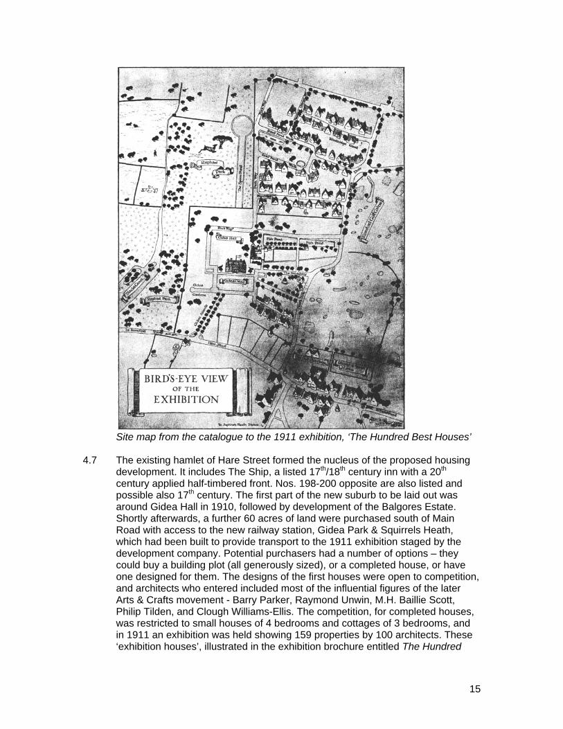
15
Site map from the catalogue to the 1911 exhibition, ‘The Hundred Best Houses’ 4.7 The existing hamlet of Hare Street formed the nucleus of the proposed housing
development. It includes The Ship, a listed 17th/18th century inn with a 20th century applied half-timbered front. Nos. 198-200 opposite are also listed and possible also 17th century. The first part of the new suburb to be laid out was around Gidea Hall in 1910, followed by development of the Balgores Estate. Shortly afterwards, a further 60 acres of land were purchased south of Main Road with access to the new railway station, Gidea Park & Squirrels Heath, which had been built to provide transport to the 1911 exhibition staged by the development company. Potential purchasers had a number of options – they could buy a building plot (all generously sized), or a completed house, or have one designed for them. The designs of the first houses were open to competition, and architects who entered included most of the influential figures of the later Arts & Crafts movement - Barry Parker, Raymond Unwin, M.H. Baillie Scott, Philip Tilden, and Clough Williams-Ellis. The competition, for completed houses, was restricted to small houses of 4 bedrooms and cottages of 3 bedrooms, and in 1911 an exhibition was held showing 159 properties by 100 architects. These ‘exhibition houses’, illustrated in the exhibition brochure entitled The Hundred
16
Best Houses13, formed the core of the suburb and set the tone for subsequent development. The layout, an informal grid varied by deliberate kinking of roads or to avoid important trees, was not according to the designs originally produced (by Parker & Unwin), which were for a more formal layout and incorporated a site for a church (not built) as a part of the design. Nevertheless, many landscape features were retained and used as elements of the townscape, including lakes and ponds. A further area to the east of the golf course, although a competition subject, was never executed. The houses as built were all of different designs, with a tendency to either picturesque Tudor or neo-Georgian. They were heavily dependent on the use of good quality materials, and sometimes exaggerated vernacular details, but often with sufficient recurring elements to mark them as members of the same family of designs.
4.8 A number of factors contributed to the failure of the garden suburb to live up to its
initial promise: the abandonment of the original layouts and the scheme to the east of the golf course; the intervention of the First World War; the construction of Eastern Avenue arterial road in 1926, which cut off the northern part of the proposed development; and the failure to complete the intended shopping centre north of the station, which would have been a valuable focus for the suburb. Gidea Hall, which had been an important element in the design of the first phase, was demolished in 1930. A subsequent ‘Modern Homes’ competition and exhibition in 1934 promoting architectural innovation was intended to sell more plots on the land south of Eastern Avenue; it did not match the scale of the original concept although it produced one genuinely contemporary design, by Francis Skinner and Tecton, at 64 Heath Drive. Thirty five houses were built, in Brook Road and nearby in Eastern Avenue. By the time of this exhibition, the developers’ garden suburb ideas had been abandoned in favour of ribbon development, and speculative housing – some of it conventional inter-war designs - later filled in the remaining unused plots.
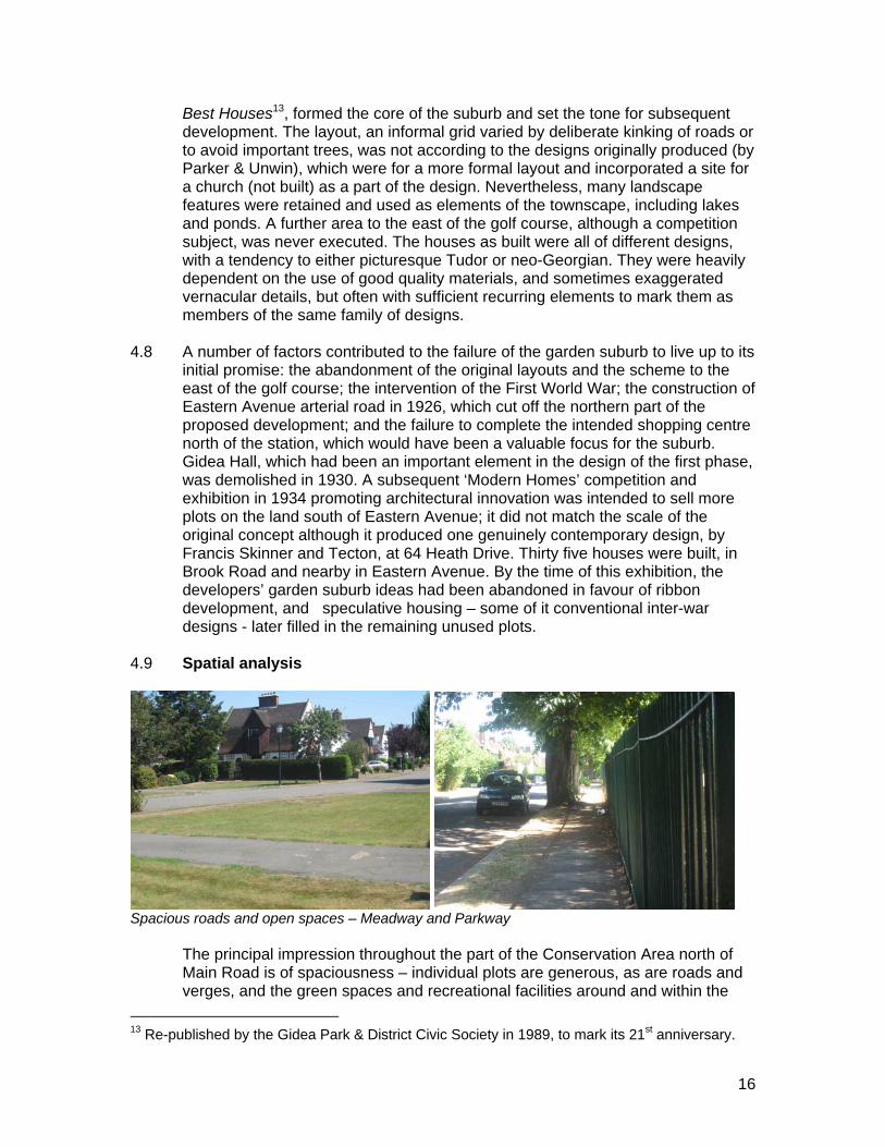
4.9 Spatial analysis
Spacious roads and open spaces – Meadway and Parkway
The principal impression throughout the part of the Conservation Area north of Main Road is of spaciousness – individual plots are generous, as are roads and verges, and the green spaces and recreational facilities around and within the
13 Re-published by the Gidea Park & District Civic Society in 1989, to mark its 21st anniversary.
17
residential roads allow views out and provide magnificent backdrops of mature trees. The area north of Main Road is bounded by two long avenues running roughly north/south, Heath Drive and Parkway; both border open land on one side, although the views from Heath Drive are restricted by hedges and trees, whereas Raphael Park reads very much as part of the townscape at Parkway. Directly or indirectly, the other roads in this area run between these two avenues, with deliberate changes of direction to provide variety and eliminate straight vistas. This layout, the prevalence of vernacular styles, and the fact that every house is different from its neighbour, produces a constant succession of picturesque views involving complex rooflines and massing, many varieties of gable design, sculptural hedges and enclosed front gardens, and a high standard of detailing.
4.10 The incorporation of various natural features has tended to define the character
of individual roads. The U-shaped Reed Pond Walk with a copse at its centre has a different atmosphere, with a wider variety of houses, to the more open Parkway, its park views deserving plots reserved for more expensive house types. Meadway has smaller cottage units, balanced by broad verges and given a focus by its central dog-leg, bordered by mown grass triangles (seen in the photograph on the previous page). At Heath Drive, the houses are more expansive to match the wider road and golf course views. The retained ponds to the west of Heath Drive have views from the bridge into an extensive area of water stretching between rear gardens, and the fact that many of the gardens are extremely long in relation to the size of the houses means that at some points –for example at Heaton Grange Road, where two rows of gardens meet - there are also extensive views across these back areas. Despite the apparent informality of the planning, the end result is a strong cohesion of setting and houses in the earlier parts of the estate, reinforced by consistency of boundaries and front garden planning that is lost in the outer fringes such as Gidea Close, and in the 1930s exhibition area, Brook Road, where the frontages are much more open and the boundaries less enclosing.
Views from the bridge in Heath Drive, and across back gardens 4.11 Main Road, incorporating the historic Hare Street and some of its early buildings,
provides the setting for the entry into Heath Drive, the principal access to the northern area of Gidea Park. It is a busy road and this intensifies the contrasts with the secluded character of the estate. However, its existence also enables the differences between the two parts of the divided Conservation Area to be
18
more sharply perceived. The approach from east or west gives little indication of the character of the areas beyond the main road, although the design of the 1912 shopping parade on Balgores Lane corner is clearly of the Gidea Park competition period and in character. The large houses on both sides of the road, (65-69 late Victorian) are well set back and their size is commensurate with the width and status of the road, rather than with the rest of the estate; extensive parking areas in front, many now bland and featureless, reinforce their difference. At the western boundary, the proximity of Raphael Park and its lake suddenly reveals itself at the bridge, with views northwards, bounded to the west by continuous inter-war development. The park is a highly important component of the spatial experience; although most of its extent is only appreciated from within the estate, notably from Parkway, it is visible from the bridge and also provides the rear setting for a swathe of Parkway’s houses. The open views across the park make Parkway the most spacious-seeming road in the area; Heath Drive, which also adjoins open space, is enclosed by hedges.
4.12 South of Main Road, there are fewer ‘exhibition’ houses and the roads form a
more regular grid. Although the plots are smaller, they are more regularly laid out and, with few exceptions, the sense of intimacy and enclosure of the central part of the northern area is not present. The parallel roads have a strong directional impetus south from Balgores Crescent to the railway station. Balgores Square - conceived as a shopping centre for the garden suburb, but not completed - is now a car park enclosed by high shrubs and hedges, so that there is no possibility of appreciating it as a single space and there is no ‘designed’ approach to the station.
Balgores Square car park, and smaller houses opposite the green at Squirrel’s Heath Avenue
19
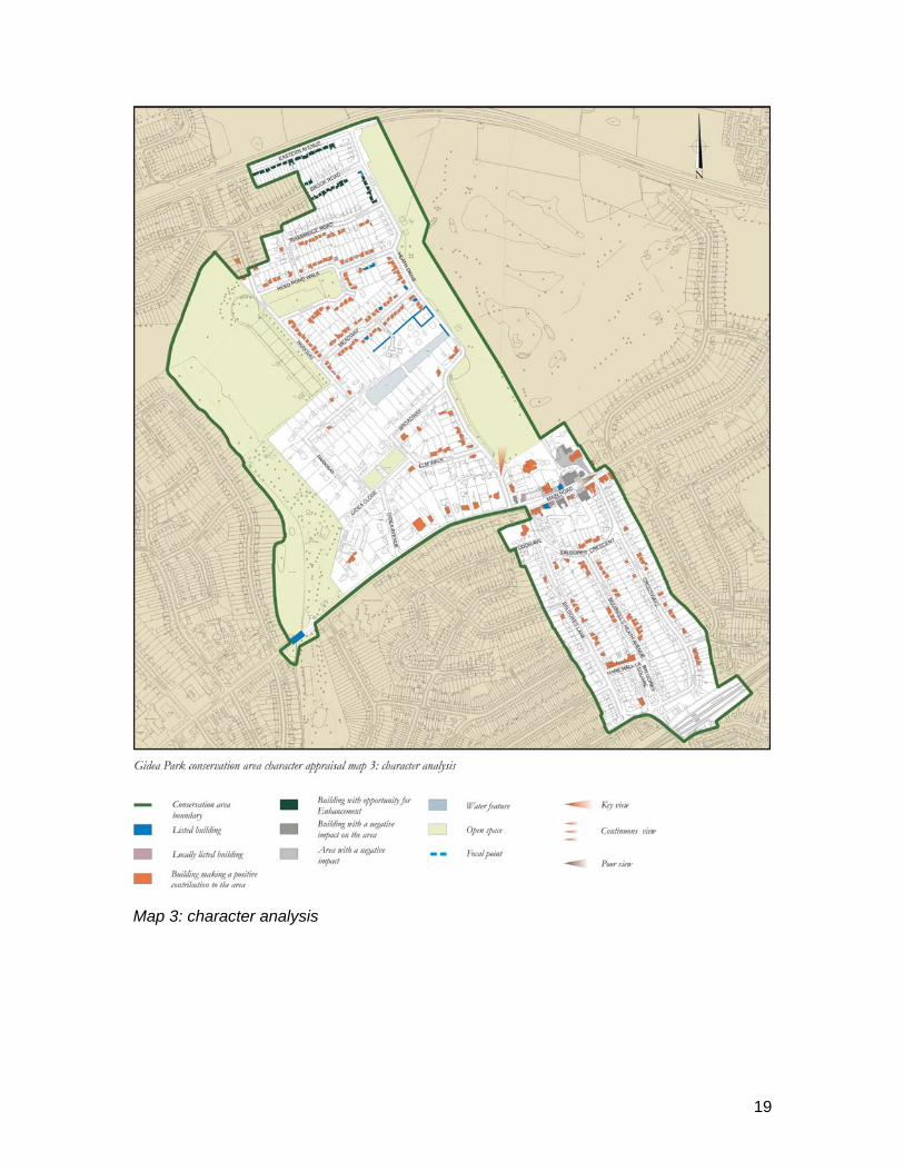
Map 3: character analysis

20
4.13 Character analysis
Because of the multitude of examples of houses by renowned Arts & Crafts architects working in the first decade of the 20th century, and the existence of a detailed gazetteer in the form of the 1911 exhibition brochure ‘The Hundred Best Houses’, the architectural appraisal which follows is not in the form of a street-by-street analysis. This type of detailed description has been set out in the 2005 edition of Buildings of England: London 5 East by Cherry, O’Brian and Pevsner, the previous Pevsner Essex volume having ignored Gidea Park completely. This appraisal simply aims to define the principal architectural and townscape characteristics in general terms, and to illustrate these with examples, either written or photographic. It is therefore intended primarily not as a detailed architectural judgement, but as an overview of the area’s character and an assessment of how the 1910 and 1934 developments have fared over time.
4.14 Character areas
The areas north and south of Main Road have substantially different characteristics of design and layout, as suggested in the spatial analysis in paragraph 3.5 above; and Main Road acts as the axis of both areas, while being in mainly retail and commercial use and a through route. The area around the station is also denser and more commercial in character. These locations therefore form distinct character areas, in terms of architecture and layout. The area north of Main Road contains most of the 1910 ‘exhibition houses’ in its central part, with mostly later houses in its south-west corner, and 1934 exhibition houses to the south of Eastern Avenue and in Brook Road. The area south of Main Road has fewer exhibition houses and more commercial elements around the station and Balgores Square, with later infill of less unusual designs; its layout is a more regular grid. Main Road itself is dominated by retail and commercial uses and the larger houses to the west, and focuses on the listed public houses, while the open space and surviving historic features of Raphael Park make it a distinctive space in its own right – it is not just an adjunct to the housing. The station area is less cohesive, and Main Road is more of a natural focus for the Conservation Area in terms of both urban design and activity.
4.15 Activity and uses
Before the development of the residential garden suburb, the area was two large private estates, Gidea Hall and Balgores Estate, set either side of the former Hare Street. Main Road, as it is now named, is little different from most suburban commercial centres, and is both a local centre and part of continuous development between Romford and Brentwood. Commercial activity is focused here and around the rail station. The largest houses are now in institutional or school use. Recreational activity is well represented, with the golf course, tennis courts, and playground in Raphael Park.
21
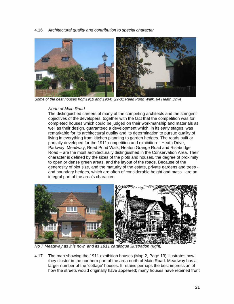
4.16 Architectural quality and contribution to special character
Some of the best houses from1910 and 1934: 29-31 Reed Pond Walk, 64 Heath Drive North of Main Road The distinguished careers of many of the competing architects and the stringent
objectives of the developers, together with the fact that the competition was for completed houses which could be judged on their workmanship and materials as well as their design, guaranteed a development which, in its early stages, was remarkable for its architectural quality and its determination to pursue quality of living in everything from kitchen planning to garden hedges. The roads built or partially developed for the 1911 competition and exhibition – Heath Drive, Parkway, Meadway, Reed Pond Walk, Heaton Grange Road and Risebridge Road – are the most architecturally distinguished in the Conservation Area. Their character is defined by the sizes of the plots and houses, the degree of proximity to open or dense green areas, and the layout of the roads. Because of the generosity of plot size, and the maturity of the estate, private gardens and trees - and boundary hedges, which are often of considerable height and mass - are an integral part of the area’s character.
No 7 Meadway as it is now, and its 1911 catalogue illustration (right) 4.17 The map showing the 1911 exhibition houses (Map 2, Page 13) illustrates how
they cluster in the northern part of the area north of Main Road. Meadway has a larger number of the ‘cottage’ houses. It retains perhaps the best impression of how the streets would originally have appeared; many houses have retained front
22
gardens without parking, whereas this is rare in other roads. The 1934 exhibition houses are best represented by No.64 Heath Drive, the most architecturally distinguished and innovative, which has fortunately been very well preserved and enhanced. It was intended as a prototype for a street of similar linked houses; the fact that it stands alone is perhaps emblematic of the failure of courage by its developers, which meant that Gidea Park has not attained the cohesion and consistency it could have had.
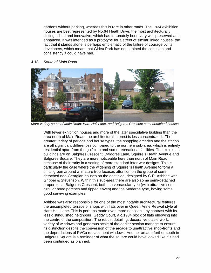
4.18 South of Main Road
More variety south of Main Road: Hare Hall Lane, and Balgores Crescent semi-detached houses With fewer exhibition houses and more of the later speculative building than the
area north of Main Road, the architectural interest is less concentrated. The greater variety of periods and house types, the shopping arcades and the station are all significant differences compared to the northern sub-area, which is entirely residential apart from the golf club and some recreational facilities. The exhibition buildings are on Balgores Crescent, Balgores Lane, Squirrels Heath Avenue and Balgores Square. They are more noticeable here than north of Main Road because of their rarity in a setting of more standard inter-war designs. This is particularly the case where the widening of Squirrel’s Heath Avenue to form a small green around a mature tree focuses attention on the group of semi-detached neo-Georgian houses on the east side, designed by C.R. Ashbee with Gripper & Stevenson. Within this sub-area there are also some semi-detached properties at Balgores Crescent, both the vernacular type (with attractive semi-circular hood porches and tipped eaves) and the Moderne type, having some good surviving examples.
Ashbee was also responsible for one of the most notable architectural features,
the uncompleted terrace of shops with flats over in Queen Anne Revival style at Hare Hall Lane. This is perhaps made even more noticeable by contrast with its less distinguished neighbour, Geddy Court, a c.1934 block of flats elbowing into the centre of the composition. The robust detailing, decorative plasterwork, variety of windows and generous scale of the earlier section manage to ensure its distinction despite the conversion of the arcade to unattractive shop-fronts and the depredations of PVCu replacement windows. Another arcade further south in Balgores Square is a reminder of what the square could have looked like if it had been continued as planned.
23
4.19 Main Road
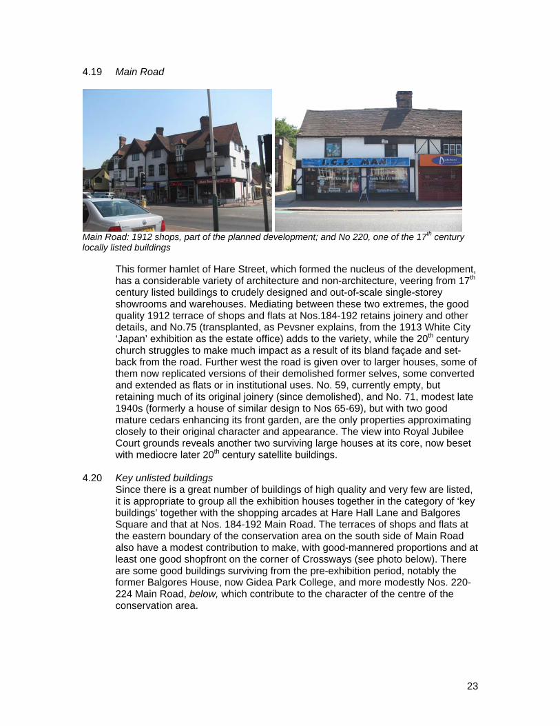
Main Road: 1912 shops, part of the planned development; and No 220, one of the 17th century
locally listed buildings This former hamlet of Hare Street, which formed the nucleus of the development,
has a considerable variety of architecture and non-architecture, veering from 17th century listed buildings to crudely designed and out-of-scale single-storey showrooms and warehouses. Mediating between these two extremes, the good quality 1912 terrace of shops and flats at Nos.184-192 retains joinery and other details, and No.75 (transplanted, as Pevsner explains, from the 1913 White City ‘Japan’ exhibition as the estate office) adds to the variety, while the 20th century church struggles to make much impact as a result of its bland façade and set-back from the road. Further west the road is given over to larger houses, some of them now replicated versions of their demolished former selves, some converted and extended as flats or in institutional uses. No. 59, currently empty, but retaining much of its original joinery (since demolished), and No. 71, modest late 1940s (formerly a house of similar design to Nos 65-69), but with two good mature cedars enhancing its front garden, are the only properties approximating closely to their original character and appearance. The view into Royal Jubilee Court grounds reveals another two surviving large houses at its core, now beset with mediocre later 20th century satellite buildings.
4.20 Key unlisted buildings
Since there is a great number of buildings of high quality and very few are listed, it is appropriate to group all the exhibition houses together in the category of ‘key buildings’ together with the shopping arcades at Hare Hall Lane and Balgores Square and that at Nos. 184-192 Main Road. The terraces of shops and flats at the eastern boundary of the conservation area on the south side of Main Road also have a modest contribution to make, with good-mannered proportions and at least one good shopfront on the corner of Crossways (see photo below). There are some good buildings surviving from the pre-exhibition period, notably the former Balgores House, now Gidea Park College, and more modestly Nos. 220-224 Main Road, below, which contribute to the character of the centre of the conservation area.
24
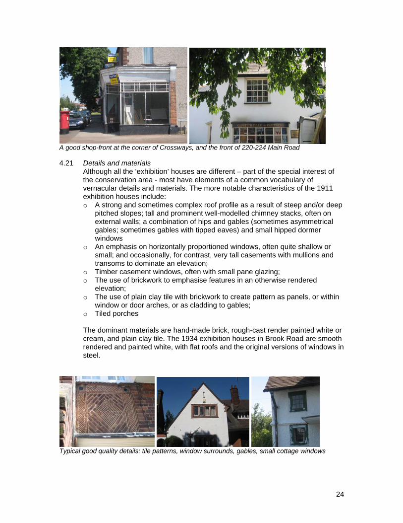
A good shop-front at the corner of Crossways, and the front of 220-224 Main Road 4.21 Details and materials
Although all the ‘exhibition’ houses are different – part of the special interest of the conservation area - most have elements of a common vocabulary of vernacular details and materials. The more notable characteristics of the 1911 exhibition houses include: o A strong and sometimes complex roof profile as a result of steep and/or deep
pitched slopes; tall and prominent well-modelled chimney stacks, often on external walls; a combination of hips and gables (sometimes asymmetrical gables; sometimes gables with tipped eaves) and small hipped dormer windows
o An emphasis on horizontally proportioned windows, often quite shallow or small; and occasionally, for contrast, very tall casements with mullions and transoms to dominate an elevation;
o Timber casement windows, often with small pane glazing; o The use of brickwork to emphasise features in an otherwise rendered
elevation; o The use of plain clay tile with brickwork to create pattern as panels, or within
window or door arches, or as cladding to gables; o Tiled porches
The dominant materials are hand-made brick, rough-cast render painted white or
cream, and plain clay tile. The 1934 exhibition houses in Brook Road are smooth rendered and painted white, with flat roofs and the original versions of windows in steel.
Typical good quality details: tile patterns, window surrounds, gables, small cottage windows
25
4.22 The public realm
Roads are generally wide and footways generous, sometimes with wide or narrow grass verges. Parking is mostly unrestricted in the area north of Main Road (apart from parts of Heath Drive), which benefits the area. Because of the presence of the station and the perceived need to restrict commuter parking nearby, this is not the case in the southern part of the conservation area, where parking signs and poles are much in evidence. Road surfaces are functional tarmac, sometimes with intrusive markings (such as ‘Slow’, in large letters in the setting of an important house closing the vista).
4.23 Greenery and green spaces
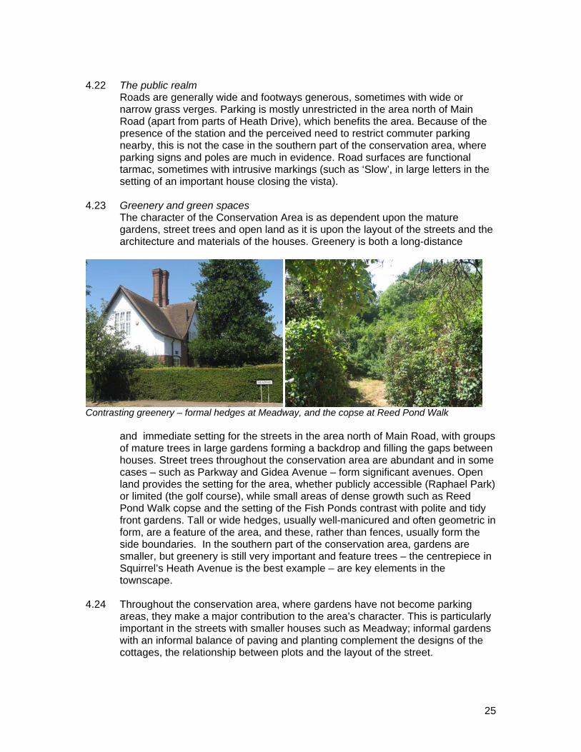
The character of the Conservation Area is as dependent upon the mature gardens, street trees and open land as it is upon the layout of the streets and the architecture and materials of the houses. Greenery is both a long-distance
Contrasting greenery – formal hedges at Meadway, and the copse at Reed Pond Walk and immediate setting for the streets in the area north of Main Road, with groups
of mature trees in large gardens forming a backdrop and filling the gaps between houses. Street trees throughout the conservation area are abundant and in some cases – such as Parkway and Gidea Avenue – form significant avenues. Open land provides the setting for the area, whether publicly accessible (Raphael Park) or limited (the golf course), while small areas of dense growth such as Reed Pond Walk copse and the setting of the Fish Ponds contrast with polite and tidy front gardens. Tall or wide hedges, usually well-manicured and often geometric in form, are a feature of the area, and these, rather than fences, usually form the side boundaries. In the southern part of the conservation area, gardens are smaller, but greenery is still very important and feature trees – the centrepiece in Squirrel’s Heath Avenue is the best example – are key elements in the townscape.
4.24 Throughout the conservation area, where gardens have not become parking
areas, they make a major contribution to the area’s character. This is particularly important in the streets with smaller houses such as Meadway; informal gardens with an informal balance of paving and planting complement the designs of the cottages, the relationship between plots and the layout of the street.
26
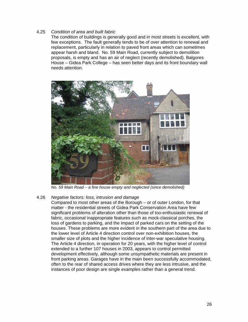
4.25 Condition of area and built fabric The condition of buildings is generally good and in most streets is excellent, with
few exceptions. The fault generally tends to be of over attention to renewal and replacement, particularly in relation to paved front areas which can sometimes appear harsh and bland. No. 59 Main Road, currently subject to demolition proposals, is empty and has an air of neglect (recently demolished). Balgores House – Gidea Park College – has seen better days and its front boundary wall needs attention.
No. 59 Main Road – a fine house empty and neglected (since demolished) 4.26 Negative factors: loss, intrusion and damage
Compared to most other areas of the Borough – or of outer London, for that matter - the residential streets of Gidea Park Conservation Area have few significant problems of alteration other than those of too-enthusiastic renewal of fabric, occasional inappropriate features such as mock-classical porches, the loss of gardens to parking, and the impact of parked cars on the setting of the houses. These problems are more evident in the southern part of the area due to the lower level of Article 4 direction control over non-exhibition houses, the smaller size of plots and the higher incidence of inter-war speculative housing. The Article 4 direction, in operation for 20 years, with the higher level of control extended to a further 107 houses in 2003, appears to control permitted development effectively, although some unsympathetic materials are present in front parking areas. Garages have in the main been successfully accommodated, often to the rear of shared access drives where they are less intrusive, and the instances of poor design are single examples rather than a general trend.
27
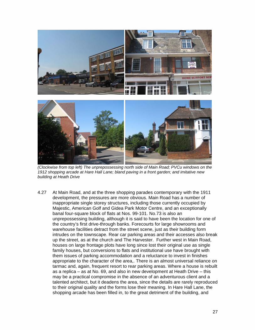
(Clockwise from top left) The unprepossessing north side of Main Road; PVCu windows on the
1912 shopping arcade at Hare Hall Lane; bland paving in a front garden; and imitative new building at Heath Drive 4.27 At Main Road, and at the three shopping parades contemporary with the 1911
development, the pressures are more obvious. Main Road has a number of inappropriate single storey structures, including those currently occupied by Majestic, American Golf and Gidea Park Motor Centre, and an exceptionally banal four-square block of flats at Nos. 99-101. No.73 is also an unprepossessing building, although it is said to have been the location for one of the country’s first drive-through banks. Forecourts for large showrooms and warehouse facilities detract from the street scene, just as their building form intrudes on the townscape. Rear car parking areas and their accesses also break up the street, as at the church and The Harvester. Further west in Main Road, houses on large frontage plots have long since lost their original use as single family houses, but conversions to flats and institutional use have brought with them issues of parking accommodation and a reluctance to invest in finishes appropriate to the character of the area,. There is an almost universal reliance on tarmac and, again, frequent resort to rear parking areas. Where a house is rebuilt as a replica – as at No. 69, and also in new development at Heath Drive – this may be a practical compromise in the absence of an adventurous client and a talented architect, but it deadens the area, since the details are rarely reproduced to their original quality and the forms lose their meaning. In Hare Hall Lane, the shopping arcade has been filled in, to the great detriment of the building, and
28
there is widespread use of PVCu replacement windows, an appalling desecration of a fine building by one of the best known architects of the Arts and Crafts movement.
4.28 Problems and pressures
The negative factors described above are indications of the pressures on the area, which may be summarised as follows:
o While the Article 4 direction, policy ENV 23 in the UDP and specific design
guidance appears to be managing change effectively, there is an urgent need for the quality of the architecture and the historic interest of the area’s origins to be recognised by a more integrated and logical listing of buildings of special architectural or historic interest. Listing at present appears to be random and arbitrary, and the lack of listing of buildings such as the Hare Hall Lane shops may have contributed to its degradation in terms of design and materials.
o The need to accommodate 21st century car ownership and demand for garages and front-garden parking in the context of an area designed for low levels of car ownership
o Pressure for extensions affecting traditional rooflines and relationships of plots and buildings
o The use of standard architectural features on traditional vernacular buildings o Pressure for forecourt parking for large scale retail uses in Main Road o Pressure for conversion of large houses to flats o Conflict between need for parking control and the appearance of standard
signs and posts in residential areas o Use of Balgores Square as a car park, negating the space and reducing the
opportunity for views across and daytime activity.
29
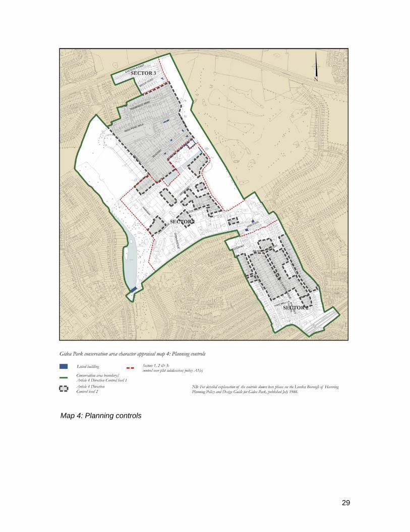
Map 4: Planning controls
30
5.0 Community involvement
The Gidea Park & District Civic Society was actively involved in the designation of the Conservation Area and the inception of the Article 4 direction, and drafted guidance that the Council publishes on its website in the form of a guided walk and a list of Gidea Park’s original architects. It was also responsible for the re-printing of the catalogue of the 1911 exhibition, an invaluable source of information, and the publication in 1988 of a short history of the area, both listed in the bibliography to this report. The society retains a continuous involvement in planning and development control issues in Gidea Park, and provided much information and several publications for use in compiling this appraisal.
6.0 Summary of issues
o Need for statutory listing re-survey to provide additional protection for buildings of high quality by known architects – exhibition houses from 1911 and 1934 should be listed as they are of high quality and by known architects and have group value.
o Re-consider the two control levels in the A4 direction – more detailed control could be extended to the whole area to protect from inappropriate alteration. (More detailed survey of changes may need to be done to justify this.)
o Enforce existing controls over PVCu windows where there are no permitted development rights, especially at Hare Hall Lane
o There are opportunity sites in Main Road at single storey warehouse/showroom sites – there is a need for site briefs.
o There should be encouragement of good contemporary design for infill sites on Main Road and elsewhere
o There is a need to improve forecourt standards for large buildings and commercial sites
o There is a need for a strategy for maintenance/protection of trees, street greenery and green spaces in the public realm.
7.0 Contact details Environmental Strategy London Borough of Havering 9th Floor, Mercury House, Romford RM1 3SL Tel: 01708 432868 Fax: 01708 432696 Email: [email protected]
Management proposals
8.0 Introduction and background 8.1 The management proposals for Havering’s conservation areas are based on the
character appraisals and provide detailed strategies for the positive management of change within these areas, in order to preserve and enhance their distinctive
31
character. The proposals aim to preserve each conservation area’s positive characteristics by the detailed application of planning policies and the implementation of some new controls; and to enhance the character of each area by encouraging the improvement or re-development of sites which detract from its character.
8.2 English Heritage’s revised guidance on conservation area management
(February 2006) states in paragraph 5.1 that “The character appraisal should provide the basis for developing management proposals for the conservation area that will fulfil the general duty placed upon local authorities under the Act, now formalised in BV219c, to draw up and publish such proposals. The proposals should take the form of a mid- to long-term strategy setting objectives for addressing the issues and recommendations for action arising from the appraisal, and identifying any further or more detailed work required for their implementation.”
8.3 The English Heritage guidance also suggests (paragraph 5.2) what issues a
management strategy might cover. Relevant issues for Havering’s conservation areas appear to be: o the application of policy guidance, both national and local, and site-specific
development briefs o establishing procedures to ensure consistent decision-making o establishing a mechanism for monitoring change in the area on a regular
basis; o a rapid-response enforcement strategy to address unauthorised
development o proposals for Article 4(2) directions, following detailed survey and justification,
which will restrict permitted development rights by requiring planning consent for specific alterations to residential properties;
o intended action to secure the future of any buildings at risk from damage, vacancy or neglect;
o enhancement schemes and ongoing/improved management regimes for the public realm
o a strategy for the management and protection of important trees, street greenery and green spaces; and
o proposals for an urban design/public realm framework for the area (setting out agreed standards and specifications for footway surfaces, street furniture, signage and traffic management measures).
9.0 Management proposals for the Gidea Park Conservation Area 9.1 The character appraisal of the Gidea Park Conservation Area sets out in section
3.0 a list of key characteristics (or ‘positive factors’) which provide the special interest of the conservation area. These are summarised as the ‘Definition of special interest’ of the conservation area. The management strategy sets out the Council’s proposals for protecting these key characteristics. Similarly, the character appraisal examines problems and pressures (or ‘negative factors’) in each character area, summarised at the end of the appraisal as ‘Issues affecting the conservation area’, and the management strategy addresses these with proposals for improved management, enhancement or re-development where appropriate, in consultation with stakeholders.

32
9.2 In the following table of proposals, the first column shows the general categories
of proposals; not all conservation areas will generate issues to be addressed in all these categories.
33
APPENDIX A
Criteria for assessing unlisted building in a conservation area [from English Heritage guidance Conservation area appraisals (2006)]
When considering the contribution made by unlisted buildings to the special architectural or historic interest of a conservation area, the following questions might be asked: • Is the building the work of a particular architect of regional or local note? • Has it qualities of age, style, materials or any other characteristics which reflect those
of at least a substantial number of the buildings in the conservation area? • Does it relate by age, materials or in any other historically significant way to adjacent
listed buildings, and contribute positively to their setting? • Does it individually, or as part of a group, serve as a reminder of the gradual
development of the settlement in which it stands, or of an earlier phase of growth? • Does it have significant historic association with established features such as the
road layout, burgage plots, a town park or a landscape feature? • Does the building have landmark quality, or contribute to the quality of recognisable
spaces, including exteriors or open spaces with a complex of public buildings? • Does it reflect the traditional functional character of, or former uses within, the area? • Has it significant historic associations with local people or past events? • Does its use contribute to the character or appearance of the conservation area? • If a structure associated with a designed landscape within the conservation area,
such as a significant wall, terracing or a minor garden building, is it of identifiable importance to the historic design?
Any one of these characteristics could provide the basis for considering that a building makes a positive contribution to the special interest of a conservation area, provided that its historic form and values have not been seriously eroded by unsympathetic alteration.