Giant's Causeway and Causeway Coast World Heritage Site ...
57
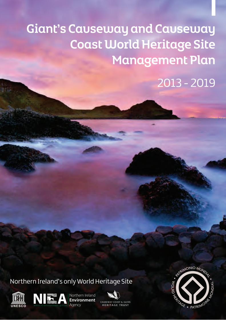
Giant’s Causeway and Causeway Coast World Heritage Site Management Plan Northern Ireland’s only World Heritage Site 2013 - 2019
Transcript of Giant's Causeway and Causeway Coast World Heritage Site ...
Giant’s Causeway and Causeway Coast World Heritage Site
Management Plan
Northern Ireland’s only World Heritage Site
2013 - 2019
World Heritage Steering Group Members
Council for Nature Conservation and Countryside
02871267509/02871279439
1
Contents
Foreword 2Executive Summary 3 List of Abbreviations 4
Part 1 Setting the Scene 5 1.1 UNESCO and the World Heritage Convention 6 1.2 Preparation of Management Plans 6 1.3 The World Heritage Convention in Northern Ireland 6 1.4 Inscription of The Giant’s Causeway and Causeway Coast WHS 7 1.5 Operational Guidelines 7 1.6 Periodic Reporting 7
Part 2 The Giant’s Causeway and Causeway Coast World Heritage Site 9 2.1 Location & Site Description 10 2.2 World Heritage Site Landscape Setting 10 2.2.1 The Distinctive Landscape 10 2.2.2 The Supportive Landscape 10 2.2.3 The Connective Landscape 122.2.4 Seascapes - dNAP 122.3 Natural Heritage 122.3.1 Geology and Geomorphology 122.3.2 Dynamic Site 132.3.3 Habitats and Biodiversity 14 2.3.4 Causeway Coast AONB 14 2.3.5 Landscape Character 15 2.4 Intagible Values and Cultural Heritage 16 2.4.1 Myth & Folklore 16 2.4.2 The Girona 17 2.4.3 Place Names 17 2.5 Socio Economic Context 18 2.5.1 Visitor Centre & Facilities 18 2.5.2 Formal Learning at the Site 18 2.6 The Wider Area - Community Settlements around the World Heritage Site 19
Part 3 Site Management & Policy Context 21 3.1 Current Management Context 22 3.2 Status of the World Heritage Site Management Plan 22 3.3 Evaluation of the WHS Management Plan 2005-2011 22 3.4 Current Policy and Legislative Context 22
Part 4 Issues & Opportunities 25 4.1 Impact of Climate Change 26 4.2 Dynamic Natural Processes and Hazard Management 26 4.3 Education & Research Potential of the WHS 27 4.4 Visitor Management 27 4.5 The Setting of the Site and its Status 27 4.6 Governance 27 4.7 Community Involvement 28 4.8 Socio-Economic Context 28
Part 5 Vision, Aims & Objectives 29 5.1 A Vision 30
Part 6 Implementation of the Plan and Making it Happen 33 6.1 Strategy for the Implementation of the Plan 34
Appendices 35 - 42Action Plan 2013 - 2016 43 - 55
2
Foreword
Outstanding, spectacular, dynamic, rugged … These are just a few of the words you’ll find used to describe the Giant’s Causeway and Causeway Coast World Heritage Site in this plan. The Causeway Coast is a special place, reflected in no small way by the number of protective designations and volume of international visitors which guarantee the site acts as an economic engine, driving development which is both sustainable and supports local communities.
The World Heritage Convention defines sites such as the Giant’s Causeway as irreplaceable treasures of all humanity. Everyone in Northern Ireland should be proud of the Giant’s Causeway. Have a quick look around and you are sure to find evidence of its influence. It is printed on our money, wrapped around our mugs; we even have Finn McCool crisps based on the mythology and legends of the site. Every department within the Northern Ireland Executive displays the columnar formations proudly on their logo. The true value of the Giant’s Causeway is incalculable, suffice to say it’s been with us for millennia and we need to ensure protection of its natural, cultural, historical, educational and scientific values for present and future generations. The Causeway represents an enormous natural resource and one which we have not yet fully or sustainably explored. Throughout the period of this plan debates surrounding oil exploration, fracking and marine wind and tidal turbines are likely to become heated. Protection of our scenic coastal landscape should be the primary aim of any development.
New terms of reference and re-branding of the World Heritage Steering Group has been undertaken to cement progress achieved since publication of the first Management Plan in 2005. Despite natural differences of opinion within the steering group, all members are unanimously committed to protection of the site’s Outstanding Universal Value, Integrity and Status. To this end the Steering Group have developed a 30 year vision which forms the foundation of the new 2013-2019 plan: “The Giant’s Causeway and Causeway Coast World Heritage Site will be recognised as a global leader in the sustainable management of dynamic natural sites, inspiring people to celebrate, value and enjoy a Site that offers a world class visitor experience. This Site will become a vibrant thread of the life of the Causeway Coast and Glens, benefiting local and regional communities, visitors and the environment for present and future generations.’’
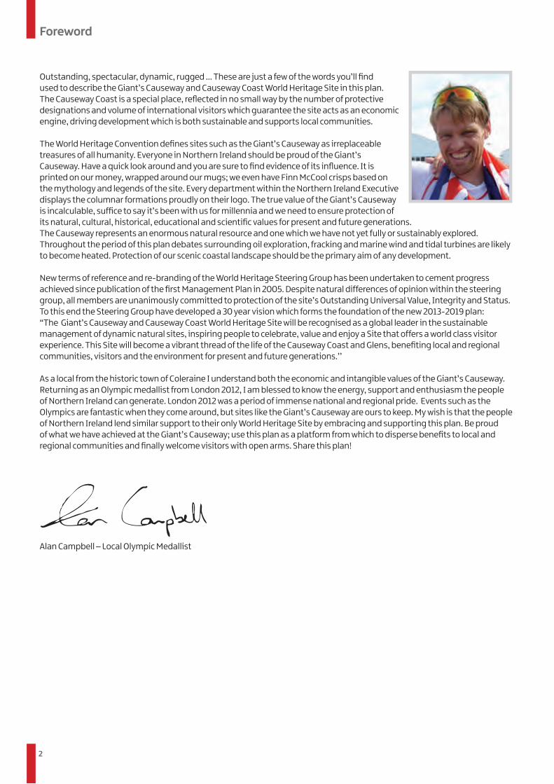
As a local from the historic town of Coleraine I understand both the economic and intangible values of the Giant’s Causeway. Returning as an Olympic medallist from London 2012, I am blessed to know the energy, support and enthusiasm the people of Northern Ireland can generate. London 2012 was a period of immense national and regional pride. Events such as the Olympics are fantastic when they come around, but sites like the Giant’s Causeway are ours to keep. My wish is that the people of Northern Ireland lend similar support to their only World Heritage Site by embracing and supporting this plan. Be proud of what we have achieved at the Giant’s Causeway; use this plan as a platform from which to disperse benefits to local and regional communities and finally welcome visitors with open arms. Share this plan!
Alan Campbell – Local Olympic Medallist
3
Executive Summary
Introduction This Management and Action Plan was prepared by the Causeway Coast and Glens Heritage Trust on behalf of its partner organisations in the Giant’s Causeway and Causeway Coast World Heritage Steering Group, namely: • Causeway Coast and Glens Tourism Partnership• Council for Nature Conservation and Countryside• The Crown Estate
• Moyle District Council • National Trust• Northern Ireland Environment Agency • Northern Ireland Tourist Board• Planning NI• Private Landowners
What are World Heritage Sites and how are they protected in Northern Ireland? World Heritage Sites (WHSs), are quite simply irreplaceable natural and/or cultural treasures of all humanity. Operational guidelines define WHSs as places or buildings of Outstanding Universal Value i.e. with natural or cultural significance so exceptional that they transcend national boundaries and are of common importance for present and future generations of all humanity. The Giant’s Causeway and Causeway Coast is Northern Ireland’s only WHS and was inscribed in 1986 as a natural site, under criteria vii and viii, in recognition of its geological and geomorphological values, its history of scientific study and its exceptional landscape values. Within Northern Ireland, as in the rest of the UK, WHSs are not statutory designations and their Management Plans have no statutory basis but are implemented within the context of a hierarchy of local, regional, national and international policies.
Why is an updated Management and Action Plan needed? It is now UK Government Policy that all WHSs have Management Plans to fulfil our obligations under the World Heritage Convention. The first Plan for the Giant’s Causeway and Causeway Coast WHS was published in 2005 and covered the period up-to and including 2012. Since 2005 a number of changes have affected the operation and management of the WHS. The National Trust are now sole property managers within the WHS and have opened a range of world class visitor facilitates. The WHS Steering Group invites representation from private landowners and a dedicated WHS Officer is employed to provide a secretariat service for the Steering Group and to prepare and coordinate implementation of the Management and Action Plans.
What are the main opportunities and issues at the site? The main issue facing the National Trust, as property managers,is effective management of large visitor numbers within a dynamic site characterised by frequent slope failures. The Steering Group recognise there is a need to increase research and education potential of the WHS. There is significant scope to increase protection of the setting of the WHS and strengthen governance. Finally and perhaps most importantly there is a need to increase community involvement and a desire to spread the benefits derived from the WHS to surrounding communities.
Vision, Aims and Objectives Using this Management and Action Plan as a foundation, the World Heritage Steering Group envisages that in thirty years: ‘’The Giant’s Causeway and Causeway Coast World Heritage Site will be recognised as a global leader in the sustainable management of dynamic natural sites, inspiring people to celebrate, value and enjoy a Site that offers a world class visitor experience. This Site will become a vibrant thread of the life of the Causeway Coast and Glens, benefiting local and regional communities, visitors and the environment for present and future generations” To realise this vision the Steering Group have developed aims and objectives intended to guide the actions of the Steering Group and external organisations which make decisions affecting the Site:
Geological Survey of Northern Ireland •
4
Executive Summary
Moving Forward… To deliver a sustainable future for the WHS this Management and Action Plan needs to be promoted and monitored. This requires considerable commitment from partner organisations and the WHS Steering Group whose membership reflects conservation, tourism, economic and educationalinterests. The WHS Steering Group provides strategic guidance on activities and operations occurring within and around the Site and facilitates dialogue with the local community. The WHS Management Plan will be regularly reviewed, monitored and updated taking account of emerging issues, research findings and the knowledge and experience of those responsible for managing the Site.
The Action Plan, 2013-2016, identifies tasks required to meet these stated aims and objectives. These tasks require action by a wide range of agencies and bodies. Whether actions are implemented by a single body or by a partnership approach it is important they are conceived, designed and implemented within the framework established by the WHS Management Plan and are undertaken in a manner that is compliant with the aims of the WHS Steering Group. Throughout 2015 the Action Plan will be reviewed providing an updated Action Plan for the second half of the Plan period, 2016 – 2019, ensuring its relevance and focus.
List of AbbreviationsAONB Area of Outstanding Natural Beauty ASSI Area of Special Scientific Interest CCGHT Causeway Coast and Glens Heritage Trust DCMS Department of Culture, Media and Sport DETI Department for Enterprise, Trade and
DoE
LCA dNAP NIEA NITBNNR NT OUVPPSQUBSOUV
UNESCO
WHSWHSPM WHSSG
InvestmentDepartment of the Environment Geological Survey of Northern Ireland Landscape Character Assessment draft Northern Area Plan Northern Ireland Environment Agency Northern Ireland Tourist Board National Nature Reserve National Trust Outstanding Universal Value Planning Policy Statement Queen’s University Belfast Statement of Outstanding Universal Value United Nations Educational, Scientific and Cultural Organisation World Heritage Site World Heritage Site Project Manager World Heritage Site Steering Group
Aims Objectives
(1) Protect and conserve the Outstanding Universal Value of the World Heritage Site and its setting for present and future generations
(2) Support & demonstrate good WHS Management
(3) Raise public awareness of the Giant’s Causeway and its WHS/International status
(4) Provide a safe and enjoyable visitor experience that does not compromise the Outstanding Universal Value of the Site
(5) Engage local communities with the WHS and enable them to gain greater benefits from the WHS designation
(a) Conserve the geological and geomorphological attributes of the Site
(b) Maintain an appropriate setting and ‘sense of place’ for the Site
(c) Encourage and support research and monitoring programmes that inform the sustainable management of the Site and its setting
(a) Maintain a strong management structure for effective coordination of all activities that influence the OUV of the Site
(b) Ensure that sufficient resources are secured to allow effective delivery of the WHS Plan
(a) Increase public understanding of the OUV of the Site and its WHS status
(b) Enhance interpretation material and information provision both within the WHS and on a local to global level
(c) Maintain and improve the education programmes and facilities at the WHS
(a) Develop appropriate visitor access to and around Site in a safe and sustainable manner
(b) Encourage visitors to make environmentally sustainable choices when visiting the WHS
(a) Involve local communities in the management of the WHS (b) Support local communities in utilising the WHS as a driver for
economic growth
GSNI
5
Setting the Scene
PART 1
Setting the Scene
6
1.1 UNESCO and the World Heritage ConventionThe United Nations Education, Scientific and Cultural Organisation (UNESCO) was established in 1945, with the aim “to contribute to peace and security by promoting collaboration among nations through education, science and culture in order to further universal respect for justice, for the rule of law and for the human rights and fundamental freedoms which are affirmed for the peoples of the world, without distinction of race, sex, language and religions”
The World Heritage Convention was adopted by UNESCO at its seventeenth session in Paris on the 16th November 1972. The Convention came into force in 1975 and aims to promote cooperation among nations to protect heritage around the world that is of such Outstanding Universal Value (OUV) that its conservation is important for present and future generations of all humanity.
UNESCO’s World Heritage Committee is responsible for inscribing properties on the World Heritage List. By signing the World Heritage Convention a country agrees to submit tentative lists of properties deemed appropriate for consideration by the committee. Sites are assessed on the basis of a statement of OUV, a comprehensive comparison with similar sites globally, and an assessment of the integrity / authenticity of the property. State parties have a duty to ensure identification, nomination, protection, conservation, presentation, and transmission of both cultural and natural heritage to present and future generations.
The UNESCO World Heritage Committee adopts a ‘Statement of Outstanding Universal Value (SOUV)’ for all World Heritage Sites. Operational Guidelines for the convention define Outstanding Universal Value as “cultural and/or natural significance which is so exceptional that it transcends national boundaries and is of common importance for present and future generations of all humanity”. A SOUV contains a summary of the World Heritage Committee’s decision that the site is of OUV; the qualifying criteria; an assessment of the conditions of integrity or authenticity, and requirements for protection and management.
1.2 Preparation of Management Plans Criteria for the inscription of properties on the World Heritage List were developed to evaluate the OUV of properties and to guide States Parties in the protection and management of World Heritage Sites. Until the end of 2004 the World Heritage Committee recognised six criteria for cultural heritage and four criteria for natural heritage sites. Since 2005 these criteria have been combined to provide a single list of ten criteria. Criteria I to VI are used to describe the OUV of cultural sites and VII to X refer to the OUV of natural sites. Nominated sites must meet at least one of these criteria (see Appendix 1 for a full list of nominating criteria).
Operational Guidelines issued by the World Heritage Committee recommend that all State Parties have management frameworks and adequate legal protection for securing long-term conservation of WHSs. Though the Operational Guidelines do not specify management plans, the creation of WHS management plans has been the response of several governments, including the UK, to requirements of the Guidelines.
As an early nomination in 1986 the Giant’s Causeway and Causeway Coast WHS was not required to prepare a management plan at the time of nomination. It is now UK Government policy that all UK sites have seven year management plans to help fulfil its obligations under the Convention. The first Giant’s Causeway and Causeway Coast WHS Management Plan provided aims, objectives and associated actions for the period 2005 – 2012.
1.3 The World Heritage Convention in Northern Ireland The Government of the United Kingdom of Great Britain and Northern Ireland ratified the World Heritage Convention in 1984 and submitted its first nominations for inscription on the World Heritage List in 1985. There are currently twenty eight WHSs in the United Kingdom and its overseas territories. Twenty three of these are designated as ‘cultural’, four as ‘natural’ including the Giant’s Causeway and Causeway Coast WHS, and one as a ‘mixed’.
Within Northern Ireland, as in the rest of the UK, World Heritage Sites are not statutory designations and their Management Plans have no statutory basis but are implemented within the context of a hierarchy of local, regional, national and international policies. The WHS management plan provides an agreed framework for the sustainable management of the Site and helps guide current and future actions on and around the Site. Achieving a sustainable future for the Giant’s Causeway and Causeway Coast WHS depends on those supporting the WHS Management Plan working effectively and in partnership to meet the defined aims and objectives
The UK Government protects World Heritage Sites and their settings under the spatial planning system through a hierarchy of regional and local policies and plans. Strategic plans ‘protect the World Heritage Site of the Giant’s Causeway, respecting and protecting its setting, conserving its physical features, managing change, and controlling access and tourism impacts in a sensitive way’. The surrounding Causeway Coast Area of Outstanding Natural Beauty (AONB) provides the Site with additional incidental protection. Planning Policy Statement 6 Planning, Archaeology and the Built Heritage provides recognition of WHSs and their settings in Area Plans.
Setting the Scene
7
Setting the Scene
1.5 Operational Guidelines Operational Guidelines (2008) issued by the World Heritage Committee recommend State Parties have appropriate management frameworks and adequate legal protection to secure long-term conservation of WHSs. This Management Plan is based upon general requirements of the Convention’s Operational Guidelines, specifically that:
“Each nominated property should have an appropriate management plan or other management system which should specify how the Outstanding Universal Value of a property should be preserved, preferably through participatory means.”
“The purpose of such a management system is to ensure the effective protection of the nominated property for present and future generations.”
1.6 Periodic Reporting In addition to management plans, States Parties are required to submit reports on the legislative and administrative provisions they have adopted and other actions which they have taken for the application of the Convention. This forms part of a six-year ‘Periodic Reporting’ exercise organised by UNESCO. The previous round of periodic reporting for Europe was completed during 2005/2006. The current round of periodic reporting for Europe and North America closes in July 2013.
Periodic Reporting Provides:
a) An assessment of the application of the World Heritage Convention by the State Party;
b) An assessment as to whether the Outstanding Universal Value of the properties inscribed on the World Heritage List is being maintained over time;
c) Updated information about the World Heritage properties to record the changing circumstances and state of conservation of the properties; and
d) A mechanism for regional co-operation and exchange of information and experiences between State Parties concerning the implementation of the Convention and World Heritage conservation.
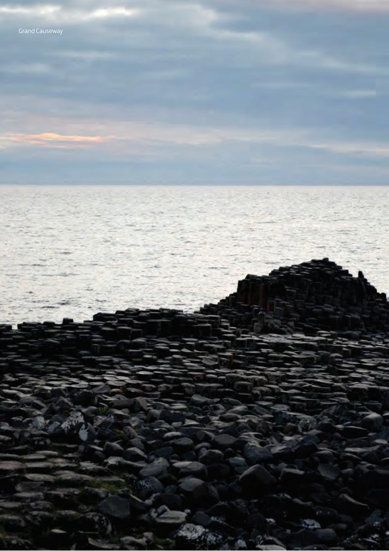
1.4 Inscription of the Giant’s Causeway and Causeway Coast World Heritage Site The Giant’s Causeway and Causeway Coast WHS was inscribed on the World Heritage List in 1986. The ‘Statement of Outstanding Universal Value (SOUV)’ for the Giant’s Causeway and Causeway Coast WHS was compiled by the World Heritage Site Steering Group (WHSSG) and submitted for consideration by the UNESCO World Heritage Committee in February 2011:
VII (formerly III) – Contain superlative natural phenomena, formations or features, for instance, outstanding examples of the most important ecosystems, areas of exceptional natural beauty or exceptional combinations of natural and cultural elements The cliff exposures of columnar and massive basalt at the edge of the Antrim Plateau represent a spectacle of exceptional natural beauty. The extent of visible rock sections and the quality of the exposed columns in the cliffs and on the Causeway combine to present an array of features of considerable significance.
VIII (formerly I) – Be outstanding examples representing the major stages of the earth’s evolutionary history; The geological activity of the Tertiary is clearly illustrated by the succession of lava flows and interbasaltic beds which are in evidence on the Causeway Coast. Interpretation of succession has allowed a detailed analysis of Tertiary events in the North Atlantic. The extremely regular columnar jointing of the Thoeliitic basalts is a spectacular feature which is displayed in exemplary fashion at the Giant’s Causeway. The Causeway itself is a unique formation and a superlative horizontal section through columnar basalt lavas.
Integrity In 1986, IUCN identified the key attributes of the site which conveyed the Outstanding Universal Value, assessed the integrity of these attributes and confirmed that the property met the criteria for inscription. It also evaluated the site in comparison with other sites in different parts of the world offering similar natural formations. The Site’s integrity has not deteriorated since inscription. The cliff exposures and causeway stones, which are held to be key attributes, are protected by ownership in perpetuity by the National Trust.
(See Appendix 2 for the complete Statement of Outstanding Universal Value (SOUV))
8
Grand Causeway
9
Contents
PART 2
The Giant’s Causeway & Causeway Coast
World Heritage Site
10
The Giant’s Causeway and Causeway Coast World Heritage Site
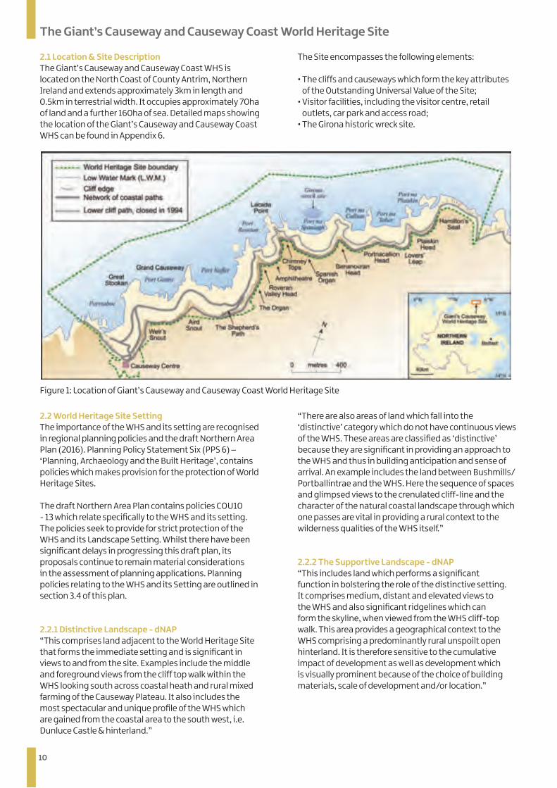
2.1 Location & Site Description The Giant’s Causeway and Causeway Coast WHS is located on the North Coast of County Antrim, Northern Ireland and extends approximately 3km in length and 0.5km in terrestrial width. It occupies approximately 70ha of land and a further 160ha of sea. Detailed maps showing the location of the Giant’s Causeway and Causeway Coast WHS can be found in Appendix 6.
The Site encompasses the following elements:
• The cliffs and causeways which form the key attributes of the Outstanding Universal Value of the Site;
• Visitor facilities, including the visitor centre, retail outlets, car park and access road;
• The Girona historic wreck site.
Figure 1: Location of Giant’s Causeway and Causeway Coast World Heritage Site
2.2 World Heritage Site Setting The importance of the WHS and its setting are recognised in regional planning policies and the draft Northern Area Plan (2016). Planning Policy Statement Six (PPS 6) – ‘Planning, Archaeology and the Built Heritage’, contains policies which makes provision for the protection of World Heritage Sites.
The draft Northern Area Plan contains policies COU10 - 13 which relate specifically to the WHS and its setting. The policies seek to provide for strict protection of the WHS and its Landscape Setting. Whilst there have been significant delays in progressing this draft plan, its proposals continue to remain material considerations in the assessment of planning applications. Planning policies relating to the WHS and its Setting are outlined in section 3.4 of this plan.
2.2.1 Distinctive Landscape - dNAP “This comprises land adjacent to the World Heritage Site that forms the immediate setting and is significant in views to and from the site. Examples include the middle and foreground views from the cliff top walk within the WHS looking south across coastal heath and rural mixed farming of the Causeway Plateau. It also includes the most spectacular and unique profile of the WHS which are gained from the coastal area to the south west, i.e. Dunluce Castle & hinterland.”
“There are also areas of land which fall into the ‘distinctive’ category which do not have continuous views of the WHS. These areas are classified as ‘distinctive’ because they are significant in providing an approach to the WHS and thus in building anticipation and sense of arrival. An example includes the land between Bushmills/Portballintrae and the WHS. Here the sequence of spaces and glimpsed views to the crenulated cliff-line and the character of the natural coastal landscape through which one passes are vital in providing a rural context to the wilderness qualities of the WHS itself.”
2.2.2 The Supportive Landscape - dNAP “This includes land which performs a significant function in bolstering the role of the distinctive setting. It comprises medium, distant and elevated views to the WHS and also significant ridgelines which can form the skyline, when viewed from the WHS cliff-top walk. This area provides a geographical context to the WHS comprising a predominantly rural unspoilt open hinterland. It is therefore sensitive to the cumulative impact of development as well as development which is visually prominent because of the choice of building materials, scale of development and/or location.”
11
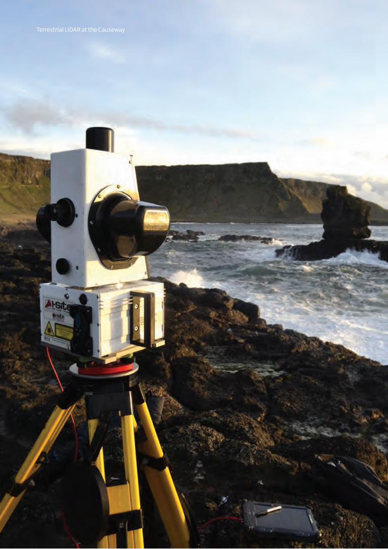
Terrestrial LiDAR at the Causeway
12
The Giant’s Causeway and Causeway Coast World Heritage Site
2.2.3 Connective Landscape - dNAP “This comprises land which is some distance from the WHS, but within the zone of visual influence. From these areas there is often substantial foreground of land or sea in views to the WHS. In some areas these are limited to the WHS due to topography, vegetation or built development but these areas form an important landscape context all the same. Here the distance from the WHS means that these landscapes are less influential in providing a context to the visitor experience and development in the landscape, when viewed from the WHS, is often less discernible.”
2.2.4 Seascape - dNAP The 2005 Giant’s Causeway and Causeway Coast World Heritage Site Management Plan proposed a fourth landscape component. The WHS benefits from an extensive ‘Seascape Setting’ which has a significant visual connection to the World Heritage Site. Areas of the seascape proposed in 2005 have recently been designated a marine Special Area of Conservation – ‘Skerries and Causeway’.
See maps in appendix 8
2.3 Natural Heritage 2.3.1 Geology and Geomorphology The formation of the Causeway Coast began some sixty million years ago with an episode of extensive volcanic activity linked to the opening of what is now the North Atlantic Ocean. This period was dominated by multiple flows of basalt lavas, the total area of which are now much reduced compared to their original extent, but still at 3,800km² constitute Europe’s most extensive lava field.
Traditionally the lavas of the Antrim Group have been divided into three main phases of activity, separated by two extended periods of limited local activity. During these intervening periods the upper surfaces of preceding lava flows were exposed to wet sub-tropical climatic conditions and associated weathering. The result of these conditions appear as two, red coloured, inter-basaltic beds separating the Lower, Middle and Upper Basalts. The exposed landscape of the Site is cut into the Lower and Middle Basalts and the lower of the two interbasaltic beds.
The Lower Basalts are a series of up to eleven complex olivine-rich flows. The Lower Interbasaltic Bed was formed by deep weathering of the uppermost flow of the Lower Basalt, possibly aided by the circulation of hot groundwater. The formation of the Interbasaltic Bed was accompanied by significant fluvial erosion which produced an extensive drainage network in valleys. It was into these valleys that the lava of the Middle Basalts flowed, which was ultimately to be exposed millions of years later as the Causeway Stones.
The Grand, Middle and Little Causeways were carved by the sea from the lowest colonnade of the Middle Basalts between Port Ganny and Port Noffer. Together they are made of approximately 40,000 vertical or gently inclined columns. They owe their great number and regularity to the slow cooling and gradual contraction that took place at the base of the large mass of basalt.
The site was also very important in the advancement of the concepts of volcanology in the late 18th and early 19th Centuries. Etchings produced from the water colours of Susanna Drury made it one of the best known geological localities in the world at that time. More recently the columnar flows were described in classical architecture terms, using colonnade for the lower, wide and very regular columns, and entablature for the upper zone of narrower, more irregular and often curved columns (Tomkeieff, 1940). While the terminology was subsequently modified this descriptive approach has been adopted globally.
13
The Giant’s Causeway and Causeway Coast World Heritage Site
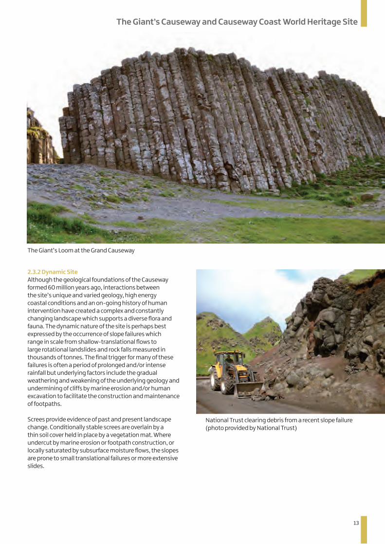
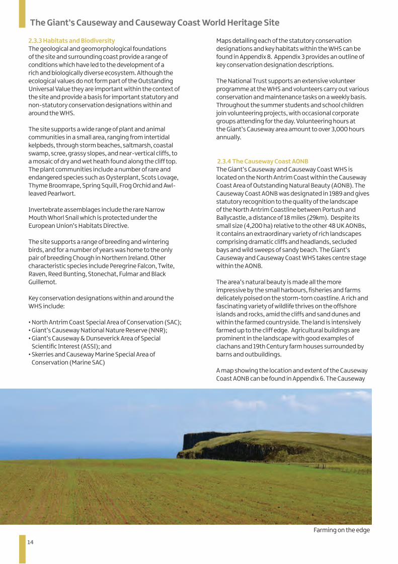
2.3.2 Dynamic Site Although the geological foundations of the Causeway formed 60 million years ago, interactions between the site’s unique and varied geology, high energy coastal conditions and an on-going history of human intervention have created a complex and constantly changing landscape which supports a diverse flora and fauna. The dynamic nature of the site is perhaps best expressed by the occurrence of slope failures which range in scale from shallow-translational flows to large rotational landslides and rock falls measured in thousands of tonnes. The final trigger for many of these failures is often a period of prolonged and/or intense rainfall but underlying factors include the gradual weathering and weakening of the underlying geology and undermining of cliffs by marine erosion and/or human excavation to facilitate the construction and maintenance of footpaths.
Screes provide evidence of past and present landscape change. Conditionally stable screes are overlain by a thin soil cover held in place by a vegetation mat. Where undercut by marine erosion or footpath construction, or locally saturated by subsurface moisture flows, the slopes are prone to small translational failures or more extensive slides.
The Giant’s Loom at the Grand Causeway
National Trust clearing debris from a recent slope failure (photo provided by National Trust)
14
The Giant’s Causeway and Causeway Coast World Heritage Site
2.3.3 Habitats and Biodiversity The geological and geomorphological foundations of the site and surrounding coast provide a range of conditions which have led to the development of a rich and biologically diverse ecosystem. Although the ecological values do not form part of the Outstanding Universal Value they are important within the context of the site and provide a basis for important statutory and non-statutory conservation designations within and around the WHS.
The site supports a wide range of plant and animal communities in a small area, ranging from intertidal kelpbeds, through storm beaches, saltmarsh, coastal swamp, scree, grassy slopes, and near-vertical cliffs, to a mosaic of dry and wet heath found along the cliff top. The plant communities include a number of rare and endangered species such as Oysterplant, Scots Lovage, Thyme Broomrape, Spring Squill, Frog Orchid and Awl-leaved Pearlwort.
Invertebrate assemblages include the rare Narrow Mouth Whorl Snail which is protected under the European Union’s Habitats Directive.
The site supports a range of breeding and wintering birds, and for a number of years was home to the only pair of breeding Chough in Northern Ireland. Other characteristic species include Peregrine Falcon, Twite, Raven, Reed Bunting, Stonechat, Fulmar and Black Guillemot.
Key conservation designations within and around the WHS include:
• North Antrim Coast Special Area of Conservation (SAC);• Giant’s Causeway National Nature Reserve (NNR);• Giant’s Causeway & Dunseverick Area of Special
Scientific Interest (ASSI); and • Skerries and Causeway Marine Special Area of
Conservation (Marine SAC)
Maps detailing each of the statutory conservation designations and key habitats within the WHS can be found in Appendix 8. Appendix 3 provides an outline of key conservation designation descriptions.
The National Trust supports an extensive volunteer programme at the WHS and volunteers carry out various conservation and maintenance tasks on a weekly basis. Throughout the summer students and school children join volunteering projects, with occasional corporate groups attending for the day. Volunteering hours at the Giant’s Causeway area amount to over 3,000 hours annually.
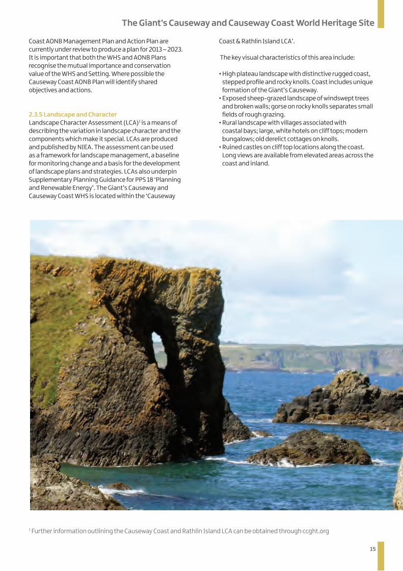
2.3.4 The Causeway Coast AONB The Giant’s Causeway and Causeway Coast WHS is located on the North Antrim Coast within the Causeway Coast Area of Outstanding Natural Beauty (AONB). The Causeway Coast AONB was designated in 1989 and gives statutory recognition to the quality of the landscape of the North Antrim Coastline between Portush and Ballycastle, a distance of 18 miles (29km). Despite its small size (4,200 ha) relative to the other 48 UK AONBs, it contains an extraordinary variety of rich landscapes comprising dramatic cliffs and headlands, secluded bays and wild sweeps of sandy beach. The Giant’s Causeway and Causeway Coast WHS takes centre stage within the AONB.
The area’s natural beauty is made all the more impressive by the small harbours, fisheries and farms delicately poised on the storm-torn coastline. A rich and fascinating variety of wildlife thrives on the offshore islands and rocks, amid the cliffs and sand dunes and within the farmed countryside. The land is intensively farmed up to the cliff edge. Agricultural buildings are prominent in the landscape with good examples of clachans and 19th Century farm houses surrounded by barns and outbuildings.
A map showing the location and extent of the Causeway Coast AONB can be found in Appendix 6. The Causeway
Farming on the edge
15
The Giant’s Causeway and Causeway Coast World Heritage Site
Coast AONB Management Plan and Action Plan are currently under review to produce a plan for 2013 – 2023. It is important that both the WHS and AONB Plans recognise the mutual importance and conservation value of the WHS and Setting. Where possible the Causeway Coast AONB Plan will identify shared objectives and actions.
2.3.5 Landscape and Character Landscape Character Assessment (LCA)1 is a means of describing the variation in landscape character and the components which make it special. LCAs are produced and published by NIEA. The assessment can be used as a framework for landscape management, a baseline for monitoring change and a basis for the development of landscape plans and strategies. LCAs also underpin Supplementary Planning Guidance for PPS 18 ‘Planning and Renewable Energy’. The Giant’s Causeway and Causeway Coast WHS is located within the ‘Causeway
Coast & Rathlin Island LCA’.
The key visual characteristics of this area include: • High plateau landscape with distinctive rugged coast,
stepped profile and rocky knolls. Coast includes unique formation of the Giant’s Causeway.
• Exposed sheep-grazed landscape of windswept trees and broken walls; gorse on rocky knolls separates small fields of rough grazing.
• Rural landscape with villages associated with coastal bays; large, white hotels on cliff tops; modern bungalows; old derelict cottages on knolls.
• Ruined castles on cliff top locations along the coast. Long views are available from elevated areas across the coast and inland.
1 Further information outlining the Causeway Coast and Rathlin Island LCA can be obtained through ccght.org
16
2.4 Intangible Values and Cultural Heritage
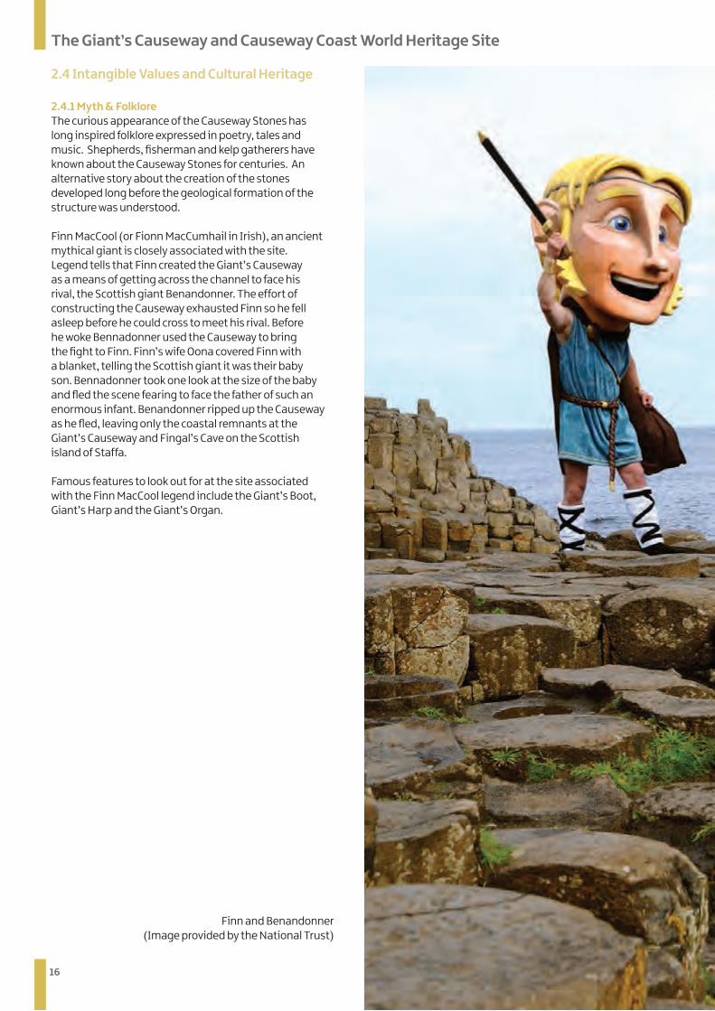
2.4.1 Myth & Folklore The curious appearance of the Causeway Stones has long inspired folklore expressed in poetry, tales and music. Shepherds, fisherman and kelp gatherers have known about the Causeway Stones for centuries. An alternative story about the creation of the stones developed long before the geological formation of the structure was understood.
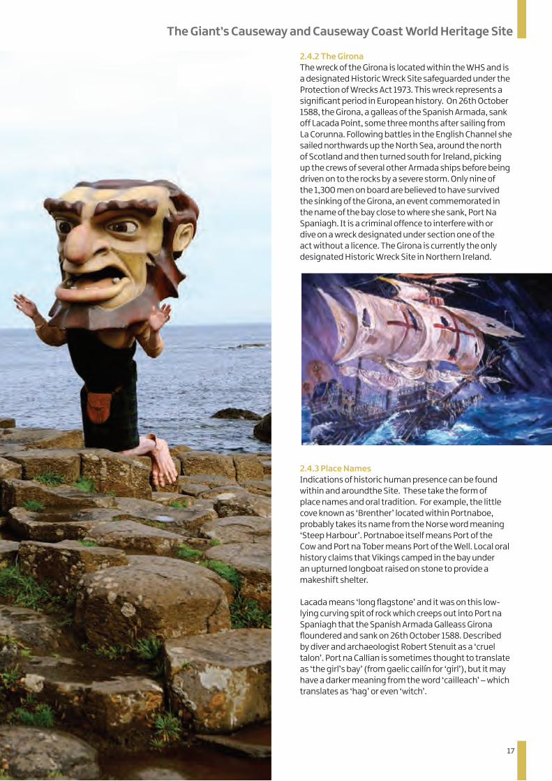
Finn MacCool (or Fionn MacCumhail in Irish), an ancient mythical giant is closely associated with the site. Legend tells that Finn created the Giant’s Causeway as a means of getting across the channel to face his rival, the Scottish giant Benandonner. The effort of constructing the Causeway exhausted Finn so he fell asleep before he could cross to meet his rival. Before he woke Bennadonner used the Causeway to bring the fight to Finn. Finn’s wife Oona covered Finn with a blanket, telling the Scottish giant it was their baby son. Bennadonner took one look at the size of the baby and fled the scene fearing to face the father of such an enormous infant. Benandonner ripped up the Causeway as he fled, leaving only the coastal remnants at the Giant’s Causeway and Fingal’s Cave on the Scottish island of Staffa. Famous features to look out for at the site associated with the Finn MacCool legend include the Giant’s Boot, Giant’s Harp and the Giant’s Organ.
The Giant’s Causeway and Causeway Coast World Heritage Site
Finn and Benandonner (Image provided by the National Trust)
17
The Giant’s Causeway and Causeway Coast World Heritage Site
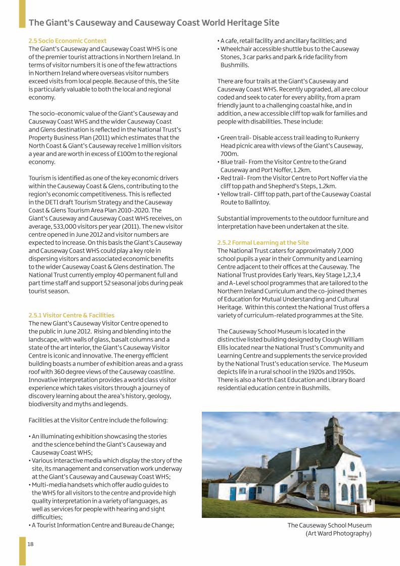
2.4.2 The Girona The wreck of the Girona is located within the WHS and is a designated Historic Wreck Site safeguarded under the Protection of Wrecks Act 1973. This wreck represents a significant period in European history. On 26th October 1588, the Girona, a galleas of the Spanish Armada, sank off Lacada Point, some three months after sailing from La Corunna. Following battles in the English Channel she sailed northwards up the North Sea, around the north of Scotland and then turned south for Ireland, picking up the crews of several other Armada ships before being driven on to the rocks by a severe storm. Only nine of the 1,300 men on board are believed to have survived the sinking of the Girona, an event commemorated in the name of the bay close to where she sank, Port Na Spaniagh. It is a criminal offence to interfere with or dive on a wreck designated under section one of the act without a licence. The Girona is currently the only designated Historic Wreck Site in Northern Ireland.
2.4.3 Place Names Indications of historic human presence can be found within and aroundthe Site. These take the form of place names and oral tradition. For example, the little cove known as ‘Brenther’ located within Portnaboe, probably takes its name from the Norse word meaning ‘Steep Harbour’. Portnaboe itself means Port of the Cow and Port na Tober means Port of the Well. Local oral history claims that Vikings camped in the bay under an upturned longboat raised on stone to provide a makeshift shelter. Lacada means ‘long flagstone’ and it was on this low-lying curving spit of rock which creeps out into Port na Spaniagh that the Spanish Armada Galleass Girona floundered and sank on 26th October 1588. Described by diver and archaeologist Robert Stenuit as a ‘cruel talon’. Port na Callian is sometimes thought to translate as ‘the girl’s bay’ (from gaelic cailín for ‘girl’), but it may have a darker meaning from the word ‘cailleach’ – which translates as ‘hag’ or even ‘witch’.
18
The Giant’s Causeway and Causeway Coast World Heritage Site
2.5 Socio Economic Context The Giant’s Causeway and Causeway Coast WHS is one of the premier tourist attractions in Northern Ireland. In terms of visitor numbers it is one of the few attractions in Northern Ireland where overseas visitor numbers exceed visits from local people. Because of this, the Site is particularly valuable to both the local and regional economy.
The socio-economic value of the Giant’s Causeway and Causeway Coast WHS and the wider Causeway Coast and Glens destination is reflected in the National Trust’s Property Business Plan (2011) which estimates that the North Coast & Giant’s Causeway receive 1 million visitors a year and are worth in excess of £100m to the regional economy.
Tourism is identified as one of the key economic drivers within the Causeway Coast & Glens, contributing to the region’s economic competitiveness. This is reflected in the DETI draft Tourism Strategy and the Causeway Coast & Glens Tourism Area Plan 2010-2020. The Giant’s Causeway and Causeway Coast WHS receives, on average, 533,000 visitors per year (2011). The new visitor centre opened in June 2012 and visitor numbers are expected to increase. On this basis the Giant’s Causeway and Causeway Coast WHS could play a key role in dispersing visitors and associated economic benefits to the wider Causeway Coast & Glens destination. The National Trust currently employ 40 permanent full and part time staff and support 52 seasonal jobs during peak tourist season.
2.5.1 Visitor Centre & Facilities The new Giant’s Causeway Visitor Centre opened to the public in June 2012. Rising and blending into the landscape, with walls of glass, basalt columns and a state of the art interior, the Giant’s Causeway Visitor Centre is iconic and innovative. The energy efficient building boasts a number of exhibition areas and a grass roof with 360 degree views of the Causeway coastline. Innovative interpretation provides a world class visitor experience which takes visitors through a journey of discovery learning about the area’s history, geology, biodiversity and myths and legends.
Facilities at the Visitor Centre include the following:
• An illuminating exhibition showcasing the stories and the science behind the Giant’s Causeway and Causeway Coast WHS;
• Various interactive media which display the story of the site, its management and conservation work underway at the Giant’s Causeway and Causeway Coast WHS;
• Multi-media handsets which offer audio guides to the WHS for all visitors to the centre and provide high quality interpretation in a variety of languages, as well as services for people with hearing and sight difficulties;
• A Tourist Information Centre and Bureau de Change;
• A cafe, retail facility and ancillary facilities; and• Wheelchair accessible shuttle bus to the Causeway
Stones, 3 car parks and park & ride facility from Bushmills.
There are four trails at the Giant’s Causeway and Causeway Coast WHS. Recently upgraded, all are colour coded and seek to cater for every ability, from a pram friendly jaunt to a challenging coastal hike, and in addition, a new accessible cliff top walk for families and people with disabilities. These include:
• Green trail- Disable access trail leading to Runkerry Head picnic area with views of the Giant’s Causeway, 700m.
• Blue trail- From the Visitor Centre to the Grand Causeway and Port Noffer, 1.2km.
• Red trail- From the Visitor Centre to Port Noffer via the cliff top path and Shepherd’s Steps, 1.2km.
• Yellow trail- Cliff top path, part of the Causeway Coastal Route to Ballintoy.
Substantial improvements to the outdoor furniture and interpretation have been undertaken at the site.
2.5.2 Formal Learning at the Site The National Trust caters for approximately 7,000 school pupils a year in their Community and Learning Centre adjacent to their offices at the Causeway. The National Trust provides Early Years, Key Stage 1,2,3,4 and A-Level school programmes that are tailored to the Northern Ireland Curriculum and the co-joined themes of Education for Mutual Understanding and Cultural Heritage. Within this context the National Trust offers a variety of curriculum-related programmes at the Site.
The Causeway School Museum is located in the distinctive listed building designed by Clough William Ellis located near the National Trust’s Community and Learning Centre and supplements the service provided by the National Trust’s education service. The Museum depicts life in a rural school in the 1920s and 1950s. There is also a North East Education and Library Board residential education centre in Bushmills.
The Causeway School Museum(Art Ward Photography)

19
The Giant’s Causeway and Causeway Coast World Heritage Site
2.6 The Wider Area - Community Settlements around the World Heritage Site
Bushmills Bushmills, gateway to the Giant’s Causeway and formerly known as Portcaman, developed as an industrial town on the banks of the River Bush and the river has long provided the main focal point of the village. The settlement, the largest in the area, developed with the water powered industries of the 1600s to become one of the main centres for corn milling, flax processing, spade manufacture and whiskey distilling. The river once powered seven mills along its stretch through the village and one of the first recorded mills in County Antrim existed here.
The village owes much of its development to the McNaghten family who reside in, the Grade A listed, Dundarave House which lies between the village and the WHS. They are responsible for the building of many of the prominent buildings here, including the Clock Tower and the Courthouse. Bushmills has some wonderful examples of period architecture and is also fortunate to have examples of work by the famous architect Clough Williams-Ellis who designed the former Grammar School and the Causeway School.
Bushmills, an area home to 3,666, residents, also houses the world famous Bushmills Distillery, the oldest licensed distillery in Ireland which attracts over 110,000 visitors per year. Bushmills is the gateway to, and has strong connections with the Giant’s Causeway and Causeway Coast World Heritage Site. It was designated a Conservation Area in 1992 in recognition of the historic built fabric and cultural heritage of the settlement.
Portballintrae Portballintrae lies at the mouth of the Bush river valley and developed as a small fishing village. The harbour is well protected within a small horseshoe bay and is home port to several fishing vessels, though gradually pleasure craft are replacing working boats. It was at the harbour in May 1967 that the first of 12,000 artifacts recovered from the wreck site of the Spanish Galleass came ashore. The recovered treasure included gold and silver coins, jewellery, silver plates and a bronze cannon. Across the bay is Runkerry Headland and Runkerry House built in the 18th century by Edward Macnaghten of Dundarave. Another important historical site in Portballintrae is Lissanduff Earthworks located near the car park overlooking Bushfoot Strand. This consists of two large circular earthworks with concentric ramparts. One is clay lined and appears to have been designed specifically to hold water for what is presumed to have
The Giant’s Causeway and Causeway Coast Visitor Centre (Art Ward Photography)
Bushmills Village (Art Ward Photography)
20
The Giant’s Causeway and Causeway Coast World Heritage Site
been water rituals. The other is a more typical lios or rath and would have served as a fortified settlement for people and animals. The site dates to the Bronze Age (3000BC) and has yet to be fully understood or archaeologically excavated. Classic examples of architectural heritage can still be found in the village including the Old Coastguard Station built in 1874 and Seaport Lodge. The thatched cottage overlooking the harbour is the last remaining example of the style of cottage that once surrounded the Bay. The once small fishing settlement has experienced rapid growth since the 1970s and is now a popular tourist destination. Significant residential development, primarily holiday home provision has considerably altered the character of Portballintrae.
Ballintoy The smaller settlement of Ballintoy is located between Ballycastle and the Giant’s Causeway and Causeway Coast WHS. The name Ballintoy has two translations, one commonly refers to it as the ‘ Town of the North ‘ while another translation refers to it as ‘The place of the Axe’. The limestone harbour and Parish Church are distinctive features of the village. The harbour, built from limestone blocks and surrounded on the landward side by limestone cliffs, was once a hub for north coast fishing, boat building and local industries. The well-built lime kiln stands as a testament to the harbour’s industrial past; burnt lime would have been drawn away by horse and cart to help build the numerous stone cottages and rural halls in the district.
A narrow winding road takes visitors down to the harbour of Ballintoy. A notable building adjacent to the harbour is ‘Bendhu House’ and was built by the Cornish artist Newton Penprase over a 40 year period from 1935. The harbour is well sheltered from the Atlantic by a series of black basalt islands and looks out across Boheeshane Bay to Larry Bane Head, Sheep Island, Rathlin Island and Scotland. Ballintoy is located on the Causeway Coastal Route and given its proximity to the Giant’s Causeway and Causeway Coast WHS and Carrick-a-Rede Rope Bridge is a popular tourist centre.
Lisnagunogue & Dunseverick Lisnagunogue is located approximately 4km north east of Bushmills on the main A2 Coast Road. The main focal point within this hamlet is the public house, whilst Dunseverick Castle, a short distance to the east is a prominent local landmark. Dunseverick Castle & Earthworks are Scheduled Historic Monuments. Overlooking the ocean, Dunseverick was also a key ancient site in Ireland lying at the northern end of one of the royal roads from Tara, the seat of the Kings of Ireland.
Portbraddan Portbraddan is a picturesque fishing village under the cliff at the end of White Park Bay. The small hamlet offers stunning views out across Whitepark Bay to Ballintoy Church and the basalt islands known as the Parks which shelter the harbour of Ballintoy. The name means ‘Port of the Salmon’ as it is the site of a traditional salmon fishing station and still has a working slipway for fishermen. The small church in Portbdaddan may be the smallest church on the island of Ireland. Whitepark Bay was one of the first settlements of man in Ireland and evidence of these Neolithic settlers are continually being exposed in the Bay.
21
Part 3 - Site Management & Policy Context
PART 3
Site Management & Policy Context& Policy Context
22
3.1 Current Management Context Ownership of the Site
There are five bodies with legal rights to the Giant’s Causeway and Causeway Coast WHS:
• The Crown Estate; • National Trust;• Moyle District Council; and• Two private landowners.
The Crown Estate Within the WHS the Crown Estate is the legal owner of all land between the Mean High and Mean Low Water Mark which includes the inter-tidal area of Causeway Stones. It also owns the sea-bed within the territorial waters of the United Kingdom.
National Trust Since 1961 the National Trust has held approximately 70ha of the Site including the key attributes of the WHS through freehold or leasehold agreements. It currently owns, leases and manages approximately 95% of the terrestrial site, including almost all of the cliffs and foreshore, the Causeway Hotel and the Visitor Centre. It is responsible for public access and visitor management at the Site and along the coastal path. The National Trust rents some of the cliff-top lands adjacent to the Site to a tenant farmer.
National Trust land holdings are ‘inalienable’, which means that the National Trust is duty-bound to maintain the property in perpetuity, as far as possible in its natural state for the nation to enjoy. The National Trust cannot sell or mortgage inalienable land without the formal approval of the National Trust’s Board of Trustees. Approval can only be given if the matter is considered to be of over-riding national interest and that all possible steps have been taken to avoid or mitigate the risk of damage to the property. If the National Trust’s Board of Trustees is not satisfied that necessary actions have been taken, the matter becomes subject to Special Parliamentary Procedures.
Moyle District Council Moyle District Council retains a legal interest in certain lands which, since 2005, have been leased to and managed by the National Trust.
Private landowners There are two private landowners who retain an interest in a relatively small part of the Site.
(Detailed landownership maps can be found in Appendix 8)
Agencies with an interest in the Site In addition to the Site owners, there are several other organisations and agencies with management responsibilities for, or interests in, the Site. Many of these bodies are represented on the WHS Steering Group. The following are the key organisations with an interest in the Site:
• Department of the Environment (DoE) represented by the Northern Ireland Environment Agency (NIEA)
• Department of the Environment (DoE) represented by the Marine Division
• Department of Enterprise, Trade and Investment (DETI), represented by the Northern Ireland Tourist Board (NITB)
• Causeway Coast and Glens Heritage Trust (CCGHT), the independent body with lead responsibility for managing the Causeway Coast AONB
• Causeway Coast & Glens Tourism Partnership. A description of the role of the various agencies can be found in Appendix 4. A full list of World Heritage Site Steering Group Members can be found in Appendix 5.
3.2 Status of the World Heritage Site Management Plan The WHS Management Plan is not a statutory document and is not regarded as a ‘material consideration’ in the planning process. Nevertheless it is financially supported by the Northern Ireland Environment Agency (NIEA), is endorsed by key partners and provides an agreed framework and important actions for the sustainable management of the Site and its environs. The Site derives most of its legal protection from European level SAC designations and National/Regional level protection through a designated ASSI, NNR and AONB.
3.3 Evaluation of the WHS Management Plan 2005-2011 Since 2005 a number of changes have been made which have affected the operation and management of the WHS. The lack of a dedicated WHS Officer between 2005 and 2011 delayed progress with delivery of the 2005 Plan. In April 2011 CCGHT appointed a WHS Officer on a part-time basis to coordinate WHS Management Plan preparation and coordination. This position is secured through core-funding from the NIEA Natural Heritage Grant Scheme.The opening of the Giant’s Causeway Visitor Centre also represents significant progress in terms of the delivery of key objectives set out in the 2005 Plan.
3.4 Current Policy and Legislative Context The WHS Management Plan does not exist in isolation. A comprehensive policy framework operates in Northern Ireland and there are a plethora of regional and local strategies, policies and plans that are relevant to the WHS and its surroundings. Some of these plans and
Site Management & Policy Context
Department of Enterprise, Trade and Investment (DETI), represented by the Geological Survey of Northern Ireland (GSNI)
•
23
policies are currently under review or are in draft format and may be subject to change before adoption. The key policies and plans which are of relevance to the WHS are listed below. These can be obtained from the relevant organisations or accessed through the Causeway Coast and Glens Heritage Trust Website (ccght.org).
Regional Strategies • Northern Ireland Regional Development Strategy 2035 ‘Building a Better Future’ • Planning Strategy for Rural Northern Ireland 1993• Draft Department of Enterprise Trade and Investment Tourism Strategy for Northern Ireland 2010-2020 • Northern Ireland Sustainable Development Strategy ‘Everyone’s Involved’ 2010 • Northern Ireland Biodiversity Strategy• Planning Policy Statements • PPS 2 - Planning & Nature Conservation (1997)• PPS 3 - Access Movement & Parking (2005)• PPS 6 - Planning, Archaeology & The Built Heritage
(1999)• PPS 16 (draft) - Tourism (2010)• PPS 21 - Sustainable Development in the Countryside
(2010)
Development Plans Draft Northern Area Plan (2016) Policies:
• COU 10 – The Giant’s Causeway World Heritage Site• COU 11 & COU 12 – The Distinctive Landscape Setting of
the World Heritage Site• COU 13 – Supportive Landscape Setting of the World
Heritage Site
Other Relevant Plans• Causeway Coast Area of Outstanding Natural Beauty
Management Plan 2013 – 2023• Giant’s Causeway National Nature Reserve Plan 2006• Causeway Coast & Glens Tourism Action Plan 2012-
2017: Growing Tourism Together• National Trust Property Business Plan 2011-2014• Tourism Strategy and Action Plan for Moyle District
Council 2008-2013• Marine & Coastal Access Act 2009• ASSI Options for Management / Conservation
Objectives• SAC Conservation Objectives • Causeway Coast & Glens Council Cluster Local
Biodiversity Action Plan 2013-2018
Site Management & Policy Context
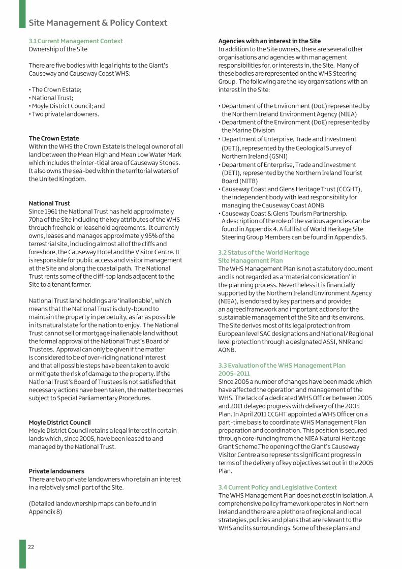
Horse Shoe Harbour and the Murder Hole at Hamilton’s Seat
24
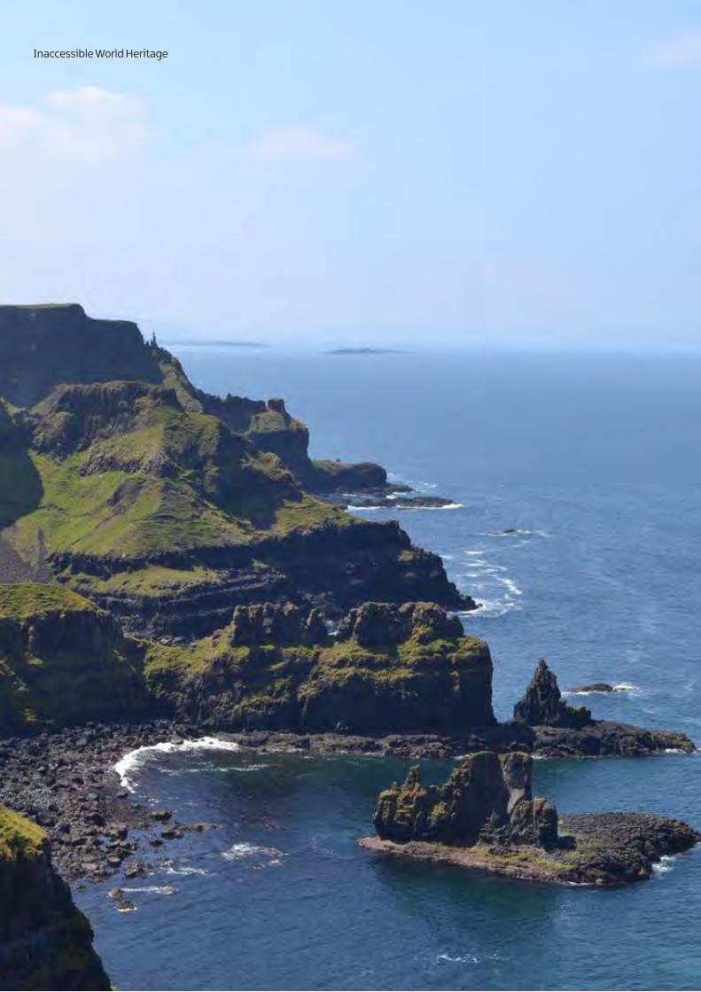
Inaccessible World Heritage

25
Contents
PART 4
Issues & Opportunities
26
Issues & Opportunities
The review of the existing WHS Management Plan identified the progress made by partners in the delivery of the 2005 plan objectives. Since the publication of the first plan in 2005 new issues and opportunities have emerged and an evaluation exercise allowed the WHS Steering Group to focus on and identify future needs and challenges. This section summarises the key issues and opportunities which will have a significant impact on the management of the WHS over the next seven years, 2013-2019.
4.1 Impact of Climate Change In 2007 the National Trust commissioned a team of experts from Queen’s University Belfast and the University of Ulster to investigate how the climate of Northern Ireland is likely to change during this century; how these changes may impact on coastal sites including the WHS; and what management and policy challenges these may present.
The detailed report entitled ‘Future Coastal Scenarios for Northern Ireland’ and its summary ‘Shifting Shores’ present the following key climate predictions:
• Warmer Annual Temperatures –increased average annual temperature between 1.5 - 2.5oC by 2080;
• Wetter Winters and Drier Summers – precipitation to increase by 20% in winter and decrease by 40% in summer with a corresponding 20% decrease in soil moisture by 2080;
• Sea level rise of between 85 cm and 1 m by 2100;• Increased frequency of extreme storm surge events
with present 1/50 year events occurring every 1-3 years by 2050.
Major impacts at coastal sites including the Giant’s Causeway and Causeway Coast WHS over the next 25-100 years may include:
• Increased coastal erosion and flooding;• Changes to and degradation/loss of important
habitats and wildlife;• Increased land instability.
The predicted impacts of climate change demand consideration now, of an appropriate response to ensure that the best possible approach is developed to protect and conserve the WHS and its OUV. At a strategic level there is a need to continue to increase awareness and understanding amongst policy makers and the wider population about the impacts of climate change and its implications for the WHS. At local level the challenge lies in adapting and developing new management practices to respond accordingly to the effects of climate change. The National Trust and partners strive to be world leaders in the pro-active management of climate change at dynamic natural sites.
4.2 Dynamic Natural Processes and Hazard Management The Site was inscribed as a natural site under the World Heritage Convention and continuation of dynamic natural processes which shape the Site form an essential element of the Site’s OUV and support its WHS status. Slope failures occur frequently and range from shallow translational mudflows to large rotational landslides and block falls. Slope failures are an essential component of the Site as they:
• have intrinsic importance as geomorphological features and continuously create new exposures for scientific study;
• are essential in maintaining the overall rugged nature of the coastline and are crucial to the creation of the Site’s spectacular landscape; and
• regularly expose soil and bedrock which are instrumental in the Site’s biodiversity.
Whilst providing unparalleled opportunities for scientific research and significant ecological benefits dynamic natural processes present problems for visitor management, in particular visitor access and safety. Whilst stability issues could be tackled through physical intervention to provide for enhanced visitor access, this cannot be carried out in a manner which would affect dynamic processes and therefore compromise the OUV of the Site. Uncontrolled or inappropriate intervention could serve to exacerbate slope failures at the Site.
The challenge lies in finding appropriate and innovative solutions to maintain visitor access and safety without compromising the natural dynamism and OUV of the Site.
As a tourism ‘honeypot’ the Giant’s Causeway and Causeway Coast World Heritage Site represents a contested space where managers must balance conservation and visitor requirements with safety considerations created by slope instabilities.
The 2007 report commissioned by the National Trust to scope climate change impacts at the Giant’s Causeway concluded that the Site represents a high energy environment that will require adaptive management strategies to “respond to the demands of a dynamic landscape” and “accommodate any changes in the nature of this dynamic”. The National Trust and its partners are committed to working in tandem with the Site’s natural dynamics to conserve geomorphological processes which support maintenance of the Site’s outstanding values and protected biodiversity. Working with the School of Geography at Queen’s University Belfast, the National Trust has undertaken a complete terrestrial LiDAR survey (3D laser scan) of the WHS, upon which an online natural heritage database and integrated hazard assessment tools have been established. This tool enables the National Trust to establish where specific processes occur, the likelihood of their occurrence and potential impacts.
27
Issues & Opportunities
4.3 Education & Research Potential of the WHS The Giant’s Causeway has played a critical role in the development of scientific ideas concerning the nature of key geological processes. The importance of the Site in the advancement of volcanology concepts since the 18th Century is evidenced in the wealth of research literature published about the site. Today the WHS continues to represent an internationally renowned case study site for both teaching and exploration of geological and geomorphological processes. Future geological and geomorphological research into the Site’s OUV will positively contribute to site management and monitoring regimes. Of particular concern is the challenge posed by climate change to the natural dynamism of the Site and the implications for site management. Issues are complicated by a range of conservation designations which are traditionally rooted in the preservation of biodiversity regardless of natural let alone anthropogenic change.
4.4 Visitor Management As the region’s leading tourist attraction the Giant’s Causeway and Causeway Coast WHS attracts on average 600,000 visitors per year and following the opening of the new visitor centre in June 2012 this is expected to increase to 820,000 by 2016, according to the National Trust Business Plan 2011. On that basis visitor pressure will continue to be a significant issue. Management needs to be delivered in a manner that continues to provide a high quality visitor experience without compromising the conservation value or contravening any statutory designations that apply to the Site.
The issues associated with visitor management at the Site are broad-ranging and include visitor access and flow, traffic congestion and visitor safety. They can arise as staff work to mitigate the impacts on the geological/ecological/landscape value of the Site arising from the provision of necessary infrastructure, access and services to ensure a comfortable and enjoyable visitor experience.
Redevelopment of the visitor facilities on the Site has provided a unique opportunity to address some of the key issues for visitor management. The underlying principle informing the location, design and operation of the new facilities has been to conserve and enhance the conservation value of the Site
A major management challenge is achieving sustainable visitor management whilst delivering a first class visitor experience to increasing numbers of visitors and protecting and maintaining the OUV of the Site.
4.5 The Setting of the Site and its Status A key tool for managing change within the WHS setting is the regional planning policy framework (see section 3.4). The WHS and its setting are recognised and protected through regional planning policy and the emerging draft Northern Area Plan (2016). Whilst there have been significant delays in progressing the Northern Area Plan, its policies continue to remain material considerations. PPS 6 relates to the Protection of World Heritage Sites and states that there will be a presumption in favour of the protection of these sites and development which would affect such sites or the integrity of their settings will not be permitted unless there are exceptional circumstances.
Large-scale planning proposals within the setting of the WHS have sparked debate amongst key stakeholders. One debate has focused on the potential for a new links golf course and visitor accommodation to impact on the Outstanding Universal Value and Integrity of the WHS and its Setting. There is broad consensus that there is a need for modern facilities to accommodate increasing tourist numbers. National Trust and stakeholders are keen to ensure any potential development is in keeping with the Site’s landscape setting and provides sustainable economic benefits for the local community.
4.6 Governance The WHS Steering Group has responsibility for coordinating preparation and implementation of the Management Plan. The group consists of organisations which play a key role in the delivery of the aims and objectives set out in the plan and includes representatives from the public, private and voluntary sectors. To date it has not included all interested parties and representation from the wider community currently consists of just one local landowner. The issues associated with maintaining the existing partnership, reinforcing its purpose, ensuring balanced representation and securing the resources to coordinate and deliver the WHS Management plan cannot be underestimated and will ultimately determine its overall success. The effectiveness of the Steering Group has been weakened by the inability of its members to reach consensus on a number of key issues, relating particularly to the protection of the Distinctive Landscape Setting. This has led group members to question the role of the Steering Group. New Terms of Reference are currently under discussion. Whilst there are significant differences in opinion, the group agree unanimously that protection of the OUV and integrity are prime considerations.
28
Issues & Opportunities
4.7 Community Involvement Key to the long term sustainable management of a WHS is involvement and support by local communities living and working in the surrounding area. The Convention acknowledges that the protection of World Heritage should be a function in the life of a community. The Budapest Declaration (2002) recognises that WHSs are located within and near communities and they can be used to offer sustainable socio-economic benefits for these communities. The evaluation of the 2005 WHS Management Plan highlighted the failure to achieve effective community involvement at the Giant’s Causeway and Causeway Coast WHS. This can be attributed to the lack of a dedicated WHS Officer. This refreshed Management Plan presents an opportunity to tackle these issues, re-engage with local communities, raise awareness and gain support for the WHS and reinvigorate community involvement and volunteering. Forging stronger relationships with local communities, achieving active community involvement in the management of the Site and promoting the benefits associated with the WHS to support local communities, provides the foundations for this Management Plan.
4.8 Socio-Economic Potential of WHS The development of tourism is recognised as a major opportunity to raise awareness of the Causeway Coast & Glens region whilst adding significant value to the Northern Ireland economy. NITB state that tourism represents at least 4.9% of Gross Value Added, placingtourism almost on a par with agriculture as one of Northern Ireland’s top industries. The Giant’s Causeway and Causeway Coast WHS is the leading tourist attraction in Northern Ireland, generating significant tourism revenue for the region. On this basis it could play a significant role for visitor dispersal in the wider Causeway Coast & Glens. According to the Causeway Coast & Glens Tourism Area Plan 2012-2017, the basis for visitor dispersal should be: • “The quality of attractions in the area, but crucially
too, of local communities and destination towns and villages. The momentum to improve the environment, facilities & interpretation in these local communities must continue;
• Interpretation and orientation reinforcing ‘reasons to visit’ local areas and why visitors should ‘linger longer’;
• Continuing promotion of routes, trails & itineraries associated with public transport, walking, cycling etc;
• Including and engaging local communities to help them see the benefit of being involved with and welcoming visitors”
This is based on a ‘hubs and spokes’ approach, encouraging people to visit attractions, towns/villages and help disperse visitors along the ‘spokes’. The Giant’s Causeway and Causeway Coast WHS has an important role to play as a key driver for tourism. The Tourism Plan encourages operators to realise the benefits of the World Heritage Site through partnerships and innovative working. Huge numbers of ‘day-visit’ tourists are currently bussed in and out of key destinations along the Causeway Coastal Route. These tours frequently originate in other areas of Northern Ireland and the Republic of Ireland. The challenge lies in dispelling the myth that the north coast and Northern Ireland as a whole can be experienced in a single day. By attracting visitors to major tourist attractions such as the WHS and providing a warm and homely welcome, major socio-economic benefits can be realised.
29
Contents
PART 5
Vision, Aims & Objectives
30
Vision, Aims & Objectives
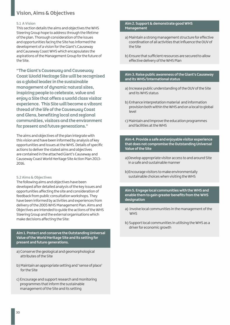
5.1 A Vision This section details the aims and objectives the WHS Steering Group hope to address through the lifetime of the plan. Thorough consideration of the issues and opportunities facing the Site has informed the development of a vision for the Giant’s Causeway and Causeway Coast WHS which encapsulates the aspirations of the Management Group for the future of the Site.
“The Giant’s Causeway and Causeway Coast World Heritage Site will be recognised as a global leader in the sustainable management of dynamic natural sites, inspiring people to celebrate, value and enjoy a Site that offers a world class visitor experience. This Site will become a vibrant thread of the life of the Causeway Coast and Glens, benefiting local and regional communities, visitors and the environment for present and future generations.’’
The aims and objectives of the plan integrate with this vision and have been informed by analysis of key opportunities and issues at the WHS. Details of specific actions to deliver the stated aims and objectives are contained in the attached Giant’s Causeway and Causeway Coast World Heritage Site Action Plan 2013-2016.
5.2 Aims & Objectives The following aims and objectives have been developed after detailed analysis of the key issues and opportunities affecting the site and consideration of feedback from public consultation workshops. They have been informed by activities and experiences from delivery of the 2005 WHS Management Plan. Aims and Objectives are intended to guide the actions of the WHS Steering Group and the external organisations which make decisions affecting the Site:
Aim 1. Protect and conserve the Outstanding Universal Value of the World Heritage Site and its setting for present and future generations.
a) Conserve the geological and geomorphological attributes of the Site
b) Maintain an appropriate setting and ‘sense of place’ for the Site
c) Encourage and support research and monitoring programmes that inform the sustainable management of the Site and its setting
Aim 2. Support & demonstrate good WHS Management
a) Maintain a strong management structure for effective coordination of all activities that influence the OUV of the Site
b) Ensure that sufficient resources are secured to allow effective delivery of the WHS Plan
Aim 3. Raise public awareness of the Giant’s Causeway and its WHS/International status
a) Increase public understanding of the OUV of the Site and its WHS status
b) Enhance interpretation material and information provision both within the WHS and on a local to global level
c) Maintain and improve the education programmes and facilities at the WHS
Aim 4. Provide a safe and enjoyable visitor experience that does not compromise the Outstanding Universal Value of the Site
a) Develop appropriate visitor access to and around Site in a safe and sustainable manner
b) Encourage visitors to make environmentally sustainable choices when visiting the WHS
Aim 5. Engage local communities with the WHS and enable them to gain greater benefits from the WHS designation
a) Involve local communities in the management of the WHS
b) Support local communities in utilising the WHS as a driver for economic growth
31
Vision, Aims & Objectives
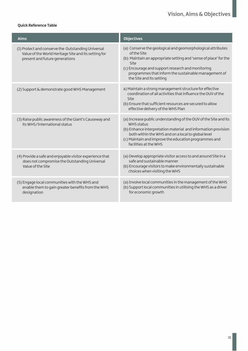
Quick Reference Table
Aims Objectives
(1) Protect and conserve the Outstanding Universal Value of the World Heritage Site and its setting for present and future generations
(2) Support & demonstrate good WHS Management
(3) Raise public awareness of the Giant’s Causeway and its WHS/International status
(4) Provide a safe and enjoyable visitor experience that does not compromise the Outstanding Universal Value of the Site
(5) Engage local communities with the WHS and enable them to gain greater benefits from the WHS designation
(a) Conserve the geological and geomorphological attributes of the Site
(b) Maintain an appropriate setting and ‘sense of place’ for the Site
(c) Encourage and support research and monitoring programmes that inform the sustainable management of the Site and its setting
a) Maintain a strong management structure for effective coordination of all activities that influence the OUV of the Site
(b) Ensure that sufficient resources are secured to allow effective delivery of the WHS Plan
(a) Increase public understanding of the OUV of the Site and its WHS status
(b) Enhance interpretation material and information provision both within the WHS and on a local to global level
(c) Maintain and improve the education programmes and facilities at the WHS
(a) Develop appropriate visitor access to and around Site in a safe and sustainable manner
(b) Encourage visitors to make environmentally sustainable choices when visiting the WHS
(a) Involve local communities in the management of the WHS (b) Support local communities in utilising the WHS as a driver
for economic growth
32
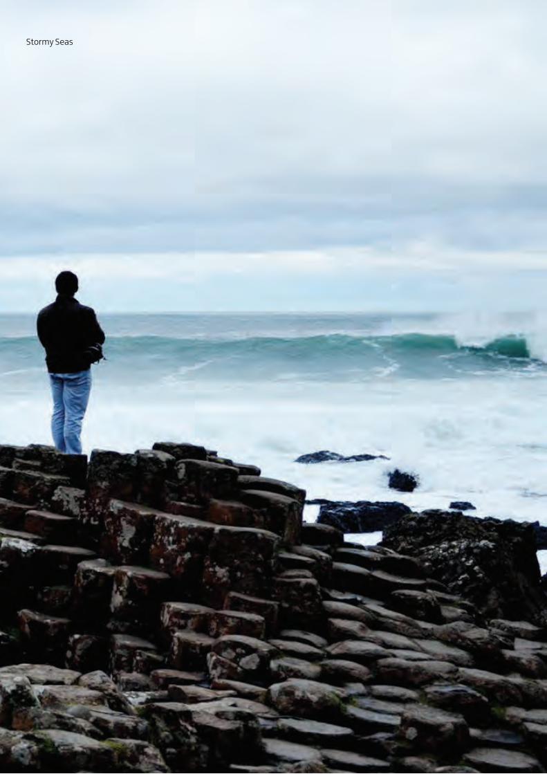
Vision, Aims & ObjectivesStormy Seas
33
Vision, Aims & Objectives
PART 6
Implementation of the Plan and Making it Happen
34
Implementation of the Plan and Making it Happen
6.1 Strategy for the Implementation of the Plan For the WHS Management Plan to deliver a sustainable future for the WHS, it needs to be promoted and monitored. This requires considerable commitment from partner organisations and the WHS Steering Group. This group’s membership reflects conservation and tourism interests at the Site. The WHS Steering Groupprovides strategic guidance on activities and operations occurring within and around the Site and facilitates dialogue with the local community.
The 2005 WHS Management Plan detailed the need for a dedicated WHS Officer. A part-time WHS Manager post has been appointed by CCGHT and is funded by NIEA. The Manager, together with the WHS Steering Group, must ensure the following responsibilities are carried out:
• Update, prepare and coordinate an annual programme for action based on the Action Plan that translates the objectives into practical action on the ground • Establish monitoring procedures and regimes to
ensure the effective delivery of the management plan• Secure funding to cover the coordination costs of the
management of the WHS and identify opportunities for funding to support new initiatives
• Review and update the WHS Management Plan on a six yearly cycle
• Coordinate and facilitate new initiatives and projects identified in the WHS Management Plan
• Integrate the interpretation provided at the new Visitor Centre with that provided elsewhere on the site
• Work with local communities to deliver initiatives in the Setting of the Site
• Inform the local community about the Site and the activities occurring on it
• Monitor and record development in the setting of the Site
• Liaise with other organisations (including site owners) to ensure the implementation of the WHS Management Plan
• Liaise with other bodies and landowners on the Site and within the Setting; and promote the WHS to local, regional and international audiences
• Completion of the six-yearly Periodic Reporting exercises.
The WHS Management Plan will be regularly reviewed, monitored and updated to take account of emerging issues and research findings and the knowledge and practical experience of those responsible for management of the Site.
6.2 Action Plan 2012-2018 The attached three-year Action Plan identifies key tasks required to meet the stated aims and objectives of the Management Plan. These tasks require action by a wide range of agencies and bodies. Whether actions are implemented by a single body or partnership approach it is important that they are conceived, designed and implemented within the framework established by the WHS Management Plan and are undertaken in a manner that is compliant with the aims of the WHS Steering Group.
Action Plan abbreviations The following abbreviations are used to identify the agencies or bodies with the lead or associated responsibility for implementation of each action:
CCGTP Causeway Coast and Glens Tourism Partnership
CCGHT Causeway Coast and Glens Heritage Trust DARD Department of Agriculture and Rural
DevelopmentDoE Department of Environment ESA Education and Skills Authority GSNI Geological Survey of Northern Ireland LGA Local Government Authority NIEA Northern Ireland Environment Agency NITB Northern Ireland Tourist Board NT National Trust QUB Queen’s University Belfast WHSO World Heritage Site Officer WHSSG World Heritage Site Steering Group
35
Implementation of the Plan and Making it Happen
WHS Management PlanAPPENDICES
36
Apendices
WHS Management Plan - Appendices
Appendix 1 UNESCO - Outstanding Universal Value Criteria for Inscription of World Heritage Sites
Appendix 2 Draft SOUV for Giant’s Causeway and Causeway Coast World Heritage Site
Appendix 3 Conservation Designations at the World Heritage Site.
Appendix 4A description of the role of the various agencies
Appendix 5Full List of World Heritage Site Steering Group Members
Appendix 6 Location Maps of WHS • UK and Northern Ireland context of the Giant’s
Causeway and Causeway Coast WHS • Northern Ireland context of the Giant’s Causeway and
Causeway Coast WHS• Local context of the Giant’s Causeway and Causeway
Coast WHS and Causeway Coast AONB
Appendix 7 WHS Boundary, Setting and Landownership Maps • Boundary of the Giant’s Causeway and Causeway Coast
WHS• Giant’s Causeway and Causeway Coast WHS with
Distinctive and Supportive Settings Boundary of the Giant’s Causeway and Causeway Coast WHS with National Trust and Moyle District Council Land Ownership.
Appendix 8 WHS and Conservation Designation Maps • Giant’s Causeway and Causeway Coast WHS and
Giant’s Causeway ASSI• Giant’s Causeway and Causeway Coast WHS and
Giant’s Causeway NNR.• Giant’s Causeway and Causeway Coast WHS and North
Antrim Coast SAC• Giant’s Causeway and Causeway Coast WHS and
National Trust Habitat Survey Land Parcels
Appendix 1 UNESCO - Outstanding Universal Value Criteria for Inscription of World Heritage Sites
Cultural Criteria i. To represent a masterpiece of human creative genius; ii. To exhibit an important interchange of human values,
over a span of time or within a cultural area of the world, on developments in architecture or technology, monumental arts, town-planning or landscape design;
iii. To bear a unique or at least exceptional testimony to a cultural tradition or to a civilization which is living or which has disappeared;
iv. To be an outstanding example of a type of building, architectural or technological ensemble or landscape which illustrates (a) significant stage(s) in human history;
v. To be an outstanding example of a traditional human settlement, land-use, or sea-use which is representative of a culture (or cultures), or human interaction with the environment especially when it has become vulnerable under the impact of irreversible change;
vi. To be directly or tangibly associated with events or living traditions, with ideas, or with beliefs, with artistic and literary works of outstanding universal significance. (The Committee considers that this criterion should preferably be used in conjunction with other criteria);
Natural Criteria vii. To contain superlative natural phenomena or
areas of exceptional natural beauty and aesthetic importance;
viii. To be outstanding examples representing major stages of earth’s history, including the record of life, significant on-going geological processes in the development of landforms, or significant geomorphic or physiographic features;
ix. To be outstanding examples representing significant on-going ecological and biological processes in the evolution and development of terrestrial, fresh water, coastal and marine ecosystems and communities of plants and animals;
x. To contain the most important and significant natural habitats for in-situ conservation of biological diversity, including those containing threatened species of outstanding universal value from the point of view of science or conservation.
Appendix 2Statement of Outstanding Universal Value (SOUV) for Giant’s Causeway and Causeway Coast World Heritage Site
Date of Inscription: 1986 Criteria: vii, viii Date of draft: August 2010
Brief Synthesis The Giant’s Causeway and Causeway Coast World Heritage Site is a spectacular area of global earth science interest straddling the north coast of Northern Ireland. It includes sea cliffs, shoreline features and undersea boulder fields. Celebrated in the arts and in science, it has been a visitor attraction for at least 300 years and has come to be regarded as a symbol for Northern Ireland.
37
Appendices
The site’s accessible array of curious geological exposures and polygonal columnar formations formed over 60 million years ago, make it a ‘classic locality’ for the study of Palaeogene (formerly referred to as Tertiary) basalts. The Giant’s Causeway site, and in particular the strata exposed in the cliff faces, have been key to shaping the understanding of the sequences of activity in the Earth’s geological history.
Criteria for Inscription Criterion viii (formerly 1986 natural criterion i): ‘be outstanding examples representing the major stages of the earth’s evolutionary history’
The geological activity of the Tertiary era is clearly illustrated by the succession of the lava flows and interbasaltic beds which are in evidence on the Causeway Coast. Interpretation of the succession has allowed a detailed analysis of Tertiary events in the North Atlantic. The extremely regular columnar joining of the Tholeiitic basalts is a spectacular feature which is displayed in exemplary fashion at the Giant’s Causeway. The Causeway itself is a unique formation and a superlative horizontal section through columnar basalt lavas
Criterion vii (formerly 1986 natural criterion iii): ‘contain superlative natural phenomena, formations or features, for instance, outstanding examples of the most important ecosystems, areas of exceptional natural beauty or exceptional combinations of natural and cultural elements’
The cliff exposures of columnar and massive basalt at the edge of the Antrim Plateau present a spectacle of exceptional natural beauty. The extent of visible rock sections and the quality of the exposed columns in the cliff and on the Causeway combine to present an array of features of considerable significance.
Integrity In 1986, IUCN identified the key attributes of the site which conveyed the Outstanding Universal Value, assessed the integrity of these attributes and confirmed that the property met the criteria for inscription. It also evaluated the site in comparison with other sites in different parts of the world offering similar natural formations.
The Site’s integrity has not been compromised since inscription. The cliff exposures and causeway stones, which are held to be the key attributes, are protected by ownership in perpetuity by The National Trust. The removal of ‘souvenir’ stones from the Causeway, which occurred before the Site was protected, has long since ceased.
Protection and Management Requirements The UK Government protects World Heritage Sites and their settings under the spatial planning system through a hierarchy of regional and local policies and
plans. Strategic plans ‘protect the World Heritage Site of the Giant’s Causeway…respecting and protecting its setting, conserving its physical features, managing change, and controlling access and tourism impacts in a sensitive way’. The surrounding Causeway Coast Area of Outstanding Natural Beauty (AONB) provides the Site with additional incidental policy protection. Planning Policy Statement 6 Planning, Archaeology and the Built Heritage provides recognition of WHSs and their settings in Area Development plans.
There is a presumption in favour of the preservation of WHS. Within the Site and in the surrounding ‘setting’ (as defined through the planning system) restrictive policies on development apply, with ‘development which would adversely affect such sites or the integrity of their settings …not permitted unless there are exceptional circumstances.’
Besides the WHS inscription, the Site benefits from several other designations for its outstanding conservation interest. Virtually all of the terrestrial area of the WHS falls within the North Antrim Coast Special Area of Conservation (SAC) designated under the Habitats Directive (Natura 2000): for this designation, the key feature is the vegetated sea cliffs. Other nature conservation designations contributing to the protection of the area include the Giant’s Causeway National Nature Reserve (NNR), and the Giant’s Causeway and Dunseverick Area of Special Scientific Interest (ASSI).
The National Trust holds most of the land in inalienable ownership, with approximately 5% of the Site remaining in private ownership. The Crown Estate is the legal owner of approximately half of all lands between Mean High and Mean Low Water Mark and nearly all the sea bed within the UK 12 nautical mile Territorial Seas, it also has rights over the Exclusive Enterprise Zone up to 200 nautical miles or the continental shelf. In 2012, the National Trust will open a new world-class visitor centre at the Site, at the same time improving both the visitor experience and the integration of visitor facilities into the landscape.
An update of the World Heritage Site Management Plan (2005-11) is currently being prepared. The drafting of the management plan, and its subsequent implementation, is overseen by a World Heritage Management Group comprising relevant stakeholders. This management framework marries the integrity management requirements for the property arising from all the various designations with the delivery of a world-class visitor experience.
The WHS management plan acknowledges that the continuing effects of natural erosion will gradually alter the cliff exposures, and that path routes (and perhaps even site boundaries) may need to be changed to accommodate the effects of this process. Changes in sea level or an increased frequency of storm events may also,
38
Appendices
in the future, affect the degree to which the causeway is accessible or visible. The current management plan includes monitoring of climate change and erosion.
In summary, the main risks to the Outstanding Universal Value of this WHS are:
• attrition of natural features through natural processes such as cliff erosion or sea level change. Monitoring of erosion events is ongoing.
• damage to natural features through human impact is mitigated by legal control and management by the National Trust.
• damage to the setting through human impact through inappropriate development or land use. Mitigated through legal and spatial planning control measures
Mitigation measures are considered adequate to the levels of risk posed.
Appendix 3 Conservation Designations at the World Heritage Site.
North Antrim Coast Special Area of Conservation (SAC) Special Areas of Conservation (SACs) are those which have been given greater protection under the European legislation of the Habitats Directive. They have been designated because of a possible threat to the special habitats or species which they may contain and to provide increased protection to a variety of animals, plants and habitats of importance to biodiversity both on a national and international scale.
Annex I Habitats that are a primary reason for selection of this site:
1230 Vegetated Sea Cliffs of the Atlantic & Baltic Coasts
The North Antrim Coast represents an extensive area of hard cliff along one of the most exposed coastlines in Northern Ireland. The site exhibits contrasting geology. The western part is centred on the Giants Causeway with it geochemically alkali and intermediate basaltic high cliff, interspersed with a series of coves. The eastern section hosts the limited active and extensive fossil chalk sea cliffs. The basalt series supports a range of communities including those associated with rock crevices and cliff ledges, and with a range of typical maritime grasslands and heath. Notable species for the site include Wilsons filmy fern Hymenophyllum wilsonii, thyme broomrape Orobanche alba, hare’s foot clover Trifolium arvense zigzag clover Trifolium medium and common jumiper Juniperus communis. The chalk cliffs support mesotrophic and calcareous grasslands.
Annex II Habitats present as a qualifying feature, but not a primary reason for selection of this site:
• 1210 Annual vegetation of drift lines • 1330 Atlantic salt meadows (Glauco-Puccinellietalia
Maritimae) • 2120 Shifting Dunes along the Shoreline with
Ammophila arenaria (‘white dunes’)• 2130 Fixed dunes with herbaceous vegetation (‘grey
dunes’)• 6230 Species – rich Nardus grassland, on siliceous
substrates in mountain areas (and submountain areas in continental Europe)
The WHS Site occurs within the North Antrim Coast Special Area of Conservation (SAC), proposed under the EU Council Directive on the Conservation of Natural Habitats of Wild Fauna and Flora (the Habitats Directive). The SAC includes the cliffs, beaches, platforms and isles between White Park Bay in the east and Runkerry Strand in the west.
The citation for the SAC designation identifies the narrow-mouthed whorl snail, Vertigo angustior, as the main species of importance with regard to this designation. The North Antrim Coast supports the only known living population of this snail in Northern Ireland. The species was rediscovered in 2002 at two separate localities on the site. Both support strong populations of the species in areas of ideal habitat –i.e. tall, lightly grazed, damp grassland and it is likely that they have persisted for many decades.
The SAC citation indicates that the following habitats found within the Site are also of European significance: annual vegetation of drift lines; Atlantic salt meadows (Glauco-Puccinellietalia maritime); species-rich nardus grassland, on siliceous substrates in mountain areas; and vegetated sea cliffs.
Skerries and Causeway marine SAC Skerries and Causeway marine SAC has been designated for the habitats ‘reefs’, ‘sandbanks which are slightly covered by seawater all the time’ and Submerged or partial submerged sea caves listed in Annex I of the Habitats and the Annex II species Phocoena phocoena (Harbour porpoise). The Common seal (Phoca vitulina) and and the Grey seal (Halichoerus grypus) are additional features of this site.
The Skerries and Causeway proposed SAC area contains a wide variety of ground types, depths (down to 155m), tidal strength (up to 6 knots) and exposure to wave action (to a wave base 70-80m deep). This produces a complex mosaic of habitats that contain many rare and priority species. Many of the rare habitats and species present are there as a result of the warming influence of the Gulf Stream, the variation in underlying geology of the reef, the complex tidal currents and the interaction between reef and sandbank in this area. It is also an important site for marine mammals, particularly the harbour porpoise Phocoena phocoena.
39
Appendices
Invertebrates Assemblages The wide range of habitats contained within the Site support a rich invertebrate assemblage with a number of notable species, including snails, craneflies and weevils. Together with more common or typical species, a number of rarer species have been found at the Site. These include:
• the rare ground beetle, Trechus discus;• two rare craneflies, Limonia goritiensis and
Dactylolabis sexmaculata; and• the strandline woodlouse Metatrichonisciodes celticus,
which is unknown elsewhere in Ireland.
Birds The Site is important as a feeding and residential site for both breeding and wintering birds, with significant populations of breeding shags, fulmar, black guillemot and most notably, breeding chough. This Site has the only remaining breeding population of chough in Northern Ireland. The choughs are of national significance and identified as a Northern Ireland Biodiversity Strategy (NIBS) priority species. A large number of birds of lesser significance feed at the Site and are present all year round, including stonechat. In addition the grasshopper warbler Locustella naevia is a migratory visitor to the site. Other residents include the buzzard, peregrine falcon, twite and eider duck. The large numbers of breeding birds present at the Site have led the Royal Society for the Protection of Birds (RSPB) to consider the area as being of regional importance as a breeding site.
Reefs The primary reason for designation is the areas of Annex I reef that include bedrock and stony reef subject to varying degrees of silt, sand scour or sediment veneer and these conditions largely determine the communities that are found there, including the presence of the colonial ascidian Synoicum incrustans which is rare in Northern Ireland and is designated a Species of Conservation Concern. A small Modiolus modiolus biogenic reef also existed here intact in 1979, although only remnant scattered individuals now remain.
The Annex I sandbank areas include stable coarse sediments with cobbles and shell that can support a diverse epifauna and is thought to have provided habitat for the long lived bivalve Atrina fragilis (dead fan shells Atrina fragilis found on diving surveys included a young clean shell, recorded in 2007, indicating that living fan shells may still be present). Other sediment areas include the bryozoan Eucratea loricata on mixed sediment areas where Flustra foliacea is rare or occasional, which may require proposal of a new mixed sediment biotope. There are also good densities of sea grass Zostera marina on the inside of the Skerries, sediment areas that interact closely with the reef and dramatic sand waves, some which are over 30m high from scour pit to crest.
Sandbank Both in the area shallower than 20m and in the deeper flanks and sandwaves there is a diversity of sandbank type and communities in a relatively small area. Within the Broad Sound there are relatively stable areas of coarse sediment. Inside of the Skerries Islands there is an area of eelgrass Zostera marina and there are also large areas of mobile sandwaves with a relatively poor fauna that provide an important habitat for sand eels which are characteristic of this type of sandbank.
Sea caves The Annex I sea caves of this area have not been well surveyed due to adverse weather conditions. However, the ones that have been investigated have been found to have priority species (Stelletta grubii, Stryphnus ponderosus and Parazoanthus anguicomus). The sea caves are found in at least three main rock types and some are known to be large enough to take a boat in if the conditions allow.
Harbour porpoise The monthly effort watch (100 minutes per watch) conducted from Ramore Head showed the presence of harbour porpoise in every month of 2009 and therefore is continuously or regularly present. In addition, calves and juveniles are regularly recorded during effort watches. Although there is continuous presence the population densities are relatively low with harbour porpoise mostly sighted as individuals or very small groups. The Ramore Head site within the SAC boundary contains the highest calf-adult ratio and the second highest young-adult ratio in all of Northern Ireland’s coastal waters. The oceanographic features at this site are thought to provide suitable conditions for aggregations of prey species in sufficient quantity and quality to support individual growth, reproduction and development and to allow for movement rest and foraging
Other interests The islands and rocks of the Skerries provide haul-outs that are used by both grey seals and harbour seals, though both species were only recorded in small numbers. Bottlenose dolphins have also been seen but they are graded as a non-significant presence.
Giant’s Causeway & Dunseverick ASSI Areas of Special Scientific Interest (ASSI) are areas of land that have been identified by scientific survey as being of the highest degree of conservation value. They have a well defined boundary and by and large remain in private ownership. The underlying philosophy is to achieve conservation by co-operation and in this, the part played by landowners is fully recognised and appreciated. The law relating to ASSI’s is contained in the Environmental (NI) Order 2002. NIEA must, as required by law laid down in the Order, declare land as ASSI’s if it is of special scientific interest because of the flora and fauna that is found on it, or because of geological features.
40
Appendices
The NNR and ASSI citations describe the Site as being nationally notable for a range of seminatural habitats and plant communities, which include some rare and decreasing species:
• Maritime cliff communities - the cliff lands are enhanced by patches of heath, flushes, slips and screes, rock exposure with lichen cover and ledge / crevice flora;
• Wet and dry heath - the relict heath and species-rich grassland on the cliff-top are of particular significance, representing valuable relicts of a vegetation which was presumably once wide-spread along these cliff-tops;
• Species-rich grasslands - The large extent of unimproved grassland within the NNR is particularly notable as are the stands of greater woodrush, Luzula sylvatica;
• Saltmarsh - This contains some uncommon species, including the saltmarsh flat-sedge, Blysmus rufus, which is rare in Ireland;
• Strandline and Intertidal communities - these include coastal vegetated shingle, which comprises the rare and decreasing species, oysterplant Mertensia maritima, and bedrock with rock pools; and
• Sub-tidal communities - This area is dominated by bedrock with wave-cut platforms often reaching substantial widths and boulders providing habitats rich in biodiversity. Further offshore, sand dominates the seabed.
Giant’s Causeway National Nature Reserve (NNR)The Site was designated a National Nature Reserve (NNR) by the Department of the Environment in 1987 because of its ‘nationally important’ geological and biological interest. It was established to protect some of the most important geological features in the UK and to promote its use as a place for scientific research.
Causeway Coast Area of Outstanding Natural Beauty (AONB) In 1989, the Department of the Environment, under the Nature Conservation and Amenity Lands (Northern Ireland) Order 1985, designated the Causeway Coast as an Area of Outstanding Natural Beauty (AONB). The designation gives formal statutory recognition to the quality of the landscape of the North Antrim coastline between Ballycastle and Portrush. This designation superseded an earlier one made under the Amenity Lands Act (1965). The AONB encompasses an area of spectacular coastal scenery stretching for approximately 29km.
Appendix 4Description of Role(s) from Participating Agencies
Northern Ireland Torist Board The Department of Enterprise, Trade and Investment (DETI) is leading on a ten year strategy for tourism to provide vision and direction for the industry through to 2020. The Northern Ireland Tourist Board’s Corporate Plan will play a vital role in supporting all of us in tourism to deliver the key priorities for action, while in the medium term rebalancing the Northern Ireland economy in line with the Economic Strategy in which tourism is a key component. NITB’s vision is to confidently and passionately champion the development and promotion of the NI Tourism Experience.
National Trust The National Trust was founded in 1895 and the charity has been active in the protection of our natural, built and cultural heritage in Northern Ireland since 1936. The National Trust looks after some of Northern Ireland’s most beautiful and special places – for ever, for everyone. The places in our care range from Northern Ireland’s highest mountain, Slieve Donard, to our only World Heritage Site, the Giant’s Causeway and Causeway Coast.
In all the National Trust protect and provide access to:
• Over 120 miles of coastline (about one third of NI’s coastline)
• 40 square miles of countryside• More than 200 listed buildings• 4,000 hectares of farmed land• Over 1,500 archaeological sites.
We are actively supported by over 60,000 members and around 2,000 volunteers in Northern Ireland. Well over a million visitors enjoy our sites every year. We encourage everyone to enjoy and care for our nature and heritage. In doing so, we also advocate for the protection of the environment across all of Northern Ireland, not just at our own sites.
The Council for Nature Conservation and the Countryside The Council for Nature Conservation and the Countryside (CNCC) is a Statutory Advisory Council to the Department of the Environment (DoE). It was established in 1989 under the provisions of the Nature Conservation and Amenity Lands (Amendment)(Northern Ireland) Order 1989. Its statutory role is also covered by the provisions of The Environment (Northern Ireland) Order 2002.
The Council is made up of 16 members who cover a wide range of environmental expertise and experience throughout Northern Ireland. Its role as statutory advisor is to advise the Department of the Environment for Northern Ireland on matters affecting nature
41
Appendices
conservation and the countryside. Council also offers advice relevant to its remit to other government departments such as The Department of Agriculture and Rural Development (DARD), Department for Regional Development (DRD) and The Department of Culture Arts and Leisure (DCAL) and is represented on a range of related groups and working parties
Queen’s University Belfast Queen’s became a University in 1908 and is a broadly based, research-driven university with a dynamic world-class research and education portfolio and strong international connections but rooted at the heart of Northern Ireland.
The University is a member of the prestigious Russell Group of leading UK research universities, and is striving to change the world with its expertise. The Weathering Research Group (WRG) is part of the Environmental Change Research Cluster in the School of Geography, Archaeology and Paleoecology (GAP). The WRG comprises of a team of researchers who have built upon quality research over the last 15 years establishing themselves as one of the most significant groups in the UK delivering pure and applied research into stone properties, natural rock weathering, urban stone decay and management of complex landscapes.
A major strategy of the WRG is development of an interdisciplinary approach to understanding and managing complex weathering issues. Over the last 15 years the WRG has had significant involvement with the Giant’s Causeway World Heritage Site through the leading work of the late Professor Bernie Smith.
Causeway Coast and Glens Tourism Partnership Causeway Coast and Glens Tourism is responsible for the out of state tourism marketing for the area covered by the local authority areas of Ballymena, Ballymoney, Coleraine, Larne, Limavady and Moyle.
Presently over 400 businesses are represented by the Causeway Coast and Glens, the largest RTP geographically. The membership comprises businesses from a range of sectors, all benefiting from tourism, including accommodation, visitor attractions, restaurants, tour guides, ferries, airlines, public transport, community groups, tour operators, golf clubs, activity providers, etc.
It manages and contributes to the communication, development and marketing of the region’s tourist image in defined markets with its key products being the natural environment, golf, walking and cycling.
The Causeway Coast and Glens RTP works in association with the Causeway Coast and Glens Heritage Trust which is responsible for natural and sustainable tourism.
Causeway Coast and Glens Heritage Trust The Causeway Coast & Glens Heritage Trust’s Mission Statement is:
“to raise awareness of the special qualities of the natural, built and cultural heritage of the Causeway Coast & Glens area including the Antrim Coast & Glens, Causeway Coast and Binevenagh Areas of Outstanding Natural Beauty; promoting environmental management and sustainable development that aims to conserve and enhance the unique heritage of the area for the benefit of all.’
CCGHT provide a secretariat service for the WHS Steering Group and are responsible for production of the World Heritage Management Plan and Action Plan. They also complete UNESCO periodic reporting exercises on behalf of the WHS
Moyle District Council Still awaiting
Planning Northern Ireland “The Department has the important and positive task of guiding appropriate developments to the right places, while preventing developments that are not acceptable or would cause demonstrable harm to interests of acknowledged importance. In exercising its planning role, it must make provision for necessary developments and at the same time protect the natural and built environment. It must secure economy and efficiency as well as amenity in the use of land. In exercising its planning functions, therefore, the Department must integrate a variety of complex economic, social, environmental and other factors, many of which have implications beyond the confines of the land-use planning system. The key themes that underlie the Department’s approach to planning are sustainable development, mixed use, quality development and design”
The Crown Estate We are governed by an Act of Parliament. The property we manage is owned by the Crown, but is not the private property of HM the Queen. We work supportively with government; in Westminster, in Scotland, Wales, and Northern Ireland and at a local level.
Our property portfolio covers urban and rural areas, around half of the foreshore and almost all of the seabed around the UK. This is the case at the Giant’s Causeway World Heritage Site. Our net surplus (profit) goes to the Treasury for the benefit of the nation.
We have a commercial mandate to optimise returns from our assets. Under the Crown Estate Act we cannot borrow, consequently we operate a business model based on the effective recycling of our existing capital and, if appropriate, the formation of strategic partnerships.
42
Appendices
Appendix 5 Full List of World Heritage Site Steering Group Members (March, 2013)
Chair: Sandi Howie – Northern Ireland Environment Agency
Members: Elaine Anderson – Planning NI Andrew Bratton – Causeway Coast and Glens Heritage
TrustMax Bryant – National Trust Patrick Casement – Council for Nature Conservation and
CountrysideSandra Hunter – Private Landowner Kirstin Lemon – Geological Survey of Northern Ireland Nikki Maguire - Causeway Coast and Glens Heritage
TrustKathleen McBride – Northern Ireland Tourist Board Esther Mulholland – Moyle District Council Gary Thompson – The Crown Estate Patricia Warke – Queen’s University Belfast Don Wilmont – Causeway Coast and Glens Tourism
Partnership
Acknowledgments
This Management and Action Plan was developed through funding provided by the Northern Ireland Environment Agency. It was produced by the Causeway Coast and Glens Heritage Trust (CCGHT) in discussion with and on behalf of the Giant’s Causeway and Causeway Coast World Heritage Steering Group. A full list of Steering Group members can be found in Appendix 5.
The Northern Ireland Environment Agency
Northern Ireland Environment Agency (NIEA) is an Executive Agency within Department of the Environment (DOE) and works to protect Northern Ireland’s natural environment and built heritage.
It aims to be recognised as the leading body responsible for protecting, conserving and promoting the environment and heritage in Northern Ireland and is working towards four long term environmental outcomes:
•The sustainable use and protection of our natural resources; •Improved conservation and management of our natural heritage; •Improved conservation and protection of our built heritage; and •Better public awareness and understanding of the environment
The Agency is headed by Chief Executive, Terry A’Hearn. The Board of Directors spans three Directorates – Environmental Protection, Built Heritage and Natural Heritage. In addition, two internal business units, Strategy Group and Environmental Crime Unit report directly to the Chief Executive.
NIEA co-funds and supports the work of the World Heritage Site Project Manager, the WHS Steering Group and the development and implementation of the WHS Management Plan. NIEA represents the ‘State Party’ in matters related to World Heritage List status. NIEA’s aim is to ensure the Outstanding Universal Value of the Giant’s Causeway and Causeway Coast is both maintained and celebrated
The Geological Survey of Northern Ireland
The Geological Survey of Northern Ireland, founded in 1947, is part of the Department of Enterprise, Trade and Investment (DETI), and is staffed by scientists of the British Geological Survey (BGS) under contract to DETI.
The GSNI maps, models and monitors the ground we live on and the geological information produced underpins decision making, promotes economic development and generates baseline data for environmental management. The GSNI is responsible for providing a wide range of geological advice and information in support of, but not exclusively for, planning, land use, environmental protection, natural resource assessment and geotourism development.

43
ContentsVision, Aims & Objectives
Action Plan2013 - 2016
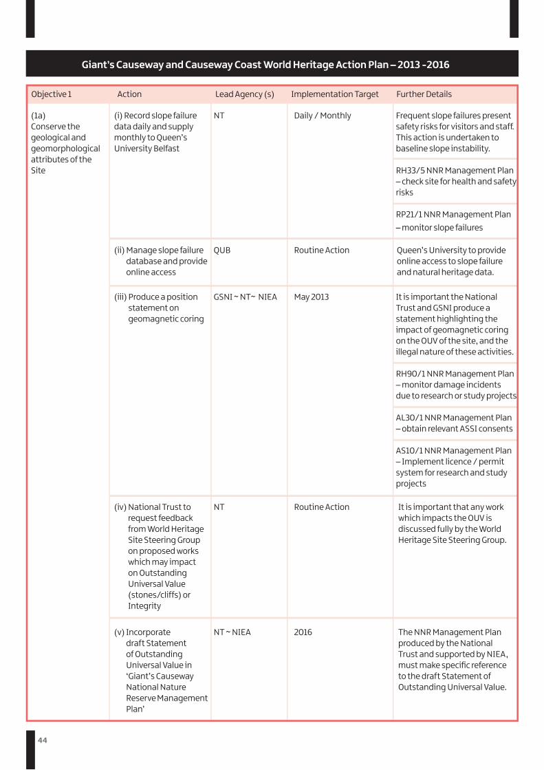
44
Objective 1 Action Lead Agency (s) Implementation Target Further Details
(1a)Conserve the geological and geomorphological attributes of the Site
(i) Record slope failure data daily and supply monthly to Queen’s University Belfast
(ii) Manage slope failure database and provide online access
(iii) Produce a position statement on geomagnetic coring
(iv) National Trust to request feedback from World Heritage Site Steering Group on proposed works which may impact on Outstanding Universal Value (stones/cliffs) or Integrity
(v) Incorporate draft Statement of Outstanding Universal Value in ‘Giant’s Causeway National Nature Reserve Management Plan’
NT
QUB
GSNI ~ NT~ NIEA
NT
NT ~ NIEA
Daily / Monthly
Routine Action
May 2013
Routine Action
2016
It is important that any work which impacts the OUV is discussed fully by the World Heritage Site Steering Group.
The NNR Management Plan produced by the National Trust and supported by NIEA, must make specific reference to the draft Statement of Outstanding Universal Value.
Frequent slope failures present safety risks for visitors and staff. This action is undertaken to baseline slope instability.
RH33/5 NNR Management Plan – check site for health and safety risks
RP21/1 NNR Management Plan – monitor slope failures
Queen’s University to provide online access to slope failure and natural heritage data.
It is important the National Trust and GSNI produce a statement highlighting the impact of geomagnetic coring on the OUV of the site, and the illegal nature of these activities.
RH90/1 NNR Management Plan – monitor damage incidents due to research or study projects
AL30/1 NNR Management Plan – obtain relevant ASSI consents
AS10/1 NNR Management Plan – Implement licence / permit system for research and study projects
Giant’s Causeway and Causeway Coast World Heritage Action Plan – 2013 -2016
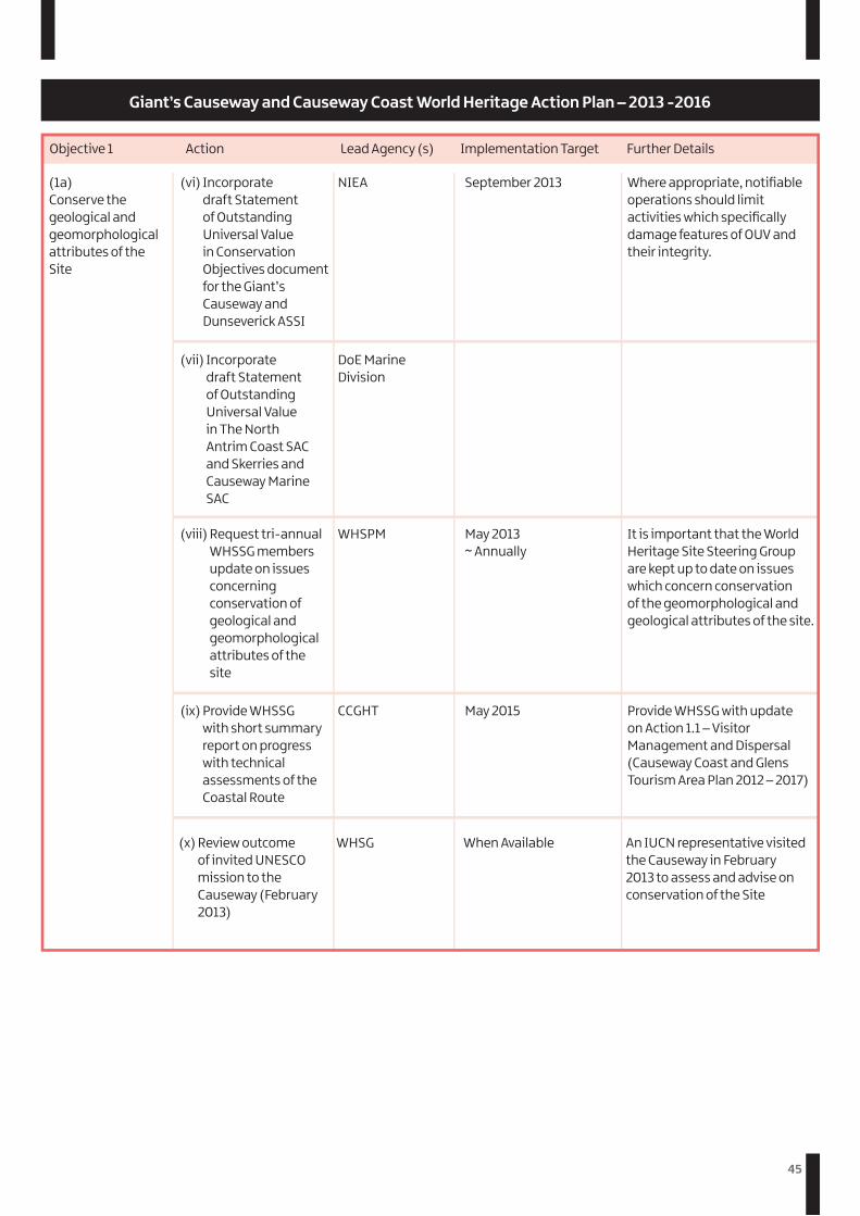
45
Objective 1 Action Lead Agency (s) Implementation Target Further Details
(1a)Conserve the geological and geomorphological attributes of the Site
(vi) Incorporate draft Statement of Outstanding Universal Value in Conservation Objectives document for the Giant’s Causeway and Dunseverick ASSI
(viii) Request tri-annual WHSSG members update on issues concerning conservation of geological and geomorphological attributes of the site
(ix) Provide WHSSG with short summary report on progress with technical assessments of the Coastal Route
(vii) Incorporate draft Statement of Outstanding Universal Value in The North Antrim Coast SAC and Skerries and Causeway Marine SAC
NIEA
WHSPM
CCGHT
DoE Marine Division
September 2013
May 2013 ~ Annually
May 2015
Where appropriate, notifiable operations should limit activities which specifically damage features of OUV and their integrity.
It is important that the World Heritage Site Steering Group are kept up to date on issues which concern conservation of the geomorphological and geological attributes of the site.
(x) Review outcome of invited UNESCO mission to the Causeway (February 2013)
WHSG When Available An IUCN representative visited the Causeway in February 2013 to assess and advise on conservation of the Site
Provide WHSSG with update on Action 1.1 – Visitor Management and Dispersal (Causeway Coast and Glens Tourism Area Plan 2012 – 2017)
Giant’s Causeway and Causeway Coast World Heritage Action Plan – 2013 -2016

46
Objective 1 Action Lead Agency (s) Implementation Target Further Details
(1b)Maintain an appropriate setting and ‘sense of place’ for the Site
(i) Review the new Regional Seascape Character Assessment for the Site and its setting and take account of this information in assessing the seascape character impact of proposed developments in the area
(ii) National trust to produce written update for WHSSG on opportunities to promote sensitive farming within the World Heritage Site and its setting
(iii) Provide annual short summary report to World Heritage Steering Group on planning applications within the World Heritage Setting
(iv) Establish mechanism to direct potential marine developers to information relating to the Outstanding Universal Value, Integrity and Setting of the World Heritage Site
(v) Ensure Councillors and staff are fully aware of the World Heritage Site Management and Action Plans through annual meeting with World Heritage Site Officer
NT ~ Crown Estate
NT ~ DARD ~ NIEA
Planning NI ~ WHSPM
Crown Estate
WHSPM ~ LGA ~ GSNI
September 2013 ~ Routine Action
September 2013
May 2013 ~ Annually
January 2014
September 2013 ~ Annually
The National Trust and Crown Estate represent the two major landowners within the World Heritage Site. There is a need to assess the impact of the NI Seascape Character Assessment on the World Heritage Site and its setting.
Northern Ireland Countryside Management Scheme is going to be replaced during 2013. As the major landowner and property manager National Trust should provide a written update for the WHSSG on opportunities to promote sensitive farming within the World Heritage Site.
As the body responsible for assessing planning applications and granting permission, Planning NI should provide an annual written update on planning applications outlining the number and nature.
Crown Estate is keen to work with developers, particularly renewable energy companies, to explore renewable energy schemes. Mechanisms should be in place to refer potential developers to information regarding adverse impact to the OUV and integrity of the site.
Although many councillors and council staff are aware of World Heritage Status, there is a need to promote and support the Management and Action Plans.
Giant’s Causeway and Causeway Coast World Heritage Action Plan – 2013 -2016
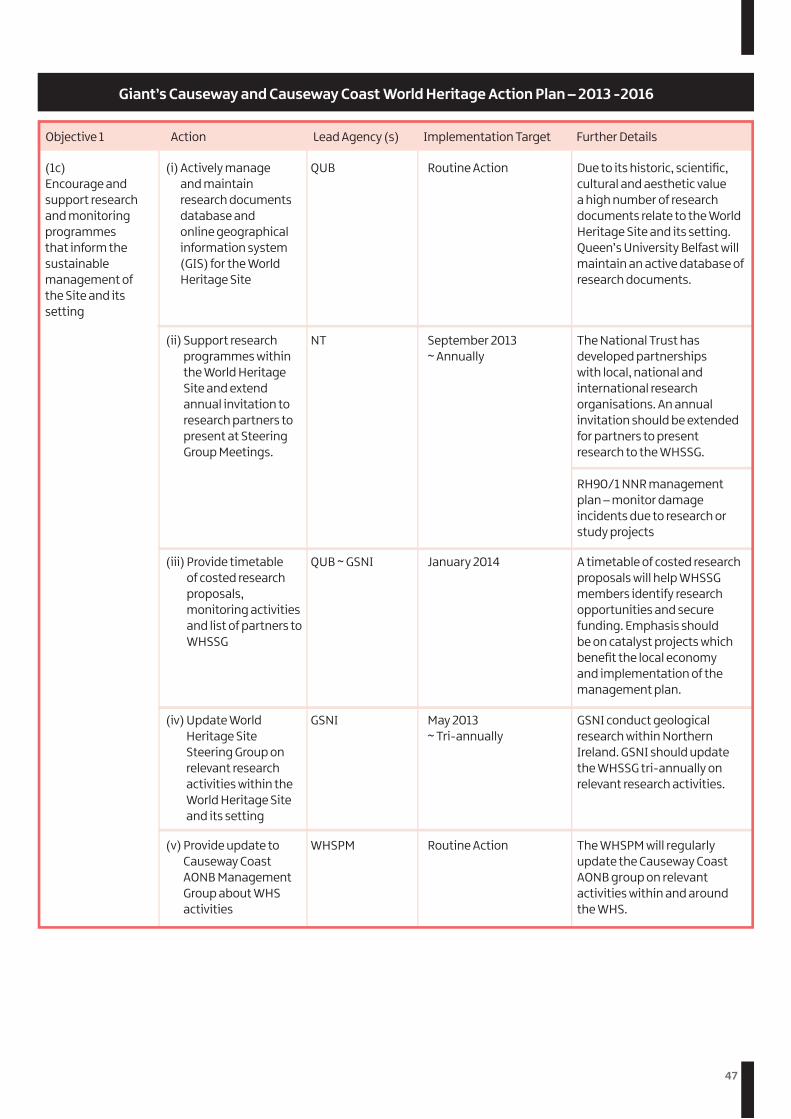
47
Objective 1 Action Lead Agency (s) Implementation Target Further Details
(1c)Encourage and support research and monitoring programmes that inform the sustainable management of the Site and its setting
(i) Actively manage and maintain research documents database and online geographical information system (GIS) for the World Heritage Site
(ii) Support research programmes within the World Heritage Site and extend annual invitation to research partners to present at Steering Group Meetings.
(iii) Provide timetable of costed research proposals, monitoring activities and list of partners to WHSSG
(iv) Update World Heritage Site Steering Group on relevant research activities within the World Heritage Site and its setting
(v) Provide update to Causeway Coast AONB Management Group about WHS activities
QUB
NT
QUB ~ GSNI
GSNI
WHSPM
Routine Action
September 2013 ~ Annually
January 2014
May 2013 ~ Tri-annually
Routine Action
Due to its historic, scientific, cultural and aesthetic value a high number of research documents relate to the World Heritage Site and its setting. Queen’s University Belfast will maintain an active database of research documents.
The National Trust has developed partnerships with local, national and international research organisations. An annual invitation should be extended for partners to present research to the WHSSG.
RH90/1 NNR management plan – monitor damage incidents due to research or study projects
A timetable of costed research proposals will help WHSSG members identify research opportunities and secure funding. Emphasis should be on catalyst projects which benefit the local economy and implementation of the management plan.
GSNI conduct geological research within Northern Ireland. GSNI should update the WHSSG tri-annually on relevant research activities.
The WHSPM will regularly update the Causeway Coast AONB group on relevant activities within and around the WHS.
Giant’s Causeway and Causeway Coast World Heritage Action Plan – 2013 -2016
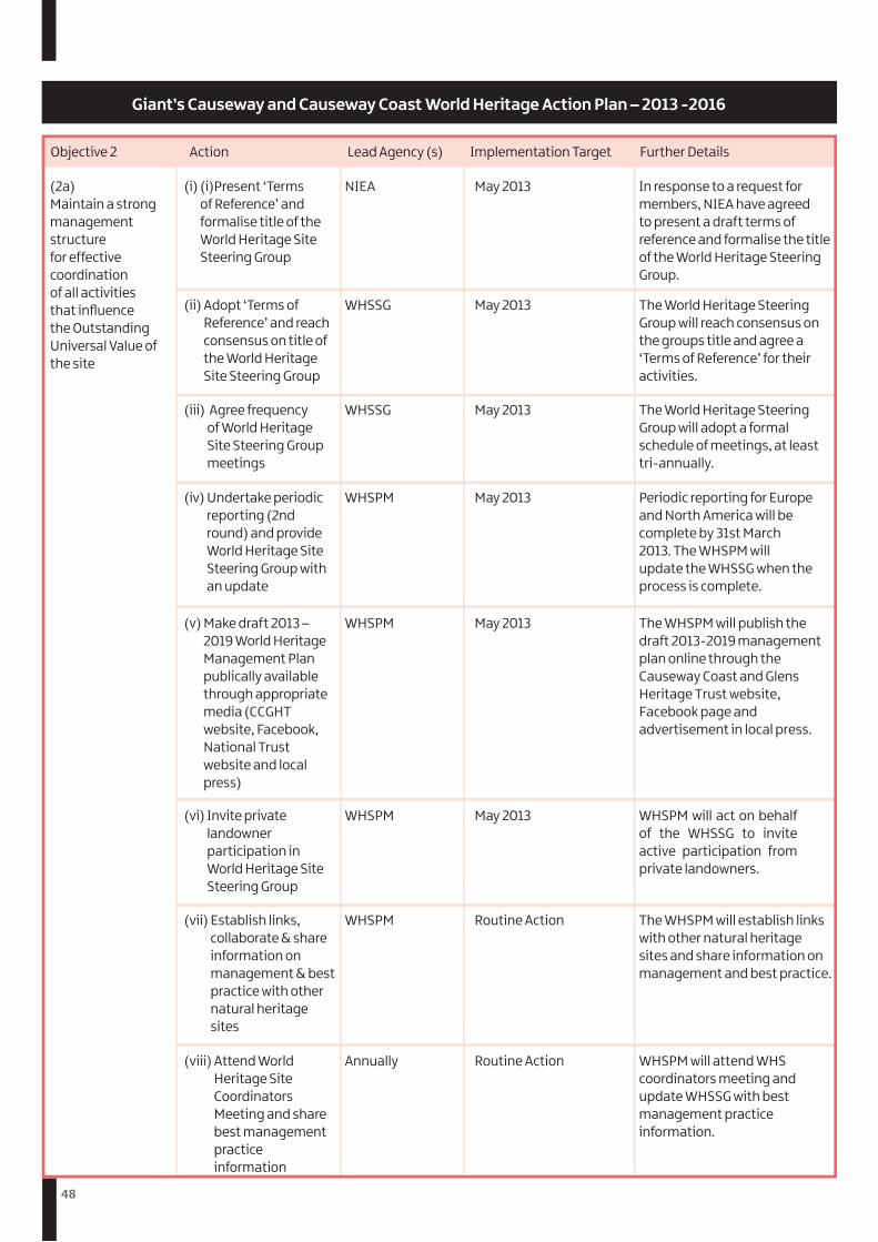
48
Objective 2 Action Lead Agency (s) Implementation Target Further Details
(2a)Maintain a strong management structure for effective coordination of all activities that influence the Outstanding Universal Value of the site
(i) (i)Present ‘Terms of Reference’ and formalise title of the World Heritage Site Steering Group
(ii) Adopt ‘Terms of Reference’ and reach consensus on title of the World Heritage Site Steering Group
(iii) Agree frequency of World Heritage Site Steering Group meetings
(iv) Undertake periodic reporting (2nd round) and provide World Heritage Site Steering Group with an update
(v) Make draft 2013 – 2019 World Heritage Management Plan publically available through appropriate media (CCGHT website, Facebook, National Trust website and local press)
(vi) Invite private landowner participation in World Heritage Site Steering Group
(vii) Establish links, collaborate & share information on management & best practice with other natural heritage sites
(viii) Attend World Heritage Site Coordinators Meeting and share best management practice information
NIEA
WHSSG
WHSSG
WHSPM
WHSPM
WHSPM
WHSPM
Annually
May 2013
May 2013
May 2013
May 2013
May 2013
May 2013
Routine Action
Routine Action
In response to a request for members, NIEA have agreed to present a draft terms of reference and formalise the title of the World Heritage Steering Group.
The World Heritage Steering Group will reach consensus on the groups title and agree a ‘Terms of Reference’ for their activities.
The World Heritage Steering Group will adopt a formal schedule of meetings, at least tri-annually.
Periodic reporting for Europe and North America will be complete by 31st March 2013. The WHSPM will update the WHSSG when the process is complete.
The WHSPM will publish the draft 2013-2019 management plan online through the Causeway Coast and Glens Heritage Trust website, Facebook page and advertisement in local press.
WHSPM will act on behalf of the WHSSG to invite active participation from private landowners.
The WHSPM will establish links with other natural heritage sites and share information on management and best practice.
WHSPM will attend WHS coordinators meeting and update WHSSG with best management practice information.
Giant’s Causeway and Causeway Coast World Heritage Action Plan – 2013 -2016
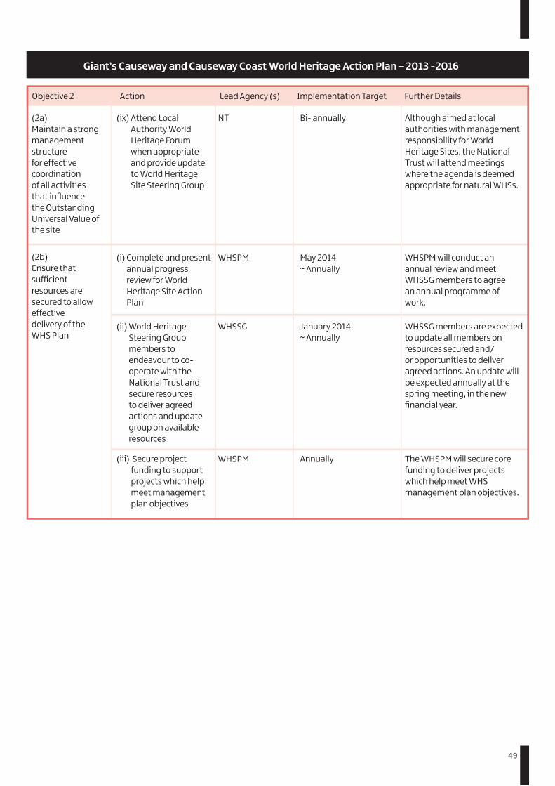
49
Objective 2 Action Lead Agency (s) Implementation Target Further Details
(2a)Maintain a strong management structure for effective coordination of all activities that influence the Outstanding Universal Value of the site
(2b)Ensure that sufficient resources are secured to allow effective delivery of the WHS Plan
(ix) Attend Local Authority World Heritage Forum when appropriate and provide update to World Heritage Site Steering Group
(i) Complete and present annual progress review for World Heritage Site Action Plan
(ii) World Heritage Steering Group members to endeavour to co-operate with the National Trust and secure resources to deliver agreed actions and update group on available resources
(iii) Secure project funding to support projects which help meet management plan objectives
NT
WHSPM
WHSSG
WHSPM
Bi- annually
May 2014 ~ Annually
January 2014 ~ Annually
Annually
Although aimed at local authorities with management responsibility for World Heritage Sites, the National Trust will attend meetings where the agenda is deemed appropriate for natural WHSs.
WHSPM will conduct an annual review and meet WHSSG members to agree an annual programme of work.
WHSSG members are expected to update all members on resources secured and/or opportunities to deliver agreed actions. An update will be expected annually at the spring meeting, in the new financial year.
The WHSPM will secure core funding to deliver projects which help meet WHS management plan objectives.
Giant’s Causeway and Causeway Coast World Heritage Action Plan – 2013 -2016
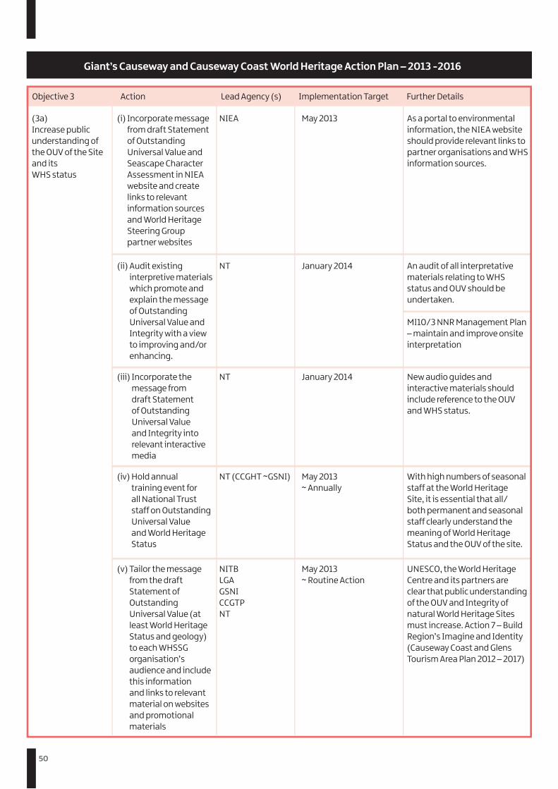
50
Objective 3 Action Lead Agency (s) Implementation Target Further Details
(3a)Increase public understanding of the OUV of the Site and its WHS status
(i) Incorporate message from draft Statement of Outstanding Universal Value and Seascape Character Assessment in NIEA website and create links to relevant information sources and World Heritage Steering Group partner websites
(ii) Audit existing interpretive materials which promote and explain the message of Outstanding Universal Value and Integrity with a view to improving and/or enhancing.
(iii) Incorporate the message from draft Statement of Outstanding Universal Value and Integrity into relevant interactive media
(iv) Hold annual training event for all National Trust staff on Outstanding Universal Value and World Heritage Status
(v) Tailor the message from the draft Statement of Outstanding Universal Value (at least World Heritage Status and geology) to each WHSSG organisation’s audience and include this information and links to relevant material on websites and promotional materials
NIEA
NT
NT
NT (CCGHT ~GSNI)
NITB LGA GSNI CCGTP NT
May 2013
January 2014
January 2014
May 2013 ~ Annually
May 2013 ~ Routine Action
As a portal to environmental information, the NIEA website should provide relevant links to partner organisations and WHS information sources.
An audit of all interpretative materials relating to WHS status and OUV should be undertaken.
MI10/3 NNR Management Plan – maintain and improve onsite interpretation
New audio guides and interactive materials should include reference to the OUV and WHS status.
With high numbers of seasonal staff at the World Heritage Site, it is essential that all/both permanent and seasonal staff clearly understand the meaning of World Heritage Status and the OUV of the site.
UNESCO, the World Heritage Centre and its partners are clear that public understanding of the OUV and Integrity of natural World Heritage Sites must increase. Action 7 – Build Region’s Imagine and Identity (Causeway Coast and Glens Tourism Area Plan 2012 – 2017)
Giant’s Causeway and Causeway Coast World Heritage Action Plan – 2013 -2016
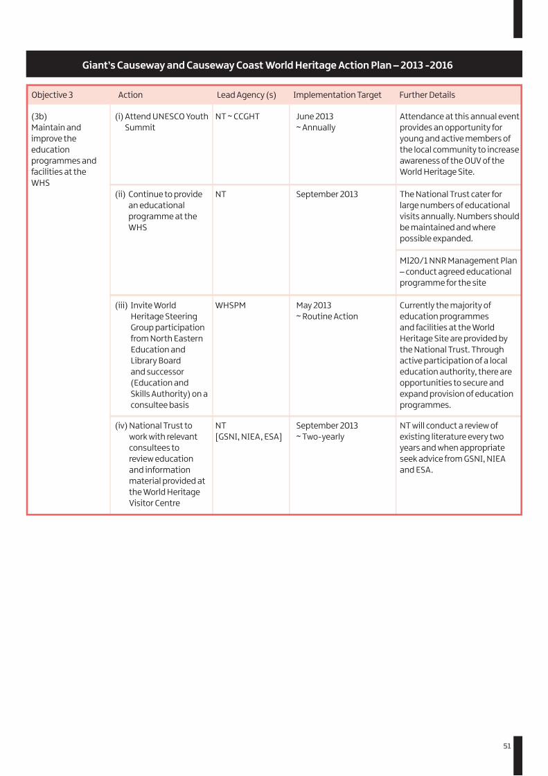
51
Objective 3 Action Lead Agency (s) Implementation Target Further Details
(3b)Maintain and improve the education programmes and facilities at the WHS
(i) Attend UNESCO Youth Summit
(ii) Continue to provide an educational programme at the WHS
(iii) Invite World Heritage Steering Group participation from North Eastern Education and Library Board and successor (Education and Skills Authority) on a consultee basis
(iv) National Trust to work with relevant consultees to review education and information material provided at the World Heritage Visitor Centre
NT ~ CCGHT
NT
WHSPM
NT [GSNI, NIEA, ESA]
June 2013 ~ Annually
September 2013
May 2013 ~ Routine Action
September 2013 ~ Two-yearly
Attendance at this annual event provides an opportunity for young and active members of the local community to increase awareness of the OUV of the World Heritage Site.
The National Trust cater for large numbers of educational visits annually. Numbers should be maintained and where possible expanded.
MI20/1 NNR Management Plan – conduct agreed educational programme for the site
Currently the majority of education programmes and facilities at the World Heritage Site are provided by the National Trust. Through active participation of a local education authority, there are opportunities to secure and expand provision of education programmes.
NT will conduct a review of existing literature every two years and when appropriate seek advice from GSNI, NIEA and ESA.
Giant’s Causeway and Causeway Coast World Heritage Action Plan – 2013 -2016
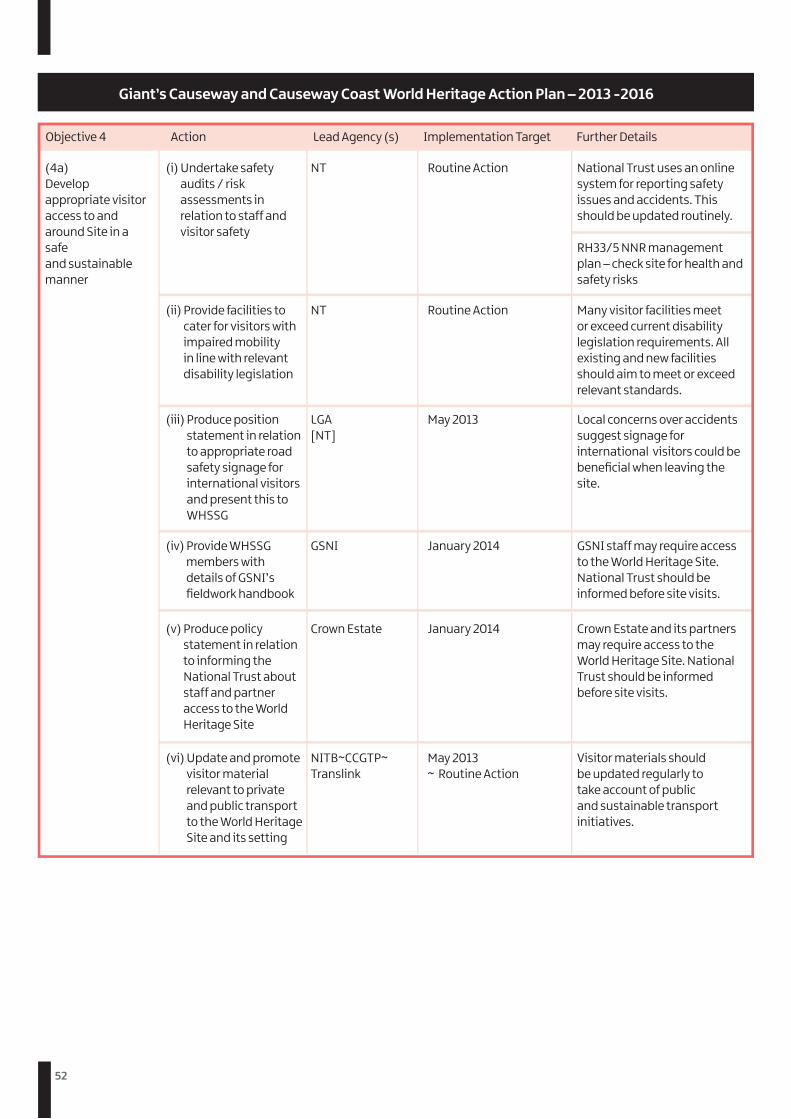
52
Objective 4 Action Lead Agency (s) Implementation Target Further Details
(4a)Develop appropriate visitor access to and around Site in a safe and sustainable manner
(i) Undertake safety audits / risk assessments in relation to staff and visitor safety
(ii) Provide facilities to cater for visitors with impaired mobility in line with relevant disability legislation
(iii) Produce position statement in relation to appropriate road safety signage for international visitors and present this to WHSSG
(iv) Provide WHSSG members with details of GSNI’s fieldwork handbook
(v) Produce policy statement in relation to informing the National Trust about staff and partner access to the World Heritage Site
(vi) Update and promote visitor material relevant to private and public transport to the World Heritage Site and its setting
NT
NT
LGA [NT]
GSNI
Crown Estate
NITB~CCGTP~ Translink
Routine Action
Routine Action
May 2013
January 2014
January 2014
May 2013 ~ Routine Action
National Trust uses an online system for reporting safety issues and accidents. This should be updated routinely.
RH33/5 NNR management plan – check site for health and safety risks
Many visitor facilities meet or exceed current disability legislation requirements. All existing and new facilities should aim to meet or exceed relevant standards.
Local concerns over accidents suggest signage for international visitors could be beneficial when leaving the site.
GSNI staff may require access to the World Heritage Site. National Trust should be informed before site visits.
Crown Estate and its partners may require access to the World Heritage Site. National Trust should be informed before site visits.
Visitor materials should be updated regularly to take account of public and sustainable transport initiatives.
Giant’s Causeway and Causeway Coast World Heritage Action Plan – 2013 -2016
53
Objective 4 Action Lead Agency (s) Implementation Target Further Details
(4b) Encourage visitors to make environmentally sustainable choices when visiting the WHS
(i) Engage with Translink to explore feasibility of providing increased levels of public transport to the site and greater integration of public transport options at key rail/bus/ferry/airport terminals
(ii) Organise a ‘Sustainable Choices’ meeting and invite local businesses to discuss provision of visitor facilities e.g. cycle hire, luggage storage, sanitation for recreational vehicles and coaches etc.
(iii) Provide update on foot and cycle path provision and potential developments to the WHS and its setting
(iv) Promote use of public transport in all promotional and educational materials
NT- CCGTP
WHSPM [NT]
LGA
National Trust GSNI NIEA LGA CCGTP NITB
May 2014 ~ Routine Action
September 2013
January 2015
May 2014 ~ Routine Action
There is a significant need to increase the number of visitors who arrive at the site via sustainable public transport options. National Trust should encourage Translink to lead on these initiatives.
Involving local businesses will help increase the range of visitor facilities both on and off-site. It also increases involvement on the local community in site management.
Various proposals for foot and cycle access have been discussed. Moyle District Council will update the WHSSG on relevant developments.
There are significant opportunities to promote public transport options in promotional materials for the World Heritage Site and its setting.
Causeway Coast and Glens Tourism Area Plan 2012 – 2017 (Improving Access) DRDNI Regional Transport Strategy – Strategic Objective 6 (Improve connections to key tourism sites)
Giant’s Causeway and Causeway Coast World Heritage Action Plan – 2013 -2016
54
Objective 5 Action Implementation Target Further Details
(5a) Involve local communities in the management of the WHS
(i) Complete public consultation exercise for 2013-2019 World Heritage Site Management Plan, including publication on CCGHT and National Trust website and local press release
(ii) Maintain a functional database of community contacts
(iii) Develop coordinated, multi-agency approach to community engagement events
(iv) Public open morning/evening for local community groups will be held twice a year with opportunity to discuss issues with National Trust Management.
(v) Produce report investigating opportunities and options for applying for Geopark status covering the WHS and Causeway Coastal Route
Lead Agency(s)
WHSPM
WHSPM
CCGHT ~ NT
NT ~ GSNI
GSNI~CCGHT
May 2013
Routine Action
Routine Action
October 2013
September 2014
Community consultation events have taken place to support production of the management plan. Before publication, the public will be provided with further opportunities to comment.
The WHSPM maintains a functional database of community contacts on behalf of the WHSSG.
CCGHT and NT will endeavour to secure a coordinated and multi-agency approach to all community engagement events.
The local community have indicated they would welcome an open morning or evening at the World Heritage Site. GSNI are happy to support National Trust with delivery of this.
The local community have indicated they would welcome an open morning or evening at the World Heritage Site. GSNI are happy to support National Trust with delivery of this.
Giant’s Causeway and Causeway Coast World Heritage Action Plan – 2013 -2016
55
Objective 5 Action Lead Agency (s) Implementation Target Further Details
Giant’s Causeway and Causeway Coast World Heritage Action Plan – 2013 -2016
(5b) Support local communities in utilising the WHS as a driver for economic growth
(i) Distribute sustainable tourism toolkit to local businesses through website and post
(ii) Establish annual business and community engagement event at the World Heritage Site including workshops on relevant tourism initiatives, and promotion and sharing of benefits of World Heritage Status.
(iii) Promote events within the setting and settlements surrounding the WHS
CCGHT ~ LGA- CCGTP
CCGHT ~ NT [NITB, CCGTP, GSNI, LGA]
CCGHT ~ CCGTP
May 2014
October 2013 ~ Annually
Routine Action
Community consultation identified that there was an appetite for a raising awareness and a community engagement event. The WHSPM will work with the National Trust to organise an annual event. GSNI are willing to help with the event and promotion of economic benefits of Geotourism
CCGHT and CCGTP will promote local events where possible and relate these back to activities within the WHS.
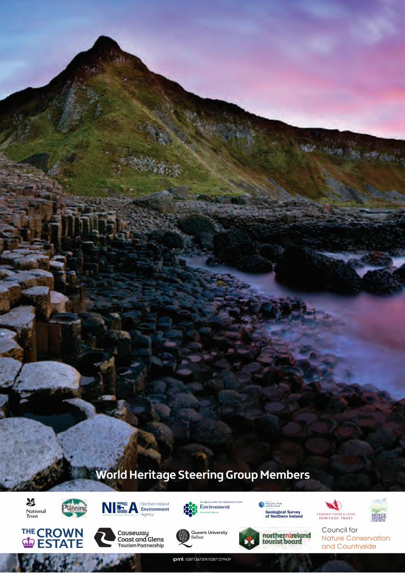
Giant’s Causeway and Causeway Coast World Heritage Site
Management Plan
Northern Ireland’s only World Heritage Site
2013 - 2019
World Heritage Steering Group Members
Council for Nature Conservation and Countryside
02871267509/02871279439