GHD Spatial Sciences · uses Geographic Information System (GIS) technology to acquire, compile,...
13
GHD Spatial Sciences
Transcript of GHD Spatial Sciences · uses Geographic Information System (GIS) technology to acquire, compile,...

GHD Spatial Sciences

GHD Spatial Sciences | 3
Spatial Sciences
2013 Project highlightsOur world is changing. Fast access to high quality geographic data and information is now critical for decision makers in every industry. By combing geographic data with other business information, organisations can see trends and generate meaningful intelligence to streamline internal processes and improve performance.
GHD’s award winning spatial sciences team uses Geographic Information System (GIS) technology to acquire, compile, manipulate, interpret and visualise data to reveal geographic patterns and relationships.
By bringing together large volumes of disparate data, decisions that were once largely based on guess work, become more quantitative and can be powerfully presented using map-based tools.
GHD has a reputation for innovation. We can be involved at all stages of delivery - from planning and project management, through to data acquisition, processing, modelling, reporting, map production and web deployment.

GHD Spatial Sciences | 5
Our services• Spatial data presentation and
cartography
• Constraints analysis and multiple criteria analysis
• Site and corridor selection
• Data capture, processing and management
• Environmental modelling
• Visibility analysis and visual impact assessment
• 3D modelling
• Utility and transport network analysis
• Remote sensing and image analysis
• Project management
• GIS training
• Web GIS and multimedia
• Business analysis and GIS implementation
• Database design and system development
GHD was named "Recommended Spatial Employer of the Year" at the 2012 Asia Pacific Spatial Excellence Awards.

GHD Spatial Sciences | 7
Habitat Mapping of Klamath River Corridor - California, USAGHD was commissioned by the Yurok Tribe to improve habitat mapping of the Tribe’s 64,000 acre Reservation, which is located along the Klamath River in far northern California.
The primary goal was to develop GIS layers that would better enable wildfire risk modeling and to provide an improved basis for habitat conservation planning and forestry practices. GHD utilised a combination of remote sensing, GIS and field sampling activities to produce a customised vegetation model and habitat classification map. This included an analysis of LiDAR in the context of canopy height, regional geologic and soil data, existing vegetation data, and field validation.
An unsupervised spectral classification of 4-band orthoimagery was undertaken to partition the study area into stratified clusters of presumed vegetation categories. Target vegetation classes were then identified via local ecological knowledge, including input from ecologists, timber managers and Tribal members.
The result was a preliminary vegetation class model and base map that was used to conduct stratified field sampling for confirmation and training of the model. With the help of Yurok Tribe members, the ecology team accessed field validation locations to determine the accuracy and precision of the preliminary model and map. Floristic data from fieldwork was fed into a supervised classification analysis that incorporated both spectral and textural correlative cues.
Environment

GHD Spatial Sciences | 9
LiDAR and GIS Capacity Building - Tonga, Vanuatu and Papua New GuineaAs part of the Australian Government’s International Climate Change Adaptation Initiative, the Department of Climate Change and Energy Efficiency (DCCEE) engaged GHD to assist in scoping and defining the technical specifications for the acquisition of high quality topographic and bathymetric data (LiDAR), the development of digital elevation models and other derived products, and the requirements of GIS capacity building programs in Tonga, Papua New Guinea (PNG) and Vanuatu.
This work contributed to a series of activities aiming to provide Tonga, PNG and Vanuatu with the appropriate data, supporting IT infrastructure and skills to enable these countries to develop coastal inundation models that would inform an understanding of climate change risk.
The scoping missions took the form of a needs assessment and included literature reviews, face-to-face interviews, group meetings, selective self-assessments, field reconnaissance and an existing data review.
International development

GHD Spatial Sciences | 11
Tea Tree Gully City Master Plan - South AustraliaTea Tree Gully’s City Master Plan is the physical expression of Council’s vision and objectives for the city during the next 30 years. GHD was commissioned to prepare eight customised maps with associated commentary to reflect the main physical features of the city as envisaged for 2040.
The maps identified opportunities for growth and revitalisation of the City, in addition to illustrating areas of high environmental value and economic activity, urban renewal, cultural interests, community hubs, recreation centres, local and regional connections and open space areas.
“The [map] production has been highly praised by Council, other local Councils and the community. It has proven to be an invaluable tool for us to plan our City and assist with budgets and funding applications.”
Di Rogowski Chief Executive Officer
Municipal planning

GHD Spatial Sciences | 13
Great Eastern Highway Upgrade - Western AustraliaIn an era where project teams are widely distributed between cities or even continents, online mapping provides a mechanism to share and distribute the most up to date geographic information to any desktop, whether it be next door or across the globe. Web mapping is now a core component of integrated information systems and the majority of planning and infrastructure projects rely heavily on geographic data to make effective decisions.
GHD recently developed an integrated web mapping application to support the design and construction of the Great Eastern Highway upgrade in Western Australia.
The application provided a mechanism for geographically diverse project alliance partners and the community to view and query high resolution aerial photography, road designs, neighbourhood infrastructure, environmental constraints and property information in real-time via a web browser, with no end-user requirement for expensive or specialist GIS software.
The ability to make distributed geographic information available to a large audience in varied locations via a web browser reduced data management costs, provided more reliable version control, enabled better transparency and consistency of information and supported simultaneous data renewal.
Transportation

GHD Spatial Sciences | 15
Traffic Hazard Study - GuamThe territory of Guam’s occurrence of traffic accidents is higher than the national average resulting in property damage, injury and loss of life. Our team was commissioned to conduct an analysis of four years’ worth of traffic accidents throughout the island. A highly interactive, easily updatable GIS geodatabase was developed to identify the island’s most dangerous intersections for targeted safety modifications.
The system required working with the Guam Police Department to a review 5000 paper-based traffic accident reports. The team then extracted key information into a
database and mapped the location of each accident. The extracted data and mapped locations were linked and an analysis was undertaken to consider the type of accident, severity of accident, time of day, day of week, age of driver and weather conditions. The statistical frequency of accidents was also considered. The results were used to identify and further examine the most dangerous intersections on the island, with a series of recommendations made for techniques to increase the operational efficiency of the transportation system and to reduce the factors that were leading to traffic accidents.
GHD Spatial Sciences | 17
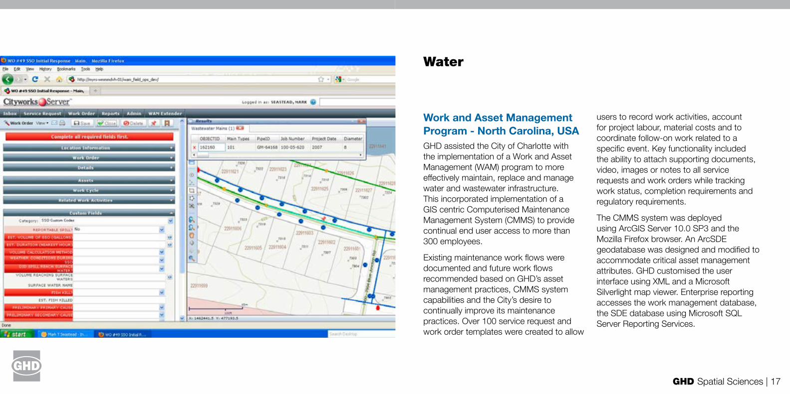
Work and Asset Management Program - North Carolina, USAGHD assisted the City of Charlotte with the implementation of a Work and Asset Management (WAM) program to more effectively maintain, replace and manage water and wastewater infrastructure. This incorporated implementation of a GIS centric Computerised Maintenance Management System (CMMS) to provide continual end user access to more than 300 employees.
Existing maintenance work flows were documented and future work flows recommended based on GHD’s asset management practices, CMMS system capabilities and the City’s desire to continually improve its maintenance practices. Over 100 service request and work order templates were created to allow
users to record work activities, account for project labour, material costs and to coordinate follow-on work related to a specific event. Key functionality included the ability to attach supporting documents, video, images or notes to all service requests and work orders while tracking work status, completion requirements and regulatory requirements.
The CMMS system was deployed using ArcGIS Server 10.0 SP3 and the Mozilla Firefox browser. An ArcSDE geodatabase was designed and modified to accommodate critical asset management attributes. GHD customised the user interface using XML and a Microsoft Silverlight map viewer. Enterprise reporting accesses the work management database, the SDE database using Microsoft SQL Server Reporting Services.
Water

GHD Spatial Sciences | 19
Alternative Water Atlas - Melbourne, VictoriaGHD was commissioned by Victoria’s Smart Water Fund to explore, cost and quantify the opportunities for alternative water sources across Melbourne, taking into account the spatial variability inherent in these opportunities.
The project analysed four alternative water sources – centralised wastewater recycling, de-centralised wastewater recycling (sewer mining and blackwater treatment plants), stormwater harvesting and rainwater harvesting. The project considered the water demands that these different sources could supply across the Melbourne region, by quantifying and mapping the locations of substitutable demands up to the year 2060.
Spatial analysis identified potential opportunities for each alternative water source, and a water supply–demand balance was undertaken to quantify the yield of the alternative water opportunities. The costs were then calculated and assessed via a Rapid Assessment Method (RAM), developed specifically for this project. The RAM was developed through a stakeholder workshop and incorporated a number of factors, which were indicators of the environmental and social costs and benefits of each option. A key element involved the mapping of sensitive environmental receptors that alternative water use could impact, enabling assessment of the spatial variation of environmental costs and benefits of different options.
This project won the Innovation Category in the 2012 Victorian Spatial Excellence Awards.
GHD Spatial Sciences | 21
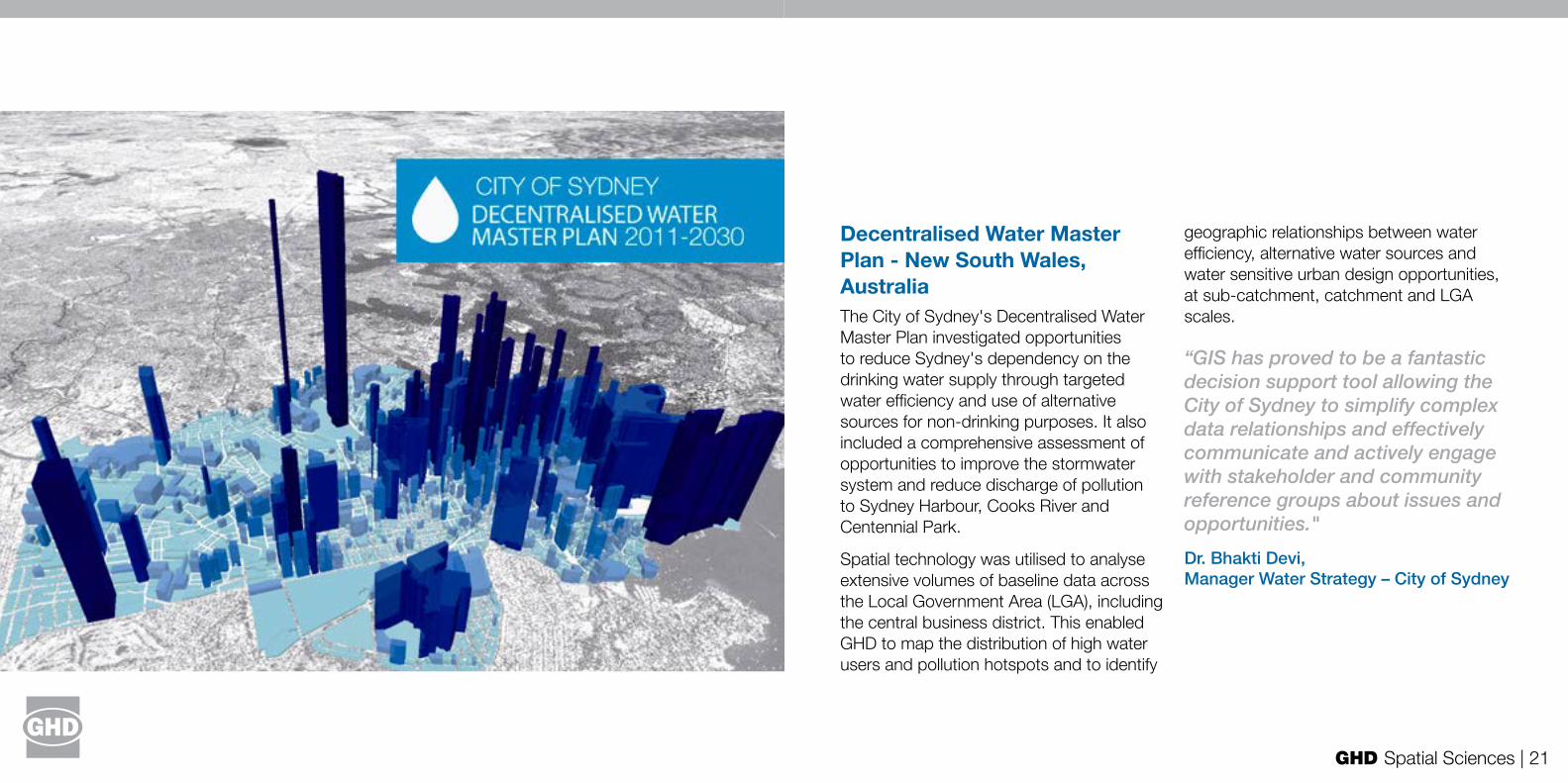
Decentralised Water Master Plan - New South Wales, AustraliaThe City of Sydney's Decentralised Water Master Plan investigated opportunities to reduce Sydney's dependency on the drinking water supply through targeted water efficiency and use of alternative sources for non-drinking purposes. It also included a comprehensive assessment of opportunities to improve the stormwater system and reduce discharge of pollution to Sydney Harbour, Cooks River and Centennial Park.
Spatial technology was utilised to analyse extensive volumes of baseline data across the Local Government Area (LGA), including the central business district. This enabled GHD to map the distribution of high water users and pollution hotspots and to identify
geographic relationships between water efficiency, alternative water sources and water sensitive urban design opportunities, at sub-catchment, catchment and LGA scales.
“GIS has proved to be a fantastic decision support tool allowing the City of Sydney to simplify complex data relationships and effectively communicate and actively engage with stakeholder and community reference groups about issues and opportunities."
Dr. Bhakti Devi, Manager Water Strategy – City of Sydney

GHD Spatial Sciences | 23
Critical Water Pipe Analysis - Ontario, CanadaWith the demand for water resources increasing in communities with an aging infrastructure, it is becoming increasingly important for cities to be proactive in developing approaches for preventative maintenance. The Town of Markham is one local authority developing strategies to reduce the frequency of water main breaks and subsequent community impacts.
GHD was engaged to collaborate with the Town of Markham’s Waterworks Department to establish a framework and spatial tool to undertake a semi-automated risk assessment and to identify critical water pipes in high risk environments. Our services included:
• Integration of service level objectives for distribution water main pipe preventative maintenance strategies
• Establish a framework for defining ‘critical’ water mains and risk environments
• Assessing hydraulic critical pipe locations and their spatial relationship to high impact locations (e.g. hospitals, major road intersections, railway crossings, water crossings, environmentally sensitive areas, high density populations) or other high risk geographic settings
• Developing a geo-processing model to be used as a planning tool to facilitate future distribution water pipe assessments and to optimise preventative maintenance prioritisation processes
• Calculating risk scores based on a combination of the probability of a threat occurring, pipe vulnerability, system resilience and potential impacts
Drainage Pipe Network Management - Harbin, China
GHD's water team was commissioned by Harbin Drains Water Limited to develop a GIS based process to support improvements to the efficiencies of the city’s drainage system, to streamline management processes and to collect and store the most current and accurate data for drainage services.
The system developed by GHD integrated remote sensing, GIS, wireless networking and multimedia technologies and allowed real-time monitoring and analysis of the pipe network. The system enabled 3D visualisation of the drainage network and the generation of statistical reports and graphs.

GHD Spatial Sciences | 25
For more information, please contact:
http://www.ghd.com/spatial-sciences