2f Sulphur and Nitrogen. Allotropes of sulphur Sulphur molecule consists of 8 atoms in a ring form.
• ~!Q The United Nations ~ University
GEOTHERMAL TRAINING PROGRAMME Orkustofnun, Grensasvegur 9, IS-,08 Reykjavik, Iceland
Reports'997 Number 9
PRELIMINARY ENVIRONMENTAL ASSESSMENT FOR DRILLING IN THE KRiSUVIK-TROLLADYNGJA AREA, SW-ICELAND
Benjamin Mwakichako Kubo Kenya Power Company Ltd, Olkaria Geothermal Project,
P.D. Box 785, Naivasha, KENYA
ABSTRACT
The Krisuvik-Tr51ladyngja high-temperature area is located on the Reykjanes Peninsula, SW-Iceland. This area has been investigated for geothennal resources by various researchers in the past due to the interest in using geothermal steam. This report presents a preliminary environmental impact assessment for drilling in the Krisuvik-Tr6lladyngja geothermai fields. A preliminary review is carried out of the environmental components and the proposed project in order to decide whether to carry out an environmental impact assessment (EIA) and what key impacts, issues and alternatives to consider. In this study, an attempt has been made to identify the likely impact of drilling and potential mitigating measures. A checklist was used for impact identification, while for impact prediction a matrix was utilized. The results of this study suggest that detailed studies be carried out on water supply for drilling, on how to get rid of effluent water, on the monitoring of gas emissions to the atmosphere and on steam flow and gas concentrations in steam.
1. INTRODUCTION
The Krisuvik-Trolladyngja high-temperature area is located on the Reykjanes Peninsula, SW-Iceland (Figure 1) and was first explored before 1950 (Am6rsson et al., 1975). It covers a large area and can be divided into several fields such as Krisuvik, TroIladyngja, and Sandfell. In this study only the Krisuvik (also wrinen Krysuvik) and Trolladyogja fields are considered. This area has been investigated for geothermal resources by various researchers in the past due to the interest in using geothennal steam. Armannsson et al. (1994) described the state of exploration of these two fields and recommended what needed to be done in order to confirm the presence of an exploitable resource.
Scientific investigations carried out by Orkustofnun scieptists and UNU Fellows in this area include geology (J6nsson, 1978; Kifua, 1986; Vargas, 1992), geophysics, geochemistry and reservoir assessment (Am6rsson et al.,1975; Am6rsson, 1987; Orkustofnun and Vatnaskil Consulting Engineers, 1986). The area has high precipitation (1500-2000 mm) and all water percolates into the bedrock through faults, open fissures and fractures as well as through porous lava nows. Drilling started between 1940 and 1950
221

Kubo 222 Report 9
" !
• Hot spring or fumarole
• Alteration or thermal activity
" _.,...CN"""~'- ' _ Geothermal fields
and 15-20 shallow wells had been drilled in the Krisuvik area before 1950 as a part of an exploration programme that was undertaken by Hafnarfjordur Electrical Services to investigate its potential for the generation of electricity.
In 1970-1973 another exploration effort funded by the
FIGURE 1: The Krisuvik-Trolladyngja geothermal area ( modified from Stefansson et ai., 1982)
Icelandic Energy Fund involved the drilling of six slim exploration wells 816-943 m deep, to obtain information on geology and temperature. Of the six drilled wells, five displayed a thermal reversal or inverse gradient (Figure 2). Well KR-09 is the
~oo .... '-<"', ....•.........
400 • •• •••••••••
000 -- -- --------- ------ -- ------
~ ~ KR-oe 18-04 - 1972 -KR- 07 07- oe - 1972 - KR - 02 ~6 -03-1ge5 - KR - OI 26 - 03- 1005
~ KEI. - 09 26-07- !99 ~
FIGURE 2: Temperature logs of deep wells in the Krisuvik area (Armannsson
and Th6rhallsson, 1996)
most recent In
Krisuvik, drilled in 1995. In comparison with the old profiles for wells KR-O 1 and KR-02, there seems to be no cooling in the area.
The purpose of this project is to carry out a preliminary environmental impact assessment (EIA) for drilling in the Krfsuvfk-Trolladyngja geothermal fields. A preliminary review is carried out covering the environmental factors pertaining to the proposed project in order to decide whether to carry out an EIA (screening) and what key impacts, issues and alternatives to consider (scoping) (Morris and Therivel, 1995). The emphasis will be on scoping, to find the probable impact of drilling and to suggest potential mitigating measures. The methodology involved is a checklist for impact identification which will serve as a guide to the potential impact of drilling, in the two fields (Appendix I). A matrix will be utilized for impact prediction.

Report 9 223 Kubo
2. GENERAL INFORMATION ON THE KRiSUviK-TROLLADYNGJA FIELDS
In a report by Checchi and Company and the Architect Collaborative Inc. (1975) the following is stated: wIt can almost be said of Krisuvik that it is Iceland in miniature because almost all the geophysical and nature uniqueness that makes Ice land a fascinating vacation spot is to be found right in this one place.· The active steam vents, steaming grounds, birds in the cl iffs , Lake Kleifarvatn, Lake Graenavatn and the compromising cl imate make Krisuvik very attractive to tourists. It is a rather remote area with few signs of modern farming or manufacturing industries. A road which was heavily disputed because of high cost was constructed along the bank of Lake Kleifarvatn in 1940. The area is protected to a certain extent, being a part of the official Reykjanes country park. Several recreation possibilities have been proposed but up to now fishing in Lake Kleifarvatn, viewing geothermal manifestations in Seltun and the birds of Krisuvfk cliffs have drawn most tourists. The Krisuvfk Organization which is a rehabilitation centre for young drug addicts and alcoholics, is located in Krisuvik.
The Krisuvik land is shown in Figure 3. The total land is shown as the larger strip in the figure. The ownership of the smaller patch of land shown was transfe rred from the state to Hafnarfjordur townsh ip in 1941. Furthermore, all rights to geothermal utilization outside the transferred land were sold to Hafnarfjordur township at the same time with the proviso that the state had the right to re-purchase the rights should they be needed for mining or related activity and that the Hafnarfjordur township was making use of what it needed. In 1973 Hitaveita Reykjav ikur (The Reykjavik Municipal Heating Services) was afforded the right of exploration and utilization for space heating of houses with a special agreement that no other use wou ld be made of the resource unless adequate resources were left intact for space heating .
.. ~ 's ,.; • ' ,' ;
/ : :., ' .. ~, ;,.; &.1 ,' ; ..
,,"
" .. ~ "
, . ..;, t \ ...
FIGURE 3: Map showing the Krisuvik land and its boundaries (Stefansson et al., 1982)
-..

Kubo
FIGURE 4: The proposed steam pipeline from Krisuvik to Straumsvik
(Armannsson et al., 1994)
224 Report 9
The temperature of the fields is probably 230-260°C and the fluid appears to be dilute and easily exploited. In spite of relatively intense exploration over the last 50 years, knowledge of the area is scarcer than would be expected. In the past, ideas of creating a tourist paradise in Krisuvik have been put forward. Ami 61a (1944) proposed a health resort with sulphur steam baths and hot spring clay baths besides space heating and manufacturing. Checchi and Company and the Architect Collaborative Inc. (1975) proposed a multi resort and an Icelandic geosciences research centre in Krisuvik. The most promising use of the geothermal heat is probably a future space heating plant for the capital area. In the past the lack of a good source of fresh groundwater for heat exchangers was considered a great drawback, but now a closed circuit distribution system recycling the fresh ground water could be designed and the demand for fresh groundwater supplies would not be so great. Another possible use is for industry in Straumsvik on the north coast of the Reykjanes Peninsula, which would involve building a steam pipeline (Armannsson et al., 1994) (Figure 4). Such exploitation would need to be on a large scale because of the distance to Straumsvik, the pressure drop in the pipe and high costs. A small local plant serving tourism and greenhouses is yet another possibility. Least attractive perhaps is power production on a large scale, especially as space heating possibilities for the capital area need to be given priority. It would take 5-8 years to start large scale exploitation and the exact rights to ownership and utilization have to be established before this is possible. The area needs to be explored before a decision can be made. The Krisuvik organization utilizes a well drilled in 1995 and a diesel turbine for power production. It is desirable that a small steam turbine be installed. The present well could produce I MWe, and wells for further small production could be drilled without much additional exploration. There is no river draining Lake Kleifarvatn. Therefore, water level variations are great. The lake serves as a precipitation gauge showing long term changes in the piezometric surface. There is some fishing in Lake Kleifarvatn, and the profits from egg collection in the cliffs are used to support a local rescue squad. Hot spring clay has been mined and used for clay baths. The winter garden idea is probably out of date; untouched nature is more attractive to the modem tourist.
3. mSTORICAL OVERVIEW (prepared by Armannsson and Thorhallsson, 1996)
A recent report by Annannsson and Th6rhallsson (1996) gives an historical overview of the exploration and exploitation of the Krfsuvik area. The following is based on this report and most of the original references can be found there.
During the earlier centuries sulphur used to be mined for the Danish kings.
Report 9 225 Kubo
1857 British mining companies obtained mining rights, including those for "The Krisuvik sulphur company" (1869-1879). Gennans also held the rights for some time.
1882 Sulphur mines used up and sulphur mining discontinued. The mines were taken over by "The Borax Company" which intended to mine borax as was done in Italian geothermal areas. But Icelandic geothennal areas are different and no borax was found so this activity was discontinued in 1884.
1940 1941
Road constructed on the bank of Lake Kleifarvatn . Hafnarfjordur township acquired part of the Krisuvik land and the Lake Kleifarvatn fishing rights, acquisitioned by the government in 1936 and 1940 on behalf of the township. The borders of the land are unclear and hotly disputed.
1944 Ideas on large scale exploitation presented (Ola, 1944). 1945-1950 Hafnarfjordur township had 19 wells drilled using own rig to prepare for power
production. Project was abandoned but well KV- 14 still spews steam over tourists. 1951 "Plan for power production in Krysuvik" published. 1952 Proposed law for the exploitation of geothennal steam in Krisuvik presented to parliament. A
5.5 MW station which could be increased to 11 MW used for greenhouses and space heating was proposed but the proposal was not passed.
1959 "Report on the possibility of production of salt in Iceland" was published. The Krisuvik area potential was deemed "insufficiently economic".
1960 Two wells of 1200 m depth and one shallow well drilled by the government. Infonnation on temperature and geological sections obtained but the wells collapsed upon initiation of flow. Well KR-2 still breathes out a little steam which is used to heat a kiosk in the parking area.
1964 A well was drilled at a small distance from Krisuvik fann, used for space heating of houses and livestock facilities, and greenhouses. However farming and greenhouses did not prove successful in Krisuvik.
1964-1965 Exploration for a possible space heating plant for the Hafnarfjordur township was carried out.
1971 Four slim exploration wells drilled to about 800 m depth . Aquifers cemented to obtain drill cuttings. Information on temperature and geological cuttings obtained for all the wells but none on flow and enthalpy (Arn6rsson et aI., 1975).
1973 Contract between Hafnarfjordur and Reykjavik signed. Reykjavik district heating planned to build a pipeline from one of their areas and to supply Hafnarfjordur with space heating and acquired rights to exploitation for space heating in Krisuvik instead.
1974 "Draft pre-feasibility study on the production of alumina in Iceland" published. The proposed plant was to utilize geothermal steam from the Krisuvik area and supply the aluminium smelter at Straumsvik with sufficient raw material for its production. The plan was abandoned for many reasons, one being environmental considerations regarding the dumping of red clay.
1975 The Krisuvik land became a part of the Reykjanes country park. Utilization of geothermal steam exempt from limitations. In 1975 Checchi and Co. and the Architects Collaborative Inc. (1975) recommended Krisuvik as the best area in Iceland for a "winter garden".
1981 The report "On geothennal heat for fish meal factories" recommended Krisuvik as an economic area for such production.
1983 Orkustofnun published "Economic estimate for the building of a steam pipeline from Straumsvik to 'frolladyngja". In the same year Orkustofnun prepared to drill an exploratory well III
Trolladyngja but the project was abandoned due to lack of funds. 1984 Krisuvik recommended as a site for "geothermal fishmeal and fish oil factory". 1986 The report "Vatnsleysa-Trolladyngja. Freshwater and geothermal investigation" (Orkustofnun
and Vatnaskil Consulting Engineers, 1986) published. 1991 The report on "Vegetation changes in the Krisuvik land 1945-1990" (Gislad6ttir, 1991) was
presented. 1994 The report "Krisuvik-Trolladyngja. Potential steam production and transmission." (Armannsson

Kubo 226 Report 9
et aI., 1994) was published. 1994-1995 Hot spring clay from Krisuvik used for clay baths at the Laugardalur swimming pool,
Reykjavik. 1995 Idea for ethanol production using lupin as raw material and geothennal steam from Krisuvik as
an energy source presented. In the same year a shallow well was drilled for the Krisuvik Organization for space heating. It produces 5 kgls of dry steam.
4. WEATHER CONDITIONS
On the Reykjanes Peninsula there are two meteorological stations, at the Reykjanes lighthouse and Keflavik airport, respectively. Precipitation is measured in Grindavik, Straumsvik and Svartsengi. The frequency of wind direction at Keflavik airport from 1981 to 1995 is presented in Figure 5 while in
."
" ~~: ~ .• ••
. " .• .• •• • •
.• • • - ~ry StI and et.ngMbIfIUlIo -March M and cl. gl bit 1.6% - FebrWry SIll and ch&ngeabIe 2.5'4 - Apt SdI and c:hfr988bIe 2.9 - - ~ December StII and c/"angMbIe 1.5'4 - - - May S1I and dItngeab'e u%
" ." "
• " •
~: ~ .• ~: ~ .• .. , .. ,
•• .• ••
.• • • - J .... $1. and el"langeflble 4.6'!I. - JIiy Stl and changeablfl2.8'JIo
-Septernb.. StII and ehatlgeable 4.3% - 0Ict0ber StII,nd changeablfl2.8'JIo OS 97.10.0234 BeKu
- - August Stl and changeable 4.5% -- - Oeeember StiI and ehangooble 2.4'4
FIGURE 5: Frequency of wind directions on the Reykjanes Peninsula

Report 9
Figure 6 the average precipitation in Grindavfk during the period 1991-1996 is presented. These measurements can be used to estimate precipitation III
J<risuvfk.
227
120 . OS 97.10 .0235 BeKu
100
80
60
20
2 3 4 5 6 7 8 9 10 11 12
Month
Kubo
FIGURE 6: Monthly precipitation in Grindavik during the period 1991-1996
5. GAS CONCENTRATION IN STEAM AND GAS EMISSIONS TO TIlE ATMOSPIIERE
Geothermal power generation using a standard steam-cycle plant will result in the release of noncondensable gases, and fine solid particles to the atmosphere. In vapour-dominated fields and fields in which all waste fluids are reinjected, gas in steam will be the most important discharge from an environmental perspective (Webster and Timperley, 1995). The most significant ongoing gas emissions will be from the gas exhausters of the power stations, but discharge often occurs during well drilling, bleeding, clean-outs and testing (Table I). Although mainly carbon-dioxide the geothermal gases can include high concentrations of hydrogen sulphide gas.
TABLE I: Chemical analysis of gas and steam from the Trolladyngja field (Orkustofnun and Vatnaskil Consulting Engineers, 1986) and Seltun and Hveradalur, Krisuvik field (Olafsson, 1991)
Gas Method Trolladyngja Sog Seltiin Hveradalur
CO, Volume-% in gas 89.24 89.03 84.25 88.92
H,S Volume-% in gas 1.35 1.21 11.18 8.15
H, Volume-% in gas 4.30 0.30 3.98 2.37
0 , Volume-% in gas 0.49 0.63 om om CH, Volume-% in gas 0.18 0.33 0.03 0.Q3
N, Volume-% in gas 4.35 8.31 0.54 0.51
Ar Volume-% in gas 0.10 0.20
Rn dpm/l in gas 13646 16508 1692 4452
CO, mglkg in steam 13214 7064 10440 8180
H,S mglkg in steam 16 117 1420 820
Hg ng/kg in steam 2500 850 970
The impact of hydrogen sulphide discharge will depend on the local topography, wind patterns and land use (Figure 7), but include an unpleasant odour, equipment corrosion, eye irritation and respiratory damage in humans. Geothermal gases may also contain ammonia gas (NH), trace amounts of mercury (Hg), boron (B) vapour, hydrocarbons such as methane (C~) and ethane, or arsenic (As) and radon (Rn).

Kubo
.. Iso concentration
400 metre altitude
Sample No. and concentration
OS measuring device
Road
1--500 m---i
J(/ r/ 1 \ ~ , ·iS· j~ -V j ~
228
,,;, J" J~ f (I' ,"'" f" j . /; / '-' I ~/~ ,/
,/ ( \j! Sell.n· ,I! ./ 1 \.. 1~/0·· ,/.."
too1~
~ .J ,
•. ,
! @]~b, ';
/ GestastaO:lVatn ,
OS 97.10.02 .Ku
, , , , , , , , , ,
, , , ,
, , , ,
·QMvarn , ,
Report 9
'\ ~, ~,
/' . ' /
J (\< / \)
>Xl
\ Wind directions
8·10/ 91993
e WeatherBj 91993
E·SE Rain or drizzle
FIGURE 7: Hydrogen su lphide (ppb H2S) in atmospheric air in Krisuvik on September 8,1993 (ivarsson et al. , 1993)
Boron, ammonia and to a lesser extent mercury are leached from the atmosphere by rain, leading to so il and/or vegetation contamination. Boron can have a serious impact on vegetation. Contaminants leached from the atmosphere can also affect surface waters and have an impact on aquatic life. Binary plants, in which the geothermal fluid is passed through a heat exchanger and reinjected without exposure to the atmosphere, will discharge neither gas nor fluid during normal operations. Ammonia and boron are generally low in Icelandic geothermal fluids (Armannsson and Kristmannsd6ttir, 1992).
H1S in air was measured in Krisuvik August 5, 1993 and September 8-9, 1993, when 502 and Hg were also monitored in two locations for 24 hours (ivarsson et al., 1993). The H2S distribution on September 8 along with infonnation on weather is shown in Figure 7. Such distribution is very much dependent on the weather and monitoring over at least 6 months is needed to establish the probable distribution and movement of these gases within the area.
Report 9 229 Kubo
,,, ,,, 14' 14' ;;;
~
E '40 '40 ., > .!! '39 '39 ~
~ '38 '38
'37 137
'964 '967 1970 1973 1976 1979 '982 1985 1988 1991 1994 '997 2000
Kleifarvatn; Hellur
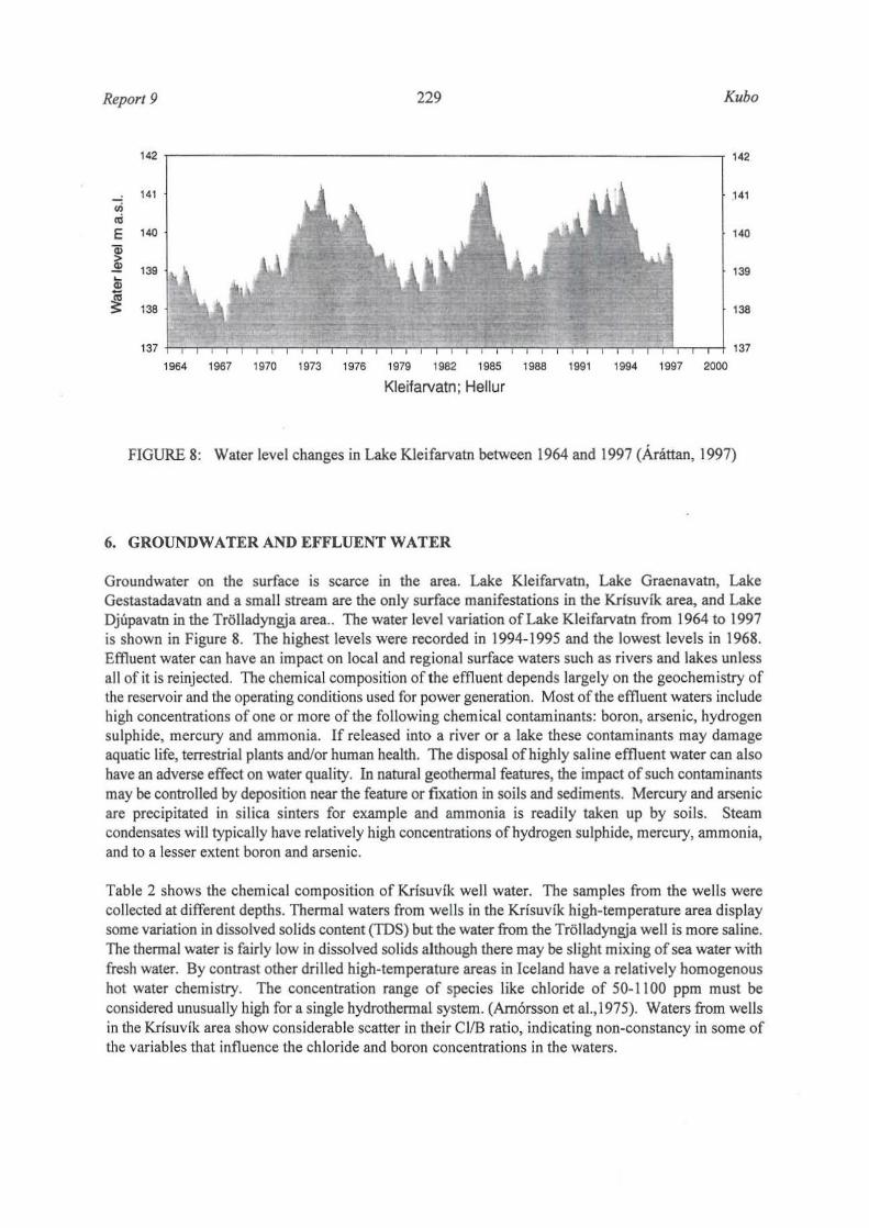
FIGURE 8: Water level changes in Lake Kleifarvatn between 1964 and 1997 (Arattan, 1997)
6. GROUNDWATER AND EFFLUENT WATER
Groundwater on the surface is scarce in the area. Lake Kleifarvatn, Lake Graenavatn, Lake Gestastadavatn and a small stream are the only surface manifestations in the Krisuvik area, and Lake Djupavatn in the Trolladyngja area .. The water level variation of Lake Kleifarvatn from 1964 to 1997 is shown in Figure 8. The highest levels were recorded in J 994-1995 and the lowest levels in 1968. Effluent water can have an impact on local and reg ional surface waters such as rivers and lakes unless all of it is reinjected. The chemical composition of the effluent depends largely on the geochemistry of the reservo ir and the operating conditions used for power generation. Most of the effluent waters include high concentrations of one or more of the following chemical contaminants: boron, arsenic, hydrogen sulphide, mercury and ammonia. If released into a river or a lake these contaminants may damage aquatic life, terrestrial plants and/or human health . The disposal of highly saline effluent water can also have an adverse effect on water quality. In natural geothermal features, the impact of such contaminants may be controlled by deposition near the feature or fixation in soils and sediments. Mercury and arsenic are precipitated in sil ica sinters for example and ammonia is readily taken up by soils. Steam condensates will typically have relatively high concentrations of hydrogen sulphide, mercury, ammonia, and to a lesser extent boron and arsenic.
Table 2 shows the chemical composition of Krisuvik well water. The samples from the wells were collected at different depths. Thermal waters from wells in the Krisuvik high-temperature area display some variation in dissolved solids content (TOS) but the water from the Trol ladyngja well is more saline. The thermal water is fairly low in dissolved so lids although there may be s light mixing of sea water with fresh water. By contrast other drilled high-temperature areas in Iceland have a relatively homogenous hot water chemistry. The concentration range of species like chloride of 50-1100 ppm must be considered unusually high for a single hydrothermal system. (Am6rsson et aI., 1975). Waters from wells in the Krisuvik area show considerable scatter in their CIIB ratio, indicating non·constancy in some of the variables that influence the chloride and boron concentrations in the waters.

Kubo
Loca-lion
Spring Spring Well 3 Well 3 Well 5 Well 5 Well 5 WellS WellS Well 6 Well 6 Wel16 Well 7 Well 7 We ll 8 Well 8 Well 8 Well 8 Well 14
230
TABLE 2: Chemical composition (in ppm) ofthennal waters from the Krisuvik high-temperature area
pHl"C SI01 B Na ' K' Ca- Mg- CO, S04- H1S CJ" F" TDS Sampl. total total depth
(m)
6.48/23 133 42 3.5 32.4 32.5 14.5 29 <0.1 42.3 0 . 1 552
6.98/23 77 34.3 2.8 52.4 21.2 14. 1 69.5 <0. 1 2 1.2 0 . 1 426 142 10.8 24.6 1.4 316 31.3 <0.1 34.4 0.1 6 10 200
6.91120 154 148 12.8 19 .1 1.3 310 3 1.9 <0. 1 70.4 0. 15 654 300 8.35120 222 1.25 206 21.5 9.4 0.24 96 157 3.3 102 0.34 856 200 8.80120 226 1.23 205 12.9 9.1 0.24 55 175.3 0.3 122 850 350 8.80120 220 1.18 210 13.8 10.6 2.22 63 178.2 4.4 118 0.45 861 470 8.60120 210 1.1 5 200 12.9 10 0.23 72 141.6 0.2 151.5 822 650 8.85120 164 0.59 233 16.7 16.5 0.51 63 324.7 1.3 52 0.6 896 800 7.85120 205 0.65 680 40.4 90.8 0 .5 55.7 103. 1 <0. 1 1234 0.2 2563 200 8.35120 514 0.79 700 119 42.4 0 .38 62.2 49.6 6.6 1094 0.5 2605 500 7.30120 304 0.39 596 64 0 0.44 59.5 40.1 1.7 9 14 0.3 2020 800 8.00120 50 30.6 1.7 18.4 lOA 110 7.9 <0.1 16. 1 0 .2 208 325 7.15120 178 0. 14 160 8.2 15.3 1.4 120 75.1 <0.1 163.2 OA 692 475 8.90118 2 10 0.24 140 8.3 5.5 0.3 66.9 90 <0.1 96.8 0.7 600 240 6.82118 332 0.52 227 21.5 11.5 0.13 12 1 240 <0.1 246A 0.7 1000 450 6.83118 332 0.5 230 20.8 12.5 0 .14 117.5 106.3 <0.1 245.6 0.8 1000 700 6.90118 298 0.53 226 21.3 17 0.23 12 1 104 <0. 1 244 0.8 1030 920 9.23/23 490 1.77 465 57.2 lOA 0.04 49.8 92A 9.9 759 0 .3 1876
7, NATURAL CONDITIONS AND PROTECTION
Report 9
T(sampl. depth) ('C)
105 115 173 154 151 151 151 183 258 218 30 119 129 192 184 170 100
Natural surface features such as hot springs, mud pools, geysers, fumaroles and steaming ground are assoc iated with most geothennal systems (Brown, 1995). Because of their unique nature these are often tourist attractions, or are used by the local residents. Geothermal development that draws from the same reservo ir can potentially affect these features. These vis ible signs of geothennal activity are part of a country's heritage and in any geothennal development they must be taken into account during environmental impact assessment. Before any development takes place, the natural features associated with a geothennal field are catalogued with as much infonnation and for as long as possible to provide a data baseline for later comparison. During the exploration phase, the heat flow of natural features is estimated, sampled for, and the chemical analysis corrected. This data can be used to monitor the features. Geothennal features do change, e.g self-sealing is fo llowed by movement such as earthquakes which can cause breakout and thus affect surface manifestations.
In water-dominated geothennal systems, experience has shown that natural features tend to change with the exploitation ofa deep reservoir. Quite often they change to a vapour-dominated system and steam pillows are formed causing hot springs to change to fumaroles. Since there is a possibil ity of a change in the natural features, it is important to have a system for ranking them in order of priority of preservation. Development mayor may not proceed depending on the balance of the economics of the energy production versus the heritage value of the natural features.
The natural features found in Krisuvik are extensive post-glacial lava fields and steep-sided mountains. Minor post-glacial vo lcanic edifices on fissures are particularly abundant within and in the vicin ity of the Krisuvik area. Other natural features found in Krisuvik are thermal manifestations including steam

Report 9 23 1 Kubo
vents, mud pools, sulphurous deposits and wann springs of carbonate water. Lake Kleifarvatn is another feature. The steam vents, mud pools and wann springs are the major tourist attractions in this area. Some monitoring of natural manifestations has been carried out up to now and it is included in plans for env ironmental work at Orkustofnun. This monitoring should be continued and funds should be set aside for it. This system is probably water·dominated , and there is a possibil ity of the natural features decl ining with exploitation. Iflceland is serious with its plans to develop tourism in Krisuv ik, then funds fo r this monitoring should be made available and work continued.
8. GEOPHYSICAL STUDIES
Some gravity measurements were carried out in the early seventies (Arn6rsson et al., 1975). These measurements show a sharp change in the Bouguer anomaly a short distance to the east of the geothermal areas. The cause of this change is not yet clear and a more detailed study needs to be carried out before drilling is considered there .
Figure 9 shows a resistivity map of the Krisuvik· Tro lladyngja area at 300 m below sea leve l (Georgsson, 1987). The reversed temperature profi les (Figure 2) are thought to have resulted from lateral flow with none of the wells having struck the upflow. Some of the resistiv ity lows appear to represe~t upflow.
Trolladyngja :... Krfsuvik Resistivity at 300 ",/b.s.l.
. " SOm _s-.aOm CJJ ~8nm
N
I
Imlow resistivity above o IOCCltion of Schlum_
berger sounding .... .... location Qf resistivity
cross·sectlon
· .. ··t.. '-.J' . ,;,' /Il.,. ..~
" . "--
./ PostglilciClI vola nic ./ fissure o volanic crater
FIGURE 9: Resistivity map of the Krisuvfk and Trolladyngja area at 300 m below sea level (Georgsson, 1987)
Kubo 232 Report 9
6 Higt1 lemperalUfe field
• Epk:enter
U Fissure swarm
~ Hypotheli callnflow erN
O~, -" __ "-___ .L, ____ L�~ ____ ~1 __ __C'~'m
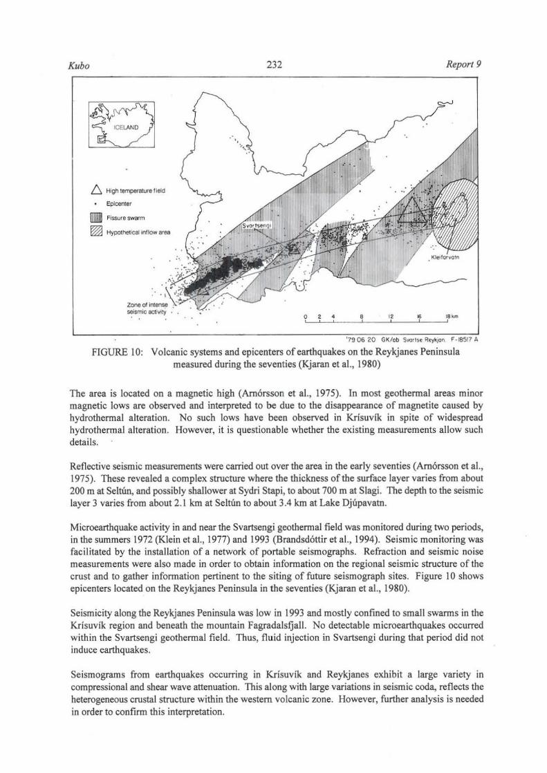
FIGURE 10: Volcanic systems and epicenters of earthquakes on the Reykjanes Peninsula measured during the seventies (Kjaran et al. , 1980)
The area is located on a magnetic high (Amorsson et al., 1975). In most geothermal areas minor magnetic lows are observed and interpreted to be due to the disappearance of magnetite caused by hydrothermal alteration. No such lows have been observed in Krisuvik in spite of widespread hydrothermal alteration. However, it is questionable whether the existing measurements allow such details.
Reflective seismic measurements were carried out over the area in the early seventies (Amorsson et al., 1975). These revealed a complex structure where the thickness of the surface layer varies from about 200 m at Seltim, and possibly shallower at Sydri Stapi, to about 700 m at Slagi. The depth to the seismic layer 3 varies from about 2.1 km at Seltun to about 3.4 km at Lake Djupavatn.
Microearthquake activity in and near the Svartsengi geothennai field was monitored during two periods, in the summers 1972 (Klein et al., 1977) and 1993 (Brandsdottir et al., 1994). Seismic monitoring was facilitated by the installation of a network of portable seismographs. Refraction and seismic noise measurements were also made in order to obtain infonnation on the regional seismic structure of the crust and to gather infonnation pertinent to the siting of future seismograph sites. Figure 10 shows ep icenters located on the Reykjanes Peninsula in the seventies (Kjaran et al., 1980).
Seismicity along the Reykjanes Peninsula was low in 1993 and mostly confined to small swarms in the Krisuvik region and beneath the mountain Fagradalsfjall. No detectable microearthquakes occurred within the Svartsengi geothermal field. Thus, fluid injection in Svartsengi during that period did not induce earthquakes.
Seismograms from earthquakes occurring in Krisuvik and Reykjanes exhibit a large variety in compressional and shear wave attenuation. This along with large variations in seismic coda, reflects the heterogeneous crustal structure within the western volcanic zone. However, further analysis is needed in order to confirm this interpretation.

Report 9 233 Kubo
9. CHANGES IN NATURAL ACTIVITY
9.1 Hydrotbermal eruptions
Although relatively rare, hydrothermal eruptions do occur and hence need to be assessed. Eruptions occur when steam pressure in the near surface aqu ifers becomes greater than the overlying lithostat ic pressure and the overburden is then ejected to form a crater. The resulting vents have been known to vary in diameter and in depth although most eruptions are relatively shallow. In assessing the likelihood of a hydrothermal eruption, hazard evidence of previous hydrothermal eruptions, increasing steam flow to the surface from reservoir pressure drawdown or an expanding steam zone are some of the factors to be considered. Other points to consider are, shallow gas pockets, kicks or blowouts during drilling. Drilling can also cause eruptions if the casing string is set too shallow, or if the casing develops a leak. Reinjection under pressure of fluids at temperatures> 100°C also needs care as there is a poss ibility that such water will rise rapidly to the surface and heat the local groundwaters resu lting in an eruption.
9.2 Subsidence
Withdrawal of fluid from any type of underground reservoir will normally result in a reduction of pressure in the formation pore space and th is can lead to subsidence. Subsidence has been ~bserved in groundwater reservoirs and geothermal reservoirs. Subsidence has a number of implications fo r geothermal development and also for the effect on the surrounding area as it can have serious consequences for the stabi lity of pipelines, drains and well casing in a geothennal field. If a field is close to a populated area. then it can lead to instab ility in dwellings and other buildings. In more remote areas, where there may be no habitation, the local surface watershed systems may be affected. Before exploitation, a baseline levell ing survey and gravity measurements with installation of levelling stations need to be undertaken. There should be a number of separate surveys to cover as long a time as possible before exploitation so that the local tectonic changes in level, if any, can be subtracted from those due to explo itation.
9.3 Induced seismicity
By their nature geothennal fields usually occur in regions of high seismic activity (Figure 10). In such a case there is a natural occurrence of earthquakes that are not related specifically to the exploitation of the geothermal field. Microearthquakes are seismic events that are of a very low magnitude and can only be detected instrumentally. Seismic activity seems to be present in geothennal systems whether they are being active ly exploited or not and is thought to be related to the flow of water through subsurface channels (Brown,1995). Injection of fluids into deep formations, on the other hand, has been recognized as a cause of se ismicity, but there has been no record of geothermal production causing damaging levels of seismicity anywhere in the world. N5 mentioned earlier, a study to monitor microearthquake activity in Svartsengi geothermal field in Iceland showed that there were no detectable microearthquake occurrences in that field (Brandsd6ttir et al., 1994).
9.4 Thermal emissions
The efficiency of geothennal power plants is much lower than that of other types of power plants. Waste heat per MW of electricity generated in geothermal power plants is much larger than in other types of power plants and needs to be dissipated in an environmentally acceptable way. A portion of that waste
Kubo 234 Report 9
heat contained in the water effluent is nowadays used for power generation through binary cycle generation plants. In thi s way its temperature and waste heat will be reduced. Also, most geothermal developments now dispose of geothermal wastewater by deep re-injection, from which the environmental impact due to heat is negligible.
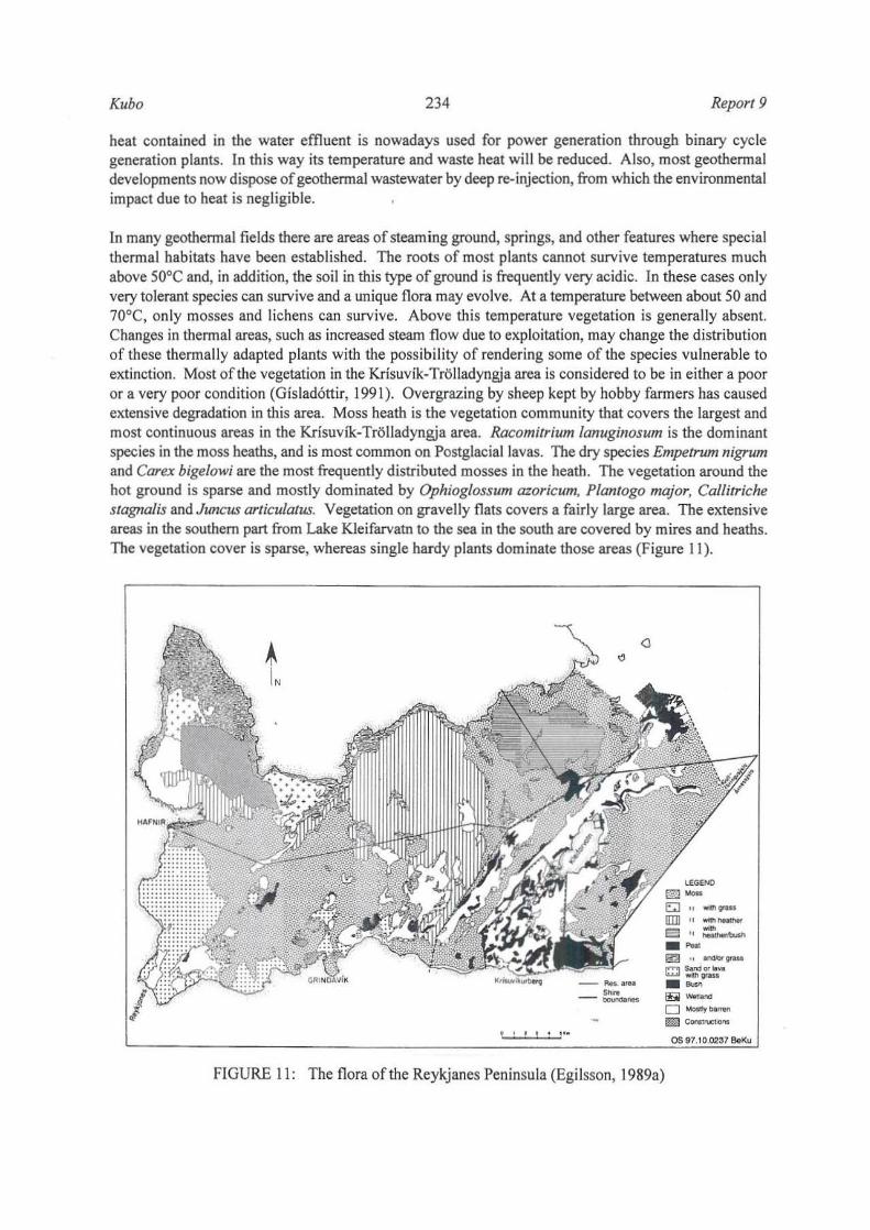
In many geothermal fie lds there are areas of steaming ground, springs, and other features where special therma l habitats have been established. The roots of most plants cannot survive temperatures much above soac and, in addition, the soil in this type of ground is frequently very acidic. In these cases only very tolerant species can survive and a unique flora may evolve. At a temperature between about 50 and 70°C, only mosses and lichens can survive. Above this temperature vegetation is generally absent. Changes in thennal areas, such as increased steam flow due to exploitation, may change the distribution of these thermally adapted plants with the possibility of rendering some of the species vulnerable to extinction. Most of the vegetation in the Krisuvik-Tr~lIadyngja area is considered to be in either a poor or a very poor condition (Gislad6ttir, 1991). Overgrazing by sheep kept by hobby fanners has caused extensive degradation in this area. Moss heath is the vegetation community that covers the largest and most continuous areas in the Krisuvfk· Trolladyngja area. Racomitrium lanuginosum is the dominant species in the moss heaths, and is most common on Postglaciallavas. The dry species Empetrum nigrum and Carex bigelowi are the most frequently distributed mosses in the heath. The vegetation around the hot ground is sparse and mostly dominated by Ophioglossum azoricum, Plantogo major, Callitriche stagnalis and Juncus articulatus. Vegetation on gravelly flats covers a fairly large area. The extensive areas in the southern part from Lake Kleifarvatn to the sea in the south are covered by mires and heaths. The vegetation cover is sparse, whereas s ingle hardy plants dominate those areas (Figure 11).
FIGURE I I: The flora of the Reykjanes Peninsula (Egilsson, 1989a)
e::;J " ..... _
urn" ..... -~ ".:----Em·, -_ C~p~ --"" -0 __
.m Contt'llCtioro!
os 1il7.10.(Xl37 BeKu

Report 9 235 Kubo
9.5 Water usage
Water is required for drilling, reinjection, well testing, and for cooling in the power stations. The impact the requirements will have on the water situation depends on the locality. In arid areas the problem of suitable water can be acute, and geothermal water produced from the first wells has been used as a water supply for subsequent drilling. Water is fairly scarce in Krisuvik despite high rainfall . In Trolladyngja, a fresh water well was drilled to supply water for drilling fluid as there was no other source.
9.6 Solid wastes
Geothermal development produces significant amounts of solid wastes and suitable disposal methods need to be found because of the heavy metals produced (Brown, 1995). These heavy metals must be disposed of safely. Other solid wastes include drilling muds and cement not normally considered hazardous. The other principal solid waste is construction debris and normal maintenance debris. Maintenance debris can be considered hazardous due to the presence of asbestos in insulation material. Disposal of hazardous solid wastes on site is a big problem. Reinjection is one solution to the disposal of heavy metals. When transporting waste, care must be taken to avoid spills. Solid waste disposal sites need to be periodically monitored and such sites could be a long term liability.
10. COST OF PRELIMINARY ASSESSMENT BEFORE DRILLING
Orkustofnun has made separate estimates of the cost of the minimum exploration and environmental assessment work necessary before drilling can start for the Krfsuvfk and Trolladyngja areas. The cost for the different items for the two areas has been added up and is presented in Table 3. According to this estimate, the total minimum cost for the two areas is close to 18 million ISK or about USD 250,000.
TABLE 3: Cost of preliminary environmental assessment before drilling (in Icelandic kr)
Item ISK
Description of geothennal manifestations 4,873,319
Geochemistry 2,534,666 Geophysics 4,661,000
Microearthquake activity 748, 144
Atmospheric gas 1,916,159
Levelling and gravity 1,609,800
Remote sensing (temperature) 918,000
Microorganism study 726,787
Total 17,987,876
H. ENVIRONMENTAL IMPACT OF DRILLING
11.1 Oven'icw
In recent years there has been a remarkable growth of interest in environmental issues such as sustainability and better management of development in harmony with the environment. Associated with this growth of interest has been the introduction of new legislation derived from new national and

Kubo 236 Report 9
international legislation, that seeks to influence the relationship between development and the environment. Environmental impact assessment (ElA) is an important example. EIA legislation was introduced in Iceland in 1993 while in Kenya it is at a very advanced stage.
Introduction of compulsory EIA met with a strong resistance from many quarters, particularly in United Kingdom. Planners argued with partial justification that they were already making such assessments. Many developers saw it as yet another costly and time·consuming constraint on development. There are many definitions of environmental impact assessment. They range from the often quoted and broad definitions e.g. that of Munn (1979) which refers to the need "to identify and predict the impact on the environment and on man's health and well·being of legislative proposals, policies, programmes, projects and operational procedures and to interpret and communicate information about the impacts", to the narrow U.K. Department of the EnvironmentlWelsh office (1988) operational definition: "the term environmental assessment describes a technique and a process by which information about the environment effects of a project is collected, both by the developer and from other sources, and taken into account by the planning authority in forming their judgements on whether the development should go ahead." United Nations Economic Commission for Europe (1991) defines ElA as Man assessment of the impact of a planned activity on the environment." In essence ElA is a systematic process that examines the environmental consequences of development actions and alternatives in advance.
The EIA methodology approach in the 1970s followed in the tracks of economic science in the direction of models, matrices, numbers, networks, input and output (Gilpin, 1995). Methodology, like cost benefit analysis which compares the social costs with the social benefits of a project all expressed as far as practicable in monetary terms, have been used. Others like opportunity cost, the multiplier, contingent valuation, travel cost approach and hedonic price technique are sparingly used because of their complexity in application. Leopold et al. (1971), working with the US Geological Survey produced a methodology in which matrices are used for the entire field ofEIA. Of all the methodologies checklists have tended to surv ive as a gu ide to the potential impacts ofa project (Appendix I: Checklist used for the project). For this project a checklist has been used for impact identification. The checklist is used because unlike other mentioned methodologies, it is simple and descriptive. For impact assessment of drilling, matrices are quite useful and are used for this study because they are more detailed (Table 4).
11.2 Road construction
The amount of land that is disturbed by road construction during geothennal development can be quite large (Brown, 1995); estimated is about 12 hectares for road construction alone when drilling 15 wells. It is worth noting that the general topography of the geothennal area has a large effect on these figures. By their nature, geothermal systems are often located in volcanic environments (The Krisuvik· Trolladyngja areas is no exception) where the terrain is steep and access difficult. Furthermore, such an environment may also have severe erosion problems, particularly if the rainfall is high . (Rainfall in Krisuvik-Tr6l1adyngia is 1500·2000 mm/year). Stabilization of the roads in such an environment is difficult and the land affected by the development is correspondingly increased.
Road construction in these steep environments nonnally involves extensive intrusion into the landscape and can often cause slumping or landslides with consequent loss of vegetation cover. The lack of vegetation can then cause greatly accelerated erosion with the possibility of further slumping or landslides. Parts of the Krisuvik·Trolladyngia area are highly susceptible to erosion as they are steep with very fragile soi ls which are easily erodible . The area is devoid of appropriate vegetation cover, exposing it to the agents of erosion. For drilling pads in the steep part of the area, the solution to erosion and landslides will be to drill a number of deviated wells from a single drilling pad. In this way a large volume of the reservoir can be tapped at depth, while requiring only a small area which can be situated on stable land surface. During well testing, care should be taken not to discharge the waste water directly to steep areas but to sumps made to contain this waste water. Failure to do so can cause serious gullying.

Report 9 237 Kubo
TABLE 4: Matrix used fo r impact analysis
Execution Operation End c c OD t: c OD OD OD c a. ~ '" OD -" 0 0 c 0 .2 c c .5 0 ~ 0 II = 0
'u 'B a. ~ .,
" .~ E '" ·OD S ~ ., • ~ OD ~ ~ ·0 c ·0 U • ....
b " ." • 0 Cl E • 0 .2 .3 ." ~ " " :;, • ~ ~
] f-< a. • :0 c ... 0 C C U 0 .2 " 0 0 " 0 0 ~ E •• " ." ." • • ." c IMPACT • • :0 :;, Cl ] ii: 0 0. •
'" U
Change in landscape Y Y N N P N N N N N N N N Y
Increased earthquake activity N N N N N N N N N N P P N N Changes in groundwater flow N N P N P P N N N N N N N N Changes in effluent flow to groundwater N N P N Y Y N N N N N N N N Changes in amount of water N N N N N Y N P N N Y Y N N Emission N N N N N Y Y N N N Y Y N N Odour N N N N N P N N N N Y Y N N Local climate change N N N N N N N N N N P P N N Noise N N N N N N N N N N P P N N Changes in vegetation N N N N N Y Y Y N N Y Y N N Changes in fauna p P N N P N N N N N Y Y N N Effect on outdoor amenities and tourism N N N N N N N N N N N N N N Aesthetics-appearance N N N N N N N N N N N Y N Y
Light and glare N N P N N P P P P N N N N N
Y = yes : N = no: P = Possibly,
IZl Pool , - 1040 m' Fireproof infillO,5 m
m Base for drilling machine - 1.050 ms. Fireproof infill3,5 m
E:8 Base fo r pumps and tubs - 295 ml. Fireproof inlill 0,75 m
E:3 Sump for collection of cuttings, depth 1,0- 1,5 m volume - 350 ml
AI! inlills to be compressed with a 5 ton vibroroller In 50 cm layers
FIGURE 12: Drill pad for a high-temperature well (Th6rhall sson, pers, comm,)
11.3 Drill site
" • E .9-~ <7
Ul
Y
N
N
N
N
N
N
N
N
N
N
N Y
N
One drill pad occupies about 0.4 hectares and th is area is cleared of vegetation and compacted (Figure 12). The exposure of the area around each well site will create a major erosion hazard. Erosion of cut

Kubo 238 Report 9
slopes takes place by runoff and slumping, but much of the sediment is deposited at the foot. Erosion of the fill slopes is more serious because of the lack of compaction and because the sediment is likely to be carried further downslope. Runoff which accumulates on the pad itself usually finds its way out through the fill slope and, where this is not vegetated, the potential for gully erosion is high.
11.4 Cable tool drilling
The cable tool rig is not a true drill in the strict sense of the word since it does not rotate, but employs a heavy hammer bit that pounds and crushes the rock. This drilling method is common for cold water drilling and before rotary equipment was taken into use in Iceland it was extensively used for geothermal drilling. The cable tool drilling rigs have the advantage of being cheap to buy and requiring only two men to operate. Among the disadvantages of this drilling method are the slow penetration rate compared with rotary drilling especially at depths below 200-300 m, and that in geothennal drilling blow-out prevention equipment cannot be adapted. The cable tool rig is therefore unsuitable for drilling in areas where the water temperature exceeds looae and lower temperature wells, in which free-flow may be dangerous when using this method.
The main role of the cable tool rig in geothermal drilling in Iceland is to pave the way for the rotary drilling equipment. This means that the rig is brought to the drill site to start drilling the first 25-70 m and to set the conductor pipe to keep the loose surface layers from fall ing into the hole. The rotary drilling rig is very ineffective at shallow depths as sufficient weight cannot be applied to the drill bit, so it is necessary to get the hole started by another drilling method. This also mitigates the erosion impact in the loose soil.
11.5 Transportation
It is important to understand the traffic impacts in drilling activity. The area before drilling starts has a certain amount of traffic known to the area. When drilling starts the traffic increases as the rig and all its accessories are transported to the drill site.
The rotary drill rig is transported on set trailers pulled by a truck. Transport takes 2-4 days depending on the number of trucks and the distance. About 130 tons of casing, 140 tons of cement with an additional 25 tons of drilling mud and 30 tons of diesel oil and some lubrication o il are expected to be transported to the drill rig during drilling. The rig will be removed in 2-3 days after drilling is finished. This can lead to an increase in dust, noise, vehicular em iss ions and increased traffic. Occas ional traffic delays wi ll occur at various points in the project area. The assessment of significance will focus on who will be affected to what degree and whether the change is significant. Some of the affected groups are people at home, work places. Special interest groups are children, elderly and disabled and sensitive locations like schools, hospitals places of worship. In the Krisuvik area there is a rehabilitation centre for drug addicts and also open spaces, recreational sites, sites of ecological or nature conservation value and sites of tourist or visitor attraction. Secondary impacts like vibration accidents, safety and hazardous loads are also possible.
11.6 Drilling fluids
Water is required for drilling. A typical shallow well requires 1000 mJ/day, some or all of which may be lost to the fonnation. A deeper well may require up to 3000 m3/day (Brown, 1995) for periods up to several months. Completion testing and injection testing can use up to 10,000 m3/day of water. In

Report 9 239 Kubo
Iceland up to 40 Vs or 3500 m] of water are required for 24 hours of drilling. If this water is discharged, care must be taken to have it disposed of into a well designed for this purpose, as the quality of the water can be affected by suspended solids and chemical content change (Brown, I 995). The waste water from drilling can create serious gullying if discharged directly to the surface, e.g. into valleys. This can be a problem in the steep parts of Krisuvik if proper disposal methods are not applied.
After use drilling muds are produced as solid alkaline waste that may contain many other chemicals (Table 5) Annannsson (1997). Drilling muds are either lost to the circulation in the well or end up in the drilling sumps as sol id waste for disposal. A drilling mud like bentonite is mostly used when hole clearing is inadequate or when well stability is a problem.
Aerated water or mud and foam are sometimes used for pressure balancing. Air or foam drilling is used in holes with low water tables or vapour-dominated reservoirs. Air only drilling requires very large compressors which may be very noisy. Foam drilling can have some impacts on the vegetation around and a large area can be covered by the foam causing an eyesore but fortunately such impacts are not permanent.
TABLE 5: Chemical composition of bentonite and perlite (% of mass) (Annannsson, 1997)
Material 810, AlIO] Fe2O] Ti02 CaO MgO Na10 K,O LOll) Water Acid solubility solubility
Bentonite 64.1 20.0 3.66 0.16 1.52 2.38 2.18 0.49 6.26
Perlite 73.0 12.5 0.7 0.1 1.0 0.5 4.5 4.8 1.3 0.1 0.5
1) LOl = Loss on ignition
11.7 Drilling
Typically, drilling involves the preparation of a rectangular flat area of ground. This area is required to accommodate the drill rig and the associated equipment including drill pipes. As drilling takes place cuttings from the drill head are flushed out with water, frequently mixed with drilling detergent to assist in the collection of cunings. The detergent used must be capable of withstanding high temperature. Benton ite drilling mud mixed with some barium is often used. If the well erupts, a heavy substance barium sulphate is usually added. This is essentially an inert materia l but can smother plants and does not support plant growth and in this respect is similar to a hard compacted surface. Other wastes produced include petroleum products from lubricants and fuels plus cement wastes as spills. Air pollution can result from non-condensable gas emissions and exhaust smoke from generators and com pressors. In vapour-dominated reservoirs, air only drilling takes place and this requires large compressors which, in effect, increases noise to unbearable levels. A drill rig is seen from afar during drilling and may be regarded as visual pollution but it is removed after drilling. Some people on the other hand find drill rigs magnificently beautiful.
11.8 Casing and cementing
Conductor casing, the largest diameter casing used in a well is required only where the surface soils are so incompetent that the washing and eroding action of the drilling mud would create a large cavity at the surface. Conductor casing controls such erosive action. Surface casing is of a smaller diameter and its function is to protect the fresh water table and provide an anchor for blowout preventer equipment. The
Kubo 240 Report 9
amount of surface casing required, therefore depends on the depth of the freshwater table with a minimum of 60 m and a maximum of 400 m and is cemented all the way to the surface. If the fresh water table is below the surface casing, the contro l authority requires that the fresh water be protected by setting either intermediate or production casing and cementing it with enough cement to completely fi ll the casing wellbore annulus from the shoe to the surface (Corsi, 1995).
The cementing of casing in wells is carried out for a number of reasons. Where conductor casing is required, it must be cemented in order to prevent the drilling fluid from circu lating outside the casing and, thus, cause surface erosion which the casing was designed to prevent. Surface casing must be cemented in order to seal off and protect freshwater formations. Cement also effective ly protects the casing from corrosive environments, notably corrosive fluids wh ich may be present in the surface format ions.
11.9 Demobilization
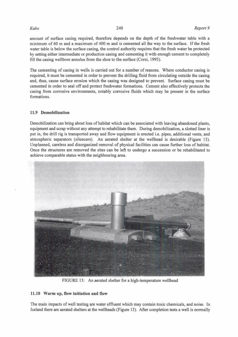
Demobilization can bring about loss of habitat which can be associated with leaving abandoned plants, equ ipment and scrap without any attempt to rehabilitate them. During demobilization, a s lotted liner is put in, the drill rig is transported away and flow equipment is erected i.e. pipes, addit ional vents, and atmospheric separators (si lencers). An aerated shelter at the wellhead is desirable (Figure 13). Unp lanned, care less and disorganized removal of physical fac il ities can cause further loss of habitat. Once the structures are removed the sites can be left to undergo a succession or be rehabil itated to achieve comparable status with the neighbouring area.
FIGURE 13: An aerated she lter for a high-temperature wellhead
11.10 Warm up, flow initiation and flow
The main impacts of well testing are water effluent which may contain toxic chemicals, and noise. In Iceland there are aerated shelters at the wellheads (Figure 13). After completion tests a we ll is normally
Report 9 241 Kubo
closed in order to warm up and to build up pressure. This is common with wells which can selfdischarge. For wells which cannot self-discharge, it is common practise to compress them using compressors and leave them for awhile to build up pressure. Drilling soap is normally added during compression time. Some wells have to be airlifted to initiate flow. Noise impact can be experienced from the large compressors used. Testing of wells has often had a deleterious effect on local vegetation with trees and other plants being scalded by escaping steam and spray. This effect is more severe during the vertical discharge of wells which is carried out in order to clean them . It is advisable that vertical discharge take as short a time as possible, preferably not more than one hour. The waste water from a tested well can cause serious gullying when discharged directly to a steep area, very possible in the fragile soils found in the Krisuvik-Trolladyngja area.
12. ENVIRONMENTAL ASSESSMENT FOR DRILLING
12.1 Checklist
The key elements of the project are all included in the checklist. Those impacts that could result if the project were implemented are also discussed where appropriate. Only those elements of the environment which may be impacted or might be considered as producing cumulative effects are included in the discussion. Since exploration for the project is sparse, it is not realistic to estimate, for example, the amount of water that might be available for use should implementation start immediately (Appendix I).
12.2 Natural conditions
12.2.1 Earth (land)
During road construction and drill site preparation, unstable earth conditions and changes in geological substructure can occur. The Krfsuvik-Trolladyngja field has steep terrain and difficult access. With high rainfall (1500-2000 m) in the two fields, erosion by water is likely when the area is opened for road and pad construction. These fields display a high erosion hazard as part of the area is steep with very fragile soils which are easily erodible. The area is generally devoid of appropriate vegetation cover, so it is exposed to erosion agents. Careful attention should be given to re-vegetation with grass and trees on the cut slopes, fill slopes and well pads themselves. For drilling pads in the steep part of the area, the solution to erosion and landslides will be to drill a number of deviated wells from a single drilling pad. In this way a large volume of the reservoir can be tapped at depth, while requiring only a small area which can be situated on stable land at the surface. During well testing care should be taken not to discharge the waste water directly to steep areas but sumps should be made to contain this waste water, as failure to do this can cause serious gullying. Some rare bacteria species have been found in Icelandic geothennal fields (Petursd6ttir, 1995). Therefore, it is recommended that bacterial counts be made and the bacteria monitored if interesting results are obtained. This is because these can be either rare species or strains of bacteria which probably can be utilized in bio-technology in future.
12.2.2 Air
During drilling, air pollution can result from non-condensable gas emissions, exhaust smoke from generators, compressors, and vehicles. There may be objectionable hydrogen sulphide odours. During well testing, steam and spray can have an adverse effect on the vegetation with trees and grass being scalded. Hydrogen sulphide produces an unpleasant odour. Eye irritation and respiratory damage may not be of any significance as the Trolladyngja area is not inhabited and the population of Krisuvik is very

Kubo 242 Report 9
small. As drilling is a temporary activity, no significant long term air quality impacts are expected. Hydrogen sulphide, sulphur dioxide and possibly mercury in atmospheric air should be monitored.
12.2.3 Water
Water is required as a drilling fluid. The wells to be drilled in this area will be deep and may require up to 3000 m1lday for periods of several months depending on the number of wells to be drilled. Completion testing and injection testing can use up to 10,000 ml/day of water. This will have an impact on the volume of water in the stream at Krisuvik ifthe water is extracted from there and Lake Kleifarvatn will be simi larly affected. At TrOlladyngja a fresh water well was drilled to supply water for drilling fluid and which may solve any problems in that field. Fresh water wells can be drilled for Krisuvik too. The amount of water used as drilling fluid is enormous and should be discharged with utmost care into well designed sumps or possibly re-injected as this can affect the quality of the water, particularly in Krisuvik where there is a stream. The discharge to the surface can lead to siltation and deposition from the stream and just possibly Lake Kleifarvatn. For Trolladyngja the casing programme should be such that there is no danger of pollution of groundwater. A detailed study on ground water in these two areas is required.
12.2.4 Noise
The relative remoteness of the Krisuvik-Trolladyngja fields ensures that there will be no serious noise impacts during drilling, well testing, tripping and cementing. Some temporary noise impact may be felt at the rehabilitation center and the coffee shop where visitors stop to see well KV-14 spitting steam and to have refreshments. The noise impact will decline when all the wells have been drilled and tested. In Trolladyngja, noise impact will not be of any significance as the area is not inhabited.
12.2.5 Flora
The flora of Iceland consists of 438 species. Of these 63% or 273 species are found in the Reykjanes country park (Figures 14 and 11) (Kristinsson, 1986). Although moss covers the lava fields , the carpet is broken by sharp joints, and in deep depressions where soil accumulates, species like dwarf shrubs and low herbs become frequent. On the plateau east of Lake Kleifarvatn, snow beds are frequent in the moss heath, intermingled with dwarf willows and mosses. The largest continuous heaths are in Postglacial lava fields in the Krisuvik-Trolladyngja area. Grass species, mosses and Carex are most important in the grass dominated heath. In general the flora of the Reykjanes country park can be classified as follows: Mosses 45.5%, open country vegetation 11.5%, the rest 22% (grass, bush, wetland, etc.) or 78% vegetated (Thorvaldsd6ttir, 1987). Further classification of the vegetation is given in Table 6.
TABLE 6: Vegetation in the Reykjanes country park, 1964 and 1988 (Gisladottir, 1991)
Extent 1964 1988 Difference
(Ha) C%) (Ha) C%) (Ha) C%) Completely vegetated 847 22.2 51) 1).4 -))) -8.7
< 1/3 barren 442 11 .6 928 24.3 486 12.7
113-213 barren )18 8.3 446 11.7 127 ).3
> 2/3 barren 454 11.9 172 4.5 -281 -7.4
Completely barren 1745 45 .7 1747 45.7 2 0
Water 14 0.4 14 0.4 0 0

Report 9
OS 97.10.0238 BeKu
LEGEND
Protected area:
243
Natural monuments and nalure reserves
Protected area: Country parks
Areas included in Nature Conservation Register
Bounqaries of research area
_._.-
Kubo
- _ .;
/
t
1966
FIGURE 14: Map of the Reykjanes Peninsula showing the country park and protected areas and the research area for studies on vegetation (modified from Egiisson, 1989b)
For this type of vegetation vel)' little disturbance is expected except during drill-site preparation and road construction, which may cause slight reduction in vegetation cover in Krisuvik, but will be of little significance in the Trolladyngja area. The pads can be vegetated with grass after drilling and well testing. Trees can be planted on the pads and the hiUtops. With the large amount of rainfall in the Krisuvik area, afforestation in that area should be quite easy. The only possible problems are the hobby fanners who keep sheep in this area; the sheep graze on the planted trees. It is strongly recommended that this practise be stopped in Krisuvik in order to revegetate the area and leave sheep farming to serious farmers who earn a living and keep their sheep on appropriate land. During drilling and well testing, care should be taken to avoid damage to the grass when disposing of drilling effluents and waste waters. A detailed study on the continuation of hobby sheep fanning in the Krfsuvik-Trolladyngja area is required. In the study it shou ld be investigated whether there is any benefit from such farming to the economy of the country, employment, and of course the environment in a fragile area like Krisuvik-TroJladyngja. The detailed study should also include the potential effect of changes in the thennal areas, such as increased steam flow due to exploitation, the change of distribution of the thermally adapted plants, and to whether some of the species could be rendered extinct.
12.2.6 Aoimallife
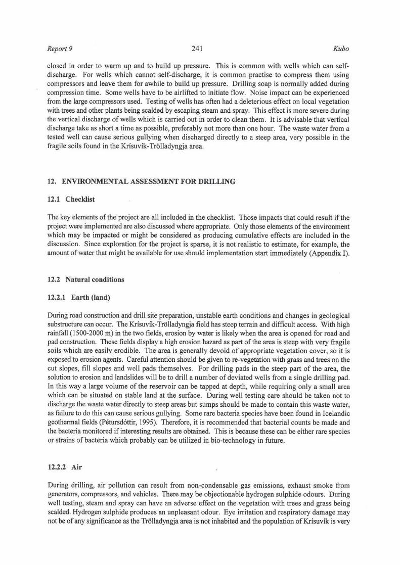
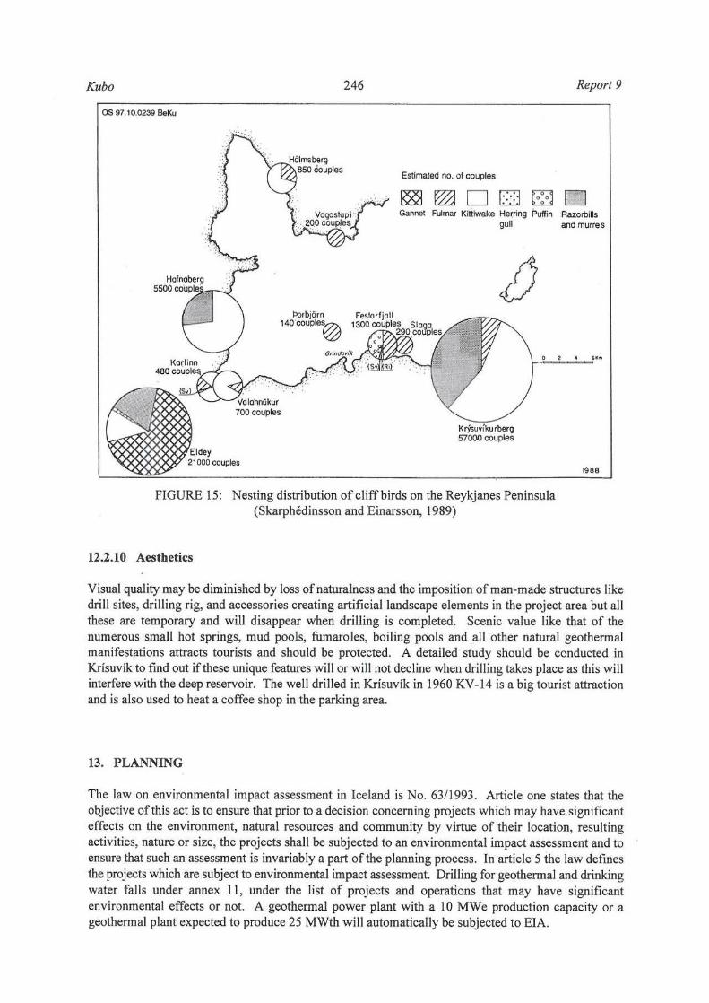
Wild mammals on the Reykjanes Peninsula are foxes which are rare, minks that are common, rats and mice about which there is little infonnation although field mice are expected to be common (Petersen and Olafsson, 1986). On the whole peninsula at least 43 bird species are known to nest, 26 of them every year. In Krisuvikurberg there is some utilization of eggs and in 1987, 10-1 2,000 eggs were taken there. Proceeds go to the local rescue squad (Skarphedinsson and Einarsson, 1989). A list of nesting birds from Krisuvikurberg to Hafnaberg is presented in Table 7. Cliff birds are considered separately in Table 8 and
Kubo 244 Report 9
a generalized map of nesting distribution in the peninsula is shown in Figure 15. The c1iffbirds found under the low mountains along the shore cliffs in Krisuvik have become a big tourist attraction in the area. There will be no impact in this area as it is unlikely that drilling will take place near the cliffs. If wells will be sited near the cliffs in future ,' then a detailed EIA will be required . This is important because one of the bird species, the Red phalarope, is now a very rare bird, possibly facing extinction.
Name of bird
Fulmar
Gannet
Shag
Herring gull
Kittiwake
Razorbill
Common Murre
rrhiek-billed Murre
Black guil lemot
Puffin
Tota l
TABLE. 7: Cliff birds found on the southern Reykjanes Peninsula (Skarphedinsson and Einarsson, 1989)
Krfsu· Slagi Festar- Haga- Thor· Hal- Krossa- Vala· Karl- Hafna -vlkur- fjall fell bjiirn eyja- vlkur- hnjuk- inn berg berg betg berg "' 3000 283 643 30 136 11 46 48 3 1 10-20
(400) (70) (70)
- 150
- 150 5 91 3 1 6+ 1 1-2
3200 33 577 38 4000 (300) (400)
7000 15 4 7 500 (8) (8)
11000 800
3000 150
1 1 <20
Total
-4000
1453 1
- ISO
- 260
-40000
- 7500
- 14300
-4150
100-200
30 1000-2000 (8)
-57000 303 - 1300 30 139 12 48 - 730 480 5500 87000
12.2.7 Light and glare
Eldey
- 170
14531
3000
2500
100-200
21200
There will be some light or glare while drilling in these two areas but this will not be of any significance as the areas are remote with only a few people at the rehabilitation centre in Krisuvik. The light from the drilling rig can also cause some interference to shipping particularly in small harbours because the pilot may confuse the drilling rig with the harbour. But at other times it may assist in estimating the distance from the ship sailing on the sea, to the mainland. If ships are well informed, such a light is likely to be an advantage.
12.2.8 Transportation
There will be some increased traffic generated on the main roadway in the project area due to the transportation of the drill rig, together with all its accessories to the area (see notes on 10.5).
12.2.9 Utilities
Water for drilling in Krisuvik may be obtained from the small stream, Lake Kleifarvatn or probably by drilling a fresh water well. In Tr611adyngja a fresh water well was drilled for water as drilling fluid, but a detailed study should be conducted to find out if this one fresh water well will be able to serve all the wells to be drilled in the area.

Report 9 245 Kubo
TABLE 8: Nesting birds on southern Reykjanes Peninsula from Krisuvfkurberg to Hafnaberg (Skarphedinsson and Einarsson, 1989)
Name of bird Zooloeica1 name Year Occasional Former
Fulmar Fulmarus glacial is X
Manx shearwater Puffmus puffmus ? Gannet Sula bassana X
Shag Phalarcocorax aristotelis X
Mallard Amas platyrhynchos X
Eider Somateria mollisima X
Red breasted merganser Mergus serrator X
White tailed eagle Haliaetus albicil la X
Gyrfalcon Falco rusticolus X Merlin Falco columbarius X
Ptannigan Lagopus mutus X
Oystercatcher Haematopus ostralegus X Eurasian golden plover Pluvialis apricaria X
Ringed plover Charadrius hiaticula X
Whimbrel Numenius phaeopus X
Common snipe Gallinago gallinogo X
Redshank Tringa totanus X Purple sandpiper Calidris maritima X Red phalarope Phalaropus fulicarius X
Northern phalarope Phalaropus lobatus X Great skua Stercorarius skua X
Arctic skua Stercorarius parasiticus X
Great black·backed gull Larus marinus X Lesser black·backed gull Larus fUSCllS X Herring gull Larus argentatus X Glaucous gull Larus hyperboreus X
Mew gull (Common gull) Lams canus 1 Black legged kittiwake Rissa tridactyla X
Arctic tern Sterna paradisea X
Razorbill Auka torda X Great auk Pinguinus impennis X Common murre Uria aalge X Thick·billed murre Uria lomvia X Black guillemot Cephus grylle X
Puffin Fratercula arctica X Swallow Hirunda rustica X
Raven Corvus corax X White wagtail Motacilla alba , X Meadow pipit Arthus pratensis X Wheatear Oenanthe oenanthe X Starling Stunnus vulgaris X
Snow bunting Plectrophenas nivalis X
Total 32 4+2 5
Kubo
OS "7.10.0239 BaKu
couples
PoIbjOfn t40COUPIe~
246 Report 9
Estimated 1'10. of couples
Gannet Fulmar Kittiwake Hetring Puffin Razorbills gull and murres
1988
FIGURE 1 S: Nesting distribution of cliff birds on the Reykjanes Peninsula (Skarphedinsson and Einarsson, 1989)
12.2.10 Aestbetics
Visual quality may be diminished by loss of naturalness and the imposition of man-made structures like drill sites, drilling rig, and accessories creating artificial landscape elements in the project area but all these are temporary and will disappear when drilling is completed. Scenic value like that of the numerous small hot springs, mud pools, fumaroles, boiling pools and all other natural geothermal manifestations attracts tourists and should be protected. A detailed study should be conducted in Kr[suvik to find out if these unique features will or will not decline when drilling takes place as this will interfere with the deep reservoir. The well drilled in Krisuvik in 1960 KV-14 is a big tourist attraction and is also used to heat a coffee shop in the parking area.
13. PLANNING
The law on environmental impact assessment in Iceland is No. 6311993. Article one states that the objective of this act is to ensure that prior to a decision concerning projects which may have significant effects on the environment, natural resources and community by virtue of their location, resulting activities, nature or size, the projects shall be subjected to an environmental impact assessment and to ensure that such an assessment is invariably a part of the planning process. In article S the law defines the projects which are subject to environmental impact assessment. Drilling for geothermal and drinking water falls under annex 11, under the list of projects and operations that may have significant environmental effects or not. A geothennal power plant with a 10 MWe production capacity or a geothermal plant expected to produce 2S MWth will automatically be subjected to ElA.

Reporl9 247 Kuho
There were plans to put up a big tourist multi resort and an Icelandic geoscience research center in Krisuvik as this area was selected as the best in a study of possible areas. (Checchi and Company and the Architect Collaborative Inc., 1975). The climate, and its closeness to Reykjavik and Keflavik makes KIisuvik close to the hubs of foreign and local tourist activity. The drilling of geothennal wells should, therefore, not conflict with the tourist industry and, if anything, should benefit the tourist resort centre. Drilling should not interfere either with the recreation and fishing activity in Lake Kleifarvatn by Icelanders. Krisuvik has a combination of resources and scenic beauty, backed by advantages of a central location vis-a-vis existing markets.
Landownership in the Krisuvfk-Trolladyngja area requires urgent attention because, up to now, ownership rights are not clear, particularly so in Trolladyngja. It is absurd to transport steam all the way from Krisuvik to Straumsvik instead of getting it from Trolladyngja which is quite close, just because of the grey area in landownership or utilization rights. For instance Krisuvik and Lake Kleifarvatn are owned by Hafnarfjordur township (see Chapter 2).
Some monitoring of natural manifestations has been done and is included in plans for environmental work at Orkustofnun. However, it has been difficult to finance as the power companies are not interested in supporting research until they have obtained the right for exploitation. Therefore, it is suggested that the government shoulder the cost of the monitoring but charge the exploiter for it when he gets the rights.
14. NECESSARY ACTION
1. A detailed study of the water supply for drilling is required in Krisuvik. In Trolladyngja a freshwater well was drilled to provide water for drilling, and this is still in existence.
2. A study will be required on how to get rid of effluent water in the Krisuvik-Trolladyngja area.
3. Monitoring of steam flow and gas concentrations in steam needs to be carried out in more locations and more frequently than up to now.
4. Monitoring of gas emissions to the atmosphere should be carried out. A short tenn check has been performed but much more information is needed.
5. Some monitoring of natural manifestations has started and plans for it are included in plans for environmental work at Orkustofnun. This monitoring should be continued and funds set aside for it.
ACKNOWLEDGMENTS
My grateful thanks are due to many people without whose help this report would not have been produced. I am particularly grateful to lngvar Birgir Fridleifsson, the director of the UNU Geothermal Training Programme, for giving me a chance to come and ,train in environmental studies, the first fellow to do so; Ludvik S. Georgsson for providing all the guidance and Gudrun Bjamad6ttir for translating some reports for me. Many thanks go to my supervisor Halld6r Armannsson for his guidance and advice which led to the production of this report. I am grateful to my employer, Kenya Power Company, for granting me the sabbatical leave to come and attend this important course and, of course, to my wife Asbetty, children Alex, limo and Rab for the moral support they accorded me during my stay in Iceland.
Kubo 248 Report 9
REFERENCES
Arattan, 1997: Quarterly review of hydrological measurements, July-September 1997. OrkuslOfoun, Newsleller of the Hydrological Division, No. 9 (in Iceland ic).
Armannsson, H., 1997: Reykjanes, a preliminary investigation for environmental assessment. Orkustofnun, ReykjavIk, report OS97031 ( in Iceland ic), 58 pp.
Armannsson, H., and Kristmannsd6ttir, H., 1992: Geothermal environmental impact. Geothermics.21-516, 869-880.
Armannsson, H., and Th6rhallsson, S., 1996: Krisuvik. an overview of previous exploration and exploitation and utilization possibilities, along with proposals for further exploration. Orkustofnun, Reykjavik, report OS-96012/JHD-068 (in Icelandic), 25 pp.
Armannsson, H., Th6rhallsson, S., and Ragnarsson, A., 1994: Krisuvik-Tr6I1adyngja. Potential steam production and transmission to energy park. Straumsvik. Orkustofnun, Reykjavik, report OS-94012/JHS-078 , 17 pp.
Arn6rsson, S., 1987: Gas chemistry of the Krisuvik geothennal field, Ice land, with special reference to evaluation of steam condensation in upflow zones. J6kull, 37, 31-47.
Arn6rsson, S., BjOrnsson. A., Bjomsson, S., Einarsson, P., GIslason, G., Gudmundsson, G., Gunnlaugsson, E., J6nsson, J., and Sigunnundsson, S.O, 1975: Report on explorations of the geothermal reources of the Krisuvik area. Orkustofnun, ReykjavIk, OS lHD-7554, 71 pp + figures.
Brandsd6ttir, 8., Einarsson, P., Amason, K., and Kri stmannsd6ttir, H., 1994: Refraction measurements and seismic monitoring during an injection experiment at the Svartsengi geothermal field in the summer 1993. Orkustofnun, Reykjavik, OS-94016IJHD-OS (in Icelandic), 28 pp.
Brown, K.L., 1995: Impacts on the physical environment. In: Brown, K.L. (convenor), Environmental aspects of geothermal development. World Oeothennal Congress 1995, IGA pre-congress course, Pisa, Italy, May 1995,39-55.
Checchi and Company and the Architect Collaborative Inc., 1975: Tourism -Iceland. Phase 11. Un ited Nations pub licat ion, 106+250 pp.
Corsi, R., 1995: Env ironmental protection aspects related to injection. In: Brown, K.L. (convenor), Environmental aspects of geothermal development. World Geothenna l Congress 1995, IGA precongress course, Pisa, ltaly, May 1995, 147-171.
Egilsson. K., 19898: The flora of the southern part of the Reykjanes Peninsula. In: Egilsson, K. (editor), Natural conditions in the southern part of the Reykjanes Peninsula. Co-operative Committee on Planning in Sudumes, Reykjavik, 23-35.
Egilsson, K., 1989b: Protected parts in the southern part of the Reykjanes Peninsula. In: Egilsson, K. (editor), Natural conditions in the southern part of the Reykjanes Peninsula. Co-operative Committee on Planning in Sudurnes, Reykjavik, 63-65.
Georgsson, L.S., 1987: Application of resistivity sounding in the exploration of high-temperature geothermal areas in Iceland with examples from the Trolladyngja-Krisuvik area, SW-Iceland. Technical Programme and Abstracts of Exploration '87. Toronto, 52.
Report 9 249 Kubo
Gilpin, A., 1995: Environmental impact assessment, cutting edgefor the twenty-first century. Cambridge CB2 IRP, UK, 182 pp.
Gislad6ttir, G., 1991: Vegetation changes in the Krisuvik land 1945~1990. University ofIceland, Reykjavik, Departm. of Geology, report (in Icelandic), 41 pp + maps.
ivarsson, G., Sigurgeirsson, M.A., Gunnlaugsson, E., Sigurdsson, K.H., Kristmannsd6ttir, H., 1993: Measurement on gas in atmospheric air. Orkustofnun and Hitaveita Reykjavikur, Reykjavik, report OS~
93074/JHD-IO (in Icelandic), 69 pp.
16nsson, 1., 1978: A geological map 0/ the Reykjanes peninsula. Orkustofnun, Reykjavik, report OS/JHD 7831 (in Icelandic), 333 pp and maps.
Kifua, G.M., 1986: Geologic mapping for geothermal exploration, Trolladyngja area, Reykjanes peninsula, Southwest Iceland. UNU G.T.P., Iceland, report 4,38 pp.
Kjaran, S.P., Eliasson, 1., and Halld6rsson, G.K., 1980: Svartsengi, reservoir engineering studies 0/ the exploitation 0/ geothermal reservoir. Orkustofnun, Reykjavik, report OS~80021 fROD~ I 0 ~ JHD-17 (in Icelandic with English summary), 98 pp.
Klein, F.W., Einarsson, P., and Wyss, M. , 1977: The Reykjanes Peninsula, Iceland, earthquake swann of September 1972 and its tectonic significance. J. Geophys. Res., 82, 865-888.
Kristinsson, H., 1986: The plant handbook. Flowering and bracken plants. NattUra islands (Iceland's nature) 2, Reykjavik (in Icelandic), 304 pp.
Leopold, L.B., Clarke, F.E., Kanshaw, B.B., and Balsley, J.R., 1971: A procedure for evaluating environmental Impact. US Geological Survey Circular No.654, Washington D.e.
Morris, P., and Therivels, R. (editors), 1995: Methods o/environmental impact assessment. UCL Press Ltd., London, 378 pp.
Munn, R.E. 1979: Environmental impact analysj~', principles and procedures. SCOPE report no. 5, John WiJey and Sons Ltd., Chichester.
Orkustofnun and Vatnaskil Consulting Engineers, 1986: Vatnsleysa-Trolladyngja. Freshwater and geothermal investigation. Orkustofnun, Reykjavik, report OS-86032/JHD~ lOB, 92 pp and maps.
Ola, A., 1944: The land is lovely and beautiful. B6kfellsutgMan, Reykjavik (in Icelandic), 308 pp.
Olafsson, M. 1991: Geothermal heat in Krisuvik. Sampling/or chemical analysisfromfumaroles in the autumn 1990. Orkustofnun, Reykjavik, report MO-91/06 (in Icelandic), 4 pp.
Petersen, Ae., and Olafsson, E., 1986: Animal life in Sudurnes (in Icelandic).1n: Egilsson, K. (editor), Sudurnes ~ Natural conditions, relics and land use. Natturufraedistofnun, Reykjavik, report, 31~48.
Petursd6ttir; S., 1995: The microbiology o/the Blue lagoon and other saline geothermal areas in Iceland. University of Iceland, Department of Biology, Dissertation, Reykjavik.
Roberts, J.A., 1991 : Just what is EIR? Global Environmental Services, Sacramenta, CA, 209 pp.
Skarphedinsson, K.H. and Einarsson, O. 1989: Birdlife in the southern part of the Reykjanes Peninsula.

Kubo 250 Report 9
In: Egilsson, K. (editor), Natural conditions in the southern part of the Reykjanes Peninsula. Cooperative Committee on Planning in Sudumes, Reykjavik, 37-57.
Stefansson, V., Gislason, G., Torfason, H., Georgsson, L.S., Sigunnundsson, S.G., and Th6rhallsson, S., 1982: A programme for exploration of the high-temperature areas of Iceland. Orkustofnun, Reykjavik, report OS-82093/JHD-13 (in Icelandic), 176 pp.
Thorvaldsd6ttir, E.G., 1987: Flora and vegetation conditions in the Reykjanes country park. Report prepared for the management of Reykjanes country park, 141 pp.
U.K. Department of the Environment/Welsh office, 1988: Environmental assessment. DOE Circular 15/88 (Welsh office circular 23/88).
United Nations Economic Commission for Europe. 1991: Policies and systems of environmental impact assessment. United Nations, Environmental series.
Vargas M., J.R., 1992: Geology and geothermal considerations of Kriswik valley, Reylganes, leeland. UNU G.T.P., Iceland, report 13,35 pp.
Webster lO., and Timperley, M.H., 1995: Chemical impacts ofgeothermal development. In: Brown, K.L. (convenor), Environmental aspects of geothermal development. World Oeothennal Congress 1995, lOA pre-congress course, Pisa, Italy, May 1995,97- 117.
APPENDIX I: Checklist used for environmental assessment of drilling in the Krisuvik-Trolladyngja geotbermal field (based on Roberts, 1991)
Environmental impacts: Yes Maybe No
1. Earth. Will the proposal result in:
a. Unstable earth conditions or in changes in geo logic substructures? .JL
b. Disruptions, disp1acements, compaction or over covering of the soil? _
c. Change in topography or ground surface relief features?
d. The destruction, covering or modification of any unique geologic or physical features? _ _ _ ...x...
e. Any increase in wind or water erosion of the soil, either on or off the site? .JL __ _
f. Changes in deposition or erosion of beach sands, or changes in siltation, deposition or erosion which may modify the channel of a river or stream or the bed of the ocean or any bay, inlet or lake? ___ ...x...
g. Exposure of people or property to geologic hazards such as earthquakes, lands lides, muds1ide, ground failure or similar hazards? _ _ _ ...x...

Report 9 251 Kubo
Yes Maybe No 2. Air. Will the proposal result in:
a. Substantial air emissions or deterioration of ambient air quality? .JL
b. The creation of objectionable odours? ~
c. Alteration of air movement, moisture, or temperature, or any change in climate either locally or regionally? _ __ -.lL
3. Water. Will the proposal result in:
a.
b.
c.
d.
e.
f.
Changes in currents, or the course of direction of water movements in either marine or fresh water?
Changes in absorption rates, drainage patterns, or the rate and amount of surface runoff?
Alterations to the course or flow of flood waters?
Change in the amount of surface water in any water body?
Discharge into surface waters or in any alteration of surface water quality, including but not limited to temperature, dissolved oxygen, or turbidity?
Alteration of the direction or rate of flow of ground waters?
g. Change in the quantity of ground waters, either through direct additions or withdrawals, or through an interception of an aquifer by cuts or excavations?
h. Substantial reduction in the amount of water otherwise available for public water suppl ies?
I. Exposure of people or property to water related hazards such as flooding or tidal waves?
4. Plant life. Will the proposal result in:
a.
b.
c.
d.
Change in the species diversity, or number of any species of plants (including trees, shrubs, grass, crops and aquatic plants)?
Reduction of the numbers of any unique, rare, or endangered species of plants?
Introduction of new species of plants into an area ,or a barrier to the normal replenishment of existing species?
Reduction in acreage of any agricultural crop?
___ -.lL
___ -.lL
_ __ -.lL
_ --1L- _
_ --1L-_
_ --1L-

Kubo 252
S. Animal life. Will the proposal result in:
a. Change in the divers ity of spec ies, or numbers of any species of animals (birds, land animals including reptiles, fish and shellfish,
benthic organisms or insects)?
b. Reduction of the numbers of any unique, rare or endangered species
Report 9
Yes Maybe No
_ -----X- _
of animals? ___ ...lL
c. Introduction of new species of animals into an area, or result in a
barrier to the migration or movement of animals?
d. Deterioration to existing fish or wildlife habitat?
6. Noise. Will the proposal result in :
a. Increase in existing noise levels
b. Exposure of people to severe noise levels
7. Light and glare. Will the proposal produce new light or glare?
...lL
...lL
...lL __
...lL
...lL
8. Land use. Will the proposal result in a substantial alteration of the present or planned land use of an area? Present:
Planned
9. Nat.ural resource. Will the proposal result in:
a. Increase in the rate afuse of any natural resource?
b. Substantial depletion of any nonrenewable natural resource?
10. Risk of upset. Will the proposal involve:
a.
b.
A risk of an explosion or the release of hazardous substances including but not limited to, oil pesticides chemicals or radiation
in the event of an accident or upset conditions.
Possible interference with an emergency response plan or an emergency evacuation plan?
11. Population. Will the proposal alter the location, distribution, density,
or growth rate of the human population of an area?
12. Housing. Will the proposal alter the location, distribution , density,
or growth rale of the human population of an area?
...lL
...lL
...lL __
...lL
___ ...lL
___ ...lL
___ ...lL
___ ...lL

Report 9 253
13. Transportation/circulation. Will the proposal result in:
a. Generation of substantial additional vehicular movement?
b. Effects on existing parking facilities or demand for new parking?
c. Substantial impact upon existing transportation systems?
d.
e.
Alterations to present patterns of circulation or movement of people and lor goods?
Alterations to waterborne, rail or air traffic?
Yes Maybe
...lL --
- --
- - -
f. Increase in traffic hazards to motor vehicles, bicyclists or pedestrians?_ ---.lL.
14. Public service. Will the proposal have an effect upon, or result in a need for new or altered governmental services in any of the following areas:
a. Fire protection? -
b. Police protection? -
c. Schools?
d. Parks or other recreational facilities?
e. Maintenance of public facilities including roads? -f. Other government services? -
15. Energy. Will the proposal result in:
--
--
---.lL.
--
--
Kubo
No
...lL
...lL
...lL
...lL
...lL
...lL
...lL
a. Use of substantial amounts of fuel or energy? _ ---.lL. _
b. Substantial increase in demand upon existing sources of energy, or require the development of new sources of energy?
16. Utilities. Will the proposal result in a need for new systems or substantial alterations to the following utilities:
a. Power or natural gas?
b. Communications systems?
c. Water?
d. Sewer or septic tank?
e. Storm water drainage?
_ __ ...lL
- -- ...lL
...lL
...lL
---.lL.
---.lL.

Kubo 254
f. Solid waste and disposal?
17. Human health. Will the proposal result in: a. Creation of any health hazard or potential health hazard
(excluding mental health)?
b. Exposure of people to potential health hazards?
18. Aesthetics. Will the proposal result in the obstruction of any scenic vista or view open to the public, or will the proposal result in the creation of an aesthetically offensive site open to the public view?
19. Recreation. Will the proposal result in an impact upon the quality or quantity of existing recreational opportunities?
20. Cultural resources.
a. Will the proposal result in the alteration of or the destruction of a pre-historic or historic archaeological site?
b. Wi ll the proposal result in adverse physical or aesthetic effects to a pre-historic or historic building, structure, or object?
c.
d.
Does the proposal have the potential to cause a physical change which would affect unique ethnic cultural values?
Will the proposal restrict existing religious or sacred uses within the potential impact area?
21. Mandatory findings of significance.
a. Does the project have the potential to degrade the quality of the environment, substantially reduce the habitat of fish or wildl ife
Report 9
Yes Maybe No
_ --1L-_
___ ...lL
_ __ ...lL
___ ...lL
___ ...lL
___ ...lL
species, cause a fish or wi ldlife population to drop below self sustain ing levels, threaten to eliminate a plant or animal community, reduce the number or restrict the range of a rare or endangered plant or animal or eliminate important examples of the major periods of history or
b.
c.
d.
prehistory? __ ...lL
Does the project have the potential to achieve short-term, to the disadvantage of long-term, environmental goals?
Does the project have impacts which are individually limited, but cumulatively considerable?
Does the project have environmental effects which wi ll cause substantial adverse effects on human beings, either directly or indirectly?
_ --1L- _
___ ...lL
___ ...lL