
GEOTECHNICAL INVESTIGATION REPORT - Milwaukee...
32
GEOTECHNICAL INVESTIGATION REPORT RAWSON AVENUE LIFT STATION Project Number: V025-13807 Milwaukee County, WI Prepared For: AECOM, Inc. 4135 Technology Pkwy Sheboygan, WI 53083 Prepared By: HIMALAYAN CONSULTANTS, LLC W156 N11357 Pilgrim Road Germantown, WI 53022 Phone: (262) 502-0066 • Fax: (262) 502-0077 September 25, 2013
Transcript of GEOTECHNICAL INVESTIGATION REPORT - Milwaukee...

GEOTECHNICAL INVESTIGATION REPORT
RAWSON AVENUE LIFT STATION
Project Number: V025-13807
Milwaukee County, WI
Prepared For:
AECOM, Inc.
4135 Technology Pkwy
Sheboygan, WI 53083
Prepared By:
HIMALAYAN CONSULTANTS, LLC
W156 N11357 Pilgrim Road
Germantown, WI 53022
Phone: (262) 502-0066 • Fax: (262) 502-0077
September 25, 2013
GEOTECHNICAL INVESTIGATION REPORT
RAWSON AVENUE LIFT STATION
Project Number: V025-13807
Milwaukee County, WI
Prepared By:
HIMALAYAN CONSULTANTS, LLC
W156 N11357 Pilgrim Road
Germantown, WI 53022
Mark A. Babich, P.E.
Project Manager
Gopal K. Adhikary, P.E.
Principal / Senior Geotechnical Engineer

i
TABLE OF CONTENTS
1.0 EXECUTIVE SUMMARY ....................................................................................... - 1 -
2.0 INTRODUCTION .................................................................................................... - 2 -
3.0 PROJECT BACKGROUND .................................................................................... - 2 -
4.0 REGIONAL GEOLOGY ......................................................................................... - 3 -
5.0 SUBSURFACE INVESTIGATION ......................................................................... - 3 -
6.0 INVESTIGATION RESULTS ................................................................................. - 4 -
6.1 Field and Laboratory Testing .......................................................................... - 4 -
6.2 Surface Conditions .......................................................................................... - 5 -
6.3 Subsurface Conditions .................................................................................... - 5 -
7.0 ANALYSIS AND RECOMMENDATIONS ............................................................ - 6 -
7.1 Site Preparation ............................................................................................... - 6 -
7.2 Foundation Recommendations ........................................................................ - 7 -
7.2.1 Matt Foundation .................................................................................. - 7 -
7.2.2 Shallow Foundations ........................................................................... - 8 -
7.3 Below Grade Walls Design Parameters ........................................................... - 9 -
8.0 CONSTRUCTION CONSIDERATIONS.............................................................. - 10 -
8.1 Construction Inspection................................................................................. - 10 -
8.2 Moisture Sensitive Soils ................................................................................ - 11 -
8.3 Seepage......................................................................................................... - 11 -
8.4 Temporary Excavation Retention .................................................................. - 11 -
8.5 Excavations ................................................................................................... - 12 -
9.0 LIMITATIONS ...................................................................................................... - 12 -
10.0 REFERENCES ....................................................................................................... - 12 -

ii
LIST OF TABLES
Table 4-1: NRCS Soil Types and Series Typical Profile 3
Table 5-1: Test Boring Summary 4
Table 7-1: Below Grade Wall Design Parameters 10

iii
APPENDICES
Appendix A Figures
Figure 1: Project Location Map
Figure 2: Boring Location Map
Appendix B Soil Boring Logs
Unified Soil Classification System
Symbols and Terminology
Appendix C Temporary Excavation Retention System Design Parameters

iv
ACRONYMS, ABBREVIATIONS, AND SYMBOLS
AASHTO American Association of State Highway Transportation Officials
ASTM American Society of Testing Materials
B-X Soil boring identification
bgs Below ground surface
bpf Blows per foot
CTH County Trunk Highway
DGI Design Group Index
E/B Eastbound
EBS Excavation Below Subgrade
ECRM Erosion Control Revegetative Mat
FI Frost Index
N/B Northbound
NRCS Natural Resources Conservation Service
PAL Product Acceptability List
psi Pounds per square inch
qest Unconfined compressive strength
S/B Southbound
SPT Standard Penetration Test
SSV Soil Support Value
STA Station
STH State Trunk Highway
tsf Tons per square foot
USH United States Highway
USCS Unified Soil Classification System
USDA United States Department of Agriculture
W/B Westbound
WDNR Wisconsin Department of Natural Resources
WisDOT Wisconsin Department of Transportation
~ Approximately

- 1 -
1.0 EXECUTIVE SUMMARY
Milwaukee County is planning the construction of a new storm water lift station and electrical
building at the W. Rawson Avenue underpass at the Soo Line Railroad bridge just west of S. 6th
Street, in the City of Oak Creek. Also included in this project, is the installation of a new
discharge chamber and the reconditioning of the discharge swale both located in the railroad
right of way east of the tracks south of W. Rawson Avenue, see Figure 1, Appendix A for
general location of the project area. The existing lift station and discharge chamber are slated for
demolition.
The following recommendations are outlined in this report:
Site Preparation
o Excavations should be backfilled with structural or engineered fill. The on-site
fine-grained lean clay and sandy silt/silt soils may be used as engineered fill.
Foundation Recommendations
o Matt Foundation
A maximum design pressure (net allowable pressure at the footing level) of 2,500
pounds per square foot (psf).
A free draining layer consisting of compacted clear crushed stone fill at least 1-
foot thick is recommended below the matt foundation.
A geotextile fabric should be considered to separate the free draining layer from
the underlying subgrade of native silty clays or sandy silts.
A value of 200 pci can be used for coefficient of vertical subgrade modulus (K1)
for design of matt foundation supported on hard silty clays or medium dense
sandy silts.
The base of the matt should be oversized extending at least 18 inches beyond the
vertical walls of the lift station to mobilize a greater soil mass resistance against
the uplift or implement permanent tie-down anchors.
It is recommended that the joints between the base slab and perimeter retaining
walls be outfitted with water stops to avoid/minimize undesirable seepage. A
waterproof membrane should also be provided below the base slab to prevent
condensation.
o Electrical Building
Maximum gross allowable soil bearing resistance, 3,500 psf
o Portion of Retaining Wall not Supported on the Wet Well Walls
Maximum gross allowable soil bearing resistance, 4,000 psf
o Below Grade Walls Design Parameters
See Table 7-1
Construction Considerations

- 2 -
2.0 INTRODUCTION
Himalayan Consultants, LLC (Himalayan) has performed a subsurface investigation for the
Rawson Avenue Lift Station located along the south side of W. Rawson Avenue, approximately
830 feet west of S. 6th Street adjacent to the Amtrak railroad tracks in the City of Oak Creek,
Milwaukee County, Wisconsin (hereafter referred to as project location). See Figure 1, Appendix
A for project location.
The purpose of this investigation was to determine the stratification and engineering properties
of the subsurface soils in the project location, to evaluate the subsurface conditions in
consideration of the proposed construction and to provide geotechnical recommendations with
respect to the following:
Foundation support for structures associated with the proposed lift station,
Estimated settlements,
Below grade wall design parameters,
Groundwater conditions and management and
Temporary construction considerations.
3.0 PROJECT BACKGROUND
Milwaukee County operates a storm water lift station at the project location identified above.
The lift station was originally constructed in 1935 as part of the Rawson Avenue Subway Section
project with portions of the lift station being replaced in 1967 as part of the West Rawson
Avenue Underpass reconstruction project.
According to Milwaukee County records, the lift station employs a redundant pumping system
consisting of two pumps, one of which, is inoperable. The remaining pump frequently fails
during operation, requiring Milwaukee County maintenance staff to dewater the underpass by
means of portable pumps. As a result of the unsafe roadway and flooding conditions resulting
from the failing operation; in June of 2013, Milwaukee County declared an emergency to
allocate funds to repair the system immediately and eventually decided to replace the existing lift
station.
The proposed lift station will include a 10 feet x 12 feet electrical/control building at an above
grade level (Top of Slab Elevation = 718.5 to 719.5) and a reinforced concrete structure with a
pump and wet well at a below grade level (Top of Slab Elevation = 689 feet). The existing
ground elevation at the lift station location is approximately 721 feet. Therefore, an
approximately 30-foot deep excavation is anticipated for construction of the base slab/wet well
foundation of the lift station and retaining walls. The portion of retaining wall not supported on

- 3 -
the wet well walls is expected to be founded on spread footings (Top of footing Elevation =
708.5).
Based on the information obtained from AECOM, the weight of the structure is anticipated to be
about 3,700 pounds per square foot (psf).
4.0 REGIONAL GEOLOGY
It appears that the predominant subsurface soils in the project location are associated with the
Oak Creek Formation, which are surficial tills and outwash deposits produced from the most
recent glacial event about 15,000 years ago [Ref. 1]. These glacial deposits are usually yellow or
light brown colored sediments and include fine-textured glacial till, lacustrine clay, silt, sand,
and some glaciofluvial sand and gravel.
The Niagara Dolomite, which is the primary bedrock aquifer in this area of Milwaukee County,
is overlain by 100 to 200 feet of glacial till and outwash deposits [Ref. 2].
A review of the USDA Natural Resources Conservation Service (NRCS) Soil Survey of
Milwaukee and Waukesha Counties, Wisconsin indicates that the soil within the project area
consist of silt loam from the Morley (MzdB2) series soil type [Ref. 3]. A description and typical
profile of the soils is outlined in Table 4-1 below.
Table 4-1: NRCS Soil Types and Series Typical Profile
Rawson Avenue Lift Station
Milwaukee County, WI
Soil Series Type
(Symbol)
Depth
(inches)[1]
Typical Soil
Profile
Depth to
Water
Table[1]
Depth to
Bedrock[1]
Morley Silt Loam
(MzdB2)
0-8
8-12
12-28
28-60
Silt loam
Silty clay loam
Silty clay
Silty clay loam
> 80” > 80”
Notes: [1] - Depths are referenced to below ground surface (bgs), water table information consists of
seasonal high depths.
5.0 SUBSURFACE INVESTIGATION
On August 15, 2013, Professional Service Industries, Inc. (PSI), under contract with Himalayan,
advanced two test borings (B-1 and B-2) within the project location (see Figure 2, Boring
Location Map in Appendix A). Boring B-1 was advanced through the grassed terrace area along
the south side of W. Rawson Avenue. Boring B-2 was advanced on top of the south roadway
embankment in a field.

- 4 -
The borings were advanced to depths ranging from 50 to 65 feet bgs and were placed as close to
the location of the replacement structure as possible as suggested and approved by AECOM,
avoiding buried utilites and overhead utility lines. See Table 5-1 for a summary of the boring
data results.
Table 5-1: Test Boring Summary
Rawson Avenue Lift Station
Milwaukee County, WI
Boring
ID Ground
Elevation1
Thickness (inches) Boring Depth
(feet) Groundwater
Elevation1
Topsoil Pavement
B-1 720.86 3 --- 50 705.4
B-2 731.18 --- --- 65 ---
Notes: 1 Elevations are referenced to the National Geodetic Vertical Datum of 1929 (NGVD 1929)
--- Not Applicable
All borings were advanced with a rotary drilling rig in accordance with the specifications for the
Standard Penetration Test (SPT) ASTM D-1586 (AASHTO T206) [Ref. 4]. Soil sampling was
performed at 2.5-foot intervals from zero to ten feet below ground surface (bgs) and 5-foot
intervals from ten feet and beyond using a 2-inch outside diameter by 1.375-inch inside diameter
split-spoon sampler. The split-spoon sampler was driven 18 inches into the soil using a 140-
pound hammer. The blow counts were recorded for every six-inch penetration. The Standard
Penetration Resistance (N-value), which is the total number of blows required to penetrate the
last 12 inches, was recorded for each sample interval throughout the borings.
During field activities, Himalayan visually classified the soils and prepared a field log of each
boring (see Appendix B, Soil Boring Logs). Upon completion of sampling and water level
observations, all boreholes were properly abandoned/backfilled as per Wisconsin Administrative
Code NR 141.25 [Ref. 5].
Upon completion of the drilling operations, the acquired soil samples were taken to Himalayan’s
office for further examination and determination of natural water content. Each sample was
examined and classified by Himalayan in accordance with the Unified Soil Classification System
(USCS).
6.0 INVESTIGATION RESULTS
6.1 Field and Laboratory Testing
The field testing for estimates of unconfined compressive strength using a pocket penetrometer
(qest values) was conducted on cohesive samples. The qest values ranged from 2.5 to 4.5+ tons

- 5 -
per foot (tsf) in boring B-1 and 2.0 to 4.5+ tsf in boring B-2. Additionally, the SPT N-values
were recorded for every sample during drilling and ranged from 12 to 45 blows per feet (bpf) in
boring B-1 and 10 to 36 bpf in boring B-2.
Laboratory testing consisting of natural water content determinations were performed in
accordance with applicable ASTM Standard D-2216-90 on the cohesive samples obtained. The
natural water content (w) for these soils ranged from 11 to 23 percent in boring B-1 and 12 to 22
percent in boring B-2. Refer to the Soil Boring Logs in Appendix B for qest values, SPT N-
values, and w values.
6.2 Surface Conditions
The project location represents a urban six-lane divided highway section with steep cut
embankments on both sides of the roadway ranging from 6 to 19 feet in height. The surface
elevations at boring locations range from 720.86 to 731.18 NGVD with a ground relief of
approximately 10 feet observed from north to south across the project location.
6.3 Subsurface Conditions
The subgrade soils in the project location consist predominantly of stratified lean clays and
silts/sandy silts in boring B-1 and lean clays and silts in boring B-2. A layer of sandy clay fill
was also observed in the top 3 feet of boring B-2. Generally, the soils encountered during the
investigation agreed with the soils information obtained from the USDA-NRCS Web Soil Survey
in the project locaton. See soil boring logs in Appendix B for detailed information on soil types
and groundwater encountered at boring locations.
Table 5-1 above summarizes the groundwater elevations for each boring. Based upon the
measurements taken upon completion of drilling, groundwater was encountered in boring B-1,
approximately 15.5 feet bgs (Elevation = 705.4 feet). This may indicate a perched water
condition occurring in the sandy silt layer, from 6 to 12 feet bgs; however, according to Map 21
of SEWRPC Techincal Report No. 37, the generalized water table elevation for the project
location is 695 feet [Ref. 6]. There was no groundwater encountered in boring B-2.
It should be noted that groundwater levels vary throughout the year, depending on several
environmental factors that include variations in precipitation, infiltration, and surface runoff.
Based on the subsurface soils encountered in the project area and site classification procedures
for seismic design, the project location is classified as Site Class D [Ref. 7].
- 6 -
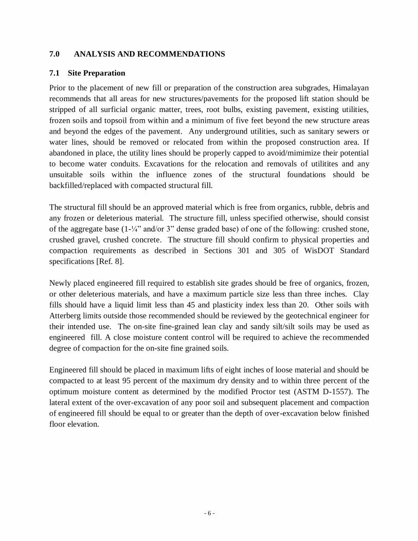
7.0 ANALYSIS AND RECOMMENDATIONS
7.1 Site Preparation
Prior to the placement of new fill or preparation of the construction area subgrades, Himalayan
recommends that all areas for new structures/pavements for the proposed lift station should be
stripped of all surficial organic matter, trees, root bulbs, existing pavement, existing utilities,
frozen soils and topsoil from within and a minimum of five feet beyond the new structure areas
and beyond the edges of the pavement. Any underground utilities, such as sanitary sewers or
water lines, should be removed or relocated from within the proposed construction area. If
abandoned in place, the utility lines should be properly capped to avoid/mimimize their potential
to become water conduits. Excavations for the relocation and removals of utilitites and any
unsuitable soils within the influence zones of the structural foundations should be
backfilled/replaced with compacted structural fill.
The structural fill should be an approved material which is free from organics, rubble, debris and
any frozen or deleterious material. The structure fill, unless specified otherwise, should consist
of the aggregate base (1-¼” and/or 3” dense graded base) of one of the following: crushed stone,
crushed gravel, crushed concrete. The structure fill should confirm to physical properties and
compaction requirements as described in Sections 301 and 305 of WisDOT Standard
specifications [Ref. 8].
Newly placed engineered fill required to establish site grades should be free of organics, frozen,
or other deleterious materials, and have a maximum particle size less than three inches. Clay
fills should have a liquid limit less than 45 and plasticity index less than 20. Other soils with
Atterberg limits outside those recommended should be reviewed by the geotechnical engineer for
their intended use. The on-site fine-grained lean clay and sandy silt/silt soils may be used as
engineered fill. A close moisture content control will be required to achieve the recommended
degree of compaction for the on-site fine grained soils.
Engineered fill should be placed in maximum lifts of eight inches of loose material and should be
compacted to at least 95 percent of the maximum dry density and to within three percent of the
optimum moisture content as determined by the modified Proctor test (ASTM D-1557). The
lateral extent of the over-excavation of any poor soil and subsequent placement and compaction
of engineered fill should be equal to or greater than the depth of over-excavation below finished
floor elevation.

- 7 -
7.2 Foundation Recommendations
7.2.1 Matt Foundation
Based on the proposed base slab elevation (Elevation = 689 feet), the foundation for the wet
well be constrcuted as a matt foundation bearing on hard lean clays and medium dense sandy
silts. A maximum design pressure (net allowable pressure at the footing level) of 2,500 psf is
recommended for design of the matt foundation.
A free draining layer consisting of compacted clear crushed stone fill (clean, containing less than
5% fines with 3/4” to 1” of fractured face) at least 1-foot thick is recommended below the matt
foundation, which will also provide a good working platform. The crushed stones should be
compacted with a hand-guided compactor until no displacement or settlement is observed under
compaction equipment.
A geotextile fabric should be considered to separate the free draining layer from the underlying
subgrade of native silty clays or sandy silts. Construction traffic should not be allowed directly
over these soils. Excavation should be performed by remotely removing the overburden to the
required elevation and then placing the geotextile fabric on the subgrade. The free draining layer
should then be placed over the geotextile thus providing a firm working platform for the
construction equipment. The geotextile fabric should be wrapped around the free draining fill to
prevent/minimize potential contamination by fines from the side walls.
The geotextitle fabric should have the minimum physical properties of WisDOT designated Type
SAS (Subgrade Aggregate Separator) as outlined in Section 645 of the WisDOT Standard
Specifications [Ref. 8].
A value of 200 pci can be used for coefficient of vertical subgrade modulus for design of matt
foundation supported on hard silty clays or medium dense sandy silts. This value (k1) is based
on foundations measuring 1 ft x 1 ft. The final design value for coefficient of subgrade modulus
(ks) should be adjusted based on the actual width of the mat.
Considering the groundwater conditions, the proposed matt foundation should be designed to
withstand hydrostatic uplift forces equal to the depth of the mat below the groundwater table.
Although the resistance to uplift will be provided by the dead weight of the mat, pump and
structural elements, Himalayan recommends that the base of the matt be also oversized extending
at least 18 inches beyond the vertical walls of the lift station to mobilize a greater soil mass
resistance against the uplift (the unit weight of backfill over the base extensions can be used to
estimate this additional uplift resistance). Permanent tie-down anchors may also be considered to
supplement the dead weight resistance.

- 8 -
It is recommended that the joints between the base slab and perimeter retaining walls be outfitted
with water stops to avoid/minimize undesirable seepage. A waterproof membrane should also be
provided below the base slab to prevent condensation.
Provided the matt foundation systems for the wet well are implemented and designed/constructed
in accordance with the recommendations provided in this report, the post construction total and
differential settlements are not expected to exceed 2.0 inch total and 0.75 inch differential
settlement.
7.2.2 Shallow Foundations
Electrical Building
Based on the results of the field investigation from test boring (B-1) placed near the location of
proposed electrical building, field and laboratory testing, and our subsequent analysis, it is
Himalayan’s opinion that suitable soil conditions exist in the project location to support the
proposed building on shallow foundations (spread footings consisting of conventional continuous
strip footings and isolated column footings) bearing on hard lean clays.
Recommended foundation design parameters are listed below:
Maximum gross allowable soil bearing resistance: 3,500 psf
Minimum foundation widths
o Continuous strip footings 18 inches
o Isolated column footings 30 inches
Note that the above footing widths are the minimum values to avoid/minimize the possibility of
punching shear failure even if the recommended bearing resistance is not fully utilized.
The exterior footings and footings in unheated or poorly heated areas should be founded at least
four feet below the finished grade line for adequate frost protection. Interior footings within
heated portions of the building can be located directly below the floor slab. All footings must be
adequately protected from adverse weather conditions during construction. The footing trenches
should be observed, the support soils tested and approved, and the foundations constructed as
soon as possible to avoid exposing the supporting soils to wetting and drying. See Section 8,
Construction Considerations for additional recommendations.
Portion of Retaining Wall not Supported on the Wet Well Walls

- 9 -
Considering the anticipated footing level (Elevation = 708.5 feet), a maximum gross allowable
bearing resistance of 4,000 pounds per square foot (psf) may be used for design of retaining wall
not supported on the wet well walls, based on the results of the field investigation (from test
boring (B-2) placed near the location of the retaining wall) and our analysis.
The footings for the retaining wall should be founded at least four feet below the finished grade
line to avoid the adverse effects of frost penetration.
The foundation support soils within the footing influence zones for electrical building and the
above retaining wall must be tested and approved by a qualified soils engineer prior to
foundation construction to ensure that soils are capable of supporting the design loads and are
consistent with the soils discussed in this report. If unsuitable soils are encountered within the
footing influence zones, Himalayan recommends that these soils be removed to expose the
suitable bearing soils consisting of native lean clays and the footing grades be re-established by
placement of compacted structural fill (see Section 7.1).
Provided the shallow foundation systems for the electrical building are implemented and
designed/constructed in accordance with the recommendations provided in this report, the post
construction total and differential settlements are not expected to exceed 1.0 inch total and 0.5
inch differential settlement. It is recommended that the structures at the above-grade and below-
grade levels be designed to include properly spaced vertical control joints to minimize the effects
of differential settlement.
Similarly, if the retaining wall foundation systems are implemented and designed/constructed in
accordance with the above recommendations, the post construction total and differential
settlements should not exceed 2 inches and angular distortion from differential settlements
should not exceed 1:500 (inch/inch), respectively.
7.3 Below Grade Walls Design Parameters
The wet well walls and retaining walls must be capable of resisting the laterals earth pressures
that will be imposed on them. Walls that will be permitted rotation on top such as exterior
retaining walls may be designed to resist the active lateral earth pressure using the active earth
pressure coefficient Ka. Walls that are likely to be braced against rotating such as the wet well
walls should be designed to resist the at-rest lateral earth pressure using the at-rest earth pressure
coefficient K0.
The passive earth pressure may be considered as the pressure exerted on the side of a foundation,
which aids in resisting sliding of foundation and should be estimated using the passive earth

- 10 -
pressure coefficient, Kp. The Kp value should be divided by an appropriate factor of safety
(usually taken as 2) to limit the amount of lateral deflection to mobilize the passive ressitance.
Table 7-2 provides soil parameters that may be used for earth pressure calculations on below
grade vertical walls with a level backfill surface backfilled with imported granular material.
Table 7-1: Below Grade Wall Design Parameters
Rawson Avenue Lift Station
Milwaukee County, WI
Parameters c
(psf)
ϕ
(deg.)
γ
(pcf) K0 Ka Kp
Friction
Factor,
tanδ
(concrete)
Imported Granular Material 0 34 128 0.44 0.28 3.57 0.47
Existing Fill Materials* 0 28 125 0.53 0.36 2.77 0.30
Notes:
C = cohesion; ϕ = angle of internal friction; γ = Moist Unit Weight, K0 = At-Rest Earth Pressure Coefficient; Ka = Active Earth
Pressure Coefficient; Kp = Passive Earth Pressure Coefficient * Lean clays and silts
The parameters presented in Table 7-1 assume that the granular backfill used behind the wall
consist of one of the following materials: sand, a mixture of sand and gravel, crushed gravel,
crushed stone, crushed concrete, or other fragmented mineral material containing less than 5
percent by weight passing the No. 200 sieve.
The backfill should be compacted to a mimimum of 95 percent of the maximum dry density as
determined by modified Proctor Test, ASTM D-1557 and placed with light equipment (< 500
pounds) to minimize the stresses on the wall. Surcahrge loads within a zone defined by a line
extending from a 45o
angle above the base of the wall should be included in the design. The
below grade walls should be designed using full hydrostatic pressure under the assumption that
the backfill will be fully satrurated (submerged unit weight) in the absence of a drainage system.
A perimeter drainage system at the base of the walls should be provided to relieve the hydrostatic
pressure.
8.0 CONSTRUCTION CONSIDERATIONS
8.1 Construction Inspection
All footing and floor slab excavations and fill placement operations should be inspected and
approved by a geotechnical engineer prior to the placement of concrete or bedding material.
Also, Himalayan recommends that a qualified geotechnical engineer test and document the
engineered fill materials prior to placement. The compaction of all subgrades, embankment

- 11 -
backfill soil and all pavement materials should be tested full time by an experienced soil
technician.
8.2 Moisture Sensitive Soils
Most of the soils encountered in the project are relatively sensitive to disturbances caused by
construction traffic and changes in moisture content. Increases in the moisture content of the soil
can cause significant reduction in soil strength and bearing resistance. Additionally, soils that
become wet may be slow to dry causing significant delays of the grading and compaction
activities. Therefore, consideration should be given to perform earthwork and foundation
activities during dry weather.
8.3 Seepage
Based on the perched groundwater conditions encountred at Elevation =705.4 feet in B-1 and
proposed base slab elevation (Elevation = 689 feet), it is expected that majority of the seepage
will be encountered within the sandy silt soils located between 6 to 13 feet overlying the the low
permeability lean clays. Additional seepage may be encountered from the native sandy silts if
these soils are exposed at the base of the excavation.
Seepage into the excavation can be controlled using properly placed sump and pump system. A
temporary excavation retention system consisting of steel sheet piles could also be used to reduce
the amount of seepage into the sides of the excavation. See Section 8.4 for details.
Water should not be allowed to collect in the foundation excavations, the floor slab, and the
pavement areas or on the prepared subgrades of the construction area either during or after
construction. Positive site drainage should be maintained to reduce infiltration of surface water
around the perimeter of buildings, underneath floor slabs, and within pavement areas. The site
grades should be sloped to direct any collected rain water, groundwater, or surface run off away
from the construction areas.
8.4 Temporary Excavation Retention
Steel sheet piles could be used to provide temporary excavation retention. Based on the soil
information obtained from testing boring B-1 located near the wet well, the sheet piles could be
driven to the sufficient depth into the native silt layer encountered at 38 feet bgs to provide
adequate toe resistance. Due to the expected height of the sheet pile wall, it is anticipated that at
least a single level of anchors will be needed to provide the required stiffness.
The temporary excavation retention system should be designed for the appropriate overburden
pressure, surcharge loadings from construction equipment, laterals pressure, and differential
hydrostatic pressure. The design of the temporary excavation retention system should be
performed by a professional engineer registered in Wisconsin. The soil parameters for the

- 12 -
temporary retention system design (based on soil information obtained from test boring B-1) are
provided in Table C-1 in Appendix C.
The temporary excavation retention system could also be used a seepage cutoff for dewatering of
the excavation.
8.5 Excavations
All excavations must be constructed in accordance with current OSHA guidelines to protect
workers and others during construction. Piles of excavated soil and heavy equipment should not
be permitted closer to the top of any excavation than a distance equal to two times the depth of
the excavation, in order to reduce the possibilities of cave-ins.
The contractor is solely responsible for designing and constructing stable excavations and must
shore, slope, or bench the sides of excavations as required and specified in local, state, and
federal safety regulations. Himalayan does not assume any responsibility for construction site
safety or the contractor’s or other parties’ compliance with local, state, and federal safety or
other regulations.
9.0 LIMITATIONS
Himalayan prepared this report for AECOM and Milwaukeee County to use as part of the
evaluation of the subsurface conditions in the project location. This report was prepared in
accordance with the current guidelines and currently accepted geotechnical engineering
practices as conducted within the site region by similar qualified consultants. Because the
evaluation is based upon subsurface physical data obtained from soil borings only at specific
locations and time and only to the depths sampled, the report does not reflect potential variations
in the subsurface conditions that could occur between or beyond the limits of the test borings that
were used for analysis. The conclusions or recommendations contained represent our
professional opinions. No warranty or guarantee is expressed or implied. If variations are
encountered and/or the project scope is altered, further evaluation and testing should be
performed by a geotechnical engineer.
10.0 REFERENCES
1. A. F. Schneider (July 1983). Wisconsin Stratigraphy and Glacial Sequence in Southeastern
Wisconsin, Geoscience Wisconsin, Volume 7, UW-Parkside, Kenosha, Wisconsin.
2. F. C. Foley, W.C. Walton, and W. J. Drescher (1953). Ground-Water Conditions in the
Milwaukee-Waukesha Area, Wisconsin, Geological Survey Water-Supply Paper 1229, U.S.
Government Printing Office, Washington.

- 13 -
3. United States Department of Agriculture Natural Resources Conservation Service. URL:
http://websoilsurvey.nrcs.usda.gov/app/WebSoilSurvey.aspx
4. ASTM International (1992). Method for Penetration Test and Split Barrel Sampling of Soils.
5. Wisconsin Department of Natural Resources (March 2011). Wisconsin Administratrive Code
NR 141.
6. Southeastern Wisconsin Regional Planning Commission (June 2002). Groundwater
Resources of Southeastern Wisconsin, Technical Report No. 37, Map 21.
7. Wisconsin Enrolled Commercial Building Code (2001). Section 1615: Earthquake Loads –
Site Ground Motion.
8. Wisconsin Department of Transportation, Standard Specifications for Highway and Structure
Construction, 2013 Edition.

- 14 -
Appendix A Figures
Figure 1: Project Area Location Map
Figure 2: Boring Location Map
Appendix B Soil Boring Logs
Unified Soil Classification System
Symbols and Terminology
Appendix C Temporary Excavation Retention System Design Parameters

APPENDIX A
FIGURES

Figure
1Project AreaLocation Map
Project ID No: V025-13807
Hwy: W. Rawson Avenue
Source:
Milwaukee County Automated
Mapping and Land Information
System (MCAMLIS) 2010
Scale: 1 inch = 500 FEET
Himalayan Consultants, LLCEngineers and Hydrogeologists
W156 N11357 Pilgrim Road
Germantown, Wisconsin 53022
Phone: (262) 502-0066
Fax: (262) 502-0066

Figure
LEGENDBORING (B-X)
Figure
2Base Map Provided By Milwaukee County
Boring Location MapProject ID No: V025-13807
Hwy: W. Rawson Avenue (CTH BB)
Graphic Scale
1 inch = 50 feet
Himalayan Consultants, LLCEngineers and HydrogeologistsW156 N11357 Pilgrim RoadGermantown, Wisconsin 53022Phone: (262) 502-0066Fax: (262) 502-0066

APPENDIX B
SOIL BORING LOGS

Symbols and Terminology
Symbols
Drilling and Sampling Field and Laboratory Tests
HAS = Hollow Stem Auger
HA = Hand Auger
SS = Split Spoon Sampler
2ST = 2” diameter Thin-Walled Tube Sample
3ST = 3” diameter Thin-Walled Tube Sample
NX = Rock Core 2-1/8” diameter
AS = Auger Sample
WS = Wash Sample
PTS = Peat Sample
PS = Pitcher Sample
NR = No Recovery
PMT = Borehole Pressuremeter Test
VS = Vane Shear Test
WPT = Water Pressure Test
WOH = Weight of Hammer
WOR = Weight of Rod
= Water Level
NW = No Water Encountered
PID = Photo-Ionization Reading, parts per million
qest = Pocket Penetrometer Reading, tons/sq.ft.
W = Moisture Content, %
LL = Liquid Limit, %
PL = Plastic Limit, %
SL = Shrinkage Limit, %
LI = Loss on Ignition, %
DD = Dry Unit Weight, lbs/cu.ft.
pH = Measure of Alkalinity or Acidity
FS = Free Swell, %
γ = Moist Unit Weight, lbs/cu.ft.
Terminology
Grain Size Relative Proportion
Soil Fraction Size Range Proportional Term % by Weight
Boulders > 12” Trace 0% - 5%
Cobbles 3” – 12” Little 5% - 12%
Gravel Some 12% - 35%
Coarse 3/4” – 3” And 35% - 50%
Fine #4 Sieve 3/4” Plasticity
Sand Term Plasticity Index
Coarse #4 - #10 Sieve None to Slight 0 – 4
Medium #10 - #40 Sieve Slight 5 – 7
Fine #40 - #200 Sieve Medium 8 – 22
Silt 100% passing #200 Sieve & > 0.005 mm Medium to Very High Over 22
Clay 100 % passing #200 Sieve & < 0.005 mm
Relative Density Consistency
Term “N” Value Term qest – tons/sq.ft.
Very Loose 0-4 Very Soft 0.00 – 0.25
Loose 4-10 Soft 0.25 – 0.50
Medium Dense 10-30 Medium 0.50 – 1.00
Dense 30-50 Stiff 1.00 – 2.00
Very Dense Over 50 Very Stiff 2.00 – 4.00
Hard Over 4.00

UNIFIED SOIL CLASSIFICATION SYSTEM (ASTM D-2487)
Typical Namesla
rger
than
No.
4 si
eve
size)
(Mor
e th
an h
alf o
f cou
rse
frac
tion
issm
alle
r tha
n N
o. 4
siev
e siz
e)
SP
Group Symbols
Major Divisions
Cour
se g
rain
ed so
ils(M
ore
than
hal
f of m
ater
ial i
s lar
ger t
han
No.
200
siev
e siz
e)Gr
avel
sSa
nds
(Mor
e th
an h
alf o
f cou
rse
frac
tion
is
Clea
n gr
avel
s(L
ittle
or n
o fin
es)
Grav
els w
ith fi
nes
(App
reci
able
am
ount
of fi
nes)
GW
GP
GC
GMad
u
SW
Clea
n sa
nds
(Litt
le o
r no
fines
)Sa
nds w
ith fi
nes
(App
reci
able
am
ount
of fi
nes)
Silts
and
cla
ys
(Liq
uid
limit
grea
ter t
han
50)
Fine
gra
ined
soils
(Mor
e th
an h
alf m
ater
ial i
s sm
alle
r tha
n N
o. 2
00 si
eve)
High
lyor
gani
cSi
lts a
nd c
lays
(Liq
uid
limit
less
than
50)
soils
Poorly graded sands, gravelly sands, little or no fines
ML
CL
OL
MH
CH
OH
Pt
SMad
u
SC
Inorganic clays of high plasticity, fat clays
Organic clays of medium to high plasticity, organic silts
Peat and other highly organic soils
Dete
rmin
e pe
rcen
tage
s of s
and
and
grav
el fr
om g
rain
size
cur
veDe
pend
ing
on p
erce
ntag
e of
fine
s (fr
actio
n sm
alle
r tha
n N
o. 2
00 si
eve
size)
, cou
rse
Silty sands, sand-silt mixtures
Clayey sands, sand-clay mixtures
Inorganic silts and very fine sands, rock flour, silty or clayey fine sands or clayey silts with slight plasticity
Inorganic clays of low to medium plasticity, gravelly clays, sandy clays, silty clays, lean clays
Organic silts and organic silty clays of low plasticity
Inorganic silts, micaceous or diatoma-ceous fine sandy or silty soils, elastic silts
Well-graded gravels, gravel-sand mix-tures, little or no fines
Poorly graded gravels, gravel-sand mix-tures, little or no fines
Silty gravels, gravel-sand-silt mixtures
Clayey gravels, gravel-sand-clay mix-tures
Well-graded sands, gravelly sands, little or no fines
B
orde
rline
cas
es re
quiri
ng d
ual s
ymbo
ls
Laboratory Classification Criteria
Not meeting all gradation requirements for GW
Atterberg limits below "A" line or P.I. less than 4
Atterberg limits below "A" line with P.I. greater than 7
soils
are
cla
ssifi
ed a
s fol
low
s:
Les
s tha
n 5
perc
ent
M
ore
than
12
perc
e
b Borderline classifications: used for soils possessing characteristics of two groups; are designated by combinations of group symbols. For example:GW-GC, well-graded gravel-sand mixture with clay binder
greater than 4;
between 1 and 3
greater than 6;
between 1 and 3
a Division of GM and SM groups into subdivisions of d and u are for roads and airfields only. Subdivision is based on Atterberg limits; suffix d usedwhen L.L. is 28 or less and the P.I. is 6 or less; the suffix u used when L.L. is greater than 28
Above "A" line with P.I> between 4 and 7 are borderline cases requiring use of dual symbols
Not meeting all gradation requirements for SW
Atterberg limits above "A" line or P.I. less than 4
Atterberg limits above "A" line with P.I. greater than 7
Limits plotting in hatched zone with P.I. between 4 and 7 are borderline cases requiring use of dual symbols
5
to 1
2 pe
rcen
t
G
W, G
P, S
W, S
P
GM
, GC,
SM
, SC
10
60
DDCu =
( )6010
230
DDDCc ×
=
10
60
DDCu =
( )6010
230
DDDCc ×
=
10
60
DDCu =
( )6010
230
DDDCc ×
=

0
5
10
15
20
25
30
1
2
3
4
5
6
7
8
SS
SS
SS
SS
SS
SS
SS
SS
18"
12"
18"
18"
18"
18"
18"
18"
M
M
M
M
M
W
W
W
17
24
27
24
25
22
20
12
TOPSOIL 3-INCHLEAN CLAY (CL): Hard, mottledbrown to gray, moist, tracegravel
SANDY SILT (ML) : Medium dense,gray, moist, trace gravel
LEAN CLAY (CL): Hard, gray,moist, trace gravel
SANDY SILT (ML) : Medium Dense,gray, moist to wet, trace gravel
LEAN CLAY (CL): Hard, gray, moistto wet, trace gravel
4.5+
4.5+
4.5+
15
15
11
LOG OF TEST BORINGBoring No. B-1
Project Rawson Avenue Lift Station Surface Elevation 720.86
Oak Creek Job No. 13051.030
Location Milwaukee County, WI Sheet 1 of
Himalayan Consultants, L.L.C.
P.O. Box 693 Germantown, WI 53022 Tel.: (262) 502-0066 Fax: (262) 502-0077
WATER LEVEL OBSERVATIONS GENERAL NOTESWhile Drilling 19 ft Start 8/15/13 Complete 8/15/13Upon Completion of Drilling 15.5 ft Crew Chief DZ Rig ATV
Time After Drilling Drilling Method: 3-1/4 INCH HSA
Depth to Water Split Spoons
Depth to Cave-in 32 FT
NOTE: Soil stratification lines represent approximate boundaries between soil types and transitions may be gradual.
No.
SAMPLE
Typ
e
Rec
ov.
Moi
st.
N-V
alue
Dep
th(f
t.)VISUAL CLASSIFICATION
and Remarksqest(qu)tsf
SOIL PROPERTIES
W%
LL PLDDpcf
PID
2

35
40
45
50
55
60
65
70
9
10
11
12
SS
SS
SS
SS
18"
18"
18"
18"
M
W
M
M
41
33
45
25
SILT (ML) : Dense to mediumdense, gray, moist, trace gravel
End of Boring = 50.0 FeetBorehole abandoned with bentonitechips
4.5+
4.5+
2.5
23
16
LOG OF TEST BORINGBoring No. B-1
Project Rawson Avenue Lift Station Surface Elevation 720.86
Oak Creek Job No. 13051.030
Location Milwaukee County, WI Sheet 2 of
Himalayan Consultants, L.L.C.
P.O. Box 693 Germantown, WI 53022 Tel.: (262) 502-0066 Fax: (262) 502-0077
NOTE: Soil stratification lines represent approximate boundaries between soil types and transitions may be gradual.
No.
SAMPLE
Typ
e
Rec
ov.
Moi
st.
N-V
alue
Dep
th(f
t.)VISUAL CLASSIFICATION
and Remarksqest(qu)tsf
SOIL PROPERTIES
W%
LL PLDDpcf
PID
2

0
5
10
15
20
25
30
1
2
3
4
5
6
7
8
SS
SS
SS
SS
SS
SS
SS
SS
18"
18"
18"
18"
18"
18"
18"
18"
M
M
M
M
M
M
M
M
18
14
17
19
13
10
19
22
SANDY CLAY (FILL/CL) : MediumDensse, brown, moist
LEAN CLAY (CL) : Very stiff tohard, mottled browm to gray,moist, trace gravel
4.5+
4.5+
4.5+
2.0
2.75
2.5
2.25
17
17
19
18
19
16
16
LOG OF TEST BORINGBoring No. B-2
Project Rawson Avenue Lift Station Surface Elevation 731.18
Oak Creek Job No. 13051.030
Location Milwaukee County, WI Sheet 1 of
Himalayan Consultants, L.L.C.
P.O. Box 693 Germantown, WI 53022 Tel.: (262) 502-0066 Fax: (262) 502-0077
WATER LEVEL OBSERVATIONS GENERAL NOTESWhile Drilling 39 ft Start 8/15/13 Complete 8/15/13Upon Completion of Drilling N/A Crew Chief DZ Rig ATV
Time After Drilling Drilling Method: 3-1/4 INCH HSA
Depth to Water Split Spoons
Depth to Cave-in 30 FT
NOTE: Soil stratification lines represent approximate boundaries between soil types and transitions may be gradual.
No.
SAMPLE
Typ
e
Rec
ov.
Moi
st.
N-V
alue
Dep
th(f
t.)VISUAL CLASSIFICATION
and Remarksqest(qu)tsf
SOIL PROPERTIES
W%
LL PLDDpcf
PID
2

35
40
45
50
55
60
65
70
9
10
11
12
13
14
15
SS
SS
SS
SS
SS
SS
SS
18"
18"
18"
18"
18"
18"
6"
M
W
M
W
M
M
M
25
12
24
36
34
30
27
SILT (ML) : Medium dense, gray,wet, trace gravel
LEAN CLAY (CL) : Very stiff tohard, gray, moist, trace gravel
End of Boring = 65.0 FeetBorehole abandoned with bentonitechips
4.5+
3.5
3.5
4.5+
4.5+
12
17
22
14
16
LOG OF TEST BORINGBoring No. B-2
Project Rawson Avenue Lift Station Surface Elevation 731.18
Oak Creek Job No. 13051.030
Location Milwaukee County, WI Sheet 2 of
Himalayan Consultants, L.L.C.
P.O. Box 693 Germantown, WI 53022 Tel.: (262) 502-0066 Fax: (262) 502-0077
NOTE: Soil stratification lines represent approximate boundaries between soil types and transitions may be gradual.
No.
SAMPLE
Typ
e
Rec
ov.
Moi
st.
N-V
alue
Dep
th(f
t.)VISUAL CLASSIFICATION
and Remarksqest(qu)tsf
SOIL PROPERTIES
W%
LL PLDDpcf
PID
2
Appendix C
TEMPORARY EXCAVATION RETENTION
SYSTEM DESIGN PARAMETERS

Table C-1
Temporary Excavation Retention System Design Parameters Rawson Avenue Lift Station
Milwaukee County, WI
Layer Approx.
Depth
(ft)
Soils
Description
Moist
Unit
Weight
(pcf)
Submerged
Unit Weight
(pcf)
Undrained
Shear
Strength
(psf)
Drained Shear
Strength
Interface
Friction
Angle
(Steel)
(deg.)
Adhesion
(Steel)
(psf)
Earth Pressure
Coefficient
Cohesion,
c’ (psf)
Friction
Angle,
φ’ (deg.)
Active,
Ka
Passive,
Kp*
1 0-6 Hard Lean Clay 130 67.6 4,500 150 28 N/A 750 0.36 1.4
2 6-13 Medium Dense
Sandy Silt
130 67.6 N/A 0 32 11 N/A 0.31 1.6
3 13-19 Hard Lean Clay 130 67.6 4,500 150 28 N/A 750 0.36 1.4
4 19-32 Medium Dense
Sandy Silt
130 67.6 N/A 0 30 11 N/A 0.33 1.5
5 32-38 Hard Lean Clay 135 72.6 4,500 150 28 N/A 750 0.36 1.4
6 38-50 Dense Silt 135 72.6 N/A 0 35 11 N/A 0.27 1.8
Notes Estimated ground water depth = 15.5 ft. Submerged unit weight should be used to calculate the effective pressure below groundwater depth.
*A factor of safety of 2 is applied to passive pressure coefficients due to the large strains required to mobilize the full passive resistance.
N/A = Not Applicable, ft = feet, psf = pounds per square foot; pcf = pounds per cubic foot.


