Geospatial Technologies Application for Water Resources ... · Fig.5. Result sheet with image by...
16
Geospatial Technologies Application for Water Resources Management in Taiwan Yu-Sheng Lin Hsin-Yung Hsiao Jing-Dan Ho Zheng-Dao Xie Mei-Hsin Chen Tien-Yin Chou Abstract Water resources management is a significant issue in Taiwan because of the extensive mountain areas, vulnerable geological structures, short and rapid river flows, inconsistent precipitation, and difficulties in water storage and resource allocation. This article describes how to apply ESRI ArcIMS, ArcGIS series, and self-developed components to develop the relative management application systems for the central government agencies. WMS and WFS were combined with the application to share the water conservation information to other public agencies needed. The hybrid mode Web GIS systems were designed for providing spatial queries for flood area calculations, debris flow location, river bank locating piles, display DEM charts, concatenate construction data between different organizations by service oriented architecture that also provided users fast browsing and useful GIS functionalities, which can be an essential tool of decision supporting for water resource conversation policy makers. Keywords: Water resources management, Hybrid mode Web GIS Presentation Will Feature the Following ESRI Software ArcInfo, ArcIMS
Transcript of Geospatial Technologies Application for Water Resources ... · Fig.5. Result sheet with image by...

Geospatial Technologies Application for Water
Resources Management in Taiwan
Yu-Sheng Lin Hsin-Yung Hsiao Jing-Dan Ho
Zheng-Dao Xie Mei-Hsin Chen Tien-Yin Chou
Abstract
Water resources management is a significant issue in Taiwan because of the extensive mountain areas, vulnerable geological structures, short and rapid river flows, inconsistent precipitation, and difficulties in water storage and resource allocation. This article describes how to apply ESRI ArcIMS, ArcGIS series, and self-developed components to develop the relative management application systems for the central government agencies. WMS and WFS were combined with the application to share the water conservation information to other public agencies needed. The hybrid mode Web GIS systems were designed for providing spatial queries for flood area calculations, debris flow location, river bank locating piles, display DEM charts, concatenate construction data between different organizations by service oriented architecture that also provided users fast browsing and useful GIS functionalities, which can be an essential tool of decision supporting for water resource conversation policy makers. Keywords: Water resources management, Hybrid mode Web GIS Presentation Will Feature the Following ESRI Software ArcInfo, ArcIMS

1. Introduction In the recent years, the requirements to GIS applications have
been constantly increased in the whole world; GIS technologies and applications are relatively upgraded. We considered that users can’t feel satisfied with only a simple map browser; opened internet applications have replaced desktop versions, complicate GIS query methods are not suitable for most people, humble user-interface can’t attract end users anymore; web browsers (especially the Internet Explorer, Fire Fox, Chrome… etc) are embedded in most desktops. Based on the above considerations, we implement our study as Web-Based GIS Systems. End users can freely enter our GIS applications using a general web browser without any extra plug-ins.
We apply ESRI ArcIMS to be the GIS service provider, ESRI
ArcInfo to be the GIS tool. Moreover, we develop several components to operate GIS services, to visualize user interfaces, to enhance web GIS performance, and so on.
In our study, we bring up a hybrid mode web GIS application. We
provide a static cached map which is similar with WMTS to make users fast browsing maps. Moreover, basic or complicate GIS queries are combined in our applications. Not only the query result data sheets, but also visualized GIS graphs are displayed in our applications. 2. Architecture of our implementation We apply ESRI ArcMap to set map styles and then generate mxd files to be the configuration files. Next, we develop our component to operate ArcObject to generate maps, which are formed as common image format such like jpg, png, gif…etc. Moreover, we generate those maps as many different scales. By the customized issue, we maybe generate the maps as 10 scales, which includes 1/5K, 1/10K, 1/25K, 1/50K, 1/100K, 1/250K, 1/500K, 1/1000K, 1/2500K and 1/5000K. For different requirement, we can generate different amount of scales.

We apply ESRI ArcIMS to be the Dynamic image generator. The dynamic image includes dynamic layers, customized images (we use acetate layers to request ArcIMS map services). However, as the flexibility aspect, our feature operating methods are hybrid mode. We use ArcIMS’s GET_FEATURE related functions to meet that the data sources are shapefiles or ArcSDE; we use our self-developed components to operate SQL server 2008 spatial when shapefiles or ArcSDE is not available. At the negotiation phase between client scripts and our component, our component plays the role to listen and response for client; on the other hand, the client scripts send requests to our component and maps.
3. Main features of our study

We apply our study to many water resource applications, several cases of our study are listed as the following sections. 3.1 Our customized spatial queries Spatial query --- Authority of basin land management
According to current frame of national (Taiwan) land plan, different attributes or classes of basin land are involved with several laws and regulations. The land may not only belong to “hill area” but also belong to “Indigenous peoples preserved land” and “National landscape area”. To generate the relationship between spatial data and monitoring messages, we apply our study to link laws and regulations database, spatial database and reservoir monitoring database. After integrating these databases, users can get laws and regulations information for specific queries.
Reservoir and basin area land management authority info sheet
Main Management Unit Related Layers
Ministry of Economic
Affairs
Water Resources
Bureaus Reservoir area
Water Resources
Agency River land
Ministry Of Interior National Park Administration
Office National park area
Ministry Of
Transportation And
Communications
Directorate General of
Highways Basin road system
Tourism Bureau National landscape area
Council of Agriculture,
Executive Yuan
Soil and Water Conservation
Bureau Mountain hill area
Forestry Bureau National forest area
Taiwan Forestry Research
Institute Experiment forest area
Council of Indigenous Peoples, Executive Yuan Indigenous peoples reserved
land area
Base on the management aspect, we provide related
information for users. Users can overlay several topic layers to set
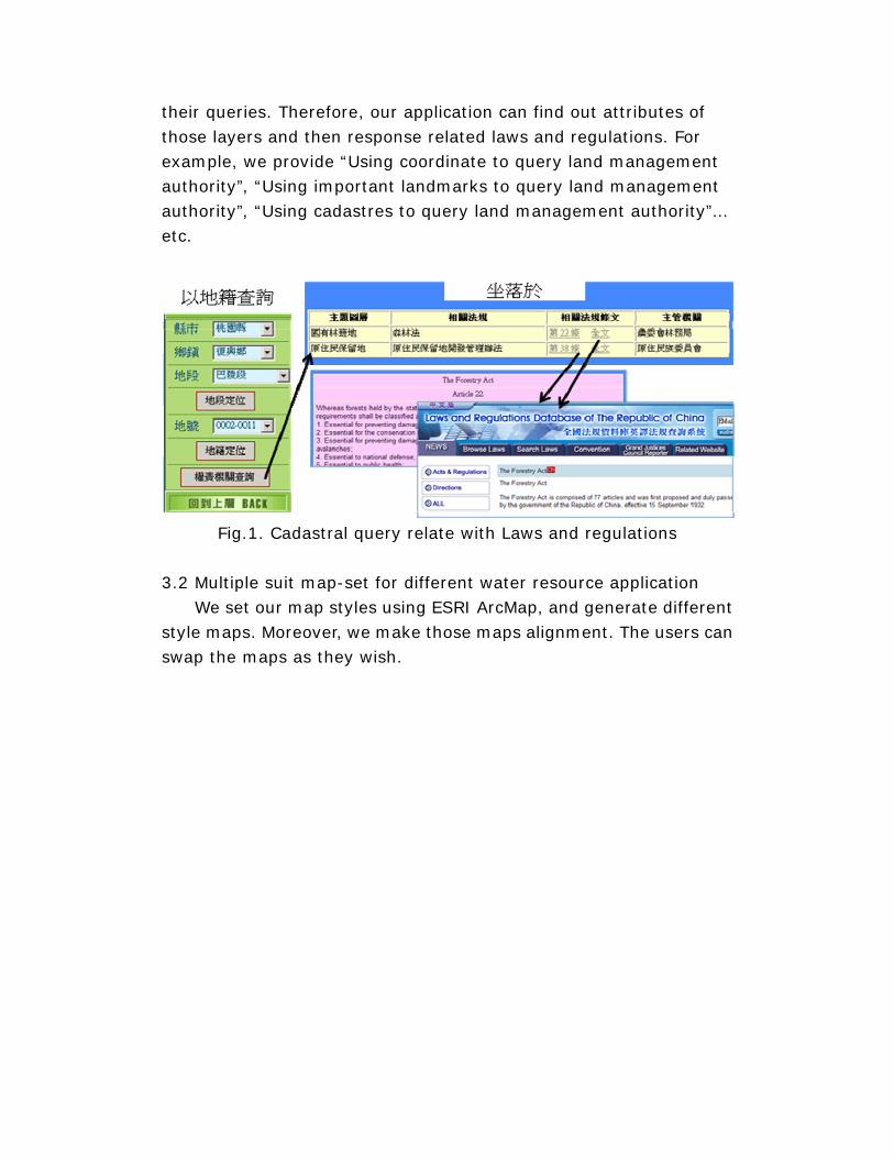
their queries. Therefore, our application can find out attributes of those layers and then response related laws and regulations. For example, we provide “Using coordinate to query land management authority”, “Using important landmarks to query land management authority”, “Using cadastres to query land management authority”… etc.
Fig.1. Cadastral query relate with Laws and regulations
3.2 Multiple suit map-set for different water resource application We set our map styles using ESRI ArcMap, and generate different style maps. Moreover, we make those maps alignment. The users can swap the maps as they wish.

Fig.2. Map – named electronic map
Fig.3. Map – Satellite map

Fig.4. Map – electronic map combined with satellite
4.3 Using web service to include complicate spatial queries to support water resource management For the purpose to let the applications which are not composed as GIS systems to simply include GIS functionalities, we provide web services to be the GIS service broker. As the following image, the relay web service is based on ESRI ArcIMS map service, providing “GetImage”, “GetIfIntersected” and “GetAttribute”… etc methods. Message format is using ArcXML between our web service and ArcIMS server; on the side, message is formed as streams between web service and client applications. The main methods of the web service are listed in the followings:

1. GetImage Method:input envelop and response image
Parameters: Host: ArcIMS Server host name or IP ServiceName: ArcIMS Service name MinX: minimal X of the envelop MinY: minimal Y of the envelop MaxX: Maximum X of the envelop MaxY: Maximum Y of the envelop ImageWidth: returned image width in pixel ImageHeight: returned image height in pixel Return value: encoded with Base64Encode binary data
2. GetIfIntersected Method:input coordinate and return whether
inside the specific layer Parameters: Host: ArcIMS Server host name or IP ServiceName: ArcIMS Service name LayerIdList: query target layer list, formed as "LayerId1, LayearId2, …" Xcoord: X coordinate Ycoord: Y coordinate Return value: query result list, formed as "N,Y,E,…", Y as inside the layer, N as not and E as exceptions.
3. GetAttribute Method: input coordinate and return layer attributes Parameters: Host: ArcIMS Server host name or IP ServiceName: ArcIMS Service name LayerId: query target layer ID FieldName: target layer’s attributes field name Xcoord: X coordinate Ycoord: Y coordinate Return value: returns “Y,{field value}” if the input coordinate is inside the layer, on the other hand, “N,{field value} for not”; if exception occurs, “E,{error message}” is returned

One of our implementation is to generate estimating sheets for constructions. Using this web service to combine with GPS position, our application can generate the construction’s map and determine whether the construction is inside the govern business area (i.e. mountain hill protection area, flooding area, basin area… etc). Moreover, our application can also gather the related geological information of the constructions (i.e. debris flow id, cadastre number, river name, detail basin info… etc).
Fig.5. Result sheet with image by integrated web service
4.4 Generate DEM chart to support debris flow management
Landforms are critical information for debris flow management. Fig. 1 is a function users are easy to view a DEM chart by choosing any two points. A decision maker can easily understand the profile of debris, rivers, tumble or etc. In this function, we separate 50 points between the two points chosen by users and send "<GET_RASTER_INFO>" requests to ArcIMS asking the altitude at each point (Fig. 6). But a "<GET_RASTER_INFO>" request can get only one pixel value, there are 50 requests would be sent for drawing one chart.

Fig.6. A profile between two points
Fig.7. Generate a profile by getting altitudes from ArcIMS
4.5 Flexible and fine map layout
The users usually hope the map layout containing information as many as possible and fitting their own layout. We design a flexible map layout enabling users to attach, resize and position images, such like Fig. 8. Moreover, we add popular geography information usually drawn on maps, coordinate grid line, which is
ASP.NET ArcXML
GET_RASTER_INFO * 50 ArcIMS
DEM

not provided by ArcIMS directly. But the acetate layer is very powerful in ArcIMS to customize the layout. In Fig. 9, an acetate layer draw hollow square to shape the map and to create the empty space for customized information, like the title, creating date, institute mark and coordinate numbers. There are two key points, the customized information position and the gap of coordinate lines, in this format. To calculate customized information positions should consider font size and map layout size (A0~A4). A suitable distance between two coordinate lines should be found. If the distance is too small, the map will be crossed by many lines and will become complex to read. If the distance is too large user will be not easy to estimate the XY of a specific location on the map.
Fig.8. Map layout setting page
Attach Images

Fig.9. Customized map layout
4.6 Migration analysis Inconsistent precipitation in Taiwan often makes lots of tumble area. We apply our study to develop some systems to display migration analysis for users to see different years’ tumble area. Moreover, users can use this application to consider that the tumble area recuperating job is whether good.

Fig.10. Migration analysis for tumble area 4.7 Collecting information and sharing in real time
In Taiwan, most of rainfall is in summer. A lot of rain disasters will be happened, especially in typhoon. To decrease these disasters, monitoring rainfall in real time becomes an important job for river bureau. In Fig. 11, we design a functionality allowing users showing pluviometers or flow meters on ArcIMS and opening real-time rainfall information by clicking them.

Fig.11. Pluviometer
4.8 Customized spatial tools for river bureau, i.e. riverbank constructions In our study, we provide editing tools to create, to delete and to modify features. Here is an example to assist users to manage their riverbank constructions which need to set piles. Users can add new piles, delete piles, automatic calculate length and elevation, locate, save information and generate reporting sheets.
Click to get real-time rainfall

Fig.12. Feature operating tool for riverbank constructions
5. Conclusion We integrate several ESRI software and technologies to build applications for water resource management via web.
We deeply trust that web GIS application is the best way to share, to display and to easily support end users. Combining web GIS applications with Rich Internet Application (RIA) is a good method to rise up user’s interest. Showing 3D maps is a big requirement of common users.
In conclusion, users need not only the functionalities but also the surface. This is always under our consideration.
* References
1. Tim Bray, Jean Paoli, C. M. Sperberg-McQueen, Eve Maler and François Yergeau; Extensible Markup Language (XML) 1.0 (Third Edition) W3C Recommendation 04 February 2004.
2. Panagiotis A. Vretanos; OGC Web Feature Service Implementation Specification, 3 May 2005.

3. OpenGIS Web Map Service (WMS) Implementation Specification, http://www.opengeospatial.org/standards/wms
4. GIS LOUNGE; Web-based GIS, http://gislounge.com/ll/webgis.shtml. 5. ESRI; Knowledge Base - Technical Articles, http://support.esri.com/index.cfm?fa=knowledgebase.techarticles.browseFilter&p=16&pf=0 6. OpenGIS Web Processing Service, Peter Schut, OGC 05-007r7, version 1.0.0, June 6, 2007. 7. Candidate OpenGIS Web Map Tiling Service Implementation Standard, Joan Maso, Keith Pomakis and Nuria Julia, OGC 07-057r6, version 0.6.0, Feb 26, 2009.
* Author Information
(name, title, organization, address, telephone and fax numbers, e-mail address) Yu-Sheng Lin, Senior System Engineer, GIS Research Center, Feng Chia University, No.100 Wenwha RD, Taichung City, Taiwan, R.O.C., 886-4-2451-6669 ext.608, fax: 886-4-2451-9278, [email protected] Zheng-Dao Xie, Chief, Taipei Water Management Office, WRA, MOEA, 5F., No.5, Ln. 45, Sec. 1, Beisin Rd., Sindian City, Taipei County 231, Taiwan (R.O.C.), 886-2-2917-3281, fax: 886-2-2918-0335, [email protected] Hsin-Yung Hsiao, System Engineer, GIS Research Center, Feng Chia University, No.100 Wenwha RD, Taichung City, Taiwan, R.O.C., 886-4-2451-6669 ext.609, fax: 886-4-2451-9278, [email protected] Jing-Dan Ho, Senior System Engineer, GIS Research Center, Feng Chia University, No.100 Wenwha RD, Taichung City, Taiwan, R.O.C., 886-4-2451-6669 ext.608, fax: 886-4-2451-9278, [email protected] Mei-Hsin Chen, Department Manager, GIS Research Center, Feng Chia University, No.100 Wenwha RD, Taichung City, Taiwan, R.O.C., 886-4-2451-6669 ext.600, fax: 886-4-2451-9278, [email protected] Tien-Yin Chou, President, GIS Research Center, Feng Chia University, No.100 Wenwha RD, Taichung City, Taiwan, R.O.C., 886-4-2451-6669 ext.100, fax: 886-4-2451-9278, [email protected]


![Landforms Mady By Wind [Desert Landforms]](https://static.fdocuments.net/doc/165x107/56813971550346895da1066c/landforms-mady-by-wind-desert-landforms.jpg)