
Geospatial Engineering Overview - Esri: GIS Mapping … · · 2012-10-08Geospatial Engineering...
21
US Army Corps of Engineers BUILDING STRONG ® Geospatial Engineering Overview Jason C. Fairchild, P.E. CAD/BIM/GIS Team Lead Engineering and Construction, HQUSACE March 14, 2012
Transcript of Geospatial Engineering Overview - Esri: GIS Mapping … · · 2012-10-08Geospatial Engineering...
US Army Corps of Engineers BUILDING STRONG®
Geospatial Engineering Overview
Jason C. Fairchild, P.E. CAD/BIM/GIS Team Lead Engineering and Construction, HQUSACE
March 14, 2012
BUILDING STRONG® 4/30/2012
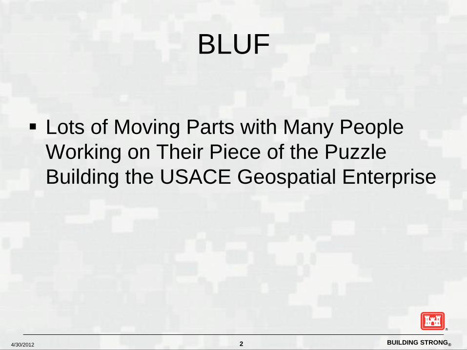
BLUF
Lots of Moving Parts with Many People
Working on Their Piece of the Puzzle Building the USACE Geospatial Enterprise
2

BUILDING STRONG® 4/30/2012
Topics
Geospatial Engineering and the Geospatial CoP Internal Governance Structure and the
USACE Geospatial Oversight Committee Coordination with DoD and Federal
Agencies
3

BUILDING STRONG® 4/30/2012
The 18 Sub-Communities & Leaders
Architecture – Chris Hinton-Lee (SAD) CAD/BIM (multi-discipline) – Jason Fairchild (HQ) Civil Engineering – Paul Dicker Construction Management – Paul Parsoneault Cost Engineering - Ray Lynn Dam Safety – Travis Tutka Electrical & Electronic Engineering - Bob Billmyre Engineering Management – Bruce Ware Fire Protection - Vacant Geospatial - Nancy Blyler Geotechnical and Materials – Joe Koester Hydrology, Hydraulics and Coastal (HH&C) - Jerry Webb Levee Safety – Tammy Comforti Mechanical – Tim Gordon/Thomas Jamieson Security Engineering - Vacant Specifications - Pete Rossbach Structural - Pete Rossbach Value Engineering – Jeff Hooghouse
About the E&C CoP - Leadership
BUILDING STRONG® 4/30/2012
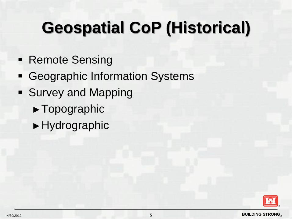
Geospatial CoP (Historical)
Remote Sensing Geographic Information Systems Survey and Mapping
►Topographic ►Hydrographic
5

Geospatial Engineering Framework Integrating GIS, CAD, BIM, RS and Survey Technologies
Presenter
Presentation Notes
GIS consists of five key components: Hardware (computers, printers, etc.) Software (ArcGIS, ArcIMS, MapInfo, etc.) Data (shapefiles, coverages, geodatabases, aerial photography, etc.) People (you and me) Method (map creation, presentation, implementation, etc.)
BUILDING STRONG® 4/30/2012
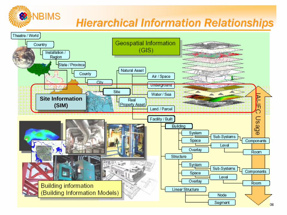
Site Information (SIM)

BUILDING STRONG®
Key Components to a Geospatial Engineering Framework
Consistent - Standard Data Sets and Models ► Spatial Data Standards for Infrastructure and Environment (SDSFIE) ► A/E/C CAD and BIM Data Standards ► Enables the concept of “collect once and use many times”
Accessible - Easy Access to Authoritative Data Sources ► Data is consistent, unambiguous, and exploitable by any business
function or organizational element ► Integrated with and Available through CorpsMap, the USACE Enterprise
GIS Sustainable - Integrating Geospatial Technology into Business Line
Workflow to Maintain Information and Give Users Access to Technology and Tools ► Policy ► Standard Tools and Applications
BUILDING STRONG® 4/30/2012 9
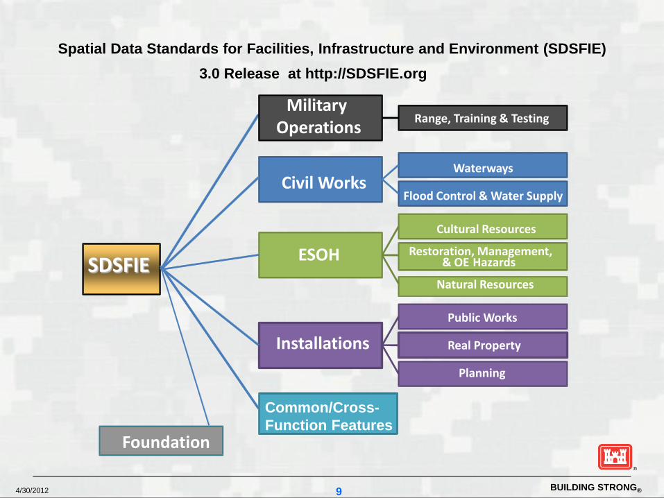
Spatial Data Standards for Facilities, Infrastructure and Environment (SDSFIE) 3.0 Release at http://SDSFIE.org
SDSFIE
Military Operations
Civil Works
ESOH
Installations
Common/Cross- Function Features
Foundation
Range, Training & Testing
Waterways
Flood Control & Water Supply
Cultural Resources Restoration, Management,
& OE Hazards
Real Property
Planning
Public Works
Natural Resources

BUILDING STRONG® 4/30/2012
CorpsMap
What is CorpsMap? - CorpsMap Web Viewer - CorpsMap Database; Authoritative Data Source - Geospatial Component to Many Automated Information System’s
https://corpsmap.usace.army.mil
BUILDING STRONG® 4/30/2012
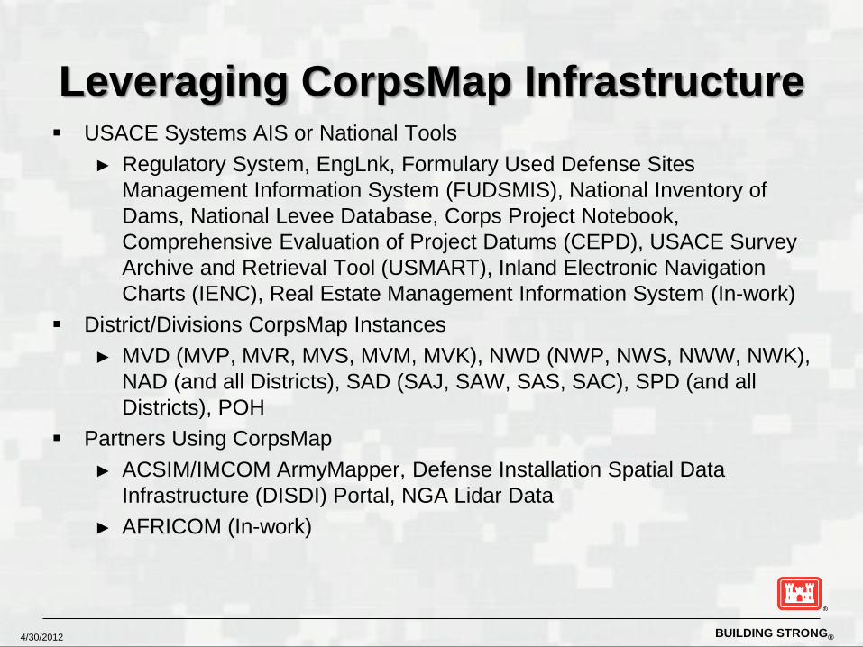
Leveraging CorpsMap Infrastructure USACE Systems AIS or National Tools
► Regulatory System, EngLnk, Formulary Used Defense Sites Management Information System (FUDSMIS), National Inventory of Dams, National Levee Database, Corps Project Notebook, Comprehensive Evaluation of Project Datums (CEPD), USACE Survey Archive and Retrieval Tool (USMART), Inland Electronic Navigation Charts (IENC), Real Estate Management Information System (In-work)
District/Divisions CorpsMap Instances ► MVD (MVP, MVR, MVS, MVM, MVK), NWD (NWP, NWS, NWW, NWK),
NAD (and all Districts), SAD (SAJ, SAW, SAS, SAC), SPD (and all Districts), POH
Partners Using CorpsMap ► ACSIM/IMCOM ArmyMapper, Defense Installation Spatial Data
Infrastructure (DISDI) Portal, NGA Lidar Data ► AFRICOM (In-work)

BUILDING STRONG®
Making Geospatial Engineering a Reality
Software and technology interoperability Adding CAD/BIM language to Geospatial ER
and EM Establishing Geospatial Service
Section/Branches at District Offices Establishing high level support at HQ
BUILDING STRONG® 4/30/2012
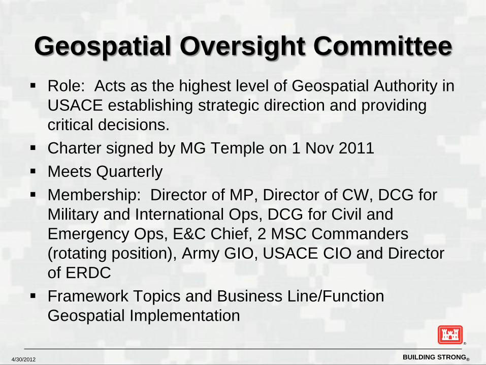
Geospatial Oversight Committee Role: Acts as the highest level of Geospatial Authority in
USACE establishing strategic direction and providing critical decisions.
Charter signed by MG Temple on 1 Nov 2011 Meets Quarterly Membership: Director of MP, Director of CW, DCG for
Military and International Ops, DCG for Civil and Emergency Ops, E&C Chief, 2 MSC Commanders (rotating position), Army GIO, USACE CIO and Director of ERDC
Framework Topics and Business Line/Function Geospatial Implementation
BUILDING STRONG® 4/30/2012
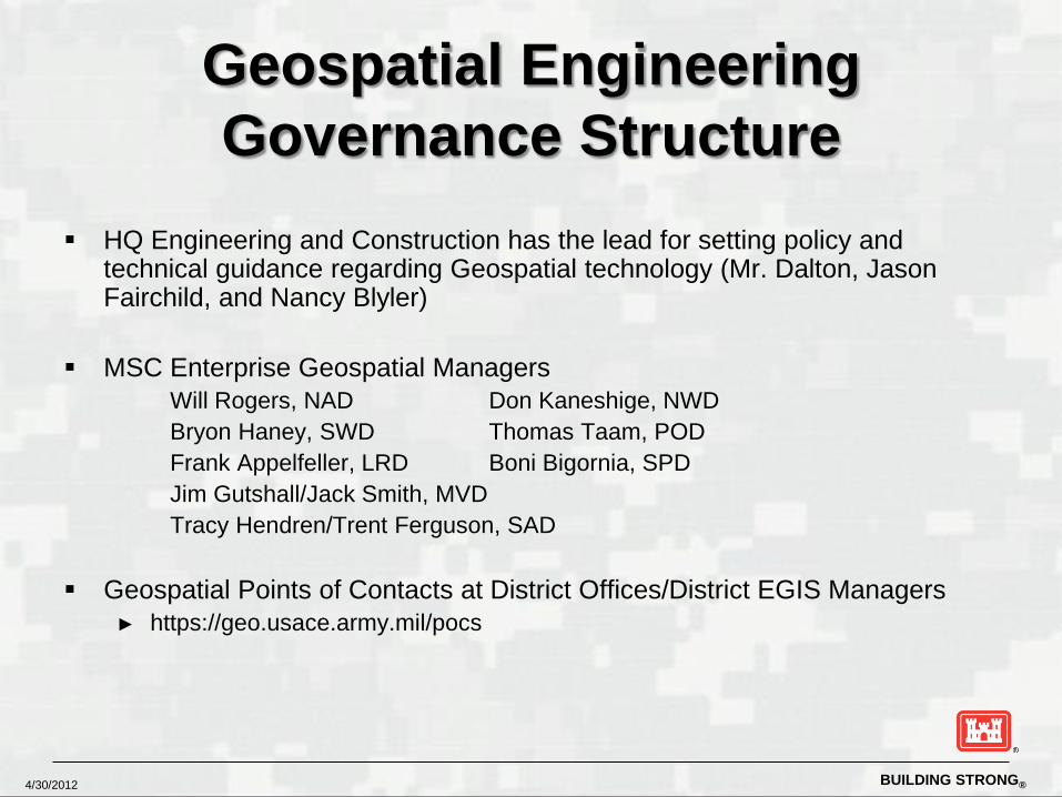
Geospatial Engineering Governance Structure
HQ Engineering and Construction has the lead for setting policy and
technical guidance regarding Geospatial technology (Mr. Dalton, Jason Fairchild, and Nancy Blyler)
MSC Enterprise Geospatial Managers Will Rogers, NAD Don Kaneshige, NWD Bryon Haney, SWD Thomas Taam, POD Frank Appelfeller, LRD Boni Bigornia, SPD Jim Gutshall/Jack Smith, MVD Tracy Hendren/Trent Ferguson, SAD
Geospatial Points of Contacts at District Offices/District EGIS Managers ► https://geo.usace.army.mil/pocs

BUILDING STRONG® 4/30/2012
EGIS Governance Structure (Cont’d)
ACE-IT Geospatial CoP Representative – Mary Martin ► Geospatial Community, ACE-IT, CE-CI MOA Defining Roles and
Responsibilities
CECI Geospatial CoP Representative – Doug Hemsley
CorpsMap Team ► Mike Smith (lead), Joel Schlagel, Amy Stender, BAH Contractors
SDSFIE
► AGC, Lisa Delmonico (Contracting Officer Representative)
ESRI ELA ► AGC, Ashley Talley (Contracting Officer Representative)
BUILDING STRONG® 4/30/2012
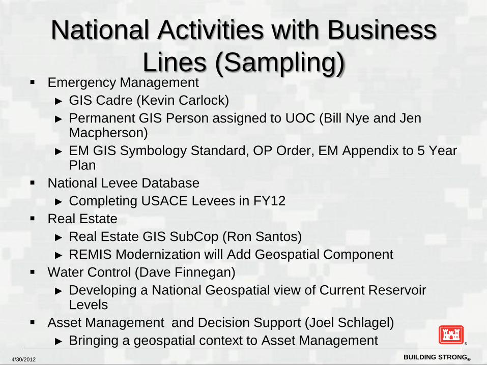
National Activities with Business Lines (Sampling)
Emergency Management ► GIS Cadre (Kevin Carlock) ► Permanent GIS Person assigned to UOC (Bill Nye and Jen
Macpherson) ► EM GIS Symbology Standard, OP Order, EM Appendix to 5 Year
Plan National Levee Database
► Completing USACE Levees in FY12 Real Estate
► Real Estate GIS SubCop (Ron Santos) ► REMIS Modernization will Add Geospatial Component
Water Control (Dave Finnegan) ► Developing a National Geospatial view of Current Reservoir
Levels Asset Management and Decision Support (Joel Schlagel)
► Bringing a geospatial context to Asset Management

BUILDING STRONG® 4/30/2012
Coordination with other Federal Agencies
Defense Installation Spatial Data Infrastructure Group (DISDIG) ► Dave LaBranche (OSD) leads the group ► HQUSACE a member along with Army, Navy, Air Force and
Marines ► Strong supporter of the Spatial Data Standards and committed to
moving standards into the DoD enterprise standards arena.
Federal Geographic Data Committee ► Mr. Dalton is USACE Senior Representative ► Nancy Blyler is primary USACE liaison to FGDC ► Numerous Subcommittees and Working Groups
BUILDING STRONG® 4/30/2012
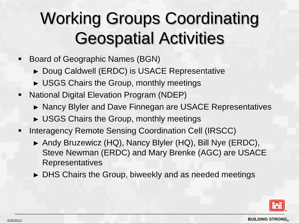
Working Groups Coordinating Geospatial Activities
Board of Geographic Names (BGN) ► Doug Caldwell (ERDC) is USACE Representative ► USGS Chairs the Group, monthly meetings
National Digital Elevation Program (NDEP) ► Nancy Blyler and Dave Finnegan are USACE Representatives ► USGS Chairs the Group, monthly meetings
Interagency Remote Sensing Coordination Cell (IRSCC) ► Andy Bruzewicz (HQ), Nancy Blyler (HQ), Bill Nye (ERDC),
Steve Newman (ERDC) and Mary Brenke (AGC) are USACE Representatives
► DHS Chairs the Group, biweekly and as needed meetings
BUILDING STRONG® 4/30/2012
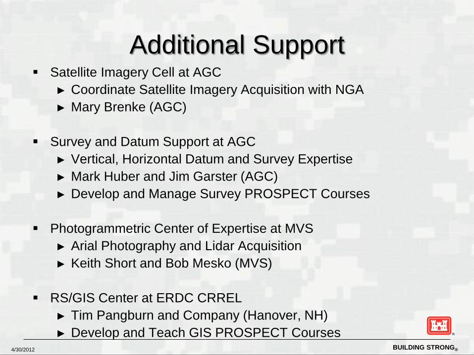
Additional Support Satellite Imagery Cell at AGC
► Coordinate Satellite Imagery Acquisition with NGA ► Mary Brenke (AGC)
Survey and Datum Support at AGC
► Vertical, Horizontal Datum and Survey Expertise ► Mark Huber and Jim Garster (AGC) ► Develop and Manage Survey PROSPECT Courses
Photogrammetric Center of Expertise at MVS ► Arial Photography and Lidar Acquisition ► Keith Short and Bob Mesko (MVS)
RS/GIS Center at ERDC CRREL
► Tim Pangburn and Company (Hanover, NH) ► Develop and Teach GIS PROSPECT Courses

BUILDING STRONG® 4/30/2012
Communication
CDL-GDS-POC-List ► CDL of all District/Division/ERDC Geospatial POC’s in USACE
[email protected] ► Open to anyone in USACE. To join, send an email to Merland
Halisky. “Monthly” Technical Exchange Web Meetings Geospatial Sub Community hosted on the Technical Exchange
Network (TEN) Site
… more to come
BUILDING STRONG® 4/30/2012
Jason Fairchild Geospatial Engineering Team Lead Engineering and Construction, HQUSACE [email protected] Nancy Blyler Geospatial Coordinator Engineering and Construction, HQUSACE [email protected]
Questions ???


![PART HEARD MATTERS [PERSONAL APPEARANCE CASES] · sunny choudhary[impl], santosh a kumar - i[impl], plr chambers and co.[impl], m. p. vinod[impl], g. prakash[impl][gr] {mention memo}](https://static.fdocuments.net/doc/165x107/5eca55a2c38f4e40c93e9850/part-heard-matters-personal-appearance-cases-sunny-choudharyimpl-santosh-a.jpg)


