Geophysics in INSPIRE - CASczechgeo.ig.cas.cz/data/MFGI_GeophysicsInINSPIRE.pdf · Geophysics in...
23
Geophysics in INSPIRE László Sőrés PhD MFGI, TWG-GE/MR Data Specification Technical Workshop Prague 2017.06.08-09
Transcript of Geophysics in INSPIRE - CASczechgeo.ig.cas.cz/data/MFGI_GeophysicsInINSPIRE.pdf · Geophysics in...

Geophysics in INSPIRELászló Sőrés PhD
MFGI, TWG-GE/MR
Data Specification Technical Workshop
Prague
2017.06.08-09
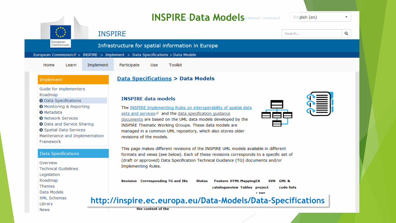
http://inspire.ec.europa.eu/Data-Models/Data-Specifications
INSPIRE Data Models
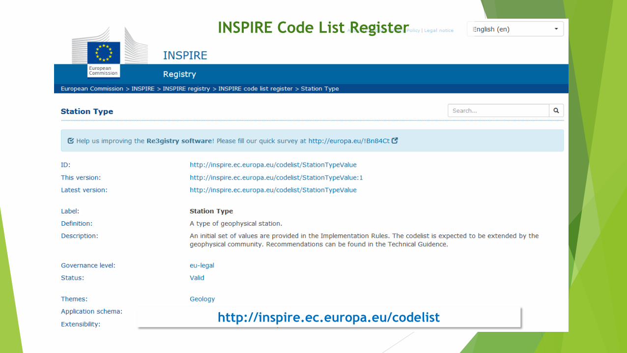
INSPIRE Code List Register
http://inspire.ec.europa.eu/codelist
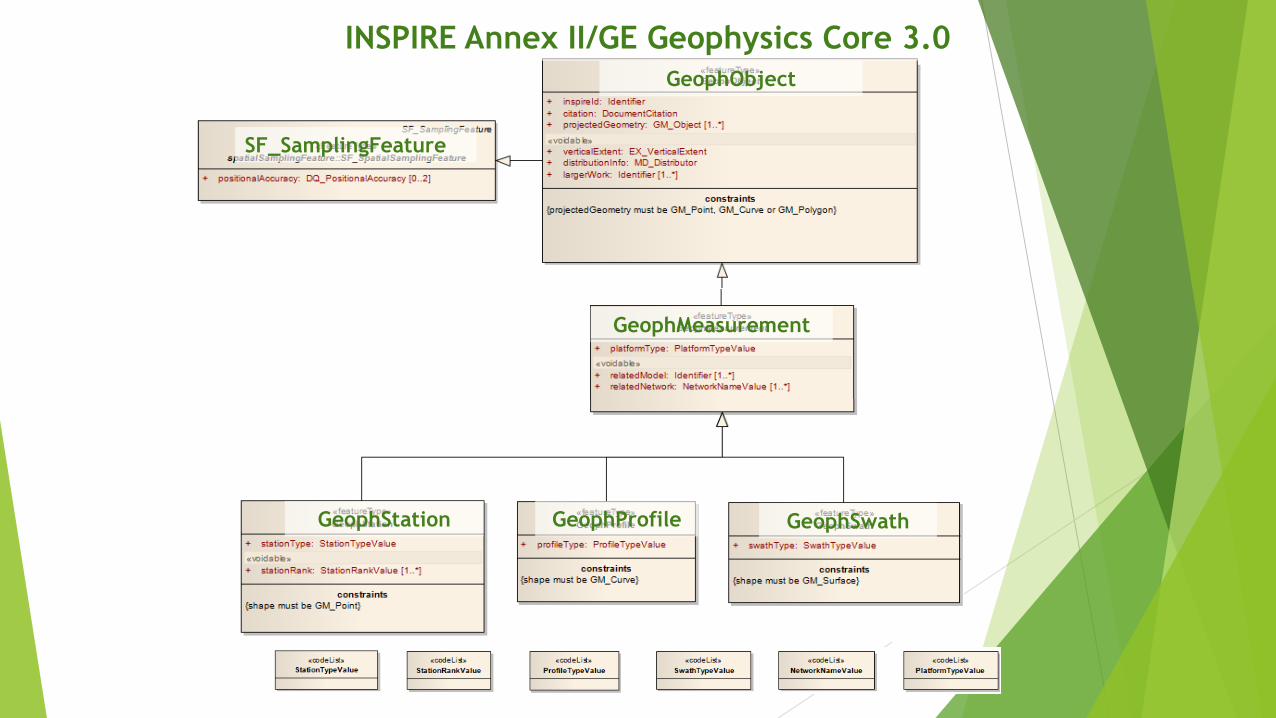
SF_SamplingFeature
GeophObject
GeophMeasurement
GeophStation GeophProfile GeophSwath
INSPIRE Annex II/GE Geophysics Core 3.0
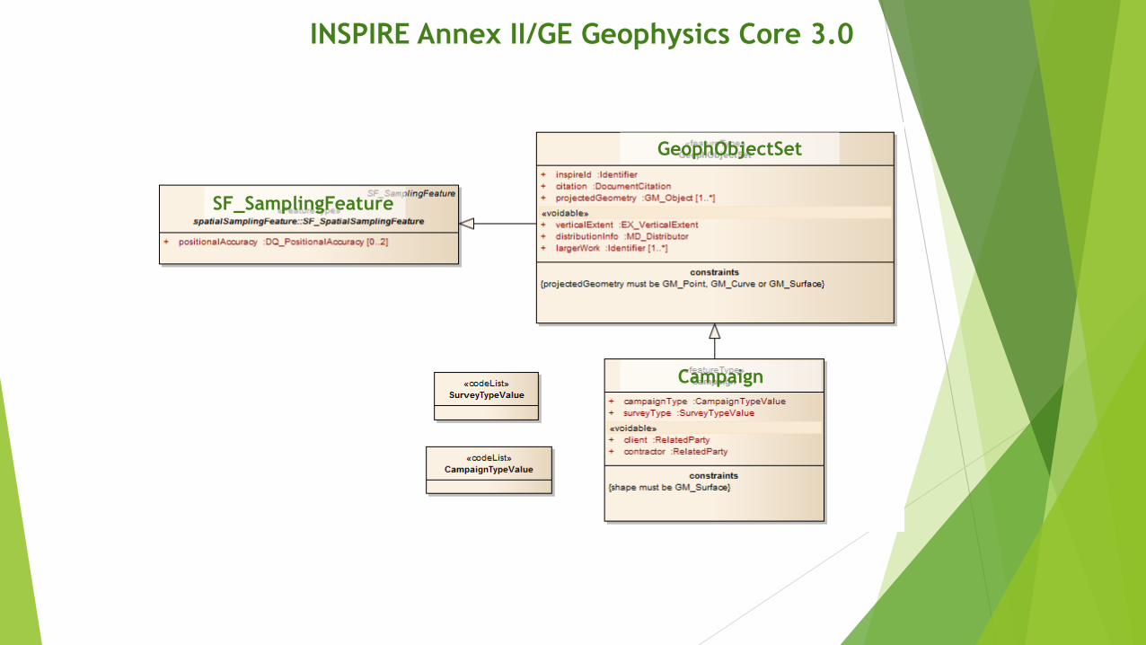
INSPIRE Annex II/GE Geophysics Core 3.0
GeophObjectSet
SF_SamplingFeature
Campaign

Geophysical Station• Gravity Station (observatory, 1st, 2nd order base stations)
• Magnetic Station (observatory, 1st, 2nd order base stations)
• Seismological Station (observatory, 1st, 2nd order base stations)
• Magnetotelluric Soundings (MT)
• Vertical Electric Soundings (VES)
Geophysical Profile• Seismic Line
• Borehole logging
• Multielectrode DC Profile
Geophysical Swath• 3D Seismics
Campaign• Airborne geophysical survey
• Ground gravity survey
• Ground magnetic survey
• Seismological survey
INSPIRE Legal Level (Obligations)
21/10/2015
Newly collected and extensively restructured
Annex II and III spatial data sets available
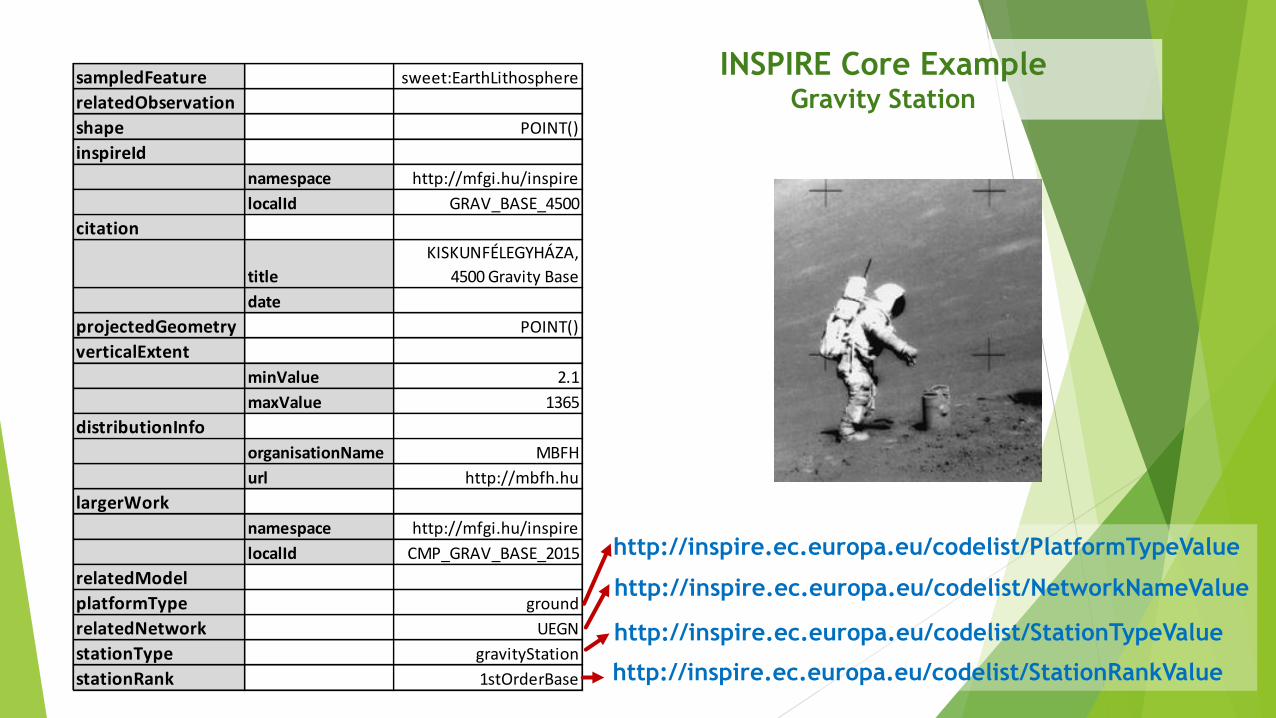
sampledFeature sweet:EarthLithosphere
relatedObservation
shape POINT()
inspireId
namespace http://mfgi.hu/inspire
localId GRAV_BASE_4500
citation
title
KISKUNFÉLEGYHÁZA,
4500 Gravity Base
date
projectedGeometry POINT()
verticalExtent
minValue 2.1
maxValue 1365
distributionInfo
organisationName MBFH
url http://mbfh.hu
largerWork
namespace http://mfgi.hu/inspire
localId CMP_GRAV_BASE_2015
relatedModel
platformType ground
relatedNetwork UEGN
stationType gravityStation
stationRank 1stOrderBase http://inspire.ec.europa.eu/codelist/StationRankValue
http://inspire.ec.europa.eu/codelist/StationTypeValue
http://inspire.ec.europa.eu/codelist/NetworkNameValue
http://inspire.ec.europa.eu/codelist/PlatformTypeValue
INSPIRE Core ExampleGravity Station
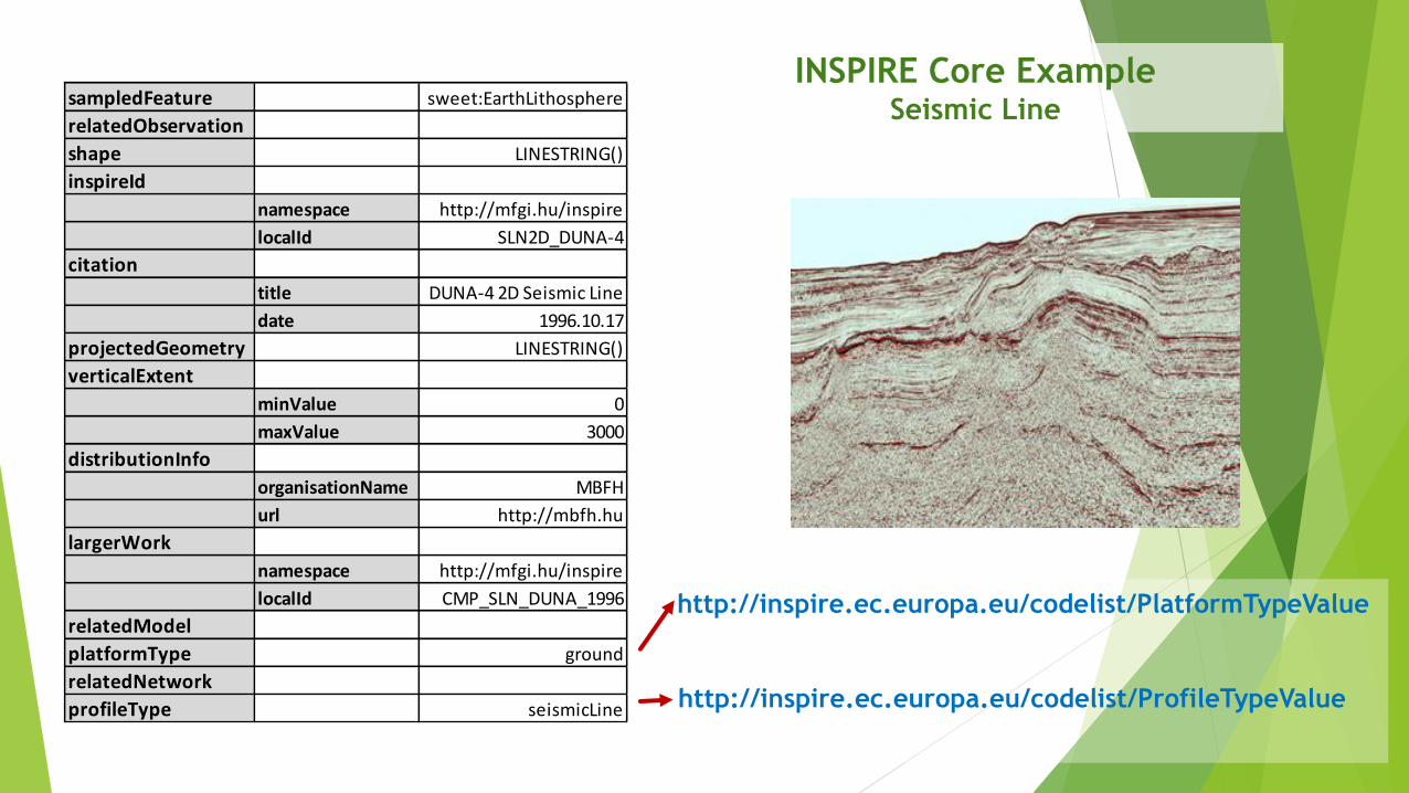
sampledFeature sweet:EarthLithosphere
relatedObservation
shape LINESTRING()
inspireId
namespace http://mfgi.hu/inspire
localId SLN2D_DUNA-4
citation
title DUNA-4 2D Seismic Line
date 1996.10.17
projectedGeometry LINESTRING()
verticalExtent
minValue 0
maxValue 3000
distributionInfo
organisationName MBFH
url http://mbfh.hu
largerWork
namespace http://mfgi.hu/inspire
localId CMP_SLN_DUNA_1996
relatedModel
platformType ground
relatedNetwork
profileType seismicLine http://inspire.ec.europa.eu/codelist/ProfileTypeValue
http://inspire.ec.europa.eu/codelist/PlatformTypeValue
INSPIRE Core ExampleSeismic Line

INSPIRE Annex II/GE Geophysics Extension 3.0
GeophMeasurement (core)
The “official” extension ge_gp.xsd schema (2.0) is outdated and wrong. Do
not use it! Instead use O&M with appropriate MD_Metadata elements
OtherGeophMeasurement
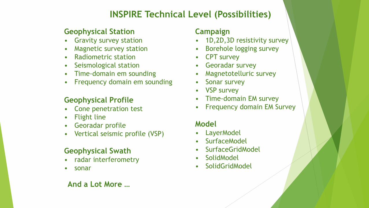
INSPIRE Technical Level (Possibilities)
Geophysical Station• Gravity survey station
• Magnetic survey station
• Radiometric station
• Seismological station
• Time-domain em sounding
• Frequency domain em sounding
Geophysical Profile• Cone penetration test
• Flight line
• Georadar profile
• Vertical seismic profile (VSP)
Geophysical Swath• radar interferometry
• sonar
And a Lot More …
Campaign• 1D,2D,3D resistivity survey
• Borehole logging survey
• CPT survey
• Georadar survey
• Magnetotelluric survey
• Sonar survey
• VSP survey
• Time-domain EM survey
• Frequency domain EM Survey
Model• LayerModel
• SurfaceModel
• SurfaceGridModel
• SolidModel
• SolidGridModel

http://geonetwork.mfgi.hu/InspireLayersStyleGeophysics.html
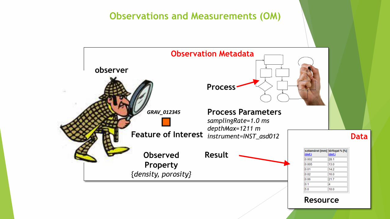
GRAV_012345
observer
Feature of Interest
Process
ResultObserved
Property{density, porosity}
Process ParameterssamplingRate=1.0 ms
depthMax=1211 m
instrument=INST_asd012
Observation Metadata
Resource
Data
Observations and Measurements (OM)
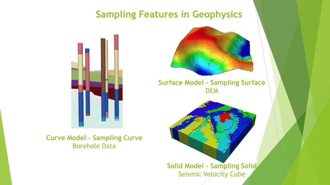
Curve Model - Sampling Curve
Borehole Data
Surface Model - Sampling Surface
DEM
Solid Model - Sampling Solid
Seismic Velocity Cube
Sampling Features in Geophysics
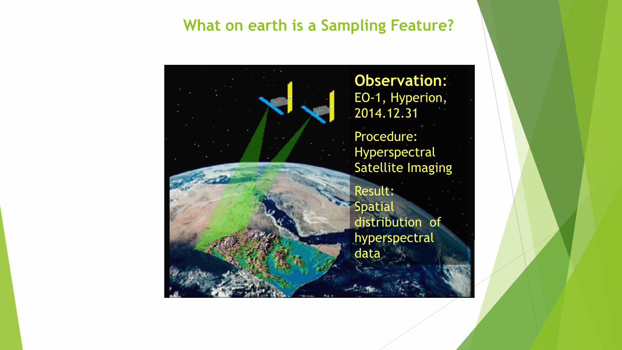
What on earth is a Sampling Feature?
Observation: EO-1, Hyperion,
2014.12.31
Procedure:
Hyperspectral
Satellite Imaging
Result:
Spatial
distribution of
hyperspectral
data
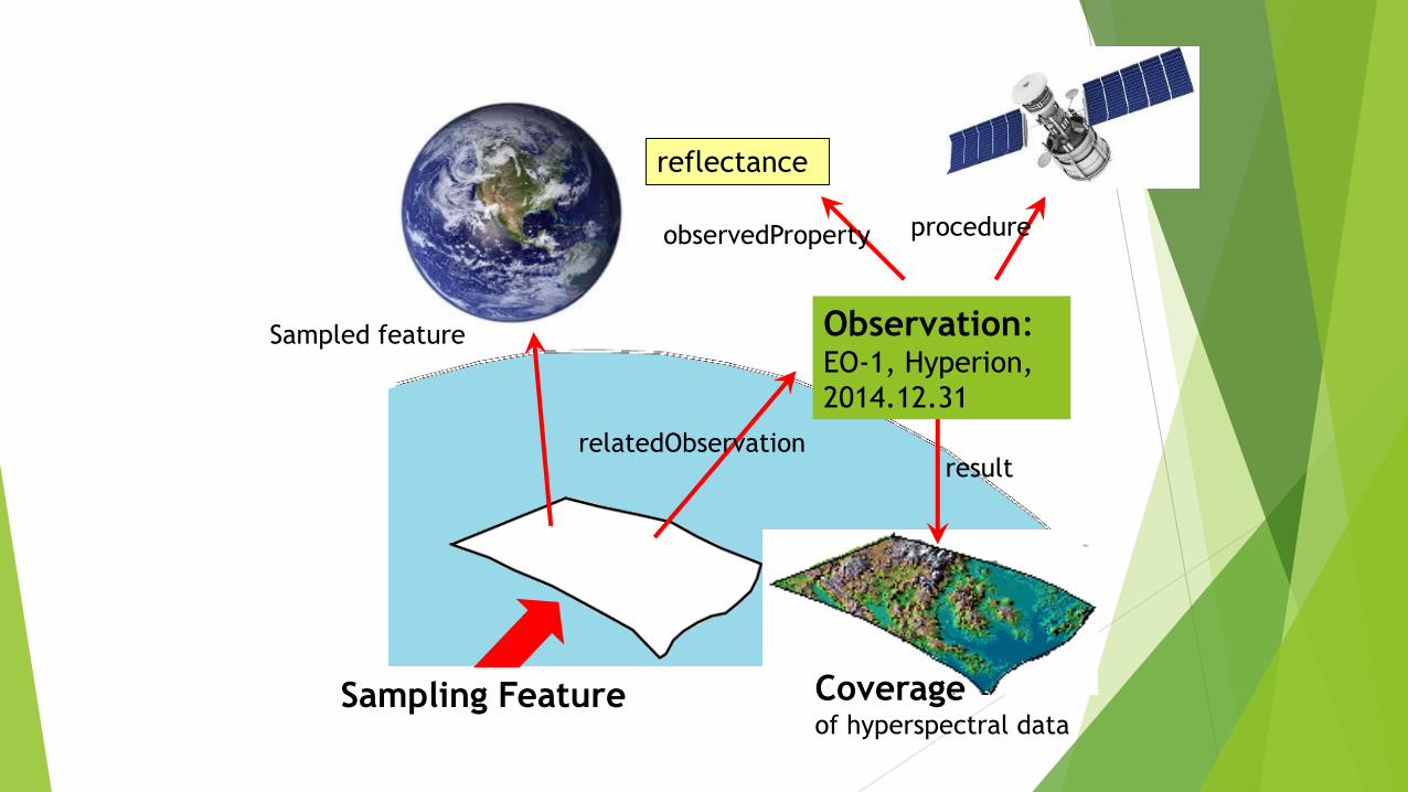
Coverageof hyperspectral data
Observation: EO-1, Hyperion,
2014.12.31
result
procedureobservedProperty
reflectance
Sampled feature
relatedObservation
Sampling Feature
Sampling
Feature
Observation ResourceresultRelated
Observation
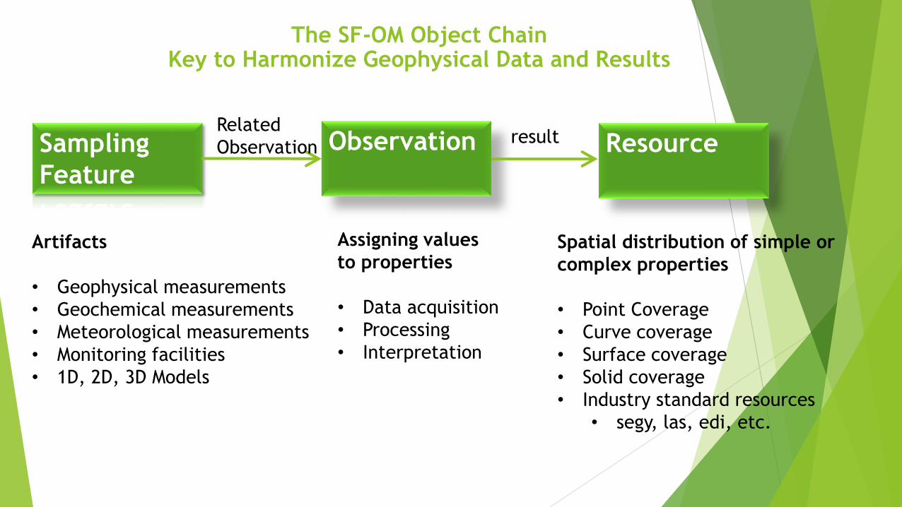
Artifacts
• Geophysical measurements
• Geochemical measurements
• Meteorological measurements
• Monitoring facilities
• 1D, 2D, 3D Models
Assigning values
to properties
• Data acquisition
• Processing
• Interpretation
Spatial distribution of simple or
complex properties
• Point Coverage
• Curve coverage
• Surface coverage
• Solid coverage
• Industry standard resources
• segy, las, edi, etc.
The SF-OM Object ChainKey to Harmonize Geophysical Data and Results
GeophModel
CurveModel SolidGridModel
SurfaceGridModel OtherGephModel
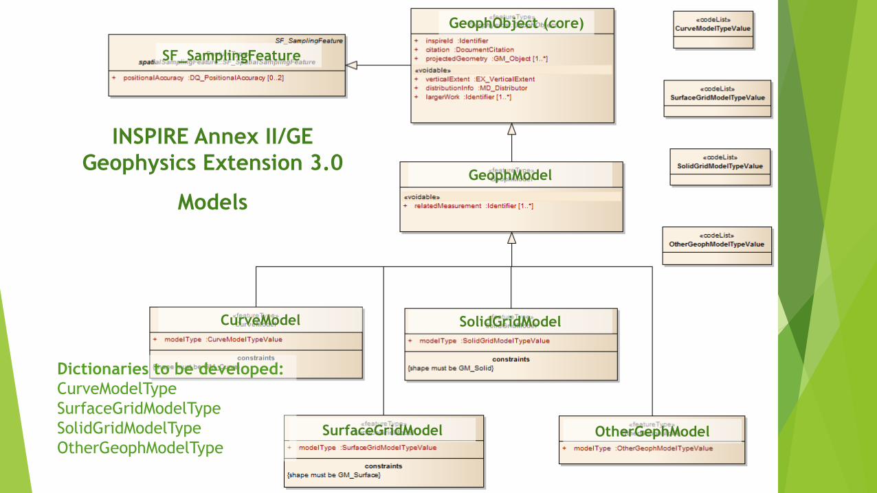
INSPIRE Annex II/GE
Geophysics Extension 3.0
Models
GeophObject (core)
SF_SamplingFeature
Dictionaries to be developed:
CurveModelType
SurfaceGridModelType
SolidGridModelType
OtherGeophModelType
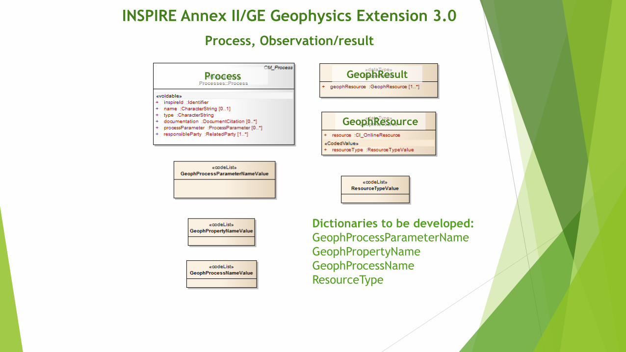
GeophResource
GeophResultProcess
INSPIRE Annex II/GE Geophysics Extension 3.0
Process, Observation/result
Dictionaries to be developed:
GeophProcessParameterName
GeophPropertyName
GeophProcessName
ResourceType
INSPIRE Extension Example - SurfaceGridModel
sampledFeature sweet:EarthLithosphere
relatedObservation http://mfgi.hu/inspire/OBS_SGM_GRD_Resistivity10.1
relatedObservation http://mfgi.hu/inspire/OBS_SGM_GRD_Resistivity10.2
shape POLYGON(())
inspireId
namespace http://mfgi.hu/inspire
localId SGM_GRD_Resistivity10
citation
title Resistivity Distribution in NW Hungary at 10 m depth
date 2004.12.17
projectedGeometry POLYGON(())
verticalExtent
minValue 7
maxValue 15
distributionInfo
organisationName MFGI
url http://mfgi.hu
largerWork
namespace http://mfgi.hu/inspire
localId CMP_GRD_Resistivity.hu
relatedMeasurement
modelType horizontalParameterGrid
Inversion
Interpolation

identifier http://mfgi.hu/inspire/OBS_SGM_GRD_Resistivity10.1
name 1D Inversion
featureOfInterest http://mfgi.hu/inspire/SGM_GRD_Resistivity10
observedPorperty resistivity
phenomenonTime 2004-10-28T10:00:00.0
resultTime 2004-10-29T10:00:00.0
parameter inversionType="single"
parameter inversionMethod="marquardt"
process http://mfgi.hu/inspire/PRC_1D_ResistivityInversion
result
resource SGM_GRD_Resistivity10.dat
INSPIRE Extension Example - Observations
Observation – 1D Inversion
Observation – Interpolationidentifier http://mfgi.hu/inspire/OBS_SGM_GRD_Resistivity10.2
name Interpolation
featureOfInterest http://mfgi.hu/inspire/SGM_GRD_Resistivity10
observedPorperty resistivity
phenomenonTime 2004-10-30T10:00:00.0
resultTime 2004-10-30T11:00:00.0
parameter interpolationMethod="Kriging"
parameter cellSizeX=500
parameter cellSizeY=500
process http://mfgi.hu/inspire/PRC_Kirgging
result
resource SGM_GRD_Resistivity10.grd
resource SGM_GRD_Resistivity10.srf
resource link to a WMS service
For online Observation examples check:
http://www.europe-geology.eu/groundwater/groundwater-map/shallow-seismics/

INSPIRE Extension Example - Process
inspireId
namespace http://mfgi.hu/inspire
localId PRC_1D_ResistivityInversion
name 1D Resistivity Inversion
type mathematical optimization
documentation
title 1D Inversion of DC resistivity data
date 1988.01.01
url http://mfgi.hu/precess/PRC_1D_ResistivityInversion
processParameter inversionType
processParameter inversionMethod
responsibleParty
individualName Kovács Béla
organisationName ELGI
email [email protected]

Open Issues
• Schema for extention 3.0
• To be done by JRC
• Dictionaries (properties, processes, process parameters)
• To be done by the community (geoERA)
• Description of Processing Chains (Data acquisition >> processing >>
interpretation)
• Quick win: join all results and link it to one SF
• Exact solution: describe each sub SF and show how they are related
(input, output)
• Supporting 3D Geologic models
• Joint use of INSPIRE Geology, Geophysics and GeoSciML
• Linked Data, Semantic Web
• Joint use of structured metadata (INSPIRE XML resources) and semantic
information (OWL/RDF/SKOS)
• Recreate GEOMIND
• To be done by US, but how to get funding?

Thank You for the Attention