Geophysical Survey at Snape, Suffolk March 2014 · Anglo-Saxon date and dowsing had fuelled local...
22
i Geophysical Survey at Snape, Suffolk March 2014 Marcus Brittain
Transcript of Geophysical Survey at Snape, Suffolk March 2014 · Anglo-Saxon date and dowsing had fuelled local...

i
Geophysical Survey at Snape, Suffolk
March 2014
Marcus Brittain

ii
iii
Geophysical Surveying at Snape, Suffolk March 2014
Carenza Lewis, Marcus Brittain and Tim Dennis
Access Cambridge Archaeology McDonald Institute for Archaeological Research
University of Cambridge Downing Street
Cambridge CB2 3ER
01223 761518
www.access.arch.cam.ac.uk

iv
v
Contents
1 SUMMARY .............................................................................................................................................. VI
2 INTRODUCTION .................................................................................................................................. VII
2.1 TOUCHING THE TIDE .......................................................................................................................... VII 2.2 ACCESS CAMBRIDGE ARCHAEOLOGY ................................................................................................ VII
3 AIMS, OBJECTIVES AND DESIRED OUTCOMES ...................................................................... VIII
3.1 AIMS ................................................................................................................................................. VIII 3.2 OBJECTIVES ...................................................................................................................................... VIII 3.3 OUTCOMES ....................................................................................................................................... VIII
4 LOCATION .............................................................................................................................................. IX
5 GEOLOGY AND TOPOGRAPHY ........................................................................................................ XI
6 ARCHAEOLOGICAL AND HISTORICAL BACKGROUND .......................................................... XII
7 METHODOLOGY ................................................................................................................................ XIII
7.1 SURVEY STRATEGY .......................................................................................................................... XIII 7.2 SITE CONDITIONS .............................................................................................................................. XIV 7.3 MAGNETOMETER SURVEY 1 ............................................................................................................. XIV 7.4 RESISTANCE SURVEY 1 ...................................................................................................................... XV 7.5 PROCESSING ...................................................................................................................................... XV 7.6 GEOPHYSICAL SURVEY 1 RESULTS .................................................................................................... XV 7.7 RESISTANCE SURVEY 2 ..................................................................................................................... XVI 7.8 MAGNETOMETRY SURVEY 2 ............................................................................................................ XVII
8 DISCUSSION ....................................................................................................................................... XIX
9 CONCLUSION ....................................................................................................................................... XX
10 ACKNOWLEDGEMENTS .............................................................................................................. XXI
11 REFERENCES ............................................................................................................................... XXII
List of Figures
Figure 1: Map of England with a close-up insert of East Anglia showing the village of Snape highlighted in red ................................................................................................................. ix Figure 2: Site of the field surveyed in 2014 .......................................................................... x Figure 3: Training day survey grid. Magnetometer survey (red) and Earth resistance survey (blue)................................................................................................................................. xiii Figure 4: Extent of area surveyed in April/May 2014 (area of training day geophysical survey 1 shaded darkest; area of resistivity survey 2 shaded lighter and area of magnetometer survey 2 shaded lightest) ........................................................................... xiv Figure 5: Survey 1 - Combined magnetometry and resistance survey data interpretation . xvi Figure 6: Survey 2 resistivity meter survey data ................................................................ xvi Figure 7: Follow up survey magnetometer survey data .................................................... xvii Figure 8: Lidar plot for survey area (ref), with sub-circular feature present to north-east of surveyed area (circled) ..................................................................................................... xvii Figure 9: Lidar plot with overlain magnetometry data (survey 2) for survey area .............. xviii Figure 10: Lidar plot with overlain resistivity data (survey 2) (arrows indicate features present on both surveys) .................................................................................................. xviii

vi
1 Summary
In March 2014 a community archaeological project focussed on a grass field 1km east of the village of Snape where previous metal detecting had yielded metal work of Roman and Anglo-Saxon date and dowsing had fuelled local speculation about the possible presence of a boat burial. Geophysical survey was carried out as a community training activity and identified anomalies indicating discrete features of linear, curvilinear and sub-circular form which may represent anthropogenic activity within the survey area and possibly extending beyond it. The linear features do not appear likely to relate to a boat burial, but the sub-circular features are similar in size and geophysical signature to sunken featured buildings, while a larger circular feature may be the remains of a round barrow.
vii
2 Introduction A single day of training in the theory and practice of geophysical surveying for archaeological features took place on 15th March 2014. The techniques of resistivity and magnetometry were demonstrated in a field near Decoy Wood, east of the village of Snape. The day was organized, funded and run by Touching the Tide in conjunction with Access Cambridge Archaeology (ACA) and the surveying was undertaken by 12 volunteers. This was followed by two further days of survey with a smaller number of more experienced volunteers.
2.1 Touching the Tide
Touching the Tide (TtT) is a Landscape Partnership Scheme for the Suffolk coastline, covering the area between Covehithe and Felixstowe. It aims to conserve and celebrate the heritage of the coast and to increase understanding of coastal change. TtT is a £900,000 partnership between a wide range of statutory, voluntary, and community organisations and is funded by the Heritage Lottery Fund. Full details of all TtT’s work are on the website at www.touchingthetide.org.uk The Scheme is hosted by the Suffolk Coast & Heaths Area of Outstanding Natural Beauty (AONB) and Suffolk County Council. Touching the Tide started delivery in spring 2013 and ends in July 2016.
2.2 Access Cambridge Archaeology
Access Cambridge Archaeology (ACA) (http://www.arch.cam.ac.uk/aca/) is an archaeological outreach organisation based in the McDonald Institute for Archaeological Research in the University of Cambridge which aims to enhance economic, social and personal well-being through active engagement with archaeology. It was set up by Dr Carenza Lewis in 2004 and specialises in providing opportunities for members of the public to take part in purposeful, research-orientated archaeological investigations including excavation. Educational events and courses range in length from a few hours to a week or more, and involve members of the public of all ages.
Thousands of members of the public have taken part in scores of programmes run by ACA, including teenagers involved in Higher Education Field Academy (HEFA) test pit excavation programmes intended since 2005 to build academic skills, confidence and aspirations. More widely, ACA has involved thousands of members of the public of all ages and backgrounds, including those with special needs, in a wide range of archaeological activities including field-walking, excavation, analysis and reporting. These have included projects funded by the Heritage Lottery Fund and events in 2011-12 as part of the Cultural Olympiad for the 2012 London Olympic Games.

viii
3 Aims, objectives and desired outcomes
3.1 Aims
The aims of the geophysical surveying at Snape were as follows:
To allow local community participants to develop knowledge and experience of geophysical survey.
To increase knowledge and understanding of the historical development of the site under investigation.
3.2 Objectives
The objectives of the geophysical surveying at Snape were as follows:
To investigate the archaeology of a field to the east of Snape through geophysical surveying.
To provide the opportunity for a minimum of 12 volunteers to learn new practical and analytical archaeological skills.
To support and engage with members of local communities through involvement with the project.
3.3 Outcomes
The desired outcomes of the geophysical surveying at Snape were as follows:
A minimum of 12 people with new archaeological skills.
A minimum of 12 people with an enhanced understanding and awareness of the archaeological potential of the landscape around Snape.
A local population more engaged and informed about the historic landscape at Snape.

ix
4 Location The surveyed field is in the parish of Friston in Suffolk, centred on TM 417588. It lies c. 2km north-east of the village of Snape which is situated just inland from the Suffolk coast, 6.9km west of Aldeburgh and 26.6km northeast of Ipswich, just east of the A12 main road. Both Snape and the surveyed site lie on the northern bank of the River Alde (figs 1 and 2). If the landscape were clear of trees, Long Reach estuary would be visible from the surveyed field.
Figure 1: Map of England with a close-up insert of East Anglia showing the village of Snape highlighted in red

x
Figure 2: Site of the field surveyed in 2014

xi
5 Geology and Topography Suffolk is a coastal county in East Anglia, bounded by Norfolk to the north, Essex to the south and Cambridgeshire to the northeast. Snape sits in east Suffolk, along the northern bank of the River Alde in a landscape that has been classified as ‘Estate Sandlands’1 by Suffolk County Council. This type of landscape is characterised as ‘very gently rolling plateaux of free draining sandy soils, where the dry mineral soils have given rise to extensive areas of heathland and grasslands and used for either sheep grazing or rabbit warrens. It is a landscape generally without areas of ancient woodland, although has a number of ‘fields with trees’. The scarcity of water in these areas also means that they were also not favoured as areas for settlement and were usually peripheral to settlements in the valleys. This led to the Sandlands being utilised as areas for burial from the Bronze Age onwards, in particular as a number of barrows, with only later isolated farmsteads and small settlements developing.2 The surveyed field lies between c.15m OD in the north sloping gently down to c.13m OD to the west and southwest. It sits on the northern bank of the River Alde, which rises near Laxfield in the north of the county and widens considerably as it becomes tidal when it reaches Snape, before flowing east past Aldeburgh and entering the sea at a small hamlet called Shingle Street.3 The underlying geology of the area consists of the crag group of sand with the superficial deposits of Lowestoft formation of sand and gravel in the north to alluvium, clay, sand, silt and gavel in the south with tidal flat deposits of clay and silt along the edge of the River Alde.4
1 http://www.suffolklandscape.org.uk/landscapes/Estate-sandlands.aspx (Accessed March 2014)
2 Williamson, T. 2005. Sandlands - The Suffolk Coast and Heaths. (Windgather Press) 3 http://en.wikipedia.org/wiki/River_Alde (Accessed March 2014)
4 http://mapapps.bgs.ac.uk/geologyofbritain/home.html (Accessed March 2014)

xii
6 Archaeological and Historical Background
The field subject to geophysical survey which is the subject of this report has not previously been investigated by archaeological assessment, but has been subject to periodic and sanctioned metal detecting from which items of early Medieval and post-Medieval date have been recovered (Richard Newman pers comm); the general find location of these items is known, but has not been individually recorded. The site lies on the north side of the River Alde, near the village of Snape is recognised archaeologically for its important Anglo-Saxon cemetery from which 52 cremations and 47 inhumations have been excavated, at least twelve of which are likely to have once been covered by earthen burial mounds, and three of which contained wooden boats approximately 3m in length (Filmer-Sankey and Pestell 2001).
The surveyed field is today isolated some 2km east of Snape, with just a couple of farms located 0.5-1km to the south-west and south of the site. The field within which the survey grid is situated is bounded to the south and east by Decoy Wood, which owes its name to a series of water channels or decoy ponds formerly used as lures for wildfowl; these are marked on a map of 1753 drafted by Emanuel Baren (HER FRS 004). Snape Warren to the west of the surveyed site attests to another former use of the area for keeping rabbits, well suited to the sandy soil of the area. The heathy character of the area is attested by Hazelwood Common and Black Heath Wood nearby to the east and south, indicating a surrounding landscape formerly dominated by heath and woodland. A quarry pit on the southern boundary of the field is depicted in the Ordinance Survey 25” map for 1880, after which time no addition features appear to have been plotted. A possible linear running along a northwest-southeast axis is visible on online ‘GeoPerspectives’ 2m composite LIDAR digital surface model data as traversing the central area of the field, although its origins are unknown. Second World War military defences comprising pillboxes and trench complexes are recorded as lying in the field to the immediate west of the study area, the trenches having been levelled by 1955 (HER FRS 026).
xiii
7 Methodology
Gradiometer and earth resistance surveys were initially conducted over an area of 90 m2 on grassland north of Decoy Wood approximately 1km east of the village of Snape, Suffolk (TM 417590) (figs 2 and 3), with a larger area of 180m x 80m surveyed after the initial results had demonstrated the presence of features of possible archaeological interest.
7.1 Survey Strategy
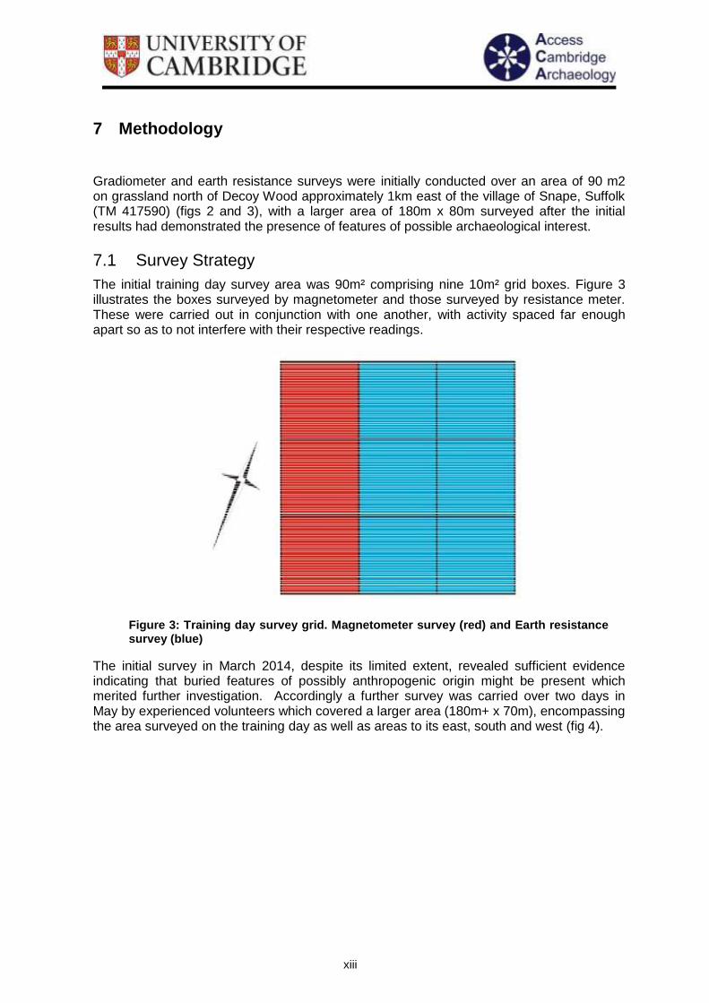
The initial training day survey area was 90m² comprising nine 10m² grid boxes. Figure 3 illustrates the boxes surveyed by magnetometer and those surveyed by resistance meter. These were carried out in conjunction with one another, with activity spaced far enough apart so as to not interfere with their respective readings.
The initial survey in March 2014, despite its limited extent, revealed sufficient evidence indicating that buried features of possibly anthropogenic origin might be present which merited further investigation. Accordingly a further survey was carried over two days in May by experienced volunteers which covered a larger area (180m+ x 70m), encompassing the area surveyed on the training day as well as areas to its east, south and west (fig 4).
Figure 3: Training day survey grid. Magnetometer survey (red) and Earth resistance survey (blue)

xiv
Figure 4: Extent of area surveyed in April/May 2014 (area of training day geophysical survey 1 shaded darkest; area of resistivity survey 2 shaded lighter and area of magnetometer survey 2 shaded lightest)
7.2 Site conditions
The field was under grass when surveyed but not in active use for pastoral grazing. Conditions were dry on all survey days.
7.3 Magnetometer Survey 1
During the initial training day survey, three adjacent grid squares were surveyed with a Geoscan Research single fluxgate RM36 gradiometer. Readings were collected in 10m grid squares by making repeated parallel traverses across it, all parallel to that pair of grid square edges most closely aligned with the direction of magnetic North. Each separated by a distance of 1m from the last; the first and last traverses were 0.5m from the nearest parallel grid square edge. Readings were taken along each traverse at 1m intervals, with the first and last readings being 0.5m from the nearest grid square edge. These traverses are walked in what is called a ‘zig-zag’ fashion, in which the direction of travel alternates between traverses, but during which the magnetometer is always kept facing in the same (northerly) direction so to reduce heading error.
It is the opinion of the manufacturer of the Geoscan instrument that two sensors placed 0.5m apart cannot produce a true estimate of vertical magnetic gradient unless the bottom sensor is far removed from the ground surface. Hence, when the results are presented, the difference between the field intensity measured by the top and bottom sensors is quoted in units of non-Tesla (nT) rather than in the units of magnetic gradient, nano-Tesla per metre (nT/m).
xv
7.4 Resistance Survey 1
During the initial training day, in conjunction with the magnetometer survey, earth resistance survey was conducted over six different grid squares using a twin electrode TR/CIA resistance meter. Readings were collected in 10m grid squares by making repeated parallel traverses across it, each separated by a distance of 1m from the last; the first and last traverses were 0.5m from the nearest parallel grid square edge. Readings were taken along each traverse at 1m intervals, with the first and last readings being 0.5m from the nearest grid square edge. The measurements were collected with a built-in data logger, which was supplemented with manual data entry onto Geoscan geophysical survey sheets. The readings presented in plots are the actual values of earth resistance as recorded by the meter and measured in Ohms (Ω).
7.5 Processing
After the initial training day, the measurements of both the magnetometer and earth resistance surveys were transferred to portable laptop computer for storage and processing in Geoplot 3. Magnetometer data was de-spiked and set through a low pass filter (2,1) followed by sin interpolation (x3). Earth resistance data was also first de-spiked and then set through a low pass filter (2,1) before sin interpolation (x1).
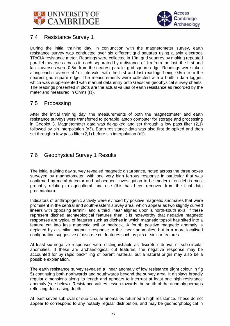
7.6 Geophysical Survey 1 Results
The initial training day survey revealed magnetic disturbance, noted across the three boxes surveyed by magnetometer, with one very high ferrous response in particular that was confirmed by metal detector and subsequent investigation to be modern iron debris most probably relating to agricultural land use (this has been removed from the final data presentation). Indicators of anthropogenic activity were evinced by positive magnetic anomalies that were prominent in the central and south-eastern survey area, which appear as two slightly curved linears with opposing termini, and a third linear aligned upon a north-south axis. If these represent ditched archaeological features then it is noteworthy that negative magnetic responses are typical of features such as ditches in which magnetic topsoil has silted into a feature cut into less magnetic soil or bedrock. A fourth positive magnetic anomaly is depicted by a similar magnetic response to the linear anomalies, but in a more localised configuration suggestive of discrete cut features such as pits or similar features. At least six negative responses were distinguishable as discrete sub-oval or sub-circular anomalies. If these are archaeological cut features, the negative response may be accounted for by rapid backfilling of parent material, but a natural origin may also be a possible explanation. The earth resistance survey revealed a linear anomaly of low resistance (light colour in fig 5) continuing both northwards and southwards beyond the survey area. It displays broadly regular dimensions along its length and appears to interrupt at least one high resistance anomaly (see below). Resistance values lessen towards the south of the anomaly perhaps reflecting decreasing depth. At least seven sub-oval or sub-circular anomalies returned a high resistance. These do not appear to correspond to any notably regular distribution, and may be geomorphological in
xvi
origin. The trace plot hints towards a zig-zag formation for these anomalies which if observable as a pattern over a larger survey area might indicate natural formation through periglacial processes.
7.7 Resistance Survey 2
Negative magnetic anomaly
Positive magnetic anomaly
Magnetic disturbance
Darker grey = higher resistance Lighter grey = lower resistance
Figure 5: Survey 1 - Combined magnetometry and resistance survey data interpretation
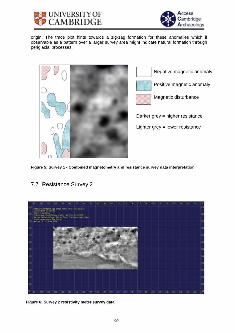
Figure 6: Survey 2 resistivity meter survey data

xvii
7.8 Magnetometry Survey 2
Lidar data for survey area
Figure 8: Lidar plot for survey area (ref), with sub-circular feature present to north-east of surveyed area (circled)
Figure 7: Follow up survey magnetometer survey data

xviii
Figure 9: Lidar plot with overlain magnetometry data (survey 2) for survey area
Figure 10: Lidar plot with overlain resistivity data (survey 2) (arrows indicate features present on both surveys)
xix
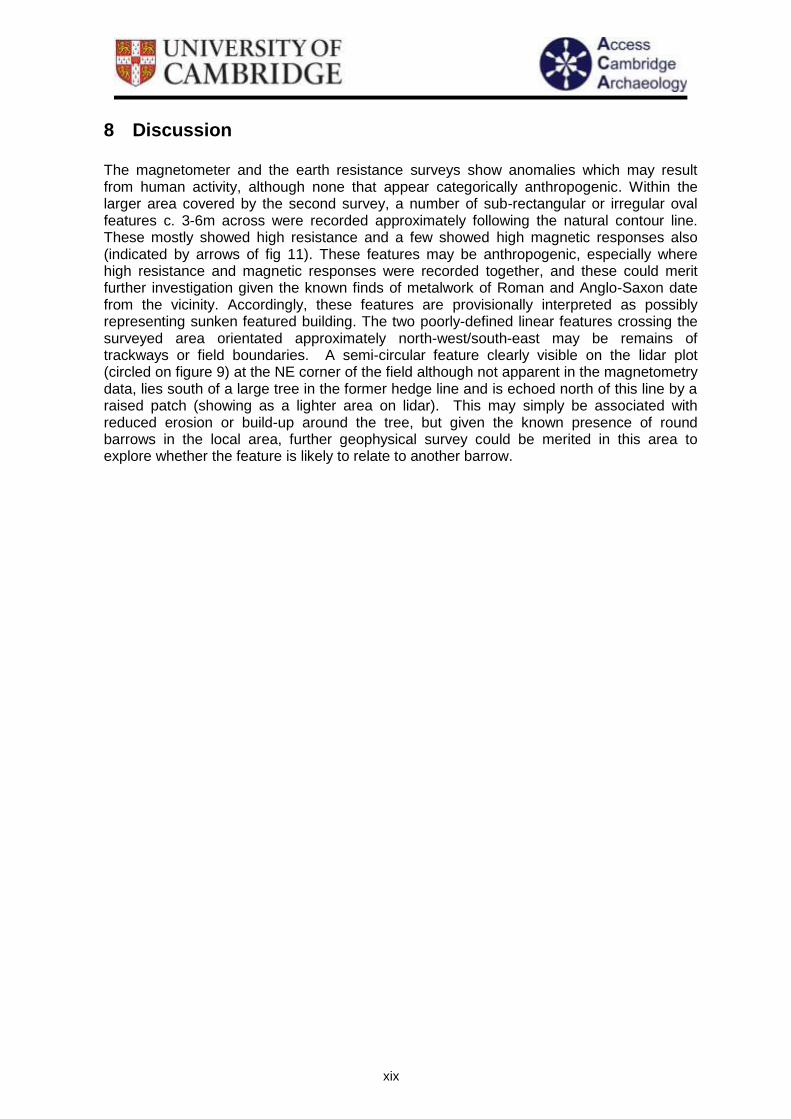
8 Discussion The magnetometer and the earth resistance surveys show anomalies which may result from human activity, although none that appear categorically anthropogenic. Within the larger area covered by the second survey, a number of sub-rectangular or irregular oval features c. 3-6m across were recorded approximately following the natural contour line. These mostly showed high resistance and a few showed high magnetic responses also (indicated by arrows of fig 11). These features may be anthropogenic, especially where high resistance and magnetic responses were recorded together, and these could merit further investigation given the known finds of metalwork of Roman and Anglo-Saxon date from the vicinity. Accordingly, these features are provisionally interpreted as possibly representing sunken featured building. The two poorly-defined linear features crossing the surveyed area orientated approximately north-west/south-east may be remains of trackways or field boundaries. A semi-circular feature clearly visible on the lidar plot (circled on figure 9) at the NE corner of the field although not apparent in the magnetometry data, lies south of a large tree in the former hedge line and is echoed north of this line by a raised patch (showing as a lighter area on lidar). This may simply be associated with reduced erosion or build-up around the tree, but given the known presence of round barrows in the local area, further geophysical survey could be merited in this area to explore whether the feature is likely to relate to another barrow.

xx
9 Conclusion Both geophysical techniques – magnetometry and earth resistivity – have provided positive and complimentary results for anomalies that clearly demonstrate the presence of sub-surface features, some or all of which may or may not have been created as a result of human activity. This data, combined with the metal detected finds from on or near the survey area, indicates that further geophysical work could build a detailed picture of its archaeological potential. The possibility of anthropogenic features is not fully supported by either the magnetometer or the earth resistance results, with a geomorphological origin being quite possible. Nevertheless, ‘ground truthing’ through more intrusive archaeological investigation would clarify their nature.

xxi
10 Acknowledgements
The project was funded by the Heritage Lottery Fund through its Touching the Tide landscape partnership programme. Thanks are due to Bill Jenman and Kate Osborne from Touching the Tide and to all the volunteers who took part in the survey. The survey was carried out and the data analysed by Marcus Brittain (Cambridge Archaeological Unit) and Tim Dennis (University of Essex) with assistance from Clemency Cooper (Access Cambridge Archaeology) under the direction of Dr Carenza Lewis, also of ACA. Richard Newman of Aldeburgh and District Local History Society previously carried out metal detecting on and around the site and brought it to the attention of Touching the Tide: the survey would not have taken place without his involvement.

xxii
11 References
Filmer-Sankey, W. and Pestell, T. 2001 Snape Anglo-Saxon Cemetery: Excavations and Surveys 1824-1992. East Anglian Archaeology Monograph no.95, Ipswich. Williamson, T. 2005. Sandlands - The Suffolk Coast and Heaths (Macclesfield, Windgather Press)