GEOPHYSICAL AND HYDROGEOLOGICAL … · (Grassi et al., 2001a, 2001b). In the last century, the...
7
GNGTS 2014 SESSIONE 3.2 143 GEOPHYSICAL AND HYDROGEOLOGICAL CHARACTERIZATION OF SIRINO LAKE (BASILICATA, ITALY) V. Giampaolo 1 , L. Capozzoli 1 , E. Rizzo 1 , S. Grimaldi 2 1 CNR-IMAA. Laboratorio Hydrogeosite, Marsico Nuovo (PZ), Italy 2 Università degli Studi della Basilicata, Potenza, Italy Introduction. The presence of natural or artificial lakes and reservoir that can empty due to natural phenomena such as landslides, flood and piping is a serious hydrogeological problem because it can generate catastrophic events affecting urban and agricultural areas settled below the source area. This is the case of the Sirino Lake affected, in the last century, by many pipings as a result the Sirino Lake affected, in the last century, by many pipings as a result of sudden openings of sinkholes which resulted in the almost total lake depletion (Fig. 1). Moreover, the hydraulic instability combined with the geomorphological and seismic risks he hydraulic instability combined with the geomorphological and seismic risks recognize the entire area as exposed to potential flood and landslide risk due to new episodes of siphoning. In order to mitigate this hydrogeological risk it is necessary to solve some fundamental questions regarding for example the thickness of the impermeable layer und the lake, the flow pathways and the presence of possible water escape routes. Therefore, scientific community water escape routes. Therefore, scientific community scientific community has devoted considerable attention to some geophysical methods, such as electrical resistivity tomography (ERT), Ground Penetrating Radar (GPR), and self-potential (SP) because these methods are relatively time and cost effective when working on large area and are reasonably user-friendly for geomorphologists (Naudet et al., 2008). The electrical resistivity method is an important tool in the hydrogeological applications (Kosinski and Kelly, 1981; Daily et al., 1992; Slater et al., 1997; Binley et al., 2002; Dam and Christensen, 2003; Darnet et al., 2003; Rizzo et al., 2004; Binley and Kemna, 2005; Straface et al., 2007). One of the electrical resistivity surveys skill is the evaluation of subsurface condition in water-covered area (stream, river, wetland, lake, and see) for hydrogeological and environmental purposes. Surveys in water-covered areas includes conventional surveys using multi-electrodes resistivity system where part of the survey line crosses a river or a lake, and surveys conducted entirely within a water-covered environment (Loke and Lane, 2004). However, while on dry land the geoelectrical method is well known, the method in water-covered areas is not widespread. Still less common are electrical resistivity measurements in wetlands, ponds and lakes. Examples less common are electrical resistivity measurements in wetlands, ponds and lakes. Examples of applications have been reported by Mansoor and Slater (2007) who performed aquatic electrical resistivity imaging to predict spatial and temporal patterns of pore-fluid conductivity in wetland soils using fixed floating electrodes, Baumgartner (1996) who used electrodes located underwater and orientated vertically, and Yang Yang et al. (2006) who integrated GPR and resistivity image profiling methods at the water surface. Inversion algorithms generally used for inverting Inversion algorithms generally used for inverting apparent electrical resistivity measurements in water covered areas are commonly iterative, nonlinear least squares methods, with regularization based on discretized first or second spatial derivative filters, to produce a flat or smooth tomogram, respectively. One strategy to improve the resolution of electrical resistivity tomograms in water covered areas is to incorporate constraints on the water-column resistivity and thickness (Loke and Lane, 2004). Ground penetrating radar (GPR) is a high resolution geophysical electromagnetic technique (10 MHz ÷ 2 GHz) designed primarily to investigate the shallow subsurface of the earth, building structures, roads, and bridges. However, GPR was used successfully to locate and characterize risk of subsidence of a sinkhole collapse in carbonate crock outcrops (Gómez- Ortiz and Martín-Crespo, 2012), to assess karst collapse hazard (Nuzzo Martín-Crespo, 2012), to assess karst collapse hazard (Nuzzo , 2012), to assess karst collapse hazard (Nuzzo et al., 2004), to identify geological hazard for exploitation (Zayc et al., 2014) in flyschoid rocks, to detect water surface of geological structures beneath rivers, ponds, and swamps (Yang et al., 2006) and to predict and follow development sinkholes near lakes (Frumkin et al., 2011).
Transcript of GEOPHYSICAL AND HYDROGEOLOGICAL … · (Grassi et al., 2001a, 2001b). In the last century, the...

GNGTS 2014 sessione 3.2
143
GEOPHYSICAL AND HYDROGEOLOGICAL CHARACTERIzATION OF SIRINO LAKE (BASILICATA, ITALY)V. Giampaolo1, L. Capozzoli1, E. Rizzo1, S. Grimaldi2
1 CNR-IMAA. Laboratorio Hydrogeosite, Marsico Nuovo (PZ), Italy 2 Università degli Studi della Basilicata, Potenza, Italy
Introduction. The presence of natural or artificial lakes and reservoir that can empty due to natural phenomena such as landslides, flood and piping is a serious hydrogeological problem because it can generate catastrophic events affecting urban and agricultural areas settled below the source area.
This is the case of the Sirino Lake affected, in the last century, by many pipings as a resultthe Sirino Lake affected, in the last century, by many pipings as a result of sudden openings of sinkholes which resulted in the almost total lake depletion (Fig. 1). Moreover, the hydraulic instability combined with the geomorphological and seismic riskshe hydraulic instability combined with the geomorphological and seismic risks recognize the entire area as exposed to potential flood and landslide risk due to new episodes of siphoning.
In order to mitigate this hydrogeological risk it is necessary to solve some fundamental questions regarding for example the thickness of the impermeable layer und the lake, the flow pathways and the presence of possible water escape routes. Therefore, scientific communitywater escape routes. Therefore, scientific communityscientific community has devoted considerable attention to some geophysical methods, such as electrical resistivity tomography (ERT), Ground Penetrating Radar (GPR), and self-potential (SP) because these methods are relatively time and cost effective when working on large area and are reasonably user-friendly for geomorphologists (Naudet et al., 2008).
The electrical resistivity method is an important tool in the hydrogeological applications (Kosinski and Kelly, 1981; Daily et al., 1992; Slater et al., 1997; Binley et al., 2002; Dam and Christensen, 2003; Darnet et al., 2003; Rizzo et al., 2004; Binley and Kemna, 2005; Straface et al., 2007).
One of the electrical resistivity surveys skill is the evaluation of subsurface condition in water-covered area (stream, river, wetland, lake, and see) for hydrogeological and environmental purposes. Surveys in water-covered areas includes conventional surveys using multi-electrodes resistivity system where part of the survey line crosses a river or a lake, and surveys conducted entirely within a water-covered environment (Loke and Lane, 2004). However, while on dry land the geoelectrical method is well known, the method in water-covered areas is not widespread. Still less common are electrical resistivity measurements in wetlands, ponds and lakes. Examplesless common are electrical resistivity measurements in wetlands, ponds and lakes. Examples of applications have been reported by Mansoor and Slater (2007) who performed aquatic electrical resistivity imaging to predict spatial and temporal patterns of pore-fluid conductivity in wetland soils using fixed floating electrodes, Baumgartner (1996) who used electrodes located underwater and orientated vertically, and YangYang et al. (2006) who integrated GPR and resistivity image profiling methods at the water surface. Inversion algorithms generally used for invertingInversion algorithms generally used for inverting apparent electrical resistivity measurements in water covered areas are commonly iterative, nonlinear least squares methods, with regularization based on discretized first or second spatial derivative filters, to produce a flat or smooth tomogram, respectively. One strategy to improve the resolution of electrical resistivity tomograms in water covered areas is to incorporate constraints on the water-column resistivity and thickness (Loke and Lane, 2004).
Ground penetrating radar (GPR) is a high resolution geophysical electromagnetic technique (10 MHz ÷ 2 GHz) designed primarily to investigate the shallow subsurface of the earth, building structures, roads, and bridges. However, GPR was used successfully to locate and characterize risk of subsidence of a sinkhole collapse in carbonate crock outcrops (Gómez-Ortiz and Martín-Crespo, 2012), to assess karst collapse hazard (NuzzoMartín-Crespo, 2012), to assess karst collapse hazard (Nuzzo, 2012), to assess karst collapse hazard (Nuzzo et al., 2004), to identify geological hazard for exploitation (Zayc et al., 2014) in flyschoid rocks, to detect water surface of geological structures beneath rivers, ponds, and swamps (Yang et al., 2006) and to predict and follow development sinkholes near lakes (Frumkin et al., 2011).
001-258 volume 3 143 24-10-2014 16:45:45

Finally, the self-potential method (SP) is a passive geoelectrical technique and it consists in measuring the potential differences between two unpolarizable electrodes placed at the ground surface. These voltage differences result from the existence of an electric field produced by natural electrical sources distributed in the subsoil and generated by various phenomena (hydraulic, chemical, or thermal disequilibria). In particular, the SP method is sensitive to groundwater flow through the electrokinetic effect (Thony et al., 1997; Revil, 1999; Darnet and Marquis, 2004; Rizzo et al., 2004). Therefore, detecting electrokinetic effect based on SPTherefore, detecting electrokinetic effect based on SP survey can allow zoning of infiltrating water recharge and run-off areas, and can determine the extent of effects of subsurface drainage works.
Site description. The Sirino Lake (Fig.1), placed at 784 m above sea level is a major tourist place in the middle of a naturalistic interesting area, between the towns of Lauria, Lagonegro and Maratea (south Basilicata region, Italy). Almost elliptical in shape, the Lake Sirino extends for about 3 hectares with a 300 m length and a 150 m width; the depth varies according to the season but it doesn’t exceed 6 m depth. The landscape surrounding the lake is characterized by a complex orography, mostly mountainous with a steep morphology. Furthermore, the studied area is affected by severe and permanent landslides, involving relevant sectors of infrastructure systems, and a pervasive network of minor entity gravitational phenomena (Grassi et al., 2001a, b; Guida and Siervo, 2005; Guida et al., 2006).
The Sirino Lake is placed on the SE side of the Mount Sirino tectonic window at the base of the Costa del Capraro ridge. The area is characterized by a calcareous-siliceous marly succession attributable to Lagonegro I Unit (Flinty Limestone, Siliceous Schists and Galestrino Flysh), which constitutes the backbone of the Monte Sirino. Moreover, massive glacial debris accumulations, refer to the last Wurm glacial phase, and slope and/or landslide debris are present (Cotecchia et al., 1993). The Sirino Lake rests on silty-clay sediments accumulated in the depression that houses the lake. These reddish clay deposits, due to the dissolution of
Fig. 1 – Sirino Lake affected by piping phenomena in 1994, 2009 and 2014.
144
GNGTS 2014 sessione 3.2
001-258 volume 3 144 24-10-2014 16:45:46

GNGTS 2014 sessione 3.2
14
the cherty limestone, were detected above the bedrock (Siliceous Schists) and they probably contributed to waterproofing the bottom of the lake.
The Flinty Limestone and Siliceous Schists are the main reservoir of the Monte Sirino aquifer system. The cherty limestone are characterized by a relatively mid-high permeability, mainly due to the widespread cracking and\or layering and to the major fracture systems oriented N-S and NNE-SSW; instead, the Siliceous Schists can be appreciably permeable along the stratification planes and\or along bands of intense fracturing. All around, the system is wholly or partially buffered by a belt of less permeable soils (Galestrino Flysch) which constitute the main waterproof of the carbonate aquifer formed by Monte Sirino (D’ecclesiis et al., 1990). Locally, for anisotropy of the structure, also the Siliceous Schists act as impermeable soils (Grassi et al., 2001a, 2001b).
In the last century, the Sirino Lake was affected by many pipings, as a result of sudden openings of sinkholes, which have resulted in the almost total lake depletion. For these reasons, a series of local waterproofing remediation actions were carried out. These, however, did not prevent the phenomenon to recur at different times and in adjacent areas. Moreover, these measures have been often of environmental and especially visual strong impact.
The opening of these sinkholes occurs with a not predictable multi-yearly frequency. However, a written record of all the episodes that took place over time lacks. Among the most recent episodes, there are those occurred in 1994, 2009 and 2014. In July 1994, a sinkhole opened in the SW side of the lake, about 3 meters from the shore, with a collapse area of 1 meter in diameter. The water was poured into the hole and in a short time the lake level dropped about 2 m. Simultaneously, there was a sudden increase in the flow rates of underlying sources: in particular the Sotto il Lago II source reached a flow rate value of about 300 l/s. The siphoning stopped naturally, following the collapse of a shore section, with the consequent closure of the hole and the returning, after a few days, at normal flow rates values (Grassi et al., 2001a, 2001b).
In the episode occurred in the summers of 2009 and 2014, a sinkhole opened on the same shore that was affected in the 1994 episode, a few tens of meters away. In this case, the hole was closed artificially with concrete.
Geophysical data acquisition and processing. For the study of sinkhole phenomena along the Sirino lake shores an electrical resistivity tomography (ERT) was carried out both on land and water-covered area and a ground penetrating radar and a self-potential surveys (SP) were carried out around the lake shores (Fig. 2).
The ER profile was carried out between the northwester and the southeastern lake shores, with a total length of approximately 450 m of which 210 m into the lake with electrodes floating on the water surface.
The geoelectrical tomography was performed using the georesistivity meter Syscal Junior (IRIS Instrument) coupled to a multi-electrode system, consisting of two measuring cable at 24 channels with an electrodes spacing of 10 m. For the geoelectrical data acquisition in water, the only measuring cable, floating on the lake surface by means of a series of PVC bottles equally spaced along the cable, was used. For the ground measures, standard stainless steel electrodes were used connected to the cable. The Syscal Junior resistivity meter was placed on board of a small boat, held steady in the lake centre for the whole duration of measures. The ERT was acquired using the Wenner, Wenner-Schlumberger and Dipole-Dipole arrays, with an electrodes spacing of 10 m. Furthermore, water electrical conductivity and temperature were measured along ERT profile.
The ETR was inverted by means of the res2Dinv software that uses the smoothness-constrained least-squares inversion method based on the quasi-Newton method (Loke and Barker, 1996). In particular, water electrical resistivity and bathymetry constrains were included in the inversion processes, using a distorted finite element grid, where the upper part of the mesh was used to model the water layer at the assigned electrical resistivity value of 50 Ωm.
001-258 volume 3 145 24-10-2014 16:45:46

GPR surveys were carried out using GSSI SIR-2000 Instruments equipped with the two high-frequency antenna 40 and 400 MHz, characterized by different resolution and investigation depth. The two antennas were used to investigate the lake shores to find possible areas affected by sinkhole phenomena. For this purposes, on the south lake shore, two long acquisition profiles (about 180 m) were performed (Fig. 1): 400 MHz antenna: red line composed by F1÷F11 segments in step mode with survey-wheel coupled to the antenna; 40 MHz: blue line composed step mode with survey-wheel coupled to the antenna; 40 MHz: blue line composedstep mode with survey-wheel coupled to the antenna; 40 MHz: blue line composed by F12÷F15 segments in continuous mode. in continuous mode.in continuous mode.
The raw-data acquired in field without gain and other filters were processed in order to, compensate the attenuation of GPR signal, eliminate noise and associate the GPR information with the real depth of reflectors after an assessment of electromagnetic velocity propagation (migration).
Finally, self-potential measurements (for a total of 226 points) were acquired along closedalong closed loops, around the lake shores and the surrounding areas, by alternating the leading and following
Fig. 2 – Electrical resistivity and GPR profiles acquired with 400 (red line) and 40 MHz antennas (blu line) carried out both on water covered area and lake shores.
14
GNGTS 2014 sessione 3.2
001-258 volume 3 146 24-10-2014 16:45:48
GNGTS 2014 sessione 3.2
14
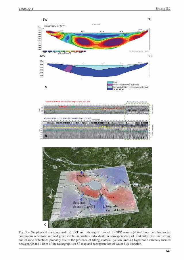
Fig. 3 – Geophysical surveys result: a) ERT and lithological model; b) GPR results (dotted lines: sub horizontal continuous reflectors; red and green circle: anomalies individuate in correspondence of sinkholes; red line: strong and chaotic reflections probably due to the presence of filling material; yellow line: an hyperbolic anomaly located between 90 and 110 m of the radargram); c) SP map and reconstruction of water flux direction.
001-258 volume 3 147 24-10-2014 16:45:49

electrodes (leap-frog technique) in order to reduce cumulative errors caused by electrode polarization. The distance between the measuring electrodes was 25 m. The SP values in the measuring net were obtained by adding readings after establishing a SP arbitrary zero value as a point of reference in the area. Moreover, SP measurements were corrected in order to compensate for cumulative errors and the topographic effect. Finally, we obtained a SP map using Surfer 8 for a contour line representation of the distribution of the potential field.
Results and conclusions. Fig. 3 shows the results of the integrated geophysical survey carried out at the Sirino Lake.
The ERTs acquired with different electrode arrays shows similar results. In particular the Wenner-Schlumberger one (Fig. 3a) is characterized by relatively low electrical resistivity values (< 100 Ωm) down to - 20 m depth and by higher electrical resistivity values (> 700 Ωm) in the lower portion. In the right the ERT shows a low resistivity zone, connected to the lake that crosses the underlying resistive body. The comparison between the electrical resistivity data with the lithostratigraphy obtained by a geognostic drilling investigation and a gamma-ray log (Grassi et al., 2001b) allows us to reconstruct the complex geological situation beneath the Sirino Lake. In particular, the shallower low electrical resistivity body represents the debris and lacustrine deposits characterized by an inhomogeneous downwards infiltration. The deeper resistive area denotes the presence of a Siliceous Schists body not fractured and therefore with a generally low hydraulic permeability. Moreover the ERT underline the presence of a low resistivity area, on the southern shore of the lake, interpreted as a highly fractured portion of Siliceous Schists involved into mass movements, with a medium-high relative permeability. This area may represent a possible water route escape because is characterized by more permeable soil layers.
Results of GPR survey are shown in Figure 3b. In particular, the 40 MHz acquisition shows three main sub-horizontal continuous reflectors probably due to presence of interfaces with different physical properties. An interesting hyperbolic anomaly is located between 90 and 110 meter of the radargram (yellow line). The 400 MHz radargram shows two horizontal reflectors located respectively at an estimated depth of 0.8 and 1.6 meter. At a distance of 27 and 35 meter from the origin of the acquisition there are the two sub-surface anomalies due to the seepage phenomena occurred in the past (red circle). A zone with a similar electromagnetic behaviour is located to 50 m from the origin (green circle). Moreover between 100 and 125 m there is a zone characterized by strong and chaotic reflections, probably due to deposits of filling material.
Finally, the obtained SP map (Fig. 3c) shows negative values upstream (down to -350 mV), while there are positive ones (up to 200 mV) in the lower area surrounding the lake. In particular, the SP negative values identify the areas characterized by a downward water flow, while SP positive values represent water accumulation zones.
In conclusions the integration of GPR, SP and ERT techniques allowed to identify possible causes of sinkhole problem and characterize the hydro-geological structure of the area. Moreover, joint interpretation of geophysical, geological, hydrogeological and geomorphological data allowed us to estimate the thickness of the lacustrine deposits, describe the main patterns of the subsurface fluid flows in the area, and identify possible water escape routes causing the piping phenomena.
Acknowledgements. The authors are grateful for the geological and logistical support the “Micromondo”, the first theme park on the geology, in order to create an impetus to the dissemination of knowledge concerning the Earth Sciences (geologists Patrizia Magnotti and Dario Rizzo, http://www.ilmicromondo.com).
ReferencesBaumgartner F.; 1996: A new method for geoelectrical investigations underwater. Geophysical Prospecting 44, 71–
98.Binley A. and Kemna A.; 2005: Electrical Methods. In: Hydrogeophysics by Rubin and Hubbard (Eds.), 129-156,
Springer.
14
GNGTS 2014 sessione 3.2
001-258 volume 3 148 24-10-2014 16:45:49

GNGTS 2014 sessione 3.2
14
Binley A., Winship P., West L.J., Pokar M. and Middleton R.; 2002: Seasonal variation of moisture content in unsaturated sandstone inferred from borehole radar and resistivity profiles. Journal of Hydrology 267, 160–172.
Cotecchia V., D’Ecclesiis G. and Polemio M.; 1993: High pressure artesian wells to tap Torbido Spring (Italy). In: International Conference on Environmental Management, Geo-water and Engineering Aspects (February, 1993, Wollongong, Australia) Edited by: Chowdhury & Sivakumar editors. Balkema, Rotterdam.Balkema, Rotterdam.
D’Ecclesiis G., Grassi D., Sdao F. and Tadolini T.; 1990: Potenzialtà e vulnerabilità delle risorse idriche sotterranee del monte Sirino (Basilicata). Geologia Applicata e Idrogeologia 25, 195-219.
Daily W., Ramirez A., Labrecque D. and Nitao J.; 1992: Electrical resistivity tomography of vadose water movement. Water Resources Research 28, 1429-1442.
Dam D. and Christensen S.; 2003: Including geophysical data in groundwater model inverse calibration. Ground Water 41, 178-189.
Darnet M. and Marquis G.; 2004: Modelling streaming potential (SP) signals induced by water movement in the vadose zone. Journal of Hydrology 285, 114–124.
Darnet M., Marquis G. and Sailhac P.; 2003: Estimating aquifer hydraulic properties from the inversion of surface Streaming Potential (SP) anomalies. Geophysical Research Letters 30, doi: 10.1029/2003GL017631.
Frumkin A., Ezersky M., Al-Zoubi A., Akkawi E. and Abueladas A.R.; 2011: The Dead Sea sinkhole hazard: geophysical assessment of salt dissolution and collapse. Geomorphology 134, 102–117.
Gómez-Ortiz D. and Martín-Crespo T.; 2012: Assessing the risk of subsidence of a sinkhole collapse using ground penetrating radar and electrical resistivity tomography. Engineering GeologyEngineering Geology 149-150, 1–12.
Grassi D., Grimaldi S., Sdao G. and Spilotro G.; 2001a: Ambiente idrogeologico e fenomeni di sifonamento relativi al Lago di frana Sirino (Basilicata). Atti del convegno Geoitalia 2001, 320-322, Chieti.
Grassi D., Grimaldi S., Sdao G. and Spilotro G.; 2001b: Geologia, geomorfologia, idrogeologia e stabilità idraulica del lago Sirino (Basilicata). Atti del Dipartimento Strutture, Geotecnica, Geologia Applicata all’Ingegneria - Università della Basilicata 3, 20 pp, Lamisco-Spes, Potenza.
Guida D., Nocera N. and Siervio V.; 2006: Analisi morfoevolutiva sulla riattivazione di sistemi franosi a cinematismo intermittente in Appennino campano-lucano (Italia meridionale). Giornale di Geologia Applicata 3, 114-122.
Guida D. and Siervo V.; 2005: La Carta Inventario dei Fenomeni Franosi del Foglio 521”Lauria”. Giornale diGiornale di Geologia Applicata 2, 58-64.
Kosinski W.K. and Kelly W.E.; 1981: Geoelectric soundings for predicting aquifer properties. Ground Water 19, 163-171.
Loke M.H. and Barker R.D.; 1996: Rapid least-sqares inversion of apparent resistivity pseudosections by a quasi-Newton method. Geophysical Prospecting 44, 131–152.
Loke M.H. and Lane J.W.; 2004: Inversion of data from electrical resistivity imaging surveys in water-covered areas. Exploration Geophysics 35, 266-271.
Mansoor N. and Slater L.; 2007: Aquatic electrical resistivity imaging of shallow-water wetlands. Geophysics 72, F211–F221.
Naudet V., Lazzari M., Perrone A., Loperte A., Piscitelli S., Lapenna V.; 2008: Integrated geophysical and geomorphological approach to investigate the snowmelt-triggered landslide of Bosco Piccolo village (Basilicata, southern Italy). Engineering Geology 98, 156–167.
Nuzzo L., Leucci G. and Negri S.; 2004: GPR survey in the karstic area Vore di Spedicaturo near Nociglia (Lecce, Italy). Tenth International Conference on Ground Penetrating Radav, Delft, The Netherlands.
Revil A.; 1999: Ionic diffusivity, electrical conductivity, membrane and thermoelectric potentials in colloids and granular porous media: a unified model. Journal of Colloid Interface Science 212, 503–522.
Rizzo E., Suski B., Revil A., Straface S. and Troisi S.; 2004: Self-potential signals associated with pumping tests experiments. Journal of Geophysical Research 109: doi: 10.1029/2004JB003049.
Slater L., Binley A. and Brown D; 1997: Electrical imaging of fractures using ground-water salinity change. Ground Water 35, 436-442.
Straface S., Fallico C., Troisi S., Rizzo E. and Revil A.; 2007: An inverse procedure to estimate transmissivity from heads and self-potential signals. Ground Water 45, 420–428.
Thony J.L., Morat P., Vachaud G. and Mouel J.L.L.; 1997: Field characterization of the relationship between electrical potential gradients and soil water flux. Comptes rendus de l’Académie des Sciences de Paris Série IIaComptes rendus de l’Académie des Sciences de Paris Série IIa 325, 317–321.
Yang C., Tong L.T. and Yu C.Y.; 2006: Integrating GPR and RIP Methods for Water Surface Detection of Geological Structures. TAO 17, 391-404.
Zajc M., Pogačnik Ž. and Gosar A.: 2014: Ground penetrating radar and structural geological mapping investigation of karst and tectonic features in flyschoid rocks as geological hazard for exploitation. International Journal of Rock Mechanics and Mining Sciences 67, 78–87.
001-258 volume 3 149 24-10-2014 16:45:50