Geomorphology - Shodhganga
54
47 CHAPTER 3 Geomorphology 3.1 Regional Geomorphology The north eastern region of India presents a unique of mosaic of landforms with great diversity reflecting a complex geo tectonic setup. In a regional scale the most striking morphological expression is given by the Arunachal Himalaya towards north, the Naga-Patkai range of Hills towards south, the fold belts of Cachar-Tripura and Mizoram, the Shillong plateau and the Brahmaputra valley. It has a regional westward gradient but two major trend of topographic gradient from north and south converges towards the regional gradient. The Brahmaputra within Assam represents the general westward gradient while it’s numerous north and south bank tributaries represent the other two gradient trends. The vast tract of Brahmaputra valley developed between the Arunachal Himalaya, the Naga-Patkai range of hills and the Shillong plateau is a typical fluvial terrain with a mosaic of numerous minor fluvial landform features. The valley has developed through alleviation over a sequence of Cenozoic sediments which again overlie a basement that has developed a structural high nearly coinciding the flow path of the Brahmaputra. Originating from near Manas Sarovar in Tibet, the river Brahmaputra first flows in an easterly direction for about 1200 km in the name of Tsang Po. Then it abruptly turns towards south and named as Dihang in Siang district of Arunachal. After descending to the plains of Assam, It meets the Dibang and Lohit River from north east and east respectively, from where it takes a westerly course and flows through the plains of Assam as the Brahmaputra for about 720 km. The Brahmaputra River is a very young one and its present configuration took place only during the Pleistocene and Recent times; and in spite of its low gradient in the plains area its erosive powers are still very active and have got many changing courses in recent times.
Transcript of Geomorphology - Shodhganga

47
CHAPTER 3
Geomorphology
3.1 Regional Geomorphology
The north eastern region of India presents a unique of mosaic of landforms with great
diversity reflecting a complex geo tectonic setup. In a regional scale the most striking
morphological expression is given by the Arunachal Himalaya towards north, the
Naga-Patkai range of Hills towards south, the fold belts of Cachar-Tripura and
Mizoram, the Shillong plateau and the Brahmaputra valley. It has a regional westward
gradient but two major trend of topographic gradient from north and south converges
towards the regional gradient. The Brahmaputra within Assam represents the general
westward gradient while it’s numerous north and south bank tributaries represent the
other two gradient trends. The vast tract of Brahmaputra valley developed between
the Arunachal Himalaya, the Naga-Patkai range of hills and the Shillong plateau is a
typical fluvial terrain with a mosaic of numerous minor fluvial landform features. The
valley has developed through alleviation over a sequence of Cenozoic sediments
which again overlie a basement that has developed a structural high nearly coinciding
the flow path of the Brahmaputra. Originating from near Manas Sarovar in Tibet, the
river Brahmaputra first flows in an easterly direction for about 1200 km in the name
of Tsang Po. Then it abruptly turns towards south and named as Dihang in Siang
district of Arunachal. After descending to the plains of Assam, It meets the Dibang
and Lohit River from north east and east respectively, from where it takes a westerly
course and flows through the plains of Assam as the Brahmaputra for about 720 km.
The Brahmaputra River is a very young one and its present configuration took place
only during the Pleistocene and Recent times; and in spite of its low gradient in the
plains area its erosive powers are still very active and have got many changing
courses in recent times.

48
Shillong plateau is a large geomorphic unit of this region; up arch of Precambrian
metamorphic rocks characterized by Basement Gneissic Complex with a structural
trend of NE-SW, abutting into Assam plains in the north and are delimited sharply to
the south against the alluvial plains of Bangladesh. The plateau is more prominent in
the southern part of the area scalloped by numerous steep valleys; coincide
approximately with the Dauki Fault zone. The structural hills are subjected to various
degrees of dissections, the predominant trend parallel to the structural strike of which
is along NE-SW.
The Arunachal Himalayas themselves can be further sub-divided into morpho
structural zones: The Sub-Himalayan zone or Siwaliks; rising abruptly from the
Brahmaputra Plains along a tectonic plane-the Himalayan frontal thrust (HFT). It is
about 10-20 km wide. The Lesser Himalayan Gondwana and moderately
metamorphosed Pre-Gondwanas; its southern limit is defined by the MBT (Main
Boundary Thrust). The Greater or Higher Himalayas high grade metamorphic,
gneisses and granites: A zone of very high relief with heights greater than 6000 m
having precipitous slopes and deep gorges. Its southern limits are defined by the MCT
(Main Central Thrust). Trans-Himalayan Tibetan or the Thethyan zone: The northern-
most zone. It is about 30-40 km wide and of low relief (Elev. 3000 – 6000m).
The Jia Bharali river is one of the largest tributaries of Brahmaputra river in the north
bank. The river Jia Bharali is known as Kameng river in the Arunachal Pradesh. It
originates from the Indo-China border and gradually diminishes and meets the
Brahmaputra near Bhomoraguri, Tezpur. During the journey from the origin it
receives several tributaries and shows significant meandering pattern following the
sharp valley and narrow deep gorges it enters the alluvial plain in the foothills of
Himalaya. It shows braided pattern in the alluvial regime of the catchment. The
remnants of old channel of Jia Bharali named as Mara Bharali shows meandering
pattern. Allen (1905) stated that sometimes prior to 1824 the major change in the shift
of the river course from the Mara Bharali to the present one has taken place. In
between the Mara Bharali and the present Jia Bharali channel, scars of the older
meander scrolls are seen in the satellite imagery and the topographic maps.
49
The upper catchment of Jia Bharali, north of HFT (Himalayan Frontal Thrust) is hilly
with steep slopes. In general the major domains of this area are the rugged hills of the
high Himalaya, the low Himalayan foot hills, the valley of Brahmaputra and its
tributaries have been treated under the three basics landforms viz., denudational,
depositional and structural. The geomorphology of the upper region is controlled by
the geology and the structure of the area. The striking feature of the river course in the
area is its general east-west trend with sharp southward swings. The general strike of
rocks in the area is East-West as well as the general trend of major thrust HFT, MBT,
MCT are also East-West with numerous diagonal cross-faulting. Thus the
geomorphology of the area well reflects the geological structure of the area whereby
indicating that the river map occupy some weak lineament. Drainage forms a major
geomorphic element of this region. A large number of major rivers along with their
numerous tributaries drain in the catchment. The drainage system in general can be
classified as subsequent/ structurally controlled.
3.2 Geomorphology of the study area
The geomorphology of Jia Bharali basin has been studied based on visual
interpretation of satellite data together with Digital Elevation Model (DEM) and
selective field verifications. Three major geomorphic units (Level 1) can be broadly
delineated viz., dissected structural hills of the upper catchment, the piedmont zone
south of the HFT (Himalayan Frontal Thrust) and the vast Brahmaputra alluvial plain
occupying the southernmost segment of the study area that also include a number of
inselbergs as well (Table 3.1; Figure 3.26). Numerous minor landform features are
found dotting these three major geomorphic units which have been delineated to the
extent possible from the spatial resolution of the primary data source. The minor
landform features are however, more well discernible within the alluvial terrain.
Table 3.1 Major geomorphic units of the study area
Geomorphic Unit Lithostratigraphic Unit Flood Plain (Younger Alluvial Plain) Alluvium (Recent) Piedmont Plain (Alluvial Fan, Terrace) Alluvium (Older)
Dissected Hill Tertiary Sandstone Crystalline Rock Granite and Gneiss
Inselberg Granitoid Gneisses (Precambrian)

50
Figure 3.1 Geomorphological map of the Jia Bharali catchment showing the mega geomorphic feature

51
3.2.1 Structural hills
Folded sedimentary sequence of Kimin, Subansiri and Dafla Formation, The
deformed Gondwana sequence and the crystallines north of MBT form linear ridges
following the Himalayan trend. The broad structural alignments of these hills are well
discernible from satellite images and shaded relief derived from DEM. The rocks are
folded into number of anticlines and synclines with differential erosion along them
making the structural trend (general trends of E-W and ENE-WSW) prominent.
These hills are dissected by the extensive erosion through fluvial action and mass
movement. The hills in the Siwaliks have steep slopes and higher relief than those of
the granite and gneisses of Bomdila Group that have smoother crests and gentle
slopes. In general the dissected hills of the crystallines present a subdued topography.
There are number of high ridges in the upstream catchment having a general E-W
trend.
Figure 3.2: a) Panoramic view of structural hills and narrow valleys in Arunachal
Himalaya b) Dissected hills in the Tenga valley of Lesser Himalaya
The erosional dissection is found to be controlled by the fracture pattern of the
bedrock. The geomorphology of the Lesser Himalayan part is dominated by steeply
sloping surface and deep cut gorges and valleys are fairly sinuous suggesting the
considerable long period which has elapsed during the development. The dissected
hills can be further classified into three categories viz., highly dissected, moderately
dissected and less dissected hills. The northern part of HFT is a rugged terrain and
from south to north with increasing elevation. It is observed that the Siwaliks hills are
in general moderately dissected, but along the MBT, Gondwana and the Siwaliks are
highly dissected. The sedimentary sequences in this zone are highly fractured and
jointed which aids in higher degree of dissection. North of MCT the hills are
a b
52
moderately dissected and comparatively the degree of dissection is more in the
southern part of MCT. Weathering and erosion in this region has produced a variety
of erosional land-form features as rills and gulley’s, scarp faces, hogbacks and cuesta
and variously shaped ridges and valleys. The hills in the extreme northern part are
however, comparatively less dissected.
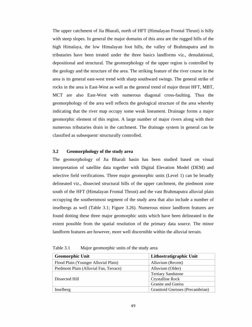
Gully erosion
Gully erosion is common in the Himalayan part of the Jia Bharali catchment.
Headward erosion is also common through rills. Gullies have discrete cut banks and
often with a steep head, that distinguishes it from rills. They are developed rapidly
through head ward erosion capturing the adjacent rills. The gully erosion followed by
numerous first order channel networks provides a measure of the dissection. In effect,
the higher degree of dissection leads to generation of more sediment in the source
region of the catchment and thus contributes towards the sediment yield along the
trunk channels. The erosion also causes exposure of fresh rock surfaces, thus aiding
the process of enhanced weathering. As such the erosional dissection may provide
clues to the unroofing history of the orogen.
Figure 3.3: Gully erosion on hill flanks in higher Himalaya
Triangular Facet
Due to high degree of dissection by gullies on hillslopes and mass movement,
numerous triangular facets (Figure 3.4) have developed along hill flanks. They often
represent a barred bedding plane surface or weathered rock mass forming a scrap
face at an appropriate angle of repose of. Apart from the triangular facets which often

53
form part of a longitudinal scarp face, partially dissected scarps are also quite
common within the Himalayan domain. Some of these scarps are of erosional origin
while some are linked to tectonic deformation and faulting (Figure 3.5 b,c).
Figure 3.4: Triangular facet developed on hill flanks. Numerous gully erosions can be seen towards left part of the photograph. The barred rock surfaces enhance mass movement and thus sediment generation also accelerates
Figure 3.5: a. Triangular facets along a scarp face on left bank of Jia Bharali river;
b and c are Fault scarps along the Kameng fault of Srivastava et al., 2008
a
b c

54
Talus
Numerous talus with typical break in slope on the hillslope profiles are found dotting
the hill flanks within structural hills. These represent a depositional feature with a
sloping surface topography abutting against the free face segment of hillslopes and
often merging with a river valley down slope (Figure 3.5). They are composed of
poorly sorted assorted mixture of angular gravels with a thin soil profile developed on
it. Due to high percolation rate leading to high seepage pressure, these areas
frequently experience slumping. The phenomenon is often aided by incision along
the river valleys to which the talus gradually merges.
Figure 3.6: A talus with prominent break in slope which merges with the Alluvium further downslope. Slumping from the talus put a continuous downslope pressure on the channel course which takes a circuitous route and deflects around this zone.
Valley fill
Along the major drainage system valley filling is common. In the meander section of
the river along the hills slope, boulder, cobbles, pebbles and clast materials are
deposited. In the Tenga valley it is common feature.
Figure 3.7: Valley fill along the Bichom valley section
55
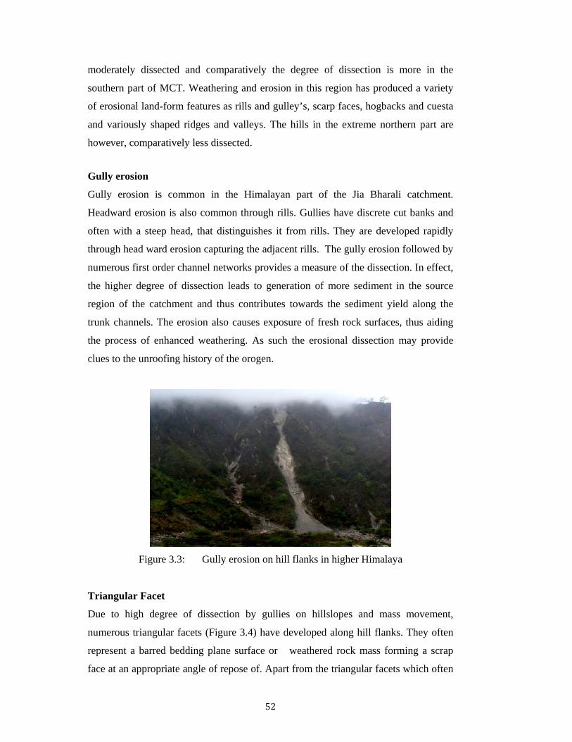
Fluvial terraces
Within the Himalayan domain, terraces are developed along many segments of the
Kameng river and its tributaries. North of the HFT, around Bhalukpong, at least three
terrace levels can be identified on the right bank of Jia Bharali. From the ratio of
alluvium to bedrock thickness these are found to be aggradational terraces without
correlatable terraces on the left bank. However, on the left bank a well developed
strath terrace can be traced for a distance of about 500m. The unpaired nature of these
terraces together with the strath terrace on left bank suggests tectonic control on their
development associated with a possible eastward tilt. Further upstream and north of
HFT, incision of bedrock has resulted in development of a number of terrace levels as
exemplified by the Tenga valley and Bichom valley terraces. These terraces provide a
measure of uplift/incision in an active tectonic setting.
Figure 3.8 a) Poorly sorted terrace near Seijosa b) Strath terrace near Bhalukpong
Along the Bhalukpong-Tipi section of Jia Bharali river, terraces are observed in the
both the bank. These terraces are strath terrace (Figure 3.9). The terraces are the result
of the valley filling and deep incision of the river. The river terraces are of alluvium,
boulder, cobles and pebbles. The Bhalukpong terrace is of Holocene time (Srivastav
et. al., 2008, Kumar et.al., 1996, Kar et.al., 1997). Sediments of these terraces are not
compact but well sorted. The Jia Bharali has a high gradient in this river section. All
the materials that carry dump in the low lying area. In this area Kameng River has 4
level of unpaired terrace are found (Srivastav et.al. 2008).
a b

56
Figure 3.9 Strath Terrace along the Jia Bharali river near Bhalukpong
(92o38’44.8”E 27o01’04.4”N)
Figure 3.10 Showing the location of Bhalukpong Terrace Surface and location of
different lineament prevailing in the area. Topographic profile along BB’ shown in the Figure 3.11. The Kameng Fault is marked after Srivastava et.al., 2008

57
Terrace occurs due to an equilibrium reached in the fluvial system resulting from:
slowed or paused uplift, climate change, or a change in the bedrock type (Burbank
et.al. 2001). These terraces are depositional in origin and may be able to be identified
by a sudden change in alluvium characteristics such as finer material for example.
Once down cutting continues the flattened valley bottom composed of bedrock
(overlain with a possible thin layer of alluvium) is left above either a stream or river
channel. These bedrock terraces are the strath terraces and are erosional in nature
(Burbank et.al. 2001). Figure 3.10, showing the locality of terrace deposits along the
Jia Bharali River. BB1 section is made from the SRTM which reflects the unpaired
terraces. The more terraces are seen in the right bank of the Jia Bharali river. In the
left bank single terrace is observed where as in the right bank more than 3 levels of
terraces are observed (Figure 3.11). The right bank of the river is more resistant to
erosion than the north bank.
Figure 3.11 Vertical Profile section (BB’) across the Bhalukpong section of Jia Bharali
3.2.2 Piedmont Zone
An extensive piedmont zone has developed all along the Arunachal Himalaya
foothills and across the HFT through merging of numerous alluvial fans developed by
the mountainous streams discharging into the valley. This linear, slightly sinuous
gently dipping plain follow the mountain front geometry and forms the interface
between the well developed Brahmaputra alluvial plain towards south and the
structural hills towards north. The mountain fed streams take multithread flowpath
within this zone developing numerous gravelly braid bars and lobes of debris flow
deposits. High gradient and high percolation through permeable gravels particularly in
58
the proximal part leads to ‘lost river’ condition which is well observed in the satellite
images. The rivers revert back to single channel flows towards the distal part of the
piedmont zone and further into the Brahmaputra Alluvium.
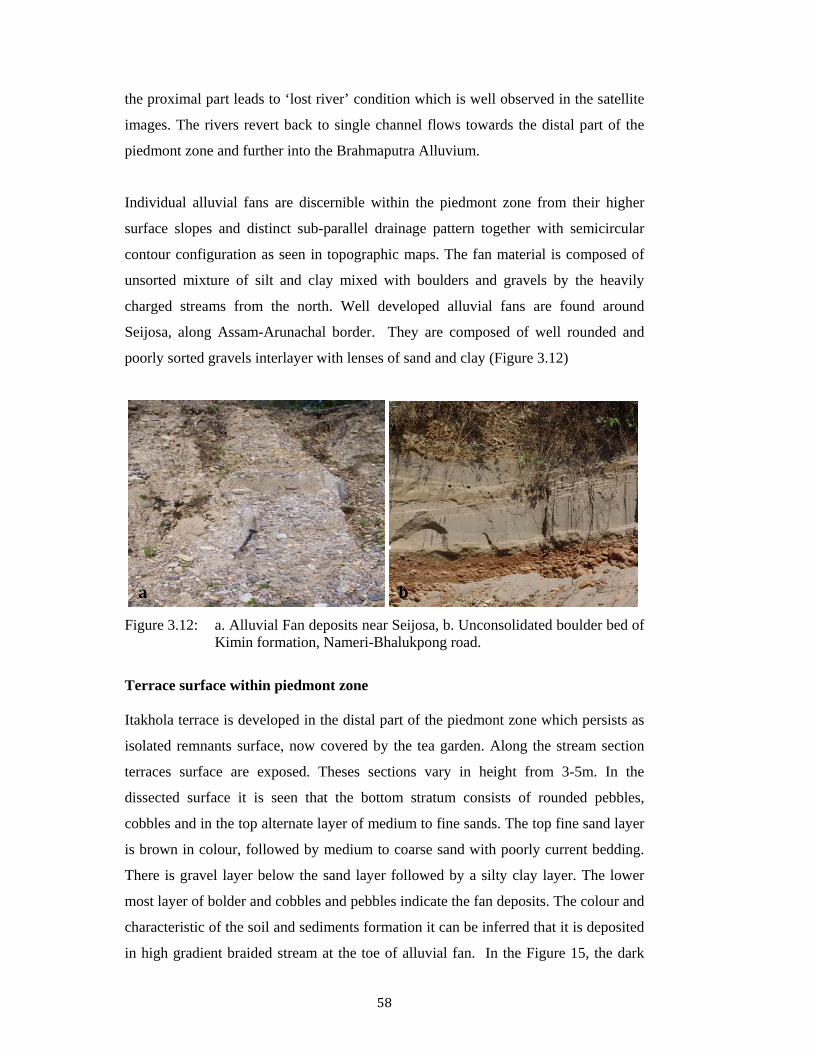
Individual alluvial fans are discernible within the piedmont zone from their higher
surface slopes and distinct sub-parallel drainage pattern together with semicircular
contour configuration as seen in topographic maps. The fan material is composed of
unsorted mixture of silt and clay mixed with boulders and gravels by the heavily
charged streams from the north. Well developed alluvial fans are found around
Seijosa, along Assam-Arunachal border. They are composed of well rounded and
poorly sorted gravels interlayer with lenses of sand and clay (Figure 3.12)
Figure 3.12: a. Alluvial Fan deposits near Seijosa, b. Unconsolidated boulder bed of
Kimin formation, Nameri-Bhalukpong road.
Terrace surface within piedmont zone
Itakhola terrace is developed in the distal part of the piedmont zone which persists as
isolated remnants surface, now covered by the tea garden. Along the stream section
terraces surface are exposed. Theses sections vary in height from 3-5m. In the
dissected surface it is seen that the bottom stratum consists of rounded pebbles,
cobbles and in the top alternate layer of medium to fine sands. The top fine sand layer
is brown in colour, followed by medium to coarse sand with poorly current bedding.
There is gravel layer below the sand layer followed by a silty clay layer. The lower
most layer of bolder and cobbles and pebbles indicate the fan deposits. The colour and
characteristic of the soil and sediments formation it can be inferred that it is deposited
in high gradient braided stream at the toe of alluvial fan. In the Figure 15, the dark
a b
59
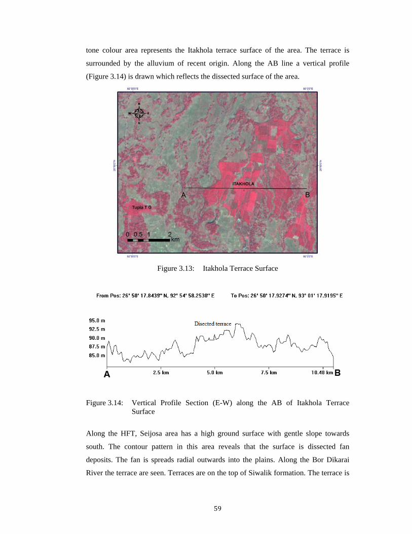
tone colour area represents the Itakhola terrace surface of the area. The terrace is
surrounded by the alluvium of recent origin. Along the AB line a vertical profile
(Figure 3.14) is drawn which reflects the dissected surface of the area.
Figure 3.13: Itakhola Terrace Surface
Figure 3.14: Vertical Profile Section (E-W) along the AB of Itakhola Terrace Surface
Along the HFT, Seijosa area has a high ground surface with gentle slope towards
south. The contour pattern in this area reveals that the surface is dissected fan
deposits. The fan is spreads radial outwards into the plains. Along the Bor Dikarai
River the terrace are seen. Terraces are on the top of Siwalik formation. The terrace is
60
poorly sorted comprise reddish brown sand and grey clays with minor pebbles and
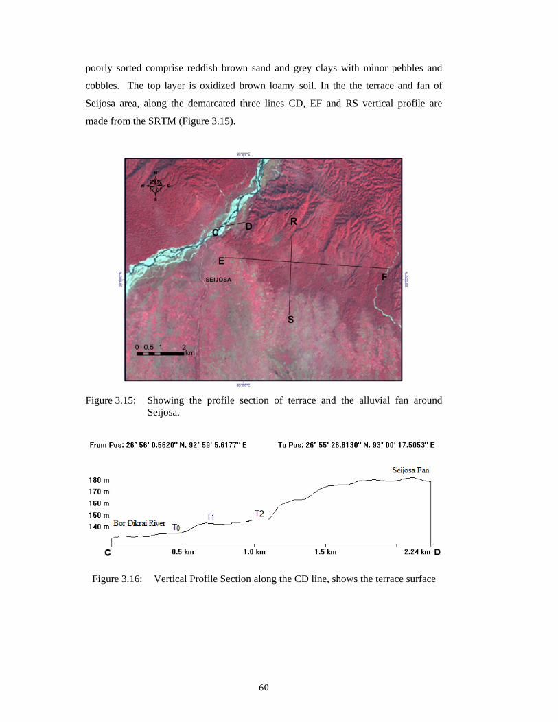
cobbles. The top layer is oxidized brown loamy soil. In the the terrace and fan of
Seijosa area, along the demarcated three lines CD, EF and RS vertical profile are
made from the SRTM (Figure 3.15).
Figure 3.15: Showing the profile section of terrace and the alluvial fan around
Seijosa.
Figure 3.16: Vertical Profile Section along the CD line, shows the terrace surface
61
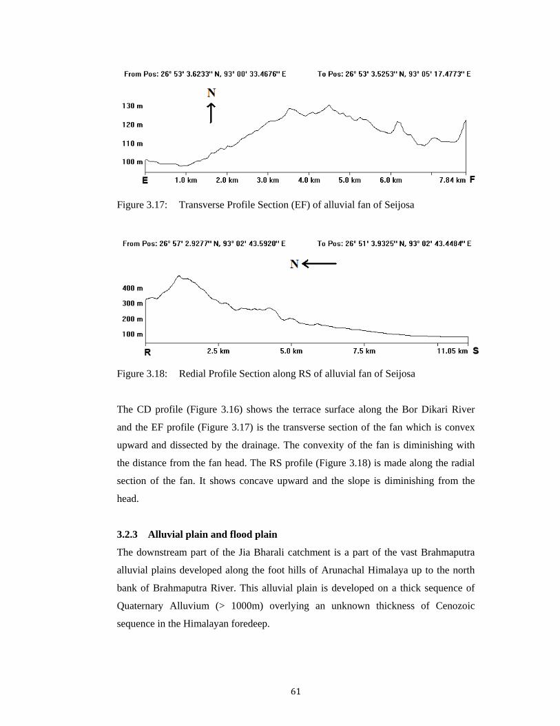
Figure 3.17: Transverse Profile Section (EF) of alluvial fan of Seijosa
Figure 3.18: Redial Profile Section along RS of alluvial fan of Seijosa
The CD profile (Figure 3.16) shows the terrace surface along the Bor Dikari River
and the EF profile (Figure 3.17) is the transverse section of the fan which is convex
upward and dissected by the drainage. The convexity of the fan is diminishing with
the distance from the fan head. The RS profile (Figure 3.18) is made along the radial
section of the fan. It shows concave upward and the slope is diminishing from the
head.
3.2.3 Alluvial plain and flood plain
The downstream part of the Jia Bharali catchment is a part of the vast Brahmaputra
alluvial plains developed along the foot hills of Arunachal Himalaya up to the north
bank of Brahmaputra River. This alluvial plain is developed on a thick sequence of
Quaternary Alluvium (> 1000m) overlying an unknown thickness of Cenozoic
sequence in the Himalayan foredeep.

62
The alluvial plain exhibits a gently southerly slope extending up to the Brahmaputra
River. This alluvial plain has an undulating topography forming by the dissected
terraces of older alluvium along the foothills and in the southern limit the area
exhibits a flat topography and merges with the flood plains of Brahmaputra. The
upper part of the catchment is highly dissected by numerous streams. The river
network in this part flows through deep gorges and formed steep scarp face in the
bank.
Terrace
Numbers of terraces in the alluvial plain of Jia Bharali river consisting of Older
Alluvium have developed which form topographic highs within the alluvial plain.
Three most well developed terrace surface is found around Rangapara and is known
as the Rangapara terrace. The Rangapara surface on the west and Itakhola terrace on
the east represents the older valley floors which are now cut into two parts by the Jia
Bharali and other streams.
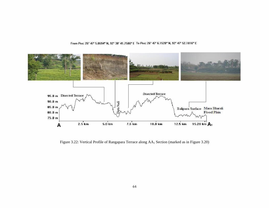
Figure 3.19: Rangapara Terrace (Older alluvium) along Diputa Nadi
Typical sections of the Rangapara terrace are found all along the Diputa river. The
scarp faces of more than 12m are exposed along this river. In the Rangapara terrace
mainly three levels (Figure 3.21) of terrace are found which are formed due to erosion
and soil cutting for the tea garden. The terraces of Rangapara are highly dissected and
due to erosion big gullies formed. The terrace is surrounded by the younger alluvium
Mara Bharali in the east and Jia Gabharu River in the west. In the right bank of Diputa

63
high level terrace are found and in the left bank all the second level of terrace are
exposed.
Figure 3.20: Showing dissected Rangapara Terrace Surface and drainage system.
Figure 3.21 Three different levels of terraces in Rangapara surface
64
Figure 3.22: Vertical Profile of Rangapara Terrace along AA1 Section (marked as in Figure 3.20)

65
Figure 3.23: Cliff faces of Terrace Section along the Diputa River near
Namonigaon. (92o41’24.1”E 26o48’22.3”N)
Flood plain
The recent alluviums are found along the active flood plain, swamps area, sand bar
natural levees etc. of the different river in the alluvium plain. It consists of flood
plains of river Brahmaputra, Jia Bharali, and Bor Dikrai consists of unconsolidated
gravels, sands, silts and clays, flooded seasonally when the river overflow their banks.
They form a higher level than the active floodplain and are not frequently inundated
by flood waters. These alluvial plains composed of clay rich alluvium and form the
paddy fields used for widespread cultivation and the waste lands. The alluvial plain is
characterized by numerous paleochannels old meanders, natural levees, back swamps;
partially recharge zone; shallow ground water table.
Figure 3.24: Channel Fill due to seasonal siltation
66
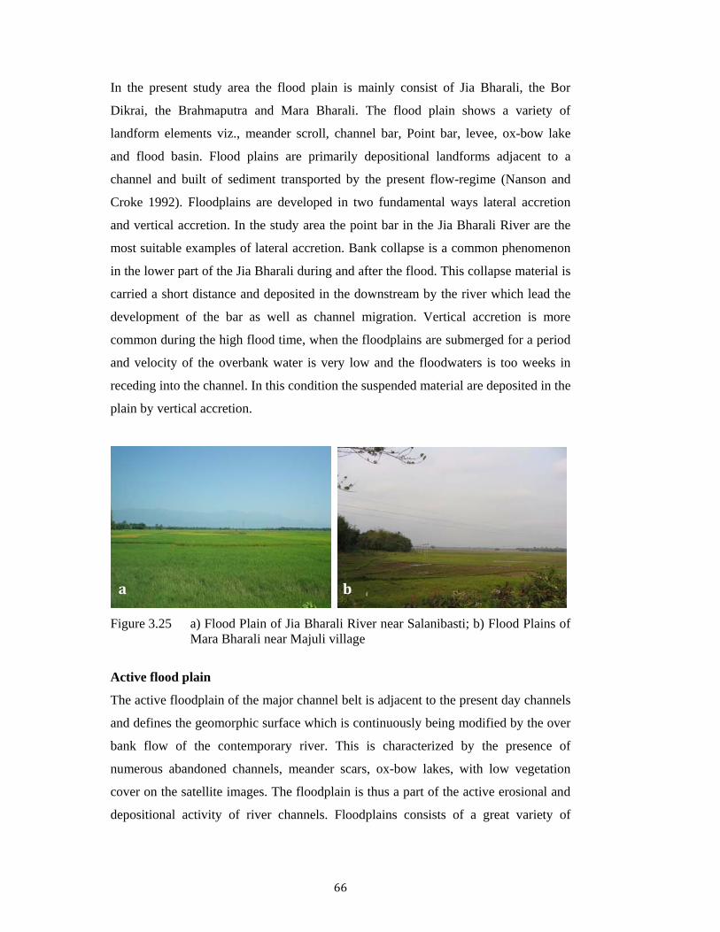
In the present study area the flood plain is mainly consist of Jia Bharali, the Bor
Dikrai, the Brahmaputra and Mara Bharali. The flood plain shows a variety of
landform elements viz., meander scroll, channel bar, Point bar, levee, ox-bow lake
and flood basin. Flood plains are primarily depositional landforms adjacent to a
channel and built of sediment transported by the present flow-regime (Nanson and
Croke 1992). Floodplains are developed in two fundamental ways lateral accretion
and vertical accretion. In the study area the point bar in the Jia Bharali River are the
most suitable examples of lateral accretion. Bank collapse is a common phenomenon
in the lower part of the Jia Bharali during and after the flood. This collapse material is
carried a short distance and deposited in the downstream by the river which lead the
development of the bar as well as channel migration. Vertical accretion is more
common during the high flood time, when the floodplains are submerged for a period
and velocity of the overbank water is very low and the floodwaters is too weeks in
receding into the channel. In this condition the suspended material are deposited in the
plain by vertical accretion.
Figure 3.25 a) Flood Plain of Jia Bharali River near Salanibasti; b) Flood Plains of
Mara Bharali near Majuli village
Active flood plain
The active floodplain of the major channel belt is adjacent to the present day channels
and defines the geomorphic surface which is continuously being modified by the over
bank flow of the contemporary river. This is characterized by the presence of
numerous abandoned channels, meander scars, ox-bow lakes, with low vegetation
cover on the satellite images. The floodplain is thus a part of the active erosional and
depositional activity of river channels. Floodplains consists of a great variety of
a b

67
depositional materials, including channel deposits (sand and gravel), and vertical
accretion deposits (clay and silt deposited by over bank flows).
Active flood plains are found to undergo frequent transformation through avulsion,
neckcut-off, lateral erosion and formation of point bar crescents. The active floodplain
is well developed south of HFT and discernible from tonal characteristics in the
satellite images. In the plains section it is quite well developed. The channel
migration features are prominently developed and their geometric pattern and
superposition suggest multiple phases of channel migration and floodplain
development.
Figure 3.26: Active Flood Plains of Jia Bharali
Valley fills
The Borjuli and Dipota Nadi have entrenched valleys within the Rangapara surface.
Their present channel is confined within the valley in the Rangapara section. In
contrast to terrace sediments the valley fill sediments are essentially yellowish to
grayish finer silty sand to fine sands. Near Pachmolegaon the valley fill sediments are
light grayish in colour. Sediments are silty sand to fine sands. Beds are well marked
by small scale current beddings. The Jia Bharali has also valley fill deposits along its
course from Bhalukpong to the confluence of Nameri Nadi with Jia Bharali.

68
Point Bar
Point bars are the most conspicuous geomorphic features of a meandering stream; at
the same time deposition on point bars is the major process of sedimentation in
meandering river channels. The point bars are observed along the meandering course
of Mansari Nadi, Jorasar Nadi, and Mara Bharali River. Deposition on point bars
result from lateral migration of a meandering river during flooding. The point bar
deposits are particularly found associated with the old course of Mara Bharali river
that have resulted from the lateral accretion on the inner banks of the channel. The
area between Panchmile and Tezpur and Tezpur and Na Pam, a well developed point
bar complex is well discernible both from satellite imagery and in the field.
Shape and size of point bars vary with the size of the river. In the smaller streams
point bars are simple depositional features on the convex sides of the meander dipping
gently towards the channel. In the Jia Bharali river point bars are composed of scroll
shaped ridges (scroll bars) alternating with depressions (swales). Swales are filled
with fine grained muddy sediments, or marshes may develop in them. Each scroll bar
of a point bar represents the result of the channel migration during a flood. Repeated
migration during floods produces scroll bars.
Channel lag
Sediments transported by a river cover a wide range of particle sizes. Silt and clay is
carried away much faster in suspension and is deposited in flood basins. In the
channel itself the coarser sediments, gravels and pebbles lag behind, while the sand
moves as bed load. It represents residual concentration and accumulates as
discontinuous lenticular patches in the deeper parts of the channel – channel lag
deposit. Such coarse-grained accumulation quickly becomes covered by finer-grained
sediments and is preserved. Channel lag deposits never make thick layers, and they
are invariably discontinuous. They occupy the lowest part of a channel or point bar
sequence and indicate the base of the channel. The Jia Bharali River shows the poorly
sorted channel lags of boulders and pebbles in the segment between Bhalukpong and
NT Road crossing (Figure3.27). Lithology and grain size of the point bar deposits
depend upon the grain size available. Besides the channel lag deposits point bar
deposits are composed of the coarsest sediment available in the stream.

69
Figure 3.27: Channel lag deposits along the Jia Bharali course near NT crossing.
Channel bar of Jia Bharali river
The Jia Bharali River has a braided character with low gradient (~0.4m/km) in the
alluvial segments and formed bars of coarse bed materials. The sediments essentially
coarse sand and pebbles boulders and gravels. Jia Bharali flow more or less straight
southerly course from Potasali up to the confluence with Brahmaputra River.
Throughout the river course of Jia Bharali from Bhalukpong to Bhomoraguri, is
characterized by the typically braided bars with its high bed load. The braided
condition of the channel indicates that the river is unable to carry its entire load when
it enters the plain. Due to the presence of easily erodable bank materials of gravel,
sand and silt, the river cuts laterally thereby widening its channel. The river is much
wider compared to its depth. The Jia Bharali has restricted flood plains and a few spill
channels which suggest that the channel represents a recent phenomenon in the
evolution of the basin. Rapid flow conditions are dominant in this braided segment of
Jia Bharali river. High sediments yield even at moderate to high discharges is one of
the contributory factor for the formation of channel bars in the channels (Leopold and
Wolman, 1957).
Channel Bar near Uppar Dikarai confluence is consisting of coarse sand with pebbles,
boulders and gravels. Near Khar Dikrai some stabilized bar exposed course to fine
sand with boulders and pebbles in lower and gravel in the upper with some
intercalation with dark grey silt and clay. Bar of the Bor Dikari near Danlog (Assam-

70
Arunachal Boarder) the sediments are essentially coarse sand with pebbles, boulders
and gravels. The proportion of very coarse sands is less. The top part of the bar
deposits is essentially to coarse sand with minor pebbles.
Figure 3.28: Development of Sand Bar along Jia Bharali in the lower course
In the dry season, in the lower section of the Jia Bharali large stretches of sand
chars extend for several miles at many places, until a bank sufficiently high is formed
to limit the width of the channel during the flood season, but not enough to prevent
inundation during floods.
Figure 3.29: Comparatively permanent sand Bar (Char) in the Jia Bharali River
71
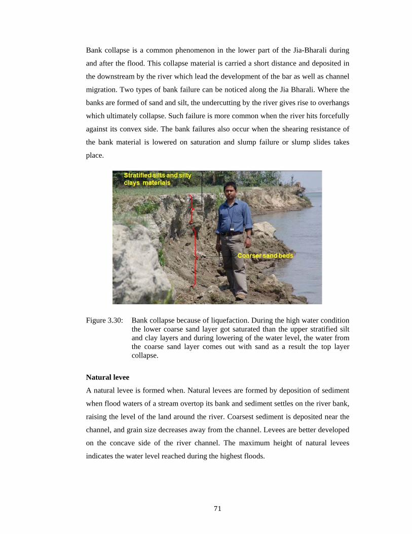
Bank collapse is a common phenomenon in the lower part of the Jia-Bharali during
and after the flood. This collapse material is carried a short distance and deposited in
the downstream by the river which lead the development of the bar as well as channel
migration. Two types of bank failure can be noticed along the Jia Bharali. Where the
banks are formed of sand and silt, the undercutting by the river gives rise to overhangs
which ultimately collapse. Such failure is more common when the river hits forcefully
against its convex side. The bank failures also occur when the shearing resistance of
the bank material is lowered on saturation and slump failure or slump slides takes
place.
Figure 3.30: Bank collapse because of liquefaction. During the high water condition the lower coarse sand layer got saturated than the upper stratified silt and clay layers and during lowering of the water level, the water from the coarse sand layer comes out with sand as a result the top layer collapse.
Natural levee
A natural levee is formed when. Natural levees are formed by deposition of sediment
when flood waters of a stream overtop its bank and sediment settles on the river bank,
raising the level of the land around the river. Coarsest sediment is deposited near the
channel, and grain size decreases away from the channel. Levees are better developed
on the concave side of the river channel. The maximum height of natural levees
indicates the water level reached during the highest floods.

72
Figure 3.31: Natural Levee sections in the bank of Jia Bharali
Natural levees are observed along the old course of Mara Bharali river that are
standing as scarp faces adjacent to the palaeochannels. Along Jia Bharali, a few
segments show the levee development as seen on the right bank near Kuruwani,
Bihiagaon (Figure 3.31). The levee sediments are made up of somewhat finer-grained
material than their corresponding point bar sediments. However the composition of
the upper part of point bar sediment is rather similar to the composition of the levees.
Sedimentary structures of levee deposits are also very similar to the sedimentary
structure of the upper point bar. They include small ripple cross bedding, climbing
ripple lamination, horizontal bedding, and parallel laminated mud layers. Large levee
support much plant growth. Thus, much plant debris and organic matter is
incorporated into levee sediments.
Backswamp Deposits
Backswamps are the result of vertical accretion. In the study area Backswamps are
developed in the downstream reaches of the flood plains of all the major streams near
their confluence with the Brahmaputra river. The abrupt loss of velocity at the edge of
the flooded channel and the abundant sediment supply led to develop this type of
deposits. Mostly a back-swamp is a typical geomorphic feature of flood plain,
consisting of recent alluvial deposits. The backswamp area which is prone to periodic
floods is less cultivated and being dotted with numerous swamps and bills, the land-
use is less as compared to the higher surface. The backswamp sediments are greyish

73
black coloured with more of silty clay and iron oxides, while those of the higher
surface are more sandy. The soils of the red, oxidized older alluvium, fringing the
inselberg areas are more fertile but prone to erosion. Backswamps are mostly massive
clay with abundant organic materials
Figure 3.32: Backswamp area of Jia Bharali flood plain
The area in the immediate vicinity on both sides of the Jia Bharali River is a
backswamp area and is prone to frequent floods. It shows all the typical elements of a
flood plain, namely abandoned channels, chute and neck cut-off meanders now
forming the bills or lakes, meander scrolls and scars, and flood basins.
The meander zone of Mara Bharali
The abandoned Mara Bharali stream course is well depicted on the images and the
topographic maps represents the old channel of Jia Bharali. The Mara Bharali (Figure
3.33) has a meandering course with large loops of about 15-18 km in length. The river
Jia Bharali earlier flows through a meandering course from Salanibasti to Tezpur. The
total length of the meandering loop is about 50 km whereas the length of the present
straight channel known as Jia Bharali is only 30 km. the Mara Bharali seemed to have
attained a profile of equilibrium could be called a graded river before it from the Jia
Bharali channel. The Mara Bharali meander zone is distinguished by the well
developed often intricate pattern of closely spaced, overlapping series channel scars,
meander scrolls and ox-bow lakes which are more clearly seen on the images and also
identifiable on the ground. The meander cut offs of the zone indicate the initiation of
74
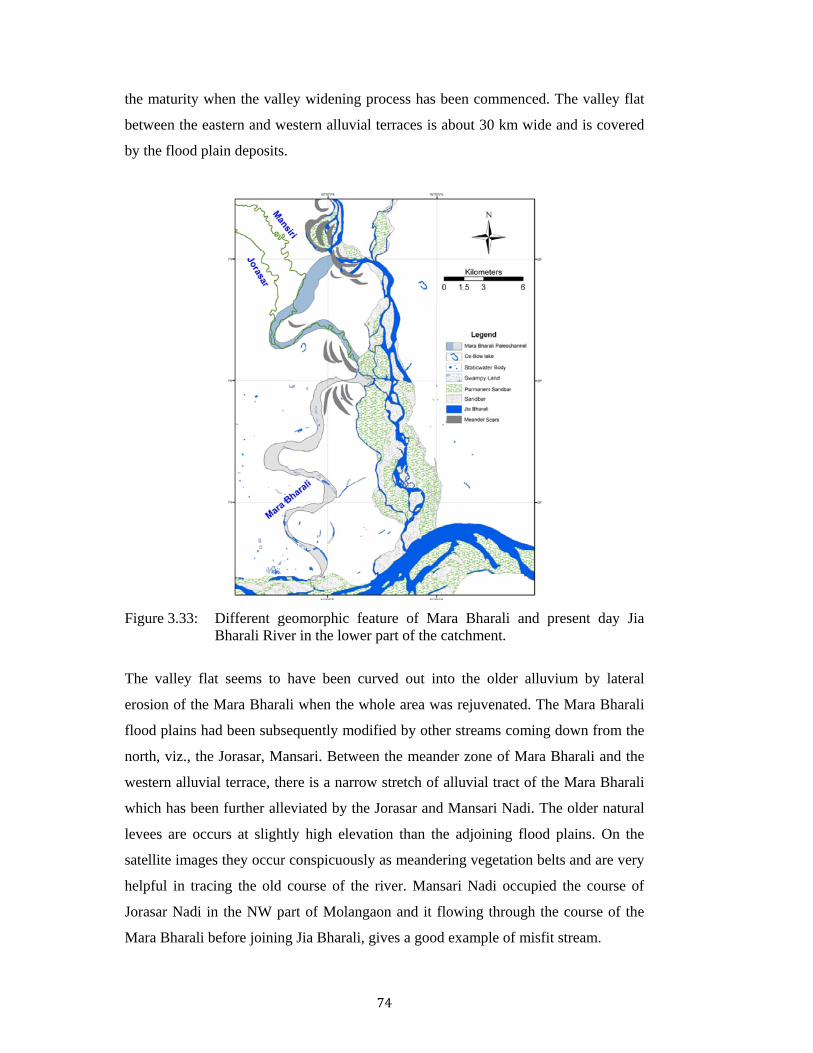
the maturity when the valley widening process has been commenced. The valley flat
between the eastern and western alluvial terraces is about 30 km wide and is covered
by the flood plain deposits.
Figure 3.33: Different geomorphic feature of Mara Bharali and present day Jia
Bharali River in the lower part of the catchment.
The valley flat seems to have been curved out into the older alluvium by lateral
erosion of the Mara Bharali when the whole area was rejuvenated. The Mara Bharali
flood plains had been subsequently modified by other streams coming down from the
north, viz., the Jorasar, Mansari. Between the meander zone of Mara Bharali and the
western alluvial terrace, there is a narrow stretch of alluvial tract of the Mara Bharali
which has been further alleviated by the Jorasar and Mansari Nadi. The older natural
levees are occurs at slightly high elevation than the adjoining flood plains. On the
satellite images they occur conspicuously as meandering vegetation belts and are very
helpful in tracing the old course of the river. Mansari Nadi occupied the course of
Jorasar Nadi in the NW part of Molangaon and it flowing through the course of the
Mara Bharali before joining Jia Bharali, gives a good example of misfit stream.

75
Figure 3.34: Misfit Mansari Nadi along the course of Mara Bharali
Palaeochannel, cuttoff meander and channel fills
The active floodplain of Jia Bharali and the abandoned floodplain of Marabharali
river are dotted with numerous static water bodies of various dimensions. These are
genetically linked to fluvial processes in the area with channel cut off, avulsion and
anabranching followed by various degrees of channel fills. Remnants of these
waterbodies are locally known as ‘bil’ (Figure 3.35) which show a regular pattern of
distribution in satellite images. Together with the meander scars/paleochannels, these
water bodies help delineation of different phases of river migration across the
floodplain.
Figure 3.35: Static Water Body (Na Bil)

76
The numerous cutoff channels and avulsion segments within the Alluvial plain are
filled with continued sedimentation from the fluvial processes. Flood inundation and
more significantly, infrequent flashfloods contribute accelerated aggradation of the
abandoned channels. The sequence of sedimentation is punctuated by duration of non
deposition as evidenced by thin carbonaceous silt and clay horizons interlayered with
coarser sediment sequences. These channel fill sequences bear the signatures of
multiple phases of aggradation and river rejuvenation in the area
Figure 3.36: Paleochannels of Mara Bharali filled with siltation and converted to
paddy field
Apart from the meander cut offs associated with the erstwhile Mara Bharali, some of
the tributaries viz., Mansari and Diputa were subjected to meander growth and
cutoffs- both chute and neck cutoff (Fisk 1944, 1947). The abandoned channels of
these rivers are slowly alluviated and sealed at both the ends, isolating the old channel
loop in the form of a cut-off lake, or ox-bow lake (Figure 3.37). In the beginning,
sedimentation is rather rapid at and near the ends of the cut-off lakes. However, later
the rate of sedimentation in the cut-off lakes is very slow. Some suspended material is
introduced during over bank floods. Mainly clayey sediments and organic matter are
deposited until filling is complete. This process produces a sequence of thick clayey
sediments in the form of clay plugs at both ends of the abandoned segments whose
thickness is controlled by the depth of the abandoned channel.
77
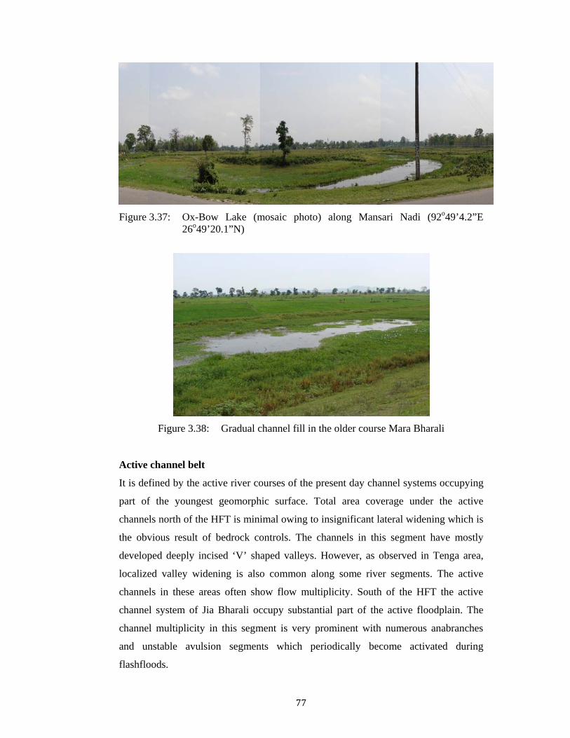
Figure 3.37: Ox-Bow Lake (mosaic photo) along Mansari Nadi (92o49’4.2”E
26o49’20.1”N)
Figure 3.38: Gradual channel fill in the older course Mara Bharali
Active channel belt
It is defined by the active river courses of the present day channel systems occupying
part of the youngest geomorphic surface. Total area coverage under the active
channels north of the HFT is minimal owing to insignificant lateral widening which is
the obvious result of bedrock controls. The channels in this segment have mostly
developed deeply incised ‘V’ shaped valleys. However, as observed in Tenga area,
localized valley widening is also common along some river segments. The active
channels in these areas often show flow multiplicity. South of the HFT the active
channel system of Jia Bharali occupy substantial part of the active floodplain. The
channel multiplicity in this segment is very prominent with numerous anabranches
and unstable avulsion segments which periodically become activated during
flashfloods.

78
3.2.4 Inselberg zone
Isolated residual hills (90-140m amsl) interspersed with narrow valley fills have been
found around Tezpur town occupying part of the overall alluvial terrain adjacent to
the Brahmaputra. These are mostly composed of Precambrian granites and granitic
gneisses representing northern extension of the Mikir Hills massif. Due to spheroidal
weathering, the granites occur as boulders embedded in the highly oxidised weathered
mantle. Prominent of these inselbergs are Agnigarh hill near Tezpur town and the
Bhomoraguri Hill near Kolia-Bhomora Bridge across the Brahmaputra. This inselberg
zone provides a control on the northward migration of the Brahmaputra and westward
migration of the Jia Bharali river which debouche into the Brahmaputra ~5km east of
Tezpur town.
3.3 River Dynamics
3.3.1 Channel changes
River Planform and position is controlled by a number of variables, viz., sediment
flux, bank materials, variability of water discharge, flow velocity and the stream
power. These controlling variables may be independent of tectonic activities or may
be influenced by tectonism. A quite good number of research works on river response
to tectonism (e.g., Burbank and Anderson 2001) and climate (e.g., Goodbred Jr.,
2003). In case of Jia Bharali, in the alluvial part there is record of channel changes
and the form of the river. The Jia Bharali River or Kameng River has N-S flow in the
upstream and change its direction toward SW after confluence of Bichom River. It
takes a sharp band near Bhalukpong with ESE trend along a valley within the
piedmont zone and enters the Assam plains. Near Chotiagaon, it again changes its
direction towards south upto confluence with Brahmaputra. From the Bhalukpong to
the confluence of Uper Dikrai both the banks are high. Extensive Bank erosion is
caused by small streams dissecting these banks. Near Bhalukpong the river incised the
bed rock (Figure 3.39a).

79
Figure 3.39: Jia Bharali River in different section a) Incision in the bed rock near
Bhalukpong b) Bank migration and gravel deposits in the bank near Nameri Reserve Forest.
The Kameng River debouches from Himalaya through a dissected piedmont plain and
enters the alluvial plain of Assam and changes its name as Jia Bharali. From the
debouching point to the confluence point with Brahmaputra, its course is about 64km.
Along this course the river flows through a gravel bed upto Silonighat where the river
meet Bor Dikrai. The river flows along a almost straight, braided channel and flow a
slightly sinuous braided path. After entering the plains extensive bank erosion takes
place (Figure 3.39b)
Changes in Mara Bharali course
The river has undergone a major shifting in the alluvial segments. The older course of
Jia Bharali is still preserved as the Mara Bharali in the west of the present stream. The
river Jia Bharali had the earlier meandering course from Salanibasti to Tezpur over a
channel length of 50 km. Allen (1905) stated that sometimes prior to 1824 the major
changes in the shift of the river channel from the Mara Bharali to the present one has
taken place. In between the Mara Bharali channel and the present Jia Bharali channel,
scars of the older meander scroll are clearly seen both in the satellite imagery and in
the topographic maps.
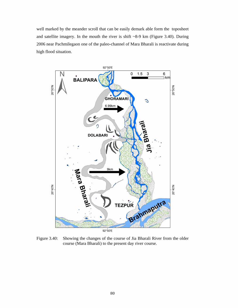
In the present study it is marked that prior to 1979 the river change its course from
Ghoramari to Dolabari. It shifted ~6.99 km towards east after a successive movement
which is clearly markable from the satellite imagery. The older paleo-channel course
has a length ~16.5km along which in present day Mansari Nadi is flowing as misfit.
In the lower part from Dolabari to Tezpur section the Mara Bharali has a length ~23.6
km. The river periodically shift towards east with a average shifting of ~9 km, and
a b
80
well marked by the meander scroll that can be easily demark able form the toposheet
and satellite imagery. In the mouth the river is shift ~8-9 km (Figure 3.40). During
2006 near Pachmilegaon one of the paleo-channel of Mara Bharali is reactivate during
high flood situation.
Figure 3.40: Showing the changes of the course of Jia Bharali River from the older
course (Mara Bharali) to the present day river course.

81
Bor Dikrai course
Bor Dikari has a largest contribution to Jia Bharali among the left bank stream. The
Bor Dikari has a southwestern flow from Seijosa to Silonighat. In the north of Seijosa
the Pakke River joins with Dibru Nadi, the river got its name as Bor Dikrai up to its
confluence with Jia Bharali. It is found that prior to 1894 the Dikrai river had a
straight southerly course starting from the Seijosa foot hill itself and debouched
directly into the Brahmaputra river near Jia Bharali confluence (Viswanathan and
Chakraborti, 1977). On the other hand the Koila Jan was an active stream and used to
join the Jia Bharali river near Silonighat which is reflects in the Survey of India
toposheet, 1913 (GSI, Geological survey of India report, 1977). GSI had reported the
in the channel map of 1894, the Bor Dikrai used to feed the Dikrai river, which is
remains as a miss fit in present time. Again in the present study during 1979 to 2001,
the shifting is prominent. It has a continuously southwesterly progression abandoning
a number of channel through which some other river flows as misfit.
During the period 1960-1971 Bor Dikrai met the Kolia Jan about 3 km upstream on
the north bank from the Bor Dikrai - Jia Bharali confluence (GSI, 1977). In the older
course of Bor Dikrai, the Rathevali has become a misfit stream and its channel is
completely filled up being used for agricultural purposes. The upstream Bor Dikrai
was flowing through straight Boyamara Nala upto the Mirigaon.
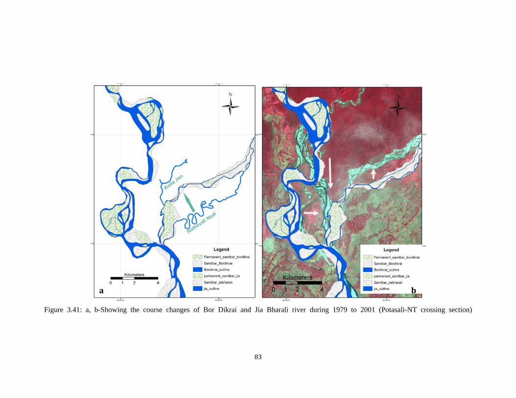
This study reveals that the upper section Jia Bharali, near Nameri is straightening its
course occupying the course of Koila Jan during the period of 1979-2001. Here Jia
Bharali shift laterally ~3km east ward and it met the course of Bor Dikari which again
shift north ward ~1.5km leaving its ~10km length old course. Jia Bharali and Bor
Dikari flow in the same course ~5km and debouch in the old course of Jia Bharali
near Silonighat (Figure 3.41). The confluence of Bor Dikrai is shifted northward 3km
from Silonighat. Prior to 1979, the paleo-course of Bor Dikrai is easily identifiable
from the satellite imagery and along its course some small river are flows as misfit.
The Bahibhara Nadi and Rathevali Nadi flows as misfit along the paleo-course of Bor
Dikrai. During 1979-2001 Bor Dikrai shifts north to present day course and Boymara
Nadi flows as misfit within the older course.

82
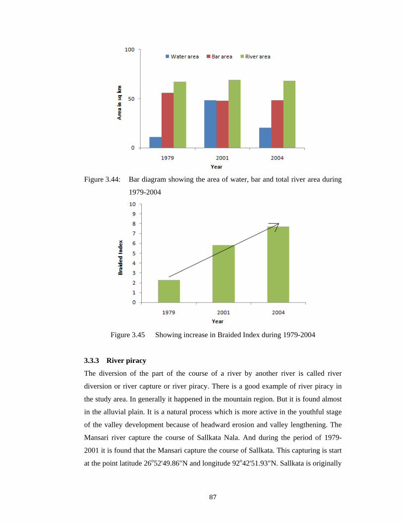
Lower regime of Jia Bharali (NT Crossing to Brahmaputra)
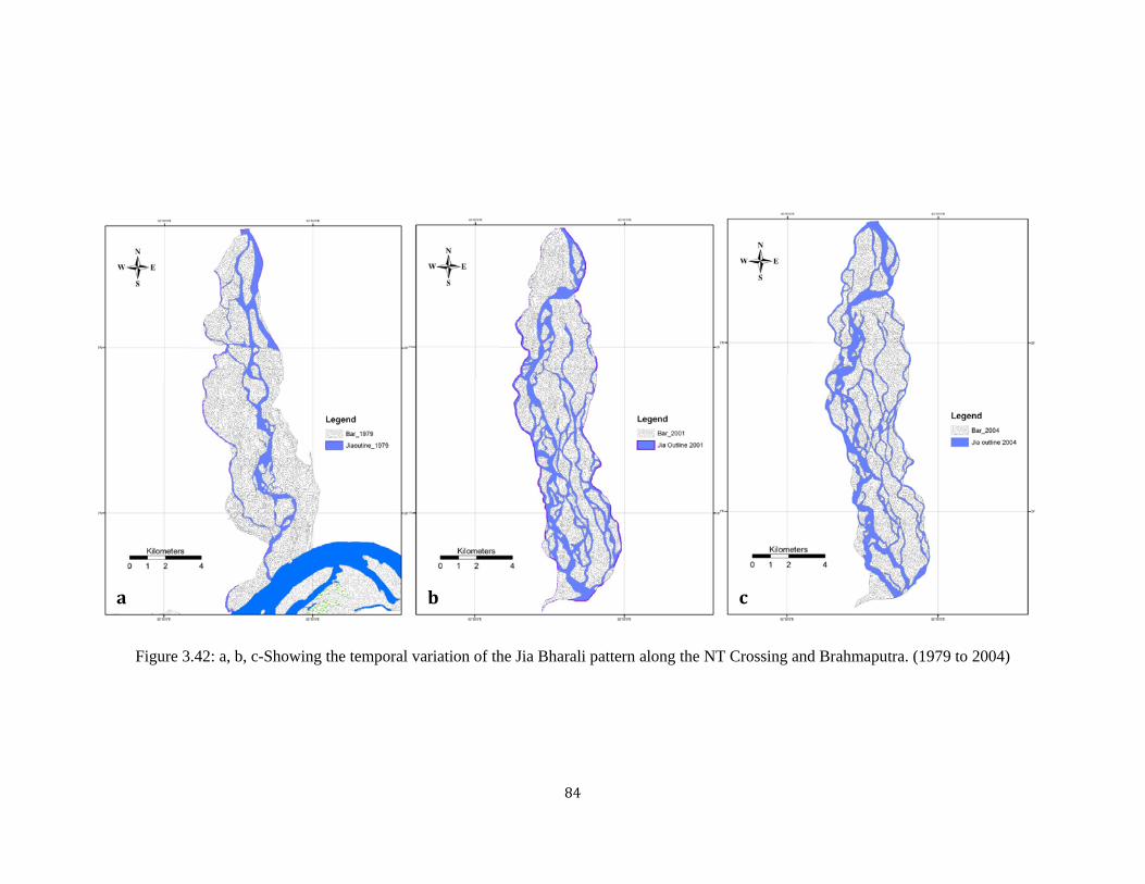
Jia Bharali river in this section shows highly braided character. The braided index is
increasing from 1979 to 2004. During 1979 braided index is 2.3 and it is increase upto
7.7 in 2004. The number of bar development increase from 76 to 90 during 1979 to
2001 and it again decrease in 2004 up to 86. It indicate that the sediment load increase
with time. In this section the river has a low gradient of 0.4m/km. from the variation
of three year it is observed that the trunk channel of Jia Bharali is shifted towards west
from 1979 to 2004 (Figure 3.42). From the study it is seen that the sinuosity of the
channel in between the bar is increasing from 1979 to 2004.
Ghiladhari-Brahmaputra Section
Earlier Ghiladhari river used to join directly Brahmaputra near Ghiladharighat.
Brahmaputra had a shifted ~6km towards south compared to 1894 channel map (GSI
1977). And Ghiladhari has taken up one of the remnant branch of Brahmaputra. Prior
to 1979 lower course of this Ghiladhari river debouches with Brahmaputra near
Panpur Ghat. In the present study it is observed that Brahmaputra shifted 3km towards
south during 1979-2004. Ghiladhari again flows through an older course (~3.4km) of
Brahmaputra and meet Jia Bharali near Laletapur. Further the discharge of Ghiladhari
from the north-east side in the mouth of the Jia Bharali, resulted shifting in the
debouch point of Jia Bharali with Brahmaputra west ward up to the limit of
Bhomoraguri Hill (Figure 3.43).
83
Figure 3.41: a, b-Showing the course changes of Bor Dikrai and Jia Bharali river during 1979 to 2001 (Potasali-NT crossing section)
a b
84
Figure 3.42: a, b, c-Showing the temporal variation of the Jia Bharali pattern along the NT Crossing and Brahmaputra. (1979 to 2004)
a b c

85
Figure 3.43: a, b Showing the Southward movement of Brahmaputra River during 1979 to 2001
a b
86
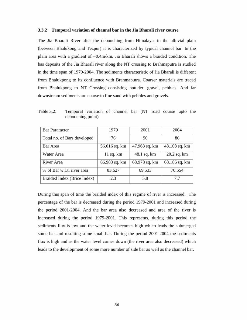
3.3.2 Temporal variation of channel bar in the Jia Bharali river course
The Jia Bharali River after the debouching from Himalaya, in the alluvial plain
(between Bhalukong and Tezpur) it is characterized by typical channel bar. In the
plain area with a gradient of ~0.4m/km, Jia Bharali shows a braided condition. The
bas deposits of the Jia Bharali river along the NT crossing to Brahmaputra is studied
in the time span of 1979-2004. The sediments characteristic of Jia Bharali is different
from Bhalukpong to its confluence with Brahmaputra. Coarser materials are traced
from Bhalukpong to NT Crossing consisting boulder, gravel, pebbles. And far
downstream sediments are coarse to fine sand with pebbles and gravels.
Table 3.2: Temporal variation of channel bar (NT road course upto the debouching point)
Bar Parameter 1979 2001 2004
Total no. of Bars developed 76 90 86
Bar Area 56.016 sq. km 47.963 sq. km 48.108 sq. km
Water Area 11 sq. km 48.1 sq. km 20.2 sq. km
River Area 66.983 sq. km 68.978 sq. km 68.186 sq. km
% of Bar w.r.t. river area 83.627 69.533 70.554
Braided Index (Brice Index) 2.3 5.8 7.7
During this span of time the braided index of this regime of river is increased. The
percentage of the bar is decreased during the period 1979-2001 and increased during
the period 2001-2004. And the bar area also decreased and area of the river is
increased during the period 1979-2001. This represents, during this period the
sediments flux is low and the water level becomes high which leads the submerged
some bar and resulting some small bar. During the period 2001-2004 the sediments
flux is high and as the water level comes down (the river area also decreased) which
leads to the development of some more number of side bar as well as the channel bar.
87
Figure 3.44: Bar diagram showing the area of water, bar and total river area during
1979-2004
Figure 3.45 Showing increase in Braided Index during 1979-2004
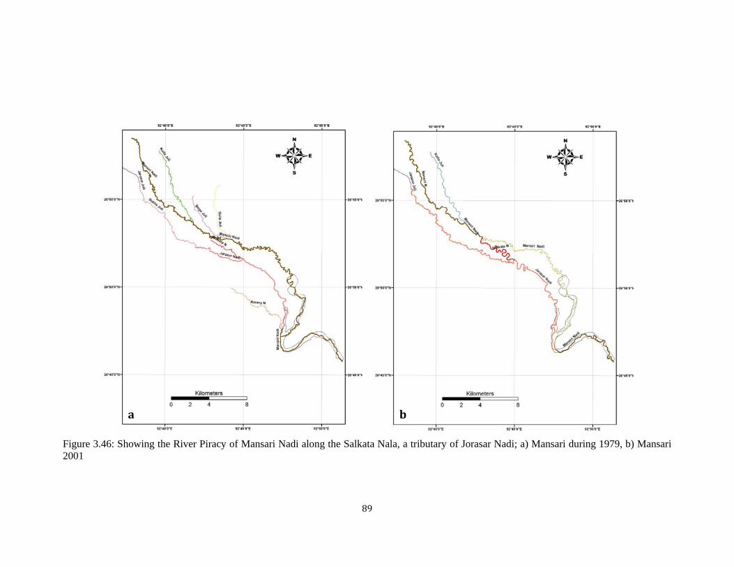
3.3.3 River piracy
The diversion of the part of the course of a river by another river is called river
diversion or river capture or river piracy. There is a good example of river piracy in
the study area. In generally it happened in the mountain region. But it is found almost
in the alluvial plain. It is a natural process which is more active in the youthful stage
of the valley development because of headward erosion and valley lengthening. The
Mansari river capture the course of Sallkata Nala. And during the period of 1979-
2001 it is found that the Mansari capture the course of Sallkata. This capturing is start
at the point latitude 26o52'49.86"N and longitude 92o42'51.93"N. Sallkata is originally

88
a 2nd order stream of river Jorasar found in the topomap of 1979. Salkata has a high
gradient than Mansari, hence a high amount of water of Mansari flows through the
Jorasar leaving its original course (Figure 3.46 a, b). This type incidence is take place
because of upstream erossion of Sallkata Nala and simultaneously the meandering
character of the Mansari Nadi. The lateral shifting of a meander of Mansari Nadi
extends upto the Salkata Nala. And during the high flood time it flows through
Salkata. And the present Mansari flows along with Jorasar.
Earlier course of the Mansari Nadi was highly meandering in its course. After
occupying the Salkata Nala it forms again form meandering along the older course of
Salkata.
3.3.4 Misfit stream
Misfit is also a process of river capturing. In this case the capturing river flow through
the course of captured river, where it not able to occupy the whole course of the river.
Mansari Nadi: In the eastern part of the lower catchment of Jia Bharali the Mansari
and the Jorasar, both earlier meet the Bharali in the different confluence point (GSI,
1977). But as the Bharali flow through the course of Jia Bharali and leaving the older
course as palaeochannel, the Mansari flows through it as Misfit River. Along the
course the Jorasar met the Mansari and flow in same course up to the confluence point
with Jia Bharali as Misfit River (Figure 3.47 a, b).
89
Figure 3.46: Showing the River Piracy of Mansari Nadi along the Salkata Nala, a tributary of Jorasar Nadi; a) Mansari during 1979, b) Mansari 2001
a b

90
Figure 3.47: a, b. Showing the misfit of Mansari along the older course of Mara Bharali.
a b
91
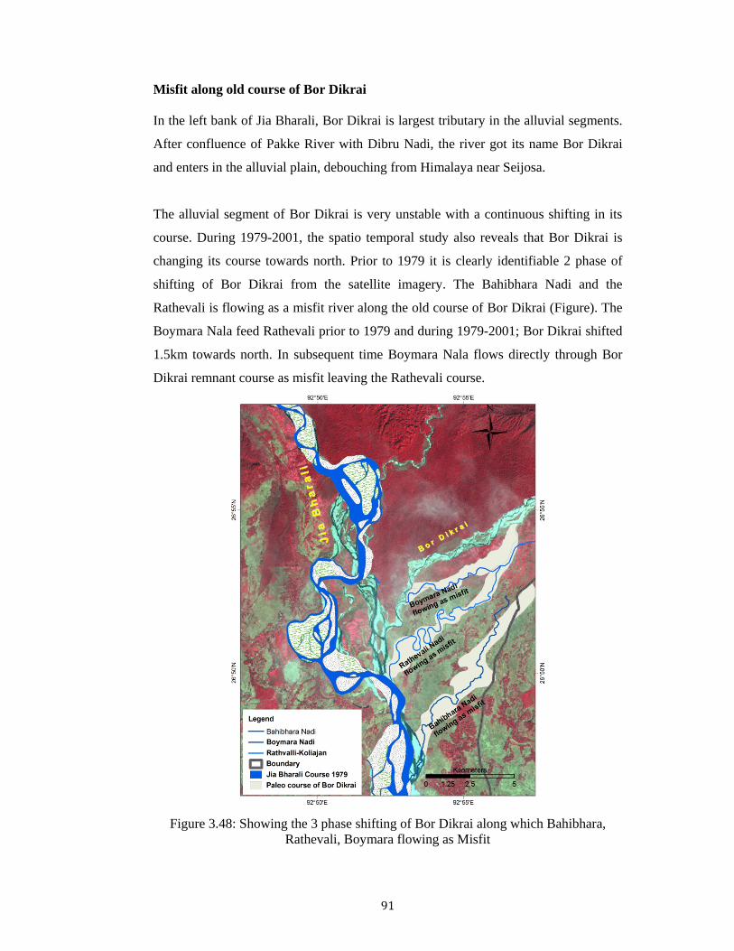
Misfit along old course of Bor Dikrai
In the left bank of Jia Bharali, Bor Dikrai is largest tributary in the alluvial segments.
After confluence of Pakke River with Dibru Nadi, the river got its name Bor Dikrai
and enters in the alluvial plain, debouching from Himalaya near Seijosa.
The alluvial segment of Bor Dikrai is very unstable with a continuous shifting in its
course. During 1979-2001, the spatio temporal study also reveals that Bor Dikrai is
changing its course towards north. Prior to 1979 it is clearly identifiable 2 phase of
shifting of Bor Dikrai from the satellite imagery. The Bahibhara Nadi and the
Rathevali is flowing as a misfit river along the old course of Bor Dikrai (Figure). The
Boymara Nala feed Rathevali prior to 1979 and during 1979-2001; Bor Dikrai shifted
1.5km towards north. In subsequent time Boymara Nala flows directly through Bor
Dikrai remnant course as misfit leaving the Rathevali course.
Figure 3.48: Showing the 3 phase shifting of Bor Dikrai along which Bahibhara,
Rathevali, Boymara flowing as Misfit

92
3.4 Drainage pattern
Drainage pattern is the planimetric arrangement of streams within a drainage basin.
Where run-off concentrates, the land surface is eroded to form a channel. Most of the
stream appears to be in conformity with the geological and structural set up (Rachna
et.al 1999). The patterns which streams from are determines by the inequalities of
surface slope and inequalities of rock resistance. It is evident that drainage patters
may reflects original slope and original structure or the successive episodes by which
the surface has been modified, including uplift, depression, tilting, wrapping, folding,
faulting and jointing, as well as deposition by any depositional facto (Zernitz, 1932).
The pattern formed by the network is influenced by climate and land relief, but the
underlying geological structure is usually the most important determining factor. The
drainage pattern is an excellent indicator of not only the surfacial lithology and
geological structure but also the ongoing morphotectonic processes.
In the Jia Bharali catchment area the major drainage patterns (after Howard, 1967;
Zernitz, 1932) can be delineated as dendritic, sub-dendritic, sub-parallel, trellis and
rectangular pattern. The drainage of the most of the part of Jia Bharali catchment area
is collected from the available topographic maps. Drainage are controlled by the
structure and the lithology of the area. The drainage networks by large rectangular and
trellis that are orienting the channels along east–west (major trend of the structure)
and north–south (transverse fault and Lineament) directions in the central domain.
The dominant pattern type is dendritic and sub-dendritic.
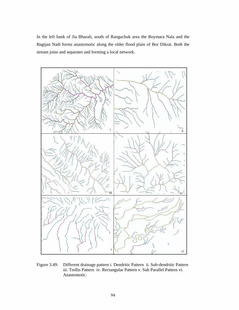
Dendritic Pattern: The dendritic drainage pattern formed by a main stream with its
tributaries branching and rebranching freely in all directions (Figure 3.49 i). It is
particularly characteristic of rocks, which are homogeneous with respect to erosion by
running water. It is the dominant pattern in the study area as well as in the Himalaya.
This pattern is due to the tendency of all drainage to integrate in relatively short
geological time. As the study area has a gentle slope dendritic pattern is well
developed. Which reflects in the slope map derives from DEM that about 74% of the
total area under a slope of 30o. In the upper part sub-dendritic pattern is common
within the study area because of its uniformly resistant rocks.

93
Trellis Pattern: Trellis drainage pattern are formed by the network of tributaries and
master consequent streams, which follow the regional slope and well adjusted to the
geological structure. Along the major thrust and lineament, drainage shows trellis
pattern (Figure 3.49 ii).
Rectangular pattern: In the central-eastern part of the basin shows a broadly
rectangular pattern (Figure 3.49 iii). Along the NNE-SSW fault (Duarah et al., 2011)
in the Siwalik sequence rectangular type of drainage pattern developed, indicate the
resistance to the eastern propagation of the faults, since such a tip damage zone
develops in response to stress concentration at a fault tip (Kim et al. 2004; Cowie and
Scholz 1992). Normally, a fault tends to grow along a curved or kinked path, which
is locally parallel to the direction of maximum compressive stress at the time of
faulting (Pollard and Segall 1987).
Sub Parallel Pattern: Locally developed this type of drainage pattern all along the
piedmont zone (Figure 3.49 v). The alluvial fan and terraces are dissected by
numerous streams. These stream are flows almost N-S direction and meet the major
channel directly.
Anastomotic: It is a modified pattern. Rivers have multiple channels that separate
and re-join over distances of many kilometers, with large islands separating several
relatively stable channels (Nanson and Kinghton, 1996). These are called
anastomotic, or deranged pattern (Thornbury 1960). In the study area this type of
pattern develops in the alluvial part due to very low overall gradient.
The course shifting and braided character of the alluvial river also gives some
anastomosing pattern of channel. In the eastern side Bor Dikrai and Rathevali shows
anastomosing pattern (Figure 3.49 vi).. In the eastern side Mansari change its course
occupying the Jorasar course and again it meet the older Mansari course along the
Mara Bharali channel. In the braided channel of Jia Bharali shows anastomosing
pattern. This type of anastomotic is found in intermittent to perennial stream systems
with net long-term erosion, in contrast to braided streams which are characterized by
net long-term deposition, and which occur within well-defined floodplains.
Anastomosing streams are geologically temporary features.
94
In the left bank of Jia Bharali, south of Rangachuk area the Boymara Nala and the
Bagijan Nadi forms anastomotic along the older flood plain of Bor Dikrai. Both the
stream joins and separates and forming a local network.
Figure 3.49: Different drainage pattern i. Dendritic Pattern ii. Sub-dendritic Pattern
iii. Trellis Pattern iv. Rectangular Pattern v. Sub Parallel Pattern vi. Anastomotic.

95
3.5 Channel Pattern
In the study area, the channel shows straight, meander, braided pattern. The channel
path and pattern is depends on the six channel habits (Schumm, 1981); relative
stability, sediments load, grained size, ratio of suspended load and bedload and other
related variables. The morphology of the different channel is different from each
other.
Figure 3.50: Classification of Channel Pattern (after Schumm, 1981)
Straight Pattern: In between the Sessa and Tipi Jia Bharali shows a straight path.
The river Bor Dikari has also a straight path in the lower regime after debouching
from Himalaya. Straight stream channels are rare. Where they do occur, the channel
is usually controlled by a linear zone of weakness in the underlying rock, like a fault
or joint system. Even in straight channel segments water flows in a sinuous fashion,
with the deepest part of the channel changing from near one bank to near the other.
Velocity is highest in the zone overlying the deepest part of the stream. In these areas,
sediment is transported readily resulting in pools. Where the velocity of the stream is
low, sediment is deposited to form bars. The bank closest to the zone of highest
velocity is usually eroded and results in bank cutting.

96
Figure 3.51: Straight Pattern of Bor Dikrai river and Diagramatic presentation of the
sinuous fashion (www.earthsci.org)
Meandering Pattern: Whitlow, 1984, defined the meander as a loop like bend in a
river characterised by a river cliff on the outside of the curve and gently shelving
point bas on the inner side of the bend. Meandering pattern is more common channel
pattern in the alluvial part of the basin. A stream flowing over low gradients with
easily eroded banks will eventually erode into meandering channels. Erosion will take
place on the outer parts of the meander bends where the velocity of the stream is
highest. Sediment deposition will occur along the inner meander bends where the
velocity is low, develop point bar.
Figure 3.52: Meander belt of Mansari Nadi and point bar in the bank

97
Meandering streams are continually eroding and depositing sediment as a result
stream channels tend to migrate back and forth across their flood plain. In the alluvial
plain river like Mansari, Jorasar, Rathevali and older path of Mara Bharali shows
meandering pattern in their different section of the path. Meandering lengthens the
course of a stream and it reduces its gradient. Consequently its load-transporting
power diminished. Curvature of the channels hinders the movement of load and
deposited as bed load. Older course of Jia Bharali shows highly meandering. All the
morphological point of view all the three meanders pattern exhibit the river system of
the lower segments of the Jia Bharali basins.
i) Simple wavy type: Meander belt of Mara Bharali exhibit gentle curvature in its
path. Mara Bharali meander forms a big wave bands.
Figure 3.53: Simple wavy type (92o47’12.1”E, 26o41’33.5”N).
ii) Horse-shoe type: In this type the bends are curved like horse-shoe. This type
marked by great curvature in the meanders appears to very frequent type particularly
in the plain. The river Rathevali, the old course of Bor Dikari shows this type of
meander belts in its course (92o53’47.4”E, 26o30’59.8”N). Along the new course of
Mansari River before confluence with shows curvature and appears as meander
(92o44’34.2”E, 26o30’51.5”N).
98
Figure 3.54: Horse-Shoe type pattern shows by the Rathevali along the older course
of Bor Dikrai river. In present time it flows as a misfit.
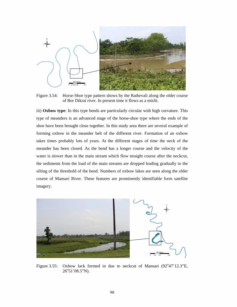
iii) Oxbow type: In this type bends are particularly circular with high curvature. This
type of meanders is an advanced stage of the horse-shoe type where the ends of the
shoe have been brought close together. In this study area there are several example of
forming oxbow in the meander belt of the different river. Formation of an oxbow
takes times probably lots of years. At the different stages of time the neck of the
meander has been closed. As the bend has a longer course and the velocity of the
water is slower than in the main stream which flow straight course after the neckcut,
the sediments from the load of the main streams are dropped leading gradually to the
silting of the threshold of the bend. Numbers of oxbow lakes are seen along the older
course of Mansari River. These features are prominently identifiable form satellite
imagery.
Figure 3.55: Oxbow lack formed in due to neckcut of Mansari (92o47’12.3”E,
26o51’08.5”N).

99
Braided Pattern: Jia Bharali itself shows braided character in the lower regime.
During the dry period lots of bars are developed in its course. But during high water it
shows some sort of meandering pattern. The braided pattern of Jia Bharali is
developed from the Nameri to its debouching point with Brahmaputra. The bars in a
braided channel are subjected to construction and destruction but as a whole there is a
downstream migration of the sandbanks during floods (Holmes, A., 1966).
Figure 3.56: Braided Pattern in Jia-Bhalari River (92o52’42.8”E, 26o 48’44.3”N). Rivers that are subjected to large fluctuations in discharge, or that drain poorly
vegetated regions, or that have generally large loads, tend to have high percentages of
solid load (Laronne and Ride, 1993) and are likely to have form braided channels.
Jia Bharali River is has a relatively wide channel. In the absence of meandering there
is erosion on both sides. This accounts for the unusual width of braided channels
which are originally broadened by the multiplicity of the streams in the river. Jia
Bharali has no such a markable bank line. It is widening its course in both side of the
bank eroding the bank material. The bank material has low cohesiveness character,
due to which it erodes easily and bank shift every year in both the direction.
Jia Bharali River is an eight order stream. Jia Bharali between Bhalukpong and
Nameri is relatively straight with some small bend depositing the river load in the
bank with a northward progression of the river. The stream network is initiated by
water draining over a land surface whose relief and erodibility are determined by

100
regional geology and underlying structure. In alluvial part when the streams carry
high amount of discharge and over flooded it flows in the any direction finding a low
gradient. There is no control of any structures. During the high Rainey seasons the
Mara Bharali course is over flooded and the water flows in some streams in the
surrounding area. In the Himalayan part of the Jia Bharali basin this type of
consequent streams are prominent.
Drainage patterns are dynamic and evolve as a result of the action of flowing water in
eroding, transporting, and depositing rock and sediment form the channel boundaries.
With time, these fluvial processes can themselves modify the drainage pattern. In the
alluvial regime, rivers are frequently changing their course. River capture, misfit or
underfits are the example of river work. River/streams flows through a new route
leaving its older route. Mansari Nadi is a best example of this type of dynamics.
Mansari Nadi is a misfit or underfit streams in its lower course. Mansari Nadi flows
through a paleo course of Bharali River, i.e., Mara Bharali River. During the period of
1979 to 2001 it shows the best dynamic work, it occupy the course of Jorasor Nadi.
Salkata N is a small tributary of Jorasar Nadi. Because of headward erosion of Salkata
N it meets the Mansari Nadi and Mansari follow the course of Salkata Nala as well as
the Jorasor. From the Basin asymmetry it is also seen that the left bank of Mansari
Nadi catchment is tilted up where as the in the catchment of Jorasar Nadi the right
bank is tilted up.