Geology Teacher Guide to Rocky Mountain National Park · PDF fileGuide to Rocky Mountain...
71
1 Geology Teacher Guide to Rocky Mountain National Park Figure 1: summit of Emerald Peak in late February, 2012 14ers.com Kellyn Griffin Spring 2012
Transcript of Geology Teacher Guide to Rocky Mountain National Park · PDF fileGuide to Rocky Mountain...

1
Geology Teacher Guide to Rocky
Mountain National Park
Figure 1: summit of Emerald Peak in late February, 2012 14ers.com
Kellyn Griffin Spring 2012
2
Contents Introduction ...................................................................................................................................................................................... 3
Acknowledgments ............................................................................................................................................................................ 3
Setting and Overview........................................................................................................................................................................ 4
Geographic Setting of Rocky Mountain National Park ................................................................................................................ 4
Geologic Setting of Rocky Mountain National Park .................................................................................................................... 5
Precambrian Era: 3800-543 million years ago ........................................................................................................................ 6
Paleozoic Era: 543-248 million years ago ............................................................................................................................... 6
Mesozoic Era: 248- 65 million years ago ................................................................................................................................ 7
Cenozoic Era: 65 million years ago- present day .................................................................................................................... 8
Tectonics of Rocky Mountain National Park .................................................................................................................................... 9
Tectonic Principles relevant to Rocky Mountain National Park .................................................................................................. 9
Plate Tectonics ...................................................................................................................................................................... 10
The Great Unconformity ....................................................................................................................................................... 12
Plate tectonics of the Paleozoic Era....................................................................................................................................... 12
Plate Tectonics of the Mesozoic Era ..................................................................................................................................... 13
Plate Tectonics of the Cenozoic Era ...................................................................................................................................... 14
Glaciers of Rocky Mountain National Park .................................................................................................................................... 15
Pre-Bull Lake- 1.2 million years ago .................................................................................................................................... 16
Bull Lake glaciation- 300,000-127,000 year ago .................................................................................................................. 16
Pinedale glaciation- 30,000-12,000 years ago ....................................................................................................................... 17
Post- Pleistocene Glaciation .................................................................................................................................................. 18
Rock Glaciers ........................................................................................................................................................................ 19
Erosion History of Rocky Mountain National Park ........................................................................................................................ 20
Foothills just outside of Rocky Mountain National Park ................................................................................................................ 21
Climate and Ecology of Rocky Mountain National Park ................................................................................................................ 21
References ...................................................................................................................................................................................... 24
Lesson Plans ................................................................................................................................................................................... 24
Making a Geologic Time Scale Lesson ...................................................................................................................................... 25
The Mystery of the Valley Lesson ............................................................................................................................................. 30
Rocks of the Alluvial Fan Lesson .............................................................................................................................................. 40
Foothills Geology Lesson .......................................................................................................................................................... 44
Appendix ........................................................................................................................................................................................ 53
Geologic Time Scale .................................................................................................................................................................. 53
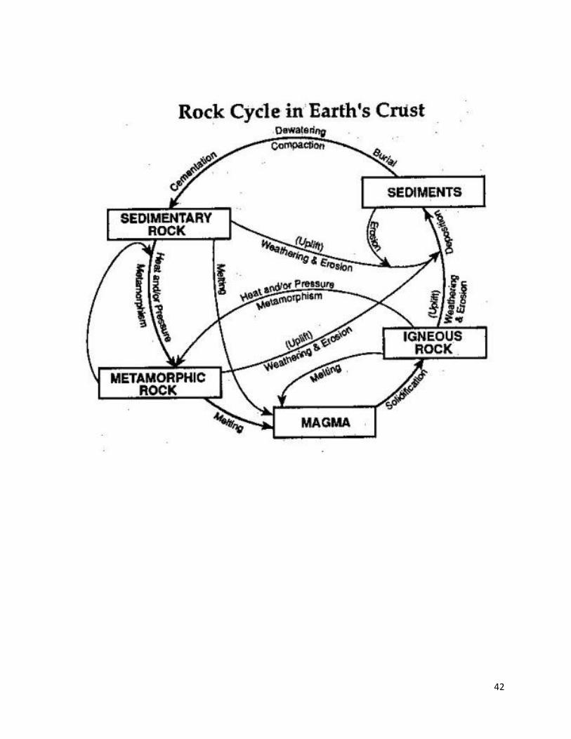
Common Rocks and the Rock Cycle .......................................................................................................................................... 55
Formation Properties of Rocky Mountain National Park ........................................................................................................... 57
Foothills Formations .................................................................................................................................................................. 58
Vocabulary ................................................................................................................................................................................. 59
3
Introduction Dear Teachers-
Rocky Mountain National Park is a unique and beautiful place. The park is made up of several geologic
processes working together for billions of years creating the dynamic beauty you see today. This teacher
guide is intended to give an overview of all the geologic history with details to the key events of Rocky
Mountain National. The goal is to use this teacher guide as a resource to the geology of Rocky Mountain
National Park and take the information back to the classroom, or better yet, in the field at Rocky
Mountain National Park.
This geology teacher guide of Rocky Mountain National Park includes the geologic history starting 1.7
billion years ago and details key geologic events that have profoundly shaped the park. The geologic
history of Rocky Mountain National Park includes several of examples of mountain building, inland sea
advancement, erosion, and glaciers. In the teacher guide you will discover why the crystalline basement
rock is so important to the stability of the Rocky Mountains, how glaciers have shaped the Continental
Divide alpine and everything in between. Geology is the backbone to the climate and ecosystems of
Rocky Mountain National Park and without all the geologic history Rocky Mountain National Park would
not be what it is today.
In the teacher guide there are lessons to be used both in the classroom and on-site at Rocky Mountain
National Park. It is important to remember when visiting Rocky Mountain National Park the high
elevation dehydrates you quicker, gives you more exposer to UV rays and causes the weather to change
quickly. Remember to come prepared and bring lots of water, sun screen, and plan accordingly for the
weather. Beyond the geology of Rocky Mountain National Park, the park is also a great place to see
diverse wildlife, colorful flowers and the experience of being on top of the world high in the alpine
tundra. Regardless if you are visiting Rocky Mountain National park for an education experience or
personal pleasure, always remember to follow park rules, leave no trace and be respectful to the wildlife
and other visitors enjoying the park.
Acknowledgments Special thanks to Mark DeGregorio, Caroline Smith, Nick Voegtly, and the Geological Society of
America for their support of this teacher guide.
4
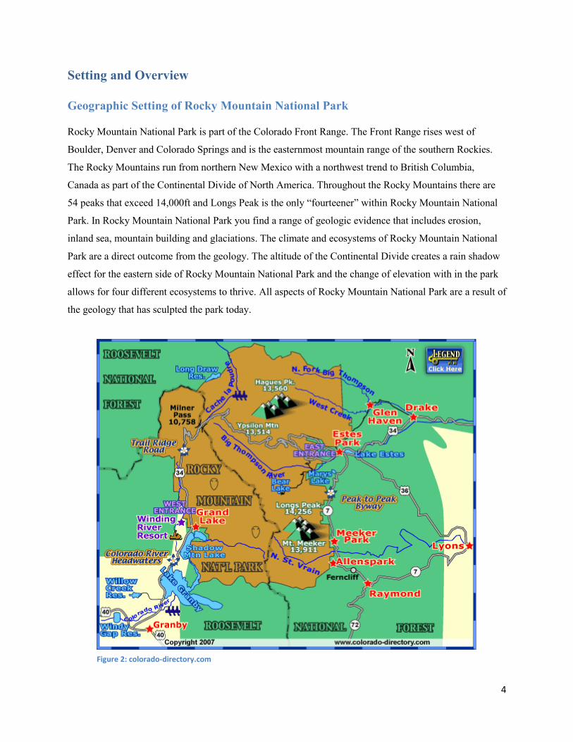
Setting and Overview Geographic Setting of Rocky Mountain National Park
Rocky Mountain National Park is part of the Colorado Front Range. The Front Range rises west of
Boulder, Denver and Colorado Springs and is the easternmost mountain range of the southern Rockies.
The Rocky Mountains run from northern New Mexico with a northwest trend to British Columbia,
Canada as part of the Continental Divide of North America. Throughout the Rocky Mountains there are
54 peaks that exceed 14,000ft and Longs Peak is the only “fourteener” within Rocky Mountain National
Park. In Rocky Mountain National Park you find a range of geologic evidence that includes erosion,
inland sea, mountain building and glaciations. The climate and ecosystems of Rocky Mountain National
Park are a direct outcome from the geology. The altitude of the Continental Divide creates a rain shadow
effect for the eastern side of Rocky Mountain National Park and the change of elevation with in the park
allows for four different ecosystems to thrive. All aspects of Rocky Mountain National Park are a result of
the geology that has sculpted the park today.
Figure 2: colorado-directory.com
5
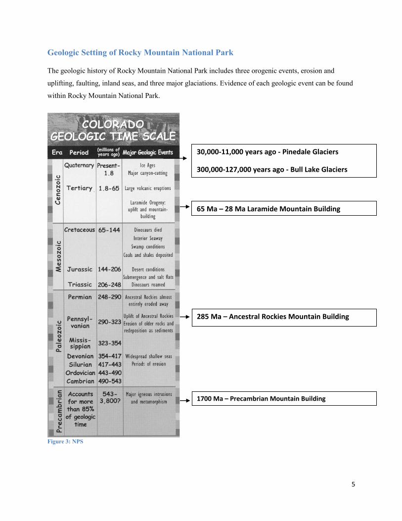
Geologic Setting of Rocky Mountain National Park
The geologic history of Rocky Mountain National Park includes three orogenic events, erosion and
uplifting, faulting, inland seas, and three major glaciations. Evidence of each geologic event can be found
within Rocky Mountain National Park.
Figure 3: NPS
30,000-11,000 years ago - Pinedale Glaciers
300,000-127,000 years ago - Bull Lake Glaciers
65 Ma – 28 Ma Laramide Mountain Building
285 Ma – Ancestral Rockies Mountain Building
1700 Ma – Precambrian Mountain Building

6
Precambrian Era: 3800-543 million years ago
The Precambrian Era, 3800-542 million years ago, is about 88% of earth‟s history. There is not a major
extinction event that ends the era, but an explosion of the first life 3.5 billion years ago starting to develop
from the single celled organisms.
Geologic Era
Time Period
Rocky Mountain National Park Evidence
Precambrian
3800-543 million years ago
- Crystalline basement rock created - Ancient Rockies Orogeny - Major igneous intrusions and
metamorphism Boulder Creek Batholith Silver Plume Granite intrusion
Several events happened in the Precambrian Era to create the rock formations seen in Rocky Mountain
National Park. The oldest rocks in Rocky Mountain National Park come from the Precambrian Era and
date back 1.7 billion years. The parent rocks include sedimentary shale, sandstone interbedded with
volcanic granites. The Precambrian orogeny that created the Ancient Rockies increased tectonic activity,
compressed, folded, uplifted and metamorphosed the parent rocks into a variety of metamorphic schist
and gneiss rocks. The metamorphosed rocks can be seen along the Continental Divide and Trail Ridge
Road. The schist and gneiss of Rocky Mountain National Park show evidence the tectonic activity
occurred repeatedly during the Precambrian Era. The tectonic activity also created major faults that are
significant to the Rocky Mountains you see today. About 1.6 billion years ago a massive igneous
intrusion known as the Boulder Creek Batholith pushed into the schist and gneiss basement rock creating
regional metamorphism. The batholith extended about 30 miles across Rocky Mountain National Park.
Contacts between the granitic intrusions and metamorphic rock can be seen on canyon walls east of the
Continental Divide. This event is separate from the worldwide intrusion 1.4 billion years ago that is
evident in Rocky Mountain National Park.
Paleozoic Era: 543-248 million years ago
The Paleozoic Era occurred 542- 251 million years ago. The prefix paleo means past and this era
encompasses the first land plants, first fish, organisms with shells, insects, amphibians, and the dominate
trilobites. The major extinction that ended the Paleozoic Era is the Permian- Triassic extinction. During
the extinction 50% of all animal families went extinct, and 95% of all marine species went extinct.
7
Geologic Era
Time Period
Rocky Mountain National Park Evidence
Paleozoic
543- 248 million of years ago
- Inland sea advancement and retreats - Ancestral Rockies Orogeny - Ancient Rockies eroded away
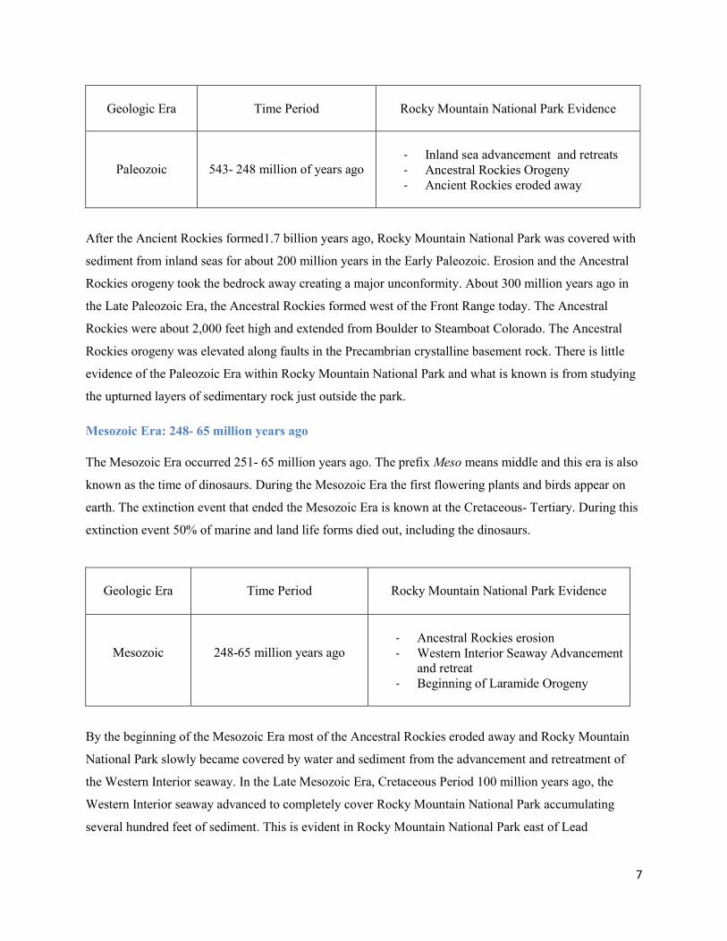
After the Ancient Rockies formed1.7 billion years ago, Rocky Mountain National Park was covered with
sediment from inland seas for about 200 million years in the Early Paleozoic. Erosion and the Ancestral
Rockies orogeny took the bedrock away creating a major unconformity. About 300 million years ago in
the Late Paleozoic Era, the Ancestral Rockies formed west of the Front Range today. The Ancestral
Rockies were about 2,000 feet high and extended from Boulder to Steamboat Colorado. The Ancestral
Rockies orogeny was elevated along faults in the Precambrian crystalline basement rock. There is little
evidence of the Paleozoic Era within Rocky Mountain National Park and what is known is from studying
the upturned layers of sedimentary rock just outside the park.
Mesozoic Era: 248- 65 million years ago
The Mesozoic Era occurred 251- 65 million years ago. The prefix Meso means middle and this era is also
known as the time of dinosaurs. During the Mesozoic Era the first flowering plants and birds appear on
earth. The extinction event that ended the Mesozoic Era is known at the Cretaceous- Tertiary. During this
extinction event 50% of marine and land life forms died out, including the dinosaurs.
Geologic Era
Time Period
Rocky Mountain National Park Evidence
Mesozoic
248-65 million years ago
- Ancestral Rockies erosion - Western Interior Seaway Advancement
and retreat - Beginning of Laramide Orogeny
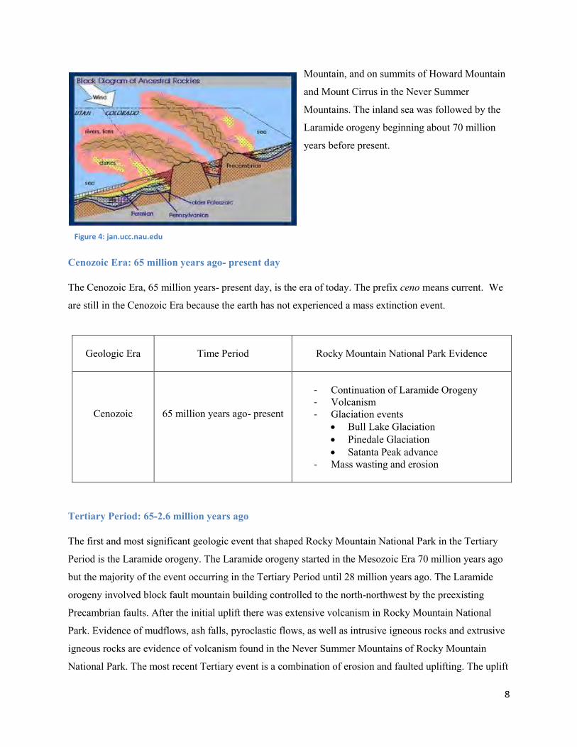
By the beginning of the Mesozoic Era most of the Ancestral Rockies eroded away and Rocky Mountain
National Park slowly became covered by water and sediment from the advancement and retreatment of
the Western Interior seaway. In the Late Mesozoic Era, Cretaceous Period 100 million years ago, the
Western Interior seaway advanced to completely cover Rocky Mountain National Park accumulating
several hundred feet of sediment. This is evident in Rocky Mountain National Park east of Lead
8
Mountain, and on summits of Howard Mountain
and Mount Cirrus in the Never Summer
Mountains. The inland sea was followed by the
Laramide orogeny beginning about 70 million
years before present.
Cenozoic Era: 65 million years ago- present day
The Cenozoic Era, 65 million years- present day, is the era of today. The prefix ceno means current. We
are still in the Cenozoic Era because the earth has not experienced a mass extinction event.
Geologic Era
Time Period
Rocky Mountain National Park Evidence
Cenozoic
65 million years ago- present
- Continuation of Laramide Orogeny - Volcanism - Glaciation events
Bull Lake Glaciation Pinedale Glaciation Satanta Peak advance
- Mass wasting and erosion
Tertiary Period: 65-2.6 million years ago
The first and most significant geologic event that shaped Rocky Mountain National Park in the Tertiary
Period is the Laramide orogeny. The Laramide orogeny started in the Mesozoic Era 70 million years ago
but the majority of the event occurring in the Tertiary Period until 28 million years ago. The Laramide
orogeny involved block fault mountain building controlled to the north-northwest by the preexisting
Precambrian faults. After the initial uplift there was extensive volcanism in Rocky Mountain National
Park. Evidence of mudflows, ash falls, pyroclastic flows, as well as intrusive igneous rocks and extrusive
igneous rocks are evidence of volcanism found in the Never Summer Mountains of Rocky Mountain
National Park. The most recent Tertiary event is a combination of erosion and faulted uplifting. The uplift
Figure 4: jan.ucc.nau.edu

9
occurred in a series of steps on older Precambrian faults and is responsible for the Rocky Mountains
modern height. The uplift disrupted the older drainage patters and created the modern drainage patters of
today. The new drainage patterns removed as much as 5000 feet of sedimentary rocks from earlier inland
seas deposits. This erosion exposed the basement rock of the Ancestral Rockies. Evidence of the uplifting
and erosion can be found on the way to Rocky Mountain National Park in the hogbacks of the Front
Range foothills.
Quaternary Period: 2.6 Million years ago- present
The major geologic process that shaped Rocky Mountain National Park in the Quaternary Period was
glaciers. The first glacial event is the Bull Lake that occurred 300,000- 127,000 years ago. Bull Lake is
further broken down into the Early Bull Lake, 300,000- 200,000 years ago, and Late Bull Lake, 200,000-
127,000 years ago. Evidence of Bull Lake can be found within Rocky Mountain National Park at
Bierstadt Lake, west of the Beaver Meadows entrance, south of Sandbeach Lake, and east of Copeland
Mountain. The second glacial event in Rocky Mountain National Park is the Pinedale glaciation. Pinedale
occurred 30,000- 12,000 years ago, reaching a maximum 23,500 years before present. Pinedale is the last
true valley glaciation to affect the Front Range. Evidence within Rocky Mountain National Park of the
Pinedale glaciation can be found at Moraine Park and Horseshoe Park, as well as Wild Basin and
Kawuneeche Valley. In the Late Pleistocene a minor glaciation event called the Satanta Peak advance
occurred about 10,000 years before present. The most recent geologic activity in Rocky Mountain
National Park is stream erosion starting 3,800 years before present. Evidence of stream erosion is seen
throughout Rocky Mountain National Park by the v- shaped valleys. The best recent example of stream
erosion in Rocky Mountain National Park is the alluvial fan that was deposited in the Lawn Lake Flood of
1982.
Tectonics of Rocky Mountain National Park
Tectonic Principles relevant to Rocky Mountain National Park
There are some important tectonic principles to know in order to understand the process of building the
Rocky Mountains. First, it is important to recognize the difference between the hard basement layer of
crystalline rock, and the easily erodible cover layer of sedimentary and igneous rocks. The mechanical
strength of the crystalline basement rock is directly proportional to how much the Earth crust can support
a geologic feature. The mechanical strength of the Rocky Mountain crystalline basement is particularly
strong because it supports a geologic feature as big as the Rocky Mountains. The basement rock has
planes of weaknesses in faults and shear zones that influence building of the current Rocky Mountains.
10
Second, isostasy is the ideal balance of large portions of Earth‟s crust. It controls the regional elevations
adjacent to Rocky Mountain National Park by elevating the area on east and west of the mountains to
account for the weight of the Rocky Mountains. Without the strength of the basement crystalline rock and
isostasy the Earth‟s crust would not be about to support the Rocky Mountains.
Plate Tectonics
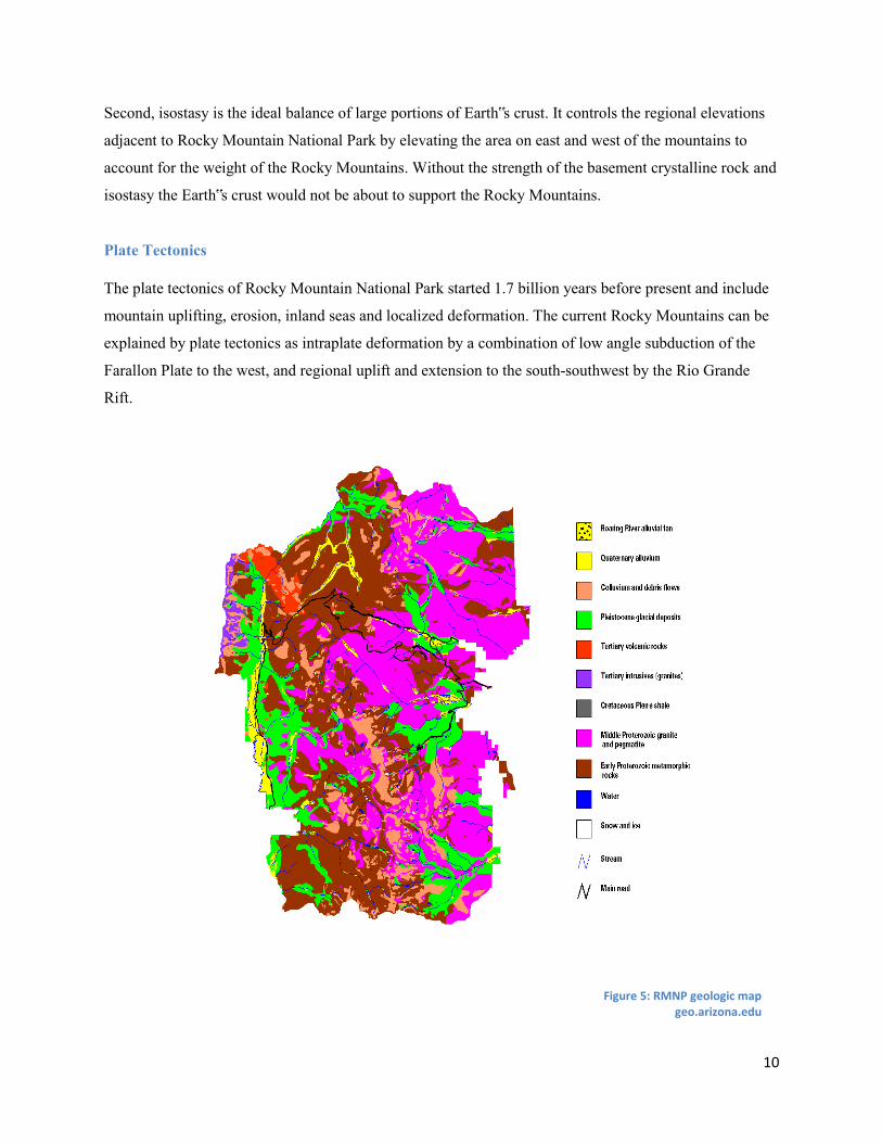
The plate tectonics of Rocky Mountain National Park started 1.7 billion years before present and include
mountain uplifting, erosion, inland seas and localized deformation. The current Rocky Mountains can be
explained by plate tectonics as intraplate deformation by a combination of low angle subduction of the
Farallon Plate to the west, and regional uplift and extension to the south-southwest by the Rio Grande
Rift.
Figure 5: RMNP geologic map geo.arizona.edu
11
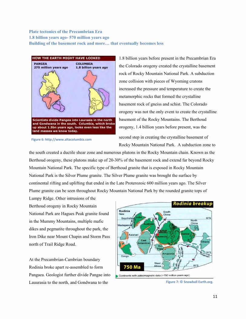
Plate tectonics of the Precambrian Era 1.8 billion years ago- 570 million years ago Building of the basement rock and more… that eventually becomes less
1.8 billion years before present in the Precambrian Era
the Colorado orogeny created the crystalline basement
rock of Rocky Mountain National Park. A subduction
zone collision with pieces of Wyoming cratons
increased the pressure and temperature to create the
metamorphic rocks that formed the crystalline
basement rock of gneiss and schist. The Colorado
orogeny was not the only event to create the crystalline
basement of the Rocky Mountains. The Berthoud
orogeny, 1.4 billion years before present, was the
second step in creating the crystalline basement of
Rocky Mountain National Park. A subduction zone to
the south created a ductile shear zone and numerous plutons in the Rocky Mountain chain. Known as the
Berthoud orogeny, these plutons make up of 20-30% of the basement rock and extend far beyond Rocky
Mountain National Park. The specific type of Berthoud granite that is exposed in Rocky Mountain
National Park is the Silver Plume granite. The Silver Plume granite was brought the surface by
continental rifting and uplifting that ended in the Late Proterozoic 600 million years ago. The Silver
Plume granite can be seen throughout Rocky Mountain National Park by the rounded granite tops of
Lumpy Ridge. Other intrusions of the
Berthoud orogeny in Rocky Mountain
National Park are Hagues Peak granite found
in the Mummy Mountains, multiple mafic
dikes and pegmatite throughout the park, the
Iron Dike near Mount Chapin and Storm Pass
north of Trail Ridge Road.
At the Precambrian-Cambrian boundary
Rodinia broke apart re-assembled to form
Pangaea. Geologist further divide Pangae into
Lauurasia to the north, and Gondwana to the Figure 7: © Snowball Earth.org.
Figure 6: http://www.altacolumbia.com

12
south. The coast of western North America was created when Gondwana rifted away from Rodinia's
southwest margin around 750 million years before present. The rifting created low lying mountains, mass
wasting and erosion, with the eventual formation of shallow inland seas. The rifting ending about 600
million years ago but the faults created define the Rocky Mountains millions of years later.
The Great Unconformity
After the creation of the crystalline basement and before the
rifting away of Gondwana the Rocky Mountains are a
mystery. Known as the Great Unconformity, Earth‟s history
from 1.4 billion years to 600 million years is missing from
the stratigraphic column of the Rocky Mountains. Any
surface deposited in Colorado before 600 million years
before present, except the crystalline basement, has been
erased by erosion to create the Great Unconformity. The
Great Unconformity leaves unanswered questions of the
plate tectonics of the Rocky Mountains in the Precambrian
Era.
Plate tectonics of the Paleozoic Era 570-290 million of years ago Build it up and break it down
Before the Cambrian period, all the evidence of Rocky
Mountain National Park is lost in the Great
Unconformity. The Rocky Mountains history begins to
show record again in the Late Cambrian, 510 years ago.
Shallow tropical seas spread over Rocky Mountain
National Park and 6,000-12,000 feet of marine sediments
accumulated over the eroded surface of the Precambrian
crystalline rocks. The sediment accumulated continued
into the early Pennsylvanian 300 million years ago. In
the Devonian, 360 million years before present, the
eastern margin of Lauurasia collided with a
microcontinent Avalonion and created the Application
Figure 8: I-70 and Glenwood Canyon, Colorado. Steven Dutch, Natural and Applied Sciences, University of Wisconsin- Green Bay
Figure 9: shallow Sea advancing over the North American Craton 540 million years before present
(Robert J. Lillie)
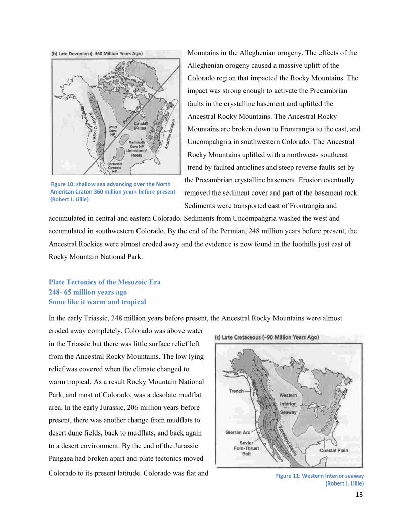
13
Mountains in the Alleghenian orogeny. The effects of the
Alleghenian orogeny caused a massive uplift of the
Colorado region that impacted the Rocky Mountains. The
impact was strong enough to activate the Precambrian
faults in the crystalline basement and uplifted the
Ancestral Rocky Mountains. The Ancestral Rocky
Mountains are broken down to Frontrangia to the east, and
Uncompahgria in southwestern Colorado. The Ancestral
Rocky Mountains uplifted with a northwest- southeast
trend by faulted anticlines and steep reverse faults set by
the Precambrian crystalline basement. Erosion eventually
removed the sediment cover and part of the basement rock.
Sediments were transported east of Frontrangia and
accumulated in central and eastern Colorado. Sediments from Uncompahgria washed the west and
accumulated in southwestern Colorado. By the end of the Permian, 248 million years before present, the
Ancestral Rockies were almost eroded away and the evidence is now found in the foothills just east of
Rocky Mountain National Park.
Plate Tectonics of the Mesozoic Era 248- 65 million years ago Some like it warm and tropical
In the early Triassic, 248 million years before present, the Ancestral Rocky Mountains were almost
eroded away completely. Colorado was above water
in the Triassic but there was little surface relief left
from the Ancestral Rocky Mountains. The low lying
relief was covered when the climate changed to
warm tropical. As a result Rocky Mountain National
Park, and most of Colorado, was a desolate mudflat
area. In the early Jurassic, 206 million years before
present, there was another change from mudflats to
desert dune fields, back to mudflats, and back again
to a desert environment. By the end of the Jurassic
Pangaea had broken apart and plate tectonics moved
Colorado to its present latitude. Colorado was flat and
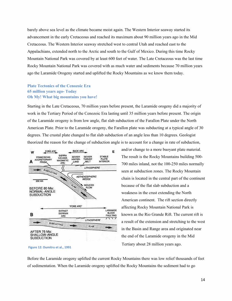
Figure 10: shallow sea advancing over the North American Craton 360 million years before present (Robert J. Lillie)
Figure 11: Western Interior seaway (Robert J. Lillie)
14
barely above sea level as the climate became moist again. The Western Interior seaway started its
advancement in the early Cretaceous and reached its maximum about 90 million years ago in the Mid
Cretaceous. The Western Interior seaway stretched west to central Utah and reached east to the
Appalachians, extended north to the Arctic and south to the Gulf of Mexico. During this time Rocky
Mountain National Park was covered by at least 600 feet of water. The Late Cretaceous was the last time
Rocky Mountain National Park was covered with as much water and sediments because 70 million years
ago the Laramide Orogeny started and uplifted the Rocky Mountains as we know them today.
Plate Tectonics of the Cenozoic Era 65 million years ago- Today Oh My! What big mountains you have!
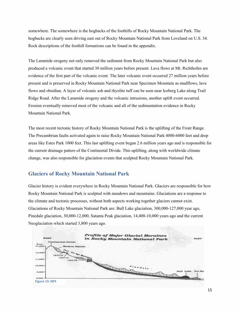
Starting in the Late Cretaceous, 70 million years before present, the Laramide orogeny did a majority of
work in the Tertiary Period of the Cenozoic Era lasting until 35 million years before present. The origin
of the Laramide orogeny is from low angle, flat slab subduction of the Farallon Plate under the North
American Plate. Prior to the Laramide orogeny, the Farallon plate was subducting at a typical angle of 30
degrees. The crustal plate changed to flat slab subduction of an angle less than 10 degrees. Geologist
theorized the reason for the change of subduction angle is to account for a change in rate of subduction,
and/or change to a more buoyant plate material.
The result is the Rocky Mountains building 500-
700 miles inland, not the 100-250 miles normally
seen at subduction zones. The Rocky Mountain
chain is located in the central part of the continent
because of the flat slab subduction and a
weakness in the crust extending the North
American continent. The rift section directly
affecting Rocky Mountain National Park is
known as the Rio Grande Rift. The current rift is
a result of the extension and stretching to the west
in the Basin and Range area and originated near
the end of the Laramide orogeny in the Mid
Tertiary about 28 million years ago.
Before the Laramide orogeny uplifted the current Rocky Mountains there was low relief thousands of feet
of sedimentation. When the Laramide orogeny uplifted the Rocky Mountains the sediment had to go
Figure 12: Dumitru et al., 1991
15
somewhere. The somewhere is the hogbacks of the foothills of Rocky Mountain National Park. The
hogbacks are clearly seen driving east out of Rocky Mountain National Park from Loveland on U.S. 34.
Rock descriptions of the foothill formations can be found in the appendix.
The Laramide orogeny not only removed the sediment from Rocky Mountain National Park but also
produced a volcanic event that started 30 million years before present. Lava flows at Mt. Richthofen are
evidence of the first part of the volcanic event. The later volcanic event occurred 27 million years before
present and is preserved in Rocky Mountain National Park near Specimen Mountain as mudflows, lava
flows and obsidian. A layer of volcanic ash and rhyolite tuff can be seen near Iceberg Lake along Trail
Ridge Road. After the Laramide orogeny and the volcanic intrusions, another uplift event occurred.
Erosion eventually removed most of the volcanic and all of the sedimentation evidence in Rocky
Mountain National Park.
The most recent tectonic history of Rocky Mountain National Park is the uplifting of the Front Range.
The Precambrian faults activated again to raise Rocky Mountain National Park 4000-6000 feet and drop
areas like Estes Park 1000 feet. This last uplifting event began 2.6 million years ago and is responsible for
the current drainage patters of the Continental Divide. This uplifting, along with worldwide climate
change, was also responsible for glaciation events that sculpted Rocky Mountain National Park.
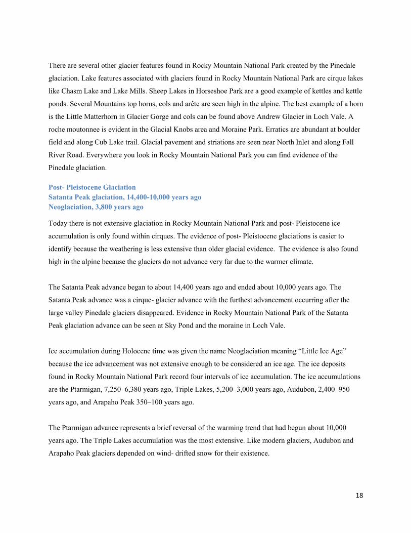
Glaciers of Rocky Mountain National Park Glacier history is evident everywhere in Rocky Mountain National Park. Glaciers are responsible for how
Rocky Mountain National Park is sculpted with meadows and mountains. Glaciations are a response to
the climate and tectonic processes, without both aspects working together glaciers cannot exist.
Glaciations of Rocky Mountain National Park are: Bull Lake glaciation, 300,000-127,000 year ago,
Pinedale glaciation, 30,000-12,000, Satanta Peak glaciation, 14,400-10,000 years ago and the current
Neoglaciation which started 3,800 years ago.
Figure 13: NPS

16
Pre-Bull Lake- 1.2 million years ago
The Pre-Bull glaciation occurred before the Bull Lake glaciation starting 1.2 million years ago. Pre Bull
Lake had 2 major advances; however most of the Pre-Bull glaciation evidence was removed by later
glaciations. Some deposits are found outside the eastern boundary of Rocky Mountain National Park
along highway 7 near the Fall River entrance. Most evidence found in Rocky Mountain National Park is
evidence from later glaciation events.
Bull Lake glaciation- 300,000-127,000 year ago
The Bull Lake glaciation is broken down in the early Bull Lake that occurred 300,000-200,000 years ago
and the late Bull Lake occurred 200,000-127,000 years ago. Bull Lake glacier tributaries started high in
the Rocky Mountains and joined together in lower elevations to create large massive glaciers that sculpted
Rocky Mountain National Park. Both advances of the Bull Lake glaciation sculpted the same cirque
basins and canyons leaving behind similar moraine evidence. To distinguish between the late Bull Lake
and early Bull Lake glaciation geologists use degree of weathering and different moraine features.
The terminal moraines of the early
Bull Lake glacial advance consist of
brown, silt and sand deposits
containing pale-gray stones. The
deposits of the late Bull Lake
advance overlie the weathered
deposits of the early Bull Lake
advance. These deposits also contain
pale brown silty sand with stones of
different sizes and degrees of
rounding. Some of the rocks in the
moraines show glacial striations,
however, boulders are usually not
found with these moraines.
On the west side of the park, Bull Lake glaciers occupied the Colorado River Valley and deposited a
terminal moraine directly south of Shadow Mountain Lake. This terminal moraine has a high degree of
weathering and is consistent with other Bull Lake evidence. The Shadow Mountain moraines contain
Figure 14: 14ers.com

17
large amounts of volcanic rock carried down by the glacier from the Never Summer Mountains. The
glaciers from the Never Summer Mountains merged with the glaciers in the Colorado River Valley to
reach 20 miles long, extending from the La Poudre Pass to Shadow Mountain Lake. Other evidence of
Bull Lake can be seen in east side of Rocky Mountain National Park at Aspenglen Campground and near
the Beaver Meadows entrance.
Pinedale glaciation- 30,000-12,000 years ago
The Pinedale glaciation occurred 30,000-23,500 years ago and makes up the majority of glacial evidence
in Rocky Mountain National Park. Not as extensive as Bull Lake, the Pinedale glaciation reached a
maximum 23,500- 20,000 years ago; then between 15,000- 12,000 years ago the glaciers started to recede.
By 10,000 years before present all Pinedale glaciers were melted.
The Pinedale glaciation sculpted the alpine and large flat valleys in Rocky Mountain National Park.
Pinedale moraines evidence shows less weathering and erosion with sharper and predominate ridges. The
Pinedale glaciers also have more boulders scattered along the moraine surface.
There are more boulders on the Pinedale moraines
because the glaciers used preexisting valleys carved by
Bull Lake. The Pinedale glaciation started in the alpine
and gouged out mountain peaks creating cirque
headwalls and vertical faces like the diamond of Longs
Peak. The alpine glaciers also created rock basin lakes
seen in Tyndall Gorge and Loch Vale. The boulders
were carried down to the valley floor and deposited in
the moraines. On the west side of Rocky Mountain
National Park a glacier 20 miles long extended west of
Le Poudre pass south to the morainal islands of Shadow
Mountain Lake. Ice 1,000 feet deep formed the Fall River glacier that sculpted the u-shaped valley of
Horseshoe Park and the 13 mile long Thompson glacier occupied Big Thompson valley and carved
Moraine Park. Enclosed by the lateral moraines and terminal moraines, ice started to melt creating glacial
lakes that filled the valley floors with small sediment. The different terrain and vegetation of the moraines
compared to the valley floor is a result of the glacier lake. Grasses grow on the valley where the sediment
is fine because of the lake and while bigger trees prefer the moraine terrain with a courser soil that is able
to support their root system.
Figure 15: rmnp.com Moraine Park view from Many Parks Curve
18
There are several other glacier features found in Rocky Mountain National Park created by the Pinedale
glaciation. Lake features associated with glaciers found in Rocky Mountain National Park are cirque lakes
like Chasm Lake and Lake Mills. Sheep Lakes in Horseshoe Park are a good example of kettles and kettle
ponds. Several Mountains top horns, cols and arête are seen high in the alpine. The best example of a horn
is the Little Matterhorn in Glacier Gorge and cols can be found above Andrew Glacier in Loch Vale. A
roche moutonnee is evident in the Glacial Knobs area and Moraine Park. Erratics are abundant at boulder
field and along Cub Lake trail. Glacial pavement and striations are seen near North Inlet and along Fall
River Road. Everywhere you look in Rocky Mountain National Park you can find evidence of the
Pinedale glaciation.
Post- Pleistocene Glaciation Satanta Peak glaciation, 14,400-10,000 years ago Neoglaciation, 3,800 years ago
Today there is not extensive glaciation in Rocky Mountain National Park and post- Pleistocene ice
accumulation is only found within cirques. The evidence of post- Pleistocene glaciations is easier to
identify because the weathering is less extensive than older glacial evidence. The evidence is also found
high in the alpine because the glaciers do not advance very far due to the warmer climate.
The Satanta Peak advance began to about 14,400 years ago and ended about 10,000 years ago. The
Satanta Peak advance was a cirque- glacier advance with the furthest advancement occurring after the
large valley Pinedale glaciers disappeared. Evidence in Rocky Mountain National Park of the Satanta
Peak glaciation advance can be seen at Sky Pond and the moraine in Loch Vale.
Ice accumulation during Holocene time was given the name Neoglaciation meaning “Little Ice Age”
because the ice advancement was not extensive enough to be considered an ice age. The ice deposits
found in Rocky Mountain National Park record four intervals of ice accumulation. The ice accumulations
are the Ptarmigan, 7,250–6,380 years ago, Triple Lakes, 5,200–3,000 years ago, Audubon, 2,400–950
years ago, and Arapaho Peak 350–100 years ago.
The Ptarmigan advance represents a brief reversal of the warming trend that had begun about 10,000
years ago. The Triple Lakes accumulation was the most extensive. Like modern glaciers, Audubon and
Arapaho Peak glaciers depended on wind- drifted snow for their existence.

19
Currently there are 34 snow banks
and ice masses near Rocky
Mountain National Park. Fourteen
of the ice masses are located in
Rocky Mountain National Park:
Rowe Glacier, located between
Rowe Peak and Hagues Peak,
Sprague Glacier, at Irene Lake in
Spruce Canyon, Tyndall Glacier
placed at the head of Tyndall Creek,
Andrews Glacier which can be seen
east of Andrews Pass, Taylor
Glacier, at the head of Icy Brook,
Chiefs Head Peak Glacier above Frozen Lake, Mills Glacier on the east side of Longs Peak, Moomaw
Glacier on the south of The Cleaver. There are six St. Vrain Glaciers located outside of the park at the
head of Middle St. Vrain Creek.
Only the ice mass above Murphy Lake near Snowdrift Peak is on the east side of the Continental Divide
and all but one ice mass occur on north or east facing cirques. The exception is the large snow bank
northeast of Rowe Mountain. Some of the ice masses, such as Andrews Glacier, are actively moving and
can be considered actual glaciers. Winter winds blow snow over the Continental Divide where the snow
drifts into cirques. The process of snow deposition gives these “wind drift glaciers” their name and is the
majority of modern glaciers in Rocky Mountain National Park.
Rock Glaciers
Rock glaciers are left by retreating ice glaciers. The rocks contain enough ice to still be affected by
freezing and thawing, pushing the rock glacier down slope over time. Rock glaciers are hard to recognize
on the ground because they look like a rock field or talus slope. Rock glaciers flow downhill at speeds up
to 1-2 m/year, however, rock glaciers in Rocky Mountain National Park have been clocked at 13-20
cm/year Rock glaciers exist below Taylor and Tyndall glaciers, as well as other locations without
glaciers
Figure 16: protrails.com Andrews Tarn and Andrews Glacier
20
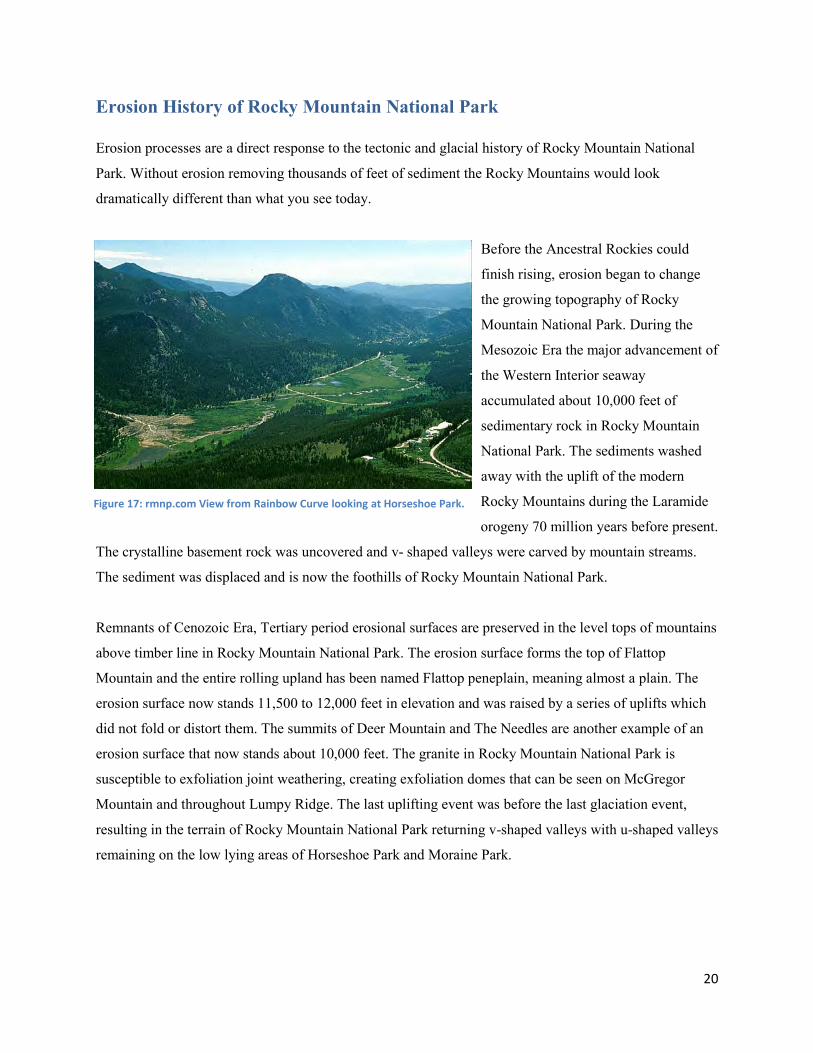
Erosion History of Rocky Mountain National Park Erosion processes are a direct response to the tectonic and glacial history of Rocky Mountain National
Park. Without erosion removing thousands of feet of sediment the Rocky Mountains would look
dramatically different than what you see today.
Before the Ancestral Rockies could
finish rising, erosion began to change
the growing topography of Rocky
Mountain National Park. During the
Mesozoic Era the major advancement of
the Western Interior seaway
accumulated about 10,000 feet of
sedimentary rock in Rocky Mountain
National Park. The sediments washed
away with the uplift of the modern
Rocky Mountains during the Laramide
orogeny 70 million years before present.
The crystalline basement rock was uncovered and v- shaped valleys were carved by mountain streams.
The sediment was displaced and is now the foothills of Rocky Mountain National Park.
Remnants of Cenozoic Era, Tertiary period erosional surfaces are preserved in the level tops of mountains
above timber line in Rocky Mountain National Park. The erosion surface forms the top of Flattop
Mountain and the entire rolling upland has been named Flattop peneplain, meaning almost a plain. The
erosion surface now stands 11,500 to 12,000 feet in elevation and was raised by a series of uplifts which
did not fold or distort them. The summits of Deer Mountain and The Needles are another example of an
erosion surface that now stands about 10,000 feet. The granite in Rocky Mountain National Park is
susceptible to exfoliation joint weathering, creating exfoliation domes that can be seen on McGregor
Mountain and throughout Lumpy Ridge. The last uplifting event was before the last glaciation event,
resulting in the terrain of Rocky Mountain National Park returning v-shaped valleys with u-shaped valleys
remaining on the low lying areas of Horseshoe Park and Moraine Park.
Figure 17: rmnp.com View from Rainbow Curve looking at Horseshoe Park.
21
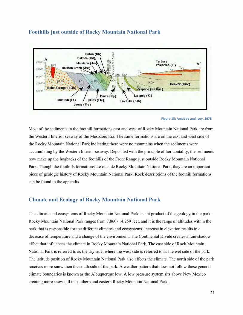
Foothills just outside of Rocky Mountain National Park
Most of the sediments in the foothill formations east and west of Rocky Mountain National Park are from
the Western Interior seaway of the Mesozoic Era. The same formations are on the east and west side of
the Rocky Mountain National Park indicating there were no mountains when the sediments were
accumulating by the Western Interior seaway. Deposited with the principle of horizontality, the sediments
now make up the hogbacks of the foothills of the Front Range just outside Rocky Mountain National
Park. Though the foothills formations are outside Rocky Mountain National Park, they are an important
piece of geologic history of Rocky Mountain National Park. Rock descriptions of the foothill formations
can be found in the appendix.
Climate and Ecology of Rocky Mountain National Park
The climate and ecosystems of Rocky Mountain National Park is a bi product of the geology in the park.
Rocky Mountain National Park ranges from 7,860- 14,259 feet, and it is the range of altitudes within the
park that is responsible for the different climates and ecosystems. Increase in elevation results in a
decrease of temperature and a change of the environment. The Continental Divide creates a rain shadow
effect that influences the climate in Rocky Mountain National Park. The east side of Rock Mountain
National Park is referred to as the dry side, where the west side is referred to as the wet side of the park.
The latitude position of Rocky Mountain National Park also affects the climate. The north side of the park
receives more snow then the south side of the park. A weather pattern that does not follow these general
climate boundaries is known as the Albuquerque low. A low pressure system sits above New Mexico
creating more snow fall in southern and eastern Rocky Mountain National Park.
Figure 18: Amuedo and Ivey, 1978

22
Climate is also related to the ecology of Rocky Mountain National Park. Climate and elevation control
what plants and animals can survive. As you increase in elevation you decrease in temperature and
oxygen levels. Rocky Mountain National Park has four ecosystems intertwined together in a delicate
balance with the climate and geology. The four ecosystems give home to a variety of plants and animals
that are dependent of the climate of their particular ecosystem.
The base ecosystem in Rocky Mountain National Park is the montane and occurs until 9,500 feet. The
montane has a combination of dense forest and parks to support both large trees and grasses. The
difference in vegetation is a result of soil content and what direction the slope is facing. The montane
ecosystem in Rocky Mountain National Park is molded by large glacier moraines. The moraine soil can
support the large evergreen trees, however the valley parks cannot. The soil found in the valleys tends to
be of finer grained material and support
grasses with some aspen and willow
trees. The Subalpine Ecosystem occupies
elevations between 9,500 and 11,000
feet. The lower elevation of the Rocky
Mountain National Park subalpine forest
consists mostly of subalpine fir and
engelmann spruce. As you climb higher
the trees start to change to limber pine
and whitebark pine. Huckleberry and
other shrub plants live in the subalpine
and are vital to forest restoration after a
fire. The geology of the subalpine allows
for the tress to dig through roots into soil
that will support them from the winds. The higher you go in elevation the oxygen become thinner and so
do the trees. The subalpine ecosystem reaches the tree line and gives way to the alpine ecosystem on
Rocky Mountain National Park. The alpine ecosystem of Rocky Mountain National Park occurs around
11,000 and higher. Frequent strong winds and cold temperatures limit what plants can grow is the alpine
ecosystem. Cushion plants, looking like ground-hugging clumps of moss, escape the strong winds
blowing a few inches above them. Many flowering plants of the tundra have dense hairs on stems and
leaves to provide wind protection. Where the tundra soil is well-developed, grasses and sedges are found.
Non-flowering lichens cling to rocks and soil and only photosynthesize at a temperature above 32 F. The
adaptations for survival of drying winds and cold may make tundra vegetation seem very hardy, but in
Figure 19: Alpine Sub-alpine Montane and Riparian (Image created by Jon Nicholson).

23
some respects the tundra is very fragile. Repeated footsteps often destroy tundra plants, leaving exposed
soil to blow away, and recovery may take hundreds of years. The geology of the alpine is important
because without the rich soil and rocks for moss and lichen to cling to, the ecosystem would not exist as it
does today. The last ecosystem in Rocky Mountain National Park is the riparian. The riparian ecosystem
stretches through all other ecosystems in Rocky Mountain National Park. This ecosystem is vital to the
geology by creating v-shaped valleys and other erosional features.

24
References Cole, J. C., & Braddock, W. A. (n.d.). Geologic Map of the Estes Park 30’ x 60’ Quadrangle,. From
usgs.gov: http://pubs.usgs.gov/sim/3039/downloads/SIM_3039_Pamphlet.pdf
Ivey, A. a., & Resources, C. a. (1978). Geologic Overview of Jefferson County, Colorado. Jefferson County, Colorado.
Keller, K. L. (n.d.). Rocky Mountain National Park: Geologic resource Evaluation Report. Retrieved April, 2012 from nps.gov/romo: http://www.nps.gov/romo/parkmgmt/upload/romo_geo_overview.pdf
McCreary, J. (n.d.). The Earth At Work. Retrieved April, 2012 from Colorado Geology Photojournals: http://www.cliffshade.com/colorado/tectonics.htm
Pierce, K. L. (2003). Pleistocene glaciations of the Rocky Mountains. Development in Quaternary Science, 63-76.
Raup, O. B. (2005). Geology Along Trail Ridge Road: A Self-Guided Tour for Motorists. Rocky Mountain Nature Association.
Service, N. P. (2006). A Guide to the Geology of Rocky Mountain National Park, Colorado . Estes Park.
University, I. S. (2004). Glossary of Geologic Terms . From College of Liberal Arts and Sciences: Department of Geological and Atmospheric Sciences.
Lesson Plans The following lesson plans are designed to teach students geologic processes using Rocky Mountain National Park. The lessons are better taught on-site in Rocky Mountain National Park but can be adapted for a classroom. If you would like to bring your classroom outdoors to Rocky Mountain National Park visit The Heart of the Rockies website to learn more http://www.heartoftherockies.net/welcome.html and then contact Mark De Gregorio at (970) 586-3777 or [email protected] to schedule a field trip.
25
RMNP has some of the oldest
geologic evidence dating back 1.7
billion years ago, but is nothing
compared to the beginning of the
geologic time scale.
To understand how long the earth
has been around
SWBAT categorize the evolution of
geologic and life events within each
time period
SWBAT break down each geologic
time period in relation to one
another by illustrating the size ratio
of each time period.
SWBAT interpret dominate geologic
and life event of each time period.
30 min
RMNP
Classroom or outside
All grade levels
1 inch of stacked paper per group
40 feet rope/ string/ wood
25+ foot measuring tape
Timeline markers
Label stickers
Calculator
List of geologic events of RMNP
Making a Geologic Time Scale Lesson Introduction Give the students an introduction of the lesson, the goals and objectives, and final outcome of the assignment. Remind the students of geologic time. Relative dating, absolute dating, millions of years verse billions of years, how the geologic time scale is read and interpreted. Lead the students into the idea that geologic time is a long time and this assignment is going to help them conceptualize the concept.
Talk to the students about the geologic history of RMNP. Students should know about how there have been several mountain building events, and the inland seas that covered the area. Talk to the students about the faulting and glacier history of RMNP. If you are doing this assignment in RMNP give the students a few minutes to observe the environment around them.
Engage Give the students a warm up to start conceptualizing the length and size of the geologic time scale. The warm up can be any metaphor of your choice. Example: Dollar bill: Have the students stack paper, dollar bills, anything of your choice, 1 inch high. Have the students count how many items it to make 1 inch. Remind the students the earth is 4.6 billion years old. Tell the students 1 billion dollars stacked would be 20 times higher than Longs Peak. (14,256 x 20= 285,120) Next have the students do the math and work out how high a billion dollar bills would be. Connect the billion dollars to being less than ¼ of the earth‟s history and if the students wanted to represent the full length of the geologic time scale using dollar bills the students would need a lot more space. After the students are familiar with RMNP geologic history, give the details of the timeline activity.
Explain students are going to represent the time scale using ratios. o The time scale can be hard to comprehend because it is
dealing with a large amount of time. A better way to conceptualize the length of time is with ratios
1 inch= 10 million years o Remind students that geologist always use millions of years
to keep everything organized in the time scale. 2.5 billion years is represented as 2500 million
years. Use the Quaternary period as an example
o 1.8 million years = 0.17 inches (~1/8 inch)
Theme
Goals
26
Explore The students will now complete the timeline activity using the materials and worksheets. Explain After the students have completed labeling their timeline regroup back together and discuss. Explain to the students how most of the world‟s history came towards the end of geologic time. Point out how in the Precambrian there wasn‟t much going on but it is the longest time length on the time scale. Show the students how life grows exponentially once life started. Elaborate After the timeline activity has been discussed. Share with the students another example of how geologic time can be interpreted. Bring this section back to RMNP by using the length of a year as a reference. Year example of RMNP: If the span of Earth‟s history was compressed into one calendar year
Earth would form on January 1st. August 15 the metamorphic rocks of RMNP form The granites would intrude around September 3rd The first shell-bearing animals appear November 16th. Between December 12th and 27th dinosaurs would roam the planet.
Between December 20th and 25th current Rocky Mountains form At 5:00 PM on December 31st the ancestors of man would appear
The Last Ice Age was at 11:58 PM At 11:59:58 modern technology would make its way to the stage.
Evaluate Your explanation in the year example did not cover all the geologic events of RMNP. Have the student put the remainder of RMNP geologic history in the correct calendar day. Conclusion Sum up the activity by relating back to geologic time and how life has grown exponentially. Pose the question of how the time scale might look in the near and distance future.

27
28
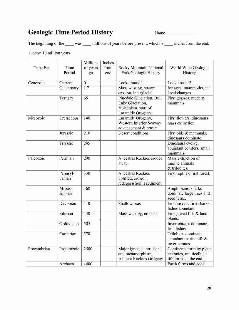
Geologic Time Period History Name______________
The beginning of the ____ was ____ millions of years before present, which is ____ inches from the end.
1 inch= 10 million years
Time Era
Time Period
Millions of years
go
Inches from end
Rocky Mountain National
Park Geologic History
World Wide Geologic
History
Cenozoic Current 0 Look around! Look around! Quaternary 1.7 Mass wasting, stream
erosion, interglacial Ice ages, mammoths, sea level changes
Tertiary 65 Pinedale Glaciation, Bull Lake Glaciation, Volcanism, start of Laramide Orogeny.
First grasses, modern mammals
Mesozoic Cretaceous 140 Laramide Orogeny, Western Interior Seaway advancement & retreat
First flowers, dinosaurs mass extinction
Jurassic 210 Desert conditions. First bids & mammals, dinosaurs dominate.
Triassic 245 Dinosaurs evolve, abundant conifers, small mammals.
Paleozoic Permian 290 Ancestral Rockies eroded away.
Mass extinction of marine animals & trilobites.
Pennsyl-vanian
330 Ancestral Rockies uplifted, erosion, redeposistion if sediment
First reptiles, first forest.
Missis- sippian
360 Amphibians, sharks dominate large trees and seed ferns.
Devonian 410 Shallow seas First insects, first sharks, fishes abundant
Silurian 440 Mass wasting, erosion First jawed fish & land plants.
Ordovician 505 Invertebrates dominate, first fishes
Cambrian 570 Trilobites dominate, abundant marine life & invertebrates
Precambrian Proterozoic 2500 Major igneous intrusions and metamorphism, Ancient Rockies Orogeny
Continents form by plate tectonics, multicellular life forms at the end.
Archaen 4600 Earth forms and cools

29
Geologic Time Period History Name: ___Teacher Copy__
The beginning of the ____ was ____ millions of years before present, which is ____ inches from the end.
1 inch= 10 million years
Time Era
Time Period
Millions of years
go
Inches from end
Rocky Mountain National
Park Geologic History
World Wide Geologic
History
Cenozoic Current 0 0 Look around! Look around! Quaternary 1.7 ~1/8 Mass wasting, stream
erosion, interglacial Ice ages, mammoths, sea level changes
Tertiary 65 6.5 Pinedale Glaciation, Bull Lake Glaciation, Volcanism, start of Laramide Orogeny.
First grasses, modern mammals
Mesozoic Cretaceous 140 14 Laramide Orogeny, Western Interior Seaway advancement & retreat
First flowers, dinosaurs mass extinction
Jurassic 210 21 Desert conditions. First bids & mammals, dinosaurs dominate.
Triassic 245 24.5 Dinosaurs evolve, abundant conifers, small mammals.
Paleozoic Permian 290 29 Ancestral Rockies eroded away.
Mass extinction of marine animals and trilobites.
Pennsyl-vanian
330 33 Ancestral Rockies uplifted, erosion, redeposistion if sediment
First reptiles, first forest.
Missis- sippian
360 36 Amphibians, sharks dominate large trees and seed ferns.
Devonian 410 41 Shallow seas First insects, first sharks, fishes abundant
Silurian 440 44 Mass wasting, erosion First jawed fish & land plants.
Ordovician 505 50.5 Invertebrates dominate, first fishes
Cambrian 570 57 Trilobites dominate, abundant marine life & invertebrates
Precambrian Proterozoic 2500 250 Major igneous intrusions and metamorphism, Ancient Rockies Orogeny
Continents form by plate tectonics, multicellular life forms at the end.
Archaen 4600 460 Earth forms and cools

30
Glaciers helped to shape the
landscape of Rocky Mountain
National Park
The students will:
Realize that glaciers shaped the u- shaped valley we see today.
Understand how glaciers create landforms.
Appreciated how glaciers grow and shrink based on climate.
The students will be able to:
Compare and contrast a valley that was shaped by water and a valley that was shaped by ice.
List three pieces of evidence that show a glacier carved the landscape.
Explain how glaciers form, grow and move.
45-50 minute
3rd
-6th
Moraine Park Museum
The Mystery of the Valley Lesson Preparation
Set out sandboxes in a location out of the way of the visitors, but overlooks Moraine Park. Moisten sandboxes and find 5 small cups. Fill a pail with water and set next to area of sandboxes.
Engage (10 min)
Explain that today they are going to be trained as Geodetectives and solve the Mystery of the Valley. Explain that Geodetectives look for clues on the landscape to solve geological mysteries.
Take the students down the path in front of Moraine Park Museum. Divide the students into 4 or 5 teams. Provide each team with a sketch of Moraine Park before ice age. Ask them to look at the sketch and compare it to what they see in front of them. What is the same? What is different? Explain that about 20,000 years ago the landscape changed the way it looked.
Explain that as Geodetectives they are going to use clues on the landscape to make a hypothesis what happened to the valley. They will then test their hypotheses by using a model.
Hand each team a set of clues (labeled photos of a moraine, a cirque, and a U-shaped Valley). Have the teams look at the valley, consult the clues and develop a hypothesis about what could have carved the valley. Provide a hint that whatever carved the valley was a force of erosion. Ask the students what things can cause erosion.
Once the teams have developed their hypotheses, have each team report their ideas. Explain that to test their hypotheses they will use models and try out each force of erosion on a mountain. They test whether the valley was created by an earthquake/rockslide, by rain, by a river, or by ice/a glacier.
Explore (15 min)
Have the teams of students gather around the sandboxes. The students will build a mountain and attempt to recreate moraine park valley using rocks, rain, a „river,‟ and a glacier. With each test, they should observe the results and take notes or draw their observations in their journal to compare and contrast their tests.
Tell the students that they will need to make one big mountain in the middle of their sandbox. Tell the students that they will need to record their observations about the results of each test using descriptive words or sketches.
Theme
Goals
Objectives
Time
Location
Grade Level
31
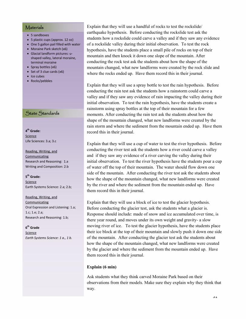
5 sandboxes
5 plastic cups (approx. 12 oz)
One 5 gallon pail filled with water
Moraine Park sketch (x6)
Glacial landform pictures: u-shaped valley, lateral moraine, terminal moraine
Spray bottles (x6)
Set of 3 clue cards (x6)
Ice cubes
Rocks/pebbles
4th
Grade:
Science
Life Sciences: 3.a; 3.c
Reading, Writing, and
Communicating
Research and Reasoning: 1.a
Writing and Composition: 2.b
5th
Grade:
Science
Earth Systems Science: 2.a; 2.b;
Reading, Writing, and
Communicating
Oral Expression and Listening: 1.a;
1.c; 1.e; 2.a;
Research and Reasoning: 1.b;
6th
Grade
Science
Earth Systems Science: 1 a., 1 b.
Materials Explain that they will use a handful of rocks to test the rockslide/ earthquake hypothesis. Before conducting the rockslide test ask the students how a rockslide could carve a valley and if they saw any evidence of a rockslide valley during their initial observation. To test the rock hypothesis, have the students place a small pile of rocks on top of their mountain and then knock it down one slope of the mountain. After conducting the rock test ask the students about how the shape of the mountain changed, what new landforms were created by the rock slide and where the rocks ended up. Have them record this in their journal. Explain that they will use a spray bottle to test the rain hypothesis. Before conducting the rain test ask the students how a rainstorm could carve a valley and if they saw any evidence of rain impacting the valley during their initial observation. To test the rain hypothesis, have the students create a rainstorm using spray bottles at the top of their mountain for a few moments. After conducting the rain test ask the students about how the shape of the mountain changed, what new landforms were created by the rain storm and where the sediment from the mountain ended up. Have them record this in their journal. Explain that they will use a cup of water to test the river hypothesis. Before conducting the river test ask the students how a river could carve a valley and if they saw any evidence of a river carving the valley during their initial observation. To test the river hypothesis have the students pour a cup of water off the top of their mountain. The water should flow down one side of the mountain. After conducting the river test ask the students about how the shape of the mountain changed, what new landforms were created by the river and where the sediment from the mountain ended up. Have them record this in their journal. Explain that they will use a block of ice to test the glacier hypothesis. Before conducting the glacier test, ask the students what a glacier is. Response should include: made of snow and ice accumulated over time, is there year round, and moves under its own weight and gravity- a slow moving river of ice. To test the glacier hypothesis, have the students place their ice block at the top of their mountain and slowly push it down one side of the mountain. After conducting the glacier test ask the students about how the shape of the mountain changed, what new landforms were created by the glacier and where the sediment from the mountain ended up. Have them record this in their journal. Explain (6 min)
Ask students what they think carved Moraine Park based on their observations from their models. Make sure they explain why they think that way.
State Standards
32
Program Title
Inform the students that even though they weren‟t here when this valley was created and the model doesn‟t quite give the whole story there is still evidence left behind on the land that tells the story of what shaped the mountains.
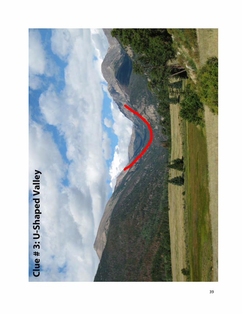
Explain to the students a few of the features that they might look for to determine what carved the valley. A river valley is shaped like the letter “V”, while a glacial valley is shaped like the letter “U”. A river valley will cut down through the material, while the glacial valley looks like it has been bulldozed. At the end and on the sides glacial valley material is deposited creating ridges on the landscape. The ridges of unconsolidated material are called moraines. The moraines on the sides of a glacial valley are called lateral-means side. The moraine at the end of the glacial valley is called a terminal or end moraine. The moraines are made up of an assortment of rock of various sizes; look for a collection of boulders that look like they were dropped randomly. A river won‟t create ridges and sorts out material as the water flows downstream (big boulders towards the start of a river, fine material towards the mouth).
Elaborate (2 min)
Walk students back down to the area that overlooks the valley. Ask the students to look around the valley (behind them, in the distance, directly in front of them, to the side) to see if they can find any signs of evidence of the glacier that carved this valley. Students should be able to point out u-shaped valley (though a few will say v-shaped, but make sure that they are focusing on the entire valley). Ask students if they are able to see any ridges on the landscape (they may have to look behind them). The area that the students are standing on is an end moraine. Point out the South Lateral Moraine (the ridge with the densely packed trees on the left side of the valley). Mention to the students that if they were to walk on that ridge then they would be walking on a random assortment of rock sizes. When a moraine forms it pushes rocks of all shapes and sizes into a giant pile at the sides, or at its furthest end. Ask the students what created the valley – have them vote (rockslide, rain, river, or glacier) and ask how they know. Students should be able to say a glacier created the valley because they can see certain features on the landscape. Elaborate (10 min)
For a 55 min. to 1hr. program you can include this section.
Using the pictures and sandboxes, have the students try to determine which features in their sandboxes may look like glacial landforms. Have them use the labeled flags to mark each landform and then ask each group to present ONE feature they identified. They will probably be able to find moraines

33
(lateral and terminal), cirques and U-shaped valleys as well. Be sure to identify any other glacial landforms you see that they missed (ie: a tarn (if you pour water in the cirque, or an arête).
Conclusion (3 min)
Ask the students what they think would happen if a glacier never carved the landscape or the mountains were never formed. Students should respond that the area would be flat, similar to Kansas. Explain to the students that because a glacier carved the huge valley of Moraine Park, certain plants and animals moved in to the area. If there wasn‟t a glacier carving the valley, they would see different plants and animals living in the area.
Remind the students that even though they weren‟t around when much of the land was formed; there is evidence of what created the landscape all around them. Challenge the students to explore other areas of Rocky Mountain National Park and see if they can find other evidence of glaciers being in Rocky Mountain National Park.
34
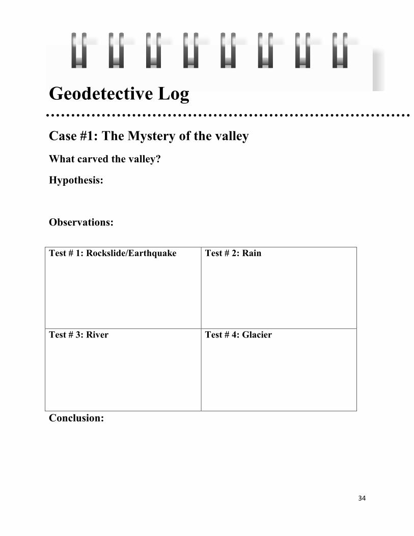
Geodetective Log
Case #1: The Mystery of the valley What carved the valley?
Hypothesis:
Observations:
Test # 1: Rockslide/Earthquake Test # 2: Rain
Test # 3: River Test # 4: Glacier
Conclusion:

35
36
37
38
39
40
Program Title Wgewalutrgw
The geology of RMNP is because of
different geologic events forming
the park to what you see today.
Students will recognize
metamorphic and igneous rocks.
Students will explain the origin of
their “pet rock”
Students will know why there
metamorphic rocks found at the
alluvial fan
Students will give a detailed rock
description
Students will use the geologic
history of RMNP to explain when
metamorphic rocks are found at the
alluvial fan
20 min presite/ intro
60 min field work
Alluvial Fan @ RMNP
Can be adapted for all grade levels
Field notebook & pencil
Rock cycle chart
Rock identification chart or list of
rocks found in RMNP
Rock description guidelines (set by
teacher)
Rocks of the Alluvial Fan Lesson Introduction
Welcome everyone to RMNP.
Engage Give the student a minute to look around. Ask them to think of questions they want answers to and write down 3 observations. When everyone is done taking in the beauty group back together and talk about the observations. The discussion lead into the background information the students get about RMNP. Explain
Review with the students the different rocks found in RMNP and how they were formed.
Access prior knowledge of the rock cycle and explain how each rock can be related to one another.
Teach the students about the Lawn Lake flood and glacier history of Horseshoe Park
o Do not give too much information away here. The goal is to determine why there are metamorphic rocks in the alluvial fan that originated in silver plume granite mountains.
o Background information on the alluvial fan can be found in the teacher guide
Explore
Break students up for field work as desired o Students will find a “pet rock” and give a detailed rock
description To adapt to all ages of students you can set the
expectation of details wanted in the rock description.
Younger students can draw their pet rock or write +/- 3 observations.
Students will next count rocks in a designated area and record if the rock is metamorphic or igneous. 100 rocks is good but you can decide how many you want counted.
o Break students up to different locations of the alluvial fan. o Bring students back together to share the results with
everyone. o First have the students write down why they think there are
metamorphic rocks mixed in. Then share and start a formal discussion of the different hypothesis
Explain
Lead the discussion into RMNP history. The rocks in the alluvial fan are a combination of schist, gneiss, and granite. The students should find a variety of different size rocks within the alluvial fan ranging from silt and
Theme
Goals
Time
Location
Objectives
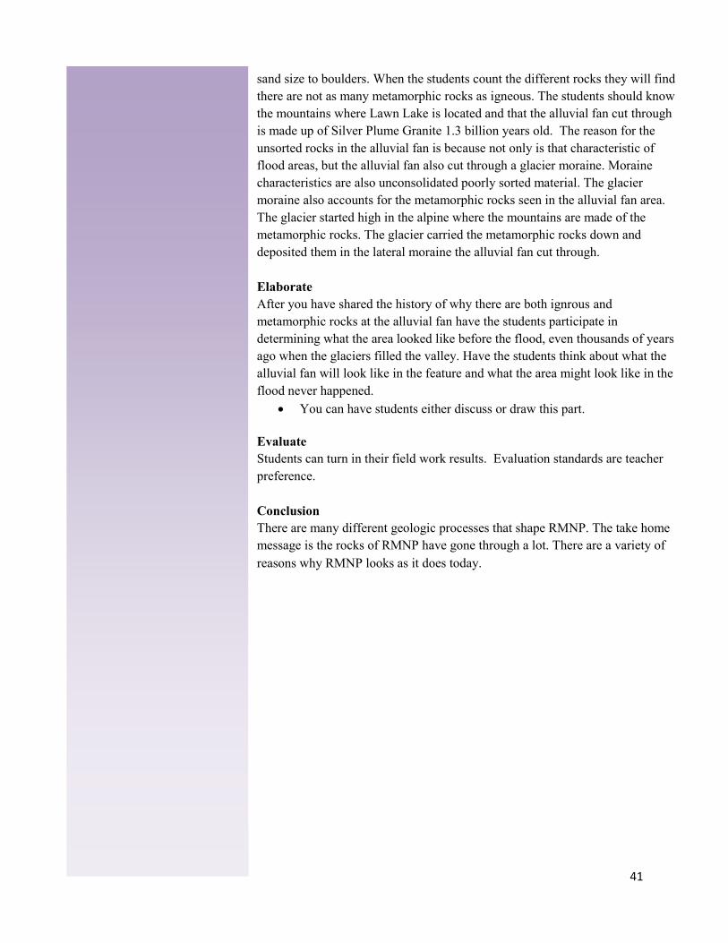
41
sand size to boulders. When the students count the different rocks they will find there are not as many metamorphic rocks as igneous. The students should know the mountains where Lawn Lake is located and that the alluvial fan cut through is made up of Silver Plume Granite 1.3 billion years old. The reason for the unsorted rocks in the alluvial fan is because not only is that characteristic of flood areas, but the alluvial fan also cut through a glacier moraine. Moraine characteristics are also unconsolidated poorly sorted material. The glacier moraine also accounts for the metamorphic rocks seen in the alluvial fan area. The glacier started high in the alpine where the mountains are made of the metamorphic rocks. The glacier carried the metamorphic rocks down and deposited them in the lateral moraine the alluvial fan cut through. Elaborate After you have shared the history of why there are both ignrous and metamorphic rocks at the alluvial fan have the students participate in determining what the area looked like before the flood, even thousands of years ago when the glaciers filled the valley. Have the students think about what the alluvial fan will look like in the feature and what the area might look like in the flood never happened.
You can have students either discuss or draw this part. Evaluate Students can turn in their field work results. Evaluation standards are teacher preference. Conclusion There are many different geologic processes that shape RMNP. The take home message is the rocks of RMNP have gone through a lot. There are a variety of reasons why RMNP looks as it does today.
42

43

44
The geologic formations of the
foothills of northern Colorado offer
a colorful and dynamic story of
landscape formation that spans of
300 million years
1. Students will discover and explore
the earth science processes behind
the creation of the landscape
between Loveland and the mouth of
the Big Thompson Canyon.
Participants will:
1. Discuss the general geologic
history of Colorado, from 1.7 bya to
the present.
2. Distinguish between the
processes of weathering and
erosion.
3. Learn how sedimentary
deposition caused by erosion
occurred over millions of years.
4. View the results of folding of
sedimentary strata to form the
existing hogbacks.
1.5 hours
Big Thompson Elementary,
Loveland
K-5 families with kids
Foothills Geology Lesson Introduction: Introduce self. Deliver theme and goals.
Engage: Have participants take a long view from the Big T nature area in the cardinal directions. Explain that within sight is 1.7 billion years of geologic history, from Milner Mountain to the Devils Backbone
Explain: Give a ~15 min. summary of Colorado geologic history.
- Details can vary to adapt for different grade levels. - Use field notebook as a guide
Precambrian uplifting o Using Precambrian Map card.
Ancestral Rockies, periods of ocean sediment deposition
o Using the plastic bag example or Foam model. o Explain different formations of the foothills
and their different depositional environments. Explain the principle of horizontality.
Present day Rockies, weathering, Laramide Orogeny. o Show how the Laramide Orogeny pushed the
sedimentation, forming the foothills Plastic bag example or foam model.
Present the rock cycle Explain the difference between weathering and erosion
o Erosion - as weathering occurs, erosion is the process of carrying away the smaller rock particles.
Agents of erosion include: Streams glaciers waves animals wind
o Weathering is the breakdown of rocks into smaller pieces by mechanical or chemical methods
Mechanical Weathering – rocks broken apart by physical force
Chemical weathering – oxidation, plant acids (lichens), acid rain
o An example to show the students would be a ball of popcorn. Show how spraying water on the popcorn is an example of weathering and pouring water on the popcorn is erosion. (pour enough water to move the popcorn downhill)
Explore: The students should be at page 3 in their field notebook. After explaining the history of Colorado geology have the students tell the story
Theme
Goals
Objectives
Time
Location
Grade Level
45
-Excursion to the Past - Geologic Map, Masonville Quadrangle - Geologic Information for Big T School, January 2011 - The Devil’s Backbone, Product of the Rockies - Hand-drawn diagram of strata near Big T school - Rock samples, igneous, metamorphic, sedimentary - Set Precambrian Rock cards, laminated - Set Rock Cycle cards - Foam sedimentary strata model - Colorado Geology Time Scale bookmarks
Materials of the area around Big T Elementary. From the Nature area the students can see a hogback in the distance. Have the students write in the field journal on page 3 the story of how the hogback was put there by geologic processes.
Elaborate: after the students have shared, reiterate the hogbacks formed first by the inland sea lying down hundreds of feet of sediment that turned into sedimentary rock and then tilted when the Rockies build up and uplifted to what you see today. Refer back to foam model. Backtrack referring to strata layers in the model and the Colorado Geologic Timescale bookmarks. When reviewing the formation and explaining the process transition into the geologic terms and characteristics of sedimentary rocks. Eventually lead the students into the different formations and depositional environments of the foothills. Have the students pull out their field guide and follow along with you.
Evaluate: As the students are filling out their notebooks, cold call and ask for volunteers to answer questions.
Explore: Walk the students to the outcrop of Lykins formation (grey carbonate, slightly reacts to acid test) to the west of the school on Highway 34. Using the clue sheet in their field guide, have the students identify what formation they are looking at. Within the field guide, have them fill out the information of the formation and sketch what they see. Point out the fractures and bedding within the formation, the vegetation, and any other features. After the students have answered the questions, and sketched, next have the students write the story of how the formation got to the location right next to the school.
After the students have completed the first road cut outcrop, have the students walk further down the road to the next large road but outcrop. This is the Lyons formation (red sandstone) on top of Ingleside formation (red sandstone). Have the students identify the formation and share observations. Guide to show how the formation is different t hen the first. Next have the students fill out their field guide and sketch the second outcrop. To elaborate on the story of how the formation was deposited next to the school, have the students make the connection that this outcrop must have been deposited before and is older than the first road cut because it dips underneath.

46
Field Guide to the Geologic Formations of the Colorado Foothills
Geologist Name: __________________________
Date:___________
Personal Goal of todays field study:
_____________________________________________________________________________________________
_____________________________________________________________________________________________
_____________________________________________________________________________________________
_____________________________________________________________________________________________
Geologic History of the Foothills _________________-Colorado was covered by a sea of watch and sediments were deposited. _________________-The Laramide Orogeny uplifted the Rocky Mountains and moved all the sediment.
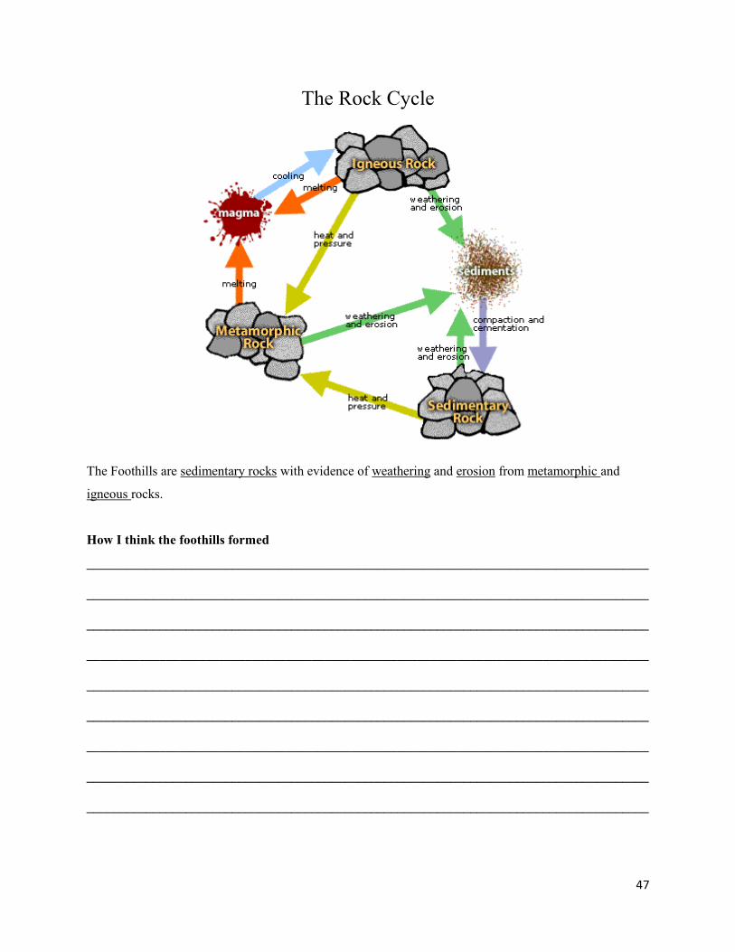
47
The Rock Cycle
The Foothills are sedimentary rocks with evidence of weathering and erosion from metamorphic and
igneous rocks.
How I think the foothills formed
_____________________________________________________________________________________
_____________________________________________________________________________________
_____________________________________________________________________________________
_____________________________________________________________________________________
_____________________________________________________________________________________
_____________________________________________________________________________________
_____________________________________________________________________________________
_____________________________________________________________________________________
_____________________________________________________________________________________
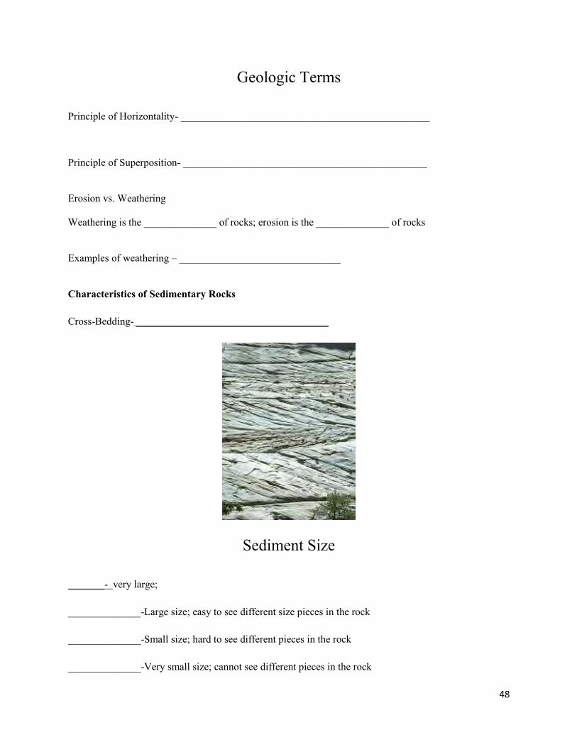
48
Geologic Terms
Principle of Horizontality- ________________________________________________
Principle of Superposition- _______________________________________________ Erosion vs. Weathering Weathering is the ______________ of rocks; erosion is the ______________ of rocks Examples of weathering – _______________________________ Characteristics of Sedimentary Rocks Cross-Bedding- _____________________________________
Sediment Size
_______- very large; ______________-Large size; easy to see different size pieces in the rock ______________-Small size; hard to see different pieces in the rock ______________-Very small size; cannot see different pieces in the rock

49
Pebble
Sand
Silt
Sedimentary Rocks found in the Foothills
Name of Rock Characteristics Depositional Environment
Conglomerate Fragments of Rounded pebbles bonded together by mud.
river
Sandstone Sand Sized Particles beaches and deserts
Shale Clay Particles deep, calm fresh water
Siltstone & Mudstone Mixture of Clay and Silt River; shallow sea
Limestone Mixture of Shells, Coral, and Marine Skeletons
deep ocean water
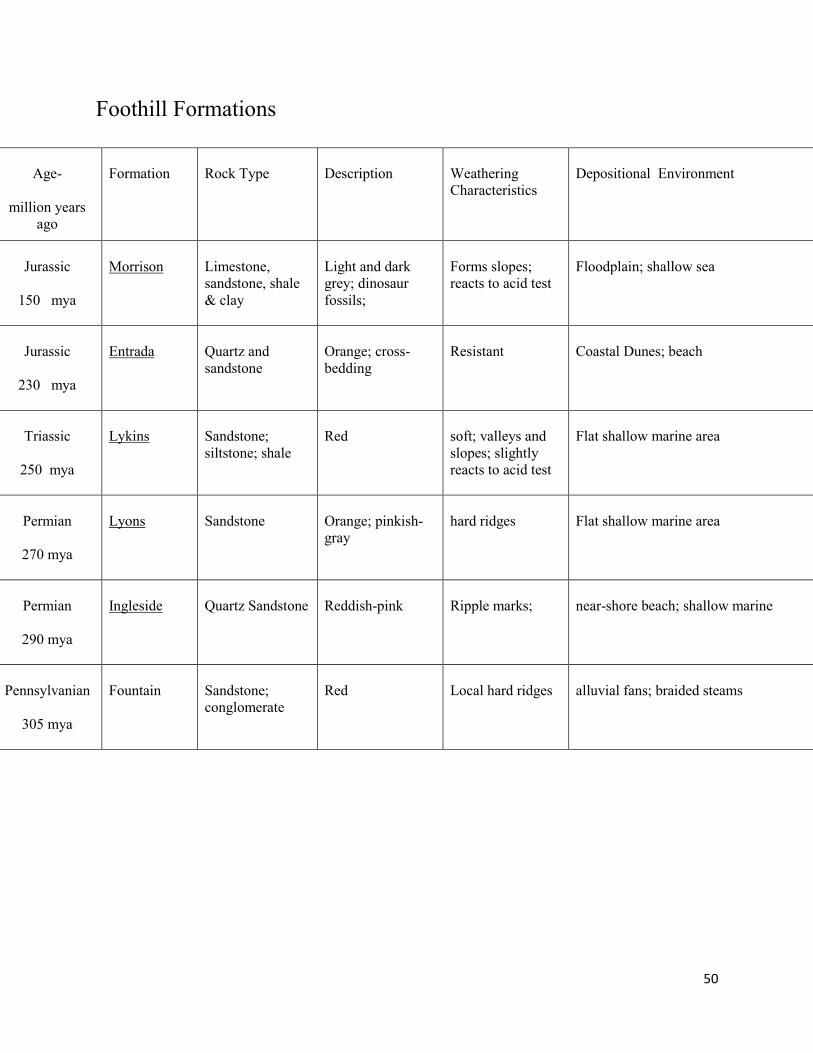
50
Foothill Formations
Age-
million years
ago
Formation
Rock Type
Description
Weathering Characteristics
Depositional Environment
Jurassic
150 mya
Morrison
Limestone, sandstone, shale & clay
Light and dark grey; dinosaur fossils;
Forms slopes; reacts to acid test
Floodplain; shallow sea
Jurassic
230 mya
Entrada
Quartz and sandstone
Orange; cross-bedding
Resistant
Coastal Dunes; beach
Triassic
250 mya
Lykins
Sandstone; siltstone; shale
Red
soft; valleys and slopes; slightly reacts to acid test
Flat shallow marine area
Permian
270 mya
Lyons
Sandstone
Orange; pinkish-gray
hard ridges
Flat shallow marine area
Permian
290 mya
Ingleside
Quartz Sandstone
Reddish-pink
Ripple marks;
near-shore beach; shallow marine
Pennsylvanian
305 mya
Fountain
Sandstone; conglomerate
Red
Local hard ridges
alluvial fans; braided steams
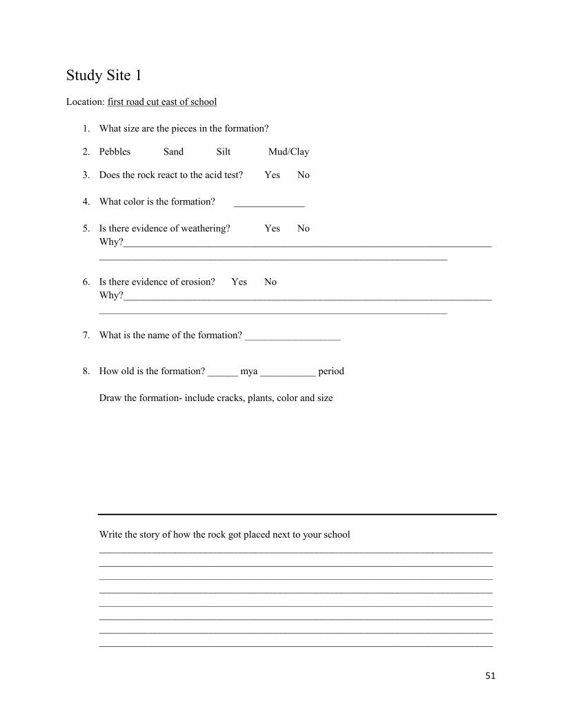
51
Study Site 1 Location: first road cut east of school
1. What size are the pieces in the formation?
2. Pebbles Sand Silt Mud/Clay
3. Does the rock react to the acid test? Yes No
4. What color is the formation? ______________
5. Is there evidence of weathering? Yes No Why?______________________________________________________________________________________________________________________________________________
6. Is there evidence of erosion? Yes No Why?______________________________________________________________________________________________________________________________________________
7. What is the name of the formation? ___________________
8. How old is the formation? ______ mya ___________ period
Draw the formation- include cracks, plants, color and size
Write the story of how the rock got placed next to your school ________________________________________________________________________________________________________________________________________________________________________________________________________________________________________________________________________________________________________________________________________________________________________________________________________________________________________________________________________________________________________________________________________________________________________________________________________________________________________________
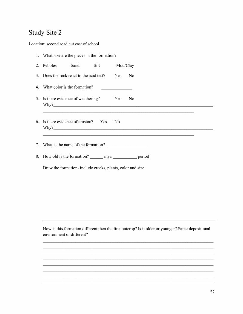
52
Study Site 2 Location: second road cut east of school
1. What size are the pieces in the formation?
2. Pebbles Sand Silt Mud/Clay
3. Does the rock react to the acid test? Yes No
4. What color is the formation? ______________
5. Is there evidence of weathering? Yes No Why?______________________________________________________________________________________________________________________________________________
6. Is there evidence of erosion? Yes No Why?______________________________________________________________________________________________________________________________________________
7. What is the name of the formation? ___________________
8. How old is the formation? ______ mya ___________ period
Draw the formation- include cracks, plants, color and size
How is this formation different then the first outcrop? Is it older or younger? Same depositional environment or different? ________________________________________________________________________________________________________________________________________________________________________________________________________________________________________________________________________________________________________________________________________________________________________________________________________________________________________________________________________________________________________________________________________________________________________________________________________________________________________________
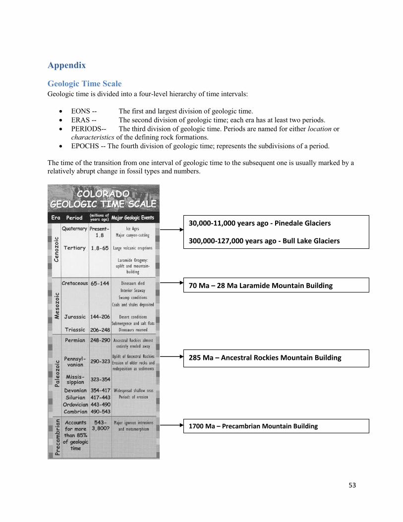
53
Appendix
Geologic Time Scale Geologic time is divided into a four-level hierarchy of time intervals:
EONS -- The first and largest division of geologic time. ERAS -- The second division of geologic time; each era has at least two periods. PERIODS-- The third division of geologic time. Periods are named for either location or
characteristics of the defining rock formations. EPOCHS -- The fourth division of geologic time; represents the subdivisions of a period.
The time of the transition from one interval of geologic time to the subsequent one is usually marked by a relatively abrupt change in fossil types and numbers.
30,000-11,000 years ago - Pinedale Glaciers
300,000-127,000 years ago - Bull Lake Glaciers
70 Ma – 28 Ma Laramide Mountain Building
285 Ma – Ancestral Rockies Mountain Building
1700 Ma – Precambrian Mountain Building
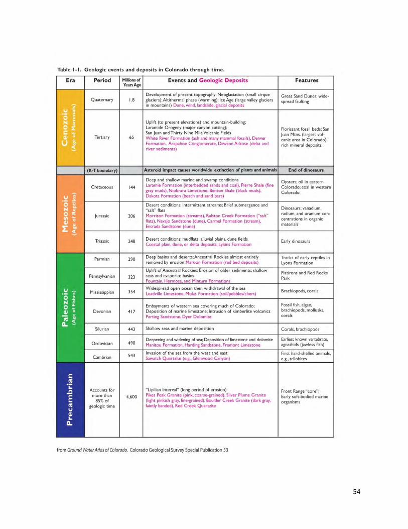
54
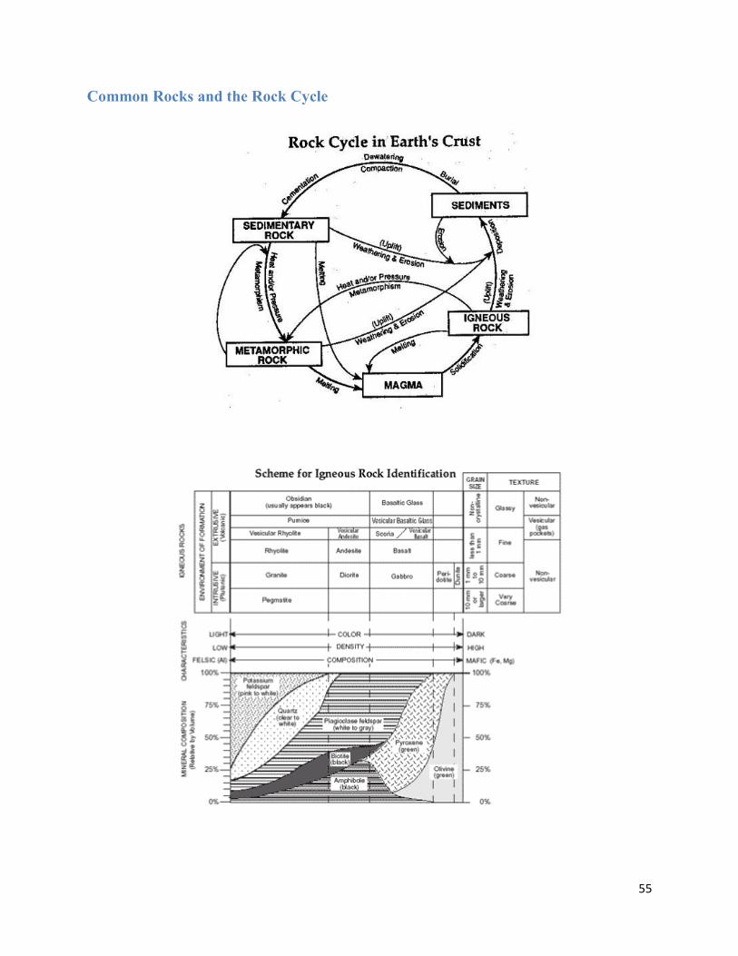
55
Common Rocks and the Rock Cycle
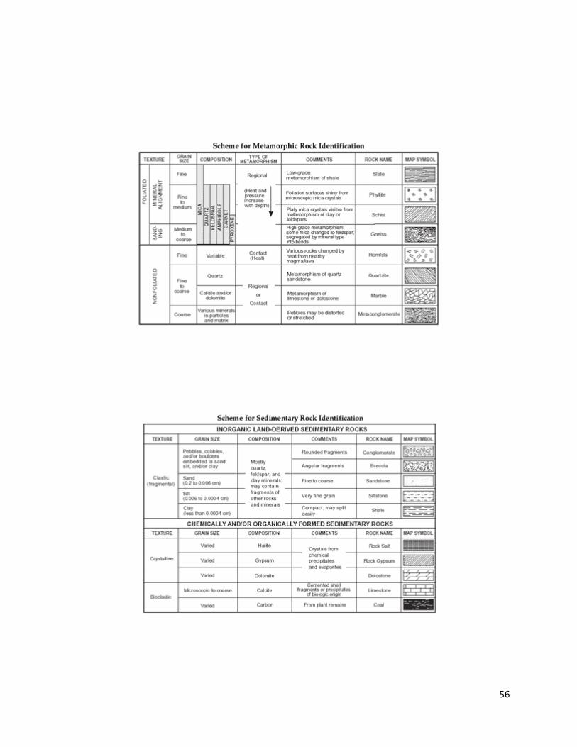
56

57
Formation Properties of Rocky Mountain National Park
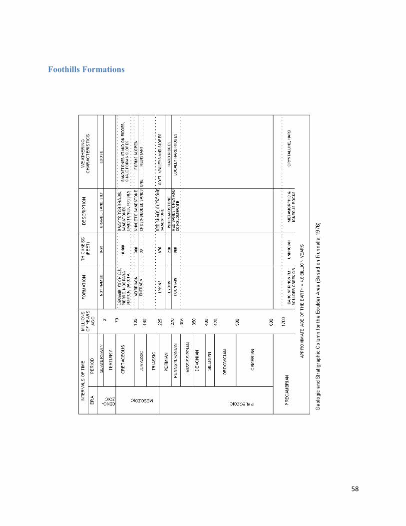
58
Foothills Formations
59
Vocabulary Ablation As applied to glacier ice, the process by which ice below the snow line is wasted by evaporation and melting. Alluvial fan An assemblage of sediments marking place where a stream moves from a steep gradient to a flatter gradient and suddenly loses transporting power. Typical of arid and semiarid climates but not confined to them. Andesite A fine-grained volcanic rock of intermediate composition, consisting largely of plagioclase and one or more mafic minerals. Anticline A fold that is convex upward, or that had such an attitude at some stage of its development. Aphanitic A textural term meaning "fine-grained" that applies to igneous rocks. Archean An eon of geologic time extending from about 3.9 billion years to 2.5 billion years ago. Arête A narrow, saw-toothed mountain ridge developed by glacier erosion in adjacent cirques. Arkose A sedimentary rock formed by the cementation of sand-sized grains of feldspar and quartz. Asthenosphere The weak or "soft" zone in the upper mantle just below the lithosphere, involved in plate movement and isostatic adjustments. It lies 70 to 100 km below the surface and may extend to a depth of 400 km. Aureole A zone surrounding an igneous intrusion, in which contact metamorphism has taken place. Basalt A dark colored extrusive igneous rock composed chiefly of calcium plagioclase and pyroxene. Extrusive equivalent of gabbro underlies the ocean basins and comprises oceanic crust. Basin A synclinal structure, roughly circular in its outcrop pattern, in which beds dip gently toward the center from all directions. Batholith A large, discordant, intrusive body of igneous rock. Bed load Material in motion along a stream bed. Bedding A collective term used to signify presence of beds, or layers, in sedimentary rocks and deposits. Bedding plane Surface separating layers of sedimentary rocks and deposits. Each bedding plane marks termination of one deposit and beginning of another of different character, such as a surface separating a sandstone bed from an overlying mudstone bed. Rock tends to breaks or separate, readily along bedding planes. Bedrock Any solid rock exposed at the Earth's surface or overlain by unconsolidated material. Block fault Mountain- A linear mountain that is bounded on both sides by normal faults Bottom Set Bed Layer of fine sediment deposited in a body of standing water beyond the edge of a
60
growing delta and which is eventually built over by the advancing delta. Similarly bottom set beds may accumulate in the wind shadow of a sand dune and be preserved beneath it as the dune advances. Boundary The tectonic region in which two plates meet. Breccia A clastic rock in which the gravel-sized particles are angular in shape and make up an appreciable volume of the rock. Brittle Structural behavior in which a material deforms permanently by fracturing. Burial metamorphism Takes place in an environment where pressure and temperature are barely more intense than during diagenesis, typically in a deepening sequence of sediments. Carbonate rock A rock consisting primarily of a carbonate mineral such as calcite or dolomite, the chief minerals in limestone and dolostone, respectively. Cenozoic The current geologic era, this began 66.4 million years ago and continues to the present. Chemical sediment Sediment formed by chemical precipitation from water. Cirque A steep-walled hollow in a mountain side, shaped like an amphitheater, or bowl, with one side partially cut away. Place of origin of a mountain glacier. Clastic Refers to rock or sediments made up primarily of broken fragments of pre-existing rocks or minerals. Clay The name for a family of finely-crystalline sheet silicate minerals Cleavage of a mineral: The tendency of a mineral to split along planes determined by the crystal structure Col Mountain pass formed by enlargement of two opposing cirques until their head walls meet and are broken down. Columnar jointing The type of jointing that breaks rock, typically basalt, into columnar prisms. Usually the joints form a more or less distinct hexagonal pattern. Compaction Reduction of pore space between individual particles as the result of overlying sediments or of tectonic movements. Compression Squeezing a material from opposite directions. Conglomerate A clastic sedimentary rock composed of lithified beds of rounded gravel mixed with sand. Contact metamorphism Metamorphism genetically related to the intrusion (or extrusion) of magmas and taking place in rocks at or near their contact with a body of igneous rock. Continental arc A belt of volcanic mountains on the continental mainland that lie above a subduction zone. Continental crust The part of the crust that directly underlies the continents and continental shelves. Averages about 35 km in thickness, but may be over 70 km thick under largest mountain ranges.

61
Continental Divide the watershed of North America comprising the line of highest points of land separating the waters flowing W from those flowing N or E, coinciding with various ranges of the Rockies, & extending SSE from NW Canada to NW S. America Continental ice glacier An ice sheet that obscures all but the highest peaks of a large part of a continent. Convergent boundary A boundary between two plates of the Earth's crust that are pushing together. Core Innermost zone of Earth. Consists of two parts, an outer liquid section and an inner solid section, both chiefly of iron and nickel with about 10 percent lighter elements. It is surrounded by the mantle. Craton The stable portions of the continents that have escaped orogenic activity for the last 2 billion years. Made predominantly of granite and metamorphic rocks. Crevasse Deep crevice or open fracture in glacier ice. Cross-bedding Bedding laid down at an angle to the horizontal, as in many sand dunes. Cross-cutting relationships Geologic discontinuities that suggest relative ages: A geologic feature is younger than the feature it cuts. Thus, a fault cutting across a rock is younger than the rock. Crust The upper part of the lithosphere , divided into oceanic crust and continental crust . Crystal The multi-sided form of a mineral, bounded by planar growth surfaces, that is the outward expression of the ordered arrangement of atoms within it. Crystalline Having a crystal structure. Cumulate An igneous rock that forms by crystal settling. Current ripple mark An asymmetric ripple mark formed by wind or water moving generally in one direction. Steep face of ripple faces in direction of current. compare oscillation ripple mark . Debris flow Fast-moving, turbulent mass movement with a high content of both water and rock debris. The more rapid debris flows rival the speed of rock slides. Decomposition (chemical weathering) Weathering processes that are the result of chemical reactions Deflation A process of erosion in which wind carries off particles of dust and sand. Dehydration Any process by which water bound within a solid material is released. Depositional environment The nature of the environment in which sediments are laid down. They are immensely varied and may range from the deep ocean to the coral reef and the glacial lake of the high mountains. The nature of the depositional environment may be deduced from the nature of the sediments and rock deposited there. Diagenesis All the physical, chemical, and biologic changes undergone by sediments from the time of their initial deposition, through their conversion to solid rock, and subsequently to the brink of metamorphism.
62
Differential weathering Weathering that occurs at different rates, as the result of variations in composition and mechanical resistance of rocks, or differences in the intensity of weathering processes. Dike A tabular igneous intrusion that cuts across the surrounding rock. Dip The angle that a structural surface such as a bedding plane or fault surface makes with the horizontal, measured perpendicular to the strike and in the vertical plane. Dip slip fault A fault on which the movement is parallel to the dip of the fault plane. Discharge In a stream, the volume of water passing through a channel in a given time. Disconformity An unconformity in which the beds above the unconformity are parallel to the beds below the unconformity. Discordant Cutting across surrounding strata. Disintegration (mechanical weathering) The processes of weathering by which physical actions such as frost wedging break down a rock into fragments, involving no chemical change. Dissolution A chemical reaction in which a solid material is dispersed as ions in a liquid. Divergent boundary Boundary between two crustal plates that are pulling apart. Dome An uplift or anticlinal structure, roughly circular in its outcrop exposure, in which beds dip gently away from the center in all directions. Drag fold A minor fold produced within a weak bed or adjacent to a fault by the movement of surrounding rocks in opposite directions. Drainage basin The area from which a stream and its tributaries receives its water. Drainage divide The line that separates one drainage basin from another. Drift Glacial deposits laid down directly by glaciers or laid down in lakes, ocean, or streams as result of glacial activity. Drumlin Streamlined hill, largely of till, with blunt end pointing into direction from which ice moved. Occur in clusters called drumlin fields. Ductile Structural behavior in which a material deforms permanently without fracturing. Earthflow A form of slow, but perceptible, mass movement, with high content of water and rock debris. Lateral boundaries are well-defined and the terminus is lobed. With increasing moisture content grades into a mudflow. Elastic Non-permanent structural deformation during which the amount of deformation (strain) is proportional to the stress. Elastic rebound The statement that movement along a fault is the result of an abrupt release of a progressively increasing elastic strain between the rocks on either side of the fault.
63
Elasticity The tendency for a body to return to its original shape and size when a stress is removed. Eon The primary division of geologic time which are, from oldest to youngest, the Hadean, Archean, Proterozoic, and Phanerozoic eons. Epoch A division of geologic time next shorter than a period. Example: the Pleistocene epoch is in the Quaternary period. Equilibrium line On a glacier the line separating the zone of accumulation from the zone of ablation . Era A division of geologic time next smaller than the eon and larger than a period. Example: The Paleozoic era is in the Phanerozoic eon and includes, among others, the Devonian period. Erratic A stone or boulder, glacially transported from place of origin and left in an area of different bedrock composition. Esker A winding ridge of stratified drift . Forms in a glacial tunnel and, when ice melts, stands as ridge up to 15 m high and kilometers in length. Evaporite A mineral or rock deposited directly from a solution (commonly seawater) during evaporation. For example, gypsum and halite are evaporite minerals. Exfoliation The process by which concentric scales, plates, or shells of rock are stripped or spall from the bare surface of a large rock mass. Exfoliation dome A large dome-shaped form that develops in homogeneous crystalline rocks as the result of exfoliation. Extrusive Pertaining to igneous rocks or features formed from lava released on the Earth's surface. Fault The surface of rock rupture along which there has been differential movement of the rock on either side. Foliation A planar structure that develops in metamorphic rocks as a result of directed pressure. Fold and thrust mountains Mountains, characterized by extensive folding and thrust faulting, that form at convergent plate boundaries on continents. Foot wall block The body of rock that lies below an inclined fault plane. compare hanging wall block Fossil Evidence in rock of the presence of past life, such as a dinosaur bone, an ancient clam shell, or the footprint of a long-extinct animal. Fractional crystallization A sequence of crystallization from magma in which the early-formed crystals are prevented from reacting with the remaining magma, resulting in a magma with an evolving chemical composition. Frost wedging A type of disintegration in which jointed rock is forced apart by the expansion of water as it freezes in fractures.

64
Geologic column The arrangement of rock units in the proper chronological order from youngest to oldest. Geologic time scale The chronological sequence of units of Earth time. Glaciation The formation, advance and retreat of glaciers and the results of these activities. Glacier A mass of ice, formed by the recrystallization of snow, that flows forward, or has flowed at some time in the past. Glacier ice Ice with interlocking crystals that makes up the bulk of a glacier. Gneiss A coarse, foliated metamorphic rock in which bands of granular minerals (commonly quartz and feldspars) alternate with bands of flaky or elongate minerals (e.g., micas, pyroxenes). Generally less than 50% of the minerals are aligned in a parallel orientation. Gondwana The southern portion of the late Paleozoic supercontinent known as Pangea. It means, literally "Land of the Gonds" (a people of the Indian subcontinent). The variant Gondwanaland found in some books, therefore, is a tautology. Graded bedding Type of bedding sedimentary deposits in which individual beds become finer from bottom to top. Gradient Slope of a stream bed or hillside. The vertical distance of descent over horizontal distance of slope. Granite Light colored, coarse grained, intrusive igneous rock characterized by the minerals orthoclase and quartz with lesser amounts of plagioclase feldspar and iron-magnesium minerals. Underlies large sections of the continents. Granitic belt A region of granitic rock, one of two characteristic regions within cratons . Ground moraine Till deposited from main body of glacier during ablation. Hanging valley A valley whose mouth is high above the floor of the main valley to which it is tributary. Usually, but not always, the result of mountain glaciation. Hanging wall block The body of rock that lies above an inclined fault plane. compare foot wall block Hardness Resistance of a mineral to scratching, determined on a comparative basis by the Mohs scale . Hinge fault A fault along which there is increasing offset or separation along the strike of the fault plane, from an initial point of no separation. Horn The sharp spire of rock formed as glaciers in several cirques erode into a central mountain peak. Ice sheet A broad, mound-like mass of glacier ice that usually spreads radially outward from a central zone. Ice shelf A floating ice sheet extending across water from a land-based glacier.

65
Icecap A small ice sheet. Igneous rock A rock that has crystallized from a molten state. Inclined fold A fold whose axial plane is inclined from the vertical, but in which the steeper of the two limbs is not overturned. compare overturned fold. Inclusion (xenolith) A fragment of older rock caught up in an igneous rock. Index fossil A fossil that identifies and dates the strata in which it is typically found. To be most useful, an index fossil must have broad, even worldwide distribution and must be restricted to a narrow stratigraphic range. Index mineral A mineral formed under a particular set of temperature and pressure conditions, thus characterizing a particular degree of metamorphism. Inner core The solid innermost part of the core with a diameter of a little over 1,200 km. Interlobate moraine Ridge formed along junction of adjacent glacier lobes. Intrusive Pertaining to igneous rocks formed by the emplacement of magma in pre-existing rock. Island arc A curved belt of volcanic islands lying above a subduction zone. compare continental arc. Isoclinal fold A fold in which the limbs are parallel. Isostasy The condition of equilibrium, comparable to floating, of units of the lithosphere above the asthenosphere. Joint A surface of fracture in a rock, without displacement parallel to the fracture. Kettle Depression in ground surface formed by the melting of a block of glacier ice buried or partially buried by drift. Lahar A mudflow composed chiefly of pyroclastic material on the flanks of a volcano. Laminar flow Fluid flow in which flow lines are distinct, and parallel and do not mix. compare turbulent flow . Lateral moraine Moraine formed by valley glaciers along valley sides. Laurasia The northern portion of the late Paleozoic supercontinent called Pangea. Lava dome A steep-sided rounded extrusion of highly viscous lava squeezed out from a volcano and forming a dome-shaped or bulbous mass above and around the volcanic vent. The structure generally develops inside a volcanic crater. Limestone A sedimentary rock composed mostly of the mineral calcite, CaCO3. Lineation A general term applying to any linear feature in a metamorphic rock.
66
Liquefaction The transformation of a soil from a solid to a liquid state as the result of increased pore pressure. Lithification The process by which an unconsolidated deposit of sediments is converted in to solid rock. Compaction, cementation and recrystallization are involved. Lithosphere The rigid outer shell of the Earth. It includes the crust and uppermost mantle and is on the order of 100 km in thickness. Load Of a stream, the amount that it carries at any one time. Luster The manner in which light reflects from the surface of a mineral, described by its quality and intensity. Mafic Referring to a generally dark-colored igneous rock with significant amounts of one or more ferromagnesian minerals, or to a magma with significant amounts of iron and magnesium. Magma Molten rock, containing dissolved gases and suspended solid particles. At the Earth's surface, magma is known as lava. Mantle That portion of the Earth below the crust and reaching to about 2,780 km, where a transition zone of about 100 km thickness separates it from the core. Mantle plume A hypothetical column of hot, partially molten material that rises from an indeterminate depth in the mantle and is thought by some geologists to provide a driving force for plate movement. compare hot spot . Marble A metamorphic rock composed largely of calcite. The metamorphic equivalent of limestone. Margin The tectonic region that lies at the edge of a continent, whether it coincides with a plate boundary or not. Medial moraine Formed by the merging of lateral moraines as two valley glaciers join. Mesosphere A zone in the Earth between 400 and 670 km below the surface separating the upper mantle from the lower mantle. Mesozoic An era of time during the Phanerozoic eon lasting from 245 million years ago to 66.4 million ago. Metamorphic rock A rock changed from its original form and/or composition by heat, pressure, or chemically active fluids, or some combination of them. Metamorphic zone A mappable region in which rocks have been metamorphosed to the same degree, as evidenced by the similarity of mineral assemblages in them. Metamorphism The processes of recrystallization, textural and mineralogical change that take place in the solid state under conditions beyond those normally encountered during diagenesis. Monocline A simple fold, described as a local steepening in strata with an otherwise uniform dip.
67
Moraine Landform made largely of glacier till. Mountain glacier see valley glacier. Mudflow Form of mass movement similar to a debris flow but containing less rock material. Nonclastic A term applied to sedimentary rocks that are not composed of fragments of pre-existing rocks or minerals. The term "crystalline" is more commonly used. Nonconformity An unconformity that separates profoundly different rock types, such as sedimentary rocks from metamorphic rocks. Normal fault A dip-slip fault on which the hanging wall block is offset downward relative to the foot wall block. compare reverse fault. Oceanic crust That part of the crust underlying the ocean basins. Composed of basalt and having a thickness of about 5 km. Original horizontality Refers to the condition of beds or strata as being horizontal or nearly horizontal when first formed. Orogeny The process of mountain building. Oscillation ripple mark A symmetric ripple mark formed by waves, which move water back and forth. compare current ripple mark. Outer core The outermost part of the core. It is liquid, about 1,700 km thick, and separated from the inner, solid core by a transition zone about 565 km thick. Outwash Beds of sand and gravel laid down by glacial melt water Overturned fold An inclined fold in which one limb has been tilted beyond the vertical, so that the stratigraphic sequence within it is reversed. compare inclined fold. Paleozoic An era of geologic time lasting from 570 to 245 million years ago. Pangea A supercontinent that existed from about 300 to 200 million years ago, and included most of the continental crust of the Earth. Pegmatite An extremely coarse-grained igneous rock with interlocking crystals, usually with a bulk chemical composition similar to granite but commonly containing rare minerals enriched in lithium, boron, fluorine, niobium, and other scarce metals. Pegmatites are also the source for many gem-quality precious and semiprecious stones. Period In the geologic time scale a unit of time less than an era and greater than an epoch. Example: The Tertiary period was the earliest period in the Cenozoic era and included, among others, the Eocene epoch. Phaneritic A textural term meaning "coarse-grained" that applies to igneous rocks. Phanerozoic the most recent eon of geologic time beginning 570 million years ago and continuing to the present.
68
Phenocryst Any relatively large, conspicuous crystal in a porphyritic igneous rock Piedmont glacier A glacier that spreads out at the foot of mountains, formed by the coalescence of two or more valley glaciers. Plate A rigid segment of the Earth's lithosphere that moves horizontally and adjoins other plates along zones of seismic activity. Plates may include portions of both continents and ocean basins. Plate boundaries The zones of seismic activity long which plates are in contact. These may coincide with continental margins, but usually do not. Movement between plates is predominately horizontal, and may be divergent, or convergent, or side-by-side. Plate tectonics A theory of global tectonics according to which the lithosphere is divided into mobile plates. The entire lithosphere is in motion, not simply those segments composed of continental material. compare continental drift Plucking (quarrying) A process of erosion in which the glacier pulls loose pieces of bed rock. Plume The movement of water along flow lines from a point source of ground water pollution toward its eventual emergence at the surface. Plunging fold A fold in which the axis is inclined at an angle from the horizontal. Pluton An igneous intrusion. Porphyritic A texture of an igneous rock in which large crystals (phenocrysts) are set in a matrix of relatively finer-grained crystals or of glass. Precambrian An informal term to include all geologic time from the beginning of the Earth to the beginning of the Cambrian period 570 million years ago. Principle of faunal and floral succession Groups of animals and plants have succeeded one another in a definite and discernible order. Proterozoic The geologic eon lying between the Archean and Phanerozoic eons, beginning about 2.5 billion years ago and ending about 0.57 billion years ago. Pyroclastic Pertaining to clastic material formed by volcanic explosion or aerial expulsion from a volcanic vent. Rain shadow formed by blocking moisture-bearing winds with mountain barriers. Recessional moraine Ridges of glacial till marking halt and slight readvance of glacier during its general retreat. Regional metamorphism Metamorphism affecting an extensive region, associated with orogeny . Relative time Dating of rocks and geologic events by their positions in chronological order without reference to number of years before the present.
69
Reverse fault A dip-slip fault on which the hanging wall block is offset upward relative to the foot wall block. compare normal fault. Rhyolite A fine-grained silica-rich igneous rock, the extrusive equivalent of granite. Rift (graben) A valley caused by extension of the Earth's crust. Its floor forms as a portion of the crust moves downward along normal faults. Ripple marks of oscillation Symmetrical ripple marks formed by oscillating movement of water such as may be found along the coast just outside the surf zone. Rio Grande Rift The Rio Grande Rift is a rift valley extending north from Mexico, near El Paso, Texas through New Mexico into central Colorado, and is part of the Basin and Range Province. Rock cycle The concept of a sequence of events involving the formation, alteration, destruction and reformation of rocks as a result of geologic processes and which is recurrent, returning to a starting point. It represents a closed system. compare rock system. Rock flour Finely divided rock material ground by glacial action and fed by streams fed by melting glaciers. Rock glacier A mass of ice-cemented rock rubble found on slopes of some high mountains. Movement is slow, averaging 30 to 40 cm/yr. Sandstone A clastic sedimentary rock in which the particles are dominantly of sand size, from 0.062 mm to 2 mm in diameter. Schist A strongly foliated, coarsely crystalline metamorphic rock, produced during regional metamorphism, that can readily be split into slabs or flakes because more than 50% of its mineral grains are parallel to each other. Schistosity The foliation in a schist, due largely to the parallel orientation of micas. Seafloor spreading Process by which ocean floors spread laterally from crests of main ocean ridges. As material moves laterally from the ridge, new material replaces it along the ridge crest by welling upward from the mantle. compare continental drift, plate tectonics Seamount (guyot) A volcanic mountain on the seafloor. If flat-topped, it is a guyot. Sedimentary rock Rock formed from the accumulation of sediment, which may consist of fragments and mineral grains of varying sizes from pre-existing rocks, remains or products of animals and plants, the products of chemical action, or mixtures of these. Shale A mudstone that splits or fractures readily. Shatter cone A distinctively striated conical structure in rock, ranging from a few centimeters to a few meters in length, believed to have been formed by the passage of a shock wave following meteorite impact. Shear Rock deformation involving movement past each other of adjacent parts of the rock and parallel to the plane separating them.
70
Shear strength The resistance of a body to shear stress. Shear stress The stress on an object operating parallel to the slope on which it lies. Sheeting A type of jointing produced by pressure release (unloading) or exfoliation. Silica Silicon dioxide (SiO2) as a pure crystalline substance makes up quartz. Sill A tabular igneous intrusion that parallels the planar structure of the surrounding rock. Slaty cleavage A style of foliation common in metamorphosed mudstones, characterized by nearly flat, sheet-like planes of breakage, similar in appearance to a deck of playing cards. compare cleavage Slickenside A polished and smoothly striated surface that results from friction along a fault plane. Sorting The range of particle sizes in a sedimentary deposit. A deposit with a narrow range of particle sizes is termed "well-sorted." Stratification The accumulation of material in layers or beds. Stratified drift Debris washed from a glacier and laid down in well-defined layers. Stratigraphy The succession and age relation of layered rocks. Striations Scratches, or small channels, gouged by glacier action. Occur on boulders, pebbles, and bedrock. Striations along bedrock indicate direction of ice movement. Strike The compass direction of the intersection between a structural surface (e.g., a bedding plane or a fault surface) and the horizontal. Strike-slip fault (transcurrent fault) A fault on which the movement is parallel to the fault's strike. Subduction zone A narrow, elongate region in which one lithospheric plate descends relative to another. Surging glacier A glacier that moves rapidly (tens of meters per day) as it breaks away from the ground surface on which it rests. Syncline A fold that is convex downward, or that had such an attitude at some stage in its development. Talus A slope built up by the accumulation of rock waste at the foot of a cliff or ridge. Tarn A lake in the bedrock basin of a cirque. Temperate glacier A glacier whose temperature throughout is at, or close to, the pressure point of ice, except in winter when it is frozen for a few meters below the surface. Tensile fracture A fracture caused by tensional stress in a rock. Tension A stress that tends to pull a body apart.
71
Tephra A general term for all pyroclastic material. Terminal moraine (end moraine) Ridge of till marking farthest extent of glacier. Thrust fault A reverse fault on which the dip angle of the fault plane is 15 degrees or less. Till (unstratified drift) Glacial drift composed of rock fragments that range from clay to boulder size and randomly arranged without bedding. Transform boundary A plate boundary in which plates on opposite sides of the boundary move past each other in opposite directions. Transform fault A plate boundary that ideally shows pure strike-slip movement. Associated with the offset segments of midocean ridges. U-shaped valley A valley carved by glacier erosion and whose cross-valley profile has steep sides and a nearly flat floor, suggestive of a large letter "U". Unconformity A buried erosion surface separating two rock masses. Uniformitarianism principle acknowledges that past processes, even if the same as today, may have operated at different rates and with different intensities than those of the present. Valley glacier (alpine glacier, mountain glacier) Streams of ice that flow down valleys in mountainous areas. Viscosity The internal resistance to flow in a liquid. Volcanic ash The dust-sized, sharp-edged, glassy particles resulting from an explosive volcanic eruption. Weathering The process by which Earth materials change when exposed to conditions at or near the Earth's surface and different from the ones under which they formed. compare decomposition , disintegration . Welded tuff A pyroclastic rock in which glassy clasts have been fused by the combination of the heat retained by the clasts, the weight of overlying material, and hot gases. Zone of accumulation The area in which ice accumulates in a glacier. Zone of fracture The near surface zone in a glacier that behaves like a brittle substance.