Geology of the Hames Valley, Wunpost and Valleton ... · Geology of the Hames Valley, Wunpost and...
57
Geology of the Hames Valley, Wunpost and Valleton Quadrangles Monterey County, California By DAVID L. DURHAM CONTRIBUTIONS TO GENERAL GEOLOGY GEOLOGICAL SURVEY BULLETIN 1221-B A study of stratigraphy and structure of Cenozoic sedimentary rocks in part of the Salinas Valley UNITED STATES GOVERNMENT PRINTING OFFICE, WASHINGTON : 1966
Transcript of Geology of the Hames Valley, Wunpost and Valleton ... · Geology of the Hames Valley, Wunpost and...

Geology of the Hames Valley, Wunpost and Valleton Quadrangles Monterey County, CaliforniaBy DAVID L. DURHAM
CONTRIBUTIONS TO GENERAL GEOLOGY
GEOLOGICAL SURVEY BULLETIN 1221-B
A study of stratigraphy and structure of Cenozoic sedimentary rocks in part of the Salinas Valley
UNITED STATES GOVERNMENT PRINTING OFFICE, WASHINGTON : 1966
UNITED STATES DEPARTMENT OF THE INTERIOR
STEWART L. UDALL, Secretary
GEOLOGICAL SURVEY
William T. Pecora, Director
For sale by the Superintendent of Documents, U.S. Government Printing Office Washington, D.C. 20402

CONTENTS
PageAbstract_________________________-___-__.:_-_____-_---__------__ BlIntroduction. ___________________________-__---___---_-__-___--____ 1
Purpose and scope.-___________________________________________ 1Location of area______.________________________________________ 2Previous work-_-__--_-__--_-_---_---__----_----------------_- 2Fieldwork and acknowledgments._____--____-___-__-.___________ 4
Stratigraphy.______-__---._--__---_-_----------_-_------_----_--.- 5General features.....-___-_--_---------------_-----------_---__ 5
Description of exposed formations._--__--__--_----___-----_- 5Tertiary System..._--_____-_-___--__---__----__-_____.__._ 5
Miocene Series Monterey Shale.__-_-_--____.___-___-__ 5Diatomaceous mudstone member,___________________ 6Lithology_ ____-__-__--_---_--___---__--._-_-______ 8
Porcelaneous rocks__________________________ 8Clastic rocks___-__-_-___-_-_-_-__-_--__.______ 9Carbonate beds and concretions_________________ 10Chert..._.___._.._..__.__._..-____._..__...._ 10
Thickness.___._---_----_----------___-.-_________ 11Age and conditions of deposition.___________________ 11
Pliocene Series Pancho Rico Formation.________________ 12Lithology__ _ ______---_--____-__-___-____________ 13Thickness. ________----_--_'-___-_--_______________ 15Age and conditions of deposition._____.--___._______ 15
Tertiary and Quaternary (?) Systems. ___ _____________________ 18Pliocene and Pleistocene(?) Series Paso Robles Formation. 18
Lithology_ _-_-_--_--------_--_---------_________ 19Thickness------------------------------_----_-.__ 21Age and conditions of deposition___________________ 22
Quaternary System._______________________________________ 22Pleistocene and Recent(?) Series older alluvium._________ 22Recent Series Alluvium._______________________________ 23
Structure....__-.-------...--_...__---..--....-__-........._..._.. 23General features...._-_-_-__-------_--------__--___-___________ 23Faults---____---------_--_---_-_----_--_-.___-______________ 25Folds._______________________________________________________ 26
Economic geology.___---_--_-_____-_--___-________-____.__________ 27San Ardo oil field____________________________________________ 34
Development.--___--__-_-----_-_-___--_.--___-___________ 34Stratigraphy._____________________________________________ 35Structure and accumulation of oil__________________________ 36Drilling practice_______----_-___________.-___.__________. 37Production. ___-__._-___..._._...____.___--_._._____.____. 38
Lynch Canyon oil field.__-_.--_----.---____-___-_______________ 39Measured sections----_---__--__-__-_---_--____-___-_-_-___________ 40References_ _-__--_--_--___________-________-____-_._____________ 50
in

IV CONTENTS
ILLUSTRATIONS
[Plates are in pocket]
PLATES 1-3. Geologic map and structure section of the 1. Hames Valley quadrangle.2. Wunpost quadrangle.3. Valleton quadrangle.
4. Composite generalized stratigraphic section.5. Approximate configuration of the concealed basement complex
surface.
FIGURE 1. Index map_________________________________________ B32-5. Photograph showing
2. Porcelaneous rocks of the Monterey Shale_-_--____ 63. Diatomaceous mudstone of the Monterey Shale...- 74. Conglomerate and sandstone of the Paso Robles
Formation. _________________________________ 205. Limestone in the Paso Robles Formation__________ 21
TABLES
Page TABLE 1. Fossils from the Pancho Rico Formation._.__________ ___ B16
2. Exploratory and outpost wells.________________________ 283. Production statistics, San Ardo oil field_.___.__.______. 384. Fossil localities.--------___---_-_--___-_______________ 39

CONTRIBUTIONS TO GENERAL GEOLOGY
By DAVID L. DURHAM
ABSTRACT
The Hames Valley, Wunpost, and Valleton quadrangles lie side by side across the southern Salinas Valley at the latitude of the San Ardo oil field.
Monterey Shale is exposed west of the Salinas River in high hills and locally east of the river in canyons. Diatomaceous mudstone beds near the top of the Monterey form a distinctive member. The Monterey is at least as thick as 5,800 feet west of the river. It is marine and contains fossils that indicate late Miocene age.
The Pancho Rico Formation conformably overlies and probably intertongues with the Monterey Shale. The Pancho Rico is chiefly sandstone and is 100-650 feet thick. It contains marine fossils indicative of Pliocene or early Pliocene age.
The Paso Robles Formation overlies the Pancho Rico Formation with apparent conformity, except in the southwest part of the Hames Valley quadrangle, where the Paso Robles unconformably overlies the Monterey Shale. The Paso Robles contains conglomerate, sandstone, mudstone, and limestone, and is as thick as 1,000 feet. It is considered nonmarine in origin and Pliocene and Pleistocene (?) in age.
The thick sequence of faulted and folded Monterey Shale and other rocks that overlies the basement complex west of the Salinas River contrasts markedly with the comparatively thin sequence of unfaulted and broadly folded or tilted strata east of the river. Beds just west of the river and in the southwestern part of the Hames Valley quadrangle are severely deformed near large faults.
The San Ardo oil field, which contains more than 800 wells, is in the Hames Valley and Wunpost quadrangles. The field yielded about 125 million barrels of oil and 43 million Mcf of gas between 1947, when it was discovered, and 1962.
INTRODUCTION
PURPOSE AND SCOPE
U.S. Geological Survey investigation in the Salinas Valley area is concerned mainly with recording the nature, distribution, and struc ture of Cenozoic sedimentary rocks exposed there. The purpose of this investigation is both to assist in realizing the economic mineral potential of the area and to contribute to geologic knowledge of the California Coast Kanges. Cenozoic sedimentary rocks crop out in the area from north of the latitude of Arroyo Seco southeastward for more than 80 miles to beyond the town of Santa Margarita. These
Bl

B2 CONTRIBUTIONS TO GENERAL GEOLOGY
strata contain oil and gas in commercial quantities at the San Ardo, King City, and Lynch Canyon oil fields, and the prospect of finding additional petroleum or other commercial mineral commodities in the Salinas Valley area is favorable.
This report describes the geology of the Hames Valley, Wunpost, and Valleton quadrangles and includes geologic maps and structure sections of the three quadrangles (pis. 1, 2, and 3). Similar reports describe the Reliz Canyon, Thompson Canyon, and San Lucas quad rangles (Durham, 1963), the Cosio Knob and Espinosa Canyon quadrangles (Durham, 1964), and the Jolon and Williams Hill quadrangles (Durham, 1965).
LOCATION OF AREA
The Hames Valley, Wunpost, and Valleton TVk-minute quadrangles lie side by side across the Salinas Valley at the latitude of the San Ardo oil field, southern Monterey County, Calif, (fig. 1). They in- .elude high hills west of the Salinas River and part of the mesalike area of more subdued relief east of the river. The San Ardo oil field is in the Hames Valley and Wunpost quadrangles, and part of the smaller Lynch Canyon oil field is in the Wunpost quadrangle.
PREVIOUS WORK
Earlier geological investigations concerned specifically with part of or all the map area were related mainly to mineral resources. Good year (1888, p. 86) reported bituminous sandstone in the hills southwest of San Ardo in or near the Hames Valley quadrangle. Angel (1890, p. 345) noted that placer gold had been taken from Big Sandy Creek, which flows through the Valleton quadrangle. Watts (1900, p. 145) mentioned an oil seep on Big Sandy Creek, probably outside the map area, and listed exploratory oil wells just west of the Salinas River near the north edge of the Hames Valley quadrangle. Nutter (1901 p. 335) reported fossils of Pliocene age in railroad cuts near the south edge of the Wunpost quadrangle, and fossils of Miocene age on the west bank of the Salinas River opposite Wunpost. Hamlin (1904, p. 47) re marked on the depth of the canyon cut by the Salinas River south of Wunpost and the widening of the valley north of there. Waring (1914, p. 426) noted an anticline near Valleton, and he (p. 423) de scribed beds in the Indian Valley and Big Sandy Creek areas that he assigned to the Etchegoin and Jacalitos Formations. He (p. 435) also listed information on wells drilled for oil west of the Salinas River near the north edge of the Hames Valley quadrangle. Diller and others (1915, p. 119) recognized evidence suggestive of a large fault along the Salinas River, and they (p. 120) mentioned fossiliferous sandstone beds south of San Ardo that they considered part of the
' vVs-KING CITY /
OIL FIELD \
35°
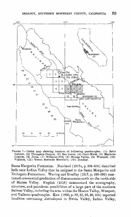
FIGURE 1. Index map showing location of following quadrangles: (1) Reliz Canyon, (2) Thompson Canyon, (3) San Lucas, (4) Cosio Knob, (5) Bspinosa Canyon, (6) Jolon, (7) Williams Hill, (8) Hames Valley, (9) Wunpost, (10) Valleton, (11) Tierra Redonda Mountain, (12) Bradley.
Santa Margarita Formation. Nomland (19l7a, p. 304-305) described beds near Indian Valley that he assigned to the Santa Margarita and Etchegoin Formations. Waring and Bradley (1917, p. 598-599) men tioned commercial production of diatomaceous earth on the north side of Hames V-alley. English (191.8) summarized the stratigraphy, structure, and petroleum possibilities of a large part of the southern Salinas Valley, including the area within the Hames Valley, Wunpost, and Valleton quadrangles. Kew (1920, p. 83, 85, 86, 90,104) reported localities containing Astrodapsis in Swain Valley, Indian Valley,

B4 CONTRIBUTIONS TO GENERAL GEOLOGY
Lynch Canyon, and Sargent (Powell) Canyon. Vander Leek (1921, p. 87, 89) recorded evidence for a large fault near the Salinas River, and he (p. 87) pictured the structure at Hames Valley as "a broad synclinal trough." He (p. 89) also mentioned a large anticline that trends southeast in the southwestern part of the Wunpost quadrangle. Reed (1925, p. 594-595, and fig. 2) described the upper contact of the Monterey Shale exposed in the west bank of the Salinas River opposite Wunpost. Taliaferro (1934, pi. 11) indicated that spheroids of rhyth mically and concentrically banded chert and porcelanite occur in the Monterey Shale near Hames Valley, and he (pi. 24) illustrated an example from west of there. Later Taliaferro (1943) summarized the geology of the Bradley and San Miguel 15-minute quadrangles, which include the Hames Valley, Wunpost, and Valleton 1~y2 -minute quad rangles. Bramlette and Daviess (1944), in their general study of the Salinas Valley area, mentioned diatomaceous beds in the Monterey Shale near Hames Valley, tar sands and associated strata southwest of San Ardo, and porcelaneous beds near Indian Valley that they con sidered at least partly equivalent to the Pancho Rico Formation. Kilkenny (1948, p. 2266) concluded that faults extend along the west side of the Salinas River as far south as Bradley. Woodring and Bramlette (1950, p. 67-68) reported the occurrence of Dendraster in the Pancho Rico Formation at a locality near Lynch Canyon. Wood- ford (1951, p. 833) mentioned the narrowness of the Salinas River at Wunpost. Kilkenny and others (1952) prepared a structure section across the map area through the San Ardo oil field. Baldwin (1963, p. 11, 15) stated that the course of the Salinas River in the southern part of the Wunpost quadrangle is across a former drainage divide.
Papers concerned primarily with the San Ardo oil field include ones by Thorup (1948), Campbell (1948), Baldwin (1949, 1950,1953), Barger and Zulberti (1949), Baldwin and others (1951), Fackler (1953), Miller (1953), Bradford and Lawrence (1956), and Colvin (1963). Gribi (1963a) briefly described the Lynch Canyon oil field.
FIELDWOBK AND ACKNOWLEDGMENTS
The Hames Valley quadrangle was mapped in 1962, with the as sistance of D. C. Wiese. The Wunpost quadrangle was mapped in 1962 and 1963, and the Valleton quadrangle was mapped in 1963. Mapping was done on aerial photographs of approximately 1:20,000 scale, and the field data were compiled on topographic maps of 1: 24,000 scale.
Many landoAvners in the map area kindly permitted access to their property. W. S. Harris, Texaco, Inc., and E. A. Gribi, consulting geologist, King City, generously provided information on some wells.
W. 0. Addicott identified fossil mollusks and echinoids from the

GEOLOGY, SOUTHERN MONTEREY COUNTY, CALIFORNIA B5
map area and visited and collected from several localities. J. W. Durham identified echinoids from localities M982, M1674, and M1935. Patsy J. Smith identified fossil Foraminifera. J. G. Vedder and C. A. Repenning made the collection from localities M982 and M983.
STRATIGRAPHY
GENERAL FEATURES
The marine Miocene Monterey Shale, which is the oldest strati- graphic unit exposed in the map area, crops out in the hills west of the Salinas River and locally in the upper reaches of the larger canyons farther east. Diatomaceous strata near the top of the Monterey form a conspicuous member. The Pliocene Pancho Rico Formation com prises the marine sandstone and associated beds that conformably overlie and probably intertongue with the Monterey. The nonmarine Paso Robles Formation of Pliocene and Pleistocene (?) age over lies the Pancho Rico with apparent conformity east of the Salinas River and northeast of Hames Valley, but strata assigned to the Paso Robles unconformably overlie the Monterey in the southwestern part of the Hames Valley quadrangle. Alluvium and older alluvium cover the valley bottoms.
Many wells drilled for oil in the map area reached the pre-Tertiary basement complex (table 2, remarks column). The Vaqueros Forma tion and the Sandholdt Member of the Monterey Shale were reported in some wells drilled west of the Salinas River (structure section A- B, pi. 1), and strata that are generally called "continental beds" or "nonmarine red beds" occur beneath the Monterey and Santa Mar- garita( ?) Formations in several wells drilled east of the river (table 2, remarks column; structure section B-C, pi. 2; C-D, pi. 3). Some wells in the eastern part of the Valleton quadrangle penetrated beds that may belong to the marine upper Miocene Santa Margarita For mation (structure section C-D, pi. 3).
Plate 4 shows the succession, generalized lithologic character, and approximate maximum thickness of stratigraphic units exposed in the Hames Valley, Wunpost, and Valleton quadrangles.
DESCRIPTION OF EXPOSED FORMATIONS
TERTIARY SYSTEM
MIOCENE SERIES MONTEREY SHALE
Blake (1855) named the Monterey Shale for exposures near the town of Monterey, which is on the coast about 65 miles northwest of the Hames Valley quadrangle. The Monterey Shale forms most of the high hills west of the Sal bias River in the map area and crops out east of the river mainly in Indian Valley (fig. 2) and Sargent, Walker, and Powell Canyons. The Monterey exposed east of the river cor-

B6 CONTRIBUTIONS TO GENERAL GEOLOGY
FIGURE 2. Porcelaneous rocks of the Monterey Shale exposed along Big Sandy Creek where the stream enters Indian Valley. The beds are nearly flat lying. The thin dark bed about 3 feet below the top of the outcrop is bentonitic clay.
responds approximately to the unit that English (1918, p. 229) called "a shale member of the Santa Margarita" Formation, and that Taliaferro (1943, p. 460) designated the "upper Santa Margarita shale." However, the porcelaneous and diatomaceous beds that are exposed east of the river are identical in lithologic character and stratigraphic position with the Monterey Shale north of Hames Val ley, and for that reason they are here assigned to the Monterey. The base of the Monterey is concealed in the map area. -
DIATOMACEOUS MUDSTONE MEMBER . .
The sequence of diatomaceous mudstone beds in the upper part of the Monterey Shale at most places in the map area is here considered a member of the Monterey. The member is distinguished by the con spicuously diatomaceous character of its strata and by its stratigraphic position at the top of the Monterey.
Taliaferro (1943, p. 459) noted that the "highest member" of the Monterey Shale near Hames Valley is "a rather pure diatomite," and Bramlette and Daviess (1944) reported that "diatomaceous shale locally forms the upper part of the [Monterey] formation, as in part of Hames Valley * * *." Kilkenny and others (1952) showed an "upper diatomite member of Monterey Formation" on their structure
GEOLOGY, SOUTHERN MONTEREY COUNTY, CALIFORNIA B7
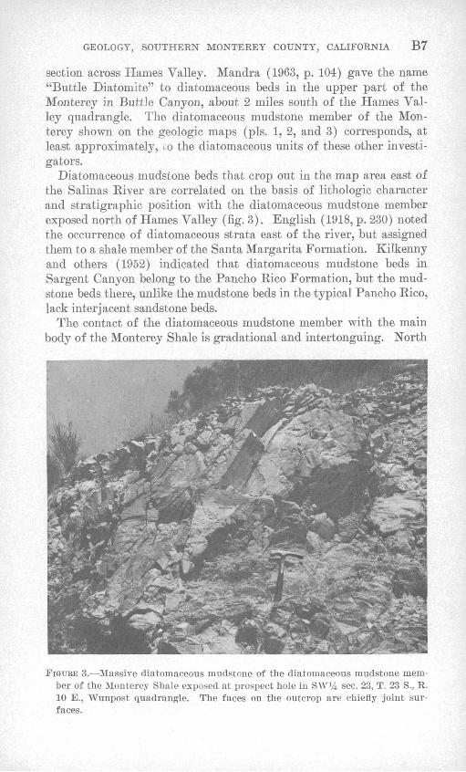
section across Hames Valley. Mandra (1963, p. 104) gave the name "Buttle Diatomite" to diatomaceous beds in the upper part of the Monterey in Buttle Canyon, about 2 miles south of the Hames Val ley quadrangle. The diatomaceous mudstone member of the Mon terey shown on the geologic maps (pis. 1, 2, and 3) corresponds, at least approximately, LO the diatomaceous units of these other investi gators. : ; '.;'.
Diatomaceous mudstone beds that crop out in the map area east of the Salinas River are correlated on the basis of lithologic character and stratigraphic position with the diatomaceous mudstone member exposed north of Hames Valley (fig. 3). English (1918, p. 230) noted the occurrence of diatomaceous strata east of the river, but assigned them to a shale member of the Santa Margarita Formation. Kilkenny and others (1952) indicated that diatomaceous mudstone beds in Sargent Canyon belong to the Pancho Rico Formation, but the mud- stone beds there, unlike the mudstone beds in the typical Pancho Rico, lack interjacent sandstone beds.
The contact of the diatomaceous mudstone member with the main body of the Monterey Shale is gradational and intertonguing. North
FIGURE 3. Massive diatomaceous mudstone of the diatomaceous mudstone mem ber of the Monterey Shale exposed at prospect hole in SW 1/! sec. 23, T. 23 S., R. 10 E., Wunpost quadrangle. The faces on the outcrop are chiefly joint sur faces.
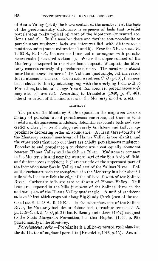
B8 CONTRIBUTIONS TO GENERAL GEOLOGY
of Swain Valley (pi. 2) the lower contact of the member is at the base of the predominantly diatomaceous sequence of beds that overlies porcelaneous rocks typical of most of the Monterey (measured sec tions 1 and 2). In the member there and farther east porcelanite or porcelaneous mudstone beds are interstratified with diatomaceous mudstone units (measured sections 1 and 2). Near the NE. cor. sec. 26, T. 23 S., R. 10 E., the member thins and intertongues with porcela neous rocks (measured section 1). Where the upper contact of the Monterey is exposed in the river bank opposite Wunpost, the Mon terey consists entirely of porcelaneous rocks. The member is absent near the northeast corner of the Valleton quadrangle, but the reason for its absence is unclear. On structure sections C-D (pi. 3), the mem ber is shown to thin by intertonguing with the overlying Pancho Rico Formation, but lateral change from diatomaceous to porcelaneous rock may also be involved. According to Bramlette (1946, p. 47, 48), lateral variation of this kind occurs in the Monterey in other areas.
LITHOLOGY
The part of the Monterey Shale exposed in the map area consists mainly of porcelanite and porcelaneous mudstone, but there is some mudstone, diatomaceous mudstone, dolomitic carbonate beds and con cretions, chert, bentonitic clay, and rarely sandstone and tuff, in ap proximate decreasing order of abundance. At least three-fourths of the Monterey exposed southwest of Hames Valley is porcelanite, and the other rocks that crop out there are chiefly porcelaneous mudstone. Porcelanite and porcelaneous mudstone are about equally abundant between Hames Valley and the Salinas River. Mudstone is common in the Monterey in and near the western part of the San Ardo oil field, and diatomaceous mudstone is characteristic of the uppermost part of the formation near Swain Valley and east of the Salinas River. Dol omitic carbonate beds are conspicuous in the Monterey in a belt about 1 mile wide that parallels the edge of the hills southwest of the Salinas River. Carbonate beds are rare southwest of Hames Valley. Tuff beds are exposed in the hills just west of the Salinas River in the northern part of the Hames Valley quadrangle. A unit of sandstone at least 50 feet thick crops out along Big Sandy Creek (east of the cen ter of sec. 2, T. 23 S., R, 12 E.). In the subsurface east of the Salinas River, the Monterey includes sandstone beds (structure sections A-B, pi. 1; B-C, pi. 2; tf-Z?, pi. 3) that Kilkenny and others (1952) assigned to the Santa Margarita Formation, but that Hughes (1963, p. 95) placed mainly in the Monterey.
Porcelaneous rocks. Porcelanite is a silica-cemented rock that has the dull luster of unglazed porcelain (Bramlette, 1946, p. 15). Accord-

GEOLOGY, SOUTHERN MONTEREY COUNTY, CALIFORNIA B9
ing to X-ray analysis, porcelanite consists chiefly of cristobalite, quartz, and opal. Porcelanite with the addition of clastic material grades into porcelaneous mudstone, which is intermediate in texture between porcelanite and clastic mudstone. Porcelaneous mudstone contains fine and very fine sand, silt, and clay bound in a porcelaneous matrix. Three thin sections of procelaneous mudstone from the map area contain 70-90 percent matrix, 10-20 percent silt particles larger than 0.02 mm, 1-15 percent sand, 1-10 percent mica flakes, and less than 1 percent fish scales, diatoms, and sponge spicules.1 Nearly all the sand grains in the thin sections are quartz or feldspar. In the thin sections the grains generally appear to be angular and are ordinarily less than 0.12 mm in size, although the largest are 0.15-0.20 mm.
Porcelanite and porcelaneous mudstone (fig. 2) generally occur in beds 1-6 inches thick, although thicker or thinner beds are common. Porcelaneous rocks range from well bedded to irregularly bedded or massive. Ordinarily they are separated into angular fragments by joints spaced 0.25-4 inches apart, and locally they are crushed or brecciated. Beds or larger units of porcelanite are interstratified with porcelaneous mudstone or mudstone, and units of porcelaneous rock commonly include dolomitic carbonate beds or concretions. Some beds contain both porcelanite and porcelaneous mudstone in irregular layers or ill-defined masses. Thin beds or partings of shaly mudstone or bentonitic clay separate some beds of porcelaneous rock (fig. 2). Porcelaneous rocks at some localities contain fish scales and molds of mollusk shells, Foraminifera, or fish vertebrae. Porcelanite is generally pinkish gray, yellowish gray, or very light gray. Porce laneous mudstone is mainly very pale orange and less commonly pinkish gray or yellowish gray.
Clastic rocks. Mudstone in the Monterey Shale is similar to porce laneous rocks of the Monterey in bedding characteristics and general appearance, but it lacks porcelaneous material in the matrix and is less well indurated. Unlike the porcelaneous rocks, the mudstone may be easily scratched by a fingernail. The mudstone is ordinarily massive or poorly bedded, but where beds are apparent they are generally 1-6 inches thick. Fossil diatoms, fish scales, molds or casts of Foraminifera, casts of fish vertebrae, and imprints of mollusk shells are more common in mudstone than they are in porcelaneous rocks. Mudstone is generally very pale orange or yellowish gray. A thin section of massive mudstone contains about 75 percent matrix, 20 per-
1 The percentage of constituents in these and other thin sections were determined by the Chayes (1949) point-count method.

BIO CONTRIBUTIONS TO GENERAL GEOLOGY
cent silt particles larger than 0.02 mm, 5 percent very fine sand, and less than 1 percent mica. The length of the largest sand grain in the section is 0.13 mm, and of the largest mica flake is 0.26 mm.
Diatomaceous mudstone (fig. 3) that forms the upper part of the Monterey Shale at most places in the map area is more massive, less well indurated, and less dense than other rock in the formation. It is white and has a hackly or conchoidal fracture. Discoidal fossil diatoms about 0.4 mm in diameter are conspicuous in the rock.
Sandstone that occurs in the Monterey Shale on the east side of Big Sandy Creek (sec. 2, T. 23 S., R. 12 E.) consists of angular and subangular fine and medium grains of quartz and feldspar, together with conspicuous but less abundant biotite. It is white, massive, friable, noncalcareous, and unfossiliferous.
Vitric tuff is interbedded with mudstone of the Monterey Shale in a fault block (sees. 29 and 32, T. 22 S., R. 10 E.) near the edge of the hills west of the Salinas River. It is pale brown or moderately yellowish brown and friable. The color is apparently caused by oil staining. The tuff beds are poorly exposed and their thickness and extent are uncertain. The larger shards in a thin section of the tuff are about 0.35 mm long.
Carbonate beds and concretions. Carbonate beds in the Monterey Shale are commonly as thick as 2 or 3 feet. They are associated with both porcelaneous rocks and mudstone, but ordinarily they are absent from the diatomaceous mudstone member. The rock consists of clay and silt in a matrix of ferruginous dolomite. It is massive, dense, and generally more resistant to weathering than are porcelaneous rocks and mudstone. It has a wide range of color on freshly exposed sur faces, including grayish orange, pale yellowish orange, and yellowish gray.
Concretions of similar dolomitic carbonate rock in the Monterey Shale are ellipsoidal and as large as 5 or 6 feet in diameter and as thick as 2 or 3 feet. They occur at particular horizons, and their longer axes lie parallel to the bedding. In some places beds can be traced into and through concretions from the enclosing rock. These beds are thicker in the concretion than they are outside of it, suggest ing differential compaction of the rock following formation of the concretions.
Chert. Chert is uncommon in the Monterey Shale in the map area, but it is associated with porcelaneous rocks at a few places. It is generally dark colored and occurs in irregular beds or bands %-6 inches thick.
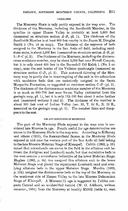
GEOLOGY, SOUTHERN MONTEREY COUNTY, CALIFORNIA Bll
THICKNESS
The Monterey Shale is only partly exposed in the map area. The thickness of the Monterey, including the Sandholdt Member, in the syncline in upper Hames Valley is probably at least 5,800 feet (measured on structure section A-B, pi. 1). The thickness of the Sandholdt Member is at least 800 feet nearby in the James M. Douglas Smith 1 (No. 14 on map). The thickness of the sequence of beds assigned to the Monterey in the San Ardo oil field, including sand stone units, is about 1,500 feet (measured on structure section A-B, pi. 1; B-C pi. 2). The thickness of the Monterey, including the diatoma- ceous mudstone member, may be about 2,000 feet near Powell Canyon, but it is only about 400 feet in the Barnsdall Oil Kelch 1 (No. 3 on map), near the east border of the Valleton quadrangle (measured on structure section C-D, pi. 3). This eastward thinning of the Mon terey may be partly due to intertonguing of the unit in the subsurface with sandstone beds that are tentatively assigned to the Santa Margarita Formation, as suggested on structure section C-D (pi. 3). The thickness of the diatomaceous mudstone member of the Monterey is as much as 600-700 feet near Swain Valley (estimated from the geologic map, pi. 1), but it is only 112-120 feet about 2 miles farther east (measured sections 1 and 2). The thickness of the member is about 350 feet west of Indian Valley (sec. 33, T. 22 S., R. 12 E., measured on the geologic map, pi. 3). The member thins and disap pears to the east.
AGE AND CONDITIONS OF DEPOSITION
The part of the Monterey Shale exposed in the map area is con sidered late Miocene in age. Fossils useful for age determination are scarce in the Monterey Shale in the map area. According to Kilkenny and others (1952), the foraminiferal faunas in the Monterey Shale exposed in and near the western part of the San Ardo oil field belong to the late Miocene Mohnian Stage of Kleinpell. Colvin (1963, p. 58) stated that microfossils are scarce in the field in the siltstone unit be tween the Aurignac and Lombardi sands, but that correlative beds to the west contain a microfauna indicative of the lower Mohnian Stage. Hughes (1963, p. 94) too assigned this siltstone unit to the lower Mohnian Stage and placed the superjacent Lombardi sand and over lying siltstone beds in the upper Mohnian Stage. Mandra (1963, p. 104) assigned the diatomaceous beds at the top of the Monterey on the southwest side of Hames Valley to the late Miocene Delmontian Stage of Kleinpell. A Miocene(?) age is suggested by Tellina, con- gesta Conrad and an unidentified naticid (W. 0. Addicott, written commun., 1964) from the Monterey at locality M1932 (table 4), west

B12 CONTRIBUTIONS TO GENERAL GEOLOGY
of the Salinas River in the San Ardo oil field. Some of the upper most beds of the Monterey may be of Pliocene age if the Monterey and Pancho Rico Formation intertongue as suggested on structure sections B-C (pi. 2) and C-D (pi. 3), but evidence for the age of the upper part of the Monterey based on fossils from that part of the formation is inconclusive.
Fossils in the Monterey Shale show that the unit is marine. Baldwin (1950, p. 1987) considered the sandstone units in the Monterey along and east of the Salinas River as near-shore, and presumably shallow- water, facies of the finer grained, and presumably deeper water, beds farther west.
PLIOCENE SERIES PANCHO RICO FORMATION
Reed (1925, p. 606) gave the name Poncho Rico Formation to marine beds exposed on the east side of the Salinas Valley, and al though he presumably intended that strata along Pancho Rico Creek, l 1/£-41/£ miles north of the Wunpost quadrangle, should be considered typical of the formation, he failed to define the unit adequately. The Pancho Rico Formation comprises sandy marine strata and inter- bedded finer grained rocks that generally overlie the Monterey Shale and underlie the nonmarine Paso Robles Formation in the Salinas Valley area of southern Monterey County (Durham and Addicott, 1964). Waring (1914, p. 423) and English (1918, p. 231) assigned beds in the Pancho Rico in the map area east of the Salinas River to the Jacalitos and Etchegoin Formations, and Nomland (19l7b, p. 215), Taliaferro (1943, p. 457), and Baldwin (1950, p. 1988) placed them in the Etchegoin Formation. Kew (1920, p. 104) and Reed (1925, p. 593, 594) assigned beds in the Pancho Rico in the map area west of the river to the Santa Margarita Formation, and Taliaferro (1943, p. 457) considered part of these beds Santa Margarita and part Etchegoin.
The Pancho Rico Formation crops out along the north side of Hames and Swain Valleys, on both sides of the Salinas River in the southwest part of the Wunpost quadrangle, and in a structurally complex strip west of the river north of Wunpost. It also covers about 20 square miles east of the river in the northeastern part of the Wunpost and Valleton quadrangles.
The Pancho Rico Formation conformably overlies and probably intertongues with the Monterey Shale. The lower contact is at the base of the stratigraphically lowest sandstone unit above the thick sequence of diatomaceous or porcelaneous rocks typical of the Mon terey. The contact is gradational in that diatomaceous mudstone occurs in some places above the sandstone beds that mark the base of the Pancho Rico.

GEOLOGY, SOUTHERN MONTEREY COUNTY, CALIFORNIA B13
HTHOLOGY
The Pancho Rico Formation in the map area is chiefly and charac teristically sandstone, but the unit also contains mudstone, conglom erate, porcelaneous mudstone, and dolomitic carbonate beds, in approximate order of decreasing abundance. Very fine and fine grained sandstone are most common in the Pancho Rico west of the Salinas River, and coarser grained sandstone and conglomerate are common in the upper part of the unit east of the river. Porcelaneous rocks and noncalcareous mudstone are interbedded with very fine and fine-grained sandstone in the Pancho Rico near the Salinas River in the northern part of the Hames Valley quadrangle. Diatomaceous mudstone is interbedded with sandstone in the lower part of the Pancho Rico near Swain Valley, west of the Salinas River, and locally at places east of the river. Dolomitic carbonate beds are conspicuous in the formation near the north edge of the Hames Valley quadrangle.
Very fine grained sandstone in the Pancho Rico Formation is mas sive or poorly bedded and is associated at many places with mudstone, porcelaneous rocks, and calcareous concretions. It is generally non- calcareous, moderately well indurated, and pale yellowish brown or yellowish gray. It appears to be oil stained at some localities. Mol^ls and casts of clam shells are common.
Fine-grained sandstone in the Pancho Rico Formation is generally massive or in beds 2-3 feet thick. It is ordinarily noncalcareous and friable, but some beds are well cemented by calcite. It is yellowish gray, very pale orange, or white.
A thin section of very fine and fine-grained noncalcareous arkosic sandstone from the San Ardo oil field west of the Salinas River con tains about 65 percent sand grains and 35 percent silt and clay matrix. The grains in the thin section are angular and are mainly 0.08-0.18 mm in greatest dimension, although the largest grain is 0.31 mm long. A thin section of similar-appearing rock from the Pancho Rico nearby contains only about 20 percent sand grains, including mica flakes, and 80 percent matrix. A thin section of very fine and fine-grained non- calcareous arkosic sandstone from south of Swain Valley contains about 30 percent sand grains and 70 percent silt and clay matrix. The grains in the thin section are angular and are generally 0.06-0.22 mm in greatest dimension, although two grains are as large as 0.8 mm. Diatom frustules and sponge spicules are abundant in the rock, which is from a bed that apparently intertongues with the diatomaceous mudstone member of the underlying Monterey Shale. A thin section of very fine and fine-grained noncalcareous arkosic sandstone from the Pancho Rico in Walker Canyon (measured section 4, unit 4) con tains 45 percent sand grains and 55 percent silt and clay matrix. The
TOTl-872 O &6 2

B14 CONTRIBUTIONS TO GENERAL GEOLOGY
grains in the section are mainly angular and subangular and 0.09-0.18 mm in greatest dimension. A few rounded grains are glauconite.
Medium- and coarse-grained sandstone in the Pancho Rico Forma tion is generally massive or thick bedded, but some is in beds less than 1 foot thick. It is arkosic and is commonly fossiliferous and conglom eratic. The rock at many places is well cemented with calcite; how ever, at some localities it is well indurated but noncalcareous, and at many other localities it is friable and noncalcareous. It has a wide range of color that is largely related to weathering, but most commonly it is yellowish gray.
A thin section of fine- to coarse-grained calcareous sandstone from the Pancho Rico Formation in the northeastern part of the Hames Valley quadrangle (NE% sec. 32, T. 22 S., R. 10 E.) contains about 15 percent quartz grains, 20 percent feldspar grains, and 65 percent calcite matrix, including some shell fragments. The grains in the thin section are angular or subangular and are generally 0.18-0.53 mm in greatest dimension, but some are as large as 1.55 mm. The rock is in
beds 2-3 feet thick. A thin section of well-sorted medium-grained arkosic sandstone from the Pancho Rico in the southwestern part of the Wunpost quadrangle (near the south edge of sec. 23, T. 23 S., R. 10 E.) contains about 20 percent quartz, 35 percent feldspar, 45 percent calcite matrix, and less than 2 percent mica and dark minerals. The sand grains in the thin section are angular to rounded and are 0.25-0.35 mm in greatest dimension. The rock occurs in beds 6-10 inches thick. A thin section of very fine to medium-grained arkosic sandstone from Walker Canyon (measured section 4, unit 3) contains about 60 percent sand grains and 40 percent calcite matrix. The grains in the thin sec tion are mainly angular or subangular and are 0.09-0.53 mm in great est dimension. They are chiefly quartz and feldspar, but include biotite, hornblende, porcelaneous rock, and glauconite. The glauconite grains are well rounded. Thin sections of poorly sorted fine- to coarse grained noncalcareous sandstone from beds about 60 and 80 feet higher stratigraphically (measured section 4, units 5 and 7) contain about 40 percent sand grains and 60 percent silt and clay matrix. The grains in the thin sections are 0.18-0.8 mm in greatest dimension. They are mainly quartz and feldspar, but some rounded grains are glauconite, phosphate pellets, and porcelaneous rock. A thin section of poorly sorted conglomeratic f ossiliferous sandstone from the Pancho Rico in the northwestern part of the Valleton quadrangle (east of the center of sec. 1, T. 23 S., R. 11 E.) contains grains of quartz and feldspar ce mented by rims composed of layers of opal. Fibrous chalcedony fills interstices between the rimmed grains, and calcareous shell material is

GEOLOGY, SOUTHERN MONTEREY COUNTY, CALIFORNIA B15
replaced by silica. With respect to cementation and replacement of calcareous shell material, the rock is similar to a Miocene orthoquartz- ite from New Jersey described by Friedman (1954).
Mudstone and porcelaneous mudstone in the Pancho Rico Forma tion are similar to rocks in the Monterey Shale. Two thin sections of mudstone from the Pancho Rico just west of the Salinas River (SW% sec. 33, T. 22 S., R. 10 E.) contain about 20 percent sand grains and 80 percent silt and clay matrix. The sand grains in the thin section are angular and are mainly 0.13-0.18 mm in greatest dimension, although a few are as large as 0.4 mm. The rock is massive, noncalcareous, and contains mica flakes and small charcoallike clasts. A thin section of mudstone from the Pancho Rico in the southern part of the Wunpost quadrangle (measured section 3, unit 5), contains about 90 percent clay and silt matrix and 10 percent very fine sand.
Conglomerate in the Pancho Rico contains pebbles and cobbles in a sandy matrix. The larger clasts are generally rounded or. sub- rounded and are mainly porcelaneous rock, chert, volcanic rock, quartzite, gneiss, and granitic rock. The relative abundance of the kinds of clasts changes from place to place. Fossils are common in many conglomerate beds. Shell material is preserved at some places; only molds and casts of shells remain at others; and in a few beds cal careous shell material is replaced by silica.
Dolomitic carbonate beds in the Pancho Rico Formation are iden tical with those in the Monterey Shale.
THICKNESS
The thickness of the Pancho Rico Formation is 100-200 feet north east of Hames Valley (measured on the geologic map, pi. 1) and is greater than 375 feet 2-3V2 miles farther east near the Salinas River (measured section 2). The thickness is about 500 feet in the San Ardo oil field (measured on structure sections A-B, pi. 1, and B-Cr , pi. 2), 450-500 feet near Sargent Canyon (measured on the geologic map, pi. 2) where both the upper and lower contacts are exposed, and about 650 feet east of Indian Valley (measured on the geologic map, pi. 3). As indicated on structure sections B-C (pi. 2) and C-D (pi. 3), changes in the thickness of the Pancho Rico may be at least partly due to probable intertonguing of the unit with the Monterey Shale and Paso Robles Formation.
AGE AND CONDITIONS OF DEPOSITION
The Pancho Rico Formation is considered Pliocene in age. Mega- fossils from the Pancho Rico Formation are listed on table 1. Ac cording to W. 0. Addicott (written commun., 1963, 1964), the collec-

B16 CONTRIBUTIONS TO GENERAL GEOLOGY
tions from localities M1675, M1676, M1934, M1967, and M1970 (see table 4) indicate Pliocene age, and those from localities M1930, M1935, and M1966 indicate early Pliocene age. The fossil echinoids from locality M1674 are probably of early Pliocene age (J. W. Durham and W. O. Addicott, written commun., 1964). Mudstone beds near the top of the Pancho Eico in the northwest part of the Valleton quadrangle at fossil locality Mf746 contain the following Foraminifera (identified by P. B. Smith) :
Elphidium hughesi Cushman and Grant (abundant) Ammonia, beccarii (Linne) (common) Buliminella elegantissima (d'Orbigny) (abundant) Bolimna cf. B. gira/rdensis Rankin (rare) Bolimna cf. B. malagensis Kleinpell (rare) Bolivina cf. B. obliqua Barbat and Johnson (rare)
The foraminifers are mainly species that indicate shallow water (less than 20 meters) and that range from at least early Miocene to Recent age (P. B. Smith, written commun., 1963).
Both the larger and smaller fossils in the Pancho Rico Formation in the map area indicate a shallow marine environment.
TABLE 1. Fossils from the Pancho Rico Formation[Identified by W. O. Addicott, except where otherwise noted. X, present as identified; ?, doubtful identi
fication; cf., similar form, specimen(s) incomplete or too poorly preserved for definite identification; aff., comparable but apparently different form; sp., species not determinable; ?sp, genus questionably identified]
Gastropods: Bittium cf. B. attenualum muUi-
casmaliense Bartsch, strongly sculptured form ...... .......
Calicantharus cf. C. forth forma
Calliostoma coalingensis ( Arnold) --
Calyptraea filosa ( Oabb) __ . . Cancettaria cf. C. fernandoengis
Arnold.... ___________
Kelletia kelleti (Forbes). ..........Maraaritea aff. M. vuvittus (Gould).
US OS locality
N
I
cf.i
X
sp.
sp.
1
X
-----
i< fc%
-----
{2CO
%
-----
-
CO t~CO
%
X
cf.
sp.
cf.
y
8
§
X X
X
?X
%%
-----
55
§
Xsp.
XX
X
?X
3%
V
Xcf. X
XX
X X
X
X
sen
%
?
X
£Oi
%
X
XX
-----
O CT>
s
?
sp.
X
See footnote at end of table.
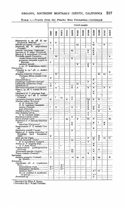
GEOLOGY, SOUTHERN MONTEREY COUNTY, CALIFORNIA B17
TABLE 1. Fossils from the Pancho Rico Formation Continued
Megasurcula n. sp. aft. M. wy-
MUrella gausapata (Gould) ........Nassarius aff. N. californianus
Sinum cf. S. scopulosum (Conrad). Turritella cooperi Carpenter .......
gonostoma hemphilli Applin in
Pelecypods: Amiantis n. sp.? aff. A. stalderi
(Clark). ........................
Trilineata forma canalis (Con rad).........................
Florimetis biangulata (Carpenter)..Glansn. sp. afl. 0. radiata (Sower-
by). ................ .........
Lucinisca n. sp.? aff. L. nuttalli (Conrad).. ______ . _ . ...
nasuta (Conrad).. ............
Protothaca cf. P. lacinata hannibali
Sanguinolaria cf. S. nuttalli Con-
Siligua cf. S. media (Sowerby) of Woodring [and Bramlette] (I960). . .. ........
Solen perrini Clark ______ . ...
cf. T.luteaWooA. .............Trachycardium quadragenarium
Barnacles: Balanus gregarius (Conrad). __ ..
sp. (Small)......-.. __ . .....Echinoids:
Astrodapsis aff. A. cuyamanus
sp. (A. whitneyi-A.jacalitosen-
USGS locality
SX
X
X
cf
?
>
X
X 2X 2
1
X
X'
Xi
?
V
?
.....
SS
?
.....
X"r.POf 2
12
S
X
.-..-
CO l>-
S
qrv
y
X
XX
X
X
sp.
cf.
|S
sp.
X
sp.
X
?
X
sp.
1S
.....
sp-
SS
X X
X X
X
X
?sp. XXXX X
XX
sp.
X
>oSS
Xsp.
Xcf. X X
X
X
X
X
X
X
X X
X
X?X
sp. X
XX
X X
X X
X 2
X"X
1S
-----
X
XX
X
?
XX X
cf.
sp.
cf.
t^SS
X
sp.
X
.....
.....
X X
sp.
.....
1z
X
X
X
1
?X
sp.
cf.
X
1 Identified by Ellen J. Moore. * Identified by J. Wyatt Durham.
B18 CONTRIBUTIONS TO GENERAL GEOLOGY
TERTIARY AN1> QTJATERNARY(?) SYSTEMS
PLIOCENE AND PLEISTOCENE (?) SERIES PASO ROBLES FORMATION
Fairbanks (1898, p. 565) gave the name Paso Robles Formation to nonmarine beds exposed about 17 miles south of the Valleton quad rangle near the town of Paso Robles. The Paso Robles Formation crops out in much of the map area east of the Salinas River, on the sides of Hames Valley, and near the southwest corner of the Hames Valley quadrangle. It is chiefly conglomerate, sandstone, and mud- stone.
The Paso Robles Formation overlies the Pancho Rico Formation with apparent conformity east of the Salinas River and northeast of Hames Valley. The base of the Paso Robles in these areas is placed at the top of the stratigraphically highest lithologic unit that con tains marine fossils. The Paso Robles apparently lies directly on the diatomaceous mudstone member of the Monterey 'Shale southwest of Hames Valley, but the beds there are poorly exposed and the con tact relations are obscure. The Paso Robles lies with pronounced angular unconformity on porcelaneous rocks of the Monterey Shale near the southwest corner of the Hames Valley quadrangle. The beds assigned to the Paso Robles there are equivalent to those questionably assigned to the Paso Robles farther west in the Williams Hill quad rangle (Durham, 1965).
Ideally, the base of the Paso Robles Formation represents the begin ning of nonmarine deposition following the last withdrawal of the Tertiary sea from,the map area. Practically, the base east of the Salinas River is the lower contact of the first prominent lithologic unit above the stratigraphically highest occurrence of marine fossils. At many places the uppermost part of the underlying Pancho Rico Formation contains abundant fossil oyster shells, 1-2 inches long. In areas of nearly flat lying beds, the topographically highest occur rence of these shells marks the approximate base of the Paso Robles. The base west of the Salinas River is the lower contact of the strati graphically lowest conglomerate unit above finer grained rocks of the Pancho Rico Formation or Monterey Shale. Obviously, the base of the Paso Robles does not necessarily represent the same strati- graphic horizon throughout the map area. As mapped, the Paso Robles could contain some marine beds that lack fossils, and if the basal contact of the Paso Robles is in a sequence of intertonguing marine and nonmarine beds, some nonmarine beds may be included in the Pancho Rico.
GEOLOGY, SOUTHERN MONTEREY COUNTY, CALIFORNIA B19
LITHOLOGY
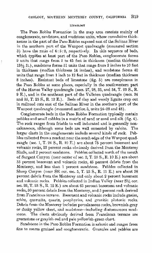
The Paso Robles Formation in the map area consists mainly of conglomerate, sandstone, and mudstone units, whose cumulative thick nesses in the part of the Paso Robles exposed east of the Salinas River in the southern part of the Wunpost quadrangle (measured section 3) have the ratio of 6:5:2, respectively. In this sequence of beds, which typifies at least part of the Paso Robles, conglomerate forms 9 units that range from 5 to 45 feet in thickness (median thickness 131/2 ft.), sandstone forms 51 units that range from 2 inches to 10 feet in thickness (median thickness 14 inches), and mudstone forms 42 units that range from 1 inch to 12 feet in thickness (median thickness8 inches). Resistant beds of limestone (fig. 5) are conspicuous in the Paso Robles at some places, especially in the southwestern part of the Hames Valley quadrangle (sees. 27, 28, 33, and 34, T. 23 S., R.9 E.), and in the southeast part of the Valleton quadrangle (sees. 34 and 35, T. 23 S., R. 12 E.). Beds of clay and woody lignite crop out in railroad cuts east of the Salinas River in the southern part of the Wunpost quadrangle (measured section 3, units 24-28 and 48).
Conglomerate beds in the Paso Robles Formation typically contain pebbles and small cobbles in a matrix of sand or sand and silt (fig. 4). The rock ranges from friable to well indurated and is generally non- calcareous, although some beds are well cemented by calcite. The larger clasts in the conglomerate include several kinds of rock. Peb bles collected from a readout near the south edge of the Wunpost quad rangle (sec. 1, T. 24 S., R. 10 E.) are about 75 percent basement and volcanic rocks, 23 percent rocks obviously derived from the Monterey Shale, and 2 percent sandstone. Pebbles collected north of the mouth of Sargent Canyon (near center of sec. 2, T. 23 S., R. 10 E.) are about 55 percent basement and volcanic rocks, 45 percent debris from the Monterey, and less than 1 percent sandstone. Pebbles collected in Sheep Canyon (near SE cor. sec. 5, T. 23 S., R. 11 E.) are about 98 percent debris from the Monterey and only about 2 percent basement and volcanic rocks. Pebbles collected in Indian Valley (near S*4 cor. sec. 29, T. 23 S., R. 12 E.) are about 65 percent basement and volcanic rocks, 30 percent debris from the Monterey, and 5 percent rock derived from Franciscan terrane. Basement and volcanic rocks include gneiss, schist, quartzite, quartz, porphyries, and granitic plutonic rocks. Debris from the Monterey includes porcelaneous rocks, brownish-gray or dusky yellow chert, and mudstone including diatomaceous mud- stone. The clasts obviously derived from Franciscan terrane are greenstone or grayish-red and pale yellowish-green chert.
Sandstone in the Paso Robles Formation is arkosic and ranges from fine to coarse grained and conglomeratic. Granules and pebbles are

B20 CONTRIBUTIONS TO GENERAL GEOLOGY
FIGURE 4. Conglomerate and poorly sorted sandstone beds of the Paso Robles Formation exposed in roadcut near the south edge of the Wunpost quadrangle. Cross-stratification nearby in the same exposure indicates a current direction to the left (south). - ' , . .
common in the sandstone (fig. 4), either scattered or in lenses. Much of the rock is massive or poorly bedded, but some is cross-stratified, laminated, or cross-laminated. Most of the sandstone is noncalcareous and friable, but beds that are well indurated and noncalcareous and others that are firmly cemented by calcite occur in the formation. Some sandstone beds are lenticular, and some fill channels in the underlying rock. The sandstone has a wide color range, but most commonly it is yellowish gray.
A thin section of sandy limestone from the Paso Eobles Formation just east of the Salinas River (measured section 3, unit 60) contains about 15 percent sand grains and 85 percent calcite matrix. The size of the sand grains ranges from 0.06 to 0.7 mm. Another thin section of sandy rock (measured section 3, unit 37) contains about the same proportion of sand and matrix, but the matrix is only slightly calcare ous and is chiefly silt and clay. The size of the sand grains in this thin section ranges from 0.06 to 0.18 mm. The rock contains small cavities lined with calcite.

GEOLOGY, SOUTHERN MONTE KEY COUNTY, CALIFORNIA B21
Mudstone in the Paso Robles is generally massive, noncalcareous, and has a hackly fracture, but in some places it is laminated, and locally it is calcareous. Ordinarily it is grayish orange, very pale orange, or yellowish gray. Some units of muclstone contain lenses of irregular pods of sandstone and some others grade into sandstone. Secondary gypsum is commonly associated with mudstone along bedding and joint surfaces.
Limestone in the Paso Robles Formation is massive, occurs in units about 2-5 feet thick, and commonly forms bold outcrops (fig. 5). It is generally gray, pinkish gray, or very pale orange. Four thin sections of the limestone contain a few scattered sand grains, 0.06-0.18 mm long, in an aphanitic matrix. The limestone in two of the thin sections contains vugs and cracks that are lined or nearly filled with secondary calcite. A thin section of limestone from near the southwest corner of the Hames Valley quadrangle (sec. 28, T. 23 S., R. 9 E.) contains former cavities and cracks that are lined with opal and filled with fibrous chalcedony.
THICKNESS
The thickness of the Paso Robles Formation may be greater than 1,000 feet east of the San Ardo oil field (structure section B-C, pi. 2).
FIGUKE 5. Massive limestone beds in the Paso Robles Formation one-quarter of a mile west of the center of sec. 34, T. 23 S., R. 9 E., near the southwest corner of the Hames Valley quadrangle.

B22 CONTRIBUTIONS TO GENERAL GEOLOGY
Where the base of the formation is exposed east of the Salinas River in the southwestern part of the Wunpost quadrangle, the thickness is greater than 500 feet (measured on the geologic map, pi. 2). The top of the Paso Robles is absent or unrecognized in the map area, so that probably even where the unit is thickest, only part of the original thickness remains.
AGE AND CONDITIONS OF DEPOSITION
Fossils are scarce or absent in the Paso Robles Formation. Plant material is preserved in woody lignite beds exposed along the railroad in the southwestern part of the Wunpost quadrangle (measured sec tion 3, units 24 and 27). Samples from these and associated beds were prepared for pollen analysis, but only a few gymnosperm pollen grains, too weathered for identification, were obtained (Estella B. Leopold, written commun., 1964). The Paso Robles is considered to be of Pliocene and possibly Pleistocene age because it overlies and probably intertongues with the Pancho Rico Formation of Pliocene age, and unconformably underlies older alluvium.
The Paso Robles Formation lacks marine fossils and has the poor sorting and rude stratification commonly attributed to nonmarine rocks. Much of the formation closely resembles older alluvium in the area and is presumably of fluviatile origin, but other depositional environments are suggested by the limestone and lignite beds in the formation.
QUATERNARY SYSTEM
PLEISTOCENE AND RECENT(?) SERIES OLDER ALLUVIUM
Older alluvium includes fluviatile sediments that unconformably overlie the Paso Robles and other formations and that are older than Recent ailuviiqm in modern streams. It covers or borders valleys in the map area and occurs high on valley sides as isolated remnants of formerly more extensive alluvial deposits.
Older :alluvium is chiefly poorly sorted and consists of semicon- solidated conglomerate, sandstone, and mudstone. It resembles parts of the Paso Robles Formation and in places it is difficult to1 distinguish between the two units. Southwest of Hames Valley, for example, in an area of ploughed fields and poor exposures, the contact between the older alluvium and Paso Robles is arbitrarily placed at the base of the hills that border the valley.
Bluffs of older alluvium along the Salinas River are as high as 80 feet, and hills mapped as older alluvium in Hames Valley are about
the same height. The maximum thickness of older alluvium in the map area is unknown because where the unit is thickest, the base is

GEOLOGY, SOUTHERN MONTEREY COUNTY, CALIFORNIA B23
concealed. However, the maximum thickness may be as little as 100 feet.
Older alluvium is younger than the Paso Robles Formation of Pliocene and Pleistocene(?) age and is1 older than Recent alluvium- It is thus limited to Pleistocene and possibly Recent age.
RECENT SERIES ALLUVIUM
Alluvium occurs in the beds of all streams in the map area, but it is most extensive along the Salinas River and Big Sandy Creek and is shown on the geologic maps only along those streams. It is mainly sand and sandy gravel. The gravel is composed of pebbles and cobbles similar to those in the Paso Robles Formation. Clasts as large as boulders are rare in the alluvium.
STRUCTURE
GENERAL FEATURES
The major structural divisions of the Hames Valley, Wunpost, and Valleton quadrangles are (a) the area west of Hames Valley, where a moderately thick sequence of faulted and folded strata overlies the basement complex, (b) the belt between Hames Valley and the Salinas River, where a thick sequence of slightly folded to tightly folded and faulted beds overlies the basement complex, and (c) the area east of the Salinas River, where a comparatively thin sequence of nearly undeformed strata covers the basement complex. Systems of north west-trending faults west of Hames Valley and west of the Salinas River mark the boundaries of the divisions.
Monterey Shale exposed in the southwestern part of the Hames Valley quadrangle is deformed into closely spaced north- to northwest- trending folds and is cut by large northwest-trending faults. The Paso Robles Formation, which there unconf ormably overlies the Mon terey, is warped into broad folds and is apparently unfaulted. The Texaco Hall 1 (No. 62 on map), the only exploratory well drilled in this part of the map area, reportedly reached weathered granitic rock at a depth of about 3,000 feet or less, but was drilled alternately in basement and sedimentary rocks to much greater depths. The trace of a large fault is about 500 feet southwest of the well site, and the well may have penetrated slivers of basement complex associated with that fault. But even discounting fault slivers of basement rock in the well, the depth to the surface of the basement complex in this part of the map area must be considerably less than it is farther northeast near Hames Valley.
Monterey Shale and younger strata are exposed in a belt about 5 miles wide that extends northwest across the map area west of the
B24 CONTRIBUTIONS TO GENERAL GEOLOGY
Salinas River. The southwest border of the belt is the system of en echelon faults between sec. 6, T. 24 S., R. 10 E., at the south edge of the Hames Valley quadrangle, and sec. 4, T. 23 S., R. 9 E., at the west edge of the same quadrangle. The Monterey and younger rocks exposed in most of the belt form broad folds and lack large faults, but near the Salinas River the beds are tightly folded, locally over turned, and cut by large faults. The Monterey Shale in this belt, except possibly southwest of Hames Valley, is overlain conformably by the Pancho Rico Formation, which is in turn overlain conform ably by the Paso Robles Formation. The Pancho Rico Formation is apparently absent southwest of Hames Valley and the Paso Robles there appears to lie directly on the Monterey Shale, as it does in the southwest part of the Hames Valley quadrangle, but the relations may be complicated by faulting.
The surface of the basement complex is much deeper near Hames Valley than it is elsewhere in the map area. The Shell Oil Labarere 27-X (No. 42 on map, sec. 21, T. 23 S., R. 10 E.), on the ridge between Hames and Swain Valleys, penetrated sedimentary rocks for nearly 11,000 feet, although it was probably not above the deepest depression on the basement surface. Gribi (1963b, p. 26) showed the top of the basement complex to be deeper than 14,000 feet below sea level near Hames Valley. The surface of the basement complex slopes upward to the northeast away from Hames Valley (pi. 5). The average slope of the basement-complex surface between the Shell Oil Labarere 27-X and the Texaco Labarere 3-1 (No. 67 on map, sec. 15, T. 23 S., R. 10 E.), drilled 2*£ miles farther northeast near the Salinas River, is about 2,880 feet per mile, or about 28°. The average slope between the Texaco Labarere 3-1 and the Socony Mobil Oil Ferrini 73 (well A, pi. 5, sec. 11, T. 23 S., R. 10 E.), drilled about li/2 miles farther northeast near the center of the San Ardo oil field, is about 600 feet per mile, or about 7°. The average slope farther north between the Texaco Aurignac 1-29 (No. 57 on map, sec. 5, T. 23 S., R. 10 E.) and the Texaco Aurignac 1-30 (No. 58 on map, sec. 33, T. 22 S., R. 10 E.), drilled less than half a mile northeast, measured oblique to the strike of the basement-complex surface, is about 4,300 feet per mile, or about 38°. Information from wells shows that the sloping surface of the basement complex trends southeastward in the subsurface across thenortheast quarter Of the Hames Valley quadrangle, approximately
parallel to the front of the hills west of the Salinas River. Near the east edge of the quadrangle, the trend of the surface turns more toward the east across the southern part of the Wunpost quadrangle (pi. 5).
Strata of the Monterey Shale and younger units exposed east of the Salinas River are tilted and deformed into broad folds and are cut
GEOLOGY, SOUTHERN MONTE RE Y COUNTY, CALIFORNIA B25
by few, if any, faults. The exposed strata are apparently conform able, although Baldwin (1950, p. 1987) reported a "slight localized unconformity" in the San Ardo oil field at the base of the diatomaceous mudstone unit that he assigned to the Pancho Eico Formation and that is here considered a diatomaceous mudstone member of the Monterey Shale. Colvin (1963, p. 57) reported a disconformity at the same horizon. The basement complex in most of the map area east of the river has a platformlike surface of low relief (pi. 5). The surface is shallowest in the northwestern part of the Wunpost quad rangle and near the San Ardo oil field, where it is generally 2,000 feet or less below sea level and is overlain by strata of late Miocene age. Farther east the basement complex surface is generally deeper and is overlain by beds of pre-late Miocene age.
Structure sections A-B, B-C, and C-D (pis. 1, 2, and 3) illustrate the geologic structure of the map area as interpreted from surface and well data. The parts of section A-B between the Texaco Aurignac 3 and Rosenberg 1-10, and the part of sections B-C and G-D between the Bishop Oil and Cuyama Oil O'Reilly 1 and Jergins Oil U.S.L. South 1 are adapted partly from Kilkenny and others (1952).
FAULTS
Faults in the Monterey Shale are rarely well exposed, but they are commonly marked by a linear zone of crushed rock and steeply dipping or contorted beds against which nearby structural features terminate abruptly. Generally their exact location, and in some places their very existence, is questionable. Faults that separate the Monterey from other units are more obvious, but because they ordinarily are poorly exposed, their location is seldom precise.
The northwest-trending faults in the southwestern part of the Hames Valley quadrangle belong to a fault system that extends at least 7!/£ miles northwest of the map area across the Williams Hill quadrangle into the Espinosa Canyon quadrangle and continues at least 5 miles southeast of the map area into the Tierra Redonda Mountain quadrangle. Wells drilled in and just southwest of this fault system in the map area reach the basement complex at much shallower depths than do wells drilled 1-3 miles northeast of it. This apparent offset of the basement-complex surface suggests that the fault system in the Monterey is the.effect in the sedimentary cover of displacement along one or more faults in the basement complex below.
The zone of faults and tight folds near the edge of the hills west of the 'Salinas River in the northern part of the map area is markedly dissimilar to the area of nearly undeformed rocks i/4-2 miles farther east across the river. The contrast in the structure was attributed by

B26 CONTRIBUTIONS TO GENERAL GEOLOGY
Diller and others (1915, p. 119) to a large fault along the river, by English (1918, p. 245) to a syncline or a faulted syncline under the valley, and by Vander Leek (1921, p. 87, 89) to a fault that extends along the west side of the valley to about 3-5 miles south of San Ardo. Reed (1925, p. 590) gave the name "King City fault" to the structural feature that forms the boundary between the structurally contrasting east and west sides of the Salinas Valley, and he (1933, p. 44) noted "fair evidence" for existence of the fault through the Hames Valley and Wunpost quadrangles. Kilkenny (1948, p. 2265) considered the King City fault as primarily a subsurface feature (p. 2266) that formed a west-facing escarpment by normal faulting in Eocene time. He further concluded that the escarpment was periodically renewed in Miocene time and was the locus of thrust faulting in Pliocene and Pleistocene time.
Drilling near the west edge of the San Ardo oil field demonstrated that rocks exposed there lie above a thrust fault, the Los Lobos thrust fault of Kilkenny and others (1952). On structure section A-B (pi. 1), this thrust fault intersects the Texaco Rosenberg 1-10, Aurignac 1, and Garrissere 1. Faults near the edge of the hills west of the river are apparently related to this thrust fault, which is distinct from any fault beneath the river along which the basement complex to the east might have been uplifted. The thrust fault may be the probable subsurface fault shown on plate 5, as suggested on structure section A-B (pi. 1). The trace of the thrust fault may be concealed by alluvium and older alluvium along the river, or perhaps the displacement near the surface is distributed among several faults, as suggested on structure section A-B (pi. 1). Surficial evidence of faulting along the west side of the river is lacking south of about the latitude of Wunpost. North of there the zone of faults and tightly folded rocks west of the Salinas River is presumably caused by crumpling, crushing, and thrusting of the thick sequence of strata west of the river against the structurally high and comparatively rigid mass of basement rock east of the river. Farther southeast the basement complex is at greater depth (pi. 5), and the beds along and west of the river are much less severely deformed, pos sibly because the basement complex there is more remote. The thrust fault involves the Pancho Rico and Paso Robles Formations, so that the latest movement at least is thus no older than Pliocene in age.
FOLDS
Beds in the map area near large faults are generally deformed into closely spaced, steep-limbed folds, and those in areas that lack large faults are ordinarily warped into broad folds. The folds west of the Salinas River trend north to northwest, subparallel to the major faults. The genetic relationship of these folds and faults seems obvious. The

GEOLOGY, SOUTHERN MONTEREY COUNTY, CALIFORNIA B27
broad poorly defined folds in the northern part of the map area east of the river trend southwestward, nearly perpendicular to the trend of the regional structure farther west.
The Monterey Shale near the faults in the southwestern part of the Hames Valley quadrangle is tightly folded, but the Paso Eobles Formation there is much less severely deformed, suggesting at least two periods, or one long continuing period of deformation. The Monterey Shale and younger formations in the central part of the Hames Valley quadrangle are warped into broad folds, and dips greater than 40° are rare in that part of the map area. The Monterey Shale and Pancho Eico Formation near the edge of the hills west of the Salinas River are distorted into closely spaced and locally overturned folds in fault blocks. The beds east of the Salinas River are generally so little deformed, and in many places so poorly exposed, that deter mination of the structure of beds at the surface is difficult. The con figuration of the basal contacts of the Pancho Rico and Paso Robles Formations suggests a series of broad southwest-trending and plung ing folds in the northern part of the Wunpost and the northeastern part of the Valleton quadrangles. The folds in the Wunpost quad rangle, at least, appear unrelated to relief on the surface of the base ment complex, for the anticline near Deadman Gulch is above a struc tural high, and the anticline near Sargent Canyon is above a structural low on that surface (pi. 5).
ECONOMIC GEOLOGY
Petroleum is the dominant mineral resource in the map area. The San Ardo oil field covers about 4,200 acres in the Hames Valley and Wunpost quadrangles, and the smaller Lynch Canyon oil fields extends into part of the Wunpost quadrangle. Table 2 lists 80 exploratory and outpost wells drilled for oil in the map area outside oil fields.
Prospectors have shown some interest in the diatomaceous mudstone member of the Monterey Shale as a source of diatomite. An adit in the Wunpost quadrangle (near center of SW1̂ sec. 23, T. 23 S., R. 10 E.) was dug horizontally more than 50 feet into diatomaceous rock before being abandoned. The remains of smaller pits and tunnels are evident at several places. Waring and Bradley (1917, p. 598-599) reported that diatomaceous earth from sec. 20, T. 23 S., R. 10 E., had been on the market since 1905 and was adapted for use as building blocks for interior fireproof walls.
A small abandoned sand quarry is on the east side of Big Sandy Creek in the Valleton quadrangle (near center of NE1̂ sec. 2, T. 23' S., R. 12 E.) It is in a unit of friable sandstone in the Monterey Shale.
TABL
E 2
. E
xplo
rato
ry a
nd o
utpo
st w
ells
out
side
oil
fie
lds
in t
he
Ham
es V
alle
y,
Wun
post
, an
d V
alle
ton
quad
rang
les,
dri
lled
bef
ore
jg19
64
oo[L
ocat
ions
wer
e su
ppli
ed b
y th
e op
erat
ors
and
veri
fied
in t
he f
ield
whe
re p
ossi
ble.
S
trat
igra
phic
nom
encl
atur
e us
ed in
rem
arks
col
umn
is t
hat
of t
he o
pera
tor
or o
f the
aut
hori
ty
cite
d, a
nd is
not
nec
essa
rily
the
sam
e as
that
use
d el
sew
here
in
this
rep
ort.
Ele
vati
on:
from
top
ogra
phic
map
, t;
kel
ly b
ushi
ng, k
b; g
roun
d, g
r; de
rric
k fl
oor,
df]
No.
on
map
(p
l. 5)
1...-
_
2...-
-.
3-..
4.-
.- _
5-
6-.
---
7.-
8-.
----
91 -
-
10.-
--
11--
Ope
rato
r
Ade
lant
o D
evel
op
men
t C
orp.
Ash
, Fre
d, a
nd
Sons
. B
arns
dall
Oil
Co.
.
. d
o.. .
..........
- -
do........
. ....
Bis
hop
Oil
Co
.
Bis
hop
Oil
Co.
an
d C
uyam
a O
il C
o.
Cha
nslo
r-C
anfi
eld
Mid
way
Oil
Co.
Con
tine
ntal
Oil
Co.
Cre
agm
ile, J
. C
., an
d S
tew
art,
J.T
. C
uyam
a O
il C
o
Wel
l
Woo
d l.
... _
_ .
Kel
ch 1
.. _
_ .
P.
W.
and
P.
1.
R.
and
W.
1..
...
Ale
xand
er B
-1-.
San
Ard
o 6-
G-l
.
Ale
xand
er 8
8-5-
-
Det
oy 2
O'R
eil
ly2 .
Loc
atio
n
Qua
dran
gle
Wun
post
_
-.d
o
Val
leto
n-
Wun
post
....
Val
leto
n- _
Wun
post
....
-.d
o
Ham
es
Val
ley.
Wun
post
....
Val
leto
n..-.
Wunpost
.
Sec. 35 27
23 29
21 8 32 6 5 28
28
Tow
n
ship
so
uth 22 23
23 23
23
23
22
23 23
23 22
Ran
geea
st 10 11
12 11
12
11
11
10 11
12
11
Yea
r(s)
dr
ille
d
1956
1963
1948
1948
1948
1953
1948
1946
-47
1955
1935
(?)-
38
1948
Ele
vati
on
(fee
t)
525
t
960
1
l,90
0gr
851k
b
1, 05
0 gr
751
gr
769k
b
l,00
9gr
980
t
l,340t
855
t
Tot
al
dept
h (f
eet)
2,65
0
3,30
0
2,40
7
4,15
1
4,10
0
2,46
8
2,48
3
8,06
2
2,98
6
2,58
2
2,96
2
Rem
arks
(d
epth
s in
fee
t)
Q % j £d
Top
San
ta M
arga
rita
For
mat
ion,
1,6
24;
top
Lor
n-
£J
bard
i sa
nd,
2,39
0;
top
base
men
t co
mpl
ex,
2,55
9 2
(C
alif
orni
a O
il F
ield
s, 1
956,
v. 4
2, n
o. 2
, p.
124)
. 2
*~d
i
i oR
epor
ted
base
men
t co
mpl
ex(?
) (O
akes
hott
and
^
othe
rs,
1952
, p.
29)
or r
ed
beds
at
bott
om.
Als
o 02
ca
lled
Sun
ray
Oil
Kel
ch 1
. O
n st
ruct
ure
sect
ion
C-D
, pl
. 3.
H
Rep
orte
d: t
op C
ampb
ell
[Aur
igna
c] z
one,
2,9
00;
top
O
base
men
t co
mpl
ex,
4,08
8; t
op u
nwea
ther
ed b
ase
m
ent
com
plex
, 4 ,1
3 9.
O
Bas
emen
t co
mpl
ex(?
) at
bo
ttom
(O
akes
hott
an
d M
ot
hers
, 19
52,
p. 2
9);
repo
rted
: oi
l-st
aine
d sh
ale
in
%
core
, 4,0
55; t
op
red
bed
s, 3
,010
. H
T
op L
omba
rd!
sand
, 1,
924;
top
Aur
igna
c sa
nd, 2
,344
; SJ
to
p ba
sem
ent
com
plex
, 2,
462-
2,46
8 (C
alif
orni
a O
il >
F
ield
s, 1
953,
v.
39, n
o. 2
, p.
103)
. F
B
asem
ent
com
plex
at
bott
om (
Oak
esho
tt a
nd o
ther
s,
1952
, p.
28).
On
stru
ctur
e se
ctio
n B
-C, p
l. 2.
Q
ea
Acc
ordi
ng
to
Kil
kenn
y (1
948,
p.
22
66),
this
w
ell
P
"enc
ount
ered
8,0
00 f
t of
Mon
tere
y ch
erty
sha
les
on
g
1 70
ft o
r mor
e of
gra
nodi
orite
bre
ccia
* *
* b
elie
ved
X
to b
e a
rece
men
ted
talu
s de
posi
t at
the
bas
e of
the
£4
old
srar
p.
The
age
of
the
talu
s is
pre
-Mon
tere
y an
d pr
obab
ly p
re-V
aque
ros.
" T
op L
omba
rd!
sand
, 2,4
18; t
op A
urig
nac
sand
, 2,8
10;
top
base
men
t com
plex
, 2,9
35 (
Cal
ifor
nia
Oil
Fie
lds,
19
55, v
. 41
, no
. 2,
p.
117)
. M
onte
rey
Sha
le a
t bo
ttom
; oi
l and
gas
sho
ws,
1,7
78-
1,82
4 (B
ram
lett
e an
d D
avie
ss,
1944
). A
lso
calle
d M
cDon
ald
Det
oy 2
. R
epor
ted
top
base
men
t com
plex
, 2,9
23.
On
stru
ctur
e se
ctio
n B
-C,
pl.
2.

12 ......
13 2
14
......
15.
17.
18...
201 -
21.
221
231
241
251
27.
281
.d
o .
... ..
.
M.
leum
Cor
p.
d
o..
... ..
...
velo
pmen
t C
o.
Oil
Co.
H
umbl
e O
il an
d R
efin
ing
Co.
.do..... .
....
. do
.... .
..... d
o ......
...
..... d
o..
....
... .
...
..d
o
.....d
o.............
... .
.do
.... ..
.. ..
.. .
d
o ..
.. ..
1C)
2(7)
. ..
. ...
.S
mit
h l _
. .....
67X
-30.
H
ambe
y 24
8-18
-
Peri
l...
.... ..
. .
A.
Orr
adre
1.. .
..
Cor
e H
ole
1.
Jerg
ins
US
L25
-9.
Lan
igan
251
-35
McC
ooll
........
San
Ard
o 23
-35.
.
US
L S
outh
1
VaU
ey.
__
do .......
.d
o.... ..
.
do.......
Wu
np
ost
....
Val
ley.
Wun
post
....
.d
o
VaU
ey.
.....d
o.......
..... d
o..
....
.
.... .d
o..
....
.
....
.do..
....
.
.d
o...
See
foo
tno
tes
at
end
of t
able
.
20 20
36 30 18 30 9 25 26 9 9 9 35 35 26 35 26
22 22
22 22 23 23 23 22 22 23 23
23 22 22 22 22 22
10 10 9 10 11 10 12 10 10 10 10
10 10 10 10 10 11
1908
-09
1908
-09
1933
(?)-
34
1953
1954
1953
1958
1956
1956
1951
1951
19
51
1951
1951
1951
1947
1949
600(
7)
(?)
1, 3
80 t
835
t
1, 0
38 k
b
904
df
1, 12
8 kb
660
1
925
t
837
kb
852
kb
l,386
(?)k
b
620
t
688
kb
760
t
540
t
1, 20
0 t
1,00
0
1,13
5 4,
158
3,36
7
3,05
1
800
2,44
8
2,07
2
2,46
5(?)
4,32
1
3,96
1 6,
470
2,80
4
2,87
3
2,47
8(?)
2,56
7
3,30
2
Onl
y tr
aces
of o
il (W
arin
g, 1
914,
p. 4
35).
Do.
Mon
tere
y Sh
ale,
0-
3,20
0;
San
dhol
dt
Shal
e,
3,20
0-
4,15
8; t
ar,
1,07
0; g
as s
how
, 2,
008
(Bra
mle
tte
and
Dav
iess
, 19
44);
Vaq
uero
s F
orm
atio
n at
bo
ttom
(O
akes
hott
and
oth
ers,
195
2, p
. 28
). A
lso
calle
d Sa
n A
rdo
!(?)
. O
n st
ruct
ure
sect
ion
A-B
, pi.
1.B
asem
ent
com
plex
at
bott
om
(Jen
ning
s an
d H
art,
19
56, p
. 56
).T
op
Mon
tere
y Sh
ale,
1,
470;
to
p L
omba
rdi
sand
, 2,
440;
to
p A
urig
nac
sand
, 2,
669
(Cal
ifor
nia
Oil
Fie
lds,
195
4, v
. 40
, no.
2, p
. 11
9); b
asem
ent
com
plex
at
bot
tom
(?)
(Col
vin,
196
3, p
i. 4)
.R
epor
ted
Mon
tere
y Sh
ale
at b
otto
m.
Bas
emen
t co
mpl
ex
at
bott
om
(Pop
enoe
, 19
59,
p.14
00).
On
stru
ctur
e se
ctio
n C
-D,
pi.
3.
Top
S
anta
M
arga
rita
F
orm
atio
n, 1
,362
; ba
sem
ent
com
plex
at
bott
om (
Cal
ifor
nia
Oil
Fie
lds,
195
6, v
.42
, no.
2, p
. 12
1).
Top
C
-san
d,
1,65
0;
base
men
t co
mpl
ex
at
bott
om(C
alif
orni
a O
il F
ield
s, 1
956,
v. 4
2,no
. 2, p
. 12
1); t
opL
anig
an s
and,
1,1
85 b
elow
sea
lev
el (
Gri
bi,
1963
a,p.
72)
. R
epor
ted:
plu
gged
, 3,
510;
on
Mar
ch 2
0, p
umpe
d 18
bbl
per
day,
14.
0° A
PI
grav
ity
oil,
18 p
erce
nt c
ut;
on M
arch
28,
pum
ped
14 b
bl p
er d
ay,
14.4
° A
PI
grav
ity
oil,
16 p
erce
nt c
ut;
on M
arch
30,
pum
ped
16 b
bl p
er d
ay,
14.0
° A
PI
grav
ity
oil,
16 p
erce
ntcu
t.
Lat
er a
band
oned
. R
epor
ted
no o
il or
gas
sho
ws.
D
o.
Top
Lom
bard
i sa
nd,
2,34
0; t
op A
urig
nac
sand
, 2,
735;
ba
sem
ent c
ompl
ex a
t bot
tom
(C
alif
orni
a O
il F
ield
s,
1952
, v.
38,
no.
2,
p.
100)
. O
n st
ruct
ure
sect
ion
B-C
, pi
. 2.
Bas
emen
t co
mpl
ex a
t bo
ttom
(C
olvi
n, 1
963,
fig
. 1)
; re
port
ed n
o oi
l or
gas
show
s.B
otto
m i
n ba
sem
ent
com
plex
(B
arge
r an
d Z
ulbe
rti,
1949
, pi.
2).
Lom
bard
i san
d w
et (
Bar
ger a
nd Z
ulbe
rti,
1949
, p. 2
0).
Rep
orte
d ba
sem
ent
com
plex
at
bo
ttom
. A
lso
calle
d N
orth
A
mer
ican
O
il C
onso
lida
ted
and
Jerg
ins
Oil
McC
ool 1
.T
op S
anta
Mar
gari
ta F
orm
atio
n, 1
,550
; top
Lom
bard
i sa
nd,
1,93
0;
top
nonm
arin
e re
d be
ds,
2,20
0;
top
base
men
t co
mpl
ex,
3,29
3 (O
akes
hott
and
oth
ers,
19
52,
p. 6
3).
Als
o ca
lled
Jerg
ins
Oil
and
Nor
th
Am
eric
an O
il C
onso
lida
ted
Sou
th 1
. O
n st
ruct
ure
sect
ion
C-D
, pi
. 3.
to co

B30 CONTRIBUTIONS TO GENERAL GEOLOGY
§rO
1
ts00to
h-a
1
O
i"53
i09O
$k
e
TJ49 $,
^1
Si 2" 3 053*""toS"
o
>§ «!*
£
So<*>
Ca to
§
t* 09Oa ^0
1
S>
SH«A>>
a.8
fei
9H
%*5 &
o>j$&
1% A ft
%
"35*?o&%EH-O-
g
IIM^
£S|1
-w>
°3 §W
|a|
g 1H"8
S o CD
Q CO
CD"3
d
130?
1
£32Cl
0
d ^-0 ftu?
I S 3
III
ifc 033 oS05 co
urted: top, Lombardi s 70. Also called Jergins
I Consolidated USL tion C-D, pi. 3.
>rted top conglomerate,
Swo s g-« «
S i-(t--CN" co"
w -w0 0
~. ^^
I 1OS OS
N O
a a
g c^
1,
a >.| II"3 at*> tn
,' !
<N! j
'a £ra J
CO 1P O
jO O (
§ §1-!s «^19 -S-o £? £?§ «
|2J ^
;!
S to
gs-B'g Sd-S-§ §§=3 iwco § Sf3 ci g c° SS*~<S S'HMfe .Sfcagg-g-sa ^d,ss a|«"«?? Ifr 11^ {>» CO Q d *^ 9 t ^S^^y>
o 2 2 8 > -« s^'oS ^ "O !3 S .2 -dCS O..2 ^ "-I
05 S e CD g <g~.2 OT cq-g *j (.£_
flP§£!-H!!fc03 ^ 5 43 <N*2 ° ® w ® §IS rt IN Q ^ * ® S ^ *°5^g rtrgEo§>-g^
^Ifs'Slgiasil^ iSlPjilljIjiT3o3p fO"(^^^S e'3 '®^So *
fl> S w » < N O's-/ o to O Q w mP5 EH EH EH
S S «?3 SCM" co" *" i-T
^a rfs ja
g g g o S* C5^ 00 (N^
*3* *O »O W3
s s s s
O »H i-< CJ
s ?5 a s
t- CO CO 1C (N r-l N CO
! ! i
1 1 '
^o ' dg 0 C S
g ' "cs&: | >
CO 1
u3 t^.
hi U.
i itsc | |jj 1^ ^ ^ «
! M) ^9 ! S |H
II S ^ S3 ® o *tk ^
ll-s ? |I |d<!0 fe -§5 SO
M § IS
!!
S So' S3 S
2; formation ivered 260 ft
S"ScN 1"
r> rr> /-\
gas snows.
>rted: top basement ci t of tarry oil zone, 2,1! iddy water with spots <
o aj.2 Stf
§CM"
*»
1
^o>
o
s
CO«
!i
ft
aa
!
rl
tf
1
tf
g g 2 i <FH ^
!l?§r^5 JT Frt".S
lolo*
>aCO
Kl8 w.o » d Sg fe -§l| ^ g S^ag^ fl-J| .2 N| N"|«§«
|l| p-|^||l
t'S|S§8--Q,- CD a & ft ft^-W
=S i^Iffil^ gs& lisMfs^as ^l^'gS^s^^3i!ji MUSE'4^lHSssl6!slt!'2§ co ^S..^d2§ *
S ^ Q. S * S -*^"'d ^* o S °p< S o ^ Q«O o* ® co N o S S<rph- 1 4^>M O N '3) G W i-H O rH Cj-
« EH « ;
?5 « 3 coCN" of of co"
° -0 uM -w M EC
S co S §U3*"
CO CO S ^lOS O> O> Oi
o 2 S °
s a s s
s s °° s
C C C C
-7 ^pa -O
3 r-
^ ^J bC r ( 4J
V. W O PH
o5'
«-a 13 r3S d x fa»o cs ft "
r^ H O O A^
g| ' || ||
*& o £
S So g g§

40 »
_ _
.
41-.
-.-
421
431 -
44..
451
46
L
47...
48
...
491
50.-
.
51
52-
53-..
54
-.
55-
56 .
67--
58
San
Ant
onio
Oil
Co.
Shel
l O
il C
o.
-d
o... .
....
Sta
ndar
d O
il C
o.-
-do
- d
o
---d
o... .
.. ..
....
-
-do.. .
...
-.d
o.. ..
..
Sun
ray
Oil
Corp
Co.
Co.
-d
o ..
....
-d
o..
... .
....
- d
o..
. .......
-do.. ---
.do.....
...
(?).
Jorg
ense
n un
it 1
.
Ale
xand
er 5
7 _ .
Ale
xand
er 8
5-9.
.
Ale
xand
er B
6-5.
Mah
er 7
5-21
.
Ale
xand
er 3
3-15
-
Hol
e 14
.
1.
Aur
igna
c 1-
30.
Ham
esV
alle
y.
.d
o -
d
o.
Wun
post
....
.do ..
.
.d
o...
.d
o... .
...
.d
o... .
...
Wun
post
....
Val
leto
n. _
Val
leto
n _
_
vall
ey.
.d
o..
..
d
o
d
o -
do...
20 19 21 8 9 5 3 21 1 15 1 24 26 19 4 31 5 5 33
22 22 23 23
23 23 23 23 23 23
23 22 23 22 23 22 23 23 22
10 10 10 11
11 11 11 11 11 11
11 10 12 11 10 10 10 10 10
1901
(?)
1948
-19
1959
1950
1951
1951
1952
1952
pre-
1914
1954
-55
1949
1962
1952
1955
1946
1948
1957
1957
1957
(?)
705
t
1,08
8 df
1, 0
69 g
r
932
df
1,09
6 df
1,20
6 d
f
965
t
1, 1
90 t
1,44
0 t
1, 1
80 t
691
kb
1,53
0 t
813
kb
1,02
0 t
1, 3
20 g
r
758
gr
655
gr
720
t
700
(?)
2,72
1
10,9
57
2,90
2
2,81
2
3,05
0
2,93
8
3,52
7
875
3,43
7
3,44
0
1,81
0
4,14
3
2,22
5
4,20
1
4,76
5
6,72
3
6,08
3
4,01
8
Riv
er g
ravel
at
bott
om
(W
arin
g, 1
914,
p.
435)
. C
ali
fo
rnia
Div
. M
ines
(19
43,
p.
650)
li
sted
th
ree
wel
ls
bel
on
gin
g t
o t
his
com
pan
y i
n s
ees.
20,
29,
an
d 3
0,
but
War
ing
(191
4, p
. 43
5) m
enti
on
ed o
nly
one
.T
op
conglo
mer
ate,
2,
453;
to
p
bas
emen
t co
mp
lex
, 2,
571
(Oak
eshott
and o
ther
s, 1
952,
p.
63).
Bas
emen
t co
mple
x (
Popen
oe,
196
0, p
. 91
3),
or l
ow
er
Mio
cene(
?)
sandst
one
(Gri
bi,
19
63b,
pi.
2)
at
bott
om
.R
eport
ed:
top
Lo
mb
ard
! sa
nd,
2,34
7;
top
O
rrad
re
(Auri
gnac
) sa
nd,
2,71
1;
top
b
asem
ent
com
ple
x,
Rep
ort
ed:
Lo
mb
ard
! sa
nd,
2,23
0-2,
557;
O
rrad
re(A
uri
gnac
) sa
nd,
2,61
8-2,
774;
conglo
mer
ate,
2,7
74-
2,81
1; t
op
bas
emen
t co
mple
x, 2
,811
. T
op L
om
bar
d!
sand,
2,60
5; t
op
Au
rig
nac
san
d,
3,01
9;to
p b
asem
ent
com
ple
x,
3,04
3 (J
enn
ing
s an
d H
art
,19
56,
p. 5
6).
Rep
ort
ed:
top
Lo
mb
ard
! sa
nd,
2,67
0; A
uri
gn
ac s
and
abse
nt;
to
p b
asem
ent
com
ple
x,
2,92
8.
Top L
om
bar
d!
sand,
2,62
0; .
top
Au
rig
nac
san
d,
2,96
2;to
p n
on
mar
ine
bed
s, 3
,488
(Je
nn
ing
s and H
art
, 19
56,
p.
57).
Jo
int
test
wit
h O
hio
Oil
Co.
Top L
om
bar
d!
San
d,
2,83
2; t
op
Au
rig
nac
san
d,
3,21
4;bott
om
in
M
ioce
ne
rock
s (C
alif
orn
ia
Oil
F
ield
s,19
55,
v. 4
1, n
o. 2
, p.
114
).
Bott
om
in b
asem
ent
com
ple
x (
Mo
od
y,
1950
, p.
102
5).
To
p M
ioce
ne
rock
s, 1
,244
(C
alif
orn
ia O
il F
ield
s, 1
962,
v.
48,
no.
2, p
. 17
1);
bas
emen
t co
mp
lex
at
bo
tto
m
(Gri
bi,
196
3a,
p. 7
2);
also
cal
led
Mo
riq
ui
Explo
ra
tion a
nd R
anch
o O
il L
anig
an 1
.M
ioce
ne
rock
s at
bott
om
(C
alif
orn
ia O
il F
ield
s, 1
952,
v
. 38
, no
. 2,
p.
97).
Top
Lom
bar
d!
sand,
2,00
6;
top
bas
emen
t co
mple
x,
2,1
47±
(C
alif
orn
ia O
il F
ield
s, 1
955,
v.
41,
no
. 2,
p.
114)
.A
uri
gnac
san
d w
et;
ver
y h
eavy o
il,
3,02
5; t
op
gra
nit
ic
bre
ccia
, 3,
765;
top b
asem
ent
com
ple
x,
4,20
0 (B
arg
er
and Z
ulb
erti
, 19
49,
p. 1
5,20
).
On
str
uct
ure
sec
tion
A-B
,pl.
1.
Top b
asem
ent
com
ple
x,
about
4,55
0 (K
ilken
ny a
nd
oth
ers,
195
2).
On
str
uct
ure
sec
tio
n A
-B,
pi.
1.
Bott
om
in
bas
emen
t co
mple
x
(Popen
oe,
19
58,
p.
1406
).B
ott
om
in
bas
emen
t co
mp
lex
(P
op
eno
e,
1958
, p
. 14
06);
plu
gged
at
3,70
0, r
edri
lled
to 5
,445
.T
op
Auri
gnac
san
d,
2,96
7;
top
bas
emen
t co
mple
x,
4,00
4 (C
alif
orn
ia O
il F
ield
s, 1
958,
v.
44, n
o.
2, p
. 14
1).
See
foot
note
s at
end
of
tabl
e.
O
H
O f
O
O GO
O d H W n
o I W CO
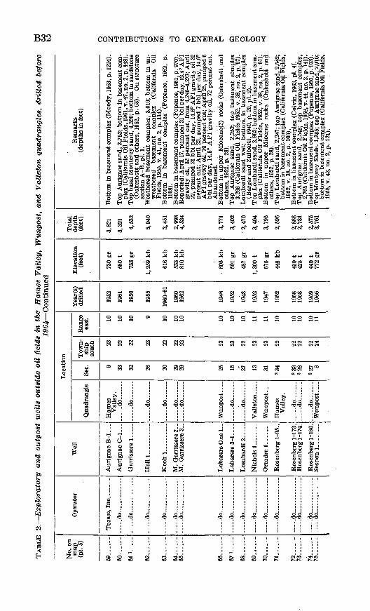
B32 CONTRIBUTIONS TO GENERAL GEOLOGY
S3
1
IH if IJilJf1! f,BCL S rafei.o r»;r 5 °l S o 9 ,-£! g R IN
1-1 o.°> . *"H-d 'o" *" Sm «2^ ^fl"S2 K ---43 § a-0 «» « § « OQ5lf3-:fSSiSg|l §le||S-&«f85-1 ""Sf.^l rf! 3 ! 6*" " "-_ ^1 "3 . _TTH 1, _>- -!-] ^ . - rt X j_, -S3
& bl -° +» bo M
CO COt» 3
O
<y
O O O <3> O OO O O O iH !-l O OO OrH
IM i-H IM »H CO
I
« o
iOO
s5 ^ ^a aw i
o tf tftf tfl
<N CO Vl <-l INCO
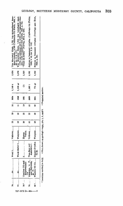
76
.-.
-» ? "
-
00
-4 w
782-
i.
79...
I 1 80
>
*
-...d
o -
.d
o -
Impr
ovem
ent
Co.
and
Rey
nold
s,
H.
G.
Wils
hire
Oil
Co.
.. .
Woodl
2. A
ssoc
iate
s 1.
Hun
ter-
Dry
den
71-2
6.
Val
leto
n .
Val
ley.
Val
leto
n -
Wun
post
--
25 23 19 31 26'-
23 23 22 22 23
11 11 10 12 10
1954
1949
1901
1959
1951
1, 1
40 t
1, 1
59 g
r
(?)
1,28
0 t
775
gr
3,82
4
3,17
8
1,32
5
3,00
1
5,05
2
men
t co
mpl
ex,
3,78
0 (C
alif
orni
a O
il F
ield
s, 1
954,
v.
40, n
o. 2
, p.
117
).
2.70
4; t
op A
urig
nac
sand
, 3,
023;
top
bas
emen
t co
m
plex
, 3,
114
(Oak
esho
tt a
nd
oth
ers,
195
2, p
. 64
).
1959
, v.
45,
no.
2,
p. 1
18).
Bot
tom
in
base
men
t co
mpl
ex
(Jen
ning
s an
d H
art,
19
56,
p. 5
6).
Loc
atio
n ve
rifi
ed in
fie
ld.
* Not
sho
wn
on g
eolo
gic
map
s, p
is.
1, 2
, and
3.
. 3
Proj
ecte
d se
ctio
n.
o
o W CO
C
O
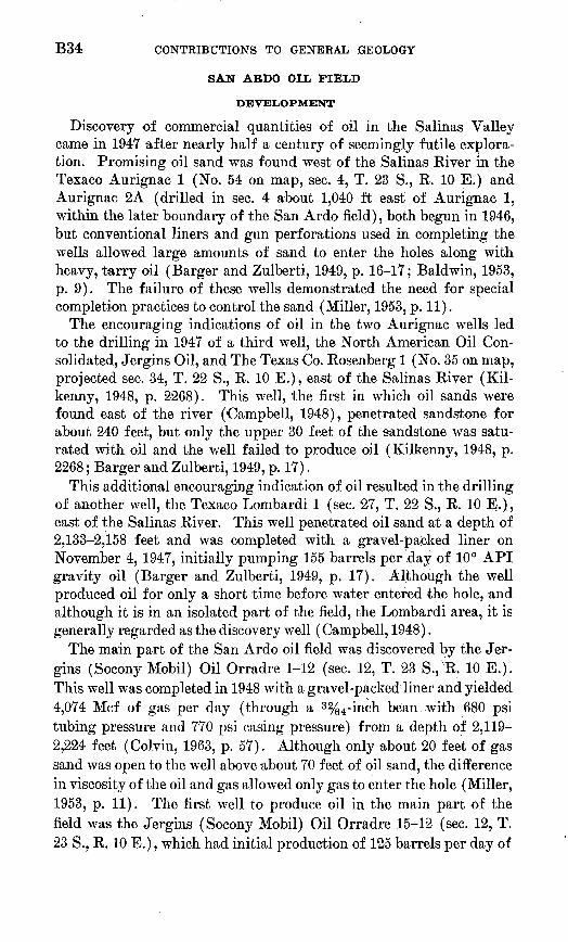
B34 CONTRIBUTIONS TO GENERAL GEOLOGY
SAN ABDO OIL FIELD
DEVELOPMENT
Discovery of commercial quantities of oil in the Salinas Valley came in 1947 after nearly half a century of seemingly futile explora tion. Promising oil sand was found west of the Salinas River in the Texaco Aurignac 1 (No. 54 on map, sec. 4, T. 23 S., R. 10 E.) and Aurignac 2A (drilled in sec. 4 about 1,040 ft east of Aurignac 1, within the later boundary of the San Ardo field), both begun in 1946, but conventional liners and gun perforations used in completing the wells allowed large amounts of sand to enter the holes along with heavy, tarry oil (Barger and Zulberti, 1949, p. 16-17; Baldwin, 1953, p. 9). The failure of these wells demonstrated the need for special completion practices to control the sand (Miller, 1953, p. 11).
The encouraging indications of oil in the two Aurignac wells led to the drilling in 1947 of a third well, the North American Oil Con solidated, Jergins Oil, and The Texas Co. Rosenberg 1 (No. 35 on map, projected sec. 34, T. 22 S., R. 10 E.), east of the Salinas River (Kil kenny, 1948, p. 2268). This well, the first in which oil sands were found east of the river (Campbell, 1948), penetrated sandstone for about 240 feet, but only the upper 30 feet of the sandstone was satu rated with oil and the well failed to produce oil (Kilkenny, 1948, p. 2268; Barger and Zulberti, 1949, p. 17).
This additional encouraging indication of oil resulted in the drilling of another well, the Texaco Lombardi 1 (sec. 27, T. 22 S., R. 10 E.), east of the Salinas River. This well penetrated oil sand at a depth of 2,133-2,158 feet and was completed with a gravel-packed liner on November 4, 1947, initially pumping 155 barrels per day of 10° API gravity oil (Barger and Zulberti, 1949, p. 17). Although the well produced oil for only a short time before water entered the hole, and although it is in an isolated part of the field, the Lombardi area, it is generally regarded as the discovery well (Campbell, 1948).
The main part of the San Ardo oil field was discovered by the Jer gins (Socony Mobil) Oil Orradre 1-12 (sec. 12, T. 23 S., R. 10 E.). This well was completed in 1948 with a gravel-packed liner and yielded 4,074 Mcf of gas per day (through a 3 %4-inch bean with 680 psi tubing pressure and 770 psi casing pressure) from a depth of 2,119- 2,224 feet (Colvin, 1963, p. 57). Although only about 20 feet of gas sand was open to the well above about 70 feet of oil sand, the difference in viscosity of the oil and gas allowed only gas to enter the hole (Miller, 1953, p. 11). The first well to produce oil in the main part of the field was the Jergins (Socony Mobil) Oil Orradre 15-12 (sec. 12, T. 23 S., R. 10 E.), which had initial production of 125 barrels per day of
GEOLOGY, SOUTHERN MONTEREY COUNTY, CALIFORNIA B35
11.5° API gravity oil cutting 10 percent water (Barger and Zulberti, 1949, p. 17).
The first producing well in the field west of the Salinas River was the Texaco Aurignac (NCT-1) 4 (sec. 4, T. 23 S., R. 10 E.). It initially produced 110 barrels per day of 13° API gravity oil from a depth of 2,642-2,748 feet (Barger and Zulberti, 1949, p. 18).
Early development of the San Ardo field was hampered by want of a market for the crude oil. At first the crude oil was carried by truck nearly 60 miles to a pumping station near Santa Margarita (Miller, 1953, p. 11). An 8-inch pipeline 39.8 miles long was com pleted in 1951 between the field and the coast at Estero Bay, where the crude oil was loaded aboard tankers at an existing marine terminal (Colvin, 1963, p. 57). The viscous San Ardo crude oil is blended with about 25 percent higher gravity oil to aid its flow through the pipeline. The blend is 14.0°-14.8° API gravity and has a viscosity of 175 seconds furol at 180° F. (Miller, 1953, p. 5). The higher gravity oil added to the San Ardo crude oil is removed and recycled to the field through a 4-inch pipeline laid beside the main pipeline. Four pumping sta tions that have oil-heating facilities are spaced along the pipeline, which can handle 32,000 barrels of oil per day (Colvin, 1963, p. 57). Other pipelines deliver gas from the field to the nearby towns of King City and Paso Robles.
All of the more than 800 producing wells in the field have electric pumps. Oil is collected in tank batteries that have heating facilities for defrothing and dewatering the oil, and waste water is disposed of in wells maintained for the purpose (Colvin, 1963, p. 58, 59).
STRATIGRAPHY
According to Kilkenny and others (1962), the basement complex east of the Salinas River in the San Ardo oil field is overlain by the Santa Margarita Formation, which includes in ascending order the Aurignac sand, Aurignac siltstone, Lombardi sand, Lombardi silt- stone, and an upper sand member, followed by the San Ardo Group, which contains the Pancho Rico mudstone and the Paso Robles Forma tion and Pancho Rico sands undifferentiated. They also indicated that their Aurignac and Lombardi sands intertongue with or grade into the Monterey Formation to the west, where the sedimentary cover on the basement complex is much thicker. Hughes (1963, p. 94, 95) considered the Aurignac sand, Aurignac siltstone, Lombardi sand, and Lombardi siltstone, of Kilkenny and others, as part of the Monterey Shale, overlain in sequence by the Santa Margarita, Pancho Rico, and Paso Robles Formations. The Aurignac and Lombardi sands are here also considered to be sandstone units within the Monterey'Shale, but the Pancho Rico mudstone of Kilkenny and others (1952) is cor-

B3.6 CONTRIBUTIONS TO GENERAL GEOLOGY
related with the diatomaceous mudstone member of the Monterey Shale that is exposed in the map area both east and west of the Salinas River.
Baldwin and others (1951, p. 2633) proposed the name "Aurignac sand" for the lower of the two productive units in the San Ardo oil field. The name "Orradre sand" was applied to the Aurignac sand west of the Salinas River during early stages in the development of the field (Barger and Zulberti, 1949, p. 18), but information from wells drilled later demonstrated the identity of the Aurignac and Orradre sands (Baldwin and others, 1951, p. 2633), and the term "Orradre sand" was discontinued. The Aurignac sand west of the Salinas River is about 120 feet thick and consists of coarse-grained friable sandstone (Bradford and Lawrence, 1956, p. 30). The thick ness of the unit varies east of the river, where the Aurignac lies on the basement complex, but the average thickness is about 100 feet. The unit consists of very fine grained firm silty sandstone (Barger and Zulberti, 1949, p. 18).
The Lombardi sand, named for its discovery in the Texaco Lom- bardi 1, is generally separated from the stratigraphically lower Aurignac sand by a siltstone unit 35-70 feet thick (Colvin, 1963, p. 58). The Lombardi sand is about 250 feet thick and consists of fine- to medium-grained well-sorted unconsolidated sandstone (Bradford and Lawrence, 1956, p. 30).
STRUCTURE AND ACCUMULATION OF OIL,
Beneath most of the San Ardo oil field the surface of the basement complex forms an irregular platformlike structural feature that lies 1,800-2,100 feet below sea level, but near the southwest edge of the field the surface slopes steeply southwestward to 3,000 feet or more below sea level (pi. 5). Information from wells drilled to the base ment complex suggests that a broad, flat ridge of basement complex trends southeastward under the field from the southern part of sec. 34, T. 22 S., R. 10 E., to the northern part of sec. 12, T. 23 S., R. 10] E., and thence more eastward toward sec. 9, T. 23 S., R. 11 E. (pi. 5).
The sequence of beds, including the oil-bearing Aurignac and Lom bardi sands, that overlies this ridge on the basement complex is the stratigraphic equivalent of the upper part of the much thicker se quence of beds southwest of the Salinas River. The oil-bearing and associated beds form a broad, flat-topped irregular anticline (Bald win, 1950, p. 1983), but this subsurface structural feature is not ap parent in beds exposed in the field.
The oil at the San Ardo oil field accumulated in sandstone beds of near-shore facies on a broad eastward-plunging anticline (Baldwin,

GEOLOGY, SOUTHERN MONTE KEY COUNTY, CALIFORNIA B37
1953, p. 10). Later downwarping superimposed a broad syncline on the original anticlinal structure of the field, and apparently caused warping of the oil-water interfaces in both the Aurignac and the Lombardi sands (Colvin, 1963, p. 58). According to Colvin (1963, figs. 3 and 4), the axis of the synclinal trough on the oil-water inter face in the Lombardi sand trends and plunges northwestward from about sec. 18, T. 23 S., R. 11 E., toward sec. 34, T. 22 S., R. 10 E.; the axis of the synclinal trough on the interface in the Aurignac sand trends more northward through sec. 4, T. 23 S., R. 10 E., and sec. 33, T. 22 S., R. 10 E., and plunges nearly due north. Colvin (1963, p. 58) attributed the lack of correspondence of the axes to permea bility changes and to deformation related to faulting near the Salinas River.
The productive limits of the field are controlled mainly by the tilted oil-water interface and by permeability barriers (Colvin, 1963, p. 58). Oil in both the Aurignac and Lombardi sands is trapped where these units grade westward into finer grained and less permeable beds (Gribi, 1963b, p. 24). The limits of production from the Aurig nac sand are determined by pinching out of the unit to the north and by decreasing permeability of the sandstone to the south (Colvin, 1963, p. 59). The limits of production from the Lombardi sand are determined by the tilted oil-water interface on the northeast and south east sides and by a decrease in the grain size and permeability of the unit to the northwest and southwest (Bradford and Lawrence, 1956, p. 30).
DRILLING PRACTICE
Wells in the San Ardo oil field are drilled with portable rotary equipment (Bradford and Lawrence, 1956, p. 30). The general pro cedure is to cement 100-500 feet of surface casing (Miller, 1953, p. 12), drill an 11-inch hole to the top of the oil sand, reduce the hole size to Sy2 inches, and continue drilling until the desired depth is reached. An electric log is then run, and an 8%-inch casing is cemented at the top of the productive sand to obtain a water shutoff. The cement is drilled out of the casing to within about 5 feet of the shoe, and a com bination gun-perforator and tester is run into the hole to perforate and test the effectiveness of the water shutoff. The hole is then cleaned out and the clay-base drilling fluid used until this stage in the drilling operation is replaced with an oil-base or similar drilling fluid. After the hole below the casing, shoe is underreamed to 13% inches, a 6%- inch preperf orated 60- or 80-mesh liner is landed and flow packed with % 6-inch gravel. Wells are drilled and completed in about 6 days (Bradford and Lawrence, 1956, p. 30).
Water production tends to replace oil production in wells drilled in the Lombardi area of the San Ardo oil field. As oil is pumped, the oil-

B38 CONTRIBUTIONS TO GENERAL GEOLOGY
water interface rises or cones vertically 30-50 feet around the holes of the wells that are drilled deep enough to reach or nearly reach the in terface. This condition is controlled by bottoming the holes well above the oil-water contact. Similar conditions were found in the main part of the field in the early stages of development (Miller, 1953, p. 11).
Wells in which casing was set just below the gas-oil interface in the main part of the field produced with high gas-oil ratios soon after completion because of depression or coning of the gas-oil interface near the hole. This coning was controlled, and more normal gas-oil ratios were obtained in later wells by setting the casing 20 feet below the gas-oil contact (Miller, 1953, p. 11).
The steepness of the hills west of the Salinas Kiver made road and well-site preparations expensive; directional drilling was impractical there because of the shallow depth to the productive oil sand (Miller, 1953, p. 11). Drilling costs west of the river were also increased be cause the crushed and fractured rock there led to lost circulation of drilling fluid and necessitated setting about 500 feet of surface casing (Miller, 1953, p. 12).
Wells just east of the main channel of the Salinas Eiver are pro tected from high water by a levee about 1% miles long. Wells drilled from the levee are whipstocked under the riverbed (Miller, 1953, p. 12).
PRODUCTION
According to Colvin (1963, p. 59), 86 million barrels of oil and 18 billion cubic feet of gas were produced before 1963 from 581 wells com pleted in the Lombardi zone, and 39 million barrels of oil and 25 billion cubic feet of gas were produced before 1963 from 274 wells completed in the Aurignac zone. Table 3 summarizes the annual production statistics for the field.
TABLE 3. Production statistics, San Ardo oil field
Year
1947....................1948....................1949....................1950.. ..................1951....................1952....................1953....................1954....................1955.. ..................1956....................1957....................1958....................1959....................1960....................1961....................1962....................
Total. .........
Average number of
wells actually producing oil
1 13 46 22
153 333 413 455 516 612 675 648 668 717 756 811
Production ofoil(bbl)
737 119, 572 480, 765 188,068
2, 744, 896 8, 280, 661
11, 283, 710 11, 172, 184 10, 972, 221 11, 732, 789 11,844,658 10,864,509 10, 983, 153 11, 517, 752 11, 741, 432 11,099,568
125, 026, 675
Net gas withdrawn
(Mcf)
7,517 5,255 3,710
172,817 614, 649
1, 734, 501 5, 045, 917 6, 135, 603 5, 577, 331 4, 229, 296 3,314,562 3, 073, 803 3, 537, 548 4, 536, 065 5, 646, 530
43, 635, 104
California Oil Fields (1947-62)
Volume
33 34 35 36 37 38 39 40 41 42 43 44 45 46 47 48
No.
2 1,2 1,2 1,2 1,2 1,2 1,2 1,2 1,2 1,2 1,2
2 2 2 2 2
Page
25 19; 17, 32
23, 38; 25, 40 27, 45; 25, 43 28, 46; 18, 25 24, 31; 30, 37 30, 36; 40, 47 52, 58; 64, 71 71, 78; 59, 67 69, 76; 62, 70 78, 88; 68, 77
82,92 56,68
112, 124 87,97
110, 121

GEOLOGY, SOUTHERN MONTE KEY COUNTY, CALIFORNIA B39
LYNCH CANYON OIL FIELD
The Lynch Canyon oil field is at the north edge of the Wunpost quadrangle in sec. 24, T. 22 S., R. 10 E. It was discovered in 1962 by the Moriqui Exploration Lanigan 172, which, when completed, pumped 41 barrels per day of 11.8° API gravity oil from 1,706 and 1,744 feet depth (Barton, 1962, p. 150). According to Gribi (1963a, p. 73), the oil is in a sandstone unit (Lanigan sand) in the Monterey Shale on the west fl'ank of a broad south-plunging structural high on the basement complex (pi. 5). The sandstone unit terminates against the basement complex to the east and grades into finer grained rocks to the west. It is apparently equivalent to a sandstone unit in the San Ardo oil field that is about 150 feet stratigraphically above the Lom- bardi sand (Barton, 1962, p. 150). Nine wells were completed in the field by April 1964, when the drilling of wells intended for steam- flood operations was begun (Rintoul, 1964, p. 4).
TABLE 4. Fossil localities
USGS No.
Mf746 M982...... M983......M1674.....M1675.....M1676..... M1930..... M1932..... M1933..... M1934. M1935.....M1966-... M1967.....M1970.....
Location
Quadrangle
Valleton- -._._Wunpost ........ .do... ...........do.......... do... ......Hames Valley. Valleton......Hames Valley . Valleton......Wunpost ...
... -do.... .... .Valleton....-
.....do ........Wunpost ......
Sec.
25 25 25 36 25 29 9 4
15 25 28 36
1 25
Town ship
south
22 23 23 23 23 22 23 23 23 23 22 22 23 23
Range east
11 10 10 10 10 10 12 10 12 10 11 11 11 10
Formation
Pancho Rico. . ..... do . do ..... do ..do.......... .do.............. do..
Pancho Rico. ... do.............. do...... ....... .do ...... do........ ..... .do....... ..
Types of fossils
Foram- inif- era
X
Gastro pods
X X
X X X
X X X X X
Pele- cypods
X X X X X X X
X X X X X
Bar nacles
X X
X
X X
X
Echi- noids
X
....
......
X
------
B40 CONTRIBUTIONS TO GENERAL GEOLOGY
MEASURED SECTIONS
SECTION 1. North of Swain Valley on southwest flank of anticline in sec. 2T. 28 S., R. 10 E., Wunpost quadrangle
Thickness
Feet Inches Paso Robles Formation (lower part only):
60. Conglomerate, pebbles and small cobbles of chert, porcela- neous rock, basement rock, and volcanic rock; matrix and interbeds of sandstone that is arkosic, grayish orange (1QYR 7/4), fine and medium grained, noncalcareous, friable; beds as thick as 6 in.________________------_ 30+ 0
Total (part measured), Paso Robles Formation ______ 30+
Contact gradational. Pancho Rico Formation:
59. Sandstone, arkosic, yellowish-gray (5Y 8/1), fine- and medium-grained, noncalcareous, friable; lenses of coarse grains.-__---___---------____-___-_-____-__-_----- 16 0
58. Covered_________________________________._ 8 057. Sandstone, arkosic, yellowish-gray (5Y 8/1), fine- and
medium-grained, noncalcareous, friable, massive; gran ules and small pebbles of porcelaneous rock in lenses near top; scattered calcareous nodules--_--________------- 20 0
56. Sandstone, arkosic, yellowish-gray (5Y 8/1), very fine grained, locally calcareous; more firmly indurated than unit57_.________________________________.__ 92 0
55. Covered___---_---_---_-_-_-_-_______________-_-_-_- 33 654. Sandstone, arkosic, yellowish-gray (5F 8/1), fine-grained,
noncalcareous, friable, massive; partly covered-------- 5 053. Sandstone, arkosic, yellowish-gray (5Y 8/1), very fine
grained, scattered coarser grains; more firmly indurated than unit 54_____-_-_-_---_____________-_- -__--_- 1 0
Total, Pancho Rico Formation_______.______-_-___ 175
Contact conformable.Monterey Shale (upper part only):Monterey Shale above diatomaceous mudstone member:
52. Porcelanite and porcelaneous mudstone, yellowish-gray (5F 8/1) and white C/V9), poorly bedded--__--_---_--_
Total, Monterey Shale above diatomaceous mudstone member._____________________________________
Diatomaceous mudstone member:51. Mudstone, diatomaceous, white (N9), massive; grades into
underlying unit.___________________________________ 6 050. Conglomerate, pebbles of chert, basement rock, porcelane
ous rock, and volcanic rock; matrix of diatomaceous mudstone like unit 51 _______________._____-_-_-_--_ 6
49. Mudstone, diatomaceous, like unit 51 ___-___-_-_------_- 1 6

GEOLOGY, SOUTHERN MONTEREY COUNTY, CALIFORNIA B41
SECTION 1. North of Swain Valley on southwest flank of anticline in sec. 26,T. 2S S., R. 10 E., Wunpost quadrangle Continued
ThicknessDiatomaceous mudstone member Continued peet inches
48. Porcelanite, yellowish-gray (5F 8/1) -------------------- 647. Mudstone, diatomaceous, like unit 51------------------ 1 046. Porcelanite, like unit 48_--_-_---_-----------_-------_ 245. Mudstone, diatomaceous, like unit 51------------------ 4 044. Porcelanite, like unit 48_______-----_-_-----_--____-_- 343. Mudstone, diatomaceous, like unit 51------------------ 22 042. Porcelanite, light-olive-gray (5F 6/1)-__---------_---_-_ 1 641. Mudstone, diatomaceous, like unit 51__---------------- 19 640. Porcelanite, like unit 42_ ___----______-___-_--________ 439. Mudstone, diatomaceous, like unit 51_-_-__-_---_---_-_ 11 838. Porcelanite, like unit 42.__._...__-_-_-_---_-.._.___ 237. Mudstone, diatomaceous, like unit 51__-_-------------- 1 336. Porcelanite, like unit 42_ _____-__________--_-__.____-_ 335. Mudstone, diatomaceous, like unit 51------------------ 234. Porcelanite, like unit 42._____________________________ 633. Mudstone, diatomaceous, like unit 51_--_-----------__- 1 032. Porcelanite, like unit 42._____________________________ 631. Mudstone, diatomaceous, like unit 51___--------------- 1 630. Porcelanite, like unit 42. _____ ____---____-_---_.-_-__. 1 629. Mudstone, diatomaceous, like unit 51 _______________ 8 028. Porcelanite, like unit 42_____________________________ 1 027. Mudstone, diatomaceous, like unit 51____-_--_-______ 3 626. Porcelanite, like unit 42____________________________ 425. Mudstone, diatomaceous, like unit 51___--_-----__--____ 1 024. Porcelanite, like unit 42____________________________ 4 023. Mudstone, diatomaceous, like unit 51__------__-_-___- 1 022. Porcelanite, like unit 42____________________________ 1 021. Mudstone, diatomaceous, like unit 51_____-._-----_._ 4 020. Porcelanite, like unit 42_____________________________ 519. Mudstone, diatomaceous, like unit 51___-___-______-_ 618. Porcelanite, like unit 42____________________________ 1 017. Mudstone, diatomaceous, like unit 51____--_______-_- 1 416. Porcelanite, like unit 42____________________________ 615. Mudstone, diatomaceous, like unit 51.___-_____-_-____ 814. Porcelanite, like unit 42____________________________ 613. Mudstone, diatomaceous, like unit 51____---._____--_ 212. Porcelanite, like unit 42____________________________ 1 011. Mudstone, diatomaceous, like unit 51____-____-___--_ 2 010. Porcelanite, like unit 42____________________________ 69. Mudstone, diatomaceous, like unit 51_____-_-_____-__ 88. Porcelanite, like unit 42____________________________ 87. Mudstone, diatomaceous, like unit 51________________ 9 06. Porcelanite, like unit 42____________________________ 1 05. Mudstone, diatomaceous, like unit 51----___-_____--_-__ 6
Total, diatomaceous mudstone member_______________ 120 0
B42 CONTRIBUTIONS TO GENERAL GEOLOGY
SECTION 1. North of Swain Valley on southwest flank of anticline in sec. iT. 23 S., R. 10 E., Wunpost quadrangle Continued
ThicknessMonterey Shale below diatomaceous mudstone member: peet inches
4. Porcelanite, yellowish-gray (5Y 8/1); beds 1-6 in. thick,poorly bedded.____________________________________ 23 0
: 3. Covered..____________._.____ __________ 44 02. Mudstone, very pale orange (10YR 8/2), massive, hackly
fracture___________^_____________________________ 10 01. Porcelanite, pale-yellowish-brown (10 YR 6/2), massive,
hackly fracture; contains poorly preserved Foraminifera _ _ 57 0
Total, Monterey Shale below diatomaceous mudstone member (part measured)________________________ 134
Total, Monterey Shale, including diatomaceous mud- stone member (part measured)______-__-^.____ 262
Base of exposed section.
SECTION 1. North of Swain Valley on northeast flank of anticline in sees, and 26, T. 23 S., R. 10 E., Wunpost quadrangle
Thickness
Pancho Rico Formation (part only): Feet inches 30. Sandstone, arkosic, yellowish-gray (5Y 8/1) and white (A/"9),
fine-grained, noncalcareous, friable; partly covered.____ 376 0
Total, Pancho Rico Formation (part measured) __ __ 376
Contact concealed, apparently conformable.Monterey Shale (upper part only).Monterey Shale above diatomaceous mudstone member:
29. Covered...._________.___________,_____-- 10 028. Porcelanite and porcellaneous mudstone, very pale orange
(WYR 8/2); beds 6-24 in. thick, poorly bedded, hackly fracture___--___-_-___---_---------____----_-__-_ 85 6
27. Mudstone, very pale orange (WYR 8/2), massive; containsfossils Foraminif era, diatoms, and fish fragments.----.- 3 0
26. Porcelanite, very pale orange (WYR 8/2), poorly bedded,hackly fracture.___-____-_-___-____-__-_____--_____ 14 0
Total, Monterey Shale above diatomaceous mudstonemember____________________________________ 112 6
Diatomaceous mudstone member:25. Mudstone, diatomaceous, very pale orange (10 YR 8/2)
massive--_---__-----_----------_---------__-----__ 3 024. Porcelanite, like unit 26____---__--__-_--- _-__.-___ 2 0 23. Mudstone, diatomaceous, like unit 25_---___----_-_-_-_ 12 022. Porcelanite, like unit 26....-_____________________ 9 021. Mudstone, pale-yellowish-brown (WYR 6/2), poorly bedded
hackly fracture, noncalcareous......._.-.._._...__._. 1 320. Porcelanite, like unit 26______________-_---______--- 1 219. Mudstone, like unit 21______________________________ 8 018. Porcelanite, like unit 26__.____________________________ 7

GEOLOGY, SOUTHERN MONTEKEY COUNTY, CALIFORNIA B43
SECTION 2. North of Swain Valley on northeast flank of anticline in sees. 23, 24,and 26, T. 28 S., R. 10 E., Wunpost quadrangle Continued
Diatomaceous mudstone member Continued ThicknessFeet Inches
17. Mudstone, diatomaceous, like unit 25 ____----_-_____-__ 1 016. Porcelanite, like unit 26_.___-_-_-----_---_---__-______ 315. Mudstone, diatomaceous, like unit 25..-...-.-..-....-. 214. Porcelanite, like unit 26.______-_---------_--_-________ 413. Mudstone, diatomaceous, like unit 25.__________________ 112. Porcelanite, like unit 26____.-__-_---_-_-__._.______ 311. Mudstone, diatomaceous, like unit 25__________________ 9 010. Porcelanite, like unit 26___.-__--__--___-___-_-_____ 99. Mudstone, diatomaceous, like unit 25.____----__-_-___._ 68. Porcelanite, like unit 26_____--____---_-__-_____.___ 77. Mudstone, diatomaceous, like unit 25_________________ 86. Porcelanite, like unit 26___-_-----_---------__._____ 45. Mudstone, diatomaceous, like unit 25__________________ 11
Total, diatomaceous mudstone member. ______________ 51 10
Monterey Shale below diatomaceous mudstone member:4. Porcelanite, very pale orange (10 YR 8/2) and pale-yellow
ish-brown (10 YR 6/2); beds 2-12 in. thick; hackly frac ture ; inter beds of mudstone 1-2 in. thick ______________ 119 6
3. Covered.______________________.._______. 19 02. Mudstone, very pale orange (WYR 8/2), massive, hackly
fracture_________________________________________ 3 01. Porcelanite, pale-yellowish-brown (10YR 6/2), massive,
hackly fracture; contains poorly preserved Foraminifera. 25 0
Total, Monterey Shale below diatomaceous mudstonemember (part measured)________________________ 166
Total, Monterey Shale, including diatomaceous mud- stone member (part measured)__________________ 330 10
Base of exposed section.
SECTION 3. East of Salinas River along railroad north of mouth of Sarah Canyon,sec. 25, T. 23 S., R. 10 E., Wunpost Quadrangle
Thickness
Feet Inches Paso Robles Formation (part only):
119. Conglomerate, rounded pebbles of basement rock, porce- laneous rock, and chert; massive; matrix mainly of sandstone that is arkosic, yellowish gray (5F 7/2), non- calcareous, friable; top covered. ____________________ 30 0
118. Mudstone, grayish-orange (107/2 7/4), massive, hacklyfracture. _________________________________________ 3
117. Sandstone, arkosic, yellowish-gray (5Y 7/2), fine- and me dium-grained, noncalcareous, friable; contains lenses of coarser grains and small pebbles.-__------__-_--____ 1 0

B44 CONTRIBUTIONS TO GENERAL GEOLOGY
SECTION 3. East of Salinas River along railroad north of mouth of Sarah Canyon,sec. 25, T. 23 S., R. 10 E., Wunpost quadrangle Continued
Paso Robles Formation (part only) Continued ThicknessFeet Inches
lie. Mudstone, like unit 118____________________________ 3115. Sandstone, like unit 117_________-___________________ 2 0Ii4. Mudstone, like unit 118__.------__--_______-_--____ 1 0113. Sandstone, like unit 117_.___________________________ 5 0112. Mudstone, like unit 118___-__-_.__--.___________.__ 1 0111. Sandstone, arkosic, pale-greenish-yellow (107 8/2), fine
grained, noncalcareous, friable, massive._____..______ 1 0110. Mudstone, like unit 118---.--__________-----_ 1 0109. Sandstone, like unit 117___.._-----_-_-----_--------_ 8 0lb8. Mudstone, like unit 118___-_----_-__-___-__-----_-- 2 0107. Conglomerate, like unit 119._-__--___-----___------__ 15 0106. Mudstone, like unit 118-______________--.____-_-_ 2 2105. Sandstone, like unit 111________-_________--___---__- 1 2104. Mudstone, like unit 118___________________________ 8103. Sandstone, like unit 111______-_-----_-_________--__- 4102. Mudstone, like unit 118__-__-____---__-____--_-__-_ 9101. Sandstone, like unit lll_--_-_----__---__-____------- 5100. Mudstone, like unit 118____---.____.______________ 10
99. Sandstone, arkosic, yellowish-gray (5V 7/2) and dusky- yellow (5V 6/4), fine-grained, noncalcareous, well- indurated; bedding indistinct; moderately porous. _ _ _ _ 7
98. Conglomerate, like unit 119-----__-_--------_-------- 597. Sandstone, like unit 111______----____-__-______-____96. Mudstone, like unit 118__-__-_---___-_--_-__-_-____95. Sandstone, like unit lll____---_--____-___-___---___-94. Mudstone, like unit 118__-___-____---_-_--_________93. Sandstone, like unit 117-_____-__._.__-_________-.___ 292. Mudstone, like unit 118____________________________91. Sandstone, like unit lll___---_----------_--____---_-90. Mudstone, like unit 118__-__-_-_____--__-____-__-__89. Sandstone, like unit 111_____--_---_----__-_____-____88. Mudstone, like unit 118__-_ ______-____________-__87. Sandstone, like unit 111____--__--______-______--____86. Mudstone, like unit 118______-_.__-__.-_-_____._.__ 285. Sandstone, like unit 111_____________________________84. Mudstone, like unit 118__-_-____________-___-___ ___83. Sandstone, like unit 111___-_-__-_-__--_________-____ 282. Sandstone, like unit 117_____________________ __-____ 481. Conglomerate, like unit 119___-_---__----_--__---_--- 2080. Sandstone, like unit 111_________.____-.__-__-._-____ 179. Mudstone, like unit 118____________________________78. Sandstone, like unit lll______-_-____._.___.._-______77. Mudstone, like unit 118______-___-___-_-____--__--76. Sandstone, like unit 111________-_-.---_-_-____--__--75. Mudstone, like unit 118____________._______---_-_-74. Sandstone, like unit 111________-___--___-____-------73. Mudstone, like unit 118___.______-..__-.__.---_---72. Sandstone, like unit lll___-__-_-_-__--__----_------- 171. Mudstone, like unit 118; lower contact gradationaL-..--

B45
SECTION 3. East of Salinas River along railroad north of mouth of Sarah Canyon,sec. 25, T. 23 S., R. 10 E., Wunpost quadrangle Continued
Paso Robles Formation (part only) Continued ThicknessFeet Inches
70. Sandstone, like unit 111; thickens and thins along strike;lower contact distinct, but irregular__-_-___._______- 1 6
69. Mudstone, like unit 118; pinches out along strike--____- 168. Sandstone, like unit 111; thins along strike; lower contact
distinct, but irregular---.-----------.----------.--- 2 867. Mudstone, like unit 118; lower contact distinct, but
irregular.____-_______-__--__-__--_-__--_-_______- 666. Sandstone, like unit 111; lower contact gradational____-- 1065. Mudstone, like unit 118; lower contact gradationaL____- 1164. Sandstone, like unit 111; thickens and thins along strike;
lower contact distinct- --_____-_-_.__-__-______-- 1063. Mudstone, like unit 118; lower contact distinct___.__-_- 9 62. Mudstone, yellowish-gray (57 7/2), massive, hackly frac
ture, noncalcareous, moderately porous; lower contact gradational_ _ ____-_-_-_----____---_____-_-_----- 8
61. Sandstone, like unit 111; lower contact irregular-_______ 960. Sandy limestone, yellowish-gray (5Y 7/2); fine and
scattered medium grains of quartz and feldspar; lower contact irregular._____-_----_____--__--_-__-_____- 7
59. Sandstone, like unit 111 ____--___-__-_-_---_._______- 2 058. Mudstone, like unit 62___-_--_______._-.__-________ 657. Sandstone, like unit 111----------------------------- 2 656. Mudstone, like unit 62__--_.___..___.___..____..._ 655. Sandstone, like unit 111_____________________________ 5 654. Mudstone, like unit 62__--__-___-__-___--_-_-__--__ 6 53. Sandstone, like unit 111; lower contact gradationaL---_- 3 6 52. Mudstone, like unit 62____________________________ 651. Sandstone, like unit 111; scattered pebbles; lower contact
gradational_____________________________________ 6 050. Mudstone, like unit 62; lower contact gradational-_____ 1 049. Sandstone, like unit 111; lower contact irregular._______ 3 648. Clay, moderate-yellowish-brown (107/2 4/6) and light-
olive-gray (57 5/2), massive, hackly fracture; lower contact distinct_______________________-_-_._..____ 1 3
47. Sandstone, arkosic, yellowish-gray (57 7/2), fine-grained, calcareous, well-cemented; contains nodules and thin interbeds of mudstone; lower contact irregular.__-_-__ 1 0
46. Mudstone, like unit 62; lower contact gradationaL...... 2 045. Sandstone, like unit 111; lower contact gradational ______ 6 044. Conglomerate, like unit 119; sandstone lenses near top;
scattered clasts of dusky-yellow (5F 6/4) mudstone about 6 ft below top are rounded and are as long as 15 in. 45 0
43. Covered___-_----.._...--.-.-_._._._.._-.___.. 10 042. Conglomeratic sandstone, arkosic, yellowish-gray (5 Y 7/2),
fine- to coarse-grained, noncalcareous, friable; lenses and irregular beds of pebbles, mainly of porcelaneous rock and chert; lower contact gradational_..______.-_ 7 0
41. Sandstone, arkosic, pale-reddish-brown (10JR 5/4), very fine grained, noncalcareous, massive; a few scattered pebbles; lower contact gradational__________________ 8

B46 CONTRIBUTIONS TO GENERAL GEOLOGY
SECTION 3. East of Salinas River along railroad north of mouth of Sarah Canyon,sec. 25, T. 28 S., R. 10 E., Wunpost quadrangle Continued
Paso Robles Formation (part only) Continued ThicknessFeet Inches
40. Sandstone, like unit 111; lower contact gradational-_-___ 2 939. Sandstone, arkosic, yellowish-gray (5F7/2), fine-grained,
noncalcareous, massive; lower contact gradationaL___ 1 238. Sandstone, arkosic, pale-yellowish-brown (10YR 6/2),
very fine grained; a few scattered coarser grains and granules; noncalcareous; massive; lower contact grada- tional_ _ ________________________________________ 6
37. Sandstone, yellowish-gray (5F 7/2), fine grained (except near top where some graded beds have medium and coarse grains; lower contacts of graded beds are irregular and gradational), locally slightly calcareous, well- indurated, massive; calcareous nodules near top of unit; lower contact of unit gradational______-.___-__--__ 10 0
36. Conglomerate, rounded pebbles and cobbles of basement rock and porcelaneous rock, massive; matrix of sand stone is arkosic, yellowish gray (5Y 7/2), noncalcareous, friable; lower contact distinct, channels as much as 4 ft into underlying units.__________________ ___________ 6 0
35. Sandstone, moderate-yellowish-brown (10F.R 5/4), fine grained, noncalcareous, porous, laminated and cross- laminated; lower contact distinct. ___________________ 8
34. Mudstone, olive-gray (5F 4/1), massive, noncalcareous, clayey; includes layers of gypsum; lower contact dis tinct.. .___-.__-__-___---_---__-__--__-___________ 1 0
33. Sandstone, grayish-orange (10 YR 7/4), fine-grained, non- calcareous, massive, porous; lower contact distinct..-- 8
32. Mudstone, yellowish-gray (5F 7/2), noncalcareous, gen erally massive but locally laminated, porous; lower contact gradational______________________________ 2 0
31. Sandstone, yellowish-gray (5F 7/2), fine-grained, non- calcareous, friable, massive; lower contact gradationaL _ 8
30. Mudstone, like unit 32; lower contact gradational_______ 3 029. Mudstone, pinkish-gray .(5 YR 8/1), noncalcareous, mas
sive, hackly fracture; gypsum along bedding and joint surfaces; lower contact irregular and gradational._____ 1 0
28. Clay, dusky-yellowish-brown (1QYR 2/2), massive; con tains gypsum and jarosite(?); lower contact grada tional_________________________________________ 1
27. Woody lignite, brownish-gray (5 YR 4/1), flaky; lowercontact irregular.___________i_______-_____________ 2
26. Mudstone, like unit 29; lower contact irregular.________ 4 625. Clay, like unit 28; lower contact distinct.-______-_._-__ 1024. Woody lignite, like unit 27; lower contact distinct__._. 423. Conglomerate, like unit 36; sandstone lenses in upper
part, larger clasts most common in lower part; channels as much as 3 ft into underlying unit.._______________ 13 6
22. Sandstone, yellowish-gray (5V 7/2), fine-grained, non- calcareous, massive, porous; lower contact irregular__ 6 0

GEOLOGY, SOUTHERN MONTEREY COUNTY, CALIFORNIA B47
SECTION 3. East of Salinas River along railroad north of mouth of Sarah Canyon,sec. 25. T. 28 S., R. 10 E., Wunpost quadrangle Continued
Paso Robles Formation (part only) Continued ThicknessFeet Inches
21. Sandstone, arkosic, yellowish-gray (5F 7/2), fine- to coarse-grained, noncalcareous, friable, cross-stratified, pebbly; lower contact irregular..____-_-_--------__- 1 4
20. Sandstone, yellowish-gray (5F 7/2), fine-grained, non- calcareous, friable, laminated; lower contact distinct-. 7
19. Mudstone, pale-olive (10F/E 6/2), noncalcareous, massive; gypsum along bedding and joint surfaces; includes one gypsum layer 1 in. thick; lower contact gradational.__ 6
18. Sandstone, arkosic, yellowish-gray (5F 7/2), fine- and medium-grained (lenses of coarser grains), locally cal careous, friable, massive; thins along strike; lower con tact irregular._______-_----_----___--_----__i---_- 5 0
17. Sandstone, arkosic, yellowish-gray (5F 8/1), medium- grained (lenses of coarse grains and scattered coarse grains and pebbles), noncalcareous, friable, massive; lower contact gradational__-__--_____-____-_---___- 1 8
16. Conglomerate; rounded pebbles of basement rock and porcelaneous rock; massive; matrix of sandstone is arkosic, yellowish gray (5F 8/1) and moderate brown (SYR 3/4), noncalcareous, friable; lenses of sandstone; lower contact distinct--__---___--____--___-_-__.,___ 8 0
15. Mudstone, pale-greenish-yellow (10Y 8/2), noncalcareous,massive, hackly fracture; lower contact distinct_______ 1
14. Sandstone, arkosic, yellowish-gray (5F 7/2), medium- grained, noncalcareous, friable, laminated; lower con tact distinct... ___________________________________ 2 4
13. Mudstone, like unit 15; lower contact gradational _____ 3 012. Sandstone, arkosic, yellowish-gray (5Y 7/2), fine- to
coarse-grained and pebbly, noncalcareous, friable; gypsum on joint surfaces; lower contact covered------ 10 0
11. Covered____-_-_--_____-----__--.____.____---__-_-- 5 010. Mudstone, very pale orange (10 YR 8/2), noncalcareous,
massive, hackly fracture, moderately porous; locally contains irregular masses of fine-grained sandstone; lower contact distinct____________________________ 12 0
Total, Paso Robles Formation (part measured) _ _ _ _ _ 340
Contact conformable.Pancho Rico Formation (part only):
9. Sandstone, grayish-orange (1QYR 7/4), fine-grained, gen erally noncalcareous and friable but locally well cemented and calcareous; fossil mollusk shells abundant in upper part and in calcareous beds (loc. Ml934); lower contact irregular___________________________
8. Sandstone, arkosic, yellowish-gray (5Y 7/2), generally fine grained (scattered coarser grains and pebbles), noncalcareous, cross-stratified (indicating northerly current); lower contact distinct---_-__-___-___--_-_-

B48 CONTRIBUTIONS TO GENERAL GEOLOGY
SECTION 3. East of Salinas River along railroad north of mouth of Sarah Canyon,sec. 25, T. 28 S., R. 10 E., Wunpost quadrangle Continued
Pancho Rico Formation (part only) Continued ThicknessFeet Inches
7. Sandstone, yellowish-gray (5Y 7/2), fine-grained, non- calcareous, friable; beds 10-16 in. thick; scattered charcoallike clasts %-% in. long; gypsum on joint sur faces; lower contact distinct,_______________________ 6 6
6. Claystone, pale-greenish-yellow (10Y 8/2), noncalcareous, massive, moderately porous; gypsum abundant on bedding and joint surfaces; gypsum layer 1 in. thick at top of unit; lower contact distinct-_______________ 10 0
5. Mudstone, very pale orange (10YR 8/2), noncalcareous, moderately porous, poorly bedded; beds 6-24 in. thick; gypsum on joint surfaces; contains lenses and irregular podlike masses of pebbly sandstone as thick as 4 in.; lower contact irregular.,-__________________________ 14 0
4. Sandstone, arkosic, yellowish-gray (5Y 7/2), generally fine grained (scattered coarser grains and pebbles), noncalcareous, well-indurated, porous; contains fossil mollusk shells; lower contact gradational. ____-__-___ 0 4
3. Conglomerate, pebbles and cobbles mainly of basement rock, but also of porcelaneous rock; larger clasts in lower part mainly pebbles less than one-half in. long; cobbles 2-5 in. long are common in upper part; matrix of sandstone is arkosic, yellowish gray (5Y 7/2), fine and medium grained, noncalcareous, friable, porous; lower contact gradational________-_________,--______--_ 6 6
2. Siltstone, yellowish-gray (5Y 7/2) and very light gray (-V8), noncalcareous, porous, laminated; local sandy streaks; veins of gypsum; lower contact distinct___._ 1 8
1. Sandstone, arkosic, yellowish-gray (5F 7/2), generally fine grained (scattered coarser grains and pebbles), noncalcareous, locally well indurated; contains fossil mollusk shells (loc. Ml 970); upper part conglomeratic, contains scattered pebbles and small cobbles of base ment rock and porcelaneous rock; lower contact concealed.____-_______---_-___-___-___--__--__--_ 4 0
Total, Pancho Rico Formation (part measured)__.^_ 52 0
GEOLOGY, SOUTHERN MONTEREY COUNTY, CALIFORNIA B49
SECTION 4. North of Walker Canyon, sees. 00 and 07, T. 00 S., R. 11 E., Wunpostquadrangle
Thickness (Feet)
Pancho Rico Formation (part only):17. Conglomerate, pebbles and cobbles of chert and basement rock;
matrix of sandstone is yellowish gray (5Y 7/2), mainly non- calcareous, locally well indurated; contains mollusk shells. _____ 5
16. Sandstone, arkosic, yellowish-gray (57 8/1), fine- and medium- grained (scattered coarser grains), locally calcareous, massive; poorly exposed. _______________________________________ 36
15. Conglomerate, rounded pebbles of chert; matrix of sandstone is yellowish gray (5Y 7/2), noncalcareous, well indurated; molds of clam shells; poorly exposed, partly covered.-___--____-_.__ 12
14. Sandstone, arkosic, yellowish-gray (57 7/2), generally fine grained (scattered medium grains), noncalcareous, moderately friable, massive; poorly exposed__________________________________ 10
13. Conglomerate, like unit 15; locally calcareous; contains spongespicules (?) andsilicified mollusk shells_____________________ 17
12. Mudstone, yellowish-gray (578/1), noncalcareous, massive, hacklyfracture; partly covered.___-_-_--_--------______-__-_-____ 58
11. Conglomerate, like unit 15; poorly exposed..__________________ 410. Covered._._______________________________..._ 89. Conglomerate, like unit 15; poorly exposed. ___________________ 128. Sandstone, arkosic, yellowish-gray (5Y 7/2), generally fine grained
(scattered coarser grains and granules of porcelaneous rock), noncalcareous, massive...- ______________________________ 58
7. Sandstone, arkosic, light-brown (5YR 5/6), fine-to coarse-grained and granulitic, noncalcareous, well-indurated, poorly bedded; beds 6-24 in. thick; contains glauconite grains, phosphate pellets, scattered chips of mudstone, and mollusk shells; forms ledges.--______---____--__---_-_--_-______-_-.___-______ 17
6. Conglomerate, rounded pebbles of chert, and some of porcelaneous rock; matrix of sandstone is yellowish gray (5Y 7/2), calcareous, well cemented; contains clam shells. ________________________ 1
5. Sandstone, arkosic, yellowish-gray (577/2), fine-grained, scattered coarser grains), noncalcareous, friable, massive; molds of clam shells...____..__________.-._..-._____._... 25
4. Mudstone, very pale orange (107/2 8/2), calcareous, massive, hackly fracture, poorly exposed; includes some beds of very fine and fine grained noncalcareous arkosic sandstone that contains rounded grains of glauconite_____________________________ 45
3. Sandstone, arkosic, pale-yellowish-brown (107ft 6/2), fine- and medium-grained, calcareous well-cemented; beds 6-12 in. thick; molds of clam shells; contains grains of glauconite; locally forms cliffs, but generally poorly exposed ___________________ 7
2. Sandstone, arkosic, yellowish-gray (57 8/1), fine-grained, non- calcareous, friable, micaceous, massive; locally forms cliffs, but generally poorly exposed._________________________________ 37
Total, Pancho Rico Formation (part measured)____________ 352
B50 CONTRIBUTIONS TO GENERAL GEOLOGY
SECTION 4. North of Walker Canyon, sees. 22 and 27, T. 22 S., R. 11 E. tWunpost quadrangle Continued
Contact conformable.Monterey Shale: ThicknessDiatomaceous mudstone member (part only): (Feet)
1. Mudstone, diatomaceous, white (Af9) and very pale orange (10 YR8/2), massive; conchoidal fracture; poorly exposed, base covered. 75
Total, Monterey Shale, diatomaceous mudstone member(part measured)______________________________.______ 75
REFERENCES
Angel, Myron, 1890, Monterey County [California]: California Mining Bur.10th Ann. Kept. 'State Mineralogist, p. 345-585.
Baldwin, T. A., 1949, San Ardo [oil field, California], a stratigraphiic analysis[a'bs.]: Am. Assoc. Petroleum Geologists Bull., v. 33, no. 12, p. 2058.
1950, San Ardo a stratigraphic analysis of a California oil field: Am. Assoc. Petroleum Geologists Bull., v. 34, no. 10, p. 1981-1989.
1953, :San Ardo field [California] a geologic case history: Jour. Petro leum Technology, v. 5, no. 1, sec. 1, p. 9-10, continued, sec. 2, p. 5.
1963, Land forms of the ;Salinas Valley, California, in Guidebook to thegeology of Salinas Valley and the San Andreas fault: Am. Assoc. Petroleum Geologists-Soc. Econ. Paleontologists and Mineralogists, Pacific 'Sec., Ann. Field Trip 1963, p. 11-15.
Baldwin T. A., and others, 1951, 'Salinas Valley [California] cross section [abs.] : Am. Assoc. Petroleum Geologists Bull., v. 35, no. 12, p. 2633.
Barger, R. M., and Zulberti, J. L., 1949, 'San Ardo oil field: California Oil Fields, v. 35, no. 2, p. 15-20, pis. 1-2.
Barton, C. L., 1962, Operations in district no. 3, 1962: California Oil Fields, v. 48, no. 2, p. 149-150.
Blake, W. P., 1855, Notice of remarkable strata containing the remains of In fusoria and Polyfchalmia in the Tertiary formation of Monterey, California: Acad. Nat. >Sci. Philadelphia Proc., v. 7, p. 328-331, [1856].
Bradford, W. C., and Lawrence, E. D., 1956, San Ardo oil field: California Oil Fields, v. 42, no. 2, p. 27-31.
Bramlette, M. N., 1946, The Monterey 'Formation of California and the origin of its siliceous rocks : U.S. Geol. Survey Prof. Paper 212, 57 p.
Bramlette, M. N., and Daviess, S. N., 1944, Geology and oil possibilities of the Salinas Valley, California, 1944: U.S. Geol. Survey Oil and Gas Inv. Prelim. Map 24, scale 1:125,000.
California Division of Mines, 1943, Tabulated data on wells drilled outside of the principal oil and gas fields: California Div. Mines Bull. 118, p. 636-664.
California Oil Fields, 1947-62, San Francisco, Calif., v. 33-48.Campbell, H. A., 1948, 'San Ardo oil field [California] [abs.]: Am. Assoc. Petro
leum Geologists Bull., v. 32, no. 12, p. 2319.Chayes, F. A., 1949, A simple point counter for thin-section analysis: Am. Min
eralogist, v. 34, nos. 1-2, p. 1-11.Oolvin-, R. G., 1963, San Ardo oil field, Monterey County, California, in Guide
book to the geology of Salinas Valley and the San Andreas fault: Am. Assoc. Petroleum Geologists-Soc. Econ. Paleontologists and Mineralogists, Pacific Sec., Ann. Field Trip 1963, p. 57-59, figs. 1-4, pis. 1-5.

GEOLOGY, SOUTHERN MONTEREY COUNTY, CALIFORNIA B51
Diller, J. S., and others', 1915, The Shasta Route and Coast Line, Part D of Guidebook of the western United States: U.S. Geol. Survey Bull. 614, 142 p.
Durham, D. L., 1963, Geology of the Reliz Canyon, Thompson Canyon, and San Lucas quadrangles, Monterey County, California: U.S. Geol. Survey Bull. 1141-Q, 41 p.
: 1964, Geology of the Cosio Knob and Espinosa Canyon quadrangles, Mon terey County, California: U.S. Geol. Survey Bull. 1161-H, 29 p.
1965, Geology of the Jolon and Williams Hill quadrangles, MontereyCounty, California: U.S. Geol. Survey Bull. 1181-Q, 27 p.
Durham, D. L., and Addicott, W. O., 1964, Upper Miocene and Pliocene marine stratigraphy in southern Salinas Valley, California: U.S. Geol. Survey Bull. 1194-B, 7 p.
English, W. A., 1918, Geology and oil prospects of the Salinas Valley-Parkfield area, California: U.S. Geol. Survey Bull. 691-H, p. 219-250.
Fackler, J. H., 1953, Peculiarities of Aurignac sand accumulation in San Ardo field Monterey County, California [abs.]: Am. Assoc. Petroleum Geologists Bull., v. 37, no. 1, p. 185.
Fairbanks, H. W., 1898, Geology of a portion of the southern coast ranges: Jour. Geology, v. 6, no. 6, p. 551-576.
Friedman, Melvin, 1954, Miocene orthoquartzite from New Jersey: Jour. Sed. Petrology, v. 24, no. 4, p. 235-241.
Goodyear, W. A., 1888, Petroleum, asphaltum, and natural gas; coal: California Mining Bur. 7th Ann. Kept. State Mineralogist, p. 63-178.
Gribi, E. A., Jr., 1963a, Lynch Canyon oil field, Monterey County, California, in Guidebook to the geology of Salinas Valley and the San Andreas fault: Am. Assoc. Petroleum Geologists-Soc. Econ. Paleontologists and Mineralogists, Pacific Sec., Ann. Field Trip 1963, p. 72-73.
1963b, The Salinas basin oil province, in Guidebook to the geology of Sali nas Valley and the San Andreas fault: Am. Assoc. Petroleum Geologists-Soc. Econ. Paleontologists and Mineralogists, Pacific Sec., Ann. Field Trip 1963, p. 16-27.
Hamlin, Homer, 1904, Water resources of Salinas Valley, California: U.S. Geol. Survey Water-Supply Paper 89, 91 p.
Hughes, A. W., 1963, The two sides: of Salinas a biostratigraphic outline of Salinas Valley sediments, in Guidebook to the geology of Salinas Valley and the San Andreas fault: Am. Assoc. Petroleum Geologists-Soc. Econ. Paleon tologists and Mineralogists, Pacific Sec., Ann. Field Trip 1963, p. 94-97.
Jennings, C. W., and Hart, E. W., 1956, Exploratory wells drilled outside of oil and gas fields in California to December 31, 1953: California Div. Mines Spec. Kept. 45, 104 p.
Kew, W. S. W., 1920, Cretaceous and Cenozoic Echinoidea of the Pacific coast of North America: California Univ., Dept. Geology Bull., v. 12, no. 2, p. 23-236.
Kilkenny, J. E., 1948, Geology and exploration for oil in Salinas Valley, Califor nia : Am. Assoc. Petroleum Geologists Bull., v. 32, no. 12, p. 2254-2268.
Kilkenny, J. E., chm., and others, 1952, Cenozoic correlation section, Salinas Valley from San Antonio River northerly to San Andreas fault through San Ardo oil field, California: Am. Assoc. Petroleum Geologists, Pacific Sec., scale 1 in. to 1,000 ft.

B52 CONTRIBUTIONS TO GENERAL GEOLOGY
Mandra, Y. T., 1963, Buttle Diatomite, a new member of the Monterey Formation, Salinas Valley, California, in Guidebook to the geology of Salinas Valley and the San Andreas fault: Am. Assoc. Petroleum Geologists-Soc. Econ. Paleontologists and Mineralogists, Pacific Sec., Ann. Field Trip 1963, p. 104- 105.
Miller, H. O., 1953, San Ardo field A history of development: Jour. Petroleum Technology, v. 5, no. 1, sec. 1, p. 11-13; continued in sec. 2, p. 5.
Moody, G. B., 1950, Developments in West Coast area in 1949: Am. Assoc. Petroleum Geologists Bull., v. 34, no. 6, p. 1014-1031.
1953, Developments in West Coast area in 1952: Am. Assoc. PetroleumGeologists Bull., v. 37, no. 6, p. 1211-1232.
Nomland, J. O., 1917a, Fauna of the Santa Margarita beds in the north Coalingaregion of California: California Univ., Dept. Geology Bull., v. 10, no. 18,p. 293-326.
1917b, The Etchegoin Pliocene of middle California: California Univ., Dept. Geology Bull., v. 10, no. 14, p. 191-254.
Nutter, E. H., 1901, Sketch of the geology of the Salinas Valley, California: Jour. Geology, v. 9, p. 330-336.
Oakeshott, G. B., Braun, L. T., Jennings, C. W., and Wells, Ruth, 1952, Explora tory wells drilled outside of oil and gas fields in California to December 31, 1950: California Div. Mines Spec. Rept. 23, 77 p.
Popenoe, H. L., 1958, Developments in West Coast area in 1957: Am. Assoc. Petroleum Geologists Bull., v. 42, no. 6, p. 1394-1412.
1959, Developments in West Coast area in 1958: Am. Assoc. Petroleum Geologists Bull., v. 43, no. 6, p. 1389-1405.
1960, Developments in West Coast area in 1959: Am. Assoc. Petroleum Geologists Bull., v. 44, no. 6, p. 901-917.
1961, Developments in West Coast area in 1960: Am. Assoc. Petroleum Geologists Bull., v. 45, no. 6, p. 959-973.
1962, Developments in West Coast area in 1961: Am. Assoc. PetroleumGeologists Bull., v. 46, no. 6, p. 999-1011.
Reed, R. D., 1925, The post-Monterey disturbance in the Salinas Valley, Cali fornia : Jour. Geology, v. 33, no. 6, p. 588-607.
1933, Geology of California: Tulsa, Okla., Am. Assoc. PetroleumGeologists, 355 p.
Rintoul, Bill, 1964, Full steam ahead in California: California Oil World, v. 57,no. 13, p. 1-6.
Taliaferro, N. L., 1934, Contraction phenomena in cherts: Geol. Soc. AmericaBull., v. 45, no. 2, p. 189-232.
1943, Bradley-San Miguel district [California] : California Div. Mines Bull. 118, p. 456-462.
Thorup, R. R., 1948, Recent [oil] developments in Salinas Valley [California] [abs.]: Am. Assoc. Petroleum Geologists Bull., v. 32, no. 12, p. 2317, 2319.
Vander Leek, Lawrence, 1921, Petroleum resources of California, with special reference to unproved areas: California Mining Bur. Bull. 89,186 p.
Waring, C. A., 1914, Geology and possibilities of oil in portions of Monterey, San Luis Obispo, and San Benito Counties, chap. 10 of McLaughlin, R. P., Petro leum Industry of California; California Mining Bur. Bull. 69, p. 418-438.
Waring, C. A., and Bradley, W. W., 1917, Monterey County [California]: Cali fornia Mining Bur., 15th Rept. State Mineralogist, p. 595-615 [1919].

GEOLOGY, SOUTHERN MONTEREY COUNTY, CALIFORNIA B53
Watts, W. L., 1900, Oil and gas yielding formations of California: CaliforniaMining Bur. Bull. 19, 236 p.
Woodford, A. O., 1951, Stream gradients and Monterey sea valley: Geol. Soc.America Bull., v. 62, no. 7, p. 799-851.
Woodring, W. P., and Bramlette, M. N., 1950, Geology and paleontology of theSanta Maria district, California: U.S. Geol. Survey Prof. Paper 222, 185 p.
U.S. GOVERNMENT PRINTING OFFICE: 1966 O 797-872