
GEOLOGY AND GROUND WATER RESOURCES WILLIAMS...
63
BULLETIN 4 8 NORTH DAKOTA GEOLOGICAL SURVEY Edwin A . Noble, State Geologis t COUNTY GROUND WATER STUDIES 9 NORTH DAKOTA STATE WATER COMMISSIO N Milo W. Hoisveen, State Enginee r GEOLOGY AND GROUND WATER RESOURCE S WILLIAMS COUNTY, NORTH DAKOT A PART I — GEOLOGY b y Theodore F . Freers Prepared by the North Dakota Geological Survey in cooperatio n with the North Dakota State Water Commission, United State s Geological Survey, and Williams County Board o f Commissioners . 1970
Transcript of GEOLOGY AND GROUND WATER RESOURCES WILLIAMS...
BULLETIN 48
NORTH DAKOTA GEOLOGICAL SURVEYEdwin A . Noble, State Geologis t
COUNTY GROUND WATER STUDIES 9
NORTH DAKOTA STATE WATER COMMISSION
Milo W. Hoisveen, State Engineer
GEOLOGY AND GROUND WATER RESOURCESWILLIAMS COUNTY, NORTH DAKOT A
PART I — GEOLOGY
by
Theodore F . Freers
Prepared by the North Dakota Geological Survey in cooperatio nwith the North Dakota State Water Commission, United State sGeological
Survey,
and
Williams
County
Board
o fCommissioners .
1970
This is one of a series of county reports published cooperativelyby the North Dakota Geological Survey and the North Dakota StateWater Commission . The reports are in three parts; Part I describes th egeology, Part II presents ground water basic data, and Part III describesthe ground water resources .
Parts II and III have been published previously.

CONTENTS
PageABSTRACT vi
INTRODUCTION
1Purpose 1Sources of Information
Field methods 1Acknowledgments 2Geologic Setting 2
SURFACE TOPOGRAPHY 4Topographic units 7
Topographic Unit A (Badland) 7Topographic Unit B (Dissected upland) 8Topographic Unit C (Level upland) 8Topographic Unit D (Bottomland) 8Topographic Unit E (Steep knob and kettle) 9Topographic Unit F (Steep hills and sloughs) 9Topographic Unit G (Undulating knob and kettle) 9Topographic Unit H (Undulating hills and sloughs) 1 2Topographic Unit I (Intraupland flats) 1 2
SUMMARY OF PRE-TERTIARY STRATIGRAPHY 1 2Precambrian Rocks 1 2
Sauk Sequence 1 3Tippecanoe Sequence 1 3Kaskaskia Sequence 1 3Absaroka Sequence : 1 3Zuni Sequence 1 4Tejas Sequence 1 4
TERTIARY DEPOSITS 14Cannonball and Ludlow Formation 1 4Tongue River and Sentinel Butte Formations 14
Bedrock topography 1 5
Lithologic descriptions 17

PageSand and sandstone 1 7Silt 1 8Clay, claystone, and shale 1 9
Lignite 20"Scoria" or baked sediment 20
QUATERNARY 2 2
Preglacial Deposits 2 2
Wiota Gravel 2 2
Stratigraphic position, thickness and age 22Lithology 25
Glacial Deposits 25Till 25
Distribution and thickness 2 5
Lithology 28Sand and gravel 29
Lithology 3 2Silt and clay 33
Lithology 33Postglacial Deposits 3 5
Alluvium 3 5Lithology 3 5
Aeolian deposits 3 7
Slump blocks 3 7
QUATERNARY HISTORY 37The Sperati Phase 40Charlson Phase 43
ECONOMIC GEOLOGY 5 0Petroleum 5 0Lignite 50Halite or Rock Salt 5 1Clay 5 1Sand and Gravel 5 1"Scoria" 52
SELECTED REFERENCES 53
ii
ILLUSTRATIONS
Plate
1 . Geologic Map of Williams County, NorthDakota (in pocket )
2. Bedrock Topographic Map of Williams County ,North Dakota (in pocket )
3. Stratigraphic Cross-Section along the Missour iRiver from the Yellowstone River to theMountrail-Williams County line (in pocket )
4. Geologic Sections of Glacial Drift in William sCounty, North Dakota (in pocket )
PageFigure 1 . Schematic map of the major regiona l
physiographic and geologic features with th earea of study outlined 3
2. Topographic units of Williams County 5
3. Stratigraphic column of North Dakota 1 0
4. Cross-section of bedrock along the Nesso nanticline and west to Grenora 1 1
5. Tongue River Formation where the Missouri Rivercuts across the Nesson anticline in southeaster nWilliams County 1 6
6. Sentinel Butte Formation along the Missour iRiver in the NE 1 /4 , sec. 20, T. 153 N., R .99 W 1 6
7. Wind-eroded, cross-bedded sandstone of th eSentinel Butte Formation, SE 1 /4 SW 1/4, sec . 16 ,T. 153 N., R . 99 W 1 8
iii

Page8. Petrified stump from the Sentinel Butte Formation ,
NE 1 /4 NE 1/4, sec . 20, T. 153 N., R 99 W 2 1
9. Columnar jointing in a sandstone "scoria, "NE 1 /4 NE 1/4, sec . 16, T. 153 N., R . 100 W .
. 2 1
10. Map of Williams County showing elevations o fbrown quartzitic gravels 23
11. Pebble counts of brown quartzitic gravels inWilliams County and surrounding area 24
12. Isopach map of glacial drift in Williams County
26
13. Isopach map of glacial till in Williams County 27
14. Geologic, graphic, and electrical resistivity lo gof test hole number 3233, Williams County 30
15. Isopach map of the glacial sand and gravel inWilliams County 3 1
16. Isopach map of the glacial silt and clay i nWilliams County 34
17. A buried trash pit overlain by 1 1/2 feet ofalluvium along the Missouri River in the NW 1/4 ,sec . 18, T. 153 N., R. 97 W ., McKenzie County . . . .
36
18. Preglacial drainage and topography in William sCounty 39
19. The Sperati Point phase including initia ldiversion of the Missouri, Yellowstone, an dLittle Missouri Rivers on the Missouri Plateau 4 1
20. Recession of the Sperati Point phase ice an destablishment of the new course of the Missour iand Yellowstone Rivers 42
21. Second advance of ice diverting the LittleMissouri River to its present course anddeposition of the Charlson dead-ice moraine 44
iv

Page22. Recession of the Charlson phase ice 46
23. A short readvance of ice forming the McGrego rend moraine 48
24. Final recession of the ice leaving the Grenora ,Appam, and Hamlet end moraines 49
TABLES
Table 1 . Topographic units of Williams County 6
v

THE GEOLOG Y
OF WILLIAMS COUNTY
by
Theodore F . Freer s
ABSTRACT
Williams County, in northwestern North Dakota, is located nea rthe center of the structural and sedimentary Williston basin . Thepreglacial sedimentary formations beneath the county are as much a s14,828 feet thick . Their beds dip generally to the south except alongthe flanks of the north-south striking Nesson anticline in the easternpart of the county . Late Wisconsinan glacial deposits cover all o fWilliams County except along the Missouri River and other scatteredsmall areas.
Topography of glacial origin includes knob and kettle, dissecte dupland, level upland, intraupland flats, and parts of bottomland .Badland topography and part of the bottomland topography are o fnonglacial origin . Surficial deposits are chiefly glacial till and outwashwith some areas of Tertiary Tongue River and Sentinel ButteFormations . The thickness of the glacial deposits on uplands ranges fro ma few feet in the southern part of the county to more than 100 feet i nthe northern part of the county. Thick glacial deposits occur in th epreglacial Yellowstone and Little Missouri River valleys . These tw opartly buried valleys contain thick deposits of silt, sand, and gravel . A tseveral locations beneath the glacial deposits, small outcrops of th enonglacial Wiota Gravel of western and southwestern origin occur .
Advancing Pleistocene glaciers modified the preglacial valley an ddivide topography and diverted the northward-flowing rivers to easterlycourses. Two advances of glacier ice were recognized in souther nWilliams County, but no evidence for drift older than late Wisconsina nwas found .
Petroleum, the most important resource in the county, i sproduced mainly from the Mississippian Madison Formation along theNesson anticline . Sand, gravel, lignite, "scoria," and salt are currentl ybeing mined in the county .
vi

INTRODUCTIO N
Purpose
This geological report of Williams County, North Dakota, is par tof a cooperative groundwater project by the North Dakota GeologicalSurvey, the North Dakota State Water Commission, and the Unite dStates Geological Survey . In addition to this report, a compilation o fground-water basic data (Part II) and a report of the hydrology (PartIII) of Williams County has been published . Glacial drift and expose dbedrock were the primary subjects of the field work and ar eemphasized in this report .
The main objectives of this investigation were to compile ageologic map of Williams County, to recommend locations fo rground-water test holes, to look for potentially economic geologica lresources, and to explain the geological processes involved in shapin gthe geology of the area .
Sources of Information
FIELD METHOD S
Williams County (pl . 1) was mapped by Jack Kume, Dan E .Hansen, and Theodore F. Freers of the North Dakota Geological Surve yduring the summer and fall of 1963, and the bedrock was studie dduring the summer and fall of 1964 by Theodore F. Freers and John P .Bluemle and during the spring and early summer of 1965 by Freers .Information gathered in the field was plotted on a 1960 William sCounty highway map, scale 1 :63,360 . Topographic map coverage inWilliams County includes all of the Grenora, Hanks, Zahi, Marmon SE ,Williston West, and Williston East and part of the Brush Lak equadrangles (7 1 /2 minute series, scale 1 :24,000) and part of the Ra yquadrangle (30 minute series, scale 1 :125,000), all published by the U .S . Geological Survey. Aerial photograph stereopairs (scal eapproximately 1 :20,000, flown in 1958) were used for reconnaissanc eand to refine the contacts between geological units . The mappin gprocedure consisted of lithologic determinations of the near-surfac ematerial at selected intervals along all the accessible section lines .Additional information was gathered on foot in the areas where drivin gwas not possible or where more detail was needed .
1

Bedrock lithologies were determined while measuring vertica lsections at selected locations . All color codes given in this report ar efrom the Rock Color Chart (Goddard and others, 1951). Subsurfaceinvestigations of the glacial drift by the U . S. Geological Survey and th eNorth Dakota Water Commission using rotary drill rigs provide dadditional information which is used in this report .
Sub-Tongue River Formation stratigraphy is briefly discusse dusing information available from oil well cores, cuttings, andmechanical logs .
Acknowledgment s
Dr. Wilson M . Laird was particularly helpful while visiting thewriter and other geologists in the field where he contributed man yuseful ideas. Jack Kume and Dan Hansen mapped large areas o fWilliams County (pl . 1), and John P. Bluemle helped measure bedroc ksections along the Missouri River .
Clarence Armstrong, author of Parts II and III of this study, gav emany valuable suggestions . The geologists of the North Dakota Stat eWater Commission, L . L. Froelich, Alain Kahil, and Roger Schmidprovided geologic and mechanical logs of all the test holes drilled durin gthe study. The cooperation of the Williams County Board o fCommissioners is also greatly appreciated .
I also wish to thank Lee Clayton of the Department of Geology a tthe University of North Dakota for reviewing and editing this repor tand Henry Reed, geologist with The Great Northern Railroad, for th econtribution of his information on Williams County . Sidney B .Anderson, head of the North Dakota Geological Survey Subsurfac eDivision, helped with the pre-Tertiary stratigraphy . I appreciate th econtributions of these agencies and individuals during this study .
Geologic Setting
Williams County, an area of 2,032 square miles in northwester nNorth Dakota (fig. 1), lies in the glaciated section of the Missour iPlateau of the Great Plains Province (Fenneman, 1931) . To thenortheast of the area of study is the Missouri Coteau, a band o f
2
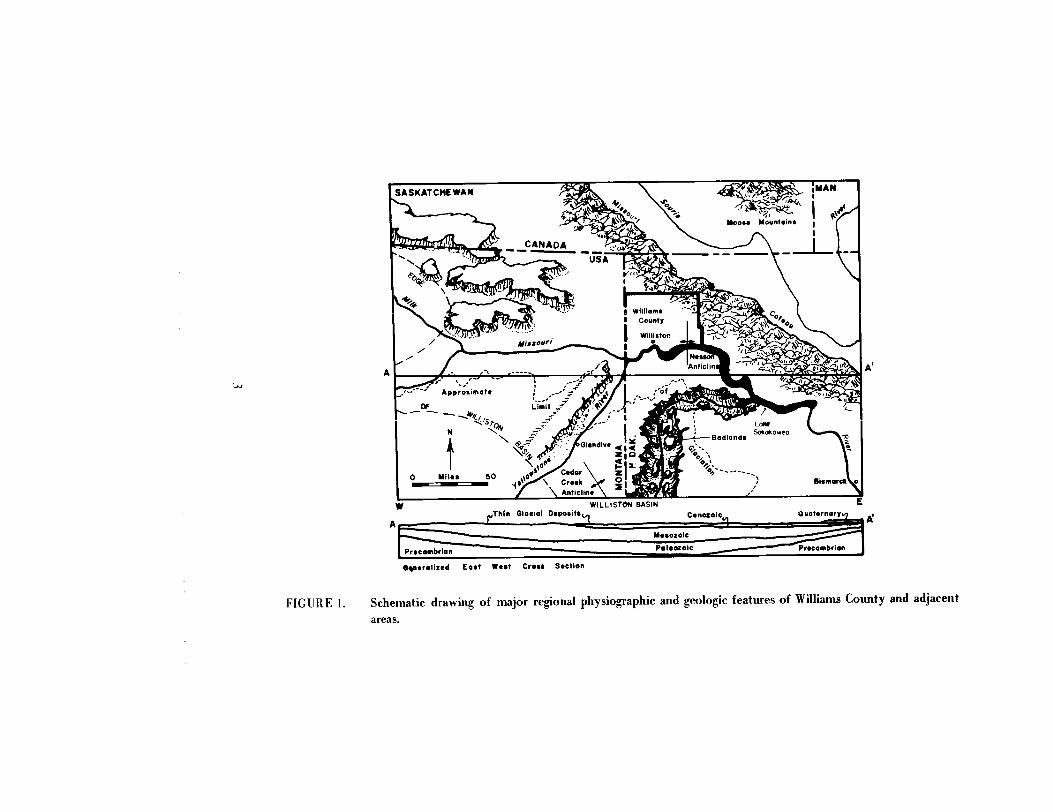
SASKATCHEWAN
TLoMSokokowea
Bismarck
WILLISTON BASI NThin Glacial Deposits
Precambrian
Paleozoic
Precambrian
Approximate
Cenozoic
Quaternar y
O nerolized East West Cross Sectio n
FIGURE 1 .
Schematic drawing of major regional physiographic and geologic features of Williams County and adjacent
areas.
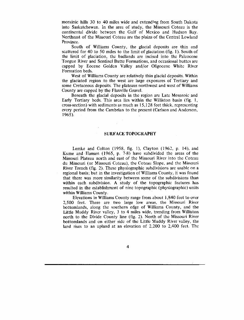
morainic hills 30 to 40 miles wide and extending from South Dakot ainto Saskatchewan . In the area of study, the Missouri Coteau is thecontinental divide between the Gulf of Mexico and Hudson Bay .Northeast of the Missouri Coteau are the plains of the Central LowlandProvince .
South of Williams County, the glacial deposits are thin andscattered for 40 to 50 miles to the limit of glaciation (fig . 1) . South ofthe limit of glaciation, the badlands are incised into the PaleoceneTongue River and Sentinel Butte Formations, and occasional buttes arecapped by Eocene Golden Valley and/or Oligocene White Rive rFormation beds .
West of Williams County are relatively thin glacial deposits . Withinthe glaciated region to the west are large exposures of Tertiary an dsome Cretaceous deposits. The plateaus northwest and west of William sCounty are capped by the Flaxville Gravel .
Beneath the glacial deposits in the region are Late Mesozoic an dEarly Tertiary beds. This area lies within the Williston basin (fig. 1 ,cross-section) with sediments as much as 15,128 feet thick, representin gevery period from the Cambrian to the present (Carlson and Anderson ,1965) .
SURFACE TOPOGRAPH Y
Lemke and Colton (1958, fig . 1), Clayton (1962, p . 14), andKume and Hansen (1965, p . 7-8) have subdivided the areas of theMissouri Plateau north and east of the Missouri River into the Coteaudu Missouri (or Missouri Coteau), the Coteau Slope, and the Missour iRiver Trench (fig . 2) . These physiographic subdivisions are usable on aregional basis ; but in the investigation of Williams County, it was foundthat there was more similarity between some of the subdivisions tha nwithin each subdivision . A study of the topographic features hasresulted in the establishment of nine topographic (physiographic) unit swithin Williams County .
Elevations in Williams County range from about 1,840 feet to ove r2,500 feet . There are two large low areas, the Missouri Rive rbottomlands, along the southern edge of Williams County, and th eLittle Muddy River valley, 3 to 4 miles wide, trending from Willisto nnorth to the Divide County line (fig . 2) . North of the Missouri Riverbottomlands and on either side of the Little Muddy River valley, th eland rises to an upland at an elevation of 2,200 to 2,400 feet . The
4

umuUndulatin gHills 9 Sough s
Intrauplan dFlat s
D
Q Dissecte dUpland s
Leve lUpland
Bottomlon dFlat s
Laity Sakakawea
FIGURE 2 . Topographic units of Williams County .

TABLE 1. Topographic Units of Williams Count y
SlopeUnit
Drainage
Type 1
Degrees
Local relief2
General Name
A Integrated Steep 20-65 High (greater than 50 feet) Badland
B Well integrated Hilly andsteep
5-20 Medium (15 to 50 feet) to high(greater than 50 feet)
Dissected upland
C Fairly wel lintegrated
Undulatingto rolling
3-10 Low (5 to 15 feet) to mediu m(25 to 50 feet)
Level upland
D Well integrated Nearly level 0-2 Low (less than 15 feet) Bottomland
E Nonintegrated Hilly andsteep
5-20 Medium (15 to 50 feet) to high(greater than 50 feet)
Steep, knob, andkettle
F Nonintegrated Hilly andsteep
5-20 Low (0 to 15 feet) to medium(15 to 50 feet)
Steep, hilly, an dsloughy
G Partly integrated Undulatingto rolling
3-10 Medium (15 to 50 feet) to high(greater than 50 feet)
Undulating knoband kettle
H Partly integrated Undulatingto rolling
3-10 Low (0 to 15 feet) to medium(15 to 50 feet)
Undulating, hilly ,and sloughy
Partly integrated Nearly level 0-2 Low (0 to 15 feet) Intraupland flat
'Modified from USDA Soil Survey Manual p . 162 to 164 . (Soil Survey Staff, 1951 )2 Local relief based on estimated elevation difference between adjacent lows and highs .

bottom of many valleys, tributary to the Missouri River and Littl eMuddy River, are at elevations of 1,900 to 2,000 feet . Another low are abelow 2,000 feet is west of Grenora in extreme northwestern William sCounty .
Topographic Units
Topographic units are determined in Williams County b ycombinations of degrees of drainage integration, local relief and averag eslope angles.
Drainage integration was determined in the field and from aeria lphotographs and was found to be nonintegrated, partly integrated ,fairly well integrated, and integrated. There are no abrupt boundariesbetween the different degrees of drainage integration, and partl yintegrated and fairly well integrated overlap considerably . Local reliefwas determined in the field by estimating the elevation differencesbetween adjacent lows and highs. Three terms are applied to localrelief–low (0 to 15 feet), medium (15 to 50 feet) and high (greater tha n50 feet) . Slope was determined . primarily in the office using areconnaissance soils map of Williams County (General Soil Map ,Williams County ; prepared by the North Dakota AgriculturalExperiment Station, Department of Soils, scale 1 :126,720) . Slope type sand angles were taken from the soils map and regrouped into a for musable for delineating topographic units . Slope types are steep (20° t o65°), hilly and steep (5° to 20'), undulating to rolling (3° to 10°), andnearly level (0° to 20). Combinations of drainage integration, localrelief, and slope angles are used on the topographic unit map Figure 2and in Table 1 .
TOPOGRAPHIC UNIT A (BADLAND )
This area is characterized by badland topography . It has 20° to65° slopes, usually the higher angles, integrated drainage, and usuall yhigh local relief, up to 500 feet . Unit A is found almost entirely on theTongue River and Sentinel Butte Formations and has slopes almos tdevoid of plant life . Erosion of the badland topography has resulted insharp, almost knife-like ridges, with steep arroyos between Steep rill sand resistant ledges are common . The few buttes that are present aregenerally capped by glacial drift overlying a resistant sandstone or asiliceous bedrock layer. Large slump blocks as much as 1 /4 mile longoccur at several locations .
7

Topographic Unit A is found almost entirely along the Missour iRiver, except for three small areas, one near Hanks in northwester nWilliams County, one along Stony Creek, northeast of Williston and anarea west of Williston on the Montana state line . These three small areasare not shown on Figure 2 .
TOPOGRAPHIC UNIT B (DISSECTED UPLAND )
Unit B consists of well integrated hilly topography with hilly an dsteep (5° to 20 0) slopes and medium (15 to 50 feet) to high (greate rthan 50 feet) local relief. It is primarily a dissected upland consisting o fvalleys between relatively level uplands ; it consists of bedrock overlai nby a blanket of glacial deposits . The largest area of Unit B is found inthe Missouri River Trench between Unit A, badlands, and Unit C, leve luplands. Other areas of Unit B are found along the major streams o fWilliams County .
TOPOGRAPHIC UNIT C (LEVEL UPLANDS )
This is an upland area and is found at elevations of 2,210 to 2,400feet . It has fairly well integrated drainage on undulating to rollin gslopes of 3° to 10° and has mostly low relief . The area of Unit C islargely on the Coteau Slope with a few areas within the Missouri Rive rTrench. Unit C is underlain almost entirely by glacial drift deposits . It isessentially a gently rolling plain with a few undrained depressions and afew ridges of glacial origin . There are some broad valleys with lowslopes occurring on the valley walls . Integration of drainage is almos tcomplete, but very recent .
TOPOGRAPHIC UNIT D (BOTTOMLAND )
Unit D is characterized by flat bottomland topography . It hasfairly well integrated drainage, nearly level slopes (0 to 2°) and lo wrelief (0 to 15 feet). It consists of floodplains of the Missouri River an dtributary streams and by gravel and sand terraces in the Little Mudd yRiver valley . Unit D lies at elevations from about 1,850 to 2,050 feet .Commonly Unit D is nearly flat, especially along the Missouri River ,but near the Divide County line the topography is gently rolling an dpitted in places . The slope of this unit increases from the floodplain o f
8

the Missouri River to as much as 4° to 5° on the tributary valleys . UnitD is underlain by mixtures of clays, silts, sands, and gravels .
TOPOGRAPHIC UNIT E (STEEP KNOB AND KETTLE )
Unit E is characterized by high relief, knob and kettle topography ,medium (25 to 50 feet) to high (greater than 50 feet) local relief, hillyand steep slopes (5° to 20°), and nonintegrated drainage. Of all thetopographic units, Unit E has the least integrated drainage . The slopeangles have a considerable range within a short distance . The tops ofsome of the knobs are nearly level, whereas the side slopes are about200 , except the lower 10 feet near sloughs or kettles, where the slop emay be as much as 35°. Most slough bottoms are nearly level . Unit Ecovers only small isolated areas in the north and east sides of WilliamsCounty. North in Divide County are large areas of this knob and kettl etopography. This topographic unit is entirely underlain by glacial drift .There is some integrated drainage within the area of Unit E, but it i slimited to the land immediately adjacent to glacial channels .
TOPOGRAPHIC UNIT F (STEEP HILLS AND SLOUGHS)
This unit is identical to Unit E, but has low (5 to 15 feet) t omedium (15 to 50 feet) local relief. The topography is characterized bymedium relief and hilly and sloughy features. Drainage is nonintegratedalthough there are some narrow channels which transect some of Uni tF. In general, the area has low knobs and undrained sloughs underlai neverywhere by glacial till . There are some ridges, but the topography ispredominantly irregular or nonlineal .
TOPOGRAPHIC UNIT G (UNDULATING KNOB AND KETTLE )
This unit has partly integrated drainage, medium (15 to 50 feet) t ohigh (greater than 50 feet) local relief, and undulating to rolling (3 t o10°) slopes . The primary difference between Unit E and Unit G is tha tUnit G has lower slopes and more medium local relief, whereas Unit Ehas higher slopes and higher local relief. Slough banks are more gentl ein Unit G than in Unit E . Unit G areas are underlain by glacial till .
9

SYSTEM SEQUENCE GROUP OR FORMATION DOMINANT
LITHOLCG Y
TERTIARY
TEJASGLACIAL DEPOSITS Sandy loam, Band and Gravel
WRITE RIVER Cla
Sand
and Lim-ston -
ZUNI
Clay, Sand and Sil t
•••
•~
Shale
Cla
Sandstone and Lignit e
• Shale, Sandstone
and Lignit e
~
~
~
• Marine Sandstone and Shal e7 Sandstone, Shale and Lignit e
CRETACEOUS
•
•'• Marine Sandstone
Shale
•' Shale, Calcareous
•
•
.
•i Shal e
''
•'•'
• Shal eSandstone
Shal eSandstone and Shal e
~ Sands tone and Shal e
•" • Shale s Clay
JURASSIC
®
Shale and Sandston eLimestone, Anhydrite, Balt and re dShale
•.uuIu u n n nnn n nnnnn nn nn nnn nnn nI n nnn n n nnn n n nnn nnMnn nnn
TRIASSIC
ABSAROKA
Siltstone, Salt and Sandstone
LimestonePERMIAN •• Shale, Siltstone and Sal t
Sandstone and Dolomite~' NNSYLVANLAN , Dolomite, Limestone, Shale & Sandston :
ISSISSIPPIAN
KASKASKIA
••
i Shale,
Sandstone and
Limestone
•
• •
•
Interbedde d
Limestone andEvaporates
Limestone
Siltstone and Shal e
•' Shale, Siltstone and Dolomite
DEVONIAN
V
c
'~~ Limestone
•• Interbedded Dolomite and Limestone
• Interbedded Dolomite and Limestone
• Dolomite and Limestone
Halit e•
• Limestone and Dolomite
muuuunnuuuu•u•uiu.innnn••u•~nnnunn•u~nnu•.u• suSILURIAN
TIPPECANOE
INTERLAKE DolomiteSTONEWALL Dolomite and Limestone
ORDOVICIAN
STONYMOUNTAINFORMATION
GUNTONMEMBER Limestone and Dolomite
STOUGHTONMEMBER Argillaceous Limestone
RED RIVER Limestone and Dolomite
WINNIPEGGROUP
ROUGHLOCK Calcareous Shale and Siltston e
ICEBOX Shal eBLACKISLAND Sandstone
IHuIlUI nUUIm•n uuUuUU• •n•nn••nunnm•muunnntnn1
SAUK DEADWOOD Limestone, Shale and Sandston eCAMBRIAN
I~I~~~~~V~~11~~~~~~~~u•uuuu~II~~~~~••u•uu~uuu•uuuu•PRECAMBRIAN
FIGURE 3.
Stratigraphic column of North Dakota .
1 0

ESAROJb-Ma
3043It-IM-102
1403m•laa-Rs
TERTMRY ROCKS
DAKOTA
o rJURASSIC
ma
FOROA7101I
nscm
FORM 27105
ROCKS
---- GROUP
rnssisS/PPIA N
.92
EXPLANATIO N
STSTEM SOUMOARIEs
FORMATION BOUNDARIES
MAJOR UMOONFORMI TIES
NORTH WROTE OEOIORIGI SUAVE,
MILL MRBER
SILURIAN
------------ -------------- -
PE MAIN ROCKS
'mac
FORk ,
CRETACEOUS
- - ---------- -
------------ -
FIGURE 4 . Stratigraphic cross section from northwestern to southeastern Williams County .

TOPOGRAPHIC UNIT H (UNDULATING HILLS AND SLOUGHS )
This unit is characterized by areas of low (5 to 15 feet) to mediu m(15 to 50 feet) local relief, undulating to rolling (3° to 10°) slopes, an dpartly integrated drainage . Although this unit is similar to the previousthree hilly and sloughy units, its outward character is subtle because i thas low hills and low undrained depressions . It is most easily recognizedon aerial photographs . Unit H is underlain by glacial drift, chieflyglacial till .
TOPOGRAPHIC UNIT I (INTRAUPLAND FLATS )
Unit I consists of intraupland flats . The features of this unitinclude partly integrated drainage, low (0 to 15 feet) local relief, an dnearly level (0° to 2°) slopes . Unit I in Williams County is underlain b yclays and silts . This unit is associated with Units E to G (hilly an dsloughy types) .
SUMMARY OF THE PRE-TERTIARY STRATIGRAPH Y
Williams County lies near the center of the intracratonic Willisto nbasin (fig . 1), which is a structural and sedimentary basin . The greatestknown thickness of post-Precambrian sediments in the Williston basin i s15,128 feet in a well in McKenzie County. The deepest well in WilliamsCounty was drilled to a depth of 14,828 feet along the Nesson anticlin e(fig. 1). Most wells in the county have been drilled into the uppe rPaleozoic rocks along the Nesson anticline and in the Grenora field i nnorthwestern Williams County .
The oldest exposed rocks are those of the Tertiary Tongue Rive rand Sentinel Butte Formations . Data on the older rocks (fig . 3) come sfrom mechanical well logs, cores, and drill cuttings . Figure 4, across-section along the Nesson anticline and then west to the Grenor afield, shows the stratigraphic relationship of the formations in th ecounty .
Precambrian Rock s
Three oil wells have been drilled into the Precambrian . In two ofthem, syenite was identified as the Precambrian rock-type ; the third
12

well probably had weathered syenite . Above the Precambrian rocks ar esix sequences separated by five major unconformities (fig . 3) (Carlso nand Anderson, 1965) .
SAUK SEQUENCE
The Sauk Sequence in Williams County consists of th eCambro-Ordovician Deadwood Formation . The Deadwood Formatio nlies unconformably on the Precambrian and is composed of limestone ,shale, and sandstone .
TIPPECANOE SEQUENCE
The Tippecanoe Sequence includes most of the Ordovician and al lof the Silurian systems . The Winnipeg Group, at its base, consists o fsandstone, siltstone, and shale . Overlying the Winnipeg Group is th eRed River, Stony Mountain, Stonewall, and Interlake Formation swhich are limestones and dolomite . Oil and gas is produced from thissequence .
KASKASKIA SEQUENCE
Many formations are found in this sequence which include all o fthe Devonian and Mississippian systems . The lithologies within theKaskaskia Sequence are predominantly limestone and dolomite wit hsome evaporites, siltstones, and sandstones . In the Upper KaskaskiaSequence is the Madison Formation which produces most of the oil an dgas in North Dakota .
ABSAROKA SEQUENCE
The Absaroka Sequence includes all of the Pennsylvanian ,Permian, and Triassic systems . This sequence has five formations thatare composed of sandstone, siltstone, shale, limestone, dolomite, andsalt .
13

ZUNI SEQUENCE
The Zuni Sequence includes all of the Jurassic and Cretaceoussystems and part of the Tertiary system . It includes both marine andnon-marine beds consisting of sandstones, shale, limestone, anhydrite ,salt, lignite, clay, and silt . This sequence includes the vast lignit eresources of the Tongue River and Sentinel Butte Formations . TheGolden Valley Formation in Figure 3 is not known to be present i nWilliams County .
TEJAS SEQUENCE
The White River Formation is found in this sequence but is notknown to be present in Williams County . The glacial deposits are th eonly major deposits represented in the Tejas Sequence . The Teja sSequence extends to the present time . The lithologies of the TejasSequence are primarily sandy clay, sand, and gravel .
TERTIARY DEPOSIT S
Cannonball and Ludlow Formations
The Fort Union Group, which is of Paleocene age in North Dakot a(Brown, 1962) consists of the Ludlow, Cannonball, Tongue River, an dSentinel Butte Formations . The lowermost Tongue River, Cannonball ,and Ludlow Formations are not exposed in Williams County but com eclose to the surface along the Nesson anticline . The Cannonball an dLudlow Formations are interfingering sand and shale deposits withsome lignite in the Ludlow in other areas of North Dakota, but little i sknown of these formations in Williams County.
Tongue River and Sentinel Butte Formation s
Directly beneath the Recent and Pleistocene deposits in William sCounty are the Tongue River and Sentinel Butte Formations . Theseformations were first investigated by Meek and Hayden (1862) who
14

described the beds exposed on the north side of the Missouri River nea rFort Union (pl. 1) on the North Dakota-Montana border ; they calle dthese beds the Fort Union Group . The Tongue River Formation wasfirst described by Taff (1909) along the Tongue River in the Sherida nCoal Field, Wyoming, and was later traced into North Dakota by Tho mand Dobbin (1924) . Leonard (1908) named the upper part of th esequence at Sentinel Butte, North Dakota, the Sentinel ButteFormation. The exposed bedrock in Williams County is the Sentine lButte Formation with the exception of some Tongue River bed sexposed on the crest and east flank of the Nesson anticline (pl. 3) andthe beds west of T . 102 W. along the Missouri River (Royse, 1967) .
Exposures of the Fort Union Group in Williams County are foun dalong the Missouri River and many of its tributaries, along Scoria Cree kat Hanks, at Bull Butte in T . 156 N., R. 104 W., and at many otherisolated, small exposures shown on Plate 1 . The bedrock exposures inplaces are over 400 feet high along the Missouri River (for example ,measured sections 21 and 22 in pl . 3), but in others they are only a fe wfeet high. Twenty-eight separate sections were measured between theWilliams-Mountrail County line and Snowden, Montana. Thesetwenty-eight sections, some of which are represented in th estratigraphic cross-section Plate 3, included lithologic descriptions ,thickness, and structure.
BEDROCK TOPOGRAPHY
The topography on top of the Fort Union beds is basically simila rto the present surface topography. A major low (pl. 2) that trendsnorth from Williston to the Divide County line may be an old course ofthe Yellowstone River . This low is at an elevation of about 1,700 feet ,except in the northern part of the county where it drops t o1,600 feet . East and west of the low the bedrock rises to a 2,000 footto 2,300 foot up land. Another low area that bisect the upland to th eeast may be the old course of the Little Missouri River . Small lows tha thead back from the old Yellowstone River valley are probabl ypreglacial tributary valleys. West of Grenora, an area below 1,700 feet i sprobably part of the old course of the Missouri River . Two large highsin T. 156 N., R. 104 W., and T. 158 N., R. 95 W., are probably largeburied preglacial buttes.
15

FIGURE 5 .
Tongue River Formation where the Missouri River cuts across th eNesson anticline in southeastern Williams County .
FIGURE 6 . Sentinel Butte Formation along the Missouri River in the NE 1/4 ,sec . 20 .,T . 153 N., R . 99 W .
6

LITHOLOGIC DESCRIPTION S
The Sentinel Butte Formation consists of alternating beds o fsomber-colored clays, silts, sands, and lignites (fig . 6) . The TongueRiver Formation is similar but is lighter and more yellow (fig . 5) . N oestimates are made of the abundance of any lithologies because of th ediverse character of the formation . However, clay and shale ar eprobably the most abundant .
Sand and sandstone
Thickness of sand and sandstone beds ranges from several inche sto over 90 feet . Almost every measured section contained some sand ,which is found everywhere in the area of study . Commonly, the tops o fbuttes are capped by sandstone that is more resistant to weatherin gthan the other beds of the Tongue River Formation . These beds do no tpersist laterally over great distances, and often they pinch out in a fewhundred feet .
The sand in weathered outcrops is generally yellowish gray (5 Y7/2) to light gray (N7) with rust-colored stains . The sandstone isyellowish gray (5Y 7/2) or yellowish gray (5Y 8/1) . The sand is fine tomedium grained and the sandstone is very fine to medium grained . Nobeds with larger than medium-sized particles were seen with th eexception of some conglometric-claystone channel deposits . All sandgrains that were examined are subangular . Sorting ranges from claye ysand to silty sand to sand .
Bedding of the sand is most easily seen in the wind-erode dsandstones (fig . 7) . Most of the sandstone is cross-bedded with som eforeset and topset beds . Bedding in sand that is not well induratedgenerally appears to be horizontal and often obscure . Most of the sand sare massive, non-indurated, clean, and uniform with claystone o rironstone layers .
The most common secondary features in the sand are concretions .Spherical limonite concretions are common. They are as much as 8inches in diameter, and their iron oxides stain the surface of the sand ayellowish brown (10YR 5/3), and sometimes contain centers o funweathered marcasite . Another kind of concretion is a log-lik ecylinder. These are hard, well-indurated cylinders of cross-bedded sand2 or 3 feet in diameter and sometimes several hundred feet long . Theyare usually much harder than the surrounding sand .
Fossils are present in some of the sand, but none were found i nthe sandstone. The most common fossils in the sands are twigs or leafimprints. Gastropod and pelecypod shells are sometimes found .
17

FIGURE 7 .
Wind-eroded, cross-bedded sandstone of the Sentinel Butt eFormation, SE 1/4 SW 1/4, sec . 16, T . 153 N., R . 99 W .
Silt
Silt is present in the Sentinel Butte Formation throughout the are aof study. Silt beds range in thickness from several inches to more tha n30 feet, but most are less than 10 feet thick . The silt beds commonl ygrade laterally to different lithologies such as clays or sands within afew tens of feet .
The silts are commonly yellowish gray (5Y 7/2) and les scommonly light olive gray (5Y 5/2) on weathered outcrops . Some sil tbeds are very conspicuously grayish yellow (5Y 8/4), much yellowe rthan most adjacent beds .
Sorting of the silts is variable . Most of those described in th emeasured sections in Plate 3 contain some clay . A large proportion o fthe silts contain very fine sand . Silt grains are angular . The silts areusually bedded, individual beds being less than one millimeter thick .
The silt is very poorly cemented and is soft and loose . A largepercentage of the beds are calcareous in the weathered zone (about 2feet into the outcrop) . In general, the silt beds are massive, clean, an duniform ; but carbonaceous streaks occur on some of the beddingplanes. In addition, limonite balls and other concretions are common .Also found in the silt are gypsum crystals, selenite, and ironston elayers. A few of the beds contain plant fossils, gastropods, an dpelecypods .
18

Clays, claystone, and shales
The term clay, in this report, refers to soft,bedded or unbeddedclays ; claystone, hard, unbedded, massive clays ; and shale, hard ,bedded or fissile clays .
Clays, silty clays, sandy clays, claystone, and shale are the mos textensive lithologies in the exposed Fort Union beds of William sCounty. Some of the beds are only a fraction of an inch thick whil eothers are nearly a hundred feet thick .
Like the sand and silt, the clays and shales have little latera lpersistence over great distances . They are more persistent than theother mentioned lithologies, but they may pinch out in several hundre dfeet or grade to another lithology . Some of the underclays beneath thelignites are as persistent as the lignite bed under which they lie .
The clay and claystone is commonly yellowish gray (5Y 7/2) o rlight olive gray (5Y 5/2) . Less commonly it is very light gray (N8),ordark gray (N4), and sometimes olive brown (5Y 4/4), olive black (5 Y2/1), or dusky yellow (5Y 6/4) . Shales are not as common as the claysand claystone . They range from grayish red (5R 4/2) to light olive gray(5Y 5/2) . The clay beds in deep fresh cuts are darker than on weathere dsurfaces ; examples are dusky yellow green (5GY 5/2) or dark yellowishorange (10YR 6/6) .
Sorting of the clays and claystones varies from nearly pure clay t osilty and sandy clay ; the shales are largely composed of clay-siz ematerial . Bedding is evident in the shales and some of the clays. Theclaystones are massive, hard and sometimes have a sub-conchoida lfracture . Carbonaceous shales are well bedded and fissile . The clays an dshales are commonly calcareous, whereas the claystones show little o rno reaction to acid .
Vertical orange streaks are common in the clay beds . These streakscan usually be traced up the outcrop to ironstone layers or limonit eballs in the same bed or an overlying one. The ironstone layers in th eclays are less than 6 inches thick, and having greater resistance t oerosion, form benches as much as 2 feet wide . These ironstone layersand the benches they form are sometimes good markers to carrycorrelations for short distances .
Previous reports (Fisher, 1953, and Benson, 1952) have referred t obentonitic clays in the Tongue River Formation . Bentonitic clay spresent in the Williams County area are indicated in Plate 3 by a "B . "The bentonitic clay at one location, measured section 17 (pl . 3), swell swhen placed in water .
19
Gypsum (selenite) is concentrated on the surface of many clay an dshale outcrops. The clays, claystones, and shales contain abundant plan tfossils and many gastropods and pelecypods . The plant fossils areusually leaf imprints, twig or branch imprints, and petrified stumps (fig .8) .
Jointing in the clay beds is common and normally vertical . Manyof the joint faces have rust-colored stains or gypsum crystals or both .
Lignite
Lignite beds are found at almost every bedrock outcrop i nWilliams County . They range in thickness from about 1 inch to over 1 0feet . The lignite beds are the most persistent beds in this area, and the ycan often be traced for many miles, whereas the overlying an dunderlying beds may grade from one lithology to another . Even so ,some of the lignite beds do pinch out in short distances .
Lignite, and its weathered equivalent leonardite, range from darkreddish brown (10R 3/4), to brownish black (5YR 2/ 1), or black (NI) .Commonly associated with the lignites are brightly multicoloredaccessory minerals. The lignite ranges from almost entirely organi cmaterial to laminated clays or shales and organic material. O nweathered surfaces lignite beds are commonly soft and broken, bot halong bedding planes and vertically . Unweathered lignite is hard, brittle ,and uniform .
Fossil wood is characteristic of the lignite . Some of it still retainsits woody texture, but others are carbonized or silicified .
"Scoria" or baked sediments
"Scoria", a term applied in North Dakota to volcanic-like rocksthat formed when a lignite bed burned, baking the surroundin gsediments into a scoria-like rock . This "scoria " can be greater than 60feet thick or as little as 10 feet thick . In Williams County, the "scoria "is restricted to narrow bands about 150 feet wide that follow th emargin of the outcrop . It is common along the Missouri River betwee nWilliston and the Mountrail-Williams County line and in some isolate doutcrops at Bull Butte, T . 156 N., R. 104 W., and in the Scoria Cree kvalley near Hanks .
"Scoria" is generally light red (5R 6/6) or moderate pink (5 R7/4); but some is dark reddish brown (10R 3/4) .
The original lithologies of the "scoria" were silt, clay, shale, an dsand . Columnar jointing is sometimes found in "scoria" derived fro m
20

FIGURE 8. Petrified stump from the Sentinel Butte Formation, NE 1/4 NE
1/4, sec. 20, T . 153 N ., R . 99 W .
FIGURE 9 .
Columnar jointing in a sandstone "scoria, '' NE 1/4 NE 1/4, sec . 16 ,
T . 153 N., R . 100 W .
21

sand. Individual joint columns are generally about 1 to 2 inches i ndiameter and less than 1 foot long (fig . 9), much smaller than columna rjointing in volcanic rocks.
QUATERNAR Y
Preglacial Deposits
WIOTA GRAVE L
The Wiota Gravel was named by Jensen (1952) for gravels an dassociated sediments near Nashua, Montana, that were deposited b ystreams and rivers prior to local glaciation. They were deposited belo wthe Flaxville plain and are eroded primarily from Flaxville and highe rgravels .
Howard (1960) described and named two gravel units in easter nMontana and western North Dakota that are lithologically similar to th eWiota Gravel except that they were deposited by the YellowstoneRiver, whereas the type Wiota Gravel was deposited by the MissouriRiver . They are the Cartwright Gravel and Crane Creek Gravel, whichare lithologically identical, but are found on different bench level salong the Yellowstone and Missouri Rivers .
The type Wiota Gravel and the Williams County brown quartziti cgravel were examined in the field and determined to be similar . In thisreport, the Cartwright and Crane Creek Gravels mapped by Howar d(1960, pl . 1) and additional exposures mapped during the present stud yin Williams County are called Wiota Gravel .
The Wiota Gravel in Williams County occurs at two, possiblythree, levels on benches along the valley wall of the prediversion courseof the Yellowstone River. The three bench levels at which Wiota Grave lare found are about 2,030, 2,085, and 2,145 feet above sea level (fig .10) . Howard (1960) reported an exposure at Hoffland Flats (pl. 1), butthis has since been covered by the rising water of Lake Sakakawea .
Stratigraphic position, thickness, and age
The Wiota Gravel rests on Paleocene rocks of the Tongue Rive rand Sentinel Butte Formations. Overlying the gravel is glacial till . Thegravel ranges in thickness from 6 to 18 feet and is generally about 1 0feet thick .
22

R.103 W. R.IO2 W.
R .101 W.
R .100 W. R.99 W .
R .98 W.
R .97 W.
R .96 W.
R .95 W.T. •168 5
159 180f 18 4N . L1640I
1111 1T.
15 8N.
T.15 7
N .
1968
•20612078
2088
•2038
.1948 • 204 7
T.I56N .
.2373 •2254
2100x
212 6
2098
T.Is e
N .
T.154N.
T.153N.
T.15 2
N .
2030boos it%
2 y70x i~15
‘.)I 2050 ,
2025
x 2130 OUTCROP S ELEVATIO N
• 2373 SUBSURFACE S ELEVATIO N
FIGURE 10. Localities and elevations of brown quartzitic gravels.
*2030
x208 5x203.0

100
20
6 0
40
20
0
e Cher iQuart Limestone
an dDolomite
Granite and
other
Felsile and
Fine-grained Ouarte and
FoliatedGneissic Grate
Granitoids
Silicious and Porphyritic
Quartz
metamorphic
Porphyritic
mofic igneous
aggregate
rocks
rocks
rocks
Misc. shale ,siltatone,and
cool
WITKIND, 1959LOWER QUATERNARY(? )GRAVEL C
HOWARD, 196 0CARTWRIGHT GRAVEL
HOWARD,1960
WITKIND,1959
J5GS MAP,WILLIAMS COUNTYCRANE CREEK
a FLAXVILLE GRAVEL
LARRABEE, 199 7GRAVEL
BROWN,QUARTZITIC GRAVEL S
* ON THE USGS MAP THE CHERT AND QUARTZITE WERE COUNTED TOGETHER .
FIGURE 11 . Pebble counts of brown quartzitic gravels in Williams County and surrounding area.

No fossils were found in the Wiota Gravel in Williams County, bu tfossils identified as probably Pleistocene in age were found in the typ earea by Jensen (1964) .
Because no glacial deposits were found beneath the Wiota Grave land the benches on which the gravel rests are on the valley wall of theprediversion Yellowstone River , the gravels must be preglacial o rprediversion in Williams County .
Lithology
The Wiota Gravel in Williams County is similar to the FlaxvilleGravel and other gravels of Quaternary age described by Colton (1955) .They are well rounded, water-worn pebbles usually 2 inches or less indiameter. Most of the deposits in Williams County appear to have les ssand and silt than those described by Jensen (1964) . Chert andquartzite comprise about 70 to 80 per cent of the deposits (Larrabee ,1947). Rhyolite ranges from 2 to 10 per cent and averages 7 per cent ;limestone and dolomite range from 0 to 12 per cent and average 5 pe rcent (fig . 11) .
Gravel deposits in several places in Williams County are compose dof brown quartzitic gravel as well as abundant glacial erratics . Thesedeposits are not Wiota Gravel because Jensen (1964) said that the Wiot aGravel should be restricted to deposits that are mostly nonglacial i norigin .
Glacial Deposits
Glacial drift is the most extensive surface deposit in William sCounty. Except for the area along the Missouri River (pl . 1) and a fewisolated bedrock outcrops, the surface is underlain by glacial drift (fig .12) . Glacial deposits are of three basic types : till, sand and gravel, andclay and silt .
TIL L
Distribution and thickness
Glacial till is a heterogeneous mixture of all particle sizes fro mclay through boulders . Till is widely distributed throughout the county
25

T.
159N .
T.
15 8
N .
T.
157
N .
T.
156N .
T .
15 5N .
T.15 4
N.
T.153
N.
T.
15 2N .
R .103 W.
R.102 W
R .IOI W.
R .100 W. R.99 W.
R .96W.
R .97 W.
R .96 W.
R .95 W .
9,90
00
20
oo , I
. /
o0PI 11E,D
2,
0 0
0000
ME
DAMEo ~
Nu, IN . \
I y
NA POF TH ERIP TOTAL GLACIAL DRIF T
PENETRATED IN THE TEST
10MML,11m P4111 DRILLIN G
CONTOUR INTERVAL 100 FEE T
FIGURE 12. Isopach map of glacial drift in Williams County.

R .9$ W.
R .97 W.
R .94 W.
R.115 W.
00 O
ao
1.111
RE ME
'
goo
w~)
°o
I ;
ISOPACH MAP
AM* OF THETOTA
L PENETRATED L/INATHE IL TES TDRILLING
CONTOUR INTERVAL 50 FEET
Wr

and is absent only where post-glacial erosion has removed it as in th ebadlands (topographic Unit A, figure 2) along the Missouri River wher eseveral dozen square miles are underlain by bedrock, alluvium, orcolluvium .
The thickness of the till ranges from only a few inches near theMissouri River to over 250 feet in T. 159 N., R. 100 W., in northernWilliams County . There is a close association between the till thicknes sand the bedrock topography . Figure 13, a till thickness map, (comparewith Plate 2, the bedrock topography map) shows the till is generall ythickest in the bedrock valleys such as the Ray channel or the valley o fthe pre-glacial Yellowstone River . Aside from those areas where the til lhas been eroded, the thinnest deposits of till are on the bedrock high sby the uplands (topographic Unit C) . One exception to this generality isnorth of Bull Butte where the till is over 100 feet thick and on abedrock high .
Lithotogy
Till in Williams County can be described as uniformly variable .That is, variability of the lithology of the till exists at any give nlocation; but the variability is usually within predictable limits. Forexample, one road cut may expose a sandy-clay till, a stony-loam till ,and a silty-clay till, whereas another road cut 15 miles away migh texpose a sandy-loam till and a sandy-clay till . The till is generally amixture of nearly equal parts of clay, silt, and sand with a few per centof gravel .
The color of the till changes both vertically and horizontally . Inthe northern tier of townships the upper 4 or 5 feet is generally ligh tolive gray (5Y 5/2) when moist . The dry till is lighter hued ; usuallyyellowish gray (5Y 7/2) or light olive gray (5Y 6/2) . Till south of thenorthernmost tier of townships has more red in it . The color in theupper few feet ranges from yellowish gray (5Y 7/2) to dark yellowis hbrown (10YR 6/6) when moist and lighter when dry . Throughout thearea the upper 1 or 2 feet of drift has light gray to white overtones du eto the presence of much calcium carbonate in the form of caliche .
Till cuttings from test holes are generally moderate yellowishbrown (10YR 5/4), dark yellowish orange (10YR 6/6), yellowish gra y(5Y 7/2) or light brown (5YR 5/6) in the upper 35 to 45 feet, th eoxidized zone. Below these depths in the unoxidized zone, the till i smuch darker, normally olive gray (5Y 4/1), but sometimes mediu mgray (N5) or dark greenish gray (5GY 3/1) . At four locations, thelighter, more reddish colors, were found below the olive gray zone aswell as in the upper zone .
28

Two main groups of rock types constitute the gravel size fractionof the till : those of local origin and those of distant origin . The localtypes are all from the Fort Union Group or from Tertiary o rQuaternary gravels . Fort Union rock types are shale sandstone, lignite ,"scoria," petrified wood, ironstone, and some limestone . Quaternarygravels are either Wiota or Flaxville Gravel which are primarily chert ,quartzite, and agate . The distant rock types are of Mesozoic, Paleozoic ,or Precambrian origin . They are primarily granitic, metamorphic ,carbonate, and shale .
Most of the larger particles in the till, pebbles to boulders, ar eangular to subangular . Throughout the area are occurrences of gravelderived from the Wiota and Flaxville Formations in the till . Most ofthem a:re blade shaped and are rounded to well rounded . Occasionalrounded glacial pebbles from the Canadian Shield also occur . Thesand-size grains in the till are mostly angular to subrounded . Siltparticles are generally subangular and are blade shaped . Most angulargrains are of local origin ; they are primarily shale, "scoria, " petrifiedwood, and lignite fragments from the Fort Union Group .
Most of the till is firm, but easily crushed with moderate pressur ein the hand. Extremely hard tills, as are found in eastern North Dakota(Bluemle, 1967) are absent . Hardness of the till in the upper few feet isvariable due to secondary enrichment of the B-horizon .
Figure 14 is a graphic, descriptive, and electrical log of th ematerials penetrated in test hole 3233, in central Williams County . Thi sdata was selected as an example of the types of lithologies penetrate dduring test drilling . Descriptive and electrical logs were made for ever ytest hole during this study. Descriptive logs for all test holes ar epublished in Part II of the Williams County study (Armstrong, 1967) .
SAND AND GRAVE L
On Plate 1, the glacial sand and gravel is in yellow . The mostextensive surface deposit of sand and gravel is in the Little Mudd yvalley which extends from Williston to the Divide County line. Otherlarge surface deposits are in Beaver Creek, southeast of Ray ; west ofGrenora, and in the valley at McGregor . In the subsurface, the sand andgravel is almost as extensive as at the surface .
Figure 15, a sand and gravel total thickness map, reveals thegreatest : thickness of sand and gravel in the bedrock valleys of the Raychannel and old course of the Yellowstone River (pl . 2). The uplandareas (topographic Unit C) are almost devoid of thick sands and gravels .
29

Descriptive Log Graphic
Log
Electrical Resistivit y
Lo g
Logged by Larry Froelich, North Test Hole #3233,
NEkDakota State Water Commission NEC, Sec . 19,
T .158
N . ,
R .97 W .
Depth
Description
(Feet )
0-4
Clay, sandy, yellowish gray, soft ,
fairly loose .
4-16 Clay, sandy with pebbles, dusky yellow ,
soft, slightly cohesive . (Till )
16-86 Clay, silty and sandy with pebbles ,
moderately soft, cohesive, tough ,occasional rocks . (Till )
86-94 Sand, medium gray, moderately wel lsorted, subrounded, lignitic .
94-99 Clay, silty, olive gray cohesive ,
tight .99-10S Sand, fine to coarse, gray, moderatel y
well sorted, subangular and sub-
rounded . Mostly quartz, lignitic .
105-140 Clay, silty and sandy with pebbles ,
olive gray, moderately soft t oslightly hard, cohesive, very tight .(Till )
153-189 Sand, coarse and very coarse, gravelly ,
brown, moderately sorted, subangular
and subrounded, mostly quartz and chert ,drills good, rough in spots, takingsome water .
189-203 Clay, silty, light gray, light greenis hgray, greenish gray and brownish black,
soft to slightly hard, interbedded ,
slightly cohesive to very tight, cal-_careous, highly carbonaceous in spots .
FIGURE 14 . Geologic, graphic, and electrical resistivity log of test hole numbe r3233, Williams County .
3 0
140-153 Sand, medium gray, very well sorted ,
subrounded, clean.

R.103 W .
R .102 W.
R .101 W.
R .100 W.
R .99 W .
R .98 W.
R .97 W.
R .96 W.
R .95 W.
RI n‘El
El'UM.1moprou
IFPP 'MISOPACH MA P
OF TH E
TOTAL GLACIAL SAND 6 GRAVEL
PENETRATED IN THE TEST DRILLING . CONTOU R
FIGURE 15. Isopach map of the glacial sand and gravel in Williams County.
INTERVAL 50 FEE T
T.
59
N .
T.
15 8
N .
T.
157
N .
T.
156
N .
T.
5 5
N.
T.
5 4
N.
T.
15 3
N.
T.
15 2
N .
W
Lithology
Sand and gravel in the upper 10 feet of most deposits are lightolive gray (5Y 4/3) to yellowish gray (5Y 7/2) . In several gravel pit snear the base of the exposure at a depth of 10 to 12 feet, the sediment sare stained black (N2), and just above this they are moderate reddishbrown (1 OR 4/6) . Subsurface sand and gravel have similar colors .
Individual gravel grains are subangular to subrounded an doccasionally rounded. Sand grains are angular to subangular . The bulkof these deposits consist of granitics and carbonates . Field estimate sand several pebble counts averaged 55 per cent carbonates, 20 per cen tgranitic, 5 per cent metamorphic, and 20 per cent local (sandstone ,shale, and miscellaneous) rock types .
In the upper 3 to 4 feet of most sand and gravel deposits ,individual grains have deposits of caliche on the underside . The calicheis as much as 3/8 of an inch thick. Many of the sand deposits haveconcentrations of black organic material, probably lignite that ha sconcentrated during deposition . Iron oxide stains are also quit ecommon .
One sand and gravel deposit, NE 1 /4 NW 1 /4 sec . 7, T. 157 N., R .101 W. contains balls of glacial till mixed in with the gravel .
The linear sand and gravel deposit along Cottonwood Creek, ma psymbol Kt, is a fairly well-sorted deposit . The deposit extends from th etop of the Cottonwood Creek valley wall to the valley floor . In someplaces are large concentrations of cobbles and boulders .
The sand and gravel deposits indicated by the symbol Drg on Plate1 are linear, steep-sided ridges segmented and sinuous . They range fro mwell sorted to poorly sorted . West of Grenora are several well-sorte ddeposits of this type. The one extending from the SE 1 /4 NE 1 /4 sec .16, T. 159 N., R. 103 W. to Horseshoe Lake is very large, up to 50 fee thigh, with well-sorted sand and gravel deposits . Another well-sortedsand and gravel deposit crosses U . S . Highway 85 about 2 miles south ofthe Divide County line. An example of a poorly sorted deposit occurs 3miles west of the junction of U . S. Highway 2 and North DakotaHighway 40. Many smaller deposits that are found throughout thecounty are variable in their sorting .
Another type of sand and gravel deposit that is generally wel lsorted is indicated by K on Plate 1 . This type of deposit is generally aknob, hill or mound, well sorted and stratified, and variable in size .Similar to these deposits are the deposits indicated by IU on Plate 1which are usually not as well sorted and do not have any definite shape .
The largest, most extensive, and best-sorted deposits are the area sof yellow on Plate 1 . Those with the symbol Op are gently rolling area s
32
that are composed of large amounts of sand and gravel . Sorting variesthroughout the deposit ; for example, one part may be primarily beds ofsand with a little gravel, and another part may be gravel with som esand. The yellow areas with the symbol Oc are similar to those with th esymbol Op but are hilly with as much as 50 feet of local relief.Generally, the best sorted of all the deposits in Williams County ar ethose with the symbol Ot on Plate 1, especially the deposits nea rMcGregor . Subsurface sands and gravels penetrated in the test drillin ghave sorting similar to the surface sands and gravels.
SILT AND CLAY
Silt and clay deposits of glacial and proglacial origin are extensiv ein eastern Williams County . The areas of light blue on Plate 1 anddesignated either Lp or Lc are the glacial silt and clay deposits . Thereare two types of silt and clay deposits ; one is a nearly flat deposi tdesignated by Lp, and the other is gently rolling and sometime shummocky as designated by Lc on Plate 1 . An example of a gentl yrolling deposit is the area called locally the ` Big Meadow " located 5miles south of Hamlet . The nearly flat silt and clay deposit is typifie dby the area 3 miles west and 2 miles north of Ray . In addition to th esilt and clay deposits in the eastern part of the county, three small areasof silt and clay deposits occur north of Bull Butte in T . 157 N., R. 103W. All of the silt and clay deposits of glacial or proglacial origin arefound associated with topographic Units E through H. The larger siltand clay units are represented by topographic Unit I in Figure 2 .
The greatest known thickness of the silts and clays at the surface is26 feet in a test hole 1 mile west and 6 miles south of Hamlet . Figure16, a thickness map of the total silt and clay in the county, indicate sthat the thickest areas coincide with the old course of the Yellowston eRiver . Near Williston buried deposits exceed 200 feet in thickness .
Lithology
Generally the silt and clay deposits are well sorted into clayey silt sand silty clays. Near the edge of many of the deposits are associatedsands and gravels . These occur in the form of ridges and are sometimescontinuous for 1 1 /2 miles. The sediment generally grades from coarser
33

R.103 W.
R .102 W.
R .101 W.
R .100 W.
R .99 W.
R .98 W.
R .97 W.
R .96 W.
R95 W.
ISOPACH MA P
OF THE
TOTAL SILT & CLAY
PENETRATED IN THE TEST
DRILLIN G
CONTOUR INTERVAL 50 FEE T
T.
15 9
N.
T.
156
N.
T.
15 7
N .
T.
15 6
N .
T.
15 5
N .
T.
15 4
N.
T.
153
N.
T.
15 2
N .
FIGURE 16. Isopach map of the glacial silt and clay in Williams County .

at the margin, especially when there is a sand or gravel rim, to fine cla yat the center of the deposit . Colors of the deposits range from yellowis hgray (5Y 7/2) to olive gray (5Y 4/1) . In the upper few feet of thedeposits are iron oxide stains and small, less than 1 /4 inch long, gypsu mcrystals .
Bedding in the silts and clays are present, but exposures of th ebedding are few and shallow so that sedimentary and structuralcharacteristics are not easily seen . One good exposure is just north ofthe Divide-Williams County line along the edge of the Wildrose sewag elagoon. The alternating silt and clay beds in the exposure are about 1 / 8to 1 /4 inch thick .
Postglacial Deposits
ALLUVIUM
Alluvium occurs along the stream and river channels and in th esloughs of Williams County. The largest area of alluvium, along theMissouri River west of Williston, is indicated by the gray areas on Plat e1, with the symbols A or At. The second largest area of alluvium is inthe Little Muddy valley from Williston north to Scoria Creek and westto Grenora. All of the streams tributary to the Little Muddy an dMissouri River has alluvium usually only several hundred feet wide .The sloughs in the area of nonintegrated drainage contain postglacial t orecent alluvium. The thickness of the alluvial deposits is variable an doften difficult to distinguish from the glacial deposits. The alluviumalong the Missouri River ranges from a few feet on some of the area sdesignated At on Plate 1 to 178 feet in sec. 8, T. 152 N., R. 103 W. onthe floodplain. The small tributary valleys have narrow alluvial deposit s5 to 25 feet thick. Sloughs contain up to 20 feet of alluvium .Topography of the alluvium is generally nearly level as represented b ytopography Unit D, Figure 2 .
L ithology
The alluvium is composed of clay, silt, sand, and gravel . The upperbeds along the Missouri River and Little Muddy River are generall y
35

composed of finer material than the lower beds . Alluvium in the sidevalley is composed of clay, silt, and sand with a little gravel especiall ynear the base of the beds . Bedding is distinct with separate beds o fsand, silt, and clay most common . Dark silty and clayey beds ar echaracteristic and contain large amounts of organic material . The bedsalong the Missouri and Little Muddy Rivers have an overall color o flight gray (N7) . Beds along the tributary valleys have a more yellowis hhue and are commonly yellowish gray (5Y 7/2) . Figure 17 is an alluvia ldeposit along the Missouri River . The upper unit is deposited on top o fan old trash pit which contained an emblem of an Ajax 6 automobil ewhich was manufactured no earlier than 1926 . The 1 1 /2 feet o falluvium cannot be any older than 39 years, giving some indication o fthe rate of alluvial deposition in this area .
FIGURE 17 . A buried trash pit overlain by 1 1/2 feet of alluvium along theMissouri River in the NW 1/4, sec . 18, T. 153 N., R. 97 W. ,McKenzie County .
36

The surface alluvium is characteristically oxidized in William sCounty, although at depth it is unoxidized . Most of the individual san dgrains from the test holes in the Missouri River are subangular t orounded . Sand grains in alluvium along the tributary valleys are angular .
The alluvium along the Missouri River and its side valley is derivedprimarily from the Tongue River and Sentinel Butte Formations . I tconsists of clays, silts, sands, "scoria, " coal, and petrified wood .Alluvium along the Little Muddy River and its tributaries is derive dfrom glacial deposits and consists of clays, silts, sands, and gravels .
AEOLIAN DEPOSITS
Wind-blown sediments are present in Williams County and overli eevery type of sediment . Generally, they are thin and scattered and werenot mapped during this study . In T. 154 N., Rs. 96 and 97 W., there aresand dunes that are several feet thick and about 3 square miles in area .These deposits lie in a low area along the Missouri River and areprobably from an alluvial source . Dunes are 1 to 4 feet high, andblowouts are common .
SLUMP BLOCKS
Along the Missouri River are large blocks of bedrock which hav eslumped from 10 to 100 feet . This slumping usually occurs wher eoversteepening has taken place, such as along the outside of a meande rloop where the river impinges against the bedrock .
QUATERNARY HISTOR Y
In North Dakota a definite stratigraphic break between Tertiar yand Quaternary has not been recognized . The earliest Quaternarydeposition in northwestern North Dakota and northeastern Montana i sthe Wiota Gravel . The next oldest known deposit is the Flaxville Gravelwhich is identified as possibly Miocene or Pliocene by Collier and Tho m(1917) . However, Alden (1932) and Bluemle, (1962, Erosional surface s
37
and glacial geology along the southwest flank of the Crazy Mountains ,Montana, Montana State College, unpublished master's thesis) sugges tthat some of the Flaxville Gravel may have been deposited during earl yPleistocene time .
In Divide County are several remnants of gravels at elevations o fmore than 2,300 feet which are lithologically similar to the Flaxvill eGravel (Hansen, 1967). These gravels are disturbed, dipping as much as800 to the west, and are probably at lower elevations than whe ndeposited by the rivers . The Flaxville Gravel near Flaxville, Montana, i sat an elevation of about 2,700 to 2,800 feet . In Williams County, justnorth of Bull Butte in sec . 1, T. 156 N., R. 104 W., test well numbe r3284 penetrated a gravel at an elevation of 2,373 feet (fig . 12). TheFlaxville Gravel east of the Missouri-Yellowstone divide is at a nelevation of more than 2,700 feet . Projecting the gradient of th eYellowstone River during the time of Flaxville deposition as calculatedby Alden (1932, p . 30) (4 feet in a mile), the expected elevation of th eFlaxville at Bull Butte would be about 2,470 feet . Bull Butte andsurrounding areas are over 2,500 feet in elevation, and Fort Unio nFormation beds crop out at the top of Bull Butte (more than 2,50 0feet) . It seems likely that the gravels penetrated in test hole numbe r3284 are displaced Flaxville Gravel .
At the close of deposition of the Flaxville Gravel, the Missouri ,Yellowstone, and Little Missouri Rivers began to incise themselve sbelow the Flaxville level . Rejuvenation was probably initiated in theLate Tertiary or Early Quaternary. The downcutting continueduninterrupted into Pleistocene time, resulting in a topography similar t othat represented in Figure 18 .
During Early Quaternary time, gravels of western an dsouthwestern origin were deposited on terraces along the Yellowstone ,Missouri, and Little Missouri Rivers (fig. 18) . These gravels are probablyreworked Flaxville and older gravels . Figure 10 shows the locations an delevations of brown quartzitic gravels exposed or penetrated by tes tdrilling in Williams County . Except for the one deposit of gravel at anelevation of 2,373 feet, all of the deposits of gravel in Figure 10 ar ewithin two ranges of elevation: one between 1,950 and 2,250 feet, andone between 1,640 and 1,848 feet . The gravel at 1,950 to 2,250 feet i sprobably equivalent to Alden's number 2 bench and Howard's (1960 )Cartwright Gravel . These deposits of gravel are equivalent lithologicall yto the Wiota Gravel described by Jensen (1964) near Nashua, Montana .The Wiota Gravel in Williams County is the alluvial deposits of theMissouri, Yellowstone, and Little Missouri Rivers prior to glaciation o fthe area .
38

6£
0X•r
<<X
!Trr Frm
S

The lower gravel (1,690 to 1,850 feet), about which little i sknown, occurs in the preglacial valleys of the Missouri and YellowstoneRivers, but none has been found in the preglacial Little Missouri Rive rvalley in Williams County . This gravel could possibly represent apreglacial erosion period in the early or middle Pleistocene . Onlyfragmentary evidence has been found for pre-Wisconsinan glaciation i nNorth Dakota (Clayton, 1966) which may indicate that one or more ofthe three pre-Wisconsinan glaciers did not extend to western NorthDakota. These gravels may be equivalent (based entirely on elevations )to the Crane Creek Gravel of Howard (1960) .
It is not known when glacial ice first advanced into North Dakota .Some of the radiocarbon dates are greater than 35,000 years, but mostdates are around 10,000 to 12,000 years B. P. Some evidence forpre-Wisconsinan drifts are red colored highly weathered gravels i nLogan County (Clayton, 1962) and in Mountrail County (Clayton ,personal communication) ; jointed, hard tills overlain by oxidized zones ,boulder pavements and other tills in northeastern North Dakota(Bluemle, 1967). In Williams County, the drift is all lithologicallyindistinguishable and no till or gravel was found that could be calle dpre-Wisconsinan . To the south, in McKenzie County, are thin an dscattered till deposits that may be of pre-Wisconsinan age .
The Sperati Phase
As the first glacial ice advanced from the north or northeast int oNorth Dakota, the northward flowing streams and rivers were damme dcausing large proglacial lakes . The lakes rose higher, as the ice margi nadvanced and eventually spilled over cutting channels across the divide sin a southeasterly direction . This channel cutting probably took plac einitially on the northeastern side of the Missouri Coteau Escarpmen t(fig . 1), as suggested by Laird (1967) . Lobate tongues of ice extendedfar out in front of the main ice mass as the ice advanced up the majo rvalleys cutting across the Missouri Coteau .
The ice first entered Williams County by way of the Yellowston evalley. As the glacier moved across the county, the Missouri ,Yellowstone, and Little Missouri Rivers were dammed to form larg elakes (fig. 19) . Silt and clay deposits accumulated in these valleys (pl . 4 ,
40

:>-
g
1
' F~
Z
U1
~.
I
I
I
I
I
I
7
W IOT AGRAVE L
F LAXV IL L EGRAVE L
ICE DAMME DRIVER S
k~a=
ACTIVE IC E
DIRECTION OFMOVEMENT O FGLACIER MARGI N
DIRECTION O FWATER FLOW
COO N-rY
DIVIDE COUNT Y
0 .4 MILE S
FIGURE 19 . The Sperati Point phase including initial diversion of the Missouri, Yellowstone, and Little Missouri Rivers o n
the Missouri Plateau .

ACTIVE IC E
WATE R
DIRECTION OFMOVEMENT O FGLACIER MARGI N
J DIRECTION O F/ WATER FLO W
ICE MARGINA L^
CHANNE L
FIGURE 20 .
Recession of the Sperati Point phase ice and establishment of the new course of the Missouri an dYellowstone Rivers .

section A -A') . The water impounded in the Missouri valley probablyspilled across the divide into the Yellowstone valley during the initia ladvance by way of the Culbertson-Bainville channel, in easter nMontana. A diversion channel was cut between the Yellowstone valle yand the Little Missouri valley (fig . 20). Another channel was cutbetween the Little Missouri valley and an unnamed valley in th eposition of the present White Earth valley in western Mountrail County .Soon after these diversion channels were cut, the ice advanced acros sthem, again damming the rivers of the area . During the initial advanc eof the ice, there was considerable erosion of buttes and valleys .Probably some ice marginal meltwater channels on the divides were cu tat this time and are now buried (pl . 1) .
This initial advance of ice probably extended to the glacial limi tnear Sp°rati Point in central McKenzie County . It deposited the Mortondrift, and due to its lack of deep weathering in areas of little erosion i sthought to possibly be early Wisconsinan by Clayton (1966) .
As the initial advance of ice wasted and the ice margin withdre wto the north, the major drainageways were grossly altered from th epreglacial . The Missouri and Yellowstone Rivers now joined in wester nNorth Dakota and flowed eastward across the southern boundary o fWilliams County . The Little Missouri River joined the Missouri River i neastern Williams County (fig . 20). The ice withdrew to the north, a nunknown distance. If the initial advance was pre-Wisconsinan, then th eice probably withdrew entirely out of North Dakota. The glacier wasprobably lobate, because when it advanced it had proglacial lakes infront of the lobes in the valleys as evidenced by the silt deposits on to pof the till deposits in test hole number 3085, sec . A-A' , Plate 4 . Thetopography was changed considerably as the highs were rounded anderoded and the lows were filled with drift and lake sediments .
The Charlson Phase
Ice again advanced into Williams County and beyond during thelate middle or late Wisconsinan. This ice advanced almost as far as theinitial advance in central McKenzie County . Along the eastern edge ofthe ice in McKenzie County (fig . 21) on high ground, a band of dead-icemoraine 18 miles long was deposited, the Charlson dead-ice en d
43

ACTIVE IC E
DEAD IC EMOSTLY DRIF TCOVERED
DIRECTION O FMOVEMENT O FGLACIER MARGI N
X
+
-1-+ +
+ +
.11
n
DIVIDE COUNT Y
FIGURE 21 . Second advance of ice diverting the Little Missouri River to its present course and deposition of the Chariso ndead-ice moraine.
moraine. It has many fresh dead-ice features with nonintegrate ddrainage similar to those described by Clayton (1967) . On the basis ofsimilarity of topography, Clayton (1966) has very tentatively correlatedthe Charlson moraine with the Zeeland moraine in McIntosh an dEmmons Counties. No radiocarbon dates have been made from th eZeeland-Charlson drift . The dead-ice features of the Charlson morain eare almost as fresh as the dead-ice features on the Missouri Coteauwhich have been dated from 9,000 to 12,000 years before present . Ifthere is any validity in age relationships based on similarity o ftopography for western North Dakota, then the Charlson moraine i sprobably of Late Wisconsinan age. In other parts of the state, especiallyBurleigh, Emmons, Logan, and McIntosh Counties, the Burnstad drift i sbetween the Morton and Zeeland drifts . There is no evidence inWilliams County for the Burnstad drift, but it may be present in th esubsurface .
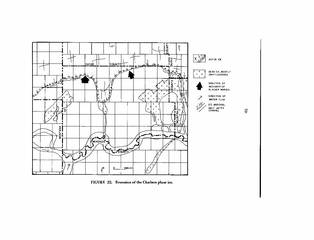
As the Charlson ice reached its maximum advance, the Littl eMissouri River was diverted to its present course, to the east joining theMissouri River about 55 miles southeast of the pre-Charlson junction o fthe Missouri-Little Missouri River . At the time of maximum advance ,the Yellowstone and Missouri Rivers were again diverted out of theirchannels and across divides . When the Charlson ice began to wane andthe margin receded to the north, much of the present day topographyof -southern Williams County was formed .
Till deposits are present in the trench of the Missouri River inWilliams County indicating glaciation after the trench had been cut .The most conspicuous deposit is the till in T. 154 N ., R. 96 W. (pl . 1) .Considerable erosion has removed most of the drift immediatelyadjacent to the Missouri River leaving badlands today . The Charlson ic eprobably withdrew entirely out of Williams County . During thewithdrawal, it left large areas of low-relief, dead-ice moraine especiallyon the topographic highs (fig . 22) . The dead-ice moraine is composed o fmany features, ice-walled lake plains and collapsed lake sediments bothunderlain by silt and clay, as shown on Plate 1 as Lc . The origin of thi stype lake is discussed by Clayton and Cherry (1967) . Disintegratio nridges of till and sand and gravel are a common feature of dead-ic emoraine, and their origin is discussed in detail by Clayton (1967) .
Ice-marginal channels were cut during recession of the ice margin .Stony Creek has a large amount of outwash sand and gravel terraces ;Beaver Creek and Sand Creek are underlain by outwash sand and gravel .Cow Creek contains scattered terraces with remnants of glacial gravel s
45
0
6MILE S
FIGURE 22. Recession of the Charlson phase ice .
ACTIVE ICE
+
+ -f DEAD ICE, MOSTLY+
+ DRIFT COVERED+
+ +
--~
DIRECTION O F
MOVEMENT O FGLACIER MARGI N
DIRECTION O F
\ ~
'
J
WATER FLOW
ICE MARGINAL
MELT WATE RCHANNEL

on some. Many scattered sand and gravel deposits in the area of sheetmoraine are small outwash bodies or ice-contact sand and graveldeposits .
It is possible, as suggested by Howard (1960), that Cow Cree kterraces represent a temporary halt in the recession of the ice . Thisstudy suggests that the Charlson ice margin stopped recedingtemporarily to form the terraces while Howard said it was Middl eWisconsinan (?) ice . Some evidence that supports a temporary halt is ;dead-ice moraine extends south as far as the mouth of Cow Creek in th eLittle Muddy valley (pl . 1), multiple terrace levels along Cow Cree k(Howard, 1960), and a relatively greater thickness of drift north of Co wCreek than south .
The southern one-half of Williams County is sheet moraine . Sheetmoraine is a blanket-like, thin deposit of drift, mostly till which doe snot mask the underlying topography (Kume, 1964) . The contactbetween sheet moraine and ground moraine was arbitrarily determine dand based on the relative abundance of drift mantled channels, driftmantled bedrock scarps and bedrock outcrops south of the contact .
Another temporary pause in the Charlson ice recession allowed theCottonwood Creek melt-water channel (pl . 1 and fig. 23) and theMcGregor melt-water channel to be cut .
Cottonwood Creek is a melt-water channel with steep sides an dgravel deposits scattered along the channel walls . The gravel deposit shave sloping and faulted bedding and are called kame terraces b yWitkind (1959) . Drainage from Cottonwood Creek probably ran botheast and west as the ice pivoted around the bedrock high south o fHanks.
The McGregor end moraine is not very prominent , and probablywas deposited during a short still stand in the ice recession.
The ice margin continued to recede to the north stabilizing whe nthe Grenora, Appam, and Hamlet end moraines were deposited (fig .24) . The glacier ice at this time probably did not recede much to th enorth but remained in place on the Missouri Coteau .
The Missouri Coteau escarpment acted as a barrier restricting th emovement of the Late Wisconsinan ice to generally less than 30 miles .There was considerable shearing of the ice bringing debris up onto th eice surface . The debris insulated the ice slowing the melting . It wasduring this slow melting that much of the outwash was deposited in th eLittle Muddy valley (p1 .1) .
47

ACTIVE IC E
DEAD ICE, MOSTLYCOVERED BY DRIFT
END MORAIN E
WATE R
DIRECTION O FMOVEMENT OFGLACIER MARGI N
+ ++ +
7, 1' ICE MARGINA LMELT WATER CHANNE L
FIGURE 23. A short readvance of ice forming the McGregor end moraine .

MEW= iF/ m
DIVIDE ~f
COUNT
END MORAIN E
WATE R
I DIRECTION O FMOVEMENT O FGLACIER MARGI N
MELT WATE RCHANNE L
DIRECTION O F/,WATER FLO W
FIGURE 24. Final recession of the ice leaving the Grenora, Appam, and Hamlet end moraines .
ACTIVE IC E
DEAD ICE, MOSTLYCOVERED BY DRIF T
+
++

ECONOMIC GEOLOG Y
Petroleum
By far the most important economic resource in Williams Count yis petroleum. Oil was discovered in North Dakota in April, 1951, in th eClarence Iverson number 1, SW 1/4 SW 1/4 sec . 6, T. 155 N., R. 95 W . ,along the Nesson anticline (pl . 1) . Production of oil in Williams Countythrough January 1, 1969 was 102,492,226 barrels of oil . The monthlyproduction for the second half of 1968 was about 530,000 barrel s(North Dakota Geological Survey, 1968). All the oil in William sCounty, except for about 12,000 barrels in a month from the Grenor afield, is produced from the Nesson anticline . Oil and gas productioncomes from Mississippian, Devonian, Silurian, and Ordovician rocks .More detailed information can be found in other North Dakot aGeological Survey publications . A list of publications can be obtainedfrom the North Dakota Geological Survey, Grand Forks, North Dakota .
Lignite
Lignite, one of the most valuable resources, is found throughou tWilliams County . Brant (1953) lists six major lignite beds in the countywith an estimated total original reserve of 26,934,000 short tons . Atpresent, there are only two lignite mines operating in Williams County :the Cedar Coulee Mine number 2, a small underground mine with a nannual production of about 615 tons, and the Nelson Pit, minin gleonardite, producing 4,600 tons per year (Easton, 1967) . The GreatNorthern Railway Company has explored the lignite deposits in th eWilliston basin and has reports on prospects in Williams County whic hare available at the North Dakota Geological Survey office, Gran dForks, North Dakota, or the Great Northern Railway station i nWilliston, North Dakota .
Lignite beds found during this study are fairly persistent . (Seesection on lignite under Tongue River and Sentinel Butte Formations) .At . several locations along the Missouri River, lignite beds are foun d
50

directly under the glacial deposits . The glacial deposits are generallythin along the Missouri River, and most of the lignite beds directl ybeneath the glacial deposits are leonardite . The leonardite mined in theNelson Pit, mentioned above, is of this type .
Throughout the southern part of the county are many abandone dcoal mines which were mined primarily by the landowner for his ow nuse. Near Hanks are several abandoned underground mines whic hsupplied coal for local use .
Plate 3 has a fair representation of the lignite beds found insouthern Williams County . These beds are exposed along the MissouriRiver and are fairly flat lying except near the Nesson anticline .
Halite or Rock Salt
Salt is presently being mined by the Dakota Salt and Chemica lCompany at Williston . This salt is mined hydraulically from th eMississippian "A" salt (Anderson and Hansen, 1957) which is 230 feetthick at a depth of 8,000 feet . Production in 1964 was about 200 ton sper day .
Clay
Clay deposits are extensive in the Fort Union beds of WilliamsCounty. On Plate 3, all the beds which are bentonitic are represente dby the symbol B. An unpublished study by Oscar E. Manz, Cerami cEngineer with the North Dakota Geological Survey in 1961, indicatesthat some of the clays are suitable for ceramic products .
Sand and Gravel
Sand and gravel deposits of various sizes are present in most area sof Williams County . The gravels indicated by yellow on Plate 1 are the
51
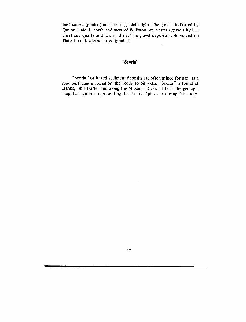
best sorted (graded) and are of glacial origin . The gravels indicated b yQw on Plate 1, north and west of Williston are western gravels high i nchert and quartz and low in shale . The gravel deposits, colored red o nPlate 1, are the least sorted (graded) .
"Scoria"
"Scoria" or baked sediment deposits are often mined for use as aroad surfacing material on the roads to oil wells . "Scoria" is found atHanks, Bull Butte, and along the Missouri River. Plate 1, the geologicmap, has symbols representing the "Scoria " pits seen during this study .
52
SELECTED REFERENCES
Alden, W. C., 1932, Physiography and glacial geology of easternMontana and adjacent areas : U. S. Geol. Survey Prof. Paper 174,133 p .
Anderson, S . B ., and Hansen, Dan E., 1957, Halite deposits in NorthDakota: North Dakota Geol . Survey Rept . Inv. 28.
Armstrong, C. A., 1967, Geology and ground water resources ofWilliams County, North Dakota ; Part II, Ground-water basic data :North Dakota Geol. Survey Bull . 48, 132 p .
Benson, W . E., 1952, Geology of the Knife River area, North Dakota :U . S. Geol . Survey open-file report, 323 p.
Bluemle, John P ., 1967, Multiple drifts in northeast North Dakota, in
Glacial geology of the Missouri Coteau and adjacent areas, NorthDakota Geol . Survey Misc. Series 30, p. 133-136 .
Brant, R. A., 1953, Lignite resources of North Dakota : U. S. Geol .Survey Circ . 226, 78 p .
Brown ., R . W., 1962, Paleocene flora of the Rocky Mountains and GreatPlains: U. S. Geol . Survey Prof. Paper 375, 119 p .
Carlson, C. G., and Anderson, S . B., 1965, Sedimentary and tectoni chistory of North Dakota part of Williston basin : Am. Assoc .Petroleum Geologists Bull ., v . 49, no. 11, p. 1833-1846 .
Clayton, Lee, 1962, Glacial geology of Logan and McIntosh Counties ,North Dakota: North Dakota Geol . Survey Bull . 37, 84 p .
Clayton, Lee, 1966, Notes on Pleistocene stratigraphy of Nort hDakota: North Dakota Geol . Survey Rept . Inv. 44, 25 p .
Clayton, Lee, 1967, Stagnant-glacier features of the Missouri Coteau i nNorth Dakota, in Glacial geology of the Missouri Coteau an dadjacent areas, North Dakota : North Dakota Geol . Survey Misc .Series 30, p . 25-46 .
Clayton, Lee, and Cherry, J . A., 1967, Pleistocene superglacial an dice-walled lakes of west central North America, in Glacial geologyof the Missouri Coteau and adjacent areas, North Dakota : NorthDakota Geol . Survey Misc . Series 30, p . 47-52 .
Collier, Arthur J ., and Thom, W. T., Jr ., 1918, The Flaxville Gravel andits relation to other terrace gravels of the northern Great Plains : U .S . Geol . Survey Prof. Paper 108-J, p . 179-184.
Colton, R. B., 1955, Geology of the Wolf Point quadrangle, Montana :U. S . Geol . Survey Map GQ 67 .
53

Easton, G . B., 1967, Annual Report July 1, 1966 - June 30, 1967 :North Dakota Coal Mine Inspection Department, 7 p .
Fenneman, N . M., 1931, Physiography of western United States : NewYork, McGraw-Hill, 534 p .
Fisher, S. P., 1953, Geology of west central McKenzie County, Nort hDakota: North Dakota Geol . Survey Rept . Inv. 11 .
Hansen, Dan E., 1967, Geology and ground water resources, Divid eCounty, North Dakota ; Part I, Geology : North Dakota Geol .Survey Bull. 45, 90 p .
Howard, Arthur D., 1960, Cenozoic history of northeastern Montanaand northwestern North Dakota with emphasis on the Pleistocene :U. S . Geol . Survey Prof. Paper 326, 107 p .
Jensen, F . S., 1952, Preliminary report on the geology of the Nashuaquadrangle : U. S. Geol . Survey open-file report .
Jensen, F. S., and Barnes, H . D., 1964, Geology of the Fort Peck area ,Garfield, McCone, and Valley Counties, Montana : U. S . Geol .Survey Prof. Paper 414-F, 49 p .
Kume, Jack, 1964, Sheet Moraine in Burleigh County, North Dakota :North Dakota Acad. Sci ., v . XVIII, p . 162-166 .
Kume, Jack, and Hansen, Dan E ., 1965, Geology and ground wate rresources of Burleigh County, North Dakota ; Part I, Geology :North Dakota Geol. Survey Bull . 42, 111 p .
Laird, Wilson M., 1967, A note on preglacial drainage in the norther nGreat Plains, in Glacial geology of the Missouri Coteau an dadjacent areas: North Dakota Geol . Survey Misc . Series 30, p .167-170 .
Larrabee, D . M ., 1947, Preliminary map of construction materials in th esouth one-half of Williams County, North Dakota : U. S . Geol .Survey open-file report .
Lemke, R. W ., and Colton, R. B., 1958, Summary of the Pleistocen egeology of North Dakota, in Mid-Western Friends of th ePleistocene Guidebook 9th Ann . Field Conf. : North Dakota Geol .Survey Misc . Ser. 10, p . 41-57 .
Leonard, A. G., 1908, The geology of southwestern North Dakota wit hspecial reference to Coal : North Dakota Geol . Survey, 5th Biennia lRept., p . 29-113 .
Meek, F. B., and Hayden, F . V., 1862, Descriptions of new lowe rSilurian (Primodial), Jurassic, Cretaceous, and Tertiary fossil scollected in Nebraska . . ., with some remarks on the rocks fro mwhich they were obtained : Philadephia Acad. Nat. Sci. Proc . ,1861, v . 13, n . 415-435 .
54

North Dakota Geological Survey, 1968, Official Oil in North Dakota ,second half 1968 : 163 p .
Royse, Chester F ., Jr ., 1967, Tongue River-Sentinel Butte contact i nwestern North Dakota : North Dakota Geol. Survey Rept . Inv. 45 ,53 p .
Soil Survey Staff, 1951, Soil Survey Manual, U. S. Dept. Agr.Handbook no . 18, 503 p .
Taff, J . A., 1909, The Sheridan coal field, Wyoming : U. S . Geol . SurveyBull . 341, p. 123-150.
Thom, W. T., Jr., and Dobbin, C. E., 1924, Stratigraphy o fCretaceous-Eocene transition beds in eastern Montana and theDakotas : Geol. Soc. America Bull . v . 35, p . 481-506.
Witkind, I . J ., 1959, Geology of the Smoke Creek, Medicine Lake ,Grenora area, Montana-North Dakota : U. S. Geol . Survey Bull .1073, 80 p .
55

![Welcome [library.nd.gov]library.nd.gov/statedocs/ParksRec/statetrailguide20101013.pdfOct 13, 2010 · Indian Hills State Recreation Area 36 Sully Creek State Recreation Area 38 Nature](https://static.fdocuments.net/doc/165x107/5fca39c52e6d5b456d11a1a2/welcome-oct-13-2010-indian-hills-state-recreation-area-36-sully-creek-state.jpg)


![[SEAT BELT USE IN NORTH DAKOTA, JUNE 2008]library.nd.gov/statedocs/Transportation/SeatBeltUse/2008.pdf · Source of Samples 2001 Methodology, approved by NDDOT and NHTSA. Identified](https://static.fdocuments.net/doc/165x107/605b02406967507d7701cee6/seat-belt-use-in-north-dakota-june-2008-source-of-samples-2001-methodology-approved.jpg)


