
Geology and Basalt Stratigraphy of the Weiser Embayment...
26
103 Geology and Basalt Stratigraphy of the Weiser Embayment, West-Central Idaho by James F. Fitzgerald* ABSTRACT The Weiser embayment in west-central Idaho is the southeasternmost extension of the Columbia Plateau. It is made up of rocks of the Columbia River Basalt Group. Field mapping and X-ray fluorescence chemical analysis of numerous samples resulted in a geologic map and the delineation of both regional and localized Columbia River basalt units in the embayment. Subbasalt rocks consist of Permian to Jurassic metavolcanic and metasedimentary lithologies, Meso- zoic schists and gneisses, and Mesozoic and Cenozoic granodiorite to quartz diorite intrusive complexes. Prior to basalt extrusion, basement rocks were eroded into a relatively mature topography with considerable local relief. Regional Imnaha and Grande Ronde Basalt se- quences are present in the Weiser embayment. Over 700 meters of Imnaha Basalt first spread over low- lands and filled canyons to establish the general con- figuration of the embayment. The overlying Grande Ronde Basalt sequence was more constrained in ‘Editors’ note: James F. Fitzgerald was a graduate student at the University of Idaho in 1977 when he embarked on the research reported in this article. It was his intention to submit the completed research to the University of Idaho to fulfill the requirements for his Ph.D. degree in geology. Toward that end he spent the summers of 1978 and 1979 in the field and the remainder of his time in classroom and laboratory studies at the University of Idaho and Washington State University. Unfortunately, he was never able to complete the research, due to his untimely death in the May 18, 1980, cataclysmic eruption of Mount St. Helens in Washington. By the time of his death he had nearly completed the field and laboratory research upon which this report is based. It is important to note that the final field work, much of the interpreta- tion of the field and laboratory investigations, and the preparation of the written account were completed by his friends and associates. In large part, credit for completion of the project is due to the dili- gent efforts of John G. Bond and John D. Kauffman of Geoscience Research Consultants, and their associates William C. Rember and Donna J. Shieveler, all of Moscow, Idaho Not only did the fine work of these people make it possible for this article to be com- pleted, but their efforts in completing the research also made it possible for Jim Fitzgerald to be granted posthumously, in May 1981, the Ph.D. degree in geology from the University of Idaho. extent. A thickness of 150 to 300 meters accumulated in the northwestern part of the embayment; progres- sively thinner accumulations occur to the south and east. A few thin, ashy interbeds occur locally within both the Imnaha and Grande Ronde sequences. Minor warping of the Grande Ronde surface preceded extrusion of the localized Weiser Basalt units and accumulation of the associated pyroclastic and fluvial sediments. Four distinct units were identi- fied within the Weiser Basalt sequence: the Cambridge member, the Sugarloaf member, the Star Butte member, and the basalt of Black Canyon. These units were defined by physical, chemical and remanent magnetic characteristics, and by stratigraphic posi- tion. Common to each is a relatively high (generally above 16 percent) A1203 content when compared to the regional units. Two vents and related pyroclastic accumulations exposed at the top of the Weiser Basalt are included in that sequence, although they could not be correlated with any specific unit. Addi- tional localized basalt units may also occur in the embayment. The geographically isolated basalt of Cuddy Moun- tain could not be chemically or stratigraphically correlated with Imnaha, Grande Ronde, or Weiser Basalts. Field relations suggest it may actually consist of both pre- and post-Grande Ronde Basalt flows. Following the Weiser Basalt eruptive episode, structural activity became pronounced. Basement blocks were uplifted and tilted into fault-blocks and horst and graben structures, generally along preexist- ing zones of weakness. Three major fault patterns developed in the embayment. These are (I) the Long Valley fault system-a north-trending block-fault pattern along the eastern margin of the embayment, (2) the Paddock Valley fault system-a northwest- trending open-fold and block-fault pattern in the south-central and southwestern portion of the embay- ment, and (3) the Snake River fault system-a north- east-trending block-fault pattern in the northwestern portion of the embayment. All three systems extend beyond the embayment and are regional in perspec- tive. Other structural activity includes continued
-
Upload
dinhkhuong -
Category
Documents
-
view
235 -
download
2
Transcript of Geology and Basalt Stratigraphy of the Weiser Embayment...

103
Geology and Basalt Stratigraphy of the Weiser Embayment, West-Central Idaho
by James F. Fitzgerald*
ABSTRACT
The Weiser embayment in west-central Idaho is the southeasternmost extension of the Columbia Plateau. It is made up of rocks of the Columbia River Basalt Group. Field mapping and X-ray fluorescence chemical analysis of numerous samples resulted in a geologic map and the delineation of both regional and localized Columbia River basalt units in the embayment.
Subbasalt rocks consist of Permian to Jurassic metavolcanic and metasedimentary lithologies, Meso- zoic schists and gneisses, and Mesozoic and Cenozoic granodiorite to quartz diorite intrusive complexes. Prior to basalt extrusion, basement rocks were eroded into a relatively mature topography with considerable local relief.
Regional Imnaha and Grande Ronde Basalt se- quences are present in the Weiser embayment. Over 700 meters of Imnaha Basalt first spread over low- lands and filled canyons to establish the general con- figuration of the embayment. The overlying Grande Ronde Basalt sequence was more constrained in
‘Editors’ note: James F. Fitzgerald was a graduate student at the University of Idaho in 1977 when he embarked on the research reported in this article. It was his intention to submit the completed research to the University of Idaho to fulfill the requirements for his Ph.D. degree in geology. Toward that end he spent the summers of 1978 and 1979 in the field and the remainder of his time in classroom and laboratory studies at the University of Idaho and Washington State University. Unfortunately, he was never able to complete the research, due to his untimely death in the May 18, 1980, cataclysmic eruption of Mount St. Helens in Washington. By the time of his death he had nearly completed the field and laboratory research upon which this report is based. It is important to note that the final field work, much of the interpreta- tion of the field and laboratory investigations, and the preparation of the written account were completed by his friends and associates. In large part, credit for completion of the project is due to the dili- gent efforts of John G. Bond and John D. Kauffman of Geoscience Research Consultants, and their associates William C. Rember and Donna J. Shieveler, all of Moscow, Idaho Not only did the fine work of these people make it possible for this article to be com- pleted, but their efforts in completing the research also made it possible for Jim Fitzgerald to be granted posthumously, in May 1981, the Ph.D. degree in geology from the University of Idaho.
extent. A thickness of 150 to 300 meters accumulated in the northwestern part of the embayment; progres- sively thinner accumulations occur to the south and east. A few thin, ashy interbeds occur locally within both the Imnaha and Grande Ronde sequences.
Minor warping of the Grande Ronde surface preceded extrusion of the localized Weiser Basalt units and accumulation of the associated pyroclastic and fluvial sediments. Four distinct units were identi- fied within the Weiser Basalt sequence: the Cambridge member, the Sugarloaf member, the Star Butte member, and the basalt of Black Canyon. These units were defined by physical, chemical and remanent magnetic characteristics, and by stratigraphic posi- tion. Common to each is a relatively high (generally above 16 percent) A1203 content when compared to the regional units. Two vents and related pyroclastic accumulations exposed at the top of the Weiser Basalt are included in that sequence, although they could not be correlated with any specific unit. Addi- tional localized basalt units may also occur in the embayment.
The geographically isolated basalt of Cuddy Moun- tain could not be chemically or stratigraphically correlated with Imnaha, Grande Ronde, or Weiser Basalts. Field relations suggest it may actually consist of both pre- and post-Grande Ronde Basalt flows.
Following the Weiser Basalt eruptive episode, structural activity became pronounced. Basement blocks were uplifted and tilted into fault-blocks and horst and graben structures, generally along preexist- ing zones of weakness. Three major fault patterns developed in the embayment. These are (I) the Long Valley fault system-a north-trending block-fault pattern along the eastern margin of the embayment, (2) the Paddock Valley fault system-a northwest- trending open-fold and block-fault pattern in the south-central and southwestern portion of the embay- ment, and (3) the Snake River fault system-a north- east-trending block-fault pattern in the northwestern portion of the embayment. All three systems extend beyond the embayment and are regional in perspec- tive. Other structural activity includes continued

104 Cenozoic Geology of Idaho
downwarping of the central embayment area and up- lifting of the Seven Devils area connected by the south-dipping Seven Devils homocline, plus doming and anticlinal-synclinal warping southwest of Cuddy Mountain. Postbasalt terrigenous sediments accumu- lated in basins and along the southern margin of the embayment; these remain relatively undeformed.
INTRODUCTION
The eastern part of the Columbia Plateau consists of three major lobes of basalt which protrude into Idaho. From north to south these are called the Benewah, Clearwater, and Weiser embayments (Fig- ure 1). The northern and central basalt lobes were mapped by Bishop (1969) and Bond (1963), respec- tively. Subsequently, these were mapped and studied in additional detail by Camp (in Swanson and others, 1979a, 1981; Camp, 1981; Camp and Hooper, 1981; Camp and others, 1982 this volume). The southern- most lobe, the Weiser embayment, however, has been the subject of only localized mapping by the U. S. Geological Survey (McIntyre, 1976a, 1976b) and a number of theses by students mainly from the Uni- versity of Idaho and Oregon State University (Breeser, 1972; Fankhauser, 1968; Juras, 1973; King, 1971; Nakai, 1979; Paris, 1969; Shah, 1966, 1968; Skurla, 1969; Slater, 1969). The Columbia River Basalt Group in the Weiser embayment has not been previously studied and mapped in a regional strati- graphic format.
This study examines in detail these basalt flows of the Weiser embayment in order to (I) determine the interrelations of observations and findings from prior field projects conducted in scattered parts of the embayment, (2) complete the mapping of previously unmapped regions of the embayment, (3) establish a stratigraphic framework for Weiser embayment basalt flows and correlate it with the chemical-magneto- stratigraphic framework established by Swanson and others (1979b) for Columbia River Basalt Group units of the Columbia Plateau, and (4) determine the current structural setting of the embayment and fit this pattern into the volcanic history and postextru- sion structural evolution of the Columbia Plateau.
The full results of this study have been incorporated in the plateauwide investigation being compiled by the U. S. Geological Survey. The results are also reported in Rockwell Hanford Operations Basalt Waste Isola- tion publication RHO-BWI-SA-217p, (1982). All preserved field notes, basalt samples, and analytical data are on file with the Rockwell Hanford Opera- tions Basalt Waste Isolation project at Richland, Washington.
LOCATION AND GEOMORPHIC SETTING
The Weiser embayment is the southeastern lobe of the Columbia River Basalt Group at the eastern edge of the Columbia Plateau in west-central Idaho (Figure I). It is bounded on the east by the Salmon River Mountains, and on the west by the deep canyon of the Snake River. It is bounded on the north by the Seven Devils Mountains, and on the south by the Snake River Plain. The embayment is roughly delta- shaped, approximately 130 kilometers from north to south, and 75 kilometers wide near the Snake River Plain; it covers about 7,500 square kilometers. The map area, including the main geographical locations and features, is shown in Figure 2.
Topographic relief is greatest near the northwestern and eastern mountainous margins of the delta-shaped area. These uplifted areas, with elevations over 2,135 meters (7,000 feet), are separated by a broad, topo- graphically subdued, southerly plunging synclinal depression with elevations below 915 meters (3,000 feet). Local relief around the periphery of the em- bayment is as much as 1,525 meters (5,000 feet). Local relief within the central Indian Valley synclinal portion of the area ranges between 90 and 185 meters (300 and 600 feet), except where block faulting has occurred along the flanking limbs or where stream dissection is marked.
The Weiser River drainage system dissects the interior of the embayment. Deep, youthful canyons of the Weiser system include Crane Creek canyon
CANADA .-.-.-.-.- .-.-. -.-.-.
WASHINGTON :-7'-
0 )/ Embiymen w 4 OREGON I >
Figure I. Location map of Columbia Plateau and major basalt embayments in Idaho (after Waters, 1961; Swanson and others, 1979b).

Fitzgerald-Basalt of Weiser Embaymenr 105
.+ ,/=-+@Horseshoe Bend
to 0 to 20
10 0 to 20 30 0
Figure 2. Location map of the Weiser embayment. Idaho
east-northeast of Weiser and the main Weiser River canyon north of Council and south of Cambridge. These canyons generally have walls cut 250 meters (800 feet) or more in Columbia River basalt flows. The Snake River and its tributaries of the western border area and those of the Payette River on the east have cut through the basalt to expose subbasalt rock units.
STUDY METHODS
Field work in the Weiser embayment consisted of a reconnaissance and planning inspection in 1977, detailed mapping and sampling of the central and southern portions of the area in the summer and fall of 1978, and detailed mapping and sampling of the northern portion and other incompletely mapped localities in the summer and fall of 1979.
The basalt flows were grouped into stratigraphic
units by using lithologic and hand-specimen charac- teristics, lateral correlation of sampled and described canyon sections, and paleomagnetic properties.
For geochemical characterization, major oxide abundances for approximately 280 basalt samples were determined by X-ray fluorescence at the depart- ment of geology, Washington State University, during the winter and spring following the two major field seasons. The report was prepared while at the depart- ment of geology, University of Idaho.
PREVIOUS INVESTIGATIONS
COLUMBIA PLATEAU FLOOD BASALT UNITS
Until the mid-1950’s, most geologists regarded the Columbia Plateau of Idaho, Washington, and Oregon (Figure I) as composed of a monotonous, uninterest- ing sequence of flood basalts. During the last twenty years, however, the areal distribution, physical and chemical properties, and petrogenesis of individual basalt flows have been the subjects of intensive scientific investigations.
Waters (1961) was the first to divide Columbia River basalt flows (after the Columbia basalt and Columbia River basalt of Russell, 1893 and 1901, respectively) into three formal, regional stratigraphic types-Picture Gorge Basalt, Yakima Basalt (after Yakima basalt of Smith, 1901) and Late Yakima Ba- salt. Using Waters’ oldest-to-youngest stratigraphic framework and Mackin’s (1961) flow-by-flow field identification approach, such subsequent workers as Grolier (1965) Bingham and Walters (1965) Schmincke (1967), Swanson (1967), and Lefebvre (1970) were able to delimit accurately the continuity of individual flows and sequences of flows over several tens of kilometers in western and central portions of the Columbia Plateau. Similarly, broad- area stratigraphic correlations were made by Bond (1963) and Bishop (1969) for basalt flows of the Columbia Plateau that extended eastward into north- ern Idaho. These various studies from throughout the Columbia Plateau demonstrated the viability of a regional stratigraphic framework.
Waters’ initial three-unit stratigraphic classifi- cation was subsequently modified by Wright and others (1973), who further divided Columbia River basalt flows into chemical types and suggested a four-unit, oldest-to-youngest stratigraphic grouping- Picture Gorge, lower Yakima, middle Yakima, and upper Yakima Basalts. This framework was refined more recently (Swanson and others, 1979b) with the establishment of a Columbia River Basalt Group

106 Cenozoic Geology of Idaho
which has been subdivided into one subgroup-the Yakima Basalt, five formations-the Imnaha, Pic- ture Gorge, Grande Ronde, Wanapum, and Saddle Mountains Basalts, and fourteen members (Figure 3). Chemical analysis data were important parameters in developing these units, which have become the work- ing nomenclature of the basalt sequences of the Columbia Plateau (Camp and others, 1982 this volume).
Findings from the Weiser embayment demonstrate that the regional Imnaha and Grande Ronde Basalts persist into the southern Columbia Plateau area of Idaho. In addition, a younger, relatively unmapped and previously unnamed Weiser Basalt sequence occurs in the embayment and is added to the estab- lished stratigraphic framework (Figure 4).
WEISER EMBAYMENT STRATIGRAPHY
Lindgren (1898), the first geologist to report on
Waters
_---.
Yakima
Basalt
Picture Gorge Basalt
Wright and others Swanson and others
Upper
Yakima
Middle
Yakima
Basalt
Lower
Yakima
Basalt
Picture Gorge
Basalt
/
that portion of Idaho including the Weiser embay- ment, noted that unconformable relations exist be- tween the flood basalts of the area and the underlying granite, and also between the sequence of basalt flows and the overlying sedimentary Idaho Formation. Later, Kirkham (1930, 1931). who studied the south- ern part of the embayment from the Snake River west of Weiser to Horseshoe Bend near the eastern margin, noted that “a series of terrestrial deposits and lake beds exists in the Columbia River basalt”and that “a series of terrestrial deposits and lake beds, in places several thousand feet thick, overlies the Columbia River basalt and Owyhee rhyolite” (1931, p. 201) which he redefined as the Payette and Idaho Forma- tions respectively. By his definition, the Payette Formation includes all sediments interbedded with Columbia River basalt flows; the Idaho Formation applies to all sediments overlying these basalt flows. Anderson (1934) extended the basalt discussion of Kirkham into the Pearl area east of Horseshoe Bend, noting the existence of two types of basalt-olivine free and olivine rich-in this very distal portion of the
Vanapum
3asalt
irande 3onde 3asalt
Picture Gorge I Basalt i
lmnaha
Basalt
Lower Monumental Member
Ice Harbor Member
Buford Member
Elephant Mountain Member
Pomona Member
Esquatzel Member
Weissenfels Ridge Member
Asotin Member
Wilbur Creek Member
Umatilla Member
Priest Rapids Member Roza Member Frenchman Springs Member Eckler Mountain Member
N*
Figure 3. Sequential development of Columbia River Basalt Group stratigraphic nomenclature (after Waters, 1961; Wright and others, 1973: Swanson and others. 1979b).

Fitzgerald-Basah o/ W&u Embaymenf 107
Columbia Plateau. Two comparable mineralogical of the sediments of the Payette Formation appeared types of basalt were noted by Savage (1958, 1961) as to overlie the main body of lava and that most of the occurring in the southern portion of the embayment. lava flows exposed in Crane Creek canyon composi- After conducting a paleontological study of the sedi- tionally were andesites rather than basalts. Nakai ments associated with basalt of the southern embay- (1979), in a study of hydrocarbon-storage potential of ment margin, Shah (1966, 1968) concluded that the the Payette Formation, identified several basalt flows oldest Columbia River basalt flows in that region interlayered with sediments in four measured sections were to the west along the Snake River. east of Weiser.
Most recent field investigations which have touched on basalt stratigraphy of the Weiser embayment generally have been either (I) very localized geo- thermal or mineral-resource studies of parts of the southern and western portion of the embayment, or (2) highway-corridor studies concerned with general surficial mapping and engineering needs in the central and northern portion of the embayment.
Young and Whitehead (1975) and McIntyre (1976b) analyzed hot springs in Crane Creek canyon in the south-central part of the embayment and mapped areas surrounding them. A photogeologic map of the general Cambridge-Council area also was prepared by McIntyre (1976a). McIntyre concluded that most
Previous studies in the western and northern portions of the embayment, in particular, reflect the changes in basalt nomenclature that occurred else- where on the Columbia Plateau during the 1960’s and 1970’s. For example, mineral deposit studies in the Sturgill Peak-Cuddy Mountain area, conducted by Fankhauser (1968) Slater (1969) and King (1971) subdivided the then “Columbia River Basalt” into phyric “Picture Gorge” and aphyric “Yakima” se- quences after the stratigraphic framework established by Waters (1961) for the basalt flows to the west.
About the same time Hoover (1968) used a “Lower” (phyric) and “Upper” (aphyric) basalt stratigraphic nomenclature in his U. S. Highway 95 corridor study,
Swanson and others Fitzgerald
rVanapun
3asalt
Srande Ronde Basalt
iq Gorge t Basalt I
lmnaha
Basalt
1
Lower Monumental Member N
ice Harbor Member N.R,N
Buford Member R
Elephant Mountain Member N
Pomona Member R
Esquatzel Member N
Weissenfels Ridge Member N
Asotin Member N
Wilbur Creek Member N
Umatilia Member N
Priest Rapids Member R3 Roza Member T,R, Frenchman Springs Member N,
Eckler Mountain Member N,
R2 NT
5 T
NO
?
?
?
.- - /
/?
-
2i a m” B 2
-
Star Butte Member N
Sugarloaf Member R
Cambridge Member R
Grande Ronde
Basalt
N,?
R,?
lmnaha Basalt R, T
NO
Figure 4. Comparison of regional Columbia River Basalt Group stratigraphic sequence, on left, with Weiser embayment basalt sequence, on right. Correlation of Wetser Basalt to Wanapum Basalt and Saddle Mountains Basalt is uncertain (after Swanson and others, 1979b; Fitzgerald, 1982).

108 Cenozoic Geology of Idaho
similar to that estabished by Bond (1963) to the north. The presence of younger local vent rock and near-vent flows also was recognized by Hoover in the Cambridge area. Later, Breeser (1972) and Vallier and Hooper (1976) used the terms Imnaha and Yakima to designate the same or correlative se- quences of phyric and aphyric, older and younger basalt units.
In summary, geologists previously working with the Weiser embayment generally approached dividing basalt flows and associated sediments into mappable stratigraphic units by using local field and hand- specimen relationships. Investigators in the southern portion of the embayment commonly used Payette Formation interbeds as the breaks between selected map units. In contrast, investigators working to the west and north used broad-area phyric-aphyric basalt flow associations for older and younger (now Imnaha and Grande Ronde) map-unit boundaries. Post- Yakima Basalt units (Weiser Basalt), where recog- nized, were considered to be near-source, Pliocene(?) flows.
For further overviews or extensions of current basalt stratigraphic associations into nearby areas, the reader is referred to Bond (1978) Gaston and Bennett (1979), Mitchell and Bennett (1979a, 1979b), Strowd (1978), Myers and others (1979), Camp (1981), Camp and Hooper (1981), Hooper (1982), Camp and others (1982 this volume), and Reidel (1982 this volume).
GENERALGEOLOGY
SUBBASALT ROCKS AND CONDITIONS
Based on data sources previously cited and the field observations of this study, rocks older than the Columbia River Basalt Group in the vicinity of the Weiser embayment, from oldest to youngest, include Permian to Jurassic metavolcanic and metasedimen- tary lithologies, Mesozoic schists and gneisses, and Mesozoic to Cenozoic granodiorite to quartz diorite intrusive bodies. These basement rocks are exposed locally above plateau level as ancestral highlands and steptoes and below plateau surface elevations where they have become exposed by erosion.
Subbasalt rocks were eroded into a relatively mature topography prior to extrusion of the Colum- bia River Basalt Group in middle Miocene time. The Peck Mountain, Cuddy Mountain, and Sturgill Peak steptoes and nearby exhumed basement surfaces, plus erosional exposures of basement-basalt contacts in the Snake River canyon, demonstrate that more than
915 meters of relief characterized western Idaho in the early Miocene. Well-developed westerly to south- westerly flowing drainage systems existed at that time. Contact relations between basalt flows and older rocks along the eastern border of the embay- ment show that the subcropping basement paleo- topography was youthful to mature. Here, thick sections of basalt, as on Squaw Butte, give way easterly in less than IO kilometers to markedly unconformable basalt-basement contacts and base- ment uplands.
BASALT DISTRIBUTION
The eruption of fluid Miocene Columbia River lavas approximately 17 to 14 million years ago (McKee and others, 1981) consisted of sheets of Imnaha Basalt followed by those of Grande Ronde Basalt that spread westerly into and through the lowlands and valleys of the embayment. At least 700 meters of Imnaha Basalt spread over many low-lying areas. The Imnaha, the principal sequence of flows to spread almost completely across the area, established the general configuration of the embayment. The overlying Grande Ronde sequence was more limited areally; its thickest portion of 150 to 300 meters was toward the northwest, and it progressively thinned to the south and east. The southeastern wedge-edge margin of initial Grande Ronde Basalt distribution was near Squaw Butte.
During quiescent periods between eruptive epi- sodes in Imnaha and Grande Ronde time, fine- to medium-grained sediments from adjoining upland areas were deposited on the transient, constructional plateau, particularly near its margins. Ashy layers and weathered soil zones also formed on the plateau surface and were preserved as volcaniclastic and saprolitic interbeds by succeeding flows. Together, these scattered, relatively thin interbeds can most appropriately be categorized as “lower” Payette For- mation. They are not extensively exposed in the embayment.
By the end of the Imnaha and Grande Ronde volcanism, the broad plateau of the Weiser embay- ment, excluding basement steptoes, covered the older terrain east of its current erosional margin, as shown by basalt remnants overlying Idaho batholith rocks at many localities east of Payette River canyon. At the end of Grande Ronde volcanism the Weiser embay- ment locally merged northward with the Clearwater embayment through saddles between the Seven Devils steptoes. The plateau surface also extended south- ward into the area now down-dropped and filled by terrigenous deposits of the late Cenozoic Snake River Plain. Basement steptoes remained above plateau

Fitzgerald-Basal of Weiser Embayment 109
level in the Seven Devils Mountains area in the north, at Peck Mountain, Cuddy Mountain, and Sturgill Peak in the west, in the McCall-Payette River area in the east, and locally elsewhere.
Prior to major deformation and erosion, and penecontemporaneous with early downwarping of the central part of the embayment, sediments from eastern upland areas accumulated on the plateau surface. These fluvial sediments were deposited by streams from preexisting upland drainage systems as they ponded and spilled generally westward across the plateau toward the Pacific Ocean.
Concurrently with downwarping, sporadic local volcanism commenced within the embayment, per- haps as early as Grande Ronde time in the Cuddy Mountain area. However, most of this volcanism, the Weiser volcanic episode, followed the accumula- tion and initial warping of the Grande Ronde Basalt. Weiser volcanism is recorded by localized accumu- lation of lava flows and associated near-vent ejecta and coarse-grained pyroclastic debris. This sequence now forms the bulk of the basalt exposed in the structurally depressed south-central portion of the embayment.
Locally, up to 350 meters of Weiser Basalt accu- mulated in a nearly flow-on-flow sequence. Intercala- tion of sediments, ash layers, pyroclastic units, and basalt flows commonly occurred during the Weiser eruptive interval so that stratigraphic sections vary from 100 percent sediments and ash to nearly 100 percent lava flows and associated pyroclastic accumu- lations. The sediments and ashy material associated with Weiser Basalt flows and pyroclastic layers are aptly called “upper” Payette Formation.
The greatest thickness of Weiser Basalt and asso- ciated sediments accumulated in the downwarped lndian Valley trough in the central part of the embayment. However, flows, pyroclastic units, ash layers, and associated sediments of the Weiser Basalt sequence, with the exception of the basalt of Cuddy Mountain, extend as far north as Mesa, as far east as Montour near the Payette River, as far west as Warm Springs Creek northwest of Weiser, and at least as far south as the northern edge of the Snake River Plain.
In the southeastern part of the embayment, poorly sorted, coarse-grained arkoses are exposed locally near the basalt-basement contact and also in associa- tion with flows of the Weiser Basalt. These sediments generally reflect the composition of nearby granitic basement, show only short transport, are moderately lithified, and typically dip less than 10 degrees. They are principally of Weiser Basalt age and have resulted from the influx of abundant basement detritus. Some postdate Weiser Basalt units and are relatively un- deformed.
The general characteristics of the various basalt
units in the Weiser embayment are summarized in Table I, and the geographic distribution of the main units are indicated in Figure 5
A N
EXPLANATION
Weiser Basalt
Grande Ronde Basalt
Basalt of Cuddy M in
Pre- and Post- Basalt Units
Imnaha Basalt
El
0
Figure 5. Generalired geologic map of the Weiser embayment showing basal! distribution

110 Cenozoic Geology of Idaho
POSTBASALT CONDITIONS
Following the Weiser episode of Miocene-age volcanism, structural activity became pronounced in the eastern and western parts of the embayment, as granitic and metamorphic basement blocks were jostled and uplifted into a series of tilted fault blocks and imperfect horst and graben structures. Movement commonly occurred along preexisting zones of weak- ness. Sediments continued to accumulate on the plateau, particularly in down-dropped and down- warped areas of the central and southern portion of
the embayment. At the same time the Snake River took its present course south of the embayment and west of the Seven Devils steptoe flowing northward to the Columbia River. The postbasalt terrigenous sediments which accumulated at that time and still remain relatively undeformed are primarily associated with the embayment’s southern margin, the Snake River Plain. They are most aptly categorized as Idaho Formation.
Following volcanism, three major fault patterns developed or continued to develop in different por- tions of the embayment. These are (1) a north-
Table I. Summary of physical characteristics of Weiser emhayment basalt units.
Vent rind pyrwinstie mrterisf in the W&&r-Bitt&It
Near-vent units appear as low hummocky slopes and mounds: pumice-laden tuffs form coarsely “etched” surfaces, Band speci- mens consist of volcaniclastic material. Bombs and other ejecta occur near vents. Lapilli tuff with abundant pm&e is Common. Pyroclastic material is associated with the Cambridge, Sugarloaf, and Star Butte members of the Weiser Basalt and is abundanf in the Stockton Ranch and We&r River vents.
Star Buttr member of the Weiser B&At
Paleomagnetically normal, Locally forms columnar-joinIed mas- sive cliffs; weathers black. Overlies a tuffaceous interbed in most areas. Hand specimens are aphyric to slightly ph+rio with small plagioclase phenocrysts visible in some samples. Unit consists of 2 to 4 flows.
Sugarloaf member of the W&w Bssnlf
Paleomagnetically reverse. Fotms cliffs atong canyons; commonly weathers to subrounded boulders 0.5 to 2.0 metels in diameter. Sooty appearance common on weathered outcrops. Hand speci- mens have a grainy appearance and are phyric, with plagioclase and minor olivine and pyroxene phenocrysts visible on most surfaces. Finely vesicular to microvesicular; a resinous appearance is common. Unit probably contains 15 to 20 flows of basalt 1o basaltic andesite.
Cambridge member of the Weiser Basalt
phyric, nearly nonvesicular nature appears to be characteristic. Coarsely phyric type fofms columnar-jointed (columns 10 to 16 centimeters across) ledges; sparsely phyric type forms massive outcrops. Locally, phyric type forms prominent cliffs with talus slopes at base: several tiers occur in the thick accumulation on Cuddy Mountain. Hand speqimens vary from coarsely phyric (abundant pyroxene crystals 0.3 to 2.5 centimeters long) to nearly aphyric. Rocks are black, dense, and non~esicular at most exposures. Weathering forms pits in pyroxene-rich flows (coarsely phyric), to give a vesicular appearance. The stratigraphic position of this unit has not been determined from field relationships; it may be as old as Imnaha Basalt or as young as part of the Weiser Basalt.
Grande Ronde Basal
Reverse paleomagnetism is most common, but normal paleo- magnetism readings have been recorded locally within the reverse sequeuees, The upper flow or flows have normal paleomagnetism in the southeast pbrrion of the embayment and perhaps elsewhere. Where dipping 10 degrees or less, rubbly flow tops or basal columns form intermittent low-relief ledges on slopes; where dipping more steeply, cliffs are more pronounced. Light reddish brown residual soil and weathered flow-top surfaces typify the unit and are most pronounced in lowdip areas. Hand specimens generally are aphyric, but narrow plagioclase laths are scattered in some flows. A sugary texture is common. Medium dark gray: weathered specimens show yellowish green mottling on freshly broken surfaces in most samples.
Paleomagnetically reverse. Forms cliffs on steep slopas; weathers dark brown. Scoriaceous, rubbfy, purple and pinkish purple flow tops are prominent in road cuts south of Cambridge. Hand specimens are sparsely phyric to phyric with plagioclase and minor olivine and pyroxene phenocrysts. Dark gray to black, glassy, and microvesicular. Unit consists of 12 to 14 flows,
Bssalt of Black Canyon member of the W&w Basalt
Paleomagnetically normal. Forms massive, bulbous cliffs; is very dark colored; has extremely hackly jointing and little or no internal. structure. Hand specimens are aphyric, very dense, black, and glassy. Rocks are characterized by numerous joints intersecting aI acute angles. Occurs as a thick valley- or canyon-filling Row neat Black Canyon Dam. The stratigraphic position of &is unil relative to the other membersof the Weiser Basalt has notbeendetermined due to its geographic isolation,
Basalt of Cuddy Mountain
Both normal and reverse paleomagnetic determinations ‘were obtained. Unit appears to consist of m6re than one flow or sequence of flows. A highly phyric, nonvesicular type is common in the Pyramid Peak area of Cuddy Mountain, &ewhere, a sparsely
Imnaba Bzasatt
Normal paleomagnelism (probably the NO magnetostratigraphic epoch) ocqurs.in most stratigraphic sections, except in the south- eastern portion of the embayment. A stratigraphically lower, paleomagneticatlp reverse (probably the b magnetostratigraphic epoch) section has been documented only on the east side of Squaw Butte. The unit may have one or more paleomagneticaily traasibonal or reverse (perhaps the early part of the RI magneto- stratigraphicepoch) flowsat the tops of some sections. Commonly forms steep cliffs from basal columns and retreating slopes from upper portions of flows in rugged areas. Dip slopes tend to have patchy irregular outcrops. Columns weather dark brown to sooty or resinou’s in appearance. Flow tops are rubbly and pinkish purple to purple, particularly in the south. Hand specimens are sparsely phyric t6 extremely phyric. Phenocrysts are mostly plagioclase laths 0.5 (a 3.0 centimeters long, but some olivine and pyroxene phenocrysts are present. Rocks are black (sooty to resinous) in appearanne, with a microvesicular to diktytaxitic texture in many flows. Sparsely phyrie flows cammonly are more dense and glassy. Unif contains as many as 19 flows in a single exposed sequence; its base is not exposed.

Fitzgerald-Basalt of Weiser Embaymenf 111
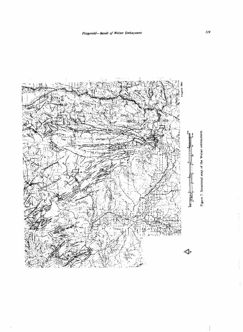
trending block-fault pattern along the eastern margin of the embayment referred to as the Long Valley fault system (after Capps, 1941), (2) a northwest-trending open-fold and block-fault pattern in the south-central and southwestern portion of the embayment called the Paddock Valley fault system, and (3) a northeast- trending block-fault pattern in the northwestern portion of the embayment called the Snake River fault system (after Newcomb, 1970) (Figure 7). All of these fault systems extend beyond the Weiser embay- ment and are regional in perspective.
Other postbasalt structural activity included the continued broad downwarping of the central embay- ment Indian Valley trough, a synclinal depression, and upwarping of the Seven Devils area. Doming and weak anticlinal-synclinal folding along northwesterly axes that parallel the Paddock Valley fault system became more pronounced at this time southwest of Cuddy Mountain through the Sturgill Peak area to Dead Indian Ridge. This style of deformation has continued to contribute to the late Cenozoic topo- graphic development of major geographic features in the western part of the embayment.
IMNAHA BASALT
Eruption of Imnaha Basalt flows began approxi- mately 17 million years ago (McKee and others, 1981) during the Ro paleomagnetic epoch. Imnaha flows covered nearly all of the Weiser embayment (Figure 5) by the end of the No paleomagnetic epoch or early during the RI epoch. These flows apparently were extruded during several separate eruptive events from numerous feeder dikes west of the embayment and along its western margin.
In the southeastern corner of the embayment, near the distal margin of the original Columbia Plateau, over 400 meters of lmnaha Basalt accumulated during the Ra and the succeeding No paleomagnetic epochs. There, at least nineteen flows, aggregating 400 meters of R” and No basalt, occur in a single stratigraphic section at Squaw Butte (sec. 26, T. 8 N., R. 1 W.). A minimum of twelve flows, aggregating 200 meters of No lmnaha Basalt, is exposed at the nearby Big Willow Creek section (sec. 28, T. 9 N., R. I W.).
A minimum thickness of 700 meters of NO lmnaha Basalt accumulated in ancestral lowland portions of the western Weiser embayment near known sources. This thickness is continuously exposed in the canyons of the Snake River and its major tributaries north- west of Cuddy Mountain. In this portion of the embayment, fourteen flows of No basalt occur in a single section at Wildhorse Canyon (sec. 23, T. 18 N.,
R. 4 W.). If intraformational chemical breaks can be used for lateral correlations (see discussion below), a minimum of twenty-five No flows of Imnaha Basalt, aggregating 900 meters, can be recognized in a composite section at Oxbow Dam and Wildhorse Canyon.
No subbasalt rocks are exposed below the lowest outcrops in any of the thick Imnaha Basalt sections previously discussed in either the southeastern or northwestern embayment areas: therefore, a greater overall thickness undoubtedly is present.
The lmnaha sequence of flows changes upward from a very phyric lower portion to a nearly aphyric central portion to a coarsely phyric upper portion. The phyric flows generally have large phenocrysts of plagioclase and olivine that measure as much as I to 2 centimeters and 0.5 to I centimeter in length, respec- tively. lmnaha flows generally range in thickness from 20 to 60 meters. Flow-top breccia is present in a few flows.
The phyric, coarse-grained nature of most flows, along with their intergranular glass content, makes the Imnaha Basalt relatively susceptible to surficial weathering. The basalt commonly disaggregates into grus, particularly in the middle and upper portions of a flow, forming canyon walls that consist of a series of relatively subdued slopes developed from the upper parts of flows and nearly vertical cliffs devel- oped from basal colonnades. Generally, isolated exposures of lmnaha Basalt are readily recognizable by their characteristic weathering into spalled col- umns and rounded boulders.
Relative concentrations of major oxides in the lmnaha sequences (Table 2) show ranges of composi- tion characteristic of that unit elsewhere in the Columbia Plateau (Wright and others, 1973; Hooper and others, 1976; Reidel and others, 1981; Camp and others, 1982 this volume). The typical lower silica and higher alumina contents, when compared with Grande Ronde (lower Yakima) concentrations (Wright and others, 1973), can be recognized in lmnaha samples from the Weiser embayment.
At least two chemical basalt types occur in the lmnaha sequence in the northwestern part of the em- bayment as determined from the Wildhorse Canyon section (sec. 23, T. 18 N., R. 4 W.). An upper unit of at least eleven flows consists of moderately high SiO2 (greater than 50.4 percent) and intermediate A1203 (less than 16.0 percent) contents. These flows overlie a group of at least six flows of lower SiOl (less than 50.2 percent) and higher Al203 (greater than 16.1 percent) contents. Neither the base of the lmnaha section nor its contact with the overlying Grande Ronde is exposed in the Wildhorse Canyon section; all flows in this section are of No paleomagnetism.
This older group of lower silica flows in the

II‘? Cenozoic Geology of Idaho
Table 2. Characteristic ranges in chemical composition of Weiser embayment basalt units (weight percent).
* Fe0 + Fe203
Wildhorse Canyon section is similar to the Rock Creek chemical type recognized by Brock and Grolier (1973) for some lower basalt (Imnaha) flows in the Little Salmon River section of Breeser (1972). This Little Salmon River vertical section (sec. 27, T. 22 N., R. I E.) is located east of the Seven Devils Mountains approximately I5 kilometers north of Pollock Moun- tain and the northern erosional margin of the Weiser embayment.
The overlying group of higher silica lmnaha flows in the Wildhorse Canyon section corresponds closely in chemical composition to the high-TiOz Picture Gorge (Imnaha) chemical type of Brock and Grolier sampled by Breeser near the base of the Little Salmon River stratigraphic section.
An Imnaha stratigraphic section near Oxbow Dam (sec. 17, T. 19 N., R. 4 W.), 16 kilometers northwest of the Wildhorse Canyon section, is in contact with the overlying Grande Ronde Basalt. In this Imnaha section the lower portion is of a high silica/intermediate alumina character similar to the upper portion of the Wildhorse Canyon section. This suggests the upper part of the Oxbow section is stratigraphically higher than the Wildhorse Canyon section. Silica is relatively high (greater than 50.5 percent) and alumina is intermediate (less than 16.2 percent) in the lower part of the Oxbow section. Above this is a lower SiO2 (less than 49.9 percent) and higher AhOr (greater than 16.2 percent) group of at least three flows. This same separation into two chemical groups of flows also occurs in the upper Lick Creek section (sec. 3 I. T. 21 N., R. 1 W.) about 30 kilometers northeast of Oxbow.
The upper group of lower silica and higher alumina flows at Oxbow and Lick Creek are directly below the Grande Ronde contact. It is significant that they could not be distinguished from the underlying
group of lmnaha flows near river level at the base of the Wildhorse Canyon section. This suggests that, even though chemically recognizable Imnaha flow groups can be laterally correlated in the western part of the embayment, the chemical variation is the result of intermittent eruption of different magma batches from various sources and feeder systems, rather than magma from a single source which evolved chemically by subsurface differentiation pro- cesses. Multiple sources of magma that erupted through different feeder systems may also explain why the lower SiO2 (less than 49.0 percent) and lower Al203 (less than 15.9 percent) Little Salmon chemical type (Brock and Grolier, 1973) was not identified in the northern Weiser embayment southwest of the Little Salmon River section.
Other chemical groups occur in the thick Squaw Butte section (sec. 26, T. 8 N., R. 1 W.) in the southeast part of the embayment where both RI, and younger No Imnaha flows occur. In the upper part of the Squaw Butte section, at least eleven flows of relatively low SiOJ (less than 50.6 percent) and high A1203 (greater than 16.7 percent, with greater than 17 percent typical) contents make up the paleomagneti- tally normal series. These are slightly different from the low silica lmnaha flows near the bottom of the Wildhorse Canyon section, many kilometers to the northwest by being consistently higher in alumina by about 1.0 percent and generally lower in both Fe0 and TiOz by that amount. The Squaw Butte No flows are also higher in alumina than the uppermost No low-silica flows of the Oxbow section.
At Big Willow Creek (sec. 28, T. 9 N., R. I W.), approximately IO kilometers northwest of the Squaw Butte section, the lowermost flow exposed is Imnaha of the No magnetostratigraphic epoch. This flow is chemically and magnetically similar to the low silica-

Fitzgerald-Basalt of Weiser Embayment 113
high alumina upper flows of the Squaw Butte section. Above this flow at Big Willow Creek are seven to nine Nu flows of higher SiO2 (greater than 51.2 percent) and lower A1203 (less than 16.2 percent) contents. If these are part of a chemical unit stratigraphically above the No flows at Squaw Butte, an additional 200 meters of lmnaha Basalt can be added to the 400 meters of continuous section exposed at Squaw Butte to give a minimum of 600 meters of lmnaha Basalt in the southeastern portion of the embayment.
The older Ro lmnaha flows at Squaw Butte differ from the overlying No flows by having a lower AhO? content (less than 16.9 percent, with less than 16.7 percent typical) below the paleomagnetic break in at least ten flows. Chemical compositions in the Ro series, however, do not show as consistent a grouping as in the No series at Squaw Butte and other sections to the northwest. Intermixed intermediate and low silica lmnaha flows appear to be present in the Squaw Butte Ro sequence. Detailed sampling and analyses might separate these into chemically distinguishable units. The interlayering of possibly different lmnaha Ra chemical types at Squaw Butte is similar to the mixed pattern of the Little Salmon section (Brock and Grolier, 1973), again suggesting multiple, inter- mittent magma sources.
GRANDE RONDE BASALT
Eruption of Grande Ronde Basalt within the Columbia Plateau began in the RI magnetostrati- graphic epoch about 14.7 million years ago (Watkins and Baksi, 1973) and continued through the N1, R:. and NZ epochs. However, only one reverse paleomag- netic sequence is found in the Weiser embayment. Along Big Willow Creek, in the southeastern part of the area, a normal paleomagnetic flow or thin sequence of flows has been recorded, apparently resting on lmnaha flows. At other locations in the northwestern portion of the embayment a few normal flows overlie reverse Grande Ronde flows. Because no paleomagnctic continuum of RI through Nz could be found, it is not possible to determine conclusively which reverse and normal sequences are present. Tentative correlation with units mapped to the northwest in Oregon and to the north in Idaho (Camp and Hooper, !981; Camp, 1981) would place the Weiser embayment-Imnaha sequence in the RI and NI epochs. This interpretation requires a west- ward regional tilting of the transcient Columbia Plateau surface after early Grande Ronde Basalt extrusions and confinement of later Grande Ronde flows to Oregon, Washington, and northern Idaho as proposed by Camp and Hooper (198 I). It is conceiv-
able, however, that the reverse sequence could be R2 and the normal Nz, or the reverse sequence RI and the normal Nz. Until specific Grande Ronde units are traced laterally northwestward into areas where the complete magnetostratigraphic sequence is exposed, the magnetostratigraphic position of the Weiser em- bayment Grande Ronde sequence will remain in question.
Grande Ronde Basalt spread as far southeast as present-day Squaw Butte (Figure 5). It covered about three-quarters of the earlier Imnaha surface in the southern portion of the embayment, and also spread eastward to the outer margin of the initial Imnaha surface and into canyons of the ancestral Salmon River Mountains. This is east of the present location of Long Valley south of McCall.
Grande Ronde Basalt in the embayment ranges from scattered phyric at the base of the exposed sequence of flows to sparsely phyric in the middle to medium-grained aphyric at the top. The weakly phyric units are principally in the reverse epoch, while aphyric flows occur at the top of the reverse and in the normal intervals.
In contrast with flows of the underlying Imnaha sequence, most Grande Ronde units have a flow-top breccia, are thinner at IO to 20 meters, and are relatively resistant to weathering. As a result, they are more continuously exposed on steep erosional slopes as layered dark bands. Their debris is angular and forms prominent talus slopes.
Highly oxidized flow tops and scattered, very thin, oxidized, and layered ashy interbeds characterize the Grande Ronde in the cmbayment. Residual soils and weathered surfaces on Grande Ronde flows have a reddish cast rather than the darker colors typical of weather.ed Imnaha flows in the northwest. or the blues, pinks, and purples of lmnaha flow contacts in the southeast.
At least seven paleomagnetically reverse Grande Ronde flows occur in the northwest part of the embayment, where about 200 meters of this unit is exposed in canyons northwest of Cuddy Mountain (T. 17 N., R. 4 W.). There, the lowermost flow is thickest and appears to consist of a number of flow units. Paleomagnetically normal flows occur above this, northeastward toward the Seven Devils.
The flows mapped as Grande Ronde (Table 2) show major oxide abundances typical of Grande Ronde flows from elsewhere in the Columbia Plateau (Wright and others, 1973); they have relatively high SiO2 (greater than 52.7 percent) and relatively low Al203 (less than 16.0 percent) concentrations. This also is about the same as the aphyric, oxidized Yakima flows identified by Brock and Grolier (1973) in the Little Salmon River section of Breeser (1972). It also agrees with Brock and Grolier’s separate

114 Cenozoic Geology of Idaho
sampling of five sequential post-Imnaha flows on the Seven Devils homocline in the Grouse Creek area (sec. 10, T. 19 N., R. 2 E.). These units were considered part of the (lower) Yakima chemical stratigraphic unit and informally called “Weiser River Basalt”(Breeser, 1972), to distinguish them from the underlying, highly porphyritic Imnaha sequence. The Grande Ronde chemistry of this study suggests that one of McIntyre’s (1976b) samples from the Weiser Hot Springs area was also from the Grande Ronde sequence.
WEISER BASALT
The post-Grande Ronde basalt flows in the Weiser embayment are collectively referred to as the Weiser Basalt. Individual flows of this unit are much more restricted areally than those of the older Imnaha and Grande Ronde Basalts. Extrusion of the Weiser Basalt was accompanied by the eruption of large volumes of pumice breccia, scoria, volcaniclastic debris, and ash. These pyroclastic materials are an integral part of the unit.
No single or contiguous series of outcrops in the embayment exhibits a complete stratigraphic sequence for the Weiser Basalt. Stratigraphic position within that sequence is based on overlapping units and flow-on-flow relationships exposed in scattered canyons and scarps. Thus, the post-Grande Ronde stratigraphy is largely a floating stratigraphy based on relative positions and probable lateral correlations of flows but with no fixed position in post-Grande Ronde time.
Four distinct members of Weiser Basalt have been defined by a combination of outcrop characteristics and unconformable relations with underlying lmnaha and Grande Ronde flows. Three of these occur in succession in Crane Creek canyon near its confluence with the Weiser River. From oldest to youngest, these are the basalts of Cambridge, Sugarloaf, and Star Butte (Figure 4). The fourth member, the basalt of Black Canyon, is geographically isolated and thus has not been placed in relative stratigraphic position with the other three.
Additional chemically distinct, local basalt units, similar to the basalt of Black Canyon, may have gone unrecognized in the southern part of the embayment. For example, five of the eleven samples from near Weiser Hot Springs analyzed by McIntyre (1976b) could not be correlated with any of the basalt units discussed in this study.
This four-part subdivision of the Weiser Basalt is not all-inclusive; other post-Grande Ronde volcanic rocks with andesitic to rhyolitic compositions occur
at scattered localities in the embayment (McIntyre, 1976b, and analyses gathered for this study). In addition, the local basalt unit at Cuddy Mountain does not show a clear stratigraphic relationship or a chemical similarity to either the Weiser Basalt or to the older lmnaha and Grande Ronde Basalts; thus, in this study, it has been treated as a separate unit.
CAMBRIDGE MEMBER
The Cambridge member contains twelve to four- teen basalt flows that spread across much of the south-central portion of the embayment (Figure 6). Northward thinning remnants of the Cambridge flows overlie the Grande Ronde in low areas north- east and northwest of Cambridge. The unit extends as far east as Indian Valley and westward to Warm Springs Creek valley northwest of Weiser. A pumice breccia tuff commonly occurring at the base of the unit extends northwestward beyond the headwaters of Rock Creek into the Rock Creek syncline. Cam- bridge flows were traced as far south as Weiser Cove near the edge of the Snake River Plain; south of this location, sediments of the younger Idaho Formation cover all older units.
The Cambridge flows were erupted during a paleomagnetically reverse epoch. The amount of structural deformation which followed Grande Ronde accumulation but preceded the Cambridge eruptions suggests that this reverse epoch is of post-RS-NZ time.
Cambridge flows typically are from 10 to 15 meters thick. Individual flows, as those well exposed in Weiser River canyon (sec. 15, T. 14 N., R. 3 W.) south of Cambridge, consist of basal columnar colon- nades and rubbly, brecciated tops. Similar charac- teristics can be seen in the multi-flow exposures along Mann Creek north of Mann Creek Reservoir and at the bottom of Crane Creek canyon near its juncture with Weiser River canyon. Rolled-in portions of vesicular crust and ashy material commonly occur, particularly within the upper portions of flows and near basal contacts. Cambridge flows typically are oxidized and altered to variegated purple and pink shades in vesicular and rubbly zones. Columnar outcrops and hand specimens are dark gray to black and nearly aphyric. Textures commonly are micro- vesicular or diktytaxitic, giving a grainy appearance to fresh surfaces.
The lower silica and higher alumina contents gen- erally distinguish Cambridge flows from the under- lying Grande Ronde units, as do the lower Fe0 and Ti02 and higher MgO and CaO contents. Cambridge units have lower silica contents than Sugarloaf or Black Canyon flows, but have higher silica contents than Star Butte or Cuddy Mountain flows. Cam-
Firzgerald-Basalt of Weiser Embayment 115
bridge basalt can also generally be distinguished from the directly overlying Sugarloaf flows by its higher Fe0 and Ti02 content. As in comparisons of the older Imnaha Basalt flows, where a wide range of chemical compositions is involved, the identification of Cambridge flows must rely on field relations, hand- specimen characteristics, and remanent magnetization in addition to chemical composition.
SUGARLOAF MEMBER
Sugarloaf basalt was one of the first chemical- stratigraphic units within the Weiser Basalt to be recognized (Fitzgerald, 1980); it occurs primarily in the southern portion of the Indian Valley trough (Figure 6). No exposures north of Midvale are known, and only scattered outcrops occur north of Crane Creek Reservoir. Mann Creek is the approximate western limit of Sugarloaf distribution, and Four Mile Creek is the eastern limit. The east-west segment of Big Willow Creek southeast of Weiser is about the southern limit. As with Cambridge flows, the southernmost exposures are at the northern margin of the Snake River Plain, so it is probable that the unit extends farther south beneath the Idaho Forma- tion. Nine Sugarloaf member flows are exposed in Crane Creek canyon (sec. 9, T. 1 I N., R. 3 W.), where 150 meters of basalt rests on an ignimbrite layer separating the Sugarloaf and Cambridge members.
The Sugarloaf member is paleomagnetically re- verse and may have been erupted during a continua- tion of the reverse epoch of Cambridge basalt extru- sion. The confinement of the Sugarloaf to the Indian Valley trough suggests that post-Cambridge basining partly controlled its distribution, The spatial associa- tion of the Sugarloaf with the north-northwest trend- ing Paddock Valley fault system suggests that a fault- controlled vent system also may be a significant factor in the unit’s distribution.
Sugarloaf flows typify the Weiser Basalt by being relatively thin (10 to 20 meters) and by having abundant ash and other pyroclastic material asso- ciated with top and bottom contacts. Sugarloaf flows are generally distinguishable from other Weiser Basalt units in the field by their abundant plagioclase phenocrysts with 0.5 to I.0 centimeter lengths.
Sugarloaf basalt is distinguishable chemically from other Weiser Basalt units by its high SiOz (greater than 52.2 percent and as great as 58.1 percent) and low Fe0 (less than 10.0 percent) contents (Table 2).
STAR BUTTE MEMBER
Basalt flows of the Star Butte member occur primarily as remnant caps in the Indian Valley trough
(Figure 6). The unit is not as widely distributed as the two underlying Weiser Basalt members. Most ex- posures occur between the Little Weiser River on the north and Paddock Valley Reservoir on the south, and between the South Fork of Crane Creek on the east and Middle Valley and the main Weiser River on the west.
About 25 meters of Star Butte basalt overlies the Sugarloaf member in the Crane Creek area. Four thin flows occur at the top of the Crane Creek canyon section (sec. 4, T. I1 S., R. 3 W.). Individual flows typically are 5 to 7 meters thick. As with the other Weiser Basalt members, pyroclastic material and ashy interbeds form part of the Star Butte unit. Outcrops typically are small knobs or patches of rounded or vesicular, blocky boulders. Hand samples are aphyric or contain only scattered small plagioclase pheno- trysts, in contrast to the abundant large plagioclases in the underlying Sugarloaf unit. Fresh surfaces of Star Butte basalt typically have a grainy appearance.
Star Butte basalt is chemically similar to the Cambridge member, but slightly richer in iron and titanium (Table 2). It is much lower in silica than the Sugarloaf member. Star Butte basalt is paleomag- netically normal, in contrast to the reverse paleo- magnetic character of the Cambridge and Sugarloaf units.
BASALT OF BLACK CANYON
The basalt of Black Canyon is located at the southeastern margin of the embayment where the Payette River goes through Black Canyon. The unit apparently consists of a single very massive flow, up to 100 meters thick, with no indications of flow-on- flow emplacement. It very likely filled a preexisting valley or canyon. A vertical basalt rib on the south side of Black Canyon Reservoir near the western margin of the unit’s distribution may be a feeder remnant. The basalt of Black Canyon is paleomag- netically normal. It unconformably overlies westward- dipping and faulted Imnaha flows.
The basalt of Black Canyon has a hackly to blocky appearance in outcrop. Its color ranges from black to dark gray on fresh surfaces to rusty brown on weathered surfaces. The rock is aphyric with a very fine-grained to glassy texture and in places, contains abundant vesicles. Joint and fracture intersections are very acute, reflecting the dense, glassy texture of the rock.
The Black Canyon basalt is distinct with a very high SiO2 content (greater than 57.6 percent) and very low MgO (less than 2.3 percent) and CaO (less than 5.5 percent) contents, when compared with other basalts in the embayment (Table 2).

116 Cenozoic Geology of Idaho

Cenozoic Geology of Idaho
Fitzgerald-Basolf of Weiser Embayment 119

I20 Cenozoic Geology of Idaho
VENTS BASALT OF CUDDY MOUNTAIN
Two large vent areas are preserved in the southern half of the embayment. They are the result of some of the last volcanic eruptions in the area and thus are relatively young in the Weiser Basalt sequence. Both vents are accompanied by abundant pyroclastic de- posits that have modified the local topography. Basalt on both vents is paleomagnetically reverse, as are adjacent flows.
One, the Stockton Ranch vent, is located 18 kilometers east of Cambridge. Hoover (1968) recog- nized its post-flood-basalt stratigraphic position and suggested it was Pliocene in age. It also was partially described by McIntyre (1976a). The other, the Weiser River vent, located 7 kilometers south of Midvale, was previously defined by Fitzgerald (1979).
The basalt of Cuddy Mountain is exposed mainly along the eastern edge of the Cuddy Mountain uplift. Small isolated exposures also occur a few kilometers to the west on Cuddy Mountain. The basalt of Cuddy Mountain has not been included in the Weiser, Grande Ronde, or Imnaha Basahs because definitive stratigraphic relations have not been found, and the Cuddy Mountain unit differs chemically from any of the other units (Table 2). Both paleomagnetically normal and reverse flows have been found in the basalt of Cuddy Mountain.
The Stockton Ranch vent area consists of several small, gently sloping hills composed of pyroclastic material that surrounds and partially covers four aphyric dikes. Basaltic ash, pumice, lapilli, and occasional fragments up to 4 centimeters across are present. This pyroclastic deposit extends IO kilo- meters from the source and is at least 30 meters thick in places. It could not be correlated with other Weiser Basalt units from its physical and chemical properties. The pyroclastic debris generally is well layered with each layer less than 14 centimeters thick; the layers terminated eastward in the Lava Flats area on a series of small bluffs covered by lacustrine deposits of Weiser Basalt age. The pyroclastic deposits dip gently toward their source but he beneath younger Weiser Basalt lava flows that have a horizontal attitude. This is interpreted as an initial depositional dip.
Two textural varieties of Cuddy Mountain basalt were found: (1) a slightly phyric unit, and (2) a highly phyric, pyroxene- and plagioclase-rich unit with pyroxene phenocrysts as large as 2 centimeters in length. Based on major element chemistry of seven samples, the two types are indistinguishable (Table 2).
The slightly phyric type appears to be the more widely distributed. It underlies a Grande Ronde Basalt flow in an isolated exposure on the southwestern part of Cuddy Mountain. Other exposures, however, lie directly on pre-Tertiary rocks of the Cuddy Mountain steptoe. The slightly phyric variety is commonly massive and nonvesicular or only locally vesicular, and contains scattered small plagioclase, pyroxene, and olivine phenocrysts set in a fine-grained, glassy groundmass.
The Weiser River vent overlooks the Weiser River from the east. It is a partially dissected cinder cone that consists of two distinct circumferential zones. The outer zone consists of pinkish to orangish red, poorly welded, scoriaceous, well-layered pyroclastic material that is impregnated with numerous volcanic bombs up to 30 centimeters in length. The inner zone is highly welded pyroclastic material with a few lithic fragments; it appears to be a drain-back zone contain- ing mainly welded spatter.
The highly phyric type occurs only near Pyramid Point and at the southeasternmost limit of the basalt of Cuddy Mountain. In the southeastern part of Cuddy Mountain the highly phyric type appears to overlie Grande Ronde Basalt, although a clearcut contact was not located. The phyric type is massive or displays well-developed, thin columns 10 to 20 centi- meters in diameter. Weathered surfaces of the highly phyric variety are strongly pitted because of differen- tial weathering of pyroxene and plagioclase pheno- trysts. Fresh rock contains abundant and large pyroxene and plagioclase phenocrysts and scattered ohvine phenocrysts in a black, glassy groundmass.
The pyroclastic apron of the Weiser River vent is much less developed than that of the Stockton Ranch vent to the east. It was recognized no more than 1 kilometer in any direction from the source.
As with the Stockton Ranch vent, the Weiser River vent cannot be physically correlated to any flow of the Weiser Basalt. Chemical data, likewise, do not make diagnostic associations between vent mate- rial and individual flows. The two vent units, there- fore, also demonstrate the local nature of some eruptive features within the Weiser Basalt.
The basalt of Cuddy Mountain shows low SiO2 (less than 47.5 percent) and generally low A1203 (less than 15.9 percent) contents and generally high Fe0 (greater than 12.4 percent), CaO (greater than 9.7 percent), and TiOz (greater than 2.7 percent) contents when compared with the Weiser Basalt (Table 2). There appear to be two chemical types of Cuddy Mountain flows as defined by low MgO (less than 7.4 percent), and high MgO (greater than 9.5 percent) contents. However, the chemical types do not corre- spond to the slightly and highly phyric textural types. Additional detailed mapping and sampling will be

Fitzgerald-Basalt of Weiser Embayment I21
required to further resolve the age relationships between the chemical and textural varieties of the basalt of Cuddy Mountain.
STRUCTURE
The principal structural features within the Weiser embayment include the north-south aligned Long Valley fault system (Capps, 1941) on the east, the north-northwest-trending Paddock Valley fault sys- tem in the southern and south-central portions of the area, and the northeast-trending Snake River fault system (Newcomb, 1970) on the west (Figure 7). Other major structural features with marked topo- graphic expressions include the Seven Devils homo- cline which forms the south flank of the Seven Devils arched uplift in the north, the Cuddy Mountain uplift on the northwest, the Sturgill Peak uplift (anticlinal warp) on the west, Dead Indian Ridge on the southwest, and the broad south-plunging Indian Valley synclinal trough underlying the central and southern lowlands of the embayment. Virtually all structural features at the south margin of the embay- ment are truncated or down-dropped by the younger Snake River Plain.
NORTH-TRENDING BLOCK FAULTS-LONG VALLEY FAULT SYSTEM
The Long Valley fault system is a belt of north- trending, high-angle normal faults at the eastern margin of the Weiser embayment and in the adjacent western margin of the Idaho batholith (Anderson, 1934; Capps, 1941; Hamilton, 1962). This system extends along and north of the 165kilometer-long eastern border of the embayment; it is up to 30 kilometers wide. This fault system is responsible for the alternating north- and south-flowing rivers in the area-South Fork of the Salmon, Payette, Little Salmon, and upper Weiser-and for the deep, elon- gate valleys and tilted fault-block ridges which char- acterized the eastern margin of the embayment.
Relative movement across the fault planes typically is east-side down with steep fault scarps on the eastern slopes of the fault-block mountains and 5 to 20 degree dip slopes on the western sides of the tilted blocks. This east-side down character is most pro- nounced where the Idaho batholith makes up the bulk of exposed bedrock.
Numerous individual faults and parallel sets of faults (fault zones) make up the Long Valley fault system. Examples (Figure 7) include Bally Mountain
fault, Little Salmon fault, Mud Creek fault zone, and Lost Creek fault zone in the northeast, Long Valley fault in the east, and Squaw Creek fault, Big Willow Creek fault zone, and Squaw Butte fault zone in the southeast.
The Long Valley fault system consists primarily of dip-slip faults which are straight to slightly curvilinear or sinuous in plan view. Several faults branch or splay; this is most common in the northeastern and southeastern portions of the fault system where it intersects the Snake River and Paddock Valley fault systems respectively. Subordinate to the north-trend- ing faults of the Long Valley fault system are short, linear to slightly arcuate faults that trend at acute angles to the major north-trending traces. A cluster of these occurs at the headwaters of the Little Weiser River west of Long Valley. These faults generally have northwesterly and northeasterly orientations and appear to be a conjugate set of the Long Valley fault system.
Columbia River Basalt Group flows that discor- dantly overlie older metamorphic and plutonic rocks in the fault blocks are themselves offset and tilted. This indicates that tectonism has long been persistent and that faulting, in its latest episodes, is less than 14 million years old. Youthful consequent and ante- cedent drainage patterns within the area, when con- sidered along with the discordance between the Grande Ronde and overlying Weiser Basal& suggest that movement of the Long Valley fault system
The offset along the major faults of the Long Valley system exceeds 900 meters at many localities,
commenced shortly after the Grande Ronde eruptive
as documented by the displacement of particular Imnaha and Grande Ronde Basalt flows from uplifted
interval and has continued, at least intermittently,
fault blocks to adjoining valleys. Council Mountain, Snowbank Mountain, and Squaw Butte demonstrate
nearly to the present.
1,000 meters of displacement relative to adjoining down-dropped areas. Major postbasalt structural movement within the Long Valley fault system is also demonstrated by the homoclinal dip slopes of Imnaha Basalt flows on Tripod Peak, Indian Mountain, and Timber Butte that plunge beneath the Grande Ronde in adjacent downslope areas.
NORTHWEST-TRENDING BLOCK FAULTS AND FOLDS-PADDOCK VALLEY FAULT SYSTEM
In the south-central portion of the embayment, the basalt units and overlying sediments have been folded and faulted along northwesterly trends (Kirkham, 1928, 1931; McIntyre, 1976b). This is the Paddock
122 Cenozoic Geology of Idaho
Valley fault system of northwest-trending block faults and open folds; it extends from the Big Willow Creek area north of Emmett to near the Snake River canyon between Cuddy Mountain and Olds Ferry (Figure 7). The belt is approximately 80 kilometers wide in the southeast to 50 kilometers wide in the northwest. Faults within this system are nearly parallel to the trend of the structural belt except in the Sturgill Peak uplifted block and near Dead Indian Ridge, where fault orientations are variable and cross faults occur. This zone of variable orientations occurs where the Paddock Valley system intersects the northeast-trend- ing Snake River fault system.
The Paddock Valley fault system, in contrast to the Long Valley system, does not show a consistent down-to-the-east or down-to-the-west pattern. Dis- placements, particularly in the southern and central areas, appear to have responded to local structural adjustments in the Indian Valley synclinal trough, the Sturgill Peak plunging anticline, the Rock Creek syncline, and the Dead Indian Ridge uplift (Figure 7).
Displacements across faults in the Paddock Valley system typically range from 10 to 100 meters in areas of high fault density in the southeast. This amount of deformation appears to have partly accommodated minor late Cenozoic folding and gravity faulting. Displacements also were probably in response to slumping and sliding of Weiser Basalt flows on shallow interbed units throughout much of the south- ern Paddock Valley fault system.
Greater displacements occur to the northwest and west, near Sturgill Peak and Dead Indian Ridge, where offsets across major faults have exposed sub- basalt rocks at numerous localities and juxtaposed Imnaha and Grande Ronde units. Displacements on faults and fault zones of the Paddock Valley system are at least 700 meters in the Cuddy Mountain and Sturgill Peak areas and over 300 meters at Dead Indian Ridge. Part of the vertical movement in the Cuddy Mountain-Sturgill Peak area was due to postbasalt localized uplift which occurred Largely along established faults of the Paddock Valley system.
Many individual faults and fault zones make up the Paddock Valley fault system (Figure 7). In the northwest these include the Pine Creek fault zone, the Cambridge fault, the Sturgill Peak fault, and the Mann Creek fault zone. The northwest-trending western portion of the Cuddy Mountain fault prob- ably also belongs to the Paddock Valley system. This northwest-trending fault system also manifests itself as the Calamity Meadows fault zone on the Cuddy Mountain uplift and the Hornet Creek fault northeast of ruddy Mountain. The Crane Creek fault zone, in the center of the Paddock Valley fault system and near the center of the embayment, is where fault density is greatest but displacements are lowest. The
Black Canyon fault zone south of Squaw Butte appears to be a southeasterly extension of the Pad- dock Valley system within an area dominated by the Long Valley system.
Individual fault traces in the Crane Creek and Black Canyon fault zone segments of the Paddock Valley system range from 3 to 15 kilometers and average about 6 kilometers in length. An average length of 8 to 10 kilometers occurs to the northwest where the belt widens to about 50 kilometers and the fault density decreases. This change probably reflects both differences in magnitude of deformation and the response of the different basalt units to stresses in the two areas. In the southeast the near-surface units are the less competent Weiser Basalt flows and inter- bedded and abutting sediments, whereas in the north- west the near-surface units are the more competent flow-on-flow Grande Ronde and Imnaha sequences.
Faulting and folding in the Paddock Valley system occurred before and after the deposition of Idaho Formation sediments (Kirkham, 1928; McIntyre, 1976b). Folds, such as the Sturgill Peak anticline, are open and plunge gently to the southeast (Kirkham, 1928). The age, style, and location of these northwest- trending structures suggest they formed during the downwarping and faulting of the western Snake River Plain (Kirkham, 1931; Hamilton, 1962; Mc- Intyre, 1976b). The northwestward continuation of the fault system into Oregon (Newcomb, 1970) also supports the interpretation that the Paddock Valley system is associated with the evolution of the western Snake River Plain. The geographic relationship of the Paddock Valley system to the Weiser Basalt flows suggest that dip-slip disruption provided pathways for magma ascent and volcanic eruptions.
NORTHEAST-TRENDING HIGH-ANGLE FAULTS-SNAKE RIVER FAULT SYSTEM
Pre-Tertiary northeast-trending faults of the Snake River fault system occur along the northwestern margin of the embayment, generally parallel to the Snake River canyon (Figure 7). Some high-angle dip- slip faults of this belt offset Columbia River basalt flows, attesting to recurring and postextrusion move- ment (Cook, 1954; Hamilton, 1962; Brooks and Vallier, 1967; Vallier, 1977).
The Snake River system forms a belt up to 25 kilometers wide, much of which lies west of the Weiser embayment. The system extends into the Clearwater embayment to the north, where it inter- sects the Long Valley system. Faults of the Snake River system strike dominantly N. 30-45” E.; move- ment is nearly vertical and of block-fault character.

Fitzgerald-Basnlr of Weiser Embaymenr 123
In Idaho, offsets generally are west-side-down, so also indicating that uplift occurred, or recurred, after that the Oregon portion of the Columbia Plateau the basalt accumulated. Similarly, Cook (1954) re- next to the Weiser embayment is lower in elevation. ported that Columbia River basalt occurs at 2,485
Many youthful northeastward-aligned streams along meters (8,150 feet) elevation in the Seven Devils the western border of the embayment and nearby in Mountains. This is the northernmost erosional rem- Oregon follow the Snake River system. Vertical uplift nant of Weiser embayment Bows. These remnants are along these faults accounts for much of the northward mainly lmnaha flows, suggesting Grande Ronde units elevation increase from Olds Ferry to the Seven may have been eroded so that more structural than Devils in western Idaho. topographic relief occurs.
Fault density, as mapped during this study and compiled from previous work (Bond, 1978; Mitchell and Bennett, 1979a, 1979b), is less than in the Long Valley or Paddock Valley systems. However, because much Snake River system deformation is in basement rocks west of the area mapped, the fault abundance is not well represented on Figure 7. Fault offsets are as great as in the Long Valley system and far greater than in the Paddock Valley system. The vertical displacement of the Cuddy Mountain-Sturgill Peak area relative to Oregon is well over 1,000 meters, as demonstrated by the offset of lmnaha and Grande Ronde Basalt units. Similar displacement occurs in the Seven Devils area, where remnants of Imnaha Basalt are at 2,440 meters (8,000 feet) elevation, compared with exposures in the adjacent Snake River canyon at 1,220 meters (4,000 feet) elevation.
The uplifted blocks have a northeast-trending alignment which, as noted before, parallels the Snake River fault system (Figure 7). Cook (1954) suggested that the uplifts were squeezed up between preexisting northeast-trending structures when the Columbia Plateau was regionally folded along east-west axes. Hamilton (1962) stated that the domal blocks are dominantly bounded by northwest-trending normal faults; that is, the Paddock Valley fault system.
Major individual faults and fault zones in the Snake River system that offset Columbia River basalt flows within the embayment include (Figure 7) the Indian Creek fault, the Wildhorse Creek fault zone, and the Lick Creek fault (including the latter’s extension southwestward to Sturgill Peak).
The Sturgill Peak block is uplifted on the east and northeast by the north- to northwest-trending dip-slip Sturgill Peak fault and Pine Creek fault zone of the Paddock Valley fault system. The southwestern mar- gin of the uplift generally coincides with the down-to- the-southwest offset across the Mann Creek fault zone. The southeast-plunging Sturgill Peak anticline records postbasalt deformation within the block, as does the central uplift and flank step-faulting in the Paddock Valley fault system along the southeastward projection of the anticlinal axis.
The Snake River system deformation is clearly both pre- and post-Columbia River Basalt Group in age. The northeasterly alignment of the Sturgill Peak, Cuddy Mountain, and Seven Devils blocks or domal structures (Hamilton, 1962) along the same trend also attests to the long activity of this structural belt. These areas were structural highs prior to Columbia River basalt extrusion and became steptoes when the Weiser embayment was formed. Their present-day elevated condition and the tilted basalt remnants they contain demonstrate postbasalt movement.
The Cuddy Mountain block is largely bounded by dip-slip faults. On its southwestern and north- eastern sides the faults trend northwestward and belong to the Paddock Valley system. The faults bounding the southwest (Cuddy Mountain fault) and northeast sides (Hornet Creek fault) trend approxi- mately N. 45” W. The nearly east-west segment of the Cuddy Mountain fault forms the southern boundary. These offsets, together with offsets across faults of the Snake River system to the northwest, give the uplift a horst configuration.
UPLIFTED BLOCKS AND INTERVENING COMPLEX GRABEN
The Sturgill Peak, Cuddy Mountain, and Seven Devils uplifts are dome-shaped blocks of pre-Tertiary rocks capped by remnants of Columbia River basalt. Cook (1954) reported that the lowest basalt unit at Cuddy Mountain was draped over the subbasalt structure, suggesting postbasalt doming. Fankhauser (1968) noted that flow thicknesses do not markedly vary from the flanks to the top of Cuddy Mountain,
The south flank of the Seven Devils uplift is primarily a basalt dip slope that is tilted rather uniformly toward the Weiser River valley. This southward-dipping slope extends from the northern- most erosional basalt remnants near Smith Peak and Pollock Mountain to near Mesa in the middle of the embayment. This dip slope, the Seven Devils homo- cline, is cut by numerous faults of the Snake River system on the west and the Long Valley system on the east, The north-dipping Doumecq homocline of the Clearwater embayment is the mirror-image dip slope on the north flank of the Seven Devils Mountains and demonstrates the arching of that uplifted block.
A complex graben, the Pine Creek graben, sepa- rates Cuddy Mountain from Sturgill Peak. It is drained by Pine Creek and several subparallel trib-

124 Cenozoic Geology of Idaho
utaries of the Weiser River. The graben trends N. 30-50” W. in the northwest and about N. 90” E. at the east end where it widens and parallels the east-west Cuddy Mountain fault and merges with the central synclinal region of the embayment.
The Pine Creek graben widens southeastward from about 6 kilometers near the Snake River to about 30 kilometers east of Cambridge between the Little Weiser River and the southern side of Cuddy Mountain. The southwestern boundary of the graben steps up to the southwest on the flank faults of Sturgill Peak. These subparallel splay faults generally dip northeast to east. Several northwest-trending faults occur near the middle of the Pine Creek graben where the trend of the graben axis changes from northwest to east-west. Subsidiary northwest-trending horst and graben fault-sets trend southeastward into the graben from the south-dipping faults at the southern boundary of the Cuddy Mountain uplift.
CENTRAL SYNCLINAL REGION-INDIAN VALLEY TROUGH
The Indian Valley trough at the center of the embayment is a south-plunging syncline or complex basin bounded by the fault systems and other struc- tures discussed above (Figure 7). Although this region has poorly defined margins, it is characterized by roughly centripetal drainage of tributaries to the Middle Weiser River and Crane Creek. Many of the large alluvial valleys in the embayment and much of the Weiser Basalt and associated sediments, as well as younger Tertiary sediments, are in this central de- pression.
A strong structural pattern is not evident between the Paddock Valley and Long Valley fault systems. Minor dip-slip faults with generally east-west trends are the main faults in this area. North and south of Crane Creek Reservoir, south-dipping faults form discontinuous parallel east-west structural breaks. Faults with this trend also form the eastern boundary of the Pine Creek graben where it meets the Indian Valley trough.
Faults within the Indian Valley trough are irregu- larly distributed, less abundant, and have less dis- placement than in the surrounding regions. In part, this reflects the higher concentration of late Cenozoic, relatively unconsolidated sediments overlying the Columbia River basalt in that area.
Minor flexures in the Indian Valley trough can be seen where the basalt is not covered by younger sediments. For example, Granger Butte, near the east side of the trough, is a doubly plunging anticline
that formed when Grande Ronde Basalt was weakly folded along a north-northeast axis; this structure has about 150 meters of relief.
LATE CENOZOIC GEOLOGIC HISTORY
The evolution of structures formed since lmnaha time (16 million years ago) in the Weiser embayment has been fairly well established from field relation- ships between basalt units, sedimentary units, fault displacements, and stream patterns. The important events are summarized below in chronologic order.
(1) A youthful to mature topography with a relief exceeding 1,500 meters existed in west-central Idaho in Miocene time. Higher elevations existed near the Idaho-Oregon border where the present-day Seven Devils Mountains, Peck Mountain, Cuddy Mountain, and Sturgill Peak occur. The bedrock in this area consisted mostly of Seven Devils metavolcanic units and younger Mesozoic intrusive bodies. The area had achieved its topographic relief by structural uplift. The general elevations also were higher to the east in central Idaho where the Idaho batholith and meta- morphic rocks were exposed in the ancestral Salmon River Mountains.
(2) The eruption of Imnaha Basalt began in eastern Oregon and in Idaho near the present-day Snake River canyon during the Ro magnetostratigraphic epoch. At least twenty-five Imnaha flows, totaling more than 700 meters, had spread eastward into Idaho by the end of No time. Extrusion of Imnaha flows may have continued into the paleomagnetic transition at the beginning of. RI time. When the Imnaha eruptions stopped, basalt had spread as far southeast as Horseshoe Bend, as far east as Council Mountain, and had joined the Clearwater embayment on the north. This basalt field probably defined the eastern and northern margin of the ancestral drainage basin for Miocene streams flowing westward from the Salmon River Mountains. lmnaha Basalt also prob- ably flowed southward into the present-day western Snake River Plain toward the ancestral Owyhee Mountains in southwestern Idaho.
(3) Eruption of Grande Ronde Basalt began in RI time in Oregon and Washington. Major accumula- tions formed north and northwest of the Weiser em- bayment during the RI and NI magnetostratigraphic intervals. During Rr and Ni time the initial Weiser embayment underlain by lmnaha Basalt appears to have been tilted slightly downward to the northwest, perhaps by the initial regional basining toward the center of the Columbia Plateau. Several reverse and locally a few normal flows, probably of the RI and N,

Firzgerald- Basal1 of Weiser Embaymenr 125
magnetostratigraphic epochs, spread into and across the embayment from the west or northwest or both, to as far south as Squaw Butte and as far east as Long Valley. The thickest Grande Ronde accumulations of up to 200 meters were in the northwest, and the sequence thinned and wedged out to the south and east. This southeasterly thinning may have been partly or entirely due to the basining of the Columbia Plateau to the northwest, or partly or entirely due to the primary dip effects of the southeastward-spread- ing Grande Ronde flows.
During this same interval a local minor eruption of lava may have occurred within the embayment, as suggested by the position of the sparsely phyric unit of Cuddy Mountain basalt, possibly beneath Grande Ronde flows on the southwestern margin of Cuddy Mountain.
(4) Grande Ronde Basalt eruptions continued during the RL and NZ magnetostratigraphic epochs with most, if not all, of the basalt accumulating to the north and northwest as regional westward tilting and central plateau basining continued.
(5) Following Grande Ronde Basalt accumulation within the Weiser embayment, major deformation of the embayment surface began with incipient expres- sion of the Sturgill Peak anticline, the Indian Valley trough, probably the Rock Creek syncline, and the regional southward homoclinal tilting southward from the Seven Devils. Streams from the Salmon River Mountains carried basement-derived sediments onto the embayment margin and into slightly sub- siding areas south of the Seven Devils. Mixing of basalt detritus from the incipient Seven Devils homo- cline with prebasalt detritus from the east led to the deposition of heterolithologic conglomerates on the Grande Ronde Basalt in the Indian Valley trough southward from near Mesa, and on the lmnaha Basalt near Big Willow Creek. Consequent drainages, such as the Weiser River, flowed southward as they developed on the embayment surface down the incipient Seven Devils homocline. The interplay between accumulating sediments and shallow struc- tures controlled many stream courses in the lowlands during this interval. The Weiser River may have been displaced westward and was constrained to flow along the base of the east flank of the growing Sturgill Peak anticline by post-Grande Ronde Indian Valley conglomeratic fill from the east.
(6) Activation and reactivation of faulting along the preexisting Long Valley and Snake River systems followed formation of the trough and fold structures; this probably was concurrent with regional tilting and continued movement of the local warps. Most of the present-day fault blocks in the area began to show topographic expression prior to Weiser Basalt extru- sion. The north-south aligned drainages controlled by
the Long Valley fault system developed during this early fault-block movement. This event diverted much of the easterly derived detritus from the em- bayment interior.
(7) Eruption of Weiser Basalt flows and pyroclastic deposits commenced as locally derived sediments continued to accumulate within the Indian Valley trough. The concentration of eruptive conduits for the Weiser Basalt within the Paddock Valley fault system suggest that this fault system, as well as the associated northeastern margin of the Snake River Plain, was active by the time of Weiser Basalt volcanism. Structural uplifts, such as the Squaw Butte fault block, the Sturgill Peak anticline (or “domal” block), and the Seven Devils homocline had developed sufficiently by then to confine the Weiser Basalt and associated sediments to the present-day lowlands. One possible exception is the phyric type of the basalt of Cuddy Mountain which occurs on the east flank of Cuddy Mountain near Pyramid Point. Its occurrence on an uplifted block within the Pad- dock Valley fault system permits interpretations of local extrusion of basalt on an upland area, or of posteruption uplift.
The Weiser Basalt initially extended eastward to the margin of the Long Valley fault system, north- ward to the base of the Seven Devils homocline south of Mesa, northwestward as if wrapped around the southeast-plunging Sturgill Peak anticline, and west- ward to the general area of the Rock Creek syncline. Distinctive local units accumulated at Black Canyon south of Squaw Butte and possibly at Cuddy Moun- tain. Angular relationships between all Weiser Basalt units and the underlying Grande Ronde and lmnaha Basalt units document interformational structural movement. Continued movement during this time is suggested by the distribution patterns of the individ- ual Weiser Basalt members. During this period consequent streams, such as Crane Creek and Rock Creek, began to drain local basins, and the Weiser River made a midsegment course change near the northern margin of the Weiser Basalt.
(8) Structural growth of present-day features con- tinued following the eruption of the Weiser Basalt. A new cycle of stream development began as basins and uplands became more pronounced. Continued move- ment of the Paddock Valley fault system left the Weiser River in an antecedent position across struc- tural features, such as the Cambridge fault, while its tributaries developed in consequent and subsequent positions, as in the up-dip Pine Creek graben. Crane Creek, developing primarily in post-Weiser Basalt time from runoff gathered in the Indian Valley trough, became incised across the developing step- fault blocks of the Paddock Valley fault system. Weiser Basalt units near Mann Creek Reservoir were
126 Cenozoic Geology of Idaho
slightly uplifted as the Sturgill Peak block and anticline continued to rise. This is indicated by the incision of the Weiser River course across the Sturgill Peak anticline and adjacent Weiser Basalt units southeast of Shoe Peg Valley.
(9) Development of the present-day topography and structures formed primarily by continued move- ment of the major faults, by the development of subsequent streams along fault zones, and by the development of consequent streams on dip slopes and in depressions. A thick accumulation of Idaho For- mation sediments was deposited along the southern margin of the embayment and similar sediments partially filled fault-block troughs of the Long Valley fault system. The basement-derived arkosic composi- tion of these sediments suggests that the drainage system and structural controls at the eastern margin of the embayment were well developed by the Plio- cene, so that most post-Miocene structural activity was a continuation of an already established pattern.
ACKNOWLEDGMENTS
This research was supported principally by a Northwest College and University Association for Science (NORCUS-University of Washington) grant under contract E4-76-5-06-225 with the U. S. Depart- ment of Energy. For this assistance and for that pro- vided by Rockwell Hanford Operations in the form of field equipment, materials, geochemical analyses, and a vehicle, a very sincere thank you is due.
Acknowledgments and thanks are also given to numerous geologists and personnel active in the discipline of basalt stratigraphy. Many are currently with the Idaho Bureau of Mines and Geology and the University of Idaho, Moscow, Idaho; with Wash- ington State University, Pullman, Washington; with the U. S. Geological Survey at Denver, Colorado, and Menlo Park, California; and with Rockwell Hanford Operations at Richland, Washington.
REFERENCES
Anderson, A. L., 1934, Geology of the Pearl-Horse- shoe Bend gold belt, Idaho: Idaho Bureau of Mines and Geology Pamphlet 41, 36 p.
Bingham, J. W. and K. L. Walters, 1965, Stratigraphy of the upper part of the Yakima Basalt in Whit- man and eastern Franklin Counties, Washington: U. S. Geological Survey Professional Paper 525-C, p. C87C90.
Bishop, D. T., 1969, Stratigraphy and distribution of basalt, Benewah County, Idaho: Idaho Bureau of Mines and Geology Pamphlet 140, 22 p.
Bond, J. G., 1963, Geology of the Clearwater embay- ment: Idaho Bureau of Mines and Geology Pam- phlet 128, 83 p.
, 1978, Geologic map of Idaho: Idaho Bureau of Mines and Geology, scale 1:500,000.
Breeser, P. J., 1972, General geology and highway realignment considerations in the Pinehurst-New Meadows-Tamarack area, west-central Idaho: Uni- versity of Idaho M.S. thesis, 103 p.
Brock, M. R. and M. J. Grolier, 1973, Chemical analyses of 305 basalt samples from the Columbia River Plateau, Washington, Oregon, and Idaho: U. S. Geological Survey Open-File Report 73-33, 35 p.
Brooks, H. C. and T. L. Vallier, 1967, Progress report of the geology of part of the Snake River canyon, Oregon and Idaho: The Ore Bin, v. 29, no. 12, p. 233-266.
Camp, V. E., 1981, Geologic studies of the Columbia Plateau: Part II. Upper Miocene basalt distri- bution, reflecting source locations, tectonism, and drainage history in the Clearwater embayment, Idaho: Geological Society of America Bulletin, v. 92, p. 669-678.
Camp, V. E. and P. R. Hooper, 1981, Geologic studies of the Columbia Plateau: Part I. Late Cenozoic evolution of the southeast part of the Columbia Plateau basalt province: Geological So- ciety of America Bulletin, v. 92, p. 659-668.
Camp, V. E., P. R. Hooper, D. A. Swanson, and T. L. Wright, 1982, Columbia River basalt in Idaho: physical and chemical characteristics, flow distribution, and tectonic implications, in Bill Bonnichsen and R. M. Breckenridge, editors, Ce- nozoic Geology of Idaho: Idaho Bureau of Mines and Geology Bulletin 26.
Capps, S. R., 1941, Faulting in western Idaho-its relation to the higher placer deposits: Idaho Bureau of Mines and Geology Pamphlet 56, 20 p,
Cook, E. F., 1954, Mining geology of the Seven Devils region: Idaho Bureau of Mines and Geology Pamphlet 97, 22 p.
Fankhauser, R. E., 1968, Geology and mineralization of the southern Cuddy Mountains, Washington County, Idaho: Oregon State University M.S. thesis, 138 p.
Fitzgerald, J. F., 1979, An examination of two vents in the Columbia River basalts, Weiser embayment, Idaho (abstract): Geological Society of America, Abstracts with Programs, Rocky Mountain Sec- tion, 32nd Annual Meeting, v. I I, no. 6., p. 272.
-> 1980, A possible new unit in the Columbia River basalts, Weiser cmbayment, Idaho (abstract):

Fitzgerald-Basall of Weiser Embayment 127
Northwest Science Program and Abstracts, 53rd Annual Meeting, University of Idaho, Moscow, Idaho, p. 33.
No. 19, Washington Division of Mines and Geol- ogy, 45 P.
-> 1982, Geology and basalt stratigraphy of the Weiser embayment, west-central Idaho: Rock- well Hanford Operations RHO-BWI-SA-217~.
Gaston, M. P. and E. H. Bennett, 1979, Geologic map of the Grangeville quadrangle, Idaho: Idaho Bureau of Mines and Geology Geologic Map Series (2’ quadrangle), scale 1:250,000.
Grolier, M. J., 1965, Geology of part of the Big Bend area in the Columbia Plateau, Washington: Johns Hopkins University Ph.D. dissertation.
Hamilton, Warren, 1962, Late Cenozoic structure of west-central Idaho: Geological Society of America Bulletin, v. 73, p. 5 11-5 15.
McIntyre, D. H., 1976a, Photogeologic map of the Cambridge quadrangle and western half of the Council quadrangle, western Idaho: U. S. Geo- logical Survey Open-File Report 76-857, scale 1:62,500.
Hooper, P. R., 1982, The Columbia River basalts: Science, v. 215, p. 1463-1468.
Hooper, P. R., S. P. Reidel, J. C. Brown, G. S. Holden, W. D. Kleck, C. E. Sundstrum, and T. L. Taylor, 1976, Major element analysis of Columbia River basalt, part I: Open-File Report (revised ISSI), Basalt Research Group, Washington State University, 59 p.
-3 1976b, Reconnaissance geologic map of the Weiser geothermal area, Washington County, Idaho: U. S. Geological Survey Miscellaneous Field Studies Map MF-745, scale 1:62,500.
McKee, E. H., P. R. Hooper, and W. D. Kleck, 1981, Age of Imnaha Basalt-oldest basalt flows of the Columbia River Basalt Group, northwest United States: Isochron West, no. 3 1, p. 31-33.
Mitchell, V. E. and E. H. Bennett, 1979a, Geologic map of the Baker quadrangle, Idaho: Idaho Bureau of Mines and Geology Geologic Map Series (2’ quadrangle), scale 1:250,000.
-> 1979b, Geologic map of the Boise quad- rangle, Idaho: Idaho Bureau of Mines and Geol- ogy Geologic Map Series (2” quadrangle), scale 1:250,000.
Hoover, L., 1968, Geologic map in the Tamarack- Cambridge area along U. S.Highway 95, Idaho: unpublished manuscript for the Idaho Department of Highways.
Myers, C. W. and others, 1979, Geologic studies of the Columbia Plateau, a status report: Rockwell Hanford Operations, RHO-BWI-ST-4, Richland, Washington.
Juras, D. S., 1973, Pre-Miocene geology of the northwest part of Old’s Ferry quadrangle, Wash- ington County, Idaho: University of Idaho M.S. thesis, 82 p.
Nakai, T. S., 1979, Stratigraphy of the Payette For- mation, Washington County, Idaho: University of Idaho M.S. thesis, 187 p.
King, J. R., 1971, The geology of the southeastern Cuddy Mountain district, Idaho: Oregon State University M.S. thesis, 78 p.
Kirkham, V. R. D., 1928, Brief papers on geologic field work in Idaho during 1927: Idaho Bureau of Mines and Geology Pamphlet 29, 15 p.
Newcomb, R. C., 1970, Tectonic structure of the main part of the basalt of the Columbia River Group, Washington, Oregon and Idaho: U. S. Geological Survey Miscellaneous Geologic Inves- tigations Map I-587, scale 1:500,000.
-9 1930, Old erosion surfaces in southwestern Idaho: Journal of Geology, v. 38, p. 652-653.
-, 1931, Revision of the Payette and Idaho Formations: Journal of Geology, v. 39, no. 3, p. 193-239.
Lefebvre, R. H., 1970, Columbia River basalts of the Grande Coulee area, in E. H. Gilmour and D. Stradling, editors, Proceedings of the Second Columbia River Basalt Symposium: Eastern Wash- ington State College Press, Cheney, Washington, p. l-38.
Lindgren, Waldemar, 1898, The mining districts of the Idaho Basin and the Boise Ridge, Idaho: U. S. Geological Survey 18th Annual Report, part 111, p. 617-736.
Paris, Gabriel, 1969, Geology of the east-central part of Mineral quadrangle, Washington County, Idaho: University of Idaho M.S. thesis, 106 p.
Reidel, S. P., 1982, Stratigraphy of the Grande Ronde Basalt, Columbia River Basalt Group, from the lower Salmon River and northern Hells Canyon area, Idaho, Oregon, and Washington, in Bill Bonnichsen and R. M. Breckenridge, editors, Cenozoic Geology of Idaho: Idaho Bureau of Mines and Geology Bulletin 26.
Reidel, S. P., V. E. Camp, and M. E. ROSS, 1981, Major element analysis of Columbia River basalt, part II: Open-File Report, Basalt Research Group, Washington State University, 90 p.
Russell, I. C., 1893, Geologic reconnaissance in cen- tral Washington: U. S. Geological Survey Bulletin 108, 108 p.
Mackin, J. H., 1961, A stratigraphic section in the , 1901, Geology and water resources of Nez Yakima Basalt and the Ellensburg Formation in Perce County, Idaho: U. S. Geological Survey south-central Washington: Report of Investigation Water-Supply Papers 53 and 54, 141 p.

128 Cenozoic Geology of Idaho
Savage, C. N., 1958, Geology and mineral resources of Ada and Canyon Counties: Idaho Bureau of Mines and Geology County Report 3, 94 p.
-3 1961, Geology and mineral resources of Gem and Payette Counties: Idaho Bureau of Mines and Geology County Report 4, 50 p.
Schmincke, H. V., 1967, Flow directions in Colum- bia River basalt flows and paleocurrents of inter- bedded sedimentary rocks, south-central Washing- ton: Geologische Rundschau, v. 56, p. 992-1020.
Shah, S. M. I., 1966, Stratigraphy and paleobotany of the Weiser area, Idaho: University of Idaho M.S. thesis, 191 p.
-, 1968, Stratigraphic paleobotany of the Weiser area, Idaho: University of Idaho Ph.D. dissertation, 189 p.
Skurla, S. J., 1974, Geology of the Sturgill Peak area, Washington County, Idaho: Oregon State Univer- sity M.S. thesis, 98 p.
Slater, M. N., 1969, Geology and mineral deposits of the western Cuddy Mountain district, western Idaho: Oregon State University M.S. thesis.
Smith, G. O., 1901, Geology and water resources of a portion of Yakima County, Washington: U. S. Geological Survey Water-Supply Paper 55, p. 68.
Strowd. William, 1978, Bibliography of geologic studies, Columbia Plateau (Columbia River basalt) and adjacent areas in Idaho: Rockwell Hanford Operations, RHO-BWI-C-44, 204 p.
Swanson, D. A., 1967, Yakima basalt of the Tieton River area, south-central Washington: Geological Society of America Bulletin, v. 78, p. 1077-I 110.
Swanson, D. A., J. L. Anderson, R. D. Bentley, G. R. Byerly, V. E. Camp, J. N. Gardner, and T. L. Wright, 1979a, Reconnaissance geologic map of the Columbia River Basalt Group in eastern Washington and northern Idaho: U. S. Geological Survey Open-File Report 79-l 363, scale I :250,000.
Swanson, D. A., J. L. Anderson, V. E. Camp, P. R. Hooper, W. H. Taubeneck, and T. L. Wright, 1981, Reconnaissance geologic map of the Columbia River Basalt Group, northern Oregon and western Idaho: U. S. Geological Survey Open-File Report 81-797, scale 1:250,000.
Swanson, D. A., T. L. Wright, P. R. Hooper, and R. D. Bentley, 1979b, Revisions in stratigraphic nomenclature of the Columbia River Basalt Group: U. S. Geological Survey Bulletin 1457-G, 59 p.
Vallier, T. L., 1977, The Permian and Triassic Seven Devils Group, western Idaho and northeastern Oregon: U. S. Geological Survey Bulletin 1437, 58 p.
Vallier, T. L. and P. R. Hooper, 1976, Geologic guide to Hells Canyon, Snake River: Geological Society of America, Cordilleran Section Meeting, Field Trip Guide No. 5, Pullman, Washington, 38 p.
Waters, A. C., 1961, Stratigraphic and lithologic variations in the Columbia River basalts: Ameri- can Journal of Science, v. 259, p. 583-61 I,
Watkins, N. D. and A. K. Baksi, 1974, Magneto- stratigraphy and oroclinal folding of the Columbia River, Steens and Owyhee basalts in Oregon, Washington and Idaho: American Journal of Science, v. 274, p. 148.
Wright, T. L., M. J. Grolier, and D. A. Swanson, 1973, Chemical variations related to the stratig- raphy of the Columbia River basalt: Geological Society of America Bulletin, v. 84, p. 371-386.
Young, H. W. and R. 1. Whitehead, 1975, Geother- mal investigations in Idaho, Part 3, an evaluation of thermal water in the Weiser area, Idaho: ldaho Department of Water Resources Information Bul- letin 30, 35 p.
![Kleinsteinp r, Basalt Kleinsteinpflaster, Basalt [8/81 ...€¦ · Kleinsteippflaster, Basalt, BKL Ill nach RStO 178,05 2.5% 177,87 Kleinsteinpflaster, Basalt [1 2/ 12] 2 Cm Kleinsteinpflaster,](https://static.fdocuments.net/doc/165x107/6062510f5dcd07038d28a851/kleinsteinp-r-basalt-kleinsteinpflaster-basalt-881-kleinsteippflaster-basalt.jpg)


![BASALT - hometyles.com · 190 191 rodapiÉ basalt rect. 8 x 59 cm. p 11 [59x59 cm] 23,6”x23,6” basalt basalt perla rect. 59 x 59 cm. basalt perla antideslizante rect. 59 x 59](https://static.fdocuments.net/doc/165x107/6062510f5dcd07038d28a84f/basalt-190-191-rodapi-basalt-rect-8-x-59-cm-p-11-59x59-cm-236ax236a.jpg)


