North Dakota Geological Survey Deep Geothermal Resources ...

FIFTH BIENNIAL REPORT
of the
DIVISION OF
Geological Survey and Water Resources
of the
DEPARTMENT OF BUSINESS AND ADMINISTRATION
Transmitted to the Governor
and
The Sixty-ninth General Assembly
Covering Period
July 1, 1954 to June 30, 1956
THOMAS R. BEVERIDGE
Director and State Geologist Rolla, Missouri

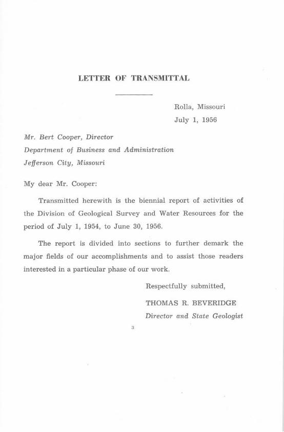
LETTER OF TRANSMITTAL
Mr. Bert Cooper, Director
Rolla, Missouri
July 1, 1956
Department of Business and Administration
Jefferson City, Missouri
My dear Mr. Cooper:
Transmitted herewith is the biennial report of activities of
the Division of Geological Survey and Water Resources for the
period of July 1, 1954, to June 30, 1956.
The report is divided into sections to further demark the
major fields of our accomplishments and to assist those readers
interested in a particular phase of our work.
Respectfully submitted,
THOMAS R. BEVERIDGE
Director and State Geologist

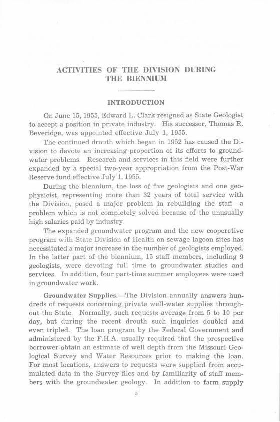
ACTIVITIES OF THE DIVISION DURING THE BIENNIUl\l
INTRODUCTION
On June 15, 1955, Edward L. Clark resigned as State Geologist to accept a position in private industry. His successor, Thomas R. Beveridge, was appointed effective July 1, 1955.
The continued drouth which began in 1952 has caused the Division to devote an increasing proportion of its efforts to groundwater problems. Research and services in this field were further expanded by a special two-year appropriation from the Post-War Reserve fund effective July 1, 1955.
During the biennium, the loss of five geologists and one geophysicist, representing more than 32 years of total service with the Division, posed a major problem in rebuilding the staff-a problem which is not completely solved because of the unusually high salaries paid by industry.
The expanded groundwater program and the new cooperative program with State Division of Health on sewage lagoon sites has necessitated a major increase in the number of geologists employed. In the latter part of the biennium, 15 staff members, including 9 geologists, were devoting full time to groundwater studies and services. In addition, four part-time summer employees were used in groundwater work.
Groundwater Supplies.-The Division annually answers hundreds of requests concerning private well-water supplies throughout the State. Normally, such requests average from 5 to 10 per day, but during the recent drouth such inquiries doubled and even tripled. The loan program by the Federal Government and administered by the F.H.A. usually required that the prospective borrower obtain an estimate of well depth from the Missouri Geological Survey and Water Resources prior to making the loan. For most locations, answers to requests were supplied from accumulated data in the Survey files and by familiarity of staff members with the groundwater geology. In addition to farm. supply
5

n Department of Business and Administration
requests, consolidation of school districts required new and additional well supplies. Irrigation with well water of special high priced crops also is being more widely practiced. In addition to private well supplies, information was given for proposed well supplies as follows:
Air Port, U.S. Auxilary, St. Charles County Anderson (city), McDonald County Barnett (city), Morgan County Boone County (school District), Boone County Civil Defense (Evacuation Center), St. Louis County Clarksburg (city), Cooper County Cruise (school), Washington County Crystal City, Jefferson County Curryville (city), Pike County Dow Chemical Co. (industrial) near Pevely, Jefferson County Ellington (city), Reynolds County Eureka (city), St. Louis County Festus (city), Jefferson County Girl Scouts (camp) near Pevely, Jefferson County Jonesburg (city), Montgomery County Linneus (city), Linn County M.F.A. (industrial), Union, Franklin County i\farquand (school), Madison County l\farshfield (city), Webster County Mercer (city), Merc~r County Miller (city), Lawrence County Milo (school), Vernon County Morley (school), Scott County Naylor (city), Ripley County Ozark Fisheries (industrial), Camden County Poplar Bluff (industrial), Butler County Prairie Home (city), Cooper County Raymondville (city), Texas County Richards (school), Vernon County St. Roberts (village), Pulaski County Seneca (city), McDonald County Smithton (city), Pettis County Strafford (city), Greene County Table Rock Dam U.S.A.E., Taney County Troy Memorial Hospital, Lincoln County Urbana (city), Dallas County Weaubleau (city), Hickory County West Plains (city), Howell County Williams Subdivision near O'Fallon, St. Charles County
The following wells were constructe~ in accordance with recommendations of the Survey; samples of rock cuttings were examined during the drilling to advise concerning terminal depth and depth for setting and sealing of the casing:
Advance (city), Stoddard County Asbury (city), Jasper County

Geological Siirvey and Water Resoiirces
Ashland (city), Boone County Atlas Powder Co. (industrial), Jasper County Aurora (city), Lawrence County Baird Cleaners (industrial) at Lebanon, Laclede County Bauer-Mallen Orchards (irrigation) near Versailles, Morgan County Belle (city), Maries County Big Springs (school), Montgomery County Boy Scouts (institutional), Osceola, St. Clair County Boys Town (institutional), St. James, Phelps County Branson (city), Taney County Brown Brothers Farm (irrigation), Humansville, Polk County Brushy Knob (school), Douglas County Buder Park (recreational), Valley Park, St. Louis County Bunceton (city), Cooper County Burfordville (school), Cape Girardeau County Calhoun (city), Henry County Clarksville (city), Pike County Conservation Commission (recreational), Peck Ranch, Carter County Couch (school), Oregon County Crocker (city), Pulaski County DeSoto (city), Jefferson County Dissen (school), Franklin County Fabick, John (irrigation) near Lake Springs, Dent County Fair Grove (school), Greene County Farber (city), Audrain County Fruit Exp. Station (irrigation), Mountain Grove, Wright County Fulton (city), Callaway County Gorin (school), Scotland County Gray Summit (school), Franklin County Forrest Harmon (semi-public) at Noel, McDonald County Hercules Powder Co. (industrial), Jasper County Hoffman-Taff (industrial), Springfield, Greene County Holliday House (recreational), Bagnell, Miller County Hopewell (school), Washington County Houstonia (city), Pettis County Hume (city), Bates County Huzzah (school), Crawford County lllmo City, Scott County Jackson City, Cape Girardeau County Jefferson County (hospital), Festus, JeITerson County Kentwood Arms Hotel, Springfield, Greene County Kingsbury Iron l\1Iine (industrial), Howell County Knob Noster (citv), Johnson County Kraft Foods (industrial), Springfield, Greene County Laddonia (2) (city), Audrain County Lakeside Subdivision near Springfield, Greene County Linn (city), Osage County Logan School near Springfield, Greene County Long Lane Scho'ol, Dalla.s County Lowry (city), St. Clair County McDowell Rendering Plant (industrial), Horton, Vernon County Marthasville (city), \:Varren County Missouri Baptists (institutional) near Arcadia, Iron County
7

8 Department of Business and Administration
Monett (2) (city), Barry County Mount Vernon (city), Lawrence County Mount Vernon Sanitarium, Lawrence County, acidize, re-case New Florence (city), Montgomery County Oak Hill Tourist Court, Roaring River, Barry County Otterville (city), Cooper County Ozark Water Co. (city), Knobnoster, Johnson County Park Board (recreational), Ft. Zumwalt, St. Charles County Park Board (recreational), Knobnoster, Johnson County Park Board (recreational), Osage Beach, Camden County Passionist Fathers (institutional), Warrenton, 'Warren County Plato School, Texas County · Pleasant Hill (industrial), Cass County Presbyterian Church (recreational), Mound Ridge near St. James, Crawford
County Prison Fa.rm (irrigation), Callaway County Republic (city), Greene County Russellville (city), Cole County St. Clair (city), Franklin County Sedalia (city), Pettis County Seligman (city), Barry County Selma Realty (subdivision), Selma, Jefferson County Seymour (city), Webster County Sifferman (irrigation), Republic, Greene County Springfield Utilities (industrial), Kissick, Greene County Springfield Water Co. (5) (city), Greene County Stover (city), Morgan County Sturgeon (city), Boone County Sullivan (city), Franklin County Sunnydale Farm (institutional), Centralia, Boone County Syracuse (city), Morgan County Thayer (city), Oregon County Troy (city), Lincoln County Univ. Mo. (dairy farm), Boone County \.Yarsaw Fish Hatchery (commercial), Benton County Washington (re-case, city), Franklin County Wentzville (deepening, city), St. Charles County V-lestridge (subdivision) near Pacific, Franklin County Windsor (city), Henry County
Special Groundwater Program.-In the late summer of 1955, the Division began an expanded groundwater program with a special appropriation from the State Post-war Reserve Fund. This program, which is continuing through the 1956-57 fiscal year, consists of two major projects: test-drilling in the northern half of the State to discover new aquifers, and the state-wide establishment of observation wells to begin a long range quantitative inventory of groundwater resources.
Ground water is scarce or mineralized in much of the bedrock in northern Missouri. As a result, adequate water sqpplies are
Geological Survey and Water-Resources 9
locally obtainable only from surface reservoirs or from glacial or alluvial sands or gravels. The test-drilling project which represents an endeavor to locate aquifers in glacial sands and gravels has consisted primarily of determining the distribution and extent of river valleys which were cut into bedrock in preglacial or interglacial times and are now so completely filled with glacial material that they are no longer visible at the surface.
Drilling under contract to the lowest bidder is done with two mobile rotary rigs running simultaneously. Test holes are drilled along road right of ways and then plugged and abandoned after they reach bedrock. Well cuttings are saved at five-foot intervals, logged in the field by Survey geologists, and preserved at Rolla for future reference. A graduate geologist is assigned to each of the two test-hole rigs to log samples, note water horizons, collect water samples, verify the depth to bedrock, and plan the location of test-holes.
The existence of a major buried valley system in northern Missouri has been known for many years, but data have been insufficient to verify the trends of the main valleys or the existence of many of the tributaries. In many cases, valleys were postulated between subsurface control points as far as ten miles apart.
A cooperative plan with Washington University provided resistivity profile studies in conjunction with the drilling. It is hoped that this geophysical work, which can be checked by the test holes, will prove sufficiently accurate to be used as a supplemental tool for mapping buried valleys.
By June 30, 1956, Grundy, Mercer, Putnam, and Harrison counties had been completed, and multilithed county reports were distributed to interested agencies and individuals. These reports contain small county maps showing the areas most favorable for development of drift wells, the location of buried valleys in which irrigation wells might be developed, and contours drawn on the top of bedrock. Representative chemical analyses, a general discussion of the groundwater possibilities, and surface stream-flow data are included in each county report.
The general results have been good. By the end of the biennium, 290 test holes representing 48,946 total feet had been drilled; some of the tests flowed, and the majority within the buried valleys have penetrated aquifers which may be sufficient for irrigation. Valleys as great as six miles wide and glacial fills of nearly 400

10 Department of Business and Administration
feet in thickness have been encountered. The quality of ground water from the glacial drift is much better than that of water from the underlying bedrock; especially in that it contains a lower sodium chloride content.
Many private wells hav~ been drilled as a direct result of the testing program. These private wells, in addition to furnishing satisfactory water supplies, implement the project by furnishing valuable data at no cost to the State.
The project will not solve all of the water problems in northern Missouri, for the glacial drift is thin or absent in some areas. In a few cases, the drift is thick but does not contain aquifers; fortunately, such cases are in the minority. Although the project is primarily a practical one, it is yielding some by-products of great academic interest, such as the ancient drainage system of the Missouri which lay to the north of the present system, and the extent of multiple glaciation within the State.
The observation wells of the second major project are equipped with continuous recorders which will graphically record water levels for many years. These wells are of three general classes based on depth: the "farm" type, from 200 to 500 feet deep; the "deep" wells, from 1300 to 1750 feet deep; and the sand and gravel wells which are generally shallow.
Farm type wells have been equipped with Leopold-Stevens continuous recorders in McDonald, Polk, Texas, Phelps, Franklin, and Taney counties. Recorders were installed on deep wells in Jasper County near Joplin, Howell County at West Plains, Franklin County near Washington, and in two wells in Greene County at Springfield. Sand and gravel observation wells have been established at strategic locations in the Boot Heel and in the alluvial valley flats of the Missouri River at Jefferson City.
Four of the deep observation wells are abandoned water wells, and one is an abandoned oil test. The Survey has been granted permission to install and maintain recorders on these holes through the kindness of the municipalities or corporations which drilled them-a courtesy which has saved the State thousands of dollars in drilling expenses.
Farm type holes are being drilled on publicly-owned lands, predominately on State Highway Department maintenance lots. Competitive bids are sought on each hole.
Observation wells must satisfy four major requisites: they must tap significant aquifers, they must be outside of the zone of
Geological Snrvey and Waler Resources 11
influence of nearby heavily pumped wells, they cannot be pumped themselves, and there must be assurance of long term maintenance of recorders to accumulate useful data.
It is much too early to give any meaningful data from the observation wells. These data, like those from stream gages, are of little value for the first few years. Eventually they will assist in determining whether the major groundwater supplies are being appreciably affected by drouths or increased consumption.
We know that the very shallow wells have been affected by the current drouth and that deep wells are affected by overpumping, but we do not yet know whether we are appreciably depleting our major aquifers.
Quality of Water.-The locating of new industries in Missouri is often contingent upon the quantity, the temperature, and the quality of the water available. Because of insufficient information, it was not always possible to answer in detail all questions on temperatures and qualities of water.
To correct this situation, this Division has underway a program of sampling and making chemical analyses of water from springs, streams, and wells. The waters used by most municipalities are sampled and analyzed by the State Division of Health. Through their cooperation these analyses have been made available for use in reports.
The gathering of data is now completed for Barry, Butler, Carter, Christian, Douglas, Howell, Jasper, McDonald, Newton, Oregon, Ozark, Reynolds, Ripley, Shannon, Stone, and Taney counties. Data are partly completed for all other counties. The analyses are now sufficient in number to give an overall concept of the quality of waters. Nevertheless, hundreds of additional localities must be visited and samples analyzed before specific questions can be answered for some individual situations.
Surface Waters.-The realization that groundwater supplies are inadequate in parts of the State has resulted in an increased demand for qualitative and quantitative data on surface waters. Some users of large quantities of water who previously depended exclusively on groundwater supplies have found it necessary to construct supplemental reservoirs or to rely solely on surface waters.
This trend, coupled with the drouth, increased irrigation, and air conditioning, has accentuated the value of stream-flow data.

12 Department of Btisiness and Administration
The Missouri Geological Survey and Water Resources, in cooperation with the U. S. Geological Survey and supplemented by financial assistance from the Corps of Engineers, U. S. Army, Missouri State Highway Commission, operating utility companies, and drainage districts, collects stream-flow data within the State.
To meet the increased demands for water and provide data for intelligent flood control plans, records of stream flow must be maintained to supply information as to the amount and variation in flow to be expected.
Since 1921, the Missouri Geological Survey and Water Resources has cooperated with the Water Resources Division of the U. S. Geological Survey in collecting stream-flow data. From an initial program of 40 stream-flow gaging stations in 1922, the program has grown to a present operation of 122 gaging stations on 90 streams in Missouri. Ninety of the 122 gaging stations are equipped with automatic water-stage recorders which provide more accurate records of stream flow. The remaining 32 gaging stations will be equipped with automatic recorders if and when funds will permit.
In addition to the records of daily stream flow, stations are maintained to supply records of stage only, for flood-control studies and to supply information for fish breeding; to provide daily, medium and high-water elevations and contents of the large reservoirs within the State.
To supplement the regular gaging program, miscellaneous discharge measurements are made at nearly 78 points on various streams during the low-flow periods. Other miscellaneous discharge measurements are made as requested by the State Board of Health for stream pollution surveys. Discharge and temperature measurements are made on numerous springs over the State, and silt samples are collected at a few stations for study by the Corps of Engineers. Continuous records of silt discharge are obtained on the Mississippi River at St. Louis.
The State Highway Commission of Missouri cooperated in the operation of 21 small-area gaging stations and 58 peak-stage indicator stations. Data are collected to assist in determining the area of waterway openings required for culverts and bridges. Measurements of unusual floods are made as they occur by survey and hydraulic computations to provide additional data for bridge and culvert design. A report on the frequency of floods in Missouri has been compiled during the biennium to provide data for
Geological Survey and Water Resources 13
the economical design of highways and other structures that might be damaged by floods.
An average of about 400 requests for stream-flow data are served monthly without cost to the recipient.
The U. S. Geological Survey annually publishes stream-flow data in the Water-Supply Papers, which can be .obtained for a nominal charge from the Superintendent of Documents, U. S. Government Printing Office, Washington 25, D. C. As funds are available, the data published in the several Water-Supply Papers are consolidated and published as single composit volumes by the Division. The latest such volume containing stream-flow records for the period 1940-49 was published in February, 1952.
The following organizations helped financially to partly maintain the indicated number of gaging stations during a part or the whole of the period of this report:
State Highway Commission of Missouri........ .. .... . ...... 21 Missouri State Park Board .... .. ...... . . . .............. . . . . i Corps of Engineers, U. S. Army.... .. . . . . . . . . . . . . . . . . . . . . . . . 61 U.S. Weather Bureau......... .. .... . .... . ................ 5 Little River Drainage District. . . . . ... . . . .... . . .... ... ... . . Empire District Electric Company ..... .. .... . . ... . .. . Union Electric Company of Missouri ... . . . ....... . .... .. . . . . City of Kansas City .......... . .. . . . ... .... ... ... .. . .. . . .. . U.S. Soil Conservation Service.. . . ... .. .... ... ... ... . City of Springfield ............... . . . .... ... ... ... . . . .. . . . .
10 2 1 1 2 2
Total. ..... . ... . . . .. .. ..... . ..... .. ... .... ........... 106
Because of the ever increasing need for data on surface water flow, the work within the State has continually been augmented mainly by increases in funds furnished by the U. S. Geological Survey and other Federal agencies. Unit costs have increased greatly in recent years because of higher costs of labor and materials, increased salary rates, and improvements in the quality of the records. However, except for the cooperative program of the Highway Commission of Missouri, the State of Missouri has not increased its appropriation for surface water investigation during the past ten years.
Dam Sites and Reservoirs.-This Division has cooperated with private and public agencies in determining the feasibility of various types of surface reservoirs from the geological standpoint. Such activities entailed field examination of the sites to guard
14 Department of Business and Administration
against leakage through the bedrock or residuum, and recommendations for clay or soil material sources where required for earthen dams.
Geologists from this Division have worked with the Missouri Conservation Commission in examining sites near Deer Park in Boone County, the Davis Lake site near Pomona in Howell County, near Dunn in Texas County, and near Fair Play in Polk County. Other sites were a surface reservoir for the City of Bethany in Harrison County, the Establishment Creek power reservoir system of Union Electric in Ste. Genevieve County, and a private lake in Phelps County.
Sewage Lagoons.- During the latter half of the biennium, many municipalities have CQ!lstructed sewage lagoons or oxidation basins. This Division cooperated with the State Division of Health in approval of lagoon sites. The sites are of special concern to the Survey because of possible contamination of groundwater supplies by leakage through the lagoon floor. Sewage lagoons were introduced to Missouri during the 1954-56 biennium, and it is anticipated that one geologist will devote nearly all of his time to site inspection during the 1956-58 biennium.
The following sites were inspected during the biennium:
Springfield (3 sites) Tipton Desloge Bonne Terre Wellsville Troy Carl Junction Sheldon
Butler Anderson Union Wayland Vandalia Center Fornfelt
Topographic Mapping.-Topographic maps are designed to show topography or land forms by means of contour lines which connect points of equal elevation. These highly accurate maps also show streams, ponds, lakes, roads, railroads, power lines, and other significant natural or artificial features. They were originally designed for military or engineering uses but are now used also by sportsmen-as shown by the increased sales during the fishing and hunting seasons. During the 1944-46 biennium the Survey sold 4,680 of these maps; sales have increased to 19,676 maps in the 1954-56 biennium.
The preparation of these maps, which requires highly specialized equipment and personnel, is done by the United States

Geological Survey and Water Resources 15
Geological Survey. In Missouri, the State Geologist determines the areas to be mapped after consultation with the State Highway Department. This Division and the Highway Department match funds with Federal monies for preparation of the maps. Costs of publication are paid completely from Federal funds.
The program for the biennium was financed as follows:
U niled States Geological Survey ............. . .... . Missouri Basin Inter-Agency Commiltee .......... . .
Total Federal ......... .. .. . ...... .. ... . .... .
lVlissouri State Highway Department. ... . ......... . Missouri Geological Survey (actual) ....... . .. • . .... Missouri Geological Survey (evaluated) .. .
Total State .......................... . ..... .
$98,104.18 64,487.86
$162,592.04
48,113.04 40,018.70 10,000.00
$98,131.74
Total Expenditure .................... . ................... .
$162,592.04
98,131. 74
$260,723.78
In the biennium, July 1, 1954, to June 30, 1956, the following topographic maps in parts of nineteen counties have been printed and are available in the Geological Survey office for distribution:
7}1-MINUTE QUADHANGLES
Name Location (parts of counties)
\¥estline .................... ... ... .. . Cass B~lton ........... . ................. . . Cass and Jackson Cabool NW .... .... .......... . ....... Douglas and Wright Bunceton ............... . ............ Cooper Florence .... .... .......... ........... Morgan Fayette .............................. Howard Burton ................... .. ......... Howard Otterville E ..... . .................... Morgan and Cooper Pilot Grove S .......... ........ ...... Cooper Billingsville ....... .. .......... ... .. .. Cooper Pilot Grove N .. ..... . ........... . .... Cooper Johnstown ............ .. ... ... ...... . Bates and Henry Creighton ........... . ... ........ ..... Bates and Henry Calhoun E ........ . . . ........ .... .... . Henry Beaman ................ .. ........... Pettis Bevier S .... .. ....................... Macon Leesville .......... . . . ......... ... .... Henry and Benton Gaines ............... .... ... .. ....... Henry Calhoun W .... . . . .... . .... .. ......... Henry
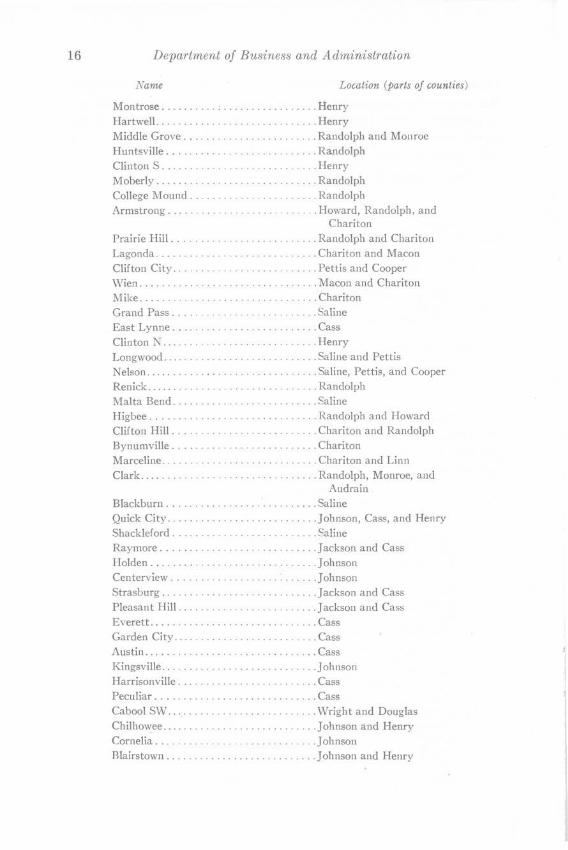
16 Department of Business and Administration
Name Location (parts of counties)
Montrose ............................ Henry Hartwell........... . ............ Henry Middle Grove ........................ Randolph and Monroe Huntsville .......... .......... ....... Ra.ndolph Clinton S ..... ............ .. ......... Henry Moberly . . . . . . . . Randolph College i\Iound . . . . . . . . .......... Randolph Armstrong ..... .............. . ...... Howard, Randolph, and
Chariton Prairie Hill .......................... Randolph and Chariton Lagonda ............ . ................ Chariton and Macon Clifton City ......... ........... . ..... Pettis and Cooper Wien. . . . . . . . . .... l\facon and Chariton Mike ....................... . ..... ... Chariton Grand Pass . . . . . . . . ....... Saline East Lynne ... ... .... .... . . .......... Cass Clinton N ............... ............. Henry Longwood ................... .... ..... Saline and Pettis Nelson ........................... . ... Saline, Pettis, and Cooper Renick ............. ... . .. ............ Randolph Malta Bend ..... .............. . ... ... Saline Higbee .............. .... . . .......... Randolph and Howard Clifton Hill ..... .. ............... ... . Chariton and Randolph Bynumville .......................... Chariton Marceline ............... .... ......... Chariton and Linn Clark ........ . .... ....... .. ....... ... Randolph, Monroe, and
Audrain Blackburn .... ... .................... Saline Quick City ........................... Johnson, Cass, and Henry Shackleford .......................... Saline Raymore .......... ........... ....... Jackson and Cass Holden .............................. Johnson Centerview .............. . .... : ..... . Johnson Strasburg ................. .... . .... .. Jackson and Cass Pleasant Hill ....... .. ................ Jackson and Cass Everett .......... . .............. ..... Cass Garden City ........................ . . Cass Austin .... ....................... .... Cass Kingsville ........ . .. ..... .... . ....... Johnson Harrisonville ......................... Cass Peculiar ............................. Cass Cabool SW ........ . . .. ... .. ... . . . .... Wright and Douglas Chilhowee ......................... .... Johnson and Henry Cornelia... . . . ........... Johnson Rlairstown ........................... Johnson and Henry
Geological Survey and lV ater Resources l7
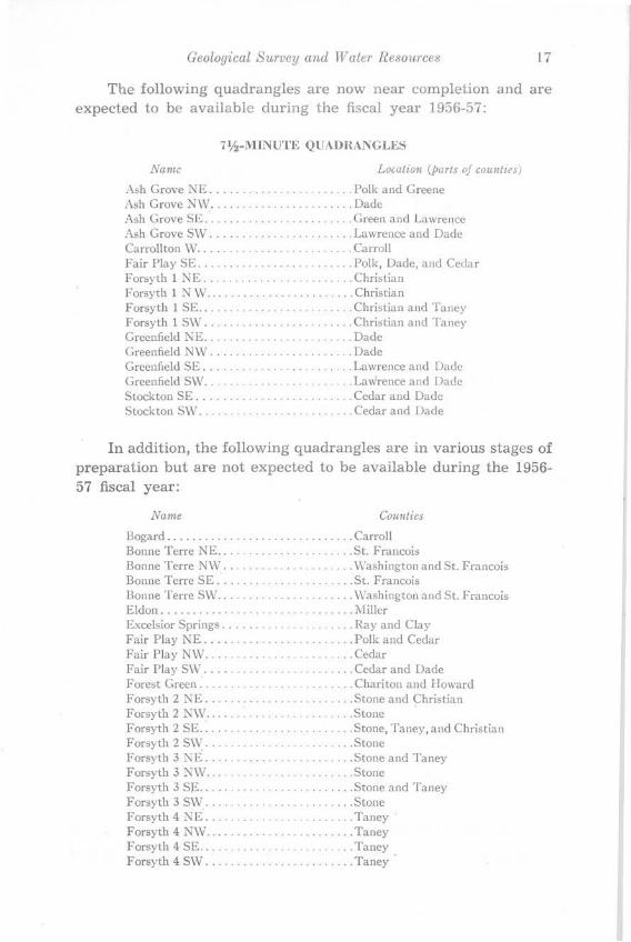
The following quadrangles are now near completion and are expected to be available during the fiscal year 1956-57:
7lf2-MINUTE QUAUHANGLES
Name Location (parts of cou11ties)
• \sh Grove NE . . . . . . . . . . . ...... Polk and Greene Ash Grove NW .... ..... .............. Dade Ash Grove SE ... . .................... Green and Lawrence Ash Grove SW ............ .. ......... Lawrence and Dade Carrollton \V ......................... Carroll Fair Play SE ......................... Polk, Dade, and Cedar Forsyth 1 NE . . . . . . . . ...... . .... Christian Forsyth 1 NW ........... . ............ Christian Forsyth 1 SE ......................... Christian and Taney Forsyth 1 SW. . . . . . . . . . . . . . . . . . ..... Christian and Taney Greenfield J',;E ............... ... ...... Dade Greenfield NW ...... . ................ Dade Greenfield SE .................. .. . ... Lawrence and Dade Greenfield SW. . . . . . . . . . . . . . . . . .. Lawrence and Dade Stockton SE .... ..................... Cedar and Dade Stockton SW. . . . . . . . . . . . . . . . . . . . . . . . Cedar and Dade
In addition, the following quadrangles are in various stages of preparation but are not expected to be available during the 1956-57 fiscal year:
Name Counties
Bogard .................... ... ....... Carroll Bonne Terre NE .... ............... ... St. Francois Bonne Terre N\V ............... .. .... \\"ashington and St. Francois Bonne Terre SE ...................... St. Francois Bonne Terre SW ....... ..... .......... \\'ashington and St. Francois Eldon ............................... i\1 iller Excelsior Springs ...... ........... .... Ray and Clay Fair Play NE ........................ Polk and Cedar Fair Play NW ........................ Cedar Fair Play S\V ............. ......... . . Cedar and Dade Forest Green ............... ....... ... Chariton and Howard Forsyth 2 NE .. .. .......... ......... . Stone and Christian Forsyth 2 N\\'........ . .......... Stone Forsyth 2 SE ... . . ..... .. ... ... . ...... Stone, Taney, and Christian Forsyth 2 SW ............. ... ........ Stone Forsyth 3 NE ........... ........... .. Stone and Taney Forsyth 3 NW ........................ Stone Forsyth 3 SE...... . ............ Stone and Taney Forsyth 3 SW ........................ Stone Forsyth 4 NE ........................ Taney Forsyth 4 NW ...... .......... ........ Taney Forsyth 4 SE.. . . . . . . . . . . . . . ...... Taney Forsyth 4 SW .................. . ..... Taney

18 Department of Business and Administration
Name Co,unties
Fox..... . . . . . . . . . . . . . . . . . .. ... . Ray Glasgow. . . . . . . . . . . . . . . . . . . . . . . . Howan..l, Saliuc, and Charito11 Grandview. . . . . . . . . . . . . . . . . . .. Jackson Grove Spriug .NE .... .... .. .... .. ... .. Laclede and Wright Grove Spring NW ..... ... .... .. ...... Wright, Webster, and Laclede Grove Spring SE. . .. . .... .. ... . Wright · Grove Spring SW ... .... . ...... . . ... .. Webster and Wright !Jardin...... ... .... .... . .... .Ray Higdon NE.. . .... .. .... .. .. Perry, St. Francois, and Ste.
Genevieve Higdon NW. . . .. .... .. .. .. Ste. Genevieve, St. Francois,
Madison and Perry Higdon SE ...... . . . .......... . ....... Perry and Bollinger Higdon SW . . . ........ .... .... Madison and Bollinger Hunnewell NE .... . ...... .. .... .. .... Shelby, Marion, and Monroe Hunnewell NW. . . . . . . .... . Shelby and Monroe Hunnewell SE.· .. .. ... ... .... . . . ... .. . Monroe Hunnewell SW .... .... .... .. ..... .. .. Monroe Independence .... .. : ..... .. ... ... . . .. Clay and Jackson Kansas City ... ... ... . .... .. .... ...... Clay, Jackson, and Kansas Keytesville . . . . . . . . . . .. .. .... Chariton Knoxville ..... . . ... .. .. . . . ... ... ... .. Ray Lawson .... .. . . .. .. .. Ray, Clay, and Clinton Lee's Summit ...... .... . .... .... . . .. .. Jackson Madison NE .......... .. . ...... . . .... . Monroe lVladison NW .... .. .. ........ . ...... .. Monroe Madison SE .... . ............... .. .... Audrain and Monroe Madison SW .. .. ..... . . .. ... ......... Audrain and Monroe Millville ... : . . . . . . . . . . . . . . . . . ... Ray Monroe City NE. . . . . . .. Marion and Ralls Monroe City NW ... .. . . .... .... . .. . .. Marion, Ralls, and Monroe Monroe City SE. . . . . . . . . . . . . . . . . . Ralls Monroe City SW .... ... . .... . .... .... Ralls and Monroe Norborne. . . . . . . . ....... ... ... ... Carroll Potosi NE. . . . . . . . . . . . . . . .. . . ... Washington Potosi NW . ... . ..... .. ....... . . . . .... \,\lashington Potosi SE....... . ............. . .. Washington Potosi SW ... ..................... ... Washington Rayville. . . . . . . . . . . . . . . . . . . . . . . Ray Richmond ...... ... .. ............... . . Ray Salisbury ..... .... . . ... ............ . . Chariton Shelbina NE . . . . . . . ........ . .... . .. .. Knox and Shelby Shelbina NW . .. . . . . .. . .. . . . .......... Knox and Shelby Shelbina SW ... .. .................... Shelby Shelbina SE ..... .. . .......... .. . ... . . Shelby Stockton NW ... . .. ......... . . .... . .. Cedar Stockton NE .... ... .. .... .. .... ...... Cedar Woods Chapel. .... .. .... . .. . . .. Jackson
Mineral Exploration.-During the biennium, there was a marked revival of interest by major companies in lead, barite, and
l r
Geological Survey and Water Resources 19
brown iron ore exploration. This activity has resulted in many field and office conferences with company geologists and mining engineers. Nonconfidential data in the Division's extensive log file as well as published and unpublished reports and geologic maps were made available to company representatives. In addition, assistance was given in interpreting cores and logs.
The demand for high-calcium limestones created many inquiries regarding favorable areas for quarry sites. These inquiries were answered from geologic maps in the Survey's files and in some cases by field studies. An extensive study of high-purity quartzite deposits suitable for the silicone industry was made in southeastern Missouri, and the unpublished results are available to interested concerns.
No commercial uranium deposits are known in the State. This Division has made many field examinations, checked hundreds of samples submitted, and traced all reputed occurrences, but thus far the results have not been encouraging; in all cases the uranium content was much too low to merit serious economic considerations.
The Survey identifies all submitted rock and mineral samples at no charge. A several-month tally showed that fossil, rock, and mineral samples were identified for an average of seventy persons per month. Many of these identifications were in response to requests for Geiger counter tests of radioactivity. Requested field examinations of mineral prospects were generally made in conjunction with scheduled projects; however, if they were deemed sufficiently urgent, special trips were made.
The policy of examining all samples submitted to this office and making field studies of prospects has in many cases resulted in great savings to the public. Many of the samples and prospects examined merited no further expenditure of time or capital, and the advice of the Division prevented appreciable financial losses in what would have been ill-fated mining or oil ventures.
Coal Resources.-Missouri coal production in 1953 reached the lowest point since 1896. During the present biennium, production, in keeping with national trends, has shown a steady increase. The downward trend in coal production into 1953 was occasioned by entry of residual foreign oil on the eastern seaboard, reduction of exports of coal, decreasing use of coal as a domestic fuel, the substitution of oil for coal as railroad locomotive fuel, and in-

20 Department of Business and Administration
creased efficiency in the use of coal. The present rise in consumption of coal in Missouri, as elsewhere, is due chiefly to the increased use of coal in electrical generating plants. Steady and continued expansion of the light and power industry promises a continued growth of the coal industry in Missouri.
Investigation of coal resources in the last several years has revealed many errors in the correlation and identification of coal beds. Interstate cooperation between neighboring geological surveys has also established the identity of coal beds extending beyond state boundaries. This cooperation has resulted in nearly complete uniformity of coal bed names in neighboring states, particularly in Kansas.
In order to acquaint geologists and people of the State with the revised stratigraphic nomenclature pertaining to Missouri coal, a guidebook was prepared by the Division for the Association of Missouri Geologists. It has been published as Report of Investigations No. 20. The report is designed to assist the worker with Missouri coal, to help him identify the coal measures associated with the beds commonly mined,. and if desirable to permit him to visit localities where these can be inspected.
Coal in many localities in Missouri cannot be extracted with profit. If mining is attempted, the projects will result in certain failure. It has been an important phase of Survey work to present the factors concerned in coal mining in the State together with conditions which prevail locally. In many cases this can be done by correspondence, but in other cases it is desirable to examine conditions in the field with the people concerned. Financial losses to citizens engaging in enterprises not economically sound are thus avoided.
The Tebo coal has been mapped in Henry County from subsurface and surface data. This bed is the most valuable mineral resource of the county and is responsible for the fact that coal production in the county is the greatest in the State.
Much of the Croweburg coal in Henry County has now been mapped. Although it is less expansive and thinner than the Tebo, it has been an important source of coal, particularly in the northeastern portion of the county. This coal has been called "Bevier", but it lies at the position of the coal now called Croweburg.
The Weir-Pittsburg and Rowe coal beds of Henry County have also been investigated during the biennium. Part of the. coal for-
Geological Survey and Water Resources 21
merly called "Jordan" is Weir-Pittsburg and part is Rowe. The "Mammoth" bed likewise is in part Weir-Pittsburg and partly Rowe.
From the information now in hand, revised estimates of the coal reserves of Henry County are nearing completion. These will be considerably more accurate than has previously been possible.
Oil and Gas.-In 1954, Missouri reached an all time oil production record because of activity from the Florissant field in St. Louis County. No wells were completed in St. Louis County during the balance of the biennium. Approximately 118 wells were producing in St. Louis County and the northwestern part of the State. Seventy-four oil tests and one gas test were drilled, 25 of which were in St. Louis County and the rest in Cass County.
The oil and gas production during the biennium was valued at approximately $30,400 and $3,300 respectively.
Underground Storage.-The Survey has answered numerous requests for data on underground storage sites in abandoned mines and quarries, some of which were to be used for liquid propane gas. Log files, geological maps, and other pertinent data were furnished to those contemplating excavation of artificial storage caverns for propane. Such storage requires a rock which is strong enough for excavation of artificial caverns, has a low permeability, and low groundwater content.
Asphaltic Rocks.-Bituminous sandstone and limestones are at or near the surface in at least 21 counties of western Missouri. These rocks range in stratigraphic position from the Batesville sandstone of Mississippian age upward into the Raytown limestone of Pennsylvanian age. The bituminous matter is a residue derived from petroleum which originally contained both paraffins and asphalt together with napthenes and aromatics. Modification of the original matter has resulted from loss of volatile aromatics by complex chemical changes attendant to weathering. Processed bituminous sandstones from Missouri have been marketed to some extent for city paving where traffic is relatively light, for surfacing of private driveways, tennis courts, and similar projects. Some of the bituminous matter is appreciably radioactive, but none is known to be of commercial value.
During the biennium, the Division has made an extensive study 9f all known deposits in the State. These deposits are of

22 Department of Business and Administration
interest to asphaltic aggregate producers and major oil companies. The studies were made as a result of the many inquiries from interested parties, and the results are to be published as a Report of Investigations.
Cataloguing Bench Marks.-Bench marks of accurate elevations have been established in Missouri by three Federal agencies. The descriptions and precise locations of these markers are not combined into a single publication, and obtaining the exact elevations, which are generally not shown on the bench marks, often entails much correspondence. Furthermore, many bench marks have been covered, disturbed, or destroyed as a result of post-war construction-a condition which is especially aggravated in urban and suburban areas.
This Division has begun a program of checking bench marks in the field, noting those that are destroyed or unreliable, and cataloguing them with accurate locations. By the end of the biennium, St. Charles and St. Louis counties and the Missouri River area from Hermann east to the Mississippi had been completed.
This project will greatly facilitate many phases of civil engineering and will simplify the Survey's routine work in obtaining well elevations.
Geologic Mapping.-Surface geologic mapping of specific areas was undertaken in the following quadrangles during the biennium:
1955 FIELD SEASON
Geologist Quadrangle County
Beveridge, T. R ... .. ... Various ................ Greene Bieber, C. L ...... . .... Various ... . ..... .. ... .. Barton-Dade-Lawrence Higgs, W.R ..... . ..... Silex .... . .. .. .... . . .... Lincoln-Pike Knight, R. D . ........ . Strafford ... ....... . .... Greene Martin, J. A... . . Washington N !,1 ....... . Wa'rren
1956 FIELD SEASON
Geologist Quadrangle County
Barkdull, J.E ......... Grandin NW~;,( ......... Carter Bieber, C. L. .......... Various .......... ..... . Jasper-Lawrence-Greene Kebert, F. D .... .. . .. . Clifton City . . ... ....... Cooper Martin, J. A .... .' . ... . . Morley-Thebes .. . ..... Cape Girardeau- Scott Smart, B ........ . ... .. Clinton North ... ..... .. Henry
Work was begun on revision of the State Geological map which was last revised in 1939. All pertinent data subsequent to that
Geological Survey and Water Resources 23
date is being consolidated on a master base map to expedite planned publication in 1960. The State Geological map is in great demand and must reflect the surface geology as accurately as possible.
Structural Studies.-Stratigraphic and field mapping programs over many years have produced sufficient data to begin the preparation of a state tectonic map showing the faults and folds. Such a map is a valuable guide in the search for ground water and various minerals for the distribution of these resources is determined in part by the attitudes and structural relations of the various rock units. This is a long-term project requiring intermittent office and field work for several years.
Stratigraphic Investigations.-Stratigraphy is the branch of geology concerned with the description, organization or arrangement, and classification of stratified rocks. Stratigraphic investigations thus involve detailed study of the rock types and fossils of individual beds, plus ascertainment of their position in the succession of strata common to a given area, and finally, correlation of individual beds or groups of beds with their equivalents in other areas. Such information may be obtained by detailed geologic mapping in combination with careful outcrop description in areas where bedrock is exposed on the surface, or by study of well cuttings or well logs in regions where bedrock exposures are incomplete.
Knowledge of stratigraphy is of importance in the study of economic geology as many naturally-occurring materials of economic value are restricted in their occurrence to particular strata, or to particular parts of the geologic column. Oil and gas, coal, clay, and ground water are outstanding examples of such materials.
The stratigraphy, including the paleontology or fossils, of a particular succession of strata over relatively large areas may or may not include the actual preparation of a geologic map. These regional studies are essential to a better understanding of statewide conditions. During the biennium the following specialized studies were completed or in progress:
Mississippian stratigraphy of northeastern Missouri, by J. E. Noble; the Venteran-Cygnian boundary, by R. D. Hoare; DevonianMississippian transition beds of central and east-central Missouri, by M. G. Mehl; Pleistocene reconnaissance in northern Missouri, by S. Davis; Kinderhookian and Osagean formations of southwestern Missouri, by J. W. Koenig; Mississippian of southweste.rn Mis-
24 Department of Business and Administration
souri, by A. C. Spreng; Pleasanton and Wabaunsee groups and Linn subgroup, by W. B. Howe; subsurface insoluble residue zones of the Paleozoic, by Earl McCracken.
Educational Activities.-During the past biennium this Division sent 62 sets of common Missouri rocks and minerals to school and Scout organizations. These sets, which include a descriptive manual and a brief "Introduction to the Geologic History of Missouri", are sent only to educational organizations.
The policy of subsidizing field work of carefully selected graduate students doing theses of value to the Survey has been continued. This policy results in much valuable work being done at a relatively low cost. Faculty members from various institutions are used on a part-time basis during the summer to augment the permanent staff.
Various members of the Survey have lectured and led field trips at schools and universities in the State.
In the fall of 1954, the Survey acted as host and leader of two geological field trips for more than 350 oil geologists at the request of the Kansas Geological Society. These trips, which began at Rolla, went through St. Clair, Ironton, Piedmont, and Cabool, terminating at Mansfield.
COOPERATION WITH OTHER AGENCIES AND ORGANIZATIONS
State Highway Department.-The State Geologist, as an exofficio member of the State Highway Commission, has the opportunity of working closely with the Highway Department. He determines the areas of topographic mapping subsidized by matched State and Federal funds, and does so with a thorough consideration of future highway construction activities.
Geologists from the Highway Department and the Missouri Geological Survey maintain a close liaison yet have no duplication of activities. The subsurface log files and unpublished geologic maps of the Survey are made accessible to Highway Department geologists; these geologists reciprocate by furnishing the Survey with results of highway core drilling and notifying the Division of pertinent geologic data encountered in new highway cuts.
Numerous field and office conferences have been held between representatives of the two organizations regarding such problems as highway construction over mined-out or sink hole areas, the
Geological Survey and Water Resources 25
types of rock that will be encountered in excavations, sources of rock building materials, and landslide or rock-fall areas.
Division of Health.- As previously mentioned, the Survey and the State Division of Health have worked together closely because of their common interest in assuring and protecting potable water supplies. Public wells must be cased in accordance with recommendations of the Geological Survey before they can be approved by the Division of Health. The cooperation between the two Divisions has been further intensified by the joint studies of all sewage lagoon or oxidation pond sites-a program which began during the biennium. Copies of all water supply chemical analyses made by the Division of Health are filed at the Survey and are invaluable in answering requests for given qualities of ground water.
Conservation Commission.-The State Geologist and other geologists from the Survey have made many examinations of reservoir sites in conjunction with engineers of the State Conservation Commission. Such cooperation is vital to assure supplies of source material for earthern dams and to eliminate unfavorable geological sites where leakage might occur. The Commission is supplied with topographic maps by the Survey and is the largest user of these maps in the State.
Corporation and Securities Department.-Although not required by statute, the State Geologist has passed on the geological merits of applications for the sale of mineral, oil, and gas securities in the State. This arrangement is by mutual agreement with and at the request of the Commissioner of Securities. Such a procedure has served to protect potential investors in the State-a protection which has been especially valuable with the large volume of uranium securities on the market during the biennium.
Federal Agencies.-The joint programs with the U. S. Geological Survey on topographic mapping and surface waters have been discussed previously. The Division is fortunate in being located in the same town as the Federal Survey where close personal contacts can be maintained. Similar close relationships are maintained with the Rolla office of the U. S. Bureau of Mines. This Division and the Bureau cooperate in collecting and analyzing annual mineral production statistics for Missouri. In 1955, the State Geologist sponsored a multilithed paper entitled "Prospecting in Missouri". In addition to a section which he contributed on
26 Department of Business and Administration
privately-owned lands, this compilation included sections contributed by the State Forester, The State Park Board, the U. S. Forest Service, and the Bureau of Land Management. This compilation was in answer to the many requests for information regarding prospecting and leasing of land held by various public agencies.
Other Agencies and Organizations.-The State Geologist and his representatives have worked closely with the Arkansas-WhiteRed Rivers Inter-Agency Committee and the Missouri Basin InterAgency Committee. This Division has contributed to and critiqued reports by these organizations and representatives have continued to attend Committee meetings.
The State Geologist has been editor of the State Geologists Journal from 1952 to the present and has held various offices in this organization. He is at present Secretary of the Highway Geology and Soils Subcommittee of the American Association of State Highway Officials and a Field Trip Chairman for the St. Louis meeting of the American Association of Petroleum Geologists.
Mr. Dale Fuller, a staff member of the Survey, is Service Secretary of the Missouri Water Well Drillers Association, and the Survey has annually contributed speakers and exhibits to conventions of this organization.
The State Geologist, Assistant State Geologist, or other staff members have given papers or have been the panel at the following additional organizations during the biennium: American Society of Civil Engineers, Conservation Federation of Missouri, 4-H Conservation Camp, Phelps County Extension Service, and Friends of the Land.
PUBLICATIONS
Distribution.-During the biennium the Survey distributed 31,442 copies of geologic reports and maps as contrasted with 27,696 copies in the previous biennium and 14,219 copies in the 1944-46 biennium ten years previously.
Reports and maps were distributed during the biennium as follows:
GEOLOGICAL REPORTS
Volumes I to XXXVII, inclusive, 2nd series ....... . . . Biennial Reports of State Geologist . . . . . . . . . . . . . . . . . . . . ) Reports of Investigations. . . . . . . . . . . . . . . . . . . . . . . . . . . . . ~ Information Circulars . . .... . . . ...... . . . .. . . .. . ..... .. J Miscellaneous Reports .... .... . ... ... . .. . . .. ... . . . .
2,273
5,581
1,394
9,248
Geological Survey and Water Resources 27
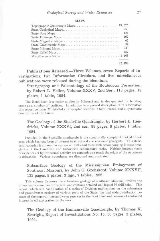
MAPS Topographic Quadrangle Maps .......... .. ........ . ...... 19, 676 State Geological Maps.. . . . . . . . . . . . . . . . . . . . . . . . . . . . . . . . . . 553 State Base Maps. . . . . . . . . . . . . . . . 124 State Drainage Maps. . . . . . . . . . . . . . . . . . . . . . . . . . . . . . . . . . . 107 State Magnetic Maps. . . . . . . . . . . . . . . . . . . . . . . . . . . . . . . . . . . 67 State Gravimetric Maps. . . . . . . . . . . . . . . . . . . . . 34 State Mineral Maps. . . . . . . . . . . . . . . . . . . . . . . . . . . . . . . . . . . . 341 State Relief Maps. . . . . . . . . . . . . . . . . . . . . . . . . . . . . . . . . . . 187 Miscellaneous l\faps. . . . . . . . . . . . . . . . . . . . . . . . . . . . . . . . . l, 105
22,194
Publications Released.-Three Volumes, seven Reports of Investigations, two Information Circulars, and five miscellaneous publications were released during the biennium.
Stratigraphy and Paleontology of the Roubidoux Formation, by Robert L. Heller, Volume XXXV, 2nd Ser., 118 pages, 19 plates, 1 table, 1954.
The Roubidoux is a major aquifer in Missouri and is also quarried for building stone at a number of localities. In addition to a general description of this formation this report contains 27 detailed stratigraphic sections, 7 fossil plates, and a systematic description of the fauna.
The Geology of the Steelville Quadrangle, by Herbert E. Hendricks, Volume XXXVI, 2nd ser., 88 pages, 9 plates, 1 table, 1954.
Included in the Steelville quadrangle is the structurally complex Crooked Creek area which has long been of interest to structural and economic geologists. This structural complex is an annular system of faults and folds with accompanying intense brecciation of the Cambrian and Ordovician sedimentary rocks. Neither igneous rocks or evidences of hydrothermal activity are exposed; as a result the origin of the structures is debatable. Various hypotheses are discussed and evaluated.
Subsurface Geology of the Mississippian Embayment of Southeast Missouri, by John G. Grohskopf, Volume XXXVII, 133 pages, 9 plates, 3 figs., 7 tables, 1955.
This volume discusses the subsurface geology of southeast Missouri, reviews the groundwater resources of the area, and contains detailed well logs of 99 drill holes. This report, which is a continuation of a series of Division publications on the subsurface and groundwater geology of various parts of the State, has had wide distribution because of the important groundwater reserves in the Boot Heel and because of continued interest in oil exploration in the area.
The Geology of the Humansville Quadrangle, by Thomas K. Searight, Report of Investigations No. 15, 50 pages, 3 plates, 1954.

28 Department of Business and Administration
This report covers an area where the characteristics of the lower Mississippian rocks change markedly in a north-south direction. It will serve as an invaluable guide to those logging wells in the area, as well as to the field geologist.
The Structure and Magnetic Surveys of the Sullivan-Bourbon Area, by Thomas K. Searight, James H. Williams, and James S. Hendrix, Report of Investigations No. 16, 14 pages, 4 plates, 1 table, 1954.
Deep drilling and magnetic surveys have disclosed magnetite deposits of milling grade and undetermined areal extent in the Sullivan-Bourbon area. This report discusses the relationships of structure and magnetic anomalies to possible iron ore distribution in the area.
Guide Book, Seventeenth Regional Field Conference, Kansas Geological Society, by Garrett A. Muilenburg and Thomas R. Beveridge, Report of Investigations No. 17, 63 pages, 26 figures, 1954.
In addition to the geology exposed along a route from Rolla to Mansfield via St. Clair, Bonneterre, Ironton and Piedmont, this publication includes chapters on mining in southeastern Missouri, lithofacies of the Gunter and Bonneterre, and the geology and mining of barite.
The Geology of the Lebanon Quadrangle, Missouri, by Thomas K. Searight, Report of Investigations No. 18, 35 pages, 3 plates, 1955.
The Lebanon quadrangle, in south-central Missouri contains exposures of the Gasconade, Roubidoux, and Jefferson City formations; all Ordovician in age. The accompanying geologic map shows several previously unrecognized major folds and inliers.
Seven detailed stratigraphic sections and subsurface data from 37 water wells are included in this report. This publication is intended to be a guide for the lower Ordovician surface stratigraphy of the west-central Ozarks.
The Geology of the Fulton Quadrangle, by A. G. Unklesbay, Report of Investigations No. 19, 1955.
This report is the first in a contemplated series of double sheet folios. The central Missouri stratigraphic section of Ordovician, Devonian, Mississippian, and Pennsylvanian rocks is well-exposed in the quadrangle. One major structure, the Auxvasse Creek anticline, interrupts the gentle regional dip. Minor folds and faults are believed to be the result of solution and slumping.
Guide Book, Field Trip, Second Annual Meeting, Association of Missouri Geologists, by Walter V. Searight, Report of Investigations No. 20, 44 pages, 21 figures, 1955.

Geological S1irvey and W aler Resottrces 29
Desmoinesiau (Pennsylvanian) rocks of extreme western lVlissouri between ~ebb City and Nevada are described in th is guide book which contains detailed sections at nine stops. Eleven pages are devoted to a lexicon of pre-Marmaton, Pennsylvanian terms.
Northeast Missouri's Oil Possibilities Improve, by Earl McCracken , Report of Investigations No. 21, 2 pages, 3 figures, 1955.
This report discusses the development of the F lorissant oil field in St. Louis County a nd the oil and gas possibilities of northeastern Missouri.
The Mineral Industry of Missouri in 1952, by Eugene S. Smith, Information Circular No. 11, 19 pages, 1 table, 1955.
This publication gives the quantities and values of the var ious mineral commodities produced in Missouri in 1952. No attempt is made to discuss the origin or geologic environment of these minerals in detail. The year 1952 was a record year for the Missouri clay industry.
The Mineral Industry of Missouri in 1953, by Kenneth G. Larsen, Information Circular No. 12, 18 pages, 2 figures, 1 table, 1955.
The 1953 report is similar in style to that of 1952, but contains in addit ion two figures showing counties in which fuels and metallic industries were produced.
The following are not considered formal publications for bibliographic purposes, and bear no serial or volume numbers.
An Introduction to the Geologic History of Missouri, by Thomas R. Beveridge, 1955.
A seven page multilithed discussion of the generalized geology of Missouri, written for the laymen.
P rospecting in Missouri, by Thomas R. Beveridge, et al, 1955.
A four page multilithed compilation of statements by State and Federal agencies regarding the necessary procedures for prospecting in Missouri. Sponsored and re-produced by this Division. •
Water Possibilities in the Glacial Drift of Grundy County, by Dale Fuller and W. B. Russell, 1956.
This multilithed paper discusses groundwater possibilities from glacial drift in Grundy County and contains maps showing generalized areas most favorable for water wells; 7 pages, 3 plates.
Water Possibilities in the Glacial Drift of Mercer County, by J . R. McMillen and W. B. Russell, 1956.
30 Department of Business and Administration
This multilithed paper discusses the groundwater possibilities from glacial drift in Mercer County and contains maps showing generalized areas most favorable for water wells; 11 pages, 4 plates.
Water Possibilities in the Glacial Drift of Putnam County, by Dale L. Fuller and J. R. McMillen, 1956.
This multilithed paper discusses the groundwater possibilities from glacial drift in Putnam County and contains maps showing generalized areas most favorable for water wells; 8 pages, 3 plates.
PERSONNEL AND FINANCIAL STATEMENTS
During the biennium the following technically trained and experienced employees have resigned.
Kenneth H. Anderson Edward L. Clark Kenneth G. Larsen John V. Lavery
La Vern J. Markos Lewis C. Martin Eugene S. Smith
The following stenographic employees have resigned:
Barbara Sue Brumley Rita La Verne Catron Carol M. Dean
June Hubbs Rosemary H. Stewart
Temporary summer employees and student assistants during the biennium were as follows:
Donald H. Bailey William E. Banks Carol Lee Barnard Charles L. Bieber Joh~ Sutton Blair J Harlen Bretz Tony M. Brumley Robert L. Catron Thomas D. Crutcher Stanley Davis Franklin C. Edwards Theodore F. Friedlein John R. Gealy Joseph Paul Green William R. Higgs Norman S. Hinchey Martin Hollandsworth, Jr. John R. Jackson Margaret LeNora Johnson
Maxine E. Kingery Elmer L. Luehring LeRoy McClay Ma_ry McCracken Terry Mayo Maurice G. Mehl Liston E. Neely Orel R. Sands Nancy Lou Scofield Ted P. Smith Alfred C. Spreng Jack D. Stewart Jerry D. Vineyard John C. Wagner Emma D. Welden Jack S. Wells Harry Werbitzky Guy L. Wiggs Robert L. Wilkins, Jr.
Geological Siirvey and W alet Resources 31
In July 1956 the following persons were on full time and con-sidered to be the permanent staff of the Division:
Thomas R. Beveridge ...... .......... ... State Geologist Rupert B. Bridges... . . . . . . . . . . . . . . . Field Geologist Georgiana Carroll. . . . . . .... . ..... Supervising Clerk Dale L. Fuller. . . . . . . . . . . . . . . .. . .. Geologist Esther J. Friedlein. . . . . . .......... Stenographer Frank C. Greene.... .. . .. .. ........ Geologist John Grohskopf.. . . . . . . Geologist Henry M. Groves. . . . .. Geologist Isham Harris.. ..... . .. Senior Janitor Wallace B. Howe.... . . .... . . .... . Geologist Wayne L. Hudgens.. . . . Field Engineer Virginia Jackson. . . ...... . ... .. ... .. Executive Secretary Mary J. Jones. . . . . . . . . . . . .. ... ... .. Stenographer Robert D. Knight ..... .. ........ ........ Geologist Albert E. Koch. . . . . .. . Assistant Geophysicist John W. Koenig.·. . . .. . Geologist Earl McCracken. . . . . . ... Geologist James Robert Mc Millen. . . . . ... Geologist Garrett A Muilenburg .... ............. ... Assistant State Geologist Mabel E. Phillips. . . . . . ..... .. Chemist Harry Pick.. . . . . . . . . . . . . . . . . . . Geologist Clyde 0. Reinoehl... . . . . . . Office Engineer Walter Bo Russell, Jr... . . Geologist Woodrow Sands.. . . . . . . . ... . ..... Laboratory Assistant Walter V. Searight. ... . .. ...... Principal Geologist Everett F. Walker... . ........... . Senior Janitor Russell Watson. . . . . . . . ... . .. Laboratory Assistant Ellis K. Webb.... . .. . . .. .. .... Laboratory Assistant Genevieve C. Werbitzky. . . . .... Draftsman Frank L. Whaley. . . . . . . .. ........ .. ... Field Engineer Cleo G. Williamson.. . .. Assistant Office Engineer Bonnie Wills. . . . . . . ...... Stenographer E. H. Woolrych.. . . . . .. ... Draftsman

32 Department of Business and Administration
FINANCIAL STATEMENT OF DISBURSEMENTS AND BALANCES FOR THE DIVISION OF GEOLOGICAL SURVEY AND WATER RESOURCES
FOR THE FISCAL YEAR ENDING JUNE 30, 1955
Fun d
Personal Service. Balance Carried 0
············· ver . . ... . .. .
Additions . .. . .. . ......... .. .. Balance Carried 0v er .........
acements ..... Repairs and Rep! Balance Carried 0v er .........
.. . . . . . . . . . . . Operations. ..... Balance Carried 0 ver .........
Balance Appropria- Payments Appropria-
tion to tion (Includes June 30, June 30, Reserves) 1955 1955
$158,620.00 4,020.62 $141,348.21 $21,292.41
---$7,210.00 4,772.22 $2,806.38 $9,175.84
$12,875.00 6,870.30 $6,002.14 $13,743.16
$75,190.00 17,049.38 $65,930.03 $26,309.35
$286, 607 . 52 $216,086.76 $70,520.76
FINANCIAL STATEMENT
SUMMARY
Branch
Unexpended Payments Balance
on Returned to Encumbered State
Accounts Treasurer After June December 30, 1955 31, 1955
. ........... $21,292.41
$903.63 $8,272.21
$1,188.00 $12,555.16
$8,550.96 $17,758.39
$10,642.59 $59,878.17
Total Expenditure
Geology....... . . . . . . . . . . . . . . . . . . . . . . . . . . . . . . . . . . . . . . . . . . . . . . . . . . $188,215.19 Water Resources.............. . ..................... . .... . ....... 18,495.46 Topographic Mapping ..... . . .. ... . ... . ..... . ............ '. ......... 20,018.70
$226,729.35

Geological Survey and Water Resources 33
FINANCIAL STATEMENT OF DISBURSEMENTS AND BALANCES FOR THE DIVISION OF GEOWGICAL SURVEY AND WATER RESOURCES
FOR THE FISCAL YEAR ENDING JUNE 30, 1956
Fund
Personal Service ... Additions ....... . . Repairs and Re-
placements ...... Operations ........
Commitments Expenditures Carried Over
Appropriation to Into Year June 30, 1956 1956-l 957
$160,050.00 $142,880.26 . . .. ....... . . . 38,180.00 1.651.98 ........... . ..
11,155.00 2,321.19 .............. 99,425.00 63,057.08 $105.77
$308,810.00 $209,910.51 I $105.77
FINANCIAL STATEMENT
SUMMARY
Branch
Balance Appro-priation Carried Over Into Year
1956-1957
$17.169. 74 36,528.02
8,833.81 36,262.15
$98,793 . 72
Total Expenditure
Geology.... . . . . . . . . . . . . . . . . . . . . . . . . . . . . . . . . . . . . . . . . . . . . . . . . . . . . . $170,314.08 Water Resources........... .. ... ... . ................ .. ....... . ... 19,596.43 Topographic Mapping.. . . . . . . . . . . . . . . . . . . . . . . . . . . . . . . . . . . . . . . . . . . . 20,000.00
$209,910.51
34 Department of Business and Administration
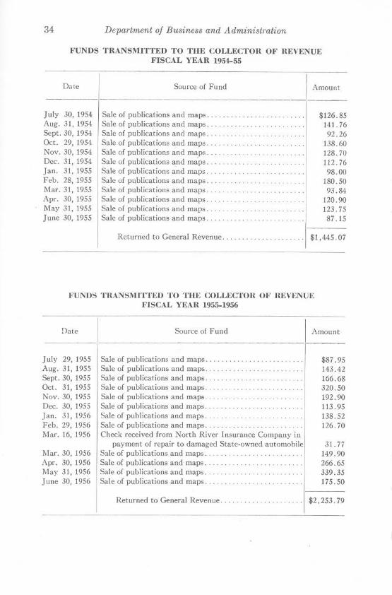
FUNDS TUANSMITTED TO THE COLLECTOR OF REVENUE FISCAL YEAR 1954-55
__ Date _]
July 30, 1954 Aug. 31, 1954 Sept. 30, 1954 Oct. 29, 1954 Nov. 30, 1954 Dec. 31, 1954 Jan. 31, 1955 Feb. 28, 1955 Mar. 31, 1955 Apr. 30, 1955 May 31, 1955 June 30, 1955
Source of Fund
Sale of publications and maps ....... . .... . .... . ... .. . . Sale of publications and maps .. . .. . ....... . . . . .. . . . .. . Sale of publications and maps ... ........ .. ... . .. . Sale of publications and maps ..... .... . Sale of publications and maps ... . . .. ... ... . .. . . . Sale of publications and maps .... . .. . Sale of publications and maps .. .. .... ... .. .. . . . Sale of publications and maps ..... .. . . . ... .. .. . Sale of publications and maps . .. . Sale of publications and maps . . . . .. .... . ..... . Sale of publications and maps . . . . .. ... .... .. . Sale of publications and maps ...... . .. .. ........... .. .
Amount
$126.85 141. 76 92.26
138.60 128.70 112. 76 98.00
180.50 93.84
120.90 123.75 87 .15
Returned to General Revenue.. . . . . . . . . . . . . . . . . . . . $1,445.07
l'UNDS TRANSMI'JVfED TO Tllli COLLECTOU OF REVENUE FISCAL YEAR 1955-1956
Date
July 29, 1955 Aug. 31, 1955 Sept. 30, 1955 Oct. 31, 1955 Nov. 30, 1955 Dec. 30, 1955 Jan. 31, 1956 Feb. 29, 1956 Mar. 16, 1956
Mar. 30, 1956 Apr. 30, 1956 May 31, 1956 June 30, 1956
Source of Fund
Sale of publications and maps . . . .. . . ... .. .. . . . .... ... . Sale of publications and maps ... .. . . . Sale of publications and maps ... ... . . . .... . .... . .. . . . . Sale of publications and maps . . . . . . .. .. . .. .. .. .. .. . Sale of publications and maps . . . . . . .. ... .. . Sale of publications and maps ... ... .. . . . .. . .. . ... .... . Sale of publications and maps. . . . .. ... .. . Sale of publications and maps .......... . . . . . .. .. ... .. . Check received from North River Insurance Company in
payment of repair to damaged State-owned automobile Sale of publications and maps ......... .. .. .. ... . . .. . . . Sale of publications and maps. . . .. . . . ... .. . . Sale of publications and maps .... .... . . . . Sale of publications and maps.
Returned to General Revenue .... . . ... ... .. . .. . .. .
Amount
$87 .95 143.42 166.68 320.50 192.90 113. 95 138.52 126 . 70
31. 77 149.90 266.65 339.35 175.50
$2,253.79