Geological Setting - WIReDSpace Homewiredspace.wits.ac.za/bitstream/handle/...GEOLOGY.pdf ·...
37
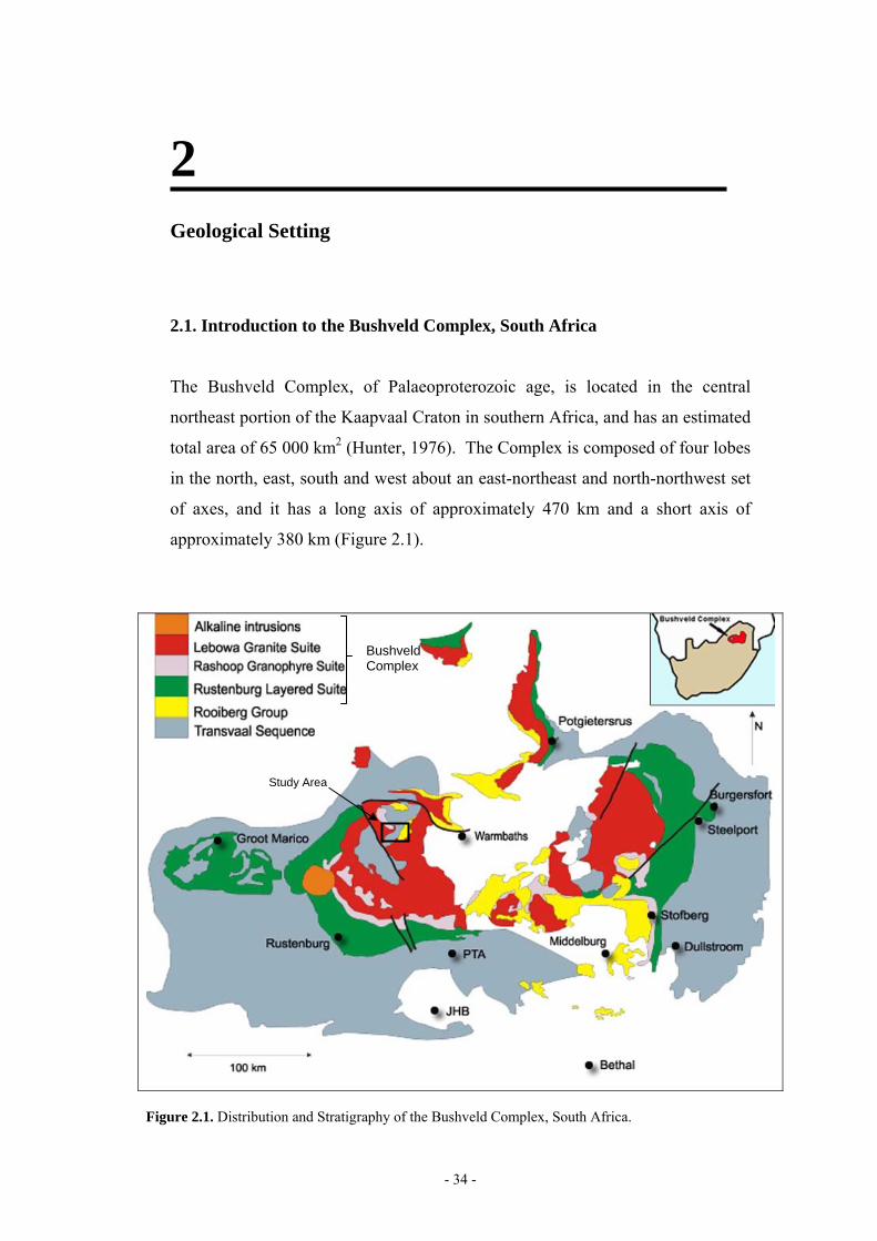
2 Geological Setting 2.1. Introduction to the Bushveld Complex, South Africa The Bushveld Complex, of Palaeoproterozoic age, is located in the central northeast portion of the Kaapvaal Craton in southern Africa, and has an estimated total area of 65 000 km 2 (Hunter, 1976). The Complex is composed of four lobes in the north, east, south and west about an east-northeast and north-northwest set of axes, and it has a long axis of approximately 470 km and a short axis of approximately 380 km (Figure 2.1). Figure 2.1. Distribution and Stratigraphy of the Bushveld Complex, South Africa. Study Area Bushveld Complex - 34 -
Transcript of Geological Setting - WIReDSpace Homewiredspace.wits.ac.za/bitstream/handle/...GEOLOGY.pdf ·...
2 Geological Setting
2.1. Introduction to the Bushveld Complex, South Africa
The Bushveld Complex, of Palaeoproterozoic age, is located in the central
northeast portion of the Kaapvaal Craton in southern Africa, and has an estimated
total area of 65 000 km2 (Hunter, 1976). The Complex is composed of four lobes
in the north, east, south and west about an east-northeast and north-northwest set
of axes, and it has a long axis of approximately 470 km and a short axis of
approximately 380 km (Figure 2.1).
Figure 2.1. Distribution and Stratigraphy of the Bushveld Complex, South Africa.
Study Area
Bushveld Complex
- 34 -
Chapter 2 – Geological Setting
Interest and exploration efforts within the Bushveld Complex have largely been
concentrated on the more economically important mafic rocks of the Rustenburg
Layered Suite, which host vast resources of platinum, platinum group elements,
chromium, nickel, vanadium and titanium in quantities unparalleled elsewhere in
the world.
Documentation of the granites belonging to the Lebowa Granite Suite and their
associated roof rocks has concentrated principally on tin mineralisation, most
notably developed at mines such as Zaaiplaats, Union, Stavoren and Rooiberg,
and on fluorite mineralisation located at the Vergenoeg, Zwartkloof and Buffalo
fluorite mines.
Vergenoeg Fluorite Mine, situated approximately 65 kms north of Pretoria, is
possibly one of the single largest fluorspar mines in the world with an estimated
178 Mt @ 28.1 % CaF2 and 195 Mt @ 42 % Fe (Fourie, 2000). Vergenoeg is of
particular significance to this study because it represents a well-developed and
well-documented example of fluorite-hematite mineralisation in the Lebowa
Granite Suite, similar in mineralisation and geological setting to deposits found
throughout the acid rocks and roof rocks of the Bushveld Complex. It also
demonstrates the potential for development of sizeable mineralised targets. Its
characteristics are distinctly IOCG in nature and it has been broadly correlated
with Olympic Dam (South Australia) and Kiruna-Aituk (Sweden).
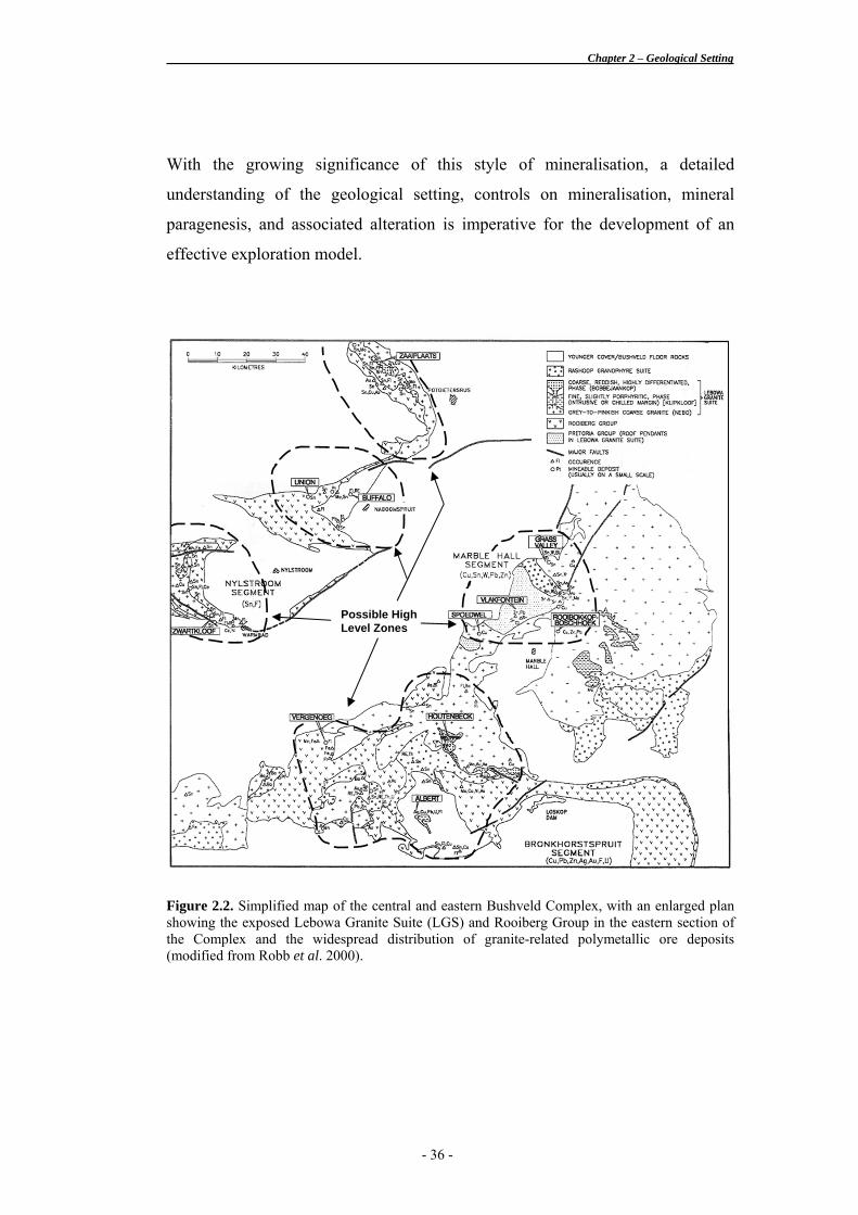
Numerous small deposits similar to the Vergenoeg massive iron oxide-fluorite
deposit occur distributed in around the Bushveld granites and its associated roof
rocks. Most of these deposits possess an intrinsic iron oxide component, and
usually posses some polymetallic association, such as that found at Albert silver
mine (Robb et al, 1994), Klipdrift molybdenum deposit (Bailie, 1997),
Rooibokkop-Boschhoek copper deposit (Smits, 1986) and Spoedwel copper mine
(Scoggins, 1991) (Figure 2.2). Deposits and occurrences in the western
Bushveld, such as those on the farms Ruigtepoort, Slipfontein, and Blokspruit
will be examined in this study.
- 35 -
Chapter 2 – Geological Setting
With the growing significance of this style of mineralisation, a detailed
understanding of the geological setting, controls on mineralisation, mineral
paragenesis, and associated alteration is imperative for the development of an
effective exploration model.
Figure 2.2. Simplified map of the central and eastern Bushveld Complex, with an enlarged plan showing the exposed Lebowa Granite Suite (LGS) and Rooiberg Group in the eastern section of the Complex and the widespread distribution of granite-related polymetallic ore deposits (modified from Robb et al. 2000).
Possible High Level Zones
- 36 -
Chapter 2 – Geological Setting
2.2. Regional and Tectonic Setting
The Bushveld Complex is seated in the central northeast portion of the Kaapvaal
craton and is regarded as having been emplaced in an intra-cratonic, anorogenic
setting possibly related to mantle pluming. The Kaapvaal Craton covers an area
of approximately 1.2 x 10⁶ km2 and comprises predominantly granitoids
interspersed with greenstone belts, covered by a variety of Neo-Archean to
Mesoproterozoic sedimentary and volcanosedimentary basins (Good & De Wit,
1997).
The emplacement of the Bushveld Complex is thought to have been controlled by
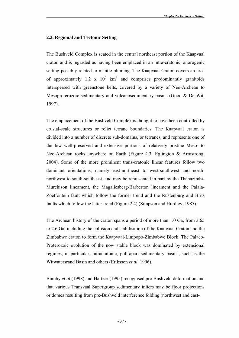
crustal-scale structures or relict terrane boundaries. The Kaapvaal craton is
divided into a number of discrete sub-domains, or terranes, and represents one of
the few well-preserved and extensive portions of relatively pristine Meso- to
Neo-Archean rocks anywhere on Earth (Figure 2.3, Eglington & Armstrong,
2004). Some of the more prominent trans-cratonic linear features follow two
dominant orientations, namely east-northeast to west-southwest and north-
northwest to south-southeast, and may be represented in part by the Thabazimbi-
Murchison lineament, the Magaliesberg-Barberton lineament and the Palala-
Zoetfontein fault which follow the former trend and the Rustenburg and Brits
faults which follow the latter trend (Figure 2.4) (Simpson and Hurdley, 1985).
The Archean history of the craton spans a period of more than 1.0 Ga, from 3.65
to 2.6 Ga, including the collision and stabilisation of the Kaapvaal Craton and the
Zimbabwe craton to form the Kaapvaal-Limpopo-Zimbabwe Block. The Palaeo-
Proterozoic evolution of the now stable block was dominated by extensional
regimes, in particular, intracratonic, pull-apart sedimentary basins, such as the
Witwatersrand Basin and others (Eriksson et al. 1996).
Bumby et al (1998) and Hartzer (1995) recognised pre-Bushveld deformation and
that various Transvaal Supergroup sedimentary inliers may be floor projections
or domes resulting from pre-Bushveld interference folding (northwest and east-
- 37 -
Chapter 2 – Geological Setting
Figure 2.3. Proposed cratonic architecture as suggested by terrane boundaries within the Kaapvaal Craton. Thick dashed line delineates the geophysical boundary of the Kaapvaal Craton, with terrane boundaries chosen to coincide with the Colesberg lineament, the Thabazimbi-Murchison lineament (TMZ), the Hout River Shear Zone (HRSZ), the Palala shear zone (PSZ) and a south-westerly extension of the Inyoka Fault (reproduced from Eglington & Armstrong, 2004).
- 38 -

Chapter 2 – Geological Setting
Figure 2.4. Lineaments traversing the Bushveld Complex shown in relation to older megalineaments of the Kaapvaal and Zimbabwe Cratons (see inset) (Davies et al., 1970,; Wilson, 1977, 1979) and radiometric anomalies over the Lebowa Granite Suite denoted by black dots. The megalineaments are as follows: A) Great Dyke, B) Losburg-Trompsburg, C) Murchison, D) Koppies continental arch, E) Ushushwana. The corresponding Bushveld lineaments are as follows: 1) Franspoort Zone, 2) Grobblaars Hoek-Hlabisa Zone, 3) Soutpan-Spitskop Zone, 4) Murchison Zone, 5) Glenover-Grobbelaars Hoek Zone. All known deposits of fluorspar and tin and eighty-five percent of the radiometric anomalies are confined within these zones. Some of the radiometric anomalies are so closely spaced that they are not individually represented here (after Simpson & Hurdley, 1985).
northeast trending fold axes), which may have also acted as physical barriers
against which Bushveld magmas accumulated.
After the emplacement of the Bushveld Complex between 2.060 and 2.050 Ga,
the craton accreted new material principally along its western margin with the
Kheis (Eburnian) orogeny between 1.999 – 1.928 Ga (Kruger et al. 1999), the
Kibaran (Grenville) orogeny between 1.220 – 1.170 Ga (Robb, et al. 2000), and
the Panafrican (Namaquan) orogeny between 1.060 - 1.030 Ga (Robb, et al.
2000). Exhumation of the Bushveld Complex is thought to have coincided with
the deposition of the Waterberg and Zoutpansberg formations at around 1.770 Ga
- 39 -
Chapter 2 – Geological Setting
(SACS, 1980) from reset isotopic systems, which indicate a closure at c. 1.800
Ga (Robb, et al. 2000). The deposition of Karoo sediments took place between
280 and 190 Ma (Friese et al., 1995).
Subsequent to the emplacement of the Bushveld Complex, reactivation of the
Mesoproterozoic south-southeast (150°) trend, along which the Rustenburg fault
was initially formed, disrupted the western limb of the Complex. Pilanesberg
alkaline dykes (~1450-1200 Ma. Harmer, 1992) were intruded predominantly
along the north-northwest orientated extensional structures.
Karoo Supergroup sedimentary stratigraphy was deposited in basins related to
epeirogenic flexuring of the sub-continent associated with the break-up of
Gondwanaland, initiated in the Early Cretaceous (130 Ma) (Moore, 1999). Uplift
in the Pliocene and Plio-Pleistocene (4-2 Ma) occurred on the western margin of
the continent, with flexuring along a southwest-northeast axis forming
depressions in the Bushveld, Bushmanland, Karoo-Lesotho and Botswana.
The general geological characteristics of the Transvaal Supergroup and the
components of the Bushveld Complex are discussed below in more detail.
- 40 -
Chapter 2 – Geological Setting
2.3. General Stratigraphy of the Transvaal Supergroup and the Bushveld
Complex
The Bushveld Complex comprises the voluminous, bimodal intrusive magmas of
mafic and felsic characteristics into predating Transvaal Supergroup sediments
and Rooiberg Group volcanics. The country rocks to the intrusive magmas are
important with regard to chemical assimilation and mineralisation potential.
Transvaal Supergroup
The Transvaal Supergroup comprises a 15 000 m thick sequence of relatively
undeformed clastic sediments and volcanics. The principal elements of the
Supergroup include the clastic sediments of the Black Reef Formation, the
chemical and clastic sediments of the Chuniespoort Group, and the clastic
sediments and volcanics of the Pretoria Group. The Bushveld Complex intruded
into the Transvaal Supergroup at a palaeo-unconformity between the Rooiberg
Group and the underlying Pretoria Group (Cheney & Twist, 1991). The surficial
distribution of the Transvaal Supergroup extends across the central and southern
parts of the Transvaal into Botswana. The Supergroup comprises two correlated
sub-basins known as the Transvaal Sub-basin in the east and the Griqualand Sub-
basin in the west.
Deposition began in a relatively small protobasin during the Godwan, but in time
spread to an area of over 500 000 km2 (Button, 1986). The basin then decreased
in size in its terminal stages. The basin is assymetrical, thinning rapidly to the
north and more gradually to the south of an east-northeast-trending depositional
axis (Button, 1986). The present shape of the basin was largely controlled by
post-Transvaal events, such as the Bushveld intrusion. The age of the basin is
c. 2643-2061 Ma (Walraven, 1997; Walraven et al, 1999), which corresponded in
part to the probable collision between the Kaapvaal and Zimbabwe cratons at
- 41 -
Chapter 2 – Geological Setting
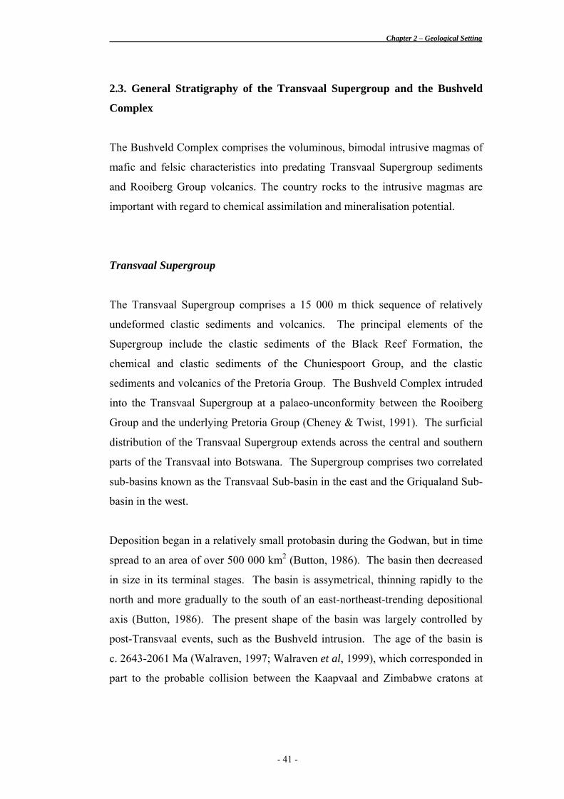
about 2 400 Ma. The clastic sediments were derived from a mountainous source
to the north-northeast of the basin (Button, 1986).
The depositional facies grade from braided fluvial arkoses, through tidal flat
sediments to mature sandy shelf deposits that consist primarily of shales and
carbonate shales. Up to 3 000 m of carbonate and iron formation were deposited
on the macro-tidal shelf, indicating that the shelf and its surroundings must have
been tectonically very stable for a considerable period of time.
Rooiberg Group
The Rooiberg Group consists of an unusually thick and extensive sequence of
epicrustal acid volcanics comprising dacites, rhyolites and rare andesites. Lavas,
air-fall tuffs, ash-flow tuffs and phreatic (hydrothermal) tuffs are all present with
interbedded shales, sandstones and volcanic mudflows. Although the Rooiberg
Group has long been viewed as the terminal stage of deposition in the Transvaal
Basin, it is now more-widely considered to represent the preliminary stage of
magmatism related to the Bushveld Complex, with a possible 30-40 million year
hiatus between sedimentary deposition in the Transvaal Basin and the eruption of
the Rooiberg volcanics (Robb, pers. comm.). With a thickness of more than 5 km
in places and an estimated volume of 300 000 km3, the Rooiberg Group
represents one of the world’s largest acid volcanic provinces (French & Twist,
1983). It has been assigned an age of 2057.3 + 3.8 Ma obtained by single U-Pb
SHRIMP zircon analysis (Harmer & Armstrong, 2000), and may be seen to
represent the earliest episode of magmatic activity pertaining to the Bushveld
Complex. It forms the “roof” rocks to the rest of the Complex with unequivocal
intrusive relationships between the Rooiberg Group and all the components of the
Bushveld Complex. The distribution of the Rooiberg Group is shown in
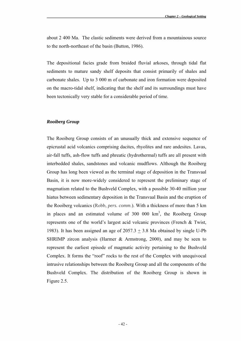
Figure 2.5.
- 42 -
Chapter 2 – Geological Setting
Figure 2.5. Distribution of Rooiberg Group rocks (taken from Crocker et al., 2001).
Study Area
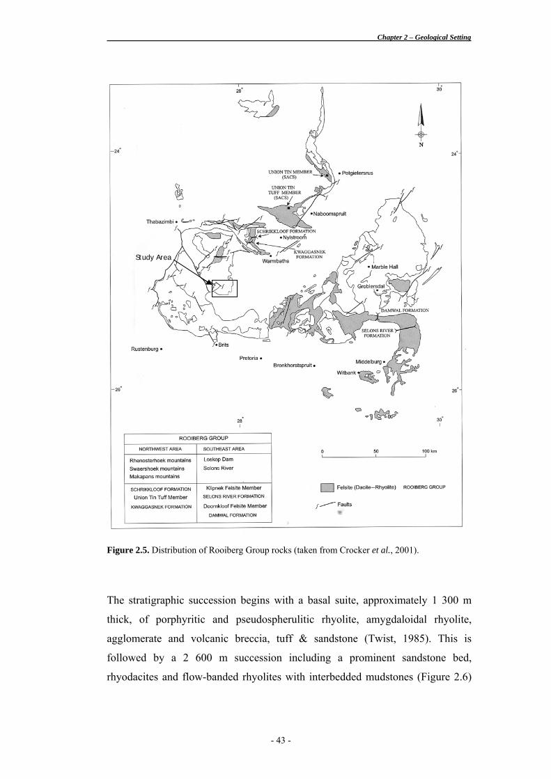
The stratigraphic succession begins with a basal suite, approximately 1 300 m
thick, of porphyritic and pseudospherulitic rhyolite, amygdaloidal rhyolite,
agglomerate and volcanic breccia, tuff & sandstone (Twist, 1985). This is
followed by a 2 600 m succession including a prominent sandstone bed,
rhyodacites and flow-banded rhyolites with interbedded mudstones (Figure 2.6)
- 43 -
Chapter 2 – Geological Setting
(Crocker et al. 2001). This stratigraphy varies between outcrops north and south
of outliers of Karoo rocks situated central to the Complex.
Contrary to expectations, most of the litho-types observed in the study area
correspond to the Damwal Formation rocks observed in the eastern Bushveld but
which are generally regarded as being undeveloped in the western Bushveld.
What is apparent is that any Rooiberg Group rocks in the area correspond to the
lowest portions of the volcanic stratigraphy.
Figure 2.6. Variation in the lithostratigraphic succession of Rooiberg Group rocks between the eastern and western lobes of the Bushveld Complex. Red bar indicates litho-types that have been potentially identified within the study area, corresponding to the Damwal Formation in the eastern Bushveld but largely undeveloped in the western Bushveld (taken from Crocker et al., 2001).
- 44 -
Chapter 2 – Geological Setting
Bushveld Complex
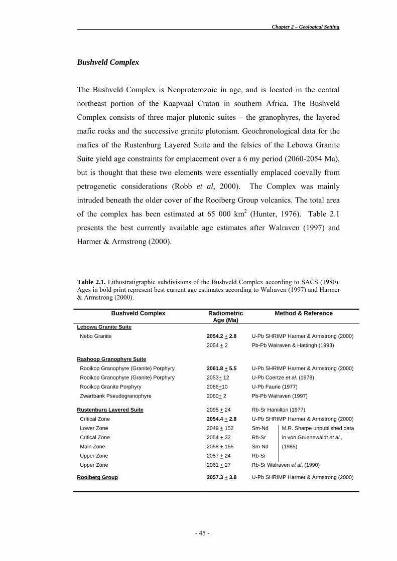
The Bushveld Complex is Neoproterozoic in age, and is located in the central
northeast portion of the Kaapvaal Craton in southern Africa. The Bushveld
Complex consists of three major plutonic suites – the granophyres, the layered
mafic rocks and the successive granite plutonism. Geochronological data for the
mafics of the Rustenburg Layered Suite and the felsics of the Lebowa Granite
Suite yield age constraints for emplacement over a 6 my period (2060-2054 Ma),
but is thought that these two elements were essentially emplaced coevally from
petrogenetic considerations (Robb et al, 2000). The Complex was mainly
intruded beneath the older cover of the Rooiberg Group volcanics. The total area
of the complex has been estimated at 65 000 km2 (Hunter, 1976). Table 2.1
presents the best currently available age estimates after Walraven (1997) and
Harmer & Armstrong (2000).
Table 2.1. Lithostratigraphic subdivisions of the Bushveld Complex according to SACS (1980). Ages in bold print represent best current age estimates according to Walraven (1997) and Harmer & Armstrong (2000).
Bushveld Complex Radiometric Age (Ma)
Method & Reference
Lebowa Granite Suite
Nebo Granite 2054.2 + 2.8 U-Pb SHRIMP Harmer & Armstrong (2000)
2054 + 2 Pb-Pb Walraven & Hattingh (1993)
Rashoop Granophyre Suite
Rooikop Granophyre (Granite) Porphyry 2061.8 + 5.5 U-Pb SHRIMP Harmer & Armstrong (2000)
Rooikop Granophyre (Granite) Porphyry 2053+ 12 U-Pb Coertze et al. (1978)
Rooikop Granite Porphyry 2066+10 U-Pb Faurie (1977)
Zwartbank Pseudogranophyre 2060+ 2 Pb-Pb Walraven (1997)
Rustenburg Layered Suite 2095 + 24 Rb-Sr Hamilton (1977)
Critical Zone 2054.4 + 2.8 U-Pb SHRIMP Harmer & Armstrong (2000)
Lower Zone 2049 + 152 Sm-Nd
Critical Zone 2054 + 32 Rb-Sr
Main Zone 2058 + 155 Sm-Nd
Upper Zone 2057 + 24 Rb-Sr
M.R. Sharpe unpublished data
in von Gruenewaldt et al.,
(1985)
Upper Zone 2061 + 27 Rb-Sr Walraven et al. (1990)
Rooiberg Group 2057.3 + 3.8 U-Pb SHRIMP Harmer & Armstrong (2000)
- 45 -
Chapter 2 – Geological Setting
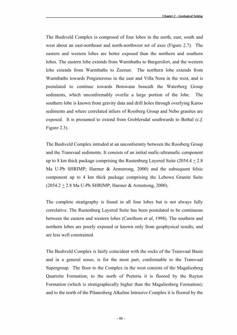
The Bushveld Complex is composed of four lobes in the north, east, south and
west about an east-northeast and north-northwest set of axes (Figure 2.7). The
eastern and western lobes are better exposed than the northern and southern
lobes. The eastern lobe extends from Warmbaths to Burgersfort, and the western
lobe extends from Warmbaths to Zeerust. The northern lobe extends from
Warmbaths towards Potgietersrus in the east and Villa Nora in the west, and is
postulated to continue towards Botswana beneath the Waterberg Group
sediments, which unconformably overlie a large portion of the lobe. The
southern lobe is known from gravity data and drill holes through overlying Karoo
sediments and where correlated inliers of Rooiberg Group and Nebo granites are
exposed. It is presumed to extend from Groblersdal southwards to Bethal (c.f.
Figure 2.3).
The Bushveld Complex intruded at an unconformity between the Rooiberg Group
and the Transvaal sediments. It consists of an initial mafic-ultramafic component
up to 8 km thick package comprising the Rustenburg Layered Suite (2054.4 + 2.8
Ma U-Pb SHRIMP; Harmer & Armstrong, 2000) and the subsequent felsic
component up to 4 km thick package comprising the Lebowa Granite Suite
(2054.2 + 2.8 Ma U-Pb SHRIMP; Harmer & Armstrong, 2000).
The complete stratigraphy is found in all four lobes but is not always fully
correlative. The Rustenburg Layered Suite has been postulated to be continuous
between the eastern and western lobes (Cawthorn et al, 1998). The southern and
northern lobes are poorly exposed or known only from geophysical results, and
are less well constrained.
The Bushveld Complex is fairly coincident with the rocks of the Transvaal Basin
and in a general sense, is for the most part, conformable to the Transvaal
Supergroup. The floor to the Complex in the west consists of the Magaliesberg
Quartzite Formation; to the north of Pretoria it is floored by the Rayton
Formation (which is stratigraphically higher than the Magaliesberg Formation);
and to the north of the Pilanesberg Alkaline Intrusive Complex it is floored by the
- 46 -
Chapter 2 – Geological Setting
Figu
re 2
.7. T
he A
cid
Roc
ks o
f the
Leb
owa
Gra
nite
Sui
te (t
aken
from
Cro
cker
et a
l. 20
01).
Stud
y Ar
ea
- 47 -
Chapter 2 – Geological Setting
Daspoort Quartzite Formation (which is stratigraphically lower than the
Magaliesberg Formation). That is to say that the Bushveld Complex overlies
successively higher Transvaal stratigraphy towards the south and the east. The
roof rocks are likewise stratigraphically higher with Rooiberg Group volcanics
roofing the Complex in the northern and central portions, and the Pretoria Group
sediments roofing the Complex in the far western and Stavoren regions.
Rashoop Granophyre Suite
Field relationships indicate that the Rashoop Granophyre Suite (2061.8 + 5.5 Ma;
Harmer & Armstrong, 2000) predates the intrusion of the Rustenburg Layered
Suite (2054.4 + 2.8 Ma U-Pb SHRIMP; Harmer & Armstrong, 2000) and occurs
as an intrusive sheet into the Rooiberg rhyolites and the Transvaal Supergroup
rocks (Kleeman, 1985). The granophyres are thought to be a cogenetic, shallow
intrusive equivalent of the Rooiberg Group volcanic event. The granophyre-
rhyolite magma is largely thought to be derived from partial melting of the lower
crust, presumably with a granitic composition (Walraven, 1982). Some varieties
of granophyre, however, possibly formed as a result of metamorphic/metasomatic
effects related to the intrusion of the Rustenburg Layered Suite acting on the
Pretoria Group sedimentary roof rocks; or by the partial melting of Rooiberg
Group rhyolites also a consequence of the hot intrusive magmas of the
Rustenburg Layered Suite (Walraven, 1982).
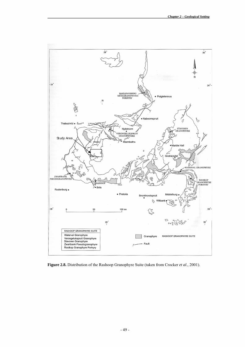
The Rashoop Granophyre Suite comprises three units based on textural
variations; the Stavoren Granophyre, the Zwartbank Pseudogranophyre and the
Rooikop Granite Porphyry (SACS, 1980). Many more varieties have been
proposed by extensive work by Walraven (1977, 1979, 1982). Figure 2.8 shows
the distribution of the Rashoop Granophyre Suite.
The Stavoren granophyre is a granophyre senso stricto, and is the most prominent
and abundant of the various types of granophyre in the Bushveld Complex. It
- 48 -
Chapter 2 – Geological Setting
Figure 2.8. Distribution of the Rashoop Granophyre Suite (taken from Crocker et al., 2001).
Study Area
- 49 -
Chapter 2 – Geological Setting
consists almost exclusively of micrographic intergrowths of quartz and perthitic
feldspar (Walraven, 1982) and displays a range of colours from brick-red to grey.
The proportion of quartz to feldspar is a remarkably constant ratio of 45:55,
which has been suggested to indicate cotectic crystallisation at the ternary
minimum melting point, and hence evidence for a magmatic origin (Walraven,
1977).
The Zwartbank pseudogranophyre is distinguished from the Stavoren granophyre
by the variability in proportions of quartz and feldspar and the distinctly less
regular intergrown textures. Walraven (1977) proposed that this rock formed
from metamorphic/metasomatic effects of the intrusion of the Rustenburg
Layered Suite acting on the Pretoria Group sedimentary roof rocks.
The Rooikop Granite Porphyry forms sills in the Rooiberg Group in the Loskop
Formation of the Transvaal Supergroup. It consists of a fine-grained matrix
containing abundant phenocrysts of quartz and feldspar (usually perthite).
Embayments in the quartz and feldspar indicate partial resorbtion (Walraven,
1982). The micrographic texture observed in the other granophyric varieties is
rarely present.
Other varieties of granophyre occur but in limited quantity and distribution;
including a spherulitc variety of the Stavoren granophyre referred to as Spherulitc
granophyre (Walraven, 1982), which is regarded as originally having been
Rooiberg Group rhyolites which was incorporated into the Stavoren Granophyre.
The granophyres themselves do not have associated mineralisation but often act
as trap-sites to mineralising fluids from the underlying granites.
- 50 -
Chapter 2 – Geological Setting
Rustenburg Layered Suite
Notes on the Rustenburg Layered Suite are included here for completeness. No
rocks of this suite have been identified in this study nor are they expected in the
area.
The Rustenburg Layered Suite has an assigned age of 2054.4 + 2.8 Ma (Critical
Zone U-Pb SHRIMP; Harmer & Armstrong, 2000), which is roughly equivalent
to the age obtained for the Rooiberg Group rhyolites of 2057.3 + 3.8 Ma
(Kwaggasnek Formation U-Pb SHRIMP; Harmer & Armstrong, 2000), consists
of approximately 8 kms of pyroxenite, norite, gabbro and other mafic to
ultramafic lithologies. The Rustenburg Layered Suite has been subdivided into
four main stratigraphic units, being the Lower Zone (1 500 m harzburgite-
bronzitite), the Critical Zone (1 500 m pyroxenite-anorthosite-norite), the Main
Zone (3 750 m norite-anorthosite-gabbronorite), and the Upper Zone (2 250 m
gabbronorite-magnetite gabbro-olivine diorite).
The Critical Zone, found in both the eastern and western lobes of the Bushveld
Complex, contains the largest stratiform chromitite deposits in the world, which
account for nearly 55 % of the world’s reserves. Numerous chromitite layers have
been identified and have been subdivided into Lower Group, Middle Group and
Upper Group chromitite seams. The Critical Zone is also host to the world’s
largest platinum-PGE deposit, situated primarily in the Merensky Reef, at the
Critical Zone-Main Zone interface, and the UG2 chromitite seam, some 500 m
stratigraphically below, and accounts for approximately 40 % of the world’s
reserves.
The Upper Zone is host to about 25 titaniferous–vanadiniferous-magnetite layers.
Opencastable reserves throughout the Bushveld Complex are estimated at about
26 000 Mt (Reynolds, 1986).
- 51 -
Chapter 2 – Geological Setting
Lebowa Granite Suite
The Bushveld granites form a 2-3 km thick sheet-like sill of batholithic
proportions, which gently dips centripetally towards the centre of the Complex,
although it is gently folded locally to expose inliers of the underlying
sedimentary rocks, such as the Marble Hall and Crocodile River fragments
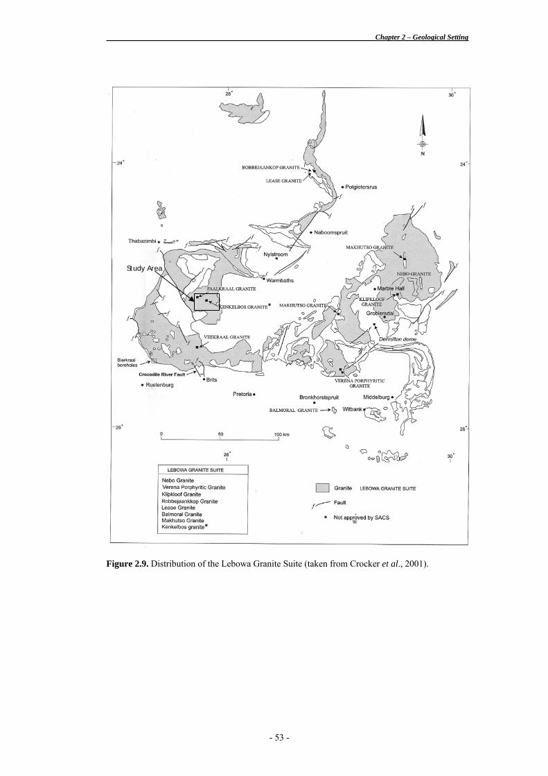
(Kleeman & Twist, 1989) (see Figure 2.9 for the distribution of the LGS). The
main granites of the Lebowa Granite Suite, or Nebo granite (SACS, 1980), are
highly potassic, magnetite-bearing, A-type* granites. Straus (1954) noted several
variations within the Nebo granite such as an upwardly decrease in hornblende
contents and a gradual colour change from grey at its base to a distinctive
deepening red colour towards the upper parts, caused by the trapping of hematite
in the feldspar lattices during deuteric alteration of the feldspar. The Nebo
granites are by and large the most common variety and occupy most of the
central core of the Complex. The zonation within the Nebo granite from base to
roof is characterised below by the following general trends shown in Table 2.2.
Table 2.2. General trends in Nebo granite from base to roof (Gain & Twist, 1995).
• Grey at the base, becoming pink and then red upwards corresponding to an upwards decrease in
the Fe2+/Fe3+ ratio (Bailie, 1997);
• Upwardly-increasing perthite and quartz contents;
• Upwardly-increasing obliquity values in K-feldspar;
• Upwardly-increasing Si, K, Rb and Th contents;
• Upwardly-increasing signs of hydrothermal alteration, like albitisation, microclinisation and
tourmalinisation;
• Upwardly-decreasing hornblende and plagioclase contents;
• Upwardly-decreasing Fe, Ti, Ca, Ba, Sr, Zr, and Zn contents.
* The A-type nature of the Bushveld granites denotes their essential characteristics: anorogenic, anhydrous, and mildly alkaline. (Chappell & White, 1974; Collins et al., 1982; and Whalen et al., 1987).
- 52 -
Chapter 2 – Geological Setting
Figure 2.9. Distribution of the Lebowa Granite Suite (taken from Crocker et al., 2001).
Study Area
- 53 -
Chapter 2 – Geological Setting
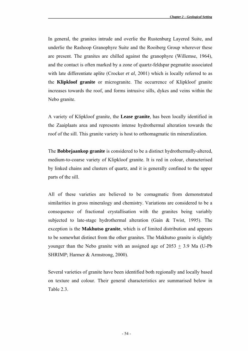
In general, the granites intrude and overlie the Rustenburg Layered Suite, and
underlie the Rashoop Granophyre Suite and the Rooiberg Group wherever these
are present. The granites are chilled against the granophyre (Willemse, 1964),
and the contact is often marked by a zone of quartz-feldspar pegmatite associated
with late differentiate aplite (Crocker et al, 2001) which is locally referred to as
the Klipkloof granite or microgranite. The occurrence of Klipkloof granite
increases towards the roof, and forms intrusive sills, dykes and veins within the
Nebo granite.
A variety of Klipkloof granite, the Lease granite, has been locally identified in
the Zaaiplaats area and represents intense hydrothermal alteration towards the
roof of the sill. This granite variety is host to orthomagmatic tin mineralization.
The Bobbejaankop granite is considered to be a distinct hydrothermally-altered,
medium-to-coarse variety of Klipkloof granite. It is red in colour, characterised
by linked chains and clusters of quartz, and it is generally confined to the upper
parts of the sill.
All of these varieties are believed to be comagmatic from demonstrated
similarities in gross mineralogy and chemistry. Variations are considered to be a
consequence of fractional crystallisation with the granites being variably
subjected to late-stage hydrothermal alteration (Gain & Twist, 1995). The
exception is the Makhutso granite, which is of limited distribution and appears
to be somewhat distinct from the other granites. The Makhutso granite is slightly
younger than the Nebo granite with an assigned age of 2053 + 3.9 Ma (U-Pb
SHRIMP; Harmer & Armstrong, 2000).
Several varieties of granite have been identified both regionally and locally based
on texture and colour. Their general characteristics are summarised below in
Table 2.3.
- 54 -
Chapter 2 – Geological Setting
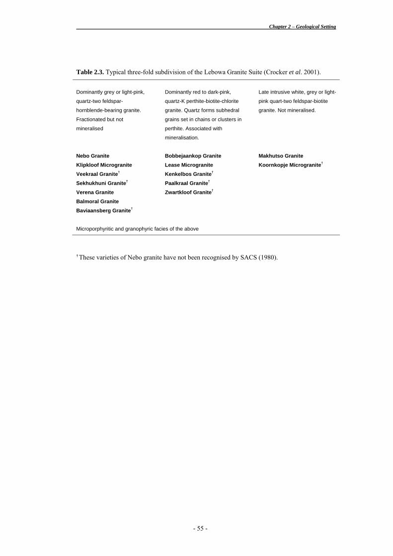
Table 2.3. Typical three-fold subdivision of the Lebowa Granite Suite (Crocker et al. 2001).
Dominantly grey or light-pink,
quartz-two feldspar-
hornblende-bearing granite.
Fractionated but not
mineralised
Dominantly red to dark-pink,
quartz-K perthite-biotite-chlorite
granite. Quartz forms subhedral
grains set in chains or clusters in
perthite. Associated with
mineralisation.
Late intrusive white, grey or light-
pink quart-two feldspar-biotite
granite. Not mineralised.
Nebo Granite Klipkloof Microgranite Veekraal Granite†
Sekhukhuni Granite†
Verena Granite Balmoral Granite Baviaansberg Granite†
Bobbejaankop Granite Lease Microgranite Kenkelbos Granite†
Paalkraal Granite†
Zwartkloof Granite†
Makhutso Granite Koornkopje Microgranite†
Microporphyritic and granophyric facies of the above
† These varieties of Nebo granite have not been recognised by SACS (1980).
- 55 -
Chapter 2 – Geological Setting
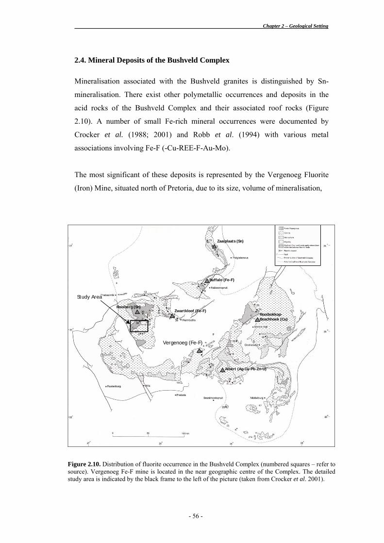
2.4. Mineral Deposits of the Bushveld Complex
Mineralisation associated with the Bushveld granites is distinguished by Sn-
mineralisation. There exist other polymetallic occurrences and deposits in the
acid rocks of the Bushveld Complex and their associated roof rocks (Figure
2.10). A number of small Fe-rich mineral occurrences were documented by
Crocker et al. (1988; 2001) and Robb et al. (1994) with various metal
associations involving Fe-F (-Cu-REE-F-Au-Mo).
The most significant of these deposits is represented by the Vergenoeg Fluorite
(Iron) Mine, situated north of Pretoria, due to its size, volume of mineralisation,
Figure 2.10. Distribution of fluorite occurrence in the Bushveld Complex (numbered squares – refer to source). Vergenoeg Fe-F mine is located in the near geographic centre of the Complex. The detailed study area is indicated by the black frame to the left of the picture (taken from Crocker et al. 2001).
Rooibokkop-Boschhoek (Cu)
Buffalo (Fe-F)
Albert (Ag-Cu-Pb-Zn-U)
Zwartkloof (Fe-F)
Zaaiplaats (Sn)
Vergenoeg (Fe-F)
Study Area
Rooiberg (Sn)
- 56 -
Chapter 2 – Geological Setting
setting and mode of emplacement, and its metallogenic and mineralogical
composition. This deposit will be discussed in greater detail below.
A description of the Phalaborwa (carbonatite-hosted magnetite-Cu-P-REE)
deposit is included in this section. The deposit occurs outside the limits of the
Bushveld Complex but was formed coeval to the emplacement of the Bushveld
granites, and the observed mineral assemblages has led some authors to include
the deposit among the IOCG class of deposits (Groves et al., 2001; Vielreicher et
al., 2000; Harmer, 2000 b).
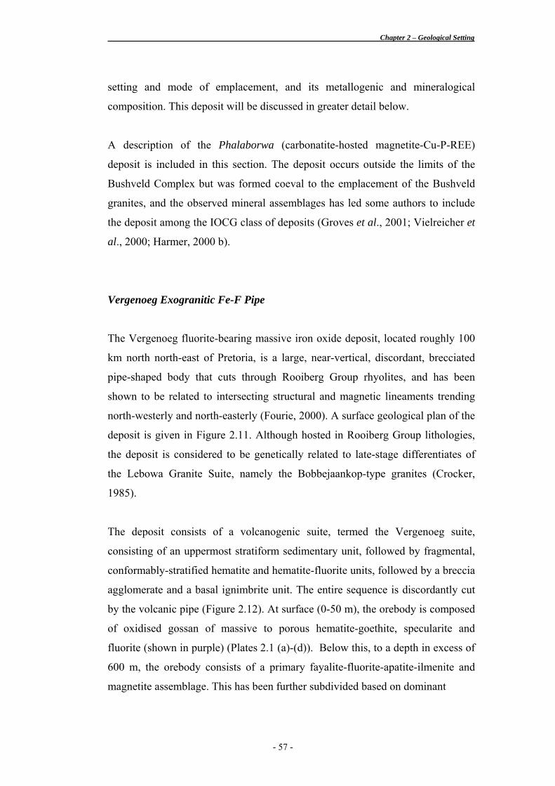
Vergenoeg Exogranitic Fe-F Pipe
The Vergenoeg fluorite-bearing massive iron oxide deposit, located roughly 100
km north north-east of Pretoria, is a large, near-vertical, discordant, brecciated
pipe-shaped body that cuts through Rooiberg Group rhyolites, and has been
shown to be related to intersecting structural and magnetic lineaments trending
north-westerly and north-easterly (Fourie, 2000). A surface geological plan of the
deposit is given in Figure 2.11. Although hosted in Rooiberg Group lithologies,
the deposit is considered to be genetically related to late-stage differentiates of
the Lebowa Granite Suite, namely the Bobbejaankop-type granites (Crocker,
1985).
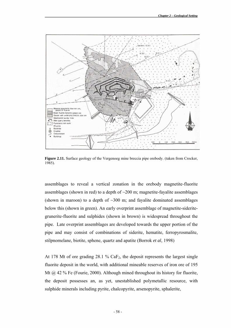
The deposit consists of a volcanogenic suite, termed the Vergenoeg suite,
consisting of an uppermost stratiform sedimentary unit, followed by fragmental,
conformably-stratified hematite and hematite-fluorite units, followed by a breccia
agglomerate and a basal ignimbrite unit. The entire sequence is discordantly cut
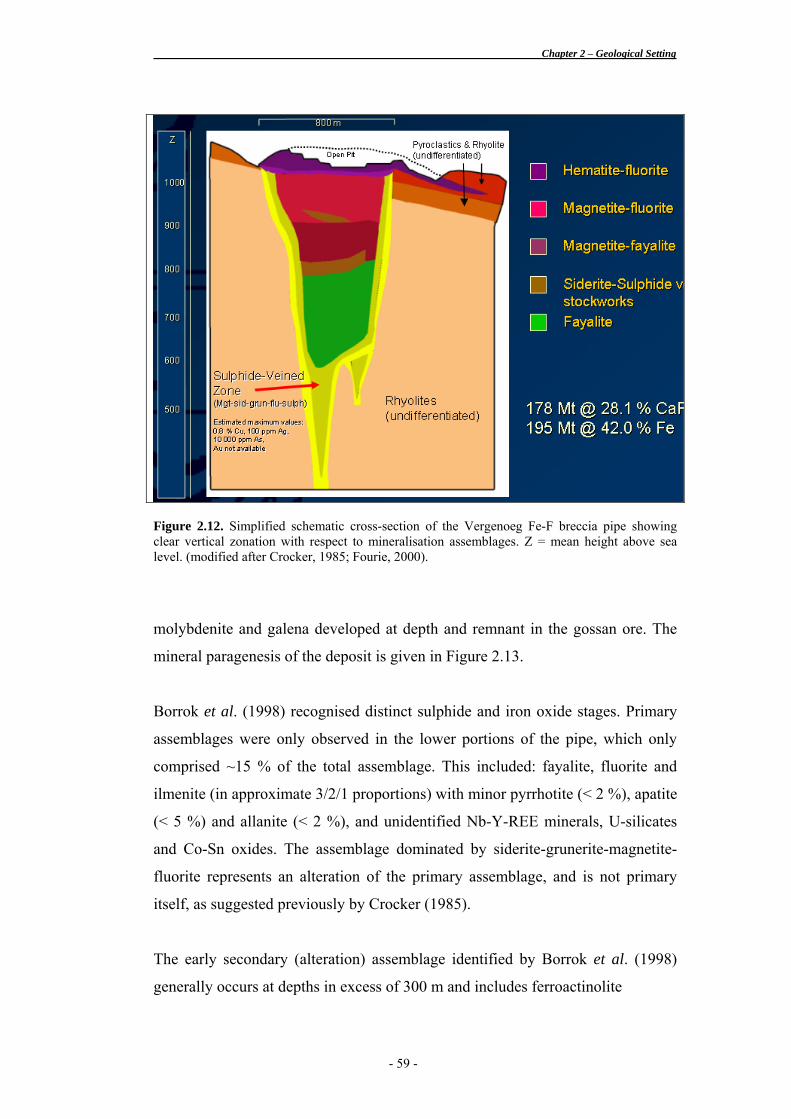
by the volcanic pipe (Figure 2.12). At surface (0-50 m), the orebody is composed
of oxidised gossan of massive to porous hematite-goethite, specularite and
fluorite (shown in purple) (Plates 2.1 (a)-(d)). Below this, to a depth in excess of
600 m, the orebody consists of a primary fayalite-fluorite-apatite-ilmenite and
magnetite assemblage. This has been further subdivided based on dominant
- 57 -
Chapter 2 – Geological Setting
Figure 2.11. Surface geology of the Vergenoeg mine breccia pipe orebody. (taken from Crocker, 1985).
assemblages to reveal a vertical zonation in the orebody magnetite-fluorite
assemblages (shown in red) to a depth of ~200 m; magnetite-fayalite assemblages
(shown in maroon) to a depth of ~300 m; and fayalite dominated assemblages
below this (shown in green). An early overprint assemblage of magnetite-siderite-
grunerite-fluorite and sulphides (shown in brown) is widespread throughout the
pipe. Late overprint assemblages are developed towards the upper portion of the
pipe and may consist of combinations of siderite, hematite, ferropyrosmalite,
stilpnomelane, biotite, sphene, quartz and apatite (Borrok et al, 1998)
At 178 Mt of ore grading 28.1 % CaF2, the deposit represents the largest single
fluorite deposit in the world, with additional mineable reserves of iron ore of 195
Mt @ 42 % Fe (Fourie, 2000). Although mined throughout its history for fluorite,
the deposit possesses an, as yet, unestablished polymetallic resource, with
sulphide minerals including pyrite, chalcopyrite, arsenopyrite, sphalerite,
- 58 -
Chapter 2 – Geological Setting
Figure 2.12. Simplified schematic cross-section of the Vergenoeg Fe-F breccia pipe showing clear vertical zonation with respect to mineralisation assemblages. Z = mean height above sea level. (modified after Crocker, 1985; Fourie, 2000).
molybdenite and galena developed at depth and remnant in the gossan ore. The
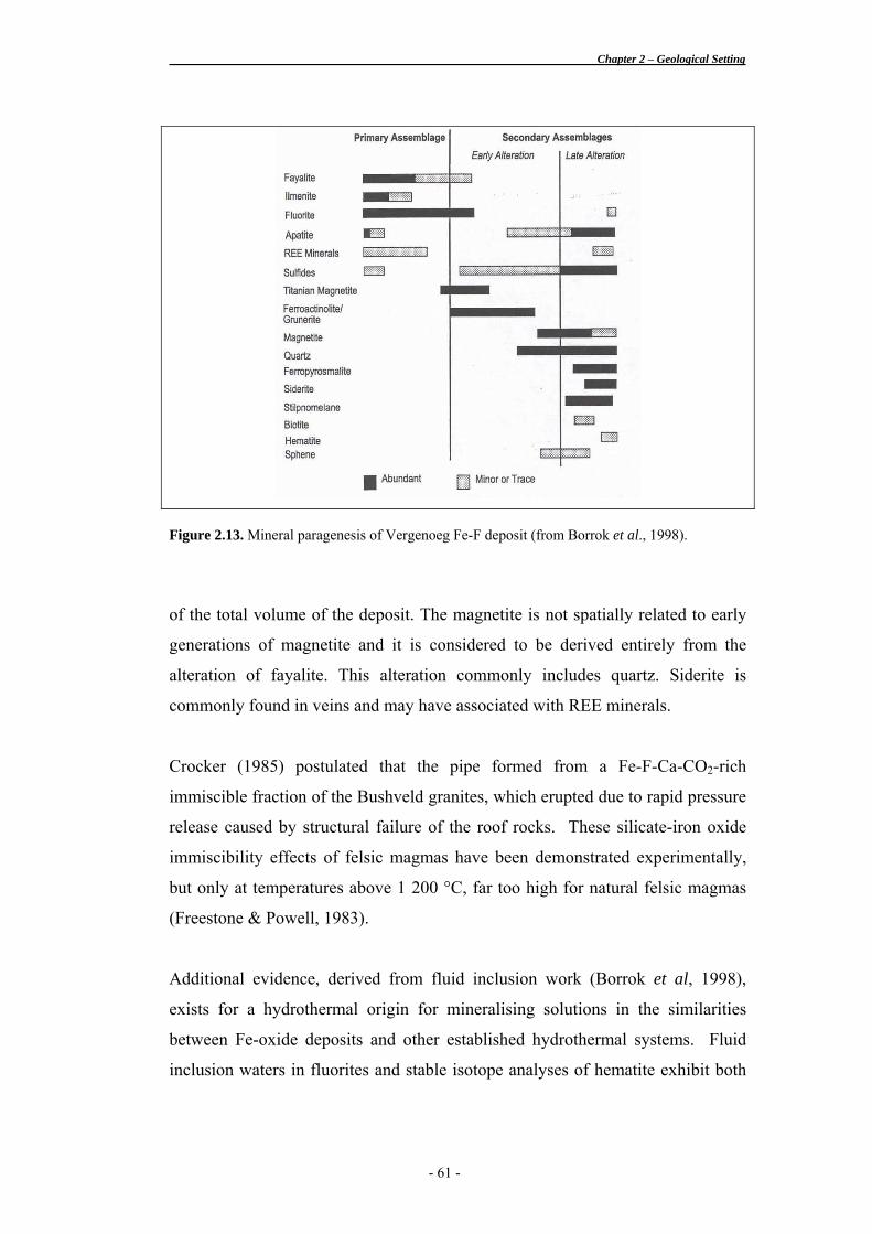
mineral paragenesis of the deposit is given in Figure 2.13.
Borrok et al. (1998) recognised distinct sulphide and iron oxide stages. Primary
assemblages were only observed in the lower portions of the pipe, which only
comprised ~15 % of the total assemblage. This included: fayalite, fluorite and
ilmenite (in approximate 3/2/1 proportions) with minor pyrrhotite (< 2 %), apatite
(< 5 %) and allanite (< 2 %), and unidentified Nb-Y-REE minerals, U-silicates
and Co-Sn oxides. The assemblage dominated by siderite-grunerite-magnetite-
fluorite represents an alteration of the primary assemblage, and is not primary
itself, as suggested previously by Crocker (1985).
The early secondary (alteration) assemblage identified by Borrok et al. (1998)
generally occurs at depths in excess of 300 m and includes ferroactinolite
- 59 -
Chapter 2 – Geological Setting
a b
c d Plate 2.1. Mineralised Fe-F breccia from Vergenoeg mine, South Africa. a) Hematite-fluorite ore sample from Vergenoeg mine. b) Thin section photomicrograph of typical magnetite-hematite-fluorite ore. Plane polars x 4; field of view is 2.75 mm wide; Photo ID: PO1-A. c) Hematite breccia with abundant sedimentary-derived fragments. Plane polars x 4; field of view is 2.75 mm wide; Photo ID: PO2-A. d) Hematite breccia with abundant sedimentary-derived fragments. Crossed polars x 4; field of view is 2.75 mm wide; Photo ID: PO2-B. (~50 %), grunerite (~20 %), titanian magnetite (~20 %), minor quartz (~10 %)
and sulphides. Ferroactinolite and grunerite occur as fine millimetre-long,
intergrown needles, forming “haystack-shaped bundles”. The authors interpreted
the growth of ferroactinolite to have occurred coeval to alteration of grunerite
after primary fayalite.
The late secondary (alteration) assemblage generally occurs at depths less than
300 m and comprises magnetite (~40 %), ferropyrosmalite (~25 %), siderite (~10
%), hematite (~8 %), stilpnomelane (~5 %), apatite (~4 %), quartz (~3 %) and
sulphides (~3 %) (Borrok et al., 1998). This assemblage constitutes about 80 %
- 60 -
Chapter 2 – Geological Setting
Figure 2.13. Mineral paragenesis of Vergenoeg Fe-F deposit (from Borrok et al., 1998).
of the total volume of the deposit. The magnetite is not spatially related to early
generations of magnetite and it is considered to be derived entirely from the
alteration of fayalite. This alteration commonly includes quartz. Siderite is
commonly found in veins and may have associated with REE minerals.
Crocker (1985) postulated that the pipe formed from a Fe-F-Ca-CO2-rich
immiscible fraction of the Bushveld granites, which erupted due to rapid pressure
release caused by structural failure of the roof rocks. These silicate-iron oxide
immiscibility effects of felsic magmas have been demonstrated experimentally,
but only at temperatures above 1 200 °C, far too high for natural felsic magmas
(Freestone & Powell, 1983).
Additional evidence, derived from fluid inclusion work (Borrok et al, 1998),
exists for a hydrothermal origin for mineralising solutions in the similarities
between Fe-oxide deposits and other established hydrothermal systems. Fluid
inclusion waters in fluorites and stable isotope analyses of hematite exhibit both
- 61 -
Chapter 2 – Geological Setting
magmatic and meteoric components. Borrok et al (1998) support a magmatic-
hydrothermal model for the Vergenoeg deposit, whereby mineralisation formed
from hydrothermal fluids of magmatic origin, later modified by an increasingly
more dominant meteoric component.
Fluids related to the primary assemblage were high temperature (>500 °C) with a
high-salinity (>67 wt% NaCl equiv.) that coexisted with a CO2-rich vapour
phase. The water compositions calculated for these fluids indicated a magmatic
source (∂18OH2O = 7-8 ‰ at 500 °C). Fluids related to the alteration assemblage
homogenised at lower temperatures (150-500 °C) with salinities of between 1 -
35 wt% NaCl equiv. The water compositions calculated for these fluids had
stable isotope signatures indicating a mixture magmatic and meteoric fluid
(Borrok et al, 1998).
Vergenoeg is regarded as having formed from an initial immiscible liquid
fraction from a magma cell, modified by magmatic-hydrothermal alterations,
both of which were related to the emplacement of the Bushveld granites. The
abundance of breccias, agglomerates and ignimbrites indicates the presence of
explosive fracturing and volcanism (Fourie, 2000).
Phalaborwa Craton-Margin Carbonatite-hosted Mg-Cu-P-REE Deposit
The Phalaborwa Complex is Palaeoproterozoic in age (2 060 + 1 Ma; Heaman &
Le Cheminant, 1993; Wingate, 1997) and intrusive into Archean basement at the
western edge of the Kaapvaal Craton. The Complex consists of a number of
intrusions, which are concentrically zoned, decreasing in age from the margin to
the core (Vielreicher et al., 2000). The outer portions are generally dominated by
clinopyroxenites with younger pegmatoidal pyroxenites towards the core.
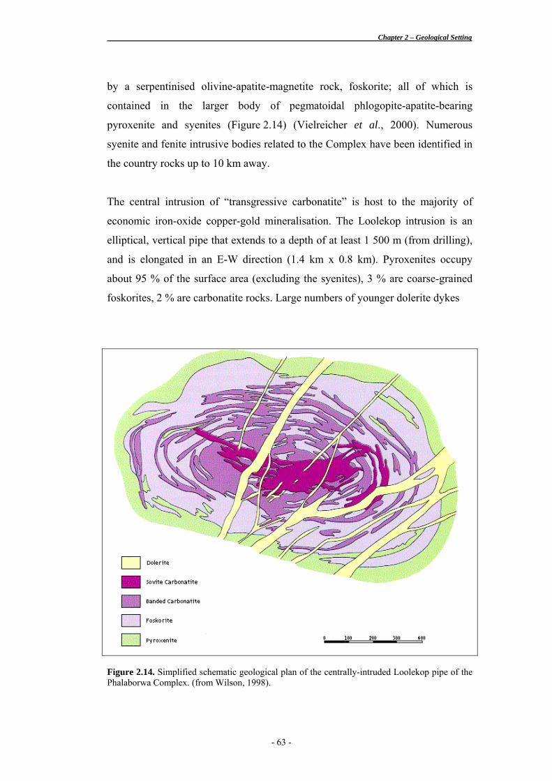
The Phalaborwa Complex is intruded at its centre by the Loolekop pipe, which is
composed of a transgressive, copper-bearing carbonatite (sövite) core surrounded
- 62 -
Chapter 2 – Geological Setting
by a serpentinised olivine-apatite-magnetite rock, foskorite; all of which is
contained in the larger body of pegmatoidal phlogopite-apatite-bearing
pyroxenite and syenites (Figure 2.14) (Vielreicher et al., 2000). Numerous
syenite and fenite intrusive bodies related to the Complex have been identified in
the country rocks up to 10 km away.
The central intrusion of “transgressive carbonatite” is host to the majority of
economic iron-oxide copper-gold mineralisation. The Loolekop intrusion is an
elliptical, vertical pipe that extends to a depth of at least 1 500 m (from drilling),
and is elongated in an E-W direction (1.4 km x 0.8 km). Pyroxenites occupy
about 95 % of the surface area (excluding the syenites), 3 % are coarse-grained
foskorites, 2 % are carbonatite rocks. Large numbers of younger dolerite dykes
Figure 2.14. Simplified schematic geological plan of the centrally-intruded Loolekop pipe of the Phalaborwa Complex. (from Wilson, 1998).
- 63 -
Chapter 2 – Geological Setting
intrude and cut all of the rocks of the complex, and it is in these that zeolite
mineralisation occurs. The total Complex occupies an area of about 20 km2 and
has been determined to a depth of about 5 000 m (from gravity data).
The orebody contains enormous deposits of copper, magnetite and apatite, as well
as the world's largest deposit of vermiculite, which is contained in the
ultramafics. The deposit also hosts important concentrations of baddeleyite,
uranothorianite, REEs associated with apatites, nickel and precious metals (Ag,
Au & PGE occur in a ratio of approximately 50:2:1 respectively).
The low-grade, high-tonnage orebody has been estimated to contain 850 Mt @
0.5 % Cu (Leroy, 1992) with mineable copper reserves are calculated at 225 Mt
@ 0.7 % Cu to a depth of 1200 m. Drill-proven and stockpiled phosphate ore
reserves exceed 300 Mt @ 7.45 % P2O5 (Wilson, 1998), with the total in-situ
resources of apatite, to a depth of 600 m, estimated at 13 000 Mt with an average
grade of 6.8 % P2O5 (de Jager, 1989).
Primary magnetite is paragenetically earlier than copper-sulphide phases, and is
found to be inversely distributed with respect to copper. Copper mineralisation
occurs as disseminated grains and veinlets of chalcopyrite with lesser bornite and
cubanite.
Ore-fluids have been characterised as high temperature, CO2-rich, magmatic-
water dominated brines (Vielreicher et al., 2000). Intense alkali-metasomatism is
reported in the country rocks spatially associated to the deposit, although details
are not available.
- 64 -
Chapter 2 – Geological Setting
Other Examples from the Bushveld Complex
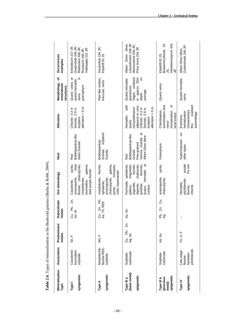
Bailie & Robb (2004) described the polymetallic mineralisation of the central
southeastern portion of the Bushveld Complex and identified four broad types
based upon mineral associations (Table 2.4). Type I deposits possess a Sn-F
association and occur in the upper portions of the granite such as that of
Zaaiplaats Tin Mine and the exogranitic Rooiberg Tin Mine. These deposits are
considered to be syngenetic in nature. Type II deposits possess a Mo-F
association and are also found in the upper portions of the granite. They further
possess a distinctive REE component. Type II deposits are also considered to be
syngenetic in nature. Type III deposits are characterised by a sulphide-carbonate
association, which may be dominated by either precious or base metal
assemblages. Type IV deposits are late-stage overprints of any of the other types
and characterised by a fluorite-hematite-pitchblende mineral association. Both
Type III and Type IV deposits are considered to be epigenetic in nature.
The broader styles of mineralisation found throughout the Lebowa Granite Suite
are briefly reviewed here from selected type deposits, namely Albert (Ag, Cu, U,
F + Pb, Zn, Bi, Sb), Rooibokkop-Boschhoek (Cu-Au), Zaaiplaats (Sn + W), and
Rooiberg (Sn + Cu, Pb, Zn, Bi). For complete accounts of these deposits refer to
the sources quoted in the text below. These descriptions are included here as an
indication of the range of mineralisation that occurs within the acid phase of the
Bushveld Complex.
Albert Endogranitic Ag-(Cu-U) Deposit
The Albert Silver Mine is situated 80 km west-northwest of Pretoria. It is hosted
within the fine-grained apical phase of the Nebo granites of the eastern Bushveld
Complex. The geological setting of the mineralisation is similar to that found at
Zaaiplaats Tin Mine and elsewhere in the granites, where mineralising fluids
have been confined and concentrated beneath an impervious layer.
- 65 -
Chapter 2 – Geological Setting
Occ
urre
nces
ex
ampl
es
Enk
eldo
orn
217
JR,
Zust
ersh
ek 2
46 J
R,
Rie
tfont
ein
446
JR,
Roo
ipoo
rt 44
0 JR
, V
lakl
aagt
e 22
1 JR
Hou
tenb
ek 1
94 J
R,
Klip
drift
62
JS
Alb
ert
Silv
er
Min
e,
Leeu
wfo
ntei
n 24
8 JR
W
elve
rdie
nd 2
49 J
R,
Prin
s A
nna
234
JR
Klip
drift
62
JS,
Boe
kenh
outh
oek
61
JS,
Har
tebe
ests
prui
t 43
4 JR
Alb
ert S
ilver
Min
e,
Zust
ersh
oek
246
JR
Mor
phol
ogy
of
min
eral
ised
st
ruct
ures
Qua
rtz v
eins
or
quar
tz-h
emat
ite
vein
s in
gr
anop
hyre
Pip
e-lik
e bo
dies
, br
ecci
as, v
eins
Qua
rtz-h
emat
ite
goss
anou
s rid
ges
oxid
ised
to
ap
prox
50
m
dept
h on
av
erag
e
Qua
rtz v
eins
Qua
rtz-h
emat
ite
vein
s
Alte
ratio
n
Chl
oriti
c 0
-2 m
S
eric
itic
2-5
m
Inci
pien
t al
tera
tion
> 5
m
Hem
atiti
c w
ith
quar
tz
recr
ysta
llisa
tion
adja
cent
to v
ein;
C
hlor
itic
0-2
m
Ser
iciti
c 2
-5 m
In
cipi
ent
alte
ratio
n >
5 m
Chl
oriti
satio
n,
seric
itisa
tion
and
min
or
hem
atis
atio
n of
lo
cal e
xten
t
Ext
ensi
ve
hem
atis
atio
n ch
arac
teris
es
this
ox
idis
ed
asse
mbl
age
Hos
t
Red
B
obbe
jaan
kop-
like
Neb
o G
rani
te
Bob
beja
anko
p G
rani
te,
Klip
kloo
f G
rani
te
Red
B
obbe
jaan
kop-
like
Gra
nite
Fi
ne-g
rain
ed
Ver
ena
Gra
nite
at
Alb
ert S
ilver
Min
e
Gra
noph
yre
Sup
erim
pose
d on
ot
her t
ypes
Ore
min
eral
ogy
Cas
site
rite,
py
rite,
ar
seno
pyrit
e,
clea
r flu
orite
, ch
alco
pyrit
e,
mol
ybde
nite
, to
urm
alin
e,
gale
na,
dark
pur
ple
fluor
ite
mol
ybde
nite
, flu
orite
, sp
hale
rite,
ar
seno
pyrit
e,
chal
copy
rite,
ga
lena
, py
rite,
m
onaz
ite,
rutil
e, b
astn
aesi
te
Pyr
rhot
ite,
spha
lerit
e,
gale
na,
mag
netit
e,
arge
ntite
, bo
rnite
, di
geni
le,
chal
coci
te,
goet
hite
, lim
onite
, qu
artz
, he
mat
ite
at
surfa
ce
arse
nopy
rite,
py
rite,
ch
alco
pyrit
e,
Hem
atite
, pi
tchb
lend
e,
purp
le
fluor
ite,
Fe-r
ich
chlo
rite
Subo
rdin
ate
met
als
Cu,
P
b,
Zn,
As,
W
Cu,
Zn
, P
b,
As,
Th,
RE
E
Au,
Sn
Pb,
Zn
, C
u,
Ag
--
Pred
omin
ant
met
als
Sn,
F
Mo,
F
Cu,
P
b,
Zn,
Ag,
As
As,
Au
Fe, U
, F
Ass
ocia
tion
Cas
site
rite-
tour
mal
ine-
sulp
hide
Mol
ybde
nite
-flu
orite
-RE
E-
sulp
hide
Sul
phid
e-
carb
onat
e
Sul
phid
e-
carb
onat
e
Late
-sta
ge
fluor
ite-
hem
atite
-pi
tchb
lend
e
Tab
le 2
.4. T
ypes
of m
iner
alis
atio
n in
the
Bus
hvel
d gr
anite
s (B
ailie
& R
obb,
200
4).
Min
eral
isat
ion
Type
Type
I sy
ngen
etic
Type
II
syng
enet
ic
Type
III a
(b
ase
met
al)
epig
enet
ic
Type
III b
(p
reci
ous
met
al)
epig
enet
ic
Type
IV
epig
enet
ic
- 66 -
Chapter 2 – Geological Setting
Mineralisation is marked at surface by at least three major ferruginous, quartz
vein systems trending roughly east-west, comprising milky quartz, hematite and
iron-oxyhydroxide minerals (Robb et al, 1994).
A very complex alteration pattern is developed in the wallrock, which intensifies
toward the mineralised veins, and is dominated by chloritisation and increasing
sericitisation towards the core.
The deposit is generally regarded as subeconomic with estimated ore reserves to
a depth of 150 m being 1.2 Mt at 73 g/t Ag, 0.4 % Cu, 0.3 % Pb, 100 ppm U3O8,
with isolated samples of up to 400 g/t Au and 0.5 % Sb (Robb et al, 1994).
Rooibokkop-Boschhoek Endogranitic Fracture-Hosted Cu Deposit
The Rooibokkop-Boschhoek hydrothermal copper prospect is situated about 12
km northeast of the town of Marble Hall. It consists of fracture-hosted, sulphide-
bearing siderite veins set within the Nebo granites of the eastern Bushveld
Complex. The well-defined zone of fracture varies in width from 400-700 m
(Smits, 1986) and parallels the Wonderkop fault, striking roughly 025°. The
Wonderkop fault is a regional feature and is also implicated in the mineralised
fissures of the Stavoren and Mutue Fides tinfields, which lie stratigraphically
higher and roughly 10 km north north-west of the Rooibokkop-Boschhoek
prospect (Wagner, 1921).
Subeconomic mineralisation is marked at surface by prominent ferruginous
ridges which carry 2.5 % Cu, 0.5 % Zn, 0.7 % Pb, and 20 ppm Ag (Smits, 1986).
Sulphide mineralisation is zonally distributed with chalcopyrite (and trace silver)
residing in the centre of the elongate, mineralised fracture zone, which is flanked
either side by a zone of significant quantities of galena and sphalerite.
- 67 -

Chapter 2 – Geological Setting
Wallrock alteration consists of sericitisation of the host granite, indicating
mesothermal conditions for hydrothermal fluids (Smits, 1986). Sericitised
plagioclase in hand specimen, acquires a colour suggestive of epidote. This is a
useful exploratory indicator in the field. In areas of strong brecciation, the sericite
alteration is superimposed by silicification. The influence of late-stage meteoric
waters caused hematisation of the siderite veins, replacement of chalcopyrite by
bornite, chloritisation of perthite and further enhancement of the permeability of
the immediate country rock.
The low concentrations and erratic distribution of copper sulphides within the
prospect make it economically unviable.
Zaaiplaats Endogranitic Sn Deposit
The Zaaiplaats Sn deposit is located south-west of Potgietersrus, in the northern
lobe of the Bushveld Complex. The acid rocks form the Makapansberg
escarpment consist of a westward dipping sheet of granite, granulite and
granophyre, capped by rhyolite and covered by younger Waterberg Group clastic
sediments (Crocker, 1986).
Mineralisation occurs primarily in Bobbejaankop-variety Nebo granites, ponded
beneath impervious granophyre cap rocks. This endogranitic mineralisation
resulted initially from late-stage, centripetal fractional crystallisation within the
Bobbejaankop granite, producing a low-grade, disseminated cassiterite zone in
the order of 2-20 m thick. Structural control only became evident in the closing
stages of mineralisation when subsequent stockworks and pipe orebodies
developed, allowing fluids to migrate to stratigraphically higher positions.
Lenticular orebodies developed at the contact between the underlying Klipkloof
microgranites and the impervious granophyres, producing a high-grade cassiterite
zone, characterised by altered dark grey granite rich in chlorite, polymetallic
- 68 -
Chapter 2 – Geological Setting
sulphides, fluorite, scheelite, wolframite, sericite and carbonates. The ore
commonly averages 5-10 % Sn, but may contain as much as 60 % Sn in localised,
high-grade pockets. The scheelite grade ranges from 0.1-1.0 % WO3, but more
often than not, does not coincide with Sn mineralisation.
Alteration around the orebodies appears to be restricted to hematisation and
chloritisation of the surrounding Bobbejaankop granite and intense sericitisation
of the Klipkloof granite.
Rooiberg Exogranitic Sn Deposit
The Rooiberg Sn deposit, which consisted of four principal mines, is situated in
the western lobe of the Bushveld Complex, approximately 65 km west of the
town of Warmbaths. The host rocks to the mineralisation are clastic sediments of
the upper Transvaal Supergroup and acid volcanoclastic rocks of the Rooiberg
Group. These rocks occur as a roughly triangular shaped fragment, named the
Rooiberg fragment, surrounded by the sheet-like granitoid intrusives of the
Lebowa Granite Suite and the Rashoop Granophyre Suite. The fragment is
thought to have detached during emplacement of the acid phase of the Bushveld
Complex (Rozendaal et al, 1986)
Just like the low-grade, disseminated cassiterite zone developed by late-stage
fractional crystallisation at Zaaiplaats, discussed above, so too is one postulated
for the Rooiberg deposits. The development of a system of joints and fissures is
subsequently responsible for remobilising the mineralisation and introducing
stanniferous fluids into the overlying sediment roof rocks. The morphology of
the resultant orebodies may take the form of stratabound bedded lodes,
replacement bodies and unconformable, steeply-dipping lodes that strike parallel
to major subvertical fractures related to the intrusion of the acid phase of the
Bushveld Complex.
- 69 -
Chapter 2 – Geological Setting
The prevailing ore assemblage is cassiterite, pyrite, chlorite, tourmaline, and
carbonates associated with varying amounts of magnetite, hematite, chalcopyrite
and potassic feldspar (Rozendaal et al, 1986). Reported grades in high-grade
pockets may contain up to 2.15 % Sn, 400 ppm Cu, and 200 ppm Zn. A complex
hydrothermal system with a low temperature of formation (174 - 220 °C) has
been attributed with the formation of the tin deposits (Ollila, 1981)
Alteration in the vicinity of the stanniferous mineralisation is mild and pervasive,
causing speckling, mottling and weak to intense enrichment of chlorite,
tourmaline, sericite, carbonate, sulphides, quartz and hematite (Rozendaal et al,
1986). In a more regional sense, the effects of the hydrothermal system have
affected the Rooiberg Fragment as a whole over a long period of time, but the
effects of this have not been properly investigated.
When the Rooiberg mines were operational, they produced a total of 11.2 Mt ore
at 0.62 % Sn, and accounted for one percent of the world’s supply of tin.
•••
This chapter reviewed the geological setting of the Bushveld Complex and briefly
identified some key aspects of similarly styled mineralisation from the granites.
Four main mineralisation assemblages were characterised from the central
southeastern portion of the Bushveld Complex. The Vergenoeg Suite represents
the largest expression of Fe-oxide dominated mineralisation found in the
Bushveld and exhibits many of the key characteristics of other IOCG deposits, in
particular Olympic Dam. The next chapter will focus on the region near Rooiberg
in the western Bushveld Complex and examine the geological characteristics of
granites and mineralisation near the farm Ruigtepoort. The mineral deposits and
occurrences in this region will be related to that of Vergenoeg and other examples
of IOCG mineralisation.
- 70 -