GEOLOGICAL MAPPING OF SOUTHEASTERN BRITISH COLUMBIA: AN UPDATE€¦ · SOUTHEASTERN BRITISH...
16
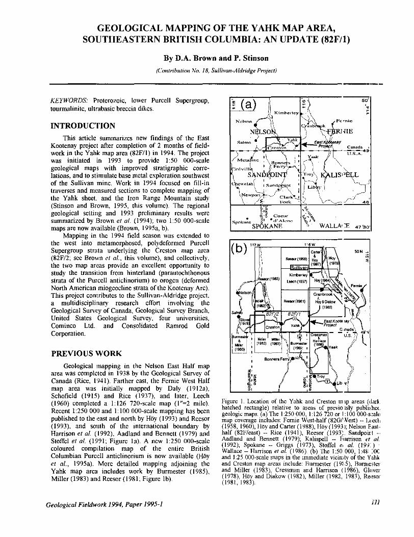
GEOLOGICAL MAPPING OF THE YAHK MAP AREA, SOUTHEASTERN BRITISH COLUMBIA: AN UPDATE (82Fll) By D.A. Brown and P. Stinson (Contribution No. 18, Sullivan-Aldridge Project) "." KEYWORDS: Proterozoic, lower Purcell Supergroup, tourmalinite, ultrabasic breccia dikes. INTRODUCTION Thisarticlesummarizes new findings of theEast Kootenay project after completion of 2 months of field- work in the Yahk map area (82F/I) in 1994. The project was initiated in 1993 to provide 130 000-scale geological maps with improved stratigraphic corre- lations, and to stimulate base metal exploration southwest of the Sullivanmine. Work in1994 focused on fill-in traverses and measured sections to complete mapping of the Yahk sheet. and the Iron Range Mountain study (Stinson and Brown, 1995, this volume). The regional geological setting and 1993 preliminary results were summarized by Brown el a/. (1994); two 1:50 000-scale maps are now available (Brown_ 1995a, b). the west into metamorphosed, polydeformed Purcell Mapping in the 1994 field season was extended to Supergroup strata underlying the Creston map area the twomapareas provide an excellentopportunity to (82F/2; see Brown el ai., this volume), and collectively, study the transil.ion from hinterland (parautochthonous strata of the Purcell anticlinorium) to orogen (deformed North American miogeocline strata of the Kootenay Arc). This project contributes to the Sullivan-Aldridge project. a multidisciplinary research effort involving the Geological Sulvc:y of Canada, Geological Sulvey Branch, United States Geological Survey, four universities, Cominco Ltd. and Consolidated Ramrod Gold Corporation. PREVIOUS WORK Geological mappinginthe Nelson East Half map area was completed in 1938 by the Geological Survey of Canada wee, 1'941). Farther easl, the Fernie West Half map area was initially mapped by Daly (1912a), (1960) completed a 1:126 720-scale map (1"=2 mile). Schofield (1915) and Rtce (1937), and later, Leech Recent 1:250 000 and 1: 100 000-scale mapping has been published to the teast and north by Hby (1993) and Reesor Harrison el a/. (1992), Aadland and Bennett (1979) and (1993). and sonth of the international boundary by coloured compllation map of the entire British Stoffel el a/. (1991;Figure la). A new 1:250 000-scale Columbian Purccll anticlinorium is now available (Hby el a/., 1995a). More detailed mapping adjoining the Yahk map area includes work by Burmester (19x5). Miller (1983) and Reesor (1981; Figure Ib). Figure 1. Location of the Y;hk and Creston m ~p areas ((luk. hatched rectangle) relative to areas of previo sly publirhec. geologic maps. (a) The 1:250 000, 1 :I26 720 or 1 :IO0 000--sralc: map coverage includes: Femie West-half (82G/ Nest) -- l,c:t:clL (1958,1960),HoyandCarter(1988),Hoy(19931;NelsonE~cst.. Aadland and Bennett (1979); Kalispell -- Elamison cf a/ half(82Fkast) -- Rice (1941), Keesor (1993:. Sandpoint (1992). Spokane -- Griggs (1973), Stoffel e, a/. (19'9 ) Wallace -- Harrison er ai. (1986). (b) The 150 000, 1:4t: C80C and I :25 000-scale maps in the immediate vicin,ty of the Y~hk andCrestonmap areas include: Earmester (19!5), Hurmerte~ and Miller (1983), Cressmm ar,d Harrison (1986), Glovel. (1978), Hoy and Diakow (19821, Miller (1982, 1983), Rexsal. (1981, 1983). Geological Fieldwork 1994, Paper 1995-1 Ill
Transcript of GEOLOGICAL MAPPING OF SOUTHEASTERN BRITISH COLUMBIA: AN UPDATE€¦ · SOUTHEASTERN BRITISH...
GEOLOGICAL MAPPING OF THE YAHK MAP AREA, SOUTHEASTERN BRITISH COLUMBIA: AN UPDATE (82Fll)
By D.A. Brown and P. Stinson (Contribution No. 18, Sullivan-Aldridge Project)
"." KEYWORDS: Proterozoic, lower Purcell Supergroup, tourmalinite, ultrabasic breccia dikes.
INTRODUCTION This article summarizes new findings of the East
Kootenay project after completion of 2 months of field- work in the Yahk map area (82F/I) in 1994. The project was initiated in 1993 to provide 130 000-scale geological maps with improved stratigraphic corre- lations, and to stimulate base metal exploration southwest of the Sullivan mine. Work in 1994 focused on fill-in traverses and measured sections to complete mapping of the Yahk sheet. and the Iron Range Mountain study (Stinson and Brown, 1995, this volume). The regional geological setting and 1993 preliminary results were summarized by Brown el a/ . (1994); two 1:50 000-scale maps are now available (Brown_ 1995a, b).
the west into metamorphosed, polydeformed Purcell Mapping in the 1994 field season was extended to
Supergroup strata underlying the Creston map area
the two map areas provide an excellent opportunity to (82F/2; see Brown el ai., this volume), and collectively,
study the transil.ion from hinterland (parautochthonous strata of the Purcell anticlinorium) to orogen (deformed North American miogeocline strata of the Kootenay Arc). This project contributes to the Sullivan-Aldridge project. a multidisciplinary research effort involving the Geological Sulvc:y of Canada, Geological Sulvey Branch, United States Geological Survey, four universities, Cominco Ltd. and Consolidated Ramrod Gold Corporation.
PREVIOUS WORK Geological mapping in the Nelson East Half map
area was completed in 1938 by the Geological Survey of Canada wee, 1'941). Farther easl, the Fernie West Half map area was initially mapped by Daly (1912a),
(1960) completed a 1:126 720-scale map (1"=2 mile). Schofield (1915) and Rtce (1937), and later, Leech
Recent 1:250 000 and 1: 100 000-scale mapping has been published to the teast and north by Hby (1993) and Reesor
Harrison el a/. (1992), Aadland and Bennett (1979) and (1993). and sonth of the international boundary by
coloured compllation map of the entire British Stoffel el a/. (1991; Figure la). A new 1:250 000-scale
Columbian Purccll anticlinorium is now available (Hby el a/. , 1995a). More detailed mapping adjoining the Yahk map area includes work by Burmester (19x5). Miller (1983) and Reesor (1981; Figure Ib).
Figure 1. Location of the Y;hk and Creston m ~p areas ((luk. hatched rectangle) relative to areas of previo s l y publirhec. geologic maps. (a) The 1:250 000, 1 :I26 720 or 1 :IO0 000--sralc: map coverage includes: Femie West-half (82G/ Nest) -- l,c:t:clL (1958,1960),HoyandCarter(1988),Hoy(19931;NelsonE~cst..
Aadland and Bennett (1979); Kalispell -- Elamison cf a/ half (82Fkast) -- Rice (1941), Keesor (1993:. Sandpoint
(1992). Spokane -- Griggs (1973), Stoffel e, a/. (19'9 ) Wallace -- Harrison er ai. (1986). (b) The 150 000, 1:4t: C80C and I :25 000-scale maps in the immediate vicin,ty of the Y ~ h k and Creston map areas include: Earmester (19!5), Hurmerte~ and Miller (1983), Cressmm ar,d Harrison (1986), Glovel. (1978), Hoy and Diakow (19821, Miller (1982, 1983), Rexsal. (1981, 1983).
Geological Fieldwork 1994, Paper 1995-1 Ill
ldegroot
New Stamp

GEOLOGICAL SETTING The Proterozoic Purcell Supergroup (Belt
carbonate sediment sequence at least 12 kilometres thick, Supergroup in the United States), a siliciclastic and
accumulated in a pericratonic basin between about 1500 and 1350 Ma ago. It is preserved in an area 750 kilometres long and 550 kilometres wide, extending from southeastern British Columbia to eastern Washington, Idaho and western Montana. In British Columbia, the
anticlinorium, a broad, gently north-plunging structural Purcell Supergroup is exposed in the Purcell
culmination (Figure 2). The stratigraphic nomenclature for the Purcell Supergroup varies across the basin; this article adopts divisions used in the east-half of the Nelson map area (Reesor, 1983; HOy, 1993).
Purcell sedimentation may have ended with the onset of the East Kootenay orogeny, a metamorphic and
and Price, 1982). Within the basin, syn-Aldridge structural event between 1350 and 1300 Ma (McMechan
tectonism is evidenced hy early faults and emplacement of the Moyie intrusions. A Late Proterozoic extensional event, the Goat River orogeny (800-900 Ma), resulted in
Purcell strata, and initiation of the Cordilleran rifting (block faulting), erosion of up to 4 kilometres of
miogeocline with deposition of the Windermere Supergroup (Lis and Price, 1976; Price, 1984). By the Middle Jurassic, collision of allochthonous terranes from the west (Columbian orogeny; Terrane I; Monger et a/.,
produced deformation, metamorphism and plutonism 1982) onto the western margin of North America
that affected the western edge of the Purcell Supergroup. Docking of Terrane I1 to North America resulted in another compressional event in the Cretaceous to early Tertiary (Laramide orogeny, circa 100-70 Ma) that produced the dominant folds and thrust faults in the map area Strata were transported to the east on westdipping thrust faults that extended into the cratonic basement
Purcell anticlinorium with Proterozoic strata in its core. (Cook and Van der Velden, in press) producing the
Emplacement of several large, syntectonic and post- tectonic Cretaceous plutons accompanied this event. Some of the plutons plugged folds and thrusts; for example, the St. Mary fault zone is plugged by the Reade Lake stock and the Hall Lake fault is occupied by the White Creek batholith (Price, 1981; Archibald et a)., 1983; HOy, 1993). Reactivation of some of the Cretaceous thrust faults during Eocene extension is locally important, notably west of the Y a m map area (see Brown et a/., 1995, this volume).
112 vey Branch

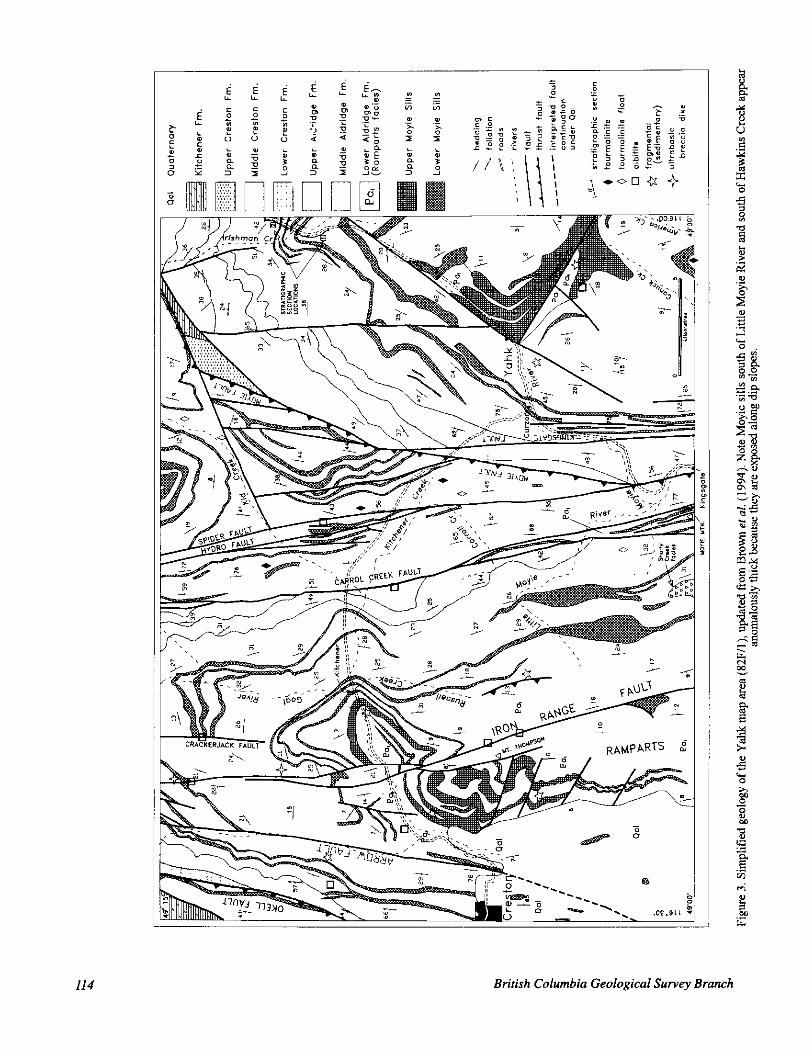
STRATIGRAPHY The Yahk map area is underlain largely by the
Aldridge Formation, the lowermost division of the Purcell Supergroup (Figure 3). The Creston Formation
the Aldridge Formation. The overlying Kitchener (about 2300 m thick; Reesor, 1983) gradationally overlies
Formation includes the lowermost significant carbonate accumulations in the F'urcell succession. The Aldridge,
the Prichard and Ravalli groups, and Wallace and Helena Creston and Kitchener formations are the equivalents to
formations in the United States, respectively.
LOWER ALDRIDGE - RAMPARTS FACIES
occur in the map area, based on stratigraphic distance Strata equivalent to the lowcr Aldridge Formation
below the lowesi: middle Aldridge marker laminite, lack of any markers in over 700 metres of stratigraphy, and presence of numerous Moyie sills. However, the outcrops are unlike the typical rusty weathering, thin-bedded
farther east in the basin. They are generally thick-bedded, siltstone and argillite of the lower Aldridge Formation
grey-weathering (non-rusty;, quartzitic wackes. and called "Ramparts facies" for their type locality east of Creston, along the Ramparts below Mount Thompson (D. Anderson, personal communication, 1994; Photo 1).
light grey to buIT, medium to fine-grained quartzitic The Ramparts facies consists primarily of distinct,
wackes with lesser green-grey argillites. The thick to medium-bedded wacke forms prominent cliffs or ribs along hillsides. Unlike the tqpe locality, the rocks carry no pyrrhotite, except for the extreme base of the Ramparts exposure southeast of Creston. Locally, the quartzitic unit:; are crossbedded, graded and/or laminated. Some: beds are lenticular in outcrop and show cut-and-fill features suggestive of channel deposits and shallow water deposition. Beds tend to form amalgamated sels that fine upward. Between the sets are sequences of nlore thinly bedded quartz wjacke and argillite. Bedding is wavy and lenticular, showing features of current activity (ripple crosslamination; Photo 2) and loading (load ripples and flames). This wavy bedform indicates more current ,activity than has been
area to the northeast. Euhedral to subhedral pits on the suggested for typical lower Aldridge in the Kimberley
weathered surfaces of argillite beds contain remnants of a soft white mineral that may be pseudomorphs a f k r
Figure 2 (facing page). Generalized geological map of part of southern British Columbia, northern Washington, Idaho and Montana, emphasizing the distnbution of the Purcell Supergroup, lower Windermere Supergroup (Toby and Irene formations) and lnaior intrusive suites. Simolified Creston Formation' distribu1;on is illustrated to delineate major anticlines. Rectangle marks East Kootenay project area. Abbreviations: GllA = Goat River anticline, HF = Hope fault, HLF = Hall Lake fault, JJF = Jumpoff Joe fault, MA = Moyie anticline, MF = Moyie fault, = Newport fault, PTF~ = Purcell Trench fault, RCF = Redding Creek fault, RMIT = Rocky Mountain Trench fault, SMF = St. Mary fault, SSP = Snowshoe fault. Modified after Hdy ,?r a/., 1995, Millcr (1982, 1983; Stoffel eta:. , 1991, Harrisonefd., 1992).
gypsum(?), near Mount Thompson. Tht: presenc: of gypsum would signify saline conditions, at least I(KEIII:/. In the same area, probable mud-chip breccia may
upward into more quartzofeldspathic and I~:al ly indicate desiccation. Quartz wacke in erbeds grac.e
calcareous beds of the middle Aldridge Fmnation. Tbe transition is subtle and difficult to map at : :50 000 s:ah:, partly due to the lack of exposure.
At Creston the Ramparts facies is etimated t:, te
the core of the Goat River anticline. To the t:ast, 700 metres thick, exposed as a flat-lying succession in
Ramparts facies can be recognized at Ame8ica Creek and at Hawkins Creek, where only about 1:;O metres r u ' e
exposed at surface (the estimated total th ckness is 400 metres; D. Anderson, personal cornmunixtion, 15194). The Ramparts facies thickens toward th: U.S. tKa.d(:r then thins farther to the sou1.h @. Ande'son, p e r s o ~ d communication, 1994). It also thins to the e a s t and northeast. The Ramparts facie!; may be a PI oximal p a l t of a turbidite fan that correlates in part uith the Iowc:r Aldridge footwall quartzite exposed in the Sullivan :Lre:L. This implies that the upper siltstone (dista turbidites) of the Sullivan area are replaced to the southwesi by proximal to middle fan turbidites of the Ra:,nparts facies.
Photo 1. View east lo subhonzonhl beds of qua tzitic wa:l:,t [sf the Ramparts facies intruded by scveral gabbro ;ills exposd in cliff faces along the Ramparts, southeast of Cre! ton. This i i the
Aldridge Formation in the Sullivan area. type area for the facies, a proximal equivalelt to the I,lwf,r
Photo 2 . Brown-weathering bed bottom with a sme t r i c rpple marks, Ramparts facies about 5 kilometres s ~ t h of Moult Thompson (5-centimetre diameter lens cap 01 top of bl'xl:; PST94-200).
Geological Fieldwork 1994, Paper 1995-1
114 British Columbia Geological Survey Branch

MIDDLE ALDRIDGE
and comprises a thick sequence of fine siliciclastic rocks, The middle Aldridge underlies most of the map area
dominantly planar-bedded, fine-grained quartzofeld-
differs from the overlying Purcell Supergroup strata in spathic wacke to quartz wacke. with lesser argillite. It
that it was deposited in deeper water as turbidites. is intruded by numerous gabbro sills, contains extensive and distinctive marker units and has disseminated pyrrhotite throughout (Cressman, 1989: Hoy. 1993). Medium-grained wacke is uncommon, and coarse- grained wacke is rare. Total thickness is at least 3000 metres, and may be as much as 4000 metres, based on estimates from map distribution. In contrast, the middle Aldridge in the Cranbrook area is about 2500 metres thick and farther north in the Sullivan mine area, only 2100 metres thick (Hay, 1993).
conglomerates ("fragmentals") are interpreted by Isolated ou~.crops of sedimentary breccias and
Cominco geologists and others to be derived from
consolidated sediments into crosscutting tabular bodies. fluidizing (dewatering) of consolidated to semi-
sheet-like mounds and debris flows (Cominco staf€ geologists.: Turner et a/., 1992: Brown el a/.. 1994: Hoy. 1993: Cressman. 1989). A newly discovcrcd fragmental locality, south of Yahk in King Creek. contains oblong wacke clasts up to 9 centimetres long. Clasts arc concentrated along two horizons parallel to bedding.
IRISHMAN CREEK MEASURED SECTIONS
Formation were measured along Highway 3 on either Two sections through parts of the middle Aldridge
side of Irishman Creek. in the northeast corncr of the Yahk map area (Figures 3 and 4). Both sections are dominated by turbidites. with lhin to thick planar,
turbidity current processes are described by Walker massive sand beds (Photo 3). Sedlmcnts associated with
Formation is givm in Hoy (1993). (1979), and a regional discussion of the middle Aldridge
In the eastern section (section I ) . the bedding has a consistent dip to the west-northwest, and in thc western section (section 2) the rocks havo a variable. moderate dip to the west; the sections are on either side of a broad, gently north-plunging anticline. bisected by Irishman Creek (Figures 3 and 5 ) . The base of section 2 is 200 to
Each section is broken by two to five normal faults: in 300 metres stratngraphically abow: the top of section 1.
based on bed-to-bed matches on either side of the faults. every case offset across the faults is less than 2 metres
The medium to fine-grained quartz wackc and wacke contains IO to 213% fine-graincd biotite. based on hand
product of the original clay constituents. Lesser arenite specimen examination. which is the metamorphic
and quartz arenite are iuterbedded with thc wackc. The lithological con!;istency. particularly in scction I . is remarkable.
centimetres to over a metre. Intcrnally. most of the beds Individual smd beds range in thickncss from several
are massive with faint parallel stratification towards their
Geological Fieldwork 1994, Paper 1995-1
tops. These beds rhythmically alternate wi h sections of laminated siltstone I to 20 centimetre: thick. Thl: packages of thickest beds, mainly towarc s the tor' of section I, are usually amalgamated: the fines of thc previous turbidity current are completely rodcd by t b : next turbidite. The amalgamaled sand beds are up Io :! metres thick, with internal contacts only I aintly visible. Thicker packages of laminated argillite Ind siltr.tone, deposited during quiescent periods in the basin, wcur sporadically.
current processes were observed: these inchde flute ~ C : I S ~ S , Sedimentary structures reflecting he turbidit?
and less common groove casts and bounce marks. Fhm,:
bedforms, and lithologic variations are prc~ented on th,: structures are present locally. PaleocurreIt direc~:i'~ns,
graphic sections (Figure 4). Most of {he measured paleocurrent indicators trend northwest, d ' e r rotatiol to paleohorizontal. Where their asymmet:*y could b: determined, they indicated currents to the north 11) northwest.
the base of section 2 exhibits small-scale, v'.ell develctped A thick sequence of siltstone and a q illite towrd;
trough crossbedding and local flascr bedl!ing. Foresets are composed of alternatrng light brown .ill and black argillite. This section is near the top c,f the m,iNjdl': Aldridge and may indicate a regression. iimilar to th': shallowing which resultcd in the transilion to upper Aldridge argillite. There are Inore tnrbidi es abovt: this unit. so it only represents a temporary change in depositional environment.
measured to the base of a sill 30 metrcs th~ck; i t fo rm . I Each section has t ~ o Moyie sills. E,cction 1 was
steep clifI which marks the lend of the txposure. Th,: other, thinner sills have narrow chilled nargins. Th,: contacts of the two sills in scction 2 are well expos,ed, and arc concordant with bedding. The contact!; ar: slightly sheared, as this part of the seclion is gentli warped. The sills appear to haw a zone of ltornfels ;tl~sv: their top contacts.
Photo 3. Part a i the west I r i shmn Creek seclion illustritin;: planar bcdfonns and typical middle AldriIge fom~tio~r ezposurc Most oithe photo <:onesponds to unit !R on Figure 4. Rear of cattlc tmck Tor scale
115

1 MIDDLE A L D R I D G E ? ~ ~ -
.............. .............. .............. ,A :::::::::::::: -Li .............. .............. .............. ..............
Irar.,.d)
(C0"."4
EAST IRISHMAN CREEK SECTION PSl94-2
Figure 4. Measured sections of the middle Aldridgc 1:onnation at Irishman Creek, llighway 3 . Locations of sections are show on FiEure 3. Unit numbers correspond to detailcd divisions.
116 British Columbia Geological Survey Branch

SHORTY CREEK AREA -- UNUSUAL FEATURES Aldridge Formation, possible lelationships of such rwk; WITHIN THE ALDRlDGE FORMATION to mineralization, and the possible assxiation with
Some unusual sedimentary and intrusive rocks crop out on a ridge above Shorty Creek. about 7 kilometres west of Kingsgate (Figure 3). The Shorty Creek UPPERALDRIDGE
tourmalinite alteration.
succession consists of medium to fine-grained wacke, siltstone, minor argillite, rare limestone. and small, xenolithic, intermediate to mafic plugs and dikes. Beds dip gently to the northeast, parallel to bedding in the enclosing middle Aldridge Formation.
The lowest rocks, which overlie middle Aldridge wacke, are massive, faintly laminated black siltstone. Rarely exposed limestone occurs toward the top of the
trains of round, 2 to 5-centimetre clasts of the same siltstone. It is massive, crystalline, but locally contains
lithology The origin of this limestone unit. its extent, and its relationship to the other rocks in this package are unknown. The black siltstone is overlain by greenish grey wacke and siltstone beds. The wacke is Characterized by wavy, nonparallel beds from 3 to 25 centimetres thick. Internally, the beds are massive, or have a faint parallel stratification. Scours are common at the base of the beds.
grains and feldspar, although some beds are quartz rich. The sand grains are mainly angular, and consist of lithic
These rocks are interpreted to be epiclastic sandstones based on their green colour. crystal content and
beds of similar ,:omposition strongly resemble trachylic composition of lithic fragments. Rare. thick, massive
to andesitic lavxs. but are more likely well indurated volcanic wacke.
and laminated siltstone is locally interbedded with Siltstone is exposed toward the top of the succession,
wacke. The upper siltstone consists of alternating dark green and red-brown discontinuous beds. Greenish layers have up to 15% hornblende porphyroblasts. giving beds a spotty appearance. This is probably a contact metamorphic effcct.
stock of medium-grained diorite. 30 metres widc, cuts the Several intrusions cut the Shorty Crcek facies. A
uppermost part of the section and is exposed in a large
Boundary. The intrusion contains numerous rounded clearing which extends across the International
inclusions of gabbro (autoliths?) and subrounded to angular xenoliths of wacke and siltstone. The inclusions are 1 to 20 cenlimetres wide. and most of the igneous ones have well developed reaction rims consisting mainly of feldspar. Notably, some of the igneous inclusions are sulphide and/or magnetite rich, forming rusty holes in the weathered outcrop surface. Two aphanitic. black, mafic dikes. 2(1 to 30 centimetres wide. were noted elsewhere in this, package.
map area. and appears to have a volcanic component. The Shorty Creek facies is anomalous for the Yahk
Several occurrences of volcanic rocks and associated mineralization in the middle Aldridge Formation are described by lloy el a/. (1995, this volume). A tourmalinite ocxrrence crops out several kilometres southwest of thc: exposures describcd above. The Shorty
anomalous. possibly volcaniclastic facies of the middle Creek area deserves further study based on the
of the Yahk map area in three areas, on [he northwest The upper Aldridge Formation underlies about ' .O%
limb of the Moyie anticline and the east a id west lirnbs
brown weathering, fissile argillaceous siltst me. It is, .;ref of the Goat River anticline (Figure 3). It is rusty, darlc
to dark grey, thin-bedded to laminate.1, commonly containing distinctive white siltstone lan8inae (Remo~,, 1981). Ripple marks are rare. Quartzofe1d;pathie w:lck: beds are very rare and thin (<I0 cm). Talu: derived frori the fissile upper Aldridge forms chip-si:e fragnic:ntr,. Moyie sills are absent. The upper Aldridge reflccts waning input of turbidites and linal pc:lagic sedimentation prior to the shallowing cf the P u d l (Belt) Basin, as represented by the Creston iormation
United States are informally called "lined rock" Strata correlative with the upper Aliridge i n the
(Cressman, 1989). South of the Yahl: map ma.
equivalent to the upper Aldridge, that i! conformably Burmester (1985) identifies a "lined argi lite" unit, an
overlain by a "transition zone" unit, which corre ;ates with the lower Creston Formation.
CRESTON FORMATION
Yahk map area: on the nudhwest limb of the Moyie The Creston Formation underlies ab0 11 15% 111' the
anticline, along the north-trending Kingsg; te graben Ithat extends southward into Idaho and Monta la (Figure: 2), and on the eastern and western limbs of t l e Goat F.ivc:r anticline (Figure 3).
The Creston Formation, is divided into a Iowc:r argillaceous member (-1000 m thick), a middle quartzitic member (-1000 m thick) and a 1 upper siltite and argillite (< 300 m thick). They corrzlate with tke Burke. Revett and St. Regls formations )f the Ravalli Group in the United States The Crestm Fornr . I t ' Ion represents shallow-water, reworked deposils accumulated on northward prograding deltas or fans (I kabar, 15'73). The Revett Formation hosts stratabound copper4vt:r deposits (including Spar Lake, Montanltre and Rock Creek) in the western Montana copper bel (Wells e ' 0 1 . . 1981; Balla, 1982, 1993) and in the Sage Creek arm in the Lewis thrust sheet in southeast British I :olumbia.
The lower and middle Creston Forma ion procluce a prominent areomagnetic signature, most lotably within the Moyie anticline. This is due to fin( dissemitl.atc,d magnetite, and quartz-magnetite veinlets and strilqers throughout. Thin irregular fractures (< 2 mm wide) are filled with black magnetite forming promi~:ent veinlm n pale green phyllitic argillitc: in an out8:rop of low8:r Creston along Highway 95, 5.5 kilomt tres south #of
crystals is common in the upper Burke Fcrmation in the Curzon. Speckled argillite with small euhtdral magrletite
Montanore deposit area (Adkins, 1993).
Geological Fieldwork 1994, Paper 1995-1 11 7

KITCHENER FORMATION The Kitchencr Formation. defined by Daly (1905)
and Schofield (1915). overlies the Creston Formation and comprises green dolomitic siltite, argillite and carbonaceous dolomite and limestone. It forms a succession I800 metres thick (in the Nelson East Half area where mapped by Reesor. 1983) of shallow-water deposits that correlate with the middle Belt carbonate, the
Formation lo the southeast. Molar tooth struclures are Wallace Formation to the south and the Helena
common and stromatolites are locally important (Winston, 1986).
The formation is poorly exposed and fault bounded in the northeast corner of the Yahk map area, within the Moyie fault zone. Prominent but thin, brown-weathering dolomitic siltstone beds distinguish Kitchener Formation from Creston Formation herc. Discontinuous dolomitic
tan to brown weathered surfaces. Otherwise, the wavy siltstones layers pitaut and produce rough and irregular,
beddcd. pale green siltstone and argillaceous siltstone are similar to the Creston Formation.
MO YIE INTRUSIONS
Moyie intrusions. dominantly sills and rarely dikes. occur mainly within two stratigraphic intervals; the
Therefore two main episodcs of sill emplaccmenl are lower. and middlc of the middlc Aldridge formations.
proposed (Rice. 1941: Leech. 1957). Both sill packages occur in the Yahk map area, but aside from stratigraphic position. no distinct mineralogy or visible features were recognized to differentiate them in the field. The sills were discussed by Daly (1905. 1912a). Schofield (1915) and Rice (1937, 1941). Geochronometric and
preparation) and E. Anderson (Geological Survey of geochemical studies are ongoing by Gorton et nl. (in
Canada) as part of the Sullivan-Aldridge project.
composition from hornblende(*pyroxene) gabbro to The fine to mcdium-grained sills range in
hornblende quartz diorite and hornblendite. and they extend laterally over tens of kilomctrcs. Mafic phenocryst contents vary up to 70% Pyroxene is only found rarely as relict cores surrounded by amphibolc. due to widespread deuteric alteration. Some of the thicker sills (>20 m) contain irregular patches of coarse pegmatitic hornblende and feldspar. Zones of granophyre are rare in the Yahk map area.
LOWER SILL PACKAGE
The lower sill packagc underlies three areas. Ramparts east of Creston. west of Kingsgate. and Hawkins Creek near Yahk (Figure 3). The sills in the Ramparts area are exposed along the prominent escarpment that rises about 1400 metres above the
here. comprising a cumulative thickness of at least 600 Creston valley (Photo I). There are at least four sills
mctres in a section about 1370 metres thick (13% sills). The thickness and number of sills decreases southward toward the U.S. border to about 250 metres (27% as two sills: D. Anderson. personal communication. 199.1).
thickest (albeit not well exposed) adjacent to an inferred Moyie sills in the Hawkins Creek area appear to be
northwest-trending fault, and to terminate abruptly to the northeast (Figure 3). The inferred fault may have formed in the Proterozoic and partially controlled the emplacement and distribution of the sill sequence. In this area, albite alteration with associated sedimentary fragmental units (south of Hawkins Creek), and several tourmalinite localities, including Mount Mahon, immediately east of the map area, indicate hydrothermal activity.
Five sills on Moyie Mountain west of Kingsgate intrude Ramparts facies. They were mapped and
by Daly (1912a, p. 221-255). The sills correlate with the described as the "Moyie sills", now a widely used term,
Crossport sill sequence studied by Bishop (1973). The Kingsgate sills are exposed along the International Boundary cut above 1220 metres elevation (Figures 13 and 14 and Photo 25 of Daly, 1912a). They can be traced northward for about 12 kilometres, where they are truncated by the Carroll fault (Figure 3).
The lower sill package comprises thicker individual sills that are less extensive or continuous compared to the uppcr sill package in the Yahk map area.
UPPER SILL PACKAGE
A conspicuous section in the middle of the middle Aldridge contains two to four prominent sills. This upper
a sequence of four sills is repeated by faulting. They have sill succession is well exposed south of Kid Creek, where
a cumulative thickness of about 240 metres in a section
sills). To the west, on Mount Kitchener, the same 1200 metres thick (960 m of sedimentary rocks and 5%
stratigraphic section contains two sills (Figure 3). Most of the Moyie sills have no aeromagnetic
signature: however, one sill does produce a strong anomaly, most prominent on Arrow Mountain near Creston. The anomalous response can be traced from south of Creston northward across the entire map area. It extends southward across the International Boundary at least 50 kilometres (D. Anderson, personal communication, 1994) and it is clear that the magnetic property ofthis sill is useful for regional correlation.
SILL EMPLACEMENT EFFECTS
locally. such as on the Goat River road near Highway 93 Bleached, albitized metasedimentary rocks occur
(Figure 3: Turner el a/ . , 1992; Stop I-S), and may be due to sill emplacement. A granophyre exposure related to "Purcell intrusive" was noted by Rice (1941, p. 26) along a trail up to Iron Range Mountain, but was not examined during this study. Another occurrence of albite alteration is exposed on a knob along the basal contact of a lower package Moyie sill, south of Yahk. Here a fragmental horizon occurs within the albitite zone (D. Anderson, personal communication, 1994).
118 British Columbia Geological Survey Branch

ULTRABASKDIKES
Several ultrabasic breccia dikes crop out on Iron Range Mountain. One dike, located 6 kilometres
centimetres wide, strikes north and has sharp, planar northwest of the town of Kitchener, is 12 to 15
contacts. Dikes farther north on Iron Range Mountain have irregular outcrop patterns and are 0.3 to 1 metre wide. All the dikes have abundant, roundcd inclusions of carbonate, possk.ble ultramafic lithologies, and xenoliths of Aldridge Formation (Photo 4). The southernmost dike has 0.5 to 1-celltimetre feldspar and biotite phenocrysts, while the other dikes have phlogopite megacrysts, some up to 8 centimctres across. Thin sections reveal that in every sample I:he groundmass and all non-carbonate inclusions are completely altered to fine-grained calcite and chlorite.
dike may be a lamprophyre, based on the phenocryst These rocks are difficult to classify. The southern
types. The other dikes have petrographic similarities to diatreme breccias in the Golden area. which are ultramafic lamprophyre and alnoite (Pell, 1994. p. 77-
the root zones of eroded diatrema systems, as the variety 89). The dikes on Iron Range Mountain may represent
and nature of inclusions in them indicate rapid emplacement. One of the dikes on the northern pan of Iron Range Mountain yielded a L.ate Carboniferous K-AI date of 301k10 Ma (D. Anderson. personal communication, 1994). Diatreme breccia and related rocks arc known from several areas in the province (Pell, 1994). The Iron, Range breccia dikes and similar rocks to the north in the Horsethief Creek area (Pope, 1989, p.
REGIONAL STRUCTIJRAL SETTING The Yahk map area includes two regi,mal anticiinm,
the Moyie and Goat River anticlines, in the westerr half of the Purcell anticlinorium. The anticlines are seyarat(:d by a disrupted zone that is bounded on 'he east bk tlle Moyie fault, a regionally important tr:nsverse thn.st fault. The fault trends obliquely across t h t : anticlinwium and records a complex history begi ming in t x Proterozoic (Hoy, 1979, 199?.; McMecha~t, 1979, 198'.).
weakness in the underlying continental I asement :Ilollg The structure may reflect the geometry of a stnJl:tw.al
which the fault propagated and ramped u ) higher in the section. The basement anisotropy may correspord to
different ages, in particular the Rimbey and M~:c!~.cine northeast-trending boundaries of the cralonic blocks of
Hat domains (cf. Figurc 7 in Ross et ol., 1'192).
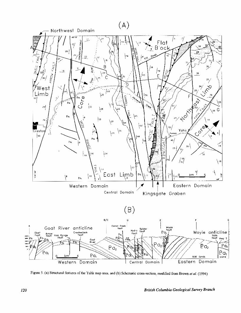
YAHK MAP AREA STRUCTURES The Yahk map area has been divided i n k lhree
structural domains, separated by hig h-angle faults (Brown et o/., 1994). The eastern and w:stern domains are dominated by broad, north-trending ar d gently ruxih- plunging folds, the Moyie and the Goat River anliclires (Figure 5 ) . Structural style IS characterim, by broad open folds and steep faults. Britlle fractures and weak, sliaced cleavage are present throughout the nap area, tlut penetrative fabrics occur adjacent to fault:, especiakv the Moyie fault, and west of the Arrow fault The folkwing
of previous ideas. section provides additional dctail and sor ,~e modific:atim
occurrences (Pell, 1994). 198-214) lie farther wesf than known diatreme breccias
EASTERN DOMAIN
northwest limb and core of the Moyie-Sylx'.anite anticline, The eastern domain consists of a :,egment c ( f the
a doubly plunging, banana-shaped culmination that terminates 30 kilometres to the northeast (Hoy, 19513) and 25 kilometres to the southeast (Hamson et al., 19!12; Figure 2). The northwest limb of the fold lies in Ihe footwall of the Moyie fault, the thrust 'hat cani6.s the
anticline. The limb is disrupled locally bj north-trending next imbricate sheet to the west including the Goat liiver
vertical faults with apparent sinistral offset, and a rlinsr, open north-plunging fold near Irishman (:reek. Th: core
trending, down-to-the-northwest Yahk ' a u k The core of the Moyie anticline ts exposed east 0 . the no~t'xast-
comprises gently dipping strata with lo:al open l'ol'js. However. strata in the core and on the northwest limb
the Kingsgate fault, which bounds Crestc n Forma.ton in steepen abruptly and bend Into a north trend approaching
the Kingsgate graben.
Photo 4. Green-weathering, ultrabasic breccia dike with phlogopite rnegzlclysts and dull b rom weathering, rounded, The Kingsgate graben preserves Cn ston Formation recessive carhorlate inclusions, Iron Range Mountain, X-ray in a north-trending belt that extends soutjlward alollg ..he claim (PST94-1.11.5). western flank of the Moyie anticline. It is bounded ,in [he
west by the Moyie fault; the zone of convl rgence with the
KINGSGATE GRABEN
Geological Fieldwork 1994, Paper 1995-1 1.19
4 Goat River anticl ine
Moyie anticline
Western Domain I Central Domain I Eastern Domain
Figure 5 . (a) Structural features oflhe Yahk map area, and (b) Schematlc cross-section, modified from B r o w etal. (1994)
120 British Columbia Geological Survey Branch
Kingsgate fault to the north is poorly understood. A splay of the Kingsgate fault system is exposed along the Canadian Pacific railway tracks, 1 kilometre southwest of Curzon. Motion appears to be dip-slip based on rare, steeply plunging mineral-fibre slickensides. Bedding- cleavage intersections across the graben indicate that most of the Cre:ston Formation within it comprises an east limb of a broad, faulted syncline, probably a truncated footwall syncline to the Moyie fault.
TRANSVERSE CONTRACTIONAL FAULTS - MOYIE FAULT
Rocky Mount:dn Trench (Dibble Creek fault) The Moyie fault extends from the east side of the
southwestward through to the Yahk map area and into northern Idaho (Figure 2; Benvenuto and Price, 1979; Harrison et al., 1992; Hoy, 1993; Hby and Diakow, 1982;
by the surface trend of the Moyie-Sylvanite anticline in Leech, 1958; Reesor, 1981). Its arcuate trace is mimicked
the footwall at about 116' longitude. The trace of the fault is defined by juxtaposition of
formations, steepening of bedding attitudes, local tight middle Aldridge, Formation against Creston or Kitchener
folding and zonm of intense cleavage. The best evidence of the fault in the Yahk map area comprises tight, upright moderately north plunging folds in middle
folded middle Creston Formation, exposed along a ridge Aldridge Formation, and a Moyie sill adjacent to openly
gullies is presumed to represent eroded zones of IO kilometres north of Curzon. Here a series of parallel
cataclasite and gouge. The fault. a zone of folded and faulted strata, i ~ t l e a s t 500 metres wide, bends to the north-northeast at this location. Farther northeast, at the headwaters of Kid Creek, lack of exposure precludes
to be a series of fault-bounded blocks of Kitchener accurate delineation of the fault zone, but there appears
Formation in the footwall of the main fault. In the Yahk map area, the apparent west-side-up
vertical throw is on the order of 1.0 to 1.5 kilometres.
the fault are predictably variable. Four kilometres of Sense and magnitude of displacement along the trace of
Mountains (Fillipone and Yin. 1994) and about 12 reverse dip-slip motion was estimated in the Cabinet
kilometres of right-lateral movement was documented by Benvenuto and Price (1979) in the Fernie area. Timing of fault motion remains poorly constrained; pre-Devonian north-side-down and younger oblique reverse movement are suggested fnr the Dibble Creek fault (Leech, 1958). The latest movement on the Moyie fault is interpreted to be between 71 and 69 Ma, based on the age of muscovite neoblasts in the mylonitized western margin of the Dry Creek stock (Fillipone and Yin, 1994). The Moyie fault therefore has a complex and episodic history with variable character along its length.
CENTRAL DOMAIN
Carroll faults, its an internally faulted horst-like block, The central domain, bounded by the Moyie and
underlain by lower and middle Aldridge Formation. It
comprises a series of narrow, north-trmding pxnels separated by steep faults, the most impormt being; & e Carroll, Spider and Hydro faults. The latter two arc: :ast- dipping reverse faults which repeat a sec uence of !rills and marker laminates. Dips within t le block a 'e moderate to steep, except for a flat-lying p; ne1 east o f the Spider fault on the north side of Kid Creec. Minor %Ids are absent and cleavage is poorly devf loped, e>:l:ept adjacent to the bounding faults where tig It and intt:nc:e
example adjacent to major faults like the Moyic and folding, with steeply plunging fold axes, i ; common, for
difficult to determine dip direction; they i re either east- Carroll. Most of the faults are steeply dipping but 'It is
dipping reverse faults or westdipping normal fault!;. 4 tentative interpretation is that they i re subsidia~y antithetic reverse faults related to the Moy:le fault (Figure 5a).
An inferred fault in the Kid Creek villey separates the flat-lying block to the north from moderate-diFpir,g strata in the central domain. Distribution of Moyie sills around an unnamed mountain and several gently dqpirtg bedding attitudes characterize this blocl:. It probably represents the core of a broad syncline that may extend ;o
Mountain map area (82F18); Reesor, 1981) the north-northeast toward Cooper &e ((3ras;y
The Carroll fault down-drops lower ('reston against middle Aldridge Formation. It consists ')f a bleachel, clay-altered mylonitic rock that was exlosed a c m s a zone 2 metres wide by road btlilding on th: Star proprty
and Iron Range faults are steeply dippi'ig to vc:r!icsl; (P. Ransom, personal communication, 199 I ) . The (:icrrcmll
Brown et a/. (1994) inferred an east dip :or the (:icrrc~ll fault, but recently Conk and Van der Velden (In preparation) suggest it is a west-dipping normal : h t . Although the dip directlon is uncertain, there is agreement on the relative displacement a c ~ oss the fimlt,
WESTERN DOMAIN
The western domain comprises much of the Goat River anticline, plunging gently to the north, and where
slightly asymmetric with a steeper and more foliated, its eastern limb is truncated by the Carroll Kid fault. It is
west-dipping limb cut by the Okell fault. !.ike the hloyie anticline, lower Aldridge strala are expos4 in the w e of
the anticline, 3 kilometres east of Mcunt Kitchener this fold. A contractional fault cuts the fastern limb of
(Figure 3). Decimetre-scale, open to ti):ht, souttt:a!t- verging folds developed in ml:dium-bedde,I quartz v8:%cke
kilometres southeast of Mount Thompson. A similar :style have moderate northwest-dipping axia I plane!;, 2.5
of folding occurs in the hangingwall of t l e Moyie .fault along the ridge 10.5 kilometres due north )f Curzon T le core of the Goat River anticline is cut by tvo main rorth- trending faults, the Iron Range and An)w faults. The Arrow fault is poorly exposed, but separat 2s gently wi t - dipping strata from moderate to steepl.' westdipping variably foliated rocks. It parallels Arrosr Creek and is exposed near Creston as a zone of folded Ilhyllitic wade. The Iron Range fault is discussed in Stin ;on and Brown (1995, this volume).
Geological Fieldwork 1994, Paper 1995-1 I21

NORTHWESTDOMAIN- WESTOFARROW FAULT
wacke occurs on the west limb of the Goat River An intense penetrative cleavage developed in quartz
anticline. It is well exposed along the Lakeview - Arrow
foliated and cut by discrete shear zones (chlorite schist) Creek road, west of the Arrow fault. Gabbro sills are
and abundant quartz-carbonate veins. The intense fabric may be related to the Okell fault, an east-directed contractional fault that places middle Aldridge on Creston and upper Aldridge formations (Figure 3). It is not well exposed but is marked by zones of tight folding and pervasive cleavage in its hangingwall in the Creston map area (Brown el a/., 1995, this volume). The fault extends northward into the Goat River valley where it may join with the St. Mary fault system (Reesor, 1981). Southward, it disappears under the thick Quaternaq cover in the Creston Valley.
MINERAL OCCURRENCES AND ALTERATION
exploration target throughout the F’urcell Basin. The Sullivan-type sedex deposits are the prime
Sullivan deposit has been described by Hamilton ef a/. (1983), Hoy (1984) and others. Recent studies by Leitch ef a/. (1991), Turner and Leitch (1992) and Leitch and Turner (1992) have refined the Sullivan model. Massive sulphide mineralization, tourmalinite, albite and muscovite alteration, manganese-rich garnet, sedimentary fragmental units and syndepositional sedimentary structures (slumps) and faults are characteristic features. Co-existing brown and black
from barren tourmalinite showings (Slack, 1993). The tourmalinite may discriminate potentially mineralized
Moyie Lake, are exploration targets described elsewhere Fors and Vine deposits, south of the Sullivan mine, near
volume; Hoy and Pighin, 1995, this volume). in this volume (Britton and Pighin, 1994, 1995, this
Several new alteration zones were discovered during the course of mapping and may warrant further prospecting. A knob of well exposed albite-flooded wacke and sedimentary fragmental within Ramparts facies crops out on the west side of Hawkins Creek in a logging clearing. Pervasive biotite flooding (with prominent biotite flakes weakly aligned perpendicular to bedding planes) of quartzofeldspathic wacke of the middle Aldridge below a sill 100 metres thick, is exposed along a new logging road directly south of the Highway 3 and 95 junction (Cumn). Some layers are so biotite rich they
bedding is still visible. The zone of biotite alteration resemble a biotite lamprophyre (minette), however, relict
extends southwest at least 300 metres. In another fragmental locality in King Creek, south of Yahk, clasts up to 20 centimetres long are supported in a wacke matrix. Pink garnet-rich beds on the south flank of Mount Mahon may correlate with similar beds farther south across Hawkins Creek. This garnet-rich horizon may be usehl for detailed stratigraphic correlation (for locations, see Brown, 1995a).
TOURMALINITES
Tourmalinite a r r e n c e s are important because some are associated with lead-zinc mineralization, notably the Sullivan orebody. There are at least five stratiform or discordant tourmalinite Occurrences in the Yahk map area (Figure 3). The stratiform Occurrences are interpreted to have formed either by early diagenetic
exhalative boron and aluminous sediments in a brine sub-seafloor replacement or by reaction between
pool (Slack, 1993). Occurrences in the region have been studied by Ethier and Campbell (1977; Kingsgate and Mount Mahon), and divided into stratiform and discordant types by Slack (1993).
The Goatfell tourmalinite Occurrence is the best known in the map area because it forms a pipe-like body
Highway 3, 6.25 kilometres northwest of Curzon. exposed along part of a prominent knob visible from
within medium-grained quartzitic wacke are selectively Argillite layers and rip-up fragments (2 to 10 mm long)
replaced by tourmaline. The aphanitic, hard black tourmalinite forms concoidal fractures and looks like chert. In thin section, fine olive-brown tourmaline crystals are interstitial to quartz (Ethier and Campbell, 1977). Another tourmaline occurrence with associated arsenopyrite, pyrrhotite, pyrite and chalcopyrite was discovered 4 kilometres northwest of Goatfell in 1989 by Chevron Minerals Ltd. (Rebic, 1989).
Tourmaline fracture fillings in fine-grained quartzofeldspathic wacke, and replacement of mudstone layers and fragments are well exposed between Canuck and America creeks, southeast of Yahk at Monument 222 on the U.S. border (this is probably the Kingsgate site of Ethier and Campbell, 1977). The irregular fractures, up to 2 centimetres wide, are perpendicular to bedding. The angular tourmaline-rich mudstone fragments are
those at Mount Mahon immediately east of the Yahk map interpreted to be rip-ups of local derivation and resemble
Moyie (gabbro) sill, 40 metres thick, crops out area, as discussed by Ethier and Campbell (1977). A
of middle Aldridge Formation at Monument 222. immediately below a gently southwest-dipping succession
Tourmalinite float, probably derived from Mount Mahon, was found southwest of Hawkins Creek. It is characterized by well bedded, aphanitic black tourmalinite dotted with small (<3 mm) brown, euhedral garnet crystals. The garnet is assumed to be a manganese-rich variety, perhaps formed in a brine pool by exhalative processes (Slack, 1993).
EXPLORATION ACTIVITY AND POTENTIAL
Indigo claims in the Yahk map area, and a third Drilling programs were completed on the Sun and
conducted immediately to the east on the Canam property. The Sun claims, owned by David Wiklund of Creston and optioned to Hastings Management Ltd., cover a lead-zinc soil anomaly that was the target of a 300-metre drill hole. East-striking, steeply south-dipping galena-bearing quartz veins, up to 30 centimetres wide,
122 British Columbia Geological Survey Branch

are hosted by the middle Aldridge Formation. Cominco Ltd. completed soil geochemistry and an EM survey on the property in 1984. Later trenching exposed the quartz veins. Black argillites with some thin slump sheets are present.
The Indigo claim group lies north of the Moyie fault in the headwaters of Kid Creek. A vertical drill hole, started in 1993 (275 m), was extended to a depth of about
the middle Aldridge, was drilled to the predicted lower- 1020 metres in 1994. The hole, collared in the middle of
middle Aldridge contact. One narrow (2 cm), galena- bearing quartz vein was intersected at 960 metres. Bleached core with albite alteration occurs in numerous intercepts. A second drill hole was collared at the same site and directed 45" to the west for about 100 metres but encountered no visible mineralization or intense alteration.
The Hawklns Creek area remains attractive for exploration; the creek bisects the lower-middle Aldridge contact, there are numerous sills that change thickness rapidly across an inferred fault. and there are exposures of albitite alteration and fragmental rocks. In addition, drilling of coincident geochemical and geophysical anomalies encountered a zone of gouge, 15 centimetres wide, containing native silver and copper (34 100 g/t Ag and 10.3% Cu) in a drill hole on the ENG property (Stephenson, 1990). This supergene mineralization may be an indicator of a disseminated target. The Canam prospect compruses weakly disseminated sphalerite and galena and (quartz-sulphide veinlets. Stratabound tourmalinites, local pervasive biotite alteration with patchy garnets are all within the middle Aldridge Formation (Anderson. 199 1 and personal communication, 1994). The property lying immediately east of the Yahk map area. remains under exploration.
CONCLUSIONS
map area includes recognition of atypical lower Aldridge A summaq of the results of fieldwork in the Yahk
Formation, defined as the Ramparts facies. Two Moyie sill packages are indistinguishable except for stratigraphic position in Ramparts facies and in the middle of the Middle Aldridge. The Iron Range fault and an inferred northwest-trending fault in Hawkins Creek may define conduits for the emplacement of Moyie sills in the Ramparts: and Hawkins Creek areas. Deformation and metamorphism in the Y a k map area increases
Early Carboniferous(?) ultrabasic breccia dikes occurs abruptly west of' Arrow fault. A north-trending array of
near the Goat River valley. Sullivan-style mineralination indicators, including the lower-middle Aldridge contact (Sullivan horizon) at depth below much of the area, sulphide occurrences, albitite zones. fragmentals, and tourmalinites occur in the map area. The nearby Fors Occurrence suggests targets in the middle Aldridge Formation also warrant exploration attention.
ACKNOWLEDGMENTS John Bradford, James Britton, Dean Barron, Ci.1v.n
Manson and Dave Melville were all valual ,le membas 'of the East Kootenay project in 1993 a n i 1994; their mapping and many ideas are incorporatec in this pqxr . Trygve Htiy and Cominco Ltd geologists I loug Andcrstm and Paul Ransom provided guidance in the field and shared their knowledge of regional st~atigraphy and metallogeny. Discussions in the field with Pet:r Klewchuk, David Pighin, Richard Wallrer and 3ave Wiklund were of considerable help. Raiews by 1:loug Anderson, Trygve HOy, John Newell and I )avid Leftlmre improved the manuscript; we thank them for their comments.
REFERENCES Aadland, R.F. and Bennett, E.H. (1979): Ge01,gic Map o f the
Sandpoint Quadrangle, Idaho and Wsrhington; .ifan0
Adkins, A.R. (1993): Geolog) of the Montanxe Stratal~~m~d Bureau ofMines and Guologv.
Cu-Ag Deposit, Lincoln and Sanders Comnties, Momna; Programs and Abstracts. Belt Sympxium m:, E d 1 Association, Spokane, Washington.
Anderson, D. (1991): Diamond Dnlling Report, Canam
Mines and Petroleum Resources, As! sssment R c p r l Property (NTS X2F/I, 82W4); B.C. Mi? islfy of E? e q y .
Archibald, D.A., Glover, J.K.; Price, R.A., C umichael, I ) . l d 21786.
Implications of Magmatism and Metamorphis~n, and Farrar, E. (1983): Geochronolog! and T,ec:l:onic
Southern Kootenay Arc and Neighb,luring Rel:ior.s, Southeastem British Columbia, Part I: 'urassic t', Mid- Cretaceous; Canadian .~oumal of I ?arih Scit'rms, Volume20,pages 1891-1913.
Balla, J.C. (1982): Geology of the Troy Depor!t, Northwt::dem Montana; Abstracts, Genesis of Rock! Mountair Ore Deposits, Denver Regional Explom~ ion Geolr~gicol Society
Balla, J.C. (1993): Geology ofthe Rock Creek ::)eposit, Sanders County, Montana; P r o p m s and Xbstracts Belt,
Benvenuto, G.L. and Price; R.A. (1979): StruAural Evo:~di~m Symposium IU, Belt Association, Spoka e, Washin8:l:or
of the Hosmer h s t Sheet, Soutleastem BIiti$h Columbia; Bu/letin of Canadian Petrol ?urn Geobg:is,'s,
Bishop, D.T. (1973): Petrology and Geochemisry of the Plrccll Volume 27, pages 360-194.
Sills in Boundary County, Idaho; in Eel1 Symposium, 1973, Volume II Universly ofldaho a d Idaho ,Trrem~
Britton, J.M. and Pighin, D.I.. (1994): The ::on Prospxt, a ofMines and Geology, Special hblicati In, pages lfi-66.
Proterozoic Sedimentary likhalative Ba: t Metal Dqpoiit
Columbia (8ZG/5W); Northwest Geolo p. Volmn: 23, in Middle Aldridge Formation, Souf teastem British
pages 33-39. Britton, J.M. and Pighin, D.I.. (1995): Fors - A Protaozcic
Sedimentam Exhalative Base Metal Dfoosit in Njddle Aldridge comation, Southeastem Bitish Coluntia (X2G/SW), in Geological Fieldwork 1991, Grant, E,. wd Newell, J.M., Editors, B.17. Ministry q Energv, h f i n u , andPelroleum Resourct,s, Paper 1995-1 this voluna:.
Brown, D.A. (1995a): Geology and Mineral 0 currences .If t1e Yahk Map Area (X2F/1); B.C. Minidry of Ef,a?qy, Mines andpetroleum Resources, open I ile 1995-14
Brown, D.A. (1995b): Geology and Mineral 0, currences ' ~ f tm
Mines andPetroleumR~~s~,urces, open 1 ile 1995-1 5 . Creston Map Area (82F/2); B.C. Min stfy of h q y ,
Geological Fieldwork 1994, Paper 1995-1

Brown, D.A., Bradford, J.A., Melville, D.M., Legun, A.S. and Anderson, D. (1994): Geology and Mineral Deposits of Furcell supergroup in Yahk Map Area, Southeastern British Columbia (82F/1); in Geological Fieldwork
Ministry of Energy, Mines, and Petroleum Resources, 1993, Grant, B. and Newell, J.M., Editors, B.C.
Brom, D.A., Stinson, P. and Doughty, T. (1995): Preliminary Paper 1994-],pages 129-151.
Geology of the Creston Map Area, Southeastern British Columbia (82F/2); in Geological Fieldwork 1994, Grant, B. and Newell, J.M., Editors, B.C. Ministry of Energy, Mines and Petroleum Resources, Paper 1995-1, this
Burmester, R.F. (1985): Preliminary Geological Map of the volume.
Eastport Area, Idaho and Montana; US. Geological Survey, Open-tile Report 85-0517, scale 1:48 000.
Burmester, R.F. and Miller, F.K. (1983): Preliminary Geological Map of the Abercromhie Mountain Area, Pend Oreille County, Washington; US. Geological
Carter, G. and Hby, T. (1987): Geology of the Skookumchuck Survey, Open-tile Report 83-600, scale 1:48 000.
Map area (W1/2), Southeastem British Columbia; B.C. Ministry of Energy, Mines and Petroleum Resources, Open File 1987-8.
Cook, F.A. and Van der Velden, A.J. (in press): Three- dimensional Crustal Structure of the Purcell Anticlinorium in the Cordillera of Southwestern Canada, Geological Sociefy ofAmerica. Bulletin.
Cressman, E.R. (1989): Reconnaissance Stratigraphy of the Prichard Formation (Middle Proterozoic) and the Early Development of the Belt Basin, Washington, Idaho and Montana; US. Geological Survey, Professional Paper 1490
Cressman, E.R. and Harrison, J.E. (1986): Geologic Map of the
Montana; US. Geological Survey, Miscellaneous Field Yaak River Area, Lincoln County, Northwestern
Dah. R.A. (1905): S u m m a r v Reuort 1904. Part A. Geolonical Studies Map Ml-1881, scale 1:48 000.
. .. ..
~. .Sum& of Canada, pages 91-100.
Daly, R.A. (1912a): Geology of North American Cordillera at the Forty-ninth Parallel; Geological Survey of Canoda, Memoir 38, Part 1
Daly, R.A. (1912b): Geology of the Forty-ninth Parallel; Geological Survey of Canada, Map 78A.
Ethier, V.G. and Campbell, F.A. (1977): Tourmaline Concentrations in Proterozoic Sediments of the Southern Cordillera of Canada and their Economic Significance; Canadian Journal of Eorth Sciences, Volume 14, pages
Fillipone, J.A. and Yin, A. (1994): Age and Regional Tectonic 2348-2363.
Implications of Late Cretaceous h s t i n g and Eocene Extension. Cabinet Mountains. Northwest Montana and
~
~~ ~ ~~ ~~
Northern ' Idaho; Geologica; ~ Socieiy of America,
Gorton, M.P., Schandl, E.S. and Hby, T. (in preparation): The Bulletin, Volume 106, pages 1017-1032.
Igneous and Metamorphic Evolution of the Moyie Sills in Southeastern British Columbia.
Griggs, A.B. (1973): Geologic Map of the Spokane Quadrangle, Washington, Idaho, and Montana; US. Geological Survey, Miscellaneous Geologic Investigations Series, Map 1-768.
Glover, J.K. (1978): Geology of the Summit Creek Area, Southem Kootenay Arc, British Columbia; unpublished
Hamilton, J.M., Delaney, G.D., Hauser, R.L. and Ransom, Ph.D. thesis, Queen's Universify, 144 pages.
P.W. (1983): Geology of the Sullivan Deposit, Kimherley, B.C.; in Sedimentary-hosted Lead-Zinc Deposits, Sangster, D.F, Editor, Minerologicol Association of Canada, Short Course Notes, Chapter 2,
Harrison, J.E., Cressman, E.R. and Whipple, J.W. (1992): pages 31-83.
Geologic and Structure Maps of the Kalispell I " x 2" Quadrangle, Montana, and Alberta and British Columbia; US. Geological S~irvey, Miscellaneous Investigations Series, Map 1-2267.
Harrison, J.E., Griggs, A.B. and Wells, J.D. (1986): Geologic and Structure Maps of the Wallace 1" x 2" Quadrangle, Montana and Idaho; U.S. Geological Survey, Miscellaneous Investigations Series, Map I-1509-A.
HOy, T. (1979): Geology of the Estella - Kootenay King Area, Hughes Ranges, Southeastem British Columbia; B.C. .Minisby of Energy, Mines and Petroleum Resources, Preliminary Map 36.
Hby, T (1984): Structural Setting, Mineral Deposits and Associated Alteration and Magmatism, Sullivan Camp, Southeastem British Columbia; in Geological Fieldwork 1983, U.C. Ministry of Energy, Mines and Petroleum Resources, Paper 1984-1, pages 24-35.
Hay, T. (1993): Geology of the Purcell Supergroup in the Fernie West-half Map Area, Southeastem British Columbia; B.C. Ministry of Enetp , Mines and
HOy, T. and Carter, G. (1988): Geology of the Fernie West-half Petroleum Resources, Bulletin 84.
Map Sheet (and part of Nelson East-half); B.C. Ministy of Energy, Mines and Perroleum Resources, Open File
HOy, 1 . and Diakow L. (1982): Geology of the Moyie Lake 1988-14.
Area; B.C. Ministry of E n e w , Mines and Petroleum
HOy, T. and Pighm, D. (1 995): Vine - A Middle Proterozoic Resources, Preliminary Map 4V.
Massive Sulohide Vein. Purcell Suwrzrouo. Southeastern B h s h Columb;a; in Geological Fieldwork
Ministy of E n e w , Mines ond Petroleum Resources, 1994, Grant, B. and Newell, J.M., Editors, B.C.
Paper 1995-1, this volume. HOy, T., Price, R.A., Grant, B., Legun, A. and Brown, D.A.
(199%): Purcell SUEI~KOUD. Southeastern British
~ ~~~~~ I ~ ~ - ~ ~ r l
Columbia, Geological' C&phation Map (NTS 82G,
Mines and Petroleum Resources, Geoscience Map 1995- 82F/E, RZJ/SW, 82WSE): U.C. Ministry of Energy,
~ ~~~~~~~~~~~ ~~~~~~~~
HOy, T., Pighin, D., Ransom, P.W., (1995): Volcanism in the Middle Aldridge Formation, Purcell Supergroup, Southeastern British Columbia; in Geological Fieldwork
Ministry of Energy, Mines and Petroleum Resources, 1994, Grant, B. and Newell, J.M., Editors, B.C.
1.
Hrabar, S.V. (1973): Deep-water Sedimentation in the Ravalli Paper 1995-1, this volume.
Group. (Late Precambrian Belt Megagroup), Northwestern Montana: in Belt Svmnoslum. 1973. Universify of Idaho and Idaho Bureau of Mines ond
Leech, G.B. (1957): St. Mary Lake, Kootenay District, British Geologv, Volume 2, pages 67-82.
Columbia (82F/93; Geological Survey of Canada, Map
~ , ~ ~ ~ r ~ ~ ~ ~~~~ ~~
15-1 oc7 Leech, G.B. (1958): Fernie Map Area, West Half, British
Columbia, 82G W1/2; Geological Survey of Canada, Paper 58-10.
Leech, G.B. (1960): Geology Fernie (West Half), Kootenay District, British Columbia; Geological Survey of
Leitch, C.H.B. and Turner, R.J.W. (1992): Preliminary Field Canodo, Map 11-1960.
Network Underlying the Western Orebody, Sullivan and Petrographic Studies of the Sulphide-bearing
Stratiform Sediment-hosted Zn-Ph Deposit, British
Survey of Canada, Paper 92-1E, pages 71-82. Columbia; in Current Research, Part E, Geological
Leitch, C.H.B., Turner, R.J.W. and Hby, T. (1991): The District-scale Sullivan - North Star Alteration Zone, Sullivan Mine Area, British Columbia; in Current Research, Part E, Geological Survey of Conado, Paper 91-1E. pages45-57.
Lis, M.G. and Price, R.A. (1976): Large-scale Block Faulting During Deposition of the Windermere Supergroup (Hadrynian) in Southeastern British Columbia; Geological Survey of Canoda, Paper 76-1A, pages 135-
McMechan, M.E. (1979): Geology of the Mount Fisher - Sand 136.
Creek Area; U.C. Ministry of Energy, Mines and Petroleum Resources, Preliminary Map 34.
.<-.,<,.
I24 British Columbia Geological Survey Branch

McMechan, M.E,. (1981): The Middle Proterozoic Furcell Supergroup in the Southwestern Purcell Mountains, British Columbia, and the htiation of the Cordilleran Miogeoclire, Southern Canada and adjacent United States, Bdletin of CanadIan Perroleum Geology, Volume 29, pages 583-641
McMechan, M.E. and Price, R.A. (1982): Superimposed Low- grade Metamorphism in the Mount Fisher Area, Southeastern British Columb1.a -- Implications for the East Kootmay Orogeny, Canadian Journal a/ Earth
Miller, F.K. (1982): Preliminary Geologic Map of the Sciences, Volume 19, pages 476489.
Survey, Open-file Report 82-1062. Continental Mountain Area, Idaho; U S . Geological
Miller, F.K. (1983): Preliminaq Geologic Map of the Smith Peak Area, Bonner and Boundary Counties, Idaho; U.S.
Monger, J.W.H., Price, R.A. and Tempelman-Kluit, D.J. Geological Survey, Open-file Report 83-602.
(1982): Tectonic Accretion and the Origin of the Two Major Meumorphic and Plutonic Welts in the Canadian
Pell, J. (1994): Csrbonatites, Nepheline Syenites, Kimberlites Cordillera; Geology, Volume IO, pages 70-75.
and Related Rocks in British Columbia; B.C. Ministry of E n e w , Mi,nes. andPetroleunr Resources, Bulletin 88.
Pope, A.J. (1989) The Tectonics and Mineralisation of the Toby - Horsethief Creek Area, Purcell Mountains, Southeast Elritish Columbia, Canada; unpublished Ph.D. thesis, Royal IIolloway and Bedford New College.
Price, R.A. (19811: The Cordilleran Foreland Thrust and Fold University oJLondon. 350 pages.
Belt in the Southern Canadian Rocky Mountains, i n Thrust and Nappe Tectonics, McClay, K.R. and Price, R.A., Editors, 7he Geological Sociery of London. pages 427- 448.
Price, R.A. (1984): Tectonic Evolution of the Furcell (Belt) Rocks of the Southeastern Canadian Cordillera and adjacent pruts of the United States, Abstracts and Summaries, Belt Symposium D, 1983, Montana Bureau ofMines and Geology Special Publication YO, pages 47- 48.
Rebic, Z. (1 989): Diamond Drilling, Geology and Geochemistry
Minisfry of E n e ~ , Minrc and Petroleum Resources, Report on the Goatfell Property (NTS 82Fll); B.C.
Assessment Report 19304. Reesor, J.E. (1981 I: Grassy Mountain, Kootenay Land District,
British Columbia (82F/8); Geological Survey of
Reesor, J.E. (1983): Geology of the Nelson Maparea, East Canada, Open File 820.
Reesor, J.E. (1993): Geology, Nelson (East Half; 82F/1,2,7- Half, GeologicalSurvey ojCannda, Open File 929.
2721. lO,IS,ll); Geological Survey of Canada, Open File
Rice, H.M.A. (1937): Cranbrook Map-area; British Columbia, Geological Survw of Canada, Memoir 207.
Rice, H.M.A. (194 I): Nelson Map Area, East Half, Geological Survey o/Canada, Memoir 228.
Ross, G.M., Parrish, R.R. and Winston, D. (1'192): Proverlance and U-Pb Geochronology of the Mesiproterozoii Bdt Supergroup (Northwest United States): Implication lor Age of Deposition and pre-Par thalassa Pkrte Reconstructions; Earth and Planefary Science I~me,*s, Volume 113, pages 57-?6.
Schofield, S.J. (1915): Geology of the Craninook Map-arm; Geological Survey o/Gmnda, Memoir ' 6 .
Slack, J.F. (1993): Models for Tourmalinite l'ormation i n t le Middle Proterozoic Belt arid Purcell SUL ergroups (lloc cy Mountains) and their Exploration :;ignificanco:; in Current Research, Part E, Geological SI rvey ofCaqaao,
Stephenson, L. (1990): Report on Diamond Irill Hole 1290.1 Paper 93-1E, pages 3340.
and 5 , Eng Property, Fort Sleek Minin; Division, E.,:. Ministry of Eneqp, Mines and Perro. eum Reso! ,ws ,
Stinson and Brown (1995): Iron Range Depos~ ts, Southe~:den Assessment Report 20828.
British Columbia; in Geological Fieldwark 1994, Cirard, B. and Newell, J.M., Fdilors, B.C. Ministry ofE:nr,rgy, Mines and Petroleum Rusaurces, Papr 1995-1, this volume.
Stoffel, K.L., Joseph, N.L., Zurenko Waggolter, S., Glllicc, C.W., Korosec, M.A. and Burning. B.B. (1591): Geologic Map of Wasllirlgton -- Notiileast Q u K ~ ~ , Washington Division of Geology and E-rrth Resourcer,
Tumer, R.J.W. and Leitch, C.B.B. (1992): Relationship o f Geological Map GM-39.
Albitic and Chloritic Alteration to Galmbro Dikes and Sills at the Sullivan Deposit and nearby are;,, Southeastern British Columbia; in Cu Tent Rer:emll, Part E, Geological Survry o/ Canada Paper !WW,
Turner, R.J.W., HOy, T., Leitch, C.H.B. an1 Anderson, 1). pages 95-106.
(1992): Guide to the Tectonic, Stl3tigraphic and Magmatic Setting of the Middle Proteri zoic Stratiform Sediment-hosted Sullivan Zn-Pb Depos I, Southea,itern British Columbia; B.C. ,Ministry o / E m w, Mines an3
Walker, R.G., (1979): Facies Models 8. rurbiditer; ani Petroleum Resources, Information Circul;r 1992-23.
Associated Coarse Clastic Deposits; in 'acies Maleh:;
Association o/Canada. Geoscience Canada Reprint Series I; Geoh>:iccl
Wells, J.D., Lindsey, D.A. and Van Loenen, R.E. ('I93lj Geology of the Cabinet Mountains Wild:rness, L:;ncoh
Survey, Bulletin 1501-A, pages 9-21. and Sanders Counties, Montana, U S . Geological
Winston, D. (1986): Sedimentology of the IKavalli C~:'UF, Middle Belt Carbonate and Missoula jroup, Mildl,: Proterozoic Belt Supergroup, Montan*, Idaho ;md Washington; in A Guide to the Protertzoic Rocks of Western Montana and Adjacent Areas, Robetts, S .M., Editor, Montana Bureau ofMines and G ,ology, Spr,,:ial Publication 94, pages 85-124.
Geological Fieldwork 1994, Paper 1995-1

NOTES