Geological issues in the development of proposed water ...
12
Niraula Saroj, 2021 1 Geological issues in the development of proposed water transfer projects in the Nepal Himalayas Saroj Niraula Nepal Electricity Authority, Soil Rock and Concrete Laboratory e-mail: [email protected] ABSTRACT Nepal is a country with ample inland water resources, with many rivers. Being a mountainous country, it is a capsule with all the physico-chemical and bio-features of the world. It is tecto-seismically active and environmentally susceptible, with a maximum number of fresh high mountains with numerous rivers, lakes and glaciers in their circles. Being a late starter in the development process, Nepal is hurdling towards the latest technology from its primitive state. So, to solve the increasing population's water demand, potential economic activity and social benefits, water diversions projects are being introduced. Among the hundreds of kilometers of planned diversion projects, most of them lie in hills till date. But such projects are in the process of being constructed in the Himalayas. This includes water diversion in a short section of river or transferring huge mass of water from one Himalayan basin to another. The Way Rivers are exploited and new projects are designed in the Mahabharat and Chure regions are not environmentally friendly. On the other hand, young mountains may not digest the various technologies and proposals which are quite unfamiliar in the existing environment. The methods and concepts usually used in such projects are ideas from elsewhere, but not even from the practices of the rivers of our own country. Such projects may be a waste of time or money, or they may cause distortions in socioeconomic, environmental, and mountain ecology. To summarize, water diversion projects in the Himalayas are a problem with social, environmental, and technological issues. Among these issues, geological concerns and their consequences are immeasurable. Thus, this paper gives emphasis to the geological issues of water diversion in the Himalayan region, with reference to under construction and proposed projects. Introduction The Himalaya, with the highest number of high peaks in the world, was developed 58 million years ago after the collision of the Indian plate with the Eurasian plate. The Neoproterozoic to Ordovician (Parrish and Hodges 1996; DeCelles et al. 2000) aged higher Himalayan rocks, Proterozoic (Holland 1908; Gansser 1964) aged Lesser Himalayan rocks, and Neogene to Quaternary aged sub-Himalayan rocks form the Himalayan block. Along with the development of the Himalayan block and the monsoonal climate, river systems were also developed. After the ice age, the
Transcript of Geological issues in the development of proposed water ...

Niraula Saroj, 2021
1
Geological issues in the development of proposed water transfer projects in the
Nepal Himalayas
Saroj Niraula
Nepal Electricity Authority, Soil Rock and Concrete Laboratory
e-mail: [email protected]
ABSTRACT
Nepal is a country with ample inland water resources, with many rivers. Being a
mountainous country, it is a capsule with all the physico-chemical and bio-features of
the world. It is tecto-seismically active and environmentally susceptible, with a
maximum number of fresh high mountains with numerous rivers, lakes and glaciers
in their circles. Being a late starter in the development process, Nepal is hurdling
towards the latest technology from its primitive state. So, to solve the increasing
population's water demand, potential economic activity and social benefits, water
diversions projects are being introduced. Among the hundreds of kilometers of
planned diversion projects, most of them lie in hills till date. But such projects are in
the process of being constructed in the Himalayas. This includes water diversion in a
short section of river or transferring huge mass of water from one Himalayan basin to
another. The Way Rivers are exploited and new projects are designed in the
Mahabharat and Chure regions are not environmentally friendly. On the other hand,
young mountains may not digest the various technologies and proposals which are
quite unfamiliar in the existing environment. The methods and concepts usually used
in such projects are ideas from elsewhere, but not even from the practices of the
rivers of our own country. Such projects may be a waste of time or money, or they
may cause distortions in socioeconomic, environmental, and mountain ecology. To
summarize, water diversion projects in the Himalayas are a problem with social,
environmental, and technological issues. Among these issues, geological concerns
and their consequences are immeasurable. Thus, this paper gives emphasis to the
geological issues of water diversion in the Himalayan region, with reference to under
construction and proposed projects.
Introduction
The Himalaya, with the highest number of high peaks in the world, was developed 58
million years ago after the collision of the Indian plate with the Eurasian plate. The
Neoproterozoic to Ordovician (Parrish and Hodges 1996; DeCelles et al. 2000) aged
higher Himalayan rocks, Proterozoic (Holland 1908; Gansser 1964) aged Lesser
Himalayan rocks, and Neogene to Quaternary aged sub-Himalayan rocks form the
Himalayan block. Along with the development of the Himalayan block and the
monsoonal climate, river systems were also developed. After the ice age, the
Niraula Saroj, 2021
2
monsoonal rainfall and glacier ice melt water were drained out by the rivers of the
Himalayas, forming seven different river basins. While flowing from north to south,
these rivers encounter higher Himalayan geology, Lesser Himalayan geology, and
Sub Himalayan geology before reaching the Terai (Indo gangatic plain) plain of
Nepal.
Only 72% of the country’s population has access to basic water supply, and 25% of
the whole population has sanitation facilities. In addition to that, 42% of the total land
is irrigated by the river source and 689 MW of electricity is generated out of an
estimated 72544 MW of potential electricity. Thus, for the further agumentation of
the flowing river water, the government of Nepal has developed a nationwide plan to
fulfill the water demand for drinking and sanitation, agriculture, electricity,
transportation, and recreational purposes. Among the several plans, water diversion
projects in the Nepal Himalayas are also one of them. Since the Himalaya is not only
seismically active but also young and environmentally susceptible. Though several
canal water transfer projects are in operation in terai, interbasin water transfer
systems are not in operation in Himalayas. Even though the government is investing
heavily in such projects, our country is still lagging behind in developing and running
such projects. There are some geological challenges too. Thus, the present study
gives the typical geological characteristic features of the Himalayas of our country
and the prevailing geological issues and future issues in constructing and
implementing such projects, with reference to some under construction and proposed
projects.
Methodology
Few cases of water diversion and water transfer projects that are being constructed
and are proposed for construction in Nepal Himalayas are selected for the study of
this research. Basically the secondary data is collected with respect to the research
aim and the collected data is compiled.
Water transfer history in Nepal Himalayas
For drinking and sanitation, Nepalese people primarily rely on springs, spouts, and
groundwater.People rely on the monsoon rainfall for agriculture. Such dependency on
seasonal rainfall results in partial or no irrigation due to the present condition of
climate change and seasonal lag. The continuous power cut problem was also faced
by Nepalese people from 2005 to 2018. To overcome the drinking water, irrigation,
and electricity demand problems, the government of Nepal has proposed and planned
several projects, including interbasin water transfer projects. The Melamchi water
supply project is an interbasin water transfer project in lesser Himalayan geology that
diverts 170 million litres of water per day from the Indrawati river basin to the

Niraula Saroj, 2021
3
Bagmati river basin. This project was started in 1998 with the aim of facilitating the
water demand of the increasing population of the Kathamndu valley. The Bheri Babai
Diversion Multipurpose Project (BBDMP), located in western sub Himalayan
geology, aims to transfer 40m3/s of water from the Bheri river in the Karnali Basin to
the Babai river in the Babai basin. This project aims to irrigate 60,000 ha of
agricultural land in western Nepal and produce 48 MW of electricity. Likewise, the
surface canals like the Sunsari Morang irrigation project, Sikta project, Bagmati
irrigation project, and Rani Jamara irrigation project are surface water transfer
projects in operation for irrigation. Prior to these, the Koshi Western Canal, Rampur
Tar Irrigation Project, Kankai Irrigation Project, Khageri Irrigation Project, Bagmati
Irrigation Project, Banganga Irrigation Project were in operation for irrigation.
River Basin of the Himalayas
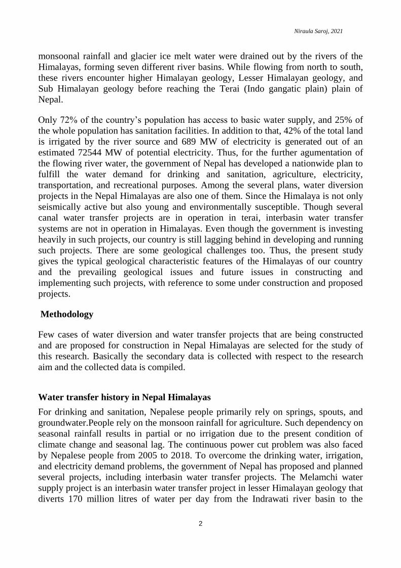
The Nepal Himalayas typically consist of twelve river basins (figure 1). The river
basins extend from the northern higher Himalayan peaks to the southern terai plains.
Surface runoff from these basins accounts for approximately 72% of the monsoon
rainfall, with a total catchment area of approximately 181000 sq. km, of which about
33600 sq. km is in Tibet (Sharma 1997). The rivers from the higher Himalayas are
north to south trending. In addition to that, the fault system and the thrusts have
controlled some rivers, changing the trend to an east to west direction. The rivers like
Sunkoshi and Tamor are east-to-west trending in some places. The Arun and
Kaligandaki rivers also flow from south to north in some places due to structural
control.
Niraula Saroj, 2021
4
Figure 1: The river basins of Nepal (WECS 2019)
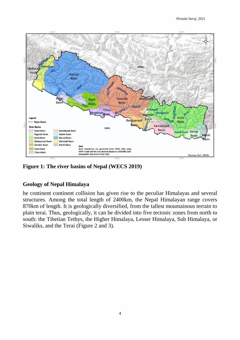
Geology of Nepal Himalaya
he continent continent collision has given rise to the peculiar Himalayas and several
structures. Among the total length of 2400km, the Nepal Himalayan range covers
870km of length. It is geologically diversified, from the tallest mountainous terrain to
plain terai. Thus, geologically, it can be divided into five tectonic zones from north to
south: the Tibetian Tethys, the Higher Himalaya, Lesser Himalaya, Sub Himalaya, or
Siwaliks, and the Terai (Figure 2 and 3).

Niraula Saroj, 2021
5
Figure 2: Simplified geological map of Nepal. Source Compiled from Tater et al.
(1983), Shrestha and Shrestha (1984), ESCAP (1993), Amatya and Jnawali
(1994)
These zones are separated by three major thrusts: the Main Central Thrust (MCT), the
Main Boundary Thrusts (MBT), and the Main Frontal Thrusts (MFT). The Tibetian
Tethys zone consists of Paleozoic to mesozoic aged sedimentary rocks in the
northernmost part of the country which are heavily folded and faulted. It consists of
the inner Himalayan valleys of Thakkhola and Langu. The rocks of this zone are
horizontally bedded and are soft to medium. As this zone lies north of the Higher
Himalayan range, there is low monsoon rainfall. But due to its high altitude, regular
snowfalls take place, resulting in the freezing and thawing of rocks. The main
Himalayan range, known as the higher Himalaya, includes Mount Everest, which has
an altitude range of 3000m to 8848m and is composed of metamorphic rocks such as
gneiss, schist, and phyllite.The rocks of this zone are hard and steep and lie between
the South Tibetian Detachment System (STDS) in the north and the Main Central
Thrust (MCT) in the south. The freezing and thawing action is prevalent in this zone
and major eroding glaciers form u-shaped valleys. The lesser Himalayas zone
consists of paleozoic and Mesozoic rocks that are exposed between the Main Central
Thrust (MCT) and the Main Boundry Thrust (MBT). This zone is highly disturbed

Niraula Saroj, 2021
6
and overturned folds, faults, and thrust sheets are common in this zone. The most
common rock types in the lesser Himalaya are slate, phyllite, sandstones, limestones,
dolomites, are common. In addition to that, in some places, lesser himilayan gneiss
can also be seen. The Sub Himalayan rock consists of Tertiary (Middle Miocene to
early Pleistocene) sedimentary rocks with fining up sequence. Mostly, the Lesser
Himalayan rock consists of mudstone, sandstone, and conglomerate beds extending
between the Himalayan Frontal Thrust (HFT) and the Main Boundary Thrust (MBT).
The terai (indo-gangatic plain) consists of a quartenary deposit of sand, gravel, and
pebbles. It ends up to the Main Frontal Thrust (MFT) giving rise to the sub-
Himalayan rocks.
Figure 3: Generalised geological section of Himalaya (after Harris & Whalley,
2001)
Geological issues
Nepal is rich in surface water resources, and for the augmentation of these resources,
water diversion is to be done in the Himalayas. The diversion of huge volumes of
water to the desired location to meet the aims and objectives is impossible without
the construction of mega structures like dams, tunnels, and underground caverns.
Geology plays a dominant role in the construction of water diversion projects. Since
the geology of the Nepal Himalaya is variable and unstable due to folded, faulted,
and thrusted rock sequences, construction of such projects without considering such
challenges results in not only a loss of investment but also a toll on life and property.
The young and mobile Himalayan zones thus have different geological challenges
such as: a) poor rock mass quality, b) highly weathered, fractured, faulted and folded
rocks, c) stress overloading in rock mass, d) influence of groundwater, e) seismic
influence, and f) geological hazards, which are discussed below.
Niraula Saroj, 2021
7
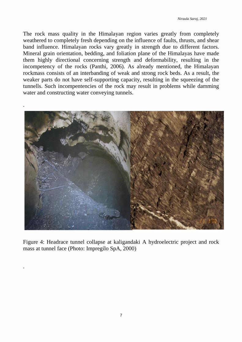
The rock mass quality in the Himalayan region varies greatly from completely
weathered to completely fresh depending on the influence of faults, thrusts, and shear
band influence. Himalayan rocks vary greatly in strength due to different factors.
Mineral grain orientation, bedding, and foliation plane of the Himalayas have made
them highly directional concerning strength and deformability, resulting in the
incompetency of the rocks (Panthi, 2006). As already mentioned, the Himalayan
rockmass consists of an interbanding of weak and strong rock beds. As a result, the
weaker parts do not have self-supporting capacity, resulting in the squeezing of the
tunnells. Such incompentencies of the rock may result in problems while damming
water and constructing water conveying tunnels.
.
Figure 4: Headrace tunnel collapse at kaligandaki A hydroelectric project and rock
mass at tunnel face (Photo: Impregilo SpA, 2000)
.
Niraula Saroj, 2021
8
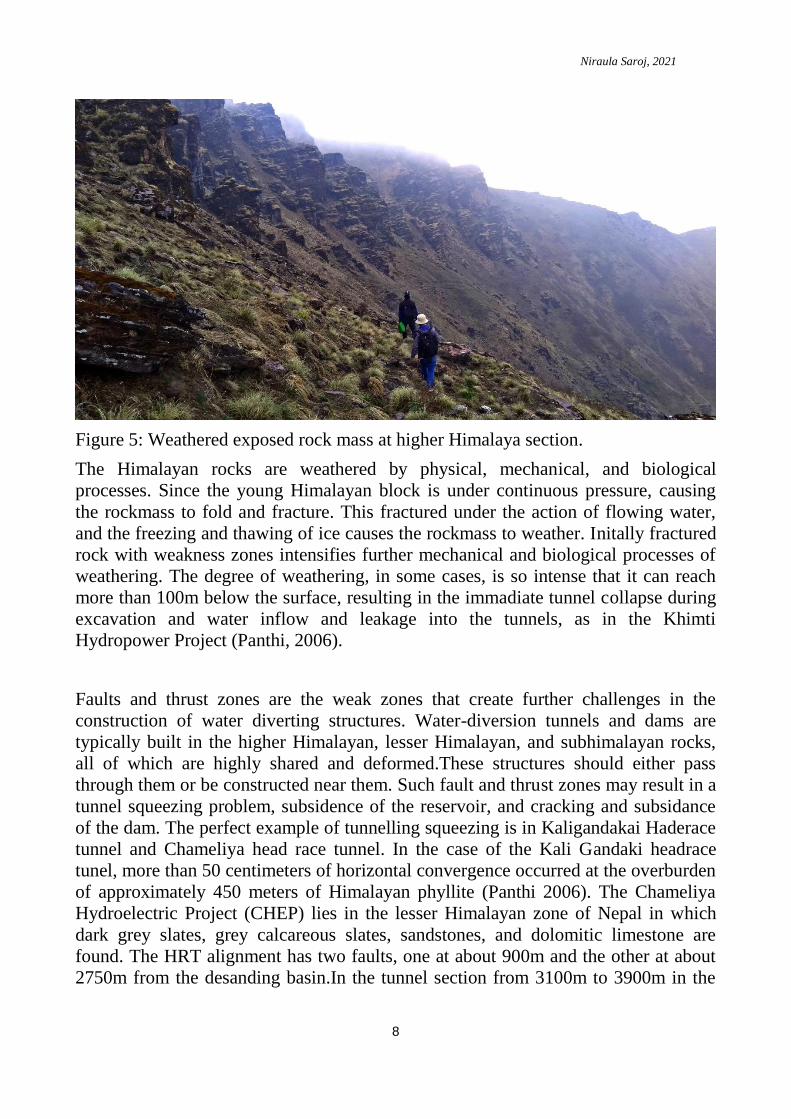
Figure 5: Weathered exposed rock mass at higher Himalaya section.
The Himalayan rocks are weathered by physical, mechanical, and biological
processes. Since the young Himalayan block is under continuous pressure, causing
the rockmass to fold and fracture. This fractured under the action of flowing water,
and the freezing and thawing of ice causes the rockmass to weather. Initally fractured
rock with weakness zones intensifies further mechanical and biological processes of
weathering. The degree of weathering, in some cases, is so intense that it can reach
more than 100m below the surface, resulting in the immadiate tunnel collapse during
excavation and water inflow and leakage into the tunnels, as in the Khimti
Hydropower Project (Panthi, 2006).
Faults and thrust zones are the weak zones that create further challenges in the
construction of water diverting structures. Water-diversion tunnels and dams are
typically built in the higher Himalayan, lesser Himalayan, and subhimalayan rocks,
all of which are highly shared and deformed.These structures should either pass
through them or be constructed near them. Such fault and thrust zones may result in a
tunnel squeezing problem, subsidence of the reservoir, and cracking and subsidance
of the dam. The perfect example of tunnelling squeezing is in Kaligandakai Haderace
tunnel and Chameliya head race tunnel. In the case of the Kali Gandaki headrace
tunel, more than 50 centimeters of horizontal convergence occurred at the overburden
of approximately 450 meters of Himalayan phyllite (Panthi 2006). The Chameliya
Hydroelectric Project (CHEP) lies in the lesser Himalayan zone of Nepal in which
dark grey slates, grey calcareous slates, sandstones, and dolomitic limestone are
found. The HRT alignment has two faults, one at about 900m and the other at about
2750m from the desanding basin.In the tunnel section from 3100m to 3900m in the
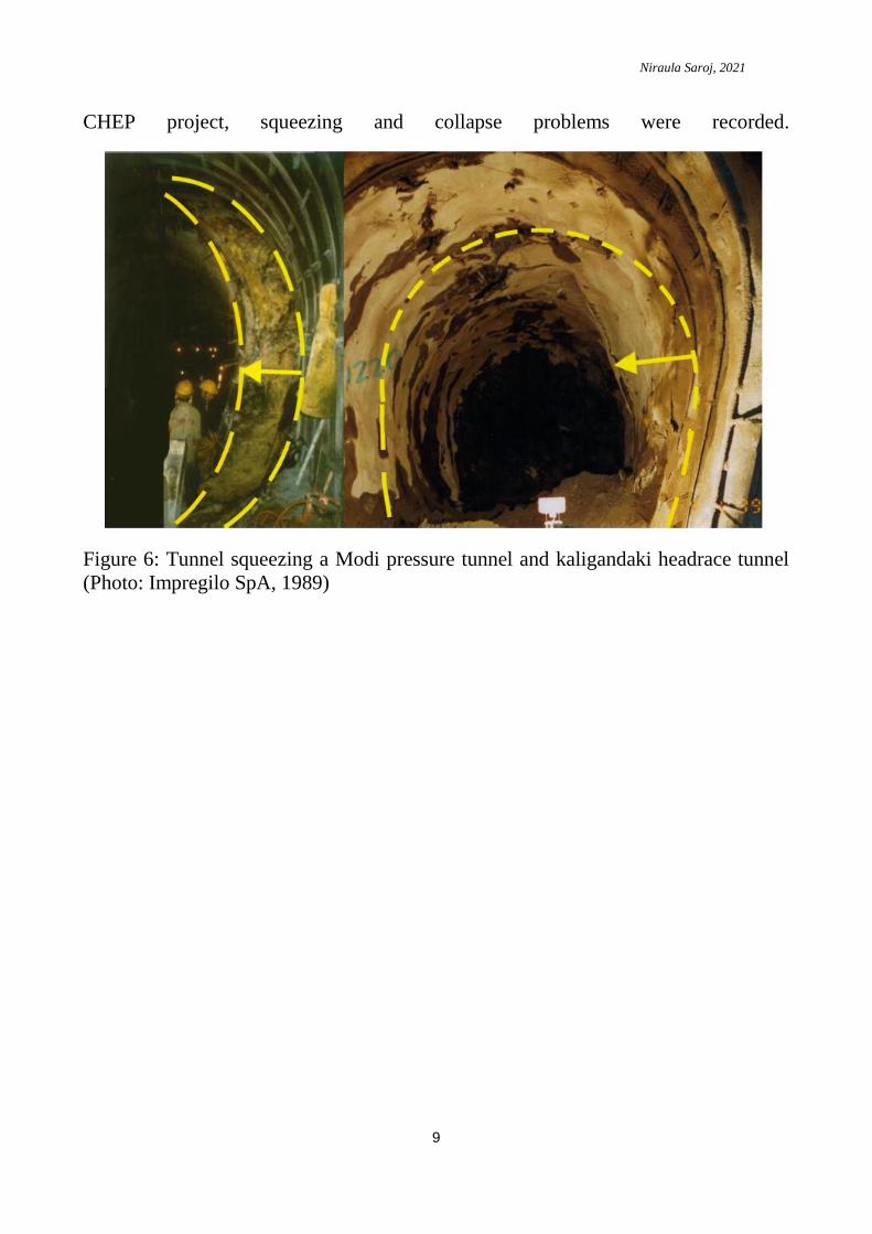
Niraula Saroj, 2021
9
CHEP project, squeezing and collapse problems were recorded.
Figure 6: Tunnel squeezing a Modi pressure tunnel and kaligandaki headrace tunnel
(Photo: Impregilo SpA, 1989)
Niraula Saroj, 2021
10
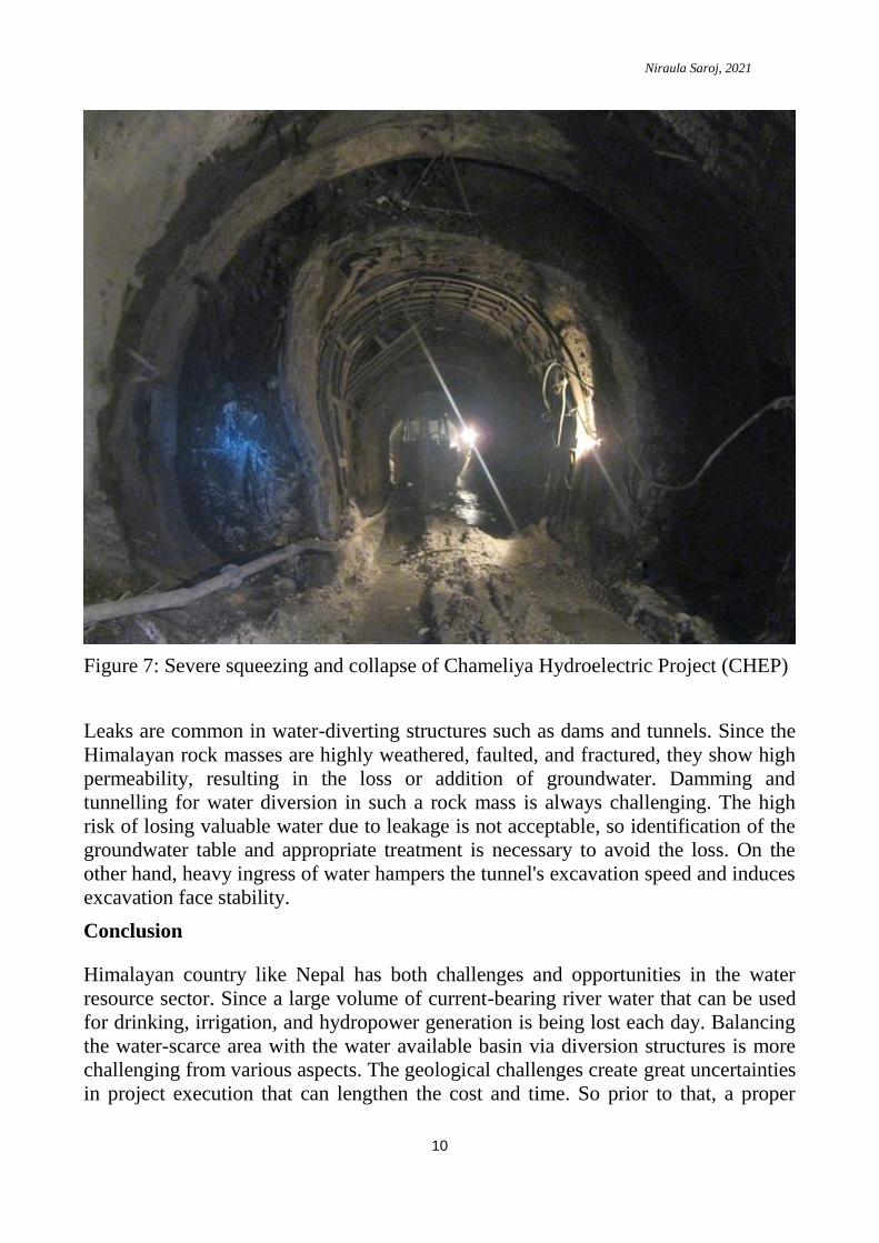
Figure 7: Severe squeezing and collapse of Chameliya Hydroelectric Project (CHEP)
Leaks are common in water-diverting structures such as dams and tunnels. Since the
Himalayan rock masses are highly weathered, faulted, and fractured, they show high
permeability, resulting in the loss or addition of groundwater. Damming and
tunnelling for water diversion in such a rock mass is always challenging. The high
risk of losing valuable water due to leakage is not acceptable, so identification of the
groundwater table and appropriate treatment is necessary to avoid the loss. On the
other hand, heavy ingress of water hampers the tunnel's excavation speed and induces
excavation face stability.
Conclusion
Himalayan country like Nepal has both challenges and opportunities in the water
resource sector. Since a large volume of current-bearing river water that can be used
for drinking, irrigation, and hydropower generation is being lost each day. Balancing
the water-scarce area with the water available basin via diversion structures is more
challenging from various aspects. The geological challenges create great uncertainties
in project execution that can lengthen the cost and time. So prior to that, a proper

Niraula Saroj, 2021
11
geological investigation is to be conducted so that the proper design of structures can
be made without any loss. The Himalayan geology is fragile and young; therefore
such a project is to be constructed with care and caution.

Niraula Saroj, 2021
12
References
Amatya KM, Jnawali BM (1994) Geological map of Nepal, Scale: 1:1,000,000.
Department of Mines and Geology, International Centre for Integrated Mountain
Development, Carl Duisberg Gesellschaft e. V., and United Nations Environment
Programme
Gansser A (1964) Geology of the Himalayas. Interscience, New York, 289 pp
Harris, N., & Whalley, J. (2001). Mountain Building, Block 4, The Open University,
U.K., PP. 165
Holland TH (1908) On the occurrence of striated boulders in the Blaini Formation of
Simla, with a discussion of the geological age of the beds. Rec Geol Surv India
XXXVII(part 1):129–135 (with one plate)
Himal Hydro (HH). 2001. Construction report. Modi Khola hydroelectric project.
Nepal.
Himal Power Limited. 1995. Project definition report. Khimti I hydropower project:
Nepal
Panthi, K.K. (2006) Analysis of engineering geological uncertainties related to
tunneling in Himalayan rock mass conditions, Doctoral Thesis, Norwegian University
of Science and Technology
Parrish RR, Hodges KV (1996) Isotopic constraints on the age and provenance of the
Lesser and Greater Himalayan sequences, Nepalese Himalaya. Geol Soc Am Bull
108:904–911 Parrish RR, Gough SJ, Searle MP, Waters DJ (2006) Plate velocity
exhumation of ultrahigh-pressure eclogites in the Pakistan Himalaya. Geology
34:989–992
Sharma CK. (1977) River Systems of Nepal. S. Sharma, Kathmandu, Nepal
Tater JM, Shrestha SB, Shrestha JN (1983) Geological map of Western Central
Nepal. Scale: 1:250,000. Department of Mines and Geology, Kathmandu
WECS (2019) Assessment of Hydropower Potential of Nepal