geological attractions of mount chamah area, kelantan
12
GEOLOGICAL ATTRACTIONS OF MOUNT CHAMAH AREA, KELANTAN Dony Adriansyah Nazaruddin 1 , Hasimah Hassan 2 , Ahmad Fadli Ahmad Sanusi 2 1 Geoscience Programme, Faculty of Agro Industry and Natural Resources, Universiti Malaysia Kelantan, Locked Bag 36, Pengkalan Chepa, 16100 Kota Bharu, Kelantan, Malaysia E-mail: [email protected] 2 Laboratory of FASA, Faculty of Agro Industry and Natural Resources, Universiti Malaysia Kelantan, Locked Bag 36, Pengkalan Chepa, 16100 Kota Bharu, Kelantan, Malaysia ABSTRACT Mount Chamah (2171 m) is the highest point in Kelantan state and is one of the mountain peaks of Titiwangsa Range, the “backbone” of Peninsular Malaysia. Preliminary identification and mapping of geological attractions in Mount Chamah area have been done during the Explore Chamah 2011 program, organized by Kelantan State Forestry Department in collaboration with Universiti Malaysia Kelantan on 24 – 29 July 2011. Like other areas in the range, Mount Chamah area was also formed of granitic rocks. Several main geological attractions have been identified, such as Pichong River, Lata Pichong Waterfall, “Boat Rock” outcrop, and the morphologic panorama from the summit area. ABSTRAK Gunung Chamah (2171 m) merupakan titik tertinggi di negeri Kelantan dan merupakan salah satu puncak gunung daripada Banjaran Titiwangsa, “tulang belakang” Semenanjung Malaysia. Pengenalan dan pemetaan awal tarikan geologi di kawasan Gunung Chamah telah dilakukan selama program Eksplorasi Chamah 2011, dianjurkan oleh Jabatan Perhutanan Negeri Kelantan dengan kerjasama Universiti Malaysia Kelantan pada 24 – 29 Julai 2011. Seperti kawasan-kawasan lain di banjaran itu, kawasan Gunung Chamah juga terbentuk oleh batuan granit. Beberapa tarikan geologi utama telah dikenal pasti, seperti Sungai Pichong, Air Terjun Pichong, singkapan "Batu Sampan", dan panorama morfologi dari kawasan puncak. 1
Transcript of geological attractions of mount chamah area, kelantan
GEOLOGICAL ATTRACTIONS OF MOUNT CHAMAH AREA, KELANTAN
Dony Adriansyah Nazaruddin1, Hasimah Hassan2, Ahmad Fadli Ahmad Sanusi2
1 Geoscience Programme, Faculty of Agro Industry and Natural Resources, Universiti Malaysia Kelantan, Locked Bag 36, Pengkalan Chepa, 16100 Kota Bharu, Kelantan, Malaysia
E-mail: [email protected] of FASA, Faculty of Agro Industry and Natural Resources, Universiti Malaysia Kelantan,
Locked Bag 36, Pengkalan Chepa, 16100 Kota Bharu, Kelantan, Malaysia
ABSTRACTMount Chamah (2171 m) is the highest point in Kelantan state and is one of the mountain
peaks of Titiwangsa Range, the “backbone” of Peninsular Malaysia. Preliminary identification
and mapping of geological attractions in Mount Chamah area have been done during the
Explore Chamah 2011 program, organized by Kelantan State Forestry Department in
collaboration with Universiti Malaysia Kelantan on 24 – 29 July 2011. Like other areas in the
range, Mount Chamah area was also formed of granitic rocks. Several main geological
attractions have been identified, such as Pichong River, Lata Pichong Waterfall, “Boat Rock”
outcrop, and the morphologic panorama from the summit area.
ABSTRAKGunung Chamah (2171 m) merupakan titik tertinggi di negeri Kelantan dan merupakan salah
satu puncak gunung daripada Banjaran Titiwangsa, “tulang belakang” Semenanjung
Malaysia. Pengenalan dan pemetaan awal tarikan geologi di kawasan Gunung Chamah telah
dilakukan selama program Eksplorasi Chamah 2011, dianjurkan oleh Jabatan Perhutanan
Negeri Kelantan dengan kerjasama Universiti Malaysia Kelantan pada 24 – 29 Julai 2011.
Seperti kawasan-kawasan lain di banjaran itu, kawasan Gunung Chamah juga terbentuk oleh
batuan granit. Beberapa tarikan geologi utama telah dikenal pasti, seperti Sungai Pichong,
Air Terjun Pichong, singkapan "Batu Sampan", dan panorama morfologi dari kawasan
puncak.
1
INTRODUCTIONThere are many wonderful landforms/landscapes and amazing phenomena on the
Earth. Those landforms/landscapes and phenomena have many stories to tell: the materials, the processes, the products, and the history of the Earth. All those things are within the scope of geology. According to Neunendorf et al. (2005), geology is the study of planet Earth, the materials of which it is made, the processes that act on these materials, the products formed, and the history of the planet and its life forms since its origin.
Understanding how beautiful landforms/landscapes originated would become a subject of interest. Mountains, hills, rivers, lakes, waterfalls, etc are some geological attractions of an area. They are geological features that make an area interesting and enjoyable. Geological attraction is one aspect of the bigger concept, ‘Geotourism’. Geological attractions of an area should be identified and exposed for many purposes and objectives, such as education, tourism, area planning and management, and so on. Geologists (or Earth scientists) should be “the spearhead” to introduce the geological attractions of an area to the general public.
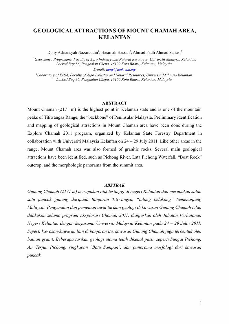
In Peninsular Malaysia, there are several mountains located along the main mountain range called the Titiwangsa Range. One of the popular mountain peaks is Mount (‘Gunung’ in Malay) Chamah, which is situated in the western corner of Kelantan, near the state border with Perak and within the area of Gua Musang district (Figure 1). Its peak is the highest point in Kelantan (2171 m = 7123 ft). From the GPS reading, it lies on the coordinates of N 5013.632’, E 101034.438’. It is the tenth highest mountain in Malaysia (Table 1). It is the fifth in Peninsular Malaysia and is also one of the Group 7 (G7), a mountain category with more than 7.000 feet altitude in Peninsular Malaysia. There are only seven mountains in this group: Mount Tahan (7175 feet/ 2187 m), Mount Korbu (7162 feet/ 2183 m), Mount Yong Belar (7156 feet/ 2181 m), Mount Gayong (7129 feet/ 2173 m), Mount Chamah (7123 feet, 2171 m), Mount Yong Yap (7110 feet/ 2167 m), and Mount Ulu Sepat (7089 feet/ 2161 m). Therefore, all these mountains are called G7 category after the number seven is taken from the height and the number. All are located in the Titiwangsa Range except Mount Tahan, which is in the Tahan Range (Wikipedia, 2011a).
2
Figure 1. The location map of Mount Chamah
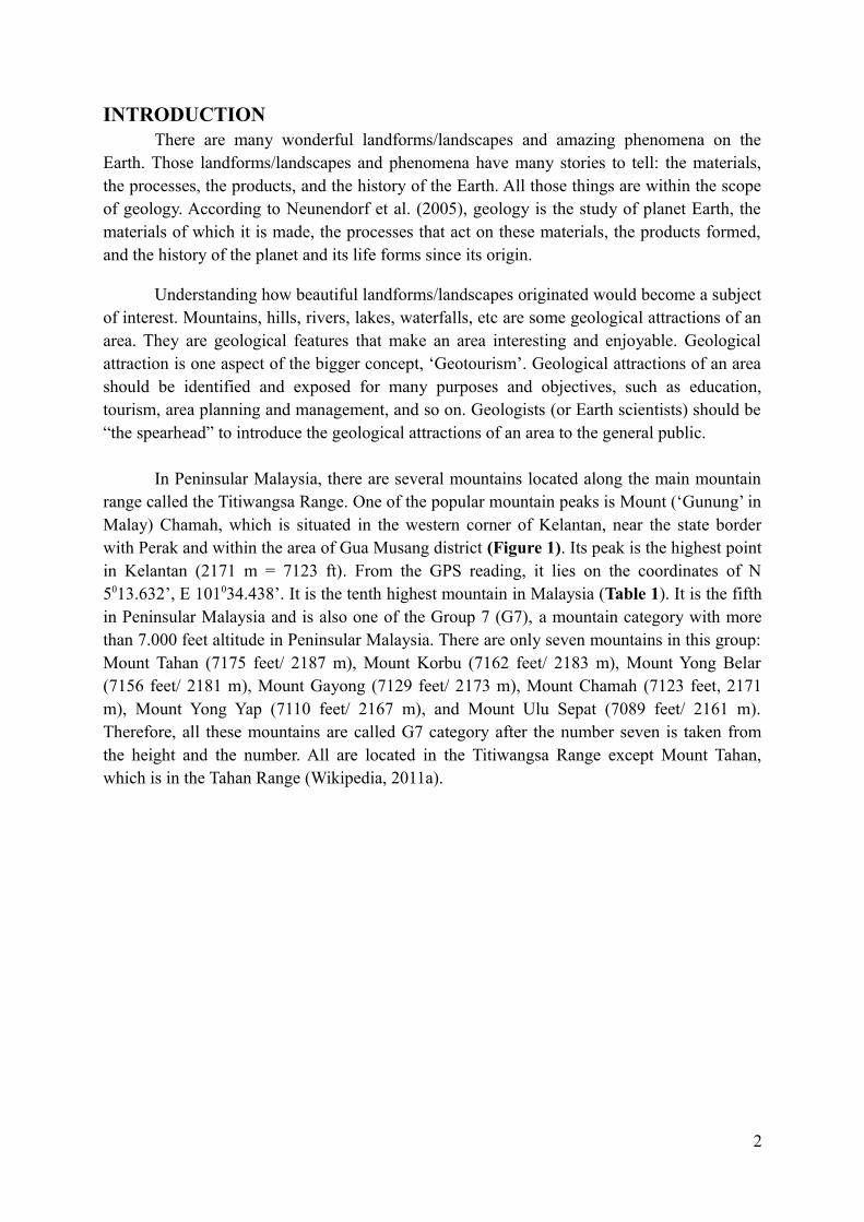
Table 1. The rank of mountains in Malaysia
No.
Name Range State Height (m, ft)
1 Mount Kinabalu Crocker Range Sabah 4095 m/ 13436 ft2 Mount Trusmadi Trusmadi Range Sabah 2642 m/ 8669 ft3 Mount Tambuyukon Crocker Range Sabah 2579 m/ 8462 ft4 Mount Murud Tama Abu Range Sarawak 2422 m/ 7946 ft5 Mount Mulu Tama Abu Range Sarawak 2376 m/ 7795 ft6 Mount Tahan Tahan Range Pahang-Kelantan
border2187 m/ 7175 ft
7 Mount Korbu Titiwangsa Range Perak 2183 m/ 7162 ft8 Mount Yong Belar Titiwangsa Range Kelantan-Perak
border2181 m/ 7156 ft
9 Mount Gayong Titiwangsa Range Perak 2173 m/ 7129 ft10 Mount Chamah Titiwangsa Range Kelantan 2171 m/ 7123 ft
Source: Wikipedia, (2011b)
Mount Chamah area is assumed as the most challenging mountain in Malaysia because of its accessibility from the town to the area and from the start of the trek to the peak. It is a remote and secluded mountain, as well as a dense forest, but contains some beautiful
3
landscapes within its area. It is also rather untouched and still unknown by general public and even by researchers. This mountain is famous only among few hikers and conservationists. This area has a wide range of natural resources, both biodiversity and geodiversity.
In geodiversity, even the area is monotonously dominated by granitic rocks, it possesses some geological features and beautiful landforms, such as hilly to mountainous terrain, rivers, waterfalls, and rock outcrops. Some of them have potential as geotourism resources of the area. This location should be conserved and developed properly and should be promoted to the public. However, it has to be done under good management and careful monitoring so that the impact to its environment is minimal. Therefore, this area should be gazetted as one of the new geotourism site in Kelantan.
Identification and mapping of geological attractions in Mount Chamah area is still in the early stage and was done during the Explore Chamah 2011 program. The objectives of this study are to identify and to map the main geological attractions of Mount Chamah area, the hidden treasures of Kelantan; to make general observations of the geological attractions in the area; and to propose an initiative to conserve and develop Mount Chamah area to become an alternative geotourism site in Kelantan.
THE EXPLORE CHAMAH 2011 PROGRAMCollaboration between Faculty of Agro Industry and Natural Resources, Universiti
Malaysia Kelantan (UMK) and Kelantan State Forestry Department has initiated a program to explore and study the hidden treasures of Kelantan in the natural resources-rich Mount Chamah area. The so-called Explore Chamah 2011 Programme has attracted many researchers from various areas of study, including of geology. They came from several universities and agencies both governmental and non-governmental bodies. The programme took place for six days (24 – 29 July 2011).
The journey was started from the office of South Kelantan Forestry Department in Gua Musang town in the first day. From the town, the team drove to Kuala Betis village before they all arrived in Pichong village, a secluded village which became the location of the campsite, called the “Abdullah Sani camp” (Figure 2). Kelantan State Forestry Department opted to name the camp from the name of its ex-Director, YBhg. Dato’ Abdullah Sani bin Shaffie. From the campsite, the journey was done by jungle trekking to climb the mount for few days. The researchers passed through the new trek which was opened by staf and rangers of Kelantan State Forestry Department.
4
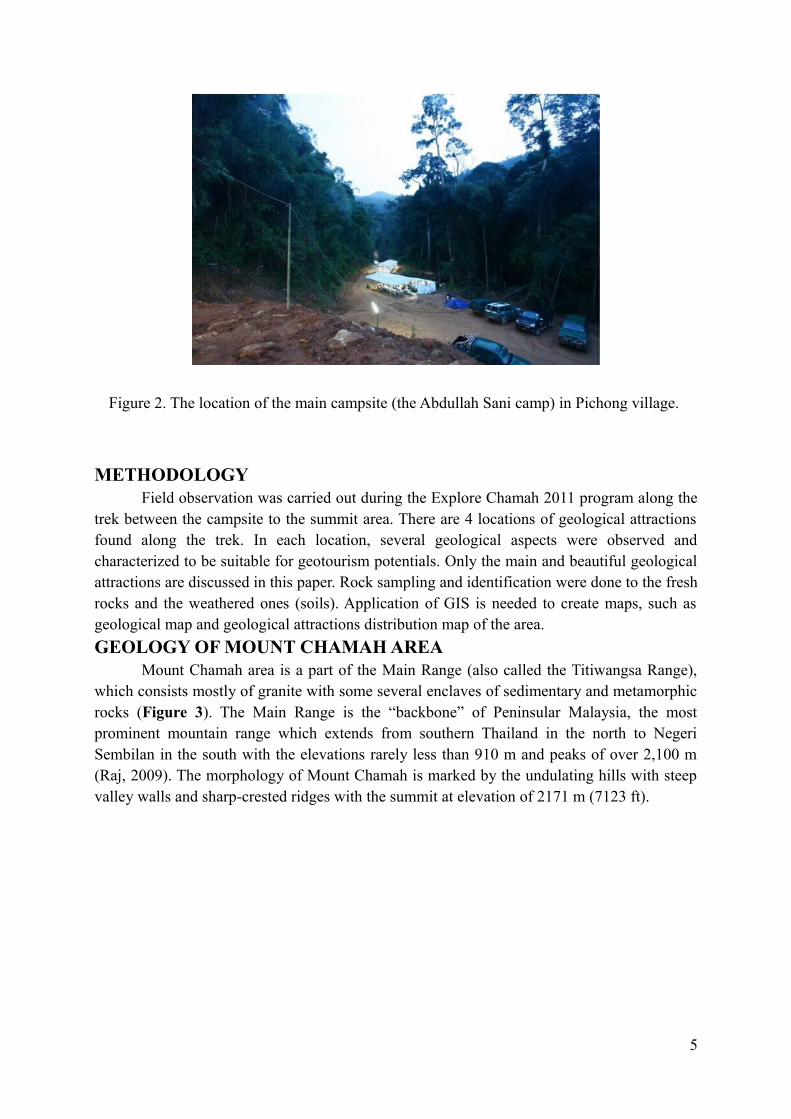
Figure 2. The location of the main campsite (the Abdullah Sani camp) in Pichong village.
METHODOLOGYField observation was carried out during the Explore Chamah 2011 program along the
trek between the campsite to the summit area. There are 4 locations of geological attractions found along the trek. In each location, several geological aspects were observed and characterized to be suitable for geotourism potentials. Only the main and beautiful geological attractions are discussed in this paper. Rock sampling and identification were done to the fresh rocks and the weathered ones (soils). Application of GIS is needed to create maps, such as geological map and geological attractions distribution map of the area.
GEOLOGY OF MOUNT CHAMAH AREAMount Chamah area is a part of the Main Range (also called the Titiwangsa Range),
which consists mostly of granite with some several enclaves of sedimentary and metamorphic rocks (Figure 3). The Main Range is the “backbone” of Peninsular Malaysia, the most prominent mountain range which extends from southern Thailand in the north to Negeri Sembilan in the south with the elevations rarely less than 910 m and peaks of over 2,100 m (Raj, 2009). The morphology of Mount Chamah is marked by the undulating hills with steep valley walls and sharp-crested ridges with the summit at elevation of 2171 m (7123 ft).
5
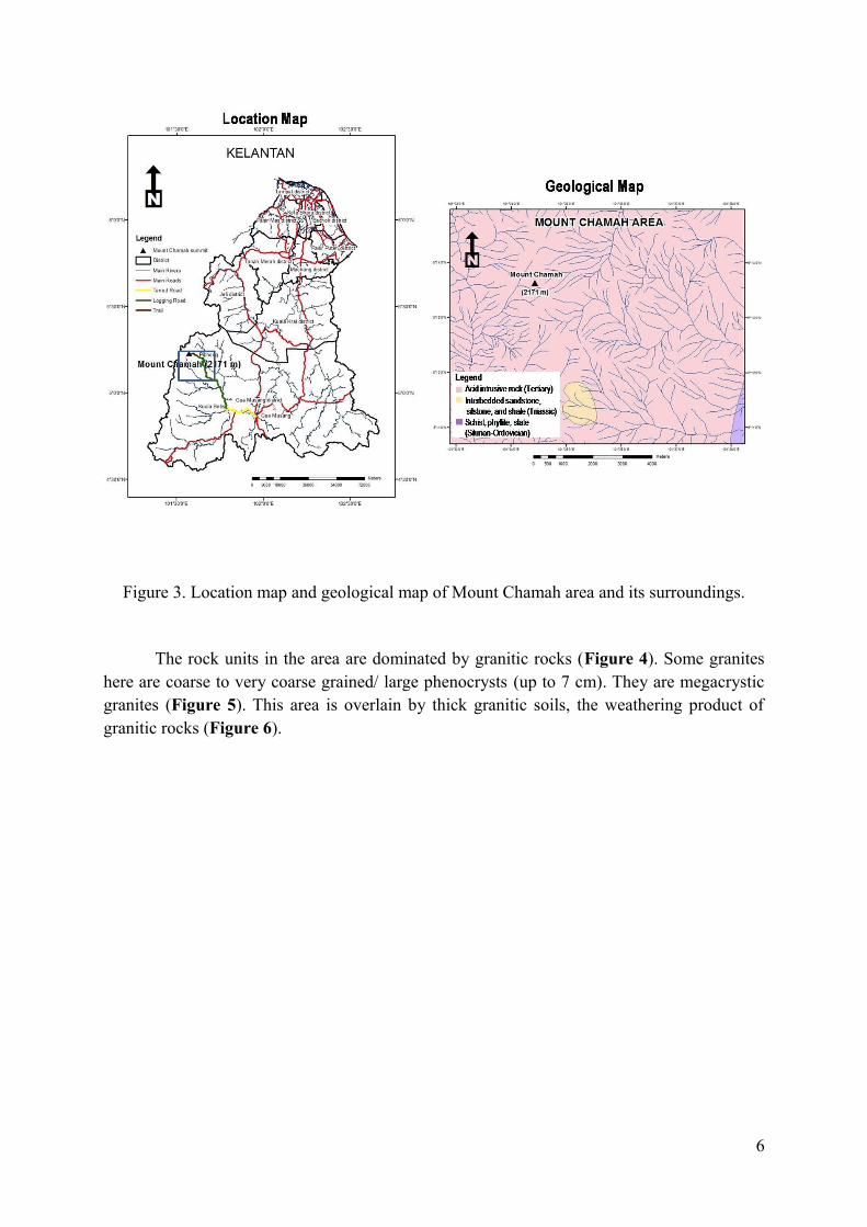
Figure 3. Location map and geological map of Mount Chamah area and its surroundings.
The rock units in the area are dominated by granitic rocks (Figure 4). Some granites here are coarse to very coarse grained/ large phenocrysts (up to 7 cm). They are megacrystic granites (Figure 5). This area is overlain by thick granitic soils, the weathering product of granitic rocks (Figure 6).
6
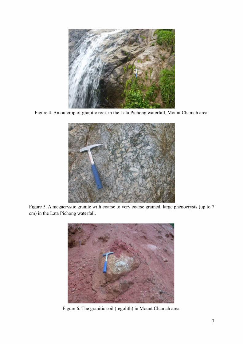
Figure 4. An outcrop of granitic rock in the Lata Pichong waterfall, Mount Chamah area.
Figure 5. A megacrystic granite with coarse to very coarse grained, large phenocrysts (up to 7 cm) in the Lata Pichong waterfall.
Figure 6. The granitic soil (regolith) in Mount Chamah area.
7
GEOLOGICAL ATTRACTIONS OF MOUNT CHAMAH AREAEder and Patzak (2004) stated that many countries have started to develop schemes for
recognizing important geological and geomorphological sites or landscapes within their national boundaries. Such sites are important for educating the general public in geological and environmental matters. They also serve as tools for demonstrating sustainable development and for illustrating methods of site conservation whereby recalling that rocks, minerals, fossils, soils, landforms and landscapes are both the products and records of the evolution of our planet Earth.
The Mount Chamah area itself is one of the largest montane forest in Kelantan. Due to this, it is important for flora and fauna conservation. In addition to biotic elements, abiotic parts are also would become a subject of interest. Wonderful landforms such as the waterfall, the river, hilly to mountainous terrain, the interesting rock outcrop and so on would become attractions of this location. They are some geological features that make this area interesting and enjoyable. These geological attractions are potentials for geotourism resources.
Ibrahim Komoo (2000) elaborated in his paper regarding the conservation geology which is introduced to effect a paradigm shift in the geological community towards the utilization of geological resources and attractions without destruction. These kind of resources/attractions need to be developed and managed based on the conservation concept for the benefit of the present society and future generations. According to Tjia Hong Djin (2000), Earth scientists/geologists can contribute to the sustained development of the area by identifying geological aspects and bringing this information to the knowledge of general public and the relevant authorities.
Mapping of geotourism resources in Mount Chamah area is still in the early stage and was done during the Explore Chamah 2011 program, organized by Kelantan State Forestry Department in collaboration with Universiti Malaysia Kelantan on 24 – 29 July 2011. Some potential geotourism resources were identified, such as Lata Pichong Waterfall, Pichong River, “Boat Rock” outcrop, and morphologic panorama in the summit area. Distribution map of geological attractions in Mount Chamah area is shown in Figure 7. Earth scientists/geologists have some important roles to study all geological matters of the area and to expose and bring this information to the authorities and the public.
8
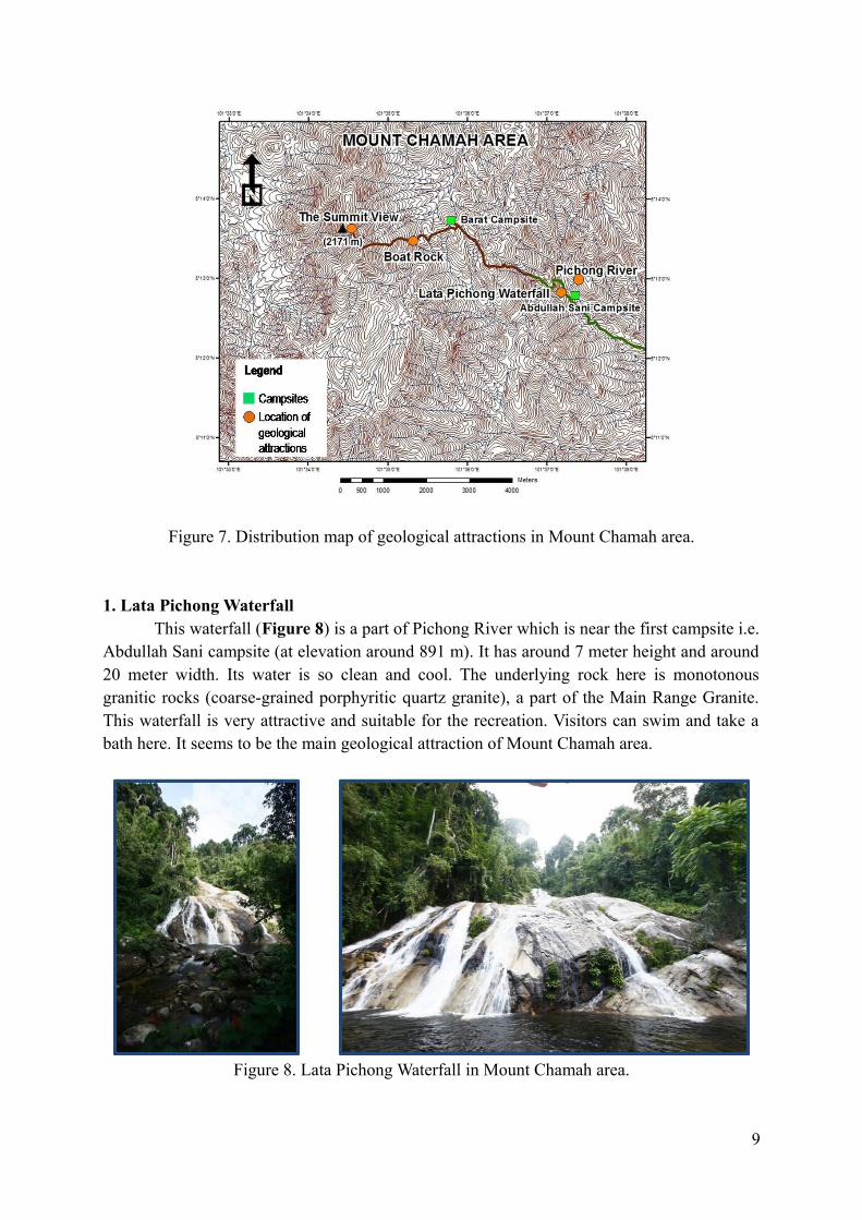
Figure 7. Distribution map of geological attractions in Mount Chamah area.
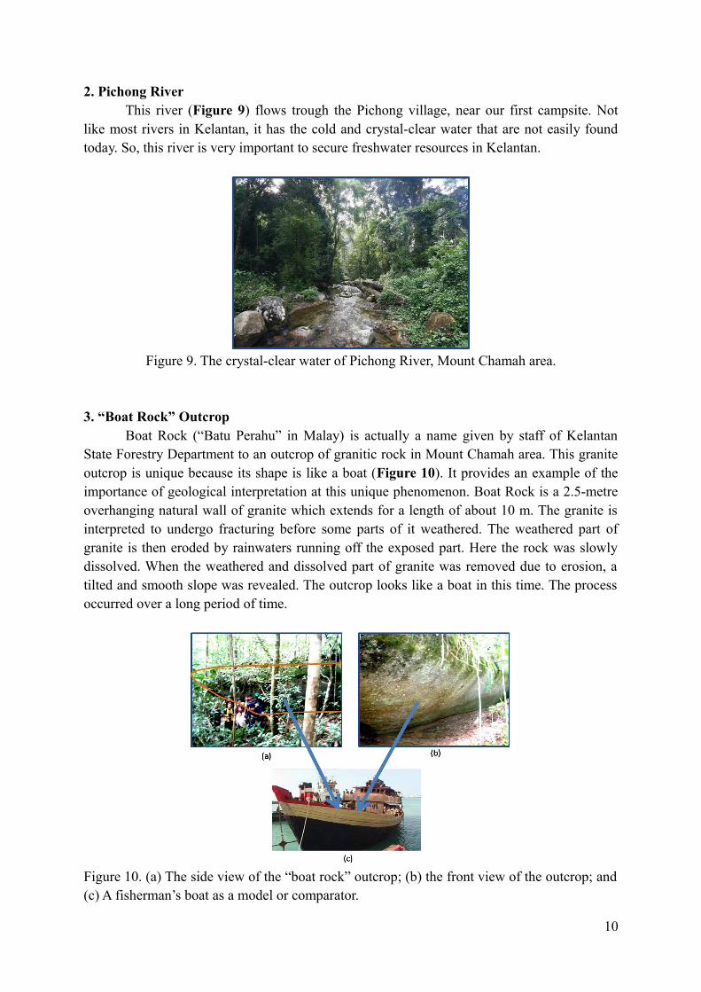
1. Lata Pichong WaterfallThis waterfall (Figure 8) is a part of Pichong River which is near the first campsite i.e.
Abdullah Sani campsite (at elevation around 891 m). It has around 7 meter height and around 20 meter width. Its water is so clean and cool. The underlying rock here is monotonous granitic rocks (coarse-grained porphyritic quartz granite), a part of the Main Range Granite. This waterfall is very attractive and suitable for the recreation. Visitors can swim and take a bath here. It seems to be the main geological attraction of Mount Chamah area.
Figure 8. Lata Pichong Waterfall in Mount Chamah area.
9
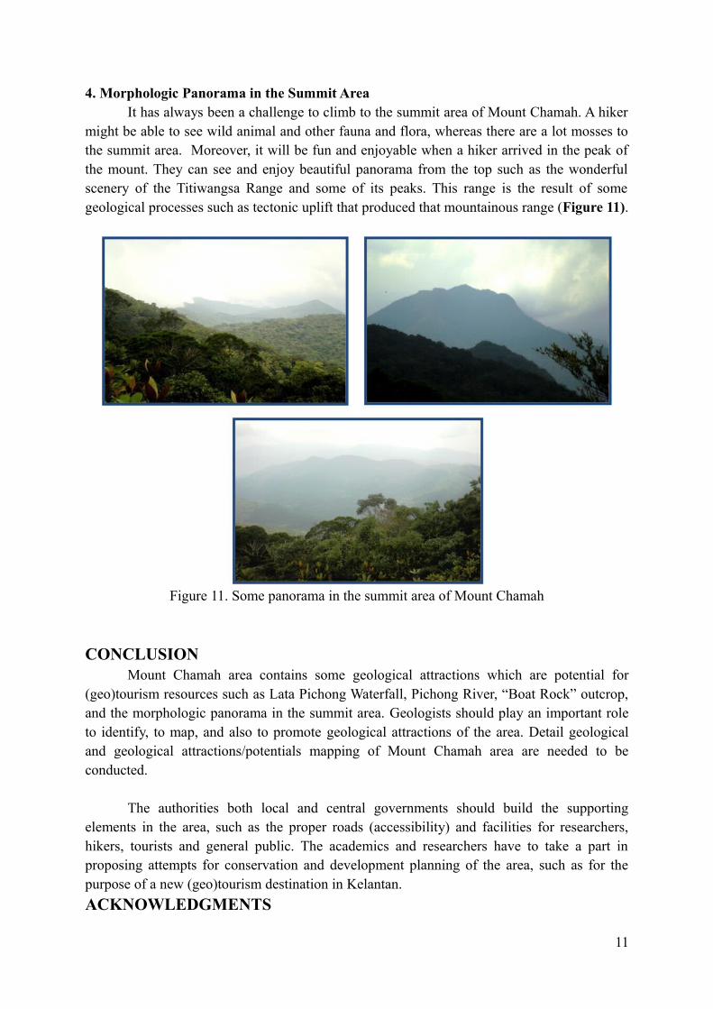
2. Pichong RiverThis river (Figure 9) flows trough the Pichong village, near our first campsite. Not
like most rivers in Kelantan, it has the cold and crystal-clear water that are not easily found today. So, this river is very important to secure freshwater resources in Kelantan.
Figure 9. The crystal-clear water of Pichong River, Mount Chamah area.
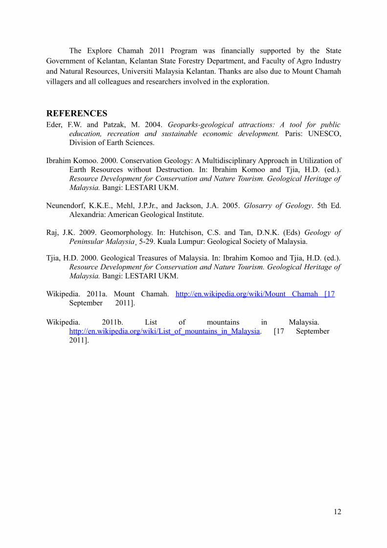
3. “Boat Rock” Outcrop Boat Rock (“Batu Perahu” in Malay) is actually a name given by staff of Kelantan
State Forestry Department to an outcrop of granitic rock in Mount Chamah area. This granite outcrop is unique because its shape is like a boat (Figure 10). It provides an example of the importance of geological interpretation at this unique phenomenon. Boat Rock is a 2.5-metre overhanging natural wall of granite which extends for a length of about 10 m. The granite is interpreted to undergo fracturing before some parts of it weathered. The weathered part of granite is then eroded by rainwaters running off the exposed part. Here the rock was slowly dissolved. When the weathered and dissolved part of granite was removed due to erosion, a tilted and smooth slope was revealed. The outcrop looks like a boat in this time. The process occurred over a long period of time.
Figure 10. (a) The side view of the “boat rock” outcrop; (b) the front view of the outcrop; and (c) A fisherman’s boat as a model or comparator.
10
4. Morphologic Panorama in the Summit AreaIt has always been a challenge to climb to the summit area of Mount Chamah. A hiker
might be able to see wild animal and other fauna and flora, whereas there are a lot mosses to the summit area. Moreover, it will be fun and enjoyable when a hiker arrived in the peak of the mount. They can see and enjoy beautiful panorama from the top such as the wonderful scenery of the Titiwangsa Range and some of its peaks. This range is the result of some geological processes such as tectonic uplift that produced that mountainous range (Figure 11).
Figure 11. Some panorama in the summit area of Mount Chamah
CONCLUSIONMount Chamah area contains some geological attractions which are potential for
(geo)tourism resources such as Lata Pichong Waterfall, Pichong River, “Boat Rock” outcrop, and the morphologic panorama in the summit area. Geologists should play an important role to identify, to map, and also to promote geological attractions of the area. Detail geological and geological attractions/potentials mapping of Mount Chamah area are needed to be conducted.
The authorities both local and central governments should build the supporting elements in the area, such as the proper roads (accessibility) and facilities for researchers, hikers, tourists and general public. The academics and researchers have to take a part in proposing attempts for conservation and development planning of the area, such as for the purpose of a new (geo)tourism destination in Kelantan.
ACKNOWLEDGMENTS
11
The Explore Chamah 2011 Program was financially supported by the State Government of Kelantan, Kelantan State Forestry Department, and Faculty of Agro Industry and Natural Resources, Universiti Malaysia Kelantan. Thanks are also due to Mount Chamah villagers and all colleagues and researchers involved in the exploration.
REFERENCESEder, F.W. and Patzak, M. 2004. Geoparks-geological attractions: A tool for public
education, recreation and sustainable economic development. Paris: UNESCO, Division of Earth Sciences.
Ibrahim Komoo. 2000. Conservation Geology: A Multidisciplinary Approach in Utilization of Earth Resources without Destruction. In: Ibrahim Komoo and Tjia, H.D. (ed.). Resource Development for Conservation and Nature Tourism. Geological Heritage of Malaysia. Bangi: LESTARI UKM.
Neunendorf, K.K.E., Mehl, J.P.Jr., and Jackson, J.A. 2005. Glosarry of Geology. 5th Ed. Alexandria: American Geological Institute.
Raj, J.K. 2009. Geomorphology. In: Hutchison, C.S. and Tan, D.N.K. (Eds) Geology of Peninsular Malaysia¸ 5-29. Kuala Lumpur: Geological Society of Malaysia.
Tjia, H.D. 2000. Geological Treasures of Malaysia. In: Ibrahim Komoo and Tjia, H.D. (ed.). Resource Development for Conservation and Nature Tourism. Geological Heritage of Malaysia. Bangi: LESTARI UKM.
Wikipedia. 2011a. Mount Chamah. http://en.wikipedia.org/wiki/Mount Chamah [17 September 2011].
Wikipedia. 2011b. List of mountains in Malaysia. http://en.wikipedia.org/wiki/List_of_mountains_in_Malaysia. [17 September 2011].
12