GEOLOGIC TRAIL GUIDES TO ZION NATIONAL … years of geologic time. ... occupied this portion of the...
90
Geologic Road, Trail, and Lake Guides to Utah's Parks and Monuments 2000 Utah Geological Association Publication 29 P.B. Anderson and D.A. Sprinkel, editors CONTENTS Introduction Zion Canyon Trails Watchman Trail ................................................................................................................. 7 Sand Bench Trail ............................................................................................................. 15 Emerald Pools Trail ......................................................................................................... 22 Weeping Rock Trail ........................................................................................................ 28 Riverside Walk Trail ....................................................................................................... 30 Canyon Overlook Trail.................................................................................................... 34 Rim Trails East Rim Trail ................................................................................................................. 38 West Rim Trail and Angels Landing............................................................................... 50 Kolob Canyons Trails Middle Fork Taylor Creek Trail ...................................................................................... 64 Timber Creek Overlook Trail .......................................................................................... 70 Timber Creek Trail and Kolob Arch ............................................................................... 73 Hop Valley Trail.............................................................................................................. 78 Acknowledgments ................................................................................................................................... 86 References ............................................................................................................................................... 86 INTRODUCTION The rocks of Zion National Park provide a record of changing environmental conditions through 275 million years of geologic time. The cliffs and mesas of the park and surrounding area are carved from nearly 7,000 feet (2,130 m) of colorful sedimentary strata ranging in age from the Early Permian Toroweap Formation to newly recognized, probable late Early Cretaceous strata (figures 1, 2, and 3). Fossils and other clues in the rocks tell us that they were deposited in a variety of shallow-marine, coastal-sabkha, tidal-flat, coastal-plain, sand-desert, river, and lake environments. Perhaps the most famous of all are the immense, ancient sand dunes of the Navajo Sandstone, seen in the great, sweeping cross-beds of the canyon walls. Zion National Park owes much of its character to the Navajo Sandstone, which attains its maximum thickness of about 2,200 feet (671 m) in this area. GEOLOGIC TRAIL GUIDES TO ZION NATIONAL PARK, UTAH Robert F. Biek, Grant C. Willis, Michael D. Hylland, and Hellmut H. Doelling Utah Geological Survey Salt Lake City, Utah 1
-
Upload
truongliem -
Category
Documents
-
view
214 -
download
0
Transcript of GEOLOGIC TRAIL GUIDES TO ZION NATIONAL … years of geologic time. ... occupied this portion of the...
Geologic Road, Trail, and Lake Guides to Utah's Parks and Monuments 2000 Utah Geological Association Publication 29 P.B. Anderson and D.A. Sprinkel, editors
CONTENTS Introduction
Zion Canyon Trails Watchman Trail ................................................................................................................. 7 Sand Bench Trail ............................................................................................................. 15 Emerald Pools Trail ......................................................................................................... 22 Weeping Rock Trail ........................................................................................................ 28 Riverside Walk Trail ....................................................................................................... 30 Canyon Overlook Trail .................................................................................................... 34
Rim Trails East Rim Trail ................................................................................................................. 38 West Rim Trail and Angels Landing ............................................................................... 50
Kolob Canyons Trails Middle Fork Taylor Creek Trail ...................................................................................... 64 Timber Creek Overlook Trail .......................................................................................... 70 Timber Creek Trail and Kolob Arch ............................................................................... 73 Hop Valley Trail .............................................................................................................. 78
Acknowledgments ................................................................................................................................... 86 References ............................................................................................................................................... 86
INTRODUCTION The rocks of Zion National Park provide a record of changing environmental conditions through 275 million years of geologic time. The cliffs and mesas of the park and surrounding area are carved from nearly 7,000 feet (2,130 m) of colorful sedimentary strata ranging in age from the Early Permian Toroweap Formation to newly recognized, probable late Early Cretaceous strata (figures 1, 2, and 3). Fossils and other clues in the rocks tell us that they were deposited in a variety of shallow-marine, coastal-sabkha, tidal-flat, coastal-plain, sand-desert, river, and lake environments. Perhaps the most famous of all are the immense, ancient sand dunes of the Navajo Sandstone, seen in the great, sweeping cross-beds of the canyon walls. Zion National Park owes much of its character to the Navajo Sandstone, which attains its maximum thickness of about 2,200 feet (671 m) in this area.
GEOLOGIC TRAIL GUIDES TO ZION NATIONAL PARK, UTAH Robert F. Biek, Grant C. Willis, Michael D. Hylland, and Hellmut H. Doelling Utah Geological Survey Salt Lake City, Utah
1
R. F. Biek Geologic Trail Guides To Zion National Park, Utah
2
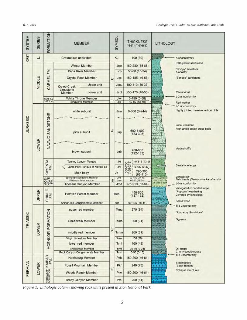
Figure 1. Lithologic column showing rock units present in Zion National Park.
P.B. Anderson and D.A. Sprinkel, editors 2000 Utah Geological Association Publication 29
3
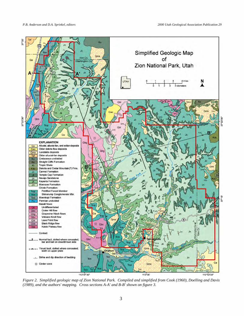
Figure 2. Simplified geologic map of Zion National Park. Compiled and simplified from Cook (1960), Doelling and Davis (1989), and the authors' mapping. Cross sections A-A' and B-B' shown on figure 3.
R. F. Biek Geologic Trail G
uides To Zion National Park, U
tah
4
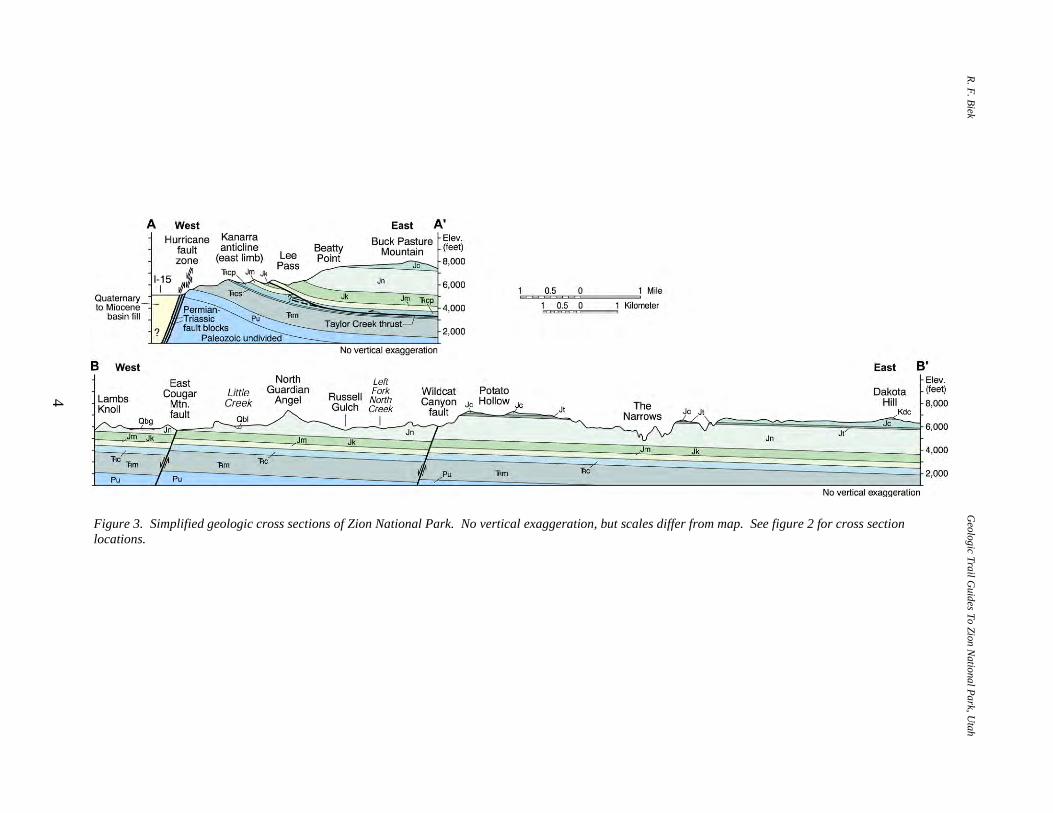
Figure 3. Simplified geologic cross sections of Zion National Park. No vertical exaggeration, but scales differ from map. See figure 2 for cross section locations.

P.B. Anderson and D.A. Sprinkel, editors 2000 Utah Geological Association Publication 29
5
Zion National Park is part of a large structural block at the western margin of the Colorado Plateau, bounded on the west by the Hurricane fault zone and on the east by the Sevier fault zone. Although the structure of the main part of the park is relatively simple — the rocks are tilted gently to the northeast and little complicated by faults — joints are exceptionally well developed and they are largely responsible for the orientation of the existing canyon network. In the Kolob Canyons portion of the park, these rocks are folded into the Kanarra anticline, where beds on the east limb of the anticline are duplicated by back-thrust faults of the Taylor Creek fault zone. Zion National Park is a window through which we can view and comprehend these stories entombed in ancient layers of rock, but above all, it is a monument to erosion. The canyons of Zion National Park represent an early stage in the erosion of the Kolob Terrace, which rises high above the Hurricane Cliffs. Erosion of this structural block by the Virgin River and its tributaries began with headward erosion of the first fault scarps on the Hurricane fault zone, which probably first moved in the Pliocene, at least several million years ago. Several times over about the past 1.5 million years, basaltic lava flowed down and blocked some of these drainages, and many of the flows now form classic examples of inverted topography. The flows also provide unique control on the erosive history of Zion National Park and vicinity, and demonstrate that most of Zion Canyon was carved within the past 2 million years. Because of the impounding effects of landslides and lava flows, the canyons of Zion National Park have periodically held small lakes and ephemeral ponds. Lacustrine deposits associated with at least 14 lakes are known in the park, and they too provide a record of more recent environmental changes. For example, tracks of an Ice Age camel, crane, and various insects are known from deposits of Coalpits Lake, and pollen recovered from these beds is dominated by ponderosa, pinyon, spruce, and fir trees, quite unlike the hot and dry Sonoran climate there today. The enchanting, flat valley floor of Zion Canyon upstream from the Court of the Patriarchs is a reflection of Sentinel Lake, which once occupied this portion of the canyon several thousand years ago. The North Fork of the Virgin River has yet to erode through these lake sediments to re-establish its steeper, pre-landslide gradient. The geologic guides describe the geology of the Permian to Cretaceous bedrock units exposed in and near the park (figure 4). They also offer new details on the fascinating erosional history of this area and the formation of Zion Canyon as recorded by a variety of alluvial, mass-wasting, and lacustrine deposits and basalt flows. These geologic guides are designed to provide basic information about specific features along the routes. The accompanying report on the geology of Zion National Park (Biek and others, 2000) should be consulted for background information on the general geology and descriptions of individual formations and structures.
R. F. Biek Geologic Trail Guides To Zion National Park, Utah
6
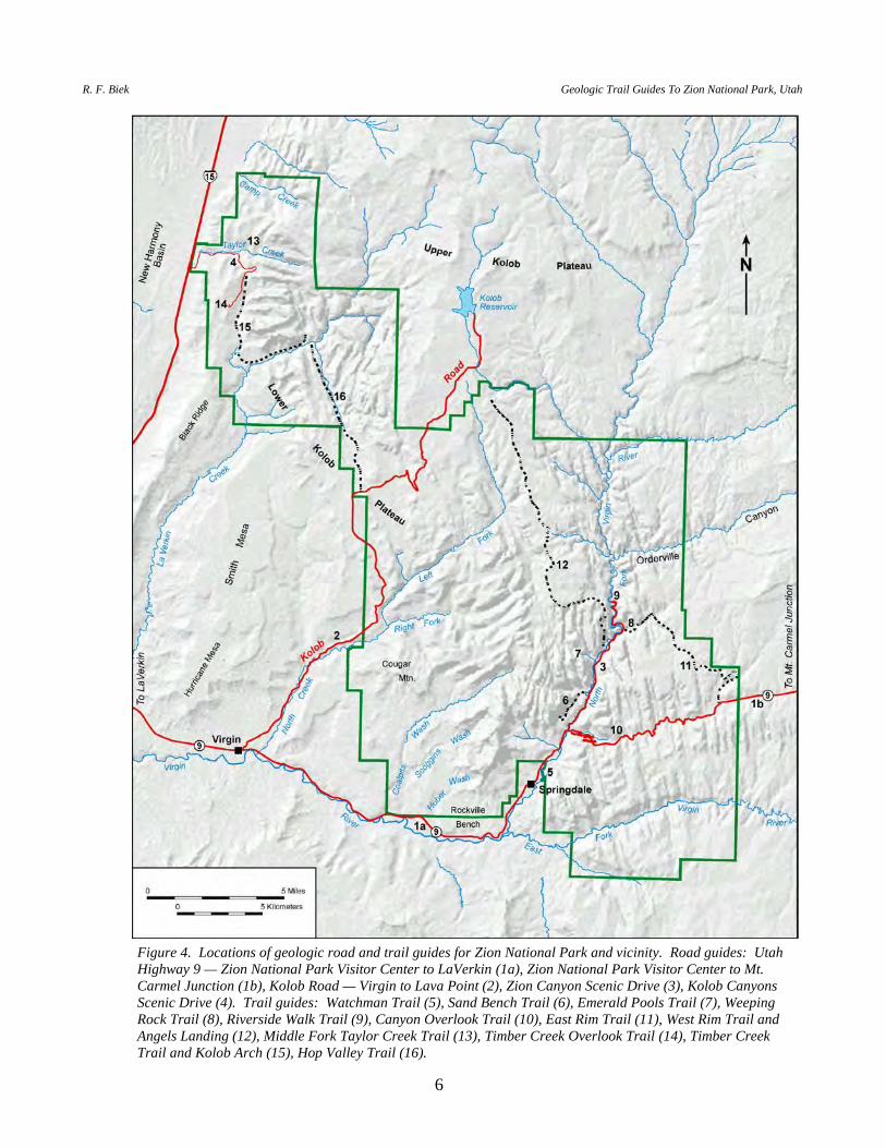
Figure 4. Locations of geologic road and trail guides for Zion National Park and vicinity. Road guides: Utah Highway 9 — Zion National Park Visitor Center to LaVerkin (1a), Zion National Park Visitor Center to Mt. Carmel Junction (1b), Kolob Road — Virgin to Lava Point (2), Zion Canyon Scenic Drive (3), Kolob Canyons Scenic Drive (4). Trail guides: Watchman Trail (5), Sand Bench Trail (6), Emerald Pools Trail (7), Weeping Rock Trail (8), Riverside Walk Trail (9), Canyon Overlook Trail (10), East Rim Trail (11), West Rim Trail and Angels Landing (12), Middle Fork Taylor Creek Trail (13), Timber Creek Overlook Trail (14), Timber Creek Trail and Kolob Arch (15), Hop Valley Trail (16).
P.B. Anderson and D.A. Sprinkel, editors 2000 Utah Geological Association Publication 29
7
ZION CANYON TRAILS WATCHMAN TRAIL
INTRODUCTION
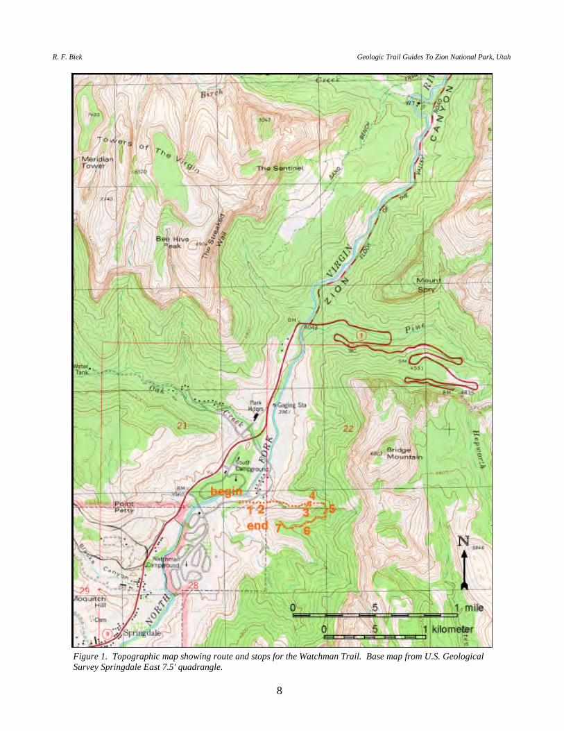
The Watchman Overlook provides commanding views of the entrance to Zion Canyon. The 1.0-mile-long (1.6 km) Watchman Trail begins on Virgin River terraces and climbs 370 feet (113 m) up through Petrified Forest and Moenave strata and onto the prominent ledge of the Springdale Sandstone Member of the Moenave Formation (figure 1). Most of the bedrock formations exposed in the main part of the park are visible from the overlook, as are a variety of younger Quaternary deposits related to the canyon's development. The overlook provides an excellent vantage point from which to discuss the influence of these units on the development of Zion Canyon. BEGIN AT THE WATCHMAN TRAIL PARKING AREA NEAR THE NEW VISITOR CENTER. STOP 1. VIRGIN RIVER TERRACES. The Watchman Trail begins on the
settlement terrace of the Virgin River. This is the level on which pioneer settlers established most of their homes and farms. Hereford and others (1996) studied terraces along the Virgin River and noted that the settlement terraces were formed less than 500 years ago.
As you hike up the stairs note the small ditch that parallels the hillside. This
ditch was built by early settlers to irrigate crops, and is still used today. Maintenance is a continual problem as intense summer cloudburst storms frequently produce flash floods in the side canyons that destroy the ditch. The settlers had only a few days to rebuild the ditch with hand tools before the heat and low humidity burned up their crops.
The gravels draped across the hillside above the ditch are from older terraces of
the Virgin River. Based on their height above the modern river, the terraces above you were deposited when the river was at that level about 50,000 years ago. Terrace remnants are key evidence used to study the downcutting history of an area.
STOP 2. PETRIFIED FOREST MEMBER OF THE CHINLE FORMATION.
Note the purplish mudstone exposed in the slope. This is a typical exposure of the Petrified Forest Member of the Chinle Formation. Petrified Forest strata contain a large percentage of swelling clays that expand in volume when moistened. This expansion, and subsequent contraction upon drying, causes a number of problems, including forming the basal slip surface of landslides and forming unstable foundation conditions for buildings and roads. Roads built on this member tend to develop dips and mounds that locals sometimes refer to as the "roller coaster." The Petrified Forest Member is easily eroded and thus forms slopes mantled with rock-fall debris from overlying formations. This debris then tends to form large landslides on the unstable slopes of the Petrified Forest Member.
R. F. Biek Geologic Trail Guides To Zion National Park, Utah
8
Figure 1. Topographic map showing route and stops for the Watchman Trail. Base map from U.S. Geological Survey Springdale East 7.5' quadrangle.

P.B. Anderson and D.A. Sprinkel, editors 2000 Utah Geological Association Publication 29
9
The small white nodules in the Petrified Forest Member are gypsum nodules.
They are "secondary," meaning that they were not deposited at the same time that the mudstone was deposited, but rather formed long after the formation turned to rock.
The contact between the Petrified Forest Member of the Chinle Formation and
the Dinosaur Canyon Member of the Moenave Formation is exposed about 30 feet (10 m) above the trail in a few places. Dinosaur Canyon strata lack purple, swelling mudstones that characterize Petrified Forest beds. Rather, they are characterized by thin, planar beds of uniformly colored reddish-brown siltstone, fine-grained sandstone, and silty sandstone. Dinosaur Canyon strata also weather readily, and form steep slopes armored with talus from overlying blocky sandstone units.
STOP 3. COLOR IN THE ROCKS. The trail winds between many fallen
blocks of sandstone derived from the Moenave, Kayenta, and Navajo Formations. Note the variety of colors, textures, and patterns in the blocks. Most of the blocks are sandstone in which the grains are composed of quartz. The colors are due to variations in the cement, the trace minerals that surround the sand grains and hold the rock together. The cement is primarily a mix of calcareous and siliceous minerals, each of which contains varying amounts of iron. Iron, even in tiny amounts, is a very strong coloring agent. It varies from black (think of your cast-iron skillet), to pale yellow or tan, to greenish-gray, to bright red (rust), depending on its oxidation state. Most of these rocks were deposited in conditions in which the sediment was strongly oxidized, forming iron oxide (similar to rust). Later, ground-water movement through the rock redistributed the iron unevenly, forming an endless variety of bands and splotches. Tiny amounts of gyspum or pyrite, or acidic ground water, locally reduced the iron, forming tan blotches. In places, the iron was removed from the rock, leaving white bands or splotches. Highly concentrated iron, like that found on rock surfaces or in veinlets in the rock, appears black. The first guess is that it is a black form of reduced iron (like your skillet); however, if you streak the iron material (rub it on a porcelain plate) or look where it has been scratched, you will see that it is actually a dark brownish red — it is hematite or highly oxidized iron. The iron is commonly accompanied by a small amount of manganese, which adds to the black color. A common misconception is that the greenish colors in some rocks are due to copper. Most such rocks actually have almost no copper (although copper minerals do occur in equivalent beds in a few places around the region). The green minerals you see in a few of the rocks are colored primarily by, you guessed it, iron.
STOP 4. WHITMORE POINT AND SPRINGDALE SANDSTONE
MEMBERS OF THE MOENAVE FORMATION. Overlying the uniformly reddish-brown Dinosaur Canyon Member, and just below the ledges of the Springdale Sandstone Member, is the Whitmore Point Member of the Moenave Formation. The Whitmore Point Member is mostly interbedded mudstone and
R. F. Biek Geologic Trail Guides To Zion National Park, Utah
10
siltstone, with minor limestone. The mudstone and siltstone are noted for their pale-purple, green, and black hues, in sharp contrast to enclosing, mostly reddish-brown units. The limestone and some of the siltstone and mudstone was deposited in a lake. This unit contains sparse fossil fish scales and tiny bone fragment — of the fish Semionotus kanabensis (these fossils are very sparse at this location B you probably won't see any here). The gar-like Semionotus was thought to have lived only during the Triassic, which conflicted with other fossil evidence that suggested that the Moenave and Kayenta Formations were Early Jurassic. The discovery of Seminotus in Early Jurassic strata in Morocco, however, was the final evidence that settled a long-standing debate — the age of the Moenave, Kayenta, and Navajo Formations. Prior to the discovery of the Moroccan fossils these formations were considered Late Triassic to Early Jurassic in age. They are now known to be Early Jurassic. Recently discovered dinosaur tracks in correlative beds near St. George also confirm an Early Jurassic age for the lower Moenave Formation in southwestern Utah (James Kirkland, Utah Geological Survey, verbal communication, March 30, 2000).
The resistant overhanging ledge is the Springdale Sandstone Member. It
consists of much more poorly sorted and coarser grained sandstone (some is even pebbly) than the enclosing units. The Springdale Sandstone was deposited by rivers and streams. Note the large lens-shaped channels, some of which are stacked one upon the other. Angular "rip-up" clasts of mudstone are common near the base of some of the channel deposits, which is typical of river deposits. Some of the overhanging ledges have a variety of sedimentary features, including load casts (irregular mounds and bumps on the undersides of beds caused by the sand loading the underlying softer mudstone), sole marks and drag marks caused by debris carried in the river, and root casts. The white rind on the rocks and fractures is calcite deposited as part of the soil-forming process as these rocks were exposed over the past several thousand years. The trail switchbacks over several resistant ledges separated by less resistant mudstone that together make up the Springdale Sandstone Member.
As you traverse the last resistant ledge of the Springdale Sandstone Member of
the Moenave Formation, you cross into the Kayenta Formation. The Kayenta Formation is composed of interbedded, thin-bedded sandstone and mudstone and forms a ledgy slope above the Springdale bench, which here is mostly covered by talus. You have to look across the canyon or to the north to see good Kayenta exposures, although small exposures are present along the trail for about the next 0.5 mile (0.8 km). In the middle of the Kayenta to the west is a thick sandstone ledge, the Lamb Point Tongue of the Navajo Sandstone. The Lamb Point Tongue is an eolian wedge of the Navajo Sandstone that pinches out not far west of here, before reaching the western part of Zion National Park. The Lamb Point Tongue thickens and merges with the Navajo Sandstone 30 miles (48 km) to the east (Doelling and Davis, 1989).
P.B. Anderson and D.A. Sprinkel, editors 2000 Utah Geological Association Publication 29
11
STOP 5. SMALL STREAM. This wash has a small stream that generally flows all year, yet the wash is usually dry where we crossed it near the start of the trail. The water flows underground through coarse alluvium in the bottom of the wash in that area, which is typical of streams in a desert environment.
A large cottonwood tree in the wash anchors a large boulder. Note that most of
the roots of the tree are exposed, some as much as 6 feet (2m) above the wash. This tree sprouted when the slope was at the level of the top of the roots. You can see the amount of erosion that has occurred since the tree began to grow. Geologists determine the age of such trees to calculate rates of erosion and slope retreat in an area.
STOP 6. KAYENTA FORMATION. Where the trail reaches the ridge crest, it
traverses well-exposed, near-horizontal sandstone beds in the Kayenta Formation. Sandstone beds like these locally contain dinosaur tracks, although none are known along this trail. Note the prominent joints in the sandstone beds. There are two sets oriented at about 90 degrees to each other. These joints trend parallel to the much larger joints that form the paths of many canyons of Zion National Park.
STOP 7. WATCHMAN OVERLOOK. The Watchman Overlook affords great
views to the south and north along the Virgin River. Some of the more interesting features that can be seen are described below. A short loop hike gives a better view of some of these features.
Stratigraphy — From this vantage point, you can see most of the formations
exposed in the main part of Zion National Park. From oldest (lowest) to youngest (highest) these are: (1) the Chinle Formation — the Shinarump Conglomerate Member forms the ledge near river level south of Springdale, and the overlying Petrified Forest Member forms variegated, purplish to grayish-white slopes mostly mantled with talus and landslides. (2) The Moenave Formation - the Dinosaur Canyon Member forms uniform, reddish-brown, steep slopes or ledges; the Whitmore Point Member forms the thin band of greenish-gray and reddish-brown beds just below the thick ledge; and the thick ledge (in some places two or three closely spaced ledges) is the Springdale Sandstone Member. The Springdale Sandstone Member thins and thickens as you follow it laterally along the cliff, and individual beds are lenticular and can't be traced more than a few hundred feet, which is typical of a fluvial sandstone. (3) The Kayenta Formation forms the steep slope that is mostly mantled with talus just below the massive cliffs, and the thin ledge near the middle of the Kayenta is the Lamb Point Tongue of the Navajo Sandstone, which is better exposed up-canyon. (4) The Navajo Sandstone forms the 2,000-foot-high (610 m) cliffs of Zion Canyon, which here are divisible into three informal subunits — the lower brown, the middle pink, and the upper white subunits. These color variations do not represent true stratigraphic members, but are due to alteration and redistribution of the cements in the Navajo Sandstone by ground water, and possibly hydrocarbons, migrating through the rock. (5) The Temple Cap
R. F. Biek Geologic Trail Guides To Zion National Park, Utah
12
Formation forms the prominent "cap" on top of the Navajo Sandstone — the thin, vegetated slope is the Sinawava Member and the slightly thicker sandstone ledge is the White Throne Member. (6) The Carmel Formation forms the white slopes near the top of the highest ridges far to the north; only the lower Co-op Creek Limestone Member is visible from here. Note that the strata are not perfectly flat lying, but have a slight regional tilt to the northeast of about 2 degrees.
Eagle Crags — The jagged peaks south of the park are the Eagle Crags, eroded
from the Navajo Sandstone. At the crags, the Navajo Sandstone does not weather to its typical habit of sheer cliffs and rounded domes because it is strongly jointed and fractured, which was caused by sliding as part of a slump whose basal slip surface is in the underlying Petrified Forest Member of the Chinle Formation.
Town of Springdale — Springdale is at the mouth of Zion Canyon, where the
canyon suddenly widens. The canyon widens here because of the Petrified Forest Member, which is the least resistant formation in Zion National Park. Once the river has cut down to the level of Petrified Forest strata, it can easily erode laterally and remove large parts of the formation, undercutting the overlying units and widening the valley. Most of Springdale is built on river-terrace deposits and on small alluvial fans that issue from side canyons. These fans are active, forcing residents to deal with frequent debris flows that come down from the many small side canyons.
Springdale landslide — The Watchman Overlook offers a superb view of the
Springdale landslide. The landslide occupies the entire area just west of the highway near the north end of town. Note the large head scarp and the irregular hummocky topography. If you look closely, you can see three destroyed houses on top of the slide. The landslide also destroyed two water tanks, disrupted utility lines, and closed Utah Highway 9. The Springdale landslide was triggered by the September 2, 1992 local magnitude (ML) 5.8 St. George earthquake. The landslide involved 18 million cubic yards (14 million m3) of material, consisting mostly of the Moenave Formation sliding on weak mudstone of the Petrified Forest Member of the Chinle Formation, and underwent about 33 feet (10 m) of primarily translational movement (Black and others, 1995; Jibson and Harp, 1995, 1996). The landslide is 27 miles (44 km) from the earthquake's epicenter, which is an unusually large distance for a landslide of this type and size to have been triggered by an earthquake of that magnitude (Jibson and Harp, 1996).
Old landslides — The Springdale landslide is just a recent example of the many
slides that have developed on the Petrified Forest Member. As you look south, you can see several landslides and slump blocks to the west, south, and east of Springdale (note the purplish Petrified Forest strata exposed between and beneath these slides in several areas). To a lesser extent, the Kayenta Formation is also prone to landslides, locally evident by hummocky areas above the resistant Springdale Sandstone ledge.

P.B. Anderson and D.A. Sprinkel, editors 2000 Utah Geological Association Publication 29
13
River terraces — Based on evidence obtained farther downstream near Virgin, we know that the Virgin River has cut down about 1,300 feet (396 m) in the past 1 million years. Watchman Overlook is nearly 500 feet (152 m) above the modern river, so a million years ago the floor of the canyon was about 700 to 800 feet (213-244 m) higher above your head, near the elevation of the contact of the Kayenta Formation and Navajo Sandstone. One million years ago, the canyon here must have been narrow, as it is today upstream near the Temple of Sinawava. No other definitive evidence is available for determining long-term erosion rates of Zion Canyon, but if we use the simplistic assumption of constant average erosion rates over time, in this area all of Zion Canyon was cut in the last 2 to 2.5 million years. As the river cut down, it left gravel behind. Remnants of these ancestral Virgin River deposits are preserved as terraces along both sides of the river.
Pediment terraces — Notice the broad, gently sloping benches above the
Springdale Sandstone. These benches ares sometimes called pediments, which are gentle slopes cut into bedrock that are inclined toward the river. These pediments were probably graded to the ancestral Virgin River when it was cutting at this level, and represents a time when the river was more stable, perhaps because the Springdale Sandstone is more resistant to erosion than enclosing units, and the valley slopes retreated due to erosion of the relatively soft Kayenta Formation.
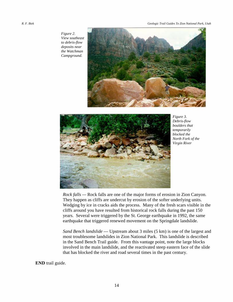
Modern debris flows — Debris flows and flash floods are two of the most
common and potentially deadly geologic phenomena in Zion National Park and throughout most parts of the Colorado Plateau. The small wash immediately south of the Watchman Overlook provides an excellent example, as you can see an entire debris-flow event recorded from the head of the flow to the foot. On July 21, 1998, 1.2 inches (3 cm) of rain fell during an intense afternoon thunderstorm. A few minutes later a debris flow surged down this wash. The area drained by the wash is surprisingly small compared to the size and energy of the debris flow. You can see most of the water accumulation area — about 45 acres (18 hectares) high up in the cliffs of Navajo Sandstone in addition to the drainage area below the cliffs. The runoff was so intense because most of the rain fell on bare sandstone. The sandstone is slightly porous but can't absorb water at a high rate, thus most rain simply runs off. The debris flow started near the head of the two small washes where you can see small scars where talus slumped into the wash. The flow picked up debris in the steep upper part of the washes, then began to spread out and drop the largest boulders as the wash gradient and thus the energy of the flow decreased (figure 2). Also note the bouldery levees formed along the edge of the debris-flow deposits. The debris flow continued to drop sediment as the gradient decreased toward the Virgin River. The flow blocked the Virgin River with boulders up to about 4 feet (1.2 m) in diameter, forming a small dam (figure 3). As the river rose behind the dam, it flooded part of the nearby campground, forcing the evacuation of several campers. Debris flows happen every year in Zion National Park, although most don't directly impact people.
R. F. Biek Geologic Trail Guides To Zion National Park, Utah
14
Rock falls — Rock falls are one of the major forms of erosion in Zion Canyon. They happen as cliffs are undercut by erosion of the softer underlying units. Wedging by ice in cracks aids the process. Many of the fresh scars visible in the cliffs around you have resulted from historical rock falls during the past 150 years. Several were triggered by the St. George earthquake in 1992, the same earthquake that triggered renewed movement on the Springdale landslide.
Sand Bench landslide — Upstream about 3 miles (5 km) is one of the largest and
most troublesome landslides in Zion National Park. This landslide is described in the Sand Bench Trail guide. From this vantage point, note the large blocks involved in the main landslide, and the reactivated steep eastern face of the slide that has blocked the river and road several times in the past century.
END trail guide.
Figure 2. View southeast to debris-flow deposits near the Watchman Campground.
Figure 3. Debris-flow boulders that temporarily blocked the North Fork of the Virgin River
P.B. Anderson and D.A. Sprinkel, editors 2000 Utah Geological Association Publication 29
15
SAND BENCH TRAIL
INTRODUCTION The Sand Bench Trail begins at the base of the Court of the Patriarchs and climbs about 500 feet (152 m) to the top of the Sand Bench landslide at the base of The Sentinel (figure 1). The enormous Sand Bench landslide blocked Zion Canyon and the North Fork of the Virgin River about 7,000 years ago. The trail offers exceptional views of lake sediments deposited in Sentinel Lake, which formed upstream from the landslide. The trail also provides excellent views of the landslide itself, and the lower portion of Zion Canyon. BEGIN AT THE COURT OF THE PATRIARCHS PARKING AREA. WALK WEST TO THE FOOTBRIDGE OVER THE VIRGIN RIVER. STOP 1. SAND BENCH LANDSLIDE AND SENTINEL LAKE. The Sand
Bench landslide is not a landslide in the traditional sense; rather, it is a huge collapsed wall or fin of Navajo Sandstone that plugged Zion Canyon about 7,000 years ago. The Sand Bench landslide formed between two closely spaced vertical joints in the Navajo Sandstone on the east side of The Sentinel. The narrow wall of Navajo Sandstone eventually collapsed as the Virgin River and a tributary stream cut down into the Kayenta Formation, undermining the Navajo and making the narrow wall unstable. The landslide formed a dam just east of The Sentinel that was about 800 feet (244 m) high at its downstream end. The dam impounded the North Fork of the Virgin River, creating Sentinel Lake (Grater, 1945; Hamilton, 1995). Sentinel Lake was at least 200 feet (61 m) deep and about 4 miles (6.4 km) long, stretching from the Court of the Patriarchs on the south upstream nearly to the Temple of Sinawava.
The gray clays exposed in the river bank in a few places are the remnants of
Sentinel Lake deposits. We have been able to date plant fragments preserved in the lake sediments using radiocarbon (14C) dating to determine the age of the lake, and thus, the timing of the collapse. In 1998, the Utah Geological Survey drilled a hole about 100 feet (30 m) northeast of the Sand Bench Trail bridge to learn more about the landslide event. It penetrated 11 feet (3.3 m) of alluvium over 30 feet (10 m) of lake deposits, which in turn overlie 28 feet (8.5 m) of Navajo and Kayenta landslide rubble. We finally had to stop the hole at 69 feet (21 m) without reaching bedrock under the canyon floor. Radiocarbon ages on plant material from near the base of the deposits at the Court of the Patriarchs show that the lake was present by at least 6,200 to 8,000 years ago (UGS unpublished data).
Note the change in gradient of the North Fork of the Virgin River upstream and
downstream of the cement dam. The point of change is called a nickpoint. This dam was installed to stabilize the river and prevent the nickpoint from migrating upstream where it would undercut park roads and facilities. Compare the coarse angular material exposed in the river bank below the dam with the fine-grained materials carried by the river upstream of the dam. Downstream from the dam,
R. F. Biek Geologic Trail Guides To Zion National Park, Utah
16
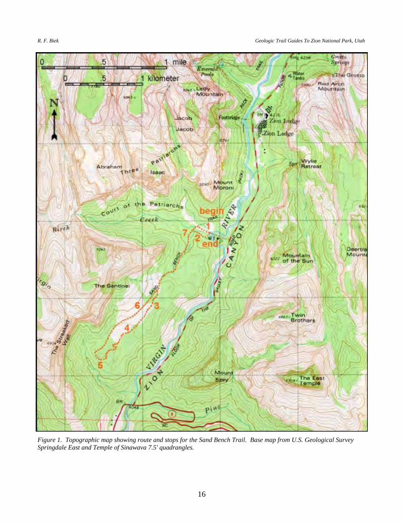
Figure 1. Topographic map showing route and stops for the Sand Bench Trail. Base map from U.S. Geological Survey Springdale East and Temple of Sinawava 7.5' quadrangles.
P.B. Anderson and D.A. Sprinkel, editors 2000 Utah Geological Association Publication 29
17
the Virgin River is cutting into the toe of the Sand Bench landslide, working to re-establish its pre-landslide gradient. When the Sand Bench slide occurred, the Virgin River was at least 70 feet (21 m) lower in elevation than it is today. The erosion has created an oversteepened, unstable slope that has intermittently produced smaller landslides. In historical times, smaller slides have dammed the Virgin River in 1923, 1941, and most recently in 1995 (Grater, 1945; Solomon, 1995).
AFTER THE BRIDGE, the trail splits; the route it takes is slightly different
than that shown on most maps. TAKE THE LEFT (SOUTH) BRANCH that follows a pipeline. The pipeline is the main source of culinary water for lower Zion National Park. Note the chaotic, angular slide debris south of the wash. Some blocks are several tens of feet across. The red color of this slide debris indicates that it is derived from the Kayenta Formation. In contrast, the light-colored sand you are walking on is well-washed sand from the Navajo Sandstone that represents deltaic deposits of Birch Creek where it entered Sentinel Lake.
THE TRAIL CROSSES BIRCH CREEK. Gravel pebbles and cobbles in this
tributary of the Virgin River are more angular and much less sorted than the Virgin River gravels seen by the bridge. WALK SOUTH parallel to Birch Creek for about 300 feet (91 m) until you round a bend in the wash. (Note: all distances are estimates and were not measured).
STOP 2. DEPOSITS OF SENTINEL LAKE. About 10 feet (3 m) of thin-
bedded, well-stratified, gray and yellowish-gray clay is exposed in the bank on the north side of Birch Creek. It is sharply overlain by a couple of feet of gravel with clasts up to 8 inches (20 cm) in diameter, which is in turn overlain by about 10 feet (3 m) of uncemented, compacted sand with scattered gravel clasts. The clay represents the deep-lake sediments deposited during the highstand of Sentinel Lake. The gravel is derived from the side canyon and may be a debris-flow deposit washed into the lake. The overlying sand is waterlain and is part of deltaic sediments deposited at the lake margin. Hamilton (1995) reported a radiocarbon age of 3,600 + 400 yr B.P. for the upper part of the lake deposits.
CONTINUE WEST on the trail to where it joins a horse trail. Follow the horse
trail up a steep grade onto Sand Bench. Near the top of Sand Bench, stay left where the trail forks at the start of a loop. A FEW HUNDRED FEET AFTER REACHING THE RIDGE CREST, AND BEFORE REACHING THE HIGHEST POINT ON THE TRAIL, WALK LEFT (EAST) A SHORT DISTANCE TO THE RIM. There are many precarious boulders along the rim — don't get too close!
STOP 3. SAND BENCH LANDSLIDE. The Sand Bench landslide consists of
two parts: (1) the older stabilized collapse mass, and (2) the reactivated face of the landslide.
Prehistorical Landslide: The old landslide is not a true landslide, though it is
R. F. Biek Geologic Trail Guides To Zion National Park, Utah
18
commonly referred to as such in the geologic literature. It is actually a huge collapsed wall or fin of Navajo Sandstone as described at stop 1. If you look northward across Birch Creek, you can see the northern continuation of the two joints that bounded the narrow fin of Navajo Sandstone. As canyon cutting progressed, the Virgin River cut down along the east joint and a small tributary cut down along the west joint, leaving a narrow wall between them. Eventually, as the canyons cut into the relatively weak Kayenta Formation, the wall became unstable and collapsed catastrophically. It must have been an incredible sight to behold! The collapse may have been triggered by an earthquake, by an unusual wet period, or just because the river finally removed too much of the wall's basal support. The river near the bridge was at least 70 feet (21 m) lower in elevation at the time of the collapse than it is today. The collapsed rock formed a huge plug or dam in Zion Canyon, creating the lake we discussed earlier. Note that the ridge crest where we are standing is higher than the flat to the west. The flat is closer to the position of the joint on the west side of the collapse. We are not sure how big the canyon was on that joint. It may have been a thin slot canyon similar to Hidden Canyon near the Grotto, or Refrigerator Canyon below Angels Landing. Note the remnants of the old landslide on the east side of Zion Canyon almost at our own height. We are not sure of the original height of the collapse dam, but it must have been at least 350 feet (107 m) higher than the river in front of us today, as deep-water lake deposits upstream of the dam are found up to an elevation of 4,400 feet (1,341 m).
Historical Landslide: At this location, you are standing near the top of the
young, reactivated portion of the Sand Bench landslide. Soon after collapse of the wall, the Virgin River filled the lake basin and overtopped the dam. It then began cutting down through the dam, trying to re-establish its pre-landslide gradient. The large blocks and the broad width of the dam slowed the downcutting process. Even today, 7,000 years later, the river still has yet to re-establish its former gradient.
Not surprisingly, as the river cut through the dam, it created an unstable,
oversteepened face. This face is the site of repeated landslides and slumps. The face becomes more active after a wet cycle and temporarily stabilizes after a dry cycle, but it is always a rock-fall hazard. Historical landsliding is enhanced because the collapsed mass is broken up. Thus, it has less internal strength than undisturbed bedrock, and ground water is able to more effectively work through the mass. In addition, the basal part is composed mostly of Kayenta Formation, which has many thin clayey beds that have little strength even when dry. When wet, the clay is especially susceptible to slippage.
Many other features of lower Zion Canyon are visible from this location. The
Lamb Point Tongue of the Navajo Sandstone, for example, is well exposed in a few places on the opposite slope. It is the thick ledge of eolian sandstone near the middle of the Kayenta Formation. Several hanging valleys adorn the rim of Zion Canyon. Hanging valleys are generally thought of as being associated with glaciers, as are the spectacular hanging valleys of Yosemite National Park.
P.B. Anderson and D.A. Sprinkel, editors 2000 Utah Geological Association Publication 29
19
Here, however, hanging valleys form because small tributary streams are unable to keep up with the rate of downcutting of the Virgin River, the trunk stream of the Virgin River basin. As base level is lowered, small ephemeral side drainages are left behind as hanging valleys. Waterfalls develop for a few hours after intense storms in these many small side drainages.
CONTINUE SOUTH ON TRAIL. Near the top of a steep grade that drops off
to the southwest is a good view to the west. STOP 4. NAVAJO SANDSTONE. Note the cone-shaped sand deposit at the
base of The Sentinel. This is a combination of talus sand and alluvial-fan sand. The sand is washed off of the high, bare Navajo and falls onto the steep slope. Infrequent running water then remobilizes the sand and deposits it in a cone-shaped alluvial fan.
The boundary between the brown and pink subunits of the Navajo Sandstone is
well exposed in the basal part of the cliff to the west. It is unusually sharp here — in many areas it is gradational. Note that the boundary zigzags such that the subunits interfinger. This clearly shows that the boundary is due to the secondary effects of ground-water and possibly hydrocarbon movement through the rock, and is not a depositional boundary.
CONTINUE SOUTH along edge of bench. Just before the trail pulls away
from the edge is a good view point southward down lower Zion Canyon. STOP 5. ZION CANYON EROSIONAL HISTORY. Near the town of
Springdale, broad sloping benches or pediments are perched several hundred feet above the valley floor. These surfaces are blanketed by colluvium and debris-flow deposits derived from the canyon slopes. The surfaces are graded to an ancestral Virgin River that was about 1,000 feet (305 m) above the present river. Based on downcutting rates determined downstream at Virgin (see the Zion Canyon Visitor Center to LaVerkin road guide), the highest of these broad surfaces is estimated to be about 750,000 years old.
Notice how wide the valley is south of the park. This is because the river is
cutting at the level of the Petrified Forest Member of the Chinle Formation. The Petrified Forest Member is a very weak unit prone to landslides. As the Virgin River meanders across the valley floor, it cuts into the Petrified Forest Member, causing it and the overlying material to slide toward the river. In this way the valley is widened. Many large landslides are visible on the Petrified Forest Member around Springdale.
CONTINUE WEST ON THE TRAIL. Just past the horse corral and hitching
rails, the trail swings north and climbs onto the sand talus cone described in stop 4. The trail drops down the north side of the sand fan. STOP where you have a good view to the north.
R. F. Biek Geologic Trail Guides To Zion National Park, Utah
20
STOP 6. JOINTS IN THE NAVAJO SANDSTONE. From this vantage point, you can look north and see the two joints that formed the two sides of the Navajo Sandstone wall that collapsed to form the Sand Bench landslide dam. Perhaps the sandstone wall of Mt. Moroni, north of Birch Creek, will collapse someday in the same way as Zion Canyon continues to deepen.
The trail leaves the sand fan and continues dropping through giant blocks of
collapsed rock debris. CONTINUE NORTH TO WHERE THE LOOP TRAIL BEGINS, and retrace your steps down the Sand Bench landslide. At the trail intersection at the base of the landslide, follow the horse trail around to the left to view additional lake deposits before returning to the Sand Bench parking area. Cross Birch Creek stream. WALK about 50 feet (15 m) up the stream bed west of the trail.
STOP 7. DEPOSITS OF SENTINEL LAKE. Lake deposits are exposed in the
south bank of the stream. In this area, the lake sediment was deposited on a sloping surface. After deposition, the lake deposits slumped down the slope so that now they are convoluted and contain several small faults. The lake sediments contain several thin bands of dark red silty sediment. This sediment was locally derived from the Kayenta Formation and is indicative of the nearby exposures of Kayenta material in the collapse block.
RETURN TO TRAIL AND CONTINUE NORTH. The trail climbs onto a
small sandy ridge. This sandy ridge rises to a bench about 50 feet (15 m) above the trail to the left (west). This bench represents the highest known level of the lake, at 4,400 feet (1,341 m), and a level at which the lake temporarily stabilized. Sentinel Lake may have risen somewhat higher than this, but no sediments or shoreline features remain.
AGAIN THE TRAIL BRANCHES. The smaller branch to the right returns to
the bridge and the parking area, staying on lake and post-lake deposits. The main trail follows the river north to the Emerald Pools Trail. We suggest that you CONTINUE NORTH ALONG THE MAIN TRAIL through the small cut in the sandy ridge, and drop down to the wash bottom a few tens of feet beyond the cut. WALK UP THE WASH about 50 feet (15 m).
Along the way, note the huge Fremont cottonwood tree. This tree is estimated to
be over 100 years old. It started growing on a surface just above stream level. Continued erosion of the stream has cut a nick point about 8 feet (2.4 m) deep, exposing the roots and threatening to topple the tree. Note that lake deposits are exposed below the nick point, showing that the stream still has not returned to its former level in this area.
STOP 8. DEPOSITS OF SENTINEL LAKE. About 40 feet (12 m) of lake
deposits is exposed in the bank of the wash. These deposits are interbedded lake deposits and sand and gravel derived from the adjacent slope and washed into the lake. They represent a near-shore facies of the lake deposits with still-water

P.B. Anderson and D.A. Sprinkel, editors 2000 Utah Geological Association Publication 29
21
sediment interbedded with sediments washed in along the shoreline. OPTION. From this point you can continue north on the trail to the Emerald
Pools parking area, or you can return to the small branch trail we just passed and then follow it back to the bridge and Sand Bench Trail parking area. If you continue northward to Emerald Pools, the trail climbs onto a bench covered with colluvium over the lake deposits. The ledge-forming, cross-bedded sandstone of the Lamb Point Tongue of the Navajo Sandstone is exposed just above the trail. The trail parallels this ledge from here to the Emerald Pools parking area. The trail is mostly in colluvium and sandy near-shore lake deposits. Deeper water deposits of clay and silt are exposed in a few side gullies.
END trail guide.
R. F. Biek Geologic Trail Guides To Zion National Park, Utah
22
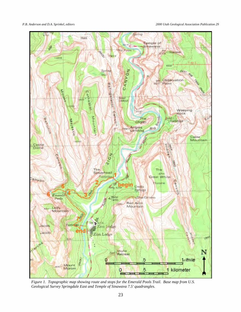
EMERALD POOLS TRAIL
INTRODUCTION Emerald Pools can be reached from either the Grotto or Emerald Pools/Zion Lodge parking areas. THEguideOUTLINED BELOW IS A LOOP THAT BEGINS AND ENDS AT THE GROTTO PARKING AREA (figure 1). The hike to lower Emerald Pool is relatively easy and the loop described here is nearly 3 miles (5 km) long. A steep, 0.5-mile-long (0.8 km) spur leads to the larger upper Emerald Pool nestled at the base of the Navajo Sandstone. The Emerald Pools Trail traverses the Kayenta Formation, which is largely concealed by talus, but provides some of the best, close-up views of the Lamb Point Tongue of the Navajo Sandstone in Zion National Park. Lacustrine deposits of Sentinel Lake are also visible along the trail. BEGIN AT THE GROTTO PARKING AREA. WALK WEST TO THE FOOTBRIDGE OVER THE VIRGIN RIVER. STOP 1. FOOTBRIDGE OVER THE VIRGIN RIVER. The flat canyon floor
here formed as the end result of a process started when the Sand Bench landslide plugged Zion Canyon about 2 miles (3.2 km) downstream at The Sentinel about 7,000 years ago. The dam created Sentinel Lake, which stretched from the Court of the Patriarchs on the south upstream nearly to the Temple of Sinawava, and filled the canyon bottom with lake deposits. The lake was at least 200 feet (61 m) deep in its early stages, and unlike other Quaternary lakes in Zion National Park, was probably full of water year round. Radiocarbon ages on plant material from near the base of the deposits at the Court of the Patriarchs show that the lake was present by at least 6,200 to 8,000 years ago (UGS unpublished data), and Hamilton (1979, 1995) reported a radiocarbon age of 3,600 + 400 yr B.P. for the upper part of the lake deposits. Deposits of Sentinel Lake may reflect one or more episodes of lake formation. The thin, horizontal lake sediments can be seen from the upper part of the Emerald Pools Trail (see stop 7) near the river footbridge.
Along the center of the canyon, the lake sediments are concealed beneath
channel and flood-plain deposits of the North Fork of the Virgin River. The reason the canyon floor here is flat is because the river is out of gradient, and has a tendency to meander laterally from canyon wall to canyon wall. As it does so, the river erodes the unconsolidated lake deposits, leaving behind a relatively level surface covered by river deposits. The North Fork of the Virgin River has eroded through 200 feet (61 m) of lake sediments, but together, river and remaining lake deposits are still probably close to 100 feet (30 m) thick beneath the Grotto parking area; the Virgin River has yet to re-establish its pre-Sand Bench profile. Note the use of riprap to control the natural tendency of the river to meander.
P.B. Anderson and D.A. Sprinkel, editors 2000 Utah Geological Association Publication 29
23
Figure 1. Topographic map showing route and stops for the Emerald Pools Trail. Base map from U.S. Geological Survey Springdale East and Temple of Sinawava 7.5' quadrangles.
R. F. Biek Geologic Trail Guides To Zion National Park, Utah
24
The Lamb Point Tongue of the Navajo Sandstone forms the upper part of a prominent, 55-foot-high (17 m) ledge along the west side of the river. The upper two-thirds of the ledge consists of pale orange, very thick-bedded, cross-bedded sandstone of the Lamb Point Tongue. The lower one-third of the ledge exposes the upper part of the main body of the Kayenta Formation, which consists of reddish-brown sandstone with thin interbeds of light-green to light-gray sandstone and siltstone. The Lamb Point Tongue is a thin eolian wedge of sandstone that thickens eastward where it merges with the Navajo Sandstone (Doelling and Davis, 1989).
STOP 2. TOP OF THE LAMB POINT TONGUE OF THE NAVAJO
SANDSTONE. Where the Lamb Point Tongue of the Navajo Sandstone is present, the Kayenta Formation is divided into the main body (below) and the Tenney Canyon Tongue (above). The base of the Tenney Canyon Tongue here is marked by a thin-bedded, white, sandy dolomite with small mudstone rip-up clasts. This dolomite probably represents deposition in a shallow lake that developed on the Kayenta flood plain. The dolomite is underlain by a mottled red and white silty sandstone.
Blocks of Kayenta and Navajo strata show a variety of weathering phenomena
common in porous sandstone. These include: white reduction spots and streaks, places where iron-oxide cement has been reduced to a pale yellow form of iron; resistant knobs and "warts," places where iron oxide and calcareous cement have been concentrated, hardening the rock; and Liesegang bands, solution fronts that form bands and swirls. All are related to the migration of water through the porous rock.
For about the next 0.5 mile (0.8 km), the trail crosses coarse talus derived from
the Navajo and Kayenta Formations. Many of these talus blocks have a thin, white, pedogenic carbonate rind, a result of soil-forming processes in a desert environment.
The view east across Zion Canyon shows good examples of sand talus and rock
talus derived from the cliffs of Navajo Sandstone. A large, historical rock fall, described under stop 7, is visible on the east side of the canyon just south of Zion Lodge. The rock-fall debris is concealed by a big, grass-covered sand pile.
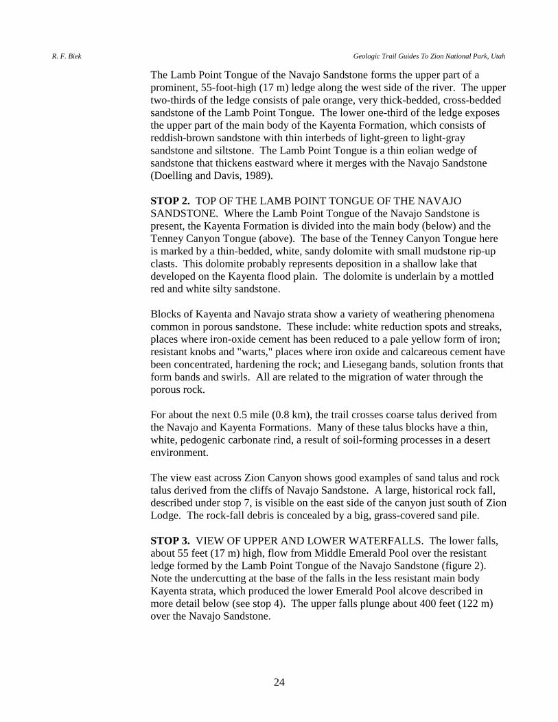
STOP 3. VIEW OF UPPER AND LOWER WATERFALLS. The lower falls,
about 55 feet (17 m) high, flow from Middle Emerald Pool over the resistant ledge formed by the Lamb Point Tongue of the Navajo Sandstone (figure 2). Note the undercutting at the base of the falls in the less resistant main body Kayenta strata, which produced the lower Emerald Pool alcove described in more detail below (see stop 4). The upper falls plunge about 400 feet (122 m) over the Navajo Sandstone.

P.B. Anderson and D.A. Sprinkel, editors 2000 Utah Geological Association Publication 29
25
FROM HERE, HIKERS HAVE A CHOICE of visiting lower Emerald Pool and continuing to the Zion Lodge/lower Emerald Pool parking area via the lower trail, or visiting upper Emerald Pool and continuing to the same parking area via the upper trail. Alternately, one can visit the lower pool and backtrack a short distance to regain the trail to the upper pool, as described in the route below.
STOP 4. LOWER EMERALD POOL. From the upper Pool/lower Pool trail
junction, the trail descends through huge rock-fall boulders of Navajo Sandstone, fallen from the cliffs above. On a nearly flat bench below the boulders is another trail junction: going left will take you back to the Grotto parking area. This bench is underlain by fine-grained Sentinel Lake deposits. Continuing to the right, the trail passes through a shallow alcove formed by an overhanging cliff that rises above lower Emerald Pool. The upper two-thirds of the cliff consists of pale-orange, very thick-bedded, cross-bedded sandstone of the Lamb Point Tongue. The lower one-third of the cliff exposes the upper part of the main body of the Kayenta Formation, which consists of reddish-brown sandstone with thin interbeds of light-green to light-gray sandstone and siltstone. Note a good example of convolute bedding within the Kayenta Formation next to the trail at the northern end of the alcove. The alcove formed as the result of a higher rate of stream erosion in the relatively soft Kayenta Formation as compared to the more resistant Lamb Point Tongue sandstone.
Figure 2. Upper and lower waterfalls, August 30, 1999. The lower falls plunge about 55 feet (17 m) over the ledge-forming Lamb Point Tongue of the Navajo Sandstone. The upper falls pour from a hanging valley in the Navajo Sandstone.
R. F. Biek Geologic Trail Guides To Zion National Park, Utah
26
For those wishing to remain on the lower trail, the trail continues southeastward
through forested slopes of colluvium that overlie the Kayenta Formation, not far below the Lamb Point Tongue. Just before turning south above the Virgin River, the trail crosses the heads of several shallow debris slides. These small landslides show that the unconsolidated colluvium is only marginally stable on this very steep slope.
Just before reaching the footbridge that crosses the Virgin River to the Emerald
Pools trailhead, gray, thin-bedded silt and clay Sentinel Lake deposits can be seen in scattered exposures about 30 feet (9 m) above the trail. Perhaps the best exposure can be seen when standing at the culvert that crosses beneath the trail just north of the footbridge; the lake sediments are exposed in the slope about 100 feet (30 m) west of the trail. These sediments are described in more detail under stop 1.
RETRACE YOUR ROUTE TO THE UPPER TRAIL AND CONTINUE
WEST TO MIDDLE EMERALD POOL. STOP 5. TOP OF LOWER FALLS. Here, the Heaps Canyon stream flows
over bare sandstone of the Lamb Point Tongue. This is a good example of streams preferentially following weaker zones along joints. Several small rivulets make a zigzag pattern as they follow joints. The water collects in the small, shallow, Middle Emerald Pool before it plunges to the lower pool.
Looking down below the falls, you can see a large deposit of colluvial and
alluvial material capped by fine sand, which is unusual in a setting like this. It is probably a delta wedge deposited in the landslide-dammed lake.
The 0.5-mile-long (0.8 km) trail to upper Emerald Pool climbs a steep talus slope
littered with large blocks of Navajo and Kayenta strata. The upper part of the Kayenta Formation is nearly everywhere concealed by this rock-fall debris.
STOP 6. UPPER EMERALD POOL. Upper Emerald Pool is located just
below the contact of the Kayenta Formation and overlying Navajo Sandstone. Looking up, one can see that the Heaps Canyon stream follows a joint set in the Navajo Sandstone. These four or five closely spaced joints trend northwest, parallel to most major joints in this part of the park. The joints may comprise a deformation band shear zone, although evidence of shearing is not obvious.
The upper falls plunge from a hanging valley. Hanging valleys are generally
thought of as being associated with glaciers, as are the spectacular hanging valleys of Yosemite National Park. Here, however, hanging valleys form because small tributary streams are unable to keep up with the rate of downcutting of the Virgin River, the trunk stream of the Virgin River basin. As base level is lowered, small ephemeral side drainages are left behind as hanging valleys.

P.B. Anderson and D.A. Sprinkel, editors 2000 Utah Geological Association Publication 29
27
Numerous seeps adorn the lower Navajo Sandstone, about 100 feet (30 m) above
the upper pool. The seeps form because thin, relatively impermeable, silty layers in the Navajo Sandstone inhibit the downward movement of ground water, forcing it to flow laterally until it eventually emerges as springs and seeps.
RETRACE YOUR ROUTE TO THE MIDDLE POOL AND CONTINUE
TO THE SOUTHEAST ON THE UPPER TRAIL. STOP 7. SEPTEMBER 17, 1994 ROCK FALL, AND SENTINEL LAKE
DEPOSITS. An interpretive sign describes the large rock fall visible on the east side of Zion Canyon just south of Zion Lodge. This rock fall occurred on September 17, 1994. The sign has dramatic photos of the fall in progress.
Just below the sign, one can look down to a small ravine below the trail, which
reveals at least 30 feet (10 m) of gray, horizontal, thin-bedded silt and clay. See Stop 1 for a discussion of Sentinel Lake.
CONTINUE ALONG THE TRAIL TO ZION LODGE, WHERE A TRAIL
LEADS BACK TO THE GROTTO PARKING AREA. END trail guide.

R. F. Biek Geologic Trail Guides To Zion National Park, Utah
28
WEEPING ROCK TRAIL
INTRODUCTION A short, 1/4-mile-long (400 m) paved trail leads to Weeping Rock, one of the park's most popular hanging gardens (figure 1). The trail ascends a talus slope, which conceals the underlying Kayenta Formation, to a picturesque alcove at the base of the Navajo Sandstone. A broad zone of springs at Weeping Rock supports lush hanging gardens and provides a cool respite during hot summer days.
Figure 1. Topographic map showing route and stop for the Weeping Rock Trail. Base map from U.S. Geological Survey Temple of Sinawava 7.5' quadrangle.
P.B. Anderson and D.A. Sprinkel, editors 2000 Utah Geological Association Publication 29
29
BEGIN AT THE WEEPING ROCK PARKING AREA. WALK A SHORT DISTANCE UPHILL TO WEEPING ROCK. STOP 1. WEEPING ROCK.
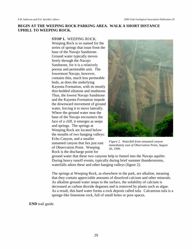
Weeping Rock is so named for the series of springs that issue from the base of the Navajo Sandstone. Ground water typically moves freely through the Navajo Sandstone, for it is a relatively porous and permeable unit. The lowermost Navajo, however, contains thin, much less permeable beds, as does the underlying Kayenta Formation, with its mostly thin-bedded siltstone and mudstone. Thus, the lowest Navajo Sandstone and the Kayenta Formation impede the downward movement of ground water, forcing it to move laterally. Where the ground water near the base of the Navajo encounters the face of a cliff, it emerges as seeps and springs. The springs at Weeping Rock are located below the mouths of two hanging valleys: Echo Canyon, and a smaller unnamed canyon that lies just east of Observation Point. Weeping Rock is the discharge point for ground water that these two canyons help to funnel into the Navajo aquifer. During heavy runoff events, typically during brief summer thunderstorms, waterfalls adorn these and other hanging valleys (figure 2).
The springs at Weeping Rock, as elsewhere in the park, are alkaline, meaning
that they contain appreciable amounts of dissolved calcium and other minerals. As alkaline ground water seeps to the surface, the solubility of calcium is decreased as carbon dioxide degasses and is removed by plants such as algae. As a result, this hard water forms a rock deposit called tufa. Calcareous tufa is a sponge-like limestone rock, full of small holes or pore spaces.
END trail guide.
Figure 2. Waterfall from unnamed canyon immediately east of Observation Point, August 30, 1999.

R. F. Biek Geologic Trail Guides To Zion National Park, Utah
30
RIVERSIDE WALK TRAIL The Riverside Walk Trail is an easy, 1.0-mile (1.6 km) hike along a paved trail that parallels the North Fork of the Virgin River (figure 1). The trail ends where the canyon becomes so narrow that, in order to continue, hikers must take to the water. The trail offers good views of the lower Navajo Sandstone and spring tufa deposits, and is a good place to discuss the influence of the Kayenta Formation on the development of Zion Canyon. BEGIN AT THE NARROWS PARKING AREA AT THE END OF ZION CANYON SCENIC DRIVE. STOP 1. THE FLOOR OF ZION CANYON AT THE TEMPLE OF
SINAWAVA. The floor of Zion Canyon is relatively wide and flat near the Temple of Sinawava, unlike the V-shaped profile of most river canyons. The canyon is wide here due to an erosional process known as "canyon widening." At Zion National Park, canyon widening is an important process below the Navajo Sandstone. The Navajo Sandstone tends to form vertical cliffs. However, the relatively soft and thin-bedded siltstone, sandstone, and mudstone of the Kayenta Formation is more easily eroded than the overlying Navajo Sandstone. Once the river cuts into the Kayenta Formation, it is able to cut laterally into the soft rock. As the Kayenta is eroded away or slips away in landslides, the great cliffs of Navajo Sandstone are undermined and, despite their inherent strength, they eventually break away. Rock falls and landslides are thus an important part of the canyon widening process. Undermining and collapse are facilitated by joints and a line of seeps near the contact of permeable Navajo and impermeable Kayenta strata.
The flat canyon floor here is a direct result of a process that started when a huge,
narrow fin of Navajo Sandstone collapsed and plugged Zion Canyon just east of The Sentinel about 7,000 years ago. This collapse formed Sand Bench and blocked the North Fork of the Virgin River, creating Sentinel Lake, which stretched upstream nearly to the Temple of Sinawava (Grater, 1945; Hamilton, 1995). The calm waters of the lake allowed suspended sediments to settle out, and they accumulated behind the dam to a thickness of at least 200 feet (61 m). At the time of the slide, Zion Canyon was at least 70 feet (21 m) deeper than it is today just south of Zion Lodge, and somewhat less so at the Temple of Sinawava. The wide, flat floor of Zion Canyon between the Temple of Sinawava and Court of the Patriarchs is a direct result of these lake and alluvial deposits partly filling the earlier V-shaped canyon, followed by the meandering river cutting back and forth across these lake deposits. The lake deposits — thin beds of silt and clay — are best observed in the vicinity of the Court of the Patriarchs. The river is still eroding through the landslide and lake deposits, working to re-establish its steeper, pre-landslide gradient.
P.B. Anderson and D.A. Sprinkel, editors 2000 Utah Geological Association Publication 29
31
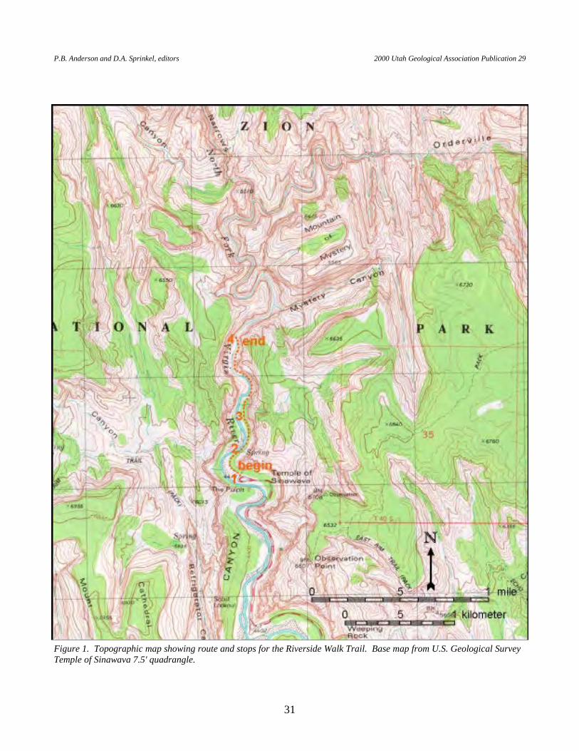
Figure 1. Topographic map showing route and stops for the Riverside Walk Trail. Base map from U.S. Geological Survey Temple of Sinawava 7.5' quadrangle.

R. F. Biek Geologic Trail Guides To Zion National Park, Utah
32
STOP 2. SEEPS AND SPRINGS NEAR THE KAYENTA/NAVAJO CONTACT. The Navajo Sandstone is a relatively porous and permeable unit, and indeed is an important aquifer throughout southwestern Utah. The underlying Kayenta Formation, however, with its mostly thin-bedded siltstone and mudstone, is a relatively impermeable unit. Water from rain and snowmelt high above the rim of Zion Canyon infiltrates the Navajo Sandstone and slowly moves down through the formation. The Kayenta Formation impedes the downward movement of ground water, forcing it to move laterally. Where the ground water encounters the face of a cliff, it emerges as seeps and springs near the base of the Navajo Sandstone. There are also impermeable layers within the lower Navajo Sandstone, giving rise to springs higher up on the canyon walls. Springs and seeps in Zion National Park are typically alkaline, meaning that they contain appreciable amounts of dissolved calcium and other minerals. As alkaline ground water seeps to the surface, the solubility of calcium is decreased as carbon dioxide degasses and is removed by plants such as algae. As a result, this hard water forms a rock deposit called tufa (figure 2). Calcareous tufa — a sponge-like limestone rock full of small holes or pore spaces — is visible at numerous places along the Riverside Walk Trail.
In some places, the tufa has cemented old river gravels preserved along the
canyon walls several tens of feet above the modern channel. These gravels contain cobbles and boulders of Navajo Sandstone and basalt. And nearly everywhere, the seeps and springs support lush hanging gardens.
STOP 3. THE LOWER NAVAJO SANDSTONE. The Riverside Walk Trail
offers excellent views of the lower, brown subunit of the Navajo Sandstone. The lower Navajo Sandstone contains many thin, planar sandstone beds interbedded with thicker cross-stratified layers. It lacks the immense, sweeping cross-beds that characterize the middle and upper portions of the Navajo Sandstone. The brown Navajo Sandstone corresponds in part to transitional Navajo strata common at the base of the formation, which records a transition from distal fluvial, to sabkha, to sand-desert depositional environments (Tuesink, 1989; Sansom, 1992).
Figure 2. Broken calcareous tufa deposit visible along the Riverside Trail.
P.B. Anderson and D.A. Sprinkel, editors 2000 Utah Geological Association Publication 29
33
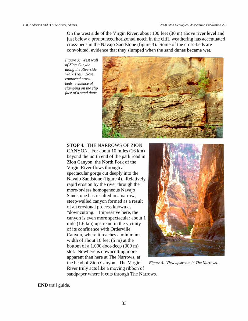
On the west side of the Virgin River, about 100 feet (30 m) above river level and just below a pronounced horizontal notch in the cliff, weathering has accentuated cross-beds in the Navajo Sandstone (figure 3). Some of the cross-beds are convoluted, evidence that they slumped when the sand dunes became wet.
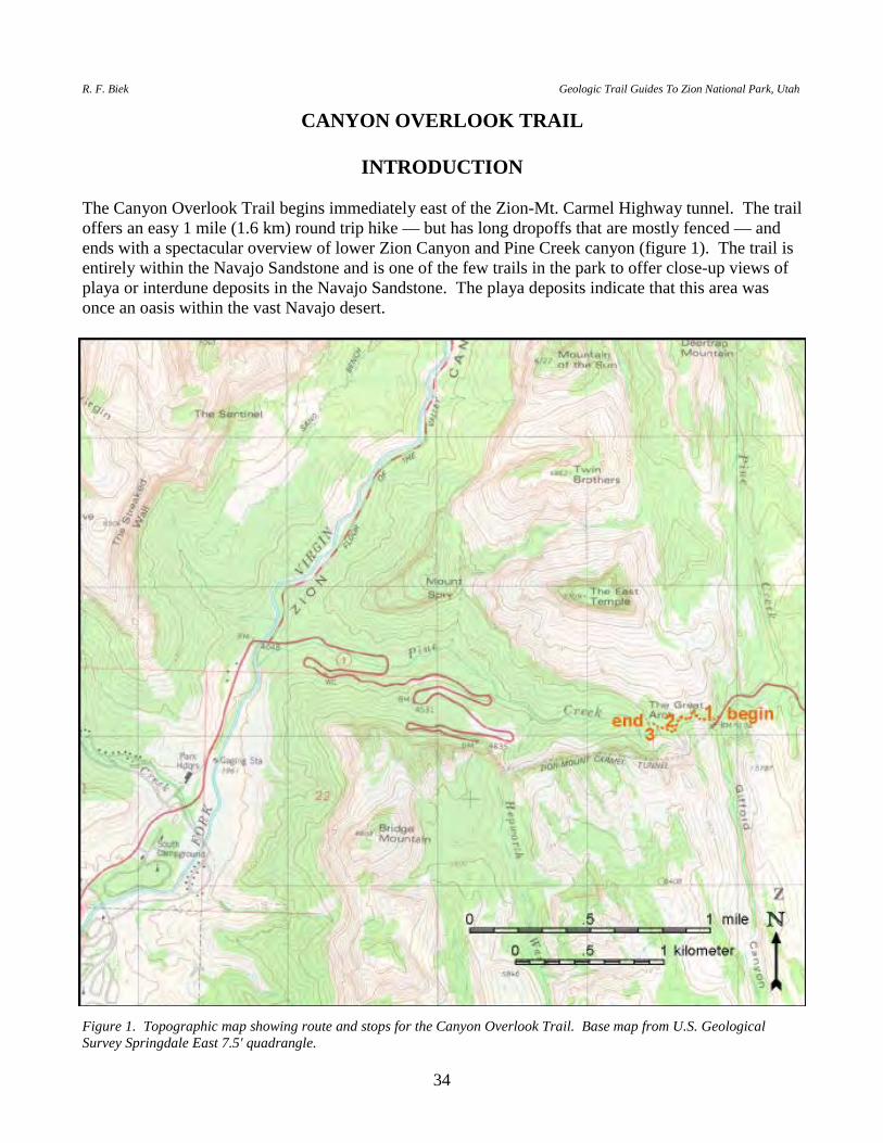
STOP 4. THE NARROWS OF ZION CANYON. For about 10 miles (16 km) beyond the north end of the park road in Zion Canyon, the North Fork of the Virgin River flows through a spectacular gorge cut deeply into the Navajo Sandstone (figure 4). Relatively rapid erosion by the river through the more-or-less homogeneous Navajo Sandstone has resulted in a narrow, steep-walled canyon formed as a result of an erosional process known as "downcutting." Impressive here, the canyon is even more spectacular about 1 mile (1.6 km) upstream in the vicinity of its confluence with Orderville Canyon, where it reaches a minimum width of about 16 feet (5 m) at the bottom of a 1,000-foot-deep (300 m) slot. Nowhere is downcutting more apparent than here at The Narrows, at the head of Zion Canyon. The Virgin River truly acts like a moving ribbon of sandpaper where it cuts through The Narrows.
END trail guide.
Figure 3. West wall of Zion Canyon along the Riverside Walk Trail. Note contorted cross-beds, evidence of slumping on the slip face of a sand dune.
Figure 4. View upstream in The Narrows.
R. F. Biek Geologic Trail Guides To Zion National Park, Utah
34
CANYON OVERLOOK TRAIL
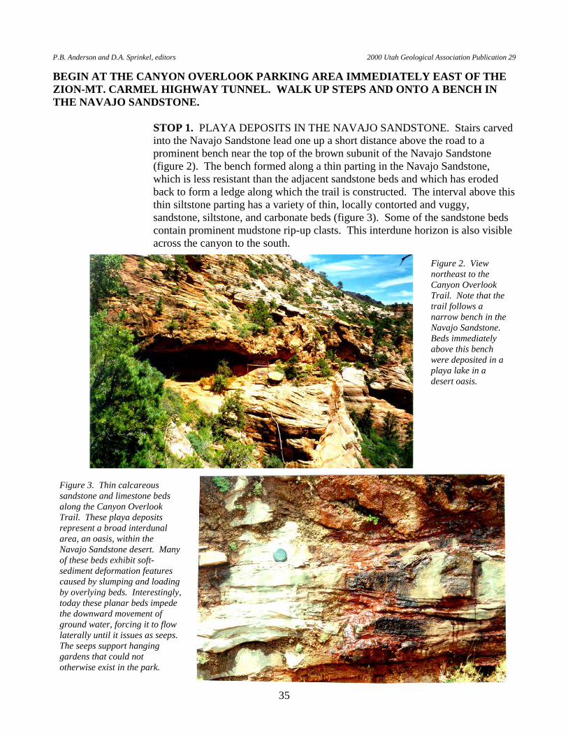
INTRODUCTION The Canyon Overlook Trail begins immediately east of the Zion-Mt. Carmel Highway tunnel. The trail offers an easy 1 mile (1.6 km) round trip hike — but has long dropoffs that are mostly fenced — and ends with a spectacular overview of lower Zion Canyon and Pine Creek canyon (figure 1). The trail is entirely within the Navajo Sandstone and is one of the few trails in the park to offer close-up views of playa or interdune deposits in the Navajo Sandstone. The playa deposits indicate that this area was once an oasis within the vast Navajo desert.
Figure 1. Topographic map showing route and stops for the Canyon Overlook Trail. Base map from U.S. Geological Survey Springdale East 7.5' quadrangle.
P.B. Anderson and D.A. Sprinkel, editors 2000 Utah Geological Association Publication 29
35
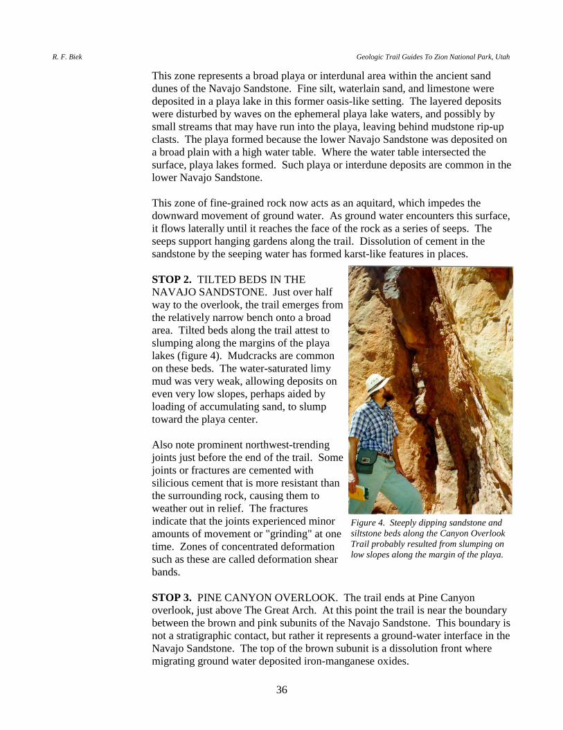
BEGIN AT THE CANYON OVERLOOK PARKING AREA IMMEDIATELY EAST OF THE ZION-MT. CARMEL HIGHWAY TUNNEL. WALK UP STEPS AND ONTO A BENCH IN THE NAVAJO SANDSTONE. STOP 1. PLAYA DEPOSITS IN THE NAVAJO SANDSTONE. Stairs carved
into the Navajo Sandstone lead one up a short distance above the road to a prominent bench near the top of the brown subunit of the Navajo Sandstone (figure 2). The bench formed along a thin parting in the Navajo Sandstone, which is less resistant than the adjacent sandstone beds and which has eroded back to form a ledge along which the trail is constructed. The interval above this thin siltstone parting has a variety of thin, locally contorted and vuggy, sandstone, siltstone, and carbonate beds (figure 3). Some of the sandstone beds contain prominent mudstone rip-up clasts. This interdune horizon is also visible across the canyon to the south.
Figure 2. View northeast to the Canyon Overlook Trail. Note that the trail follows a narrow bench in the Navajo Sandstone. Beds immediately above this bench were deposited in a playa lake in a desert oasis.
Figure 3. Thin calcareous sandstone and limestone beds along the Canyon Overlook Trail. These playa deposits represent a broad interdunal area, an oasis, within the Navajo Sandstone desert. Many of these beds exhibit soft-sediment deformation features caused by slumping and loading by overlying beds. Interestingly, today these planar beds impede the downward movement of ground water, forcing it to flow laterally until it issues as seeps. The seeps support hanging gardens that could not otherwise exist in the park.
R. F. Biek Geologic Trail Guides To Zion National Park, Utah
36
This zone represents a broad playa or interdunal area within the ancient sand dunes of the Navajo Sandstone. Fine silt, waterlain sand, and limestone were deposited in a playa lake in this former oasis-like setting. The layered deposits were disturbed by waves on the ephemeral playa lake waters, and possibly by small streams that may have run into the playa, leaving behind mudstone rip-up clasts. The playa formed because the lower Navajo Sandstone was deposited on a broad plain with a high water table. Where the water table intersected the surface, playa lakes formed. Such playa or interdune deposits are common in the lower Navajo Sandstone.
This zone of fine-grained rock now acts as an aquitard, which impedes the
downward movement of ground water. As ground water encounters this surface, it flows laterally until it reaches the face of the rock as a series of seeps. The seeps support hanging gardens along the trail. Dissolution of cement in the sandstone by the seeping water has formed karst-like features in places.
STOP 2. TILTED BEDS IN THE
NAVAJO SANDSTONE. Just over half way to the overlook, the trail emerges from the relatively narrow bench onto a broad area. Tilted beds along the trail attest to slumping along the margins of the playa lakes (figure 4). Mudcracks are common on these beds. The water-saturated limy mud was very weak, allowing deposits on even very low slopes, perhaps aided by loading of accumulating sand, to slump toward the playa center.
Also note prominent northwest-trending
joints just before the end of the trail. Some joints or fractures are cemented with silicious cement that is more resistant than the surrounding rock, causing them to weather out in relief. The fractures indicate that the joints experienced minor amounts of movement or "grinding" at one time. Zones of concentrated deformation such as these are called deformation shear bands.
STOP 3. PINE CANYON OVERLOOK. The trail ends at Pine Canyon
overlook, just above The Great Arch. At this point the trail is near the boundary between the brown and pink subunits of the Navajo Sandstone. This boundary is not a stratigraphic contact, but rather it represents a ground-water interface in the Navajo Sandstone. The top of the brown subunit is a dissolution front where migrating ground water deposited iron-manganese oxides.
Figure 4. Steeply dipping sandstone and siltstone beds along the Canyon Overlook Trail probably resulted from slumping on low slopes along the margin of the playa.
P.B. Anderson and D.A. Sprinkel, editors 2000 Utah Geological Association Publication 29
37
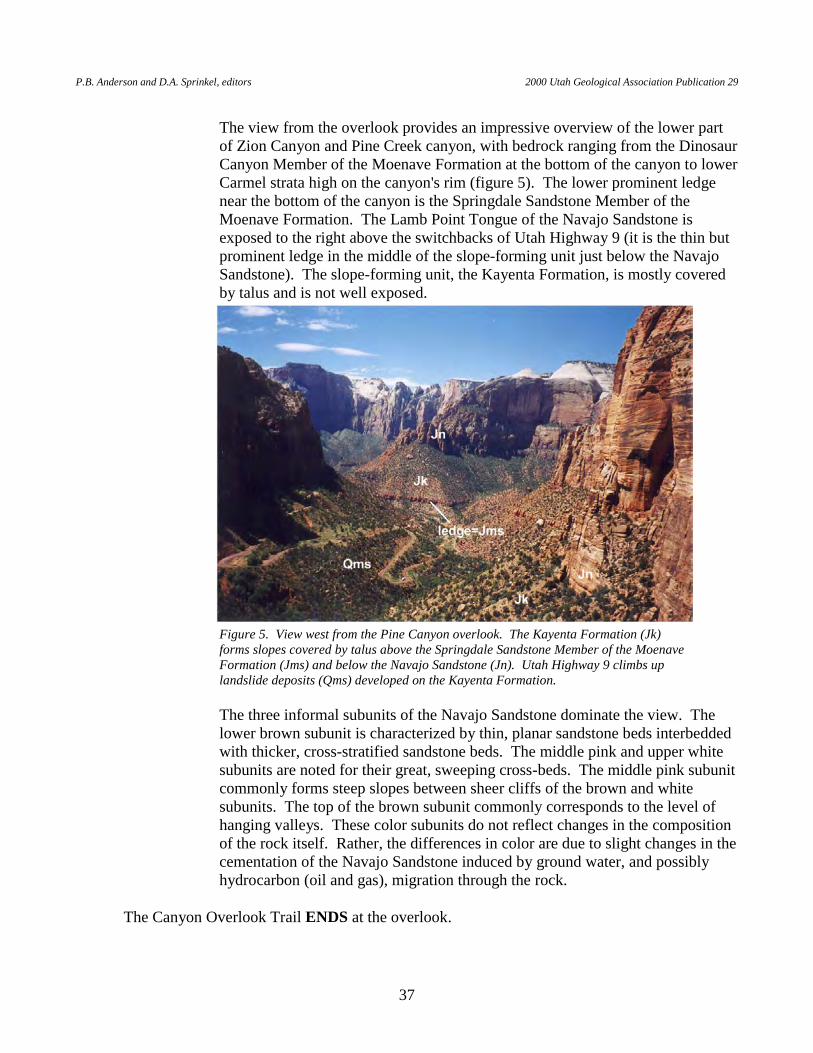
The view from the overlook provides an impressive overview of the lower part
of Zion Canyon and Pine Creek canyon, with bedrock ranging from the Dinosaur Canyon Member of the Moenave Formation at the bottom of the canyon to lower Carmel strata high on the canyon's rim (figure 5). The lower prominent ledge near the bottom of the canyon is the Springdale Sandstone Member of the Moenave Formation. The Lamb Point Tongue of the Navajo Sandstone is exposed to the right above the switchbacks of Utah Highway 9 (it is the thin but prominent ledge in the middle of the slope-forming unit just below the Navajo Sandstone). The slope-forming unit, the Kayenta Formation, is mostly covered by talus and is not well exposed.
The three informal subunits of the Navajo Sandstone dominate the view. The lower brown subunit is characterized by thin, planar sandstone beds interbedded with thicker, cross-stratified sandstone beds. The middle pink and upper white subunits are noted for their great, sweeping cross-beds. The middle pink subunit commonly forms steep slopes between sheer cliffs of the brown and white subunits. The top of the brown subunit commonly corresponds to the level of hanging valleys. These color subunits do not reflect changes in the composition of the rock itself. Rather, the differences in color are due to slight changes in the cementation of the Navajo Sandstone induced by ground water, and possibly hydrocarbon (oil and gas), migration through the rock.
The Canyon Overlook Trail ENDS at the overlook.
Figure 5. View west from the Pine Canyon overlook. The Kayenta Formation (Jk) forms slopes covered by talus above the Springdale Sandstone Member of the Moenave Formation (Jms) and below the Navajo Sandstone (Jn). Utah Highway 9 climbs up landslide deposits (Qms) developed on the Kayenta Formation.
R. F. Biek Geologic Trail Guides To Zion National Park, Utah
38
RIM TRAILS EAST RIM TRAIL
INTRODUCTION
The East Rim Trail follows the east rim of Zion Canyon between the Zion-Mt. Carmel Highway (Utah Highway 9) and Echo Canyon (figures 1a and 1b). Above cliffs of Lower Jurassic Navajo Sandstone, the forested, high plateau of the east rim is capped by gently northeastward-dipping Middle Jurassic strata consisting of sandstone and siltstone of the Temple Cap Formation and limestone, mudstone, and shale of the Carmel Formation. The 11.6-mile (18.7 km) trail provides spectacular views of finger canyons developed along vertical joints, as well as an opportunity to walk through nearly the entire stratigraphic section of Navajo Sandstone. The trail is described beginning at the trailhead near the east entrance to Zion National Park and ending at the Weeping Rock parking area in Zion Canyon. From the trailhead (elevation 5,700 feet [1,740 m]), the route begins by following an old road grade northeastward up the Clear Creek drainage, then gradually climbs the White Cliffs to the top of the plateau. This section of the trail offers excellent exposures of the upper Navajo Sandstone, Temple Cap Formation, lower Carmel Formation, and the unconformities that separate these units. The trail continues to the northwest, climbing gently to a high point on the plateau of about 6,720 feet (2,050 m), crossing scattered outcrops of fossiliferous Carmel Formation limestone. Gradually descending toward Echo Canyon, the trail passes Stave Spring, an intermittent spring near the base of the Carmel Formation, and traverses a picturesque shallow basin filled with alluvial sediments. After following the edge of the plateau (elevation 6,400 feet [1,950 m]), the trail turns to the southwest and makes a spectacular descent through Echo Canyon, crossing stretches of Navajo Sandstone slickrock and passing through the Echo Canyon narrows. A final series of switchbacks ends at the bottom of Zion Canyon at the Weeping Rock parking area (elevation 4,348 feet [1,326 m]). BEGIN at the southern trailhead of the East Rim Trail, located at the end of the short spur road on the north side of the Zion-Mt. Carmel Highway (Utah Highway 9) just west of the East Entrance tollbooth. The trail follows an old logging-road grade across thin, unconsolidated Quaternary sediments that mantle the Lower Jurassic Navajo Sandstone. The Quaternary sediments consist largely of sand derived from the Navajo Sandstone and deposited by a combination of alluvial and eolian processes. Outcrops of cross-bedded, eolian Navajo Sandstone can be seen in places poking through the thin Quaternary cover. The road itself is locally surfaced with material probably derived from the Middle Jurassic Carmel Formation (gray, platy to blocky limestone fragments) and Lower Cretaceous conglomeratic strata (multicolored, well-rounded chert and quartzite pebbles).

P.B. Anderson and D.A. Sprinkel, editors 2000 Utah Geological Association Publication 29
39
Figure 1a. Route of East Rim Trail (east part), showing locations of stops discussed in trail log. Base map from U.S. Geological Survey Clear Creek Mountain, Springdale East, Temple of Sinawava, and The Barracks 7.5' quadrangles.

R. F. Biek Geologic Trail Guides To Zion National Park, Utah
40
Figure 1b. Route of East Rim Trail (west part), showing locations of stops discussed in trail log. Base map from U.S. Geological Survey Clear Creek Mountain, Springdale East, Temple of Sinawava, and The Barracks 7.5' quadrangles.
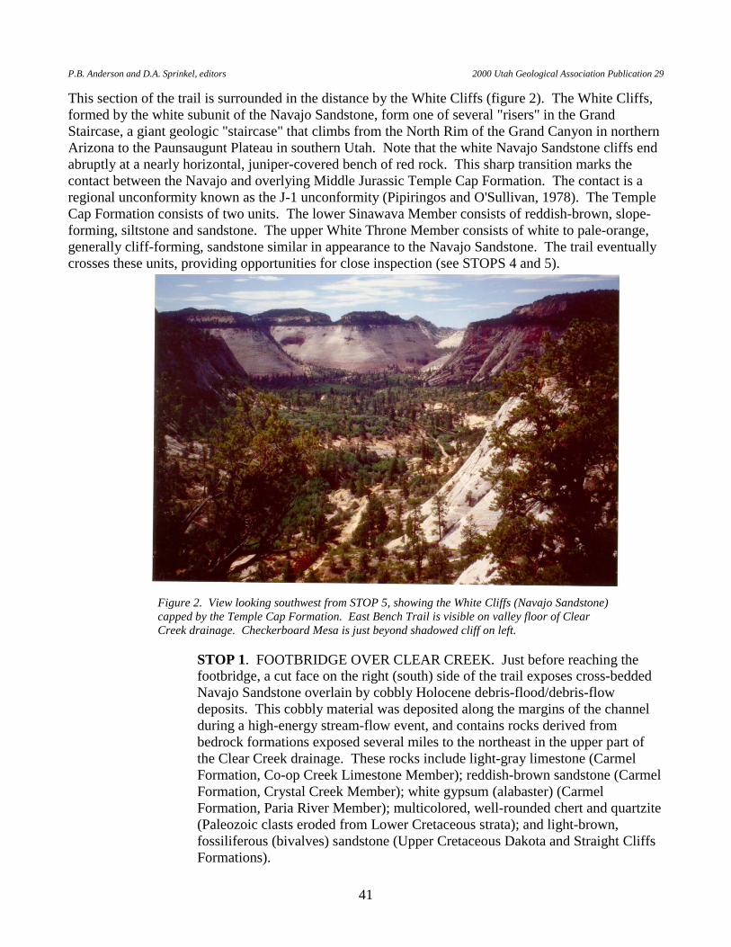
P.B. Anderson and D.A. Sprinkel, editors 2000 Utah Geological Association Publication 29
41
This section of the trail is surrounded in the distance by the White Cliffs (figure 2). The White Cliffs, formed by the white subunit of the Navajo Sandstone, form one of several "risers" in the Grand Staircase, a giant geologic "staircase" that climbs from the North Rim of the Grand Canyon in northern Arizona to the Paunsaugunt Plateau in southern Utah. Note that the white Navajo Sandstone cliffs end abruptly at a nearly horizontal, juniper-covered bench of red rock. This sharp transition marks the contact between the Navajo and overlying Middle Jurassic Temple Cap Formation. The contact is a regional unconformity known as the J-1 unconformity (Pipiringos and O'Sullivan, 1978). The Temple Cap Formation consists of two units. The lower Sinawava Member consists of reddish-brown, slope-forming, siltstone and sandstone. The upper White Throne Member consists of white to pale-orange, generally cliff-forming, sandstone similar in appearance to the Navajo Sandstone. The trail eventually crosses these units, providing opportunities for close inspection (see STOPS 4 and 5).
STOP 1. FOOTBRIDGE OVER CLEAR CREEK. Just before reaching the footbridge, a cut face on the right (south) side of the trail exposes cross-bedded Navajo Sandstone overlain by cobbly Holocene debris-flood/debris-flow deposits. This cobbly material was deposited along the margins of the channel during a high-energy stream-flow event, and contains rocks derived from bedrock formations exposed several miles to the northeast in the upper part of the Clear Creek drainage. These rocks include light-gray limestone (Carmel Formation, Co-op Creek Limestone Member); reddish-brown sandstone (Carmel Formation, Crystal Creek Member); white gypsum (alabaster) (Carmel Formation, Paria River Member); multicolored, well-rounded chert and quartzite (Paleozoic clasts eroded from Lower Cretaceous strata); and light-brown, fossiliferous (bivalves) sandstone (Upper Cretaceous Dakota and Straight Cliffs Formations).
Figure 2. View looking southwest from STOP 5, showing the White Cliffs (Navajo Sandstone) capped by the Temple Cap Formation. East Bench Trail is visible on valley floor of Clear Creek drainage. Checkerboard Mesa is just beyond shadowed cliff on left.

R. F. Biek Geologic Trail Guides To Zion National Park, Utah
42
STOP 2. TRAIL EROSION. About 1/4 mile (400 m) past the footbridge, the embankment fill upon which the trail is located is washed out in several places as the result of concentrated, "flashy" run-off from the nearby Navajo Sandstone cliffs to the north. During cloudburst rainstorms, which are common in the summer months, much of the precipitation pours down the cliff faces and concentrates in swales and gullies at the base of the cliffs. The concentrated, rapidly flowing water easily erodes the unconsolidated Quaternary sediments and embankment fill near the base of the cliffs.
STOP 3. HIGH-ANGLE NORMAL FAULT. A northwest-trending, high-angle
normal fault crosses the Clear Creek drainage about 600 feet (180 m) west of Cave Canyon (Hamilton, 1987; Sable and Doelling, 1993). As evident from offset of the Temple Cap Formation south of the trail, this fault has down-to-the-east displacement of a few tens of feet.
The trail turns to the north at CAVE CANYON and ascends to the top of the
Navajo Sandstone. Note the abundant high-angle fractures that form a criss-cross pattern in the upper part of the Navajo (figure 3). The origin of these nonpenetrative, silica-cemented fractures is uncertain, but they are probably related to development of the J-1 unconformity between the Navajo Sandstone and overlying Temple Cap Formation.
STOP 4. NAVAJO SANDSTONE-TEMPLE CAP FORMATION CONTACT (J-1 UNCONFORMITY). At the top of the Navajo Sandstone, the white eolian sandstone forms a nearly planar, red-stained bench. This erosional surface, the J-1 unconformity, marks a time when the great Navajo sand desert was eroded, prior to being inundated by rising seas that lead to deposition of reddish-brown to yellowish-orange sand, silt, and mud of the Sinawava Member of the Temple
Figure 3. Fractures in the upper part of the Navajo Sandstone.
P.B. Anderson and D.A. Sprinkel, editors 2000 Utah Geological Association Publication 29
43
Cap Formation in sabkha and tidal-flat environments (Blakey, 1994; Peterson, 1994). As you walk past cuts in the Sinawava Member, note a variety of sedimentary structures such as channel cut-and-fill structures, cross-bedding, and soft-sediment deformation (small folds).
Locally, the slope above the trail is covered with colluvium consisting of light-
gray limestone of the Carmel Formation, which overlies the Temple Cap Formation and caps the hills visible to the north, northeast, and south.
STOP 5. WHITE THRONE MEMBER OF THE TEMPLE CAP
FORMATION. Shortly before turning to the north along the east side of Jolley Gulch, the trail passes by exposures of the White Throne Member of the Temple Cap Formation; the typically gradational contact with the underlying Sinawava Member is covered in this area. The white, pink, and pale-orange sandstone of the White Throne Member, which resembles the Navajo Sandstone, reflects a return to eolian deposition following the sabkha and tidal-flat deposition recorded by the Sinawava Member.
The trail along the east side of Jolley Gulch follows near the base of the White
Throne Member, not far above the top of the Sinawava Member. The contact between these two units is concealed beneath talus and colluvium. Near the head of lower Jolley Gulch, the trail descends through the Sinawava Member to the top of the Navajo Sandstone.
STOP 6. JOLLEY GULCH BOX CANYON. Near the Zion National Park
boundary fence, lower Jolley Gulch terminates abruptly in a spectacular box canyon. This canyon is typical of the "finger canyons" of Zion National Park, which form by stream erosion along vertical fractures, or joints. Over time, erosion propagates outward along the tributary streams from the main, or trunk, stream (headward erosion), slowly carving deep slots into the surrounding mesas and plateaus. Watch your step and be very careful near the edge of the cliff.
STOP 7. TEMPLE CAP FORMATION-CARMEL FORMATION CONTACT.
After a gradual climb on the west side of Jolley Gulch, the trail makes a sharp switchback to the east. Just after the sharp bend, the contact between the White Throne Member of the Temple Cap Formation and the Co-op Creek Limestone Member of the Carmel Formation is exposed in the cut on the north side of the trail (figure 4). The contact is at the top of the uppermost thick, laterally continuous sandstone bed. The overlying Co-op Creek Limestone Member consists of a basal sequence (about 10 feet [3 m] thick) of reddish-brown to light-gray shale and mudstone with thin sandstone interbeds, overlain by yellowish-gray, medium-bedded to platy limestone exposed at the top of the cut slope. The contact corresponds to the J-2 unconformity of Pipiringos and O'Sullivan (1978), and marks an abrupt transition from eolian deposition to shallow-marine deposition in Middle Jurassic time. The gentle northeast dip of the limestone beds here reflects the regional dip of strata in the area — only a few degrees.
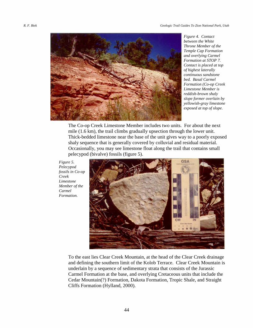
R. F. Biek Geologic Trail Guides To Zion National Park, Utah
44
The Co-op Creek Limestone Member includes two units. For about the next mile (1.6 km), the trail climbs gradually upsection through the lower unit. Thick-bedded limestone near the base of the unit gives way to a poorly exposed shaly sequence that is generally covered by colluvial and residual material. Occasionally, you may see limestone float along the trail that contains small pelecypod (bivalve) fossils (figure 5).
To the east lies Clear Creek Mountain, at the head of the Clear Creek drainage and defining the southern limit of the Kolob Terrace. Clear Creek Mountain is underlain by a sequence of sedimentary strata that consists of the Jurassic Carmel Formation at the base, and overlying Cretaceous units that include the Cedar Mountain(?) Formation, Dakota Formation, Tropic Shale, and Straight Cliffs Formation (Hylland, 2000).
Figure 4. Contact between the White Throne Member of the Temple Cap Formation and overlying Carmel Formation at STOP 7. Contact is placed at top of highest laterally continuous sandstone bed. Basal Carmel Formation (Co-op Creek Limestone Member is reddish-brown shaly slope former overlain by yellowish-gray limestone exposed at top of slope.
Figure 5. Pelecypod fossils in Co-op Creek Limestone Member of the Carmel Formation.
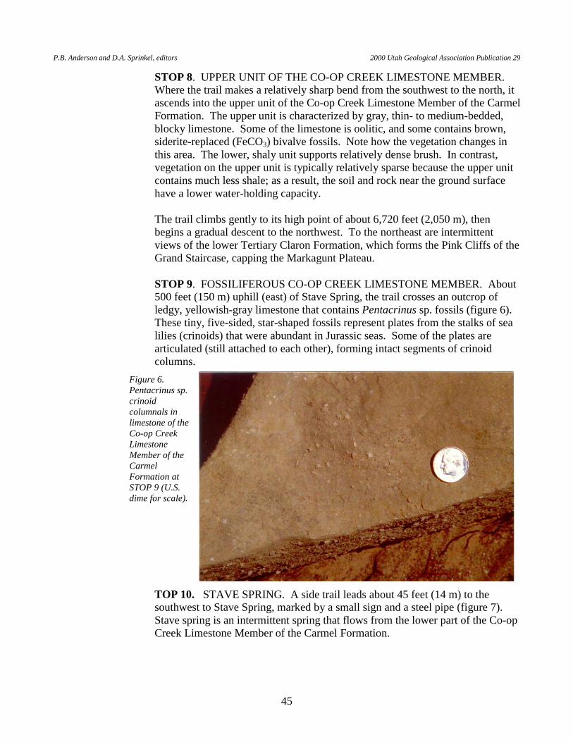
P.B. Anderson and D.A. Sprinkel, editors 2000 Utah Geological Association Publication 29
45
STOP 8. UPPER UNIT OF THE CO-OP CREEK LIMESTONE MEMBER. Where the trail makes a relatively sharp bend from the southwest to the north, it ascends into the upper unit of the Co-op Creek Limestone Member of the Carmel Formation. The upper unit is characterized by gray, thin- to medium-bedded, blocky limestone. Some of the limestone is oolitic, and some contains brown, siderite-replaced (FeCO3) bivalve fossils. Note how the vegetation changes in this area. The lower, shaly unit supports relatively dense brush. In contrast, vegetation on the upper unit is typically relatively sparse because the upper unit contains much less shale; as a result, the soil and rock near the ground surface have a lower water-holding capacity.
The trail climbs gently to its high point of about 6,720 feet (2,050 m), then
begins a gradual descent to the northwest. To the northeast are intermittent views of the lower Tertiary Claron Formation, which forms the Pink Cliffs of the Grand Staircase, capping the Markagunt Plateau.
STOP 9. FOSSILIFEROUS CO-OP CREEK LIMESTONE MEMBER. About
500 feet (150 m) uphill (east) of Stave Spring, the trail crosses an outcrop of ledgy, yellowish-gray limestone that contains Pentacrinus sp. fossils (figure 6). These tiny, five-sided, star-shaped fossils represent plates from the stalks of sea lilies (crinoids) that were abundant in Jurassic seas. Some of the plates are articulated (still attached to each other), forming intact segments of crinoid columns.
TOP 10. STAVE SPRING. A side trail leads about 45 feet (14 m) to the southwest to Stave Spring, marked by a small sign and a steel pipe (figure 7). Stave spring is an intermittent spring that flows from the lower part of the Co-op Creek Limestone Member of the Carmel Formation.
Figure 6. Pentacrinus sp. crinoid columnals in limestone of the Co-op Creek Limestone Member of the Carmel Formation at STOP 9 (U.S. dime for scale).
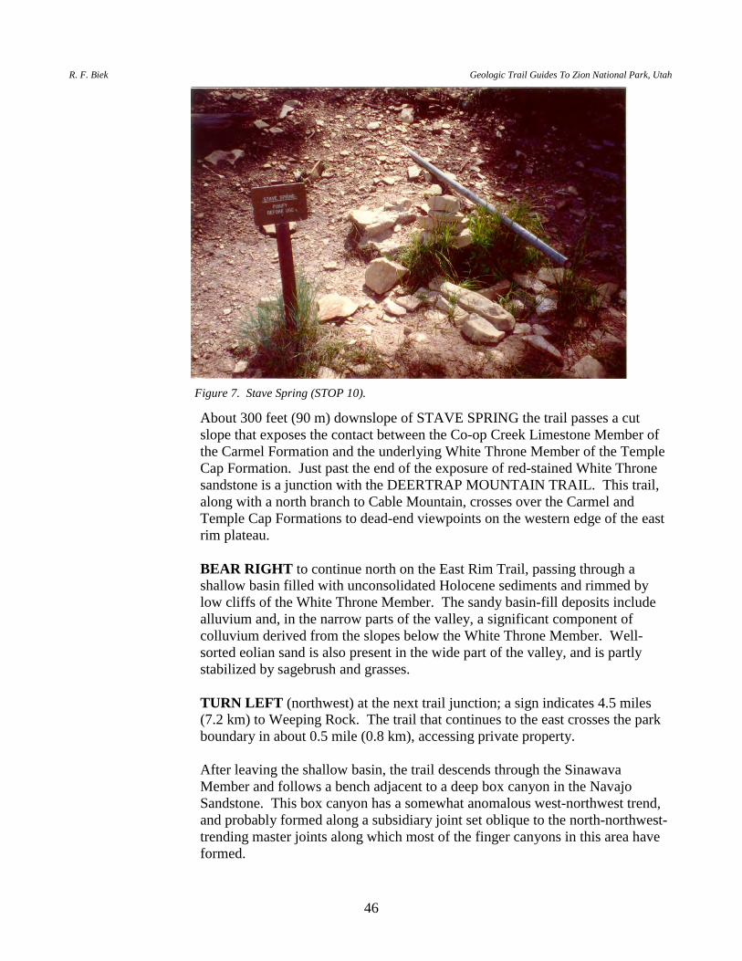
R. F. Biek Geologic Trail Guides To Zion National Park, Utah
46
About 300 feet (90 m) downslope of STAVE SPRING the trail passes a cut slope that exposes the contact between the Co-op Creek Limestone Member of the Carmel Formation and the underlying White Throne Member of the Temple Cap Formation. Just past the end of the exposure of red-stained White Throne sandstone is a junction with the DEERTRAP MOUNTAIN TRAIL. This trail, along with a north branch to Cable Mountain, crosses over the Carmel and Temple Cap Formations to dead-end viewpoints on the western edge of the east rim plateau.
BEAR RIGHT to continue north on the East Rim Trail, passing through a
shallow basin filled with unconsolidated Holocene sediments and rimmed by low cliffs of the White Throne Member. The sandy basin-fill deposits include alluvium and, in the narrow parts of the valley, a significant component of colluvium derived from the slopes below the White Throne Member. Well-sorted eolian sand is also present in the wide part of the valley, and is partly stabilized by sagebrush and grasses.
TURN LEFT (northwest) at the next trail junction; a sign indicates 4.5 miles
(7.2 km) to Weeping Rock. The trail that continues to the east crosses the park boundary in about 0.5 mile (0.8 km), accessing private property.
After leaving the shallow basin, the trail descends through the Sinawava
Member and follows a bench adjacent to a deep box canyon in the Navajo Sandstone. This box canyon has a somewhat anomalous west-northwest trend, and probably formed along a subsidiary joint set oblique to the north-northwest-trending master joints along which most of the finger canyons in this area have formed.
Figure 7. Stave Spring (STOP 10).
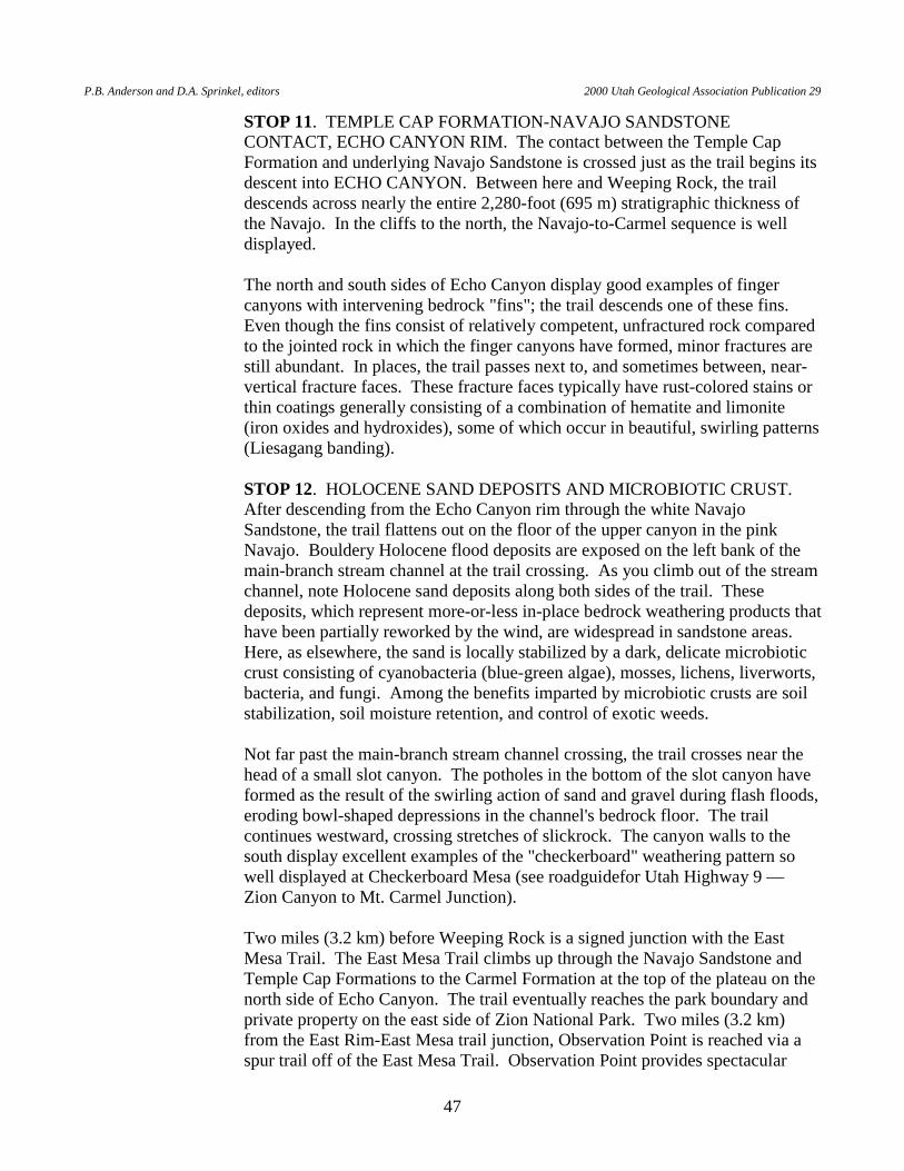
P.B. Anderson and D.A. Sprinkel, editors 2000 Utah Geological Association Publication 29
47
STOP 11. TEMPLE CAP FORMATION-NAVAJO SANDSTONE CONTACT, ECHO CANYON RIM. The contact between the Temple Cap Formation and underlying Navajo Sandstone is crossed just as the trail begins its descent into ECHO CANYON. Between here and Weeping Rock, the trail descends across nearly the entire 2,280-foot (695 m) stratigraphic thickness of the Navajo. In the cliffs to the north, the Navajo-to-Carmel sequence is well displayed.
The north and south sides of Echo Canyon display good examples of finger
canyons with intervening bedrock "fins"; the trail descends one of these fins. Even though the fins consist of relatively competent, unfractured rock compared to the jointed rock in which the finger canyons have formed, minor fractures are still abundant. In places, the trail passes next to, and sometimes between, near-vertical fracture faces. These fracture faces typically have rust-colored stains or thin coatings generally consisting of a combination of hematite and limonite (iron oxides and hydroxides), some of which occur in beautiful, swirling patterns (Liesagang banding).
STOP 12. HOLOCENE SAND DEPOSITS AND MICROBIOTIC CRUST.
After descending from the Echo Canyon rim through the white Navajo Sandstone, the trail flattens out on the floor of the upper canyon in the pink Navajo. Bouldery Holocene flood deposits are exposed on the left bank of the main-branch stream channel at the trail crossing. As you climb out of the stream channel, note Holocene sand deposits along both sides of the trail. These deposits, which represent more-or-less in-place bedrock weathering products that have been partially reworked by the wind, are widespread in sandstone areas. Here, as elsewhere, the sand is locally stabilized by a dark, delicate microbiotic crust consisting of cyanobacteria (blue-green algae), mosses, lichens, liverworts, bacteria, and fungi. Among the benefits imparted by microbiotic crusts are soil stabilization, soil moisture retention, and control of exotic weeds.
Not far past the main-branch stream channel crossing, the trail crosses near the
head of a small slot canyon. The potholes in the bottom of the slot canyon have formed as the result of the swirling action of sand and gravel during flash floods, eroding bowl-shaped depressions in the channel's bedrock floor. The trail continues westward, crossing stretches of slickrock. The canyon walls to the south display excellent examples of the "checkerboard" weathering pattern so well displayed at Checkerboard Mesa (see roadguidefor Utah Highway 9 — Zion Canyon to Mt. Carmel Junction).
Two miles (3.2 km) before Weeping Rock is a signed junction with the East
Mesa Trail. The East Mesa Trail climbs up through the Navajo Sandstone and Temple Cap Formations to the Carmel Formation at the top of the plateau on the north side of Echo Canyon. The trail eventually reaches the park boundary and private property on the east side of Zion National Park. Two miles (3.2 km) from the East Rim-East Mesa trail junction, Observation Point is reached via a spur trail off of the East Mesa Trail. Observation Point provides spectacular
R. F. Biek Geologic Trail Guides To Zion National Park, Utah
48
views of Zion Canyon. Also, watch for excellent examples of slump structures, formed prior to lithification of fine-grained sediments in the Temple Cap Formation, along the trail.
BEAR LEFT at the East Mesa Trail junction to continue west toward Weeping
Rock. Across Echo Canyon to the southwest are the impressive northern faces of Cable Mountain (left) and The Great White Throne (right). Note the slot canyon developed below the trail in the floor of Echo Canyon, indicating headward erosion of the pre-existing canyon floor.
STOP 13. FORMER FLOOR OF ECHO CANYON. Between the East Mesa
Trail junction and the Echo Canyon narrows (see STOP 14), the trail is on a mid-level bench that represents part of the former floor of Echo Canyon. This relatively broad floor may have resulted from differential erosion of a relatively weak or soft layer within the Navajo Sandstone, a period of tectonic stability, a change in climatic influences, or a combination of factors. The former canyon floor is now being incised as the stream tries to re-establish a stable channel gradient. The old floor is evident to the west in the profiles of the bedrock ridges that extend into the canyon from the south and north.
STOP 14. ECHO CANYON NARROWS. The trail descends from the former
floor of Echo Canyon to the level of the modern stream channel by passing through the Echo Canyon narrows. In the stream channel, note local deposits of coarse-grained alluvium. This sediment typically is transported within the channel during a flash flood or debris flow, and is deposited as the flood subsides. It represents a hazard to downstream areas because it could be picked up and transported by the stream during a future flood or debris flow.
STOP 15. RIM OF ZION CANYON. The rim of Zion Canyon provides good
views of Angels Landing across the canyon, The Organ inside the loop of the Big Bend of the Virgin River, and The Great White Throne. The Weeping Rock parking area is directly below.
The valley of Echo Canyon, typical of the Zion Canyon tributary valleys, is an
alluvial hanging valley. The Virgin River has more erosive energy than the smaller Echo Canyon stream, and therefore cuts down at a more rapid rate. This leaves the floor of Echo Canyon "hanging" above the floor of Zion Canyon. During periods of stream flow, a waterfall cascades from the mouth of Echo Canyon, located just above Weeping Rock, to the floor of Zion Canyon.
After the first few switchbacks, and about at the top of the brown Navajo
Sandstone, is a junction with the HIDDEN CANYON TRAIL. The Hidden Canyon Trail climbs up into and dead-ends within a deep finger canyon developed along a joint system that runs between The Great White Throne and the east rim plateau. From the trail junction, Weeping Rock is visible downslope to the north; it is the large, vegetated alcove below a smooth rock face.
P.B. Anderson and D.A. Sprinkel, editors 2000 Utah Geological Association Publication 29
49
BEAR RIGHT at the Hidden Canyon Trail junction and continue down the switchbacks. Where the trail descends beneath a large, smooth, sloping slab of sandstone, take notice of the different character of the brown Navajo compared to the overlying pink and white Navajo. Here, the cross-bedding is on a much smaller scale; superimposed sets of trough cross-beds impart an internal stratigraphy to the rock; and the rock forms smooth, planar faces instead of corrugated, somewhat rounded surfaces.
Below the last switchback, the trail descends a ridge of talus and colluvium at
the base of the cliff. Just before crossing the footbridge to the parking lot, the short (1/4 mile [400 m]) trail to Weeping Rock branches off to the right; this trail is described in a separate trail guide. Weeping Rock is a picturesque alcove that has developed in the Navajo Sandstone cliff face as the result of ground water seepage out of the rock. The seeping ground water drips from the ceiling of the alcove and provides year-round moisture for a lush hanging garden. The water is also alkaline, so that tufa (calcium carbonate) is continuously being deposited here.
The East Rim Trail ENDS at the WEEPING ROCK parking area.
R. F. Biek Geologic Trail Guides To Zion National Park, Utah
50
WEST RIM TRAIL AND ANGELS LANDING
INTRODUCTION The West Rim Trail stretches about 13.5 miles (21.6 km) between Lava Point and Zion Canyon, with an elevation gain or loss, depending on which direction one travels, of about 3,200 feet (976 m) (figures 1a, 1b, and 1c). Beginning at the parking area below Lava Point, the trail traverses limestone and mudstone strata of the Co-op Creek Limestone Member of the Carmel Formation, which holds up the Horse Pasture Plateau. About two-thirds of the trail traverses the plateau, and exposures on top of the plateau itself are limited. However, exposures along the margins of the plateau are excellent, and views westward from the plateau into the Left and Right Forks of North Creek, and into Wildcat Canyon, are breathtaking. At the south end of the plateau, the trail traverses the Temple Cap Formation, cuts across the J-1 unconformity, and drops into the Navajo Sandstone. The trail traverses a complete section of the Navajo Sandstone between the south end of the Horse Pasture plateau and Zion Canyon. A trail spur, not for the faint of heart, leads to Angels Landing. BEGIN at the West Rim Trail parking area below Lava Point. The thick basalt flow at Lava Point erupted from Home Valley Knoll, a well-weathered cinder cone west of Lava Point, just west of the park boundary. This flow has several K-Ar and 40Ar/39Ar ages of 1.0 to 1.1 million years (Best and others, 1980; unpublished UGS data). The Lava Point flow eventually entered the ancestral Left Fork of North Creek, which it followed 13 miles (21 km) down to the Virgin River to near what is now the town of Virgin. A remnant of this flow is preserved atop the high mesa northeast of Virgin, and has provided a valuable reference point from which to determine long-term erosion rates of Zion Canyon. The trail follows an old road grade southward on the Horse Pasture Plateau. The first several hundred yards of the West Rim Trail is on colluvial deposits that cover the upper unit of the Co-op Creek Limestone Member of the Carmel Formation. Scattered quartzite and chert pebbles are lag deposits from higher (now eroded) late Early Cretaceous strata. STOP 1. VIEW NORTH TO THORLEY POINT. Thorley Point, which is
capped by the upper Straight Cliffs Formation, is visible to the north; the slightly higher Hornet Point to its west is capped by basalt that yielded a K-Ar age of 1.2 + 0.6 (Best and others, 1980). To the northeast, the tree-covered cinder cone of Volcano Knoll is visible in the Deep Creek drainage. Best and others (1980) reported a K-Ar age of 0.36 + 0.8 Ma for the Volcano Knoll flow.
STOP 2. VIEW NORTHEAST TO COGSWELL POINT. Cogswell Point,
which is also capped by the upper Straight Cliffs Formation, can be seen to the northeast. The Pink Cliffs of the Paunsaugunt Plateau (early Tertiary Claron Formation) form the skyline beyond Cogswell Point. The Pink Cliffs form the uppermost "riser" of the Grand Staircase, which consists of over 6,000 feet (1,830 m) of alternating cliffs, slopes, and terraces in southern Utah and northern Arizona. In Utah, each "riser" is a cliff or slope as much as 2,000 feet (610 m) high and each "tread" is a plateau as much as 15 miles (24 km) wide. The pink cliffs of the Claron Formation are well known at Bryce Canyon National Park and Cedar Breaks National Monument.
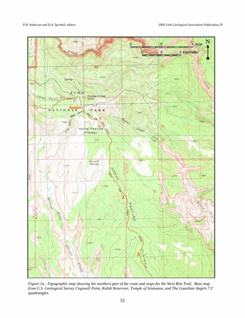
P.B. Anderson and D.A. Sprinkel, editors 2000 Utah Geological Association Publication 29
51
Figure 1a. Topographic map showing the northern part of the route and stops for the West Rim Trail. Base map from U.S. Geological Survey Cogswell Point, Kolob Reservoir, Temple of Sinawava, and The Guardian Angels 7.5' quadrangles.

R. F. Biek Geologic Trail Guides To Zion National Park, Utah
52
Figure 1b. Topographic map showing the center part of the route and stops for the West Rim Trail. Base map from U.S. Geological Survey Cogswell Point, Kolob Reservoir, Temple of Sinawava, and The Guardian Angels 7.5' quadrangles.
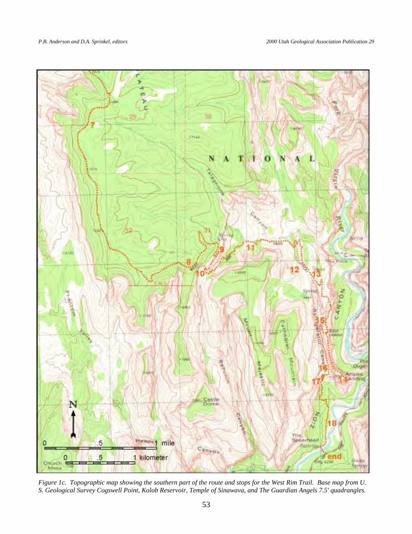
P.B. Anderson and D.A. Sprinkel, editors 2000 Utah Geological Association Publication 29
53
Figure 1c. Topographic map showing the southern part of the route and stops for the West Rim Trail. Base map from U.S. Geological Survey Cogswell Point, Kolob Reservoir, Temple of Sinawava, and The Guardian Angels 7.5' quadrangles.
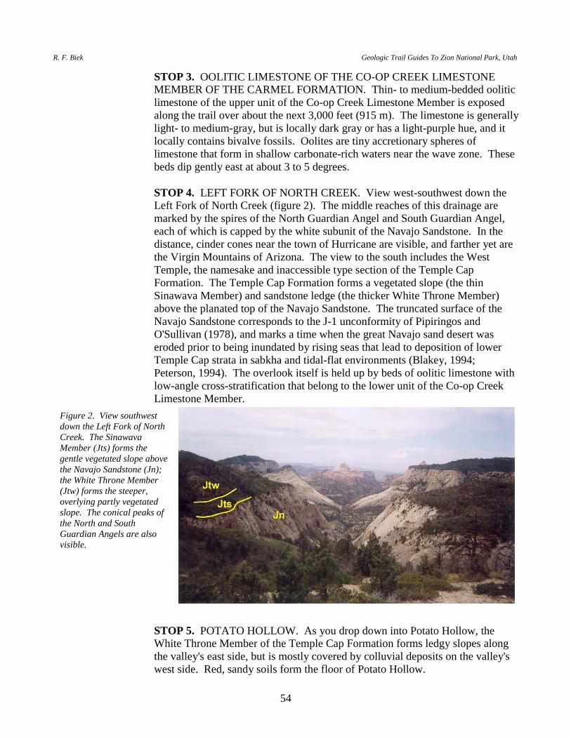
R. F. Biek Geologic Trail Guides To Zion National Park, Utah
54
STOP 3. OOLITIC LIMESTONE OF THE CO-OP CREEK LIMESTONE MEMBER OF THE CARMEL FORMATION. Thin- to medium-bedded oolitic limestone of the upper unit of the Co-op Creek Limestone Member is exposed along the trail over about the next 3,000 feet (915 m). The limestone is generally light- to medium-gray, but is locally dark gray or has a light-purple hue, and it locally contains bivalve fossils. Oolites are tiny accretionary spheres of limestone that form in shallow carbonate-rich waters near the wave zone. These beds dip gently east at about 3 to 5 degrees.
STOP 4. LEFT FORK OF NORTH CREEK. View west-southwest down the
Left Fork of North Creek (figure 2). The middle reaches of this drainage are marked by the spires of the North Guardian Angel and South Guardian Angel, each of which is capped by the white subunit of the Navajo Sandstone. In the distance, cinder cones near the town of Hurricane are visible, and farther yet are the Virgin Mountains of Arizona. The view to the south includes the West Temple, the namesake and inaccessible type section of the Temple Cap Formation. The Temple Cap Formation forms a vegetated slope (the thin Sinawava Member) and sandstone ledge (the thicker White Throne Member) above the planated top of the Navajo Sandstone. The truncated surface of the Navajo Sandstone corresponds to the J-1 unconformity of Pipiringos and O'Sullivan (1978), and marks a time when the great Navajo sand desert was eroded prior to being inundated by rising seas that lead to deposition of lower Temple Cap strata in sabkha and tidal-flat environments (Blakey, 1994; Peterson, 1994). The overlook itself is held up by beds of oolitic limestone with low-angle cross-stratification that belong to the lower unit of the Co-op Creek Limestone Member.
STOP 5. POTATO HOLLOW. As you drop down into Potato Hollow, the
White Throne Member of the Temple Cap Formation forms ledgy slopes along the valley's east side, but is mostly covered by colluvial deposits on the valley's west side. Red, sandy soils form the floor of Potato Hollow.
Figure 2. View southwest down the Left Fork of North Creek. The Sinawava Member (Jts) forms the gentle vegetated slope above the Navajo Sandstone (Jn); the White Throne Member (Jtw) forms the steeper, overlying partly vegetated slope. The conical peaks of the North and South Guardian Angels are also visible.
P.B. Anderson and D.A. Sprinkel, editors 2000 Utah Geological Association Publication 29
55
STOP 6. NAVAJO, TEMPLE CAP, AND CARMEL STRATA. View
northwest (to hill 7370) of south-facing exposures of the Navajo Sandstone, Temple Cap Formation, and the Co-op Creek Limestone Member of the Carmel Formation. The J-1 and J-2 unconformities, located at the base and top of the Temple Cap Formation, respectively, are prominently displayed here.
As you head south, the ledgy plateau is upheld by oolitic limestone of the upper
unit of the Co-op Creek Limestone Member. The trail splits to the south. FOLLOW THE CANYON RIM TRAIL rather than the Telephone Canyon Trail.
STOP 7. WESTWARD VIEWS FROM THE HORSE PASTURE PLATEAU.
View north-northwest to Lava Point, and north-northeast to Thorley Point. For about the next mile (1.6 km) along the West Rim Trail heading south, there are excellent westward views to Hurricane Mesa, Smith Mesa, and the Pine Valley Mountains, and of course to the stunning Right Fork Canyon in the foreground (figure 3). The Shinarump Conglomerate Member of the Chinle Formation (Late Triassic) forms the planar top of Hurricane Mesa, while the Springdale Sandstone Member of the Moenave Formation (Early Jurassic) forms Smith Mesa. The Pine Valley Mountains are capped by an enormous mushroom-shaped intrusion called the Pine Valley laccolith. The laccolith is a quartz monzonite porphyry intruded into the early Tertiary Claron Formation. The laccolith was emplaced at a relatively shallow level, and breached its roof on the north side where it erupted thick dacitic lava flows (Hacker, 1998). McKee and others (1997) reported a Miocene K-Ar age on biotite of 20.9 + 0.6 Ma taken from the lower part of the laccolith.
STOP 8. VIEW SOUTH FROM THE HORSE PASTURE PLATEAU. View
south and east from the south end of the Horse Pasture Plateau (figure 4). The planated top of the Navajo Sandstone, the J-1 unconformity of Pipiringos and O'Sullivan (1978), is prominently displayed here. Mt. Majestic and several of the other promontories of Navajo Sandstone that protrude south from the Horse Pasture Plateau are capped by the Temple Cap Formation and the lowermost Carmel Formation. The Sinawava Member, the lower unit of the Temple Cap Formation, forms vegetated slopes on top of the Navajo Sandstone, while the overlying White Throne Member forms cliffs of cross-bedded sandstone much like the underlying Navajo Sandstone.
STOP 9. VIEW NORTHEAST TO THE PINK CLIFFS. View northeast with
the Pink Cliffs on the skyline (figure 5). The J-1 unconformity is prominently displayed on the east rim of Zion Canyon. The trail here is cut into the upper, white Navajo Sandstone. The narrow canyon walls along this portion of the trail produce remarkably clear echos.
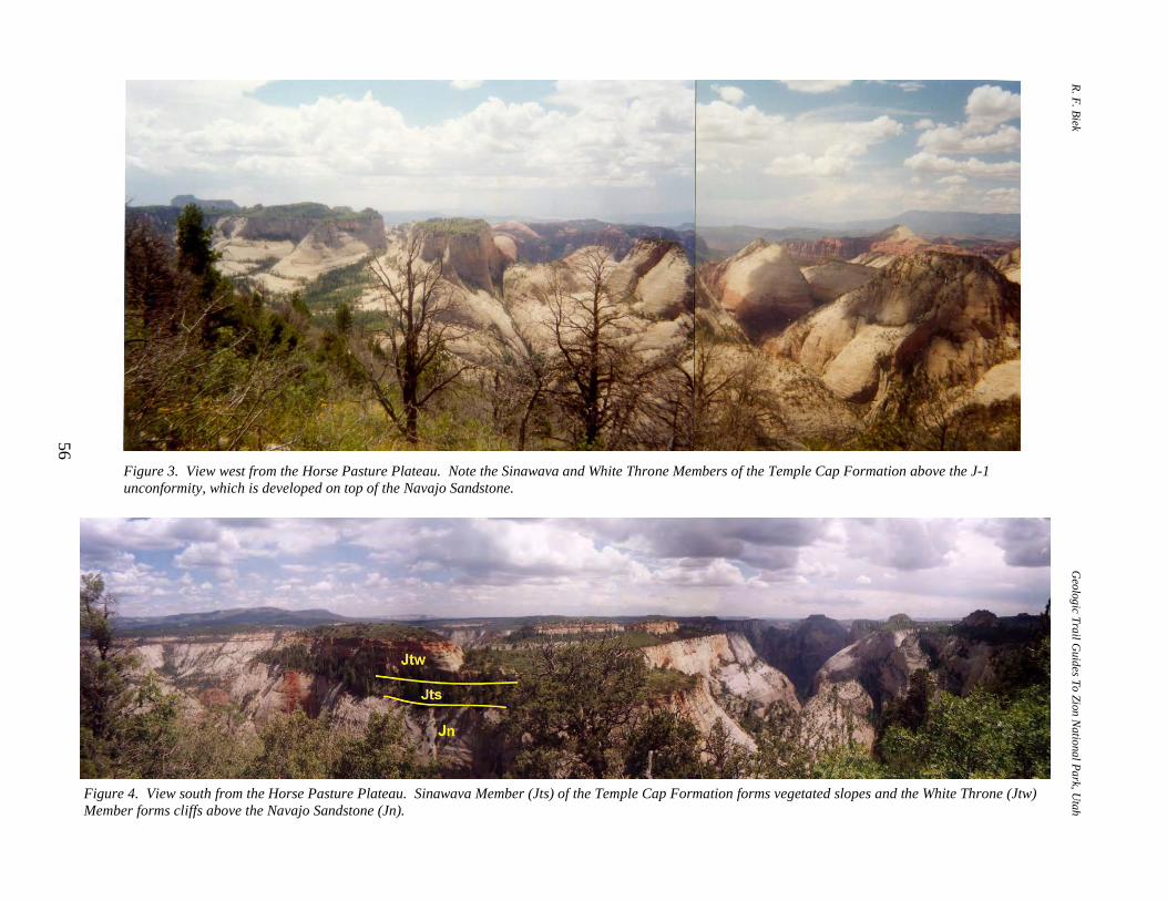
R. F. Biek Geologic Trail G
uides To Zion National Park, U
tah
56
Figure 3. View west from the Horse Pasture Plateau. Note the Sinawava and White Throne Members of the Temple Cap Formation above the J-1 unconformity, which is developed on top of the Navajo Sandstone.
Figure 4. View south from the Horse Pasture Plateau. Sinawava Member (Jts) of the Temple Cap Formation forms vegetated slopes and the White Throne (Jtw)Member forms cliffs above the Navajo Sandstone (Jn).

P.B. Anderson and D.A. Sprinkel, editors 2000 Utah Geological Association Publication 29
57
STOP 10. BEHUNIN CANYON. This switchback offers a view of the north end of Behunin Canyon. Note the massive, sweeping cross-beds in the Navajo Sandstone, numerous seeps, and iron-manganese-oxide staining on the vertical rock walls as well as along cross-bed surfaces.
STOP 11. IRON-MANGANESE-OXIDE CONCRETIONS. In this area, the
white, cross-bedded slopes of the Navajo Sandstone are littered with sandstone blocks and concretions heavily stained by iron-manganese oxides. The staining is reminiscent of "picture stone" for which the Shinarump Conglomerate Member of the Chinle Formation is well known. Ironstone such as this typically contains less than 1 percent to about 20 percent iron oxide. The upper white Navajo Sandstone probably once was a uniform pinkish color similar to the pink Navajo today. Water, and possibly hydrocarbons, migrating through the rock remobilized and concentrated trace amounts of iron oxide cement. In the process, the iron was reduced from a pink hematite form to a pale yellow limonitic form.
STOP 12. CHECKERBOARD PATTERN ON THE NAVAJO SANDSTONE.
Joints in the Navajo Sandstone, in combination with large, sweeping cross-beds, create a checkerboard pattern in these northeast-facing slopes of Navajo Sandstone, similar to that seen at Checkerboard Mesa (see roadguidefor Utah Highway 9 — Zion Canyon Visitor Center to Mt. Carmel Junction). The nearly horizontal grooves are along layers of coarse, relatively erodible sand that coincide with eolian bedding sets. The vertical grooves are shallow joints that may result from local expansion and contraction of the rock surface due to changes in temperature and moisture.
Figure 5. View northeast to the Pink Cliffs. Trail is cut into the white subunit of the Navajo Sandstone. Again, note Temple Cap strata above planar J-1 unconformity.
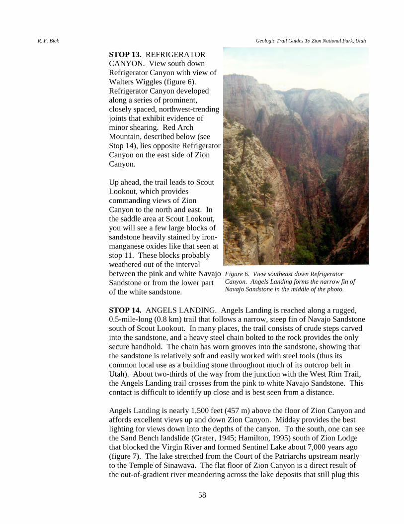
R. F. Biek Geologic Trail Guides To Zion National Park, Utah
58
STOP 13. REFRIGERATOR CANYON. View south down Refrigerator Canyon with view of Walters Wiggles (figure 6). Refrigerator Canyon developed along a series of prominent, closely spaced, northwest-trending joints that exhibit evidence of minor shearing. Red Arch Mountain, described below (see Stop 14), lies opposite Refrigerator Canyon on the east side of Zion Canyon.
Up ahead, the trail leads to Scout
Lookout, which provides commanding views of Zion Canyon to the north and east. In the saddle area at Scout Lookout, you will see a few large blocks of sandstone heavily stained by iron-manganese oxides like that seen at stop 11. These blocks probably weathered out of the interval between the pink and white Navajo Sandstone or from the lower part of the white sandstone.
STOP 14. ANGELS LANDING. Angels Landing is reached along a rugged,
0.5-mile-long (0.8 km) trail that follows a narrow, steep fin of Navajo Sandstone south of Scout Lookout. In many places, the trail consists of crude steps carved into the sandstone, and a heavy steel chain bolted to the rock provides the only secure handhold. The chain has worn grooves into the sandstone, showing that the sandstone is relatively soft and easily worked with steel tools (thus its common local use as a building stone throughout much of its outcrop belt in Utah). About two-thirds of the way from the junction with the West Rim Trail, the Angels Landing trail crosses from the pink to white Navajo Sandstone. This contact is difficult to identify up close and is best seen from a distance.
Angels Landing is nearly 1,500 feet (457 m) above the floor of Zion Canyon and
affords excellent views up and down Zion Canyon. Midday provides the best lighting for views down into the depths of the canyon. To the south, one can see the Sand Bench landslide (Grater, 1945; Hamilton, 1995) south of Zion Lodge that blocked the Virgin River and formed Sentinel Lake about 7,000 years ago (figure 7). The lake stretched from the Court of the Patriarchs upstream nearly to the Temple of Sinawava. The flat floor of Zion Canyon is a direct result of the out-of-gradient river meandering across the lake deposits that still plug this
Figure 6. View southeast down Refrigerator Canyon. Angels Landing forms the narrow fin of Navajo Sandstone in the middle of the photo.
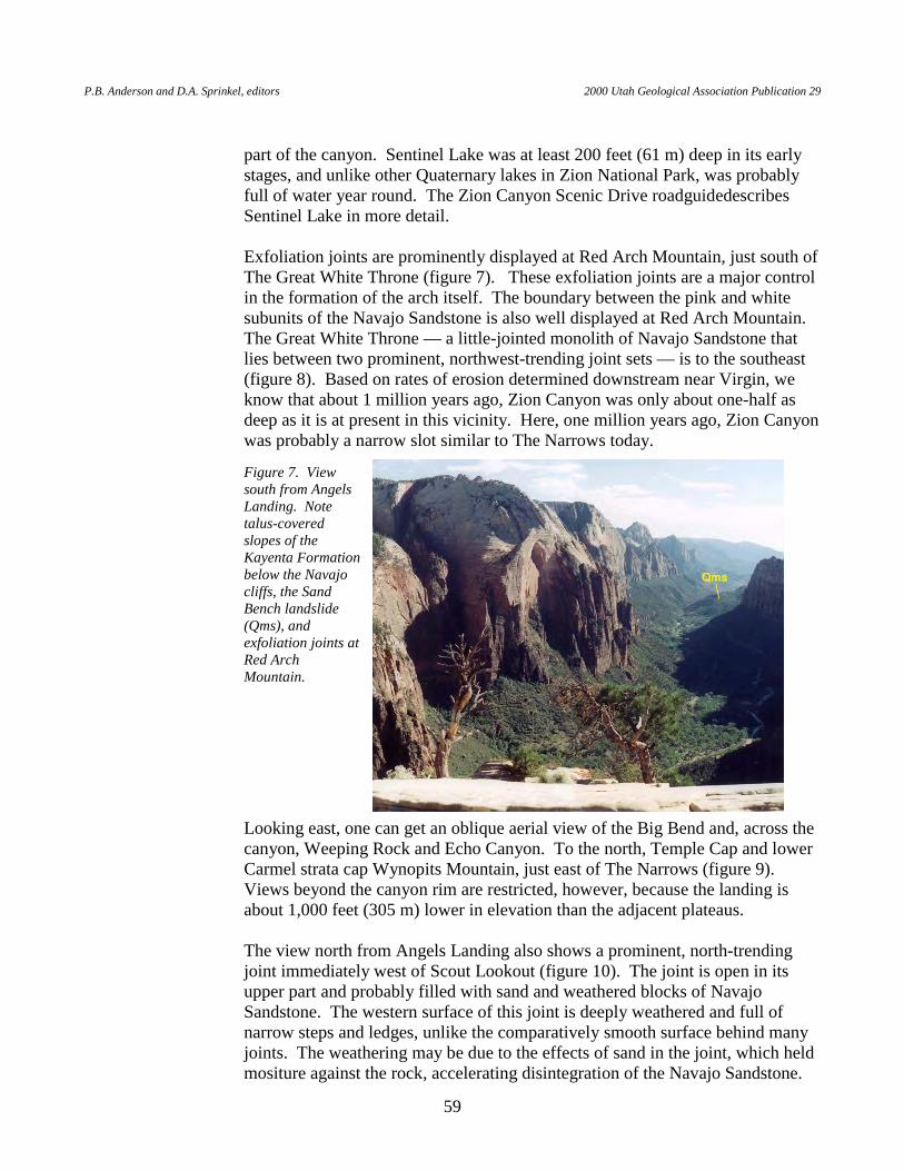
P.B. Anderson and D.A. Sprinkel, editors 2000 Utah Geological Association Publication 29
59
part of the canyon. Sentinel Lake was at least 200 feet (61 m) deep in its early stages, and unlike other Quaternary lakes in Zion National Park, was probably full of water year round. The Zion Canyon Scenic Drive roadguidedescribes Sentinel Lake in more detail.
Exfoliation joints are prominently displayed at Red Arch Mountain, just south of
The Great White Throne (figure 7). These exfoliation joints are a major control in the formation of the arch itself. The boundary between the pink and white subunits of the Navajo Sandstone is also well displayed at Red Arch Mountain. The Great White Throne — a little-jointed monolith of Navajo Sandstone that lies between two prominent, northwest-trending joint sets — is to the southeast (figure 8). Based on rates of erosion determined downstream near Virgin, we know that about 1 million years ago, Zion Canyon was only about one-half as deep as it is at present in this vicinity. Here, one million years ago, Zion Canyon was probably a narrow slot similar to The Narrows today.
Looking east, one can get an oblique aerial view of the Big Bend and, across the canyon, Weeping Rock and Echo Canyon. To the north, Temple Cap and lower Carmel strata cap Wynopits Mountain, just east of The Narrows (figure 9). Views beyond the canyon rim are restricted, however, because the landing is about 1,000 feet (305 m) lower in elevation than the adjacent plateaus.
The view north from Angels Landing also shows a prominent, north-trending
joint immediately west of Scout Lookout (figure 10). The joint is open in its upper part and probably filled with sand and weathered blocks of Navajo Sandstone. The western surface of this joint is deeply weathered and full of narrow steps and ledges, unlike the comparatively smooth surface behind many joints. The weathering may be due to the effects of sand in the joint, which held mositure against the rock, accelerating disintegration of the Navajo Sandstone.
Figure 7. View south from Angels Landing. Note talus-covered slopes of the Kayenta Formation below the Navajo cliffs, the Sand Bench landslide (Qms), and exfoliation joints at Red Arch Mountain.

R. F. Biek Geologic Trail Guides To Zion National Park, Utah
60
Figure 8. The Great White Throne as seen from Angels Landing.
Figure 9. View north from Angels Landing. Wynopits Mountain — capped by the upper and lower units of the Co-op Creek Limestone Member of the Carmel Formation (Jccu and Jccl) and the Sinawava (Jts) and White Throne (Jtw) Members of the Temple Cap Formation — is on the skyline just right of center.
Figure 10. View of joint near Scout Lookout (left). Enlargement (right) shows irregular weathered surface of joint.
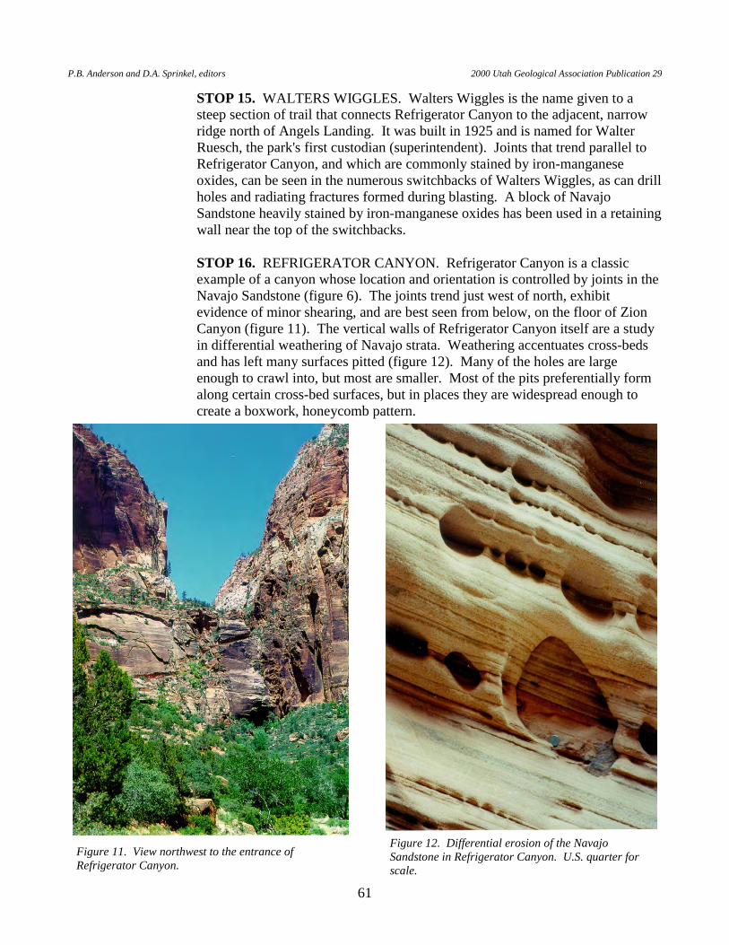
P.B. Anderson and D.A. Sprinkel, editors 2000 Utah Geological Association Publication 29
61
STOP 15. WALTERS WIGGLES. Walters Wiggles is the name given to a steep section of trail that connects Refrigerator Canyon to the adjacent, narrow ridge north of Angels Landing. It was built in 1925 and is named for Walter Ruesch, the park's first custodian (superintendent). Joints that trend parallel to Refrigerator Canyon, and which are commonly stained by iron-manganese oxides, can be seen in the numerous switchbacks of Walters Wiggles, as can drill holes and radiating fractures formed during blasting. A block of Navajo Sandstone heavily stained by iron-manganese oxides has been used in a retaining wall near the top of the switchbacks.
STOP 16. REFRIGERATOR CANYON. Refrigerator Canyon is a classic
example of a canyon whose location and orientation is controlled by joints in the Navajo Sandstone (figure 6). The joints trend just west of north, exhibit evidence of minor shearing, and are best seen from below, on the floor of Zion Canyon (figure 11). The vertical walls of Refrigerator Canyon itself are a study in differential weathering of Navajo strata. Weathering accentuates cross-beds and has left many surfaces pitted (figure 12). Many of the holes are large enough to crawl into, but most are smaller. Most of the pits preferentially form along certain cross-bed surfaces, but in places they are widespread enough to create a boxwork, honeycomb pattern.
Figure 11. View northwest to the entrance of Refrigerator Canyon.
Figure 12. Differential erosion of the Navajo Sandstone in Refrigerator Canyon. U.S. quarter for scale.
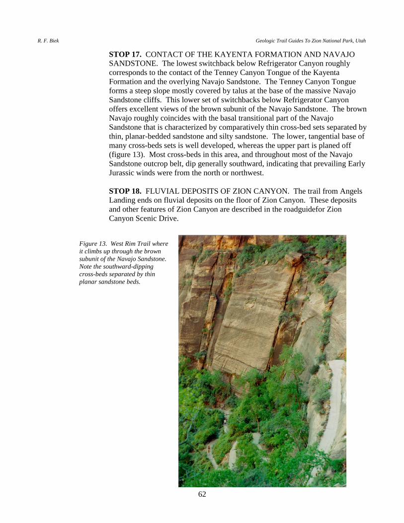
R. F. Biek Geologic Trail Guides To Zion National Park, Utah
62
STOP 17. CONTACT OF THE KAYENTA FORMATION AND NAVAJO SANDSTONE. The lowest switchback below Refrigerator Canyon roughly corresponds to the contact of the Tenney Canyon Tongue of the Kayenta Formation and the overlying Navajo Sandstone. The Tenney Canyon Tongue forms a steep slope mostly covered by talus at the base of the massive Navajo Sandstone cliffs. This lower set of switchbacks below Refrigerator Canyon offers excellent views of the brown subunit of the Navajo Sandstone. The brown Navajo roughly coincides with the basal transitional part of the Navajo Sandstone that is characterized by comparatively thin cross-bed sets separated by thin, planar-bedded sandstone and silty sandstone. The lower, tangential base of many cross-beds sets is well developed, whereas the upper part is planed off (figure 13). Most cross-beds in this area, and throughout most of the Navajo Sandstone outcrop belt, dip generally southward, indicating that prevailing Early Jurassic winds were from the north or northwest.
STOP 18. FLUVIAL DEPOSITS OF ZION CANYON. The trail from Angels
Landing ends on fluvial deposits on the floor of Zion Canyon. These deposits and other features of Zion Canyon are described in the roadguidefor Zion Canyon Scenic Drive.
Figure 13. West Rim Trail where it climbs up through the brown subunit of the Navajo Sandstone. Note the southward-dipping cross-beds separated by thin planar sandstone beds.
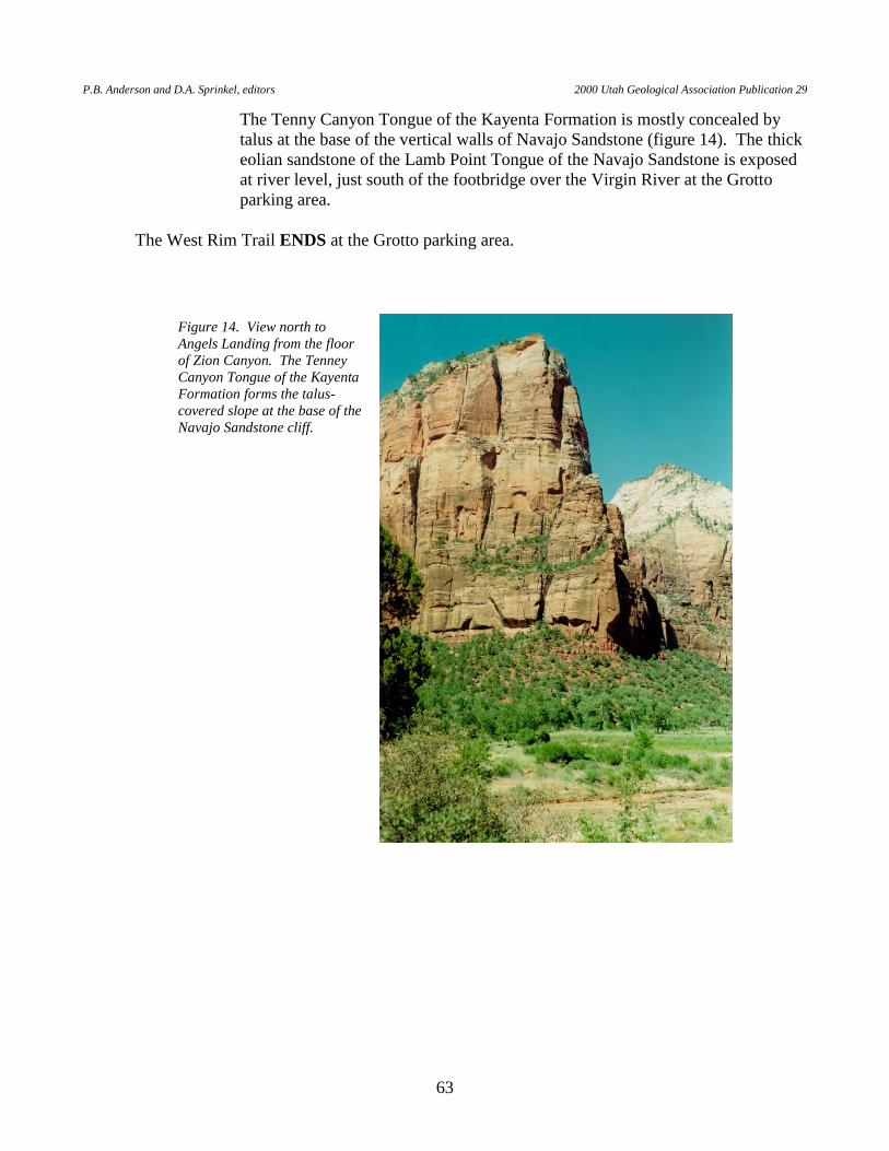
P.B. Anderson and D.A. Sprinkel, editors 2000 Utah Geological Association Publication 29
63
The Tenny Canyon Tongue of the Kayenta Formation is mostly concealed by talus at the base of the vertical walls of Navajo Sandstone (figure 14). The thick eolian sandstone of the Lamb Point Tongue of the Navajo Sandstone is exposed at river level, just south of the footbridge over the Virgin River at the Grotto parking area.
The West Rim Trail ENDS at the Grotto parking area.
Figure 14. View north to Angels Landing from the floor of Zion Canyon. The Tenney Canyon Tongue of the Kayenta Formation forms the talus-covered slope at the base of the Navajo Sandstone cliff.
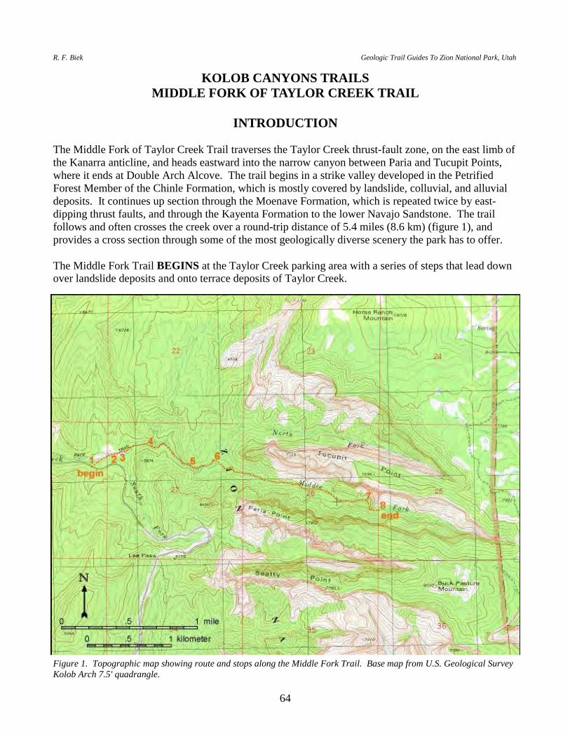
R. F. Biek Geologic Trail Guides To Zion National Park, Utah
64
KOLOB CANYONS TRAILS MIDDLE FORK OF TAYLOR CREEK TRAIL
INTRODUCTION
The Middle Fork of Taylor Creek Trail traverses the Taylor Creek thrust-fault zone, on the east limb of the Kanarra anticline, and heads eastward into the narrow canyon between Paria and Tucupit Points, where it ends at Double Arch Alcove. The trail begins in a strike valley developed in the Petrified Forest Member of the Chinle Formation, which is mostly covered by landslide, colluvial, and alluvial deposits. It continues up section through the Moenave Formation, which is repeated twice by east-dipping thrust faults, and through the Kayenta Formation to the lower Navajo Sandstone. The trail follows and often crosses the creek over a round-trip distance of 5.4 miles (8.6 km) (figure 1), and provides a cross section through some of the most geologically diverse scenery the park has to offer. The Middle Fork Trail BEGINS at the Taylor Creek parking area with a series of steps that lead down over landslide deposits and onto terrace deposits of Taylor Creek.
Figure 1. Topographic map showing route and stops along the Middle Fork Trail. Base map from U.S. Geological Survey Kolob Arch 7.5' quadrangle.
P.B. Anderson and D.A. Sprinkel, editors 2000 Utah Geological Association Publication 29
65
STOP 1. LANDSLIDE DEPOSITS. This landslide is developed in bentonitic
clays of the Petrified Forest Member of the Chinle Formation, but most of the landslide debris visible along the trail consists of blocks of sandstone from the overlying Moenave Formation. The Petrified Forest Member is notoriously susceptible to landsliding, and because it tends to swell when wet and shrink when dry, it also causes numerous building foundation problems in southwestern Utah. As you walk below the landslide, note how the river-terrace deposits contain cobbles and boulders derived from the Carmel Formation and the much younger basalt flow that caps Horse Ranch Mountain.
STOP 2. PETRIFIED FOREST MEMBER OF THE CHINLE FORMATION.
Just upstream from where the trail crosses Taylor Creek for the first time, an east-dipping, white, thick-bedded sandstone and pebbly sandstone forms a low nickpoint a few feet high in the bed of Taylor Creek. This sandstone is in the middle part of the Petrified Forest Member of the Chinle Formation, and is recognizable throughout much of the St. George basin. Uranium prospects are common in this interval to the south, along the flanks of the Virgin anticline.
STOP 3. MOENAVE FORMATION AND THE TAYLOR CREEK THRUST-
FAULT ZONE. The three-member Moenave Formation is exposed in the hillside to the north-northeast of the junction of the Middle and South Forks of Taylor Creek. The Dinosaur Canyon Member forms the base of the formation and consists predominantly of moderate-reddish-brown, ledge- and slope-forming, thin- to thick-bedded, very fine- to fine-grained silty sandstone with common ripple cross-stratification. The cliff-forming Springdale Sandstone Member forms the top of the formation and is characterized by pale-red to pale-pink, very thick-bedded, fine- to medium-grained sandstone with planar and low-angle cross-stratification, and local, channel-form intraformational pebbly conglomerates with poorly preserved, petrified and carbonized fossil plant remains. The intervening Whitmore Point Member forms lighter colored, ledgy slopes between these two members, but the member contacts are gradational and difficult to define.
Careful examination of the outcrops on the north side of the creek shows that
this distinctive, three-part sequence is repeated twice by east-dipping thrust faults. The westernmost exposures, which are in normal stratigraphic position, are due north of the junction of the South and Middle Forks of Taylor Creek; the middle exposures form a prominent, south-trending ridge just to the northeast; and the eastern exposures form the skyline to the north and northeast (figure 2). These faults are relatively small back thrusts on the east flank of the Kanarra anticline. In the Zion National Park area, the Kanarra anticline involves rocks of likely early Late Cretaceous age and we believe the fold formed during the Late Cretaceous Sevier orogeny. The formation of the Kanarra anticline is doubtless related to the Pintura anticline, a colinear fold about 8 to 10 miles (13-16 km) to the southwest. The Pintura anticline is unconformably overlain by the Canaan Peak Formation, the oldest beds of which are late Campanian (Late Cretaceous)
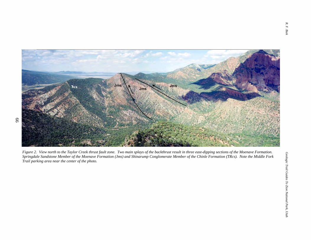
R. F. Biek Geologic Trail G
uides To Zion National Park, U
tah
66
Figure 2. View north to the Taylor Creek thrust fault zone. Two main splays of the backthrust result in three east-dipping sections of the Moenave Formation. Springdale Sandstone Member of the Moenave Formation (Jms) and Shinarump Conglomerate Member of the Chinle Formation (TRcs). Note the Middle Fork Trail parking area near the center of the photo.
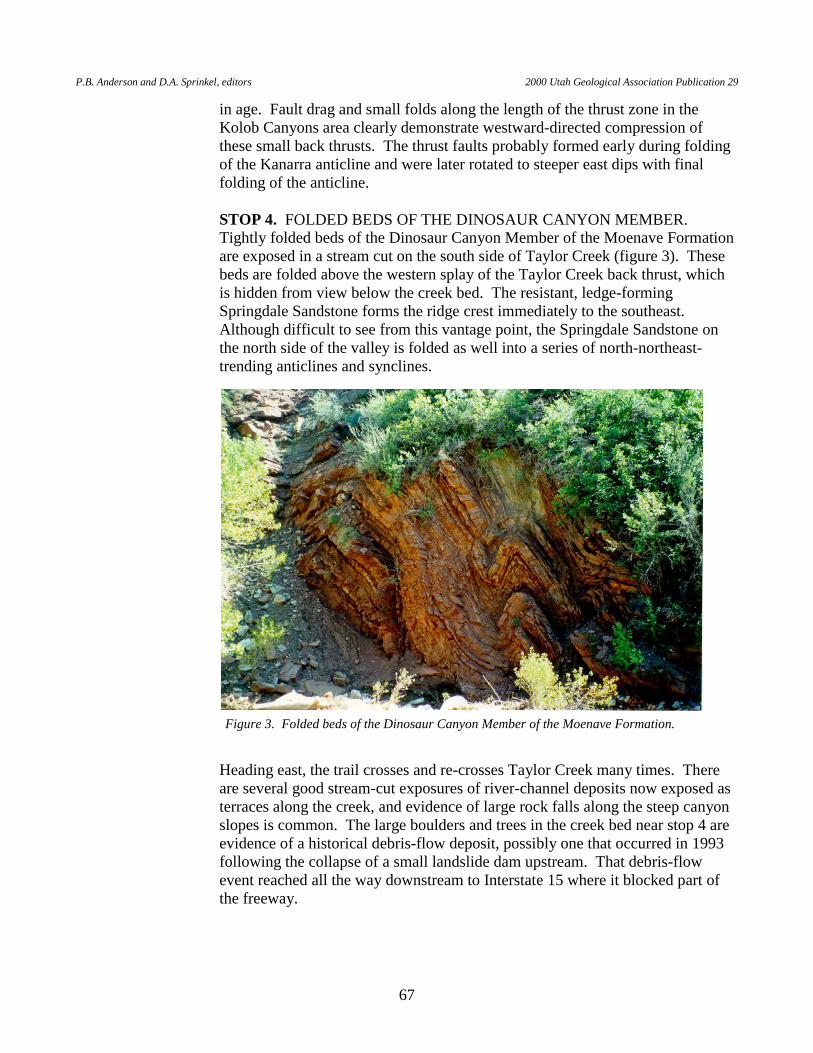
P.B. Anderson and D.A. Sprinkel, editors 2000 Utah Geological Association Publication 29
67
in age. Fault drag and small folds along the length of the thrust zone in the Kolob Canyons area clearly demonstrate westward-directed compression of these small back thrusts. The thrust faults probably formed early during folding of the Kanarra anticline and were later rotated to steeper east dips with final folding of the anticline.
STOP 4. FOLDED BEDS OF THE DINOSAUR CANYON MEMBER.
Tightly folded beds of the Dinosaur Canyon Member of the Moenave Formation are exposed in a stream cut on the south side of Taylor Creek (figure 3). These beds are folded above the western splay of the Taylor Creek back thrust, which is hidden from view below the creek bed. The resistant, ledge-forming Springdale Sandstone forms the ridge crest immediately to the southeast. Although difficult to see from this vantage point, the Springdale Sandstone on the north side of the valley is folded as well into a series of north-northeast-trending anticlines and synclines.
Heading east, the trail crosses and re-crosses Taylor Creek many times. There are several good stream-cut exposures of river-channel deposits now exposed as terraces along the creek, and evidence of large rock falls along the steep canyon slopes is common. The large boulders and trees in the creek bed near stop 4 are evidence of a historical debris-flow deposit, possibly one that occurred in 1993 following the collapse of a small landslide dam upstream. That debris-flow event reached all the way downstream to Interstate 15 where it blocked part of the freeway.
Figure 3. Folded beds of the Dinosaur Canyon Member of the Moenave Formation.
R. F. Biek Geologic Trail Guides To Zion National Park, Utah
68
STOP 5. SPRINGDALE SANDSTONE AND ALLUVIAL DEPOSITS OF TAYLOR CREEK. The Springdale Sandstone, once again repeated by the Taylor Creek thrust fault, dips eastward down to the creek bed where it forms a narrow gap at the bottom of the canyon. This is the easternmost thrust block of Moenave strata. The trail cuts under an overhang of Springdale Sandstone on the north side of the creek. Eastward, the trail cuts up through poorly exposed sandstone and siltstone of the Kayenta Formation, which is mostly covered by a veneer of talus and colluvium.
As you approach the junction of the Middle and North Forks of Taylor Creek,
note the gray limestone of the lower Carmel Formation (Co-op Creek Limestone Member) exposed at Horse Ranch Mountain to the northeast. Although not visible from here, about 100 feet (30 m) of middle Cretaceous strata overlie Carmel beds at Horse Ranch Mountain (Hamilton, 1987, 1995). Horse Ranch Mountain, the highest point in Zion National Park, is capped by a basalt flow. This flow has not yet been dated, but is likely greater than 1 million years old based on comparison with other dated flows in the area. Large basalt boulders eroded from Horse Ranch Mountain are common in the North Fork drainage and downstream along the main stem of Taylor Creek, but they are absent along the Middle Fork drainage (rare, small basalt cobbles are found in the Middle Fork drainage, however). Although it lacks large basalt clasts, the Middle Fork Creek contains abundant limestone clasts derived from the lower Carmel Formation. Many of these cobbles and boulders contain fossils, including bivalves and star-shaped Pentacrinus sp. crinoid columnals.
STOP 6. MIDDLE FORK CANYON. The view to the south shows the contact
of the Kayenta Formation and overlying Navajo Sandstone in the cliffs below Paria Point. This contact is conformable and gradational and records the transition from distal fluvial, to sabkha, to sand-desert depositional environments (Tuesink, 1989; Sansom, 1992).
Gustav Larson homesteaded here from 1930 to 1933, raising pigs, before this
area became part of the National Park System. Immediately east of the Larson cabin, the canyon narrows considerably between Paria and Tucupit Points, and the slopes below the sheer walls of Navajo Sandstone are mostly covered by talus. Because of this talus cover, it is difficult to tell exactly where you cross the contact between the Kayenta Formation and Navajo Sandstone as you walk east up the canyon. Still, one can see that eastward dips of the planar beds in the Kayenta and lower Navajo flatten toward the east, away from the east flank of the Kanarra anticline.
STOP 7. MIDDLE FORK LAKE DEPOSITS. A small exposure of lake
deposits is present in a stream cut on the north side of the creek. These thin, fine-grained sand and clayey silt beds are typical of sediments deposited in small lakes formed when channels are blocked by landslides or lava flows. They accumulated upstream from a small landslide, now removed by erosion, that once blocked the Middle Fork drainage. The lake deposits have not been dated,
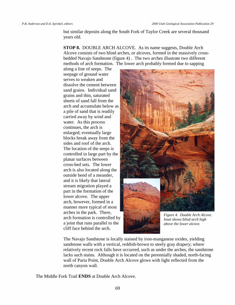
P.B. Anderson and D.A. Sprinkel, editors 2000 Utah Geological Association Publication 29
69
but similar deposits along the South Fork of Taylor Creek are several thousand years old.
STOP 8. DOUBLE ARCH ALCOVE. As its name suggests, Double Arch
Alcove consists of two blind arches, or alcoves, formed in the massively cross-bedded Navajo Sandstone (figure 4) . The two arches illustrate two different methods of arch formation. The lower arch probably formed due to sapping along a line of seeps. The seepage of ground water serves to weaken and dissolve the cement between sand grains. Individual sand grains and thin, saturated sheets of sand fall from the arch and accumulate below as a pile of sand that is readily carried away by wind and water. As this process continues, the arch is enlarged; eventually large blocks break away from the sides and roof of the arch. The location of the seeps is controlled in large part by the planar surfaces between cross-bed sets. The lower arch is also located along the outside bend of a meander, and it is likely that lateral stream migration played a part in the formation of the lower alcove. The upper arch, however, formed in a manner more typical of most arches in the park. There, arch formation is controlled by a joint that runs parallel to the cliff face behind the arch.
The Navajo Sandstone is locally stained by iron-manganese oxides, yielding
sandstone walls with a vertical, reddish-brown to steely gray drapery; where relatively recent rock falls have occurred, such as under the arches, the sandstone lacks such stains. Although it is located on the perennially shaded, north-facing wall of Paria Point, Double Arch Alcove glows with light reflected from the north canyon wall.
The Middle Fork Trail ENDS at Double Arch Alcove.
Figure 4. Double Arch Alcove. Inset shows blind arch high above the lower alcove.
R. F. Biek Geologic Trail Guides To Zion National Park, Utah
70
TIMBER CREEK OVERLOOK TRAIL
INTRODUCTION The Timber Creek Overlook Trail heads south over the three members of the Moenave Formation for 0.5 mile (0.8 km) to a hilltop that provides excellent views to the east, south, and west (figure 1). The trail BEGINS in colluvial deposits that overlie east-dipping, thin-bedded, fine-grained, reddish-brown sandstone of the Dinosaur Canyon Member of the Moenave Formation. About halfway to the overlook, the trail crosses the gradational contact with the Whitmore Point Member, which is noted for its lighter and multi-colored mudstone and siltstone. The trail finally crosses onto the east-dipping, very thick-bedded, rounded weathering, white, fine- to medium-grained sandstone of the Springdale Sandstone. The trail remains on east-dipping Springdale strata to the overlook. STOP 1. TIMBER CREEK OVERLOOK. From the overlook, one gains
excellent views east to the Finger Canyons of the Kolob (figure 2). The Finger Canyons are so named for the fins of Navajo Sandstone that extend west from the Upper Kolob Plateau. These canyons developed along west-trending joints in the Navajo Sandstone, in many cases leaving behind spectacular examples of hanging valleys. These are not true hanging valleys in the classic sense of the term — that is, they were not carved by glacial ice — but rather they reflect differential stream erosion along the main drainage (Timber Creek) and its smaller tributaries. The gradational, conformable contact between the Kayenta Formation and overlying Navajo Sandstone is well exposed on Shuntavi Butte (figure 3). It corresponds to the base of a thick, white sandstone ledge at the base of the massive cliffs of Navajo Sandstone. Note that the upper Kayenta includes several thick sandstone beds, but also has shale and mudstone interbeds, which are lacking in Navajo strata.
The view south includes the broad, flat surface of Smith Mesa, which is upheld
by the resistant Springdale Sandstone Member of the Moenave Formation. The north end of Black Ridge, capped by up to 200 feet (61 m) of basalt, is visible to the southwest, and just north of that is Pace Knoll, an outlier of Black Ridge. The Black Ridge flow is about 850,000 years old and is believed to have issued from a vent or vents to the southwest near Pintura (Lund and Everitt, 1998). Through the gap between Pace Knoll and the northern end of Black Ridge, one can look down the axis of the Virgin anticline, beyond which lie the Virgin Mountains of northwestern Arizona.
The trail ENDS at Timber Creek Overlook.
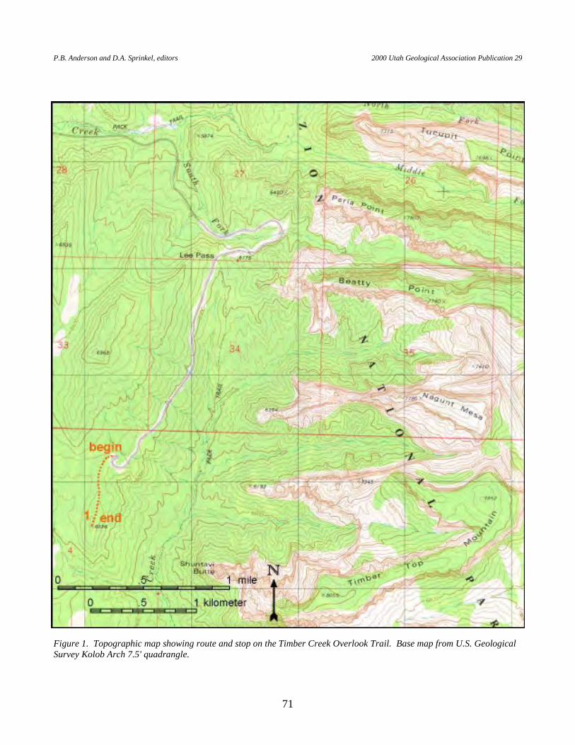
P.B. Anderson and D.A. Sprinkel, editors 2000 Utah Geological Association Publication 29
71
Figure 1. Topographic map showing route and stop on the Timber Creek Overlook Trail. Base map from U.S. Geological Survey Kolob Arch 7.5' quadrangle.
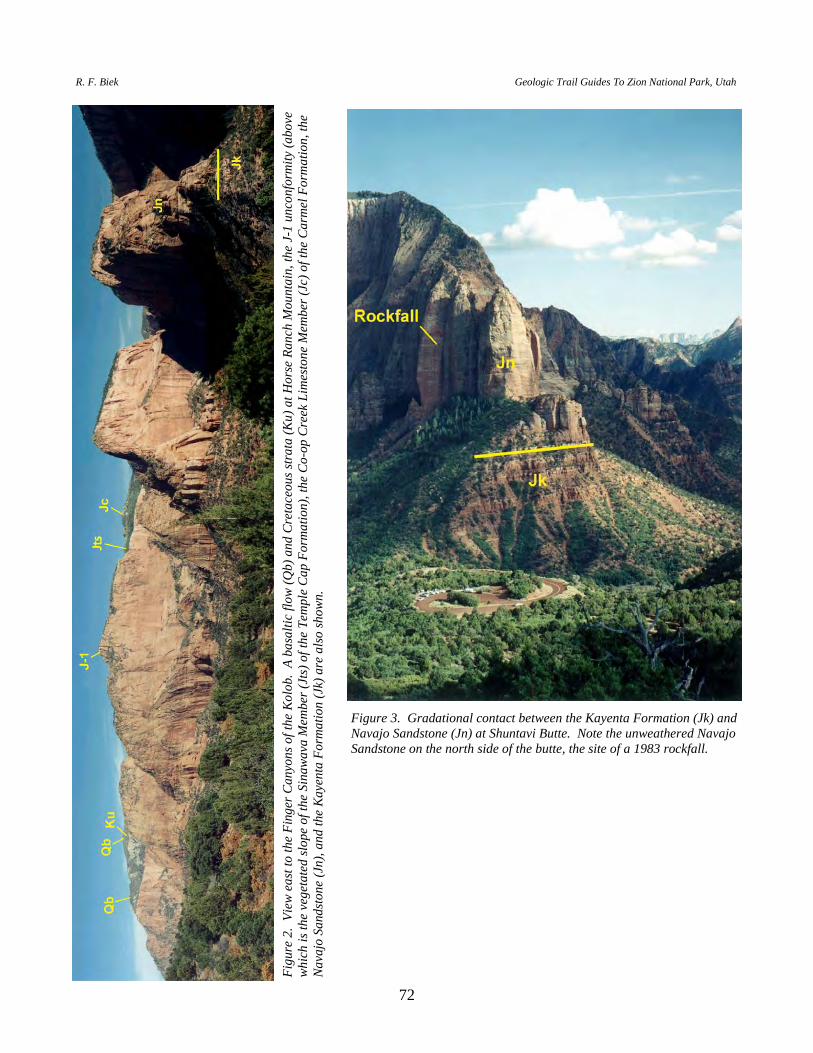
R. F. Biek Geologic Trail Guides To Zion National Park, Utah
72
Figu
re 2
. Vi
ew e
ast t
o th
e Fi
nger
Can
yons
of t
he K
olob
. A
basa
ltic
flow
(Qb)
and
Cre
tace
ous s
trata
(Ku)
at H
orse
Ran
ch M
ount
ain,
the
J-1
unco
nfor
mity
(abo
ve
whic
h is
the
vege
tate
d slo
pe o
f the
Sin
awav
a M
embe
r (Jt
s) o
f the
Tem
ple
Cap
Form
atio
n), t
he C
o-op
Cre
ek L
imes
tone
Mem
ber (
Jc) o
f the
Car
mel
For
mat
ion,
the
Nava
jo S
ands
tone
(Jn)
, and
the
Kaye
nta
Form
atio
n (J
k) a
re a
lso sh
own.
Figure 3. Gradational contact between the Kayenta Formation (Jk) and Navajo Sandstone (Jn) at Shuntavi Butte. Note the unweathered Navajo Sandstone on the north side of the butte, the site of a 1983 rockfall.
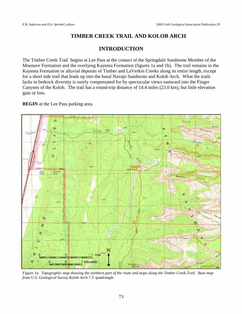
P.B. Anderson and D.A. Sprinkel, editors 2000 Utah Geological Association Publication 29
73
TIMBER CREEK TRAIL AND KOLOB ARCH
INTRODUCTION The Timber Creek Trail begins at Lee Pass at the contact of the Springdale Sandstone Member of the Moenave Formation and the overlying Kayenta Formation (figures 1a and 1b). The trail remains in the Kayenta Formation or alluvial deposits of Timber and LaVerkin Creeks along its entire length, except for a short side trail that leads up into the basal Navajo Sandstone and Kolob Arch. What the trails lacks in bedrock diversity is surely compensated for by spectacular views eastward into the Finger Canyons of the Kolob. The trail has a round-trip distance of 14.4 miles (23.0 km), but little elevation gain or loss. BEGIN at the Lee Pass parking area.
Figure 1a. Topographic map showing the northern part of the route and stops along the Timber Creek Trail. Base map from U.S. Geological Survey Kolob Arch 7.5' quadrangle.
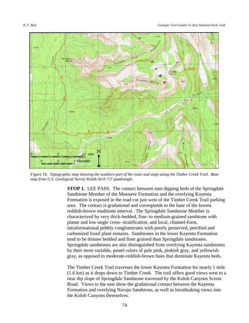
R. F. Biek Geologic Trail Guides To Zion National Park, Utah
74
STOP 1. LEE PASS. The contact between east-dipping beds of the Springdale Sandstone Member of the Moenave Formation and the overlying Kayenta Formation is exposed in the road cut just west of the Timber Creek Trail parking area. The contact is gradational and corresponds to the base of the lowest reddish-brown mudstone interval. The Springdale Sandstone Member is characterized by very thick-bedded, fine- to medium-grained sandstone with planar and low-angle cross- stratification, and local, channel-form, intraformational pebbly conglomerates with poorly preserved, petrified and carbonized fossil plant remains. Sandstones in the lower Kayenta Formation tend to be thinner bedded and finer grained than Springdale sandstones. Springdale sandstones are also distinguished from overlying Kayenta sandstones by their more variable, pastel colors of pale pink, pinkish gray, and yellowish gray, as opposed to moderate-reddish-brown hues that dominate Kayenta beds.
The Timber Creek Trail traverses the lower Kayenta Formation for nearly 1 mile
(1.6 km) as it drops down to Timber Creek. The trail offers good views west to a near dip slope of Springdale Sandstone traversed by the Kolob Canyons Scenic Road. Views to the east show the gradational contact between the Kayenta Formation and overlying Navajo Sandstone, as well as breathtaking views into the Kolob Canyons themselves.
Figure 1b. Topographic map showing the southern part of the route and stops along the Timber Creek Trail. Base map from U.S. Geological Survey Kolob Arch 7.5' quadrangle.
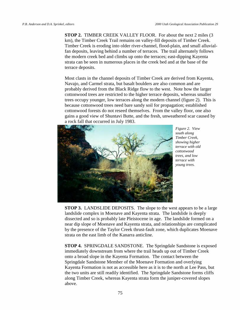
P.B. Anderson and D.A. Sprinkel, editors 2000 Utah Geological Association Publication 29
75
STOP 2. TIMBER CREEK VALLEY FLOOR. For about the next 2 miles (3 km), the Timber Creek Trail remains on valley-fill deposits of Timber Creek. Timber Creek is eroding into older river-channel, flood-plain, and small alluvial-fan deposits, leaving behind a number of terraces. The trail alternately follows the modern creek bed and climbs up onto the terraces; east-dipping Kayenta strata can be seen in numerous places in the creek bed and at the base of the terrace deposits.
Most clasts in the channel deposits of Timber Creek are derived from Kayenta,
Navajo, and Carmel strata, but basalt boulders are also common and are probably derived from the Black Ridge flow to the west. Note how the larger cottonwood trees are restricted to the higher terrace deposits, whereas smaller trees occupy younger, low terraces along the modern channel (figure 2). This is because cottonwood trees need bare sandy soil for propagation; established cottonwood forests do not reseed themselves. From the valley floor, one also gains a good view of Shuntavi Butte, and the fresh, unweathered scar caused by a rock fall that occurred in July 1983.
STOP 3. LANDSLIDE DEPOSITS. The slope to the west appears to be a large landslide complex in Moenave and Kayenta strata. The landslide is deeply dissected and so is probably late Pleistocene in age. The landslide formed on a near dip slope of Moenave and Kayenta strata, and relationships are complicated by the presence of the Taylor Creek thrust-fault zone, which duplicates Moenave strata on the east limb of the Kanarra anticline.
STOP 4. SPRINGDALE SANDSTONE. The Springdale Sandstone is exposed
immediately downstream from where the trail heads up out of Timber Creek onto a broad slope in the Kayenta Formation. The contact between the Springdale Sandstone Member of the Moenave Formation and overlying Kayenta Formation is not as accessible here as it is to the north at Lee Pass, but the two units are still readily identified. The Springdale Sandstone forms cliffs along Timber Creek, whereas Kayenta strata form the juniper-covered slopes above.
Figure 2. View south along Timber Creek, showing higher terrace with old cottonwood trees, and low terrace with young trees.
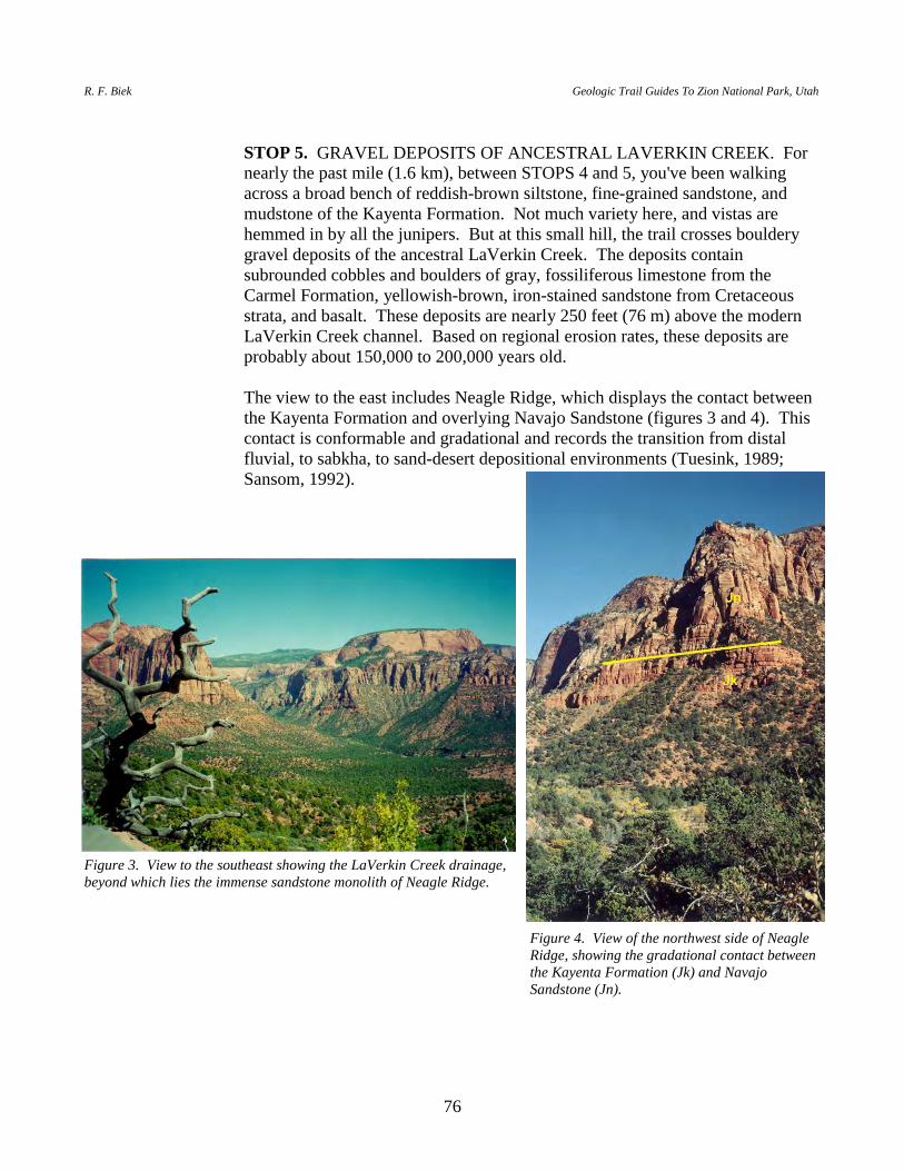
R. F. Biek Geologic Trail Guides To Zion National Park, Utah
76
STOP 5. GRAVEL DEPOSITS OF ANCESTRAL LAVERKIN CREEK. For
nearly the past mile (1.6 km), between STOPS 4 and 5, you've been walking across a broad bench of reddish-brown siltstone, fine-grained sandstone, and mudstone of the Kayenta Formation. Not much variety here, and vistas are hemmed in by all the junipers. But at this small hill, the trail crosses bouldery gravel deposits of the ancestral LaVerkin Creek. The deposits contain subrounded cobbles and boulders of gray, fossiliferous limestone from the Carmel Formation, yellowish-brown, iron-stained sandstone from Cretaceous strata, and basalt. These deposits are nearly 250 feet (76 m) above the modern LaVerkin Creek channel. Based on regional erosion rates, these deposits are probably about 150,000 to 200,000 years old.
The view to the east includes Neagle Ridge, which displays the contact between
the Kayenta Formation and overlying Navajo Sandstone (figures 3 and 4). This contact is conformable and gradational and records the transition from distal fluvial, to sabkha, to sand-desert depositional environments (Tuesink, 1989; Sansom, 1992).
Figure 3. View to the southeast showing the LaVerkin Creek drainage, beyond which lies the immense sandstone monolith of Neagle Ridge.
Figure 4. View of the northwest side of Neagle Ridge, showing the gradational contact between the Kayenta Formation (Jk) and Navajo Sandstone (Jn).
P.B. Anderson and D.A. Sprinkel, editors 2000 Utah Geological Association Publication 29
77
STOP 6. FALLS ON LAVERKIN CREEK. A series of low falls, each less than about 5 feet (1.5 m) high, characterize LaVerkin Creek where it traverses the Springdale Sandstone. The falls are located just downstream from where the trail drops down off the Kayenta Formation and onto alluvial deposits of the modern LaVerkin Creek. As you head east up LaVerkin Creek, note the evidence of past flash floods — for example, wood and other debris caught and wrapped around trees on the banks of the creek.
STOP 7. HOP VALLEY LANDSLIDE. The Hop Valley landslide blocks the
mouth of Hop Valley. Based on radiocarbon ages obtained from Hop Valley Lake deposits preserved upstream from the dam, the landslide occurred sometime prior to 2,640 + 60 yr B.P. (UGS unpublished data). The landslide involves upper Kayenta and lower Navajo strata, and broke away along a series of joints that trend northwest, parallel to Hop Valley. The landslide may have also dammed LaVerkin Creek, but we've found no evidence of lake deposits preserved upstream from the dam on LaVerkin Creek.
STOP 8. KOLOB ARCH. A 0.5-mile-long (0.8 km) trail leads from LaVerkin
Creek to the Kolob Arch viewpoint. Kolob Arch — with a span of 310 feet (94.5 m), a window height of 330 feet (101 m), and a thickness of 80 feet (24 m) — is billed as the world's longest natural arch (Blake, 1984). Because the arch is located on an east-facing vertical wall, the best time to view the arch is in the morning. One cannot see the sky through the arch from the viewpoint, however, and a sign requests that hikers proceed no farther to protect the vegetation.
Kolob Arch formed in the middle of the Navajo Sandstone along widely spaced
joints that trend parallel to the East Cougar Mountain fault. The arch lies on the south side of a hanging valley between Gregory Butte and Timber Top Mountain, 1,200 feet (366 m) above the viewpoint, and is inaccessible to all but the most experienced technical rock climbers.
The trail ENDS at the Kolob Arch viewpoint.
R. F. Biek Geologic Trail Guides To Zion National Park, Utah
78
HOP VALLEY TRAIL
INTRODUCTION The Hop Valley Trail traverses the Lower Kolob Plateau, then drops down into the narrow, vertical-walled canyon of Hop Valley (figures 1a and 1b). The Lower Kolob Plateau in this area is underlain by basalt flows that originated at Firepit and Spendlove Knolls, two cinder cones to the northeast and southeast of the trailhead. Hop Valley formed along the northern end of the East Cougar Mountain fault. The valley is partly filled with lake sediments deposited when a large landslide dammed the outlet of Hop Valley. The Hop Valley Trail also provides access to Kolob Arch, a round trip distance of 14.4 miles (23 km). However, one need only hike about 3 miles (5 km) to drop down into the splendid, isolated Hop Valley to observe deposits and landforms associated with Hop Valley Lake. BEGIN at the Hop Valley parking area, near Spendlove and Firepit Knolls, off the Kolob Road. Walk north along the Hop Valley Trail about 0.5 mile (0.8 km) to an open area with a clear view of the Lower Kolob Plateau. STOP 1. THE LOWER KOLOB PLATEAU. The broad, open field just west-
northwest of Firepit Knoll offers good views of the Lower Kolob Plateau. Firepit and Spendlove Knolls are cinder cones that mark the principal source of the Grapevine Wash flows, which cover much of the Cave Valley and Lee Valley area. The basaltic rocks are largely covered by eolian and other unconsolidated sediments, but are exposed along the margins of the Lower Kolob Plateau and protrude in many of the nearby thickets of Gambel oak. The Grapevine Wash lavas flowed 8 miles (13 km) down Grapevine Wash and North Creek, where they now form classic inverted topography that the Kolob Road follows (see roadguidefor Kolob Road — Virgin to Lava Point). Lava from these vents also flowed north into the upper reaches of Hop Valley (see stop 3). The Grapevine Wash flows are about 250,000 years old (UGS unpublished data). Just northwest of Firepit Knoll, a flow cascaded over an escarpment of Navajo Sandstone.
The East Cougar Mountain fault trends northwest between Firepit and Spendlove
Knolls. The fault is roughly under our feet at this point, but it does not offset the basalt flows and so is hidden from view. The down-to-the-west displacement in this area is probably close to 500 feet (152 m).
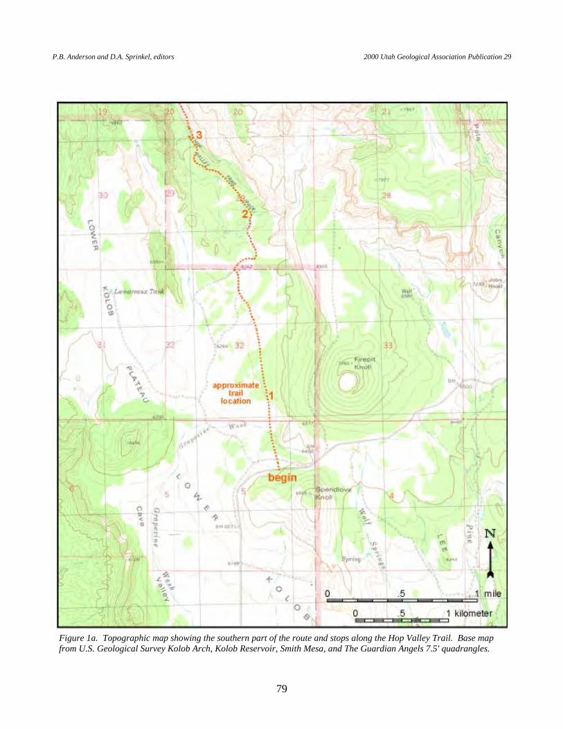
P.B. Anderson and D.A. Sprinkel, editors 2000 Utah Geological Association Publication 29
79
Figure 1a. Topographic map showing the southern part of the route and stops along the Hop Valley Trail. Base map from U.S. Geological Survey Kolob Arch, Kolob Reservoir, Smith Mesa, and The Guardian Angels 7.5' quadrangles.
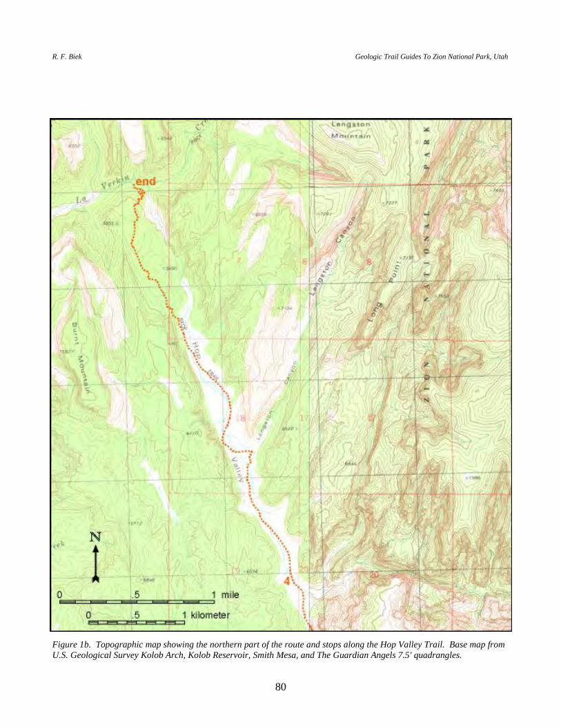
R. F. Biek Geologic Trail Guides To Zion National Park, Utah
80
Figure 1b. Topographic map showing the northern part of the route and stops along the Hop Valley Trail. Base map from U.S. Geological Survey Kolob Arch, Kolob Reservoir, Smith Mesa, and The Guardian Angels 7.5' quadrangles.

P.B. Anderson and D.A. Sprinkel, editors 2000 Utah Geological Association Publication 29
81
The boundary between the brown and pink subunits of the Navajo Sandstone skirts the base of Red Butte to the northwest, and is locally well developed in the cliffs along the east side of Hop Valley. The lower, brown Navajo roughly coincides with the basal transitional part of the Navajo Sandstone, and is characterized by fine- to medium-grained sandstone in thick, planar beds, only some of which are characterized by high-angle cross-stratification. The middle, pink Navajo, however, is known for its large, sweeping cross-beds. The lower Navajo Sandstone was deposited in a sabkha environment (Tuesink, 1989; Sansom, 1992), and represents a transition from the distal-fluvial environment of the Kayenta Formation to the sand-desert environment of the middle and upper Navajo Sandstone.
Temple Cap and Carmel strata cap the prominent cliffs about 1 mile (1.6 km)
north-northeast of Firepit Knoll. The planated top of the Navajo Sandstone, the J-1 unconformity of Pipiringos and O'Sullivan (1978), is prominently displayed there. The Sinawava Member, the lower unit of the Temple Cap Formation, forms vegetated slopes on top of the Navajo Sandstone, while the overlying White Throne Member forms cross-bedded cliffs much like the underlying Navajo Sandstone. The J-1 unconformity marks a time when the great Navajo desert was eroded prior to being inundated by rising seas, which lead to deposition of lower Temple Cap strata in sabkha and tidal-flat environments; the White Throne Member records a return to desert conditions similar to those that existed during deposition of the Navajo Sandstone (Blakey, 1994; Peterson, 1994). The top of the White Throne Member, which marks the J-2 unconformity, was also beveled flat during a period of erosion, followed by rising seas in which limestone, calcareous mudstone, and gypsum of the Carmel Formation were deposited.
STOP 2. DRAINAGE DEVELOPMENT. Older alluvial deposits of Cave
Valley consist of locally derived clasts of Navajo and Carmel strata that were probably shed from the north, before the development of the Hop Valley drainage. The deposits lack basalt clasts and so pre-date the Firepit Knoll and Spendlove Knoll flows, which are about 250,000 years old. After deposition of these older alluvial deposits, and before the eruption of the Firepit and Spendlove volcanic centers, Hop Valley eroded southward to capture part of the Cave Valley drainage. The basalt flows mimic the present topography.
STOP 3. BASALT FLOW AND EAST COUGAR MOUNTAIN FAULT. The
trail drops abruptly off the end of the Grapevine Wash basalt flow, which here forms an example of inverted topography (figure 2). The basalt flow is underlain by thin beds of volcanic cinders, with few pebbles and cobbles of Navajo Sandstone, that dip gently northward into Hop Valley (figure 3). A pebbly conglomerate with abundant Co-op Creek limestone clasts and apparently no basalt clasts lies just above these cinder deposits. The basalt flow itself locally contains sandstone xenoliths that were probably incorporated in the flow as it moved over the surface.
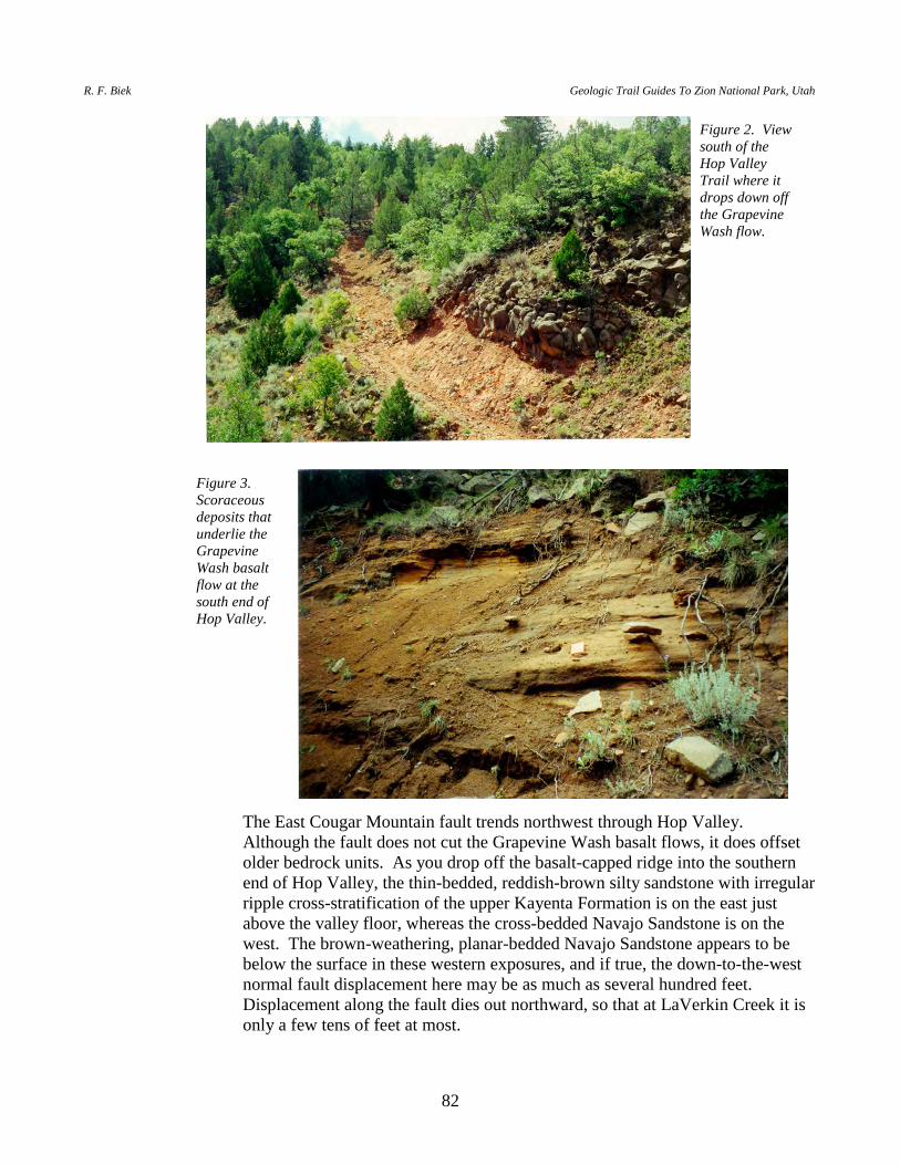
R. F. Biek Geologic Trail Guides To Zion National Park, Utah
82
The East Cougar Mountain fault trends northwest through Hop Valley. Although the fault does not cut the Grapevine Wash basalt flows, it does offset older bedrock units. As you drop off the basalt-capped ridge into the southern end of Hop Valley, the thin-bedded, reddish-brown silty sandstone with irregular ripple cross-stratification of the upper Kayenta Formation is on the east just above the valley floor, whereas the cross-bedded Navajo Sandstone is on the west. The brown-weathering, planar-bedded Navajo Sandstone appears to be below the surface in these western exposures, and if true, the down-to-the-west normal fault displacement here may be as much as several hundred feet. Displacement along the fault dies out northward, so that at LaVerkin Creek it is only a few tens of feet at most.
Figure 2. View south of the Hop Valley Trail where it drops down off the Grapevine Wash flow.
Figure 3. Scoraceous deposits that underlie the Grapevine Wash basalt flow at the south end of Hop Valley.

P.B. Anderson and D.A. Sprinkel, editors 2000 Utah Geological Association Publication 29
83
As you head north into Hop Valley, note deltaic deposits on the east side of Hop Valley. These deposits consist of well-sorted, fine- to medium-grained sand, with uncommon stringers of pebbly Co-op Creek gravel. In this area you will also see the northern two remnants of basalt on opposite sides of the East Cougar Mountain fault, just above the valley floor. The eastern remnant lies on Kayenta strata, whereas the western remnant lies on Navajo strata. The basalt remnants are at comparable elevations on either side of the fault, showing that the fault has not been active since about 250,000 years ago.
STOP 4. HOP VALLEY LAKE
DEPOSITS. Hop Valley Lake is the youngest of the large, landslide-dammed paleolakes of Zion National Park. The lake formed when a large landslide dammed the outlet to Hop Valley. The landslide broke away along a series of joints that trend northwest, parallel to Hop Valley and the East Cougar Mountain fault. The lake may have occupied the narrow, steep-walled canyon of Hop Valley as recently as several hundred years ago. The lake sediments, which form a flat valley floor that slopes gently north, are dissected by stream erosion, creating terraces about 40 feet (12 m) high at the south end of the lake and about 15 to 20 feet (5-6 m) high at the north end (figures 4 and 5). The effect is an altogether enchanting valley seldom seen by visitors to the park.
Figure 4. View north into Hop Valley from the Hop Valley Trail.
Figure 5. View east to Hop Valley Lake deposits near the south end of the valley.
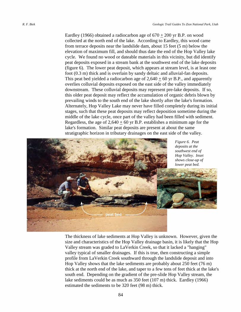
R. F. Biek Geologic Trail Guides To Zion National Park, Utah
84
Eardley (1966) obtained a radiocarbon age of 670 + 200 yr B.P. on wood collected at the north end of the lake. According to Eardley, this wood came from terrace deposits near the landslide dam, about 15 feet (5 m) below the elevation of maximum fill, and should thus date the end of the Hop Valley lake cycle. We found no wood or dateable materials in this vicinity, but did identify peat deposits exposed in a stream bank at the southwest end of the lake deposits (figure 6). The lower peat deposit, which appears at stream level, is at least one foot (0.3 m) thick and is overlain by sandy deltaic and alluvial-fan deposits. This peat bed yielded a radiocarbon age of 2,640 + 60 yr B.P., and apparently overlies colluvial deposits exposed on the east side of the valley immediately downstream. These colluvial deposits may represent pre-lake deposits. If so, this older peat deposit may reflect the accumulation of organic debris blown by prevailing winds to the south end of the lake shortly after the lake's formation. Alternately, Hop Valley Lake may never have filled completely during its initial stages, such that these peat deposits may reflect deposition sometime during the middle of the lake cycle, once part of the valley had been filled with sediment. Regardless, the age of 2,640 + 60 yr B.P. establishes a minimum age for the lake's formation. Similar peat deposits are present at about the same stratigraphic horizon in tributary drainages on the east side of the valley.
The thickness of lake sediments at Hop Valley is unknown. However, given the size and characteristics of the Hop Valley drainage basin, it is likely that the Hop Valley stream was graded to LaVerkin Creek, so that it lacked a "hanging" valley typical of smaller drainages. If this is true, then constructing a simple profile from LaVerkin Creek southward through the landslide deposit and into Hop Valley shows that the lake sediments are probably about 250 feet (76 m) thick at the north end of the lake, and taper to a few tens of feet thick at the lake's south end. Depending on the gradient of the pre-slide Hop Valley stream, the lake sediments could be as much as 350 feet (107 m) thick. Eardley (1966) estimated the sediments to be 320 feet (98 m) thick.
Figure 6. Peat deposits at the southwest end of Hop Valley. Inset shows close-up of lower peat bed.
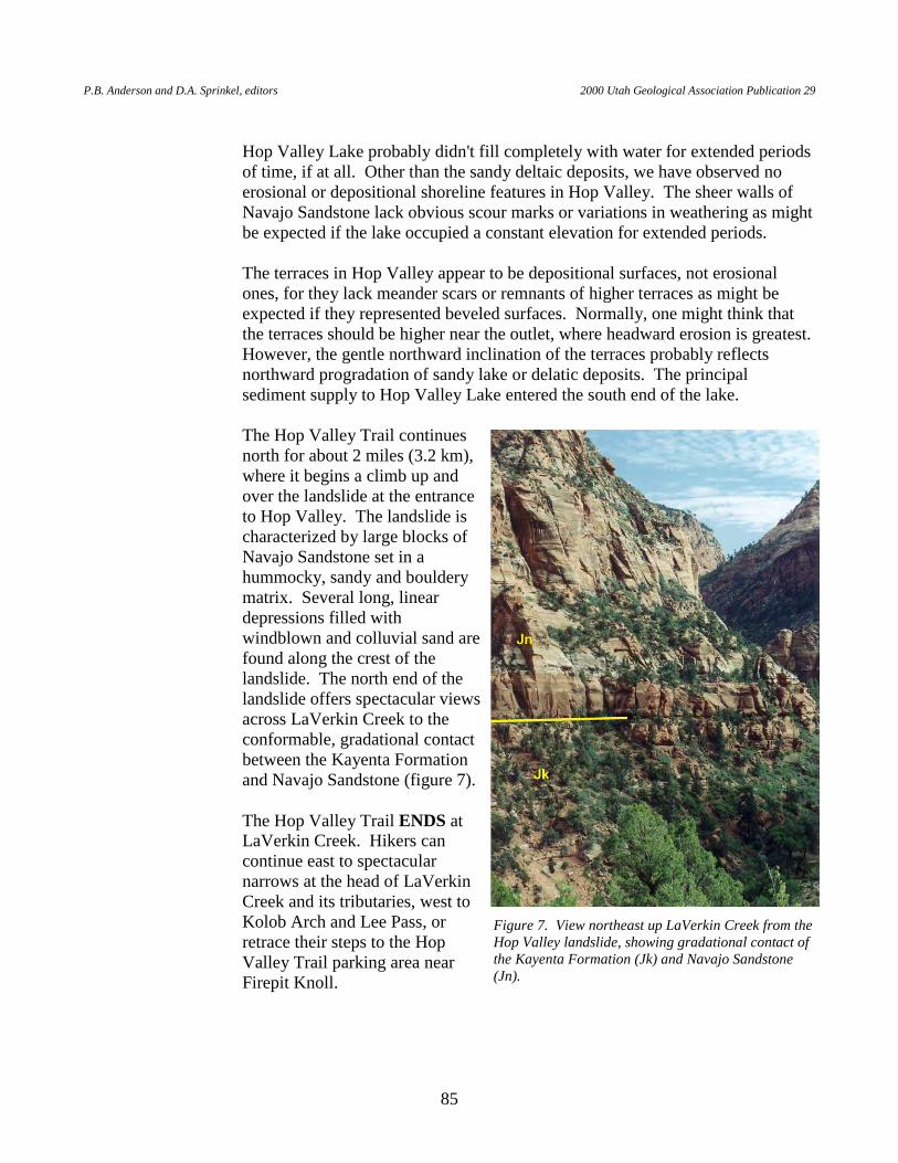
P.B. Anderson and D.A. Sprinkel, editors 2000 Utah Geological Association Publication 29
85
Hop Valley Lake probably didn't fill completely with water for extended periods
of time, if at all. Other than the sandy deltaic deposits, we have observed no erosional or depositional shoreline features in Hop Valley. The sheer walls of Navajo Sandstone lack obvious scour marks or variations in weathering as might be expected if the lake occupied a constant elevation for extended periods.
The terraces in Hop Valley appear to be depositional surfaces, not erosional
ones, for they lack meander scars or remnants of higher terraces as might be expected if they represented beveled surfaces. Normally, one might think that the terraces should be higher near the outlet, where headward erosion is greatest. However, the gentle northward inclination of the terraces probably reflects northward progradation of sandy lake or delatic deposits. The principal sediment supply to Hop Valley Lake entered the south end of the lake.
The Hop Valley Trail continues
north for about 2 miles (3.2 km), where it begins a climb up and over the landslide at the entrance to Hop Valley. The landslide is characterized by large blocks of Navajo Sandstone set in a hummocky, sandy and bouldery matrix. Several long, linear depressions filled with windblown and colluvial sand are found along the crest of the landslide. The north end of the landslide offers spectacular views across LaVerkin Creek to the conformable, gradational contact between the Kayenta Formation and Navajo Sandstone (figure 7).
The Hop Valley Trail ENDS at
LaVerkin Creek. Hikers can continue east to spectacular narrows at the head of LaVerkin Creek and its tributaries, west to Kolob Arch and Lee Pass, or retrace their steps to the Hop Valley Trail parking area near Firepit Knoll.
Figure 7. View northeast up LaVerkin Creek from the Hop Valley landslide, showing gradational contact of the Kayenta Formation (Jk) and Navajo Sandstone (Jn).
R. F. Biek Geologic Trail Guides To Zion National Park, Utah
86
ACKNOWLEDGMENTS Untold numbers of geologists have studied the rocks, sediments, and landforms of Zion National Park, and the geology outlined here draws heavily on their collective efforts. Some of these reports are cited in the road and trail guides and are referenced below, while a more complete list of references is available in Geology of Zion National Park, Utah, the companion report to these guides (Biek and others, 2000). A still more comprehensive list of references will be available in our reports (in progress) that accompany geologic maps of the Clear Creek Mountain, Cogswell Point, Kolob Arch, Kolob Reservoir, Springdale East, Springdale West, Temple of Sinawava, and The Guardian Angels 7.5' quadrangles in which the park lies. Funding for recent geologic mapping in the park by the authors was provided by the Utah Geological Survey (UGS) and a grant from the National Park Service. The UGS graciously allowed the authors the opportunity to pull together this recent work in the form of a paper and road and trail guides. Once again, Jim Parker (UGS) turned our crude drawings into superb illustrations; Pat Speranza created the trail and road maps . We thank Michael D. Stevens (University of Utah) and Brien K. Park (Utah State University), undergraduate student interns sponsored by the American Association of State Geologists, for their help with geologic guides of Kolob Road and West Rim Trail. We appreciate the assistance of Laird Naylor (formerly with the National Park Service [NPS] and now Bureau of Land Management) and Dave Sharrow (NPS) during this project.
REFERENCES (This list of references includes these cited in both the trail and road guides.)
Agenbroad, L.D., Mead, J.I., and Anderson, R.S., 1993, Quaternary paleoenvironmental studies of the
Colorado Plateau, year II: Flagstaff, Northern Arizona University, unpublished report for National Park Service contract RMR-R91-0176.
am Ende, B.A., 1991, Depositional environments, palynology, and age of the Dakota Formation, south-
central Utah, in Nations, J.D., and Eaton, J.G., editors, Stratigraphy, depositional environments, and sedimentary tectonics of the western margin, Cretaceous Western Interior Seaway: Geological Society of America Special Paper 260, p. 65-83.
Anderson, R.E., and Mehnert, H.H., 1979, Reinterpretation of the history of the Hurricane fault in
Utah, in Newman, G.W., and Goode, H.D., editors, 1979 Basin and Range Symposium: Rocky Mountain Association of Geologists, p. 145-165.
Anderson, R.E., and Christenson, G.E., 1989, Quaternary faults, folds, and selected volcanic features in
the Cedar City 10 x 20 quadrangle, Utah: Utah Geological and Mineral Survey Miscellaneous Publication 89-6, 29 p., scale 1:250,000.
Beroni, E.P., McKeown, F.A., Stugard, Jr., F., and Gott, G.B., 1953, Uranium deposits of the Bulloch
group of claims, Kane County, Utah : U.S. Geological Survey Circular 239, 9 p.
P.B. Anderson and D.A. Sprinkel, editors 2000 Utah Geological Association Publication 29
87
Best, M.G., McKee, E.H., and Damon, P.E., 1980, Space-time-composition patterns of late Cenozoic mafic volcanism, southwestern Utah and adjoining areas: American Journal of Science, v. 280, p. 1,035-1,050.
Biek, R.F., 1998, Interim geologic map of the Hurricane quadrangle, Washington County, Utah: Utah
Geological Survey Open-File Report 361, 161 p., scale 1:24,000. Biek, R.F., Willis, G.C., Hylland, M.D., and Doelling, H.H., 2000, Geology of Zion National Park,
Utah, in Sprinkel, D.A., Chidsey, Jr., T.C., and Anderson, P.B., editors, Geology of Utah's Parks and Monuments: Utah Geological Association Publication 28, p. 107-138.
Black, B.D., Mulvey, W.E., Lowe, M., and Solomon, B.J., 1995, Geologic effects, in Christenson,
G.E., editor, The September 2, 1992 ML 5.8 St. George earthquake, Washington County, Utah: Utah Geological Survey Circular 88, p. 2-11.
Blake, R.H., 1984, Measuring the span of the great arch at Zion National Park, Kolob section:
unpublished 16-page report on file at the Zion National Park library. Blakey, R.C., 1994, Paleogeographic and tectonic controls on some Lower and Middle Jurassic erg
deposits, Colorado Plateau, in Caputo, M.V., Peterson, J.A., and Franczyk, K.J., editors, Mesozoic systems of the Rocky Mountain region, USA: Denver, Colorado, Rocky Mountain Section of the Society for Sedimentary Geology, p. 273-298.
Cook, E.F., 1960, Geologic atlas of Utah B Washington County: Utah Geological and Mineralogical
Survey Bulletin 70, 119 p., scale 1:125,000. Davis, G.H., 1999, Structural geology of the Colorado Plateau region of southern Utah with special
emphasis on deformation bands: Geological Society of America Special Paper 342, 168 p. Doelling, H.H., and Davis, F.D., 1989, The geology of Kane County, Utah B geology, mineral
resources, geologic hazards: Utah Geological and Mineral Survey Bulletin 124, 192 p., 10 plates, scale 1:100,000.
Downing, R.F., 2000, Imaging the mantle in southwestern Utah using geochemistry and geographic
information systems: Las Vegas, University of Nevada, M.S. thesis, 128 p. Eardley, A.J., 1966, Rates of denudation in the High Plateaus of southwestern Utah: Geological Society
of America Bulletin, v. 77, p. 777-780. Grater, R.K., 1945, Landslide in Zion Canyon, Zion National Park, Utah: Journal of Geology, v. 53, no.
2, p. 116-124. Hacker, D.B., 1998, Catastrophic gravity sliding and volcanism associated with the growth of
laccoliths — examples from early Miocene hypabyssal intrusions of the Iron Springs axis magmatic province, Pine Valley Mountains, southwest Utah: Kent State University, unpublished Ph.D. dissertation, 258 p.
R. F. Biek Geologic Trail Guides To Zion National Park, Utah
88
Hamblin, W.K., 1970, Late Cenozoic basalt flows of the western Grand Canyon, in Hamblin, W.K., and Best, M.G., editors, The western Grand Canyon district: Utah Geological Society Guidebook to the Geology of Utah, no. 23, p. 21-38.
Hamilton, W.L., 1978 (revised 1987), Geological map of Zion National Park, Utah: Zion Natural
History Association, scale 1:31,680. —– 1979, Holocene and Pleistocene lakes in Zion National Park, Utah, in Linn, R.M., editor,
Proceedings of the First Conference on Scientific Research in the National Parks, 1977 New Orleans Conference, NPS-AIBS, DOI-NPS Transactions and Proceedings, ser. 5., p. 835-844.
—– undated, Quaternary ponds and lakes in Zion National Park, Utah: unpublished 42-page report on
file at the Zion National Park library. —– 1995, The sculpturing of Zion: Springdale, Utah, Zion Natural History Association, 132 p. Hereford, Richard, Jacoby, G.C., and McCord, V.A.S., 1996, Late Holocene alluvial geomorphology of
the Virgin River in the Zion National Park area, southwest Utah: Geological Society of America Special Paper 310, 41 p.
Hevly, R.H., 1979, Pollen studies of ancient lake sediments in Zion National Park, Utah, in Linn, R.M.,
editor, Proceedings of the First Conference on Scientific Research in the National Parks, v. 2, NPS-AIBS, DOI-NPS Transactions and Proceedings, ser. 5., p. 151-158.
Higgins, J.M., in preparation, Interim geologic map of The Divide quadrangle, Washington County,
Utah: Utah Geological Survey Open-File Report, scale 1:24,000. Hurlow, H.A., and Biek, R.F., in preparation, Interim geologic map of the Pintura quadrangle,
Washington County, Utah: Utah Geological Survey Open-File Report, 54 p., scale 1:24,000. Hylland, M.D., 2000, Interim geologic map of the Clear Creek Mountain quadrangle, Kane County,
Utah: Utah Geological Survey Open-File Report 371, p. 6, scale 1:24,000 Jibson, R.W., and Harp, E.L., 1995, The Springdale landslide, in Christenson, G.E., editor, The
September 2, 1992 ML 5.8 St. George earthquake, Washington County, Utah: Utah Geological Survey Circular 88, p. 21-30.
—– 1996, The Springdale, Utah landslide — an extraordinary event: Environmental & Engineering
Geoscience, v. 2, no. 2, p. 137-150. Kauffman, E.G., 1977, Geological and biological overview — Western Interior Cretaceous basin: The
Mountain Geologist, v. 14, p. 75-99. Keefer, D.K., 1984, Landslides caused by earthquakes: Geological Society of America Bulletin, v. 95,
p. 406-421.
P.B. Anderson and D.A. Sprinkel, editors 2000 Utah Geological Association Publication 29
89
Kirkland, J.I., Britt, Brooks, Burge, D.L., Carpenter, Ken, Cifelli, Richard, DeCourten, Frank, Eaton, Jeffrey, Hasiotis, Steve, and Lawton, Tim, 1997, Lower to middle Cretaceous dinosaur faunas of the central Colorado Plateau — a key to understanding 35 million years of tectonics, sedimentology, evolution and biogeography, in Link, P.K., and Kowallis, B.J., editors, Mesozoic to Recent geology of Utah: Brigham Young University Geology Studies, v. 42, pt. 2, p. 69-103.
Kirkland, J.I., Cifelli, R.L., Britt, B.B., Burge, D.L., DeCourten, F.L., Eaton, J.G., and Parrish, J.M.,
1999, Distribution of vertebrate faunas in the Cedar Mountain Formation, east-central Utah, in Gillette, D.D., editor, Vertebrate paleontology in Utah: Utah Geological Survey Miscellaneous Publication 99-1, p. 201-217.
Lund, W.R., and Everitt, B.L., 1998, Reconnaissance paleoseismic investigation of the Hurricane fault
in southwestern Utah, including the Ash Creek section and most of the Anderson Junction section, in Pearthree, P.A., Lund, W.R., Stenner, H.D., and Everitt, B.L., Paleoseismic investigations of the Hurricane fault in southwestern Utah and northwestern Arizona, Final Project Report: U.S. Geological Survey, National Earthquake Hazards Reduction Program, p. 8-48.
McKee, E.H., Blank, H.R., and Rowley, P.D., 1997, Potassium-argon ages of Tertiary igneous rocks in
the eastern Bull Valley Mountains and Pine Valley Mountains, southwestern Utah, in Maldonado, Florian, and Nealey, L.D., editors, Geologic studies in the Basin and Range-Colorado Plateau transition zone in southeastern Nevada, southwestern Utah, and northwestern Arizona, 1995: U.S. Geological Survey Bulletin 2153, p. 243-252.
Nielson, R.L., 1977, The geomorphic evolution of the Crater Hill volcanic field of Zion National Park:
Brigham Young University Geology Studies, v. 24, pt. 1, p. 55-70. —– 1981, Depositional environment of the Toroweap and Kaibab Formations of southwestern Utah:
Salt Lake City, University of Utah, Ph.D. dissertation, 495 p. —– 1991, Petrology, sedimentology and stratigraphic implications of the Rock Canyon Conglomerate,
southwestern Utah: Utah Geological Survey Miscellaneous Publication 91-7, 65 p. Nielson, R.L., and Johnson, J.L., 1979, The Timpoweap Member of the Moenkopi Formation,
Timpoweap Canyon, Utah: Utah Geology, v. 6, no. 1, p. 17-27. Peacock, D.C.P., and Sanderson, D.J., 1994, Geometry and development of relay ramps in normal fault
systems: American Association of Petroleum Geologists Bulletin, v. 78, no. 2, p. 147-165. Peterson, Fred, 1994, Sand dunes, sabkhas, streams, and shallow seas — Jurassic paleogeography in
the southern part of the Western Interior Basin, in Caputo, M.V., Peterson, J.A., and Franczyk, K.J., editors, Mesozoic systems of the Rocky Mountain region, USA: Denver, Colorado, Rocky Mountain Section of the Society for Sedimentary Geology, p. 233-272.

R. F. Biek Geologic Trail Guides To Zion National Park, Utah
90
Pipiringos, G.N., and O'Sullivan, R.B., 1978, Principal unconformities in Triassic and Jurassic rocks, western Interior United States — a preliminary survey: U.S. Geological Survey Professional Paper 1035-A, 29 p.
Sable, E.G., and Doelling, H.H., 1993, Geologic map of the Barracks quadrangle, Kane County, Utah:
Utah Geological Survey Map 147, scale 1:24,000, 11 p. pamphlet. Sanchez, Alexander, 1995, Mafic volcanism in the Colorado Plateau/Basin-and-Range transition zone,
Hurricane, Utah: Las Vegas, University of Nevada, M.S. thesis, 92 p., scale 1:52,000. Sansom, P.J., 1992, Sedimentology of the Navajo Sandstone, southern Utah, USA: Oxford, England,
Department of Earth Sciences and Wolfson College, Ph.D. dissertation, 291 p. Solomon, B.J., 1995, Geologic reconnaissance of the Zion Canyon landslide of April 12, 1995, Zion
National Park, Washington County, Utah, in Mayes, B.H., compiler, Technical reports for 1994-1995, Applied Geology Program: Utah Geological Survey Report of Investigation 228, p. 74-79.
Sorauf, J.E., and Billingsly, G.H., 1991, Members of the Toroweap and Kaibab Formations, Lower
Permian, northern Arizona and southwestern Utah: The Mountain Geologist, v. 28, no. 1, p. 9-24.
Stewart, M.E., and Taylor, W.J., 1996, Structural analysis and fault segment boundary identification
along the Hurricane fault in southwestern Utah: Journal of Structural Geology, v. 18, p. 1,017-1,029.
Stowe, Carlton, compiler, 1972, Oil and gas production in Utah to 1970: Utah Geological and Mineral
Survey Bulletin 94, 179 p. Threet, R.L., 1958, Crater Hill lava flow, Zion National Park, Utah: Geological Society of America
Bulletin, v. 69, p. 1,065-1,070. Tuesink, M.F., 1989, Depositional analysis of an eolian-fluvial environment — the intertonguing of the
Kayenta Formation and Navajo Sandstone (Jurassic) in southwestern Utah: Flagstaff, Northern Arizona University, M.S. thesis, 189 p.
Tschudy, R.H., Tschudy, B.D., and Craig, L.C., 1984, Palynological evaluation of Cedar Mountain and
Burro Canyon Formations, Colorado Plateau: U.S. Geological Survey Professional Paper 1281, 24 p., 9 plates.