Geologic Map of the Prescott National Forest and the Headwaters of ...
104
Geologic Map of the Prescott National Forest and the Headwaters of the Verde River, Yavapai and Coconino Counties, Arizona By Ed DeWitt 1 , Victoria Langenheim 1 , Eric Force 1 , R.K. Vance 2 , P.A. Lindberg 3 , and R.L. Driscoll 1 1 U.S. Geological Survey 2 Georgia Southern University, Statesboro, Ga. 3 Consulting geologist, Sedona, Ariz. Pamphlet to accompany Scientific Investigations Map 2996 U.S. Department of the Interior U.S. Geological Survey
Transcript of Geologic Map of the Prescott National Forest and the Headwaters of ...

Geologic Map of the Prescott National Forest and the Headwaters of the Verde River, Yavapai and Coconino Counties, Arizona
By Ed DeWitt1, Victoria Langenheim1, Eric Force1, R.K. Vance2, P.A. Lindberg3, and R.L. Driscoll1
1U.S. Geological Survey
2Georgia Southern University, Statesboro, Ga.
3Consulting geologist, Sedona, Ariz.
Pamphlet to accompany
Scientific Investigations Map 2996
U.S. Department of the InteriorU.S. Geological Survey

U.S. Department of the InteriorDIRK KEMPTHORNE, Secretary
U.S. Geological SurveyMark D. Myers, Director
U.S. Geological Survey, Reston, Virginia: 2008
About USGS Products
For product and ordering information: World Wide Web: http://www.usgs.gov/pubprod Telephone: 1-888-ASK-USGS
For more information on the USGS—the Federal source for science about the Earth, its natural and living resources, natural hazards, and the environment: World Wide Web: http://www.usgs.gov Telephone: 1-888-ASK-USGS
About this Product For more information concerning this publication, contact: Team Chief Scientist, USGS Central Mineral Resources Team Box 25046 Denver Federal Center MS 973 Denver, CO 80225-0046 (303) 236-1562
Or visit the Central Mineral Resources Team Web site at: http://minerals.cr.usgs.gov
This publication is available online at: http://pubs.usgs.gov/sim/2996
Publishing support provided by: Denver Publishing Service Center, Denver, Colorado Manuscript approved for publication November 1, 2007 Map jacket by Amber Hess
Suggested citation:
DeWitt, Ed, Langenheim, Victoria, Force, Eric, Vance, R.K., Lindberg, P.A., and Driscoll, R.L., 2008, Geologic map of the Prescott National Forest and the headwaters of the Verde River, Yavapai and Coconino Counties, Arizona: U.S. Geological Survey Scientific Investigations Map 2996, scale 1:100,000, 100-p. pamphlet.
Any use of trade, product, or firm names is for descriptive purposes only and does not imply endorsement by the U.S. Government.
Although this report is in the public domain, permission must be secured from the individual copyright owners to reproduce any copyrighted materials contained within this report.
ISBN 978-141132090-1

Contents
Description of Map Units ............................................................................................................................ 1Acknowledgments ..................................................................................................................................... 81References Cited ........................................................................................................................................ 81
Figures1. Index map showing extents of geologic map and boundary of Prescott National Forest ... 2
2–20. Major-element classification diagrams:2. For 4- to 6-Ma volcanic rocks north of Perkinsville ............................................................. 43. For 4- to 6-Ma volcanic rocks in northwest corner of map area ....................................... 5 4. For 4- to 6-Ma volcanic rocks near Paulden ......................................................................... 65. For 4- to 6-Ma volcanic rocks in Verde River valley and east of Sedona ......................... 7 6. For 8- to 10-Ma volcanic rocks at Hackberry Mountain and along Interstate 17 ........... 97. For 8- to 10-Ma volcanic rocks at Mt. Hope, west of map area ....................................... 108. For 8- to 10-Ma volcanic rocks west and northwest of Prescott, and from near Paulden ................................................................................................................... 119. For 10- to 15-Ma volcanic rocks of Hickey Formation near Prescott .............................. 14
10. For 10- to 15-Ma volcanic rocks of Hickey Formation in the Black Hills and northeast of Cordes Junction ................................................................................................ 1511. For 10- to 15-Ma volcanic rocks of Hickey Formation east and southeast of Sedona 1712. For 10- to 15-Ma volcanic rocks of Hickey Formation in Hackberry Mountain and Arnold Mesa areas .................................................................................................................. 18 13. For 10- to 15-Ma volcanic rocks of Hickey Formation near House Mountain ............... 19 14. For 10- to 15-Ma volcanic rocks in Milk Creek Formation near Wagoner and from a latite body south of Mayer ......................................................................................... 21 15. For 21- to 27-Ma volcanic rocks in Sullivan Buttes volcanic field ................................... 2316. For 21- to 27-Ma volcanic rocks in Sullivan Buttes volcanic field ................................... 2417. For 24- to 36-Ma volcanic rocks in Santa Maria Mountains, Juniper Mountains, and Martin Mountain ..................................................................................................................... 2518. For Paleocene and Late Cretaceous plutonic rocks in Bradshaw Mountains .............. 26 19. For 1,400-Ma plutonic rocks between Skull Valley and Juniper Mountains .................. 2920. For 1,400-Ma Dells Granite north of Prescott ...................................................................... 31
21. Index map showing locations of geochemical zones (1–6) in map area ............................... 32 22–49. Major-element classification diagrams:
22. For Early Proterozoic gabbros from zones 1–5 in Bradshaw Mountains and zone 6 in the Black Hills and near Dugas ............................................................................................ 3323. For Early Proterozoic gabbros from zone 2 in Bradshaw Mountains ............................. 3524. For Early Proterozoic gabbros from zone 3 in Bradshaw Mountains ............................. 3625. For Early Proterozoic gabbros from zone 4 in Bradshaw Mountains ............................. 3726. For Early Proterozoic gabbros from zone 5 in Bradshaw Mountains ............................. 38
iii

27. For Early Proterozoic gabbros and tonalite from zones 6A and 6B in the Black Hills and from zone 6B in Dugas area ................................................................................................... 39 28. For Early Proterozoic plutonic rocks from zones 1–6 in Bradshaw Mountains and the Black Hills ........................................................................................................................... 41 29. For Early Proterozoic plutonic rocks from zone 1 in Bradshaw Mountains ................... 4230. For Early Proterozoic plutonic rocks from zone 2 in Bradshaw Mountains ................... 43 31. For Early Proterozoic plutonic rocks from zone 3 in Bradshaw Mountains ................... 4432. For Early Proterozoic plutonic rocks from zone 4 in Bradshaw Mountains ................... 4533. For Early Proterozoic plutonic rocks from zone 5 in Bradshaw Mountains ................... 4634. For Early Proterozoic plutonic rocks from zone 6 in the Black Hills ................................ 47 35. For Early Proterozoic metavolcanic rocks in zones 1–5 in Bradshaw Mountains ........ 57 36. For Early Proterozoic metavolcanic rocks in zone 6 in the Black Hills ........................... 58 37. For unaltered Early Proterozoic metavolcanic rocks from zone 2 in Bradshaw Mountains ................................................................................................................................. 6038. For Early Proterozoic metavolcanic rocks from zone 3A in Bradshaw Mountains ...... 6139. For Early Proterozoic metavolcanic rocks from zone 3B in Bradshaw Mountains ...... 6240. For Early Proterozoic metavolcanic rocks from zone 4A in Bradshaw Mountains ...... 63 41. For Early Proterozoic metavolcanic rocks from zone 4B in Bradshaw Mountains ...... 64 42. For Early Proterozoic metavolcanic rocks from zone 4C in Bradshaw Mountains ...... 65 43. For Early Proterozoic metavolcanic rocks from zone 5A in Bradshaw Mountains ...... 66 44. For Early Proterozoic metavolcanic rocks from zone 5B in Bradshaw Mountains ...... 67 45. For Early Proterozoic metavolcanic rocks of intermediate to mafic composition from zone 6A in the Black Hills ....................................................................................................... 6846. For Early Proterozoic metavolcanic rocks of felsic to intermediate composition from zone 6A in the Black Hills and near Dugas .......................................................................... 69 47. For Early Proterozoic metavolcanic rocks of intermediate to mafic composition from zone 6B in the Black Hills ....................................................................................................... 70 48. For Early Proterozoic metavolcanic rocks of felsic to intermediate composition from zone 6B in the Black Hills ....................................................................................................... 7149. For hydrothermally altered Early Proterozoic felsic metavolcanic rocks south of Jerome ....................................................................................................................................... 79
Tables[Other tabular data not included in this pamphlet are spreadsheets for geochemistry and water wells; both files are available at http://pubs.usgs.gov/sim/2996]
1. Geochronologic data, in order of increasing age, for the map area .................................... 89 2. Deep water wells for which interpreted logs were provided by this study ................ 94
iv
Conversion Factors
________________________________________________________________To convert Multiply by To obtain________________________________________________________________meter (m) 3.281 foot (ft)kilometer (km) 0.6214 mile (mi)square kilometer (km2) 0.3861 square mile (mi2)________________________________________________________________
DESCRIPTION OF MAP UNITS
Qa Artificial fill—ManmadestructuresthatincludewastepilesandtailingspondsQal Alluvium (Holocene)—Sand,gravel,andsiltinpresent-daystreambeds.Includesminor
terracedepositsalongstreams.SimplifiedfromOstenaaandothers(1993)inBigChinoValleyandfromHouse(1994)andHouseandPearthree(1993)inVerdeRivervalley(fig.1).Thicknesshighlyvariable,2–20m
Qc Colluvium and sedimentary breccia (Holocene and Pleistocene)—Debrisflowsandminorlandslidedeposits
Qf Fanglomerate (Holocene and Pleistocene)—Poorlysortedgravelanddebrisflowsandminorlandslidedeposits.Includesmuchmedium-grained,limestone-richfanmaterialinBigChinoValley,northofBigChinoWash.Thicknesshighlyvariable,30–40m
Qt Terrace gravel (Holocene and Pleistocene)—Well-sortedgraveldepositsalongmajorstreams.SimplifiedfromOstenaaandothers(1993)inBigChinoValleyandfromHouse(1994)andHouseandPearthree(1993)inVerdeRivervalley.Thickness2–10m
Qg Gravel (Holocene and Pleistocene)—Well-sortedsandandgravelandminorconglomerate.SimplifiedfromOstenaaandothers(1993)inBigChinoValleyandfromHouse(1994)andHouseandPearthree(1993)inVerdeRivervalley.Thickness2–15m
Qs Sediment (Holocene and Pleistocene)—Siltandclaycontainingminordepositsofmixedsedimentandgravel.SimplifiedfromOstenaaandothers(1993)inBigChinoValley.Unknownthickness
QTl Landslide deposits (Holocene to Pliocene)—ChaoticblocksofTertiarybasaltandTertiarysedimentaryrocks,especiallyabundantinsouthwesternpartofmaparea,alongSyca-moreCreek,andinsoutheasternpartofmaparea,eastofVerdeRiver.Inplaces,maybeentirelyQuaternaryinage
QTf Fanglomerate (Pleistocene and Pliocene)—Poorlysortedgravelconglomeratethatcropsoutonnorth,east,andwestsidesofSullivanButtesaswellasinotherlocalitiesinmaparea.Gravelrichinlati-andesitefragments.Thickness10–150m
QTg Gravel (Pleistocene and Pliocene)—Poorlysortedgravelandconglomerate.Insouth-westernVerdeRivervalley,gravelcontainsangulartosemi-roundedTertiarybasaltandPaleozoiclimestoneandsandstonecobblesthatrestunconformablyonVerdeForma-tion.Thickness2–10m
QTs Sedimentary rocks (Pleistocene and Pliocene)—Siltstone,sandstone,andmixedsedimen-taryandvolcaniclasticrocks
Verde Formation (Pliocene and Miocene)—Fine-grainedclasticandchemicallyprecipi-tatedstratadepositedinlacustrineenvironment(Jenkins,1923;TwenterandMetzger,1963;Thompson,1983;Nationsandothers,1981).Twobasaltflows,onenearmouthofSycamoreCanyonandtheotheralongInterstate17,areinterbeddedwiththelake-bedsediments,butaredescribedamongtheyoungerbasalts.Thicknessofexposedrocksabout480m;thicknessofentireformationabout780m,butmayexceed950m.Ageabout2–7Ma(BresslerandButler,1978;McKeeandAnderson,1971)
Tvs Undivided sedimentary rocks—Includeslimestone,claystone,siltylimestone,andsilt-stone.Thicknessvariable
Tvl Lacustrine rocks—Includesclaystone,siltstone,andsiltylimestone.ThicknessvariableTvls Limestone—Limestoneandsiltylimestone.ThicknessvariableTvg Gravel—SiltylimestonethatcontainspebblesandcobblesofPaleozoicsandstoneand
limestoneandTertiarybasalt.AbundantonnorthwestandsoutheastmarginsofoutcropofVerdeFormation.Thicknessvariable
Tvt Travertine (Pliocene)—Coarse-grained,calcite-richtravertinemounds,especiallyabun-dantnearMontezumaWell,ineast-centralpartofoutcropsofVerdeFormation.Thick-nessabout10–35m
Tve Evaporite beds (Miocene)—Sulfate-richstratainterbeddedwithminorlimestoneandsiltstone(Thompson,1983).Sulfatemineralsincludeglauberite,gypsum,mirabillite,andthernardite.Thicknessabout10–35m
Tfy Fanglomerate (Pliocene)—PoorlysortedfanglomerateandconglomeratealongwestsideofBradshawMountains,fromGraniteMountaintosouthernboundaryofmaparea.

� Geologic Map of the Prescott National Forest and the Headwaters of the Verde River, Arizona
Figure 1. Extents of geologic map and boundary of the Prescott National Forest (shaded), north-central Arizona. Boundaries and names of 30’ x 60’ quadrangles shown.
Map boundaryPrescott NationalForest boundary
Ash Fork
Paulden
ChinoValley
Prescott
Camp Wood
Humboldt
Jerome
Skull Valley
Yarnell
Flagstaff
Sedona
Camp Verde
Crown King
Mayer
Agua
Fria
River
VerdeRiver
Verde River
Big Chino Valley
Little Chino Valley
Verde Rivervalley
BradshawM
tsBlack Hills
Santa Maria Mts
Will
iam
son
Valle
y
Weaver
Mts
0 10 KILOMETERS
Perkinsville
113°
35°
112°
34°30'
89
89A
69
89
93
17
89A
17
Juniper Mts Big Black Mesa
40 40
Kirkland
Mt. Hope
Picacho Butte
0 6 MILES
Valentine Williams Flagstaff
Bagdad Prescott Sedona
Bradshaw Mountains Payson
Cottonwood
Dugas

Cobble-toboulder-sizeclastsderivedfromtheeastincluderocktypesexposedinBrad-shawMountains,especiallyEarlyProterozoicgabbro,metavolcanicrocks,andgraniticrocks.UnconformableonunderlyingMilkCreekFormation(unitTmc)awayfrombasinmargin.UpperpartofMilkCreekFormation,asusedbyAndersonandBlacet(1972a),isincludedinthisunitbecauseofeasternprovenanceandcontrastingrocktypecomparedtounderlying,fine-grainednatureoflacustrineMilkCreekFormationasoriginallydefined(Hook,1956).Thickness10–240m
Younger volcanic and sedimentary rocks (Pliocene and Miocene)—Alkalibasaltandbasaltflowsandinterbeddedconglomeraticsedimentaryrocks.Incentralpartofmaparea,flowswerederivedfromthenorth,alongtheMogollonRim.Flowsandsedimen-taryrocksfillcanyonscutthroughtheancestralMogollonRim.Innortheasternpartofmaparea,flowswerederivedfromthenortheast,predominantlytheMormonMoun-tainvolcanicfield(NealeyandSheridan,1989;Weirandothers,1989),andincludetheso-called“ramp”basaltsthatflowedintotheancestralVerdeRivervalley.Inthenorthwest,flowswerederivedfromtheJuniperMountains(Goffandothers,1983),andflowedintotheancestralBigChinoValley.Sedimentaryrocks,inaggregate,predomi-nateoverflows.Individualflows10–20mthick.Aggregatethicknessofflowshighlyvariable,about40–50m.Sedimentaryrocksrangegreatlyinthickness,becausetheyweredepositedinchannelscutintounderlyingbedrock.Channeldepositsasthickas60marenotedinplaces.IncludesPerkinsvilleFormation.Ageabout4–7Ma(McKeeandAnderson,1971;Goffandothers,1983)
Taby Alkali basalt—Alkalibasaltflowsandminorcindercones.IncludesflowsinVerdeandPerkinsvilleFormations.Includesonlythoserocksthatareproventobealkalic.Assuch,percentageofoutcropdefinedasalkalibasalt,versusbasalt,isprobablyunderestimated.Compositionrangesfrompicriticbasalttoalkalibasalttotrachybasalt,andincludessomelatiticbasalt(geochemistrydataavailableathttp://pubs.usgs.gov/sim/2996).
AlongnorthernextensionofGrindstoneCanyonfault,northofmaparea,nearlyallanalyzedflowsarealkalic(fig.2A),averagetoverypotassic(fig.2C),andaveragetoveryFerich(fig.2D).
InJuniperMountainsinnorthwesternpartofmaparea,alkalicflows(fig.3A)areaverageintheirK/Naratio(fig.3C)andrangefromveryMgrichtoFerich(fig.3D).
NearPaulden,alkalicrocksarerepresentedbyonlyoneanalysisofthelowerflowdownstreamfromSullivanLakedamandoneanalysisoftheflownearDrake(fig.4A);otheranalysesoftheseflowsarenotalkalic.
AlkalicflowsinVerdeFormationnearmouthofSycamoreCreekrangeincom-positionfrombasanitetolatiticbasalt(fig.5A),areaveragetoverypotassic(fig.5C),andareaveragetoveryMgrich(fig.5D).SomeflowsinMundsParkandSchneblyHillarea,justeastofmaparea,arealkalic,butmorearenotalkalic(fig.5C).
IncludesflowsinPerkinsvilleFormation,whichcropsoutbetweenPauldenandVerdeRivervalley.AgeofflowinVerdeFormationnearmouthofSycamoreCanyonis4.6Ma.AgeofflowsinVerdeFormationnearInterstate17about5.7–6.4Ma(Don-chin,1983).AgeofflowsinPauldenareaabout4.6–6.3Ma
Tby Basalt—Basaltflowsandminorcindercones.Includesallcompositionsofbasaltnotproventobealkalic.IncludesflowsinVerdeandPerkinsvilleFormations.Assuch,percentageofoutcropdefinedasbasalt,versusalkalibasalt,isprobablyoverestimated.Compositionispredominantlybasalt,butincludesminorandesite.
InJuniperMountainsinnorthwesternpartofmaparea,flowsrangeincomposi-tionfrombasalttoandesiticbasalt(fig.3A),aresodictoaverageinK/Naratio(fig.3C),andareveryMgrich(fig.3D).
NearPauldenallflowsarebasaltthatisaveragetopotassic(fig.4C)andMgrichtoaverage(fig.4D).
FlowsanddikesinVerdeFormation,alongandnorthofInterstate17,appeartodefinetwopopulations:basaltthatisaveragetopotassic(fig.5C)andveryMgrichtoFerich(fig.5D);andandesitethatisverysodictosodic(fig.5C)andveryMgrichtoaverage(fig.5D).
Description of Map Units �

Figure 2. Major-element classification diagrams for 4- to 6-Ma volcanic rocks (units Taby and Tby) north of Perkinsville. Data from L.W. Nealey in Baedecker and others (1998). Localities are all north of map area. Geochemistry data available at http://pubs.usgs.gov/sim/2996). A, R1R2 major-element classification diagram (De la Roche and others, 1980). Picritic, ultramafic composition; Ban, basinite; Alk Bas, alkali basalt; Bas, basalt; Th, tholeiite; Tr Bas, trachybasalt; Lat Bas, lati-basalt; And-Bas, andesitic basalt; Tr And, trachyandes-ite; Lat, latite; Lat And, lati-andesite; And, andesite; Q Tr, quartz trachyte; QL, quartz latite; Dac, dacite; Rhy, rhyolite; R Dac, rhyodacite. Fields of alkalinity from Fridrich and others (1998). B, Alumina saturation diagram (SiO2 versus A/CNK). A, molar Al2O3; C, molar CaO; N, molar Na2O; K, molar K2O. Field of unal-tered igneous rocks from DeWitt and others (2002). C, Alkali classification diagram (K2O/(K2O + Na2O) versus SiO2). Field boundaries from Fridrich and others (1998). D, Iron enrichment classification diagram (FeO + 0.89*Fe2O3)/(FeO + 0.89*Fe2O3 + MgO) versus SiO2. Field boundaries from DeWitt and others (2002).
60
50
400.4 0.5 0.6 0.7 0.8 0.9
SiO
2 (w
t. p
erce
nt)
(FeO + 0.89Fe2O3)/(FeO + 0.89Fe2O3+ MgO)
D
0 0.1 0.2 0.3 0.440
50
K2O/K2O + Na2O
SiO
2 (w
t. p
erce
nt)
C
0.4
0.5
0.6
0.7
0.8
0.9
1.0
40 50 60
A/C
NK
Field of unalteredigneous rocks B
SiO2 (wt. percent)
2500200015001000
500
1000
1500
2000
2500
Calcic
Calc-Alkalic
Alkali-CalcicAlkalic
R1 = 4000Si - 11,000(Na + K) - 2000(Fe + Ti)
R2
= 60
00C
a +
2000
Mg
+ 10
00A
l
A
Summit MountainSouth of Summit MountainKunds KnollNear Bear Canyon roadBuzzard KnollAlong Grindstone Canyon fault
EXPLANATION
� Geologic Map of the Prescott National Forest and the Headwaters of the Verde River, Arizona

60
50
400.4 0.5 0.6 0.7 0.8 0.9
SiO
2 (w
t. p
erce
nt)
(FeO + 0.89Fe2O3)/(FeO + 0.89Fe2O3+ MgO)
D
0 0.1 0.2 0.3 0.440
50
K2O/K2O + Na2O
SiO
2 (w
t. p
erce
nt)
C
2500200015001000
500
1000
1500
2000
2500
Calcic
Calc-Alkalic
Alkali-CalcicAlkalic
R1 = 4000Si - 11,000(Na + K) - 2000(Fe + Ti)
R2
= 60
00C
a +
2000
Mg
+ 10
00A
l
A
0.4
0.5
0.6
0.7
0.8
0.9
1.0
40 50 60
A/C
NK
Field of unalteredigneous rocks B
SiO2 (wt. percent)
Northwest corner of map
Squaw Peak, west of map Henry Brown Mountain, west of map East Juniper Mountains Flows around Picacho Butte, north- west of map
EXPLANATION
Figure 3. Major-element classification diagrams for 4- to 6-Ma volcanic rocks (units Taby, Tby, and Tay) in northwest corner of map area. Data from Arney and others (1985). Rock abbreviations and field boundaries defined in figure 2. Red arrow indicates point lies outside of plot, in direction indicated.
Description of Map Units 5

60
50
400.4 0.5 0.6 0.7 0.8 0.9
SiO
2 (w
t. p
erce
nt)
(FeO + 0.89Fe2O3)/(FeO + 0.89Fe2O3+ MgO)
D
0 0.1 0.2 0.3 0.440
50
K2O/K2O + Na2O
SiO
2 (w
t. p
erce
nt)
C
0.4
0.5
0.6
0.7
0.8
0.9
1.0
40 50 60
A/C
NK
Field of unalteredigneous rocks B
SiO2 (wt. percent)
2500200015001000
500
1000
1500
2000
2500
Calcic
Calc-Alkalic
Alkali-CalcicAlkalic
R1 = 4000Si - 11,000(Na + K) - 2000(Fe + Ti)
R2
= 60
00C
a +
2000
Mg
+ 10
00A
l
A
Flows near Paulden
Top flow Lower flow Cinder pit Drake flow Hell Point flow Black Mesa flow Del Rio drillhole flow Magnetite-rich flow
EXPLANATION
Figure 4. Major-element classification diagrams for 4- to 6-Ma volcanic rocks (units Taby and Tby) near Paulden. Data from this study, McKee and Anderson (1971), and Wittke and others (1989). Rock abbreviations and field boundaries defined in figure 2.
� Geologic Map of the Prescott National Forest and the Headwaters of the Verde River, Arizona

60
50
400.4 0.5 0.6 0.7 0.8 0.9
SiO
2 (w
t. p
erce
nt)
(FeO + 0.89Fe2O3)/(FeO + 0.89Fe2O3+ MgO)
D
0 0.1 0.2 0.3 0.440
50
K2O/K2O + Na2O
SiO
2 (w
t. p
erce
nt)
C
0.4
0.5
0.6
0.7
0.8
0.9
1.0
40 50 60
A/C
NK
Field of unalteredigneous rocks B
SiO2 (wt. percent)
2500200015001000
500
1000
1500
2000
2500
Calcic
Calc-Alkalic
Alkali-Calcic
Alkalic
R1 = 4000Si - 11,000(Na + K) - 2000(Fe + Ti)
R2
= 60
00C
a +
2000
Mg
+ 10
00A
l
A
EXPLANATION
In Verde River valley
In Verde Formation Near Interstate 17 Munds Park, Schnebly Hill Stoneman Lake Lower Verde Formation, southeast of Squaw Peak
Figure 5. Major-element classification diagrams for 4- to 6-Ma volcanic rocks (units Taby and Tby) in Verde River valley and east of Sedona. Data from McKee and Anderson (1971), and L.D. Nealey, B. Houser, M. Chaffee, and G.E. Ulrich in Baedecker and others (1998). Rock abbreviations and field boundaries defined in figure 2.
Description of Map Units 7

ManyoftheflowsinMundsParkandonSchneblyHill,eastofmaparea,arenormalbasalt(fig.5).
Distinguishedfromolderflowsbyclastcompositionofinterbeddedconglomer-aticrocks.IncludesflowsinPerkinsvilleFormation,whichcropsoutbetweenPauldenandVerdeRivervalley.AgeofflowsineasternJuniperMountainsabout5.5–6.2Ma
Tcy Cinders and cinder cones—Cindersinbedsanderosionalremnantsofcones.MappedonlynorthandnortheastofPaulden.Compositionpresumedtobebasalt.ConenorthofPauldencouldbesourceofflowsnearSullivanLake
Tay Andesite—AndesiteflowineasternJuniperMountainsandfarwesternBigChinoValleythathasdistinctivecurvingcolumnarjoints.Chemicallyiscalc-alkalic(fig.3A),meta-luminous(fig.3B),averageinK/Naratio(fig.3C),andveryMgrich(fig.3D)
Tdy Dacite—Daciteandrhyodacitedomesandflows.InfarsouthernVerdeRivervalleyincludesflowdomeatbaseofVerdeFormation(Wolfe,1983)thatisarhyodacitethatisalkali-calcic(fig.5A),mildlyperaluminous(fig.5B),verysodic(fig.5C),andveryMgrich(fig.5D).Ageabout7.4Ma(McKeeandElston,1980)
Tbsy Basalt and sedimentary rocks—Youngerbasaltflowsandinterbeddedconglomerateandmixedsedimentaryrocks.Flowspredominateoversedimentaryrocks.Basalt-cobbleconglomerateismostabundantsedimentaryrock.IncludespartsofPerkinsvilleForma-tion,whichcropsoutbetweenPauldenandVerdeRivervalley
Tsvy Sedimentary and volcanic rocks—Mixedsedimentaryrocksandinterbeddedvolcanicflowsofmafictointermediatecomposition.Sedimentaryrockspredominateoverflows.Sedimentaryrocksincludebasalt-cobbleconglomerateandmixedtuffaceousrocks
Tsy Sedimentary rocks—Mixedsedimentaryrocks.Includessiltstone,sandstone,andminorconglomeratewestofWilliamsonValleyWashandinfarsouthwesternBigChinoVal-ley.DerivedfromSantaMariaMountains,tothesouthwest.Infarsouthernexposurescontainsthinbasaltflows.ThickensgreatlyintoWilliamsonValleyWashnearTuckerwheredrillingandgravitydatasuggestthicknessasmuchas800m(Langenheimandothers,2002)
Tgy Gravel—CoarsegravelandconglomerateeastofSantaMariaMountains;thickness5–50m.Isolateddepositsinfarsoutheastcornerofmap;thickness2–20m
Older volcanic and sedimentary rocks (Miocene)—Alkalibasalt,basalt,andesiticbasalt,andlati-andesiteflows;dacitetorhyodaciteflowsanddomes;andinterbeddedtuffa-ceoussedimentaryrocks.Sedimentaryrocksderived,primarily,fromthesouthandsouthwest.IncludesThirteenmilevolcanicrocksinsoutheasternpartofmapareaandrocksyoungerthanHickeyFormation(10–15Ma)andolderthanyoungerbasalt(4–7Ma)throughoutmaparea.Flowspredominateoversedimentaryrocks.Individualflows10–25mthick.Aggregatethicknessofflowsasmuchas100m.Ageabout7–10Ma(McKeeandElston,1980)
Tabo Alkali basalt—AlkalibasaltflowsnearbaseandtopofThirteenmilevolcanicrocksinHackberryMountainarea,andinMountHopearea,westofmaparea.Includesonlythoserocksthatareproventobealkalibasalt.Assuch,percentageofoutcropdefinedasalkalibasalt,versusbasalt,isprobablyunderestimated.
AlkalibasaltandpicriticrocksnearbaseofThirteenmilevolcanics(fig.6A)arepotassictoverypotassic(fig.6C)andrangefromveryMgrichtoveryFerich(fig.6D).
TrachybasaltinMt.Hopearea(fig.7A)isaveragetoverypotassic(fig.7C)andaveragetoFerich(fig.7D).
OnesillinMartinFormation,alongChasmCreek,westofVerdeRiver,isanalkalibasalt(fig.6A)thatismoderatelyperaluminous(fig.6B),verysodictoaverage(fig.6C),andaverageinitsFe/Mgratio(fig.6D).
Anundated,distinctive,magnetite-richfloweastofPauldenisalkalic(fig.8A),verypotassic(fig.8C),andaverageinFe/Mgratio(fig.8D).FlowispresumedtobelongtotheoldervolcanicrocksbecauseofitsintermediatetopographicelevationbetweenflowsofHickeyFormationandflowsofyoungervolcanicrocks,butcouldbeofHickeyage
� Geologic Map of the Prescott National Forest and the Headwaters of the Verde River, Arizona

Description of Map Units �
40
50
SiO
2 (w
t. p
erce
nt)
2500200015001000
500
1000
1500
2000
2500
Calcic
Calc-Alkalic
Alkali-Calcic
Alkalic
R1 = 4000Si - 11,000(Na + K) - 2000(Fe + Ti)
R2
= 60
00C
a +
2000
Mg
+ 10
00A
l
A
60
50
400.4 0.5 0.6 0.7 0.8 0.9
SiO
2 (w
t. p
erce
nt)
(FeO + 0.89Fe2O3)/(FeO + 0.89Fe2O3+ MgO)
D
0 0.1 0.2 0.3 0.4
K2O/K2O + Na2O
C
0.4
0.5
0.6
0.7
0.8
0.9
1.0
40 50 60
A/C
NK
Field of unalteredigneous rocks B
SiO2 (wt. percent)
EXPLANATION
Hackberry Mountain area
Tuff of Towel Creek, units 1-7Tuff of Towel Creek Tuff at Hackberry MtnTuff at Chalk Mtn
Thirteenmile basalt, units 10-15Andesite of Cimarron Hills, units 1-3BrecciaDacite of Hackberry MountainRhyoliteThirteenmile basalt, youngest
Dacite of Sally May, intrusive
Verde Rim area
Interstate 17 andesiteArnold Mesa basal flowsArnold Mesa middle flowsChasm Creek sill
Figure 6. Major-element classification diagrams for 8- to 10-Ma volcanic rocks (units Tabo, Tbo, Tao, Tdo, Trdo, and Tto) at Hackberry Mountain and along Interstate 17, west of Verde River valley. Data from this study, Scott (1974), and Lewis (1983). Rock abbreviations and field boundaries defined in figure 2.

10 Geologic Map of the Prescott National Forest and the Headwaters of the Verde River, Arizona
60
50
400.4 0.5 0.6 0.7 0.8 0.9
SiO
2 (w
t. p
erce
nt)
(FeO + 0.89Fe2O3)/(FeO + 0.89Fe2O3+ MgO)
D
0 0.1 0.2 0.3 0.440
50
K2O/K2O + Na2O
SiO
2 (w
t. p
erce
nt)
C
0.4
0.5
0.6
0.7
0.8
0.9
1.0
40 50 60
A/C
NK
Field of unalteredigneous rocks B
SiO2 (wt. percent)
2500200015001000
500
1000
1500
2000
2500
Calcic
Calc-Alkalic
Alkali-CalcicAlkalic
R1 = 4000Si - 11,000(Na + K) - 2000(Fe + Ti)
R2
= 60
00C
a +
2000
Mg
+ 10
00A
l
A
Mt. Hope area
Basalts Andesites Rhyolite at Mt. Hope
EXPLANATION
Figure 7. Major-element classification diagrams for 8- to 10-Ma volcanic rocks (unit Tbo and other more felsic rocks) at Mt. Hope, west of map area. Data from Nealey and others (1986), Simmons (1986), Simmons and Ward (1992), and L.D. Nealey in Baedecker and others (1998). Rock abbreviations and field boundaries defined in figure 2.

Description of Map Units 11
2500200015001000
500
1000
1500
2000
2500
Calcic
Calc-Alkalic
Alkali-CalcicAlkalic
R1 = 4000Si - 11,000(Na + K) - 2000(Fe + Ti)
R2
= 60
00C
a +
2000
Mg
+ 10
00A
l
A
60
50
400.4 0.5 0.6 0.7 0.8 0.9
SiO
2 (w
t. p
erce
nt)
(FeO + 0.89Fe2O3)/(FeO + 0.89Fe2O3+ MgO)
D
0 0.1 0.2 0.3 0.440
50
K2O/K2O + Na2O
SiO
2 (w
t. p
erce
nt)
C
0.4
0.5
0.6
0.7
0.8
0.9
1.0
40 50 60
A/C
NK
Field of unalteredigneous rocks B
SiO2 (wt. percent)
Flows near Paulden
Del Rio drillhole King Canyon flow
West of Prescott
Near KirklandWest of Martin MountainMartin Mountain coreNorthwest of Iron SpringsSmith Mountain
EXPLANATION
Figure 8. Major-element classification diagrams for 8- to 10-Ma volcanic rocks (units Tabo and Tbo) and Tgbd west and northwest of Prescott, and from near Paulden. Data from this study and L.D. Nealey in Baedecker and others (1998). Rock abbreviations and field boundaries defined in figure 2.
Tbo Basalt—Basaltflows,cindercones,andminordikes.Includesallcompositionsofbasaltnotproventobealkalibasalt.Assuch,percentageofoutcropdefinedasbasalt,versusalkalibasalt,isprobablyoverestimated.
BasaltinlowerpartofThirteenmilevolcanicrocks(fig.6A)hasanaverageK/Naratio(fig.6C)andisveryMgrichtoMgrich(fig.6D).
UndatedflowswestofKirklandandwestofMartinMountainrangeincomposi-tionfrombasalttoandesiticbasalt(fig.8A),aresodictoaverageinK/Naratio(fig.8C),andareveryMgrichtoveryFerich(fig.8D).
BasalpartofThirteenmilevolcanicrocksmayincludesomebasaltthatisequivalenttothatinHickeyFormation
Tco Cinders and cinder cones—Cindersinbedsanderosionalremnantsofcones.Presumedtobebasalticincomposition.ExposedpredominantlyinHackberryMountainarea
Tao Andesite—Minor,butdistinctive,andesiteinsouthernBlackHills,oneithersideofInterstate17,includesdistinctivegray,platy-weatheringflowthatispresumedtobetime-correlativeofyoungesttufferuptedfromHackberryvolcaniccenter(Lewis,1983).Chemically,rockisalati-andesitetoandesite(fig.6A)thatisverysodic(fig.6C)andhasanaverageFe/Mgratio(fig.6D).AndesiteofsimilarcompositionisfoundinMor-monMountainvolcanicfield,eastofmaparea(Wierandothers,1989).
OtherrocksreferredtoasandesiteinMt.Hopearearangeincompositionfrombasalttoandesite,andaremostlyandesiticbasalt(fig.7A)thatisaveragetopotassic(fig.7C)andveryMgrichtoMgrich(fig.7D)
Tdo Dacite—Daciteflowsanddomes.InsouthernVerdeRivervalleyincludesdaciteatHack-berryMountainwithinThirteenmilevolcanicrocksnearHackberryMountain(Lewis,1983;Scott,1974).Muchdaciteisactuallyrhyodacite(fig.6A)thatismoderatelyper-aluminous(fig.6B),verysodictosodic(fig.6C),andveryMgrich(fig.6D).AthicksectionofdacitetuffatGranitePeakinfarsoutheasternpartofmapareaisundated,butassumedtobecorrelativewithHackberryMountaindacite
Trdo Rhyodacite—Daciteflowsanddomes.InsouthernVerdeRivervalleyincludesdaciteatSallyMaywithinThirteenmilevolcanicrocksnearHackberryMountain(Lewis,1983;Scott,1974).Rhyodaciteismoderatelyperaluminous(fig.6B),sodic(fig.6C),andMgrichtoFerich(fig.6D)
Tto Tuff—Rhyodacitetoandesitictuffandinterbeddedashbeds.InsouthernVerdeRivervalleyincludestuffatTowelCreekwithinThirteenmilevolcanicrocksnearHackberryMountain(Lewis,1983)northofDugas.InHackberryMountainarea,oldestunitsaremostfelsic;youngestunitsaremostmafic.Eruptionoftuffprobablysignalsemptyingofmagmachamber,withmostmaficcomponentsoftuffequivalentincompositiontoandesiteflows(unitTao).Rangesincompositionfromrhyodacitetoandesite(fig.6A)andismetaluminoustomoderatelyperaluminous(fig.6B),sodictoaverageinK/Naratio(fig.6C),andveryMgrichtoMgrich(fig.6D).Otherbedsoftuffinoldervolca-nicsarepresumedtoberelatedtotheseashbeds.TuffexposedsouthofSkullValleyismorerhyoliticincompositionandcouldbe,inpart,older,andrelatedto15-Mavolcanism
Tmo Volcanic rocks—Mixedvolcanicflowsofmafictointermediatecomposition.ExposedeastofStricklandWash,inwesternpartofmaparea,andsouthofJohnsonFlat,infarsouthernpartofmaparea
Tbso Basalt flows and interbedded sedimentary rocks—Basaltflowsandinterbeddedbasalt-cobbleconglomeratenearJuniperMountains
Tso Sedimentary rocks—Multi-clastconglomeratecontainingPaleozoicandEarlyProtero-zoiccobblesandboulders.Derivedpredominantlyfromthesouthwest.ThicksequenceofclasticrocksexposedsouthofCedarMesaandwestofSycamoreMesa,infarsouth-westernpartofmaparea,fillspaleo-channelalongSycamoreCreek.Imbricateclastsinthisareasuggestsouthwesttransport.Channelatleast8kmwideatsouthwestedgeofmap.Channeldepositsthickentothesouthwest
Volcanic and sedimentary rocks of undetermined age (Miocene? and Oligocene?)—Basalt,andesite,dacite,andinterbeddedsedimentaryrocks.Chemistryundetermined.
1� Geologic Map of the Prescott National Forest and the Headwaters of the Verde River, Arizona

Description of Map Units 13
Probably equivalent to older volcanic and sedimentary rocks or, in part, to rocks ofHickey Formation
Tbu Basalt (Miocene?)—Basalt and andesite flows. Exposed north of Limestone Peak inwestern Big Chino Valley, southeast of Little Purcell Canyon in far northwestern part ofmap area, and at Malpais Hill at far south edge of map, where rocks may be of Hickeyage
Tgbd Gabbro-diorite (Miocene?)—Fine-grained, equigranular, irregularly shaped intrusivebody that cuts dacitic shield volcano at Martin Mountain. Chemically is alkali-calcic(fig. 8A), metaluminous, and Mg rich, and has average K/Na ratio. Composition similarto that of basalt flows (unit Tbo) north and west of Martin Mountain
Tbd Basalt dikes (Pliocene and Miocene)—Predominantly northwest striking, high-angledikes that are feeders to younger basalts (4–6 Ma), older basalts (7–10 Ma), and basaltsin Hickey Formation (10–15 Ma). Exposed throughout map area. Individual dikes1–20 m thick and 50–800 m long
Tmu Volcanic rocks (Miocene? and Oligocene?)—Mixed basalt, andesite, and possible lati-andesite flows. Exposed along Dillon Wash in southwestern Sullivan Buttes where darkandesite(?) flows may be present, southwest of Goat Peak in Santa Maria Mountains,and northwest of Skull Valley where dacite from Martin Mountain may be interbeddedwith rocks previously described
Tsb Sedimentary rocks and basalt (Miocene?)—Interbedded basalt-cobble conglomer-ate, clastic sedimentary rocks, and basalt flows at Turret Peak and Rugged Mesa in farsoutheast corner of map
Tsv Sedimentary and volcanic rocks (Miocene?)—Mixed sequence of andesite to basaltflows and clastic sedimentary rocks. Exposed in western part of map area, east of EaglePeak and east of Tailholt Mesa. Thickness at least 100 m. Sedimentary rocks probablythicken toward northeast, into basin underlying southern Williamson Valley (Langen-heim and others, 2002)
Tsu Sedimentary rocks (Miocene? and Oligocene?)—Conglomerate and sandstone contain-ing Paleozoic and Precambrian cobbles derived from the southwest. Exposed north ofBig Chino Wash, in far northwestern part of map area. Thickness at least 20 m
Hickey Formation (Miocene)—Basalt flows and minor, interbedded sedimentary rocks.Interbedded sedimentary rocks derived from Basin and Range province, to the south-west. Flows predominate over sedimentary rocks. Thickness of individual flows 10–25m. Thickness of aggregate flows as much as 120 m. Age about 10–15 Ma (McKee andAnderson, 1971; Wittke and others, 1989)
Thab Alkali basalt—Alkali basalt flows, cinder cones, and minor dikes. Includes only thoserocks that are proven to be alkali basalt. As such, percentage of outcrop defined asalkali basalt, versus basalt, is probably underestimated.
In Prescott area, trachyandesite at Thumb Butte (fig. 9A) is alkalic and potassicto very potassic (fig. 9C) and has an average Fe/Mg ratio (fig. 9D). Near Mayer, mostflows are alkalic, potassic to very potassic (fig. 9C), and very Mg rich to average in Fe/Mg ratio (fig. 9D). Flows north of Prescott are predominantly alkalic (fig. 9A), potassicto very potassic (fig. 9C), and very Mg rich (fig. 9D).
Along crest of Black Hills, from north of Woodchute Mountain to Cherry, alkalibasalt underlies calc-alkalic to alkali-calcic basalt (Wittke and others, 1989). Theserocks range in composition from basinite to alkali basalt (fig. 10A) and are average tovery potassic (fig. 10C) and very Mg rich to average (fig. 10D). Map compilation didnot allow differentiating the alkalic rocks from the overlying basalts; therefore all theoutcrop of Hickey Formation from Woodchute Mountain to Cherry is shown as basalt(unit Thb).
Flows north of Woodchute Mountain, from near First View on the east to St.Matthews Mountain on the west, range in composition from trachybasalt to basinite toalkali basalt (fig. 10A) and are potassic to very potassic (fig. 10C) and very Mg rich toaverage (fig. 10D).
Flows and plugs at Casner Butte, just east of map area, are strongly silica-under-saturated and range in composition from phono-tephrite to ankaritrite to alkali basalt

60
50
400.4 0.5 0.6 0.7 0.8 0.9
SiO
2 (w
t. p
erce
nt)
(FeO + 0.89Fe2O3)/(FeO + 0.89Fe2O3+ MgO)
D
0 0.1 0.2 0.3 0.440
50
K2O/K2O + Na2O
SiO
2 (w
t. p
erce
nt)
C
0.4
0.5
0.6
0.7
0.8
0.9
1.0
40 50 60
A/C
NK
Field of unalteredigneous rocks B
SiO2 (wt. percent)
2500200015001000
500
1000
1500
2000
2500
Calcic
Calc-Alkalic
Alkali-CalcicAlkalic
R1 = 4000Si - 11,000(Na + K) - 2000(Fe + Ti)
R2
= 60
00C
a +
2000
Mg
+ 10
00A
l
A
Prescott-Mayer area
Thumb ButtePrescottBig Bug MesaMayerWest of Chino ValleyBlack HillCordes
EXPLANATION
Figure 9. Major-element classification diagrams for 10- to 15-Ma volcanic rocks of Hickey Formation (units Thb, Thab, and Tha) near Prescott. Data from this study, McKee and Anderson (1971), Duncan and Spencer (1993), and Nichols Boyd (2001). Rock abbreviations and field boundaries defined in figure 2. Blue triangles on A are correctly plotted to left of outline.
1� Geologic Map of the Prescott National Forest and the Headwaters of the Verde River, Arizona

Description of Map Units 1�
Figure 10. Major-element classification diagrams for 10- to 15-Ma volcanic rocks of Hickey Formation (units Thab, Thb, and Tha) in the Black Hills and northeast of Cordes Junction. Data from this study, McKee and Anderson (1971), Wittke and others (1989), and L.D. Nealey in Baedecker and others (1998). Rock abbreviations and field boundaries defined in figure 2.
60
50
400.4 0.5 0.6 0.7 0.8 0.9
SiO
2 (w
t. p
erce
nt)
(FeO + 0.89Fe2O3)/(FeO + 0.89Fe2O3+ MgO)
D
0 0.1 0.2 0.3 0.440
50
K2O/K2O + Na2O
SiO
2 (w
t. p
erce
nt)
C
0.4
0.5
0.6
0.7
0.8
0.9
1.0
40 50 60
A/C
NK
Field of unalteredigneous rocks B
SiO2 (wt. percent)
2500200015001000
500
1000
1500
2000
2500
Calcic
Calc-Alkalic
Alkali-CalcicAlkalic
R1 = 4000Si - 11,000(Na + K) - 2000(Fe + Ti)
R2
= 60
00C
a +
2000
Mg
+ 10
00A
l
A
Black Hills
Central Mingus MountainAlong Verde faultNorth of Woodchute MountainEstler volcanic field
EXPLANATION

topicriticbasalt(fig.11A)andareverypotassic(fig.11C)andveryMgrichtoveryFerich(fig.11D).FlowsattopofLeeandMundsMountains,eastofSedona,althoughnotdated,havethechemistryofotherbasalflowsintheHickeyFormationbybeingstronglysilica-undersaturatedbasaniteandalkalibasalt(fig.11A)thatareverypotassic(fig.11C)andMgrich(fig.11D).
Distinguishedfromyoungerflows(unitsTabyandTby)bypercentageandprovenanceofinterflowsedimentaryrocks.Somesilica-undersaturatedalkalibasaltintheHickeyisdifficulttodistinguishfromflowsinupperpartofThirteenmilevolcanicrocks
Thb Basalt—Basaltflows,cindercones,andminordikes.Includesallcompositionsofbasaltnotproventobealkalibasalt.Assuch,percentageofoutcropdefinedasbasalt,versusalkalibasalt,isprobablyoverestimated.Rangesincompositionfromandesiticbasalttobasalt.
SoutheastofPrescott,andeastofGlassfordHill,flowsarebasalttoandesiticbasalt(fig.9A)thataresodictopotassic(fig.9C)andveryMgrichtoMgrich(fig.9D).
AtBigBugMesaandLittleMesa,flowsarebasalttolatiticbasalt(fig.9A)thatareaverageinK/Naratio(fig.9C)andMgrichtoaverage(fig.9D).
CappingflowsatcrestofBlackHills,fromWoodchuteMountaintoCherry,areandesiticbasalt(fig.10A)thatisverysodic(fig.10C)andveryMgrichtoaverage(fig.10D).
TheEstlervolcanicfield,nearEstlerPeak,northeastofCordesJunction,con-tainsbasaltandminorandesiticbasalt(fig.10A)thatissodictoaverage(fig.10C)andmostlyaveragetoFerich(fig.10D).
OnlyoneanalysisisavailableforflowsonflankofHouseMountain,inVerdeRivervalley.TheoneandesiticbasaltissimilartothoseoncrestofBlackHills(fig.11A)andisaverageinK/Naratio(fig.11C)andFerich(fig.11D).
AllexceptoneflowinHickeyFormationsouthwestofHackberryMountainarebasalttoandesiticbasalt(fig.12A)thatareaveragetoverypotassic(fig.12C)andveryMgrichtoveryFerich(fig.12D).
Distinguishedwithdifficultyfrombasaltinoldervolcanics(unitTbo)andfrombasaltinyoungervolcanics(unitTby).Interflowsedimentstypicallycontainbasementclastsderivedfromthesouthwestandlackbasaltclasts
Thc Cinder cones and basalt dikes—IncludesconstructionaledificesatGlassfordHill,northeastofPrescott;smallerconesinEstlervolcanicfield,southeastofInterstate17;andcoreofHouseMountainvolcano.AtHouseMountain,silica-undersaturatedrocksareincludedwithcindersanddikesandhaveagreatrangeincomposition,fromphono-tephrite,tephrite,trachybasalt,alkalibasalt,ankaritrite,picriticbasalt,tominortrachyte(fig.13A).Maficrocksaremostlypotassictoverypotassic(fig.13C),andrangefromveryMgrichtoveryFerich(fig.13D)
Tha Trachyandesite—FlowsatbaseofHickeyFormation,westofPrescottatThumbButte;westandsouthoftownofChinoValley;alongVerdefaultinJeromearea;andsouthofMayer.
AtThumbButte,trachyandesite(fig.9A)ispotassictoverypotassic(fig.9C)andaverageinFe/Mgratio(fig.9D).AtPrescott,oneflowisalatiticbasalt(fig.9A)thatisverypotassic(fig.9C)andveryMgrich(fig.9D).FlowswestandsoutheastoftownofChinoValleyaretrachybasalt(fig.9A)thatisaverageinitsK/Naratio(fig.9C)andMgrich(fig.9D).
AlongVerdefault,basalflowsrangeincompositionfromtrachybasaltandlati-basalttobasiniteandalkalibasalt(fig.10A).TheserockshaveK/NaandFe/MgratiossimilartothoseofbasalalkalibasaltsontopofBlackHills.
SouthofMayer,anerodedconeistrachyandesite(fig.9A)thatissodic(fig.9C)andaverageinFe/Mgratio(fig.9D).AK-Ardateonhornblendeofabout19MahasbeencitedasevidencethattheconemayberelatedtotheSullivanButtesvolcanicfield.TrachyandesitecompositionsuggeststhatconemaybeageofbasaltofHickeyForma-tioninarea.
AgeatThumbButteabout15Ma(NicholsBoyd,2001)
1� Geologic Map of the Prescott National Forest and the Headwaters of the Verde River, Arizona

Figure 11. Major-element classification diagrams for 10- to 15-Ma volcanic rocks of Hickey Formation (units Thb, Thab, and Tha) east and southeast of Sedona. Data from G.E. Ulrich in Baedecker and others (1998). Rock abbreviations and field boundaries defined in figure 2. Points in A that are left of the outline are correctly plotted.
60
50
400.4 0.5 0.6 0.7 0.8 0.9
SiO
2 (w
t. p
erce
nt)
(FeO + 0.89Fe2O3)/(FeO + 0.89Fe2O3+ MgO)
D
0 0.1 0.2 0.3 0.440
50
K2O/K2O + Na2OSi
O2
(wt.
per
cent
)
C
0.4
0.5
0.6
0.7
0.8
0.9
1.0
40 50 60
A/C
NK
Field of unalteredigneous rocks B
SiO2 (wt. percent)
2500200015001000
500
1000
1500
2000
2500
Calcic
Calc-Alkalic
Alkali-CalcicAlkalic
R1 = 4000Si - 11,000(Na + K) - 2000(Fe + Ti)
R2
= 60
00C
a +
2000
Mg
+ 10
00A
l
A
2
Lee, Munds Mountain flowsCasner, Maverick Butte flows, plugsCasner Butte
Undersaturated rocks Basalt
EXPLANATION
Description of Map Units 1�

Figure 12. Major-element classification diagrams for 10- to 15-Ma volcanic rocks of Hickey Formation (units Thb and Thab) in Hackberry Mountain and Arnold Mesa areas. Data from Lewis (1983) and Wolfe (1983). Rock abbreviations and field boundaries defined in figure 2.
60
50
400.4 0.5 0.6 0.7 0.8 0.9
SiO
2 (w
t. p
erce
nt)
(FeO + 0.89Fe2O3)/(FeO + 0.89Fe2O3+ MgO)
D
0 0.1 0.2 0.3 0.440
50
K2O/K2O + Na2O
SiO
2 (w
t. p
erce
nt)
C
0.4
0.5
0.6
0.7
0.8
0.9
1.0
40 50 60
A/C
NK
Field of unalteredigneous rocks B
SiO2 (wt. percent)
2500200015001000
500
1000
1500
2000
2500
Calcic
Calc-Alkalic
Alkali-CalcicAlkalic
R1 = 4000Si - 11,000(Na + K) - 2000(Fe + Ti)
R2
= 60
00C
a +
2000
Mg
+ 10
00A
l
A
Arnold Mesa area Basal flows Dike in Paleozoic
Hackberry Mountain area Flows, units 2-12
EXPLANATION
1� Geologic Map of the Prescott National Forest and the Headwaters of the Verde River, Arizona

Figure 13. Major-element classification diagrams for 10- to 15-Ma volcanic rocks of Hickey Formation (units Thb, Thab, and Thc) near House Mountain. Data from Wittke and Holm (1986), L.D. Nealey in Baedecker and others (1998), and Holm and others (1998). Rock abbreviations and field boundaries defined in figure 2. Red arrow indicates point lies outside of plot, in direction indicated. Points in A that are left of the outline are correctly plotted.
60
50
400.4 0.5 0.6 0.7 0.8 0.9
SiO
2 (w
t. p
erce
nt)
(FeO + 0.89Fe2O3)/(FeO + 0.89Fe2O3+ MgO)
D
0 0.1 0.2 0.3 0.440
50
K2O/K2O + Na2OSi
O2
(wt.
per
cent
)
C
0.4
0.5
0.6
0.7
0.8
0.9
1.0
40 50 60
A/C
NK
Field of unalteredigneous rocks B
SiO2 (wt. percent)
2500200015001000
500
1000
2000
2500
Calcic
Calc-Alkalic
Alkali-CalcicAlkalic
R1 = 4000Si - 11,000(Na + K) - 2000(Fe + Ti)
R2
= 60
00C
a +
2000
Mg
+ 10
00A
l
A
House Mtn
Undersaturated rocks Dikes and flows Evolved rocks Flows
EXPLANATION
Description of Map Units 1�

Tht Tuff—Rhyolitetuffandinterbeddedashbeds.MappedonlynearChasmCreek,south-westofVerdeRiver.Thickness1–10m
Thbs Basalt and sedimentary rocks—Interbeddedbasaltandalkalibasaltflowsandsedimen-taryrocks.Flowspredominateoversedimentaryrocks
Thsb Sedimentary rocks and basalt—Interbeddedsedimentaryrocksandbasaltandalkalibasaltflows.Sedimentaryrockspredominateoverflows
Ths Sedimentary rocks—CobbleconglomerateatbaseofHickeyFormation.Minorinterbed-dedsedimentaryunitsnotedhigherinformation,betweenbasaltflows.Localfresh-waterlimestoneandtravertinenorthofMayerandsoutheastofCordesareincludedwithinunitThs.ClastspredominantlyPaleozoiclimestoneandsandstone,andEarlyProterozoiccrystallinerocksderivedfromthesouthwest.Thicknesshighlyvariable,from10to40m,asmostdepositsdefinechannelscutintoPaleozoicorEarlyProtero-zoicrocks.ThickestsectionalongVerdefault,eastofCherry,whereapproximately100moffluvialdepositsdefineanortheast-flowingriversystem
Tbx Breccia (Miocene)—Angularrhyoliticbrecciaandhydrothermal(?)explosionbrecciaalongfaultsandfractures,andinlargerbodies.MostabundantfromsouthernpartofCopperBasintoLittleCopperCreek,alongU.S.Highway89A,southwestofPrescott(Light,1975)
Tr Rhyolite (Miocene)—RhyolitedikesandminorflowsinCopperBasinandsouthofSkullValley.Ageabout15Ma(Christman,1978).BrecciateddikesandbrecciabodiesalongCopperCreek,eastofWilhoit(Hennessy,1981).ThreesmallplugssouthofPineMountain,infarsoutheastcornerofmaparea,couldbeyounger,about7–10Ma.OneremnantofdomewestofBearMountaininfarnorthwestcornerofmaparea
Milk Creek Formation (Miocene)—Limestone,siltstone,dacitedomes,andminorlati-andesiteandbasaltflows.Clasticsedimentaryrocksderivedfromthesouthwest.Ageofdacite15Ma(McKeeandAnderson,1971).Thicknessofsedimentaryrocks300mormore,asdeterminedfromexploratorydrillholeseastofBlackMountain.FossilageofupperpartofsedimentaryrocksisClarendonian(Hook,1956),orupperMiocene,about5–11Ma
Tmcd Dacite—Dacitedomesandflowsinterbedded(?)withinMilkCreekFormationinWalnutGrovearea.LargestdomeatBlackMountainandsmallerflowstothewestaredacite(fig.14A)thatismetaluminoustomoderatelyperaluminous(fig.14B),sodictoaver-age(fig.14C),andveryMgrich(fig.14D).Ageofdacite15.0–15.2Ma(McKeeandAnderson,1971)
Tmcl Lati-andesite—FlownearBlindIndianCreekthatisalati-andesite(fig.14A),potassic(fig.14C),andaverageinFe/Mg(fig.14D)
Tmc Sedimentary rocks—Fine-grainedclasticrocksandminorlimestoneandclaystonedepositedinfluvialandlacustrinesetting.Rocktypesincludefine-grainedandslightlyinduratedsandstone,mudstone,andlesserdiatomite,siltylimestone,paleosols,andgravel.Clastsincludegneissicgranite,granitic,andmetavolcanicrocks.Interlay-eredwithminorbasalticflows.Stratadipgentlyeastexceptadjacenttofaultsandinsynclines.Depositsfillseveraltiltedhalf-grabens.East-dippingMilkCreekFormationisjuxtaposed,alongitsoutcroplength,againstEarlyProterozoicgraniticandmetavol-canicrockstotheeastbyalargelycovered,normalfault.InMcAllisterRange,faultsrelatedtothisbasin-boundingfaultcontainextensivegougealteredtoepidote.Locally,somefaultsinMcAllisterRangeareintrudedbydikesofunknownage
Lati-andesite of Sullivan Buttes and Santa Maria Mountains (Miocene? and Oligo-cene)—Flows,domes,agglomeratebodies,andcinderconesofandesiticbasalt,latite,lati-andesite,anddaciteexposedatSullivanButtes,SantaMariaMountains,JuniperMountains,andpossiblysouthofWilhoit.Inplaces,containsabundantmafictoultra-maficxenolithsrepresentativeoflowercontinentalcrust(ArculusandSmith,1979;Smithandothers,1994).Anareallylargegravityhighextendingsouth-southwestfromtownofChinoValleymayindicatealargebodyofmafictoultramaficrocksofEarlyProterozoicageintheuppercrust(Langenheimandothers,2002,fig.8).CharacteristicchemistryofallrocksistheirK-andMg-richnature.Intrusivecentersarereverselymagnetized,creatingaeromagneticlowsovermanybodies(Langenheimandothers,
�0 Geologic Map of the Prescott National Forest and the Headwaters of the Verde River, Arizona

Description of Map Units �1
Figure 14. Major-element classification diagrams for 10- to 15-Ma volcanic rocks in Milk Creek Formation (units Tmcd and Tmcl) near Wagoner and from a latite body south of Mayer. Data from this study and McKee and Anderson (1971). Rock abbreviations and field boundaries defined in figure 2.
60
50
400.4 0.5 0.6 0.7 0.8 0.9
SiO
2 (w
t. p
erce
nt)
(FeO + 0.89Fe2O3)/(FeO + 0.89Fe2O3+ MgO)
D
0 0.1 0.2 0.3 0.440
50
K2O/K2O + Na2O
SiO
2 (w
t. p
erce
nt)
C
0.4
0.5
0.6
0.7
0.8
0.9
1.0
40 50 60
A/C
NK
Field of unalteredigneous rocks B
SiO2 (wt. percent)
2500200015001000
500
1000
1500
2000
2500
Calcic
Calc-Alkalic
Alkali-Calcic
Alkalic
R1 = 4000Si - 11,000(Na + K) - 2000(Fe + Ti)
R2
= 60
00C
a +
2000
Mg
+ 10
00A
l
A
Milk Creek flows
EXPLANATION

2002).AgeinSullivanButtesareaabout21–27Ma.AgeinJuniperMountainsabout22–34Ma.AgeundeterminedinSantaMariaMountainsandelsewhere
Tlau Upper unit—Gentlydippingflowsoflati-andesite,andesite,andandesiticbasalt(fig.15A).MostabundantinSullivanButtesvolcanicfieldneartownofChinoValley.Flowsareverypotassic(fig.15B)andveryMgrich(fig.15D).Thicknessofindividualflows5–15m.Ageundetermined
Tlal Lower unit—Flows,domes,breccia,cindercones,andintrusivecentersoflati-andesite,andesite,anddacitecomposition,andlesseramountsofandesiticbasaltandbasalt(figs.15A,16A).MostabundantinSullivanButtesvolcanicfieldneartownofChinoVal-ley.Allrocksareaveragetoverypotassic(figs.15C,16C)andMgrichtoveryMgrich(figs.15D,16D).Thicknessofdomesandcompoundflowsdoesnotexceed80m
Tla Undivided lati-andesite—ErodedvolcanicconeinnorthernJuniperMountainsandlargedomeedificeatDennyMountain,inSantaMariaMountains(Ash,1997).ConeinJuniperMountainsrangesincompositionfromlatitetolati-andesite(fig.17A)andispotassictoverypotassic(fig.17C)andMgrichtoveryMgrich(fig.17D).FlowsanddomesatDennyMountainarelargelylati-andesite(fig.17A)thatisverypotassic(fig.17C)andveryMgrich(fig.17D).AgeofconeinJuniperMountainsabout24–36Ma
Ta Andesite—FlowsandflowdomesexposedatBearMountain,innorthernSantaMariaMountains,ofandesitetolati-andesite(fig.17A)thatisverypotassic(fig.17C)andveryMgrich(fig.17D).OtherflowspresumedtobeandesiticincompositionarenorthofWalnutCreek,infarwesternpartofBigChinoValley
Td Dacite—DaciteflowsnearHideCreekMountainandnorthtowardIndianPeakinSantaMariaMountains,andalargevolcanicedificeatMartinMountain,southwestofSkullValley.SmallerbodiessouthwestofWilhoitcontainabundantmudflows,andmaybeofdifferentage.FlowsonHideCreekMountainandnearIndianPeakaredacite(fig.17A)thatispotassictoverypotassic(fig.17C)andveryMgrich(fig.17D).BodyatMartinMountainisdacite(fig.17A)thatissodic(fig.17C)andveryMgrich(fig.17D)
Tos Sedimentary rocks (Miocene and Oligocene)—Fluvialconglomerate,sandstone,fresh-waterlimestone,andlocalconglomeraterichinlati-andesiteclasts.Underlieslati-andesite(unitsTlau,Tlal,Tla,Ta,andTd)inSullivanButtesareaandinnorthernSantaMariaMountains,southofWalnutCreekandalongWalnutCreek.ContainsclastsofPaleozoicandEarlyProterozoicrocks.Derivedpredominantlyfromthesouth-west.WidthofcompoundchannelineasternSullivanButtesabout3.5km.Thicknessvariable,asmuchas60m
CENOZOIC AND MESOZOIC INTRUSIVE ROCKS
TKb Breccia pipes (Paleocene and Late Cretaceous)—Mineralizedpipesofhydrothermalbrec-ciaassociatedwithCopperBasinstock(JohnstonandLowell,1961;Christman,1978).ContainclastsofLateCretaceousigneousrocksofvariouscompositionsandtextures.PipestoosmalltobeshowninwesternpartofCrownKingstock(Ball,1983)
TKr Rhyolite dikes (Paleocene and Late Cretaceous)—Fine-grained,porphyriticrhyolitedikescontainingquartzphenocrystsandfewmaficminerals.ExposedfromCrownKingstocktopastsouthernboundaryofmaparea.AbundanceofdikessouthofCrownKing,nearSilverMountain,mayindicatefelsicplutonatdepth.Limiteddatasuggestcalc-alkalicrhyolitecomposition(fig.18A).Hydrothermalalterationofdikescausesthemtobestronglyperaluminous(fig.18B),potassic(fig.18C),andveryFerich(fig.18D)
TKgd Granodiorite and rhyodacite porphyry dikes (Paleocene and Late Cretaceous)—Fine-grainedporphyriticgranodioriteandrhyodacitedikescontainingfeldsparandbiotitephenocrysts.OnestockexposedatPineFlat,westofBradyButte(Spatz,1974).DikesexposedfromCrownKingstocktoPolandJunctionandWalkerstocks,andnearCop-perBasinstock.Unaltereddikesarealkali-calcictocalc-alkalicdacite(fig.18A)thatismetaluminoustomildlyperaluminous(fig.18B),verysodictosodic(fig.18C),andaverageinFe/Mgratio(fig.18D).Hydrothermallyaltereddikesareenrichedinalkalielementsandarealkali-calcicrhyolitetoalkalirhyolite(fig.18A)thatisstronglyper-aluminous(fig.18B),potassictoverypotassic(fig.18C),andveryFerich(fig.18D).
�� Geologic Map of the Prescott National Forest and the Headwaters of the Verde River, Arizona

Figure 15. Major-element classification diagrams for 21- to 27-Ma volcanic rocks in Sullivan Buttes volcanic field (units Tlal, Tlau, and Tla) near town of Chino Valley. Data from Tyner (1984). Bt, biotite; pyx, pyroxene. Rock abbreviations and field boundaries defined in figure 2. Black arrow indicates point lies outside of plot, in direction indicated.
0 0.1 0.2 0.3 0.440
50
K2O/K2O + Na2O
SiO
2 (w
t. p
erce
nt)
C
0.4
0.5
0.6
0.7
0.8
0.9
1.0
40 50 60
A/C
NK
Field of unalteredigneous rocks B
SiO2 (wt. percent)
2500200015001000
500
1000
1500
2000
2500
Calcic
Calc-Alkalic
Alkali-CalcicAlkalic
R1 = 4000Si - 11,000(Na + K) - 2000(Fe + Ti)
R2
= 60
00C
a +
2000
Mg
+ 10
00A
l
A
50
400.4 0.5 0.6 0.7 0.8 0.9
SiO
2 (w
t. p
erce
nt)
(FeO + 0.89Fe2O3)/(FeO + 0.89Fe2O3+ MgO)
D
2
EXPLANATION
Sullivan Buttes
Upper flowsMafic intrusiveBt-pyx porphyry flows, brecciaAmphibole porphyry flowsBasaltic flows, cones
Description of Map Units ��

Figure 16. Major-element classification diagrams for 21- to 27-Ma volcanic rocks in Sullivan Buttes volcanic field (units Tlal, Tlau, and Tla) near town of Chino Valley. Data from Ward (1993) and Duncan and Spencer (1993). Rock abbreviations and field boundaries defined in figure 2. Red arrow indicates point lies outside of plot, in direction indicated.
0 0.1 0.2 0.3 0.440
50
K2O/K2O + Na2O
SiO
2 (w
t. p
erce
nt)
C
0.4
0.5
0.6
0.7
0.8
0.9
1.0
40 50 60
A/C
NK
Field of unalteredigneous rocks B
SiO2 (wt. percent)
2500200015001000
500
1000
1500
2000
2500
Calcic
Calc-Alkalic
Alkali-Calcic
Alkalic
R1 = 4000Si - 11,000(Na + K) - 2000(Fe + Ti)
R2
= 60
00C
a +
2000
Mg
+ 10
00A
l
A
50
400.4 0.5 0.6 0.7 0.8 0.9
SiO
2 (w
t. p
erce
nt)
(FeO + 0.89Fe2O3)/(FeO + 0.89Fe2O3+ MgO)
D
Sullivan Buttes
Pyroxene porphyry flowsBiotite porphyry flows, domesAmphibole porphyry domes, flowsShoshonite flow, cinder cone
EXPLANATION
Table Mountain
�� Geologic Map of the Prescott National Forest and the Headwaters of the Verde River, Arizona

Figure 17. Major-element classification diagrams for 24- to 36-Ma volcanic rocks (units Tlal, Tlau, Tla, Ta, and Td) in Santa Maria Moun-tains, Juniper Mountains, and Martin Mountain. Data from this study, Ash (1997), and L.D. Nealey in Baedecker and others (1998). Rock abbreviations and field boundaries defined in figure 2. Red arrow indicates point lies outside of plot, in direction indicated.
0 0.1 0.2 0.3 0.440
50
K2O/K2O + Na2O
SiO
2 (w
t. p
erce
nt)
C
0.4
0.5
0.6
0.7
0.8
0.9
1.0
40 50 60
A/C
NK
Field of unalteredigneous rocks B
SiO2 (wt. percent)
2500200015001000
500
1000
1500
2000
2500
Calcic
Calc-Alkalic
Alkali-Calcic
Alkalic
R1 = 4000Si - 11,000(Na + K) - 2000(Fe + Ti)
R2
= 60
00C
a +
2000
Mg
+ 10
00A
l
A
50
400.4 0.5 0.6 0.7 0.8 0.9
SiO
2 (w
t. p
erce
nt)
(FeO + 0.89Fe2O3)/(FeO + 0.89Fe2O3+ MgO)
D
EXPLANATION
Juniper MountainsDenny MountainHyde Creek MountainIndian PeakBear MountainMartin Mountain
Description of Map Units ��

Figure 18. Major-element classification diagrams for Paleocene and Late Cretaceous plutonic rocks (units Kt, TKgd, and TKr) in Brad-shaw Mountains. Data from this study, Sturdevant (1975), Lindgren (1926), Anderson and Blacet (1972b), and Vrba (1980). A, R1R2 major-element classification diagram (De la Roche and others, 1980). Gb-Di, gabbro-diorite; Mz Gb, monzogabbro; Sy Gb, syenogabbro; Sy Di, syenodiorite; Mz, monzonite; Mz Di, monzodiorite; Di, diorite; Sye, syenite; Q Sy, quartz syenite; Q M, quartz monzonite; Ton, tonalite; Alk Gr, alkali granite; Gr, granite; Gd, granodiorite. Fields of alkalinity from Fridrich and others (1998). B, Alumina saturation diagram (SiO2 versus A/CNK). A, molar Al2O3; C, molar CaO; N, molar Na2O; K, molar K2O. Field of unal-tered igneous rocks from DeWitt and others (2002). C, Alkali classification diagram ((K2O/K2O + Na2O) versus SiO2). Field boundaries from Fridrich and others (1998). Red arrow indicates point lies outside of plot, in direction indicated. D, Iron enrichment classification diagram (FeO + 0.89*Fe2O3)/(FeO + 0.89*Fe2O3 + MgO) versus SiO2. Field boundaries from DeWitt and others (2002).
60
500.5 0.6 0.7 0.8 0.9 1.0
(FeO + 0.89Fe2O3)/(FeO + 0.89Fe2O3+ MgO)
SiO
2 (w
t. p
erce
nt)
D
30002500200015001000
500
1000
1500
Calcic
Calc-Alkalic
Alkali-CalcicAlkalic
0
R1 = 4000Si - 11,000(Na + K) - 2000(Fe + Ti)
R2
= 60
00C
a +
2000
Mg
+ 10
00A
l
A
80
70
60
500 0.2 0.4 0.6
K2O/K2O + Na2O
SiO
2 (w
t. p
erce
nt)
C
0.7
0.8
0.9
1
1.1
1.2
1.3
50 60 70
A/C
NK
Field of unalteredigneous rocks
SiO2 (wt. percent)
B
WalkerPoland JunctionCrown KingNortheast of CleatorDikes
EXPLANATION
�� Geologic Map of the Prescott National Forest and the Headwaters of the Verde River, Arizona

Base-andprecious-metaldepositslocalizedalongmanyaltereddikes(Keithandothers,1984)
Kt Tonalite (Late Cretaceous)—StocksatCopperBasin,Walker,PolandJunction,andCrownKing,anddikesthroughoutBradshawMountains.SmallerstockatPineFlat,southofBigBugMesa.Areallymoderate-sizegravitylowsofabout6mGalassociatedwithPolandJunctionandWalterstocks(Langenheimandothers,2002,fig.8).East-westzoneoflowmagneticintensitycorrespondswithoutcropofPolandJunctionstock(U.S.GeologicalSurvey,1972).Northeast-southwestzoneofhighmagneticintensityassociatedwithWalkerstock(U.S.GeologicalSurvey,1972).PossibleburiedstocksuggestedbybouldersofgranodioriteinsedimentaryrocksatbaseofHickeyFormationalongVerdefault,eastofCherry.Stockwouldextendtothesouth,towardInterstate17.Anareallymoderate-sizegravitylowextendingacrossInterstate17maysupporttheinterpretationofaburiedstock(Langenheimandothers,2002,fig.8),butalsocouldbecausedbyanunderlying,low-densityEarlyProterozoicstock.Aeromagneticdataareequivocal(Langenheimandothers,2002,fig.5b).Textureandmineralogyofigneousrocksfromonestocktoanotherareverysimilar.Groundmassoffine-grainedquartz,feldspar,andbiotitecontainingphenocrystsofbiotiteandhornblende.Rangesincompositionfromcalc-alkalicmonzodioritetocalc-alkalicgranodiorite(fig.18A)andaveragesalkali-calcictocalc-alkalictonalite.Averagetonaliteismetaluminoustomildlyperaluminous(fig.18B),verysodictosodic(fig.18C),andMgrichtoaverageinFe/Mgratio(fig.18D).
K-ArbiotiteandhornblendedatesofCopperBasinstockare73Ma(Christman,1978).K-ArhornblendedateofWalkerstockis64Ma.K-ArbiotitedateofPolandJunctionstockis70Ma.K-ArbiotitedateofCrownKingstockis65Ma.
Extensivehydrothermalalteration,veining,andmineralizationassociatedwithmoststocks.Base-andprecious-metalveindepositsspatiallyassociatedwithmoststocks(Keithandothers,1984;Weltyandothers,1985;Weltyandothers,1989).Brec-ciaslocalizedalongrhyolitedikesandmarginofstockatCrownKing(Ball,1983;BallandCloss,1983).Gold-richbrecciapipeslocalizedinstockatCopperBasin(JohnstonandLowell,1961).Silver-richveinslocalizedalonggranodioriteporphyrydikesandinstockatPolandJunction(Sturdevant,1975).Zonationofbase-andprecious-metalscommonatWalkerandPolandJunctionstocks(O’Haraandothers,1991)
MESOZOIC SEDIMENTARY ROCKS
dm Moenkopi Formation (Middle? and Lower Triassic)—Redtopurplemudstone,shale,andsandstone.Presentonlyinfarnorth-centralpartofmaparea,alongMogollonRim,nearSycamoreCanyon.Partiallyerodedthicknesslessthan50m
PALEOZOIC SEDIMENTARY ROCKS
Pk Kaibab Limestone (Lower Permian)—Gray,sandydolomiticlimestoneanddolomite,limestone,andminorchert.Thicknessabout150m
Pt Toroweap Formation (Lower Permian)—Light-graysandstone.Thicknessabout80mPkt Kaibab Limestone and Toroweap Formation, undivided (Lower Permian)—Gray
dolomite,limestone,andminorchertoftheKaibabandlight-graysandstoneoftheToroweap.Combinedthicknessabout230m
Pc Coconino Sandstone (Lower Permian)—Light-graytotan,fine-grainedeolian,crossbed-dedsandstone.Thicknessasmuchas240mnearSedona.Thinstothewest.Thick-nessnorthofClarkdaleabout160–210m
Ptc Toroweap Formation and Coconino Sandstone (Lower Permian)—Sandstone.Com-binedthicknessabout240–320m
Psh Schnebly Hill Formation (Lower Permian)—Tantolight-gray,eolian,crossbeddedsand-stoneandminormudstone,limestone,andevaporiticbeds(Blakey,1980;BlakeyandKnepp,1989;Blakey,1990).Regionally,correlateswithupperpartofSupaiGroup.ThicknessnearSycamoreCanyonabout195m.ThicknessatSedonaabout225m.ThicknessatWestClearCreekabout275m.Thinstothewest
Description of Map Units ��

Ph Hermit Formation (Lower Permian)—Reddish-brownsandstone,mudstone,andpebbleconglomerate.UncertaintyaboutregionalcorrelationsuggeststhatthisunitmightbeequivalenttoSupaiPS2ofMcKee(1975).ThicknessinSedonaareaandnearSyca-moreCanyonabout90m.Thinstothenorthwest
Pshh Schnebly Hill and Hermit Formations, undivided (Lower Permian)—Sandstone,silt-stone,andminorconglomerate.Thicknessabout290–350m
hs Supai Formation (Lower Permian to Upper Mississippian (or Upper Pennsylvanian of Blakey))—Redsiltstone,sandstone,siltydolomite,andminorconglomerate.ReferredtoasEsplanadeSandstone(LowerPermian)inSedonaarea(BlakeyandKnepp,1989;BlakeyandMiddleton,1998).ProbablyequivalenttoSupaiPS1ofMcKee(1975;McKee,1982).ThicknessnearSedonaabout55m.Thickenstothenorthwest.Thick-nessnearSycamoreCanyonabout190m
Phss Schnebly Hill, Hermit, and Supai Formations, undivided (Lower Permian and Upper Pennsylvanian)—Sandstone,siltstone,andminordolomiteandconglomerate.Thick-nessabout330minmaparea
Mr Redwall Limestone (Mississippian)—Graylimestoneandminorchert.Extensivekarstdevelopmentandcollapsefeaturesinupperandlowerparts.Thicknessabout75–85m
Dm Martin Formation (Upper and Middle? Devonian)—Dark-graydolomite,minorlime-stone,andsandysiltstone.Thicknessabout105–145m
MDrm Redwall Limestone and Martin Formation, undivided (Mississippian through Middle? Devonian)—Limestoneanddolomite.Combinedthicknessabout180–230m
Demt Martin Formation and Tapeats Sandstone, undivided (Upper Devonian through Lower Cambrian)—Dolomiteandsandstone.Thickness120–230m
eb Bright Angel Shale (Middle Cambrian)—Grayshaleandminordolomite.IncludessomeMuavLimestone.Thicknessabout7–40minmaparea.Thickenstothewest
et Tapeats Sandstone (Middle and Lower Cambrian)—Reddish-brownsandstoneandcon-glomerate.MapunitincludesChinoValleyFormation(Devonian?orageunknown)attopofunit.Thicknessabout15–85m.Thickenstothewest
ebt Bright Angel Shale and Tapeats Sandstone, undivided (Middle and Lower Cam-brian)—Shaleandsandstone.Combinedthickness25–130m
MIDDLE PROTEROZOIC INTRUSIVE ROCKS
Ygb Gabbro—Dikesandsillsofgabbrotosyenogabbro.Conspicuousdiabasictexture.Somesillsveryirregularlyshaped.Chemicallyisalkali-calcictoalkalic,metaluminous,veryFerich,andpotassictoveryKrich.Agenotdeterminedinarea,butischemicallysimi-lartoinformallynamed1.1-GaApachediabaseincentralArizona(SmithandSilver,1975;Wrucke,1989),innorthwesternArizona(Shastriandothers,1991),andintheGrandCanyon(Timmonsandothers,2001).Individualdikesandsillsasmuchas20mthick.DiscontinuouslyexposeddikesnortheastandnorthwestofCrownKingasmuchas6kmlong.Low-angledikesnearIronSpringsaremorenumerousthanindicatedatscaleofmap.
Swarmsofeast-striking,high-angledikescutallEarlyProterozoicmetavol-canicrocksintheBlackHillsandthemassivesulfideorebodyandgabbroatJerome(AndersonandCreasey,1958,fig.12;P.A.Lindberg,unpub.mapping,1991).Dikesaretoosmalltoshowatscaleofmap.DikesdonotextendintooverlyingPaleozoicstrata.LimitedchemicaldatasuggestthattheleastaltereddikeinUnitedVerdemineisacalc-alkalicgabbrothatisAlrich,verypotassic,andveryFerich.Titaniumandphosphorusanalysesarenotavailable,whichwouldaidinclassificationofmaficdikes.SomemaficplutonicrockthatcutsmetarhyolitewestofCopperChiefminemaybe,inpart,diabaseofMiddleProterozoicage
Yg Granite of Granite Basin—Coarse-grained,stronglyporphyriticbiotitegranitecontainingphenocrystsofmicrocline.InformallynamedhereinforexposuresinGraniteBasin,westofSkullValley.Chemicallyisalkali-calcic(fig.19A),mildlyperaluminous(fig.19B),andaverageinbothK/NaandFe/Mg(figs.19C,D).Similarinmineralogy,chemistry,andtexturetogranodioriteofYava(unitYy).PresumedtobeMiddleProterozoic
�� Geologic Map of the Prescott National Forest and the Headwaters of the Verde River, Arizona

Figure 19. Major-element classification diagrams for 1,400-Ma plutonic rocks (units Ywc, Yy, Yg, and Ykp) between Skull Valley and Juniper Mountains. Data from this study and C.M. Conway in Baedecker and others (1998). Rock abbreviations and field boundaries defined in figure 18.
60
500.5 0.6 0.7 0.8 0.9 1.0
(FeO + 0.89Fe2O3)/(FeO + 0.89Fe2O3+ MgO)
SiO
2 (w
t. p
erce
nt)
D
30002500200015001000
500
1000
1500
Calcic
Calc-Alkalic
Alkali-CalcicAlkalic
0
R1 = 4000Si - 11,000(Na + K) - 2000(Fe + Ti)
R2
= 60
00C
a +
2000
Mg
+ 10
00A
l
A
80
70
60
500 0.2 0.4 0.6
K2O/K2O + Na2O
SiO
2 (w
t. p
erce
nt)
C
0.7
0.8
0.9
1
1.1
1.2
1.3
50 60 70
A/C
NK
Field of unalteredigneous rocks
SiO2 (wt. percent)
B
Walnut Creek (Ywc)Yava (Yy)Granite Basin (Yg)Kirkland Peak (Ykp)Yarnell [not a map unit]
EXPLANATION
Description of Map Units ��
Ywc Granite of Walnut Creek—Undeformed,medium-grainedbiotite-muscovitegraniteinfarwesternpartofmaparea,fromNorthForkofWalnutCreekonthenorthtosouthofCampWoodonthesouth.Southwestofmaparea,nearBlackPearltungstenmine,alsoconsistsofgranodiorite.InformallynamedhereinforexposuresalongWalnutCreek,northofCampWood.Bodyrangesincompositionfromgranodiorite(exposedonlynearBlackPearlmine)toalkaligranite(fig.19A),whichisrepresentativeofmostofbodyinmaparea.Granitetoalkaligraniteinmapareaisalkali-calcic(fig.19A),stronglyperaluminous(fig.19B),averagetoverypotassic(fig.19C),andaveragetoMgrich(fig.19D).Ageundetermined,butchemicallysimilartoknown1,400-MaplutonsincentralArizona(Bryantandothers,2001)
Ywcb Breccia in granite of Walnut Creek—Angularfragmentsofcobble-sizeandsmallergranodioriteandgraniteinmatrixoftonaliteandmoremaficmaterial.Onlyoneknownoutcrop,southofCottonwoodMountain.Chemically,matrixmaterialisalkali-calcictonalitethatismetaluminousandFerich
Ykp Granite of Kirkland Peak—Undeformed,medium-tofine-grained,stronglyjointed,equi-granularmuscovite-bearingalkaligranite.InformallynamedhereinforexposuresonKirklandPeak,southwestofSkullValley.CutsgranodioriteofYava(unitYy).Incor-rectlyreferredtoasLawlerPeakGranite(DeWitt,1987,unitYl,fig.32)andasSkullValleyMonzogranite(Anderson,1989b).Chemicallyisalkali-calcic(fig.19A),mildlyperaluminous(fig.19B),verysodic(fig.19C),andveryFerich(fig.19D).PresumedtobeMiddleProterozoic
Yd Dells Granite—Fine-tomedium-grained,highlyjointedalkaligranite(Krieger,1965).ExposedonlynorthofPrescott.Bodyismildlytostronglyperaluminous(fig.20B),averagetoverysodic(fig.20C),andFerichtoveryFerich(fig.20D).AnareallyextensivegravitylowextendsfromsouthwestofPrescotttonorthofexposuresofDellsGranite(Langenheimandothers,2002).ModelingofgravitylowsuggeststhatadeeplyrootedbodyofeitherPrescottGranodioriteorDellsGranitecouldberesponsibleformuchofgravitylow(Cunion,1985).U-Pbzirconage1,395Ma(Silverandothers,1984)
Yy Granodiorite of Yava—Undeformed,coarse-grained,stronglyporphyriticbiotitegrano-dioritecontainingphenocrystsofmicrocline.InformallynamedhereinforexposuresatandnorthofYava,justsouthofThompsonValley,insouthwesternpartofmaparea.Formslargeplutonsouthwestofmaparea.Rangesfromgranodioritetogranite(fig.19A)andismetaluminoustomildlyperaluminous(fig.19B),averagetopotassic(fig.19C),andaverageinFe/Mgratio(fig.19D).TextureandchemistrysuggestthisbodyisnorthernequivalentofgraniteofGraybackMountain,inAlamoLake1:100,000quadrangletothesouthwest(Bryant,1995;Bryantandothers,2001).U-PbzirconageofgraniteofGraybackMountainis1,415Ma
MIDDLE(?) AND EARLY(?) PROTEROZOIC INTRUSIVE ROCKS
YXgr Granite—Medium-grained,equigranularbiotitegranite.Mildlyflowfoliatedtounde-formed.IncludeslargebodynearSouthMesainfarwest-centralpartofmapareathatcropsoutincentralpartofgraniteofWalnutCreek(unitYwc).Alsoincludessmallerbodiestotheeast,northofSheridanMountain.PresumedtobeMiddle(?)andEarly(?)Proterozoic
EARLY PROTEROZOIC INTRUSIVE ROCKS
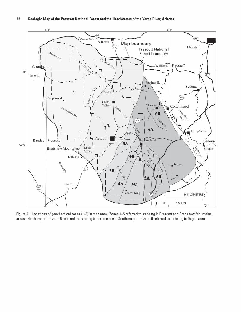
[EarlyProterozoicplutonicrocksarewidelyexposedthroughoutmaparea.Inordertoaidinthediscussionoftheserocks,theexposuresofplutonicandmetavolcanicrocksaredividedintosixzones(fig.21,zones1–6,fromwesttoeast).Thesezonesareroughlyparalleltoregionalfoliationandcontainrockunitsthataresimilartooneanother.Thezonesarenotcrustalblocksnoraretheynecessarilyseparatedfromoneanotherbydiscretetectonicstructures]
Gabbroic rocks—Mafictoultramaficintrusiverocks.Gabbroandgabbro-noritearethemostcommonrocktypes(fig.22A)andarefoundinallzonesinthePrescott-Jeromearea(fig.21).Significantexposuresofultramaficrocksarepresentonlyinzone2,inthePrescottarea.Evolvedrocks,suchasdioriteandmonzodiorite(fig.22A),are
�0 Geologic Map of the Prescott National Forest and the Headwaters of the Verde River, Arizona

Description of Map Units �1
Figure 20. Major-element classification diagrams for 1,400-Ma Dells Granite (unit Yd) north of Prescott. Data from Fleck (1983). Rock abbreviations and field boundaries defined in figure 18.
SiO
(w
t. p
erce
nt)
2
2 3 2 3(FeO + 0.89Fe O )/(FeO + 0.89Fe O + MgO)
60
500.5 0.6 0.7 0.8 0.9 1.0
D
SiO
(w
t. p
erce
nt)
2
K O/(K O + Na O)2 2 2
60
500 0.2 0.4 0.6
C
A
30002500200015001000
500
1000
1500
Calcic
Calc-Alkalic
Alkali-Calcic
Alkalic
R =
600
0Ca
+ 20
00M
g +
1000
Al
2
R = 4000Si - 11,000(Na + K) - 2000(Fe + Ti)1
A/C
NK
SiO (wt. percent)2
0.7
0.8
0.9
1
1.1
1.2
1.3
50 60 70
Field of unalteredigneous rocks
B
Dells Granite> 0.15% TiO2
0.1-0.14% TiO2
0.05-0.09% TiO2
0.01-0.04% TiO2
EXPLANATION
�� Geologic Map of the Prescott National Forest and the Headwaters of the Verde River, Arizona
Figure 21. Locations of geochemical zones (1–6) in map area. Zones 1–5 referred to as being in Prescott and Bradshaw Mountains areas. Northern part of zone 6 referred to as being in Jerome area. Southern part of zone 6 referred to as being in Dugas area.
Map boundaryPrescott NationalForest boundary
Ash Fork
Paulden
ChinoValley
Prescott
Camp Wood
Humboldt
Jerome
SkullValley
Yarnell
Flagstaff
Sedona
Camp Verde
Crown King
Mayer
Agua
Fria
River
VerdeRiver
Verde River
Big Chino Valley
Little Chino Valley
Verde Rivervalley
BradshawM
tsBlack Hills
Santa Maria Mts
Will
iam
son
Valle
y
Weaver
Mts
0 10 KILOMETERS
Perkinsville
113°
35°
112°
34°30'
89
89A
69
89
93
17
89A
17
Juniper Mts Big Black Mesa
40 40
Kirkland
Mt. Hope
Picacho Butte
0 6 MILES
Valentine Williams Flagstaff
Bagdad Prescott Sedona
Bradshaw Mountains Payson
Cottonwood
Dugas

Description of Map Units ��
Figure 22. Major-element classification summary diagrams for Early Proterozoic gabbros (units Xum, Xgb, Xlgb, and Xdi) from zones 1–5 in Bradshaw Mountains and zone 6 in the Black Hills and near Dugas. Data from this study, L.D. Nealey in Baedecker and others (1998), and Vance (1989). A, R1R2 major-element classification diagram (De la Roche and others, 1980). Picritic, ultramafic rocks; Gb-No, gabbro-norite; Gb, gabbro; Alk Gb, alkali gabbro; Thr, theralite; Sy Gb, syenogabbro; Mz Gb, monzogabbro; Gb-Di, gabbro-diorite; Sy Di, syenodiorite; Mz, monzonite; Mz Di, monzodiorite; Di, diorite; Q Sy, quartz syenite; Q M, quartz monzonite; Ton, tonalite; Gr, granite; Gd, granodiorite. Fields of alkalinity from Fridrich and others (1998). B–D, Field boundaries defined in figure 2. Red arrow indicates point lies outside of plot, in direction indicated.
60
50
400.4 0.5 0.6 0.7 0.8 0.9
SiO
2 (w
t. p
erce
nt)
(FeO + 0.89Fe2O3)/(FeO + 0.89Fe2O3+ MgO)
D
2500200015001000
500
1000
1500
2000
2500
CalcicCalc-Alkalic
Alkali-Calcic
Alkalic
R1 = 4000Si - 11,000(Na + K) - 2000(Fe + Ti)
R2
= 60
00C
a +
2000
Mg
+ 10
00A
l
A
0 0.1 0.2 0.3 0.440
50
K2O/K2O + Na2O
SiO
2 (w
t. p
erce
nt)
C
0.4
0.5
0.6
0.7
0.8
0.9
1.0
40 50 60
A/C
NK
Field of unalteredigneous rocks B
SiO2 (wt. percent)
EXPLANATION
Gabbroic rocks Zones 1-5 Zone 6

presentonlyincentralpartofmaparea,inzones2,3,and4.Manygabbrosinzone6(Jeromearea)areAlrichandplotabovethefieldofunalteredrocks(fig.22B);rocksarenotaltered,butarerichinCa-plagioclase.High-Alrocksarenotedinzones2,3,and5,butareespeciallyabundantinzone6.GabbroshaveawiderangeofK/NaandFe/Mgratios(figs.22C,D);nospatialvariationsareevident.Onlytheevolvedrocksinzone3areTirich.Ageundetermined,butcross-cuttingrelationsindicatethatgabbrosaretheoldestplutonicrocksinmaparea.Discussedfrommostmafictomostfelsic,andportrayedinchemicaldiagramsfromwest(zone1)toeast(zone6)(figs.23–27)
Xum Ultramafic rocks—Medium-tocoarse-grained,equigranular,hornblende-andpyrox-ene-richpicriticrocks.ExposedsouthandeastofPrescott,inamassthatextendsfromBadgerMountain,eastofPrescott,south-southwesttonorthofGroomCreek.Foliatedonmarginsandinsomelocalizedzonesofhighstrain.Igneouslayeringonasmallscalehasbeendescribedfromthebody(Krieger,1965).Picriticrocksrangewidelyintheirchemistryduetotheirextremesofmineralogy;plagioclase-richrocksplotabovethefieldofunalteredrocks(fig.24B)duetocrystalaccumulation.Amphibole-andpyroxene-richrocksplotbelowthefield,theirpositionalsoisprobablyduetocrystalaccumulation.Plagioclase-richrocksaresodic;amphibole-richrocksareverypotassic(fig.24C).AllrocksareveryMgrich(fig.24D).
Smalleast-strikingbodycomposedprimarilyofaugitelocatedsouthofJerome,nearDelMonteGulch.Plagioclaseisinterstitialtoaugite,whichisrimmedbyhorn-blendeandchlorite.
SmallbodyofhornblenditelocatednorthwestofTuscumbiaMountainXgb Gabbro—Medium-tocoarse-grained,equigranular,hornblende-richgabbro-norite,
gabbro,andgabbro-diorite.ExposedaslargebodiesthroughoutcentralBradshawMountains(zones2–5).SmallerbodiesexposednearJerome,intheBlackHills(zone6),especiallywithinGrapevineGulchVolcanics.MildlytostronglydeformedandmetamorphosedincentralBradshawMountains.Largerbodieshaveonlylocalizedzonesofhighstrain;smallerbodiesaremorethoroughlydeformed.UndeformedandonlymildlymetamorphosedinBlackHills.
Largestgabbromassisexposedinzone2,westofPrescott,andiscenteredonSugarloafMountain.Compositionsrangefromgabbro-noritetodiorite(fig.23A),andincludeabundantleucogabbrobodiestoosmalltoshowonmap.Zone2containsahigherpercentageofgabbro-noritethanmostotherzones(fig.23A),andhassomeofthemostprimitivechondrite-normalizedrare-earth-element(REE)profiles.
Zone3containsthreelargegabbromasses.OneextendsnorthfromLongfel-lowRidgetowestedgeofBigBugMesa,andisreferredtoastheDandreaRanchmass,foralocalitywestofBigBugMesa.Another,possiblyrelatedtothefirst,iscenteredonBodiemine,westofCrooksCanyon.ThelastiscenteredonSalidaSpring,eastofPrescott.AprominentaeromagnetichigheastofPrescottisspatiallyassociatedwiththismass(Langenheimandothers,2002,fig.5b).Chemistryoffirsttwobodiesissimilar,rangingfromgabbro-norite,throughgabbro,togabbro-diorite(fig.24A).WiderangeinbothK/NaandFe/Mgratios(figs.24C,D)andnoobvioussystematicpatternmaysuggestcomplexintrusivemixturesinthetwobodies.SalidaSpringbodycon-tainssmall-scaleigneouslayersdefinedbyeast-strikingflowfoliation.BoththeSalidaSpringgabbroicbodyandtheBadgerMountainultramaficbodyhavedistinctiveREEpatternswithpronouncedpositiveEuanomalies,suggestiveofcrystalaccumulationofplagioclase.
Manysmallgabbrobodiesareexposedinzone4,thelargestofwhichisattheBlueBellmine.Chemistryofmostbodiesissimilar(fig.25A)andshowslittlevaria-tion(figs.25C,D).
ManygabbrobodiesinJeromearea(zones6Aand6B)aredistinctivebybeinghighAlandplagioclaserich(fig.27B),similartothoseinzone5(fig.26).UndergroundsamplesofgabbroatUnitedVerdeminearenotablyAlrich,andcouldrepresentplagioclasecumulatesofleucogabbro,assuggestedbytheirsodicnature(fig.27C)andFe-toveryFe-richnature(fig.27D)
�� Geologic Map of the Prescott National Forest and the Headwaters of the Verde River, Arizona

Figure 23. Major-element classification diagrams for Early Proterozoic gabbros (units Xgb and Xlgb ) from zone 2 in Bradshaw Moun-tains. Data from this study. Rock abbreviations defined in figure 22; field boundaries defined in figure 2. Red arrow indicates point lies outside of plot, in direction indicated.
60
50
400.4 0.5 0.6 0.7 0.8 0.9
SiO
2 (w
t. p
erce
nt)
(FeO + 0.89Fe2O3)/(FeO + 0.89Fe2O3+ MgO)
D
2500200015001000
500
1000
1500
2000
2500
Calcic
Calc-AlkalicAlkali-Calcic
Alkalic
R1 = 4000Si - 11,000(Na + K) - 2000(Fe + Ti)
R2
= 60
00C
a +
2000
Mg
+ 10
00A
l
A
0 0.1 0.2 0.3 0.440
50
K2O/K2O + Na2O
SiO
2 (w
t. p
erce
nt)
C
0.4
0.5
0.6
0.7
0.8
0.9
1.0
40 50 60
A/C
NK
Field of unalteredigneous rocks B
SiO2 (wt. percent)
High-Al rocks: West Sugarloaf Mountain leucogabbroHigh-Ti rocks: none
KirklandSkull ValleyWest Sugarloaf MountainWest Maverick Mountain
EXPLANATION
Description of Map Units ��

Figure 24. Major-element classification diagrams for Early Proterozoic gabbros (units Xum, Xgb, Xlgb, and Xdi) from zone 3 in Bradshaw Mountains. Data from this study, Anderson and Blacet (1972b), and L.D. Nealey in Baedecker and others (1998). Rock abbreviations defined in figure 22; field boundaries defined in figure 2. Red arrow indicates point lies outside of plot, in direction indicated.
60
50
400.4 0.5 0.6 0.7 0.8 0.9
SiO
2 (w
t. p
erce
nt)
(FeO + 0.89Fe2O3)/(FeO + 0.89Fe2O3+ MgO)
D
2500200015001000
500
1000
1500
2000
2500
Calcic
Calc-Alkalic
Alkali-CalcicAlkalic
R1 = 4000Si - 11,000(Na + K) - 2000(Fe + Ti)
R2
= 60
00C
a +
2000
Mg
+ 10
00A
l
A
0 0.1 0.2 0.3 0.440
50
K2O/K2O + Na2O
SiO
2 (w
t. p
erce
nt)
C
0.4
0.5
0.6
0.7
0.8
0.9
1.0
40 50 60
A/C
NK
Field of unalteredigneous rocks B
SiO2 (wt. percent)
High-Al rocks: 1 at Spruce Mountain 1 at Badger Mountain 1 at Dandrea RanchHigh-Ti rocks: 2 at Dandrea Ranch
Spruce MountainPotato PatchBadger Mountain–Groom CreekLynx CreekDandrea RanchSalida SpringGreen Gulch
EXPLANATION
�� Geologic Map of the Prescott National Forest and the Headwaters of the Verde River, Arizona

Figure 25. Major-element classification diagrams for Early Proterozoic gabbros (units Xgb and Xdi ) from zone 4 in Bradshaw Mountains. Data from this study, Anderson and Blacet (1972b), and Blacet (1985). Rock abbreviations defined in figure 22; field boundaries defined in figure 2. Red arrow indicates point lies outside of plot, in direction indicated.
60
50
400.4 0.5 0.6 0.7 0.8 0.9
SiO
2 (w
t. p
erce
nt)
(FeO + 0.89Fe2O3)/(FeO + 0.89Fe2O3+ MgO)
D
2500200015001000
500
1000
1500
2000
2500
Calcic
Calc-Alkalic
Alkali-CalcicAlkalic
R1 = 4000Si - 11,000(Na + K) - 2000(Fe + Ti)
R2
= 60
00C
a +
2000
Mg
+ 10
00A
l
A
0 0.1 0.2 0.3 0.440
50
K2O/K2O + Na2O
SiO
2 (w
t. p
erce
nt)
C
0.4
0.5
0.6
0.7
0.8
0.9
1.0
40 50 60
A/C
NK
Field of unalteredigneous rocks B
SiO2 (wt. percent)
High-Al rocks: Towers MountainHigh-Ti rocks: 1 at Humboldt (moderate)
HumboldtPoland Junction and southBluebell mineTowers MountainWest of Lane Mountain
EXPLANATION
Description of Map Units ��

Figure 26. Major-element classification diagrams for Early Proterozoic gabbros (units Xgb and Xdi) from zone 5 in Bradshaw Moun-tains. Data from this study, Anderson and Blacet (1972b), and Anderson (1972). Rock abbreviations defined in figure 22; field boundaries defined in figure 2.
60
50
400.4 0.5 0.6 0.7 0.8 0.9
SiO
2 (w
t. p
erce
nt)
(FeO + 0.89Fe2O3)/(FeO + 0.89Fe2O3+ MgO)
D
2500200015001000
500
1000
1500
2000
2500
Calcic
Calc-Alkalic
Alkali-CalcicAlkalic
R1 = 4000Si - 11,000(Na + K) - 2000(Fe + Ti)
R2
= 60
00C
a +
2000
Mg
+ 10
00A
l
A
0 0.1 0.2 0.3 0.440
50
K2O/K2O + Na2O
SiO
2 (w
t. p
erce
nt)
C
0.4
0.5
0.6
0.7
0.8
0.9
1.0
40 50 60
A/C
NK
Field of unalteredigneous rocks B
SiO2 (wt. percent)
High-Al rocks: Badger Spring, Yarber SpringHigh-Ti rocks: none
EXPLANATION
Badger SpringYarber SpringNew River
�� Geologic Map of the Prescott National Forest and the Headwaters of the Verde River, Arizona

Figure 27. Major-element classification diagrams for Early Proterozoic gabbros (unit Xgb) and tonalite (unit Xdi?) from zones 6A and 6B in the Black Hills and from zone 6B in Dugas area. Data from this study, Vance (1989), Anderson and Creasey (1958), and L.D. Nealey in Baedecker and others (1998). Rock abbreviations defined in figure 22; field boundaries defined in figure 2. Red arrow indicates point lies outside of plot, in direction indicated.
60
50
400.4 0.5 0.6 0.7 0.8 0.9
SiO
2 (w
t. p
erce
nt)
(FeO + 0.89Fe2O3)/(FeO + 0.89Fe2O3+ MgO)
D
2500200015001000
500
1000
1500
2000
2500
Calcic
Calc-Alkalic
Alkali-CalcicAlkalic
R1 = 4000Si - 11,000(Na + K) - 2000(Fe + Ti)
R2
= 60
00C
a +
2000
Mg
+ 10
00A
l
A
0 0.1 0.2 0.3 0.440
50
K2O/K2O + Na2O
SiO
2 (w
t. p
erce
nt)
C
0.4
0.5
0.6
0.7
0.8
0.9
1.0
40 50 60
A/C
NK
Field of unalteredigneous rocks B
SiO2 (wt. percent)
High-Al rocks: Half of Grapevine Gulch Hull Canyon Half of United Verde mine, surface All of United Verde mine, undergroundHi-Ti rocks: none
EXPLANATION
Along Yaeger CanyonCut Grapevine Gulch FormationHull CanyonUnited Verde mine, surfaceUnited Verde mine, undergroundHutch MesaTule MesaSouthwest Verde River valley
Description of Map Units ��

Xlgb Leucogabbro—Medium-grained,equigranular,plagioclase-richleucogabbro.Extens-ivelyexposedonSugarloafMountain(zone2)andonAshCreekRidge,westofCrooksCanyon(zone3).Undeformedtomildlyfoliated.Smalldikes,sills,andirregularlyshapedbodiescutnormalgabbroandarecutbynormalgabbro.Onechemicalanalysisindicatesgabbrocomposition(fig.23A)thatisverypotassic(fig.23C)andveryMgrich(fig.23D).REEpatternhaspositiveEuanomaly
Xdi Diorite—Medium-tocoarse-grained,equigranular,hornblende-richdioritetomonzo-diorite.ExposedinmappedbodiesatTowersMountainnorthwestofCrownKing;atGreenGulch,northwestofIronKingmine;andinDandreaRanchmass,incentralBradshawMountains.Alsopresent,butnotmappedseparately,withinbodiesofgab-broatSugarloafMountain,atSpruceMountain,southofHumboldt,andsoutheastofTownsendButte.Related(?)bodiesoftonalitecutfelsicmetavolcanicrocksonTuleMesa.MildlydeformedinmostoutcropsinBradshawMountains.UndeformedonTuleMesa.
TowersMountainandGreenGulchmassesarecalc-alkalic(fig.25A)andhaveaverageK/NaandFe/Mgratios(figs.25C,D).DandreaRanchmassisalkali-calcic(fig.24A),sodictopotassic(fig.24C),andaveragetoveryFerich(fig.24D).TonaliteonTuleMesaiscalc-alkalic(fig.27),verysodictosodic(fig.27C)andaver-ageinFe/Mgratio(fig.27D).TonaliticcompositionofTuleMesamassmayindicaterelationtoyounger,intermediate-compositionplutonicrocks
Tonalitic rocks—Maficintrusiverocks,primarilyhornblendebearing.Formlargeplutonsinwest-centralandeast-centralpartsofmaparea.Discussedfrommostmafictomostfelsic.Mostabundantinzones5and6;lessabundantinzone2.Minorbodyinzone1.Tonaliticrocksrangeincompositionfromgabbro-dioritetogranodiorite(fig.28A),andareaveragetoverysodic(fig.28C)andveryMgrichtoFerich(fig.28D).Tonaliticrocksarecalcicinzones5and6,butarecalc-alkalicinzone2(fig.28A).Chemistryofindividualrockunitssummarizedfromwesttoeast(figs.29–34)
Xch Cherry Tonalite—Medium-tomedium-coarse-grainedhornblende-biotitedioritetogranodioritecontainingphenocrystsofhornblende(AndersonandCreasey,1967).IncludestonaliteofCherry(DeWitt,1989),andpartofCherrybatholith(Anderson,1989a).NewlynamedhereinforexposuresnearCherry.TypeareaisdesignatedwheremainmassexposedfromnorthofCherrytofarsoutheasternpartofmaparea.SmallerbodiesexposedalongeastsideofLonesomeValley.Prominentnorth-trendingzoneofhighmagneticintensityalongeasternLonesomeValleyprobablymarkswesterncontactofCherryTonalitewithmetavolcanicrocks(Langenheimandothers,2002).MostmaficalongwesternmarginofmainmassandinsouthernLonesomeValley.ExposedinerosionalhighsbeneathTertiarybasaltfromInterstate17tosouthernmarginofmaparea.CutsBishopSpringGranodiorite(unitXbp)northwestofRuggedMesa.CutsBlandTonalite(newlynamed,unitXbl)eastofPerryMesaandsouthofmaparea,alongSquawCreek.Undeformedinmostoutcrops,butmildlytostronglyflowfoli-atedinplaces.StronglydeformedalongShylockfaultandShylockhigh-strainzoneinsouthwesternBlackHills.Hostsgold-bearingquartzveinsinCherrydistrictthataregeneticallyrelatedtothetonalite(Clements,1991).
Chemicallyiscalc-alkalic(fig.34A),sodictoverysodic(fig.34C),andveryMgrichtoFerich(fig.34D).
AgeofsamplefromnearCherry,fromU-Pbzirconanalyses,is1,740Ma(Andersonandothers,1971).K-Arhornblendedatesof1,694and1,690MaobtainedfromsamplesnearCherry(Lanphere,1968;DalrympleandLanphere,1971).40Ar/39Artotalfusiondateof1,709Maobtainedfromonehornblende(DalrympleandLanphere,1971).K-Arbiotitedatesof1,689–1,693Maalsoobtainedfromsamesamples.Con-flictingage(cuts1,720-MaBlandTonalitebuthasU-Pbzirconageof1,740Ma)maybeduetomorethanonetonalitebodywithinacompositepluton(Anderson,1989a)
Xchg Granophyre of Cherry—Medium-grained,equigranularquartz-feldspargranophyre(AndersonandBlacet,1972a).ExposedsoutheastofDewey.Undeformed.CutsCherryTonalite(unitXch).Chemicallyisanalkali-calcictocalcicgranite(fig.34A)
�0 Geologic Map of the Prescott National Forest and the Headwaters of the Verde River, Arizona

Description of Map Units �1
Figure 28. Major-element classification summary diagrams for Early Proterozoic plutonic rocks from zones 1–6 in Bradshaw Mountains and the Black Hills. Data from this study, DeWitt (1989), Anderson and Blacet (1972b), Anderson (1972), Anderson and Creasey (1958), and L.D. Nealey in Baedecker and others (1998). Rock abbreviations and field boundaries defined in figure 18.
60
500.5 0.6 0.7 0.8 0.9 1.0
(FeO + 0.89Fe2O3)/(FeO + 0.89Fe2O3+ MgO)
SiO
2 (w
t. p
erce
nt)
D
30002500200015001000
500
1000
1500
Calcic
Calc-Alkalic
Alkali-CalcicAlkalic
0
R1 = 4000Si - 11,000(Na + K) - 2000(Fe + Ti)
R2
= 60
00C
a +
2000
Mg
+ 10
00A
l
A
80
70
60
500 0.2 0.4 0.6
K2O/K2O + Na2O
SiO
2 (w
t. p
erce
nt)
C
0.7
0.8
0.9
1
1.1
1.2
1.3
50 60 70
A/C
NK
Field of unalteredigneous rocks
SiO2 (wt. percent)
BZones 1-6All tonalitic through alkali granitic rocks
EXPLANATION
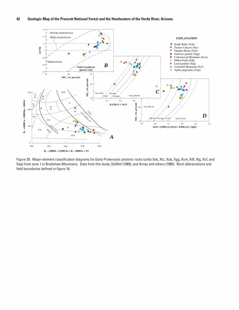
�� Geologic Map of the Prescott National Forest and the Headwaters of the Verde River, Arizona
Figure 29. Major-element classification diagrams for Early Proterozoic plutonic rocks (units Xsb, Xtc, Xob, Xgg, Xcm, Xdf, Xlg, Xcf, and Xap) from zone 1 in Bradshaw Mountains. Data from this study, DeWitt (1989), and Arney and others (1985). Rock abbreviations and field boundaries defined in figure 18.
60
500.5 0.6 0.7 0.8 0.9 1.0
(FeO + 0.89Fe2O3)/(FeO + 0.89Fe2O3+ MgO)
SiO
2 (w
t. p
erce
nt)
D
30002500200015001000
500
1000
1500
Calcic
Calc-Alkalic
Alkali-CalcicAlkalic
0
R1 = 4000Si - 11,000(Na + K) - 2000(Fe + Ti)
R2
= 60
00C
a +
2000
Mg
+ 10
00A
l
A
80
70
60
500 0.2 0.4 0.6
K2O/K2O + Na2O
SiO
2 (w
t. p
erce
nt)
C
0.7
0.8
0.9
1
1.1
1.2
1.3
50 60 70
A/C
NK
Field of unalteredigneous rocks
SiO2 (wt. percent)
B
South Butte (Xsb)Tucker Canyon (Xtc)Orejano Basin (Xob)Gneissic granite (Xgg)Cottonwood Mountain (Xcm)Dillon Field (Xdf)Leucogranite (Xlg)Cornfield Mountain (Xcf)Aplite-pegmatite (Xap)
EXPLANATION

Description of Map Units ��
Figure 30. Major-element classification diagrams for Early Proterozoic plutonic rocks (units Xmw, Xrg, Xsv, Xpv, Xwv, Xpr, Xgc, Xvr, and Xkw) from zone 2 in Bradshaw Mountains. Data from this study, DeWitt (1989), Krieger (1965), and L.D. Nealey in Baedecker and others (1998). Rock abbreviations and field boundaries defined in figure 18.
30002500200015001000
500
1000
1500
Calcic
Calc-Alkalic
Alkali-CalcicAlkalic
0
R1 = 4000Si - 11,000(Na + K) - 2000(Fe + Ti)
R2
= 60
00C
a +
2000
Mg
+ 10
00A
l
A
0.7
0.8
0.9
1
1.1
1.2
1.3
50 60 70
A/C
NK
Field of unalteredigneous rocks
SiO2 (wt. percent)
B
60
500 0.2 0.4 0.6
K2O/K2O + Na2O
SiO
2 (w
t. p
erce
nt)
C
60
500.5 0.6 0.7 0.8 0.9 1.0
(FeO + 0.89Fe2O3)/(FeO + 0.89Fe2O3+ MgO)
SiO
2 (w
t. p
erce
nt)
D
EXPLANATION
Mint Wash (Xmw)Ramsgate (Xrg)Skull Valley (Xsv)Peeples Valley (Xpv)Williamson Valley (Xwv)Prescott (Xpr)Government Canyon (Xgc)Verde River (Xvr)Kings Well (Xkw)

�� Geologic Map of the Prescott National Forest and the Headwaters of the Verde River, Arizona
Figure 31. Major-element classification diagrams for Early Proterozoic plutonic rocks (units Xcc, Xjf, Xcca, and Xwg) from zone 3 in Bradshaw Mountains. Data from this study, DeWitt (1989), Krieger (1965), and Anderson and Blacet (1972b). Rock abbreviations and field boundaries defined in figure 18.
0.7
0.8
0.9
1
1.1
1.2
1.3
50 60 70
A/C
NK
Field of unalteredigneous rocks
SiO2 (wt. percent)
B
60
500.5 0.6 0.7 0.8 0.9 1.0
(FeO + 0.89Fe2O3)/(FeO + 0.89Fe2O3+ MgO)
SiO
2 (w
t. p
erce
nt)
D
30002500200015001000
500
1000
1500
Calcic
Calc-Alkalic
Alkali-CalcicAlkalic
0
R1 = 4000Si - 11,000(Na + K) - 2000(Fe + Ti)
R2
= 60
00C
a +
2000
Mg
+ 10
00A
l
A
60
500 0.2 0.4 0.6
K2O/K2O + Na2O
SiO
2 (w
t. p
erce
nt)
C
Crooks Canyon, main (Xcc)Crooks Canyon aplite (Xcca)Wagoner (Xwg)Johnson Flat (Xjf)
EXPLANATION

Description of Map Units ��
Figure 32. Major-element classification diagrams for Early Proterozoic plutonic rocks (units Xhm, Xhy, Xbb, Xmh, Xhc, and Xcb) from zone 4 in Bradshaw Mountains. Data from this study, DeWitt (1989), Blacet (1985), and Vrba (1980). Rock abbreviations and field bound-aries defined in figure 18.
60
500.5 0.6 0.7 0.8 0.9 1.0
(FeO + 0.89Fe2O3)/(FeO + 0.89Fe2O3+ MgO)
SiO
2 (w
t. p
erce
nt)
D
30002500200015001000
500
1000
1500
Calcic
Calc-Alkalic
Alkali-CalcicAlkalic
0
R1 = 4000Si - 11,000(Na + K) - 2000(Fe + Ti)
R2
= 60
00C
a +
2000
Mg
+ 10
00A
l
A
0.7
0.8
0.9
1
1.1
1.2
1.3
50 60 70
A/C
NK
Field of unalteredigneous rocks
SiO2 (wt. percent)
B
60
500 0.2 0.4 0.6
K2O/K2O + Na2O
SiO
2 (w
t. p
erce
nt)
C
Horse Mountain (Xhm)Hassayampa (Xh)Brady Butte (Xbb)Tuscumbia (Xbb)Minnehaha (Xmh)Humbug Creek (Xhc)Crazy Basin (Xcb)
EXPLANATION

�� Geologic Map of the Prescott National Forest and the Headwaters of the Verde River, Arizona
Figure 33. Major-element classification diagrams for Early Proterozoic plutonic rocks (units Xbg, Xbl, and Xbs) from zone 5 in Bradshaw Mountains. Data from this study, DeWitt (1989), and Anderson (1972). Rock abbreviations and field boundaries defined in figure 18.
60
500.5 0.6 0.7 0.8 0.9 1.0
(FeO + 0.89Fe2O3)/(FeO + 0.89Fe2O3+ MgO)
SiO
2 (w
t. p
erce
nt)
D
30002500200015001000
500
1000
1500
Calcic
Calc-Alkalic
Alkali-CalcicAlkalic
0
R1 = 4000Si - 11,000(Na + K) - 2000(Fe + Ti)
R2
= 60
00C
a +
2000
Mg
+ 10
00A
l
A
0.7
0.8
0.9
1
1.1
1.2
1.3
50 60 70
A/C
NK
Field of unalteredigneous rocks
SiO2 (wt. percent)
B
60
500 0.2 0.4 0.6
K2O/K2O + Na2O
SiO
2 (w
t. p
erce
nt)
C
Big Bug (Xbg)Bland (Xbl)Bumblebee (Xbl)Badger Spring (Xbs)
EXPLANATION

Description of Map Units ��
Figure 34. Major-element classification diagrams for Early Proterozoic plutonic rocks (units Xch, Xchg, Xchd, Xbp, and Xbn) from zone 6 in the Black Hills. Data from this study, DeWitt (1989), Anderson and Creasey (1958), Krieger (1965), Anderson and Blacet (1972b), Wolfe (1983), and L.D. Nealey in Baedecker and others (1998). Rock abbreviations and field boundaries defined in figure 18. Red arrow indicates point lies outside of plot, in direction indicated.
60
500.5 0.6 0.7 0.8 0.9 1.0
(FeO + 0.89Fe2O3)/(FeO + 0.89Fe2O3+ MgO)
SiO
2 (w
t. p
erce
nt)
D
30002500200015001000
500
1000
1500
Calcic
Calc-Alkalic
Alkali-CalcicAlkalic
0
R1 = 4000Si - 11,000(Na + K) - 2000(Fe + Ti)
R2
= 60
00C
a +
2000
Mg
+ 10
00A
l
A
0.7
0.8
0.9
1
1.1
1.2
1.3
50 60 70
A/C
NK
Field of unalteredigneous rocks
SiO2 (wt. percent)
B
60
500 0.2 0.4 0.6
K2O/K2O + Na2O
SiO
2 (w
t. p
erce
nt)
C
Cherry, main (Xch)Cherry granophyre (Xchg)Dike cutting Cherry (Xchd)Bishop Spring (Xbp)Bloody Basin (Xbn)
EXPLANATION

thatismildlytostronglyperaluminous(fig.34B),verysodic(fig.34C),andaveragetoveryFerich(fig.34D)
Xchd Dikes of Cherry—Medium-grained,equigranulargranodioritetomedium-grained,porphyriticgranodioritecontainingphenocrystsoffeldsparandquartzinnorth-striking,high-angledikeswarms.Equigranulargranodioritedikesandporphyriticdikescon-tainingquartzphenocrystsarelatecogeneticbodiesrelatedtothemaintonalitemass,asevidencedbyimmiscibleigneoustextures.PorphyriticgranodioritedikesmayberelatedtoBadgerSpringGranodiorite(unitXbs).Alldikesundeformed.Ageofcogeneticdikesprobablyabout1,700Ma,assuggestedbyhornblendeandbiotiteK-Ardatesof1,690–1,709Ma
Xbl Bland Tonalite—Medium-grained,equigranulartoslightlyporphyritictonalitedioritecontainingphenocrystsofhornblende(Jerome,1956).Exposedinsoutheasternpartofmaparea,fromeastofCleatortopastsouthernboundaryofmaparea.BumblebeeGranodiorite(AndersonandBlacet,1972c)combinedwithBlandforpurposesofthismap.BumblebeemaybeslightlyolderthanmainmassofBland(seebelow).NamedhereinforexposuresattypeareaonBlandHillinsouthernpartofmapareaandalongBlackCanyon.Leastdeformedinnorthernandwesternpartsofpluton.StronglydeformedwithinBlackCanyonhigh-strainzone.CutsgranodioriteofBigBugCreek(unitXbg).
Rangesincompositionfromgabbro-dioritetogranodioriteandispredominantlycalcic(fig.33A).Tonaliticrocksareverysodictoaverage(fig.33C)andMgrichtoFerich(fig.33D).
AgeofBlandabout1,720Ma(Bowringandothers,1986).AgeofBumblebeeabout1,750Ma(S.A.Bowring,unpub.U-Pbzircondata,citedinKarlstromandothers,1987),indicatingthatBumblebeemaybeolderthanBland
Xgc Government Canyon Tonalite—Medium-grained,equigranularhornblende-biotitestock(Krieger,1965)havingaveragecompositionoftonalite.ExposedfromeastofGraniteMountaintosouthofWilhoit.Redescribedhereintotonalite,basedonchemicalcom-position.Undeformedinmanyeasternoutcrops,butstronglydeformedwestofCopperBasinandmildlydeformedincentralBradshawMountains.
Rangesincompositionfromalkali-calcicgabbro-dioritetocalc-alkalicgrano-diorite(fig.30A).Verysodictoaverage(fig.30C)andveryMgrichtoMgrich(fig.30D).Age,fromU-Pbzirconanalyses,isabout1,740Ma(Andersonandothers,1971)
Xcm Tonalite of Cottonwood Mountain—Medium-grained,equigranularbiotite-hornblendetonalite.ExposedonlyinsmallareawestofCottonwoodMountain,infarwesternpartofmaparea.Stronglydeformed.Chemicallyiscalc-alkalic(fig.29A),sodic(fig.29C),andaverageinFe/Mgratio(fig.29D).EarlyProterozoicagedeterminedfromPb-Pbwholerockisotopiccomposition(Bryantandothers,1994)
Granodioritic rocks—Intermediate-compositionintrusiverocks,primarilybiotitebearing,butlocallycontaininghornblende.Formsintermediate-sizeplutonsthroughoutmaparea.Mostnumerousinzone2(sevenplutons).Lessnumerousinzones1,3,and6(oneplutoneach).Mostgranodioritesaremediumgrainedandequigranular.Onlythreearestronglyporphyritic.Greatestrangeinageofmajorintrusivegroups,frompre-tectonic(about1,750Ma)topost-tectonic(about1,690Ma).Discussedfrommostmafictomostfelsic.Granodioriticrocksaremetaluminoustomildlyperaluminous,withafewassociatedrocksbeingstronglyperaluminous(fig.28B).Granodioritesareamongthemostsodicofintrusiverocks,rangingfromverysodictopotassic(fig.28C),andfromMgrichtoaverageinFe/Mgratio(fig.28D)
Xpr Prescott Granodiorite—Medium-tomedium-fine-grainedbiotitegranodiorite(Krieger,1965).ExposedfromsouthwestofPrescotttonortheasternpartofLonesomeVal-ley.Mildlyflowfoliatedinplaces.Tectonicfoliationrestrictedtominorzoneofhighstrain,noneofwhichismappableatthisscale.CutsGovernmentCanyonGranodioriteandPeeplesValleyGranodiorite(newlynamed)nearPrescottandcutsCherryTonalite(newlynamed)innortheasternLonesomeValley.
�� Geologic Map of the Prescott National Forest and the Headwaters of the Verde River, Arizona

Chemicallyiscalc-alkalictoalkali-calcic(fig.30A),mildlyperaluminous(fig.30B),verysodic(fig.30C),andveryMgrichtoaverage(fig.30D).Ageabout1,690Ma(J.L.WoodenandEdDeWitt,unpub.U-Pbzircondata,1997)
Xpv Peeples Valley Granodiorite—Medium-grained,equigranularbiotitegranodioritetoleu-cocraticgranodiorite,locallycontainingequantbooksofbiotite.ExposedfromwestofPrescotttopastsouthwesternboundaryofmaparea.EquivalenttogranodioriteofWil-hoit(DeWitt,1989),andpartofWilhoitbatholithofAnderson(1989b).NewlynamedhereinforexposuresattypeareainPeeplesValley,southwestofWilhoitandnorthofYarnell(DeWitt,1989,fig.1).Undeformedinmostexposures.CutsGovernmentCan-yonTonalite.Wherefinegrained,plutonisdifficulttotellfromPrescottGranodiorite.
Granodioriteiscalc-alkalic(fig.30A),metaluminoustomildlyperaluminous(fig.30B),verysodic(fig.30C),andveryMgrichtoMgrich(fig.30D).EarlyProtero-zoicagedeterminedfromPb-Pbwholerockisotopiccomposition(WoodenandDeWitt,1991)
Xvr Granodiorite of the Verde River—Medium-grained,equigranularbiotite-hornblendegranodiorite(Krieger,1965).ExposedonlyalongVerdeRiver,downstreamfromPaul-den.Mildlydeformedinmostoutcrops.Limiteddatasuggestbodyisalkali-calcic(fig.30A),verysodic(fig.30C),andveryMgrich(fig.30D).Age,determinedfromU-Pbanalysesofzircon,about1,720Ma(Chamberlainandothers,1991)
Xhy Hassayampa Granodiorite—Medium-tocoarse-grainedbiotitegranodioritecontainingphenocrystsofpotassiumfeldspar.Containsabundantdikesofapliteandpegmatitethatarelocallyrichintourmaline(DeWitt,1989).Exposedinfarsouthernpartofmaparea,fromnorthofGoodwinSpring(locationofHozoniRanch),toalongtheHassa-yampaRiver.ReferredtoinformallyasgranodioriteofHozoniRanch(DeWitt,1989).EquivalenttopartofporphyriticmonzograniteofHorseMountainofAnderson(1989b).NewlynamedhereinforexposuresalongHassayampaRiverandatHozoniRanch.Moderatelytostronglydeformedalongnortheast-striking,northwest-dippingfoliation.GeneticallyrelatedtopegmatitedepositsintheWhitePicachodistrict,northeastofWickenburg(Jahns,1952).
Mainbodyrangesincompositionfromcalc-alkalictonalitetogranodiorite(fig.32A).Mostmaficpartofbodyissouthwestofmaparea,nearWhitePicachopegmatitedistrict.Aplite-pegmatitedikesarealkali-calcicgranite(fig.32A).Granodioriteandaplite-pegmatitesarepredominantlyaverageinK/Naratio(fig.32C)andFe/Mgratio(fig.32D).Ageabout1,720Ma(J.L.WoodenandEdDeWitt,unpub.U-Pbzircondata,1992)
Xmh Minnehaha Granodiorite—Medium-grained,equigranularhornblende-biotitegrano-diorite(DeWitt,1989).LargestcontinuousoutcropnearandsouthofMinnehaha,itsdesignatedtypearea.SomeexposurestoosmalltoshowonmapextendfromLookoutMountaintothesouthwest.MainmassnearMinnehahaisundeformedoneasternmargin,butstronglydeformedonthewest.SmallbodiesnearLookoutMountainarestronglydeformed.NewlynamedhereinforexposuresnearMinnehaha.PreviouslyreferredtoinformallyasgranodioriteofMinnehaha(DeWitt,1989).Characteristiclowmagneticsusceptibility,similartothatofBradyButteGranodiorite(DeWitt,1989),probablyresponsibleforaeromagneticlowthatextendsfromBradyButtetonearWick-enburgMountains(U.S.GeologicalSurvey,1972;SaukandSumner,1970).Interpretedaspartofcomposite,possiblyzoned,plutonassociatedwithBradyButteGranodiorite.
Rangesfromcalc-alkalictonalitetogranodiorite(fig.32A).Metaluminoustomildlyperaluminous(fig.32B),verysodictosodic(fig.32C),andveryMgrichtoaverageinFe/Mgratio(fig.32D).Major-andminor-elementcompositionverysimilartothatofmetadacitetuffexposedonwestsideofBradyButteGranodiorite,westofBattleFlat.Couldbesubvolcanicequivalentofmetadacitetuff.EarlyProterozoicagedeterminedfromPb-Pbwholerockisotopiccomposition(WoodenandDeWitt,1991)
Xbp Bishop Spring Granodiorite—Medium-grained,equigranularbiotitegranodiorite.Undeformedtomoderatelyfoliated.NewlynamedhereinforexposuresalongBishopCreek,northofRuggedMesa,insoutheasternpartofmaparea.
Description of Map Units ��
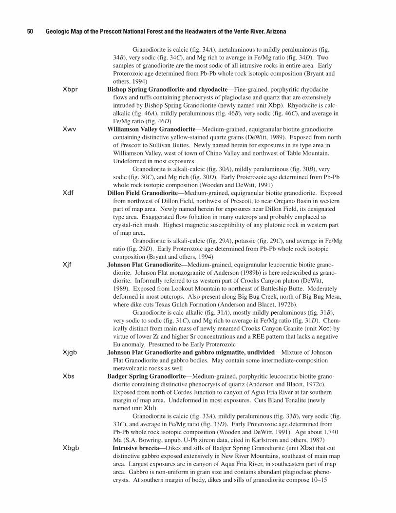
Granodioriteiscalcic(fig.34A),metaluminoustomildlyperaluminous(fig.34B),verysodic(fig.34C),andMgrichtoaverageinFe/Mgratio(fig.34D).Twosamplesofgranodioritearethemostsodicofallintrusiverocksinentirearea.EarlyProterozoicagedeterminedfromPb-Pbwholerockisotopiccomposition(Bryantandothers,1994)
Xbpr Bishop Spring Granodiorite and rhyodacite—Fine-grained,porphyriticrhyodaciteflowsandtuffscontainingphenocrystsofplagioclaseandquartzthatareextensivelyintrudedbyBishopSpringGranodiorite(newlynamedunitXbp).Rhyodaciteiscalc-alkalic(fig.46A),mildlyperaluminous(fig.46B),verysodic(fig.46C),andaverageinFe/Mgratio(fig.46D)
Xwv Williamson Valley Granodiorite—Medium-grained,equigranularbiotitegranodioritecontainingdistinctiveyellow-stainedquartzgrains(DeWitt,1989).ExposedfromnorthofPrescotttoSullivanButtes.NewlynamedhereinforexposuresinitstypeareainWilliamsonValley,westoftownofChinoValleyandnorthwestofTableMountain.Undeformedinmostexposures.
Granodioriteisalkali-calcic(fig.30A),mildlyperaluminous(fig.30B),verysodic(fig.30C),andMgrich(fig.30D).EarlyProterozoicagedeterminedfromPb-Pbwholerockisotopiccomposition(WoodenandDeWitt,1991)
Xdf Dillon Field Granodiorite—Medium-grained,equigranularbiotitegranodiorite.ExposedfromnorthwestofDillonField,northwestofPrescott,tonearOrejanoBasininwesternpartofmaparea.NewlynamedhereinforexposuresnearDillonField,itsdesignatedtypearea.Exaggeratedflowfoliationinmanyoutcropsandprobablyemplacedascrystal-richmush.Highestmagneticsusceptibilityofanyplutonicrockinwesternpartofmaparea.
Granodioriteisalkali-calcic(fig.29A),potassic(fig.29C),andaverageinFe/Mgratio(fig.29D).EarlyProterozoicagedeterminedfromPb-Pbwholerockisotopiccomposition(Bryantandothers,1994)
Xjf Johnson Flat Granodiorite—Medium-grained,equigranularleucocraticbiotitegrano-diorite.JohnsonFlatmonzograniteofAnderson(1989b)ishereredescribedasgrano-diorite.InformallyreferredtoaswesternpartofCrooksCanyonpluton(DeWitt,1989).ExposedfromLookoutMountaintonortheastofBattleshipButte.Moderatelydeformedinmostoutcrops.AlsopresentalongBigBugCreek,northofBigBugMesa,wheredikecutsTexasGulchFormation(AndersonandBlacet,1972b).
Granodioriteiscalc-alkalic(fig.31A),mostlymildlyperaluminous(fig.31B),verysodictosodic(fig.31C),andMgrichtoaverageinFe/Mgratio(fig.31D).Chem-icallydistinctfrommainmassofnewlyrenamedCrooksCanyonGranite(unitXcc)byvirtueoflowerZrandhigherSrconcentrationsandaREEpatternthatlacksanegativeEuanomaly.PresumedtobeEarlyProterozoic
Xjgb Johnson Flat Granodiorite and gabbro migmatite, undivided—MixtureofJohnsonFlatGranodioriteandgabbrobodies.Maycontainsomeintermediate-compositionmetavolcanicrocksaswell
Xbs Badger Spring Granodiorite—Medium-grained,porphyriticleucocraticbiotitegrano-dioritecontainingdistinctivephenocrystsofquartz(AndersonandBlacet,1972c).ExposedfromnorthofCordesJunctiontocanyonofAguaFriaRiveratfarsouthernmarginofmaparea.Undeformedinmostexposures.CutsBlandTonalite(newlynamedunitXbl).
Granodioriteiscalcic(fig.33A),mildlyperaluminous(fig.33B),verysodic(fig.33C),andaverageinFe/Mgratio(fig.33D).EarlyProterozoicagedeterminedfromPb-Pbwholerockisotopiccomposition(WoodenandDeWitt,1991).Ageabout1,740Ma(S.A.Bowring,unpub.U-Pbzircondata,citedinKarlstromandothers,1987)
Xbgb Intrusive breccia—DikesandsillsofBadgerSpringGranodiorite(unitXbs)thatcutdistinctivegabbroexposedextensivelyinNewRiverMountains,southeastofmainmaparea.LargestexposuresareincanyonofAquaFriaRiver,insoutheasternpartofmaparea.Gabbroisnon-uniformingrainsizeandcontainsabundantplagioclasepheno-crysts.Atsouthernmarginofbody,dikesandsillsofgranodioritecompose10–15
�0 Geologic Map of the Prescott National Forest and the Headwaters of the Verde River, Arizona

percentofbreccia.Dikesandsillsincreaseinpercentagetothenorth,composing40–80percentofbreccia.Largestinclusionsofgabbroinbrecciaare0.5mthickand3mlong
Xsv Granodiorite of Skull Valley—Medium-tomedium-fine-grainedbiotitegranodiorite,redescribedasgranodioriteforexposuresaroundthetownofSkullValley,westofPrescott.OriginallynamedSkullValleyMonzogranite(Anderson,1989b).Unde-formedinallexposures.Limiteddatasuggestgranodioriteisalkali-calcic(fig.30A),mildlyperaluminous(fig.30B),andaverageinK/NaandFe/Mgratios(figs.30C,D).SimilarinmegascopicappearancetoPrescottGranodiorite(unitXpr).EarlyProtero-zoicagedeterminedfromPb-Pbwholerockisotopiccomposition(WoodenandDeWitt,1991)
Xrg Granodiorite of Ramsgate—Medium-grained,equigranularbiotitegranodiorite.Stronglydeformedinzonesofhighstrainthatstrikenortheastanddipsteeply.ExposedalongRamsgate,westofIronSprings.CutsMintWashGranodiorite(newlynamedunitXmw).Limiteddatasuggestgranodioriteisalkali-calcic(fig.30A)andaverageinK/NaandFe/Mgratios(figs.30C,D).PresumedtobeEarlyProterozoic
Xmw Mint Wash Granodiorite—Coarse-grained,porphyriticbiotitegranitetogranodioritecontainingconspicuousphenocrystsofalkalifeldspar(DeWitt,1989).Typeareadesig-natedforexposuresalongMintWash,northwestofPrescott,andatGraniteMountain,andsouthtotownofIronSprings.StronglyfoliatedalongwesterncontactinGraniteMountainhigh-strainzoneandinnortheast-striking,steeplydippingIronSpringshigh-strainzone.Silicifiedandchloritizedwithinzonesofhighstrain.MintWashbodydoesnotcutgranodioriteofSkullValley(unitXsv),assuggestedbyAnderson(1989b).
Compositionstraddlesboundarybetweenalkali-calcicgranodioriteandgranite(fig.30A).BodyispredominantlyaverageinbothK/NaandFe/Mgratios(figs.30C,D).Ageabout1,720Ma(J.L.WoodenandEdDeWitt,unpub.U-Pbzircondata,1997)
Xbb Brady Butte Granodiorite—Medium-tomedium-fine-grained,equigranulartoslightlyporphyriticbiotitegranodiorite(Andersonandothers,1971;Blacet,1985).ExposedfromBradyButtetowestofCrownKing.Stronglydeformedwithinzonesofhighstrain.Mostdeformedonwestsideofpluton.Asmapped,includestheporphyriticgranodioriteatTuscumbia(AndersonandBlacet,1972a;Blacet,1985).Largeareaoflowmagneticintensitycorrespondstooutcropofgranodiorite(U.S.GeologicalSurvey,1972).
Granodioritestraddlestheboundarybetweenalkali-calcicandcalc-alkalic(fig.32A),andismildlytostronglyperaluminous(fig.32B),verysodictosodic(fig.32C),andpredominantlyaverageinFe/Mgratio,buttwosamplesvarywidely(fig.32D).Age,determinedfromU-Pbanalysesofzircon,about1,750Ma(Andersonandothers,1971)
Xhc Humbug Creek Granodiorite—Fine-tomedium-grained,equigranularbiotitegranodio-ritetogranite(DeWitt,1989).ExposedalongHumbugCreekandfromsouthwestofHorsethiefBasintopastsouthernboundaryofmaparea.StronglydeformedsouthofLaneMountain,especiallysouthwestofCopperBasinandalongHumbugCreek.TypeareadesignatedalongHumbugCreek.OutcropextentismorelimitedthanshowninDeWitt(1989).
Compositionstraddlesboundarybetweengranodioriteandgraniteandboundarybetweenalkali-calcicandcalc-alkalicrocks(fig.32A).Mildlyperaluminous(fig.32B),verysodic(fig.32C),andMgrichtoaverageinFe/Mgratio(fig.32D).Ageabout1,720Ma(J.L.WoodenandEdDeWitt,unpub.U-Pbzircondata,1992)
Xbg Granodiorite of Big Bug Creek—Medium-grained,equigranularbiotitegranodiorite(DeWitt,1989).ExposedbetweenCordesJunctionandCordes.Mildlydeformedwithinzonesofhighstrain.CutsBlandTonalite(unitXbl).Limiteddatasuggestgranodioriteiscalc-alkalic(calcicsamplemaybealtered;fig.33A),verysodic(fig.33C),andaverageinFe/Mgratio(fig.33D).PresumedtobeEarlyProterozoic
Granitic rocks—Felsicintrusiverockscontainingbiotiteormuscovite.Formslargeplutonsinsouthernandcentralpartsofmaparea.Mostabundantinzone1(sevenbodies).Secondmostabundantinzone3(threebodies).Notpresentinzone5.Zones2and6haveonebodyeach;zone4hastwo.Predominantlymediumtomedium-finegrained,
Description of Map Units �1

equigranular.Onlyonebodyismarkedlyporphyritic.Mostbodiesareyoungerthan1,720Maandarelate-tectonictopost-tectonic.Discussedfrommostmafictomostfelsic.Mostgraniticrocksarealkali-calcic(fig.28A),mildlyperaluminous(fig.28B),verysodictopotassic(fig.28C),andrangewidelyinFe/Mgratio,fromveryMgrichtoveryFerich(fig.28D)
Xwg Granite of Wagoner—Fine-tomedium-grainedleucocraticgranodiorite.InformallyreferredtoaspartofsouthernCrooksCanyonGranodiorite(DeWitt,1989).ExposedfromBlackMountain,south,topastCampbellFlat.Flowfoliatedinplaces,butnottectonicallydeformedinmostoutcrops.CutsMinnehahaGranodioriteandHassayampaGranodiorite(bothnewlynamed).
Graniteisalkali-calcic(fig.31A),mildlyperaluminous(fig.31B),sodictoaver-ageinK/Naratio(fig.31C),andaverageinFe/Mgratio(fig.31D).PresumedtobeEarlyProterozoic
Xsb Granite of South Butte—Medium-tocoarse-grained,slightlytostronglyporphyriticbio-titegranitetogranodioriteandassociatedaplite.ExposedalongbaseofSouthButte,onnorthsideofBigChinoValley,forwhichunitisinformallynamed,andwestofLime-stonePeakinfarwesternBigChinoValley.AlsoexposedalongunnameddrainagenorthandwestofSouthButte.Undeformedinmanyoutcrops,butvariablydeformedalongnortheast-striking,steeplydippingzonesofhighstrain.NorthwestofSouthButtecontainsintermediate-compositioninclusions.
Granodioritetograniteisalkali-calcic(fig.29A),mildlyperaluminous(fig.29B),potassic(fig.29C),andaverageinFe/Mgratio(fig.29D).Apliteisanalkali-calcicalkaligranite(fig.29A),andisstronglyperaluminous(fig.29B)andaverageinK/NaandFe/Mgratios(figs.29C,D).EarlyProterozoicagedeterminedfromPb-Pbwholerockisotopiccomposition(Bryantandothers,1994)
Xob Granite of Orejano Basin—Medium-tomedium-fine-grainedbiotitegranitehavingmoderateflowfoliation.Exposedinfarwesternpartofmaparea,centeredaboutOre-janoBasin,westofSycamoreCreek.Megascopicallysimilartogneissicgranite(unitXgg).
Graniteisalkali-calcic(fig.29A),mildlyperaluminous(fig.29B),andaverageinK/NaandFe/Mgratios(figs.29C,D).EarlyProterozoicageprobablefromPb-Pbwholerockisotopiccomposition(Bryantandothers,1994),butiswithinrangeofMiddleProterozoicplutonicrocksaswell
Xcf Cornfield Mountain Granite—Medium-grained,slightlyporphyriticbiotitegranitecon-tainingdistinctivecream-colored,medium-grainedphenocrystsoffeldspar.Exposedinwesternpartofmaparea,fromnorthoftownofSkullValleytonortheastofEaglePeak.Undeformedinmostexposures,butflowfoliatedinplaces.CutsDillonFieldGrano-diorite(unitXdf)andgneissicgranite(unitXgg).NewlynamedhereinforexposuresonCornfieldMountain,itsdesignatedtypearea.
Graniteisalkali-calcic(fig.29A),predominantlymildlyperaluminous(fig.29B),averagetopotassic(fig.29C),andaverageinFe/Mgratio(fig.29D).EarlyProterozoicagedeterminedfromPb-Pbwholerockisotopiccomposition(Bryantandothers,1994)
Xgg Gneissic granite—Medium-fine-tofine-grained,equigranularbiotitegranitehavingexaggeratedflowfoliation.PresentinsmallbodiesfromnorthofMartinMountaintonorthofLimestonePeakinwesternpartofmaparea.MegascopicallysimilarintexturetograniteofOrejanoBasin(unitXob).
Limiteddatasuggestthatgraniteisalkali-calcic(fig.29A),mildlyperaluminous(fig.29B),averagetopotassic(fig.29C),andveryMgrichtoaverageinFe/Mgratio(fig.29D).PresumedtobeEarlyProterozoic
Xcb Crazy Basin Granite—Medium-tocoarse-grained,equigranulartoporphyriticbiotite-muscovitegranite(AndersonandBlacet,1972b,c).RedescribedhereinfromCrazyBasinQuartzMonzonite(AndersonandBlacet,1972c),basedonchemicalcomposi-tion.LargeplutonexposedfromsouthofCleatortopastsouthernboundaryofmaparea.CutsHumbugCreekGranodiorite(unitXhc).Insoutherntwo-thirdsofoutcrop,themedium-fine-grainedgranitehasastronglydevelopedflowfoliationthatparal-lelsmetawacke(unitXw)andmetapelite(unitXp).SouthernBradshawMountains
�� Geologic Map of the Prescott National Forest and the Headwaters of the Verde River, Arizona

migmatitecomplexofAnderson(1989b)equivalenttosoutherntwo-thirdsofgranite.Innorthernone-thirdofoutcrop,medium-tocoarse-grainedgraniteisundeformedtomildlydeformedandhasdomedthemetawackeandmetapelite(Blacet,1985).Linear,north-southoutcroppatternofmetasedimentaryandmetavolcanicrocksoneastsideofplutonrelatedtodiapiricriseandupliftofplutonfollowingemplacement.Thebeltofmetavolcanicandmetasedimentaryrocksisnothereininterpretedasacrustalboundary(Leightyandothers,1991).Residualgravitycontourscross-cutcontactofCrazyBasinGranitewithwacke(Leightyandothers,1991),suggestingthatsouthernpartofCrazyBasinGranitemayoverhangnortheast-strikingmetavolcanicandmetasedimentaryrocksatdepthandberootless.
Plutonismoremafictosouth,butallisalkali-calcic(fig.32A),mildlytostronglyperaluminous(fig.32B),sodictoaverageinK/Naratio(fig.32C),andrangeswidelyinFe/Mgratio(fig.32D).MostmaficrocksareveryMgrichandmostfelsicrocksareveryFerich.
Age1,695Ma(S.A.Bowring,unpub.U-Pbzircondata,citedinKarlstromandothers,1987).40Ar/39Armuscoviteandbiotitedatesof1,410and1,412MasuggestMiddleProterozoicthermalpulseorprotractedcooling(HodgesandBowring,1995)
Xhm Granite of Horse Mountain—Medium-tocoarse-grainedleucocraticgraniteandpegmatite.ExposedonandnearHorseMountain,northofMinnehaha.Notacoher-entplutonicbody,butanextensiveswarmofgraniteandpegmatitedikesthatcutmaficmetavolcanicrocks.RockspreviouslyreferredtoasgraniteofHorseMountain(Ander-son,1989b)werethoughttobeequivalenttoHassayampaGranodiorite(unitXhy).CutsMinnehahaGranodiorite(unitXmh)andHassayampaGranodiorite.
Graniteisalkali-calcictocalc-alkalic(fig.32A),mildlytostronglyperaluminous(fig.32B),sodictopotassic(fig.32C),andaverageinFe/Mgratio(fig.32D).
SmallbodyonHorseMountainhasU-Pbzirconageofabout1,680Ma(S.A.Bowring,unpub.U-Pbzircondata,citedinHodgesandBowring,1995)
Xtc Granite of Tucker Canyon—Medium-grained,foliatedmuscovitegranite.ExposedalongTuckerCanyon,nearmouthofPartridgeCreekandBigChinoValley.
Graniteisalkali-calcic(fig.29A),stronglyperaluminous(fig.29B),averageinK/Naratio(fig.29C),andpredominantlyMgrich(fig.29D).EarlyProterozoicagedeterminedfromPb-Pbwholerockisotopiccomposition(Bryantandothers,1994)
Xgr Granitic rocks, undivided—Medium-tomedium-coarse-grained,equigranulartoslightlyporphyriticbiotitegranite.Presentinsmallbodiesinwestern,northwestern,andsouth-easternpartsofmaparea.Slightlydeformedinzonesofhighstrainthatstrikenortheastanddipsteeply.PresumedtobeEarlyProterozoic
Alkali granitic rocks—Felsicintrusiverocks,primarilymuscovitebearing.Formspegma-titeswarmswithinpeliticmetasedimentaryrocksinzones1and2,adeformedplutonincentralBradshawMountains(zone3),andalargeplutoninzone6thatextendstonearPayson.Discussedfrommostmafictomostfelsic
Xcc Crooks Canyon Granite—Mainphaseconsistsofmedium-tomedium-coarse-grained,equigranularleucocraticbiotitegranite,originallynamedCrooksCanyonGranodiorite(AndersonandBlacet,1972a).ExposedincentralBradshawMountains,fromWalkeronthenorthtoneartheBodiemineonthesouth.Moderatelytostronglydeformedinmostoutcrops.StronglytectonizedalongChaparralshearzone(BerghandKarlstrom,1992),hereinshownasChaparralhigh-strainzone.Redescribedhereinbasedonchemi-calcomposition.
Graniteisalkali-calcic(fig.31A),butsomesamplesarecalc-alkalicbecauseoffractionalcrystallizationofparentmaterial.Graniteispredominantlymildlyperalumi-nous(fig.31B),verysodictosodic(fig.31C),andaveragetoveryFerich(fig.31D).
Ageabout1,730Ma(S.A.Bowring,unpub.U-Pbzircondata,citedinKarl-stromandBowring,1991).Ifleucogranite(unitXlg)thatcutsTexasGulchFormation(Blacet,1985)isequivalenttoCrooksCanyonGranite,ageofCrooksCanyonGranitemustbeyoungerthan1,720Ma
Xcca Aplite of Crooks Canyon Granite—Fine-grained,equigranularleucocraticbiotitegranodioritetoalaskite(Krieger,1965).ExposedpredominantlynorthofChaparral
Description of Map Units ��

high-strainzone.Undeformedinfarnorthernexposures,butmorestronglydeformednearChaparralhigh-strainzone.CutsmainphaseofCrooksCanyonGranite(unitXcc)andGovernmentCanyonTonalite(unitXgc).
Alkaligraniteisalkali-calcic(fig.31A),mildlytostronglyperaluminous(fig.31B),verysodic(fig.31C),andaveragetoveryFerich(fig.31D).Ageundetermined,butEarlyProterozoicagepresumedonbasisofchemicalsimilaritytoCrooksCanyonGranite
Xap Aplite-pegmatite of Tonto Mountain—White,medium-tocoarse-grainedapliteandpeg-matite.ExposedinbeltthatextendsfromwestsideofSullivanButtestopastCornfieldMountaininwesternpartofmaparea.Notacoherentplutonicbody,butamassofaplite-pegmatitedikes.Extensivelyintrudespeliticmetapelite(unitXp)andmetawacke(unitXw)eastofTuckerandalongTontoWash.CutsCornfieldMountainGranite(newlynamedunitXcf).
Apliteandpegmatitearealkali-calcic(fig.29A),stronglyperaluminous(fig.29B),verysodictopotassic(fig.29C),andveryMgrichtoMgrich(fig.29D).EarlyProterozoicagedeterminedfromPb-Pbwholerockisotopiccomposition(Bryantandothers,1994),butsomeaplite-pegmatitebodiesnearTuckercouldbeyounger
Xkw Alaskite of King Well—Red,medium-tofine-grainedalkaligranite(Krieger,1965).ExposedonlynearKingWell,eastofPaulden,andsouthofVerdeRiver.CutsPrescottGranodiorite(unitXpr).Possiblyrelated,inage,toRedRock(?)RhyoliteofSilverandothers(1986).
Limiteddatasuggestalkaligraniteisalkali-calcic(fig.30A),mildlyperalumi-nous(fig.30B),averageinK/Naratio(fig.30C),andveryFerich(fig.30D).PresumedtobeEarlyProterozoic
Xbn Granite of Bloody Basin—Medium-tocoarse-grained,undeformed,equigranulartoporphyriticleucocraticbiotitegranite.IncludedinVerdeRiverredgranitebatholithofAnderson(1989b).ExposedalongSkeletonRidgeinfarsoutheasternpartofmaparea,andalongVerdeRimfarthertothesouthwest.
Alkaligranitetograniteispredominantlyalkali-calcic(fig.34A),mildlyper-aluminous(fig.34B),verysodictosodic(fig.34C),andveryFerich(fig.34D).Ageundeterminedbutpresumedtobeabout1,700Ma,becauseofchemicalsimilaritytobothPaysonGranite(EdDeWitt,unpub.data,1998)andEarlyProterozoicmetarhyolitebeneaththeMazatzalPeakFormation(unitXmp)
Xlg Leucogranite—White,fine-tomedium-grainedleucocraticalkaligranite.Infarwest-ernpartofmaparea,exposedfromIndianHillonthenorthtoYoungMountainonthesouth.AlsoexposednearCopperBasin,westofPrescott.Texturallydistinctfromaplite-pegmatite(unitXap)byvirtueofitsequigranularnature.Undeformedinmostfarwesternexposures.DeformednearCopperBasin.
LeucogranitedikesthatcutTexasGulchFormationwestofBradyButteareporphyritic,containingphenocrystsofalbite,andfoliated(Blacet,1985).ThesedikescouldbepartoftheCrooksCanyonGranite(unitXcc).
Compositionofwesternleucograniteisanalkaligranitetogranitethatisalkali-calcic(fig.29A),stronglyperaluminous(fig.29B),verysodictopotassic(fig.29C),andaverageinFe/Mgratio(fig.29D).PresumedtobeEarlyProterozoic
EARLY PROTEROZOIC METASEDIMENTARY ROCKS
Xmp Mazatzal Peak Formation—Reddish-purplequartzite,conglomerate,andminorargillite.ExposedeastofDelRioSprings,northeastoftownofChinoValley.Minimumthick-nessabout1,200m.Ageofupperpartofsectionsuggestedtobelessthan1,650Ma(Chamberlainandothers,1991),butdocumentationforageisminimal.MazatzalPeakFormationinmapareamaybeslightlyyoungerthanintypeareaofMazatzalMountainstotheeast,wherebaseofsectionis1,700Ma(Silverandothers,1986;Coxandothers,2002)
�� Geologic Map of the Prescott National Forest and the Headwaters of the Verde River, Arizona

Texas Gulch FormationXtgr Rhyolitic meta-tuffaceous rocks—Tanrhyoliticmetatuffandinterbeddedphyllite.
ExposednorthofDewey.Thicknessundetermined.Ageabout1,715Maandyounger(S.A.Bowring,unpub.U-Pbzircondata,citedinKarlstromandBowring,1991)
Xtgs Purple slate—Metamorphosedpurpleshaleandfine-grainedtuffaceousmetasedimentaryrocks.ExposednorthofDewey.Interbeddedwithrhyoliticmeta-tuffaceousrocks(unitXtgr)onaregionalscale.Thicknessundetermined
Xtgq Quartzose metasedimentary rocks—Metamorphosedsiltstone,tuff,sandstone,andminorrhyolite.ExposedaroundBradyButteGranodiorite(unitXbb)insouth-centralpartofmapareaandnorthofRoundHillinzone5B.Conglomeraticrocksrestuncon-formablyonandesiticintrusiverocks(unitXa3)southofRoundHill.Thicknessasmuchas300m
Xtgc Conglomerate—Metamorphosedpebbletocobbleconglomerate,sandstone,andarkose.Clastsofiron-formation,veinquartz,andBradyButteGranodiorite(unitXbb)com-mon.Thicknessofindividualbeds,tensofmeters.ExposedaroundBradyButteGranodiorite.ConglomeratebedsrestunconformablyonBradyButteGranodiorite(Blacet,1966).Multiplydeformedonalocalscale(O’Haraandothers,1978;Karl-stromandO’Hara,1984)whereS
2foliationsurfaceswitchesfrompredominantlywest
dippingtolocallyeastdippingXp Pelitic metasedimentary rocks—Metamorphosedsiltstone,sandyshale,andminorwacke.
ExposedaroundwesternpartofCrazyBasinGranite(unitXcb),nearCleator.Bedsofpeliticmetasedimentaryrocks,toothintoshowatmapscale,areinterbeddedwithwacke(unitXw).NorthofCleator,protolithsaremetamorphosedtoquartz-feldspar-muscovite-biotiteschist.SouthofCleator,andaroundCrazyBasinGranite,protolithsmetamorphosedtoquartz-muscovite-biotite-andalusite-stauroliteschist(DeWitt,1976;Blacet,1985;Argenbright,1986).SillimanitelocallydevelopedadjacenttoCrazyBasinGranite.Thicknessdifficulttoestimatebecauseofisoclinalfolding,butprob-ablyinkilometers.DerivedfromweatheringofEarlyProterozoicvolcanicandplutonicrocksofcentralArizonaprovince(WoodenandDeWitt,1991),asshownbylowTh/UratiosandPbisotopiccompositionsthathavelow207Pb/204Pbratios.Shale-normalizedREEpatternshavemoderatepositiveEuanomaly(Coxandothers,1991;thisstudy).
SimilarrocksexposednortheastofGraniteMountainandnorthofSkullValley.EastofTontoWash,protolithsmetamorphosedtoquartz-feldspar-muscovite-biotiteschist.WestofTontoWash,protolithsmetamorphosedtoquartz-muscovite-biotite-sil-limaniteschist.DerivedfromweatheringofEarlyProterozoicvolcanicandplutonicrocksofMojaveprovince(WoodenandDeWitt,1991),asshownbyhighTh/UratiosandPbisotopiccompositionsthathavehigh207Pb/204Pbratios.Shale-normalizedREEpatternshavesmallnegativeEuanomaly.Thicknessdifficulttoestimatebecauseoffolding,butprobablyinkilometers.Ageofbothsequencesabout1,725–1,740Ma
Xw Wacke—Metamorphosedwacke,sandstone,siltstone,andminorshale.Exposedextens-ivelyaroundnorthernandeasternpartsofCrazyBasinGranite(unitXcb),nearCleator.Changesfaciestothenorth,pastMayer,toincludetuffaceousrockseastofBlueBellmine.NortheastofMayer,facieschangeistopredominantlytuffaceousrocks.NorthofCleator,protolithsmetamorphosedtoquartz-feldspar-biotiteschist.SouthofCleator,andaroundCrazyBasinGranite,protolithsmetamorphosedtoquartz-muscovite-biotite-andalusiteschist.Thicknessdifficulttoestimatebecauseofisoclinalfolding,butprobablyinkilometers.DerivedfromweatheringofEarlyProterozoicvolcanicandplu-tonicrocksofcentralArizonaprovince(WoodenandDeWitt,1991),asshownbylowTh/UratiosandPbisotopiccompositionsthathavelow207Pb/204Pbratios.CrudepatternofincreasingAl
2O
3withdecreasingSiO
2shownbysamplesfromeastofBlueBellmine
tothesouthofCleator(AndersonandBlacet,1972b).Shale-normalizedREEpatternshavemoderatepositiveEuanomaly(Coxandothers,1991;thisstudy).
SimilarrocksexposednortheastofGraniteMountainandnorthofSkullValley.EastofTontoWash,protolithsmetamorphosedtoquartz-feldspar-biotiteschist.WestofTontoWash,protolithsmetamorphosedtoquartz-muscovite-biotiteschist.DerivedfromweatheringofEarlyProterozoicvolcanicandplutonicrocksofMojaveprovince
Description of Map Units ��

(WoodenandDeWitt,1991),asshownbyhighTh/UratiosandPbisotopiccomposi-tionsthathavehigh207Pb/204Pbratios.Shale-normalizedREEpatternshavesmallnegativeEuanomaly.Thicknessdifficulttoestimatebecauseoffolding,butprobablyinkilometers.Ageofbothsequencesabout1,725–1,740Ma
Xs Other metasedimentary rocks—Metamorphosedwacke,siltstone,peliticrocks,andminortuff.Exposedinfarwesternpartofmaparea,southofStinsonMountain;southofMt.TritleandLookoutMountain;andinfarsouthernpartofmaparea,onSilverMountain.Thicknessnotdetermined
Xwp Wacke and pegmatite—Metamorphosedwacke,sandstone,andsiltstone(unitXw)cutbygraniteandpegmatitebodiesrelatedtoCrazyBasinGranite(unitXcb).ExposedincoreofCrazyBasinGranite,southofHorsethiefBasin.Wackeprotolithsmetamor-phosedtoquartz-feldspar-biotite-andalusiteschist.Thicknessnotdetermined
Xpa Pelitic sedimentary rocks and aplite-pegmatite—Metamorphosedsiltstone,sandyshale,andminorwacke(unitXp)cutbyapliteandpegmatitebodiesrelatedtoaplite-pegma-tite(unitXap).ExposednearTucker,northofGraniteMountain.Peliticprotolithsmetamorphosedtoquartz-muscovite-andalusiteschist.Thicknessnotdetermined
Xwa Wacke and meta-andesite—Metamorphosedwacke(unitXw)andandesiteflowsandtuff.ExposedoneastsideofCrazyBasinGranite(Jerome,1956).Wackemetamorphosedtoquartz-feldspar-biotiteschist.Andesitemetamorphosedtofeldspar-actinolite-biotite-quartzschist.Andesiteflowsandtuffrepresenttheyoungestvolcanicepisodebeforewackeandpeliticsedimentaryrockscoveredthevolcanicedifices.ProbableequivalentrocksonwestsideofCrazyBasinGraniteincludemetabasaltflowsandgabbrosills.Thicknessofindividualandesiteflows,tensofmeters
EARLY PROTEROZOIC METAVOLCANIC ROCKS OF KNOWN CHEMICAL COMPOSITION
[ThecentralBradshawMountainsandtheBlackHillscontainextensiveexposuresofmetavolcanicrocksthatrangeincompositionfrombasalttorhyolite(AndersonandCreasey,1958;AndersonandBlacet,1972b;DeWitt,1979;Vance,1989;Anderson,1989a,b).Mappedunitsofthisstudyarebasedonchem-istry,notpublishednames,asthestructureandstratigraphyofpartsofthemetavolcanicrocksarepoorlyknown(DeWitt,1979;Anderson,1989b).Publishednamesarereferredtowherethevolcanicstratigraphyiswellknown.Descriptionsthatfollowdroptheprefix“meta-”whenreferringtorocktypeandchemistry. Stratifiedmetavolcanicandmetasedimentaryrocksinzones2and3AnorthoftheChaparralhigh-strainzonehadbeenreferredtoastheGreenGulchVolcanics(AndersonandBlacet,1972a,b).Ander-son(1989b)renamedrocksinthosezones,aswellasthoseinzones3Bandsomein4A,asbeingintheBradshawMountainsGroup.StratifiedrockssouthoftheChaparralshearzoneinzones4Aand4BwerereferredtoastheSpudMountainVolcanics(Andersonandothers,1971;AndersonandBlacet,1972a,b).Anderson(1989)renamedrocksinthosezones,aswellasthoseinthewesternpartofzone4C,asbeingintheMayerGroup.TheIronKingVolcanics(AndersonandBlacet,1972a,c)inzone4CareincludedbyAnderson(1989b)intheMayerGroup.Stratifiedrocksinzones5Aand5B,aswellasthoseintheeasternpartofzone4C,werereferredtoastheSpudMountainVolcanics(AndersonandBlacet,1972c).Anderson(1989b)renamedrocksinzones5Aand5BasbeingintheBlackCanyonCreekGroup.Nomenclatureofstratifiedrocksinzones6Aand6BremainsmuchasproposedbyAndersonandCreasey(1967)asbeingintheAshCreekGroup. Someofthemetavolcanicrocksarehydrothermallyaltered,especiallythoseassociatedwithvolca-nogenicmassivedeposits(O’Hara,1987a;VanceandCondie,1987;Lindberg,1989;DeWitt,1995).Manyofthefelsicmetavolcanicrocksarealteredtosuchanextentthatmajor-elementclassificationsofthemarenotpossible,androcknames(Vance,1989)havebeenappliedbasedonminor-elementgeochemistry,especiallythosenamesdevisedbyWinchesterandFloyd(1977),amongothers.Weutilizebothmajor-andminor-elementclassificationsinthisreportinordertoshowboththeunalteredprotolithandthetypeofalterationaffectingthemetavolcanicrocks. Maficmetavolcanicrockshavebeensampledmoreextensivelythanfelsicmetavolcanicrocksbecauseofthehydrothermalalterationdiscussedinthepreceding.Asaresult,thesummarygeochemicaldiagrams(figs.35and36)shouldnotbeusedtocalculatepercentagesofexposedrocktypes. IntheBradshawMountains(zones1–5),calcictocalc-alkalicbasalttobasalticandesiteisthemostwidespreadmetavolcanicrock(fig.35A).Alkalicmaficrocksarenotpresent.Muchofthebasalttobasalticandesiteissodictoverysodic(fig.35C)andaveragetoveryFerich(fig.35D).Maficsamples
�� Geologic Map of the Prescott National Forest and the Headwaters of the Verde River, Arizona

Figure 35. Major-element classification summary diagrams for Early Proterozoic metavolcanic rocks in zones 1–5 in Bradshaw Moun-tains. Data from this study, Vance (1989), Anderson and Blacet (1972b), Anderson (1972), and Krieger (1965). Data from Vance (1989) in red triangles. Rock abbreviations and field boundaries defined in figure 2. Red arrow indicates point lies outside of plot, in direction indicated.
0.4
0.5
0.6
0.7
0.8
0.9
1.0
40 50 60
A/C
NK
Field of unalteredigneous rocks
B
SiO2 (wt. percent)
60
50
400.4 0.5 0.6 0.7 0.8 0.9
SiO
2 (w
t. p
erce
nt)
(FeO + 0.89Fe2O3)/(FeO + 0.89Fe2O3+ MgO)
D
0 0.1 0.2 0.3 0.440
50
K2O/K2O + Na2O
SiO
2 (w
t. p
erce
nt)
C
2500200015001000
500
1000
1500
2000
2500
Calcic
Calc-AlkalicAlkali-CalcicAlkalic
R1 = 4000Si - 11,000(Na + K) - 2000(Fe + Ti)
R2
= 60
00C
a +
2000
Mg
+ 10
00A
l
A
2 2
EXPLANATION
Vance (1989)All other sources
Description of Map Units ��

Figure 36. Major-element classification summary diagrams for Early Proterozoic metavolcanic rocks in zone 6 in the Black Hills. Data from this study, Vance (1989), and Anderson and Creasey (1958). Data from Vance (1989) in red triangles. Rock abbreviations and field boundaries defined in figure 2. Red arrow indicates point lies outside of plot, in direction indicated.
60
500.5 0.6 0.7 0.8 0.9 1.0
(FeO + 0.89Fe2O3)/(FeO + 0.89Fe2O3+ MgO)
SiO
2 (w
t. p
erce
nt)
D
0.7
0.8
0.9
1
1.1
1.2
1.3
50 60 70
A/C
NK
Field of unalteredigneous rocks
SiO2 (wt. percent)
B
60
500 0.2 0.4 0.6
K2O/K2O + Na2O
SiO
2 (w
t. p
erce
nt)
C
30002500200015001000
500
1000
1500
Calcic
Calc-Alkalic
Alkali-CalcicAlkalic
0
R1 = 4000Si - 11,000(Na + K) - 2000(Fe + Ti)
R2
= 60
00C
a +
2000
Mg
+ 10
00A
l
A
EXPLANATION
Vance (1989)All other sources
�� Geologic Map of the Prescott National Forest and the Headwaters of the Verde River, Arizona

thatplotasalkali-calcichavelargelybeenaffectedbysodicalteration.Sampledrocksthatareintermedi-ateincomposition(andesitetodacite)arelessabundant.Sampledfelsicmetavolcanicrocksarecommonlyrhyodacitetorhyolite(fig.35A;rhyoliticrocksnotshown)thatrangesfromverysodictoaverage(fig.35C)andthatisaveragetoFerich(fig.35D).VeryMg-richrocksarenearlylacking. IntheBlackHills(zone6),thecompositionsofmetavolcanicrocksaredifferentfromthoseintheBradshawMountains.Basaltsarenearlylacking;andesiticbasaltsareminor(fig.36A).Andesiteanddaciteareabundantandarecalc-alkalictoalkali-calcic(fig.36A),verysodic(fig.36C),andveryFerich(fig.36D).Rhyodaciteandrhyolitearethemostabundantrocktypesandarelargelyalkali-calcictocalc-alkalic(fig.36A),verysodic(fig.36C),andaveragetoveryFerich(fig.36D).PotassicandverypotassicrocksandMg-richandveryMg-richrocksarelacking. ThesechemicaldifferencessupporttheinterpretationthatthemetavolcanicrocksintheBlackHillsaredistinctfromthoseintheBradshawMountains(Andersonandothers,1971;Anderson,1989b)andprobablywererelatedtoseparatevolcaniccenters.Agerangeofthemetavolcanicrocksisprobably1,740–1,765Ma(Andersonandothers,1971;Bowringandothers,1986;Karlstromandothers,1987).Thicknessesofvariousvolcanicunitschangerapidlyawayfromvolcaniccenters,makinganestimateofthetotalthicknessdifficulttoassess,butareundoubtedlyinmultiplekilometers.Discussedfrommostmafictomostfelsic,andportrayedinchemicaldiagramsfromwest(zone1)toeast(zone6)(figs.37–48). Volcanictexturesarepreservedinallmetavolcanicrocksthatarebelowmiddleamphibolitefacies.AlloftherocksintheBlackHillsarelessfoliatedandlessrecrystallizedthanthoseintheBradshawMoun-tains.MetamorphicgradedoesnotexceedgreenschistfaciesintheBlackHills(AndersonandCreasey,1958;Gustin,1988,1990).InthenorthernandcentralBradshawMountains,metavolcanicrocksareatgreenschistfacies(AndersonandBlacet,1972b;O’Hara,1980).ManyrockssouthofanapproximatelinefromCleatortoWalnutGrove,andaroundtheCrazyBasinGranite,areatamphibolitefacies,andsomevolcanictextureshavebeenobliterated(DeWitt,1976;O’Hara,1980).Localareasofgreenschist-faciesrocksarepreservednearSilverMountainnearsouthedgeofmaparea. Volcanicflowshaveunitsymbolsthatindicatetheircomposition(Xbforbasalt).Brecciashaveaunitsymbolthatindicatestheircompositionandanumericalsuffixthatshowstheirbrecciatednature(Xa1forandesiticbreccia).Tuffaceousunitssimilarlyhaveasuffixof2(Xd2fordacitictuff).Intrusivevolca-nicunitshaveasuffixof3(Xr3forrhyolitictuff).Agglomeraticvolcanicunitshaveanumericalsuffixof4(Xb4forbasaltictuff)]
Xb Basaltic flows—Fine-tomedium-grainedmetamorphosedtholeiite,basalt,andminorultra-maficrocks.Includessomebasalticandesitewhereflowsareinterbeddedwiththoleiiteandbasalt.Maficphenocrystsminor,butwherepresentareconvertedtoamphiboleandopaqueoxideminerals.Plagioclasephenocrystsminor,butpresentinmetabasaltatheadofMundsDraw(zone6).Exposedinzones2through5;minorbasaltinsouthernpartofzone6.
Inzone2,flowsareexposednorthofKirkland,westandnorthofGraniteMoun-tain,inSugarloafMountainarea,andinareafromMaverickMountaintoMountTritle.Flowsinzone2arepredominantlycalcictocalc-alkalictholeiite,basalt,andbasalticandesite(fig.37A)thatareverysodictoaverageinK/Naratio(fig.37C)andaveragetoveryFerich(fig.37D).Someandesiteispresent.Flatchondrite-normalizedREEpat-ternsindicatethatflowsinzone2areamongthemostprimitiveinBradshawMountains(EdDeWitt,unpub.data,2002).
Zone3AcontainsabundantflowsfromsouthofSpruceMountaintoCharcoalGulch.FromBigelowPeaktonorthofWalker,flowsaremostlycalc-alkalicandesiticbasalt(fig.38A).BigelowPeakareacontainssomeofthemostMg-richtholeiiteinBradshawMountains(fig.38D).Allflowshavechondrite-normalizedREEpatternsthathaveaslightlight-rare-earth-element(LREE)enrichmentandaminornegativeEuanomaly(Vance,1989;thisstudy).
Zone4AcontainsabundantflowsfromTowersMountaintothenortherncontactoftheMinnehahaGranodiorite(newlynamedunitXmh).
Flowsandbrecciasinzones4Band4CextendfromsouthofHumboldtareaonthenorthtoSilverMountainonthesouth.FlowswestoftheIronKingmine,extendingfromSpudMountaintopasttheMcCabeminealongGalenaGulch,arelargelycalc-alkalictocalcicbasalticandesite(fig.41A)thataresodictoaverageinK/Naratio(fig.
Description of Map Units ��

�0 Geologic Map of the Prescott National Forest and the Headwaters of the Verde River, Arizona
Figure 37. Major-element classification diagrams for unaltered Early Proterozoic metavolcanic rocks (units Xb and Xab) from zone 2 in Bradshaw Mountains. Data from this study. Rock abbreviations and field boundaries defined in figure 2. Location in parentheses is nearest named feature on map to listed locality.
0.4
0.5
0.6
0.7
0.8
0.9
1.0
40 50 60
A/C
NK
Field of unalteredigneous rocks
B
SiO2 (wt. percent)
60
50
400.4 0.5 0.6 0.7 0.8 0.9
SiO
2 (w
t. p
erce
nt)
(FeO + 0.89Fe2O3)/(FeO + 0.89Fe2O3+ MgO)
D
0 0.1 0.2 0.3 0.440
50
K2O/K2O + Na2O
SiO
2 (w
t. p
erce
nt)
C
2500200015001000
500
1000
1500
2000
2500
Calcic
Calc-AlkalicAlkali-CalcicAlkalic
R1 = 4000Si - 11,000(Na + K) - 2000(Fe + Ti)
R2
= 60
00C
a +
2000
Mg
+ 10
00A
l
A
2
High-Al rocks: Jerome CanyonHigh-Ti rocks: none
KirklandJerome CanyonJersey Lily mine (Independent Spring)Little Copper CreekMaverick Mountain
EXPLANATION

Description of Map Units �1
Figure 38. Major-element classification diagrams for Early Proterozoic metavolcanic rocks (units Xb, Xa, and Xd) from zone 3A in Bradshaw Mountains. Data from this study and Vance (1989). Rock abbreviations and field boundaries defined in figure 2. Rock names in brackets are those from Vance (1989), as based on minor-element classification scheme of Winchester and Floyd (1977): Th, tholeiitic basalt; And-Bas, andesitic basalt; And, andesite.
0.4
0.5
0.6
0.7
0.8
0.9
1.0
40 50 60
A/C
NK
Field of unalteredigneous rocks
B
SiO2 (wt. percent)
60
50
400.4 0.5 0.6 0.7 0.8 0.9
SiO
2 (w
t. p
erce
nt)
(FeO + 0.89Fe2O3)/(FeO + 0.89Fe2O3+ MgO)
D
0 0.1 0.2 0.3 0.440
50
K2O/K2O + Na2O
SiO
2 (w
t. p
erce
nt)
C
2500200015001000
500
1000
1500
2000
2500
Calcic
Calc-AlkalicAlkali-CalcicAlkalic
R1 = 4000Si - 11,000(Na + K) - 2000(Fe + Ti)
R2
= 60
00C
a +
2000
Mg
+ 10
00A
l
A
High-Al rocks: noneHigh-Ti rocks: some at Potato Patch some north of Walker
(All other sources)Potato PatchLynx CreekNorth of WalkerNorth of Mt. Elliott
EXPLANATION
High-Al rocks: West of Potato Patch, sodicHigh-Ti rocks: none
(Vance, 1989)Bigelow Peak High-Mg [Th] Normal [Th, And-Bas, And] Sodic [Th, And-Bas, And]
West of Potato Patch [And-Bas]West of Potato Patch, sodic [And-Bas]

Figure 39. Major-element classification diagrams for Early Proterozoic metavolcanic rocks (units Xb, Xba, Xa, and Xd) from zone 3B in Bradshaw Mountains. Data from this study and Anderson and Blacet (1972b). Rock abbreviations and field boundaries defined in figure 2. Location in parentheses is nearest named feature on map to listed locality.
�� Geologic Map of the Prescott National Forest and the Headwaters of the Verde River, Arizona
0.4
0.5
0.6
0.7
0.8
0.9
1.0
40 50 60
A/C
NK
Field of unalteredigneous rocks
B
SiO2 (wt. percent)
60
50
400.4 0.5 0.6 0.7 0.8 0.9
SiO
2 (w
t. p
erce
nt)
(FeO + 0.89Fe2O3)/(FeO + 0.89Fe2O3+ MgO)
D
0 0.1 0.2 0.3 0.440
50
K2O/K2O + Na2O
SiO
2 (w
t. p
erce
nt)
C
2500200015001000
500
1000
1500
2000
2500
Calcic
Calc-AlkalicAlkali-CalcicAlkalic
R1 = 4000Si - 11,000(Na + K) - 2000(Fe + Ti)
R2
= 60
00C
a +
2000
Mg
+ 10
00A
l
A
High-Al rocks: noneHigh-Ti rocks: none
Poland Tunnel (Postmaster Spring)North of Big Bug MesaSouthwest of Mount Union
EXPLANATION

Description of Map Units ��
Figure 40. Major-element classification diagrams for Early Proterozoic metavolcanic rocks (unit Xd2) from zone 4A in Bradshaw Moun-tains. Data from this study, Anderson and Blacet (1972b), Blacet (1985), and Vance (1989). Rock abbreviations and field boundaries defined in figure 2. Location in parentheses is nearest named feature on map to listed locality. Rock name in brackets is from Vance (1989), as based on minor-element classification scheme of Winchester and Floyd (1977): And, andesite. Red arrow indicates point lies outside of plot, in direction indicated.
0.4
0.5
0.6
0.7
0.8
0.9
1.0
40 50 60
A/C
NK
Field of unalteredigneous rocks
B
SiO2 (wt. percent)
60
50
400.4 0.5 0.6 0.7 0.8 0.9
SiO
2 (w
t. p
erce
nt)
(FeO + 0.89Fe2O3)/(FeO + 0.89Fe2O3+ MgO)
D
0 0.1 0.2 0.3 0.440
50
K2O/K2O + Na2O
SiO
2 (w
t. p
erce
nt)
C
2500200015001000
500
1000
1500
2000
2500
Calcic
Calc-AlkalicAlkali-CalcicAlkalic
R1 = 4000Si - 11,000(Na + K) - 2000(Fe + Ti)
R2
= 60
00C
a +
2000
Mg
+ 10
00A
l
A
High-Al rocks: noneHigh-Ti rocks: none
EXPLANATION
(All other sources)Goodwin (West of Battle Flat)
(Vance, 1989) Goodwin (West of Battle Flat) [And]

�� Geologic Map of the Prescott National Forest and the Headwaters of the Verde River, Arizona
Figure 41. Major-element classification diagrams for Early Proterozoic metavolcanic rocks (units Xb, Xab, and Xd, possibly Xrd) from zone 4B in Bradshaw Mountains. Data from this study, Anderson and Blacet (1972b), and Vance (1989). Rock abbreviations and field boundaries defined in figure 2. Location in parentheses is nearest named feature on map to listed locality. Rock names in brackets are those from Vance (1989), as based on minor-element classification scheme of Winchester and Floyd (1977): And-Bas, andesitic basalt; Th, tholeiitic basalt; And, andesite.
60
50
400.4 0.5 0.6 0.7 0.8 0.9
SiO
2 (w
t. p
erce
nt)
(FeO + 0.89Fe2O3)/(FeO + 0.89Fe2O3+ MgO)
D
0.4
0.5
0.6
0.7
0.8
0.9
1.0
40 50 60
A/C
NK
Field of unalteredigneous rocks
B
SiO2 (wt. percent)
0 0.1 0.2 0.3 0.440
50
K2O/K2O + Na2O
SiO
2 (w
t. p
erce
nt)
C
2500200015001000
500
1000
1500
2000
2500
Calcic
Calc-Alkalic
Alkali-CalcicAlkalic
R1 = 4000Si - 11,000(Na + K) - 2000(Fe + Ti)
R2
= 60
00C
a +
2000
Mg
+ 10
00A
l
A
High-Al rocks: McCabe, Huron, and HackberryHigh-Ti rocks: Iron King, moderate Ti-rocks west of Hackberry
(All other sources)McCabe mineIron King mineHuron mine (All near Humboldt)Humboldt
2
High-Al rocks: Spud Mountain flows, breccias, tuffHigh-Ti rocks: Spud Mountain flows, moderate-Ti in breccias
EXPLANATION
(Vance, 1989)Spud Mountain High-Ti flows [And-Bas] High-Al flows [Th] Andesitic flows [And] Moderate-Ti breccias [And-Bas] Normal breccias [Th, And-Bas] All tuffIron King High-Ti flows [And-Bas, And]

Description of Map Units ��
Figure 42. Major-element classification diagrams for Early Proterozoic metavolcanic rocks (units Xb and Xa) from zone 4C in Bradshaw Mountains. Data from this study, Anderson and Blacet (1972b), Anderson (1972), Blacet (1985), Vrba (1980), and Vance (1989). Rock abbreviations and field boundaries defined in figure 2. Locations in parentheses are nearest named feature on map to listed mine or locality. Rock names in brackets are those from Vance (1989), as based on minor-element classification scheme of Winchester and Floyd (1977): Th, tholeiitic basalt; And, andesite.
0.4
0.5
0.6
0.7
0.8
0.9
1.0
40 50 60
A/C
NK
Field of unalteredigneous rocks
B
SiO2 (wt. percent)
60
50
400.4 0.5 0.6 0.7 0.8 0.9
SiO
2 (w
t. p
erce
nt)
(FeO + 0.89Fe2O3)/(FeO + 0.89Fe2O3+ MgO)
D
0 0.1 0.2 0.3 0.440
50
K2O/K2O + Na2O
SiO
2 (w
t. p
erce
nt)
C
2500200015001000
500
1000
1500
2000
2500
Calcic
Calc-AlkalicAlkali-CalcicAlkalic
R1 = 4000Si - 11,000(Na + K) - 2000(Fe + Ti)
R2
= 60
00C
a +
2000
Mg
+ 10
00A
l
A
High-Al rocks: Blue BellHigh-Ti rocks: Blue Bell, DeSoto mine area, Swastika, and Silver Mountain
(All other sources)MayerBluebell mineDeSoto mine areaNorthwest of CleatorSwastika mine (north of Crown King)War Eagle mineOro Belle mine (both south of Crown King)Fort Misery (along Humbug Creek)Silver Mountain
2
High-Al rocks: noneHigh-Ti rocks: Blue Bell
(Vance, 1989)Blue Bell mine flows Normal [Th, And] Sodic [Th]
EXPLANATION

�� Geologic Map of the Prescott National Forest and the Headwaters of the Verde River, Arizona
Figure 43. Major-element classification diagrams for Early Proterozoic metavolcanic rocks (units Xb and Xa) from zone 5A in Bradshaw Mountains. Data from this study, Anderson (1972), and Vrba (1980). Rock abbreviations and field boundaries defined in figure 2.
0.4
0.5
0.6
0.7
0.8
0.9
1.0
40 50 60
A/C
NK
Field of unalteredigneous rocks
B
SiO2 (wt. percent)
60
50
400.4 0.5 0.6 0.7 0.8 0.9
SiO
2 (w
t. p
erce
nt)
(FeO + 0.89Fe2O3)/(FeO + 0.89Fe2O3+ MgO)
D
0 0.1 0.2 0.3 0.440
50
K2O/K2O + Na2O
SiO
2 (w
t. p
erce
nt)
C
2500200015001000
500
1000
1500
2000
2500
Calcic
Calc-AlkalicAlkali-CalcicAlkalic
R1 = 4000Si - 11,000(Na + K) - 2000(Fe + Ti)
R2
= 60
00C
a +
2000
Mg
+ 10
00A
l
A
High-Al rocks: Bland Hill, CordesHigh-Ti rocks: none
CordesTownsend ButteBland Hill
EXPLANATION
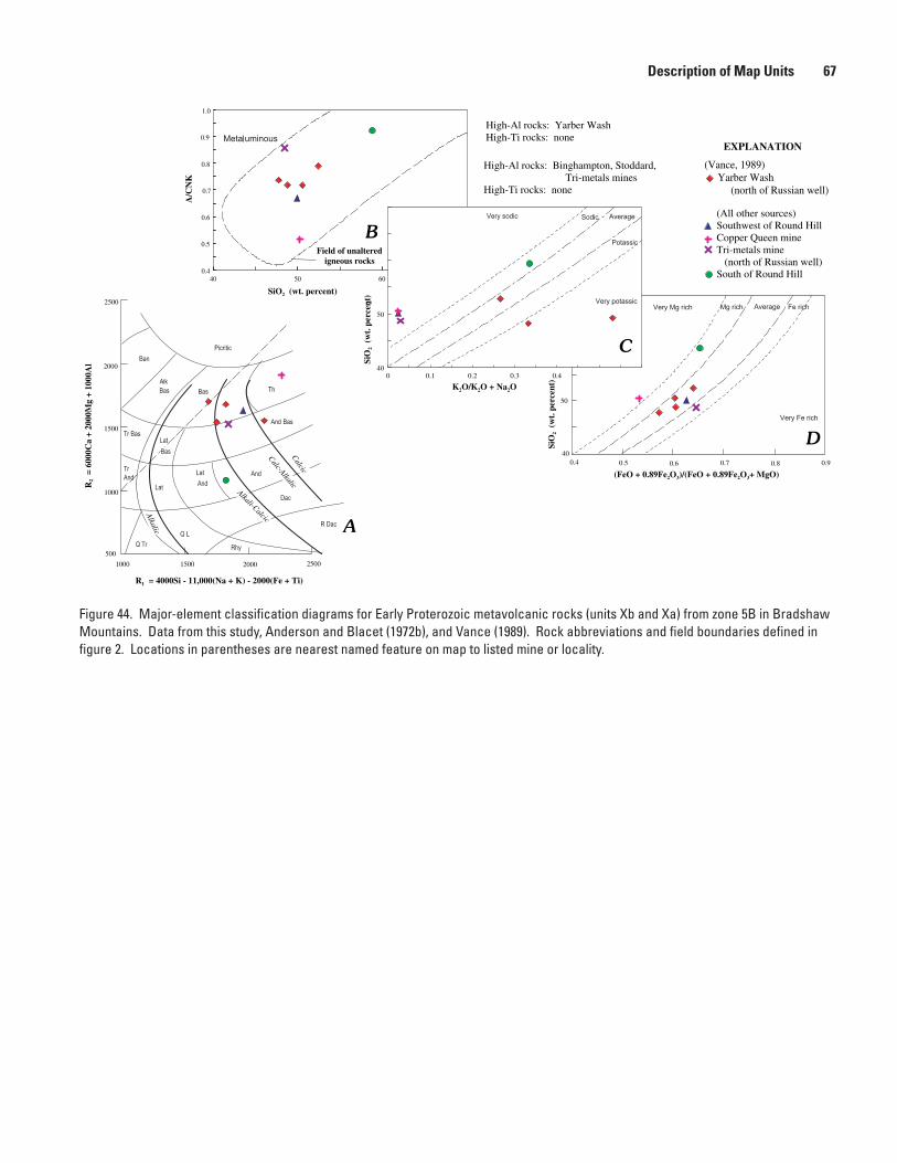
Description of Map Units ��
Figure 44. Major-element classification diagrams for Early Proterozoic metavolcanic rocks (units Xb and Xa) from zone 5B in Bradshaw Mountains. Data from this study, Anderson and Blacet (1972b), and Vance (1989). Rock abbreviations and field boundaries defined in figure 2. Locations in parentheses are nearest named feature on map to listed mine or locality.
0.4
0.5
0.6
0.7
0.8
0.9
1.0
40 50 60
A/C
NK
Field of unalteredigneous rocks
B
SiO2 (wt. percent)
60
50
400.4 0.5 0.6 0.7 0.8 0.9
SiO
2 (w
t. p
erce
nt)
(FeO + 0.89Fe2O3)/(FeO + 0.89Fe2O3+ MgO)
D
0 0.1 0.2 0.3 0.440
50
K2O/K2O + Na2O
SiO
2 (w
t. p
erce
nt)
C
2500200015001000
500
1000
1500
2000
2500
Calcic
Calc-Alkalic
Alkali-Calcic
Alkalic
R1 = 4000Si - 11,000(Na + K) - 2000(Fe + Ti)
R2
= 60
00C
a +
2000
Mg
+ 10
00A
l
A
High-Al rocks: Binghampton, Stoddard, Tri-metals minesHigh-Ti rocks: none
(All other sources)Southwest of Round HillCopper Queen mineTri-metals mine (north of Russian well)South of Round Hill
2
High-Al rocks: Yarber WashHigh-Ti rocks: none
(Vance, 1989) Yarber Wash (north of Russian well)
EXPLANATION

�� Geologic Map of the Prescott National Forest and the Headwaters of the Verde River, Arizona
Figure 45. Major-element classification diagrams for Early Proterozoic metavolcanic rocks (units Xb and Xa) of intermediate to mafic composition from zone 6A in the Black Hills. Data from this study, Anderson and Creasey (1958), Wolfe (1983), and Vance (1989). Rock abbreviations and field boundaries defined in figure 2.
0.4
0.5
0.6
0.7
0.8
0.9
1.0
40 50 60
A/C
NK
Field of unalteredigneous rocks
B
SiO2 (wt. percent)
60
50
400.4 0.5 0.6 0.7 0.8 0.9
SiO
2 (w
t. p
erce
nt)
(FeO + 0.89Fe2O3)/(FeO + 0.89Fe2O3+ MgO)
D
0 0.1 0.2 0.3 0.440
50
K2O/K2O + Na2O
SiO
2 (w
t. p
erce
nt)
C
2500200015001000
500
1000
1500
2000
2500
Calcic
Calc-Alkalic
Alkali-CalcicAlkalic
R1 = 4000Si - 11,000(Na + K) - 2000(Fe + Ti)
R2
= 60
00C
a +
2000
Mg
+ 10
00A
l
A
High-Al rocks: Munds DrawHigh-Ti rocks: none
Near Squaw Peak Squaw Creek Canyon Gap Creek Marlow Mesa Verde River
EXPLANATION
High-Al rocks: Squaw Creek Canyon, Gap Creek, Verde RiverHigh-Ti rocks: none
Munds DrawGrapevine GulchBrindle PupBurnt Canyon

Description of Map Units ��
Figure 46. Major-element classification diagrams for Early Proterozoic metavolcanic rocks of felsic to intermediate composition from zone 6A in the Black Hills and near Dugas. Data from this study, Anderson and Creasey (1958), and Vance (1989). Rock names in brack-ets are those from Vance (1989), as based on minor-element classification scheme of Winchester and Floyd (1977): Th, tholeiite; And, andesite; Dac, dacite. A, R1R2 major-element classification diagram (De la Roche and others, 1980). T Bas, trachybasalt; Lat Bas, latitic basalt; And-Bas, andesitic basalt; T And, trachyandesite; Lat, latite; Lat And, lati-andesite; And, andesite; Tr, trachyte; Q Lat, quartz latite; Dac, dacite; Q Tr, quartz trachyte; Alk Rhy, alkali rhyolite; Rhy, rhyolite; R Dac, rhyodacite. Fields of alkalinity from Fridrich and others (1998). B–D, Field boundaries defined in figure 18.
60
500.5 0.6 0.7 0.8 0.9 1.0
(FeO + 0.89Fe2O3)/(FeO + 0.89Fe2O3+ MgO)
SiO
2 (w
t. p
erce
nt)
D
0.7
0.8
0.9
1
1.1
1.2
1.3
50 60 70
A/C
NK
Field of unalteredigneous rocks
SiO2 (wt. percent)
B
A
30002500200015001000
500
1000
1500
Calcic
Calc-AlkalicAlkali-Calcic
Alkalic
R1 = 4000Si - 11,000(Na + K) - 2000(Fe + Ti)
R2
= 60
00C
a +
2000
Mg
+ 10
00A
l
60
500 0.2 0.4 0.6
K2O/K2O + Na2O
SiO
2 (w
t. p
erce
nt)
C
High-Al rocks: Tule CanyonHigh-Ti rocks: none
Bishop CreekTule CanyonWillow Spring
(All other sources)Indian HillsGrapevine GulchBrindle PupBurnt Canyon
High-Al rocks: Brindle PupHigh-Ti rocks: some Burnt Canyon, Deception
(Vance, 1989)Grapevine Gulch [Th]Brindle Pup [And]Burnt Canyon dacite [And]Burnt Canyon, felsic [Dac]
EXPLANATION

�0 Geologic Map of the Prescott National Forest and the Headwaters of the Verde River, Arizona
Figure 47. Major-element classification diagrams for Early Proterozoic metavolcanic rocks (unit Xa) of intermediate to mafic composi-tion from zone 6B in the Black Hills. Data from this study, Anderson and Creasey (1958), Vance (1989), and Gustin (1990). Rock abbrevia-tions and field boundaries defined in figure 2.
0.4
0.5
0.6
0.7
0.8
0.9
1.0
40 50 60
A/C
NK
Field of unalteredigneous rocks
B
SiO2 (wt. percent)
60
50
400.4 0.5 0.6 0.7 0.8 0.9
SiO
2 (w
t. p
erce
nt)
(FeO + 0.89Fe2O3)/(FeO + 0.89Fe2O3+ MgO)
D
0 0.1 0.2 0.3 0.440
50
K2O/K2O + Na2O
SiO
2 (w
t. p
erce
nt)
C
2500200015001000
500
1000
1500
2000
2500
Calcic
Calc-Alkalic
Alkali-Calcic
Alkalic
R1 = 4000Si - 11,000(Na + K) - 2000(Fe + Ti)
R2
= 60
00C
a +
2000
Mg
+ 10
00A
l
A
High-Al rocks: noneHigh-Ti rocks: Shea
GaddesShea
EXPLANATION

Description of Map Units �1
Figure 48. Major-element classification diagrams for Early Proterozoic metavolcanic rocks (units Xa, Xd, Xrd, and Xr) of felsic to intermediate composition from zone 6B in the Black Hills. Data from this study, Anderson and Creasey (1958), Vance (1989), and Gustin (1990). Rock abbreviations defined in figure 46; field boundaries defined in figure 18. Rock names in brackets are those from Vance (1989), as based on minor-element classification scheme of Winchester and Floyd (1977): Dac, dacite; And, andesite; Bas-And, basaltic andesite; R Dac, rhyodacite.
60
500.5 0.6 0.7 0.8 0.9 1.0
(FeO + 0.89Fe2O3)/(FeO + 0.89Fe2O3+ MgO)
SiO
2 (w
t. p
erce
nt)
D
0.7
0.8
0.9
1
1.1
1.2
1.3
50 60 70
A/C
NK
Field of unalteredigneous rocks
SiO2 (wt. percent)
B
60
500 0.2 0.4 0.6
K2O/K2O + Na2O
SiO
2 (w
t. p
erce
nt)
C
30002500200015001000
500
1000
1500
Calcic
Calc-Alkalic
Alkali-CalcicAlkalic
R1 = 4000Si - 11,000(Na + K) - 2000(Fe + Ti)
R2
= 60
00C
a +
2000
Mg
+ 10
00A
l
A
High-Al rocks: noneHigh-Ti rocks: SheaMod-Ti rocks: Buzzard
(All other sources)Quartz porphyryCleopatraDeceptionGaddesSheaBuzzard
High-Al rocks: GaddesHigh-Ti rocks: Shea
EXPLANATION
(Vance, 1989)Buzzard [Dac]Deception, Cleopatra member [R Dac, Dac]Deception, southGaddes [And, Dac]Shea [Bas-And]

41C)andveryFerich(fig.41D).Brecciabodiescontainedwithintheflowsalsoareandesiticbasaltthatrangesfromalkali-calcictocalcic(fig.41A)andthatareverysodictosodic(fig.41C)andveryFerich(fig.41D).Alltheseflows,exceptthosethatarehighTi,havechondrite-normalizedREEpatternsthathaveslightLREEenrichmentandlittletonoEuanomalies(Vance,1989;thisstudy).
SomeflowseastofIronKingminearecalc-alkalictoalkali-calcicandesiticbasalt,butmoreareandesitic(fig.41A).Andesiticbasaltisverysodic(fig.41C)andFerich(fig.41D),similartoflowsatSpudMountain.
FlowsatHuronmineandeastofHumboldtarecalcictholeiitetocalc-alkalicbasalt(fig.41A)thatisverysodic(fig.41C)andaveragetoveryFerich(fig.41D).Chondrite-normalizedREEpatternsoftheseflowsaresimilartothoseonSpudMountain.
Mostflowsinzone4Carecalc-alkalicbasalttocalcictholeiite(fig.42A)thatareverysodic(fig.42C)andMgrichtoveryFerich(fig.42D).REEpatternsofsuchrocksinnorthernandcentralpartsofzonehavetypicalLREEenrichmentandlittleornoEuanomaly(Vance,1989;thisstudy).Maficrocksinsouthernpartofzone,how-ever,haverelativelyflatREEpatterns,similartothoseofbasalticrocksinzone2.
Zones5Aand5Bcontainminorbasalt,principallyalongeastsideofCrazyBasinGranite,fromsoutheastofMayertosouthedgeofmaparea,andinYarberWasharea.InTownsendButteandBlandHillareas(zone5A),basalttotholeiiteismostcommon,butminorultramaficrocksarenoted(fig.43A).FlowsarepredominantlyverysodictoaverageinK/Naratio(fig.43C)andrangewidelyinFe/Mgratio(fig.43D).Calc-alkalicbasaltandcalcictholeiitearealsothemostcommonflowsinzone5B(fig.44A).FlowsnearcontactwithgranophyreofCherryareenrichedinpotassium(fig.44C).Mostflowsinzone5BareaverageinFe/Mgratio(fig.44D).FlowsnearCordesandBlandHillhavelowconcentrationsofREEandrelativelyflatchondrite-normalizedpatterns.
Theonlybasalticflowsinzone6AareatfarnorthwestendofBlackHills,nearheadofMundsDraw,andnorthofSquawPeak,alongsouthmarginofVerdeRivervalley.FlowsatMundsDrawaredistinctlyporphyritic,containingplagioclasepheno-crysts.Flowsarecalc-alkalicbasalttocalcictholeiite(fig.45A)thatissodictopotassic(fig.45C)andveryFerich(fig.45D).REEabundancesareamonglowestofallbasalts.Chondrite-normalizedpatternisflat.FlowsinSquawCreekCanyonarealkali-calcictocalc-alkalicbasalt(fig.45A)thatrangewidelyinK/Naratio(fig.45C)andareveryFerich(fig.45D)
Xb2 Basaltic tuff—Fine-tomedium-grained,metamorphosedbasaltictuff,basalt,andchemi-callyprecipitatedtuffaceousrocks.Exposedinzones2,3A,and4C.MasssouthofPrescott(zone2)ismixtureofbasaltictuffandtuffaceoussedimentaryrocks(Krieger,1965)andislargelyfeldspar-actinoliteschistandinterbeddedquartz-feldspar-biotiteschist.MasseseastofLynxCreekandnearheadofGreenGulch(zone3A)haveprotolithsimilartothatsouthofPrescott.LargemasssouthofMayerismixtureofthinbasaltflows,interflowmafictuff,andthinbodiesofiron-formationandchert.UnitprobablyextendsnorthofArizonahighway69.Metamorphosedtoactinolite-plagioclase-chloriteschist.MassnorthandsouthofCrownKing(zone4C)waspredominantlyafine-grainedcalcareousmafictuffthatcontainedthinbasaltflows(DeWitt,1976).Tuffmetamorphosedtodiopside-plagioclase-quartz-hornblende-gar-net-epidotecalc-silicaterock
Xb4 Basaltic agglomerate—Fine-tomedium-grained,metamorphosedbasaltmatrixandangulartosubroundedclastsofchert,andesite,basalt,minorrhyolite,andcalcareousrocks(DeWitt,1979;Blacet,1985).LargemassexposedeastofBlueBellmine(zone4C).Thickness500–900m.Matrixiscalc-alkalicbasalt(fig.42A)thatisverysodic(fig.42C)andMgrich(fig.42D).SmallermassesexposedatTri-metalsmine,northofRussianwell,andeastofRattlesnakeCanyon(zone5B).MatrixnearTri-metalsmineiscalc-alkalictocalcic(fig.44A),haslargerangeinK/Naratio(fig.44C),andisaver-agetoFerich(fig.44D).MatrixhaslowconcentrationofREEandflatchondrite-normalizedpattern(Vance,1989;thisstudy).Thickness20–50m
�� Geologic Map of the Prescott National Forest and the Headwaters of the Verde River, Arizona

Xab Andesitic basalt flows—Fine-tomedium-grainedmetamorphosedandesiticbasaltandminorbasaltandandesite.Maficphenocrystsminor,butwherepresentareconvertedtoamphiboleandopaqueoxideminerals.Exposedinzones3,4,and5.Presentinzone2nearJerseyLilymine,butincludedwithinmoreextensivebodyofbasalt.
Zone3AcontainsabundantflowsfromsouthofSpruceMountaintoeastofLynxCreek.NorthofWalker,flowsarepredominantlycalc-alkalicbasalticandesiteandalkali-calcicandesiticbasalt(fig.38A).Sodicenrichment,orspilitization,hasaffectedmanyofthemaficrocks(Vance,1989).Suchspilitizedrockswouldplotbelowandtotheleftoftheirunalteredprotolithsonfigure38A.Evenunalteredrocksareverysodictosodic(fig.38C).AllflowsexceptoneatPotatoPatchhavechondrite-normal-izedREEpatternsthathaveaslightREEenrichmentandaminornegativeEuanomaly(Vance,1989;thisstudy).
OnelargemassofbasalticandesitenearCordesisaverageinK/Naratio(fig.43C)andFerich(fig.43D).Lati-basaltnearCordesisresultofspilitizationofandesiticbasalttobasalt(fig.43A)
Xab1 Andesitic basalt breccia—Fine-tomedium-grained,metamorphosedbasalticandesitematrixandangularclastsofandesiteandmorefelsicvolcanicrocks(AndersonandBlacet,1972b).ExposedinlargemassfromSpudMountainonthenorthtoBigBugMesaonthesouth.Flowswithinbrecciaarelargelycalc-alkalictocalcicbasalticandesite(fig.41A)thatissodictoaverageinK/Naratio(fig.41C)andveryFerich(fig.41D).Brecciafragmentswithinflowsalsoarebasalticandesitethatrangefromalkali-calcictocalcic(fig.41A)andthatareverysodictosodic(fig.41C)andveryFerich(fig.41D).Alltheseflows,exceptthosethatarehighTi,havechondrite-normalizedREEpatternsthathaveslightLREEenrichmentandlittletonoEuanomalies(Vance,1989;thisstudy)
Xa Andesitic flows—Fine-tomedium-grained,metamorphosedandesiteandminorandesiticbasaltanddacitecontainingalteredphenocrystsoffeldspar.Exposedinzones2,4,and5inBradshawMountainsandinzone6inBlackHillsandDugasareas.BodyalongSlateCreek(zone2)containssomebrecciafragments.AndesiticrocksalongLittleCopperCreekandnearPotatoPatchincludedinandesiticbasalt(unitXab).
Bodyinzone4BthatextendsfromIronKingmineonthenorthtoLittleBugMesaonthesouthispredominantlycalc-alkalictoalkali-calcicandesite(fig.41A)thatisverysodic(fig.41C)andFerichtoveryFerich(fig.41D).Alkali-calcicbasalticandesite(fig.41A)isinterbeddedwiththeandesite.Includedwiththisnormalandesiteareflowsofhigh-Tiandesitetolati-andesitethatareenrichedinREEandformchon-drite-normalizedpatternsthatslopegentlydownfromtheLREEtotheheavyrare-earth-element(HREE)andthathaveminortononegativeEuanomalies(Vance,1989;thisstudy).
Alargeareaofandesiteflows,tuffs,andinterbeddedchertandiron-formationcropsoutfromMayertoCrownKinginzone4C.AndesitefromneartheSwastikamineisrepresentativeoftheflows,whicharecalc-alkalic(fig.42A),verysodic(fig.42C),andveryFerich(fig.42D).SmallerareasofandesitearefoundeastofCordestoMayerinzone5A.
IntheBlackHills(zone6A),andesitesarenotedasbombswithintuffaceousrocksinGrapevineGulchFormationalongYaegerCanyon(Vance,1989).Bombsarecalc-alkalic(fig.46A),verysodictosodic(fig.46C),andveryFerich(fig.46D).
TheSheaBasalt(AndersonandCreasey,1967),whichcropsoutsouthofJeromeinzone6B,isadistinctivehigh-Tiandesitetolati-andesitethatisalkali-calcictocalc-alkalic(figs.47A,48A).TheShea,whichisverysodic(figs.47C,48C)andveryFerich(figs.47D,48D),iscutbygabbrosillsanddikestoosmalltobeshownatmapscale.LimiteddatafromalteredsamplesofdikesandsillssuggestanalkalicsyenogabbrotosyenodioriticcompositionthatisMgrich.GabbrosofthiscompositionareunknownfromEarlyProterozoicrocks(unitsXgb,Xlgb,Xdi)inmaparea,butarepresentinMiddleProterozoicgabbro(unitYgb).AgeneticrelationshipoftheSheatothegabbrobodiesispossible,butunprovenatpresent.
Description of Map Units ��

AlongSquawCreekCanyonandtothesouth,alongVerdeRiver(zone6A),calc-alkalictoalkali-calcicandesite(fig.45A)isexposedthatissodictoverypotassic(fig.45C)andaveragetoFerich(fig.45D)
Xa1 Andesitic breccia—Fine-tomedium-grained,metamorphosedandesiticmatrixandangu-larclastsofandesiteandmorefelsicvolcanicrocks(AndersonandBlacet,1972b,c).SmallbodynorthofMt.Elliottinzone3Ahasmatrixofcalcicandesitetodacite(fig.38A)thathasanaverageK/Naratio(fig.38C)andisaveragetoFerich(fig.38D).SmallbodiesofandesitebrecciaareexposedfromBigBugMesatowestofBradyButteinzones4Aand4B.Althoughrocksarealtered,theirminor-elementcomposi-tionindicatesanandesiticcomposition.AlargemassofandesiticbrecciaextendsfromeastofHumboldttonearCopperMountain,eastofMayer.Minor-elementchemistryofrockssuggestsabasalticandesitetoandesite.AndesiticbrecciainGrapevineGulchFormationexposednorthofShylockmineinzone6Ahasamatrixthatiscalc-alkalic(figs.45A,46A),predominantlyverysodictosodic(figs.45C,46C),andaveragetoveryFerich(figs.45D,46D)
Xa3 Andesitic intrusive rocks—Fine-grained,porphyriticintrusiverockorflowdomecontain-ingphenocrystsofplagioclaseandalteredmaficmineral.ExposedonlysouthofRoundHillinzone5B.Andesiteisalkali-calcic(fig.44A),sodic(fig.44C),andMgrich(fig.44D)
Xd Dacitic flows—Fine-grained,porphyriticdacitecontainingphenocrystsofplagioclase.FlowsandbrecciasexposedeastofClimaxmineinzone2andwestofLynxLakeinzone3.MinordaciteinterbeddedwithbasalticandesitebreccianorthofBigBugMesainzone4Biscalc-alkalic(fig.39A),verysodic(fig.39C),andveryFerich(fig.39D).DaciteinterbeddedwithbasaltandrhyoliteatBlueBellmine(zone4C)iscalcictocalc-alkalic(fig.42A),verysodic(fig.42C),andMgrich(fig.42D).AtCopperMoun-tain,inzone5A,dacitecompositionisinferredfromminor-elementchemistry.
FlowsinGrapevineGulchFormationinsouthernBlackHills(zone6A)rangefromcalcicdaciteorrhyodacitetocalc-alkalicandesite,andincludeminorrhyolite(fig.46A).Anaveragecompositionisdacite,butsomeflowsmayberhyodacite.AndesiteanddaciteorrhyodacitearesodictoaverageinK/Naratio(fig.46C)andveryFerich(fig.46D).
TheBrindlePupAndesiteisaseriesofvesicularflowsthathaveafine-grainedgroundmassandconspicuousplagioclasephenocrysts.Flowsrangeincompositionfromcalc-alkalicandesitetocalcicrhyodacite(fig.46A),andhaveanaveragecomposi-tionofdacite.Overall,flowsaremetaluminoustostronglyperaluminous(fig.46B),predominantlyverysodic(fig.46C),andpredominantlyFerichtoveryFerich(fig.46D)
Xd1 Dacitic breccia—Fine-grainedmatrixofslightlyporphyriticdacitecontainingplagioclasephenocrysts.Abundantclastsofdaciteandmorefelsicvolcanicfragments.ExposedaroundCopperMountain,eastofMayerinzone5B.Daciticcompositioninferredfromminor-elementchemistry
Xd2 Dacitic tuff—Fine-grainedmatrixandabundantfeldsparandquartzphenocrystsincrystal-richtuff.Containsvariableconcentrationsoffelsictointermediate-compositionclasts.Hasbothweldedandnonweldedcharacteristicswheremetamorphismhasnotdestroyedoriginaltextures.
LargestmassexposedwestofBattleFlat,onwestsideofBradyButteGrano-diorite,inzone4A.Containsabundantplagioclasephenocrystsandlesserpartiallyresorbedquartzphenocrysts(Blacet,1985).Lithicfragmentsmostlyofdacitictoandesiticcomposition.Probablyintertongueswithandesiticmaterialtothenorth.Compositionrangesfromcalcicrhyodacitetocalc-alkalicdacite(fig.40A)thatismetaluminoustoslightlyperaluminous(fig.40B),verysodictosodic(fig.40C),andveryMgrichtoaverageinFe/Mgratio(fig.40D).Mg-richnatureofdaciteisatypicalforunalteredrocksinBradshawMountainsandBlackHills,asmostrocksareaveragetoFerich(fig.35D).REEpatternhasflatHREEsegmentandslightlyenrichedLREEandminornegativeEuanomaly(Vance,1989;thisstudy).Major-andminor-element
�� Geologic Map of the Prescott National Forest and the Headwaters of the Verde River, Arizona

chemistryofdacitecloselyresemblethatofMinnehahaGranodiorite(newlynamed),suggestingthatgranodioritemaybesubvolcanicequivalentofdacite.
SmallerbodiesexposednorthofChaparralfaultinzones3Aand4Bcontainfewerphenocrystsofplagioclaseandmorelithicfragments(Krieger,1965).Tuffinter-beddedwithbrecciabeds.
Crystal-andlithic-richtuffexposedalongTuleCanyon,eastofDugasinzone6A,retainsvariablecompactionandweldingtextures.Tuffisacalc-alkalicdacitetorhyodacite(fig.46A),andismoremafictowardthebase.Tuffismetaluminoustomildlyperaluminous(fig.46B),verysodic(fig.46C),andFerichtoveryFerich(fig.46D).
TuffaceousrocksinGrapevineGulchFormationinsoutheasternBlackHills(zone6A)containmixedsedimentaryunitsandcontainclastsofrhyolite,dacite,anddarkandesite.AlongYaegerCanyon,onwestsideofMingusMountain,tuffcontainsmaficlithicmaterialandhyaloclastite(Vance,1989)
Xd3 Dacitic intrusive rocks—Fine-grained,porphyritictoequigranulardacitecontainingphe-nocrystsofplagioclase.ExposedonlyinGrapevineGulchFormationinsoutheasternBlackHills(zone6A).Maygradeintoflows
Xrd Rhyodacitic flows—Fine-grained,porphyriticrhyodacitecontainingphenocrystsofquartzandfeldspar.Includesminorcrystal-richtuffandfragmentalrhyodacite.Exposedonlyinsmallbodiesinzones3Aand3BinBradshawMountains,butwidelyexposedinsouthernBlackHills,northofCherry.
SmallbodiesnearthePoland-WalkerTunnelandalongBigBugCreeknorthofBigBugMesaarecalc-alkalic(figs.39A,41A),predominantlyverysodic(fig.41C),andaveragetoFerich(figs.39D,41D).SimilarbodiesalongBenjaminGulchinzone3Aarepresumedtobecalc-alkalicrhyodacitethatisstronglyperaluminous,verysodic,andveryFerich.
InsouthernBlackHills,threemajorrockunitshaverhyodaciticcomposition.DaciteofBurntCanyoncontainsvesicularflowshavingafine-grainedgroundmassandphenocrystsofplagioclaseandfine-grainedquartz.Flowsrangefromalkali-calcicrhyodacitetocalc-alkalicrhyodacite(fig.46A),andaremetaluminoustomildlyperalu-minous(fig.46B),verysodic(fig.46C),andFerichtoveryFerich(fig.46D).Relictphenocrystassemblagemayindicateanoverallandesiticcomposition(Vance,1989).FelsicpartsofBurntCanyonflowsarecalcicrhyodacite(fig.46A),stronglyperalumi-nous(fig.46B),verysodic(fig.46C),andpredominantlyaverageinFe/Mgratio(fig.46D).Similarly,relictphenocrystassemblagemayindicateanoverallandesiticcompo-sition(Vance,1989).
TheDeceptionRhyolitesouthofBrindlePupminehasafine-grainedtoapha-niticgroundmassandphenocrystsofplagioclaseandquartz.Limitedsamplessuggestthatflowsarecalc-alkalicrhyodacite(fig.48A)thatisstronglyperaluminous(fig.48B),verysodic(fig.48C),andaverageinFe/Mgratio(fig.48D).Thisrhyodaciticcomposi-tionisslightlymoremaficthanthatofleastalteredrocksintheDeception(?)RhyolitenearJerome.
RocksmappedasGaddesBasaltareveryheterogeneousandcontainlittletonobasalt.Majorrocktypesconsistoffine-grained,darkrhyodacite,dacite,spilitizedandesite,andveryminorbasalt.Mostsampledunitsarecalc-alkalictocalcicrhyoda-cite(fig.48A)thatismetaluminous(fig.48B),verysodic(fig.48C),andFerichtoveryFerich(fig.48D).
RhyodaciteflowsareexposedonMarlowMesaandalongGapCreekinzone6A.Flowsarecalc-alkalicrhyodacite(fig.45A)thatismildlyperaluminous(fig.45B),hasawiderangeinK/Naratio(fig.45C),andisaveragetoveryFerich(fig.45D).
AgeofDeceptionRhyolitenearJeromewassuggestedtobeabout1,770Ma(Andersonandothers,1971),butthatagewasquestionedbyL.T.SilverinConwayandKarlstrom(1986).Ageofabout1,740Ma(S.A.Bowring,unpub.U-PbzircondatacitedinKarlstromandBowring,1991)maybemoreaccurate
Xr Rhyolitic flows and pyroclastic rocks—Fine-grained,porphyriticrhyolitecontainingphe-nocrystsofquartzandminorfeldspar.Includessmallbodiesofbrecciaandtuff,aswell
Description of Map Units ��

assilicifiedandveinedrhyolitethatisnotincludedinthehydrothermallyalteredrhyo-literelatedtomassivesulfidemineralization(unitXrh).Someflowshaveextensivelybrecciatedflowtopsandmargins,andaredifficulttodistinguishfrombodiesofbreccia.Exposedthroughoutzones1through6.Particularlyabundantinzone5AalongeasternmarginofCrazyBasinGraniteandinzone6BinsouthernBlackHills.
FlowsandminortuffeastofClimaxmineinzone2areinterbeddedwithdaciteandmoremaficrocks.BodiesnorthofSpruceMountaininzone3Aaremostlyflows,butincludesomehypabyssalintrusivemassesthatcutbasalticandesite.Limiteddatasuggestthatflowsandhypabyssalbodiesarecalc-alkalicrhyolitetorhyodacitethatismildlyperaluminous,verysodic,andMgrich.
ThinflowsandminorbodiesoftuffnorthofChaparralhigh-strainzoneandnearLynxCreekinzone3Arangefromcalcicrhyolitetorhyodacitethatisstronglyperalu-minous,verysodic,andveryMgrichtoalkali-calcicrhyolitethatismildlyperalumi-nous,verysodic,andFerich(Vance,1989;thisstudy).
SouthofChaparralhigh-strainzone,alongBigBugCreek,inzone4B,bodiesofrhyoliteareinterbeddedwithrhyodaciteandminortuff.Leastalteredbodiesofrhyoliterangeincompositionfromcalcicrhyodacitetoalkali-calcicrhyolitethatismildlyper-aluminous,rangeswidelyinK/Naratio,andisaveragetoFerich(Vance,1989).NorthofBigBugCreek,nearMt.Elliott,limiteddatasuggestpresenceofalkali-calcicrhyo-litetoalkalirhyolitethatismildlyperaluminous,averageinK/Naratio,andFerich.
Largebodiesofrhyolite,breccia,andtuffareexposedfromnorthofCrownKingstocktosoutheastofHumboldtinzone4C.Thelargestbodies,nearDeSotomineandsoutheastofRoundHill,aresilicified.LimiteddatafromsmallerbodiesnorthandwestofMayersuggestrhyoliteisalkali-calcic,mildlyperaluminous,sodic,andaverageinFe/Mgratio.
Largestconcentrationofrhyoliteflows,tuffs,andvariablysilicifiedrhyoliteinmapareaisalongBlackCanyonandwithintheBlackCanyonhigh-strainzone,fromnearCordestopastsouthernboundaryofmaparea(Jerome,1956;AndersonandBlacet,1972c).Silicificationandlossofalkalimetalsmakeoriginalcompositionofrhyolitesdifficulttoascertain.
BodiesofrhyolitenearCordesinzone5Aarefine-grainedflowsinterbeddedwithandesiteandbasalticandesite.Rhyoliteiscalc-alkalic,mildlyperaluminous,verysodic,andaveragetoFerich.NumerousbodiesofrhyolitefromsoutheastofRoundHilltowestofYarberWashinzone5Brangefromflowstohypabyssalintrusivemasses.Dataaretoolimitedtoassessthechemistryoftheserhyolitebodies.
Fine-grainedtoaphaniticflowsandhypabyssalbodiesareinterbeddedwithtuffwestofnorthernBlackHills,alongCoyoteWash(zone6A).Limiteddatasuggestthathigh-silicarhyoliteiscalc-alkalic,mildlyperaluminous,verysodic,andFerich.
PorphyriticrhyolitecontainingquartzandminorplagioclasephenocrystsatWil-lowSpring,eastofDugasinzone6A,isalkali-calcic(fig.46A),mildlyperaluminous(fig.46B),verysodic(fig.46C),andaveragetoveryFerich(fig.46D).
TheBuzzardRhyoliteinsouthernBlackHills(zone6B)isaflow-bandedrockthatcontainsphenocrystsofplagioclaseandquartz.Fragmentsoffelsicvolcanicsarecommoninrhyolite,andbrecciabedsthatlackmatrixmaterialarenoted(AndersonandCreasey,1958).Thishigh-silicarhyoliterangesfromcalcictoalkali-calcic(fig.48A)andismildlytostronglyperaluminous(fig.48B),verysodic(fig.48C),andMgrichtoFerich(fig.48D).
CleopatraFormation(previouslyreferredtoasCleopatraQuartzPorphyry)andDeceptionRhyoliteatJeromearesuggestedtobeasoldas1.76Ga(Andersonandothers,1971).Newerdeterminationof1,738±0.5Ma(S.A.Bowring,supplementarydatainSlackandothers,2007)ispreferredageofrhyolite
Xr1 Rhyolitic breccia—Fine-grainedtoaphaniticrhyolitebrecciaandquartz-veinedrhyolite.ExposednorthofBlueBellmineinzone4C.OtherbrecciabodiestoosmalltobeshownatmapscaleareatDeSotomine,inzone4C;southwestofRoundHill,inzone4C;atCopperQueenmine,tothesoutheastofRoundHillinzone5B;andatCopperMountain,eastofMayerinzone5B.Hydrothermallyalteredequivalentofsimilar
�� Geologic Map of the Prescott National Forest and the Headwaters of the Verde River, Arizona

brecciaisextensivelyexposedsouthofUnitedVerdemineatJerome,whereitispartofDeceptionRhyoliteandCleopatraFormation
Xr2 Rhyolitic tuff—Fine-grained,porphyriticrhyolitecontainingabundantphenocrystsofpar-tiallyembayedquartz.Particularlyabundantinzones5and6.Silicifiedandleachedofalkalimetalsinmanyoutcrops.Describedasquartzporphyryinplaces(AndersonandBlacet,1972c).
AtHackberrymine,southofPolandJunctioninzone4B,andextendingtothenorth,crystal-poortuffcontainsfragmentsoffelsicvolcanicrocksandminorandesite.
AlongBlackCanyon,fromTownsendButteonthenorthtopastsouthernbound-aryofmaparea,thicksequencesofcrystal-richtuffareinterbeddedwithrhyoliteflowsandflowsoffelsiccomposition.Somebodiesoftuffcouldbehypabyssalintrusiverocks.Silicifiedandleachedofalkalimetalsinmanyoutcrops,asaresimilarrocksnorthofTownsendButte(O’Hara,1987b).Alterationtoclay-richprotolithinEarlyProterozoicfacilitateddevelopmentofhigh-strainzonealongthicksequenceoftuffdur-ingregionalmetamorphismanddeformation.Leastalteredtuffiscalc-alkalicrhyolitethatisstronglyperaluminous,verysodic,andveryFerich.
LargestbodyoftuffisexposednortheastofMayer,fromnearRoundHilltowestofCopperMountain.ThistuffislessalteredthanthosealongBlackCanyon;therefore,high-strainzonesnotdevelopedhereasopposedtozonesalongBlackCan-yon.LeastalteredtuffnorthwestofCopperMountainisstronglyperaluminous,calc-alkalictocalcic,averagetopotassic,andaverageinFe/Mgratio.
BodiesoftuffinterbeddedwithSheaBasaltsouthofJerome,nearCopperChiefmine,werereferredtoasquartzporphyry(AndersonandCreasey,1958).Leastalteredrocksarealkali-calcictocalc-alkalicrhyolitethatisslightlyperaluminous,verysodic,andaveragetoFerich.
SouthofUnitedVerdemine,alongHullCanyon,relativelyunalteredtuffisinterbeddedwithbrecciabeds.SomeofthistuffispartofCleopatraQuartzPorphyryorCleopatraFormation(AndersonandCreasey,1958;AndersonandNash,1972)thathoststhemassivesulfideoreatthemine.Othertuffisstratigraphicallyabovebedsthathostmassivesulfideore(Gustin,1990).LeastalteredtuffintheCleopatrathathostsoreiscalc-alkalicrhyolitethatismildlytostronglyperaluminous,verysodic,andaveragetoveryFerich(VanceandCondie,1987).DeceptionRhyolitehasmoderatenegativeEuanomaly,similartothatinBuzzardRhyolite(Vance,1989).LeastalteredtuffinbedsabovetheCleopatraissilicifiedandstronglyperaluminous,verysodic,andveryMgrich(Gustin,1990).
AgeofrhyolitetuffalongBigBugCreeknorthofBigBugMesainzone3Babout1,750Ma(Andersonandothers,1971)
Xr3 Rhyolitic intrusive rocks—Fine-grained,equigranulartoslightlyporphyritic,irregularlyshapedmassescontainingquartzphenocrysts.IncludeslargediscordantmasswestofYarberWashinzone5BandsmallerdiscordantbodiesinGrapevineGulchForma-tioninsouthernBlackHillsofzone6A.IntrusiverhyoliticrockshavelargenegativeEuanomalies,whichdistinguishthemfromotherrhyoliticrocks,suchasBuzzardandDeceptionRhyolites(Vance,1989)
EARLY PROTEROZOIC HYDROTHERMALLY ALTERED METAVOLCANIC ROCKS RELATED TO VOLCANOGENIC MASSIVE SULFIDE DEPOSITS
Xbh Altered basaltic rocks—Silicified,epidotized,andslightlychloritizedrockexposedinirregularlyshapedzones.AlkalimetalsstronglyleachedtoproduceAl-richrockcontainingandalusiteandsillimaniteatHuronmine,southofHumboldt,inzone4C(O’Hara,1987a)
Xah Altered andesitic rocks—Chloritizedrockexposedinlenticulartoirregularlyshapedareas.ExposedwestofMayerinzone4C,southwestofCordesJunctioninzone5A,andnearCopperMountaininzone5B.AlteredrockswestofMayergradeupwardintosilicifiedandesiteandrhyolite.SouthofJerome,inzone6B,chloritizedrocksareeitheralteredandesiteoralteredrhyolite(LindbergandJacobson,1974;Lindberg,1989;Anderson,1989b)
Description of Map Units ��
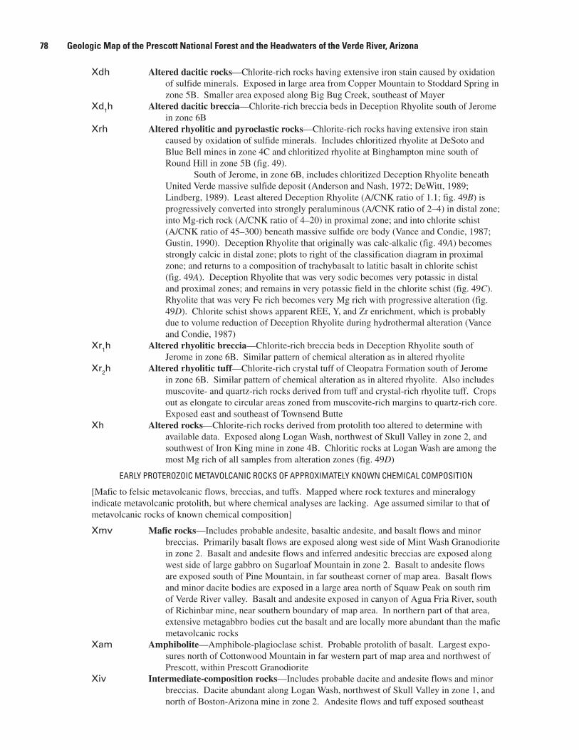
Xdh Altered dacitic rocks—Chlorite-richrockshavingextensiveironstaincausedbyoxidationofsulfideminerals.ExposedinlargeareafromCopperMountaintoStoddardSpringinzone5B.SmallerareaexposedalongBigBugCreek,southeastofMayer
Xd1h Altered dacitic breccia—Chlorite-richbrecciabedsinDeceptionRhyolitesouthofJeromeinzone6B
Xrh Altered rhyolitic and pyroclastic rocks—Chlorite-richrockshavingextensiveironstaincausedbyoxidationofsulfideminerals.IncludeschloritizedrhyoliteatDeSotoandBlueBellminesinzone4CandchloritizedrhyoliteatBinghamptonminesouthofRoundHillinzone5B(fig.49).
SouthofJerome,inzone6B,includeschloritizedDeceptionRhyolitebeneathUnitedVerdemassivesulfidedeposit(AndersonandNash,1972;DeWitt,1989;Lindberg,1989).LeastalteredDeceptionRhyolite(A/CNKratioof1.1;fig.49B)isprogressivelyconvertedintostronglyperaluminous(A/CNKratioof2–4)indistalzone;intoMg-richrock(A/CNKratioof4–20)inproximalzone;andintochloriteschist(A/CNKratioof45–300)beneathmassivesulfideorebody(VanceandCondie,1987;Gustin,1990).DeceptionRhyolitethatoriginallywascalc-alkalic(fig.49A)becomesstronglycalcicindistalzone;plotstorightoftheclassificationdiagraminproximalzone;andreturnstoacompositionoftrachybasalttolatiticbasaltinchloriteschist(fig.49A).DeceptionRhyolitethatwasverysodicbecomesverypotassicindistalandproximalzones;andremainsinverypotassicfieldinthechloriteschist(fig.49C).RhyolitethatwasveryFerichbecomesveryMgrichwithprogressivealteration(fig.49D).ChloriteschistshowsapparentREE,Y,andZrenrichment,whichisprobablyduetovolumereductionofDeceptionRhyoliteduringhydrothermalalteration(VanceandCondie,1987)
Xr1h Altered rhyolitic breccia—Chlorite-richbrecciabedsinDeceptionRhyolitesouthofJeromeinzone6B.Similarpatternofchemicalalterationasinalteredrhyolite
Xr2h Altered rhyolitic tuff—Chlorite-richcrystaltuffofCleopatraFormationsouthofJeromeinzone6B.Similarpatternofchemicalalterationasinalteredrhyolite.Alsoincludesmuscovite-andquartz-richrocksderivedfromtuffandcrystal-richrhyolitetuff.Cropsoutaselongatetocircularareaszonedfrommuscovite-richmarginstoquartz-richcore.ExposedeastandsoutheastofTownsendButte
Xh Altered rocks—Chlorite-richrocksderivedfromprotolithtooalteredtodeterminewithavailabledata.ExposedalongLoganWash,northwestofSkullValleyinzone2,andsouthwestofIronKingmineinzone4B.ChloriticrocksatLoganWashareamongthemostMgrichofallsamplesfromalterationzones(fig.49D)
EARLY PROTEROZOIC METAVOLCANIC ROCKS OF APPROXIMATELY KNOWN CHEMICAL COMPOSITION
[Mafictofelsicmetavolcanicflows,breccias,andtuffs.Mappedwhererocktexturesandmineralogyindicatemetavolcanicprotolith,butwherechemicalanalysesarelacking.Ageassumedsimilartothatofmetavolcanicrocksofknownchemicalcomposition]
Xmv Mafic rocks—Includesprobableandesite,basalticandesite,andbasaltflowsandminorbreccias.PrimarilybasaltflowsareexposedalongwestsideofMintWashGranodioriteinzone2.BasaltandandesiteflowsandinferredandesiticbrecciasareexposedalongwestsideoflargegabbroonSugarloafMountaininzone2.BasalttoandesiteflowsareexposedsouthofPineMountain,infarsoutheastcornerofmaparea.BasaltflowsandminordacitebodiesareexposedinalargeareanorthofSquawPeakonsouthrimofVerdeRivervalley.BasaltandandesiteexposedincanyonofAguaFriaRiver,southofRichinbarmine,nearsouthernboundaryofmaparea.Innorthernpartofthatarea,extensivemetagabbrobodiescutthebasaltandarelocallymoreabundantthanthemaficmetavolcanicrocks
Xam Amphibolite—Amphibole-plagioclaseschist.Probableprotolithofbasalt.Largestexpo-suresnorthofCottonwoodMountaininfarwesternpartofmapareaandnorthwestofPrescott,withinPrescottGranodiorite
Xiv Intermediate-composition rocks—Includesprobabledaciteandandesiteflowsandminorbreccias.DaciteabundantalongLoganWash,northwestofSkullValleyinzone1,andnorthofBoston-Arizonamineinzone2.Andesiteflowsandtuffexposedsoutheast
�� Geologic Map of the Prescott National Forest and the Headwaters of the Verde River, Arizona

Figure 49. Major-element classification diagrams for hydrothermally altered Early Proterozoic felsic metavolcanic rocks (units Xrh and Xr2h) south of Jerome, stratigraphically beneath United Verde massive sulfide deposit. Data from Vance and Condie (1987), Vance (1989), Gustin (1990), and this study. Rock abbreviations defined in figure 46; field boundaries defined in figure 18. Alteration zones from Vance (1989). Note change in scale of X and Y axes in B, C, and D. Dotted blue line with arrow shows overall trend of chemical change during progressive alteration of rhyolite to chlorite schist. Two-letter abbreviations are altered rhyolite from massive sulfide deposits or prospects in Bradshaw Mountains: BH, Binghampton mine; ST, Stoddard mine; LW, Logan Wash prospect; BB, Blue Bell mine. Red arrow indicates point lies outside of plot, in direction indicated.
A/C
NK B
Field of unalteredigneous rocks
0.1
1
10
100
1000
20 30 40 50 60 70 80 90
A/C
NK
SiO2 (wt. percent)
30002500200015001000
500
1000
1500
Calcic
Calc-Alkalic
Alkali-CalcicAlkalic
R1 = 4000Si - 11,000(Na + K) - 2000(Fe + Ti)
R2
= 60
00C
a +
2000
Mg
+ 10
00A
l
A
C
20
30
40
50
0 0.2 0.4
60
70
80
90
K2O/K2O + Na2O
SiO
2 (w
t. p
erce
nt)
D20
30
40
50
0.3 0.4 0.5 0.6 0.7 0.8 0.9 1
60
70
(FeO + 0.89Fe2O3)/(FeO + 0.89Fe2O3+ MgO)
SiO
2 (w
t. p
erce
nt)
Alteration of theDeception Rhyolite
Least alteredDistalProximalChlorite schist
EXPLANATION
BHST
LW
BB
BHST
LWBB
BHSTLW
BB
LW
BBSTBH
Description of Map Units ��
ofSlateCreekinzone3B.DacitetuffandandesitebrecciaexposedalongandsouthofCrooksCanyoninzone3B.Alargearea,mappedonlyinreconnaissance,northofHorseMountainandalongBlindIndianCreek,inzone4A,containstuffandminordaciteflows.AndesiteanddaciteflowsandinterbeddedtuffareexposedonsoutheastshoulderofSilverMountaininzone4C.SmallbodiesofandesiteareexposedalongBlackCanyoninzone5A
Xfv Felsic rocks—Includesprobablerhyodaciteandrhyolite,aswellasthinbedsofchemi-callyprecipitatedsedimentaryrockssuchasiron-formationandchert.Largestexpo-surealongBlackCanyoninzone5A,whererhyoliteandminorsedimentaryrocksaremapped(Jerome,1956).Highlystrained,peraluminousmetavolcanicrocksareprob-ablycrystaltuffandminorhypabyssalsills.RhyodaciteislocallyabundantalongGapCreekinzone6,butoutcropsalsoincludemaficmetavolcanicrocksandiron-formation(Wolfe,1983).Rhyodaciteiscalc-alkalic(fig.45A),verysodic(fig.45C),andaverageinFe/Mgratio(fig.45D)
EARLY PROTEROZOIC METATUFFACEOUS, CHEMICALLY PRECIPITATED, AND GNEISSIC ROCKS
[Metavolcanic,metasedimentary,tuffaceous,andchemicallyprecipitatedrocks.Alsoincludesmixturesoftheserocksandplutonicrocks.Ageofmetavolcanic,tuffaceous,andchemicallyprecipitatedrockspre-sumedtobesimilartothatofmetavolcanicrocksofknownchemicalcomposition]
Xt Tuffaceous metasedimentary rocks—Fine-grainedfelsictointermediate-compositiontuffandinterbeddedmetasedimentaryrocks.Numerousexposuresinzones2–6;particu-larlyabundantinzone4wherereferredtoaspartofSpudMountainFormation(Ander-sonandBlacet,1972a)andinzone6aspartofGrapevineGulchFormation(AndersonandCreasey,1967).Thicknessdifficulttoestimatebecauseofvariableintensityoffolding.
SouthofSlateCreekinzone2,unitcontainsmuchtuffofdaciticcompositionanddiscontinuousbedsofiron-formation.TuffextendspastwestedgeofmapintoZoniaminearea,whereitisinterbeddedwithfelsictointermediate-compositionflows.
WestofLynxCreekinzone3A,unitisamixtureofandesitictorhyolitictuffandminorchemicallyprecipitatedmetasedimentaryrocks.
AlongandsouthofChaparralhigh-strainzone,fromSpudMountainonthenorthtopastBigBugMesaonthesouth,inzone4A,dacitictuffisinterbeddedwithminorandesitictuff.Farthersouth,westofBattleFlat,thistuffispresentonthesideofdacitecrystaltuff(unitXd2).SoutheastofIronKingmine,andextendingbetweenBigBugMesaandLittleMesa,inzone4A,dacitictorhyodacitictuffcontainsminorandes-iticmaterial.OnwestsideofsouthernpartofBradyButteGranodioriteinzone4A,dacitictorhyodacitictuffisinterbeddedwithminorsedimentaryrocks.SouthofCrownKingtoSilverMountaininzone4C,tuffcontainsmuchsedimentarymaterialandthinbedsofiron-formationandchert.
AlargeexposureoftuffextendsfromeastofHumboldtonthenorthtoeastofMayeronthesouth(zones4Cand5B).Predominantlyvolcanicinthenorth,thetuffcontainsanincreasingpercentageofwackematerialtothesouth.Apparently,tuffgradesintowacke(unitXw)southeastofBlueBellmine.
MuchofGrapevineGulchFormationinsouthwesternBlackHills(zone6A)isfine-grainedsiliceoussedimentaryrocksandtuff.Fine-grainedsiliceoustuffisexposedalongeastsideofLonesomeValley
Xi Iron-formation, metachert, and siliceous metavolcanic rocks—Thinandlaterallydiscon-tinuousbedsofoxide-faciesiron-formation,impuremarble,metachert,andsilicifiedfelsicmetavolcanicrocks.Abundantinzone4C,betweenHumboldtonthenorthandCrownKingonthesouth,whereinterbeddedwithmafictofelsicmetavolcanicrocks.Thicknessdoesnotexceedtensofmeters.Thickandlaterallymorecontinuoussulfide-faciesiron-formationinisoclinallyfolded,thinlybeddedunitssouthofMayerinzone4C.Thicknessprobablyoriginally50–100m
Xgn Gneiss—Compositionallylayered,stronglymetamorphosedanddeformedmetavolcanictometasedimentaryrocksandminorplutonicmaterial.Mostlyquartz-feldspar-biotite-epidote-amphibolegneissandfeldspar-biotite-quartzgneiss.Exposedonlyalong
�0 Geologic Map of the Prescott National Forest and the Headwaters of the Verde River, Arizona

References Cited �1
Acknowledgments
BruceBryantandSteveReynoldsreviewedanearlyversionofthegeologicmap.Theirconstructivecommentsgreatlyimprovedthequalityofthemap.DiscussionswithP.F.O’HaraandPhillipAndersonabouttheProterozoicevolu-tionofArizonagreatlyaidedtheseniorauthor.P.M.BlacetisthankedforhisinputonthegeologynearMartinMountainandthesouthernBradshawMountains.D.M.Hirschberg(USGS),NancyShock(NationalParkService),andGuyPinhassiandStephenPitts(UniversityofArizona)preparedtheinitialdigitalgeologicdatabase.TammyFancherandLaurieMorath(USGS)digitizedthepointdata.
References Cited
Anderson,C.A.,1968,ArizonaandadjacentNewMexico,inRidge,J.D.,Jr.,ed.,OredepositsoftheUnitedStates,1933–1967:AmericanInstituteofMining,Metallurgical,andPetroleumEngineers,p.1163–1190.
Anderson,C.A.,1972,PrecambrianrocksintheCordesarea,YavapaiCounty,Arizona:U.S.GeologicalSurveyBulletin1345,36p.
Anderson,C.A.,andBlacet,P.M.,1972a,GeologicmapoftheMountUnionquadrangle,YavapaiCounty,Arizona:U.S.GeologicalSurveyGeologicQuadrangleMapGQ–997,scale1:62,500.
Anderson,C.A.,andBlacet,P.M.,1972b,Precambriangeol-ogyofthenorthernBradshawMountains,YavapaiCounty,Arizona:U.S.GeologicalSurveyBulletin1336,82p.
Anderson,C.A.,andBlacet,P.M.,1972c,GeologicmapoftheMayerquadrangle,YavapaiCounty,Arizona:U.S.Geo-logicalSurveyGeologicQuadrangleMapGQ–996,scale1:62,500.
SycamoreCreekinwesternpartofmaparea.MaybepartlycrustofMojaveprovincethatisolderthan1,760MaandyoungervolcanicrocksofCentralArizonaprovince(WoodenandDeWitt,1991)
Xm Migmatite—Mixtureofleucogranite(unitXlg),gneissicgranite(unitXgg),peliticmetasedimentaryrocks(unitXp),andminorgabbro(unitXgb)exposedinlargeareainSantaMariaMountains,centeredonBrushyMountain.MixtureofCrooksCanyonGranite(unitXcc),metasedimentaryrocks(unitXs),tuff(unitXt),andminorGovern-mentCanyonTonalite(unitXgc)exposednearQuartzMountain,eastofWilhoit
Anderson,C.A.,Blacet,P.M.,Silver,L.T.,andStern,T.W.,1971,RevisionofPrecambrianstratigraphyinthePrescott-Jeromearea,YavapaiCounty,Arizona:U.S.GeologicalSurveyBulletin1324–C,p.C1–C16.
Anderson,C.A.,andCreasey,S.C.,1958,GeologyandoredepositsoftheJeromearea,YavapaiCounty,Arizona,with sections ontheUnitedVerdeExtensionminebyG.W.H.Normanand ontheCherryCreekminingdistrictbyR.E.Lehner:U.S.GeologicalSurveyProfessionalPaper308,185p.,13plates.
Anderson,C.A.,andCreasey,S.C.,1967,GeologicmapoftheMingusMountainquadrangle,YavapaiCounty,Ari-zona:U.S.GeologicalSurveyGeologicQuadrangleMapGQ–715,scale1:62,500.
Anderson,C.A.,andNash,J.T.,1972,GeologyofthemassivesulfidedepositsatJerome,Arizona—Areinterpretation:EconomicGeology,v.67,p.845–863.
Anderson,Phillip,1989a,Proterozoicplatetectonicevolu-tionofArizona,inJenney,J.P.,andReynolds,S.J.,eds.,GeologicevolutionofArizona:ArizonaGeologicalSocietyDigest17,p.17–55.
Anderson,Phillip,1989b,Stratigraphicframework,volcanic-plutonicevolution,andverticaldeformationofthePro-terozoicvolcanicbeltsofcentralArizona,inJenney,J.P.,andReynolds,S.J.,eds.,GeologicevolutionofArizona:ArizonaGeologicalSocietyDigest17,p.57–148.
Arculus,R.J.,andSmith,D.,1979,Eclogite,pyroxeniteandamphiboliteinclusionsintheSullivanButteslatite,ChinoValley,YavapaiCounty,Arizona,inBoyd,F.R.,andMeyer,H.O.A.,eds.,Themantlesample;inclusionsinkimberlitesandothervolcanics:AmericanGeophysicalUnion,Pro-ceedingsofthesecondinternationalkimberliteconference,v.2,p.309–317.
Argenbright,D.N.,1986,GeologyandstructureofProterozoicrocksoftheYavapaiSupergroupinCrazyBasin,centralArizona:Raleigh,N.C.,NorthCarolinaStateUniversityM.S.thesis,81p.

�� Geologic Map of the Prescott National Forest and the Headwaters of the Verde River, Arizona
Arney,Barbara,Goff,Fraser,andEddy,A.C.,1985,Chemi-cal,petrographic,andK-Aragedatatoaccompanyrecon-naissancegeologicstripmapfromKingmantosouthofBillWilliamsMountain,Arizona:LosAlamosNationalLaboratoryReportLA-10409-HDR,26p.
Ash,N.A.,1997,PhysicalvolcanologyoftheSantaMariaMountainsvolcanicfield,YavapaiCounty,Arizona:Flag-staff,Ariz.,NorthernArizonaUniversityM.S.thesis,102p.
Baedecker,P.A.,Grossman,J.N.,andButtleman,K.P.,1998,Nationalgeochemicaldatabase;PLUTOgeochemicaldatabasefortheUnitedStates:U.S.GeologicalSurveyDigitalDataSeriesDDS–47,oneCD-ROM.
Ball,T.T.,1983,GeologyandfluidinclusioninvestigationoftheCrownKingbrecciapipe,YavapaiCounty,Arizona:Golden,Colo.,ColoradoSchoolofMinesM.S.thesis,141p.
Ball,T.T.,andCloss,L.F.,1983,GeologyandfluidinclusioninvestigationoftheCrownKingbrecciapipecomplex,YavapaiCounty,Arizona:GeologicalSocietyofAmericaAbstractswithPrograms,v.15,p.276.
Bergh,S.G.,andKarlstrom,K.E.,1992,TheChaparralshearzone;deformationpartitioningandheterogeneousbulkcrustalshorteningduringProterozoicorogenyincentralArizona:GeologicalSocietyofAmericaBulletin,v.104,p.329–345.
Billingsley,G.H.,Conway,C.M.,andBeard,L.S.,1988,Geo-logicmapofthePrescott30-by60-minutequadrangle,Ari-zona:U.S.GeologicalSurveyOpen-FileReport88–372,scale1:100,000.
Blacet,P.M.,1966,Unconformitybetweengneissicgrano-dioriteandoverlyingYavapaiSeries(olderPrecambrian),centralArizona:U.S.GeologicalSurveyProfessionalPaper550–B,p.1–5.
Blacet,P.M.,1985,ProterozoicgeologyoftheBradyButtearea,YavapaiCounty,Arizona:U.S.GeologicalSurveyBulletin1548,55p.
Blakey,R.C.,1980,PennsylvanianandEarlyPermianpaleo-geography,southernColoradoPlateauandvicinity,inFouch,T.D.,andMagathan,E.R.,eds.,RockyMountainpaleogeographysymposium1,Denver,Colo.:SocietyofEconomicPaleontologistsandMineralogists,p.239–257.
Blakey,R.C.,1990,StratigraphyandgeologichistoryofPenn-sylvanianandPermianrocks,MogollonRimregion,centralArizonaandvicinity:GeologicalSocietyofAmericaBul-letin,v.102,no.9,p.1189–1217.
Blakey,R.C.,andKnepp,R.,1989,PennsylvanianandPerm-iangeologyofArizona,inJenney,J.P.,andReynolds,S.J.,eds.,GeologicevolutionofArizona:ArizonaGeologicalSocietyDigest17,p.313–347.
Blakey,R.C.,andMiddleton,L.T.,1998,Permianrocksinnorth-centralArizona;acomparisonofthesectionsatGrandCanyonandSedona,inDuebendorfer,E.M.,ed.,GeologicexcursionsinnorthernandcentralArizona:NorthernArizonaUniversity,p.97–126.
Bowring,S.A.,Karlstrom,K.E.,andChamberlain,K.,1986,U-Pbzirconconstraintsontectonicandmagmaticevolu-tionincentralArizona:GeologicalSocietyofAmericaAbstractswithPrograms,v.18,p.343.
Bressler,S.L.,andButler,R.F.,1978,MagnetostratigraphyofthelateTertiaryVerdeFormation,centralArizona:EarthandPlanetaryScienceLetters,v.38,p.319–330.
Bryant,Bruce,1995,Geologicmap,crosssections,isotopicdates,andmineraldepositsoftheAlamoLake30’x60’quadrangle,west-centralArizona:U.S.GeologicalSurveyMiscellaneousInvestigationsSeriesMapI–2489,scale1:100,000.
Bryant,Bruce,DeWitt,Ed,Wooden,J.L.,andConway,C.M.,1994,TheboundarybetweentheEarlyProterozoicMojaveandCentralArizonacrustalprovincesinwesternArizona:GeologicalSocietyofAmericaAbstractswithPrograms,v.26,no.6,p.6–7.
Bryant,Bruce,Wooden,J.L.,andNealey,L.D.,2001,Geol-ogy,geochronology,geochemistry,andPb-isotopiccompo-sitionsofProterozoicrocks,Poachieregion,west-centralArizona;astudyoftheeastboundaryofProterozoicMojavecrustalprovince:U.S.GeologicalSurveyProfessionalPaper1639,54p.
Canney,F.C.,Lehmbeck,W.L.,andWilliams,F.E.,1967,MineralresourcesofthePineMountainPrimitiveArea,Ari-zona:U.S.GeologicalSurveyBulletin1230–J,p.J1–J45.
Chamberlain,K.R.,Karlstrom,K.E.,andBowring,S.A.,1991,U-PbageconstraintsondepositionofthequartziteatDelRioand1.72GadeformationintheChinoValleyarea,northernYavapaiCounty,Arizona:GeologicalSocietyofAmericaAbstractswithPrograms,v.23,no.4,p.11.
Christman,J.L.,1978,Geology,alterationandmineraliza-tionoftheCopperBasinporphyrycopperdeposit,YavapaiCounty,Arizona:Tucson,Ariz.,UniversityofArizonaM.S.thesis,76p.
Clements,B.P.,1991,PreciousmetalveinmineralizationintheBradshawMountainsregion,YavapaiCounty,Arizona:Tucson,Ariz.,UniversityofArizonaM.S.thesis,150p.
Conway,C.M.,andKarlstrom,K.E.,1986,EarlyProterozoicgeologyofArizona:Geology,v.14,p.625–626.

References Cited ��
Cox,Ronadh,Karlstrom,K.E.,andCullers,R.L.,1991,Rare-earthelementchemistryofEarlyProterozoicargillites,centralArizona;constraintsonstratigraphy,inKarlstrom,K.E.,ed.,ProterozoicgeologyandoredepositsofArizona:ArizonaGeologicalSocietyDigest19,p.57–66.
Cox,Ronadh,Martin,M.W.,Comstock,J.C.,Dickerson,L.S.,Ekstrom,I.L.,andSammons,J.H.,2002,Sedimentology,stratigraphy,andgeochronologyoftheProterozoicMazat-zalGroup,centralArizona:GeologicalSocietyofAmericaBulletin,v.114,p.1535–1549.
Cunion,E.J.,Jr.,1985,AnalysisofgravitydatafromthesoutheasternChinoValley,YavapaiCounty,Arizona:Flag-staff,Ariz.,NorthernArizonaUniversityM.S.thesis,110p.
Dalrymple,G.B.,andLanphere,M.A.,1971,40Ar/39Artech-niqueofK-Ardating;acomparisonwiththeconventionaltechnique:EarthandPlanetaryScienceLetters,v.12,p.300–308.
Dalrymple,G.B.,andLanphere,M.A.,1974,40Ar/39Aragespectraofsomeundisturbedterrestrialsamples:Geochi-micaetCosmochimaActa,v.38,p.715–738.
Damon,P.E.,1968,Correlationandchronologyoforedepositsandvolcanicrocks:UniversityofArizonaGeochronol-ogyLaboratory,chemicalsectionannualreportCOO-689-100,ContractAT(11-1)-689withResearchdivision,U.S.AtomicEnergyCommission,75p.
Darrach,M.E.,1988,AkinematicandgeometricstructuralanalysisofanEarlyProterozoiccrustal-scaleshearzone;theevolutionoftheShylockfaultzone,centralArizona:Flagstaff,Ariz.,NorthernArizonaUniversityM.S.thesis,81p.
DelaRoche,H.,Leterrier,J.,Grandclaude,P.,andMarchal,M.,1980,AclassificationofvolcanicandplutonicrocksusingR
1R
2-diagramandmajor-elementanalyses—Itsrela-
tionshipswithcurrentnomenclature:ChemicalGeology,v.29,p.183–210.
DeWitt,Ed,1976,PrecambriangeologyandoredepositsoftheMayer–CrownKingarea,YavapaiCounty,Arizona:Tucson,Ariz.,UniversityofArizonaM.S.thesis,150p.
DeWitt,Ed,1979,NewdataconcerningProterozoicvolcanicstratigraphyandstructureincentralArizonaanditsimpor-tanceinmassivesulfideexploration:EconomicGeology,v.74,p.1371–1382.
DeWitt,Ed,1989,GeochemistryandtectonicpolarityofearlyProterozoic(1700–1750Ma)plutonicrocks,north-centralArizona,inJenny,J.P.,andReynolds,S.J.,eds.,GeologicevolutionofArizona:ArizonaGeologicalSocietyDigest17,p.149–163.
DeWitt,Ed,1991,RoadlogandgeologicmapsforArizonaGeologicalSocietyfieldtrip,Spring1991,inKarlstrom,K.E.,ed.,ProterozoicgeologyandoredepositsofArizona:ArizonaGeologicalSocietyDigest19,p.309–332.
DeWitt,Ed,1995,Base-andprecious-metalconcentrationsofEarlyProterozoicmassivesulfidedepositsinArizona—Crustalandthermochemicalcontrolsoforedeposition:U.S.GeologicalSurveyBulletin2138,36p.
DeWitt,Ed,ed.,1987,Proterozoicoredepositsofthesouth-westernU.S.:SocietyofEconomicGeologistsGuidebookSeries,v.1,189p.
DeWitt,Ed,andWaegli,Jerome,1989,GoldintheUnitedVerdemassivesulfidedeposit,Jerome,Arizona,inShawe,D.R.,andAshley,R.P.,eds.,GeologyandresourcesofgoldintheUnitedStates:U.S.GeologicalSurveyBulletin1857,p.D1–D26.
DeWitt,Ed,Zech,R.S.,Chase,C.G.,Zartman,R.E.,Kucks,R.P.,Bartelson,Bruce,Rosenlund,G.C.,andEarley,Drum-mond,III,2002,GeologicandaeromagneticmapoftheFossilRidgeareaandvicinity,GunnisonCounty,Colorado:U.S.GeologicalSurveyGeologicInvestigationsSeriesMapI–2738,scale1:30,000,pamphlet.
Donchin,J.H.,1983,Stratigraphyandsedimentaryenviron-mentsoftheMiocene-PlioceneVerdeFormationinthesoutheasternVerdeValley,YavapaiCounty,Arizona:Flag-staff,Ariz.,NorthernArizonaUniversityM.S.thesis,182p.
Duncan,J.T.,andSpencer,J.E.,1993,UraniumandradoninthePrescottarea,YavapaiCounty,inSpencer,J.E.,ed.,RadoninArizona:ArizonaGeologicalSurveyBulletin199,p.57–60.
Eberly,L.D.,andStanley,T.B.,Jr.,1978,Cenozoicstratigra-phyandgeologichistoryofsouthwesternArizona:Geo-logicalSocietyofAmericaBulletin,v.89,p.921–940.
Fleck,K.S.,1983,Radiometricandpetrochemicalcharacter-isticsoftheDellsGranite,YavapaiCounty,Arizona:Rolla,Mo.,UniversityofMissouri-RollaM.S.thesis,90p.
Foster,D.A.,Gleadow,A.J.W.,Reynolds,S.J.,andFitzgerald,P.G.,1993,DenudationofmetamorphiccorecomplexesandthereconstructionoftheTransitionZone,westcentralAri-zona;constraintsfromapatitefissiontrackthermochronol-ogy:JournalofGeophysicalResearch,v.98,p.2167–2185.
Fridrich,C.J.,DeWitt,Ed,Bryant,Bruce,andSmith,R.P.,1998,GeologicmapoftheCollegiatePeaksWildernessAreaandtheGrizzlyPeakcaldera,centralSawatchRange,Colorado:U.S.GeologicalSurveyMiscellaneousInvestiga-tionsMapI–2565,1sheet,scale1:50,000,pamphlet.

�� Geologic Map of the Prescott National Forest and the Headwaters of the Verde River, Arizona
Goff,F.E.,Eddy,A.C.,andArney,B.H.,1983,Reconnais-sancegeologicstripmapfromKingmantosouthofBillWilliamsMountain,Arizona:LosAlamosNationalLabo-ratoryMapLA-902,5sheets,scale1:48,000.
Gustin,M.S.,1988,Apetrographic,geochemicalandstableisotopestudyoftheUnitedVerdeorebodyanditsassociatedalteration,Jerome,Arizona:Tucson,Ariz.,UniversityofArizona,Ph.D.dissertation,261p.
Gustin,M.S.,1990,Stratigraphyandalterationofthehostrocks,UnitedVerdemassivesulfidedeposit,Jerome,Ari-zona:EconomicGeology,v.85,p.29–49.
Hennessy,J.A.,1981,GeologyandhydrothermalalterationoftheGlenOaksporphyrycopperoccurrence,YavapaiCounty,Arizona:Tucson,Ariz.,UniversityofArizonaM.S.thesis,103p.
Hodges,K.V.,andBowring,S.A.,1995,40Ar/39Arthermo-chronologyofisotopicallyzonedmicas;insightsfromthesouthwesternUSAProterozoicorogen:GeochimicaetCosmochimicaActa,v.59,p.3205–3220.
Hodges,K.V.,Bowring,S.A.,andHames,W.E.,1994,U-Pband40Ar/39Arthermochronologyofveryslowlycooledsamples[abs.],inLanphere,M.A.,Dalrymple,G.B.,andTurrin,B.D.,eds.,Eighthinternationalconferenceongeo-chronology,cosmochronology,andisotopegeology:U.S.GeologicalSurveyCircular1107,p.138.
Hodges,K.V.,Hames,W.E.,andBowring,S.A.,1994,40Ar/39Aragegradientsinmicasfromahigh-tempera-ture–low-pressuremetamorphicterrain;evidenceforveryslowcoolingandimplicationsfortheinterpretationofagespectra:Geology,v.22,p.55–58.
Holm,R.F.,Ranney,W.D.R.,Wittke,J.H.,andLee,K.F.,1998,MiocenevolcanismandgeomorphologyinVerdeValley,andpetrologyofalkalineandmildlyalkalinerocksatHouseMountainshieldvolcano,Sedona,Arizona,inDuebendorfer,E.M.,ed.,GeologicexcursionsinnorthernandcentralArizona:NorthernArizonaUniversity,p.1–26.
Hook,D.L.,1956,LateCenozoicstratigraphyandstructureofapartoftheWalnutGrovebasin,YavapaiCounty,Arizona:Tucson,Ariz.,UniversityofArizonaM.S.thesis,34p.,1sheet,scale1:12,000.
House,P.K.,1994,SurficialgeologyofthesouthernVerdeValley,YavapaiCounty,Arizona:ArizonaGeologicalSur-veyOpen-FileReport94-23,20p.,3sheets,scale1:24,000.
House,P.K.,andPearthree,P.A.,1993,SurficialgeologyofthenorthernVerdeValley,YavapaiCounty,Arizona:Ari-zonaGeologicalSurveyOpen-FileReport93-16,19p.,4sheets,scale1:24,000.
Huff,L.C.,Santos,Elmer,andRaabe,R.G.,1966,MineralresourcesoftheSycamoreCanyonPrimitiveArea,Arizona:U.S.GeologicalSurveyBulletin1230–F,p.F1–F19,1plate,scale1:24,000.
Jahns,R.H.,1952,PegmatitedepositsoftheWhitePicachodistrict,MaricopaandYavapaiCounties,Arizona:ArizonaBureauofMinesBulletin162,105p.
Jenkins,O.P.,1923,VerdeRiverlakebedsnearClarkdale,Arizona:AmericanJournalofScience,5thseries,v.5,no.25,p.65–81.
Jerome,S.E.,1956,ReconnaissancegeologicstudyoftheBlackCanyonschistbelt,BradshawMountains,YavapaiandMaricopaCounties,Arizona:SaltLakeCity,Utah,UniversityofUtahPh.D.dissertation,115p.
Johnston,W.P.,andLowell,J.D.,1961,GeologyandoriginofmineralizedbrecciapipesinCopperBasin,Arizona:Eco-nomicGeology,v.56,p.916–940.
Karlstrom,K.E.,andBowring,S.A.,1991,StylesandtimingofEarlyProterozoicdeformationinArizona;constraintsontectonicmodels,inKarlstrom,K.E.,ed.,ProterozoicgeologyandoredepositsofArizona:ArizonaGeologicalSocietyDigest19,p.1–10.
Karlstrom,K.E.,Bowring,S.A.,andConway,C.M.,1987,TectonicsignificanceofanEarlyProterozoictwo-prov-inceboundaryincentralArizona:GeologicalSocietyofAmericaBulletin,v.99,p.529–538.
Karlstrom,K.E.,andO’Hara,P.F.,1984,PolyphasefoldinginProterozoicrocksofcentralArizona:GeologicalSocietyofAmericaAbstractswithPrograms,v.16,no.4,p.226.
Karlstrom,R.N.V.,Billingsley,G.H.,andMcColly,Robert,1983,GeologicmapoftheRattlesnakeRoadlessArea,YavapaiandCoconinoCounties,Arizona:U.S.Geologi-calSurveyMiscellaneousFieldStudiesMapMF–1567–A,scale1:24,000.
Keith,S.B.,Gest,Donald,DeWitt,Ed,Woode-Toll,Netta,andEverson,B.A.,1984,Metallicmineraldistrictsandproduc-tioninArizona:ArizonaBureauofGeologyandMineralTechnologyBulletin194,58p.,1sheet,scale1:1,000,000.
Krieger,M.H.,1965,GeologyofthePrescottandPauldenquadrangles,Arizona:U.S.GeologicalSurveyProfessionalPaper467,127p.,2sheets,scale1:48,000.
Krieger,M.H.,1967a,ReconnaissancegeologicmapoftheTurkeyCanyonquadrangle,YavapaiCounty,Arizona:U.S.GeologicalSurveyMiscellaneousGeologicInvestigationsMapI–501,scale1:62,500.

References Cited ��
Krieger,M.H.,1967b,ReconnaissancegeologicmapofthePicachoButtequadrangle,YavapaiandCoconinoCounties,Arizona:U.S.GeologicalSurveyMiscellaneousGeologicInvestigationsMapI–500,scale1:62,500.
Krieger,M.H.,1967c,ReconnaissancegeologicmapoftheAshForkquadrangle,YavapaiandCoconinoCounties,Arizona:U.S.GeologicalSurveyMiscellaneousGeologicInvestigationsMapI–499,scale1:62,500.
Krieger,M.H.,1967d,ReconnaissancegeologicmapoftheCampWoodquadrangle,YavapaiCounty,Arizona:U.S.GeologicalSurveyMiscellaneousGeologicInvestigationsMapI–502,scale1:62,500.
Krieger,M.H.,1967e,ReconnaissancegeologicmapoftheSimmonsquadrangle,YavapaiCounty,Arizona:U.S.Geo-logicalSurveyMiscellaneousGeologicInvestigationsMapI–503,scale1:62,500.
Krieger,M.H.,1967f,ReconnaissancegeologicmapoftheSheridanMountainquadrangle,YavapaiCounty,Arizona:U.S.GeologicalSurveyMiscellaneousGeologicInvestiga-tionsMapI–505,scale1:62,500.
Krieger,M.H.,1967g,ReconnaissancegeologicmapoftheIronSpringsquadrangle,YavapaiCounty,Arizona:U.S.GeologicalSurveyMiscellaneousGeologicInvestigationsMapI–504,scale1:62,500.
Krieger,M.H.,Creasey,S.C.,andMarvin,R.F.,1971,AgesofsomeTertiaryandesiticandlatiticvolcanicrocksinthePrescott-Jeromearea,north-centralArizona,inGeologicalSurveyresearch1971:U.S.GeologicalSurveyProfessionalPaper750–B,p.B157–B160.
Langenheim,V.E.,Hoffmann,J.P.,Blasch,K.W.,DeWitt,Ed,andWirt,Laurie,2002,PreliminaryreportongeophysicaldatainYavapaiCounty,Arizona:U.S.GeologicalSurveyOpen-FileReport02–352,22p.
Lanphere,M.A.,1968,GeochronologyoftheYavapaiSeriesofcentralArizona:CanadianJournalofEarthSciences,v.5,p.757–762.
Lehner,R.E.,1958,GeologyoftheClarkdalequadrangle,Arizona:U.S.GeologicalSurveyBulletin1021–N,p.511–592.
Leighty,R.S.,1997,NeogenetectonismandmagmatismacrosstheBasinandRange–ColoradoPlateauboundary,centralArizona:Tempe,Ariz.,ArizonaStateUniversityPh.D.dissertation,1019p.
Leighty,R.S.,Best,D.M.,andKarlstrom,K.E.,1991,Grav-ityandmagneticevidenceforanEarlyProterozoiccrustalboundaryalongthesouthernShylockfaultzone,centralArizona,inKarlstrom,K.E.,ed.,ProterozoicgeologyandoredepositsofArizona:ArizonaGeologicalSocietyDigest19,p.135–152.
Levings,G.W.,1980,WaterresourcesintheSedonaarea,YavapaiandCoconinoCounties,Arizona:ArizonaWaterCommissionBulletin11,37p.,3plates,scaleabout1:62,500.
Lewis,R.E.,1983,GeologyofHackberryMountainvolcaniccenter,YavapaiCounty,Arizona:Pasadena,Calif.,Cali-forniaInstituteofTechnologyPh.D.dissertation,398p.,1plate,scale1:24,000.
Light,T.D.,1975,GeologyoftheBoardCreekarea,YavapaiCounty,Arizona:Flagstaff,Ariz.,NorthernArizonaUni-versityM.S.thesis,61p.
Lindberg,P.A.,1989,PrecambrianoredepositsofArizona,inJenney,J.P.,andReynolds,S.J.,eds.,Geologicevolu-tionofArizona:ArizonaGeologicalSocietyDigest17,p.187–210.
Lindberg,P.A.,andJacobson,H.S.,1974,Economicgeol-ogyandfieldguideoftheJeromedistrict,Arizona,inKarlstrom,T.N.V.,Swann,G.A.,andEastwood,R.L.,eds.,GeologyofnorthernArizonawithnotesonarcheologyandpaleoclimate,PartII,Areastudiesandfieldguides:GeologicalSocietyofAmerica,Cordilleransectionannualmeeting,Trip#8,p.794–804.
Lindgren,Waldemar,1926,OredepositsoftheJeromeandBradshawMountainsquadrangles,Arizona:U.S.Geologi-calSurveyBulletin782,192p.
Marvin,R.F.,andCole,J.C.,1978,Radiometricages;compi-lationA,U.S.GeologicalSurvey:Isochron/West,no.22,p.3–14.
McKee,E.D.,1975,TheSupaiGroup—Subdivisionandnomenclature:U.S.GeologicalSurveyBulletin1395–J,p.1–11.
McKee,E.D.,1982,TheSupaiGroupofGrandCanyon:U.S.GeologicalSurveyProfessionalPaper1173,502p.
McKee,E.D.,andMcKee,E.H.,1972,PlioceneupliftoftheGrandCanyonregion—Timeofdrainageadjustment:Geo-logicalSocietyofAmericaBulletin,v.83,p.1923–1932.
McKee,E.H.,andAnderson,C.A.,1971,AgeandchemistryofTertiaryvolcanicrocksinnorth-centralArizonaandrelationoftherockstotheColoradoPlateaus:GeologicalSocietyofAmericaBulletin,v.82,p.2767–2782.
McKee,E.H.,andElston,D.P.,1980,Reversalchronologyfroma7.9-to11.5-M.Y.-oldvolcanicsequenceincentralArizona;comparisonwithoceanfloorpolarityrecord:Jour-nalofGeophysicalResearch,v.85,p.327–337.

�� Geologic Map of the Prescott National Forest and the Headwaters of the Verde River, Arizona
Nations,J.D.,Hevly,R.H.,Blinn,D.W.,andLandye,J.J.,1981,Paleontology,paleoecology,anddepositionalhis-toryoftheMiocene-PlioceneVerdeFormation,YavapaiCounty,Arizona:ArizonaGeologicalSocietyDigest13,p.133–149.
Nealey,L.D.,andSheridan,M.F.,1989,Post-Laramidevol-canicrocksofArizonaandnorthernSonora,Mexico,andtheirinclusions,inJenney,J.P.,andReynolds,S.J.,eds.,GeologicevolutionofArizona:ArizonaGeologicalSocietyDigest17,p.609–648.
Nealey,L.D.,Ward,A.W.,Bartel,A.J.,Vivit,D.V.,andKnight,R.J.,1986,PetrochemistryofrocksfromtheMohonMountainsvolcanicfield,YavapaiandMohaveCoun-ties,Arizona:U.S.GeologicalSurveyOpen-FileReport86–423,19p.
NicholsBoyd,Beth,2001,ThumbButte;alatiteamongTertiarybasalts,inErskine,M.C.,andothers,eds.,Thegeo-logictransition,highplateaustoGreatBasin—Asympo-siumandfieldguide,TheMackinVolume:UtahGeologi-calAssociationPublication30,p.305–312.
O’Hara,P.F.,1980,MetamorphicandstructuralgeologyofthenorthernBradshawMountains,YavapaiCounty,Arizona:Tempe,Ariz.,ArizonaStateUniversityPh.D.thesis,117p.
O’Hara,P.F.,1987a,EarlyProterozoicgoldmineralization,alterationassemblages,andgeochemistryoftheHuron-Montezumaprospect,YavapaiCounty,Arizona,inDeWitt,Ed,ed.,ProterozoicoredepositsofthesouthwesternU.S.:SocietyofEconomicGeologistsGuidebookSeries,v.1,p.161–166.
O’Hara,P.F.,1987b,GeochemistryofEarlyProterozoicfelsicmetavolcanicrocksassociatedwithgoldmineralizationattheBellRanchprospect,YavapaiCounty,Arizona,inDeWitt,Ed,ed.,Proterozoicoredepositsofthesouthwest-ernU.S.:SocietyofEconomicGeologistsGuidebookSeries,v.1,p.167–168.
O’Hara,P.F.,Ryberg,G.E.,andNeimuth,N.J.,1991,PrimaryelementzonationofveinsassociatedwithLaramidestocksintheGroomCreekandPolandJunction7.5’quadrangles,YavapaiCounty,Arizona,inKarlstrom,K.E.,ed.,Protero-zoicgeologyandoredepositsofArizona:ArizonaGeo-logicalSocietyDigest19,p.283–290.
O’Hara,P.F.,Yoder,M.P.,Stamm,C.A.,Niver,Randall,andMaliga,Jody,1978,ThePrecambrianTexasGulchForma-tionboundaryfaultsystem,YavapaiCounty,Arizona—Afoldedunconformity?:GeologicalSocietyofAmericaAbstractswithPrograms,v.10,no.3,p.140.
Ostenaa,D.A.,Schimschal,Ulrich,King,C.E.,Jr.,andWright,J.W.,1993,BigChinoValleygroundwaterstudy—Geologicframeworkinvestigations:U.S.BureauofRecla-mationSeismotectonicReport93-2,v.1,Reportandplates,31p.,9plates,scaleabout1:40,000,v.2,Appendices.
Pierce,H.W.,Damon,P.E.,andShafiqullah,M.,1979,AnOligocene(?)ColoradoPlateauedgeinArizona:Tectono-physics,v.61,p.1–24.
Ranney,W.D.R.,1988,GeologichistoryoftheHouseMoun-tainarea,YavapaiCounty,Arizona:Flagstaff,Ariz.,North-ernArizonaUniversityM.S.thesis,pagesunknown.
Reynolds,S.J.,Florence,F.P.,Welty,J.W.,Roddy,M.S.,Cur-rier,D.A.,Anderson,A.V.,andKeith,S.B.,1986,Compila-tionofradiometricagedeterminationsinArizona:ArizonaBureauofGeologyandMineralTechnologyBulletin197,258p.,2plates,scale1:1,000,000.
Roe,R.,1976,GeologyoftheSquawPeakporphyrycopper-molybdenumdeposit,YavapaiCounty,Arizona:Tucson,Ariz.,UniversityofArizonaM.S.thesis,102p.
Sauk,W.A.,andSumner,J.S.,1970,ResidualaeromagneticmapofArizona:Tucson,Ariz.,UniversityofArizona,scale1:1,000,000.
Scarborough,R.B.,1975,ChemistryandageoflateCenozoicairfallashesinsoutheasternArizona:Tucson,Ariz.,Uni-versityofArizonaM.S.thesis,107p.
Scott,G.R.,1974,Geology,petrology,Srisotopesandpaleo-magnetismoftheHackberryMountainvolcaniccenter:Richardson,Tex.,UniversityofTexasatDallasM.S.thesis,71p.
Shafiqullah,M.,Damon,P.E.,Lynch,D.J.,Reynolds,S.J.,Rehrig,W.A.,andRaymond,R.H.,1980,K-Argeochronol-ogyandgeologichistoryofsouthwesternArizonaandadja-centareas,inJenney,J.P.,andStone,Claudia,eds.,StudiesinwesternArizona:ArizonaGeologicalSocietyDigest12,p.201–260.
Shastri,L.L.,Chamberlain,K.R.,andBowring,S.A.,1991,Inheritedzirconfromca.1.1Gamaficdikes,northwesternArizona:GeologicalSocietyofAmericaAbstractswithPrograms,v.23,p.93.
Silver,L.T.,Conway,C.M.,andLudwig,K.R.,1986,Implica-tionsofaprecisechronologyforEarlyProterozoiccrustalevolutionandcalderaformationintheTontoBasin–Mazat-zalMountainsregion,Arizona:GeologicalSocietyofAmericaAbstractswithPrograms,v.14,p.413.
Silver,L.T.,Woodhead,J.A.,Williams,I.S.,andChappell,B.W.,1984,UraniumingranitesfromthesouthwesternUnitedStates;actinideparent-daughtersystems,sites,andmobilization;secondyearreport:U.S.DepartmentofEnergyGJBX-7-84,431p.

References Cited ��
Simmons,A.M.,1986,ThegeologyofMountHope,avolca-nicdomeintheColoradoPlateau–BasinandRangetransi-tionzone,Arizona:Buffalo,N.Y.,StateUniversityofNewYork-BuffaloM.S.thesis,156p.
Simmons,A.M.,andWard,A.W.,1992,PreliminarygeologymapoftheMohonvolcanicprovince,MohaveandYavapaiCounties,Arizona:U.S.GeologicalSurveyOpen-FileReport92–198,2sheets,scale,1:24,000.
Slack,J.F.,Grenne,T.,Bekker,A.,Rouxel,O.J.,andLindberg,P.A.,2007,SuboxicdeepseawaterinthelatePaleoprotero-zoic—Evidencefromhematiticchertandironformationrelatedtoseafloor-hydrothermalsulfidedeposits,centralArizona,USA:EarthandPlanetaryScienceLetters,v.255,p.243–256.
Smith,D.,Arculus,R.J.,Manchester,J.E.,andTyner,G.N.,1994,Garnet-pyroxene-amphibolexenolithsfromChinoValley,Arizona,andimplicationsforcontinentallithospherebelowtheMoho:JournalofGeophysicalResearch,B,v.99,p.683–696.
Smith,Douglas,andSilver,L.T.,1975,PotassicgranophyreassociatedwithPrecambriandiabase,SierraAncha,centralArizona:GeologicalSocietyofAmericaBulletin,v.86,p.503–513.
Spatz,D.M.,1974,Geologyandalteration-mineralizationzon-ingofthePineFlatporphyrycopperoccurrence,YavapaiCounty,Arizona:Tucson,Ariz.,UniversityofArizonaM.S.thesis,148p.
Sturdevant,J.A.,1975,Relationshipbetweenfracturing,hydrothermalalteration,anddistributionofcopper,BigBugarea,YavapaiCounty,Arizona:UniversityPark,Pa.,ThePennsylvaniaStateUniversityPh.D.dissertation,280p.
Swan,M.M.,1987,GeologyandgoldmineralizationattheEarlyProterozoicBellRanchprospect,YavapaiCounty,Arizona,inDeWitt,Ed,ed.,ProterozoicoredepositsofthesouthwesternU.S.:SocietyofEconomicGeologistsGuide-bookSeries,v.1,p.169–173.
Thompson,J.R.,1983,CampVerdeevaporites:TheMineral-ogicalRecord,March–April1983,p.83–90.
Timmons,J.M.,Karlstrom,K.E.,Heizler,M.T.,andBowring,S.A.,2001,AsynthesisfromtheUnkarGroupofGrandCanyon,andinferencesonlateMesoproterozoicintracra-tonicsedimentationanddeformationinthewesternU.S.:GeologicalSocietyofAmericaAbstractswithPrograms,v.33,p.20.
Twenter,F.R.,andMetzger,D.G.,1963,GeologyandgroundwaterinVerdeValley—TheMogollonRimregion,Arizona:U.S.GeologicalSurveyBulletin1177,132p.,1plate,scale1:62,500.
Tyner,GraceNell,1984,GeologyandpetrogenesisoftheSullivanButteslatite,YavapaiCounty,Arizona;fieldandgeochemicalevidence:Austin,Tex.,UniversityofTexasPh.D.dissertation,286p.
U.S.GeologicalSurvey,1972,AeromagneticmapoftheBrad-shawMountainsandvicinity,YavapaiCounty,Arizona:U.S.GeologicalSurveyGeophysicalInvestigationsMapGP–758,scale1:62,500.
Ulrich,G.E.,andBielski,A.M.,1983,Mineralresourcepoten-tialmapofWestClearCreekRoadlessArea,YavapaiandCoconinoCounties,Arizona:U.S.GeologicalSurveyMis-cellaneousFieldStudiesMapMF–1555–A,scale1:24,000.
Ulrich,G.E.,Bielski,A.M.,andBywaters,J.S.,1983,Min-eralresourcepotentialandgeologicmapoftheWetBeaverRoadlessArea,CoconinoandYavapaiCounties,Arizona:U.S.GeologicalSurveyMiscellaneousFieldStudiesMapMF–1558–A,scale1:24,000.
Ulrich,G.E.,Billingsley,G.H.,Hereford,Richard,Wolfe,E.W.,Nealey,L.D.,andSutton,R.L.,1984,Mapshowinggeology,structure,anduraniumdepositsoftheFlagstaff1°x2°quadrangle,Arizona:U.S.GeologicalSurveyMiscel-laneousInvestigationsSeriesMapI–1446,sheet1of2,scale1:250,000.
Vance,R.K.,1989,GeochemistryandtectonicsettingoftheYavapaiSupergroup,westcentralArizona:Socorro,N.Mex.,NewMexicoInstituteofMiningandTechnologyPh.D.dissertation,267p.
Vance,R.K.,andCondie,K.C.,1987,Geochemistryoffoot-wallalterationassociatedwiththeEarlyProterozoicUnitedVerdemassivesulfidedeposit,Jerome,Arizona:EconomicGeology,v.82,p.571–586.
Vrba,S.L.,1980,PrecambriangeologyoftheCleatorarea,YavapaiCounty,Arizona:Flagstaff,Ariz.,NorthernAri-zonaUniversityM.S.thesis,96p.
Ward,S.A.,1993,VolcanicstratigraphyofaportionoftheSullivanButteslatite,ChinoValley,Arizona:Flagstaff,Ariz.,NorthernArizonaUniversityM.S.thesis,60p.
Weir,G.W.,Ulrich,G.E.,andNealey,L.D.,1989,GeologicmapoftheSedona30’x60’quadrangle,YavapaiandCoconinoCounties,Arizona:U.S.GeologicalSurveyMiscellaneousInvestigationsSeriesMapI–1896,scale1:100,000.
Welty,J.W.,DeWitt,Ed,andSchnabel,Lorraine,1989,Bib-liographyformetallicmineraldistrictsinYavapaiCounty,Arizona:ArizonaGeologicalSurveyCircular27,81p.
Welty,J.W.,Reynolds,S.J.,Keith,S.B.,Gest,D.E.,Trapp,R.A.,andDeWitt,Ed,1985,Mineindexformetallicmin-eraldistrictsofArizona:ArizonaBureauofGeologyandMineralTechnology,Bulletin196,92p.
�� Geologic Map of the Prescott National Forest and the Headwaters of the Verde River, Arizona
Winchester,J.A.,andFloyd,P.A.,1977,Geochemicaldiscrim-inationofdifferentmagmaseriesandtheirdifferentiationproductsusingimmobileelements:ChemicalGeology,v.20,p.325–343.
Winegar,R.C.,Cox,B.E.,andZink,Clarence,1978,Sil-verMountaingeology:ArizonaBureauofGeologyandMineralTechnologyContributedMapMM-78-AandB,2sheets,scale1:48,000.
Winn,P.S.,1982,StructureandpetrologyofPrecambrianrocksintheBlackCanyonarea,YavapaiCounty,Arizona:SaltLakeCity,Utah,UniversityofUtahM.S.thesis,101p.
Wittke,J.H.,andHolm,R.F.,1996,Theassociationbasani-ticnephelinite–feldsparijolite–nephelinemonzosyeniteatHouseMountainvolcano,north-centralArizona:TheCanadianMineralogist,v.34,p.221–240.
Wittke,J.H.,Smith,Douglas,andWooden,J.L.,1989,OriginofSr,Nd,andPbisotopicsystematicsinhigh-SrbasaltsfromcentralArizona:ContributiontoMineralogyandPetrology,v.101,p.57–68.
Wolfe,E.W.,1983,GeologicmapoftheArnoldMesaRoad-lessArea,YavapaiCounty,Arizona:U.S.GeologicalSur-veyMiscellaneousFieldStudiesMapMF–1577–B,scale1:24,000.
Wooden,J.L.,andDeWitt,Ed,1991,PbisotopicevidencefortheboundarybetweentheEarlyProterozoicMojaveandCentralArizonacrustalprovincesinwesternArizona,inKarlstrom,K.E.,ed.,Proterozoicgeologyandoredepos-itsofArizona:ArizonaGeologicalSocietyDigest19,p.27–50.
Wrucke,C.T.,1989,TheMiddleProterozoicApacheGroup,TroyQuartzite,andassociateddiabaseofArizona,inJenney,J.P.,andReynolds,S.J.,eds.,GeologicevolutionofArizona:ArizonaGeologicalSocietyDigest17,p.239–258.

Table 1. Geochronologic data, in order of increasing age, for the map area
�0’ x �0’ Sample Type of Mineral or Age Uncertainty Rock name Map unit� Primary reference� Notes quadrangle1 number analysis� material (Ma) (Ma) or location� analyzed�
Prescott CD2 K-Ar WR 4.6 0.2 Perkinsville Tby McKeeandAnderson(1971)Prescott PA3 K-Ar WR 4.6 0.2 Perkinsville Tby McKeeandAnderson(1971)Prescott CD4 K-Ar WR 4.8 0.2 Perkinsville Taby McKeeandAnderson(1971)Prescott CD7 K-Ar WR 4.96 0.2 Perkinsville Taby McKeeandAnderson(1971)Sedona UAKA-unknown K-Ar WR 5.45 0.18 Verde Taby Donchin(1983)Williams BA-78-82 K-Ar WR 5.5 0.2 InEastJuniperMts Tby Goffandothers(1983)Sedona UAKA-unknown K-Ar WR 5.66 0.17 Verde Taby Donchin(1983)Sedona VV1 K-Ar WR 5.68 0.2 Verde Taby McKeeandAnderson(1971)Sedona UAKA-71-39 K-Ar glass 5.69 0.22 Verde Tvg Scarborough(1975)Williams BA-78-90 K-Ar WR 6.2 0.3 InEastJuniperMts Tby Goffandothers(1983)Sedona UAKA-71-22 K-Ar glass 6.24 1.0 Verde Tve Scarborough(1975)Prescott PA2 K-Ar WR 6.26 0.3 Perkinsville Tby McKeeandAnderson(1971)Sedona UAKA-77-72 K-Ar WR 6.4 0.25 AtHorseMesa Taby Pierceandothers(1979)Sedona UAKA-77-75 K-Ar WR 6.55 0.23 AtSlideRock Taby Pierceandothers(1979)Payson B2 K-Ar WR 7.4 1.9 Thirteenmile Tbo McKeeandElston(1980)Payson A4a K-Ar WR 7.7 0.8 Thirteenmile Thb McKeeandElston(1980) Locationinaccurate; plotsinHickeyFm.Payson UKA-71-19 K-Ar glass 7.8 0.23 Verde Tvg Scarborough(1975)Payson T-1 K-Ar bt 7.9 0.5 Thirteenmile Tdo McKeeandElston(1980)Prescott CD6 K-Ar WR 8.0 0.3 Perkinsville Taby McKeeandAnderson(1971)Sedona MM-2A K-Ar WR 8.15 0.3 AtOakCreek Tbo McKeeandMcKee(1972)Payson B1 K-Ar WR 8.3 2.2 Thirteenmile Tbo McKeeandElston(1980)Payson B3 K-Ar WR 8.3 0.8 Thirteenmile Tbo McKeeandElston(1980)Payson B5 K-Ar WR 8.3 0.5 Thirteenmile Tbo McKeeandElston(1980)Payson B-1 K-Ar WR 8.5 1.3 Thirteenmile Tdo McKeeandElston(1980)Payson UAKA-73-162 K-Ar WR 9.18 0.28 Thirteenmile Tbo Pierceandothers(1979) Location approximate.Payson B7 K-Ar WR 9.2 0.4 Thirteenmile Tbo McKeeandElston(1980)Payson T6 K-Ar WR 9.3 0.4 Thirteenmile Tbo McKeeandElston(1980) Nolocation.Sedona UAKA-77-162 K-Ar WR 9.66 0.35 Thirteenmile DikeinTbo Pierceandothers(1979) Eastofmap.Williams NPB-1 K-Ar hb 9.8 0.7 AtPicachoButte Trdo Goffandothers(1983) Northofmap.Payson B8 K-Ar WR 10.0 0.7 Hickey Thb McKeeandElston(1980) .Payson B9 K-Ar WR 10.0 0.7 Hickey Thb McKeeandElston(1980)Payson B11 K-Ar WR 10.2 0.4 Hickey Thb McKeeandElston(1980)Bradshaw MY8 K-Ar WR 10.4 0.4 Hickey Thb McKeeandAnderson(1971)Payson B10 K-Ar WR 10.4 0.8 Hickey Thb McKeeandElston(1980)Sedona UAKA-77-164 K-Ar WR 10.57 0.31 Thirteenmile Tbo Pierceandothers(1979)Bradshaw unknown K-Ar WR 10.6 Hickey Thb Leighty(1997)Bradshaw MY6 K-Ar WR 10.7 0.4 Hickey Thb McKeeandAnderson(1971)Payson T13 K-Ar bt 10.7 0.6 Hickey Thb McKeeandElston(1980)Payson B12 K-Ar WR 11.3 2.6 Hickey Thb McKeeandElston(1980)Payson T14 K-Ar bt 11.3 0.7 Hickey Thb McKeeandElston(1980)
References Cited
��

Table 1. Geochronologic data, in order of increasing age, for the map area.—Continued
�0’ x �0’ Sample Type of Mineral or Age Uncertainty Rock name Map unit� Primary reference� Notes quadrangle1 number analysis� material (Ma) (Ma) or location� analyzed�
Payson B23 K-Ar WR 11.3 1.8 Hickey Thb McKeeandElston(1980)Bradshaw MY7 K-Ar WR 11.35 1.8 Hickey Thb McKeeandAnderson(1971)Sedona MM3A K-Ar WR 11.4 0.5 Hickey Thb McKeeandMcKee(1972) Northeast(?)of CasnerButte.Payson B22 K-Ar WR 11.5 0.8 Hickey Thb McKeeandElston(1980)Payson B24 K-Ar WR 11.5 0.4 Hickey Thb McKeeandElston(1980)Payson B17b K-Ar WR 11.6 0.3 Hickey Thb McKeeandElston(1980)Payson B18 K-Ar WR 11.6 0.6 Hickey Thb McKeeandElston(1980)Payson B19 K-Ar WR 11.6 0.2 Hickey Thb McKeeandElston(1980)Prescott MM2 K-Ar WR 11.9 0.5 Hickey Thb McKeeandAnderson(1971)Payson B15 K-Ar WR 12.0 1.3 Hickey Thb McKeeandElston(1980)Payson B16 K-Ar WR 12.0 1.2 Hickey Thb McKeeandElston(1980)Sedona PED-29-66 K-Ar WR 12.1 1.3 Hickey Thb Pierceandothers(1979) Location approximate.Sedona K-Ar WR 12.2 Hickey Thb Damon(1968) Eastofmap.Bradshaw MM3 K-Ar WR 12.9 2.2 Hickey Thb Damon(1968) Unknownlocation.Payson B21 K-Ar WR 13.1 2.2 Hickey Thb McKeeandElston(1980)Prescott UAKA-67-09 K-Ar WR 13.2 0.8 Hickey Thb Shafiqullahandothers(1980)Prescott PR3 K-Ar WR 13.4 0.5 Hickey Thb McKeeandAnderson(1971)Bradshaw MY5 K-Ar WR 13.47 0.5 Hickey Thb McKeeandAnderson(1971)Prescott MM1 K-Ar WR 13.7 0.5 Hickey Thb McKeeandAnderson(1971)Sedona K-Ar WR 13.75 Hickey Thb Damon(1968) Location approximate.Prescott PR2 K-Ar WR 13.8 0.5 Hickey Thb McKeeandAnderson(1971)Sedona UAKA-66-55 K-Ar WR 13.9 0.3 Hickey Thb Shafiqullahandothers(1980)Bradshaw MU2 K-Ar WR 13.9 0.5 Hickey Thb McKeeandAnderson(1971)Prescott CD1 K-Ar WR 14.32 0.6 Hickey Thb McKeeandAnderson(1971)Sedona K-Ar WR 14.6 Hickey Thb Ranney(1988)Sedona UAKA-77-168 K-Ar WR 14.6 0.4 Hickey Thb Pierceandothers(1979)Sedona MM3B K-Ar WR 14.7 0.6 Hickey Thb McKeeandMcKee(1972) Northeast(?)of CasnerButte.Bradshaw UAKA-76-26 K-Ar bt 14.9 0.33 AtGabarinaHill Tr Christman(1978)Prescott A-43orMM4 K-Ar bt 15.0 1.1 Hickey Tht Kriegerandothers(1971)Bradshaw K3 K-Ar bt 15.0 0.5 MilkCreek Tmcd McKeeandAnderson(1971)Bradshaw K2 K-Ar bt 15.2 0.5 MilkCreek Tmcd McKeeandAnderson(1971)Sedona ES-64 K-Ar WR 15.4 2.1 Hickey Thb EberlyandStanley(1978)Bradshaw MY1 K-Ar hb 18.9 0.5 Hickey Tht McKeeandAnderson(1971) MaybeinunitTla.Prescott UAKA-76-90 K-Ar WR 21–28 0.51 SullivanButtes Tla Shafiqullahandothers(1980)Prescott A-43orPA5 K-Ar bt 24.0 1.0 SullivanButtes Tlal Kriegerandothers(1971)Williams K-Ar WR 24.4 1.2 InEastJuniperMts Tla Goffandothers(1983)Bradshaw 89-23 FT ap 25 2 GovernmentCanyon Xgc Fosterandothers(1993) Reheatingoruplift age.
�0
Geologic Map of the Prescott N
ational Forest and the Headwaters of the Verde River, Arizona

Prescott A-44orPA4 K-Ar hb 27.3 1.1 SullivanButtes Tlal Kriegerandothers(1971)Bradshaw 89-25 FT ap 30 3 GovernmentCanyon Xgc Fosterandothers(1993) Reheatingoruplift age.Williams K-Ar bt 32.0 2 InEastJuniperMts Tla Goffandothers(1983)Bradshaw 89-24 FT ap 33 2 GovernmentCanyon Xgc Fosterandothers(1993) Reheatingoruplift age.Williams K-Ar bt 36.1 1.2 InEastJuniperMts Tla Goffandothers(1983)Prescott 89-27 FT ap 42 4 Prescott Xpr Fosterandothers(1993) Upliftorcoolingage.Prescott 89-26 FT ap 48 3 Prescott Xpr Fosterandothers(1993) Upliftorcoolingage.Bradshaw K-Ar bt 64 Walker Kt Anderson(1968)Bradshaw K-Ar bt 64.7 2.3 CrownKing Kt Armstrong,R.L.,unpub.data, citedinReynoldsandothers(1986).Prescott PK4 FT ap 67 6 Yava Yy Fosterandothers(1993) 1047-mdepthin PK-StateA-1well 55-614743.Bradshaw K-Ar bt 70 BigBug Kt Anderson(1968)Bradshaw UAKA-76-25 K-Ar hb 72.6 1.5 CopperBasin Kt Christman(1978)Bradshaw UAKA-76-01 K-Ar bt 72.8 1.5 CopperBasin Kt Christman(1978)Bradshaw UAKA-76-01 K-Ar hb 72.9 1.5 CopperBasin Kt Christman(1978)Prescott PK6 FT ap 73 5 Yava Yy Fosterandothers(1993) 1672-mdepthin PK-StateA-1well 55-614743.Prescott PK7 FT ap 75 9 Yava Yy Fosterandothers(1993) 1984-mdepthin PK-StateA-1well 55-614743.Bradshaw UAKA-75-117 K-Ar bt 75.5 1.6 CopperBasin Kt Christman(1978)Prescott 89-28 FT ap 80 5 Cherry Xch Fosterandothers(1993) Upliftage.Prescott 89-29 FT ap 91 8 Cherry Xch Fosterandothers(1993) Upliftage.Prescott 89-30 FT ap 91 9 Cherry Xch Fosterandothers(1993) Upliftage.Prescott 90-204 FT ap 94 9 Cherry Xch Fosterandothers(1993) Upliftage.Prescott PK1 FT ap 104 12 Yava Yy Fosterandothers(1993) 100-mdepthin PK-StateA-1well 55-614743.Prescott 89-31 FT ap 107 11 Cherry Xch Fosterandothers(1993) Upliftage.Prescott PK5 FT ap 113 10 Yava Yy Fosterandothers(1993) 13,559-mdepthin PK-StateA-1well 55-614743.Prescott PK2 FT ap 133 20 Yava Yy Fosterandothers(1993) 422-mdepthin PK-StateA-1well 55-614743.Bradshaw UAKA-57-4 K-Ar bt 766 25 Prescott? Xpr? Shafiqullahandothers(1980)Prescott K-Ar bt 1110 40 Dells Yd Shafiqullahandothers(1980) Coolingage.Bradshaw Ar-Ar bt 1188– 4 HorseMountain Xhm HodgesandBowring(1995) Reheatingage. 1195. Bradshaw USGS(W)-123 K-Ar bt 1235 60 BradyButte Xbb MarvinandCole(1978) Coolingage.Bradshaw USGS(W)-123 Rb-Sr bt 1240 60 BradyButte Xbb MarvinandCole(1978) Coolingage.Bradshaw K-Ar bt 1250 KirklandPeak Ykp Shafiqullahandothers(1980)
References Cited
�1

Table 1. Geochronologic data, in order of increasing age, for the map area.—Continued
�0’ x �0’ Sample Type of Mineral or Age Uncertainty Rock name Map unit� Primary reference� Notes quadrangle1 number analysis� material (Ma) (Ma) or location� analyzed�
Bradshaw USGS(W)-550 K-Ar bt 1270 60 BradyButte Xbb MarvinandCole(1978) Coolingage.Prescott Rb-Sr WR 1282 100 NorthofMayer Xb Lanphere(1968) 3-pointisochron;Sri =0.714;tooyoung.Prescott USGS(W)-CAA-8 Rb-Sr WR 1310 50 Dells Yd MarvinandCole(1978)Williams K-Ar bt 1340 50 SouthButte Xsb Shafiqullahandothers(1980) Coolingdate.Prescott USGS(W)-CAA-6 K-Ar bt 1360 40 Prescott Xpr MarvinandCole(1978) Coolingage.Prescott U-Pb zr 1395 8 Dells Yd Silverandothers(1984)Bradshaw Ar-Ar ms 1410 10 CrazyBasin Xcb Hodges,Bowring,andHames(1994) Coolingage. plateau.Bradshaw Ar-Ar bt 1412 5 CrazyBasin Xcb Hodges,Bowring,andHames(1994) Coolingage. plateau.Williams K-Ar ms 1460 50 SouthButte Xsb Shafiqullahandothers(1980) Coolingdate.Prescott Rb-Sr WR 1493 80 WestofYaegerCanyon Xr Lanphere(1968) 3-pointisochron;Sri =0.706;tooyoung.Bradshaw PED-4-60 K-Ar ms 1500 50 CrazyBasin Xcb Shafiqullahandothers(1980)Prescott Rb-Sr WR 1547 50 WestofMayer Xb Lanphere(1968) 3-pointisochron;Sri =0.7045;tooyoung.Prescott Rb-Sr WR 1576 85 Deception Xrd Lanphere(1968) 4-pointisochron;Sri =0.705;tooyoung.Bradshaw USGS(W)-CAA-5 Rb-Sr WR 1610 90 CrazyBasin Xcb MarvinandCole(1978) Minimumage;Sri assumedat0.704.Prescott CAA-12,localityG K-Ar hb 1625 Cherry Xch Lanphere(1968)Payson SP-1 K-Ar bt 1643 Cherry Xch Roe(1976) Coolingage.Prescott USGS(W)-CAA-2 K-Ar bt 1670 80 Cherry Xch MarvinandCole(1978)Prescott U-Pb zr 1680 Prescott Xpr WoodenandDeWitt(unpub.data,2004)Bradshaw U-Pb zr 1680 5 HorseMountain Xhm HodgesandBowring(1995)Prescott CAA-12,localityF Ar-Ar hb 1682 24 Cherry Xch DalrympleandLanphere(1971,1974) Plateauage plateau. supercededby newerdata.Prescott CAA-12,localityF K-Ar bt 1689 Cherry Xch Lanphere(1968)Prescott CAA-12,localityG K-Ar bt 1693 Cherry Xch Lanphere(1968)Prescott CAA-12,localityF K-Ar hb 1694 Cherry Xch Lanphere(1968)Bradshaw U-Pb zr 1700 10 CrazyBasin Xcb Bowring,unpub.data,citedin HodgesandBowring(1995).Prescott CAA-12,localityF Ar-Ar hb 1707 15 Cherry Xch DalrympleandLanphere(1971,1974) totalgas.Prescott U-Pb zr 1717 VerdeRiver Xvr Chamberlainandothers(1991)Bradshaw U-Pb zr <1720 TexasGulch Xtgr Bowring,unpub.data,citedin Locationunknown. KarlstromandBowring(1991).Prescott U-Pb zr 1720 MintWash Xmw WoodenandDeWitt(unpub.data,2004)Bradshaw U-Pb zr 1720 HumbugCreek Xhc WoodenandDeWitt(unpub.data,2004)Bradshaw U-Pb zr 1720 Hassayampa Xh WoodenandDeWitt(unpub.data,2004)
��
Geologic Map of the Prescott N
ational Forest and the Headwaters of the Verde River, Arizona

Bradshaw U-Pb zr 1720 Bland Xbl Bowringandothers(1986) Southofmap.Bradshaw U-Pb zr 1720– Bland-Bumblebee Xbl Bowringandothers(1986) 1740.Bradshaw U-Pb zr 1730 CrooksCanyon Xcc Bowring,unpub.data,citedin Locationunknown; KarlstromandBowring(1991). 3samplelocalities.Prescott JS-05-51 U-Pb zr 1738.5 2.8 Deception Xr
2h Slackandothers(2007) 4-pointdiscordia.
Prescott U-Pb zr 1740 15 Cherry Xch Andersonandothers(1971) 2-pointdiscordia.Prescott U-Pb zr 1740 Cherry Xch Bowring,unpub.data,citedin Locationprobably Karlstromandothers(1987). inaccurate.Prescott U-Pb zr 1740 GovernmentCanyon Xgc Bowring,unpub.data,citedin Locationunknown. Karlstromandothers(1987).Prescott U-Pb zr 1740 Deception Xr
2h? Bowring,unpub.data,citedin Locationunknown.
KarlstromandBowring(1991).Bradshaw U-Pb zr 1743 BadgerSpring Xbs Bowring,unpub.data,citedin Locationunknown. Karlstromandothers(1987).Prescott U-Pb zr 1750 15 GovernmentCanyon Xgc Andersonandothers(1971) 2-pointdiscordia.Bradshaw U-Pb zr 1750 BradyButte Xbb Bowring,unpub.data,citedin Locationunknown. KarlstromandBowring(1991).Bradshaw U-Pb zr 1750 10 BradyButte Xbb Andersonandothers(1971) 6-pointdiscordia;3 pointsatlocation4.Bradshaw U-Pb zr 1755 10 BradyButte Xbb Andersonandothers(1971) 6-pointdiscordia;3 pointsatlocation3; locationunknown.Bradshaw U-Pb zr 1755 10 AlongBigBugCreek Xr Andersonandothers(1971) 3-pointdiscordia; location2.Bradshaw U-Pb zr 1755 AlongBigBugCreek Xr Bowring,unpub.data,citedin Locationunknown. KarlstromandBowring(1991).Prescott U-Pb zr 1800 10 Deception Xr
2h Andersonandothers(1971) 2-pointdiscordia;
datesupercededby newdata.
1Bradshaw=BradshawMountains.2K-Ar,potassium-argon;FT,fissiontrack;Rb-Sr,rubidium-strontium;U-Pb,uranium-lead;Ar-Ar,40argon-39argon.3wr,wholerock;bt,biotite;ms,muscovite;hb,hornblende;zr,zircon;ap,apatite.4Rocknamedoesnotcontaindescriptivelocationinformation(At,Along).Locationinformation,especiallyformanysamplesofProterozoicrocks,isupdatedfromthatinReynolds
andothers(1986).5Mapunitsymbolsongeologicmap.6Allagesreportedbefore1986aresummarizedinReynoldsandothers(1986). References Cited
��
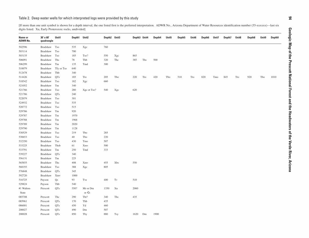
Table 2. Deep water wells for which interpreted logs were provided by this study
[Ifmorethanoneunitsymbolisshownforadepthinterval,theonelistedfirstisthepreferredinterpretation.ADWRNo.,ArizonaDepartmentofWaterResourcesidentificationnumber(55-xxxxxx)—lastsixdigitslisted.Xu,EarlyProterozoicrocks,undivided]
Name or �0’ x �0’ Unit1 Depth1 Unit� Depth� Unit� Depth� Unit� Depth� Unit� Depth� Unit� Depth� Unit� Depth� Unit� Depth� Unit� Depth�ADWR No. quadrangle
502596 Bradshaw Tso 535 Xgc 760
503114 Bradshaw Tso 700
503135 Bradshaw Tso 185 Tso? 550 Xgc 865
506091 Bradshaw Ths 78 Thb 320 Thc 385 Ths 500
506299 Bradshaw Tm 135 Tmd 300
510079 Bradshaw TfyorTso 640
512478 Bradshaw Thb 340
514426 Bradshaw QTs 185 Tto 205 Tbo 220 Tto 420 Tbo 510 Tto 820 Tmo 845 Tto 920 Tbo 1010
518542 Bradshaw Tso 182 Xgc 660
521052 Bradshaw Tm 340
521766 Bradshaw Tso 280 XgcotTso? 540 Xgc 620
521786 Bradshaw QTs 240
522079 Bradshaw Tso 301
524932 Bradshaw Tso 535
528772 Bradshaw Tso 515
529786 Bradshaw Tm 920
529787 Bradshaw Tm 1970
529788 Bradshaw Tm 1968
529789 Bradshaw Tm 2020
529790 Bradshaw Tm 1128
530529 Bradshaw Tso 219 Tbo 285
530653 Bradshaw Tso 40 Tbo 220
532350 Bradshaw Tso 430 Tmo 507
533225 Bradshaw Thsb 61 Xmv 500
533791 Bradshaw Tm 250 Tmd 333
539227 Bradshaw QTs 340
556131 Bradshaw Tm 225
565855 Bradshaw Ths 408 Xmv 455 Xbs 550
568193 Bradshaw Tso 388 Xgc 805
576848 Bradshaw QTs 345
592720 Bradshaw Xmv 1000
516725 Payson Qs 93 Tve 400 Tv 510
529824 Payson Thb 540
#1Walton- Prescott QTs 550? MrorDm 1350 Xu 2060
State oret
085708 Prescott Thc 290 Tht? 340 Ths 435
085961 Prescott QTs 170 Thb 435
086001 Prescott QTs 450 Yd 460
200027 Prescott QTs 490 Dm 507
200028 Prescott QTs 850 Tby 880 Tsy 1620 Dm 1900
��
Geologic Map of the Prescott N
ational Forest and the Headwaters of the Verde River, Arizona

200030 Prescott QTs 1680 Dm 1775
500546 Prescott QTs 250 Dm 400
500772 Prescott Ths 260 Xmv 467
501069 Prescott QTs 672
501405 Prescott QTs 109 ThborThc 618
501889 Prescott Tvl 649 Tvls 724
502008 Prescott QTs 375
504397 Prescott QTs 406
504646 Prescott Qal 75 Thb 275 Tv 480
505056 Prescott QTs 560
505300 Prescott Tv 935
505305 Prescott QTs 220 Tsv 300 Tla? 370 Tsv? 464
505514 Prescott QTs 196 MrorDm 315
505516 Prescott QTs 490 ThborThc 610 Xmw 628
505772 Prescott QTs 267 Tmu 370
506636 Prescott ThborThc 215 Ths 530
507354 Prescott ThborThc 90 Ths 610 Xpr 703
507484 Prescott QTs 140 Tby 240
507612 Prescott Ths 170 YXgr 460
508299 Prescott QTs 435 Tmu 725
508594 Prescott Thb 480 YXgr 505
509151 Prescott QTs 100 Tht 180 Tmu? 570 YXgr 608
509536 Prescott QTs 250 Tht? 270 Tmu 440
510778 Prescott QTs 250 Ths 300 Thb 435 Ths 540
511181 Prescott QTs 190 Tmu 280
511566 Prescott QTs 460 Xmv 505
511817 Prescott QTs 190 Tht 270 Tsu?or 445
Tsv?
512326 Prescott QTs 300 Thbs 470 Xgbor 558
YXgr
512777 Prescott QTs 605
512969 Prescott Thb 140 ThcorThs 360 Xmw 425
513155 Prescott QTs 245 Tmu 360
513290 Prescott Qf 30 Tvl 540 Tvls 655
515946 Prescott QTs 135 Tmu 417
518025 Prescott QTs 510
518809 Prescott ThborThs 210 Ths 595
518861 Prescott Ths 415
519055 Prescott QTs 567
519056 Prescott QTs 85 Thb 312 Ths 354
519687 Prescott QTs 702 Thb 740 Ths? 865 Thb? 926
521679 Prescott QTs 195 Xgr 385
522664 Prescott QTs 360
522714 Prescott QTs 135 Tmu 450
524200 Prescott QTs 180 Thb 325 Ths 375 Xmvor 600
Xgb
525770 Prescott QTs 180 Tht 315 Ths 380 Tla? 490 Tos? 525
References Cited
��

��
Geologic Map of the Prescott N
ational Forest and the Headwaters of the Verde River, Arizona
Table 2. Deep water wells for which interpreted logs were provided by this study.—Continued
Name or �0’ x �0’ Unit1 Depth1 Unit� Depth� Unit� Depth� Unit� Depth� Unit� Depth� Unit� Depth� Unit� Depth� Unit� Depth� Unit� Depth�ADWR No. quadrangle
526305 Prescott QTs 435 Thb 540 Ths 560 Thb 595
526793 Prescott QTs 225 Thb 303
526803 Prescott QTs 275 Thb 322
526910 Prescott QTs 220 Thb 470 Thb? 508
528270 Prescott QTs 426 TlaorTby 448
528744 Prescott Qf 60 Tvl 720 Tvls 765 Tvl 1200
530375 Prescott QTs 835 YXgr 840
530642 Prescott Qal 65 Thb 490 Tmu 560
530649 Prescott QTs 110 Thb 380 Ths? 420 Tmu 520
530748 Prescott Qf 30 Tvl 315 Tvls 440 Tvl 560 Tvls 805 Tvl 905
531578 Prescott Qal 175 Tv 555 Tvg 900
532827 Prescott QTs 1520 Dm 1720
532832 Prescott QTs 815 Dm 830
533110 Prescott Qt 175 Tvls 390 Tvl 555 Tvg 920 Thb 1115 Ths 1203
533639 Prescott Ths 150 Thb 220 Ths 305
533713 Prescott QTs 187 ThtorTvu 408 Tsu 507 Xgr? 510
534727 Prescott QTs 240 XmvorXgb 705
535284 Prescott Ths 180 Xmv 305
535934 Prescott QTs 305 YXgrorXgb 618
536623 Prescott QTs 755 Thb 828 Xmv 861
536694 Prescott QTs 270 TsyorTby? 330
537399 Prescott QTs 250 Thbs 350 Thb 507
538122 Prescott QTs 320 YXgr 385
538428 Prescott Qal 20 YXgrorXcca 400
538446 Prescott Thb 295 Xmw 510
539499 Prescott QTs 945 Xmv 995
540011 Prescott QTs 310
540640 Prescott Tla 716
541373 Prescott QTs 620 Thb 660 Xu 667
541433 Prescott QTs 310 Thb 565
541942 Prescott QTs 168 Tsv 215 Tmu 280
541955 Prescott Tvg 720
543638 Prescott Ths 365 Xpr 570
545020 Prescott QTs 165 Tmu 390
545356 Prescott Qf 20 Tv 450 Tvls 480 Tv 670 Tvls 700
545506 Prescott Ths 300 Xmv 605
545527 Prescott Qs 100 Thb 320 Ths 340 Xgb 465
548845 Prescott Tby 118 Tbsy 250 YXgr 305
549009 Prescott ThborThs 275 Ths 345 Xpr 382
549501 Prescott QTs 290 Thb 590 Ths 600 Xmv 605
549559 Prescott Tv 770
552135 Prescott Tby 70 Tsy? 210 TsyorLost 533
circulation

References Cited
��556746 Prescott QTs 340 Xmw 370
557453 Prescott QTs 215 Thb 510 Xmv 695
557485 Prescott Tby 366 Tsy 461 Tby 516
558501 Prescott QTs 590
560334 Prescott QTs 660
560414 Prescott Qf 72 Tvl 340 Tvls 485 Tvl 1025
560589 Prescott QTs 178 YXgr 300
561786 Prescott QTs 72 TbyorTcy 204 Tsy 400
562060 Prescott Tvg 610
563982 Prescott QTs 350 Tmu 410
565611 Prescott QTs 398
566301 Prescott QTs 410
566349 Prescott Tvg 620 Thb 790
566544 Prescott QTs 345 YXgr 825
566785 Prescott Tby 210 Tcy 370
566799 Prescott QTs 470 Tbo 700
567286 Prescott QTs 467 Thb 580
567519 Prescott QTs 320
568080 Prescott QTs 118 Tmu 500
568186 Prescott QTs 362 Tmu 480
568232 Prescott QTf 120 TbyorTla 300 Tmu 340
568261 Prescott QTf 200 Tmu 230 MDrm 380
568581 Prescott QTs 245 Thb 280 Xmv 600
568626 Prescott QTs 405
569301 Prescott QTs 312 Thb 375 Ths 400 YXgr 418
569724 Prescott QTs 195 Tmu 322 Tv? 500
569801 Prescott QTs 800
569852 Prescott Thb 115 Ths 340 Xmw 506
570080 Prescott QTs 670 Thb 750 Xmv 810
570936 Prescott QTs 600
571592 Prescott QTs 340
572139 Prescott QTs 320 Thb 505
572621 Prescott QTs 310 Thb 405 ThcorThb 490 Ths 510
572698 Prescott QTs 784 Thb 1220
573245 Prescott QTs 240 Thb 490
573472 Prescott Tht 180 Xmw 305 Xmv 600
574890 Prescott QTs 180 Xmv 500
574938 Prescott QTs 250 Thb 525
575576 Prescott QTs 507
575592 Prescott QTs 780 Thb 905 Ths 1065 Xmv 1085
576009 Prescott QTs 475 Thb 510
576846 Prescott QTs 366 YXgr 466
577407 Prescott QTs 300 Tmu 450
578079 Prescott QTs 418
578237 Prescott QTs 360 Tco? 395 Tbu 500
578737 Prescott QTs 730 Thb 980 Ths 1095

��
Geologic Map of the Prescott N
ational Forest and the Headwaters of the Verde River, Arizona
Table 2. Deep water wells for which interpreted logs were provided by this study.—Continued
Name or �0’ x �0’ Unit1 Depth1 Unit� Depth� Unit� Depth� Unit� Depth� Unit� Depth� Unit� Depth� Unit� Depth� Unit� Depth� Unit� Depth�ADWR No. quadrangle
579280 Prescott QTs 275 Mr 415
579607 Prescott QTs 290 Tbo? 390 Tla 480
580881 Prescott QTf 195 TbyorTsy 245 Tla 300
581893 Prescott QTs 385 Tmu 460
582491 Prescott QTs 25 TbyorTcy 450
583139 Prescott QTs 290 Thb 470 Xmv 500
583143 Prescott QTs 335 Thsb 505 Thb 956
583397 Prescott QTs 500
583487 Prescott QTs 160 Tmu 200 Tos? 315
583547 Prescott QTs 605 Thb 660 Ths 750 YXgr 805
587403 Prescott Qs 55 Thb 520 Tla 600 Dmor 820 Xu 840
et
587404 Prescott Qal 112 Thb 360 Tla 430 Tos 485 Dm 500 et 620 Xmp? 640 YXgr? 645
oret
588619 Prescott QTs 704 Thb? 724 Ths 1190 YXgr 1240
591609 Prescott QTsorTsy 1500
594558 Prescott QTs 440 Thb 510
613043 Prescott QTs 748 Thb 790 YXgr 905
614743 Prescott Yy 6500
648773 Prescott Tvg 831 Thb 834
AV72-12 Prescott Qf 50 Tv 1252
AV72-3 Prescott Qf 110 Tv 1780 Tvg 1990 Thb 2078
AV77-25 Prescott Notlogged 4175
BH-3 Prescott QTs 710 Tbo? 760 Tso 1408 Ywc 1450
Bull178502ft Prescott QTs 245 Tla 275 Tos 502
Bull178512ft Prescott QTs 512
Bull178562ft Prescott QTs 496 Tmu 502 Tos? 562
Bull178625ft Prescott QTs 256 Tmu 625
Bull178690ft Prescott QTs 255 Tsv 690
CityofPrescott Prescott QTs 63 Tby 100 Tbsy 290 Tos? 415 Xt 880
DRM-2 Prescott QTs 125 TbyorTsy 350 Tso 600
Fed#1 Prescott MrorDm 650 et 845 Xu 1205
HR-2 Prescott TbyorTcy 485 Demt 500
Krieger1013ft Prescott QTs 1003 Thb 1013
Krieger300ft Prescott QTs 300
Krieger310ft Prescott QTs 296 Tmu 310
Krieger370ft Prescott Thb 20 Ths 370
Krieger393ft Prescott QTs 393
Krieger410ft Prescott QTs 410
Krieger453ft Prescott QTs 236 Tsv 453
Krieger560ft Prescott QTs 370 Tsv 560
Krieger576ft Prescott Thb 75 Ths 451 Thb 576
Krieger605ft Prescott QTs 390 Tmu 605

References Cited
��Krieger644ft Prescott QTs 550 Tsv 644
Krieger667ft Prescott QTs 140 Tmu 474 Tsu? 659 Xg? 667
Krieger697ft Prescott QTs 320 Tmu 697
Krieger700ft Prescott QTs 700
Krieger710ft Prescott QTs 582 Tmu 666 MDrm? 710
Krieger744ft Prescott QTs 315 TmuorTsu 744
Krieger768ft Prescott QTs 310 Tsv 768
Krieger812ft Prescott QTs 650 Thb 792 Ths 812
Krieger894ft Prescott QTs 600 Thb 640 Ths 894
KriegerBull178 Prescott QTs 150 Tmu 542
Krieger-2644ft Prescott QTs 450 Tmu 630 Tos? 644
Krieger-2700ft Prescott QTs 637 Tmu 700
MW-3 Prescott QTs 550 Tbo 570
MW-4 Prescott QTs 600 Tbo 675
Ostenaa522ft Prescott QTf 522
Ostenaa531ft Prescott QTs 455 TlaorTc 531
Ostenaa690ft Prescott QTs 690
Ostenaa822ft Prescott QTs 515 Tla 822
Ostenaa-2690ft Prescott Tsy 398 TbyorTc 480 TsyorTso 676 Xu 690
Schwalen420ft Prescott QTs 400 Tvu 420
Schwalen460ft Prescott QTs 460
SL-1 Prescott Tby 170 Tbsy 250 YXgr 285
WRA298ft Prescott QTs 50 Tby 280 Mr 298
WRA300ft Prescott QTf 140 Tla 300
WRA307ft Prescott QTf 290 Tmu 307
WRA380ft Prescott QTf 360 Tmu 380
WRA550ft Prescott QTs 348 Tla 422 Tos 550
WRA600ft Prescott QTs 469 Tla 570 Tos 600
WRA615ft Prescott QTs 570 TbuorTla 615
WRA625ft Prescott QTs 522 TlaorTbo 610 Tso 625
500663 Sedona Tv 1120
501377 Sedona Qal 43 Tvls 410
501424 Sedona Qs 79 Thbs 507 Ths 546 hs 660 Mr 827
503843 Sedona Qs 42 Tv 183 Tso 434
504695 Sedona Qs 50 Tv 140 Tvls 800
506444 Sedona Tvls 165 Tv 601
506470 Sedona Tv 440
509630 Sedona Qal 43 Tvl 91 Tve 585
511022 Sedona QTf 50 Tvl 230 Tvls 291 Tvl 475 Tvls 573
519065 Sedona Tv 148 Taby 190 Tv 500
520064 Sedona Tv 1300 TvorTso? 1405
525431 Sedona Qs 70 Tv 438 Thb 456
527207 Sedona Tv 283 TabyorTsy 388 Tso 486 Thb 600
529545 Sedona QTf 34 Tvl 635 Tvls 714
533124 Sedona Tvl 171 Tvls 519 Tvl 642 Tvls 757 Tv 821
543554 Sedona Thbs 260 Thb 500

100
Geologic Map of the Prescott N
ational Forest and the Headwaters of the Verde River, Arizona
Table 2. Deep water wells for which interpreted logs were provided by this study.—Continued
Name or �0’ x �0’ Unit1 Depth1 Unit� Depth� Unit� Depth� Unit� Depth� Unit� Depth� Unit� Depth� Unit� Depth� Unit� Depth� Unit� Depth�ADWR No. quadrangle
550592 Sedona Tv 310 Thbs 420 hs? 435
555087 Sedona Tv 254 Taby 357 Tvls 400
556109 Sedona Tvl 604 TabyorTbu 606
566304 Sedona Tv 500
569531 Sedona Tv 556
577288 Sedona QTt 38 Tvl 210 Tvls 425
578642 Sedona Tv 450
581586 Sedona Tv 185 TvorTsy? 280 Taby?or 405
orTso? Thb?
581616 Sedona Tv 340 TvorTsy 525 Thb 700 hs? 780
orTaby?
587408 Sedona TvorTve 833
587409 Sedona TvorTve 885
587410 Sedona TvorTve 1028
587411 Sedona Tv 918
609337 Sedona Tv 490 Tvls 1176 Tv?orhs? 1270
614259 Sedona Tv 595 Tvls 1000 Tso 1485
AZVerdeOil#1 Sedona Tvl 800 Tve? 1625?
AZVerdeOil#2 Sedona TvorTve 1225
Cottonwood#1 Sedona Tv 250 Tvls 650 Tso 1180
026612 Williams QTs 505 Tby 573 Tsy 630
029802 Williams QTs 587 Tby 690 Tsy 795
074401 Williams QTs 370 Tby 534 Tsy 560 Tby 580 Tsy 600
081583 Williams QTs 610 Tby 615 Tsy 760
519568 Williams Tso? 410 et? 485
520534 Williams QTs 503
525566 Williams QTs 730 Tby 744
532829 Williams QTs 2290 Tla 2445
540650 Williams Tso 335 et 440
564580 Williams QTs 650 YXgr 715 XtorYXgr 755
579656 Williams QTs 540 QTs?oret? 560
583722 Williams QTs 395
607028 Williams QTs 700
645843 Williams Tbsy 720
Ostenaa311ft Williams Qal 28 Tby 230 Tsy 311
Ostenaa500ft Williams QTs 500
Ostenaa528ft Williams QTs 398 Tby 438 Tsy 446 Tby 528
Ostenaa550ft Williams QTs 550
Ostenaa600ft Williams QTs 437 Tby 600
Ostenaa602ft Williams QTs 402 Tby 431 Tsy 448 Tby 602
Ostenaa630ft Williams QTs 418 Tby 442 Tby? 466 Tby 630
Ostenaa-2600ft Williams QTs 502 Tby 600