GEOLOGIC MAP OF THE HOOD RIVER QUADRANGLE, WASHINGTON AND...
46
WASHINGTON DIVISION OF GEOL,OGY AND EARTH RESOURCES . Raymond Lasmqnis. Skte'Geologist GEOLOGIC MAP OF THE HOOD RIVER QUADRANGLE, WASHINGTON AND OREGON Compiled by MICHAEL A. KOROSEC WASHINGTON DIVISION OF GEOLOGY AND EARTH RESOURCES OPEN FILE REPORT 87-6 1987: . Division of Geology and Earth Resources standards and nomenclature. This report has not been edited or reviewed for conformity with c fkTRIBUTION OF THIS DOCUMENT IS UNLIMITED _..- -_
Transcript of GEOLOGIC MAP OF THE HOOD RIVER QUADRANGLE, WASHINGTON AND...

WASHINGTON DIVISION OF GEOL,OGY AND EARTH RESOURCES . Raymond Lasmqnis. Skte'Geologist
GEOLOGIC MAP OF THE HOOD RIVER
QUADRANGLE, WASHINGTON AND OREGON
Compiled by
MICHAEL A. KOROSEC
WASHINGTON DIVISION OF GEOLOGY AND EARTH RESOURCES
OPEN FILE REPORT 87-6
1987:
. Division of Geology and Earth Resources standards and nomenclature.
This report has not been edited or reviewed for conformity with
c fkTRIBUTION OF THIS DOCUMENT IS UNLIMITED
_..- - _
DISCLAIMER
This report was prepared as an account of work sponsored by an agency of the United States Government. Neither the United States Government nor any agency Thereof, nor any of their employees, makes any warranty, express or implied, or assumes any legal liability or responsibility for the accuracy, completeness, or usefulness of any information, apparatus, product, or process disclosed, or represents that its use would not infringe privately owned rights. Reference herein to any specific commercial product, process, or service by trade name, trademark, manufacturer, or otherwise does not necessarily constitute or imply its endorsement, recommendation, or favoring by the United States Government or any agency thereof. The views and opinions of authors expressed herein do not necessarily state or reflect those of the United States Government or any agency thereof.

DISCLAIMER Portions of this document may be illegible in electronic image products. Images are produced from the best available original document.
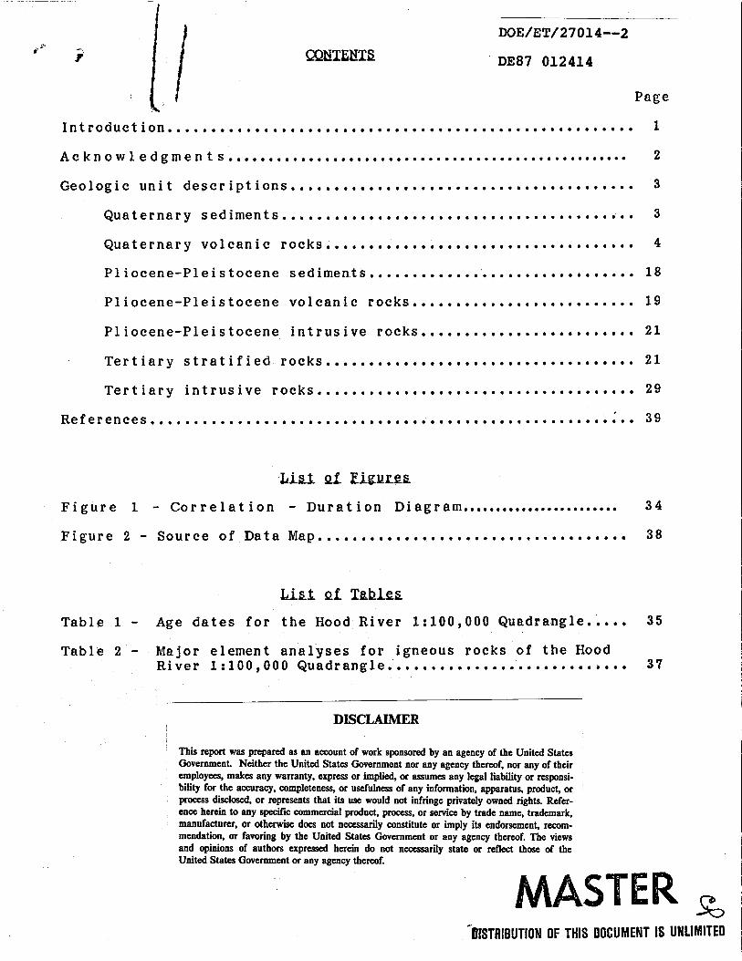
DOE/ET/ 2 70 14-4
DE87 012414
Page
Introduction...................................................... 1
Acknowledgments...... ............................................. 2
Geologic unit descriptions........................................ 3
Quaternary sediments.......................,................. 3
Quaternary volcanic r o c k s . . . . . . . . . . . . . . . . . . . . . . . . . . . . . . . . . . . . 4
Pliocene-Pleistocene sediments................. .............. 18 Pliocene-Pleistocene volcanic rocks.......................... 19
Pliocene-Pleistocene intrusive r o c k s . . . . . . . . . . . . . . . . . . . . . . . . . 21
Tertiary stratified rocks.................................**. 21
Tertiary intrusive rocks..................................... 29
References.... .................................................... 39
LA&&. Qf E&UlX&
Figure 1 . Correlation - Duration diagram.......................^ 3 4
Figure 2 . Source of Data map...................................^ 38
Table 1 . Age dates for the Hood River 1 : 1 0 0 , 0 0 0 Quadrangle..... 35
Table 2 - Major element analyses f o r igneous rocks of the Hood River 1:100,000 Quadrangle............................ 37
DISCLAIMER
This report was prepared as an account of work sponsored by an agency of the United States Government. Neither the United States Government nor any agency thereof, nor any of their employees, makes any warranty, express or implied, or assumes any legal liability or responsi- bility for the accuracy, completeness, or usefulness of any information, apparatus, product, or process disclosed, or represents that its use would not infringe privately owned rights. Refer- ence herein to any specific commercial product, process, or seMce by trade name, trademark, manufacturer, or otherwise does not necessarily constitute or imply its endorsement, recom- mendation, or favoring by the United States Government or any agency thereof. The views and opinions of authors expressed herein do not necessarily state or reflect those of the United States Government or any agency thereof.
c
CllSTRlBUTlON OF THIS DOCUMENT IS UNLIMITED

5 4 -r" I NTRODUCT I ON
This map is one of a series of 1:100,000-scale geologic maps compiled by staff geologists of the Division of Geology and Earth Resources. Other maps in the series are available or will be available for all 1:100,000-scale quadrangles within the south- west quadrant, that is, south of 47'15' north latitude and west of 12Oo3O1 west longitude, except for the Wenatchee and Snoqualmie Quadrangles which are available as U.S. Geological Maps. Other 1:100,000-scale maps in this series that have been released to date are:
Korosec, M. A., compiler, 1987, Geologic map of the Mount Adams quadrangle, Washington: Washington Division of Geology and Earth Resources Open File Report 87-5, 53 p., 1 map sheet, scale 1:100,000.
Walsh, T. J., compiler, 1986, Geologic map of the west half of the Yakima quadrangle, Washington: Washington Division of Geology and Earth Resources Open File Report 86-4, 9 p., 1 map sheet, scale 1:100,000.
Walsh, T. J., compiler, 1986, Geologic map of the west half of the Toppenish quadrangle, Washington: Washington Division of Geology and Earth Resources Open File Report 86-3, 7 p., 1 map sheet, scale 1:100,000.
Walsh, T. K. compiler, 1987, Geologic map of the Astoria and Ilwaco quadrangles, Washington: Washington Division of Geology and Earth Resources Open File Report 87-2 , 28 p., 1 map sheet, scale 1:100,000.
This text consists of unit descriptions, a table of age dates, a table of major element geochemistry, correlation diagram, source of mapping, diagram, and a list of cited references. The conventions used in describing and classifying rocks are from the following sources: Igneous rocks are classified according to Travis ( 1 9 5 5 ) . I f geochemical data are available, volcanic rocks are classified according to the current classification of the International Union of Geological Sciences (Zanettin, 1984). Most of the geologic units are informal, including all of the Quaternary volcanic rocks. The only formal units are Evans Creek Drift, Hayden Creek Drift, Troutdale Formation, Dalles Formation, Ellensburg Formation, Eagle Creek Formation, and the formations and members of the Columbia River Basalt Group.
1

I
Brent Barnett's 1985 reconnaissance geologic mapping east of Big Lava Bed added detail to an essentially unmapped area; his work was supported by contract DE-ACO7-79ET27014 of the U.S. Department of Energy Geothermal Program. Paul Hammond, Portland State University, provided unpublished mapping of the Indian Heaven area. Hammond's rock unit descriptions form the basis for most of the descriptions of the Quaternary volcanic units on this map. James Anderson (Pomona College) made available his geologic mapping of the Klickitat quadrangle prior to its publication. Reviews by Hammond, Anderson, James E. Smith (USGS), and Terry L. Tolan (Rockwell International) significantly improved this map, and the author greatly appreciates their efforts.
2

Alluvium--Well to poorly sorted and stratified clay, silt, sand, and gravel. The unit consists of stream-channel, side stream, overbank, fan, and lacustrine deposits and may include some glacial deposits and postglacial terrace gravels.
Older alluvium--Well to poorly sorted and stratified clay, silt, sand, and gravel deposited by streams, forming terraces and benches above the present flood plain. In the Wind River valley, the unit includes lacustrine and deltaic deposits from the temporary damming of the Wind and Columbia Rivers by the basalt of Trout Creek about 3 4 0 , 0 0 0 years ago.
Landslide deposits--Consists of poorly sorted blocks, boulders, gravel, and finer sediments produced by the gravitational failure and rotational-translational slide of bedrock and/or unconsolidated sediments above the bedrock; surfaces are usually hummocky. Most slides are of Holocene age.
Qdet Qoe
Evans Creek Drift--Glacial t i l l , moraines, and outwash deposits (Qoe) from alpine glaciation (Hammond, 1980). The t i l l is bouldery, loosely compacted, and complexly interbedded with poorly sorted silt, sand, and gravel. A yellowish-brown oxidized zone extends to a depth of 0 . 6 - 0 . 9 m, and cobbles within the zone do not usually have weathering rinds. The outwash deposits are loosely consolidated, stratified, poorly to well-sorted silts, sands, and gravels. The ice accumulation area for this unit was probably the Indian Heaven area. Evans Creek Drift in the Mount Rainier area has an age of 1 3 , 0 0 0 - 2 4 , 0 0 0 years and is probably time equivalent to the drift in the Indian Heaven area.
Qdht
Hayden Creek D r i f t (?)--Glacial t i l l and moraines from alpine glaciation (Hammond, 1 9 8 0 ) . The t i l l is stony and weathered to a depth of about 2 m. Clasts are partly decomposed, with
I
3
.z?
wearthering rinds from 0 . 5 to 2 . 5 mm thick. deposited by glaciers with ice accumulation areas at Indian Heaven and Mount Adams and is probably correlative with the Hayden Creek Drift in the Mount Rainier area which is believed to be 130,000-150,000 year's old (Porter, 1976; Waitt, 1977).
This unit was
Trout Lake mudflow--Unsorted mixture of subangular to subrounded boulders in a matrix of sand, silt, and clay, derived from Mount Adams (Hopkins, 1976). The boulders, up to 20 m in diameter, become finer upward and are primarily andesite from Mount Adams with lesser olivine basalt. The mudflow originated on the southwestern flank of Mount Adams at the head of the White Salmon Glacier and flowed down the White Salmon River valley for 4 0 km. A radiocarbon age of 5,070 & 260 years was obtained from a tree stump near the base of the unit (Hopkins, 1976).
Missoula flood deposits, silts and sands--Interstratified, horizontally bedded fine sand, silt, and clay deposited in backwater canyons along the course of the Missoula floods. The floods occurred between 15,300 and 12,700 years ago (Waitt, 1985).
Qfg
Missoula flood deposits, gravel--Crossbedded gravel and coarse sand from the Missoula floods along the Columbia River through the Cascade Mountains, The unit is generally less than 30 m thick, forming benches and slopes along the river. Locally, the unit is poorly sorted and unstratified. Bedded silt forms minor, commonly lensoidal interbeds. The floods occurred between 15,300 and 12,700 years ago (Waitt, 1985).
Bu~karnary Yelcanic Bncks (The named units are in alphabetical order by symbol)
Basalt flows, unnamed--Basalt flows, flow breccia, and scoria forming isolated monogenetic volcanic cones. These units have not yet been described in any detail.
Qvba
Basaltic andesite and basalt--Fine-grained olivine-bearing microporphyritic basaltic andesite and basalt, forming
4
Y intracanyon flows and associated flow breccias. In Oregon, they fotm remnant ledges along Fivemile Creek, South Fork Mill Creek, Mosier Creek, Snakehead Creek, and West Fork Neal Creek and ridge tops at Blowndown Ridge, the north side of Waucoma Ridge, and west of West Br'anch Falls Creek. The Fivemile and M i l l Creek flows originated near or at Mount Hood.
Qvab
Basalt of Alice Butte--Gray, phyric, olivine basalt (Hammond, written commun., 1983). Olivine phenocrysts are set in a fine- grained granular groundmass. The flows form a 122-m-high butte south of Red Mountain. The unit's informal name is derived from a hill in sec. 28, T. 5 N., R. 8 E., which is locally called Alice Butte; the name does not appear on the most recent U.S. Geological Survey quadrangle maps. The butte is a volcanic center, with an age stratigraphically confined to be 150,000- 500,000 years old.
Qvbc
Andesite of Black Creek--Medium-gray, sparsely phyric, plagioclase-olivine andesite and basaltic andesite (Hammond, written commun., 1983). Slabby, blocky to columnar-jointed aa and block lava flows form a broad field fanning to the south and west from a buried or eroded source near Red Mountain. Individual flows are 2-18 m thick, with a cumul tive thickness of 60-120 m. The volume is estimated t o be 4.7 km . A whole-rock K-Ar age date of 3.3 2 0.25 m.y.b.p. (Hammond and Korosec, 1983; sample no. 6, Table 1) may be too old, suggested by normal remanent magnetism, a lack of reversed magnetic flows stratigraphically above these flows, and models based on rates of volcanism in the region; however, a Pliocene age cannot be ruled out .
9
Qvbh
Basaltic andesite north of Big Huckleberry Mountain--Dark-gray quartz-olivine basaltic andesite flow (Wise, 1961). Phenocrysts of olivine and xenocrysts of quartz are in a fine-grained groundmass of plagioclase, olivine, and opaque minerals. The massive basaltic andesite has no flow tops or bottoms exposed in the limited outcrops. Wise (1961) believed that the rounded hill represented an eroded flow remnant, but Hammond (1980) maps the hill as a vent. The basaltic andesite may be the same as or related to the basaltic andesite of Bill Butte (Qvbi), 1.5 km to the north. No direct age control exists for these flows, but the thick soil cover suggests an early Pleistocene age.
5
Basaltic andesite of Bill Butte--Dark-gray, phyric, olivine basaltic andesite. Phenocrysts of olivine and rare xenocrysts of quartz are in a fine-grained crystalline groundmass. The flow forms the cone southwest of the Big Lava Bed crater. The unit's informal name is derived from a hill in sec. 27, T. 5 N., R. 8 E., which is locally called Bill Butte, but the name does not appear on the most recent U.S. Geological Survey maps.
Qvb 1
Basalt of Big Lava Bed (Holocene)--Multiple dark-gray, vesicular t o dense, phyric, olivine basalt flows (Hammond, written commun., 1983). Flows are 0.5-9 m thick, blocky jointed, with slab pahoehoe to scoriaceous tops, with pits 2-6 m deep and wide, furrowedpressure ridges 6-12mhigh, fractures up to 5 m w i d e , and sinuous channels up to 14 m deep and 30 m wide. erupted as sheet flows, inflated by internally fed lava. The flows cover the valley floor south of Indian feaven, extending for 59 km2, The total volume is about 0.9 km . A cone near the north center of the bed is 300 m high, with a crater at the top 195 m w i d e and 66 mdeep. Scoriaceous tephra fromthis crater formed a blanket up to 3 m thick, extending 8 k m east of the cone. The tephra overlies pumice of the S-tephra of Mount St. Helens (13,500 yr old); carbonized leaves underlying the Big Lava tephra give a 14C age of 8 , 2 0 0 r: 100 years (Hammond and Korosec, 1983).
The lava was
Basalt of Berry Mountain--At least five lava flows erupted from vents near Gifford Peak and on Berry Mountain (Hammond, written commun., 1983). From oldest to youngest, they are light- t o dark-gray, sparsely to moderately phyric, olivine basalt, augite- olivine basalt, hornblende-plagioclase andesite, augite plagioclase-olivine basalt, and hornblende-augite-olivine basaltic andesite. The flows are blocky and platy jointed, 1-12 rn thick with a cumulative thickness of 50-100 m. The total volume is estimated to be about 1.7 km3. Basalt of Berry Mountain is late Pleistocene, erupted after the Hayden Creek and before the Evans Creek alpine glacial periods, between about 130,000 and 25,000 years ago.
Qvcc
Basalt of Cedar Creek--Dark-gray olivine basalt and eroded cinder cone in the upper drainage of Cedar Creek (Wise, 1961). The basalt consists of phenocrysts of olivine in a groundmass of plagioclase, clinopyroxene, and minor amphibole, olivine, and magnetite. The basalt forms a small intracanyon flow along the west side of the creek up t o 6 0 m thick and 2 1 / 4 km long. The
6
2 cone forms a low, rounded hill of soft, loose, red cinders and l&ge blocks of basalt. The preservation of the flow and cone within the present-day drainage suggests a late Pleistocene age.
Qvc 1 /Q1 s
Basaltic andesite of Cascade landslide--Light-gray, platy, olivine basaltic andesite (Wise, 1961). Basaltic andesite flows and a cinder cone are breached and disrupted by a section of the composite Bonneville landslide. Above the slide scarp along the east edge of Greenleaf Basin, the flow remains intact. The basin is the result of a volcanic cone and intracanyon flow erupting in and blocking the upper drainage of Greenleaf Creek, diverting the creek to the south. In the face of the scarp, along Red Bluffs, oxidized cinders, flows overlying Eagle Creek Formation, and cross-cutting feeder dikes are exposed. At the head of the slide, a well preserved intact cinder cone and undisturbed flows demonstrate large block sliding. Broken, hummocky exposures of platy flows east of the cinder cone, lldown slide", represents the greatest volume and areal extent of the flows. The unit was called "Red Bluffs volcanot1 by Wise (1961). It is older than the 700-year-old landslide and probably of late Pleistocene age.
Basalt of Camas Prairie--Medium- to dark-gray olivine-plagioclase basalt (Sheppard, 1 9 6 4 ) . Intracanyon pahoehoe lava flows, generally 3-6 m thick, were erupted from several vents of the shield volcano at King Mountain, north of the map area. The lava flows are blocky jointed, with basal breccia and vesicular t o scoriaceous tops (Hammond, 1980). In thin section, the basalt is holocrystalline, diktytaxitic, and porphyritic, with plagioclase and olivine phenocrysts in a groundmass of plagioclase, clinopyroxene, olivine, and opaque minerals. The olivine is commonly glomeroporphyritic and partially replaced by iddingsite. At Camas Prairie, the flows are partly covered with sporadic patches of silt and sand up to 30 cm thick. In the Klickitat River canyon, numerous nested flows 3-10 m thick have a cumulative thickness of more than 120 m (Anderson, written commun., 1985). A whole-rock K-Ar age date from these flows outside of the map area is 3 0 0 , 0 0 0 a 8 0 , 0 0 0 years (Shannon and Wilson, 1973).
Qvdc
Basalt of Dry Creek--Medium-gray, vesicular to dense, sparsely to moderate phyric, augite-olivine basalt. Numerous pahoehoe flows 1-10 m thick, with blocky jointing, are commonly separated by 0.2-2-m-thick interbeds of scoria and have a total maxi um thickness of 3 7 0 m. The volume is approximately 9.2 km . The source i s unknown, but a dike at south East Crater is a possibility. The basalt of Dry Creek is similar to the basalt of
9
7

r- Ru6h Creek and may be its correlative. The stratigraphic position of the flows suggests a probable middle Pleistocene age.
Qve 1
Basaltic andesite of Eunice Lake--Light- to medium-gray, vesicular to dense, phyric, olivine basaltic andesite and aphyric andesite. Phenocrysts of plagioclase and olivine are in a fine-grained f low-layered groundmass. Numerous blocky to platy- jointed flows 1-12 m thick are commonly separated by scoria interbeds of 0.5 m thick, having a maximum cumulat’ve thickness of 140 m, and have an approximate volume of 2.0 km . The flows may have erupted from a zone of east-west-trending dikes on the north side of Gifford Peak. The stratigraphic position of the flows suggests a probable middle Pleistocene age.
4
Qvfl
Andesite of Forlorn Lake--Light-gray, sparsely phyric, two pyroxene-olivine andesite flows and flow breccia (Hammond, written commun., 1983). The andesite consists of phenocrysts of plagioclase, olivine, augite, and hypersthene in a dense, flow- layered groundmass. It forms block lava flows, 10-30 m thick, with flow-folded interiors. Individual flows are separated by breccia zones up to 30 mthick,with a cum Iative thickness of about100 mandtotal volume of about 1 k m . The flows were erupted f r o m a vent east of GiffordPeak in themiddle Pleistocene. They are partially eroded by alpine glaciers and are overlain by the andesite of upper Forlorn Lake (Qvfu).
3
Qvfm
Basalt of Flattop Mountain--Light-gray, aphyric, olivine basalt (Hammond, 1980). Vesicular to scoriaceous blocky lava flows originated from the base of a cinder cone on Flattop Mountain northofthemaparea. The age is probably middle Pleistocene.
They have arnaximumthickness of 50 m.
Qvfu
Upper andesite of Forlorn Lake--Light-gray, sparsely phyric, two pyroxene-olivine andesite flows and flow breccia (Hammond, written commun., 1983). The andesite consists of plagioclase, olivine, augite, and hypersthene phenocrysts in a dense, flow- layered groundmass. Blocky lava flows 15-30 m thick are separated by breccia zones 30-40 m thick. The to a1 thickness is 6 0 - 9 0 m, and the approximate volume is 0.12 km . The lava was derived froma low scoria andbreccia cone just east of Gifford Peak. The s t r a t i g r a p h i c position of the unit suggests a probable late Pleistocene age.
5
8

Basalt of Grouse Butte--Medium-gray, moderately phyric, olivine basalt flows and cone (Hamniond, written commun., 1983). Flows are blocky jointed pahoehoe lava, 2-6 m thick, with a c mulative thickness of 6-10 m and an estimated volume of 0.009 km . They were erupted from the northeast base of the glacially molded, craterless scoria cone at Grouse Butte, about 5 km northwest of Mann Butte. The cone is 100 m high and has a diameter of about 640 m. The basalt is of probable middle to late Pleistocene age.
Y
Basalt of Gilmer Creek--Gray, aphyric to very fine-grained, olivine basalt flows (Sheppard, 1964). In thin section, the texture is intergranular to diktytaxitic, with phenocrysts of plagioclase and olivine in a holocrystalline groundmass of plagioclase, clinopyroxene, olivine, and opaque minerals. The olivine phenocrysts are commonly resorbed and partially altered to iddingsite. The flows are dense and blocky to columnar jointed and have interbeds of breccia and scoria 3-5 m thick. The cumulative thickness is about 85 m. The flows form a large, isoleted shield volcano south and southeast of Gilmer, capped by a scoria cone consisting of red to dark-gray, poorly sorted, unconsolidated, and stratified scoria. The basalt has a whole- rock K-Ar age of 1.76 & 0 . 5 m.y.b.p. and has a reversed remanent magnetic polarity (Hammond and Korosec, 1983; sample no. 5 , Table 1).
Basalt of Goose Lake--Light- to medium-gray, fine-grained, phyric, olivine basalt (Harnrnond, written commun., 1983). The basalt forms blocky to platy-jointed pahoehoe flows, 2-10 m thick, and has local interbeds of airfall scoria up to 2 m thick. The cuyulative thickness is 46 m, and the volume i s approximately 1.8 km . The flows overlap a 120-m-high scoria cone exposed in Spring Camp Creek northwest of Goose Lake. The age of the unit is probably middle Pleistocene, suggested by its stratigraphic pos i t ion.
Qvgm
Basalt of Guler Mountain--Medium- to dark-gray, phyric, olivine basalt (Hammond, 1980). Several scoriaceous, blocky lava flows 2-3 m thick form an isolated cone. Flows erupted from a vent near the top of Guler Mountain and flowed east into the White Salmon River valley. The surfaces of the flows are covered by up to 2.4 m of silty loess. The basalt is probably of middle Pleistocene age.
9

E
Basalt of Gifford Peak--Light- to medium-gray, phyric, olivine basalt flows (Hammond, written commun., 1983). In thin sect'ion, phenocrysts of plagioclase and olivine are set in a fine-grained, flow-banded groundmass. The basalt forms blocky to platy- jointed lava flows 1-12 m thick, commonly with scoria interbeds up to 0.5 m thick, with a cumulative thickness of 9 0 m and a volume of approximately 1.9 km3. The flows were probably.erupted from a zone of east-west-trending dikes on the north side of Gifford Peak. It has a probable early to middle Pleistocene.age, suggested by its stratigraphic position.
Qvhb
Basalt of Hauk Butte--Light- to medium-gray, fine-grained aphyric, olivine basalt. In thin section the basalt is micro- porphyritic with phenocrysts of olivine ringed by iddingsite in a groundmass of flow-aligned plagioclase, olivine, and opaque
.. minerals. Flows erupted from a vent on the southwest flank of Hauk Butte and flowed west and north into Lost Creek valley. The degree of preservation suggests that the unit has a probable middle to late Pleistocene age.
Qvhc
Basalt of. Herman Creek (Oregon)--Light-gray, diktytaxitic, phyric, olivine basalt (Hammond, 1980). A single blocky jointed flow 3- 30 m thick-partially filled the paleocanyon of Herman Creekata level several tens of meters above the present creek level. The geomorphology of the flow and its setting suggest that the unit is of probable early to middle Pleistocene age.
Qvic
Basalt of Ice Caves--Gray, abundantly phyric, olivine basalt (Hammond, written commun., 1983). In thin section, phenocrysts of plagioclase and olivine are in a dfktytaxitic, holocrystalline groundmass of plagioclase, olivine, and opaque minerals. The plagioclase phenocrysts are generally glomerocrysts of radiating laths. The basalt forms blocky jointed pahoehoe lava flows 0 . 5 - 6 m thick. They were erupted from the crater at Lake Wapiti of Lemei Rock volcano and flowed down the east flank. One lobe flowed northeast, up Trout Lake Creek. Most of the lava went south and east into the White Salmon River canyon at Trout Lake and down the canyon at least 43 km t o Husum. The flow is 10-12 m thick, and its volume is about 1.2 km3. Hayden Creek glaciation (130,000-150,000 yr b.p.) but older than Evans Creek glaciation (22,000-14,000 yr bop.).
It is younger than
10

Basalt of Indian Heaven--Light-gray, abundantly phyric, olivine basalt (Hammond, written commun., 1983). Phenocrysts consist of randomly oriented plagioclase crystal plates, isolated glomerocrysts of radiating plagioclase plates, and olivine. The groundmass is diktytaxitic, with plagioclase, olivine, and opaque minerals. The basalt forms blocky joined pahoehoe lava flows 1-3 m thick, with 1-3-m-thick interbeds of scoria. Numerous flows erupted from a bocca on the west side of the 120 m high East Crater, and flowed down the west slope, reaching the upper Wind River valley. The flows have a cumulat've maximum thickness of 2 4 m and a total volume of about 0 . 5 km . The age is late Pleistocene, with the East Crater activity postdating the basalt of Lake Comcomly, a 29,000-yr-old flow (Hammond, written commun., 1985).
i
Basaltic andesite of Juice Creek--Light-gray, sparsely phyric, augite basaltic andesite and augite-olivine basaltic andesite (Hammond, written commun., 1983). The groundmass is dense, fine grained, and equigranular, with flow-layered plagioclase laths. The lava flows are platy, blocky, and colu nar jointed and are 4- 6 0 m thick. A broad, dissected shield volcano, about170 mhigh, and about 5 k m w e s t o f Berry Mountain, marks the source of most of the lava. A possible second vent is located on a butte about 5 km west-southwest of Red Mountain. A whole-rock K-Ar age date of 1.40 & 0.06 m.y.b.p. was determined for this unit (Eiammond and Korosec, 1983; and sample no. 4, Table 1).
The estimated volume is 2 k m e
Qvla
Andesite at Laurel--Light-gray, porphyritic, augite-hornblende andesite (Sheppard, 1964). Phenocrysts of oxyhornblende, oscillatory zoned plagioclase, and augite are in 8 groundmass of flow-aligned plagioclase, clinopyroxene, opaque minerals, and pale-brown glass. The oxyhornblende is commonly rimmed or replaced by opaque minerals. Rare olivine phenocrysts and quartz xenocrysts are also present. The flows are platy jointed and up t o 6 mthick, with a cumulative thickness of 5 0 m. The source is probably the hill 3 km south of Quigley Butte. The unit is probably of early Pleistocene age.
Qvlc
Basalt of Lake Comcomly--Dark-gray, sparsely phyric, olivine basalt (Hammond, written commun.! 1983). plagioclase phenocrysts surrounding o l i v i n e phenocrysts are in a fine-grained groundmass of plagioclase, olivine, and opaque minerals. The basalt forms pahoehoe lava flows, 0.5-12 m
Glomerocrysts of
11

c
thi'ck, with scoriaceous margins, pillow lava, breccia, and abundant tumuli. The cumulative thickness is 2-30 m, and the estimated volume is about 1.3 km3. The source of the lava was the southeast crater of theLemei Rock volcano (north of themap area), marked by a 120-m-high scoria and spatter cone. Flows descended the east and west "flankstt of Indian Heaven, partially cov,eringthe broad slope formed by the basalt of Ice Caves (Qvic). The eruptions occurred in late Pleistocene time, probably during an unnamed glaciation about 30,000 years ago.
Qvll
Basalt of Lost Lake Butte (Oregon)--Basalt flows and flow breccia. The lava erupted from Lost Lake Butte and covered the valley between Laurel Creek and the West Fork Hood River.
Qvlo
Basalt of Lost Creek--Light- to medium-gray, fine-grained phyric, olivine basalt flows. In thin section, phenocrysts of olivine, replaced or rimmed by iddingsite, are in a groundmass of flow- aligned plagioclase laths, olivine, opaque minerals, and granular plagioclase. Flows erupted from at least two centers on the ridge on the south side of Lost Creek valley and partially filled the valley. The age is probably middle Pleistocene, suggested by the geomorphology of the cones and flows.
Basalt of Lapham Creek--Clivine basalt. It forms a flow and cinder cone. The unit has a probable middle Pleistocene age.
Qvlw
Basalt of Little White Salmon--Gray, phyric, olivine basalt. Pahoehoe lava flows occupy the valley of the Little White Salmon River and underlie much of the basalt of Big Lava Bed (Qvbl). They erupted from vents in the southern Indian Heaven area and reached the Columbia River. The age is middle to late Pleistocene, possibly post-Hayden Creek glaciation (about 130,000-150,000 years ago).
Qvmb
Basalt of Mowich Butte--Dark-gray olivine basalt (Wise, 1 9 7 0 ) . Phenocrysts of olivine and rare augite are in a groundmass of plagioclase, clinopyroxene, olivine, magnetite, and glass. The basalt forms an intracanyon flow in the upper Rock Creek drainage. It erupted from a vent on Mowich Butte, about 3 km west of the map area.
12

4-
Qvfid
Basalt of Mount Defiance (Oregon)--Light-gray, blocky jointed, vesicular to diktytaxitic, phyric, olivine-clinopyroxene basalt and lesser dark-gray platy jointed, dense, porphyritic pyroxene andesite (Hammond, 1980). The basalt forms the base of a partially dissected shield volcano, and andesite caps the summit. Thecumulative thickness is estimatedto be about 300 m. Age is probably early Pleistocene.
Qvmf
Andesite of McCoy Flat--Gray, aphy.ric andesite (Hammond, 1980). Very fine grained, dense to highly vesicular andesite forms a single 20-m-thick block lava flow with platy, slabby, to blocky jointing along Jewett Creek north of White Salmon. The flow erupted froma v e n t o n t h e n o r t h s i d e o f M c C o y , F l a t a n d flowed down the creek valley to White Salmon, possibly reaching the Columbia River. Because the flow is well preserved, its age is probably late Pleistocene and post-Hayden Creek glaciation (less than about 130,000-150,000 years).
Qvmh
Andesite of Mount Hood--Light- to medium-gray andesite and basaltic andesite flows originating at the Mount Hood stratovolcano south of the map. In the map area, the older flows cap the flat-topped ridge at F i r Mountain. A younger flow forms a bench along part o f the west side of the upper HoodRiver valley.
Qvml
Basalt of McClellan Meadows--Medium-gray, phyric, olivine basalt. Phenocrysts of plagioclase and olivine are in a diktytaxitic groundmass of plagioclase, olivine, and clinopyroxene. The flows form part of the western margin of the Indian Heaven volcanic field and are partiallylappedby flows of the basalt of Indian Heaven (Qvih). The source and age of the McClellan Meadows flows are not known.
Qvn s
Basalt north of South Prairie--Gray, phyric, olivine basalt (Hammond, written commun., 1983). Lava and scoria form a partially eroded cone and small shield. The cone is 183 m high and has been modified by middle Pleistocene glaciation. The unit has a probable age of early to middle Pleistocene.
*
13

1
Qvba
Andesite of Petite Mountain (andesite northeast of Red Mountain) --Light-gray, aphyric, olivine andesite (Hammond, written commun., 1983). Blocky to platy jointed aa lava flows were extruded from the base of an irregular shaped, craterless, scoria cone, 135 m high and 1,300 m long. Individual flows are 2-3 m thick and have a cumulative hickness of 10 m. The volume is estimated to be about 0.03 km . These flows erupted in the late Pleistocene, probably after Hayden Creek alpine glaciation (130,000-150,000 years ago) but before Evans Creek alpine glaciation. The unit's informal name is derived from a hill northeast of Red Mountain which is locally called Petite Mountain, but the name does not appear on the most recent U.S. Geological Survey quadrangle map.
i
Qvpb
Basalt of Peterson Butte--Small olivine basalt cone. The unit has not been described. It may be similar to the' basalt of Grouse Butte, 1.5 km to the south.
Qvpm
Basalt of Papoose Mountain (basalt southeast of Red Mountain)-- Medium-gray, moderately phyric, olivine basalt (Hammond, written commun., 1983). Phenocrysts of plagioclase and olivine are in a fine-grained groundmass. The basalt forms an eroded, craterless cone of agglutinated scoria, 1 9 5 m high and 2 , 0 0 0 m wide. Blocky jointed pahoehoe lava flows, 2-6 m thick, partially cover the eastern and souther'n slopes. The individual flows are commonly separated by scoria interbeds 0.2-0.5 m thick. The c mulative thickness is 7 5 m, and the estimated volume is 2.7 km . The unit is probably of middle Pleistocene age. The unit's informal name is derived from the butte 2 km southeast of Red Mountain, known l o c a l l y a s P a p o o s e M o u n t a i n , b u t the name does not appear on the most recent U.S. Geological Survey quadrangle maps.
5
QVP s
3asalt of Peterson Ridge--An isolated volcanic center and basalt flows on the south side of Peterson Ridge, 3 k m north of Mann Butte. The unit has not been described. The southern extension of the flows have been buried by the basalt of Ice Caves (Qvic).
Qvpt
Basalt of Petite Mountain (basalt northeast of Red Mountain)-- Gray olivine basalt (Hammond, written commun. 1983. The flows were extruded from the eastern side of the butte 1 km northeast of Red Mountain. The butte is locally known as Petite Mountain, but the name does not appear on the most recent U.S. Geological
1 4

i
Sur'vey quadrangle maps.
Basaltic andesite of Quigley Butte--Light-gray, aphyric, olivine basaltic andesite (Sheppard, 1964; Hammond, 1980). Dense, very fine grained, platy to slabby jointed basaltic andesite flows up to 4 m t h i c k form a broad shield volcano centered at Quigley Butte. Individual flows are commonly separated by scoriaceous breccias of the flow bases. The cumulative thickness is at least 2 5 m. Camas Prairie (Qvcp). The unit is of probable middle or possible early Pleistocene age.
The west and north flanks aremostly coveredby basalt of
Qvrc
Basalt of Rush Creek--Medium-gray, sparsely to moderately phyric, augite-olivine basalt (Hammond, written commun., 1983). Pahoehoe lava flows, 1-10 m thick, are commonly separated by interbeds of scoria 0.2-2 m thick. The flows have a total maximum thickness of 370 m and an estimated volume of 4.75 km3. The exact source of these flows is unknown, probably concealed by the younger flows near the center of the Indian Heaven volcanic field. The basalt of Rush Creek i s petrographically and morphologically similar to and may correlate with the basalt of Dry Creek (Qvdc). The unit's stratigraphic position suggests a middle Pleistocene age.
Qvr k
Basalt of Rock Creek--Dark-gray, platy, olivine basalt (Wise, 1970). The basalt forms a small plug on the ridge north of Rock Creek. Remnants of the flow extend a short distance south of the plug. The degree of erosion suggests an early Pleistocene age.
Qvrs
Andesite of Rattlesnake Creek--Medium- to dark-gray, phyric, olivine basaltic andesite and andesite (Hammond, 1980). Phenocrysts consist of plagioclase and olivine. Dense, blocky- jointed flows, 4-6 m thick, with vesicular tops, were erupted from a cluster of vents near the confluence of Rattlesnake Creek and the White Salmon River. They have a cumulative thickness of 145 m. The fresh appearance of the basalt suggests an age of late Pleistocene, probably post-Hayden Creek glaciation (130,000- 150,000 years ago).
15

1
Qvr't
Andesite of The Race Track--Medium-gray, sparsely phyric, olivine andesite (Hammond, written commun., 1983). Phenocrysts of olivine and plagioclase are in a fine-grained groundmass. The andesite forms slabby lithic clasts in agglutinated lithic scoria surrounding a denuded plug or dome west of TheRaceTrackonthe northwest side of Red Mountain. The unit has a total thickness of 75 m. Its age is unknown.
Qvsa
Basalt of Sahalee Tyee--Dark-gray, moderately phyric, olivine basalt (Hammond, written commun., 1983). Basaltic tephra, consisting of coarse scoria andbombs, formabroadcone,12 m high, north of Gifford Peak and Blue Lake. The cone has a central crater 365 m in diameter, partially filled by a small lake named Sahalee Tyee. Asingle, small lava flowmakes up a part of the cone. The unit is of late Pleistocene age, younger than Hayden Creek alpine glaciation (130,000-150,000 years ago).
Qvsd
Basalt of Sheridan Point--Light- to medium-gray, microphyric, olivine basalt. The flow is located at the foot of the Bonneville landslide, is blocky jointed, and about 10 m thick, and forms a 400-m-long ridge parallel to the Columbia River. The flow appears to overlie landslide debris or poorly sorted talus, but is likely much older than the 700-yr-old main Bonneville landslide. A late Pleistocene age is probable.
Qvs 1
Basalt of Sheep Lakes--Medium-gray, moderately phyric, olivine basalt (Hammond, writ ten commun., 1983). The basalt forms blocky jointed, 2-4-m-thick pahoehoe and aa lava flows, separated by scoria interbeds 0.2-0.5 m thick. The total thickness ranges from 5 to 2 5 m, and the volume is approximately 0.08 km3. flows were erupted from the east base of Red Mountain in the middle to late Pleistocene.
The
Qvs r
Basalt cone southeast of Red Mountain--Black to red scoriaceous tephra (Hammond, written comrnun., 1983). The tephra forms a cone 7 0 m high on the west side of the Big Lava Bed. The unit is of late Pleistocene age, probable not much older than the Evans CreekDriftwhich mantles much ofthenorth sideofthecone. I t may have been the source of valley-filling basalts, including the basalt of Little White Salmon (Qvlw) now mostly covered by basalt of Big Lava Bed (Qvbl).
16
Qvbu \
Basalt of Sugar Bowl Butte--Poorly known volcanic center and basalt flowon the southeast sideof PetersonRidge, 6 kmwest of Trout Lake. The southern extension of the flows has been covered by the basalt of Ice Caves (Qvic).
Qvth
Basalt of Thomas Lake--L ght-gray, abundantly phyric, augite- olivine basalt (Hammond, written commun., 1983). Phenocrysts consist of randomly orie ted platelets of plagioclase and granular augite and olivine, in a diktytaxitic groundmass. The basalt forms blocky jointed pahoehoe lava flows 1-7 m thick, erupted from fissures at the south end of East Crater. Erosion has partially exposed the dikes. The unit has an average cumulative thickness of 37 m and an estimated volume of 4.0 km3. A whole-rock K-Ar age date of 3.7 2 0.5 m.y.b.p. was determined for this unit north of the map area (Hammond and Korosec, 1983). The basalt of Thomas Lake is one of the oldest units of the Indian Heaven volcanic field, but may not be as old as the age ' '
date indicates.
Qvtr
Basalt of Trout Creek Hill--Dark-gray, phyric, olivine basalt. Phenocrysts of subhedral labradorite, light-green olivine with ,rims of iddingsite, andmegascopicclots of glass are in a diktytaxitic groundmass of plagioclase microliths, granular pyroxene, and glass (Berri and Korosec, 1983). The vesicular to dense, blocky jointed flows are 1.5-10 m thick and form a series of intracanyon lava flows in the Wind River valley. In the Wind River gorge at "High Bridge" (age date site no. 2 on the map), the flows have a cumulative thickness of 70 m. They erupted from at least three vents at Trout Creek Hill and probably make up the majority of the volume of Trout Creek Hill. Flows reached the Columbia River, temporarily damming it. Two whole-rock K-Ar age dates for this unit give very similar results, 340,000 st 70,000 yr (Hammond and Korosec, 1983; and sample no. 2 in Table 1) and 338,000 f. 75 ,000 yr (Berri and Korosec, 1983; and sample no. 1 in Table 1).
Qvtw
Basalt of The Wart--Gray, sparsely phyric, olivine basalt (Hammond, written commun., 1983). Phenocrysts of plagioclase and olivine are in a partly glassy, vesicular to densely crystalline groundmass. The basalt forms a slaggy pahoehoe lava flow 1-5 km thick, and a 145 m high craterless cone of interlayered scoria, lithic fra ments, and spatter. The total volume is estimated to
m of t i l l from Evans Creek alpine glaciers. The probable age is be 0.04 km s . The northeastern flank of the cone is mantled by 2
17

>
middle to late Pleistocene.
Qvuw
Basalt of Underwood Mountain--Light-gray, phyric, olivine basalt (Hammond, 1980). Phenocrysts consist of plagioclase and olivine, The basalt forms a broad shield volcano with two cinder cones at the top, The flanks are built up by fine- to medium-grained, dense to vesicular, blocky jointed flows 3-10 m thick, with scoria interbeds. The maximum thickness is at least 180 m. Palagonite tuff breccia and pillow basalt form basal deposits where the basalt flowed into and partially blocked the Columbia River. A whole-rock K-Ar age date of 850,000 2 20,000 years was determined for this unit (Hammond and Korosec, 1983; and sample no. 3, Table 1).
Qvwn
Basalt north of White Salmon--Dark-gray, phyric, olivine basalt (Hammond, 1980). Basalt forms fine-grained, dense to diktytaxitic, blocky jointed flows 3-35 m thick and a lava cone north-northwest of the town of White Salmon. The basalt flowed to the west, reaching the White Salmon River. The age is unknown, but the unit may be related to theJbasalt of White Salmon (Qvws) and the Underwood volcano (Qvuv), about 850,000 years old.
Qvws
Basalt of White Salmon--Gray to medium-gray, phyric, olivine basalt (Hammond, 1980). Vesicular, blocky jointed lava flows, 1- 6 m thick, separated by scoria interbeds 1.5-3 m thick, form a shield volcano west of the town of White Salmon. A single cinder cone marks the top of the volcano. The total thickness of the unit is at least 90 m. The basal zone includes palagonite tuff grading upward into pillow lava and blocky subaerial lava where the flows entered the White Salmon and Columbia Rivers. Near the confluence of the rivers, the basal zone of subaqueous volcanic material has a thickness of 4 0 m. The age is unknown, but the unit may be contemporaneous with the Underwood volcano (Qvuw), about 850 ,000 years old.
QTg
Pliocene-Pleistocene gravels; Swale Creek valley sedimentary deposits (Newcomb, 1969)--Gravel and lesser sand, s i l t , and clay forming poorly sorted unconsolidated channel deposits, with a thickness of as much as 7 0 m. Thematerial was eroded fromthe
18
b
adjacent basaltic terrain and is overlain by several meters of loess. The clasts are about 8 0 % subrounded to subangular volcanic rocks, primarily basalt from the Wanapum Basalt, and about 20% well-rounded quartzite clasts derived from the Ellensburg Formation. East of the map area, an olivine basalt flow from Haystack Butte, with a K-Ar age date of 0.9 m.y.b.p. (Shannon and Wilson, 19731, overlaps the sediments.
Pliocene-Pleistocene sediments--Older alluvium of uncertain age forming remnant terraces.
Pliocene-Pleistocene volcanic rock, undifferentiated--Volcanic rocks, primarily basalt, basaltic andesite, and andesite flows, forming ridges and plateaus south of the Columbia River.
QTvb
Pliocene-Pleistocene basalt flows--Easaltic flows and flow breccia forming plateaus and remnant valley fillings south of the Columbia River. At Benson Plateau, medium-gray, phyric, olivine basalt forms blocky jointed, 5-15-m-thick lava flows with a total thickness of about 150 m (Mammond, 1980). West of the Hood River Valley, undifferentiated basalt includes isolated lava flows, layered flows from shield volcanoes, and flows mapped on the east side of the Hood River Valley as basalt porphyry of Hood River valley (QTvh), an olivine basalt.
QTvh
Basalt porphyry of Hood River Valley--Gray and blue-gray, porphyritic, olivine basalt underlying much of the lower Hood River Valley. The phenocrysts consist of aggregates of labradorite, olivine, and magnetite. The groundmass ranges from finely crystalline to glassy. On the west side of the lower Hood River Valley, flows mapped as basalt at Ruthon Point by Hammond (1980) and Crag Rat and Marble Cake flows of Goff (1977) are included in this unit. These flows are described as interstratified blocky jointed, vesicular pahoehoe flows 2-8 m thick, with foreset-bedded palagonitic tuff breccia 20-35 m thick that contains detached and fragmented pillows. An eroded vent betweenMeno and Post Canyons is a probable source for at least part of this unit (Hammond, 1980) .
19
I
QTJs d
Dacite of Snowden--Light-gray to purplish-tan hyalopilitic and porphyritic, oxyhornblende dacite flows and domes (Sheppard, 1964). The dacite contains oscillatory zoned plagioclase and zoned oxyhornblende phenocrysts with a groundmass of plagioclase, clinopyroxene, opaque minerals, and partly crystallized pale tan ' - glass. The flows erupted through the Frenchman Springs Member of the Wanapum Basalt and covered Frenchman Springs and Grande Ronde Basalt flows.
e
QTvbh
Basalt of Booth Hill--Gray basalt flows and flow breccia erupted from a cluster of cones at Booth Hill, separating the lower and upper Hood River Valley. The flows are block jointed and deeply weathered (Hammond, 1980).
QTvbl
Basalt porphyry of Balch Lake--Black to dark-gray, porphyritic, olivine basalt flows and flow breccia (Newcomb, 1969). Evenly spaced plagioclase phenocrysts (labradorite) up to 2 cm long form 10-40 96 of the rock. The matrix is microcrystalline to glassy. The basalt is probably a single flow with a thickness of 3-18 m, and it may have originated in the Simcoe Mountains volcanic field to the northeast. It overlies volcanic sedimentary rock of the Dalles Formation with a slight angular uncomformity and has been warped by the late Pliocene to early Pleistocene regional tectonics.
QTvlb
Basalt of Lenz Butte--Gray basalt flows and flow breccia, forming hills southof the lower HoodRiver Valley. erupted f r o m a single cone at Lenz Butte and are overlainby the basalt of Booth Hill.
QTsb
Basalt of the Simcoe Mount'ains (Pliocene to lower Pleistocene)-- Gray to gray-black, fine-grained, aphyric to slightly porphyritic, olivine basalt flows and flow breccia (Sheppard, 1960, 1967; Anderson, written commun., 1985). Surfaces weather to light brown to pale yellowish brown. Flows are occasionally glassy. Thin sections commonly show a trachytic texture, with rare to abundant plagioclase and olivine phenocrysts in a nearly holocrystalline groundmass of plagioclase, clinopyroxene, olivine, magnetite, and apatite. Individual flows are 1-13 m thick and form stacked flow sequences with thicknesses up to 2 2 0 m. Older intracanyon flows usually have well developed
The flows were
2 0

cofonnades and entablatures. Younger flows are thinner with columnar jointing. Flows erupted from vents on the flanks of shield volcanoes. Cinder cones, up to 4 5 - 9 0 m high, consist of poorly sorted, generally unconsolidated, stratified scoria. They often are aligned along northwest-trending zones. Remanent magnetism has both reversed and normal polarity. K-Ar age dates for flows outside the map area and to the east range from 1.0 to 4.7 m.y.b.p., with most flow ages confined to 2 .5 -4 .5 m.y.b.p. A flow filling a canyon cut into earlier flows on the northwest side of Horseshoe Bend has a whole-rock K-Ar age date of 2.88 L 0 . 0 5 m.y.b.p. (Phillips and others, 1 9 8 6 ; and sample no. 7 , Table 1) .
QTid
Dacite dome of Gross Mountain--Light-gray porphyritic hypersthene dacite plug dome (Sheppard, 1 9 6 4 ) . The hypersthene phenocrysts are partially to completely altered to saponite. The dome is poorly exposed on the south east side of Gross Mountain. It intrudes the Frenchman Springs Member of the Wanapum Basalt.
Ttd
Troutdale Formation (Pliocene)--Moderately consolidated conglomerate with lesser lenticular sandstone and siltstone interbeds. The conglomerate i s poorly bedded and is commonly crossbedded and channeled. The clasts are dominantly volcanic, especially basaltic, but distinctive light-orange quartzite pebbles form a significant component of the clasts and are often used to distinguish the Troutdale. The medium sands are . crossbedded and micaceous. In the map area, the formation is represented by a single mappable outcrop on the northwest side of Nick Eaton Ridge, just south of the Columbia River. The formation probably underlies part of the extensive Pliocene to Pleistocene volcanic rocks south and east of the outcrop. The most extensive outcrops of the formation are just west of the map boundary. The Troutdale represents the deposits of an ancestral Columbia River. The unit is primarily Pliocene, but stratigraphic evidence suggests that the Troutdale was deposited from the late Miocene through early Pleistocene. See Tolan and Beeson ( 1 9 8 4 ) for a detailed description of the formation and its age.
2 1

Tdl
Dalles Formation (upper Miocene)--Thickly bedded gray and buff volcaniclastic and sedimentary deposits of breccia, pumiceous tuff, tuff breccia, lithic tuff, ash, conglomerate, sandstone, siltstone, and mudstone (Newcomb, 1 9 6 9 ) . Most of the formation occurs west, south, and east of The Dalles, reaching a maximum thickness of about 6 0 0 m in the Mill Creek valley, thinning to the north and east. Near The Dalles, the formation is 1 5 0 m thick. Newcomb ( 1 9 6 6 ) describes the formation as the interfingering of two separate facies, an andesitic debris fan of agglomerate, tuff, and tuff breccia deposited by debris flows and mud flows, and a nonvolcanic sedimentary facies of clastic materials deposited by west-flowing rivers. The agglomerate consists of hornblende and pyroxene andesite clasts in a matrix of pumice shards, partly altered volcanic glass, and plagioclase crystals. The degree of consolidation and induration varies throughout the volcanic unit. The sedimentary facies is-mostly restricted to the Dalles Formation east of the map area, but minor interfingering of this unit with the volcanic unit does occur along Fifteenmile Creek in the southeast map area. Fine- grained tuff, silt, and sand are interbedded with river-laid conglomerate. Individual conglomerate layers are lenticular, range from 3 - 1 5 m thick, and consist of well rounded cobbles from earlier Tertiary units in the region, but do not include any of the metamorphic clasts which characterize the Ellensburg Format ion and Troutdale Format ion (Newcomb, 1 9 6 6 ) . The Dalles Formation overlies the Columbia River Basalt Group, including the Pomona Member of the Saddle Mountains Basalt, with slight angular unconformity. Vertebrate and .leaf fossil data summarized by Newcomb ( 1 9 6 6 ) suggest a late Miocene to early Pliocene age, but age dates of 1 0 . 6 and 1 5 . 2 rn.y.b.p. on a lava flow within the sedimentary facies just east of themap.area,near the topof the unit, suggests just a late Miocene age. The Dalles Formation is a time correlative of the Ellensburg Formation, but the sources of material for the two formations are dissimilar.
Te 1
Ellensburg Format ion (middle to upper Miocene)--Weakly to moderately indurated, interstratified light-gray to pale-brown fluvial and volcaniclastic deposits. The unit includes laharic breccia, volcaniclastic sandstone, felsite- and pumice-pebble conglomerate, fluvial conglomerate, and air-fall tuff. Clasts of the conglomerate are predominantly basaltic and andesitic, but include quartzite and other metamorphic clasts. Pumiceous material is predominantly dacitic. The sandy matrix of the volcaniclastic conglomerates is mostly nonmicaceous. The maxiumum total thickness of the unit is 1 5 rn in the map area (Anderson, written commun., 1 9 8 5 ) . Near the head of Indian Creek southeast of McCoy Flat, a mudflow deposit consists of gray to light-purple, angular to subangular hypersthene-oxyhornblende dacite in a yellow fine-grained matrix (Sheppard, 1 9 6 4 ) . The Ellensburg probably represents deposits of the ancestral Columbia
I
2 2

. River systems, especially deposits of the tributary streams draining the late Miocene Cascade Mountains. The deposits conformably overlie the Frenchman Springs and Priest Rapids Members of the Wanapum Basalt and are unconforrnably overlain by the basalt of the Simcoe Mountains. Consequently, the Ellensburg accumulated between 5 and 15 m.y.b.p. Age dates on the Ellensburg outside of the map area fall in this range.
Telc
Snipes Mountain conglomerate member of the Ellensburg Formation (upper Miocene)--Weakly consolidated river gravel and sand. Clasts include abundant quartzite, metavolcanic rock, and basalt of the Columbia River Basalt Group in a micaceous sandy matrix. The unit has been interpreted as a channel deposit of the ancestral Columbia River, tracing a course from Snipes Mountain through the Goldendale and White Salmon areas towards Hood River, Oregon, in post-Elephant Mountain Member time, after 10.5 m.y.b.p. (Swanson and others, 1979).
Tvbq
Middle Miocene basalt flows--Dark-gray porphyritic basalt flows. The rock contains abundant phenocrysts of plagioclase, clinopyroxene, and altered olivine with a hypocrystalline, trachytic groundmass of plagioclase, cfinopyroxene, opaque minerals, and glass. The basalt caps hills and ridges north of Lost Creek. The flows overlie tuff breccias and volcanic sediments of upper Oligocene t o lower Miocene age. A whole-rock K-Ar age date of 12.9 5 0.3 m.y.b.p. was determined for basalt from a quarry on the northwest side of the Lost Creek valley (Table 1, sample no. 12).
Saddle Mountains Basalt, Pomona Member (middle Miocene)--Cark- gray to blue-black, fine-grained, abundantly to slightly plagioclase phyric olivine flood basalt. Surfaces weather to light brownish gray to light olive gray. The basalt was erupted from vents and fissures in southeast Washington, northern Oregon, and western Idaho, as a single sheet flow and intracanyon flow 5 - 5 0 m thick. Colonnade and entablature are generally well developed. North of Grayback Mountain, i t occupies a paleochannel at least 120 m deep, representing the ancestral Columbia River(?) (Bentley and others, 1980). The basalt has reversed remanent magnetic polarity (Choinier and Swanson, 1979) and has been K-Ar-dated at 12 m.y.b.p. outside the map area (McKee and others, 1977).
23
Wanapum Basalt, Priest Rapids Member (middle Miocene)--Gray- black, fine- to coarse-grained, sparsely phyric flood basalt. The rock weathers to light brown, yellowish gray, and rusty brown. Phenocrysts include plagioclase glomerocrysts 0.5-1.0 cm long and olivine (Anderson, written commun., 1985). Olivine is a common component of the groundmass. The flows have well developed colonnades, with vertically platy sections, and are locally pillowedatthe base. overlain by the Pomona Member of the Saddle Mountains Basalt between White Salmon and the mouth of the Klickitat River, by the Dalles Formation south of the Columbia River, and by the basalt of the Simcoe Mountains in the northeast map area. Priest Rapids flows have reversed magnetic polarity, with an age of 14.5 m.y.b.p.
The unit overlies theRozaMember and is
Twr
Wanapum Basalt, Roza Member (middle Miocene)--Dark-gray, fine- to medium-grained, phyric flood basalt. The rock weathers light brown and yellowish gray. The phenocrysts are single crystals of plagioclase up to 1.0 cm long with more numerous glomerocrysts of plagioclase. Locally, the flow tops are aphyric and bases are pillowed. The colonnade is well developed, with columns reaching 1 m in diameter. entablature is present (Anderson, written commun., 1985). The magnetic polarity has been reported as both normal and transitional (Rietman, 1966; Choiniere and Swanson, 1979). Its age is bracketed by the 15.6-m.y.-old Frenchman Springs Member below and 14.5-m.y.-old Priest Rapids Member above.
Where the flow thins near its margin,
Twf
Wanapum Basalt, Frenchman Springs Member (middle Miocene)--Gray to black, medium- to coarse-grained, very sparsely to highly plagioclase phyric flood basalt. The rock weathers light brown or yellowish gray and brown. Frenchman Springs Member consists of 3-5 individual flows distinguished by phenocryst distribution and geochemistry (Anderson, written commun., 1985). The upper flow is generally aphyric but has rare plagioclase phenocrysts up to 1.5 cm long and irregularly columnar t o vertically platy jointing. The middle flow i s aphyric t o phyric, containing rare to abundant plagioclase clusters up to 2.5 cm across, 6 0 m thick, and well- developed blocky to platy lower colonnade and vertically platy center. The lower sequence of flows is phyric, conteining abundant phenocrysts and glomerocrysts of plagioclase 1-1,5 cm across, and has a collective thickness of up to 60 m. The lowest flow has well developed colonnade and entablature and is locally pillowed at its base. Blocky to p l a t y columnar jointing characterize the llupperll flows. The Frenchman Springs flows have normal magnetic polarity. They overlie Grande Ronde Basalt
In the map area, the
j
i
2 4

r
(13.6-16.5 m.y.b.p.) and are overlain by the Roza and Priest Rapids Members (14 .5 m.y.b.p.) of the Wanapum, except along the northwest margin of the Frenchman Springs. Tuffaceous sediments below the Frenchman Springs (the Vantage Member of the Ellensburg Formation) are dated at 15.6 m.y.b.p. outside the map area.
Tg r
Grande Ronde Basalt (middle Miocene)--Cark-gray to black, aphyric to very sparsely plagioclase phyric flood basalts, comprising the thickest, most voluminous formation of the Columbia River Basalt Group. The rocks weather light brown to yellowish brown. The flows are generally fine grained and petrographically nondistinctive. The chemical composition varies within a broad field referred to as the Grande Ronde chemical type. This chemical composition classifies the rock as a basaltic andesite by many classification systems. Age dates on these flows and tuffaceous sediments between the Grande Ronde and overlying Frenchman Springs Member of the Wanapum Basalt (Vantage Member of the Ellensburg Formation) restrict the age to 15.6-16.5 m.y.b.p. TheGrandeRonde flows can be divided into four magnetostratigraphic units, three of which occur within the map area:
Upper flows with normal magnetic polarity occurring over the southeast 2/3 of the map.
Upper flows with reversed magnetic polarity, underlying most, i f not all of the Tgn2.
Lower flows with normal magnetic polarity, underlying the TgrZ and with known outcrops restricted to the area along the Columbia River at Dog Mountain and north of Mount Defiance.
Te c
Eagle Creek Formation (lower Miocene)--1nterstratified light- brown to gray conglomerate, debris flow breccia-conglomerate, pebbly volcaniclastic sandstone, tuffaceous sandstone and siltstone, and minor airfall tuff (Wise, 1961; Hammond, 1980). The unit was deposited in a predominantly fluvial sedimentary environment draining a volcanic terrain, and i t includes deposits from floods, mudflows, debris flows, and moderate- to low-energy
25

c
stkeam systems. abundant well rounded dark potphyritic andesite clasts up to 2 m indiameter i n a matrix of clay, typically white montmorillonite, and forms 2-3-m-thick channel fills cut into finer gravel conglomerate and sandstone. The breccia conglomerate forms single beds up to 3.5 m thick that lack internal structure, are very poorly sorted, and contain angular to subrounded boulders and cobbles in a matrixof white tobuff clay andpumice fragments. The sandstones are thin bedded, well sorted, and form lensoidal deposits up to 4 m thick. Near Greenleaf Peak northwest of the Bonneville landslide, 370 m of the formation is exposed in the slide scarp: The Eagle Creek rests unconformably on late Oligocene volcaniclastic rocks and is uncomformably overlain by middle Miocene Grande Ronde Basalt and Quaternary basalt flows.
Boulder and cobble conglomerate consists of
Tcb
Volcanic rocks of Council Bluff (lower Miocene)--Dark-brown t o black interstratified porphyritic hypersthene-clinopyroxene andesite and basaltic andesite flows, flow breccia, and minor volcaniclastic rock. North of the map area, the Council Bluff unit ranges in age from about 26 m.y. to about 17 m.y.b.p. The unit was called lava flows of Council Bluff by Hammond (1980) and includes the Council Bluff unit of Harle (1974). A whole-rock K- Ar age date o n a flowwest of McClellanMeadows (just north of the map boundary) is 19.9 2 0.4 m.y.b.p. (Table 1, sample M K 8 5 - 5-46)
Tvbg
Lower Miocene basalt flows--Dark-gray to black, aphyric to microphyric and porphyritic, pyroxene basalt. Flows cap the ridge at Sedum Point and occurs on the.southeast flank of Big Butte. Phenocrysts of plagioclase and clinopyroxene are in a groundmass of plagioclase, opaque minerals, and brown, weakly birefringent material which probably represents altered glass. At Big Butte, the glass i s unaltered. The basalt flows average about 10 m thick. A whole-rock K-Ar age date of 23.6 2 1.2 m.y.b.p. (Phillips and others, 1986, and Table 1, sample 17) determined for the Sedum Point flow may be too old by about 1096, suggested by the local stratigraphy and other age date control. (See discussion for Tst, volcanic rocks of Stevenson Ridge.) A basalt with similar chemistry and mineralogy northeast of Sedum Point on Big Butte has an age of 2 0 . 8 f 1.2 m.y,b.p. (Phillips and others, 1986, and Table 1, sample 14).
26
Ts f
Volcanic rocks of Stevenson Ridge (lower Miocene)--Brown to dark- gray porphyritic pyroxene basaltic andesite flows and flow breccia and very minor volcaniclastic rocks (Berri and Korosec, 1983). The individual flows are platy to massive with columnar jointing and reach thicknesses of up to 40 m. The pyroxenes are typically augite, but some flows have both augite and hypersthene. Alteration is slight to moderate. Much of the unit is relatively flat lying or dips gently to the southwest. It overlies late Oligocene to early Miocene volcaniclastic rocks with angular unconformity and is overlain by the early Miocene Eagle Creek Formation with a slight angular unconformity and by a black, fine-grained, slightly phyric basalt at Sedum Point. A whole-rock K-Ar age date of 15.7 & 1.5 m.y.b.p. (Berri and Korosec, 1983; and Table 1, sample no. 15) is too young. An age of 24.2 2 1.2 for the basalt at Sedum Point (Table 1, sample no. 17) is probably too old. Given the 22.7 f 0.3 m.y.b.p. age date for a dacite within the volcaniclastic unit below the basaltic- andesite flows (Berri and Korosec, 1983), an age range of about 22 to 16.5 m.y.b.p. for the Eagle Creek Formation, and a K-Ar date of 21.3 f 1.2 m.y.b.p. (Table 1, sample no. 14, a probable extension of the Sedum Point basalt) for the basalt at Big Butte, the volcanic rocks of Stevenson Ridge are at least restricted to be about 21-24 m.y.b.p. The unit is equivalent to lava flows of Three-Corner Rock (Hammond, 1980) west of the map, and partly correlative with volcanic rocks of Council Bluff, (Tcb). ,
Tvtg
Upper Miocene tuff -- Andesitic to dacitic tuff and tuff breccia, occurring in three areas. (1) In the northwest map area, a silicic crystal lithic to pumiceous tuff overlies upper Oligocene andesite and basaltic andesite flows and underlies lower Miocene andesite flows of the volcanic rocks of Council Bluff. Northwest of the map area, the lower basaltic andesite has a whole-rock K- Ar age date of 28.5 & 1.8 m.y.b.p. (Phillips and others, 1986; and Table 1, sample MK85-8-6). Just north of the map boundary, the upper flows have a whole-rock K-Ar date of 19.9 f 0.4 m.y.b.p. (Table 1, sample MK85-5-46). (2) Southwest of the Indian Heaven volcanic field, pumiceous tuff and very coarse lithic and pumiceous tuff breccia overlie zeolitized Oligocene volcaniclastic rock mapped as Tvc2. The tuff is relatively flat lying, giving it an apparent angular unconformity with the underlying southwest-dipping volcaniclastics rocks. Quaternary basalt overlies the unit. The tuffs here may be as old as late Oligocene and may be equivalent to the tuff described above. (3) ThethirdTvt unit is present along the southwest side of the Wind River va B ley, overlying volcanic sedimentary rocks mapped as Tvs3 and underlying the lower Miocene volcanic rock of Stevenson Ridge (Tst). This tuff may also be as old as upper Oligocene.
27

Lower Miocene volcanic sedimentary rocks--Fine-grained, generally well-sorted and bedded, lithified sediments consisting of rounded andesite and altered pumice particles generally less than 2 cm in diameter, in a matrix of altered glass, crystals, clay, and organic grains (Berri and Korosec, 1983). The sediments are the result of fluvial reworking and deposition of volcaniclastic material. Thin interbeds of airfall tuff suggest quiet water and lacustrine depositional settings. The unit is restricted to the southwest side of the Wind River valley, where it underlies a tuff and tuff breccia unit (Tvt ) and is interbedded with dacite and basaltic andesite flows. is Tvc2, which crops out on the northwest side of the valley. Tvsg is indistinguishable from the sedimentary volcaniclastic beds in the upper Oligocene unit. because of its stratigraphic position and a whole-rock K-Ar age date of 22.7 & 0.3 on an interbedded dacite flow (Tvd3)(Berri and Korosec, 1983; and Table 1, sample no. 15).
T w e probable base of the Tvsg unit Tvs3 is shown as lower Miocene
Lower Miocene dacite flows--Dark-gray to black porphyritic pyroxene dacite. The flow averages about 3 m thick and is platy to blocky jointed. It is interbedded with volcanic sedimentary rock (Tvs ). A whole-rock K-Ar age date of 22 .7 2 0.3 m.y.b.p. (Berri andKorosec, 1983; and Table 1, sample no. 15) is the basis for its early Miocene age, but the date may be too young by 10 % or more. Stratigraphically, the flows may be as old as upper Oligocene.
Tvba3
Lower Miocene basaltic andesite flows--Lava flows, sills, and plugs(?) of intermediate composition, interbedded with and intruding(?) sedimentary volcaniclastic rocks (Tvsg) southwest of the Wind River valley.
Tva Tvba2
Upper Oligocene andesite and basaltic andesite flows--Gray, porphyritic to glomeroporphyritic’pyroxene and hornblende andesite, basaltic andesite, and flow breccia associated with these flows. The flows weather tan and brown. The rocks have phenocrysts of plagioclase, pyroxene (hypersthene and augite), and hornblende in a groundmass of plagioclase, augite, and glass, typically altered (Wise, 1960; McGowan, 1 9 8 5 ) . In the Middle Butte-Paradise Ridge area, a stacked sequence of flat to gently dipping flows has a total thickness of a t l eas t 100 m, Some sections of the Paradise Ridge andesites lack breccia, suggesting that this area may include a shallow sill complex.
28

c
This, along with numerous sills and dikes cutting both the underlying volcaniclastic rocks and the flows, suggests that the area was a major volcanic center. Several ridge-capping flows and single flows interbedded with the Tvc2 unit are mapped as Tvaa and Tvba2, but some of these flows may be younger than Oligocene.
Upper Oligocene volcaniclastic rocks--Tuffs, tuff breccia, volcaniclastic breccia, volcanic sandstone, lapillistone, and conglomerate (Wise, 1961, 1970). Tuffs and tuff breccia, the most abundant components, are massively bedded with little or no stratification, areas much as 12 mthick, andare composed of angular clasts of andesite and pumice. They are interbedded with fine-grained sandstone, claystone, and airfall ashbeds. Some tuffs have been partially welded, and most have had reworked upper sections. In the upper Wind River area (northwest map area), the tuffs are crystal lithic lapilli tuff and olive-green to tan, fine-grained, vitric-crystal tuff with accretionary lapilli and airfall ash. These units are interbedded with andesite flows and extensively cut by sills and dikes (McGowan, 1985). Volcaniclastic breccias 8-15 m thick contain a variety of volcanic material probably representing pyroclastic flows, as well as deposits from debris flows, surge deposits from explosive eruptions, and low-energy mudflows. The volcanic sandstones are typically thinly bedded and well to poorly sorted. They consist of volcanic debris, dominantly andesite clasts and altered pumice particles, and represent the deposits of fluvial reworking of volcaniclastics. Carbonized and partially silicified wood is common i? thicker beds. The lapilli stone is composed of well- sorted pumice lapilli and rounded andesite, and it occurs in beds up to 12 cm thick. The conglomerates contain clasts of porphy- ritic and aphanitic andesite and basaltic andesite. Most of the volcaniclastic rocks of this unit are altered, with extensive replacement by zeolites and clay minerals; Wise (1961) gives a detailed description of the zeolite alteration. In t h e Wind River area, Wise named this unit the Weigle Formation, but he later applied the name Ohanapecosh Formation, equating it to the volcaniclastics described by Fiske and others (1963). While both units are similarly zeolitized middle Tertiary volcani- clastic rocks of multiple origins, the Ohanapecosh is generally older, more silicic, and less tuffaceous at its type section than the rocks in the Wind River area. The base of this unit, which is not exposed, is probably correlative to the lower sections of the Ohanapecosh.
Tv t
Tertiary tuff and tuff breccia (Oligocene or lower Miocene)-- Andesitic to dacitic tuff and tuff breccia; partially to highly altered. The tuff is very poorly exposed west o f Willard and south and east of Hauk Butte. The unit may be equivalent to the
I
29

tuffaceous volcaniclastic rocks (TvcZ), which would make it upper 01 igocene to lower Miocene.
Pid
Pliocene dacite--Light-tan, porphyritic hornblende dacite stocks and domes at Hauk Butte, north of Augsburger Mountain (Little Wind River plug), and north of. Wind Mountain. At Hauk Butte, the dacite is fine grained, porphyritic, grading to diorite porphyry, with subhedral granular texture. The plagioclase is zoned, and the green hornblende is well preserved. A whole-rock K-Ar age date of 4.8 fr 0.1 m.y.b.p. was determined on a f ine-grained phaneritic phase (Phillips and others, 1986; and Table 1, sample no. 8). The Little Wind River plug is petrographically and chemically similar to the dacite at Hauk Butte, but generally finer grained, and is probably the result of the same intrusive/ volcanic event. North of Wind Mountain, a hornblende dacite which in hand specimen appears similar to Hauk Butte rocks, had zoned plagioclase and hornblende phenocrysts in a groundmass of plagioclase laths with quartz and orthoclase (Wise, 1961). All three dacite porphyries may be related to the Wind Mountain and Shell Rock quartz diorites, also of late Miocene to Pliocene age.
Pi qd
Pliocene quartz diorite; Wind Mountain and Shell Rock quartz diorites--Light-gray to brownish-gray, porphyritic hypersthene- biotite-quartz diorite, hornblende-quartz diorite, and hornblende diorite stocks. The varied textures and mineralogies are the result of multiple intrusions. Along the margins, inclusions of fine-grained black Grande Ronde Basalt give the intrusion an age of post-middle Miocene. Some included blocks are greater than 1 m across. A hypersthene-hornblende diorite porphyry collected on the northwest side of Wind Mountain gave a whole- rock K-Ar age date of 4.9 f 0.1 m.y.b.p. (Phillips and others, 1986; and Table 1, sample no. 9). T. L. Tolan (personal commun., 1985) reports K-Ar ages of 6.6 f 0.7 m.y.b.p. for Wind Mountain and 5.7 f 0.6 m.y.b.p. f o r Shell Rock (Table 1, sample nos. 10 and 11).
Tiqd
Upper Miocene to Pliocene quartz diorite--Discontinuous plugs and sills along the south shore of the Columbia River near Government Cove. Light greenish-gray to yellowish-gray, fine- to medium- grained porphyritic augite-hypersthene-quartz diorite (Free, 1976). Phenocrysts of plagioclase, clinopyroxene, and hypersthene and blebs of quartz are in a groundmass of felted plagioclase laths, prismatic and granular pyroxenes, interstitial quartz, and
30

fifie-grained magnetite and ilmenite. Patches of zeolites, secondary amphibole, and biotite are the most common alteration products. The rock is very similar to the Wind Mountain and Shell Rock quartz diorites and may have formed at about the same time.
Tib
Miocene intrusive basalt--Isolated dikes of fine-grained augite basalt. South of Table Mountain and at Bonneville, Oregon, the dikes have a diabase texture and are slightly altered. They cut the Eagle Creek Formation and are possibly younger than the Columbia River Basalt Group. At Shingle Mountain, a dike of fine-grained basalt cuts upper Oligocene volcanic sediments, is relatively unaltered, has only a thin zone of weathering at several outcrops, and may be younger than Miocene.
Ti r
Rhyolite of Mann Butte (upper Oligocene or lower Miocene)-- Grayish-yellow aphanitic rhyolite forming a pervasively brecciated and argillized plug or dome at Mann Butte, southwest of the town of Trout Lake (Hammond, 1980). Zircons from the rhyolite produced uranium f ission-track ages of 1.5-35.5 m.y.b.p., with clusters at ages of 3-4 m.y.b.p. and 25-26 m.y.b.p. (G. A. Clayton, Univ. of Washington, personal commun., 1983).
Tiba
Upper Miocene to Pliocene intrusive basaltic andesite--Fine- grained to porphyritic sills, dikes, and stocks of pyroxene basaltic andesite. At Termination Point, a plug and sill cut volcanic rocks of Council Bluff and appear t o be an early Miocene source of Council Bluff flows.
Tia
Miocene to Pliocene intrusive andesite--Sill of porphyritic andesite on the south shore of theColumbiaRiver west of Shell Rock. The two outcrops have been called Airway Beacon sill and "landslide knob" by Free (1976). They may be associated with the intrusive events which produced Shell Rock, Wind Mountain, and/or Government Island quartz diorites, which are upper Miocene to Pliocene.
31

Upper Oligocene to Miocene intrusive dacite--Shall sills, dikes, and plugs of hypersthene dacite and hornblende dacite in the upper Wind River drainage area. The dacites are typically porphyritic and hydrothermally altered. They cut upper Oligocene tuffs and andesite flows.
Tidi
Upper Oligocene to Miocene dioritg--Dikes, sills, and small stocks of fine- to medium-grained augite and/or hypersthene diorite and hornblende diorite. Most are diorite porphyries, commonly partially altered to kaolinite, chlorite, other clays, and quartz. The Buck Mountain intrusion, exposed along the Wind River east of Carson, is light gray to bluish gray, with large phenocrysts of plagioclase, hypersthene embayed by augite, and augite in a groundmass of plagioclase, quartz, magnetite, ilmenite, and very minor zircon (Free, 1976). The other intrusions of this unit in the Wind River area are mostly augite- hypersthene sills petrographically similar to the Buck Mountain intrusion but more porphyritic and with amygdaloidal tops. They are described by Berri and Korosec (1983). At Little Huckleberry Mountain, a light-gray to light-greenish-gray, medium-grained hornblende diorite forms a 300-m-wide northeast-trending dike. The phenocrysts are primarily plagioclase, with some hornblende and minor clinopyroxene. The dike has blocky jointing and has been partly saussuritized and argillized (Hammond, 1983). A whole-rock K-Ar age date of 23.2 2 1.0 m.y.b.p. was determined for diorite fromWarrenRidge1.5 kmnorthof Warren Gap (Berri and Korosec, 1983; and Table 1, sample no. 16).
Tigb
Upper Gligocene to Miocene gabbro--Black, coarse-grained, porphyritic, augite gabbro and diabase plugs at Bunker Hill and north of Wind Mountain. The outer shell of the Bunker Hill plug has a diabase texture; the core is coarser, with a gabbroic texture. Phenocrysts of plagioclase and subhedral augite are in a groundmass of anhedral-zoned plagioclase, magnetite, and pyroxene. Clay alteration is prevalent (Berri and Korosec, 1983). The plug cuts upper Oligocene volcaniclastic rocks and has metamorphosed the country rock to a hornfels zone extending 90 m from the contact. of Stevenson Ridge or the volcanic rocks of Council Bluff, which would suggest an early Miocene age.
Ti
Tertiary intrusive rocks, undifferentiated--Sills and plugs of undetermined composition and uncertain age south of the Columbia
I t may be a source for the volcanic rocks
32
* Riyer. The outcrops are surrounded by QTv volcanic rocks that obscure contacts. The plugs may represent volcanic centers responsible for part of the late Miocene Dalles Formation.
3 3

AGE . m.y. SEDIMENTARY ROCKS EXTRUSIVE VOLCANIC ROCKS I INTRUSIVE ROCKS
0- .01 . 10
1
2
5
10
15
20
25
30
35
Ooa
I I I I
I
QTid L I I Pida Pis
I
I I
I
I I I I I I I I I
I I Ea
Tal
I I I I I I I I I I I I I I I I I I I I I
I I I I I I
I I
-
Ti ba Tib Tid
- 7 -
-
rigb
Tidi
- 7 -
-
Tvb3
- 7 -
rvbag
Tvd3
- 7 -
Tvt
- ? -
- 7 -
2 TVC
- 7 -
‘ I t
I
I I I I 1 I I I I I I I
Figurc 1 . Correlation - Duration Diagram - Hood River Quadrangle

TABLE 1. AGE OATES FOR THE HOW RIVER l : lOO,OOO OUMRANGLE
09 HK85-5-1 10 R - 7 n 7 11 R-7278 12 HK85-5-5 13 M3 14 HK85-9-7 15 002 16 004 17 M3904851
O U T S 1
MAP ORIGINAL NO. SAHPLE NO. W E
*----- -=--e---..--
01 017 b a s a l t o f T r o u t Creek H i l l 02 155 b a s a l t o f T r o u t Creek H i l l 03 061 b a a s l t o f Underrood Mountein 04 128 b a s a l t i c andas i te o f Jules Crank 05 051 b a s a l t o f GiLner Creek 06 017 andes l t s o f B lack C r w k 07 JAB4057 Siacoe o l i v i n e b e s e l t 08 w(855-23 Hauk B u t t e d i o r i t a
W i n d Mountain qua r t z d i o r i t e Wind Mountain aua r t z d l o r i t a
HAP SYmDL
O v t r a v t r Dvun a v j c avgc Pvbc Tsb
T i d i T iqd T iqd
---I-I II ---
LATITUOE N.LOffi1TUOE W. 1/4 1/4 MATERIPL PER CENT 01 ' 9 " 0 ) 'I " TOWNSHIP RANGE SECTION DATE0 K20
I - l l = - = i l l - - = = t - ~ ~ = ~ ~ - ~ = ~ = = = ~ ~ = = ~ - = = = = ~ ~ = = ~ = ~ = = = =
45 43 00 121 47 50 03 N. OB E. SEI SEI 28 Whole Rock 45 45 14 121 49 58 03 N. 08 E. SE, SEI 07 Whole Rock 45 43 43 121 38 20 03 N. 08 E. NE, 6W, 09 Whole Rock 45 56 46 121 53 17 05 N. 07 E. NE, W, 12 Whole Rock 45 51 16 121 30 00 04 N. 10 E. NW 12 Whole Rock 45 53 37 121 50 02 05 N. 08 E. NE, SE, 30 Whols Rock 45 50 05 121 03 47 04 N. 14 E. SE, MV, 16 Whole Rock 0.963 45 47 00 121 40 25 04 N. 09 E. SE, SE, 33 Whole Rock 0.986 45 43 07 121 45 35 03 N. 08 E. W, SEI 26 Whole Rock 0.994 45 42 15 121 44 40 03 N. 09 E. 35 Whols Rock 0.811, 0.828
40AR. HOLES/ PER CENT 40AW GH x 10E12 TOTAL AR AGE Im.y.1 LAB REI
0.338+/- 0.075 1 b 0.34 +/- 0.07 1 a 0.85 +/- 0.02 1 a 1.40 +/- 0.06 2 e 1.76 +/- 0.50 3 I)
3.30 +/- 0.25 2 e
39.99 67.1 2.86 +/- 0.05 4 c 6.689 62.3 4.8 +/- 0.1 4 c 7.084 46.6 4.9 +/- 0.OB 4 c
:F~--IE=EE===EI===I~====5==S===========E-======:
8.075, 7.525 16.6, 9.2 6.6 +/- 0.7 5 d
Shell Rock d i o r i t a T lqd 45 41 24 121 44 38 02 N. 09 E. 06 Whole Rock 1.031, 1.028 9.15, 7.76 25.5, 30.7 5.7 +/- 0.6 5 d Tvb(4) 45 47 35 121 43 55 04 N. 08 E. NW, SE, 25 Whols Rock 0.646 12.12 34.7 12.9 +/- 0.3 4 c L o s t Creek b s s a l t
vo l can ic rocks o f Stevenson n idge Tar 45 44 32 121 50 21 03 N. 08 E. SE, SEI 16 Whole Rock 15.7 +/- 1.5 3 b B i g 8 u t t a b e s a l t Tvb[3) 45 51 45 121 55 25 04 N. 07 E. NE, NE, 03 Whole Rock 1.156. 1.177 35.08, 35.35 53.8, 53.5 20.8 +/- 1.2 6 c
22.7 +/- 0.3 1 b d a c i t s flow Tvdf3) 45 47 44 121 56 08 04 N. 07 E. SW, W , 27 Whole Rock Warren Ridge d i o r i t e T i d 45 50 14 121 53 38 04 N. 07 E. NW, 23 Whole Rock 23.2 +/- 1.0 3 b
Sedum P o i n t b a s a l t TvbI3) 45 47 39 121 59 53 04 N. 07 E. Wf, MV, 31 Whole Rock 0.952, 0.952 32.561 32.58 79.0, 73.3 23.6 +/- 1.2 6 C
D E H A P A R E A HK85-5-46 ondas l te west o f HcC le l l an Heedow Tcb 46 00 10 121 53 20 06 N. 07 E. NW, NW, 23 Whole Rock 0.427 12.29 47.9 19.43 +/- 0.4 4 E
19.9 +/- 0.4 4 c
HK65-8-6 sndes i ta o f S i f t Reservo i r Tve[3) 46 02 30 122 02 03 07 N. 06 E. W, 5wI 35 Whole Rock 0.756, 0.729 30.73, 30.63 54.3, 56.0 28.5 +/- 1.8 5 c [ v o l c a n i c rocks o f Council B l u f f )
LABORATORIES REFERENCES 1. A. A. Duncan. Oregon S ta te Un ive rs t t y , 1982 e. Hammond end Korosec, 1983 2. E. H. McKse, U. S. Geologica l Survey, Henlo Park, CAI 1982 b. B e r r l end Korosec, 1983 3. S. H. Evans, U n i v e r s i t y o f U tah Research I n s t i t u t e , 1982 C. P h i l l l p s end others, 1986 4. K. R. HcElwee, Oregon S ta te Un ive rs i t y , 1985 d. Ter ry Tolan, personal communication, 1965 5. Kruagar Enterpr ises, Geochron Leborator ies, 1985 8. Teladyna Isotopes, 1985
.. . ..
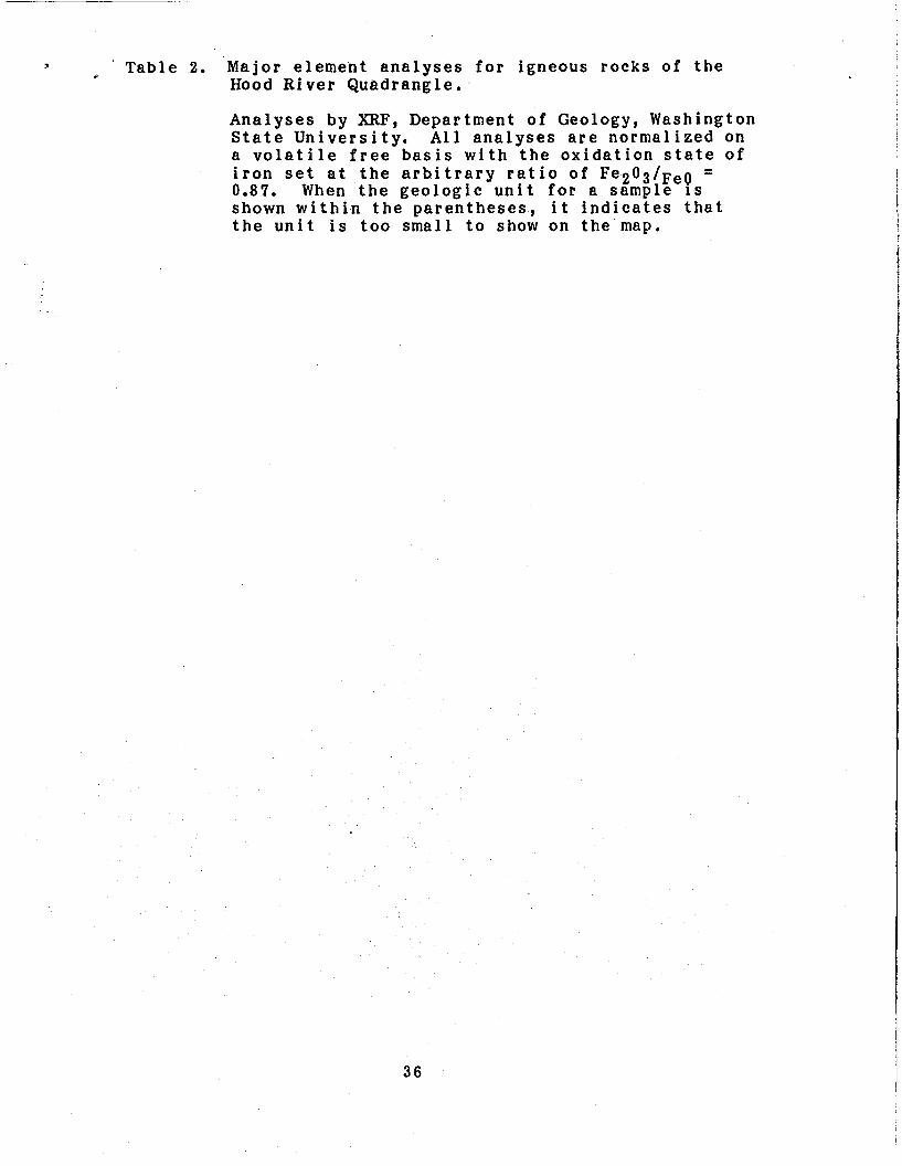
3 . Table 2. Major element analyses for igneous rocks of the . Hood River Quadrangle.
Analyses by XRF, Department of Geology, Washington State University. All analyses are normalized on a volatile free basis with the oxidation state of iron set at the arbitrary ratio of F ~ ~ O Q / F ~ O - 0.87. When the geologic unit for a sample is shown within the parentheses, i t indicates that the unit is too small to show on the map.
-
36

18807243 1880619854 I HK88416 18807246 I8807251 5 18806197 I 8806196 I MK85510 I MK8597 I HK85540 I HK88412 I HMO904851 1 MK85513 lHK85544 I HK85548 I HK8584 IMKB5710 I HK85539
I MK8558 jHK85525 I8807254 I MK8552B I HK85546 I MK85531
j IHK85524 I HK85534 I MK85542 I HK8557 I HK85547 10007252 I MK85526 I MK85517 I HK85518 I MK85532 I HK85523 I MK8552A I HK8551 I HK8847 I MK85538
I MK85535
85-08-23 T i b 85-08-14 [Tvb] 84-12-06 Ovhb 85-08-23 Tgr 85-08-23 T ibe 85-08-14 T i b 85-00-14 T i b 05-07-30 T i b 85-10-25 Tvb(3) 85-07-30 Tvb 84-12-06 Tvb(4) 85-1 0-25 Tvb [ 3 1 85-07-30 T ibe 85-07-30 f Tvb a [ 2 1 85-07-30 Ovcl 85-10-07 [Tvba[2] 85-10-07 T i b e 85-07-30 T ibe 85-07-30 T ibe 85-07-30 (Tvbe(21 I 85-07-30 t v a ( 2 ) 85-08-23 T iba 85-07-16 Tgr 85-07-30 Tcb 85-07-30 Tve(21 85-07-30 TvaI2) 85-07-30 T i e 85-07-30 T i e 85-07-30 T i a 85-07-30 T l e 85-08-23 l v e 85-07-30 Tve[2] 85-07-16 l i d 85-07-30 T i d 85-07-30 Tvo(2) 85-07-16 T i d 85-07-1 6 T i qd 85-07-1 6 T i qd @4-12-07 T i d l 85-07-30 T i d
48.10 15.23 1.44 5.71 6.54 0.19 10.75 50.48 16.91 1.87 5.87 6.50 0.21 9.57 50.92 20.84 1.88 5.02 5.75 0.18 5.86 51.82 15.71 1.75 5.28 6.05 0.19 10.67 51.83 13.93 2.89 6.79 7.78 0.24 8.88 51.89 14.63 2.15 6.08 6.96 0.19 10.13 52.20 14.97 2.23 8.17 7.06 0.20 9.07 52.42 18.39 1.45 4.52 5.18 0.15 9.22 52.68 17.03 2.13 2.00 9.16 0.18 8.90 52.77 16.78 2.00 5.33 6.11 0.17 8.53 52.96 17.85 1.44 4.46 5.11 0.16 9.77 53.22 16.52 2.31 2.00 9.78 0.18 8.08 54.12 17.72 1.44 4.33 4.98 0.15 9.46 54.42 15.53 1.59 5.39 6.17 0.18 8.70 54.52 17.39 1.13 3.71 4.25 0.13 8.20 54.82 16.88 1.30 4.80 5.50 0.19 8.60 54.82 16.77 1.36 4.20 4.81 0.15 9.41 55.09 14.96 2.41 5.44 6.23 0.18 7.74 55.26 17.97 1.43 4.34 4.97 0.16 6.52 55.39 16.53 1.34 4.76 5.45 0.18 8.08 55.61 17.47 1.33 4.15 4.75 0.16 8.87 55.68 14.62 2.35 5.79 6.63 0.23 8.91 56.63 14.23 1.92 5.52 6.32 0.19 7.68 56.99 18.51 1.09 3.91 4.48 0.23 7.92 57.97 17.30 1.26 4.09 4.69 0.17 7.23 58.13 18.69 1.35 4.45 5.10 0.15 7.78 58.16 15.89 2.02 4.62 5.29 0.16 6.20 58,49 15.15 1.98 4.77 5.46 0.18 S.46 58.97 16.60 1.46 4.09 4.69 0.18 6.45 59.70 16.15 1.31 4.26 4.88 0.16 6.28
61.30 17.01 1.16 4.10 4.70 0.12 5.07 63.51 18.55 0.66 2.27 2.60 0.09 5.89 63.00 18.69 0.64 2.23 2.56 0.08 5.49 64.42 18.44 0.77 3.59 4.11 0.13 4.29 65.83 17.39 0.61 2.05 2.34 0.08 5.56 66.65 17.26 0.50 1.99 2.28 0.00 5.10 67.22 17.05 0.49 1.89 2.16 0.08 4.94 67.45 16.66 0.47 1.90 2.17 0.08 4.93 67.52 17.08 0.48 1.80 2.06 0.08 4.96
60.02 11.80 2.33 6.16 7.05 0.17 4.08
9.13 0.48 2.18 0.24 99.99 Nw/4 W/4 5.34 0.71 2.75 0.18 99.99 W/4 N V 4 6.20 0.60 2.48 0.47 100.00 S V 4 W/4 5.46 0.14 2.70 0.24 100.01 sW/4 S V 4
5.03 0.25 2.44 0.25 100.00 N V 4 W/4 4.60 0.65 2.52 0.32 99.99 sW/4 W/4 4.99 0.85 2.61 0.22 100.00 S V 4 S V 4 4.27 0.85 2.50 0.31 100.01 N V 4 NV4 4.29 0.95 2.73 0.33 99.99 5 0 4 W/4 4.17 0.56 3.27 0.25 100.00 W/4 SE/4
4.22 0.55 2.81 0.24 100.00 W 4 W/4 4.66 0.48 2.68 0.20 100.00 W/4 N V 4 6.44 0.79 3.13 0.30 99.99 N V 4 WI/4 4.26 0.59 2.82 0.23 99.99 N V 4 SV4 4.76 0.47 3.07 0.20 100.02 Nw/4 M/4 3.83 1.21 2.53 0.39 100.01 M1/4 Nw/4 3.86 1.14 4.12 0.23 100.00 N V 4 W/4 4.37 0.50 3.22 0.18 100.00 NW/4 sW/4 3.99 0.68 2.68 0.32 100.01 W2 W/4 3.05 0.82 3.33 0.57 99.98 W/4 SU/4 4.10 0.72 2.44 0.29 1OO.M W/4 2.98 0.53 3.19 0.19 100.02 NW/4 M1/4 3.08 1.38 2.61 0.23 99.99 W/4 W/4 2.94 0.38 2.78 0.25 100.00 NW/4 SW/4 2.99 1.32 3.10 0.45 100.00 W/4 NV4 3.13 1.24 2.80 0.34 100.00 S V 4 S V 4 2.79 1.03 3.43 0.31 100.00 NW/4 W/4 2.81 1.58 2.66 0.24 100.01 S V 4 NW/4 2.45 0.89 3.53 0.03 99.99 W/4 SW4 2.07 1.64 2.60 0.24 100.01 SW/4 N V 4 1.81 0.81 3.79 0.23 100.01 hW4 NV4 1.73 0.79 3.77 0.21 99.99 NW/4 W/4 1.29 2.26 2.45 0.25 100.00 NW/4 W/4 1.71 0.95 3.31 0.16 99.99 S V 4 S V 4 1.58 1.10 3.30 0.16 100.00 Nw/4 1.48 0.92 3.61 0.16 100.00 NW/4 S V 4 1.40 0.99 3.81 0.15 100.01 SV4 NV4 1.35 0.90 3.61 0.15 99.99 SU/4 Nw/4
4.15 0.20 2.82 0.42 1oo.01 sw/4 s v 4
4.20 0.76 2.65 0.30 1oo.00 w 4 N W / ~
27 04N 09E I 17 04N 09E I 04 03N 09E Hauk B u t t e b a s a l t I 21 04N 09E I 09 04N 09E I 09 04N 09E I 16 04N 09E I 04 03N 08E Dike I 03 04N 07E SE o f B ig B u t t e I 02 04N 07E SE o f B ig But te I 25 04N 08E Lost Creek But te I 31 04N 07E Sedum Poin t I 11 I 05 04N OB€ f low e t Panther Creek I 1 4 02N 07E on Bonnev l l le lende l ide I 25 06N 06E Paredl6a H i l l s I 20 06N 07E Terminat ion P o i n t I 02 04N 07E SE o f Big But te I 13 04N 07E Warren H i l l I 21 04N OBE flow W o f B i g Huckloberry I 17 05N 07E Dry Craek I 10 04N 09E I 37 03N OB€ Inc lua fon i n q tz . d i o r i t e I 23 06N 07E W. o f McClel len Meadow I 06 05N 07E Big Hollow Creek I 21 05N 07E Peredise Ridge I 13 04N 07E Dike on Warren H i l l I
04N 08E Big Huckleberry Mtn.
36 05N 07E Dike E. o f Ten M i l e Creek I 15 04N 08E d ike W. o f B ig Huckleberry I 16 05N 07E d lke W. o f Middle But te I 00 04N 09E I 06 05N 07E Dry Creek I 05 03N 09E Wind R iver i n t r u s i v e I 05 03N 09E Wind R iver i n t r u s i v e I 17 O5N 07E N. o f B i g Hollow Creek I 33 04N 09E Hauk But te quarry I 37 03N 08E Wind Mtn., SF. qunrry I 26 03N O8E Wind Mtn., N. quarry I 32 04N 09E N. s ide o f Lost Creek I 01 04N 07E N. o f Warren H i l l I
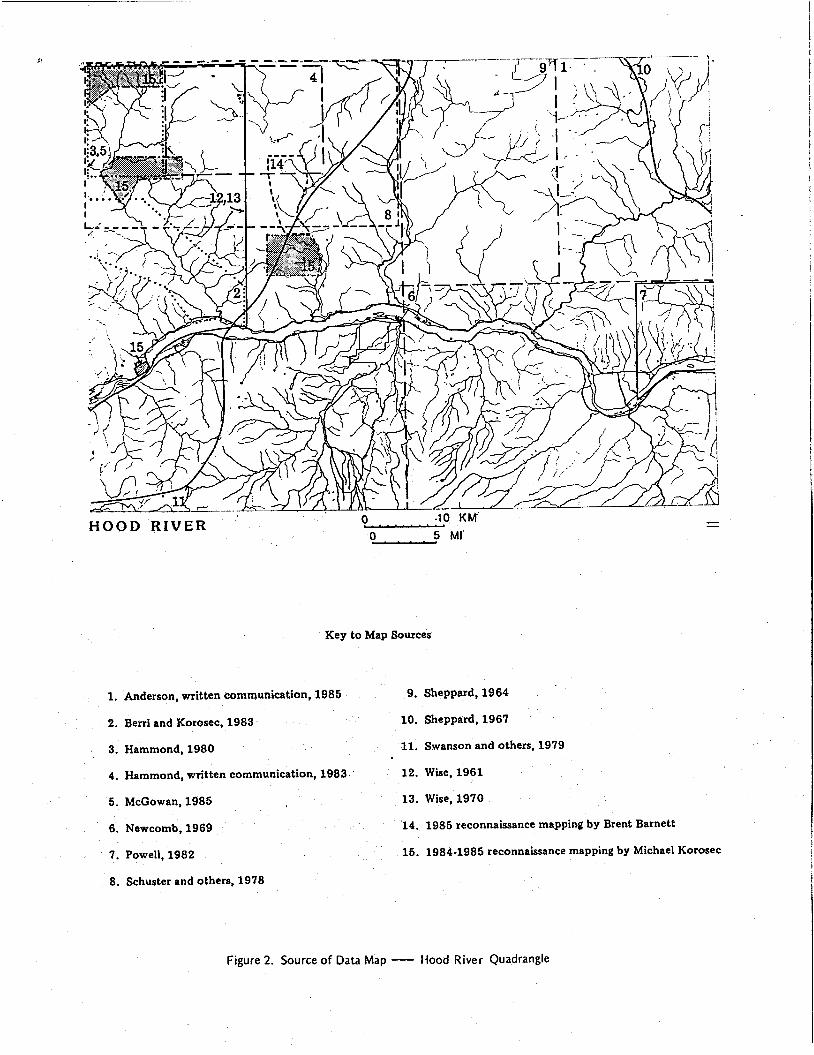
Key to Map Sources
1. Anderson, written communication, 1985
2. Berri and Korosec, 1983
3. Hammond, 1980
4. Hammond, written communication, 1983
9. Sheppard, 1964
10. Sheppard, 1967
11. Swanson and others, 1979
12. Wise, 1961
5. McGowan, 1985
6. Newcomb, 1969
7. Powell, 1982
13. Wise, 1970
14. 1985 reconnaissance mapping by Brent Barnett
15. 1984-1985 reconnaissance mapping by Michael Korosec
8. Schuster and others, 1978
Figure 2. Source of Data Map - Hood River Quadrangle

I B.&xnns;es CiLtad J
Anderson, J. L., 1985, written communication, Geologic map of the Klickitat 15-minute quadrangle, Washington: Washington Division of Geology and Earth Resources, unpublished map.
Bentley, R. D.; Anderson, J. L.; Campbell, N. P.; Swanson, D. A,, 1980, Stratigraphy and structure of the Yakima Indian Reservation, with emphasis on the Columbia River Basalt Group: U.S. Geological Survey Open-File Report 80-200, 86 p., 1 plate, scale 1:84,480.
investigation of the lower Wind River valley, southwest Washington, Cascade Range: Washington Division of Geology and Earth Resources Open-File Report 83-5, 46 p., 2 plates, scale 1:24,000.
Choiniere, S . R.; Swanson, D. A, , 1979, Magnetostratigraphy and correlation of Miocene basalts of the northern Oregon coast and Columbia Plateau, southeast Washington: American Journal of Science, v. 279, no. 7, p. 755-777.
Fiske, R. S . ; Hopson, C. A . ; Waters, A. C., 1963, Geology of Mount Rainier National Park, Washington: U.S. Geological Survey Professional Paper 444, 93 p. 1 plate, scale 1:62,500.
Free, M. R., 1976, Evidence for magmatic assimilation in several diorites of the middle Columbia River gorge: University of Utah Master of Science thesis, 67 p.
Goff, F. E., 1977, Vesicle cylinders in vapor-differentiated basalt flows: University of California at Santa Cruz Doctor of Philosophy thesis, 181 p.
Hammond, Paul E., 1980, Reconnaissance geologic map and cross sections of southern Washington Cascade Range, latitude 45' 30' - 47'15' N., longitude 120'45' - 122'22.5' W.: Portland State University Department of Earth Sciences, 31 p., 2 sheets, scale 1:125,000.
Hammond, Paul E., 1983, written communication, Prel iminary geologic map of the Indian Heaven area: the author, unpublished map, scale 1:62,500.
Harle, D. S,, 1974, Geology of Babyshoe Ridge area, southern Cascades Washington: Oregon State University Master o'f Science thesis, 71 p . , 1 plate, scale 1 : 2 4 , 0 0 0 .
Hopkins, K. D., 1976, Geology of the south and east slopes of Mount Adams volcano, Cascade Range, Washington: University of Washington Doctor of Philosophy thesis, 143 p., 1 plate, scale 1:63,360.
McGowan, K. I., 1 9 8 5 , Geochemistry of alteration and mineralization of the Wind River gold prospect, Skamania County, Washington: Portland State University Master of Science thesis, 136 p., 3 plates, scale 1:12,000.
McKee, E. H.; Swanson, D. A , ; Wright, T. T., 1977, Duration and volume of Columbia River volcanism, Washington, Oregon, and Idaho [abstract]: Geological Society of America Abstracts with Programs, v. 9, no. 4, p. 463-464.
Berri, Dulcy; Korosec, M. A., 1983, Geological and geothermal
.
39

= Newcomb, R. C., 1969, Effect of tectonic structure on the occurrence of groundwater in the basalt of the Columbia River Group of The Dalles area, Oregon and Washington: U.S. Geological Survey Professional paper 383-C, 33 p. Geologic map: 1 plate, scale 1:62,500.
Newcomb, R. C., 1966, Lithology and eastward extension of The Dalles Formation, Oregon and Washington: U . S . Geological Survey Professional Paper 550-D, p. D59-D63.
Phillips, W. M.; Korosec, M. A . ; Schasse, H. W.; Anderson, J. L.; Hagen, R. A. , 1986, K-Ar ages of volcanic rocks in southwest Washington: Isochron/West, v. 47, p. 18-24.
Porter, S. C., 1976, Pleistocene glaciation on the souther part of the north Cascade Range, Washington: Geologic1 Society of America Bulletin, v. 87, no. 1, p. 61-75.
Powell, J. E., 1982, Geology of the Columbia Hills, Klickitat County, Washington: University of Idaho Master of Science thesis, 56 p., 8 plates, scale 1:24,000.
Schuster, J. E.; Blackwell, D. D.; Hammond, P. E.; Huntting, M. T., 1978, Heat flow studies in the Steamboat Mountain-Lemei Rock area, Skamania County, Washington: Washington Division of Geology and Earth Resources Information Circular 62, 56 p. Figure 1, Generalized geologic map and cross sections of part of th’e southern Cascade Range, Washington, scale 1:340,000. Figure 2, Geologic map of the Indian Heaven area, southern Cascade Range, Washington, scale 1:200,000.
Shannon and Wilson, 1973, Geological studies of Columbia River basalt structure and age of deformation, The Dalles-Umatilla region, Washington and Oregon: Shannon and Wilson, Inc., Report 0-618E, 55 p.
Sheppard, R. A., 1964, Geologic map of the Husum quadrangle, Washington: U.S. Geological Survey Miscellaneous Field Studies Map Gm-3, 1 sheet, scale 1:125,000.
Swanson, D. A.; Anderson, J. L.; Bentley, R. D.; Byerly, G. R.; C a m p , V. E.; G a r d n e r , J. N.; W r i g h t , T. L., 1 9 7 9 , Reconnaissance geologic map of the Columbia River Basalt Group, northern Oregon and western Idaho: U.S. Geological Survey Open-File Report 81-797, 33 p., 7 plates, scale 1:250,000.
Tolan, T. L.; Beeson, M. H., 1 9 8 4 , Intracanyon flows of the Columbia River Basalt Group in the lower Columbia River Gorge and their relationship to the Troutdale Formation: Geological Society of America Bulletin, v. 95, no. 4, p . 463-477.
Travis, R. B., 1955, Classification of rocks: Colorado School of Mines Quarterly, v. 50, no. 1, 98 p.
Waitt, R. B., J r . , 1977$ Guidebook to Quaternary geology of the Columbia, Wenatchee, Peshastin, and upper Yakima Valleys, west-central Washington: U.S. Geological Survey Open-File Report 77-753, 25 p.
Waitt, R. B., J r . , 1985, Case for periodic, colossal jokulhlaups from Pleistocene glacial Lake Missoula: Geological Society of America Bulletin, v. 96, no. 10, p . 1271-1286.
4 0
--W@e, W. S., 1 9 6 1 , The geology and mineralogy of the Wind River 1 area, Washington, and the stability relations of celadonite:
Johns Hopkins University Doctor of Philosophy thesis, 2 v . 1 plate, scale 1 : 6 2 , 5 0 0 .
Wise, W. S., 1 9 7 0 , Cenozoic volcanism in the Cascade Mountains of southern Washington: Washington Division of Mines and Geology Bulletin 6 0 , 4 5 p., 1 plate, scale 1 : 1 2 5 , 0 0 0 .
Zanettin, Bruno, 1 9 8 4 , Proposed new chemical classification o f volcanic rocks: Episodes, v. 7 , no. 4 , p. 1 9 - 2 0 .
4 1

\
OPEN FILE REPORT 87-6 WASHINGTON D I V I S I O N OF GEOLOGY AND EART+R‘ESOURCES RAYMOND LASMANIS, STATE GEOLOGIST
, .
*a . WASHINGTON STATE DPARTMENT OF
Natural Resources I ___
b a n Boyle - Commlrr~oner 01 Public Lands An Stearns - SupeMror
HOOD RIVER QUADRANGLE
GEOLOGIC UNITS FOR THE HOOD RIVER 1 :100,000 QVADRANCLE
:. 1 Quaternary Sediments
8 I
T. 6 N.
a1 luvium older a1 luvium lands I ide Evans Creek D r i f t , t i l l Evans C r e e k Drift , outwash Hayden Creek Drift ( ? ) , till Trout Lake mudflow Missoula Missoula flood flood deposits, deposits, gravel silts and sands
Quaternary Volcanic Rocks - basalt flows, unnamed basaltic andesite and basalt flows, unnamed
basalt Of Alice Butte andesite of Black Creek basaltic andesite north of Big Huckleberry Mountain basaltic andesite of Bi l l Butte basalt basalt of of Big Berry Lava Mountain 6ed
basalt of Cedar Creek basaltic andesite of Cascade landslide basalt of Camas Prairie basalt of Dry Creek basaltic andesite of Eunice Lake andesite of For lorn Lake basalt of Flattop Mountain upper andesite of For lorn Lake basalt of Grouse Butte basalt of Cilmer Creek basalt of Goose Lake basalt of G u l e r Mountain basalt basalt of of Gifford Hauk Butte Peak
basalt of Herman Creek (Oregon) basalt basalt of of Ice Indian Caves Heaven
basaltic andesite of Juice Creek andesite a t Laurel basalt of Lake Comcomly basalt of Lost Lake Butte (Oregon) basalt of Lost Creek basalt of Lapham Creek basalt of Little White Salmon basalt of Mowich Butte basalt of Mount Defiance (Oregon) andesite of McCoy Flat andesite of Mount Hood basalt of McClellan Meadows basalt north of South Prairie andesite of Petite Mountain (andesite northeast of Red Mountain) basalt of Peterson Bu t t e basalt of Papoose Mountain (basalt southeast of Red Mountain) basalt of Peterson Ridge basalt of Petite Mountain (basalt northeast of Red Mountain) basaltic andesite of Quigley Butte basalt of Rush Creek basalt of Rock Creek andesite of Rattle Snake Creek andesite of t h e Race Track basalt of Sahalee Tyee basalt of Sheridan Point basalt of Sheep Lakes basalt cone southeast of Red Mountain basalt of Sugar Bowl Butte basalt of Thomas Lake basalt of Trout Creek H i l l basalt of The Wart basalt of Underwood Mountain basalt no r th of White Salmon basalt of White Salmon
T. 5 N
T. 4 N.
/
PI iocene-Pleistocene Sediments -
Plio-Pleistocene gravel; Swale Creek Valley sedimentary deposits PI io-Pleistocene terraced sediments
PI iocene-Pleistocene Volcanic Rocks
volcanic rocks, undifferentiated basalt flows basalt porphyry of the Hood River Valley (Oregon) dacite of Snowden basalt of Booth H i l l (Oregon) basalt porphyry of Batch Lake basalt of Lenz Butte (Oregon) basalt of the Simcoe Mountains
!
N.
T . 2 N.
PI iocene - Pleistocene Intrusive Rocks
dacite dome of Gross Mountain
Tertiary St rat i f ied Rocks
Troutdale Formation Dal les Fo rmat ion Snipes Ellensburg Mountain Formation conglomerate member of Ellensburg Formation
middle Miocene basalt flows Saddle Mountains Basalt, Pomona Member Wanapum Basalt, Priest Rapids Member Wanapum Basalt, Roza Member Wanapum Basalt, Frenchman Springs Member
Grande Ronde Basalt, undivided Grande Ronde Basalt; upper flows, normal magnetic polarity Crande Ronde Basalt, upper flows, reverse magnetic polarity Crande Ronde Basalt, lower flows, normal magnetic polarity Eagle Creek Format ion wlcanic rocks of Council Bluf f (Council B l u f f Formation) lower Miocene basalt flows volcanic rocks of Stevenson Ridge (Stevenson Ridge lavas ) lower Miocene Tuff and tuf f breccia lower Miocene wlcanic sedimentary rocks dacite flows, lowe r Miocene basaltic andesite flows, lower M iocene andesite flows, upper Oligocene basaltic andesite flows, upper Oligocene volcaniclastic rocks, upper Oligocene Tertiary tuffs and t u f f breccia
100
N. T. 1 N.
r S.
30’
T. 1 S.
Tertiary Intrusive Rocks
Pliocene dacite Pliocene quartz diorite; Wind Mountain and Shell Rock quartz diorite quartz diorite intrusive basalt rhyolite of Mann Butte intrusive intrusive basaltic andesite andesite
intrusive dacite diorite gabbro intrusive rocks, undifferentiated
[ Pid] [ Piqd I [Tiqd I [Tib] [Ti r ] [Tiba] [ Tia] [ Tid] [ Tidi ] [Ti&] [Ti I
Explanation of Symbols
Contacts Known and Approximate Location
- - - - - - Scratch Boundary
Faults and Folds
Solid Lines --Existence known. Location Known
Dashed -Location and existence inferred
Dotted -Concealed
o,r approximate
0 U - - - 0. AAA A 0 .
4- - . . . + --. . .
High Angle Fault
Thrust Fault
Anticlinal Fold, showing direction of plunge
Synclinal Fold, showing direction of plunge
Monoclinal Hinges
x
As
Quaternary and Pliocene Volcanic Centers
K-Ar Age Date Sample Location. See Table 1.
’ ” w QUADRANGLE LOCATION
HOOD NW/4 THE RIVER, DALLES BIL 169) WASH.-OREG. 1:250 OOOSCALE MAP
N4530-W12100/30 x 60 GEOLOGIC MAP OF THE HOOD RIVER QUADRANGLE, WASHINGTON AND OREGON Compiled by
MICHAEL A. KOROSEC 1987
THIS REPORT CONSISTS OF 1 MAP AND A 37 PAGE TEXT.