Geologic map of the Black Canyon City and Squaw -...
46
Geologic map of the Black Canyon City and Squaw Creek Mesa area, central Arizona by Robert S. Leighty Arizona Geological Survey Contributed Map CM-07-A May 2007 Scale 1:24,000 (1 sheet), with 46 p. text Arizona Geological Survey 416 W. Congress St., #100, Tucson, Arizona 85701 www.azgs.az.gov
Transcript of Geologic map of the Black Canyon City and Squaw -...

Geologic map of the Black Canyon City and Squaw Creek Mesa area, central Arizona
by
Robert S. Leighty
Arizona Geological Survey Contributed Map CM-07-A
May 2007
Scale 1:24,000 (1 sheet), with 46 p. text
Arizona Geological Survey 416 W. Congress St., #100, Tucson, Arizona 85701
www.azgs.az.gov

2
GEOLOGIC MAP OF THE BLACK CANYON CITY AND SQUAW CREEK MESA AREA, CENTRAL ARIZONA
PHYSIOGRAPHY
The Black Canyon City and Squaw Creek Mesa 7.5 minute quadrangles are located north of the Phoenix metropolitan area within the Transition Zone, an area of rugged topography, roughly 100 kilometers wide in central Arizona that separates the Basin and Range and Colorado Plateau physiographic provinces in Arizona (Figure 1). Low- to moderate-relief terrain occupies the center portion of the map area, with rugged, high-relief terrain of the New River Mountains to the east and the Bradshaw Mountains to the west. Elevations range from 1800 feet along the Agua Fria River at the southern edge of the map to just under 6000 feet in the mountainous areas to the east and west. The southern ends of Black Mesa (3000-3200 feet) and Perry Mesa (3400-3600 feet) are located along the northern border of the map area. Other prominent mesas include Williams Mesa and Squaw Creek Mesa. The Agua Fria River is the main stream drainage in the area and forms a prominent canyon where it cuts through the mesas on the north edge of the map area. The Agua Fria flows into Lake Pleasant just to the southwest of the map area. Several tributary streams flow into the Agua Fria River and include Squaw Creek, Little Squaw Creek, Moore Gulch on the east and Black Canyon Creek, Cottonwood Gulch and Boulder Creek on the west. Primary access to the area is by Interstate 17, whereas many roads (paved and unimproved) and jeep trails provide varying degrees of access to more remote areas. The map area includes the community of Black Canyon City, which is undergoing rapid population growth and is becoming increasingly urbanized. The area includes an irregular distribution of private, state, and BLM land. The Agua Fria National Monument occupies part of the northern part of the map area between I-17 and Squaw Creek and the Tonto National Forest is located along the eastern side.
GEOLOGIC SUMMARY The map area lies in the Transition Zone between the Basin and Range and Colorado Plateau physiographic/geologic provinces. The Transition Zone consists of a relatively thin cover of Tertiary volcanic and sedimentary rocks that overlie lithologically heterogeneous Early Proterozoic basement and minor Early Paleozoic erosional remnants. A simplified portrayal of the distribution of geologic units and features in the Black Canyon City area is shown in Figure 2. A diverse suite of Early Proterozoic plutonic, metavolcanic, and metasedimentary rocks form the basement from the Bradshaw to the New River Mountains. The Crazy Basin monzogranite batholith (1699 Ma) forms much of the higher Bradshaw Mountains to the west, with older (~1800-1750 Ma) metasedimentary and metavolcanic rocks of the Yavapai Supergroup exposed along the eastern flank. Early Proterozoic rocks of the Tonto Basin Supergroup (~1700 Ma) comprise most of the New River Mountains to the east. Early Proterozoic granodiorite, diorite, and tonalite (1735-1720 Ma) and metavolcanic and metasedimentary rocks compose much of the relatively low relief basement between the Shylock and Moore Gulch fault zones, with lesser amounts of granite, gabbro, and metasedimentary rocks are also present.
Occupying the lower relief terrain between the Bradshaw Mountains and the New River Mountains is a relatively unextended sequence of Tertiary volcanic and sedimentary strata. This low area was a depositional basin for Miocene basaltic lavas and fluvial-lacustrine sediment of the Chalk Canyon and Hickey Formations. This broad expanse of relatively unfaulted Miocene basaltic volcanic and sedimentary rocks represents a paleogeographic low area that has been referred to as the Agua Fria paleobasin (Leighty and Reynolds, 1998). Late Cenozoic incision of the gently-tilted Tertiary section by several streams (e.g., the Agua Fria River, Black Canyon Creek, etc.) has produced several distinctive mesas (Squaw Creek Mesa, Black Mesa, Perry Mesa, Williams Mesa, etc.). Failure of the slopes of Black Mesa and Perry Mesa adjacent to the Agua Fria River has produced several large landslide deposits. Holocene flood plain deposits are best developed along the Agua Fria River in the central and northern portions of the area.

3

4
Figure 2. Distribution of various geologic units and features in the Black Canyon City and Squaw Creek Mesa quadrangles. a) Proterozoic rocks and structures. b) Early Miocene rocks. c) Middle and Late Miocene rocks and structures. d) Quaternary stream, slope, and landslide deposits.
A
B

5
Figure 2 (continued).
C
D

6
PREVIOUS STUDIES Most of the geologic study in the map area has concentrated on the Proterozoic rocks and structures. Initial investigations of the geology and mineral resource potential of the Bradshaw Mountains area occurred in the early twentieth century (Jaggar and Palache, 1905; Lindgren, 1926). The Proterozoic geology between the Agua Fria River and the southern Bradshaw Mountains has been described by Jerome (1956) and Winn (1982), but most of the detailed geologic mapping of the Bradshaw Mountains has occurred northwest of the Black Canyon City quadrangle. In the New River Mountains, mapping has been conducted by several workers in the area southeast of Squaw Creek Mesa (Maynard, 1986; Maynard, 1989; Anderson, 1989b; DeWitt, 1991; DeWitt, unpub. mapping). Description of the Proterozoic geology of the map area is also described in several regional studies (Anderson, 1986; Karlstrom and Conway, 1986; Conway and others, 1987; Karlstrom and others, 1987; Karlstrom and Bowring, 1988; Anderson, 1989a; Conway and Silver, 1989; DeWitt, 1989; Karlstrom and Bowring, 1991).
Different aspects of the Cenozoic geology of the Black Canyon City map area is covered in several studies, including Tertiary stratigraphy (St. Clair, 1957; Leighty, 1997), petrology of the Miocene volcanic (Leighty and Glascock, 1994; Leighty and others, 1995; Leighty, 1997), Middle and Late Tertiary faulting and tectonics (Leighty and Reynolds, 1996; Leighty, 1997), and Tertiary sedimentation (Leighty, 1997; Leighty and Reynolds, 1998). Several studies have concentrated on the Tertiary rocks in adjacent areas (Ward, 1977; Gomez, 1978; Gomez and Elston, 1978; Gomez, 1979; Satkin, 1981; Esperanca, 1984; Capps and other, 1986; Jagiello, 1987; Leighty, 1997) and geologic mapping of adjacent 7.5 minute quadrangles includes New River Mesa (Ferguson and others 1998), Daisy Mountain (Leighty, 1998; Bryant 1999), New River (Bryant, 1994; Bryant, 1999), Joes Hill (Leighty, in pub.). Mapping of the Agua Fria National Monument (Leighty, in pub.) extends into the map area from the north. The only existing age determination for Tertiary rocks within the map area (the 15.4 Ma date on the Hickey Formation lavas at Squaw Creek Mesa) was provided by Eberly and Stanley (1978). The uranium potential of the Tertiary sediments of the region has been described, including the deposits considered to be potential radon hazards (Scarborough and Wilt, 1979; Harris and others, 1998).
Only a handful of geologic maps exist that cover the map area of this study. Jerome (1956) included Tertiary volcanic rocks and alluvium in the Black Canyon City area as part of his Proterozoic mapping. St. Clair (1957) described the Tertiary and Quaternary deposits along the Agua Fria corridor, including a map and two stratigraphic sections. The geology of the Tip Top mining district at the southwest edge of the map area is described by Kortemeier (1984) and Kortemeier and others (1986). Other geologic maps cover much larger areas, but show less detail, including: the Geologic Map of Arizona (Richard and others, 2000) at a scale of 1:1,000,000, and the geologic maps of Yavapai County (Wilson and others, 1958) and Maricopa County (Wilson and others, 1957), both at 1:375,000 scale. A road log by DeWitt (1991) summarized the geology along I-17 and provided a generalized 1:100,000 scale map based in part on his work and that of previous workers.
The map data for this report is largely based on new geologic mapping that augments the unpublished mapping by Leighty (1997). In some areas, the Proterozoic geology was compiled from other, more detailed mapping sources, including west of the Agua Fria River (Jerome, 1956) and southeast of Moore Gulch (Maynard, 1986; Maynard, 1989; DeWitt, unpub. data). Specific compiled contacts are noted on the map. Current mapping activity by the Arizona Geological Survey is underway in the area and will produce a map of the west half of the Black Canyon City quadrangle and the east half of the Squaw Creek Mesa quadrangle (Ferguson and others, in prep.). The AZGS mapping will overlap and complement the mapping of this report, and will likely have more detailed descriptions of the Proterozoic rocks and Quaternary surficial deposits.

7
EARLY PROTEROZOIC ROCKS AND STRUCTURES This part of central Arizona contains a diverse assemblage of Early Proterozoic rocks that can be broadly divided into two provinces: 1) an older (1800-1700 Ma) northwestern province comprised of supracrustal rocks of the Yavapai Supergroup and batholithic intrusives (Karlstrom and others, 1987), and 2) a younger (1740-1625 Ma) southeastern province largely consisting of rocks of supracrustal rocks of the Tonto Basin Supergroup and Diamond Rim Intrusive Suite (Conway and Wrucke, 1986; Karlstrom and others, 1987). The nature of the boundary between these two provinces is controversial, but has generally been accepted to correlate with the northeast-trending Moore Gulch fault zone. Rocks of the northwestern province have been interpreted as island arc volcanic rocks and associated calc-alkaline batholiths (Anderson, 1986; Condie, 1986; Vance, 1986), whereas rocks of the southeastern province have continental affinities and have structural and metamorphic histories representative of more shallow crustal levels. Both provinces include major north- and northeast-trending shear zones that may either be discrete zones of high strain within terranes or tectonic sutures between distinctive terranes (Karlstrom and Bowring, 1988).
Rocks of the Yavapai Supergroup, Tonto Basin Supergroup, and various plutonic rocks are well exposed in the Black Canyon City area (figure 2). The Crazy Basin monzogranite batholith (1699 Ma) forms the higher parts of the Bradshaw Mountains to the west (Figure 3a). Older metasedimentary and metavolcanic rocks of the Yavapai Supergroup (~1755 Ma) occupy the lower slopes down to the Agua Fria River where these rocks are highly strained in the north-trending Shylock fault zone. Various granodiorite and tonalite phases (1735-1720 Ma) underlie the Tertiary rocks from Little Squaw Creek north toward Black Mesa and Perry Mesa. Metavolcanic and metasedimentary rocks similar to those of the Yavapai Supergroup are exposed between Little Squaw Creek and Moore Gulch. These rocks are intruded by leucocratic granitic rocks that have no apparent correlative relation to units to the west. The Moore Gulch shear zone trends north-northeast across the southeastern part of the Squaw Creek Mesa quadrangle, where felsic metavolcanic rocks and related intrusives of the Tonto Basin Supergroup (1710-1675 Ma) form the New River Mountains (Figure 3b).
Yavapai Supergroup General - Metavolcanic and metavolcaniclastic rocks of the Yavapai Supergroup comprise much of the crystalline basement between the Moore Gulch shear zone and the Crazy Basin batholith in the Bradshaw Mountains. The lithostratigraphic term >Yavapai Supergroup= refers to all volcanic and related strata in the volcanic belts of central and northern Arizona (Anderson, 1968b; Anderson, 1989b) and is formerly subdivided into the Big Bug Group west of the Shylock fault zone and the Ash Creek Group east of the Shylock fault zone (Anderson and Creasey, 1958; Anderson and others, 1971). The Big Bug Group includes the compositionally diverse metavolcanic and related metasedimentary rocks of the Spud Mountain Volcanics and Iron King Volcanics, whereas the Ash Creek Group is a less-metamorphosed suite of compositionally diverse metavolcanic and related metasedimentary rocks, including the Grapevine Gulch Formation, Deception Rhyolite, Buzzard Rhyolite, Brindle Pup Andesite, Shea Basalt, and Gaddes Basalt (Anderson and Creasey, 1958). However, recent work has challenged the formational and group designations of the Big Bug Group due to the stratigraphic and petrochemical diversity of distinct rock suites. (DeWitt, 1976a,b; O'Hara, 1980; Darrach, 1988; Anderson, 1989a,b). Within the mapped area in this report, rocks correlative with Yavapai Supergroup rocks are largely exposed in two areas: 1) from the Agua Fria River area west to the Bradshaw Mountains and 2) between Moore Gulch and Little Squaw Creek (Figure 2). Bradshaw Mountains area - The metavolcanic and metasedimentary rocks in a north-trending belt between the Bland Quartz Diorite plutons on the east and the Crazy Basin batholiths on the west have been correlated with the Spud Mountain Volcanics, Iron King Volcanics, and related sedimentary rocks of the Big Bug Group (Jerome, 1956). The age of the Spud Mountain Volcanics in the Crown King quadrangle to the northwest is 1755 ±15 Ma (Anderson and others, 1971). Penetrative deformation has transposed most of the primary sedimentary and volcanic structures and no distinct facing directions have

8
been observed. The degree of ductile deformation is most intense in a north-trending zone of highly strained rocks that is the likely extension of the Shylock shear zone into the area. Rocks of the Big Bug Group in this area are generally upper greenschist facies, but are locally of amphibolite facies where affected by the thermal aureole of the Crazy Basin Monzogranite batholith. These rocks have been named according to both their presumed protolith (Jerome, 1956) and metamorphic fabric (Winn, 1982). The metavolcanic rocks (Xmv) in the Big Bug Group range in composition from largely andesite and dacite with lesser basalt to primarily felsic volcanic rocks. Light to dark grayish green andesite and dacite flows and tuff include minor interbedded metasedimentary rocks (Xmvm). Where recognizable, these rocks are featureless to porphyritic in texture, with feldspar and hornblende phenocrysts mostly altered to sericite, chlorite, and epidote (Figure 3c). Penetrative deformation has typically obscured primary features, but pillows, vesicles, amygdules, and flow breccias are found locally (Jerome, 1956). The felsic metavolcanic unit (Xmvf) is largely composed of fine-grained rhyolitic pyroclastic material that is well foliated and commonly bleached and stained with iron oxides. Phyllite, quartzite, and quartz veins are also present. The metasedimentary unit (Xms) includes pelitic to psammitic phyllite and schist, with a minor metavolcanic component. These rocks are lithologically variable and include a wide range of compositional assemblages (staurolite, muscovite+tourmaline, biotite+almandine, and hornblende+quartz, etc.) that are dependant on protolith bulk composition. These minerals are largely altered to sericite and chlorite. Within the contact aureole of the Crazy Basin Monzogranite batholith, coarse-grained staurolite schist becomes more fine-grained to the east, away from the batholith. Possibly due to the thermal effects of metamorphism, these rocks weather easily, in stark contrast with the bold topography formed by the monzogranite to the west. In the southwest part of the map area, this unit is overlain by Tertiary rocks at Boulder Creek, but is likely correlative to similar lithologies in the Hieroglyphic Mountains (Burr, 1991). Highly resistant, purple to reddish-brown ferruginous chert lenses and boudin-shaped pods are common in the Big Bug Group rocks. These rocks are dominantly composed of quartz with lesser amounts of magnetite and hematite Layers are typically <30-meters-wide and discontinuous along strike. These have not been mapped separately in this report. Little Squaw Creek area - Early Proterozoic greenschist facies metavolcanic (Xmv, Xmvm, Xmvf) and metasedimentary (Xms) rocks exposed northwest of the Moore Gulch fault zone represent the Ash Creek Group, but their classification is both complex and controversial. Several authors have assigned these rocks differently: the Moore Gulch Group (Maynard, 1986), the Ash Creek block (Karlstrom and Bowring, 1988), the Black Canyon Creek Group (Anderson, 1989b), and “group 1” rocks (Bryant, 1999). Outside of the map area to the north, the metavolcanic rocks of the Ash Creek Block were deformed before the intrusion of the 1735-Ma Cherry batholith (Anderson and Creasey, 1958; Anderson and others, 1971; Karlstrom and Bowring, 1993). Within the map area of this report, the metavolcanic rocks northwest of the Moore Gulch fault zone are intruded by 1720 ±9 Ma granodiorite and quartz diorite (Xgd) phases (Bowring and Karlstrom, 1986; DeWitt, 1989). Although facing directions in these rocks were not observed, the stratigraphic sequence is inferred to face northwest (Bryant, 1999). These rocks were intruded by a leucocratic granitic phase (Xg) and locally by thin granitic lenses. Northeast-trending quartz veins are common. The mapping of the contacts in this area was reconnaissance in nature, but further work by Ferguson and others (in prep.) will undoubtedly provide more detail. Overall, the metavolcanic rocks in this area are similar in lithology to the Big Bug Group rocks to the west, although mafic compositions may be more abundant. The metasedimentary rocks in this area are dominantly fine-grained, greenish quartz+chlorite±sericite±carbonate phyllites and schists (Maynard, 1986). These rocks generally have moderate to steeply northwest-dipping foliation and are isoclinally folded. Thin, reddish-brown ferruginous chert layers are abundant in the metasedimentary rocks, but are not mapped separately in this report. These northeast-trending lenses, are typically <5 meters wide and <100 meters in length. The massive sulfide ore deposit at the Orizaba Mine is associated with these hematitic beds (Maynard, 1986).
9
Tonto Basin Supergroup General - Rocks exposed southeast of the Moore Gulch shear zone in the New River Mountains are generally correlative with strata of the Tonto Basin Supergroup and Diamond Rim Intrusive Suite (Maynard, 1986; Anderson, 1989a,b; Conway and Silver, 1989). The Tonto Basin Supergroup was probably deposited between 1735 and 1675 Ma, and deformed largely between 1700 and 1650 Ma (Conway and Silver, 1989; Anderson, 1989b; Karlstrom and others, 1990; Reynolds and DeWitt, 1991), and intruded by pre-Mazatzal Orogeny 1700 Ma granite and hypabyssal rocks (i.e., the subvolcanic equivalents of the Red Rock Group), as well as post-tectonic granites (1625 Ma) in southeastern Arizona (Conway and Silver, 1989; Reynolds and DeWitt, 1991). Though the stratigraphy and nomenclature are still somewhat controversial, the Tonto Basin Supergroup includes four major groups (from oldest to youngest): 1) Union Hills Group, 2) Alder Group, 3) Red Rock Group, and 4) Mazatzal Group (Anderson, 1989a,b; Conway and Silver, 1989; Reynolds and DeWitt, 1991). Of these, the thick sequence of felsic ignimbrites and granitic intrusive phases exposed in the New River Mountains is correlative with the Red Rock Group (Conway, 1976; Wrucke and Conway, 1987; Anderson, 1989b). These felsic rocks have also been referred to as the New River Group (Maynard, 1986) and the New River Mountains felsic complex (Anderson, 1989b).
New River Mountains - Rhyolite, rhyodacite, and dacite flows and welded tuffs (Xmvf) form most of the rugged New River Mountains southeast of the Moore Gulch fault zone. These felsic metavolcanic rocks typically form massive, tan to reddish outcrops. Color (white, tan, black, etc.) and the degree of welding are variable. The intensity of foliation in these rocks decreases away from the Moore Gulch shear zone. Flattened pumice clasts are common. Columnar jointing is also preserved. The felsic volcanic rocks grade southeastward into an equigranular, fine-grained granitic rock (Xga).
Plutonic Rocks Across the region, four distinct intrusive suites have been defined (Anderson, 1989b; DeWitt, 1989), including: 1) pre-tectonic (1750 Ma) granodiorite and granite plutons, 2) pre- to syn-tectonic (1735 Ma) hornblende-biotite tonalite and granodiorite, 3) pre- to late-tectonic (1720 Ma) biotite-hornblende granodiorite plutons, and 4) syn- to post-tectonic (1700 Ma) biotite granodiorite to granite plutons. Three of these groups are exposed within the map area and include granodiorite, tonalite, quartz diorite, and diorite compositions. These compositional differences were not delineated in this report, and all are represented by the same map unit (Xgd). Variations in modal abundances of quartz and the pervasive alteration of feldspar make precise classification somewhat problematic. 1735-1720-Ma plutons - Diorite and tonalite phases of the Cherry batholith (1735 ±15 Ma, Anderson and others, 1971) extend into the northeastern part of the map area in the Squaw Creek area. Slightly younger (1720 ±9 Ma, Bowring and Karlstrom, 1986) granodiorite, diorite, and tonalite phases (tonalite of Little Squaw Creek, Quartz Diorite of Bland) are exposed farther south and west between the Moore Gulch and Shylock fault zones (Bowring and Karlstrom, 1986; Anderson, 1989a; DeWitt, 1989). Jerome (1956) correlated the granodiorite and diorite of the Black Canyon City area with the quartz diorite at Bland Hill, exposed to the north near Bumblebee. These rocks form blocky outcrops, and contain abundant xenolithic material (Figure 3d). This unit is foliated and is highly foliated along western margin with Big Bug Group rocks. This unit is generally equigranular, medium- to coarse-grained, and contains feldspar, hornblende and biotite, and quartz (Figure 3e, f). Sericitic alteration of feldspar (mostly oligoclase-andesine) is pervasive, with alteration of the iron-rich minerals to epidote and chlorite (Jerome, 1956). 1700-Ma plutons - The Crazy Basin Monzogranite has been referred to as the Bradshaw Granite (Jagger and Palache, 1905), Cleator Granite (Jerome, 1956), and Crazy Basin Quartz Monzonite (Anderson, 1972; Anderson and Blacet, 1972a,b). The 1699-Ma Crazy Basin Monzogranite batholith covers over 200 square kilometers and form much of the higher Bradshaw Mountains west of the Shylock fault zone. The monzogranite is more resistant than the surrounding country rock, forming massive ridges and impressive cliffs. This peraluminous, two-mica monzogranite is largely equigranular in texture, with phenocrysts of

10
microcline, oligoclase, muscovite, and biotite. Although late syn-kinematic, the monzogranite is largely undeformed. The eastern contact with the rocks of the Big Bug Group is sharp in places, but can also be somewhat arbitrary due to swarms of granitic and pegmatite dikes. Cogenetic pegmatites have compositions similar to the main monzogranite batholith, but are more coarse-grained with more abundant muscovite, almandine, black tourmaline, and less biotite. The batholith intruded and melted largely metasedimentary crustal rocks at a depth of 10-15 kilometers during the latter stages of ductile deformation (Conway and others, 1987). Peak metamorphism reached upper amphibolite grade in proximity to the Crazy Basin batholith (Williams, 1991). In the southeastern part of the map area, an equigranular, fine-grained granitic rock (Xga) is in gradational contact with the felsic volcanic rocks. The aplitic granitic rocks in turn grade into more coarse-grained granitic rocks outside the map area. This gradation from volcanic to plutonic rocks may represent a crustal-scale section (upper extrusive layers, subvolcanic hypabyssal section, deeper plutonic part) of a felsic complex that may also be the extrusive equivalent of the huge Verde River Granite batholith to the east (Anderson, 1989b). Unclassified plutons - Several leucogranite bodies intrude the Ash Creek Group metavolcanic sequence between Moore Gulch and Little Squaw Creek. These fine- to medium-grained intrusives have no counterparts in the terrane to the west. As with the metavolcanic rocks, the mapping of the contacts in this area was reconnaissance in nature, and further work by Ferguson and others (in prep.) should provide more detail.
Major Shear Zones Two important Early Proterozoic shear zones are present in the area of study: the north-trending Shylock shear zone and the northeast-trending Moore Gulch shear zone. Shylock shear zone - The Shylock shear zone is an area of intense ductile deformation located within the Big Bug Group on the eastern flanks of the Bradshaw Mountains. It averages about 2 kilometers in width for 60 kilometers. This zone of vertical foliation and tight to isoclinals folds has been studied in detail in areas adjacent to this map area (Darrach and others, 1991; Burr, 1991). The complex deformational history represented by this zone of highly strained rocks is controversial and has been interpreted as 1) a strike-slip fault (Jerome, 1956; Anderson, 1967; Anderson and Blacet, 1972a-c), 2) a dip-slip fault (Winn, 1982), and 3) the attenuated limb of a major antiform (O'Hara, 1980), and 4) as a major crustal boundary (Karlstrom and Bowring, 1988). This zone lacks of discrete boundaries in the Black Canyon City area and was not delineated on the map. Moore Gulch shear zone - The Moore Gulch shear zone trends to the north-northeast across the eastern part of the Squaw Creek Mesa quadrangle (Figure 2) and effectively separates the 1740-Ma granodioritic phases of the Cherry batholith and greenschist facies metavolcanic rocks of the Ash Creek Group on its northwest side from the ~1700-Ma felsic metavolcanic rocks of the Red Rock Group and related granitic phases on its southeast side. Proterozoic movement in the fault zone was largely ductile in nature (Maynard, 1986; Anderson, 1989b; DeWitt, 1991; Karlstrom and Williams, 1998; Bryant, 1999) and rocks in and adjacent to the shear zone become more highly strained to the northeast (Anderson, 1989b). The Moore Gulch shear zone truncates the Ash Creek Group metavolcanic and metasedimentary rocks at a low angle. Several smaller, subparallel faults are also present, but were not included in this report (see Maynard, 1986), but no significant Tertiary reactivation is observed along the Moore Gulch shear zone. Hickey Formation lavas (Tbm) are not offset where they overlie the shear zone in the northern New River Mountains near Willow Spring Canyon. Although the fault contacts are not well exposed, there may be limited offset (<50 feet down-to-the-west) of the andesitic flows (Ta) southeast of the Orizaba Mine. However, this displacement is not responsible for the differing physiography between the higher New River Mountains and the lowlands to the west. Rather, the differential erosion of the granodiorite at a faster rate relative to the resistant Red Rock Group may account for the elevation difference.

11
Figure 3. Early Proterozoic rocks. a) Crazy Basin monzogranite dominates the high Bradshaw Mountains. b) Felsic metavolcanic (Xmvf) and metasedimentary (Xms) rocks of the New River Mountains. c) Metavolcanic rocks (Xmvm) with feldspar phenocrysts near sample 2-12-07-2. d) Granodiorite-diorite (Xgd) along lower Little Squaw Creek. e) Fresh granodiorite (Xgd) near sample 11-28-06-2. f) Photomicrograph of Perry Mesa tonalite (sample 5-92-22; qtz = quartz, hbl = hornblende, pl = plagioclase, spl = sericitized plagioclase; 10x; cross-polarized light).
A
Xg
D
Xgd
B
Xmvf
Xms Moore Gulch
F
qtz
hbl spl
Xgd
pl
E Xgd
C Xmvm
feldspar phenocrysts

12
MIOCENE ANDESITIC ROCKS General - Several Late Oligocene to Early Miocene (27.3-18.9 Ma) intermediate-felsic alkaline volcanic centers are exposed across the Transition Zone, including at Sullivan Buttes, Cordes, western New River, Camp Creek, etc. (Krieger, 1965; McKee and Anderson, 1971; Tyner, 1984; Esperança, 1984; Esperanca and Holloway, 1986; Leighty, 1997). The dominant compositions are trachyandesite and trachyte, with lesser andesite and rhyolite. These rocks are commonly referred to as latites, but only the Camp Creek rocks are chemically classified as latites; many of the rocks are more silicic trachytes (Leighty, 1997). Precise classification of these rocks from field observation is difficult at best (e.g., the ratio of K-feldspar to plagioclase in rocks with high cryptocrystalline content is best made with chemical analysis).
Moore Gulch area – An Early Miocene(?) andesitic plug (~100-m-high) and northwest-dipping flow (Ta) are present on the southwestern flank of the New River Mountains <1 km southeast of the Orizaba Mine along Moore Gulch (Figure 4a). The benmoreiite plug includes a thick, southwest-trending dike (3-93-34) that produced lava that flowed downhill to the northwest. A small lava remnant (3-93-21) is exposed on the northwest side of Moore Gulch (~100 m lower in elevation), suggesting that: 1) the flow originally extended at least as far as Moore Gulch, and 2) the present physiography is similar to that which existed at the time of eruption. The southernmost andesite exposure is a flow remnant (<15-m-thick) with a basal autoclastic breccia (15 to 20-m-thick) that overlies a thin sequence of Chalk Canyon Formation tuffaceous conglomerate. The andesite is undated, but is no older than the Chalk Canyon Formation (<21 Ma). Petrography - The porphyritic hornblende andesite is dense (chemically, a benmoreiite; 3-93-31) includes euhedral hornblende phenocrysts (20-25%, <4 mm) that are highly altered and replaced by fine-grained Fe-Ti oxides (Figure 4b). Hornblende pseudomorphs typically display characteristic basal section shape. The microtrachytic groundmass is composed of fine-grained plagioclase, hornblende, clinopyroxene, and opaque oxides. Glomerocrysts of hornblende + clinopyroxene and clinopyroxene are also present. Geochemistry - This porphyritic hornblende andesite is chemically classified as a benmoreiite (3-93-31), essentially an alkaline andesite. It is compositionally similar to the andesite exposed at Pyramid Peak to the south in the Daisy Mountain quadrangle. Compatible trace element abundances are relatively low (<55 ppm Ni, <70 ppm Cr). Like other correlative Transition Zone compositions, this lava is LREE-enriched, lacks a negative Eu anomaly, and has relatively high Ba and Sr content, and low Rb, Nb, and Ta. It differs from similar compositions in its markedly lower U and Th abundances. This rock represents a moderately evolved composition that has experienced some degree of crustal assimilation, fractional crystallization, and/or magma mixing and may represent the evolved components of the initial, subduction-related melting of the lower lithospheric mantle. Figure 4. Andesite vent (Ta) near Moore Gulch. a) The vent forms a conical, steep-sided butte roughly 300-feet-high. b) Photomicrograph of hornblende phenocrysts and pseudomorphs in a cryptocrystalline, plagioclase-rich groundmass (sample 3-93-34; hbl = hornblende; 10x; plane-polarized light).
A
Ta
B
hbl
Ta

13
MIOCENE VOLCANIC AND SEDIMENTARY ROCKS Across the Transition Zone of central Arizona, Miocene volcanic, volcaniclastic, and sedimentary strata locally cover the heterogeneous Proterozoic basement. The map area contains Early Miocene basaltic lava, volcaniclastic and fluvial-lacustrine sediment, and tuff that correlate with the Chalk Canyon Formation. It is typically overlain by Middle Miocene Hickey Formation basalt flows that cap many of the mesas of the region (e.g., New River Mesa, Skull Mesa, Wild Burro Mesa, and Squaw Creek Mesa). Above the Hickey Formation lavas is a boulder conglomerate that caps several of the mesas in the area.
Agua Fria Paleobasin The Agua Fria paleobasin is an informal name for the Miocene sedimentary and volcanic depositional center located between Lake Pleasant and the Verde Valley in the central Arizona (Leighty, 1998b; Leighty and Reynolds, 1998). In the southern part of the area, where resistant Early Proterozoic rocks of the Bradshaw and New River Mountains flank the paleobasin. Early Miocene Chalk Canyon Formation sediments and basaltic rocks were deposited in this area, followed by the Middle Miocene Hickey Formation sheet lavas and younger fluvial sediments. These Miocene volcanic and sedimentary layers dip radially inward toward a depositional center in the south-central part of the map area. In this area, the Chalk Canyon Formation is thickest along a north-trending belt of low-elevation terrain. The lacustrine rocks are most abundant from Squaw Creek Mesa to Moore Gulch, and grade laterally into fluvial clastic sediments. Paleocurrent directions across the paleobasin were influenced by local paleotopography, but clast imbrication and cross bed dip direction data clearly indicate that stream flow from the east, north, and west sides was south-directed, toward the basin center (Figure 5). Thus, deposition in this area occurred after the regional drainage reversal caused by core-complex-induced crustal deflation (Spencer and Reynolds, 1989). The origin of the Agua Fria paleobasin is unresolved, but may have initially formed during the Early Tertiary (or Laramide) as north-flowing streams from the Mogollon Highlands differentially eroded channels and small basins in less resistant bedrock (Xmv, Xms, and Xgd) between highlands composed of more resistant rock (Xg and Xmvf). Pre-Early Miocene normal faulting was not a significant factor in forming the southern part of the paleobasin. Late Oligocene to Early Miocene tectonism and regional tilting subsequently established the generally south-flowing Chalk Canyon and Hickey Formations drainage systems. Figure 5. Clast imbrication data for conglomeratic sediments of the Chalk Canyon Formation.

14
Chalk Canyon Formation General - The Chalk Canyon Formation, informally named by Gomez (1978) for exposures in Chalk Canyon on the western side of Skull Mesa, represents a sequence of Early Miocene alkaline basalt, fluvial-lacustrine sediment, and tuff exposed across the southern Transition Zone in central Arizona. The Chalk Canyon Formation can be informally divided into two members: a lower portion dominated by basaltic lavas and tuff, and an upper part having more fluvial-lacustrine sediments (Figure 6). The lower member consists of interbedded basalt (Tbl, Tb), pumiceous and lithic tuff, (Tt, Tts) and conglomerate (Tst, Ts). In general, the basaltic lavas are typically dark gray, densely microcrystalline olivine ∀ clinopyroxene basalts that are alkaline in composition, and locally contain modal biotite (Leighty, 1997). The tuffaceous rocks are massively bedded to laminated, fine- to medium-grained, mostly nonwelded tuff and fluvially reworked airfall tuff. Tuff compositions include pumice-rich (distal airfall from felsic volcanic fields like the Hieroglyphic Mountains), basaltic tuff (from local basaltic vents), and lithic tuff. Locally forming the base of the Chalk Canyon Formation sequence is crudely bedded, nonvolcanic-clast conglomerate and sedimentary breccia that typically includes up to boulder-sized clasts of nearby Proterozoic basement lithologies. Determination of the age of these basal nonvolcanic deposits is problematic, and they may represent Late Oligocene or older deposits.
The upper part of the Chalk Canyon Formation consists mainly of fluvial-lacustrine sedimentary deposits (Tstl) and lesser basaltic rocks (Tbl, Tbp, Tb) that are well-exposed in many areas across the southern Transition Zone. A diverse suite of lithologies includes interbedded sandstone, limestone, dolomite, chert, and tuff, with lesser, thin basalt flows. The chert, marl, and carbonate rocks are thickly bedded to laminated, with abundant mudcracks, soft-sediment deformation features, borrowings, borings, and algal tubes. The tuffaceous sandstones are typically thinly bedded and contain well-sorted, fine- to medium-grained tuff, pumice, and altered volcanic clasts. The upper member is typically overlain by the multiple basalt flows of the Hickey Formation. However, in the Squaw Creek Mesa to Moore Gulch area of this report, lacustrine chert (Tsl) overlies the Hickey Formation basalt flows (Tbm), suggesting a conformable boundary between the Chalk Canyon and Hickey Formation in this area. Where the Hickey Formation is absent, tan-brown conglomeratic sandstone overlies the tuffaceous section. Age - No specific age determinations currently exist for Chalk Canyon Formation rocks within the map area, although stratigraphic correlation with other exposures across the region is possible. To the southeast in the eastern New River Mesa area, the lowest Chalk Canyon Formation basaltic flows yields K-Ar whole-rock dates of 23.3 ±2.7 Ma (Shafiqullah and others, 1980) and 21.3 ±0.5 Ma (Scarborough and Wilt, 1979), whereas basal pumice-rich tuff give 40Ar/39Ar sanidine dates of 20.98 ±0.06 and 21.03 ±0.06 Ma (Ferguson and others, 1998). One of these dated basalt flows overlies a lithic tuff containing the oldest Tertiary vertebrate fossil (an oreodont) in Arizona (Lindsay and Lundin, 1972). An andesitic flow (17.72 ±0.37 Ma, Scarborough and Wilt, 1979) at Pyramid Peak in the Daisy Mountain quadrangle to the south is interbedded with tuff and basalt, suggesting that the basalt-tuff sequence of the lower member probably spans at least 4 million years (21-17 Ma). The top of the upper member is typically disconformably overlain by multiple basalt flows of the Middle Miocene Hickey Formation (16.2-10.6 Ma) that cap many of the mesas of the region. Paleosols at this horizon suggest a hiatus of indeterminate length between the final deposition of Chalk Canyon Formation lacustrine sediments and the earliest eruption of Hickey Formation basaltic rocks. However, thin sequences of lakebed sediments (Tsl) overlie Hickey Formation basaltic lavas in the Lone Mountain area north of Carefree (15.4 Ma, Doorn and Pewe, 1991) and in the Squaw Creek Mesa area (15.40 ±2.10 Ma, Eberly and Stanley, 1979), and therefore represent a conformable relationship between the uppermost lacustrine sediments of the Chalk Canyon formation and the lowest Hickey Formation basaltic rocks. Thus, the upper member is late Early Miocene to early Middle Miocene (17 to 15 Ma) in age, with rocks deposited/erupted just prior to or simultaneously with eruption of Hickey Formation lavas across the Basin and Range-Transition Zone boundary.

15
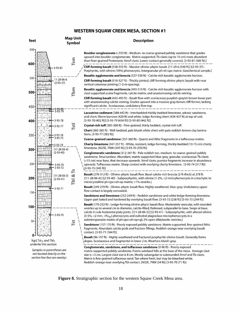
Rock Springs - The Chalk Canyon Formation is well exposed in the eastern Rock Springs area (Figure 7). Pumice-rich tuff, lithic tuff, and tuffaceous sandstone (Tts and Tst) are present between the Bland Quartz Diorite (Xgd) basement and the lowest Chalk Canyon Formation basaltic lava (Tbl). Above the lowest basaltic lavas, three basaltic flows are interbedded with pebbly arkosic sandstones. The lowest two flows have a dark-reddish brown color and are scoriaceous, whereas the upper unit is a bluish-gray, amygdaloidal lava. The section is capped by two bluish-gray basaltic flows (Tbm) that are separated by a 0.5-m-thick scoriaceous sandstone layer. This relationship between gray-weathering basalt over brown-weathering basalt is also observed in other areas (e.g., southern Black Mesa, southern Perry Mesa, etc.). Squaw Creek Mesa - The western Squaw Creek Mesa area contains excellent exposures of the Miocene section (Figure 8). Above the basal tuff, tuffaceous sediment (Tts, Tst) and lowest basaltic lava (Tbl) is a gently west-dipping sequence of variably tuffaceous conglomeratic sandstone (Tst) and olivine-phyric basalt flows (Tbl) interbedded with calcareous pebbly sandstones (Ts). A thin layer of basaltic agglomerate/breccia (Tbp) represents local basaltic pyroclastic activity (Figure 6d). A 40-m-thick interval of interbedded pumice-rich sandstone, coarse-grained arkosic sandstone, limestone, chert, and thin tuff (Tstl) overlies these basalts (Figure 6b). Worm burrows and mudcracks are common in these lacustrine sediments. A variably thin chert layer (Tsl) lies above the Hickey Formation basalt south and southwest of Squaw Creek Mesa, implying that lacustrine conditions persisted after eruption of the Hickey lavas. Orizaba Mine area - A <25-m-thick sequence of pumice-rich sandstone and pebbly lithic sandstone is exposed beneath the hornblende andesite lava and breccia southeast of the Orizaba Mine along Moore Gulch. Imbricated Proterozoic rhyolitic clasts (<15-cm in diameter) in the conglomeratic sandstone yields a S64W paleocurrent direction, suggesting a source area to the east in the New River Mountains. Southern Black Mesa - In the southern Black Mesa section (Figure 9), foliated quartz diorite (Xgd) underlies tuffaceous sandstone (Tst), with interbedded porphyritic olivine basalt (Tbl), conglomeratic sandstone (Ts), and basaltic agglomerate/breccia (Tbp) beneath the Hickey Formation mesa cap (Tbm). Lacustrine deposits (Tstl, Tsl) are not present in this area, so the boundary between the Chalk Canyon and Hickey Formations is not as distinct as in the Squaw Creek Mesa area, where the lacustrine deposits are exposed beneath the Hickey Formation. This area represents a transition between the tuffaceous lacustrine sediments to the south and the fluvial-dominated conglomeratic sandstones to the north. Much of the paleotopography exposed below the Hickey Formation basaltic rocks in the Agua Fria River gorge is also present along the western side of Black Mesa. These fluvial sediments beneath the Hickey Formation thin considerably only a few kilometers to the north of Black Canyon City. Southern Perry Mesa - The southern portion of Perry Mesa area stretches from the Agua Fria River to Squaw Creek, where various granodiorite and tonalite phases (Xgd) are overlain by Miocene lavas and sediments (Tbl, Tbp, Tbm, Tst, Ts, Tsm). Relief on the granodioritic basement in the Agua Fria River gorge to the north is such that Early Miocene sediments are absent and mesa-capping basaltic andesite lavas are in direct contact with Proterozoic basement. Similar relief on the Proterozoic basement surface is present along the southeastern margin of Perry Mesa. Chalk Canyon Formation units are generally poorly exposed along the flanks of Black Mesa and Perry Mesa, as they as covered by surficial deposits (Ql, Qc, Qt, Qct) related to the mass wasting of the mesas. However, basaltic agglomerate/breccia (Tbp) is exposed on either side of the Agua Fria River. Above the basalt tuffaceous conglomerate (Tst), the Early Miocene section is dominated by basaltic lava and thin interbedded conglomeratic sandstone. Williams Mesa and Dutch Butte - In the southwestern part of the map area west of the Agua Fria River, a relatively thick accumulation of Chalk Canyon Formation basalt (Tbl), tuff (Tt, Tts), and sediment (Ts, Tst) is exposed below the multiple basaltic flows of the Hickey Formation (Figure 6a). Variably thick basaltic tuff (Tt, Tst) is exposed in several locations (e.g., Cottonwood Gulch, Williams Mesa, and Boulder Creek; Figure 6e). This tuff commonly contains altered basaltic clasts, suggesting a phreatic or phreatomagmatic eruption. Steeply-dipping basaltic tuff (Tt) and related rocks (Tbp) at Williams Mesa may represent a partially buried/eroded vent. Interbedded tuff (Tt), agglomerate (Tbp), and basalt (Tbl) are also well exposed on the flanks of Dutch Butte. These rocks correlate with ones exposed to the south in the New River quadrangle at Wild Burro Mesa and Dutch Butte.

16
Figure 6. Rocks of the Chalk Canyon Formation. a) Basaltic lavas (Tbl) along Boulder Creek at Williams Mesa. b) Lacustrine deposits (Tstl) overlie basaltic lavas (Tbl) at western Squaw Creek Mesa. c) Photomicrograph of an olivine phenocryst in a cryptocrystalline, plagioclase-rich groundmass (sample 2-93-40; ol = olivine; 4x; plane-polarized light). d) Reddish scoria-rich basaltic agglomerate (Tbp) at northern Squaw Creek Mesa. e) Basaltic tuff (Tt) at northwestern Williams Mesa. f) Typical conglomeratic deposits (Ts) along Little Squaw Creek.
Tbl
A
Tt E
Tbp
D
Ts F
Tbl
Tstl
B
ol
C Tbl

17
Figure 7. Stratigraphic section for the eastern Rock Springs area.
18
Figure 8. Stratigraphic section for the western Squaw Creek Mesa area.

19
Figure 8 (continued). Stratigraphic section for the western Squaw Creek Mesa area.

20
Figure 9. Stratigraphic section for the southern Black Mesa area.

21
Volcanic Petrography - Early Miocene lava (Tbl) in this area is porphyitic olivine basalt is typically holocrystalline to hypocrystalline (0-7% intergranular glass) and is commonly dense (Figure 6c). Where vesicular, amygdaloidal textures are common. Overall textures are porphyritic to subaphyric, with a range of groundmass textures that include cryptocrystalline, microcrystalline, trachytic, and intergranular. The dominant phenocryst assemblages include 2-15% olivine ± clinopyroxene ± plagioclase. Phenocrysts include euhedral to subhedral olivine (2-15%; <4 mm) that is slightly to totally altered to iddingsite, euhedral labradorite laths (0-15%; <5 mm), and subhedral augite (0-10%; <2 mm). Olivine compositions range from Fo50 to Fo85, and plagioclase is mostly andesine to labradorite (An30 to An70). Olivine, augite, and plagioclase microphenocrysts are common. No feldspathoidal minerals (i.e., nepheline) have been observed. The typical groundmass assemblage consists mostly of plagioclase and clinopyroxene, with lesser heavily altered olivine, very fine-grained opaque oxides, and intergranular glass (0-7%). Also present are olivine + plagioclase, clinopyroxene, and plagioclase glomerocrysts (<5 mm). These basalts are typically dense, but may contain up to 5% open to calcite-filled intergranular vesicles. The porphyritic textures could have been produced via single-stage or multistage crystallization histories. Single-stage crystallization with small amounts of undercooling of the alkaline melts would produce relatively few stable nuclei, and subsequent crystal growth would result in a porphyritic texture with relatively few, but large and euhedral phenocrysts. Although a slow rate of cooling and crystallization at depth may result in large crystals, the combination of low nucleation densities and high crystal growth rates may also result in large crystals. Porphyritic textures may also develop from two-stage crystallization involving early slow cooling that produces the phenocrysts, followed by rapid, eruption-induced supercooling that creates the groundmass. Post-eruptive alteration is variably expressed in these rocks. Secondary calcite was deposited from fluids during post-eruption cooling or burial contemporaneous with fluvial-lacustrine sedimentation. Ubiquitous alteration of olivine is represented by the reddish-brown mineraloid iddingsite, which is most common along the outer margins and internal cracks, especially in groundmass grains. Iddingsite may be a product of high-temperature (magmatic) alteration, but is generally thought to form during post-eruption deuteric alteration (Shelley, 1993). Totally altered and replaced olivine typically has rims of opaque oxides with totally corroded and replaced cores. These olivine pseudomorphs commonly display characteristic shapes, with the most recognizable being the section cut parallel to (001). Volcanic Geochemistry - Across the region, medium-K alkaline basalt (e.g., alkali basalt, basanite, and trachybasalt) is the main compositional type of the Chalk Canyon Formation. Lesser amounts of transitional basalt and basaltic andesite are also present. At Squaw Creek Mesa, a nepheline-normative alkali basalt (3-93-84) represents the Chalk Canyon Formation. Although many of alkaline rocks Chalk Canyon Formation in the region are primitive, biotite-bearing lavas that may represent relatively undifferentiated (i.e., primary), mantle-derived compositions (i.e., >10 wt% MgO, mg# > 0.68, >200 ppm Ni, >400 ppm Cr), the Squaw Creek Mesa lava represents a relatively evolved magma, having lower MgO (7.5 wt%), mg# (0.62), Ni (<75 ppm), and Cr (<150 ppm). Like other early Miocene alkaline basalts, the Squaw Creek Mesa alkali basalt is relatively enriched in light-rare-earth elements (LREE) and large-ion-lithophile elements (LILE) and shows a Nb-Ta depletion relative to normalized chondrite. Leighty (1997) used a diverse array of trace element and isotopic data to model the petrogenesis of the Tertiary basalts in the region. The lithospheric mantle beneath the southern Transition Zone, having not experienced significant Laramide crustal thickening or plutonism, preserved optimal melting components for generating the Early Miocene alkaline basalts. These alkaline lavas may represent the initial, subduction-related melting of the lower portions of the lithospheric mantle via small degrees of partial melting of garnet or spinel peridotite with long-term LILE- and LREE- enrichments or by selective melting of LREE-enriched (Nb-Ta “depleted”) mafic veins. The Squaw Creek Mesa alkali basalt specifically may have been generated by the assimiliation and fractional crystallization (2-12% AFC) of average lower crust or mafic gneiss by more primitive alkali basalt parent magma. This parent magma likely originated via <15% partial melting of a spinel (possibly garnet-bearing) lherzolite LILE- and LREE-enriched mantle source between 50-70 km depth.

22
Hickey Formation
General - The large mesas of the Black Canyon City area are capped by multiple basaltic flows of the Hickey Formation (Tbm) and heterolithic boulder conglomerate (Tsm). The Hickey Formation was originally described by Anderson and Creasey (1958) as Middle and Late Miocene (14.6 to 10.1 Ma) basaltic lava flows and associated sedimentary rocks exposed on Hickey Mountain in the Black Hills of the northern Transition Zone. In fact, Middle Miocene basaltic volcanic rocks correlative to the Hickey Formation are exposed over a wide geographic area spanning the Basin and Range and Transition Zone in Arizona (Gomez, 1979; Moyer, 1981; Elston, 1984; Moyer, 1986; Jagiello, 1987a,b; Muehlberger, 1988; Moyer and Esperança, 1989; Bryant and others, 1990; Damon and others, 1996; Leighty, 1997; Leighty, 1998b; Bryant, 1999). Mesa-capping Hickey Formation sequences are composed of multiple sheet flows of dark brownish-gray basalt that typically have a maximum thickness <100 meters (Figure 10a). Columnar jointing is common in this unit (Figure 10b). These rocks are moderately vesicular, with abundant diktytaxitic vesicles and characteristic ellipsoidal vesicles and elongate vesicle cylinders (Figure 10c, d). The lower few meters of each flows are commonly brecciated and scoriaceous. Interbedded agglomerate, breccias, and scoriaceous basalt is common, but not mapped separately. These mesa-capping sheet lavas are relatively homogeneous in texture, mineralogy, and chemistry (Leighty, 1997). Unless the younger Tsm deposits are included, the Hickey Formation in the southern Transition Zone lacks a significant sedimentary component. Interbedded fluvial sediments are typically thin conglomeratic sandstones that are baked reddish near their contacts with overlying lavas. Age - Hickey Formations lavas of Squaw Creek Mesa are dated at 15.40 ±2.10 Ma (date; Eberly and Stanley, 1979). Correlative units in nearby areas have similar dates with better error margins (K-Ar whole-rock analyses of Scarborough and Wilt, 1979), including at Sugarloaf Mountain (14.67 ±0.35 Ma), Skull Mesa (14.81 ±0.79 Ma), and the Carefree Highway Range (15.39 Ma, ±0.79 Ma). Thus, the lavas at Squaw Creek Mesa are likely to be Middle Miocene in age (~15 Ma). Lavas in the Joes Hill area of Perry Mesa to the north are as young as earliest Late Miocene (10.6 Ma; Leighty, 1997).Squaw Creek Mesa and Little Squaw Creek - A thin (30-50 m), slightly west-dipping sequence of basaltic lava is interbedded with lacustrine chert in this area. The basal part of these lavas commonly contains abundant calcite-filled fractures. The concentration of calcite veining varies laterally, but is also seen in the same stratigraphic position in other areas (e.g., southwestern Perry Mesa, Williams Mesa, etc.). Hickey basaltic lavas thin to the southwest, where they also underlie the chert unit (Tsl). Gently west-dipping (<15°) lavas are offset by several small normal faults in the Little Squaw Creek area. New River Mountains - A sequence of basaltic flows is present on the northwestern flank of the New River Mountains (Figure 10e). These lavas erupted from fissure vents in the summit area of Squaw Mountain and flowed downhill to the northwest and west. Correlative basaltic flows are also present on the eastern side of the New River Mountains in the Cooks Mesa area. The lavas are unfaulted in the vicinity of the Moore Gulch shear zone, indicating that this structure experienced no significant post-Hickey movement. The flows become more gently-dipping (~5° NW and W) southeast of Squaw Creek, where they are at the same elevation as the basaltic lavas of the southeastern Perry Mesa area. These lavas probably flowed toward topographic lows, presumably in the Squaw Creek Mesa and Perry Mesa areas, and are likely equivalent to the Hickey Formation basalts in those areas. These flows suggest that the Middle Miocene paleotopography of the area included the high-relief terrain of the New River Mountains and a low-relief depositional basin in the Black Canyon City and Perry Mesa areas. Southern Black Mesa and Perry Mesa – The once-continuous lava sheet of Black Mesa and Perry Mesa has been incised by the Agua Fria River along the northern part of the map area. As stated previously, the Hickey-Chalk Canyon contact is not as distinct in this area. A fairly continuous conglomeratic sandstone (Ts) layer defines the base along much of the Hickey Formation. A basaltic tuff (Tt), well exposed at the Bumblebee I-17 exit north of the map area, is exposed at this stratigraphic level and grades into a more fluvial unit (Tts, Ts) to the south and east. Both the sandstone and tuff are exposed above basaltic rocks that correlate with similar rocks exposed beneath the lacustrine unit at Squaw Creek Mesa.

23
Figure 10. Rocks of the Hickey Formation. a) Multiple basaltic flow units form resistant cliffs along the western edge of Perry Mesa. b) Columnar jointing displayed in the southern Black Mesa area. c) The mesa-capping flows, like at Williams Mesa, are typical brownish-gray basalt with abundant open vesicles. d) Vesicle cylinders are a characteristic feature of the Hickey lavas. e) Basaltic lavas in northern New River Mountains originated from a vent in the Squaw Mountain area. f) Photomicrograph of a partially-altered olivine phenocryst in an intergranular, plagioclase-rich groundmass with diktytaxitic vesicles (sample 2-93-37; ol = olivine, pl = plagioclase, v = open vesicle; 4x; cross-polarized light).
Tbm
A
Tbm
B
Tbm C
Squaw Mountain Tbm flows
E
Tbm D
vesicle cylinders
ol
F Tbm v
pl

24
Williams Mesa – In the southwestern part of the quadrangle at Williams Mesa, a thick accumulation of Chalk Canyon Formation basalt and sediment is capped by multiple Hickey Formation basaltic flows. The rocks below the thin mesa-capping unit may correlate with the sequence exposed to the south at Wild Burro Mesa and Dutch Butte. The mesa-capping flows are probably equivalent to other Hickey Formation basaltic rocks in the area. These mesa-capping flows generally dip to the southeast (~10°) and are at a similar elevation as the Hickey Formation basaltic flows in the Wild Burro Mesa and Squaw Creek Mesa areas. This suggests that these rocks may have been part of the same eruptive sheet that covered the lower areas across the region. Volcanic Petrography - Middle Miocene Hickey Formation basalt is typically porphyritic to intergranular olivine+plagioclase basalt with open vesicles that are commonly entrained into discrete columns (Figure 10f). These lavas are generally holocrystalline, with lesser intersertal textures having small pools of glass occupying the spaces between plagioclase laths, pyroxene, and olivine. Rocks with large amount of glass and features indicating very high cooling rates have not been observed in this study. Overall textures are porphyritic and intergranular. Some of the porphyritic olivine basalts display ophiomottled clinopyroxene + plagioclase textures that are similar to the transitional basalts in older Chalk Canyon Formation lavas. Intergranular groundmass textures are dominantly intergranular, with lesser microcrystalline, ophitic, and trachytic textures locally. Phenocryst assemblages (5-15% phenocrysts) include olivine, olivine + plagioclase, plagioclase + olivine + clinopyroxene, and olivine + clinopyroxene. Labradorite laths (<10%; <2 mm) are abundant. Subhedral olivine (5-10%; <4 mm) ranges from Fo45 to Fo85 in composition, but is typically highly altered to iddingsite with corroded cores. Microphenocrysts of plagioclase and clinopyroxene are present in some rocks. The groundmass assemblage generally consists of euhedral to subhedral labradorite laths (75%), with lesser anhedral intergranular clinopyroxene (10-20%), altered olivine grains (0-10%), and subhedral intergranular opaque oxides (1%). Intergranular glass (0-7%) is brown to red (altered), but is relatively minor in abundance. Glomerocrysts of plagioclase + olivine + clinopyroxene and plagioclase + clinopyroxene are present, but are not highly abundant. Glomerocrysts of sieved plagioclase (<1-2 mm) are also present locally and have mottled cores and massive rims, but no reaction coronas. Xenoliths are very rare, but are generally granitic (quartz and feldspar) with pyroxene reaction coronas. Post-eruptive alteration during cooling or burial is represented by the pervasive alteration of olivine to iddingsite and the presence of secondary intergranular calcite (1-3%). The mesa-capping lavas are generally less altered than the Early Miocene basaltic rocks, probably due to their sheet-like eruption and slightly different depositional environment. Vesicles (5-15%) typically include relatively large (<5 mm), rounded or elongate vesicles, and smaller, irregularly-shaped diktytaxitic voids. Also common in these sheet lavas are discrete, cylindrical trains of vesicles that are a few centimeters in diameter, several meters in length, and generally perpendicular to the cooling surfaces. As with the Early Miocene basalts, the porphyritic overall textures of the Middle Miocene basalts could have been produced via single-stage or multistage crystallization histories of lavas with low nucleation densities. Also common are intergranular textures that form when the principal groundmass minerals grow from many nucleation sites at similar rates, probably in surficial or near-surface conditions. The mafic minerals (olivine, clinopyroxene) occupy the spaces between plagioclase laths, and this gives these rocks their distinctive texture. The distinctive vesicle cylinders form by diapiric rise of less, vesicular lava into more dense, massive lava (Philpotts, 1989). Volcanic Geochemistry - The geochemistry of the Hickey Formation lavas is fundamentally different than the older Chalk Canyon Formation lavas. Hickey Formation rocks in the region are relatively homogeneous medium-K subalkaline compositions that include olivine-subalkali basalt and basaltic andesite (Leighty, 1997). These rocks typically display moderate levels of MgO (5-9 wt%) and mg#s (0.50-0.66), with low to moderate abundances of compatible trace elements (i.e., Ni, Cr), large-ion-lithophile elements (i.e., Ba, Sr, etc.), and high-field-strength elements (i.e., Nb, Ta, Zr, etc.). A possible differentiation trend occurs between the least evolved subalkaline rocks (i.e., the olivine-subalkali basalts), and the more evolved basaltic andesites. The gradational compositional and textural nature between the olivine-subalkali basalts and the overlying basaltic andesites (present farther north) suggests

25
that the two rock units may be genetically related. Sampled Hickey Formation lavas in this report include olivine-subalkali basalt (3-93-8) at southern Black Mesa and transitional basalt (2-93-37) at Squaw Creek Mesa. With its relatively low MgO (5.8 wt%) and mg# (49.4), the Squaw Creek Mesa transitional basalt represents a more evolved composition than the southern Black Mesa ol-subalkali basalt. Both basalts are predictably less-enriched in LILE and LREE compared to the Early Miocene alkaline basalts. Leighty (1997) concluded that most of the subalkaline and transitional basalts in the region are products of variable amounts of assimilation and fractional crystallization of more primitive parent magmas that originated by 20-30% partial melting of a spinel-bearing (25-50 km depth) lithospheric mantle source.
Middle to Late Miocene boulder conglomerate A mesa-capping, heterolithic boulder conglomerate (Tsm) mantles the Hickey Formation basalts and
caps most of Squaw Creek Mesa and the southwest end of Perry Mesa. The base of this unit is matrix-supported, well-stratified, coarse-grained sandstone that grades upward into a very crudely bedded boulder conglomerate dominated by large clasts of Proterozoic rhyolite and Tertiary basalt. Similar rocks are exposed above the Hickey Formation at Williams Mesa, where quartz and Proterozoic monzogranite are the dominant clast compositions. These channel deposits formed during the latter stages of development of the Agua Fria paleobasin as part of an alluvial system that drained the nearby New River and Bradshaw Mountains. Similar boulder conglomerates cap the ridge north of Table Mountain, south of Moore Gulch. These rocks may correlate with Late Miocene basin-fill sediments in the region.
Unassigned Miocene Volcanic and Sedimentary rocks Soap Creek - West of Black Canyon Creek and the Agua Fria River, thin basaltic erosional remnants (Tb) cover variably tuffaceous conglomeratic sediments (Tst). These units likely correlate with similar lithologies in the Early Miocene Chalk Canyon Formation. The basaltic lavas may have originated from vent areas higher in the Bradshaw Mountains to the west and subsequently flowed eastward into the broad Black Canyon City depositional basin where they coalesced with other lavas and sediments.
Tip Top Mine area - Rhyolite and basaltic dikes and flow remnants are present in the vicinity of the Tip Top Mine area of the southern Bradshaw Mountains (Kortemeier, 1984). The northeast-trending rhyolite dikes (6-10 m thick) may be related to the Early Miocene Spring Valley and Garfias Wash rhyolites of the Hieroglyphic Mountains to the south. The olivine + clinopyroxene basaltic dikes (3-5 m wide) and flow remnants are typically altered. The age relations of the basaltic rocks are uncertain, but they are probably Early or Middle Miocene in age. These units were not included on the map.
TERTIARY FAULTS Extensional Miocene tectonism did not significantly affect the Black Canyon City area. As noted previously, little or no pre-Middle Miocene northwest-side-down displacement occurred along the Moore Gulch and North Mountain faults. Another faulted area with limited overall offset is a narrow, north-trending normal fault system that disrupts Early and Middle Miocene strata between Moore Gulch and Squaw Creek Mesa. Although the westerly dip of the strata in this area (5-15°) may largely represent original depositional orientation, some amount may be fault-related rotation. A northeast-trending normal fault is inferred to exist from the projected offset (<100 feet southeast-side-down offset) of Miocene strata on either side of Little Squaw Creek. Very little displacement is seen in the southwestern Squaw Creek Mesa area, but highly altered basaltic lavas and abundant calcite-filled fractures proximal to this fault zone suggest that it may have localized groundwater/hydrothermal fluid activity. A northwest-trending normal fault (<200 feet southwest-side-down offset) cuts Middle Miocene strata at Williams Mesa. This fault may have scissor-like displacement, as roughly 200 feet of offset is observed on the southeast side of the mesa, but only minimal offset on the northwest side. The southwesterly dip of Middle Miocene strata may also be due to paleorelief on the pre-Hickey Formation depositional surface. These syn- to post Hickey Formation faults were formed during the E-W to NE-SW crustal extension of the Basin and Range disturbance (Spencer and others, 1995; Leighty and Reynolds, 1996).

26
QUATERNARY DEPOSITS Surficial deposits in this area can be grouped into either stream or slope deposits. Stream deposits include the channels and terraces related to the major drainages and their tributaries in the area (e.g., the Agua Fria River, Squaw Creek, Little Squaw Creek, Moore Gulch, etc.) whereas slope deposits mantle varying terrain of bedrock surfaces.
Stream Deposits Fluvial sediments include active channels and one or more terrace levels that record former, higher positions of the stream channels (Figure 11a-c). These deposits (Qac, Qat, Qa, etc.) are differentiated from piedmont deposits by their diverse lithologic composition, clast rounding, and landform morphology. River terraces are also commonly elongate landforms that mimic the general trend of the modern rivers. These deposits are mainly related to the development of the New River, Skunk Creek, and Cline Creek drainages. Most Holocene alluvium is restricted to fairly narrow bands along washes.
Slope deposits Colluvium and talus - These piedmont deposits are ubiquitous across the map area, with colluviums (Qc) covering the lower slopes, and colluvium and talus (Qct, Qt) in the higher slopes (Figure 11d, e). These deposits are generally poorly sorted, containing particles that range in size from silt or clay to cobbles or boulders, and grade or interfinger downslope into finer-grained deposits. Some of these deposits may by older Pleistocene in age, but no attempt was made to distinguish between different ages. Landslides - Several landslide deposits (Ql) are exposed in the northern part of the area in proximity to the Agua Fria River (Figure 11f). Similar large landslide deposits are associated with other large Miocene mesa sections in the southern Transition Zone, such as New River Mesa and Skull Mesa (Gomez, 1978). These features represent slope failure where the relatively weak, fine-grained or tuffaceous Chalk Canyon Formation lithologies underlie the Miocene mesa escarpments. The large slide deposits become much less significant farther north along the Agua Fria River gorge with the concomitant thinning of the Chalk Canyon Formation with the rising level of Proterozoic crystalline rocks. Weakening may have occurred by groundwater activity during wetter climatic periods in the Pleistocene. Surficial relief on these deposits is typically hummocky, and may include a series of benches that likely represent separate slide blocks (marked by dashed lines on the map). Internal structure may be preserved where the slide deposits have remained relatively intact, but they may also consist of poorly sorted, chaotic debris. A smaller landslide deposit is located just east of I-17. The location of this slide may have been controlled by the localized absence of the lowest Chalk Canyon Formation basalt, which may help support the section in adjacent areas.
GEOLOGIC HAZARDS The primary geologic hazards that affect this area are flooding various types of mass wasting. Flooding is probably the most serious geologic hazard in the map area. Potential flood hazards mainly consist of inundation and erosion along the Agua Fria River and its larger tributaries, and flash-flooding associated with the smaller tributary streams. The Agua Fria River is a large drainage that heads in the northern Transition Zone near Prescott. Younger channel deposits (Qacy, Qac) are likely to be affected by deep, high-velocity flow during floods, whereas adjacent channel and terrace areas (Qaco, Qaty, Qat) are likely to be subject to shallower inundation and local bank erosion. Flood hazards associated with smaller tributaries (Qac, Qa) may include localized flooding along well-defined drainages, and more widespread inundation in areas of minimal topographic confinement. Rockfall and small landslides are potential hazards on and immediately adjacent to steep slopes. The mass movement of material on steep slopes is typically triggered by intense or prolonged periods of precipitation and is a potential hazard below bedrock cliffs and where bedrock outcrops exist at or near the top of steep mountain hill slopes. The existence of large boulders near the base of a steep slope should be considered evidence of potential rockfall hazard in most cases. Roadcut stability is a serious concern where I-17 traverses the Miocene layers along the western side of Black Mesa.

27
Figure 11. Quaternary surficial deposits. a) Boulder-sized active channel deposits (Qac) in Squaw Creek. b) Sandy active channel deposits (Qac) along the Agua Fria River near the southern boundary of the map. c) Agua Fria River in flood, February 20, 2005. d) Colluvium and talus (Qc, Qt, Qct) are ubiquitous slope deposits. e) Well-cemented colluvium (Qc) overlies Early Miocene sandstone (Ts) at Black Mesa. f) A large landslide area (Ql) on the east flank of Black Mesa.
Qac
A
Qc
Ts
E
C
Qct
D
Ql
F
Qac
B

28
GEOLOGIC HISTORY Since the Early Proterozoic, Arizona has experienced many periods of erosion, sedimentation,
deformation, and magmatism, and has played an important role in the geologic evolution of the southwestern U.S. Cordillera (Dickinson, 1989). The following is a summary of important events relevant to the geologic history of the Black Canyon City and Squaw Creek Mesa quadrangles.
Early Proterozoic 1800 to 1750 Ma / Yavapai Supergroup Volcanism and Sedimentation
• Deep marine volcanic and sedimentary rocks and volcanogenic massive sulfide deposits of the Yavapai Supergroup (Xms, Xmv, Xmvm, Xmvf) were deposited in and around several island-arc eruptive centers proximal to the continental margin (Anderson, 1989b).
1735 to 1720 Ma / Island-arc Plutonism • Numerous subduction-related plutons (Xgd) were emplaced into the island-arc (Anderson and
others, 1971).
1710 to 1700 Ma / Continental-arc Volcanism, Plutonism, and Sedimentation • Voluminous felsic continental arc magmatism (Xg) occurred was coeval with volcanism (Xmvf,
Xga) and clastic sedimentation of the Tonto Basin Supergroup (Conway and Silver, 1989).
1700 to 1690 Ma / Yavapai Orogeny • Northwest-directed crustal shortening, thickening, and uplift, possibly due to addition of
lithospheric fragments (terranes) to the continent generated the northeast-striking subvertical foliation that is the dominant fabric in central Arizona (Karlstrom and Bowring, 1991).
1675 to 1650 Ma / Mazatzal Orogeny • Deformation of the continental margin via northwest-directed foreland thrusting and folding in
central Arizona (Wilson, 1939; Karlstrom and Bowring, 1991).
Middle Proterozoic to Late Mesozoic 1500 to 800 Ma / Continental rifting, sedimentation, and magmatism
• Extensional tectonism, with localized sedimentation and magmatism (Apache Group, diabase; Wrucke, 1989). No rocks or structures of this age exist in the area of this report.
800 to ~75 Ma / Continental and continental margin sedimentation • A passive continental margin subsequently developed along the west coast of North America.
Erosion has removed most sedimentary deposits from the Transition Zone, and none exist in the area of this report. No rocks or structures of this age exist in the area of this report.
Late Mesozoic to Early Tertiary 80 to ~40 Ma / Laramide Orogeny, Eocene Uplift and Erosion
• The crustal thickening occurred during the Laramide Orogeny and led to widespread Eocene uplift and erosion of much of the Laramide volcanic cover (Spencer and Reynolds, 1989). The initial erosion forming Agua Fria Paleobasin may have occurred at this time.
• Southern and central Arizona were a source area (Mogollon Highlands) for Eocene to Oligocene (54-37 Ma) fluvial sediments (ARim@ gravels) that were shed to the northeast onto the Colorado Plateau (Peirce and others, 1979).
• Other Eocene to Oligocene coarse-grained sediment was deposited across much of the region before the initiation of significant Late Oligocene volcanism (Scarborough and Wilt, 1989).
29
Late Oligocene and Early Miocene ~30-16 Ma / Subduction-related Volcanism and Extensional Tectonism
• Voluminous arc-related, ash-flow volcanism (Chiricahua, Superstition-Goldfield, Hieroglyphic, etc.) occurred across the Arizona Basin and Range (Nealey and Sheridan, 1989).
• Localized alkaline volcanism occurred across the Transition Zone, signaling the initial melting of the continental lithosphere in central Arizona, (Esperanca, 1984; Tyner, 1984).
• Large magnitude, ENE-WSW-directed extension resulted from the combination of overthickened crust, high heat flow, and the end of subduction-related compression. Low-angle normal faulting and fault-block rotation occurred as metamorphic core complexes formed across the Arizona Basin and Range (Spencer and Reynolds, 1989). The Transition Zone did not experience significant upper crustal extension during this time, but the reversal of regional drainage and formation of the Mogollon Rim was a likely effect of middle to lower crustal deflation in response to extension in the adjacent Basin and Range (Spencer and Reynolds, 1989).
• Early Miocene basalt (Tbl) of the Chalk Canyon Formation was deposited into the lowland between the Bradshaw and New River Mountains (the Agua Fria Paleobasin; Leighty and Reynolds, 1998). These lavas were interbedded with fluvial sediments (Ts, Tst) and airfall tuff (Tt) from both proximal basaltic eruptions and distal felsic eruptions. These alkaline lavas may represent the initial, subduction-related melting of the lower portions of the lithospheric mantle Leighty, 1997).
Middle and Late Miocene ~16-10 Ma / Basaltic Volcanism and Continued Extensional Tectonism
• Fluvial-lacustrine sediments (Tstl, Tsl, Ts) of the upper Chalk Canyon Formation were deposited in isolated basins across the Basin and Range and Transition Zone.
• Basaltic sheet lavas of the Hickey Formation (Tbm) erupted across the region. In the Agua Fria Paleobasin, these eruptions were coeval with fluvial-lacustrine sedimentation. Subalkaline Hickey volcanism may be attributable to a large thermal pulse related to the passing of the “slab window” beneath this part of the North American lithospheric plate (Atwater, 1970). Relatively hot, convecting asthenosphere caused melting of progressively more shallow and less modified levels of the lithospheric mantle (Leighty, 1997).
• The Basin-and-Range Disturbance involved high-angle normal faulting and graben subsidence in southern Arizona. The central Arizona Transition Zone was largely spared the effects of significant extensional tectonism during this period, with relatively few post-Hickey Formation faults forming in the map area.
Late Miocene and Pliocene ~10-2 Ma / “Basin-fill” Sedimentation
• As regional tectonism waned, pediments formed and basins filled (Eberly and Stanley, 1978). The mesa-capping boulder conglomerate (Tsm) was likely deposited during this time.
Quaternary <2 Ma / Fluvial and colluvial processes
• Fluvial erosion by the south-flowing drainage system formed the modern Agua Fria River gorge.
• Mass wasting of the mesa margins formed landslides (Ql).
• Fluvial and colluvial units (Qac, Qat, Qc, Qct, etc.) deposited across the area.

30
REFERENCES Anderson, C.A., 1967, Precambrian wrench fault in central Arizona: U.S. Geological Survey Professional Paper
575-C, p. C60-C65. Anderson, C.A., 1968, Metamorphosed Precambrian silicic volcanic rocks in central Arizona, in Coats, R.R., and
others, eds., Studies in volcanology; a memoir in honor of Howel Williams: Geological Society of America Memoir 116, p. 9-44.
Anderson, C.A., 1972, Precambrian rocks in the Cordes area, Yavapai County, Arizona: U.S. Geological Survey Bulletin 1345, 36 p.
Anderson, P., 1986, Summary of the Proterozoic plate tectonic evolution of Arizona from 1900 to 1600 Ma, in Beatty, B., and Wilkinson, P.A.K., eds., Frontiers in geology and ore deposits of Arizona and the Southwest: Arizona Geological Society Digest, v. 16, p. 5-11.
Anderson, P., 1986, The Proterozoic tectonic evolution of Arizona: Tucson, University of Arizona, Ph.D. dissertation, 416 p.
Anderson, P., 1989a, Proterozoic plate tectonic evolution of Arizona, in Jenney, J.P., and Reynolds, S.J., eds., Geologic evolution of Arizona: Arizona Geological Society Digest 17, p. 17-55.
Anderson, P., 1989b, Stratigraphic framework, volcanic-plutonic evolution, and vertical deformation of the Proterozoic volcanic belts of central Arizona, in Jenney, J.P., and Reynolds, S.J., eds., Geologic evolution of Arizona: Arizona Geological Society Digest 17, p. 57-147.
Anderson, C.A., and Blacet, P.M., 1972a, Geologic map of the Mayer quadrangle, Yavapai County, Arizona: U.S. Geological Survey Geologic Quadrangle Map GQ-996, 1 sheet, scale 1:62,500.
Anderson, C.A., and Blacet, P.M., 1972b, Geologic map of the Mount Union quadrangle, Yavapai County, Arizona: U.S. Geological Survey Geologic Quadrangle Map GQ-997, 1 sheet, scale 1:62,500.
Anderson, C.A., and Blacet, P.M., 1972c, Precambrian geology of the northern Bradshaw Mountains, Yavapai County, Arizona: U.S. Geological Survey Bulletin 1336, 82 p., 2 sheets, scale 1:24,000.
Anderson, C.A., and Creasey, S.C., 1958, Geology and ore deposits of the Jerome area, Yavapai County, Arizona: U.S. Geological Survey Professional Paper 308, 185 p., 9 sheets, scale 1:24,000.
Anderson, C.A., Blacet, P.M., Silver, L.T., and Stern, T.W., 1971, Revision of Precambrian stratigraphy in the Prescott-Jerome area, Yavapai County, Arizona, Chap. C, in Contributions to stratigraphy: U.S. Geological
Atwater, T., 1970, Implications of plate tectonics for the Cenozoic tectonic evolution of western North America: Geological Society of America Bulletin, v. 81, no. 12, p. 3513-3536.
Bowring, S.A. and Karlstrom, K.E., 1986, U-Pb zircon constraints on Proterozoic tectonic evolution in central Arizona: Geological Society of America, Abstracts with Programs, v. 18, n. 5, p. 343.
Bryant, B., 1994, Preliminary geologic map of the New River quadrangle, Maricopa and Yavapai Counties, Arizona: U. S. Geological Survey Open-File Report 94-153, scale 1:24,000.
Bryant, B., 1999, Geologic Map of the New River quadrangle and part of the Daisy Mountain quadrangle, Maricopa and Yavapai Counties, Arizona: Arizona Geological Survey Contributed Map 99-C, 1 sheet, scale 1:24,000.
Burr, J.L., 1991, Proterozoic stratigraphy and structural geology of the Hieroglyphic Mountains, central Arizona, in Karlstrom, K.E., ed., Proterozoic geology and ore deposits of Arizona: Arizona Geological Society Digest, v. 19, p. 117-133.
Capps, R.C., Reynolds, S.J., Kortemeier, C.P., and Scott, E.A., 1986, Geologic map of the northeastern Hieroglyphic Mountains, central Arizona: Arizona Bureau of Geology and Mineral Technology Open-File Report 86-10, 16 p., 1sheet, scale 1:24,000.
Chayes, F., 1966, Alkaline and subalkaline basalts: Amer. Journal of Science, v. 264, p. 128-145. Condie, K.C., 1986, Geochemistry and tectonic setting of early Proterozoic supracrustal rocks in the southwestern
United States: Journal of Geology, v. 94, p. 845-864. Conway, C.M., 1976, Petrology, structure, and evolution of a Precambrian volcanic and plutonic complex, Tonto
Basin, Gila County, Arizona: Pasadena, California Institute of Technology, Ph.D. dissertation, 460 p. [abstract in Dissertation Abstracts, v. 37, no. 7, p. 3309B-3310B].

31
Conway, C.M., and Silver, L.T., 1989, Early Proterozoic rocks (1710-1615 Ma) in central to southeastern Arizona, in Jenney, J.P., and Reynolds, S.J., eds., Geologic evolution of Arizona: Arizona Geological Society Digest 17, p. 165-186.
Conway, C.M., Karlstrom, K.E., Silver, L.T., and Wrucke, C.T., 1987, Tectonic and magmatic contrasts across a two-province Proterozoic boundary in central Arizona, in Davis, G.H., and VandenDolder, E.M., eds., Geologic diversity of Arizona and its margins: Excursions to choice areas; Field-trip guidebook, 100th Annual Meeting, The Geological Society of America, Phoenix, Arizona, October 26-29, 1987: Arizona Bureau of Geology and Mineral Technology Special Paper 5, p. 158-175.
Damon, P.E., Shafiqullah, M., Harris, R.C., and Spencer, J.E., 1996, Compilation of unpublished Arizona K-Ar dates from the University of Arizona laboratory of isotope geochemistry, 1971-1991, Arizona Geological Survey, Open-File Report 96-18, 56 p.
Darrach, M.E., 1988, A kinematic and geometric structural analysis of an early proerozoic crustal-scale shear zone: The evolution of the Shylock fault zone, central Arizona, Northern Arizona University, Flagstaff, Arizona, M.S. thesis, 81 p.
Darrach, M.E., Karlstrom, K.E., Argenbright, D.N., and Williams, M.L., 1991, Progressive deformation in the Early Proterozoic Shylock shear zone, central Arizona, in Karlstrom, K.E., ed., Proterozoic geology and ore deposits of Arizona: Arizona Geological Society Digest, v. 19, p. 97-116.
DeWitt, E., 1976a, Precambrian geology and ore deposits of the Mayer-Crown King area, Yavapai County, Arizona: Tucson, University of Arizona, M.S. thesis, 150 p.
DeWitt, E., 1976b, Geologic map of the Mayer-Crown King area, Yavapai County, Arizona, and metamorphic and chemical data map, Mayer-Crown King area, Yavapai County, Arizona: Arizona Bureau of Geology and Mineral Technology Miscellaneous Map MM-76-B, 2 sheets, scale 1:24,000.
DeWitt, E., 1989, Geochemistry and tectonic polarity of Early Proterozoic (1700-1750-Ma) plutonic rocks, north-central Arizona, in Jenney, J.P., and Reynolds, S.J., eds., Geologic evolution of Arizona: Arizona Geological Society Digest 17, p. 149-163.
DeWitt, E., 1991, Road Log and Geologic Maps for Arizona Geological Society Field Trip, Spring 1991, in Karlstrom, K.E., ed., Proterozoic geology and ore deposits of Arizona: Arizona Geological Society Digest, v. 19, p. 309-332.
Dickinson, W.R., 1989, Tectonic setting of Arizona through geologic time, in Jenney, J.P., and Reynolds, S.J., eds., Geologic evolution of Arizona: Arizona Geological Society Digest 17, p. 1-16.
Doorn, P.L., and Péwé, T.L., 1991, Geologic and gravimetric investigations of the Carefree Basin, Maricopa County, Arizona: Arizona Geological Survey Special Paper 8, 187 p., 10 plates, scale 1:24,000.
Eberly, L.B, and Stanley, T.B, Jr., 1978, Cenozoic stratigraphy and geologic history of southwestern Arizona: Geological Society of America Bulletin, v. 89, no. 6, p. 921-940.
Elston, D.P., 1984, Rocks, landforms, and landscape development in central Arizona, in Smiley, T., Nations, J., Pewe, T., and Schafer, J.P eds., Landscapes of Arizona - The geological story: Lanham, Md., University Press of America, p. 151-173.
Esperanca, S., 1984, An experimental and geochemical study of the high-K latites and associated nodules from Camp Creek, Arizona: Tempe, Arizona State University, Ph.D. dissertation, 204 p.
Esperança , S., and Holloway, J.R., 1986, The origin of the high-K latites from Camp Creek, Arizona; constraints from experiments with variable fO2 and aH2O: Contributions to Mineralogy and Petrology, v. 93, p. 504-512.
Ferguson, C.A., Gilbert, W.G., and Leighty, R.S., 1998, Geologic map of the New River Mesa Quadrangle, Maricopa County, Arizona: Arizona Geological Survey Open-File Report 98-12, 3 sheets, 1:24,000, and text.
Gomez, E., 1978, Geology of the south-central part of the New River Mesa Quadrangle, Cave Creek area, Maricopa County, Arizona: Flagstaff, Northern Arizona University, M.S. thesis, 144 p., map, scale 1:12,000.
Gomez, E., 1979, Geology of part of the south-central New River Mesa quadrangle, Cave Creek area, Maricopa County, Arizona: U.S. Geological Survey Open-File Report 79-1312, 156 p., map, scale 1:12,000.
Gomez, E., and Elston, D.P., 1978, Oligocene and Miocene development of the mountain-desert region boundary, Cave Creek, Arizona [abs.]: Geological Society of America Abstracts with Programs, v. 10. no. 3, p. 107.

32
Harris, R.C., Leighty, R.S., Scarborough, R., and Spencer, J.E., 1998, Uranium levels and radon potential in selected areas north of Phoenix, in the St. Johns area, and north of Tuba City, Arizona: Arizona Geological Survey Open-File Report 98-10, 13 p.
Jaggar, T.A., and Palache, C., 1905, Description of the Bradshaw Mountains quadrangle, Arizona: U.S. Geological Survey Atlas, Folio 126, 11p.
Jagiello, K.J., 1987a, Structural evolution of the Phoenix basin, Arizona: Tempe, Arizona State University, M.S. thesis, 156 p.
Jagiello, K.J., 1987b, Bedrock geology from New River Mesa to the northern Phoenix basin, Arizona: Arizona Bureau of Geology and Mineral Technology Miscellaneous Map MM-87-D, 1 sheet, scale 1:24,000.
Jerome, S.E., 1956, Reconnaissance geologic study of the Black Canyon schist belt, Bradshaw Mountains, Yavapai and Maricopa Counties, Arizona: Salt Lake City, University of Utah, Ph.D. dissertation, 145 p.
Karlstrom, K.E., and Bowring, S.A., 1988, Early Proterozoic assembly of tectonostratigraphic terranes in southwestern North America: Journal of Geology, v. 96, no. 5, p. 561-576.
Karlstrom, K.E., and Bowring, S.A., 1991, Styles and timing of Early Proterozoic deformation in Arizona: Constraints on tectonic models, in Karlstrom, K.E., ed., Proterozoic geology and ore deposits of Arizona: Arizona Geological Society Digest, v. 19, p. 1-10.
Karlstrom, K.E., and Bowring, S.A., 1993, Proterozoic orogenic history in Arizona, in Van Schmus, W.R., Bickford, M.E., Anderson, J.L., Bender, E.E., Anderson, R.R., Bauer, P.W., Robertson, J.M., Bowring, S.A., Condie, K.C., Denison, R.E., Gilbert, M.C., Grambling, J.A., Mawer, C.K., Shearer, C.K., Hinze, W.J., Karlstrom, K.E., Kisvarsanyi, E.B., Lidiak, E.G., Reed, J.C., Jr., Sims, P.K., Tweto, O., Silver, L.T., Treves, S.B., Williams, M.L., Wooden, J.L., Transcontinental Proterozoic provinces, in Reed, J.C., Jr., Bickford, M.E., Houston, R.S., Link, P.K., Rankin, D.W., Sims, P.K., and Van Schmus, W.R., eds., Precambrian: Conterminous U.S.: Boulder, Colorado, Geological Society of America, The Geology of North America, v. C-2. p.
Karlstrom, K.E., and Conway, C.M., 1986, Deformational styles and contrasting lithostratigraphic sequences within an Early Proterozoic orogenic belt, central Arizona, in Nations, J.D., Conway, C.M., and Swann, G.A., eds., Geology of central and northern Arizona, Geological Society of America, Rocky Mountain Section Meeting, Flagstaff, Ariz., 1986, Field Trip Guidebook: Flagstaff, Northern Arizona University, Geology Dept., p. 1-25.
Karlstrom, K.E., Bowring, S.A., and Conway, C.M., 1987, Tectonic significance of an Early Proterozoic two-province boundary in central Arizona: Geological Society of America Bulletin, v. 99, no. 4, p. 529-538.
Kortemeier, C.P., 1984, Geology of the Tip Top district, Yavapai County, Arizona: Tempe, Arizona State University, M.S. thesis, 137 p.
Kortemeier, C.P., Jorgensen, M., and Sheridan, M.F., 1986, Volcanic geology of the Castle Hot Springs area, in Beatty, B., and Wilkinson, P.A.K., eds., Frontiers in geology and ore deposits of Arizona and the Southwest: Arizona Geological Society Digest, v. 16, p. 473-477.
Krieger, M.H., 1965, Geology of the Prescott and Paulden quadrangles: U.S. Geological Survey Professional Paper 467, 127 p., 5 sheets, scales 1:48,000 and 1:96,000.
Le Bas, M.J., R.W. Le Maitre, A Streckeisen and B. Zanettin, 1986, A chemical classification of volcanic rocks based on the total alkali-silica diagram. Journal of Petrology, v. 27, p. 745-750.
Leighty, R.S., 1997, Evolution of tectonism and magmatism across the Basin and Range-Colorado Plateau boundary, central Arizona: Tempe, Arizona State University, unpublished Ph.D. dissertation, 1019 p.
Leighty, R.S., 1998a, Compilation Geologic map of the Daisy Mountain 7.5-minute quadrangle, Maricopa County, Arizona: Arizona Geological Survey Open-File Report 98-22, 30 p., 1 sheet, scale 1:24,000.
Leighty, R. S., 1998b, Tertiary volcanism, sedimentation, and extensional tectonism across the Basin and Range - Colorado Plateau boundary in central Arizona: in Duebendorfer, E.M., ed., Geologic Excursions in Northern and Central Arizona, Geological Society of America, Rocky Mountain section field trip guidebook, p. 59-95.
Leighty, R.S., and Glascock, M.D., 1994, A Middle Miocene Magmatic Transition in central Arizona [abs.]: Geological Society of America Abstracts with Programs, v. 26, no. 7, p. A354.
Leighty, R.S. and Reynolds, S.J., 1996, Dynamics of Neogene faulting across the Colorado Plateau-Basin and Range boundary in central Arizona [abs.]: Geological Society of America Abstracts with Programs, v. 28, no. 7, p. A451.

33
Leighty, R. S. and Reynolds, S. J., 1998, Cenozoic Evolution of the Agua Fria Paleobasin: Geological Society of America Rocky Mountain Section Abstracts with Programs.
Leighty, R.S., Reynolds, S.J., Farmer, G. L., and Glascock, M.D., 1995, Early Miocene mafic magmatism in central Arizona [abs.]: American Geophysical Union Abstracts with Programs, v. 76, no. 46, p. F656.
Lindgren, W., 1926, Ore Deposits of the Jerome and Bradshaw Mountains quadrangles, Arizona: U.S. Geological Survey Bulletin 782, 192 p.
Lindsay, E.H., and Lundin, R.F., 1972, An Oligocene oreodont (Mammalia artiodaciylia) from central Arizona: Journal of Paleontology, v. 46, p.115-119.
Maynard, S.R., 1986, Precambrian geology and mineralization of the southwestern part of the New River Mountains, Maricopa and Yavapai Counties, Arizona: Albuquerque, University of New Mexico, M.S. thesis, 155 p.
Maynard, S.R., 1989, Geologic map and cross-sections of the southwestern part of the New River Mountains, Arizona: Arizona Geological Survey Contributed Map CM-89-E, 2 sheets, scale 1:12,000.
McKee, E.H., and Anderson, C.A., 1971, Age and chemistry of Tertiary volcanic rocks in north-central Arizona and relation of the rocks to the Colorado Plateaus: Geological Society of America Bulletin, v. 82, no. 10, p. 2767-2782.
Middlemost, E.A.K., 1989, Iron oxidation ratios, norms and the classification of volcanic rocks, Chem. Geol., v. 77, p. 19-26.
Moyer, T.C., 1981, The volcanic geology of the Kaiser Spring area, SE Mohave County, Arizona: Tempe, Arizona State University, M.S. thesis, 220 p.
Moyer, T.C., 1986, The Pliocene Kaiser Spring (AZ) bimodal volcanic field - geology, geochemistry, and petrogenesis: Tempe, Arizona State University, Ph.D. dissertation, 318 p.
Moyer, T.C., and Esperanca, S., 1989, Geochemical and isotopic variations in a bimodal magma system: The Kaiser Spring Volcanic Field, Arizona: Journal of Geophysical Research, v. 94, no. B6, p. 7841-7859.
Muehlberger, E.W., 1988, The structure and general stratigraphy of the western half of the Payson Basin, Gila County, Arizona: M.S. thesis, Northern Arizona University, Flagstaff, Arizona, 86 p.
Nealey, L.D., and Sheridan, M.F., 1989, Post-Laramide volcanic rocks of Arizona and northern Sonora, Mexico, and their inclusions, in Jenney, J.P., and Reynolds, S.J., eds., Geologic evolution of Arizona: Arizona Geological Society Digest, v. 17, p. 609-647O'Hara, P.F., 1980, Metamorphic and structural geology of the northern Bradshaw Mountains, Yavapai County, Arizona: Tempe, Arizona State University, Ph.D. dissertation, 117 p.
Peirce, H.W., Damon, P.E., and Shafiqullah, M., 1979, An Oligocene(?) Colorado Plateau edge in Arizona: Tectonophysics, v. 61, no. 1, p. 1-24.
Philpotts, A.R., 1989, Petrography of Igneous and Metamorphic Rocks: Prentice-Hall, Inc., 178 p. Reynolds, S.J., and DeWitt, E., 1991, Proterozoic geology of the Phoenix region, central Arizona, in Karlstrom,
K.E., ed., Proterozoic geology and ore deposits of Arizona: Arizona Geological Society Digest 19, p. 237-250. Richard, S., Reynolds, S., Spencer, J., and Pearthree, P. (compilers), 2000, Geologic Map of Arizona: Arizona
Geological Survey Map M-35, 1 sheet, scale 1:1,000,000. Satkin, R.L., 1981, A geothermal resource evaluation at Castle Hot Spring, Arizona: Tempe, Arizona State
University, M.S. thesis, 147 p., 3 sheets. Scarborough, R.B., and Wilt, J.C., 1979, A study of uranium favorability of Cenozoic sedimentary rocks, Basin and
Range province, Arizona - Part I - General geology and chronology of pre-late Miocene Cenozoic sedimentary rocks: Arizona Bureau of Geology and Mineral Technology Open-File Report 79-01, 101 p.
Shafiqullah, M., Damon, P.E., Lynch, D.J., Reynolds, S.J., Rehrig, W.A., and Raymond, R.H., 1980, K-Ar geochronology and geologic history of southwestern Arizona and adjacent areas, in Jenney, J.P., and Stone, Claudia, eds., Studies in western Arizona: Arizona Geological Society Digest, v. 12, p. 201-260.
Shelley, D., 1993, Igneous and Metamorphic rocks under the microscope: Classification, textures, microstructures and mineral preferred-orientations: Chapman & Hall, 181 p.
Spencer, J.E., and Reynolds, S.J., 1989, Middle Tertiary tectonics of Arizona and adjacent areas, in Jenney, J.P., and Reynolds, S.J., eds., Geologic evolution of Arizona: Arizona Geological Society Digest, v. 17, p. 539-574.

34
Spencer, J.E., Richard, S.M., Reynolds, S.J., Miller, R.J., Shafiqullah, M., Gilbert, W.G., and Grubensky, M.J., 1995, Spatial and temporal relationships between mid-Tertiary magmatism and extension in southwestern Arizona: Journal of Geophysical Research, v. 100, p. 10321-10351.
St. Clair, C.S., 1957, Geologic Reconnaissance of the Agua Fria River area, central Arizona: Unpub. M.S. thesis, University of Arizona, 76 p.
Tyner, G.N., 1984, Geology and petrogenesis of the Sullivan Buttes latite, Yavapai County, Arizona: Field and geochemical evidence: Austin, University of Texas, Ph.D. dissertation, 248 p.
Vance, R.K., 1986, Geochemistry and tectonic setting of the Yavapai Supergroup, west central Arizona: [Ph.D. thesis], New Mexico Institute of Mining and Technology.
Ward, M.B., 1977, The volcanic geology of the Castle Hot Springs area, Yavapai County, Arizona: Tempe, Arizona State University, M.S. thesis, 74 p., 1 sheet, scale 1:48,000.
Wilkinson, J.F.G., 1986, Classification and average chemical compositions of common basalts and andesites. Journal of Petrology, v. 27, p. 31-62.
Williams, M., 1991, Overview of Proterozoic metamorphism in Arizona, in Karlstrom, K.E., ed., Proterozoic geology and ore deposits of Arizona: Arizona Geological Society Digest, v. 19, p. 11-26.
Wilson, E.D., 1939, Pre-Cambrian Mazatzal revolution in central Arizona: Geological Society of America Bulletin, v. 50, no. 7, p. 1113-1163.
Wilson, E., Moore, R., and Peirce, W., 1957, Geologic Map of Maricopa County, Arizona: Arizona Bureau of Mines, 1 sheet, scale 1:375,000.
Wilson, E., Moore, R., and Peirce, W., 1958, Geologic Map of Yavapai County, Arizona: Arizona Bureau of Mines, 1 sheet, scale 1:375,000.
Winn, P.S., 1982, Structure and petrology of Precambrian rocks in the Black Canyon area, Yavapai County, Arizona: Salt Lake City, University of Utah, M.S. thesis, 101 p.
Wrucke, C.T., 1989, The Middle Proterozoic Apache Group, Troy Quartzite, and associated diabase of Arizona, in Jenney, J.P., and Reynolds, S.J., eds., Geologic evolution of Arizona: Arizona Geological Society Digest, v. 17, p. 239-258.

35
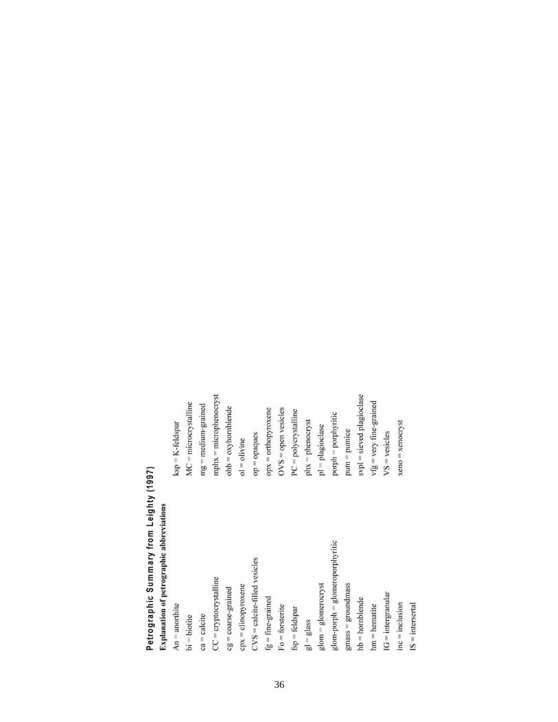
36
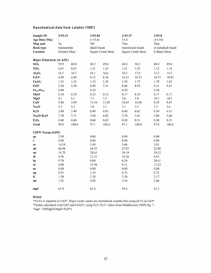
37
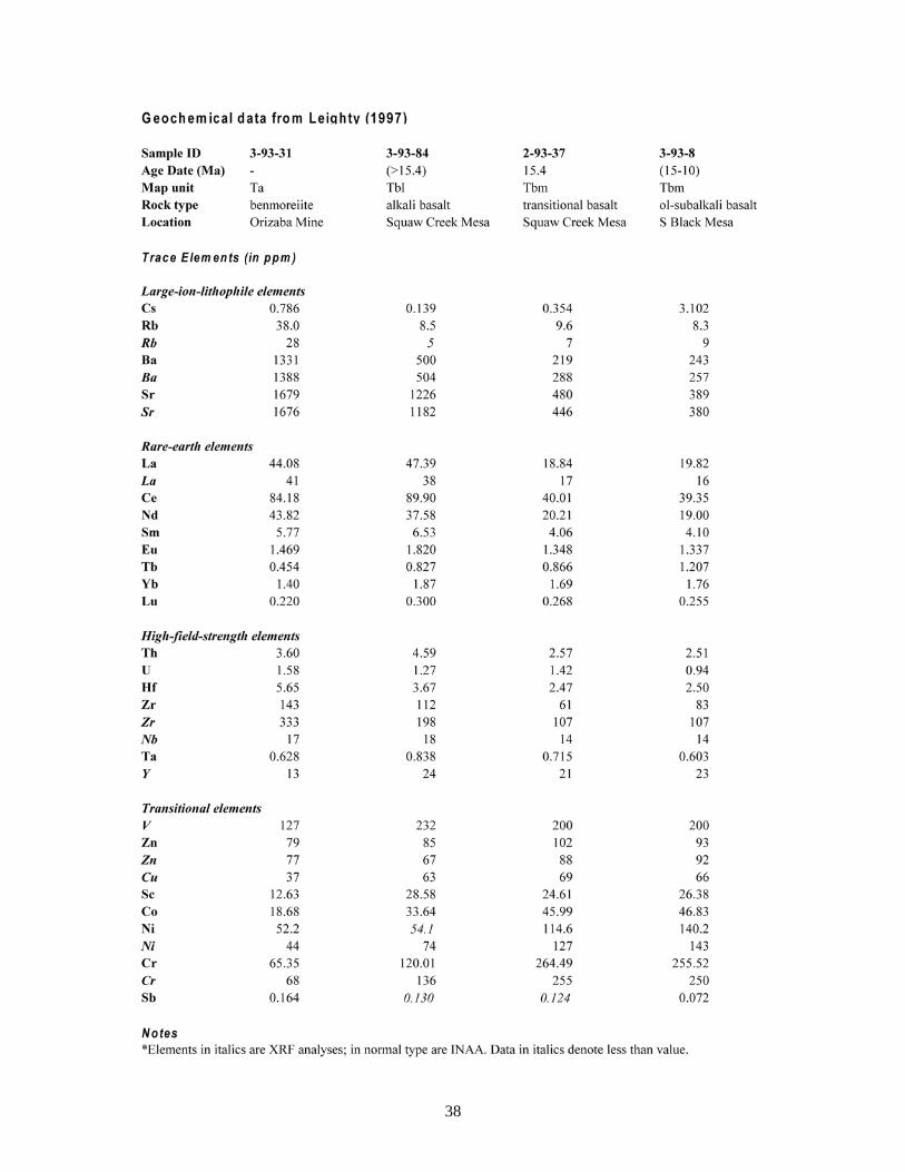
38

39
GEOCHEMICAL METHODOLOGY AND NOMENCLATURE OF LEIGHTY (1997) The basaltic rocks in Leighty (1997) are classified according to field observation, petrography, or where available, chemical composition. The chemical classifications are based on the recommendations made by the I.U.G.S. Subcommission on the Systematics of Igneous Rocks (Le Bas and others, 1986) and utilize major element and normative mineral data to derive a nongenetic chemical classification. The basis for this descriptive classification scheme is the total alkali (Na2O+K2O) vs. SiO2 (TAS) grid and certain normative mineral abundances derived from major element analyses. This chemical classification is also consistent with the QAPF modal classification (Streckeisen, 1976a, 1980). All geochemical samples require adjusting the Fe2O3/FeO ratio before being normalized volatile-free to 100%. CIPW norms were calculated with FeO' and Fe2O3' using standardized Fe2O3/FeO ratio values (Middlemost, 1989). The oxidation state of Fe has an important effect on the abundance of normative minerals and also affects the degree of silica saturation. To overcome this problem, samples from different TAS groups are standardized to the Fe2O3/FeO ratio values given by Middlemost (1989), including basalts (0.20), trachybasalts and basaltic andesites (0.30), basaltic trachyandesites (0.35), etc. Normative minerals (e.g., ne, ol, di, qz) are used in Leighty (1997) to supplement the TAS classification, but are not as heavily relied upon as in certain classification schemes (i.e., Wilkinson, 1986) due to the inherent problems in the standardization of norms calculated by numerous independent sources. The alkaline and subalkaline basaltic rocks are simply defined in this study by the presence or absence, respectively, of normative nepheline. The term alkali basalt specifically refers to ne-normative rocks that plot in the basalt field of the TAS diagram, whereas the term alkaline basalt includes several TAS classifications, including alkali basalt, basanite, trachybasalt (hawaiite, potassic trachybasalt), and basaltic trachyandesite (mugearite, shoshonite). Furthermore, the term trachybasalt has several connotations: in a petrographic sense it refers to biotite-bearing basalts, but in the I.U.G.S. chemical classification (the preferred usage) it refers to the field that includes hawaiites ({Na2O-2}<K2O) and potassic trachybasalts ({Na2O-2}>K2O). Subalkaline rocks include subalkali basalts and basaltic andesites. Since the subalkali basalts are not subdivided in the I.U.G.S. classification of Le Bas and others (1986), and important differences exist among these rocks in the Neogene volcanic suite, slight modifications were made to the TAS classification scheme. The subalkali basalts are subdivided into transitional basalts, olivine-subalkali basalts, and qz-subalkali basalts based on certain normative mineral abundances (di, hy, ol, and qz). If a basalt is quartz normative, it is a quartz-subalkali basalt. If the rock is neither quartz nor nepheline normative, then Chayes discriminant (D*), a binary linear + quadratic discriminant function based on the empirical distribution of normative ol-di-hy in subalkaline rock types (Chayes, 1966), is applied to determine whether the rock is transitional basalt (di>>hy) or a subalkali basalt (dihy); the prefix olivine- or quartz- is added to such rocks for clarification (i.e., olivine-subalkali basalt).

40
MAP UNITS Quaternary Stream Deposits Qacy (Holocene) - Younger alluvial channel deposits Qaco (Holocene) - Older alluvial channel deposits Qac (Holocene) - Alluvial channel deposits, undivided Qaty (Holocene) - Younger alluvial terrace deposits Qato (Late Pleistocene to Holocene) - Older alluvial terrace deposits Qat (Late Pleistocene to Recent) - Alluvial terrace deposits, undivided Qa (Late Pleistocene to Recent) - Alluvium, undivided Qg (Pleistocene) - Stream gravel QTg (Late Tertiary and Quaternary) - Older stream gravel
Quaternary Slope Deposits Qt (Holocene) - Talus Qc (Quaternary) - Colluvium Qct (Quaternary) - Colluvium and talus, undivided Ql (Quaternary) - Landslide deposits and colluvium
Middle and Late Tertiary Sedimentary and Volcanic Rocks Tsm (Middle Miocene to Late Miocene) - Mesa-capping boulder conglomerate Tsl (Late Early Miocene to Middle Miocene) - Lacustrine sedimentary deposits Tbm (Late Early Miocene to Middle Miocene) - Basaltic volcanic rocks (Hickey Formation) Tstl (Late Early Miocene to Middle Miocene) - Tuffaceous fluvial-lacustrine deposits and minor tuff Tb (Early Miocene to Middle Miocene) - Basaltic volcanic rocks, undivided Tt (Early Miocene to Middle Miocene) - Tuff Tts (Early Miocene to Middle Miocene) - Tuff and tuffaceous sandstone Tbp (Early Miocene to Middle Miocene) - Basaltic pyroclastic deposits Tbl (Early Miocene) - Basaltic volcanic rocks (Chalk Canyon Formation) Tst (Early Miocene) - Conglomerate, sandstone, tuffaceous sandstone, and tuff Ta (Miocene) - Andesitic volcanic rocks Ts (Late Oligocene to Miocene) - Sedimentary rocks, undivided
Precambrian Igneous and Metamorphic Rocks Xg (Early Proterozoic) - Granitic rocks Xga (Early Proterozoic) - Aplitic granite and hypabyssal rhyolite Xgp (Early Proterozoic) - Granitic pegmatite Xgd (Early Proterozoic) - Tonalite, granodiorite, and diorite Xmvm (Early Proterozoic) - Mafic to intermediate metavolcanic rocks Xmvf (Early Proterozoic) - Felsic to intermediate metavolcanic rocks Xmv (Early Proterozoic) - Metavolcanic rocks, undivided Xms (Early Proterozoic) - Metasedimentary rocks, undivided Xm (Early Proterozoic) - Metamorphic rocks, undivided

41
DESCRIPTION OF MAP UNITS
Quaternary Stream Deposits Qac Alluvial channel deposits (Holocene) - Deposits in the active channels of the Agua Fria River
and its principal tributaries (Black Canyon Creek, Squaw Creek, Little Squaw Creek, and Moore Gulch). Subrounded to well-rounded gravel-sized clasts range in size up to boulders with main channel alluvium typically being coarser that tributary alluvium. Lithologies vary, but largely consist of Tertiary basaltic rock and Early Proterozoic intrusive rocks. Channels patterns are often braided or anastomosing. Largely Holocene in age, and is locally differentiated into younger (Qacy) and older (Qaco) units.
Qat Alluvial terrace deposits (Late Pleistocene to Recent) - Low terrace deposits best developed along the Agua Fria River and Black Canyon Creek and consist of unconsolidated, moderately to poorly sorted, subrounded to rounded sand- and gravel-sized clasts in a sandy to silty matrix. Moderate soil clay and carbonate accumulation locally developed. Low terraces also may include minor channels. Largely Holocene in age, with the lowest terraces linked to the active channel deposits (Qac). The higher terraces are associated with older channels of Pleistocene age. Locally differentiated into younger (Qaty) and older (Qato) units.
Qa Alluvium, undivided (Late Pleistocene to Recent) - Unconsolidated, poorly sorted sand, gravel and boulder deposits confined to the modern tributary drainages.
Qg Stream gravel (Pleistocene) - Alluvial gravel remnants present well above modern drainage channels. Best exposed in the southern part of the map area along the lower portions of Moore Gulch and Little Squaw Creek. May be the younger equivalent to the QTg deposits.
QTg Older Stream Gravel (Late Tertiary to Quaternary) - Remnants of several terrace levels related to the development of the Agua Fria River and its major tributary drainages. Exposed as high as 50 meters above modern channels. Dominated by subrounded to rounded clasts of Tertiary basalt and diverse Proterozoic igneous and metamorphic rocks. An excellent exposure is present between Little Squaw Creek and Moore Gulch on I-17S.
Quaternary Slope Deposits Qt Talus (Holocene) - Unconsolidated scree deposits covering steep slopes beneath large mesas and
cliffs. Clast lithologies are variable and depend on the composition of the local bedrock. Variable caliche cementation. Mostly Late Pleistocene to Holocene in age.
Qc Colluvium (Quaternary) - Unconsolidated to moderately consolidated colluvial deposits on hillslopes. Typically fairly coarse, subangular to angular, very poorly sorted, weakly bedded, steeply sloping deposits. Clast lithologies are variable and depend on the composition of the local bedrock. Caliche cementation is variable. Mostly Late Pleistocene to Holocene in age.
Qct Colluvium and talus, undivided (Quaternary) - Undifferentiated, unconsolidated to moderately consolidated colluvium and talus on steeper slopes. Typically weakly bedded, subangular to angular, poorly sorted sand and gravel. Clast lithologies are locally variable and depend on the local bedrock. Variable caliche cementation. Foot travel across steeper slopes can be slow and difficult. Grades into colluvial deposits downslope. Includes small slump deposits.
Ql Landslide deposits and colluvium (Quaternary) - These deposits are present beneath the larger mesa scarps, and include mostly Miocene volcanic and sedimentary strata. Larger landslides possess a hummocky surface that has greater relief than colluvial surfaces. Linear surface topography may be related to slide block boundaries. Internal stratigraphy is very poorly exposed and ranges from chaotic to relatively intact. A variably thick veneer of colluvium typically covers significant portions of these deposits. Large landslide deposits are common along the Agua Fria

42
River on the margins of Perry Mesa and Black Mesa. The location of these deposits is largely controlled by the presence of relatively weak layers of the Chalk Canyon formation beneath the overlying basalt-dominated section. In the Joes Hill Quadrangle farther north along the Agua Fria River, large landslide deposits are less common as the basalt-dominated Hickey Formation section directly overlies crystalline basement. These deposits are less common along Squaw Creek for the same reason. A small, well-defined landslide is present at the southern end of Black Mesa and is highly visible from I-17N. Several large tension gashes are present in the Miocene basaltic and sedimentary layers near the head of this feature. The location of this slide may largely be due to the absence of the underlying Tbl basalt flow.
Middle and Late Tertiary Sedimentary and Volcanic Rocks Tsm Mesa-capping boulder conglomerate (Middle to Late Miocene) - Mesa-capping conglomerate
and sandstone best exposed above the Hickey Formation basalts in the Squaw Creek Mesa and southern Perry Mesa areas. Typically weathers to gentle slopes and is poorly exposed. The lower contact is generally covered. Variably stratified, matrix-supported, moderately to poorly sorted pebbly sandstone to boulder conglomerate. Dominantly subrounded to rounded clasts of Tertiary basalt and diverse Proterozoic igneous and metamorphic rocks. Clast compositions and relative abundances suggest a source in the New River Mountains and beyond to the east. This unit may represent an ancestral Squaw Creek braided stream or alluvial fan system developed on the eastern flank of the New River Mountains. This unit is probably equivalent to the Tsy “basin-fill” units exposed across the region, including in the Daisy Mountain quadrangle to the south (Leighty, 1998), and the TQs and Tcy units in the New River Mesa and Humboldt Mountain quadrangles to the southeast (Ferguson and others 1998; Gilbert and others, 1998).
Tsl Lacustrine deposits (Early Middle Miocene) - White chert, marl, carbonate, and sandstone deposits. Forms a thin (<10 m) and discontinuous, but distinctive layer above the Hickey Formation basalt in the buttes south and west of Squaw Creek Mesa. This highly resistant butte-capping unit is a very fine-grained, massive to well-bedded chert. This unit thickens to the south of Moore Gulch where sandstone and carbonate rocks are more abundant. This unit everywhere includes abundant primary sedimentary structures (mudcracks). Probably related to similar lithologies exposed in the Tstl unit beneath the Hickey Formation. This unit was likely deposited in a lake near the center of the paleobasin. Age is likely Middle Miocene, as it overlies Hickey Formation basalt (Tbm) and is overlain by the boulder conglomerate (Tsm).
Tbm Basaltic volcanic rocks, Hickey Formation (Middle Miocene) - Basaltic sheet lava flows and related rocks correlative to the Middle Miocene Hickey Formation. This unit represents the multiple basaltic flows of an extensive lava sheet (generally <100 m thick) that overlies the Chalk Canyon Formation sequence across the region. This unit caps the southern portion Black Mesa and Perry Mesa, Squaw Creek Mesa and the smaller buttes to southwest of Squaw Creek Mesa, Williams Mesa, and Dutch Butte. The basaltic lava flows exposed on the northwestern flank of the New River Mountains are likely erosional remnants of the Hickey Formation flows of Squaw Creek Mesa and Perry Mesa. Individual flow units are separated by autoclastic breccia zones, reddish-orange conglomeratic sediment, and soil horizons (typically <10-m-thick). Scoria and basalt-related volcanic breccia and agglomerate are locally abundant. The lower part of this unit typically weathers to dark grayish brown to bluish gray to gray cliffs and slopes. These lavas are variably altered, fractured, and typically dense, and are locally amygdaloidal. Across the area, the lower 10 meters of this unit includes a prominent zone of calcite veining. Lavas in the upper part of this unit are dark brown, variably desert-varnished, cliffs. Vesicle cylinders are common in these uppermost flows, with open vesicles (<2 cm in diameter) and variably rimmed with calcite. Columnar jointing is locally well-developed in the upper members. Petrographically, the lower Tbm lavas are dominantly porphyritic, with prominent olivine phenocrysts in a fine-grained groundmass, whereas the upper flows are characteristically intergranular to porphyritic in overall

43
texture, with clinopyroxene and altered olivine phenocrysts in a framework of plagioclase laths. Olivine phenocrysts are typically altered to reddish orange iddingsite. These lavas are transitional to subalkaline in chemistry and were likely produced by the same Middle Miocene eruptive event that formed other sheet lavas across Transition Zone and Basin and Range (Leighty, 1997). Eruptive styles ranged from fissure-fed flows Hawaiian to Plains-style shield volcanism. The Hickey Formation lavas of Squaw Creek Mesa are dated at 15.4 ±2.1 Ma (Eberly and Stanley, 1978). Other correlative units across the region are consistently 14-16 Ma (Middle Miocene) in age, so in the Black Canyon City area this unit is likely Middle Miocene in age. This unit is also referred to as the New River Mesa Basalt (Gomez, 1978; Jagiello, 1987; Bryant, 1999).
Tstl Tuffaceous fluvial-lacustrine deposits and minor tuff (Late Early Miocene to Middle Miocene) - Distinctive white to light tan, compositionally diverse fluvial-lacustrine layer of the upper member of the Chalk Canyon Formation. This unit overlies a sequence of basaltic flows (Tbl) and is exposed beneath the Hickey Formation basalt (Tbm) in the southern and western Squaw Creek Mesa area. Includes tuffaceous sandstone, limestone, dolomitic to cherty limestone, chert, and nonwelded tuff, and minor conglomerate. The lower half of the unit is dominantly pale reddish-tan matrix-supported conglomeratic sandstone that is generally structureless, with quartz, basalt, and pumice clasts in a tuffaceous matrix. Lacustrine compositions dominate the upper part of the unit. Thickly bedded limestone forms ledges and contains worm burrows and mudcracks. Well-bedded, bluish white chert with pale reddish-brown clay laminations forms thin (<1 m-thick), but highly resistant ledges. Thin (<1 m-thick) layers of nonwelded tuff weather to small slopes. A similar depositional environment also existed for the lacustrine unit (Tsl) above the Hickey Formation basalt, possibly suggesting no major disconformity between units in this area. Excellent exposures of this unit are present to the south of the map area (Leighty, 1997). This unit is equivalent to the Tsl unit of Leighty (1998) in the Daisy Mountain quadrangle, the Tl unit of Bryant (1999) in the New River quadrangle, and the host of units representing the fluvial-lacustrine upper member of the Chalk Canyon Formation (Gomez, 1978; Jagiello, 1987; Doorn and Péwé, 1991; Leighty, 1997; Ferguson and others, 1998; Gilbert and others, 1998).
Tb Basaltic rocks, undivided (Early to Middle Miocene) - Basaltic lavas, correlative with either the Early Miocene Chalk Canyon Formation or the Middle to Late Miocene Hickey Formation. The basaltic flows locally contain minor scoria, basalt-related breccia, and volcanic sandstone. West of Black Canyon Creek and the Agua Fria River, thin erosional remnants of basaltic rocks cover sediments of variable thickness. The basaltic lavas may have originated from vent areas higher in the Bradshaw Mountains to the west and subsequently flowed eastward into the broad Black Canyon City depositional basin where they coalesced with other lavas and sediments.
Tt Tuff (Early to Middle Miocene) - Variably indurated, pumice- and lithic-rich tuff. Tuff typically crumbles easily and is poorly exposed, but is locally well indurated and forms cliffs. Pumice-rich tuff ranges from white to light tan, clast-supported, beds to creamy tan, structureless, pumice-rich layers to more fine-grained, massive to laminated tuff. Lithic tuff includes reddish orange to gray basaltic clasts and is typically well bedded. Basalt clasts are locally altered to a light-colored clay-rich mineral (goethite, limonite, etc.), possibly indicating the involvement of water during eruption. Pumice-rich tuff is most abundant in the lower part of the Chalk Canyon Formation, whereas lithic tuff can be found throughout the Miocene section. Tuff interbedded with Hickey Formation lavas is generally dominated by lithic (basaltic) clasts (e.g., a <5-meter-thick basaltic tuff is exposed near the base of the Hickey Formation lavas along the southern and western portion of Black Mesa). Tuff layers commonly contain both pumice and lithic fragments. Tuff layers too thin to discriminate on the map are included in several other units (Tst, Tstl, Ts). Tuff exposures are located across the map area, including in the Williams Mesa area, between Little Squaw Creek and Moore Gulch, in the Rock Springs area, along Squaw Creek, etc. These tuffs were deposited by airfall, but from different sources: the pumice-rich tuff from a felsic source (more distant, Hieroglyphic Mountains?), whereas the basaltic tuff is more local in origin.

44
Tts Tuff and tuffaceous sandstone (Early to Middle Miocene) - Pumice- and lithic-rich tuff locally interbedded with tuffaceous sandstone. The tuffaceous sandstone is generally fine- to medium-grained, moderately well sorted, with subangular to subrounded lithic and pumice fragments. Many of these sandstone beds may represent reworked lithic tuff. Small channels of lithic sandstone are locally exposed (e.g., along I-17S near Rock Springs). Commonly grades upward and laterally into the Tst unit. Equivalent to the Ttc unit of Bryant (1999) and Tts unit of Leighty (1998) in the Daisy Mountain quadrangle to the south.
Tbp Basaltic pyroclastic deposits (Early to Middle Miocene) - Brownish-red basaltic agglomerate, basaltic breccias, and scoriaceous basalt that can locally be mapped separately from the other basaltic volcanic units. Clasts commonly welded together, but calcite and silica can be abundant locally. Exposures are located across the map area, and include the southwestern end of Perry Mesa and southern Black Mesa area, the northern end of Dutch Butte, Williams Mesa, etc. This unit likely represents localized Strombolian activity during the early phase of Hickey Formation eruptions.
Tbl Basaltic volcanic rocks, Chalk Canyon Formation (Early Miocene) - A sequence of basaltic lavas and related rocks are interbedded with the fluvial-lacustrine sediments and felsic tuff to form the Chalk Canyon Formation (Gomez, 1978; Jagiello, 1987; Leighty, 1997; Ferguson et. al., 1998; Gilbert et. al., 1998; Leighty, 1998). Where not highly altered, fractured, and amygdaloidal, these lavas are typically dense to platy-jointed. Basaltic rocks are typically moderately to highly altered. Individual flows may be separated by reddish-orange conglomeratic sediment, and soil horizons (<5 m thick). Textures are dominantly porphyritic with microcrystalline groundmass. The dominant phenocryst assemblage is olivine + clinopyroxene, and no feldspathoidal minerals (i.e., nepheline) have been observed. These basaltic lavas are largely alkaline to transitional in composition. These flows likely erupted as Hawaiian-type fissure-fed flows. Early flows were contemporaneous with the deposition of airfall tuff and fluvial sediments, and flowed into topographic low areas of the Black Canyon City depositional basin. Younger Tbl flows erupted into a more fluvial-lacustrine environment of a more mature depositional basin.
Tst Conglomerate, sandstone, tuffaceous sandstone, and tuff (Early Miocene) - Massive to moderately well-bedded conglomerate and conglomeratic sandstone with variable amounts of volcaniclastic sediment, and nonwelded tuff. This compositionally diverse unit is interbedded with or underlies the basaltic lavas (Tbl, Tbm, Tb) of the Chalk Canyon Formation and Hickey Formation. The tuffaceous component is greatest in the stratigraphically lowest part of the unit whereas light brown, heterolithic (quartz, granodiorite, etc.) pebbly sandstone is more abundant at stratigraphically higher levels. Gradational with the Tts and Ts units.
Ta Andesitic volcanic rocks (Miocene) - A 100-m-high conical andesitic plug and short northwest-dipping flow are present on the western flank of the New River Mountains, near North Mountain (<1 km southeast of the Orizaba Mine along Moore Gulch). The plug includes a thick dike that extends to the southwest. The central conduit, along with the secondary SW-trending fissure, produced lavas that flowed downhill to the northwest. A small erosional remnant is exposed on the northwest side of Moore Gulch (~100 m lower in elevation). This porphyritic hornblende andesite is classified as a benmoreiite (3-93-34). Euhedral hornblende phenocrysts (20-25%, <4 mm) are highly altered and replaced by Fe-Ti oxides. The microtrachytic groundmass is composed of fine-grained plagioclase, hornblende, clinopyroxene, and opaque oxides. Glomerocrysts of hornblende + clinopyroxene and clinopyroxene are also present. This rock is dense and not vesicular. This unit may correlate with other intermediate to felsic volcanic rocks across the central and southern Transition Zone (Leighty, 1997). The southernmost andesite exposure is a flow remnant (<15-m-thick) with a basal autoclastic breccia (15 to 20-m-thick) that overlies a thin sequence of Chalk Canyon Formation tuffaceous conglomerate. The andesite is undated, but is no older than the Chalk Canyon Formation (<21 Ma).

45
Ts Sedimentary rocks, undivided (Early to Middle Miocene) - Conglomerate, conglomeratic sandstone, tuffaceous sandstone, and sedimentary breccia, with minor tuff and limestone. Commonly underlies or is interbedded with the Miocene basaltic lavas, although some isolated exposures lack definitive stratigraphic correlation. Thin (<5 m-thick) Ts layers are commonly interbedded with the Miocene basaltic units (Tbl, Tbm, and Tb) and can serve as useful stratigraphic markers. Exposures are typically light tan, but can be orange to brick red in color due to alteration within a few meters of overlying lavas. Dominantly crudely bedded and matrix-supported, with clast compositions varying from exclusively Precambrian crystalline rock to all Miocene basaltic rock. The stratigraphically lowest members overlie Precambrian basement and are typically composed solely of pale orange Precambrian-clast sedimentary breccia or conglomerate. The matrix typically consists of sand- to silt-sized grains of quartz, lithic fragments, mica, and calcite. Bedding and cross bedding are better developed where finer grained. Where coarse-grained, clast imbrications yield paleocurrent information. Thin (<1 m) tuff and limestone beds are present locally. This unit likely represents braided stream deposition across an area of variable relief. Ts units in the map area are largely Early to Middle Miocene in age, but the age of the stratigraphically lowest members may be as old as Late Oligocene.
Precambrian Igneous and Metamorphic Rocks Xg Granitic rocks (Early Proterozoic) - The Crazy Basin monzogranite pluton (1699 Ma) forms
the rugged terrain west of the Shylock fault zone in the Bradshaw Mountains. These rocks are exposed across of the western third of the Black Canyon City quadrangle. This peraluminous, two-mica monzogranite is largely equigranular in texture, with phenocrysts of microcline, oligoclase, muscovite, and biotite. Although late syn-kinematic, the monzogranite is largely undeformed. The eastern contact with the rocks of the Big Bug Group is sharp in places, but can also be somewhat arbitrary due to swarms of granitic and pegmatite dikes. Several fine- to medium-grained leucogranite bodies intrude the Ash Creek Group metavolcanic sequence between Moore Gulch and Little Squaw Creek. These intrusives have no counterparts in the terrane to the west.
Xga Aplitic granite and hypabyssal rhyolite (Early Proterozoic) - An equigranular, fine-grained granitic rock in the southeastern part of the map area. Gradational contact with the felsic volcanic rocks to the northwest. The aplitic granitic rocks in turn grade into more coarse-grained granitic rocks outside the map area.
Xgp Granitic pegmatite (Early Proterozoic) - Pegmatites have compositions similar to the main Crazy Basin monzogranite batholith, but are more coarse-grained with abundant muscovite, almandine, black tourmaline, and less biotite.
Xgd Tonalite, granodioritic, and dioritic rocks (Early Proterozoic) - Weakly to moderately foliated with phenocrysts of whitish, altered feldspar, quartz, and hornblende that are commonly altered to epidote, clinozoisite, sericite, and clay. 10-20% quartz is typically present. Forms much of the relatively low relief basement between the Shylock and Moore Gulch fault zones in the Black Canyon City and Squaw Creek Mesa areas. The quartz diorite of Bland (1720 Ma) is exposed from Moore Gulch northward into the Black Canyon City area. It intrudes metamorphic rocks northwest of Moore Gulch. The Badger Spring and Bumblebee granodiorites and various granodiorite and tonalite phases of the Cherry Springs batholith (1740 Ma) underlie the Tertiary rocks in the Black Mesa and Perry Mesa areas farther northEquivalent to the Bland Quartz Diorite (bqd) unit of Jerome (1956), the quartz diorite (qd) unit of Maynard (1986), and the quartz diorite of Bland (1.72 Ga Xbl) unit of DeWitt (1991).
Xmvm Mafic to intermediate metavolcanic rocks (Early Proterozoic) - Metavolcanic rocks of the ~1755 Ma Big Bug Group and Ash Creek Group that range in composition from largely andesite to dacite with lesser basalt to primarily felsic volcanic rocks. Light to dark grayish green andesite

46
and dacite flows and tuff include minor interbedded metasedimentary rocks. Where recognizable, these rocks are featureless to porphyritic in texture, with feldspar and hornblende phenocrysts mostly altered to sericite, chlorite, and epidote. Penetrative deformation has typically obscured primary features, but pillows, vesicles, amygdules, and flow breccias are found locally (Jerome, 1956). Exposed in a north-trending zone west of the Agua Fria River and also northwest of Moore Gulch. Equivalent to the ya unit of Jerome (1956) and Xb unit of DeWitt (1991).
Xmvf Felsic to intermediate metavolcanic rocks, undivided (Early Proterozoic) - Massive to highly foliated felsic (rhyolite to dacite) lavas and tuff. Where porphyritic, this rock contains fine- to medium-grained phenocrysts of feldspar, quartz, and biotite or dark gray magnetite in a fine-grained groundmass. These rocks typically exhibit a wide range of colors, including white, tan, black, etc. Alteration along fractures is common, and reddish iron-staining is prominent in the light-colored rocks. These rocks are relatively undeformed, but are moderately to highly foliated where adjacent to the Moore Gulch fault zone. Primary flow textures are locally exposed, including flattened pumice fragments. This unit forms much of the high New River Mountains east of the Moore Gulch Fault and correlates with the Red Rock Group (~1700 Ma). On the east flank of the Bradshaw Mountains, rocks of this unit correlates with the older Big Bug Group (~1755 Ma) and form a north-trending belt west of the Agua Fria River. Equivalent to the rhyolitic and dacitic units (nri, nt, nlt, ndf) of Maynard (1986) and Xr unit of DeWitt (1991).
Xmv Metavolcanic rocks, undivided (Early Proterozoic) - Undivided mafic to felsic metavolcanic rocks with lesser phyllite, quartzite, and quartz veins. Exposed between Little Squaw Creek and Moore Gulch. On the east flank of the Bradshaw Mountains, this unit forms a north-trending belt west of the Agua Fria River.
Xms Metasedimentary rocks, undivided (Early Proterozoic) - Pelitic to psammitic phyllite and schist, with a minor metavolcanic component that have been correlated with ~1755 Ma Big Bug Group and Ash Creek Group. This unit is exposed west of the Moore Gulch fault along Moore Gulch and on the east flank of the Bradshaw Mountains west of the Agua Fria River. These rocks are lithologically variable and include a wide range of compositional assemblages (staurolite, muscovite+tourmaline, biotite+almandine, and hornblende+quartz, etc.) that are dependant on protolith bulk composition. These minerals are largely altered to sericite and chlorite. Within the contact aureole of the Crazy Basin Monzogranite batholith, coarse-grained staurolite schist becomes more fine-grained to the east, away from the batholith. In the southwest part of the map area, this unit is overlain by Tertiary rocks at Boulder Creek, but is likely correlative to similar lithologies in the Hieroglyphic Mountains (Burr, 1991). Equivalent to the metasedimentary units (mp) of Maynard (1986) and the Xs unit of DeWitt (1991).