Geologic History of Central Pennsylvania - … History of Central Pennsylvania Introduction by...
23
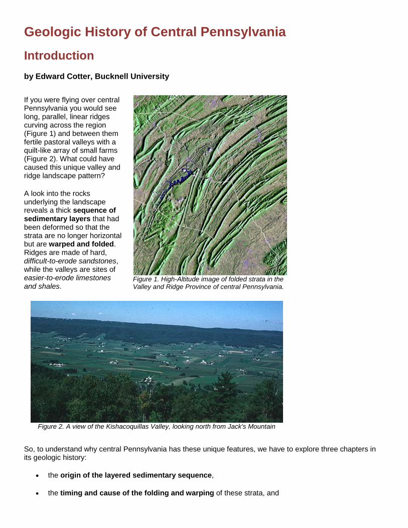
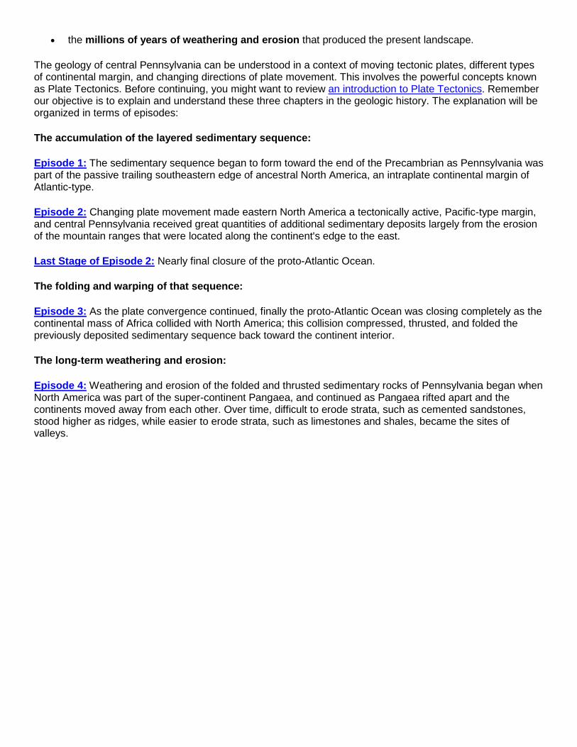
Geologic History of Central Pennsylvania Introduction by Edward Cotter, Bucknell University If you were flying over central Pennsylvania you would see long, parallel, linear ridges curving across the region (Figure 1) and between them fertile pastoral valleys with a quilt-like array of small farms (Figure 2). What could have caused this unique valley and ridge landscape pattern? A look into the rocks underlying the landscape reveals a thick sequence of sedimentary layers that had been deformed so that the strata are no longer horizontal but are warped and folded. Ridges are made of hard, difficult-to-erode sandstones, while the valleys are sites of easier-to-erode limestones and shales. Figure 1. High-Altitude image of folded strata in the Valley and Ridge Province of central Pennsylvania. Figure 2. A view of the Kishacoquillas Valley, looking north from Jack's Mountain So, to understand why central Pennsylvania has these unique features, we have to explore three chapters in its geologic history: • the origin of the layered sedimentary sequence, • the timing and cause of the folding and warping of these strata, and
Transcript of Geologic History of Central Pennsylvania - … History of Central Pennsylvania Introduction by...
Geologic History of Central Pennsylvania
Introduction by Edward Cotter, Bucknell University
If you were flying over central Pennsylvania you would see long, parallel, linear ridges curving across the region (Figure 1) and between them fertile pastoral valleys with a quilt-like array of small farms (Figure 2). What could have caused this unique valley and ridge landscape pattern?
A look into the rocks underlying the landscape reveals a thick sequence of sedimentary layers that had been deformed so that the strata are no longer horizontal but are warped and folded. Ridges are made of hard, difficult-to-erode sandstones, while the valleys are sites of easier-to-erode limestones and shales.
Figure 1. High-Altitude image of folded strata in the Valley and Ridge Province of central Pennsylvania.
Figure 2. A view of the Kishacoquillas Valley, looking north from Jack's Mountain
So, to understand why central Pennsylvania has these unique features, we have to explore three chapters in its geologic history:
• the origin of the layered sedimentary sequence,
• the timing and cause of the folding and warping of these strata, and
• the millions of years of weathering and erosion that produced the present landscape.
The geology of central Pennsylvania can be understood in a context of moving tectonic plates, different types of continental margin, and changing directions of plate movement. This involves the powerful concepts known as Plate Tectonics. Before continuing, you might want to review an introduction to Plate Tectonics. Remember our objective is to explain and understand these three chapters in the geologic history. The explanation will be organized in terms of episodes:
The accumulation of the layered sedimentary sequence:
Episode 1: The sedimentary sequence began to form toward the end of the Precambrian as Pennsylvania was part of the passive trailing southeastern edge of ancestral North America, an intraplate continental margin of Atlantic-type.
Episode 2: Changing plate movement made eastern North America a tectonically active, Pacific-type margin, and central Pennsylvania received great quantities of additional sedimentary deposits largely from the erosion of the mountain ranges that were located along the continent's edge to the east.
Last Stage of Episode 2: Nearly final closure of the proto-Atlantic Ocean.
The folding and warping of that sequence:
Episode 3: As the plate convergence continued, finally the proto-Atlantic Ocean was closing completely as the continental mass of Africa collided with North America; this collision compressed, thrusted, and folded the previously deposited sedimentary sequence back toward the continent interior.
The long-term weathering and erosion:
Episode 4: Weathering and erosion of the folded and thrusted sedimentary rocks of Pennsylvania began when North America was part of the super-continent Pangaea, and continued as Pangaea rifted apart and the continents moved away from each other. Over time, difficult to erode strata, such as cemented sandstones, stood higher as ridges, while easier to erode strata, such as limestones and shales, became the sites of valleys.

Plate Tectonics Before we begin...
An Introduction to Plate Tectonics
Earth history is easier to understand once you have two important forms of large-scale thinking. The first of these is to think in terms of geologic time, measured in millions and billions of years.
While time of this magnitude is difficult for humans to comprehend, without it one cannot grasp how our globe has come to have its present characteristics. With the availability of immense amounts of time, the history of the Earth can be seen to result from the operation of normal forces and processes seen to be operating today.
Even small, incremental changes, such as the few feet of movement that accompanied the recent earthquake in Turkey, can have major consequences if there is sufficient time.
THE GEOLOGIC TIME SCALE
Eon Era Period Epoch
Lower Age Boundary (millions of years ago)
Phanerozoic
Cenozoic
Quaternary Recent Pleistocene 1.6
Tertiary
Pliocene Miocene 23.7
Oligocene Eocene Paleocene
66
Mesozoic
Cretaceous 144
Jurassic 208
Triassic 245
Paleozoic
Permian 286
Carbon- iferous
Pennsylvanian 320
Mississippian 360
Devonian 408
Silurian 438
Ordovician 505
Cambrian 545
Precambrian
Late
Middle
Early +4500
It also helps to be able to think about Earth forces operating on a global scale; this is summed up by the theory called Plate Tectonics. An informative review of this theory can be found at the United States Geological Survey site called This Dynamic Earth. The essence of this theory is that heat from radioactivity causes the Earth's interior to flow slowly, resulting in the lateral (sideways) movement of thin rock slabs (called plates) over the Earth's surface. While once considered revolutionary, plate tectonics theory is now so solidly supported by evidence of many kinds that it is second nature for geologists to explain local histories in terms of such things as the collision of two plates or the movement of a continent from one climate zone to another. How fast do plates move? About 2 to 5 centimeters per year (1 to 2 inches per year), about the same speed that your fingernails grow.
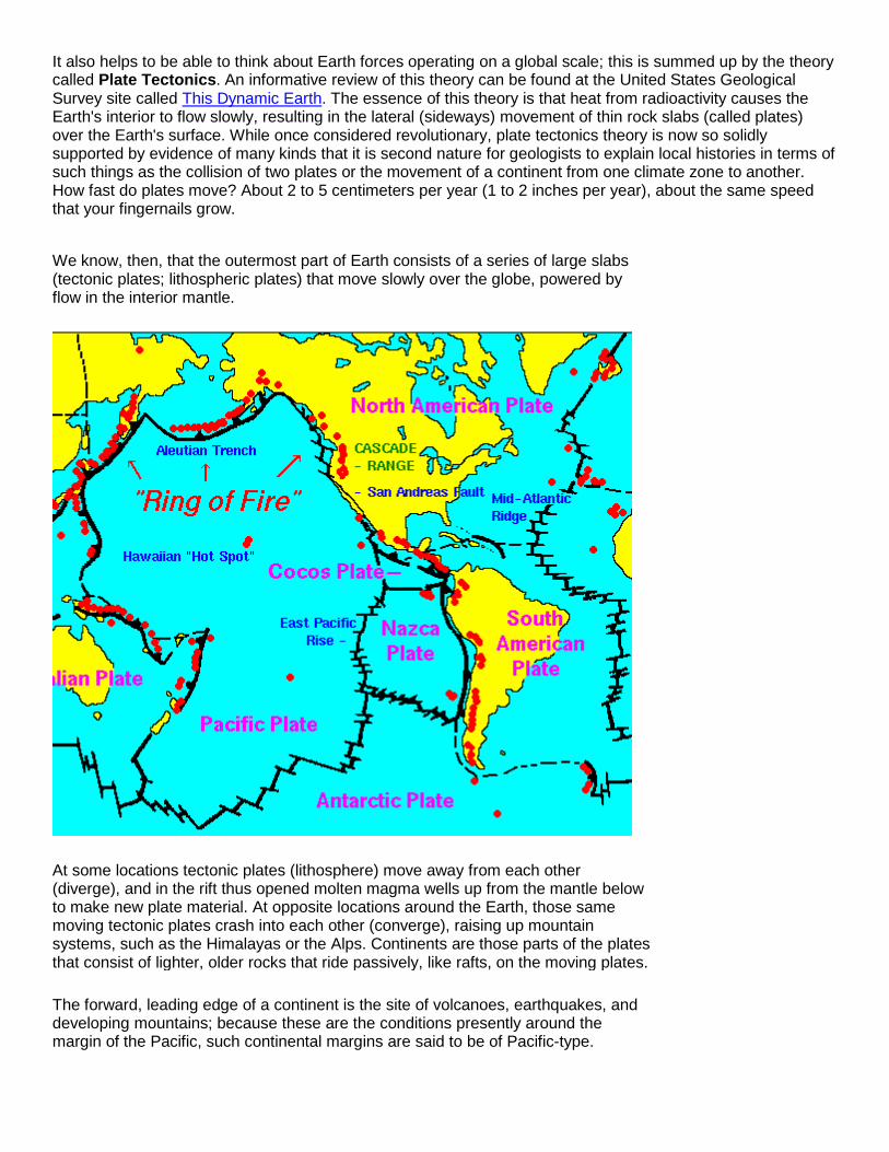
We know, then, that the outermost part of Earth consists of a series of large slabs (tectonic plates; lithospheric plates) that move slowly over the globe, powered by flow in the interior mantle.
At some locations tectonic plates (lithosphere) move away from each other (diverge), and in the rift thus opened molten magma wells up from the mantle below to make new plate material. At opposite locations around the Earth, those same moving tectonic plates crash into each other (converge), raising up mountain systems, such as the Himalayas or the Alps. Continents are those parts of the plates that consist of lighter, older rocks that ride passively, like rafts, on the moving plates.
The forward, leading edge of a continent is the site of volcanoes, earthquakes, and developing mountains; because these are the conditions presently around the margin of the Pacific, such continental margins are said to be of Pacific-type.
The trailing edge of a continent lies within a plate, so it has no volcanoes, earthquakes, or young mountains and typically looks like a low-relief, gentle coastal plain where thick sequences of sedimentary rock accumulate over millions of years. As these are the conditions on those parts of the present continents flanking the Atlantic Ocean, they are said to be Atlantic-type continental margins. At the present time, the basic pattern of plate movement is away from the center of the Atlantic Ocean, and toward the Pacific Ocean.
You can see these two types of continental margin on the global relief map of Earth (below). Around the margin of the Pacific Ocean, where plates are converging, the continents are mountainous, and the region has many volcanoes and earthquakes. Those parts of continents bordering the Atlantic Ocean, on the other hand, are much flatter, with little happening other than the deposition of sediment. The Atlantic Ocean basin is progressively widening, while the Pacific Ocean Basin is becoming smaller as the tectonic plates move over it.
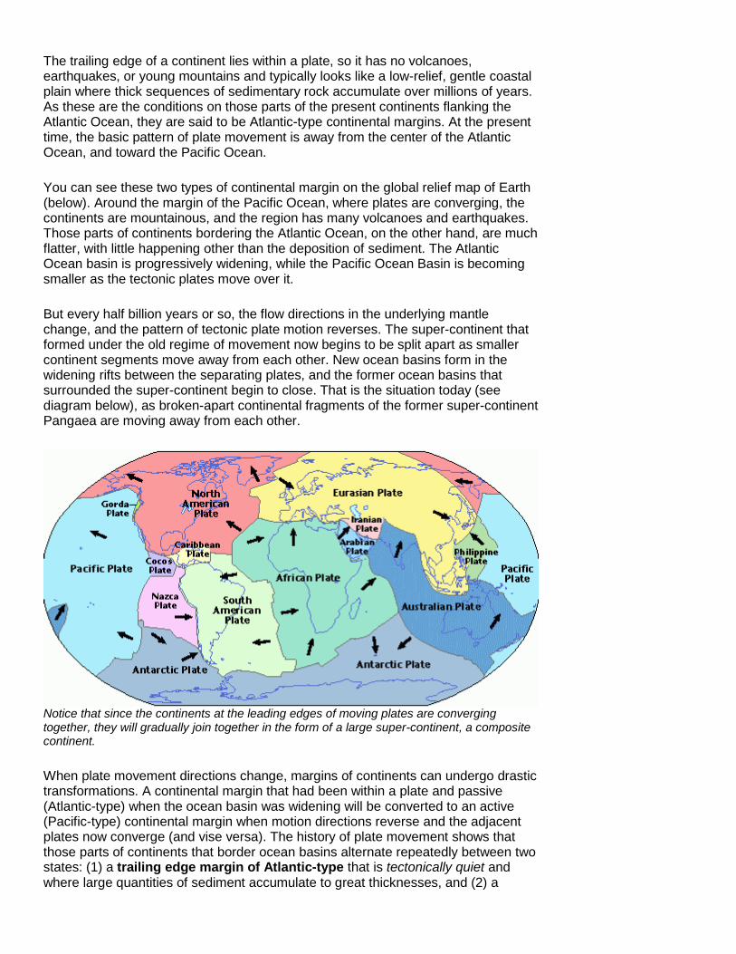
But every half billion years or so, the flow directions in the underlying mantle change, and the pattern of tectonic plate motion reverses. The super-continent that formed under the old regime of movement now begins to be split apart as smaller continent segments move away from each other. New ocean basins form in the widening rifts between the separating plates, and the former ocean basins that surrounded the super-continent begin to close. That is the situation today (see diagram below), as broken-apart continental fragments of the former super-continent Pangaea are moving away from each other.
Notice that since the continents at the leading edges of moving plates are converging together, they will gradually join together in the form of a large super-continent, a composite continent.
When plate movement directions change, margins of continents can undergo drastic transformations. A continental margin that had been within a plate and passive (Atlantic-type) when the ocean basin was widening will be converted to an active (Pacific-type) continental margin when motion directions reverse and the adjacent plates now converge (and vise versa). The history of plate movement shows that those parts of continents that border ocean basins alternate repeatedly between two states: (1) a trailing edge margin of Atlantic-type that is tectonically quiet and where large quantities of sediment accumulate to great thicknesses, and (2) a

leading edge margin of Pacific-type that is tectonically very active, with large volcanoes, many earthquakes, and high mountains. Another way of looking at this history is that it shows the cyclically repeated opening and closing of ocean basins, with a full cycle lasting something like one half billion years. This cycle is commonly called the Wilson Cycle, in honor of J. T. Wilson, who first got the idea.
The features we refer to as mountain systems (orogens) tend to have a consistent pattern of development. First, kilometers-thick sequences of sedimentary deposits accumulate over a couple of hundred million years onto passive Atlantic-type continental margins. Then, when mantle flow patterns change and plate movement directions reverse, the continental margin changes to Pacific-type, and those thick sedimentary deposits are compressed, deformed and intruded by molten magma from below.

Episode One Episode One: Development of an Atlantic-Type Continental Margin; Deposition of Sediment (about 650 to 450 million years ago)
As this episode began, the supercontinent Rodinia was breaking up and separate plates were diverging. As they did, they carried smaller continental pieces, including ancestral North America (sometimes labeled Laurentia), with them.
For outstanding maps showing the position of the continents during the Precambrian Era and Cambrian Period, please visit Christopher Scotese's website: http://www.scotese.com
Through most of this episode, North America straddled the equator and was rotated somewhat clockwise relative to its present orientation. What is now Pennsylvania was situated at the southeastern margin of North America, about 20 degrees south of the equator, and at the edge of a widening ocean basin, the proto-Atlantic (Iapetus) Ocean. As part of an intraplate, tectonically passive, Atlantic-type continental margin, Pennsylvania was a low, featureless coastal shelf sloping gently southeastward toward the sea.
North America during the Late Cambrian, ~500 million years ago. Image courtesy Ron Blakey, Colorado Plateau Geosystems, Inc.

The geologic record of this episode in Pennsylvania is a thick sequence of sedimentary rocks that record the accumulation primarily of carbonate sediment (now limestones and dolostones. Even though the average rate of sediment accumulation was only millimeters per year, with deposition taking place over something like 200 million years, the total thickness of strata reached several kilometers (below).
Cross section of strata of latest Precambrian through Middle Ordovician age in Pennsylvania (from Rankin and others, 1989). Later folding has been removed; limestones colored blue.
The weight of the accumulating sediment caused the crust to subside continually so that depositional conditions were persistently shallow-marine. At those periodic times when global sea level became relatively lower, Pennsylvania became an emergent coastal plain and some deposition took place on sandy beaches.
Because the geographic location of this shallow marginal sea was in warm, tropical waters of the southern hemisphere (see paleogeographic map above), much of the sediment was in the form of calcium carbonate (now limestone), either precipitated directly out of sea water or the skeletal remains of organisms.
Upper Ordovician carbonate strata (limestone) along U.S. 322 near Reedsville, PA.
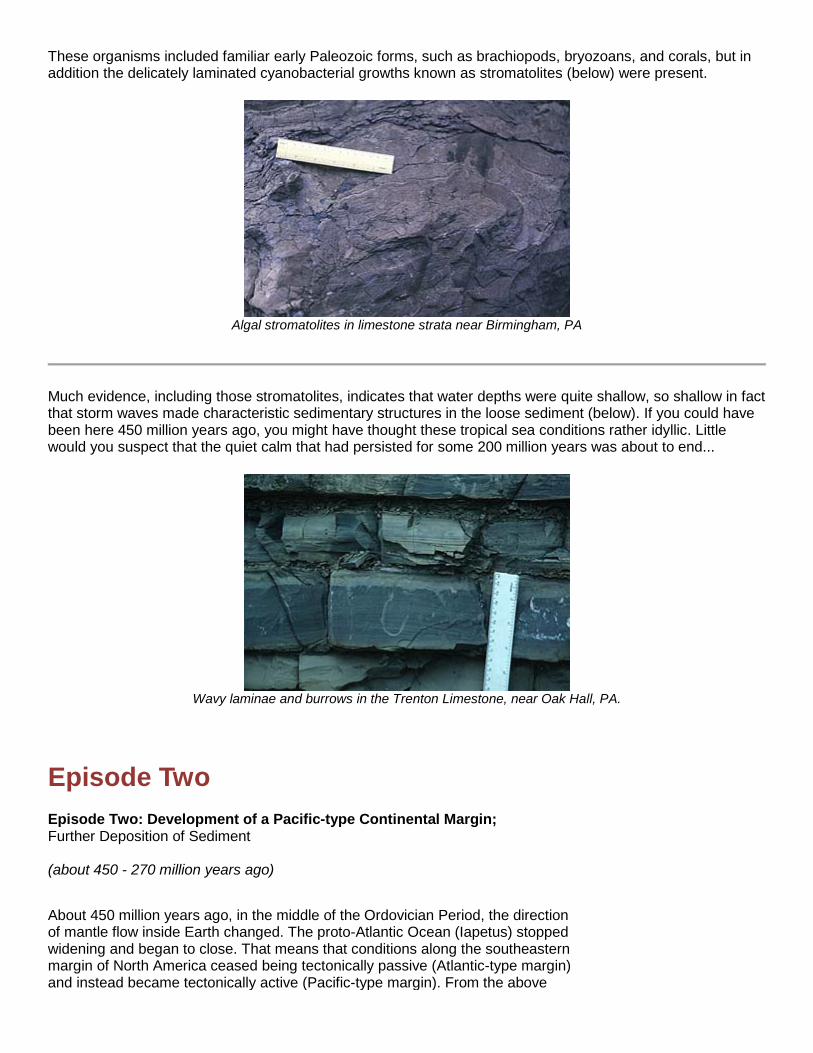
These organisms included familiar early Paleozoic forms, such as brachiopods, bryozoans, and corals, but in addition the delicately laminated cyanobacterial growths known as stromatolites (below) were present.
Algal stromatolites in limestone strata near Birmingham, PA
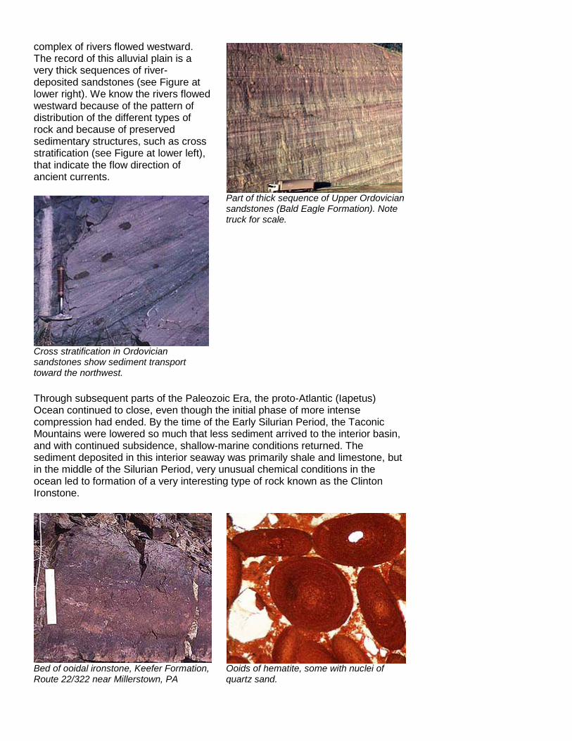
Much evidence, including those stromatolites, indicates that water depths were quite shallow, so shallow in fact that storm waves made characteristic sedimentary structures in the loose sediment (below). If you could have been here 450 million years ago, you might have thought these tropical sea conditions rather idyllic. Little would you suspect that the quiet calm that had persisted for some 200 million years was about to end...
Wavy laminae and burrows in the Trenton Limestone, near Oak Hall, PA.
Episode Two Episode Two: Development of a Pacific-type Continental Margin; Further Deposition of Sediment (about 450 - 270 million years ago)
About 450 million years ago, in the middle of the Ordovician Period, the direction of mantle flow inside Earth changed. The proto-Atlantic Ocean (Iapetus) stopped widening and began to close. That means that conditions along the southeastern margin of North America ceased being tectonically passive (Atlantic-type margin) and instead became tectonically active (Pacific-type margin). From the above

background comments, you know that this means that two tectonic plates were colliding together (converging), producing volcanic mountains similar to those around the present-day Pacific Ocean.
In central Pennsylvania, initial signs that the margin was under compression included the warping or flexing of the gently sloping continental margin, causing some parts of the continental margin to deepen while other parts were lifted above sea level. At about the same time, offshore volcanoes began to erupt enormous ash clouds, now seen as thick beds of volcanic ash interbedded with the limestones. For a while, the configuration of Laurentia's southeastern margin resembled the volcanic island complexes around the Pacific, such as Japan or the Aleutians, but after a few tens of millions of years, plate convergence had crushed the volcanic islands onto the continent. The edge of North America then probably looked more like the Andes Mountains of South America. This enormous Late Ordovician mountain complex is generally known as the Taconic Mountains.
Two layers of volcanic ash (recessed zones) in Ordovician limestones near Reedsville, PA.
These Taconic Mountains are now completely eroded away. But then how do we know where they were and that they were so large? We know principally from the sediment that came from them and was deposited in central and eastern Pennsylvania. For millions of years, the Taconic Mountains were weathered and eroded, producing enormous quantities of mud, sand, and gravel that were transported down river systems back toward the interior of North America. First to reach central Pennsylvania was the fine-grained mud that was flushed out to sea to pile up on the shallow limey shelves (see Figure at right). The great quantities of incoming sediment exceeded the capacity of the interior basin to accommodate it, so central Pennsylvania was built up above sea level. The scene then resembled a broad alluvial plain across which a
Limestones of Ordovician age (light gray) interbedded with dark shales.
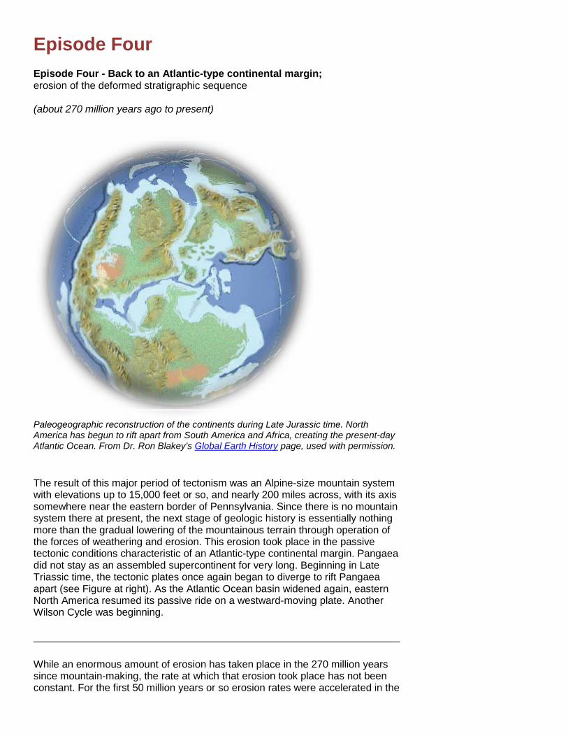
complex of rivers flowed westward. The record of this alluvial plain is a very thick sequences of river-deposited sandstones (see Figure at lower right). We know the rivers flowed westward because of the pattern of distribution of the different types of rock and because of preserved sedimentary structures, such as cross stratification (see Figure at lower left), that indicate the flow direction of ancient currents.
Cross stratification in Ordovician sandstones show sediment transport toward the northwest.
Part of thick sequence of Upper Ordovician sandstones (Bald Eagle Formation). Note truck for scale.
Through subsequent parts of the Paleozoic Era, the proto-Atlantic (Iapetus) Ocean continued to close, even though the initial phase of more intense compression had ended. By the time of the Early Silurian Period, the Taconic Mountains were lowered so much that less sediment arrived to the interior basin, and with continued subsidence, shallow-marine conditions returned. The sediment deposited in this interior seaway was primarily shale and limestone, but in the middle of the Silurian Period, very unusual chemical conditions in the ocean led to formation of a very interesting type of rock known as the Clinton Ironstone.
Bed of ooidal ironstone, Keefer Formation, Route 22/322 near Millerstown, PA
Ooids of hematite, some with nuclei of quartz sand.

Brachiopods and crinoids coated with hematite.
Tonoloway Limestone; Iddings Quarry west of Mifflinburg, PA.
As the Silurian Period came to a close, central Pennsylvania was again the site of limestone accumulation in a tropical sea (see photo at right). Some parts of this limestone preserve desiccation cracks as evidence of temporary exposure above the high tide line (see photo at lower right). At other times, environmental conditions were subtidal and sustained the development of small reefs constructed by stromatoporoids (see photo below).
Curved, laminated patterns are stromatoporid fossils seen on quarry wall.
Desiccation cracks in Tonoloway Limestone.

That shallow interior seaway was disrupted during the Devonian Period by another major tectonic disturbance along the margin of Laurentia. As the proto-Atlantic continued to close and plates converged, the ancestral part of Europe (Baltica) collided with the northern part of Laurentia (see Figure below).
Paleogeographic reconstruction of the earth for the Mid Silurian. Note that much of North America (Laurentia) is below sea level, except for the mountain belt caused by the collision between North America and Avalonia/Baltica. Diagram from the Paleomap Project by Christopher Scotese (www.scotese.com). Used by permission.

This compression raised up a high mountain range (the Acadian Mountains) that stretched from eastern Canada down to Virginia (see Figure below).
Paleogeographic reconstruction of the North America region during the Middle Devonian. Note the Acadian Mountains, and location/absence of southern portions of the North American continent. Diagram from Dr. Ron Blakey's Global Earth History Home Page. Used by permission.
With another high mountain system on its eastern border, another long period began when Pennsylvania received enormous quantities of sediment. These now-vanished Acadian Mountains must have been impressively large, judging from the great thicknesses (kilometers thick) of river and delta sediments that flowed westward from them into central Pennsylvania.
In central Pennsylvania, this river complex is preserved in the kilometers-thick redbed sequence known as the Catskill Formation.

The principal organizational pattern of the Catskill Formation is the fining-upward sequence, which is characteristic of the deposits of meandering rivers.
Meander bend in the Mississippi River; analogue of rivers that deposited much of the Catskill Formation.
Plant root marks in floodplain deposits of the Catskill Formation.
Calcium carbonate nodules in floodplain soils of the Catskill Formation indicate semi-arid climate in Late Devonian time.
But, just as happened earlier following the Taconic Orogeny, this Acadian Mountain range was also reduced by erosion over millions of years. As a result, gradually less and less siliciclastic sediment came into central Pennsylvania, and just as before, shallow-marine conditions began to return.

End of Episode Two The Last Stage of Episode 2 - Closure of the proto-Atlantic Ocean; Last Sediment Deposited (about 270 million years ago)
Toward the close of the Paleozoic Era, all continents of Earth became coalesced together to produce the supercontinent known as Pangaea. (see Figure at below) Remember that the proto-Atlantic had begun to open more than 650 million years ago with the breakup of the supercontinent Rodinia; now the proto-Atlantic was undergoing the final closing, as Africa (part of Gondwanaland) collided with North America. This would conclude the Wilson Cycle by marking the culmination of one complete opening and subsequent closing of an ocean basin.
Paleogeographic map of the Late Permian, showing the formation of the supercontinent, Pangea. Diagram from Dr. Ron Blakey's Global Earth History page, used with permission.
The first phase of this culminating compression took place during the Late Carboniferous (Pennsylvanian) Period, probably as the result of a collision between a volcanic island arc complex and the continent of Laurentia. Once more, to the east of central Pennsylvania high mountains were elevated, and increasing quantities of coarse, gravelly sediment flowed westward to be deposited in complex braided river systems central Pennsylvania. (Figure at lower left) These rivers continued to flow westward from the mountains, but over time, as gradients lessened, the rivers became less gravelly and were bordered by extensive swamps. In those swamps great amounts of plant matter accumulated to become the coal seams (Figure at lower right) mined in Pennsylvania in the present day.

To sum up Episodes 1 and 2, here at the end of the Late Carboniferous (Pennsylvanian) Period, close to 270 million years ago, a kilometers-thick sequence of horizontal sedimentary strata had been piled up under where Pennsylvania is today. The lower part of this thick sequence (the older part, deposited from about 600 to 450 million years ago) consists largely of carbonate rocks (limestones, etc.) that accumulated on a continental margin that sloped gently eastward toward an open ocean (Episode 1). In contrast, the upper part of the sequence (the younger part, deposited from about 450 to 270 million years ago) is largely siliciclastic (sandstones, etc.) that accumulated on a surface that sloped westward away from marginal mountains toward the interior of the continent (Episode 2). But that upper part is not uniformly siliciclastic, for at those times between the major elevations of the mountains, shallow-marine conditions returned to central Pennsylvania, and limestones and other marine rocks were deposited. You will see later how the alternation of "packages" of strata that have different dominant compositions (some carbonate; some siliciclastic) is to a large degree responsible for the characteristic valley and ridge landscape of central Pennsylvania.
Bucknell Geology field trip to Bear Valley near Shamokin, PA, to study the 300 million year-old coal-bearing strata of the Llewellyn Formation.
Well, the strata are now assembled, it is now time to see about their deformation.

Episode Three Episode Three - Final closure of the proto-Atlantic Ocean; Thrusting and Folding (about 270 million years ago)
Paleogeographic map showing the supercontinent Pangea during the Permian. Note the large mountain range that was built from the collision of North America (Laurasia) and Africa (Gondwana). Diagram courtesy of Dr. Ron Blakey's Global Earth History page, used with permission.
In early Permian time, not long after the marginal mountains had been elevated again in the Late Carboniferous, a more extreme collision took place as the continental mass of Africa collided with the continental mass of Laurentia.(see diagram at right). Compressive stress accompanying this collision was so intense that great portions of the Laurentian crust and overlying sedimentary sequence were thrust westward toward the continent interior. [Figure] Above the thrust planes, the sequence of sedimentary strata many kilometers thick, which had been deposited over hundreds of millions of years (see Episode 1 and Episode 2 above), was warped and folded as the strata were forced toward the west.
A NW - SE hypothetical cross section through central Pennsylvania, illustrating the folding
and thrusting of sedimentary layers during the Permian. Modified from R. T. Faill in The Geology of Pennsylvania, 1999.

That compression did not happen overnight. As ten or more million years passed, strata in the sedimentary sequence underwent a series of deformational stages: first a squeezing up of the sedimentary materials, then the beginning of small internal movements, and finally significant bending and warping of the strata as the thrust planes glided northwestward. (see photos below). In central Pennsylvania, the evidence of this compressive deformation can be seen in the major landscape features of the region, as well as in the bent and folded strata shown in many outcrops.
Folded and thrusted Tuscarora formation near Milroy, Pennsylvania
Kink folds in Trimmers Rock Formation, Watts Exit, Routes 22/322, central Pennsylvania.
Episode Four Episode Four - Back to an Atlantic-type continental margin; erosion of the deformed stratigraphic sequence (about 270 million years ago to present)
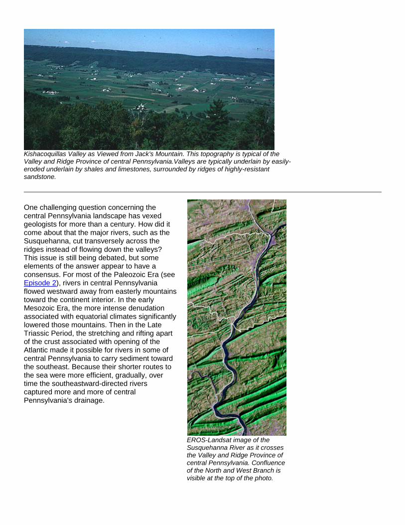
Paleogeographic reconstruction of the continents during Late Jurassic time. North America has begun to rift apart from South America and Africa, creating the present-day Atlantic Ocean. From Dr. Ron Blakey's Global Earth History page, used with permission.
The result of this major period of tectonism was an Alpine-size mountain system with elevations up to 15,000 feet or so, and nearly 200 miles across, with its axis somewhere near the eastern border of Pennsylvania. Since there is no mountain system there at present, the next stage of geologic history is essentially nothing more than the gradual lowering of the mountainous terrain through operation of the forces of weathering and erosion. This erosion took place in the passive tectonic conditions characteristic of an Atlantic-type continental margin. Pangaea did not stay as an assembled supercontinent for very long. Beginning in Late Triassic time, the tectonic plates once again began to diverge to rift Pangaea apart (see Figure at right). As the Atlantic Ocean basin widened again, eastern North America resumed its passive ride on a westward-moving plate. Another Wilson Cycle was beginning.
While an enormous amount of erosion has taken place in the 270 million years since mountain-making, the rate at which that erosion took place has not been constant. For the first 50 million years or so erosion rates were accelerated in the

near-equatorial conditions, and much of the elevation of the initial mountain system was lost. Erosion rates probably lessened as Pennsylvania drifted northward through arid subtropical latitudes, but in the Cretaceous Period, rates were again high as both global temperature and world-wide sea level were quite high. Through all this, isostatic rebound raised the regional elevation continually to make possible still more erosion.
Central Pennsylvania's characteristic linear valley and ridge landscape (above) is the consequence of this long-continued erosion. A close correlation exists between the elevation of particular rock units and their relative resistance to weathering and erosion (denudation). Well-cemented quartz sandstone is very resistant to denudation, so it is not surprising that the higher ridges consist of quartz-rich sandstones. On the other hand, limestones and shales can be eroded much faster, so once again it is not surprising that the valleys are underlain by limestones and shales. You will remember that the sedimentary sequence in central Pennsylvania consists of "packages" of strata that alternate between shallow-marine carbonate rocks (limestones and shales) and quartz-rich sandstones that were deposited in river systems.
Because those "packages" have been thrusted and folded into a particular configuration (see Figure immediately below) by the collision with Africa at the end of Episode 2, the elongate ridges are produced on top of several different sandstone-dominated rock "packages", while more than one "package" of limestones and shales underlie the intervening valleys (see photo below).
A NW - SE hypothetical cross section through central Pennsylvania, illustrating the folding and thrusting of sedimentary layers during the Permian. Modified from R. T. Faill in The Geology of Pennsylvania, 1999.
Kishacoquillas Valley as Viewed from Jack's Mountain. This topography is typical of the Valley and Ridge Province of central Pennsylvania.Valleys are typically underlain by easily-eroded underlain by shales and limestones, surrounded by ridges of highly-resistant sandstone.
One challenging question concerning the central Pennsylvania landscape has vexed geologists for more than a century. How did it come about that the major rivers, such as the Susquehanna, cut transversely across the ridges instead of flowing down the valleys? This issue is still being debated, but some elements of the answer appear to have a consensus. For most of the Paleozoic Era (see Episode 2), rivers in central Pennsylvania flowed westward away from easterly mountains toward the continent interior. In the early Mesozoic Era, the more intense denudation associated with equatorial climates significantly lowered those mountains. Then in the Late Triassic Period, the stretching and rifting apart of the crust associated with opening of the Atlantic made it possible for rivers in some of central Pennsylvania to carry sediment toward the southeast. Because their shorter routes to the sea were more efficient, gradually, over time the southeastward-directed rivers captured more and more of central Pennsylvania's drainage.
EROS-Landsat image of the Susquehanna River as it crosses the Valley and Ridge Province of central Pennsylvania. Confluence of the North and West Branch is visible at the top of the photo.