
Geographic Information in the Carare and Athena Projects
40
Geographic Information in the Carare and Athena Projects Franc J. Zakrajsek Workshop Wien 4-5.11 2010: Place, Cultural Heritage and the Internet
-
Upload
carare -
Category
Technology
-
view
143 -
download
0
Transcript of Geographic Information in the Carare and Athena Projects

Geographic Information in the Carare and Athena Projects
Franc J. Zakrajsek
Workshop Wien 4-5.11 2010: Place, Cultural Heritage and the Internet

Workshop Wien 4-5.11 2010: Place, Cultural Heritage and the Internet
Cultural content in space and time

Workshop Wien 4-5.11 2010: Place, Cultural Heritage and the Internet
• to support and encourage the participation of museums and other institutions not yet fully involved in Europeana;
• to produce a set of scalable tools, recommendations and guidelines, focusing on metadata and thesauri, data structures, semantics, and IPR issues;
• to identify digital content present in the European museums;• to contribute to the integration of the different sectors of cultural
heritage with the overall objective to merge all these different contributions into Europeana.
Europeana – Athena project
ATHENA, the European museum network, is a project whose purpose is to harvest museum content and to deliver it into Europeana.
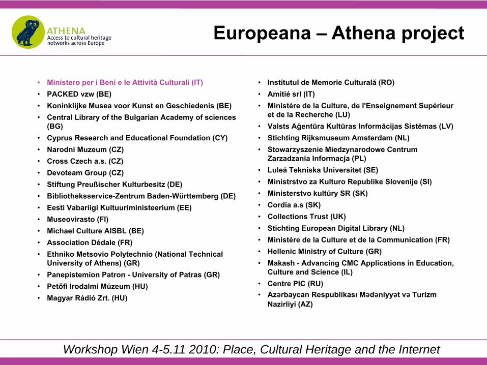
Workshop Wien 4-5.11 2010: Place, Cultural Heritage and the Internet
• Ministero per i Beni e le Attività Culturali (IT)• PACKED vzw (BE)• Koninklijke Musea voor Kunst en Geschiedenis (BE)• Central Library of the Bulgarian Academy of sciences
(BG)• Cyprus Research and Educational Foundation (CY)• Narodni Muzeum (CZ)• Cross Czech a.s. (CZ)• Devoteam Group (CZ)• Stiftung Preußischer Kulturbesitz (DE)• Bibliotheksservice-Zentrum Baden-Württemberg (DE)• Eesti Vabariigi Kultuuriministeerium (EE)• Museovirasto (FI)• Michael Culture AISBL (BE)• Association Dédale (FR)• Ethniko Metsovio Polytechnio (National Technical
University of Athens) (GR)• Panepistemion Patron - University of Patras (GR)• Petőfi Irodalmi Múzeum (HU)• Magyar Rádió Zrt. (HU)
• Institutul de Memorie Culturală (RO)• Amitié srl (IT)• Ministère de la Culture, de l'Enseignement Supérieur
et de la Recherche (LU)• Valsts Aģentūra Kultūras Informācijas Sistēmas (LV)• Stichting Rijksmuseum Amsterdam (NL)• Stowarzyszenie Miedzynarodowe Centrum
Zarzadzania Informacja (PL)• Luleå Tekniska Universitet (SE)• Ministrstvo za Kulturo Republike Slovenije (SI)• Ministerstvo kultúry SR (SK)• Cordia a.s (SK)• Collections Trust (UK)• Stichting European Digital Library (NL)• Ministère de la Culture et de la Communication (FR)• Hellenic Ministry of Culture (GR)• Makash - Advancing CMC Applications in Education,
Culture and Science (IL)• Centre PIC (RU)• Azǝrbaycan Respublikası Mǝdǝniyyǝt vǝ Turizm
Nazirliyi (AZ)
Europeana – Athena project
Workshop Wien 4-5.11 2010: Place, Cultural Heritage and the Internet
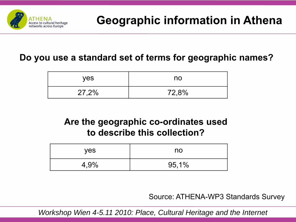
Geographic information in Athena
Do you use a standard set of terms for geographic names?
yes no
27,2% 72,8%
Are the geographic co-ordinates used to describe this collection?
yes no
4,9% 95,1%
Source: ATHENA-WP3 Standards Survey
Workshop Wien 4-5.11 2010: Place, Cultural Heritage and the Internet
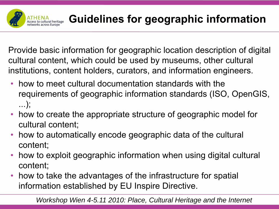
Provide basic information for geographic location description of digital cultural content, which could be used by museums, other cultural institutions, content holders, curators, and information engineers.• how to meet cultural documentation standards with the
requirements of geographic information standards (ISO, OpenGIS, ...);
• how to create the appropriate structure of geographic model for cultural content;
• how to automatically encode geographic data of the cultural content;
• how to exploit geographic information when using digital cultural content;
• how to take the advantages of the infrastructure for spatial information established by EU Inspire Directive.
Guidelines for geographic information

Workshop Wien 4-5.11 2010: Place, Cultural Heritage and the Internet
1. PURPOSE OF GUIDELINES2. INTRODUCTION TO GIS
2.1. GIS Concept2.2. GIS Technology2.3. GIS as Tool2.4. GIS History Milestones
3. BASIC TERMINOLOGY OF GIS4. GEOGRAPHIC LOCATION ASPECT IN ATHENA PROJECT CONTENT
4.1. Geographic Name Terminology and Co-ordinate Standards4.2. Using Geographic Co-Ordinates Standards to Describe Their Collections4.3. Survey Results
5. GEOGRAPHIC INFORMATION IN STANDARDS CONCERNING DIGITAL CULTURAL CONTENT
5.1. CIDOC Conceptual Reference Model (CRM)5.2. Museum Documentation Standard SPECTRUM
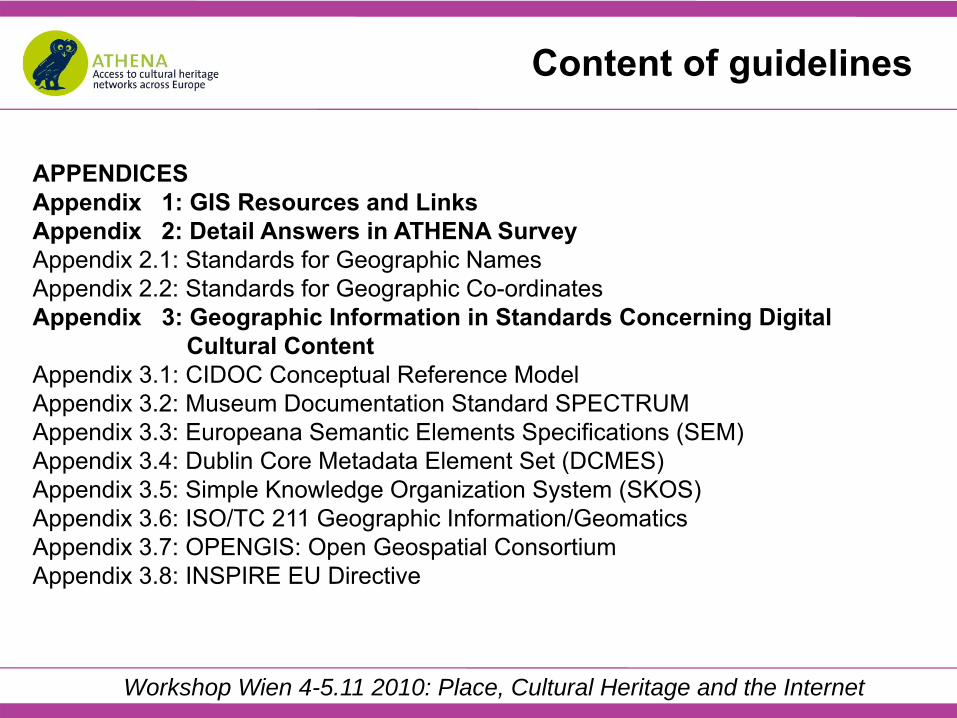
Content of guidelines

Workshop Wien 4-5.11 2010: Place, Cultural Heritage and the Internet
5.3. Europeana Semantic Elements Specifications (ESE)5.4. Dublin Core Metadata Element Set (DCMES)5.5. Simple Knowledge Organization System (SKOS)5.6. ISO/TC 211 Geographic Information/Geomatics5.7. OpenGIS: Open Geospatial Consortium5.8. INSPIRE EU Directive
6. IMPLEMENTATION OF GIS IN DIGITAL CULTURAL CONTENT6.1. Conceptual Model6.2. Possible GIS Models6.3. Quick Thoughts6.4. Curriculum of Training: Introduction of GIS
Content of guidelines
Workshop Wien 4-5.11 2010: Place, Cultural Heritage and the Internet
APPENDICESAppendix 1: GIS Resources and LinksAppendix 2: Detail Answers in ATHENA Survey Appendix 2.1: Standards for Geographic Names Appendix 2.2: Standards for Geographic Co-ordinates Appendix 3: Geographic Information in Standards Concerning Digital
Cultural ContentAppendix 3.1: CIDOC Conceptual Reference ModelAppendix 3.2: Museum Documentation Standard SPECTRUMAppendix 3.3: Europeana Semantic Elements Specifications (SEM)Appendix 3.4: Dublin Core Metadata Element Set (DCMES)Appendix 3.5: Simple Knowledge Organization System (SKOS)Appendix 3.6: ISO/TC 211 Geographic Information/GeomaticsAppendix 3.7: OPENGIS: Open Geospatial ConsortiumAppendix 3.8: INSPIRE EU Directive
Content of guidelines

Workshop Wien 4-5.11 2010: Place, Cultural Heritage and the Internet
Content of guidelines
Appendix 4: Further Elaboration for Implementation of GIS in Digital Cultural Content
Appendix 4.1: Literature on Data Structure Supported by GISAppendix 4.2: GeocodingAppendix 4.3: Retrieval with Ontology

Workshop Wien 4-5.11 2010: Place, Cultural Heritage and the Internet
GIS models
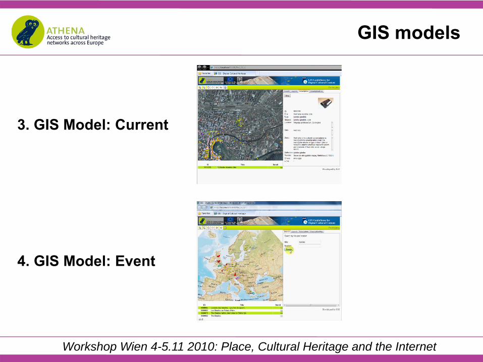
The proposed seven prototypes of GIS models were developed with aim that museums, archives, libraries, audiovisual institutions and other data providers clearly understand what they should be working on and implement in the future. These GIS models range from simplest to most complex.In our work within Athena project we have developed concepts of these possible GIS models and prepared small sample database for each model. We have also developed prototype internet applications, performed simulation and disscusion of issues pertaining to each model. Videos demonstrating features of each model are published at Athena website for users to open or download.
Workshop Wien 4-5.11 2010: Place, Cultural Heritage and the Internet
GIS models
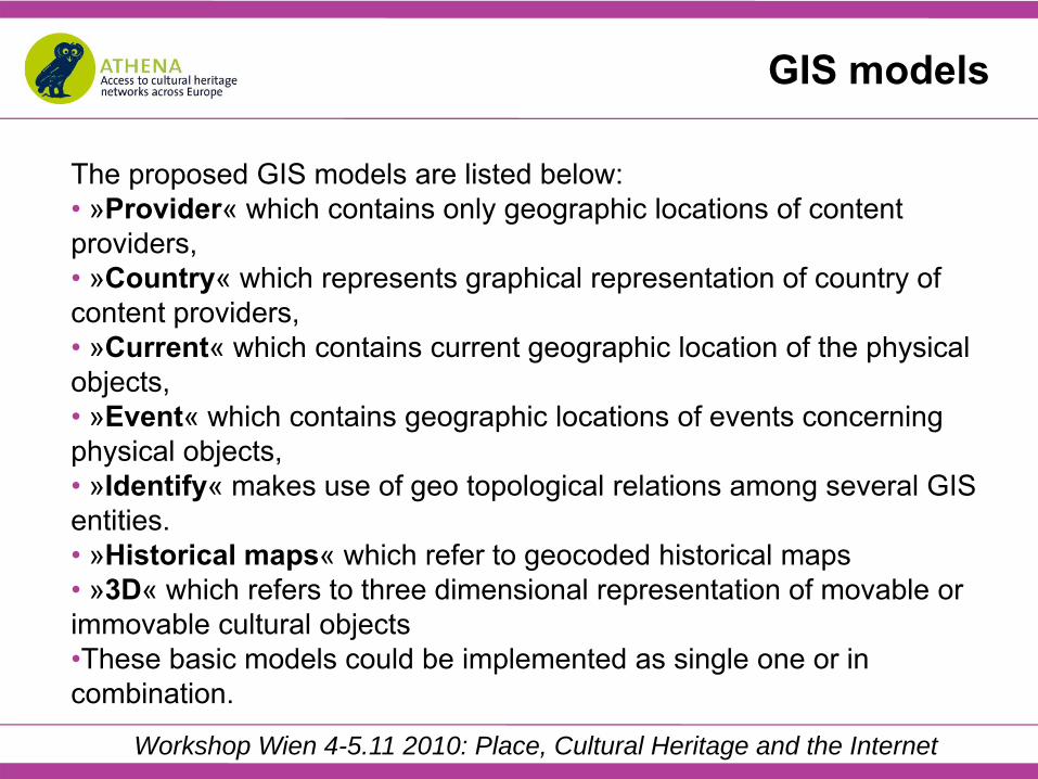
The proposed GIS models are listed below:• »Provider« which contains only geographic locations of content providers,• »Country« which represents graphical representation of country of content providers,• »Current« which contains current geographic location of the physical objects,• »Event« which contains geographic locations of events concerning physical objects,• »Identify« makes use of geo topological relations among several GIS entities.• »Historical maps« which refer to geocoded historical maps• »3D« which refers to three dimensional representation of movable or immovable cultural objects•These basic models could be implemented as single one or in combination.

Workshop Wien 4-5.11 2010: Place, Cultural Heritage and the Internet
1. GIS Model: Provider
2. GIS Model: Country
GIS models
Workshop Wien 4-5.11 2010: Place, Cultural Heritage and the Internet
3. GIS Model: Current
4. GIS Model: Event
GIS models

Workshop Wien 4-5.11 2010: Place, Cultural Heritage and the Internet
5. GIS Model: Identify
6. GIS Model: Historical maps
GIS models

Workshop Wien 4-5.11 2010: Place, Cultural Heritage and the Internet
GIS models
7. GIS Model: 3D

Workshop Wien 4-5.11 2010: Place, Cultural Heritage and the Internet
Purpose of guidelines
• raising awareness of GIS technologies potential in cultural sector; • to make introduction to fundamental GIS concepts by explaining
basic GIS terms to all readers thus furthering better understanding;
• demonstrating benefits that can be achieved by inclusion of geographic information in process of creating digital cultural content;
• to offer basic recommendations and tools how to tackle problems for overcoming bottlenecks in introducing GIS;
• to make strong suggestions to all Athena and Europeana content providers on ways how to enrich current content with appropriate geographic information in short but also long term.
Workshop Wien 4-5.11 2010: Place, Cultural Heritage and the Internet
However guidelines are not
• research in development of new GIS methods;• scientific in-depth theory or discussion of new methods in great
detail;• development of GIS software, adds-in, API-s;• technical specifications of GIS portals and data bases;• requirements for thesaurus or SKOS;• or detail plan for GIS implementation in cultural institutions.

Workshop Wien 4-5.11 2010: Place, Cultural Heritage and the Internet
CARARE is designed to involve and support Europe's network of heritage agencies and organisations, archaeological museums and research institutions and specialist digital archives in:
• making the digital content for the archaeology and architectural heritage that they hold available through Europeana,
• aggregating content and delivering services, and• enabling access to 3D and Virtual Reality content through
Europeana.
Europeana – Carare project

Workshop Wien 4-5.11 2010: Place, Cultural Heritage and the Internet
Carare partners •Kulturarvsstyrelsen •MDR Partners•Stichting European Digital Library •Archaeology Data Service•Scuola Normale Superiore di Pisa•Cyprus Research and Educational Foundation•Heritage Malta•Visual Dimension•Digital Curation Unit•Swedish National Heritage Board•Erfgoed Nederland•Cultural Heritage Agency, The Netherlands•N303BV•Krajowy Ośrodek Badań i Dokumentacji Zabytków •Deutsches Archäologische Institut•Direction des Monuments et des Sites, Ministère de la Région de Bruxelles-Capitale•Eesti Vabariigi Kultuuriministeerium•Narodni pamatkovy ustav •Pamiatkový úrad Slovenskej republiky •Directorate of the National Archive of Monuments -Hellenic Ministry of Culture •Ministry of Culture of the Republic of Slovenia•Archaeological Heritage Agency•Vilnius University, Faculty of Communication•Institutul de Memorie Culturala•National Archaeological Institute with Museum•Centro Andaluz de Arqueología Ibérica, Universidad de Jaén•National Technical University of Athens•Data Archiving and Networked Services

Workshop Wien 4-5.11 2010: Place, Cultural Heritage and the Internet
Carare geospatial data
Type Collections Items Countries
Point 20 4.702.294
Line 13 25.900
Polygon 23 1.042.354
Image/Grid 13 4.165.023
Total Spatial«Yes« 33 14
Total Spatial«No« 47
Source: Carare Survey
Scope: Archaeological Sites, Architectural buildings, Monuments, Archaeological excavations, ...

Workshop Wien 4-5.11 2010: Place, Cultural Heritage and the Internet
Spatial - Information about locations or positions in space. • Location set
• Named location• Address• Geopolitical area• Geopolitical area type• Cadastral reference• Historical name
• Spatial reference system
Carare metadata scheme v1.1
• Cartographic reference • Spatial feature type• Coordinates
• Geometry• Bounding box• Quickpoints• Entity• Stored precision, delivery precision• Height• Area
• Representations
Address• Building name • Number in road Road name • Town or city• Postcode or zipcode• Locality • Admin area• Country

Workshop Wien 4-5.11 2010: Place, Cultural Heritage and the Internet
Carare semantic mapping

Workshop Wien 4-5.11 2010: Place, Cultural Heritage and the Internet
• The review of the GIS services and being made available in EuropeanaLabs through the EuropeanaConnect project or other projects in the cluster (by month 12).
• The evaluation of the potential for enriching the place-name services in Europeana through monument inventory data from the domain and report on the results to the Europeana cluster (by month 18).
•The evaluation of the potential for the gazetteer and geo-parser services available from Europeana to enrich heritage content and report on the results to partners and the Europeana Project Group (by month 24).
• The recommendations on geographic information for archaeology/architecture domain content providers (by month 24)
Geographic information in Carare

Workshop Wien 4-5.11 2010: Place, Cultural Heritage and the Internet
Testing Europeana geoparsing service

Workshop Wien 4-5.11 2010: Place, Cultural Heritage and the Internet
Testing Europeana geoparsing service

Workshop Wien 4-5.11 2010: Place, Cultural Heritage and the Internet
Testing Europeana geoparsing service
Workshop Wien 4-5.11 2010: Place, Cultural Heritage and the Internet
INSPIRE Directive
• Infrastructure for Spatial Information in the European Community (INSPIRE).
• The INSPIRE directive came into force on 15 May 2007 and will be implemented in various stages, with full implementation required by 2019.
• The INSPIRE directive aims to create a European Union (EU) spatial data infrastructure. This will enable the sharing of environmental spatial information among public sector organisations and better facilitate public access to spatial information across Europe.

Workshop Wien 4-5.11 2010: Place, Cultural Heritage and the Internet
INSPIRE Directive
• European Spatial Data Infrastructure will assist in policy-making across boundaries. Therefore the spatial information considered under the directive is extensive and includes a great variety of topical and technical themes.
Workshop Wien 4-5.11 2010: Place, Cultural Heritage and the Internet
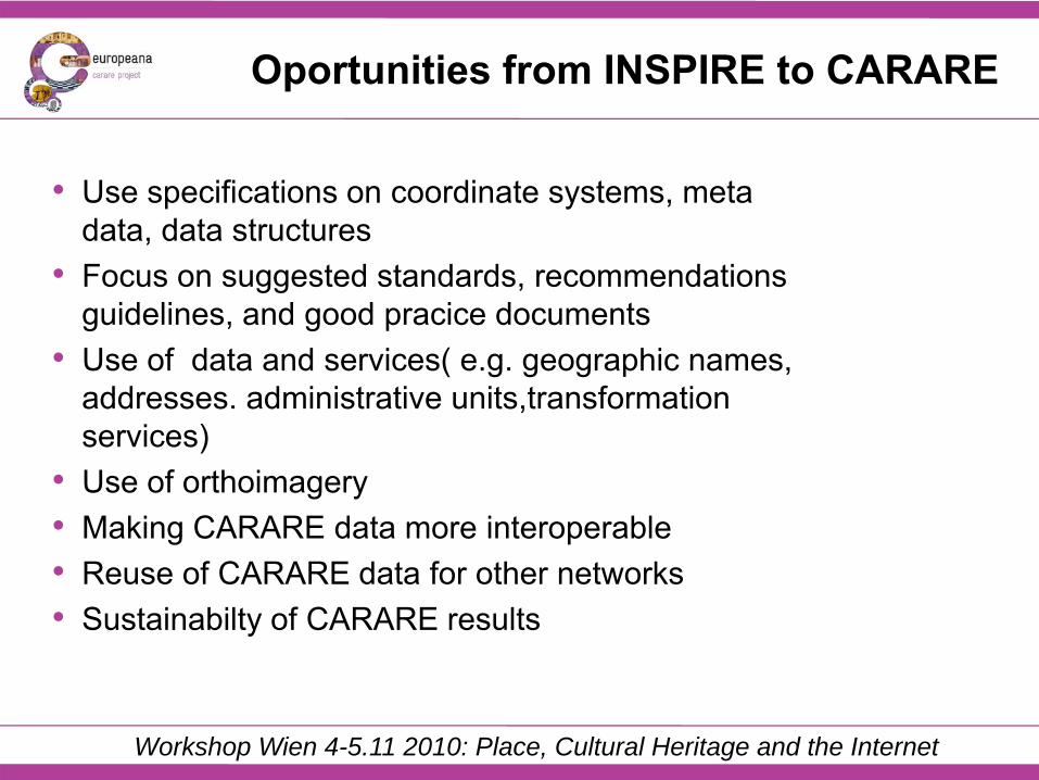
Oportunities from INSPIRE to CARARE
• Use specifications on coordinate systems, meta data, data structures
• Focus on suggested standards, recommendations guidelines, and good pracice documents
• Use of data and services( e.g. geographic names, addresses. administrative units,transformation services)
• Use of orthoimagery• Making CARARE data more interoperable• Reuse of CARARE data for other networks• Sustainabilty of CARARE results
Workshop Wien 4-5.11 2010: Place, Cultural Heritage and the Internet
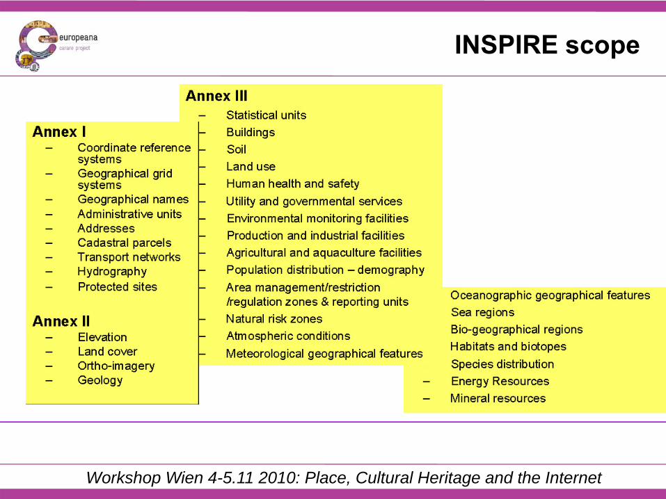
INSPIRE scope

Workshop Wien 4-5.11 2010: Place, Cultural Heritage and the Internet
INSPIRE implementing rules
To ensure that the spatial data infrastructures of the Member States are compatible and usable in a Community and transboundary context, the Directive requires that common Implementing Rules (IR) are adopted in a number of specific areas:
• Metadata • Data Specifications • Network Services • Data and Service Sharing • Monitoring and Reporting

Workshop Wien 4-5.11 2010: Place, Cultural Heritage and the Internet
INSPIRE specification on coordinate reference systems
...

Workshop Wien 4-5.11 2010: Place, Cultural Heritage and the Internet
INSPIRE implementing rules for metadata
• Identification • Classification of spatial data an services • Keyword • Geographic location • Temporal reference • Quality and validity
The following section describes the INSPIRE metadata elements briefly as specified by the INSPIRE Implementing Rules for Metadata. The elements are ordered in broader categories:

Workshop Wien 4-5.11 2010: Place, Cultural Heritage and the Internet
INSPIRE data specification on addresses
Sweden Denmark United Kingdom Mainstreet 6 1101 12345 Farsta
Mainstreet 6 1 TV 2400 København NV
Flat 1A 6, Mainstreet Fairfield Wandsworth London SW18 1ED
The Netherlands Belgium (Flanders) Germany
Mainstreet 24 2500 AA Den Haag
Mainstreet 6 bus 3 2140 Antwerpen
Mainstreet 6 67 433 Kelkheim
Spain Czech Republic Mainstreet 6 left 1 1 Cortijo del Marqués 41037, Écija (Sevilla)
Mainstreet 360/6 Chodov 149 00 Prague 41
Workshop Wien 4-5.11 2010: Place, Cultural Heritage and the Internet
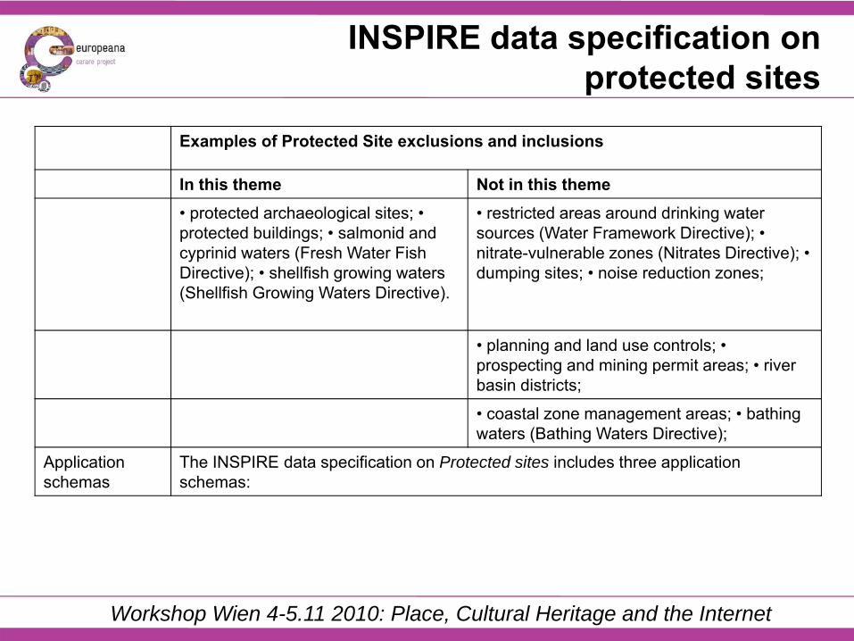
INSPIRE data specification on protected sites
Examples of Protected Site exclusions and inclusions
In this theme Not in this theme• protected archaeological sites; • protected buildings; • salmonid and cyprinid waters (Fresh Water Fish Directive); • shellfish growing waters (Shellfish Growing Waters Directive).
• restricted areas around drinking water sources (Water Framework Directive); • nitrate-vulnerable zones (Nitrates Directive); • dumping sites; • noise reduction zones;
• planning and land use controls; • prospecting and mining permit areas; • river basin districts;
• coastal zone management areas; • bathing waters (Bathing Waters Directive);
Application schemas
The INSPIRE data specification on Protected sites includes three application schemas:

Workshop Wien 4-5.11 2010: Place, Cultural Heritage and the Internet
INSPIRE data specification on protected sites

Workshop Wien 4-5.11 2010: Place, Cultural Heritage and the Internet
INSPIRE data specification on protected sites

Workshop Wien 4-5.11 2010: Place, Cultural Heritage and the Internet
Opportunities from Carare to Europeana
• Evaluation of services, API-s, UI,... • Refining the imlementation of standards• Re-use of geocodes of archaeology/architecture
domain also for movable cultural content

Workshop Wien 4-5.11 2010: Place, Cultural Heritage and the Internet
Thanks for your attention
www.carare.eu


![The Macellum of Pompeii - About CARARE [CARARE Pro]pro.carare.eu/lib/...materials:macellum_at_pompeii.pdf · The Macellum of Pompeii is located outside the northeast corner of the](https://static.fdocuments.net/doc/165x107/5f77157f00099171512788a4/the-macellum-of-pompeii-about-carare-carare-propro-macellumatpompeiipdf.jpg)


![ATHENA - Coordinate System Document...[RD02] ATHENA Mission Requirements Document (MRD), ATHENA-ESA-URD-0010 [RD03] ATHENA Product Tree, ATHENA-ESA-PT-0001 [RD04] Ariane 5 User’s](https://static.fdocuments.net/doc/165x107/5ff23cd84225de2c7f4f21b6/athena-coordinate-system-document-rd02-athena-mission-requirements-document.jpg)