Geofencing and Background Tracking – The Next - User.tu-
14
Geofencing and Background Tracking – The Next Features in LBSs Axel Küpper*, Ulrich Bareth*, and Behrend Freese** * TU Berlin – Deutsche Telekom Laboratories, TEL 19, Ernst-Reuter-Platz 7, 10583 Berlin ** Ubiry GmbH, Heidefeld 21, 14532 Kleinmachnow [axel.kuepper|[email protected]] [email protected] Abstract: The upcoming generation of LBSs will be significantly determined by geofencing applications and background tracking. A geofence is a small geo- graphic area that is defined to generate a location event as soon as a user enters or leaves this geofence and to process this event in the context of an LBS. Back- ground tracking continuously monitors the whereabouts of a user and is thus the major prerequisite for detecting location events. Both functions can be regarded as important enablers for an improvement and broad establishment of information re- levance in mobile environments. After an overview of the emergence of LBSs in the recent years, this article provides an introduction into geofencing and back- ground tracking and demonstrates their working for location-based recommender systems. 1 A Brief History of Location-based Services The success of the Mobile Internet in the recent years has created a huge market for new applications in the area of information relevance. The most innovative of these applica- tions belong to the category of Location-based Services (LBSs), which generate, com- pile, select, or filter information or perform other actions by taking into consideration the current location of the user [Kü05]. Prominent examples are so-called finder or points- of-interest (PoI) services, which deliver lists of nearby points-of-interest to the user, for example, restaurants, filling stations, or ATMs. Recently, the idea of LBSs has also been adopted by social community platforms, which now enable location sharing, that is, the mutual exchange of current whereabouts among their members. INFORMATIK 2011 - Informatik schafft Communities 41. Jahrestagung der Gesellschaft für Informatik , 4.-7.10.2011, Berlin www.informatik2011.de erschienen im Tagungsband der INFORMATIK 2011 Lecture Notes in Informatics, Band P192 ISBN 978-3-88579-286-4 weitere Artikel online: http://informatik2011.de/519.html
Transcript of Geofencing and Background Tracking – The Next - User.tu-
Geofencing and Background Tracking – The Next Features in LBSs
Axel Küpper*, Ulrich Bareth*, and Behrend Freese**
* TU Berlin – Deutsche Telekom Laboratories, TEL 19, Ernst-Reuter-Platz 7, 10583 Berlin
** Ubiry GmbH, Heidefeld 21, 14532 Kleinmachnow [axel.kuepper|[email protected]]
Abstract: The upcoming generation of LBSs will be significantly determined by geofencing applications and background tracking. A geofence is a small geo-graphic area that is defined to generate a location event as soon as a user enters or leaves this geofence and to process this event in the context of an LBS. Back-ground tracking continuously monitors the whereabouts of a user and is thus the major prerequisite for detecting location events. Both functions can be regarded as important enablers for an improvement and broad establishment of information re-levance in mobile environments. After an overview of the emergence of LBSs in the recent years, this article provides an introduction into geofencing and back-ground tracking and demonstrates their working for location-based recommender systems.
1 A Brief History of Location-based Services
The success of the Mobile Internet in the recent years has created a huge market for new applications in the area of information relevance. The most innovative of these applica-tions belong to the category of Location-based Services (LBSs), which generate, com-pile, select, or filter information or perform other actions by taking into consideration the current location of the user [Kü05]. Prominent examples are so-called finder or points-of-interest (PoI) services, which deliver lists of nearby points-of-interest to the user, for example, restaurants, filling stations, or ATMs. Recently, the idea of LBSs has also been adopted by social community platforms, which now enable location sharing, that is, the mutual exchange of current whereabouts among their members.
INFORMATIK 2011 - Informatik schafft Communities 41. Jahrestagung der Gesellschaft für Informatik , 4.-7.10.2011, Berlin
www.informatik2011.de
erschienen im Tagungsband der INFORMATIK 2011 Lecture Notes in Informatics, Band P192 ISBN 978-3-88579-286-4
weitere Artikel online: http://informatik2011.de/519.html
However, location is just one example that describes the current situation of the mobile user. Other parameters are weather conditions on the spot, his vital functions, or the current means of transportation while travelling, to name only a few. The sum of all parameters that are taken into consideration for delivering the user with relevant infor-mation are called context, and they are derived and processed by so-called Context-aware Services (CASs), see [DA99]. Thus, LBSs can be regarded as a special appea-rance of the more general CASs. However, a technical barrier for a successful mass-mar-ket introduction of CASs is still the automatic detection of context parameters, which of-ten suffers from the non-availability of appropriate sensors in mobile devices or in the environment as well as from the potential variety of such parameters. The location of the user, on the other hand, can be easily derived by various positioning technologies like GPS or Cell-ID today, which are now standard features of smartphones and mobile net-works. These technologies form the key for LBSs and their broad availability is one of the prerequisites for the latest commercial success of these services.
The last decade has created two generations of LBSs. The first one was coined by Cell-ID positioning, while the driving force behind the second one was the emergence of GPS-enabled smartphones. While this second generation still dominates the market, device manufacturers and standardization are preparing new features that enable geo-fencing and background tracking. While today’s and earlier LBSs only determine the lo-cation of a user while he is active in a service session, geofencing allows to detect the entering and leaving of so-called geofences, which are pre-defined geographic areas [BKR10]. For that purpose, the user needs to be continuously tracked in the background, that is, even when the mobile device is idle or executes other applications. Geofencing and background tracking thus enable a broad range of new applications, especially in the area of information relevance. However, their introduction is also related with new barriers, for example, the battery consumption at mobile devices and privacy concerns of the user.
In the following two sections, this paper gives an overview of the main features of first and second generation LBSs and their differences. Both generations are compared with regard to their major application areas, the fundamental working of positioning, as well as the roles of mobile network operators and other players. The second part of the paper then introduces geofencing and background tracking. The common characteristics of these features are described, followed by an application scenario in the area of location-based recommendation systems. Finally, this paper identifies the major barriers that may complicate the realization and introduction of geofencing and background tracking and discusses possible solutions.
INFORMATIK 2011 - Informatik schafft Communities 41. Jahrestagung der Gesellschaft für Informatik , 4.-7.10.2011, Berlin
www.informatik2011.de
erschienen im Tagungsband der INFORMATIK 2011 Lecture Notes in Informatics, Band P192 ISBN 978-3-88579-286-4
weitere Artikel online: http://informatik2011.de/519.html
2 First LBS Generation (200-2007)
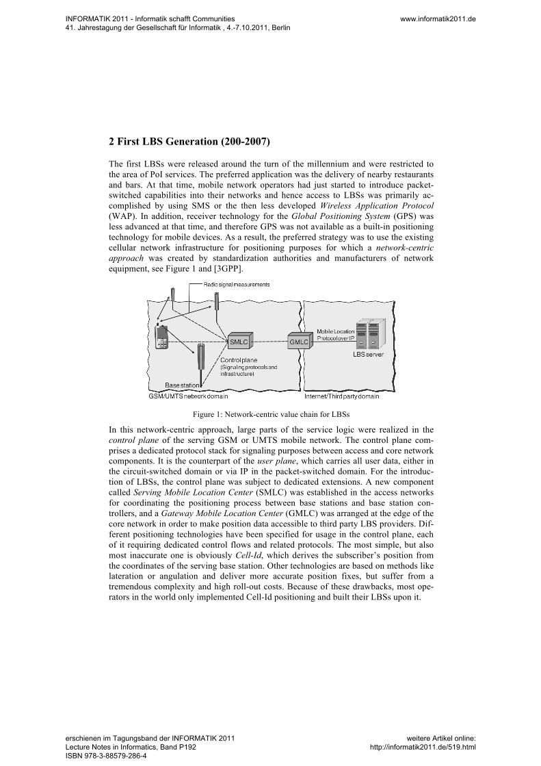
The first LBSs were released around the turn of the millennium and were restricted to the area of PoI services. The preferred application was the delivery of nearby restaurants and bars. At that time, mobile network operators had just started to introduce packet-switched capabilities into their networks and hence access to LBSs was primarily ac-complished by using SMS or the then less developed Wireless Application Protocol (WAP). In addition, receiver technology for the Global Positioning System (GPS) was less advanced at that time, and therefore GPS was not available as a built-in positioning technology for mobile devices. As a result, the preferred strategy was to use the existing cellular network infrastructure for positioning purposes for which a network-centric approach was created by standardization authorities and manufacturers of network equipment, see Figure 1 and [3GPP].
Figure 1: Network-centric value chain for LBSs
In this network-centric approach, large parts of the service logic were realized in the control plane of the serving GSM or UMTS mobile network. The control plane com-prises a dedicated protocol stack for signaling purposes between access and core network components. It is the counterpart of the user plane, which carries all user data, either in the circuit-switched domain or via IP in the packet-switched domain. For the introduc-tion of LBSs, the control plane was subject to dedicated extensions. A new component called Serving Mobile Location Center (SMLC) was established in the access networks for coordinating the positioning process between base stations and base station con-trollers, and a Gateway Mobile Location Center (GMLC) was arranged at the edge of the core network in order to make position data accessible to third party LBS providers. Dif-ferent positioning technologies have been specified for usage in the control plane, each of it requiring dedicated control flows and related protocols. The most simple, but also most inaccurate one is obviously Cell-Id, which derives the subscriber’s position from the coordinates of the serving base station. Other technologies are based on methods like lateration or angulation and deliver more accurate position fixes, but suffer from a tremendous complexity and high roll-out costs. Because of these drawbacks, most ope-rators in the world only implemented Cell-Id positioning and built their LBSs upon it.
INFORMATIK 2011 - Informatik schafft Communities 41. Jahrestagung der Gesellschaft für Informatik , 4.-7.10.2011, Berlin
www.informatik2011.de
erschienen im Tagungsband der INFORMATIK 2011 Lecture Notes in Informatics, Band P192 ISBN 978-3-88579-286-4
weitere Artikel online: http://informatik2011.de/519.html
It turned out very soon that the first LBS generation did not meet customer demands. The reasons for this failure were manifold. At first it has to be stated that at that time mobile data services in general suffered from low acceptance in many markets, because devices and networks were not mature enough to meet a sufficient usability. Another source for the failure was obviously the network-centric design itself. Mobile network operators either did not allow access to their GMLCs for independent third party LBS providers at all or only against over-priced fees, which in most cases was not in accor-dance with the business models followed by the third party providers. As a result, the emergence of open and competitive long-tail markets for LBSs was prevented. Instead, the LBS market, which was under sole control of the operators, was dominated by the aforementioned restaurant finder or other PoI applications with poor user interfaces. Not surprisingly, the user acceptance was low, whereupon many operators very rapidly with-draw their LBSs.
3 Second LBS Generation (2007-today)
In the recent years, the technological pre-conditions for LBSs essentially changed, which resulted in a broad range of new and sophisticated applications. The range of functions of these LBSs is much broader than in the first generation and comprises advanced PoI services, navigation applications, mobile marketing, and social communities. Analysts predict that especially the area of mobile marketing is the next big thing in the Mobile Internet. One of the favorite applications is couponing, where mobile users can receive beneficiaries of nearby shops and malls on their mobile devices. Social community plat-forms like Facebook and foursquare, on the other hand, recently introduced location sha-ring for the mutual exchange of location data between buddies. A special appearance of location sharing is the check-in function, which is used to explicitly check in at certain places like bars or restaurants and in this way to disclose the current location to other users. Besides this, thousands of niche applications exist that fulfill the special demands of certain user groups.
The technological achievements that have led to this revival of LBSs comprise the emer-gence of smartphones and associated marketplaces for mobile applications, the Web 2.0 paradigm including the availability of map material, and the introduction of new, hybrid positioning technologies. These features are described in the following.
INFORMATIK 2011 - Informatik schafft Communities 41. Jahrestagung der Gesellschaft für Informatik , 4.-7.10.2011, Berlin
www.informatik2011.de
erschienen im Tagungsband der INFORMATIK 2011 Lecture Notes in Informatics, Band P192 ISBN 978-3-88579-286-4
weitere Artikel online: http://informatik2011.de/519.html
3.1 Marketplaces and Mashups
The role of smartphones in the LBS market is twofold. First, in contrast to earlier gene-rations of mobile devices, they are equipped with large multitouch displays, various sen-sors (accelerometers, ambient light sensors, proximity sensors), GPS, mobile broadband access via HSPA and WiFi, and new facilities for an interactive handling. Compared to older generations of mobile devices, these features enable an advanced user experience when consuming mobile services in general and LBSs in particular. Second, the success of smartphones is closely related with the introduction of app stores and markets, a con-cept that allows everyone, no matter whether a single developer, a start-up, or a big player, to offer mobile applications (so-called Apps) to millions of users. As a conse-quence, the Mobile Internet has seen an indescribable creativity in the recent years and turned into a long-tail market with hundreds of thousands of hit and niche applications and services, many of them making use of location data.
The success of the marketplace approach is accompanied by the Web 2.0 paradigm, which, besides user-generated content and Web-based applications, introduced the con-cept of mashups. A mashup is a mix and combination of services and content from dif-ferent sources, and it is primarily used in the LBS area to integrate map material, for example, for displaying the locations of PoI or those of users. Compared to the early days of LBSs, when developers had to spend high investments for acquiring maps from offline map providers, the emergence of online map providers like Google Maps, Micro-soft Bing Maps, and OpenStreetMaps that enable an easy integration of maps via mash-ups turned out to be another occurrence that significantly pushed the development of the LBS market.
3.2 Hybrid Positioning
However, one of the most fundamental changes that happened between the first and second LBS generation is positioning. Nowadays, GPS is a standard feature of all mid and upper-class devices and delivers a much higher accuracy than Cell-ID, the preferred technology of first generation LBSs. Unfortunately, the latest GPS receivers inside smartphones still do not work indoors or near huge buildings, and they suffer from a long acquisition time (Time-to-First-Fix, TTFF) until the first position fix is available as well as from a high battery consumption. As these drawbacks would present a serious barrier for the success of modern LBSs, standardization and device manufacturers have created different variants of hybrid positioning technologies, which use a combination of GPS, WiFi, and Cell-Id positioning. All of them have different characteristics regarding battery consumption, accuracy, availability, and TTFF.
The relevance of these characteristics for the different technologies can be summarized in a positioning pyramid, see Figure 2. As shown in this pyramid, there is a trade-off bet-ween battery saving and availability on the one hand and accuracy and TTFF on the other. The idea of hybrid positioning is to follow a best effort strategy: from all position-ing methods that are available at a certain location, the one with the shortest TTFF is chosen first to provide the user with a fast response, and the remaining ones are then ac-tivated in a second phase to increase the accuracy of a position fix.
INFORMATIK 2011 - Informatik schafft Communities 41. Jahrestagung der Gesellschaft für Informatik , 4.-7.10.2011, Berlin
www.informatik2011.de
erschienen im Tagungsband der INFORMATIK 2011 Lecture Notes in Informatics, Band P192 ISBN 978-3-88579-286-4
weitere Artikel online: http://informatik2011.de/519.html
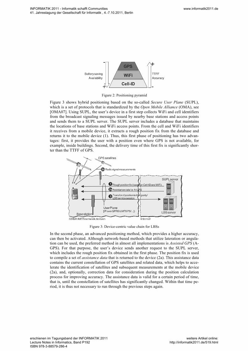
Figure 2: Positioning pyramid
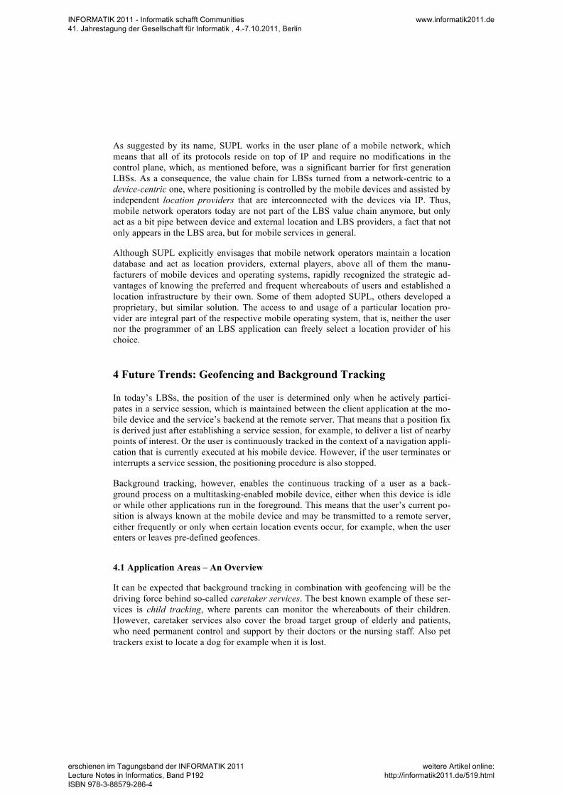
Figure 3 shows hybrid positioning based on the so-called Secure User Plane (SUPL), which is a set of protocols that is standardized by the Open Mobile Alliance (OMA), see [OMA07]. Using SUPL, the user’s device in a first step collects WiFi and cell identifiers from the broadcast signaling messages issued by nearby base stations and access points and sends them to a SUPL server. The SUPL server includes a database that maintains the locations of base stations and WiFi access points. From the cell and WiFi identifiers it receives from a mobile device, it extracts a rough position fix from the database and returns it to the mobile device (1). Thus, this first phase of positioning has two advan-tages: first, it provides the user with a position even where GPS is not available, for example, inside buildings. Second, the delivery time of this first fix is significantly shor-ter than the TTFF of GPS.
Figure 3: Device-centric value chain for LBSs
In the second phase, an advanced positioning method, which provides a higher accuracy, can then be activated. Although network-based methods that utilize lateration or angula-tion can be used, the preferred method in almost all implementations is Assisted GPS (A-GPS). For that purpose, the user’s device sends another request to the SUPL server, which includes the rough position fix obtained in the first phase. The position fix is used to compile a set of assistance data that is returned to the device (2a). This assistance data contains the current constellation of GPS satellites and related data, which helps to acce-lerate the identification of satellites and subsequent measurements at the mobile device (2a), and, optionally, correction data for consideration during the position calculation process for improving accuracy. The assistance data is valid for a certain period of time, that is, until the constellation of satellites has significantly changed. Within that time pe-riod, it is thus not necessary to run through the previous steps again.
INFORMATIK 2011 - Informatik schafft Communities 41. Jahrestagung der Gesellschaft für Informatik , 4.-7.10.2011, Berlin
www.informatik2011.de
erschienen im Tagungsband der INFORMATIK 2011 Lecture Notes in Informatics, Band P192 ISBN 978-3-88579-286-4
weitere Artikel online: http://informatik2011.de/519.html
As suggested by its name, SUPL works in the user plane of a mobile network, which means that all of its protocols reside on top of IP and require no modifications in the control plane, which, as mentioned before, was a significant barrier for first generation LBSs. As a consequence, the value chain for LBSs turned from a network-centric to a device-centric one, where positioning is controlled by the mobile devices and assisted by independent location providers that are interconnected with the devices via IP. Thus, mobile network operators today are not part of the LBS value chain anymore, but only act as a bit pipe between device and external location and LBS providers, a fact that not only appears in the LBS area, but for mobile services in general.
Although SUPL explicitly envisages that mobile network operators maintain a location database and act as location providers, external players, above all of them the manu-facturers of mobile devices and operating systems, rapidly recognized the strategic ad-vantages of knowing the preferred and frequent whereabouts of users and established a location infrastructure by their own. Some of them adopted SUPL, others developed a proprietary, but similar solution. The access to and usage of a particular location pro-vider are integral part of the respective mobile operating system, that is, neither the user nor the programmer of an LBS application can freely select a location provider of his choice.
4 Future Trends: Geofencing and Background Tracking
In today’s LBSs, the position of the user is determined only when he actively partici-pates in a service session, which is maintained between the client application at the mo-bile device and the service’s backend at the remote server. That means that a position fix is derived just after establishing a service session, for example, to deliver a list of nearby points of interest. Or the user is continuously tracked in the context of a navigation appli-cation that is currently executed at his mobile device. However, if the user terminates or interrupts a service session, the positioning procedure is also stopped.
Background tracking, however, enables the continuous tracking of a user as a back-ground process on a multitasking-enabled mobile device, either when this device is idle or while other applications run in the foreground. This means that the user’s current po-sition is always known at the mobile device and may be transmitted to a remote server, either frequently or only when certain location events occur, for example, when the user enters or leaves pre-defined geofences.
4.1 Application Areas – An Overview
It can be expected that background tracking in combination with geofencing will be the driving force behind so-called caretaker services. The best known example of these ser-vices is child tracking, where parents can monitor the whereabouts of their children. However, caretaker services also cover the broad target group of elderly and patients, who need permanent control and support by their doctors or the nursing staff. Also pet trackers exist to locate a dog for example when it is lost.
INFORMATIK 2011 - Informatik schafft Communities 41. Jahrestagung der Gesellschaft für Informatik , 4.-7.10.2011, Berlin
www.informatik2011.de
erschienen im Tagungsband der INFORMATIK 2011 Lecture Notes in Informatics, Band P192 ISBN 978-3-88579-286-4
weitere Artikel online: http://informatik2011.de/519.html
Mobile marketing is another, promising application area for geofencing and background tracking. For example, instead of a manual check-in procedure, which is common prac-tice in today’s check-in services, the user may automatically be checked in and out as soon as he enters or leaves certain geofences. In this way, the authenticity of such ser-vices can be increased: the user’s real position is shown to the community and it may not happen that other community members get misleading information about the user’s whereabouts, for example, when he forgets to perform a manual check-out when leaving a particular place. In the emerging area of couponing services, background tracking makes the cumbersome and explicit search for relevant coupons obsolete; instead the user can be proactively informed about the availability of beneficiaries offered by a shop when he is in close vicinity to this shop. Furthermore, background tracking is a pre-requisite for establishing location-based recommender systems, which will be described in the next section.
4.2 Location-based Recommendations
Recommender systems represent a key technology in the area of information relevance. The first of these systems emerged in the context of electronic commerce and helped users to find products, content, and services under consideration of their interests. They turned out to be a very powerful instrument in long-tail businesses, which are characte-rized by an overwhelming number of items that are offered for purchase [An06]. Exam-ples of such businesses are the markets for books, music, and movies. Recommender systems developed from the rudimentary content-based filtering, where user profiles are matched with product features, towards sophisticated tools, which utilize techniques of data mining and knowledge engineering. A very powerful approach is collaborative fil-tering, where the activities and preferences of large amounts of users are observed, and recommendations are compiled for a user based on his similarity to other users. The ad-vantage of this approach is that the cumbersome manual maintenance of a database with features and descriptions of tens (or hundreds) of thousands of products becomes obso-lete. Instead, recommendations are based solely on the comparison of a user’s activities in the past with those of other users. A detailed overview of recommender systems can be found in [AT05] and [RR+11].
LBSs adopted the idea of recommender systems from the very beginnings. The afore-mentioned PoI services, which coined the first LBS generation and are still dominating the second one, can be regarded as very simple recommender systems, which provide the user with a list of PoI based on his current position. However, location is still the only dimension in this business; other criteria like the user’s interests, for example, his prefe-rences for certain types of restaurants or museums, or context parameters like his current mood or accompanying persons are not taken into account. The latter is subject of inten-sive research efforts in the area of context-based recommender systems, but, as men-tioned before, the automatic detection of such context parameters is still a challenge and makes it difficult to turn these efforts into a business.
INFORMATIK 2011 - Informatik schafft Communities 41. Jahrestagung der Gesellschaft für Informatik , 4.-7.10.2011, Berlin
www.informatik2011.de
erschienen im Tagungsband der INFORMATIK 2011 Lecture Notes in Informatics, Band P192 ISBN 978-3-88579-286-4
weitere Artikel online: http://informatik2011.de/519.html
However, the forthcoming emergence of geofencing and background tracking tech-nologies will establish a basis for a broad commercial introduction of location-based re-commender systems, which utilize the locations of users as primary context information for collaborative filtering. In this scenario, the data basis for applying collaborative filte-ring is given by the frequent visits of large amounts of users at public places, which are modeled as geofences. Examples include restaurants, bars, shopping malls, discotheques, or stores of different kinds. Assuming that a sufficient granularity of background track-ing in the time domain is given, other relevant information can be considered as well, for example, the average dwell time of users at a particular location or the preferred entry and exit times there. Based on such data of a sufficient number of users, a social graph can be composed that categorizes users according to their preferences for certain places. Recommendations that can be derived from this approach include, but are not limited to, the following examples:
• People who frequently visit the restaurant A are also frequent visitors of restau-rants B and C.
• Many people who visit the bar A on a Saturday evening join the discotheque B afterwards.
• People on average spend 10 minutes less time at the haircutter A than at other haircutters.
When starting to create a data basis from the movements of users, it is to be expected that the resulting social graph will at first show a strong local coherence, which means that it reflects only similarities of users that live in the same district or city. However, in an advanced stage when the data basis has grown, the graph will also cover the move-ments of travellers, which makes it then possible to recommend remote locations, which is useful, for example, when users prepare for a journey.
Following these ideas, geofencing and background tracking are enablers that open the market for recommender systems in the mobile environment. While traditional recom-menders help users to navigate through long-tail businesses with an overwhelming num-ber of physical products or digital content, their adoption in the LBS area now helps users to navigate through the real world. The next section introduces the main technolo-gies and challenges behind geofencing and background tracking.
5 Geofencing and Background Tracking: Solutions and Challenges
The emergence of geofencing and background tracking is driven by the latest introduc-tion of multitasking capabilities on an increasing number of mobile devices, which enable to carry out the positioning process in the background, and by supporting proto-cols like SUPL 2.0, which is introduced in the following section. However, open ques-tions that still need to be addressed are the increased battery consumption at mobile devices caused by background tracking as well as privacy concerns of the users. These issues will be discussed subsequently.
INFORMATIK 2011 - Informatik schafft Communities 41. Jahrestagung der Gesellschaft für Informatik , 4.-7.10.2011, Berlin
www.informatik2011.de
erschienen im Tagungsband der INFORMATIK 2011 Lecture Notes in Informatics, Band P192 ISBN 978-3-88579-286-4
weitere Artikel online: http://informatik2011.de/519.html
5.1 SUPL 2.0
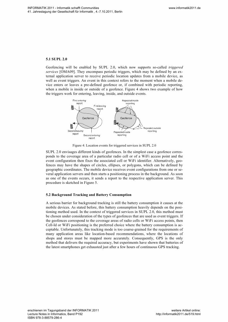
Geofencing will be enabled by SUPL 2.0, which now supports so-called triggered services [OMA09]. They encompass periodic triggers, which may be defined by an ex-ternal application server to receive periodic location updates from a mobile device, as well as event triggers. An event in this context refers to the moment when a mobile de-vice enters or leaves a pre-defined geofence or, if combined with periodic reporting, when a mobile is inside or outside of a geofence. Figure 4 shows two example of how the triggers work for entering, leaving, inside, and outside events.
Figure 4: Location events for triggered services in SUPL 2.0
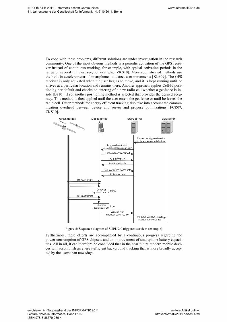
SUPL 2.0 envisages different kinds of geofences. In the simplest case a geofence corres-ponds to the coverage area of a particular radio cell or of a WiFi access point and the event configuration then fixes the associated cell or WiFi identifier. Alternatively, geo-fences may have the shapes of circles, ellipses, or polygons, which can be defined by geographic coordinates. The mobile device receives event configurations from one or se-veral application servers and then starts a positioning process in the background. As soon as one of the events occurs, it sends a report to the respective application server. This procedure is sketched in Figure 5.
5.2 Background Tracking and Battery Consumption
A serious barrier for background tracking is still the battery consumption it causes at the mobile devices. As stated before, this battery consumption heavily depends on the posi-tioning method used. In the context of triggered services in SUPL 2.0, this method must be chosen under consideration of the types of geofences that are used as event triggers. If the geofences correspond to the coverage areas of radio cells or WiFi access points, then Cell-Id or WiFi positioning is the preferred choice where the battery consumption is ac-ceptable. Unfortunately, this tracking mode is too coarse-grained for the requirements of many application areas like location-based recommendations, where the locations of shops and stores must be mapped more accurately. Consequently, GPS is the only method that delivers the required accuracy, but experiments have shown that batteries of the latest smartphones get exhausted just after a few hours of continuous GPS tracking.
INFORMATIK 2011 - Informatik schafft Communities 41. Jahrestagung der Gesellschaft für Informatik , 4.-7.10.2011, Berlin
www.informatik2011.de
erschienen im Tagungsband der INFORMATIK 2011 Lecture Notes in Informatics, Band P192 ISBN 978-3-88579-286-4
weitere Artikel online: http://informatik2011.de/519.html
To cope with these problems, different solutions are under investigation in the research community. One of the most obvious methods is a periodic activation of the GPS recei-ver instead of continuous tracking, for example, with typical activation periods in the range of several minutes, see, for example, [ZKS10]. More sophisticated methods use the built-in accelerometer of smartphones to detect user movements [KL+09]. The GPS receiver is only activated when the user begins to move, and it is kept running until he arrives at a particular location and remains there. Another approach applies Cell-Id posi-tioning per default and checks on entering of a new radio cell whether a geofence is in-side [Ba10]. If so, another positioning method is selected that provides the desired accu-racy. This method is then applied until the user enters the geofence or until he leaves the radio cell. Other methods for energy efficient tracking also take into account the commu-nication overhead between device and server and propose optimizations [FCR07, ZKS10].
Figure 5: Sequence diagram of SUPL 2.0 triggered services (example)
Furthermore, these efforts are accompanied by a continuous progress regarding the power consumption of GPS chipsets and an improvement of smartphone battery capaci-ties. All in all, it can therefore be concluded that in the near future modern mobile devi-ces will accomplish an energy-efficient background tracking that is more broadly accep-ted by the users than nowadays.
INFORMATIK 2011 - Informatik schafft Communities 41. Jahrestagung der Gesellschaft für Informatik , 4.-7.10.2011, Berlin
www.informatik2011.de
erschienen im Tagungsband der INFORMATIK 2011 Lecture Notes in Informatics, Band P192 ISBN 978-3-88579-286-4
weitere Artikel online: http://informatik2011.de/519.html
5.3 Privacy Issues
The protection of the users’ privacy is an important, but also challenging matter in the context of background tracking. The major concern is that it becomes possible to gene-rate a seamless trace of places the user has visited in the past, which may also include visits to political and religious groups, medical doctors, or nightclubs, to name only a few very personal locations. Such traces may then be subject to misuse by attackers for criminal or commercial purposes. To cope with these problems, different techniques for obfuscation and pseudonymization have been proposed in the past, see [Cu02, GG03]. Obfuscation means that blurring will be added to the derived position intentionally, while in pseudonymization a user’s location data is not disclosed with his true identity. Unfortunately, it turned out that the realization of these privacy features is very complex and often also in conflict with the actual functions of an LBS.
However, it must be stated that the concept of geofences prevents the generation of seamless traces. Assuming that the user has control of all geofences where he is tracked, he can exclude locations where he wants to be invisible for others from the tracking process. Nevertheless, there remains a problem that is related to the complexity of the management of a user’s geofences. It can be expected that users will subscribe for many different applications that apply background tracking, each of it coming with its own rules and front-views for fixing and configuring geofences and related events. In addi-tion, users tend to access LBSs from many different devices, including business phones, private phones, tablets, and notebooks. In the worst case, the configurations have to be done for each device separately. The resulting complexity may overburden the user and prevent him from using geofence services.
6 Conclusions
Geofencing and background tracking are promising features of the next LBS generation, which in particular will push the broad application area of information relevance, for example, location-based recommender systems. However, the role of mobile network operators in these scenarios is still unclear.
On the one hand, they can leave this business to other players, like device manufacturers, who will manage geofencing applications and the resulting location data on behalf of their customers. They will then become the primary enablers for information relevance in mobile environments.
INFORMATIK 2011 - Informatik schafft Communities 41. Jahrestagung der Gesellschaft für Informatik , 4.-7.10.2011, Berlin
www.informatik2011.de
erschienen im Tagungsband der INFORMATIK 2011 Lecture Notes in Informatics, Band P192 ISBN 978-3-88579-286-4
weitere Artikel online: http://informatik2011.de/519.html
On the other hand, after their failure during the first LBS generation, mobile network operators can try to participate in the LBS business again and act as location providers that control the positioning process and background tracking, for example, via SUPL 2.0 or by other protocols. This solution is obvious as mobile network operators have a trus-ted relationship with their customers anyway and also track them in the context of cel-lular mobility management. Both LBS background and mobility management tracking could be combined to improve the performance and energy consumption of the tracking algorithms. The users would profit from an increased convenience and trust when using such services, while the operators could establish themselves as important players in the area of mobile information relevance.
References
[3GPP] 3GPP TS 03.71. Location Services (LCS); Functional Description – Stage 2. http://www.3gpp.org/
[AT05] Adomavicius, G., A. Tuzhilin. 2005. Toward the Next Generation of Recommender Systems: A Survey oft he State-of-the-Art and Possible Extensions. IEEE Transactions on Knowledge and Data Engineering, Vol. 17, No. 6, 734-749.
[An06] Anderson, C. 2006. The Long Tail: Why the Future of Business is Selling Less of More. Hyperion.
[Ba10] Bareth, U. 2010. Algorithmic Optimizations for Energy-efficient Monitoring of Spatial Objects on Smartphones. Proceedings of the 40th Annual Conference of the Gesellschaft für Informatik e.V. (INFORMATIK 2010). Köllen Druck + Verlag GmbH, pp. 577-582.
[BKR10] Bareth, U., A. Küpper, and P. Ruppel. 2010. geoXmart - a Marketplace for Geofence-Based Mobile Services. Proceedings of the IEEE 34th Annual Computer Software and Applications Conference (COMPSAC 2010). IEEE, 101-106.
[Cu02] Cuellar, J.R. 2002. Location Information Privacy. B. Srikaya (Ed.), Geographic Location in the Internet. Kluwer Academic Publishers. 179-208.
[DA99] Dey, A. K., G. D. Abowd. 1999. Towards a Better Understanding of Context and Context-Awareness. Technical Report GIT-GVU-99-22, Georgia Institute of Technology
[FCR07] Farrell, T., R. Cheng, and K. Rothermel. 2007. Energy-efficient Monitoring of Mobile Objects with Uncertainty-aware Tolerances. Proceedings of the 11th International Database Engineering and Applications Symposium (IDEAS ’07). Washington, DC, USA. IEEE Computer Society. 129–140.
[GG03] Gruteser, M., D. Grunwald. 2003. Anonymous Usage of Location-based Services Through Spatial and Temporal Cloaking. Proceedings of the ACM/USENIX International Conference on Mobile Systems, Applications and Services (MobiSys ’03), San Francisco, California, USA, 31-42
[KL+09] Kjærgaard, M. B., J. Langdal, T. Godsk, and T. Toftkjær. 2009. Entracked: Energy-efficient Robust Position Tracking for Mobile Devices. Proceedings of the 7th International Conference on Mobile Systems, Applications, and Services (MobiSys ‘09). New York, NY. ACM. 221– 234.
[Kü99] Küpper, A. 2005. Location-based Services – Fundamentals and Operation. John Wiley & Sons.
[OMA07]OMA. 2007. Secure User Plane Location Architecture – Approved Version 1.0, OMA-AD-SUPL-V1_0-20070615-A, http://www.openmobilealliance.org/
[OMA09]OMA. 2009. Secure User Plane Location Architecture – Candidate Version 2.0, OMA-AD-SUPL-V2_0-20091208-C, http://www.openmobilealliance.org/
INFORMATIK 2011 - Informatik schafft Communities 41. Jahrestagung der Gesellschaft für Informatik , 4.-7.10.2011, Berlin
www.informatik2011.de
erschienen im Tagungsband der INFORMATIK 2011 Lecture Notes in Informatics, Band P192 ISBN 978-3-88579-286-4
weitere Artikel online: http://informatik2011.de/519.html
[RR+11] Ricci, F., L. Rokach, B. Shapira, and P.B. Kantor (Eds.). 2011. Recommender Systems Handbook. 1st Edition, Springer , ISBN: 978-0-387-85819-7
[ZKS10] Zhuang, Z., K.-H. Kim, and J. P. Singh. 2010. Improving Energy Efficiency of Location Sensing on Smartphones. Proceedings of the 8th International Conference on Mobile Systems, Applications, and Services, 315–330.
INFORMATIK 2011 - Informatik schafft Communities 41. Jahrestagung der Gesellschaft für Informatik , 4.-7.10.2011, Berlin
www.informatik2011.de
erschienen im Tagungsband der INFORMATIK 2011 Lecture Notes in Informatics, Band P192 ISBN 978-3-88579-286-4
weitere Artikel online: http://informatik2011.de/519.html