Geochemical Evaluation of the Winchester Roadless Area ...
9
UNITED STATES DEPARTMENT OF THE INTERIOR GEOLOGICAL SURVEY Geochemical Evaluation of the Winchester Roadless Area, Cochise County, Arizona by M. A. Chaffee Open-File Report 85-113 This report is preliminary and has not been reviewed for conformity with U.S. Geological Survey editorial standards and stratgraphic nomenclature. Any use of trade names is for descriptive purposes only and does not imply endorsement by the USGS. 1985
Transcript of Geochemical Evaluation of the Winchester Roadless Area ...
UNITED STATES DEPARTMENT OF THE INTERIOR
GEOLOGICAL SURVEY
Geochemical Evaluation of the
Winchester Roadless Area, Cochise County, Arizona
by
M. A. Chaffee
Open-File Report 85-113
This report is preliminary and has not been reviewed for conformity with U.S. Geological Survey editorial standards and stratgraphic nomenclature. Any use of trade names is for descriptive purposes only and does not imply endorsement by the USGS.
1985
CONTENTS
Page
Studies related to wilderness.............................................. 1
In troduction............................................................... 1
Geologic settlng........................................................... 1
Geochemical investigations................................................. 1
Evaluation procedures...................................................... 5
Rock samples........................................................... 5
Stream-sediment samples................................................ 6
Concentrate samples.................................................... 6
Conclusions................................................................ 6
References cited........................................................... 6
FIGURES
Figure 1. Index map....................................................... 2
Figure 2. Geologic map.................................................... 3
PLATE
Plate 1. Summary geochemical anomaly map.......................... in pocket
STUDIES RELATED TO WILDERNESS
The Wilderness Act (Public Law 88-577, September 3, 1964) and related acts require the U.S. Geological Survey and the U.S. Bureau of Mines to survey certain areas on Federal lands to determine their mineral values, if any, that may be present. Results must be made available to the public and be submitted to the President and the Congress. This report presents the results of a geochemical survey of the Winchester Roadless Area (3122) in the Coronado National Forest, Cochise County, Arizona. The area was classified as a further planning area during the Second Roadless Area Review and Evaluation (RARE II) by the U.S. Forest Service, January 1979.
INTRODUCTION
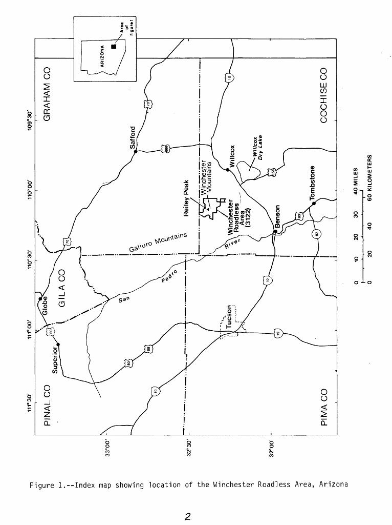
The Winchester Roadless Area, located in northwestern Cochise County, Arizona (fig. 1), consists of 14,100 acres within the Coronado National Forest. Geochemical sampling was conducted during 1980. This report summarizes the results of that investigation and provides details of the geochemical evaluation used in producing the final mineral resource assessment of the study area (Keith and others, 1983).
GEOLOGIC SETTING
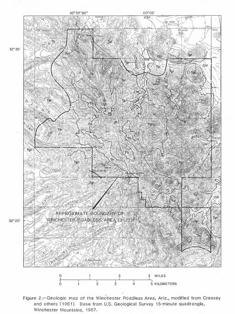
The geology of the Winchester Roadless Area was mapped previously by Creasey and others (1961; 1981). For the roadless area evaluation, the original mapping was field checked and modified where necessary (Keith and others, 1983). The geologic map from the report by Keith and others (1983) is included here for reference (fig. 2). Outcrops in the study area consist of a 1,000- to 2,000-ft-thick sequence of ash-flow tuffs and lava flows of Miocene age (Cooper and Silver, 1964) that vary in composition from latite to rhyolite. These silicic flows and tuffs are overlain locally by vesicular basalt flows, also of Tertiary age. Quaternary alluvium is present in many ,of the washes draining the study area. No evidence of mineralization was observed in the field. Further details of the geology of the roadless area can be found in the references cited above.
GEOCHEMICAL INVESTIGATIONS
This geochemical report is based on analyses of 23 rock samples, 27 minus-60-mesh stream-sediment samples, and 25 nonmagnetic heavy-mineral- concentrate samples processed from active stream alluvium.
All rock samples were composited from chips collected from outcrops that were considered to be representative of exposures in the vicinity of each of the plotted sites (plate 1). None was found to be hydrothermal ly altered. Wherever possible, the samples were hand cobbed to remove any obviously weathered material .
The stream-sediment samples consisted of active alluvium collected primarily from first-order (unbranched) and second-order (below the junction of two first-order) streams, as shown on the topographic map (plate 1). Each sample was composited from active alluvium collected from several locations within an area that may extend as much as 50 ft from each plotted site. The samples were sieved, and the minus-60-mesh material was retained for analysis. The chemical analyses of the stream-sediment samples reflect the chemistry of rock material eroded from the drainage basin upstream from each sample site
DC 111
</> ujuj Sr
5 1O _
. O (O
O .
o .
0-^-0
Figure 1.--Index map showing location of the Winchester Roadless Area, Arizona
110° 07'30" 110° 05'
32°25'
32° 20'
:^.V> vs^vxywA' vw^ X>x 1 i%^ XV. ;> fi^^^jjijgk p fov^-rs J
wfr$m%'< ^/>;^f'-J^
3 MILLS
5 KILOMETERS
Figure 2. Geologic map of the Winchester Roadless Area, Ariz., modified from Creasey and others (1961). Base from U.S. Geological Survey 15-minute quadrangle, Winchester Mountains, 1957.
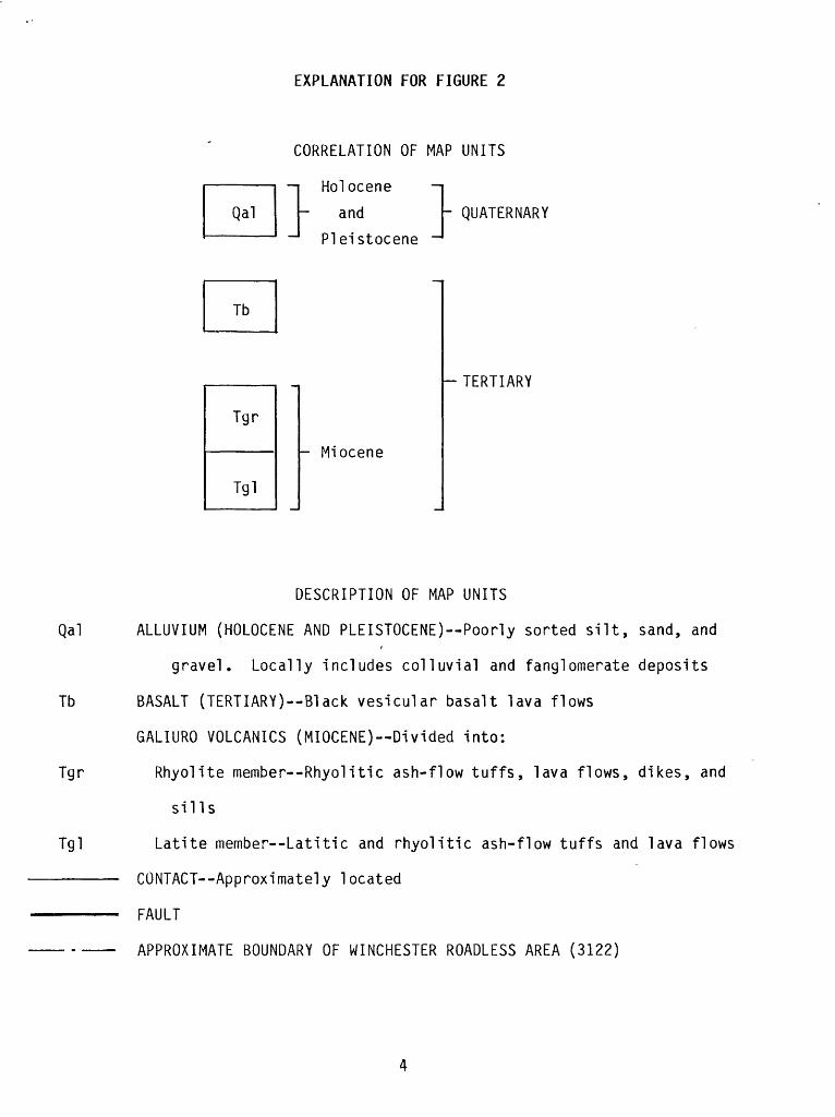
EXPLANATION FOR FIGURE 2
CORRELATION OF MAP UNITS
Holocene
- and
Pleistocene -1- QUATERNARY
Tgr
Tgl
- Miocene
-TERTIARY
DESCRIPTION OF MAP UNITS
Qal ALLUVIUM (HOLOCENE AND PLEISTOCENE) Poorly sorted silt, sand, and
gravel. Locally includes colluvial and fanglomerate deposits
Tb BASALT (TERTIARY)--Black vesicular basalt lava flows
GALIURO VOLCANICS (MIOCENE) Divided into:
Tgr Rhyolite member Rhyolitic ash-flow tuffs, lava flows, dikes, and
sills
Tgl Latite member Latitic and rhyolitic ash-flow tuffs and lava flows
CONTACT Approximately located
FAULT
APPROXIMATE BOUNDARY OF WINCHESTER ROADLESS AREA (3122)
and may reveal unusually high concentrations of elements related to mineral deposits.
The nonmagnetic heavy-mineral-concentrate samples were prepared from the same active stream-sediment material used to make the minus-60-mesh stream- sediment samples. Each bulk sample was panned and dried, and the resulting heavy-mineral fraction was treated with bromoform. The grains that were heavier than the bromoform were saved and separated into a magnetic and a relatively nonmagnetic fraction using a Frantz Isodynamic Separator. The nonmagnetic fraction was analyzed for this report. The analyses of the concentrate samples provide information about the chemistry of a limited number of minerals present in rock material eroded from the drainage basins upstream from each sample site. The concentrating procedures may produce a sample rich in heavy minerals commonly associated with many types of mineral deposits. The selective concentration of ore-related minerals permits determination of some elements that are not easily detected in bulk stream- sediment samples. The chemical composition of a nonmagnetic heavy-mineral concentrate may also indicate specific minerals. For example, the cobalt content in a stream-sediment sample may be related to a number of different minerals, many of which normally have no relation to hydrothermal mineralization. Anomalous cobalt concentrations in a concentrate sample, however, often indicate the presence of minerals such as pyrite, or possibly other iron-rich minerals, commonly associated with mineralization.
All three types of samples were analyzed for 31 elements (Ag, As, Au, B, Ba, Be, Bi, Ca, Cd, Co, Cr, Cu, Fe, La, Mg, Mn, Mo, Nb, Ni, Pb, Sb, Sc, Sn, Sr, Th, Ti, V, W, Y, Zn, and Zr) using a six-step semiquantitative emission spectrographic method (Grimes and Marranzino, 1968). Because of the limited amount of sample material, the nonmagnetic heavy-mineral concentrates were only analyzed spectrographically. The rock and stream-sediment samples were also analyzed for zinc and gold by atomic-absorption spectrometry (Ward and others, 1969; Meier, 1980).
Further details concerning the collection, preparation, and analysis of the samples, as well as a tabulation of the analyses, have been published by Sutley and others (1983).
Evaluation Procedures
Of the elements determined in the samples, 11 (Ag, Au, B, Bi, Co, Cu, Fe, Mo, Pb, Sn, and Zn) were selected as being indicative of mineral deposits that might be expected to be present in or near the study area. For each selected element in each sample medium, a threshold value (highest background value) was chosen on the basis of evaluations of comparable geochemical data sets for similar sample media collected in Arizona (Chaffee, unpublished data). Anomalous concentrations are shown for each appropriate sample on figure 3.
Rock samples
No significant anomalies were found for any of the elements determined in any of the rock samples. One sample, WN-20 (plate 1), a latite in the Galiuro Volcanics (Keith and others, 1983), contained 100 ppm copper, a value that might be considered weakly anomalous for this rock type. The unaltered nature of this sample, taken together with the lack of other anomalous elements, suggests that this copper value only represents a high background concentration and is not related to copper mineralization.
Stream-sediment samples
No anomalous concentrations that could be related to hydrothermal mineralization were detected in any of the stream-sediment samples.
Concentrate samples
Several of the concentrate samples contained apparently anomalous concentrations of one or more of the elements boron, bismuth, cobalt, copper, iron, molybdenum, lead, or tin. The anomalous values for these elements are shown on plate 1. With the possible exception of the copper anomaly in sample WN-02 (700 ppm) and the lead anomalies in samples WN-16 and WN-20 (200 ppm), however, the concentrations are probably only those to be expected in a concentrate of alluvial material derived from the rock types present. The copper and lead anomalies are not related to any known mineralization and are not reflected in any of the stream-sediment samples. It is thus suspected that these anomalies reflect contamination by hikers or hunters that frequent the roadless area.
CONCLUSIONS
Based on the chemical analyses performed on the rock, minus-60-mesh stream-sediment, and nonmagnetic heavy-mineral-concentrate samples collected for this study, no anomalies have been identified that can be definitely related to any exposed mineral deposits. Buried deposits would probably not be identified by the sampling methods used. The few anomalous concentrations found in the samples seem to reflect nonnal rock chemistry or human contamination.
REFERENCES CITED
Cooper, J. R., and Silver, L. T., 1964, Geology and ore deposits of the Dragoon quadrangle, Cochise County, Arizona: U.S. Geological Survey Professional Paper 416, 196 p.
Creasey, S. C., Jackson, E. D., and Gulbrandsen, R. A., 1961, Reconnaissance geologic map of parts of the San Pedro and Aravaipa Valleys, south-central Arizona: US. Geological Survey Mineral Investigations Field Studies Map MF-238, scale 1:125,000.
Creasey, S. C., Jinks, J. E., Williams, F. E., and Meeves, H. C., 1981, Mineral resources of the Galiuro Wilderness and contiguous further planning areas, Arizona, with a section on Aeromagnetic survey and interpretation, by_ W. E. Davis: U.S. Geological Survey Bulletin 1490, 94 p.
Grimes, D. J., and Marranzino, A. P., 1968, Direct-current arc andalternating-current spark emission spectrographic field methods for the semiquantitative analysis of geologic materials: U.S. Geological Survey Circular 591, 6 p.
Keith, W. J., Martin, R. A., and Kreidler, T. J., 1983, Mineral resourcepotential of the Winchester Roadless Area, Cochise County, Arizona: U.S. Geological Survey Open-File Report 82-1028, 7 p.
Meier, A. L., 1980, Flameless atomic-absorption determination of gold in geological materials: Journal of Geochemical Exploration, v. 13, no. 1, p. 77-85.
Sutley, S. J., Chaffee, M. A., Fey, D. L., and Hill, R. H., 1983, Chemical analyses and statistical summaries for samples of rock, minus-60-mesh (0.25-mm) stream sediment, and nonmagnetic heavy-mineral concentrate, Winchester Roadless Area, Arizona: U.S. Geological Survey Open-File Report 83-648, 18 p., 1 pi.
Ward, F. N., Nakagawa, H. M., Harms, T. M., and VanSickle, G. H., 1969, Atomic absorption methods of analysis useful in geochemical exploration: U.S. Geological Survey Bulletin 1289, 45 p.