Geoarchaeology of the Qtimran Archaeological Site, Israelpeople.uwec.edu/jolhm/Research_Pub/pdfs of...
9
Geoarchaeology of the Qtimran Archaeological Site, Israel Philip Reeder, Harry ]ol, Richard Fretmd, Carl Savage Photography by the authors Introduction G e o a r c li a c o I o g y combines archaeological ri'scjrch vvilh metliods and concepts of thft-Lirlh sciences (But/iT 1482). Geography (bolh physical and human), geology, gconiorphology and geophysics ha\e been melded witli .irchaeology to develop a multidiscipljnory tippro.ich for studying the site at Khirbet Qumran (hereafter Qumran) in Israel. The full range of earth (geo) sciences can be applied to archaeological evidence at the Qumran Archaeological Site allowing past processes and events to be inferred (Rapp and Hill 1998). In the summers of 21)01 and 20(12, the muitidiscipiinary research team consisted of geographers, a geophysicist, a historian, a photographer, biblical scholars and archaeologists. Ibis team oi researchers attempted to expand the existing base of knowledge about Qumran. Qumran is along the western shore of the Dead Sea (Figure 1). I'bis site is most famous for the caves, kKated in the cliffs west of the site, where the Dead Sea Scrolls were discovered. In 1947, Arab shepherds stumbled upon a cave and what they found was hailed as the greatest archaeological discovery of the twentieth century (Vanderkam 1994). Eleven caves at Qumran hti\e \ ielded the remains of approximately 800 manuscripts. Data compiled by Roland de Vaux (1973), based on detailed excavations from 1953 to 1956, make it clear that Qumran was occupied by a group engaged in communal activities and religious rites for most of its active history (Schiffman 1995). In an attempt to understand the historical context of the Dead Sea Scrolls, scholars have tried to identify tbe group responsible for these documents (VanderKam and Flint 2002). Schiffman (1995) accepted the conclusion, expressed by many biblical scholars, that tlie Qumran Si>ct was intrinsically linked to the scrolls found in the caves. The most widely adopted view is that the Qumran Sect was a small branch of the larger Essene mi>vement (Sukenik 1955; VanderKam and Flint 2002). Scholars believe that this sectarian group was responsible for . \ /' ) Tel Aviv, \ / ( Gaza ... Strip, _..•> -// V \ \ \ \ \ \ \ i EGYPT ^ ^ tart f c 9I JBI UodJ j ISRAEL Negev \ \. \ \ / Hi \ ' LEBANON - ' - / /•••<., ( /Heights': • ( \ .' i West Bank / / i TQUMRAN {' f' i I / JORDAN Mall Johnson Figure 1: ioaUioii nj llic Qiiiniivi Archih'olo;;;iaU Site. gathering together, copying (mostly between 150 B.C.E and 68 C.E.), and depositing documents in area caves. After modern discovery, these documents were called the Dead Sea Scrolls (Schiffman 1995). A large cemetery just east of the archaeological site and smaller cemeteries to the north and south (Figure 2) are important parts of the complex (VanderKam 1994). The Main Cemetery begins approximately 50 melcrs from the east wall of the ruins at Qumran (de Vaux 1973; VanderKam and Flint, 2002). The North Cemetery is approximately 50 meters nortb-northeast from tbe Main Cemetery and the South Cemetery is about 230 meters to the south-southwest. The South Cemetery is situated on a hill on the other side of Wadi Qumran. Uetween 1953 and I95fi, de Vaux excavated 37 of the estimated 1,100 tombs in the Main Cemetery, two out of twehe in the North Cemetery, and four out ot 30 in tbe South Cemetery. De Vaux estimated there were a total of 1,142 graves in the three cemeteries at Qumran. in 1966 and 1967, journalist S.H. Steckoil, with permission from the Jordanian Department of Antiquities (Qumran was in Jordan prior to the 1967 war), excavated nine graves in the Main Cemetery. Overall, a total of 52 graves were legally excavated at Qumran. Nine early reports, dating back as far as 1850, described various aspects of the Qumran Site, but no one had subjected the ruins to a thorough examination until after tbe discovery of scroll material in Ca\ e One in early 1947 (VanderKam and Flint 2002). The first scholars did not begin to work at Qumran until February, 1949 because of political instability and hostilities. The excavation at Cave One in 1949 was directed by de Vaux and G. Lankester Harding. During this exc.n.ition, tlu'y also visited the ruins of Qumran and conducted a quick surface examination, They retu rried 12 FOCUS on Geographii Volume 48, Number 1
Transcript of Geoarchaeology of the Qtimran Archaeological Site, Israelpeople.uwec.edu/jolhm/Research_Pub/pdfs of...
Geoarchaeology of theQtimran Archaeological Site, Israel
Philip Reeder, Harry ]ol, Richard Fretmd, Carl Savage
Photography by the authors
Introduction
G e o a r c li a c o I o g y c o m b i n e sarchaeological ri'scjrch vvilh metliods andconcepts of thft-Lirlh sciences (But/iT 1482).Geography (bolh physical and human),geology, gconiorphology and geophysicsha\e been melded witli .irchaeology todevelop a multidiscipljnory tippro.ich forstudying the site at Khirbet Qumran(hereafter Qumran) in Israel. The full rangeof earth (geo) sciences can be applied toarchaeological evidence at the QumranArchaeological Site allowing past processesand events to be inferred (Rapp and Hill1998).
In the summers of 21)01 and 20(12, themuitidiscipiinary research team consistedof geographers, a geophysicist, a historian, aphotographer, biblical scholars andarchaeologists. Ibis team oi researchersattempted to expand the existing base ofknowledge about Qumran.
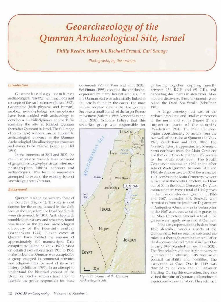
Qumran is along the western shore ofthe Dead Sea (Figure 1). I'bis site is mostfamous for the caves, kKated in the cliffswest of the site, where the Dead Sea Scrollswere discovered. In 1947, Arab shepherdsstumbled upon a cave and what they foundwas hailed as the greatest archaeologicaldiscovery of the twentieth century(Vanderkam 1994). Eleven caves atQumran hti\e \ ielded the remains ofapproximately 800 manuscripts. Datacompiled by Roland de Vaux (1973), basedon detailed excavations from 1953 to 1956,make it clear that Qumran was occupied bya group engaged in communal activitiesand religious rites for most of its activehistory (Schiffman 1995). In an attempt tounderstand the historical context of theDead Sea Scrolls, scholars have tried toidentify tbe group responsible for these
documents (VanderKam and Flint 2002).Schiffman (1995) accepted the conclusion,expressed by many biblical scholars, thattlie Qumran Si>ct was intrinsically linked tothe scrolls found in the caves. The mostwidely adopted view is that the QumranSect was a small branch of the larger Essenemi>vement (Sukenik 1955; VanderKam andFlint 2002). Scholars believe that thissectarian group was responsible for
. \
/' )Tel Aviv, \
/ (
Gaza ...S t r i p , _..•>
- / /V\\\\\\\i
EGYPT
^ ^
tart f c 9IJBI UodJ
j
ISRAEL
Negev
\\.\
\ /Hi \ '
LEBANON - ' - // •••<. , (
/Heights':
• (\ .'
i
West Bank /
/
i
TQUMRAN
{'
f'i
I/
JORDAN
Mall Johnson
Figure 1: ioaUioii nj llic QiiiniiviArchih'olo;;;iaU Site.
gathering together, copying (mostlybetween 150 B.C.E and 68 C.E.), anddepositing documents in area caves. Aftermodern discovery, these documents werecalled the Dead Sea Scrolls (Schiffman1995).
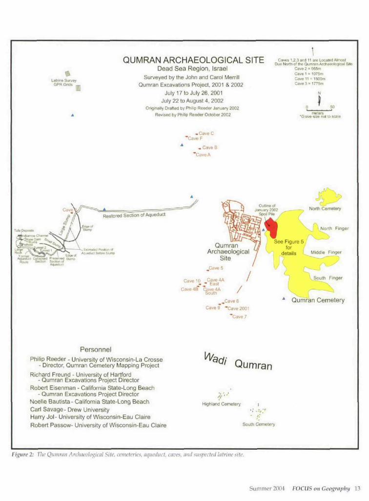
A large cemetery just east of thearchaeological site and smaller cemeteriesto the north and south (Figure 2) areimportant par ts of the complex(VanderKam 1994). The Main Cemeterybegins approximately 50 melcrs from theeast wall of the ruins at Qumran (de Vaux1973; VanderKam and Flint, 2002). TheNorth Cemetery is approximately 50 metersnortb-northeast from tbe Main Cemeteryand the South Cemetery is about 230 metersto the south-southwest. The SouthCemetery is situated on a hill on the otherside of Wadi Qumran. Uetween 1953 andI95fi, de Vaux excavated 37 of the estimated1,100 tombs in the Main Cemetery, two outof twehe in the North Cemetery, and fourout ot 30 in tbe South Cemetery. De Vauxestimated there were a total of 1,142 gravesin the three cemeteries at Qumran. in 1966and 1967, journalist S.H. Steckoil, withpermission from the Jordanian Departmentof Antiquities (Qumran was in Jordan priorto the 1967 war), excavated nine graves inthe Main Cemetery. Overall, a total of 52graves were legally excavated at Qumran.
Nine early reports, dating back as far as1850, described various aspects of theQumran Site, but no one had subjected theruins to a thorough examination until aftertbe discovery of scroll material in Ca\ e Onein early 1947 (VanderKam and Flint 2002).The first scholars did not begin to work atQumran until February, 1949 because ofpolitical instability and hostilities. Theexcavation at Cave One in 1949 wasdirected by de Vaux and G. LankesterHarding. During this exc.n.ition, tlu'y alsovisited the ruins of Qumran and conducteda quick surface examination, They retu rried
12 FOCUS on Geographii Volume 48, Number 1
LaUine SurveyGPR Grids _
QUMRAN ARCHAEOLOGICAL SITEDead Sea Region, Israel
Surveyed by the John and Carol MerrillQumran Excavations Project, 2001 & 2002
July 17 to July 26, 2001July 22 to August 4, 2002
Originally Drafted by Philip Reeder January 2002
Revised by Philip Reecfer October 2002
• CaveC"Cave F
, Cave B
"CaveA
Caves 1,3.3 end 11 are Located AlmostDUB Norlh of Ihe Oumran Archaeological Site
Cave 2 = 965mCave 1 = 1075ftiCawB 11 = 1500mCave 3 = 1775m
N
50meters
'Grave size not to scale
Restored Section of Aqueduct
Tufa Doposils
Forme- ' * » - = * ' ~ ^ \ Edgeo'AgueOuU Collapsea P'aiB<vuil slump
Rouie Sodion Secum olAguMucl
North Finger
Aqueduct flePora Stump
Cave 10 Cave4A^ ^ East
Cave 4B Cave 4ASouth
See Figure 5for
•'"' details ' , kiddie Finger
QumranArchaeological
SitejCave 5
Qumran CemeteryCave 9 -Cave 2001
'Cave 7
PersonnelPhilip Reeder - University of Wisconsin-La Crosse
- Director, Qumran Cemetery Mapping Project
Richard Freund - University of Hartford- Qumran Excavations Project Director
Robert Eisenman - California State-Long Beach- Qumran Excavations Project Director
Noelle Bautista- California State-Long BeachCarl Savage- Drevi/ UniversityHarry Jol- University of Wisconsin-Eau ClaireRobert Passow- University of Wisconsin-Eau Claire
Qumran
Highland Cemetery
South Cemetery
Figure 2: The Qiiitmm Avdmcolo^kal Site, cniictcrica, aijuciiuct, aivci^, nnii suspected latrine site.
Summer 2004 FOCUS on Geography 13
in late 1951 and bL'gan to excavate portionsof the surface ruins <ind cemetery. In 1953,de Vaux and Harding returned to work innewly found caves and at the surface ruinsand cemotery; additional expeditions werestaged in 1954, 1955, and 1956. After thefinal de Vaux-Harding expedition in 1956,little work was done with the archaeolo^;icalremains at Qumran until the mid-1980s. In1995-9f), Magen Broshi and Hanan Eshelconducted a six-week season of excavationin an area of collapsed ca\'es just north ofQumran. This was the last organizedresearch effort .it Qumr.in, until ourresearch team began work at the site in July2001.
The John ami Carol Merrill QumranExcavations Project
A major objective of the 2001 and 2002Merrill excavations at Qumran was to createdetailed maps of the cemeteries and mapsdepicting the spatial relationships betweenthe cemeteries, ruin site, caves, andaqueduct system. Based upon informationcollected by de Vaux, our survey designated(1) the Main Cemetery, (2) the fingers of theMain Cemetery, (3) the North Cemetery,and (4) the South Cemetery. Additionally, anew cemeter\' was discovered during the2002 survey, designated as the HighlandCemetery. Grave location data werecollected in these cemeteries, as well as datarelated to grave orientation, gravecondition, and the presence of headstonesand footstones.
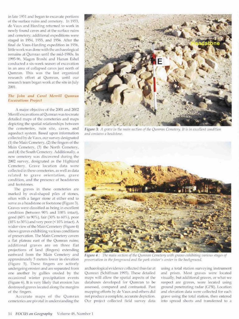
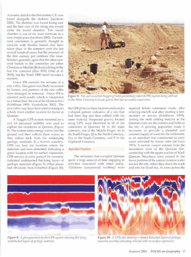
TTie graves in these cemeteries aremarked by oval-shaped piles of stones,often with a larger stone at either end toserve as a headstone or footstone (Figure 3).Graves were classified as being in excellentcondition (between 90% and 100% intact),good (60% to 9O'!i,), fair (30% to 60%), poor(10% to 30%) and very poor (< 10% intact). Awider view of the Main Cemetery (Figure 4)shows graves exhibiting various conditionsof preservation. Jhv Main Cemetery coversa flat plateau east of the Qumran ruins;additional graves are on three flatprojections of land (fingers) extendingeastward from the Main Cemetery andapproximately 5 meters lower in elowition(Figure 5). These fingers are activelyundergoing erosion and are sfparalcd fromone another by gullies eroded by theoccasional winter precipitation events(Figure 6). It is very likely that erosion hasdestroyed graves located along the marginsof the fingers.
Accurate maps of the Qumrancemeteries are pivotal in understanding the
^̂ Xf:i 'Ji ^ ;
Vigure 3: A ^rave in the main section of the Qumran Cemetery. It ifi in excellent coniiitionand contains a headstone.
Figure 4 : The main scr/icu of the Qumran Cemeterxi with ;^rtwes exliibitin>^ various staffes ofpreservation in the foreground and the park visihn's center in tlie background.
archaeological evidence collected thus far atQumran (Schiffman 1995). These detailedmaps will allow the spatial aspects of thedataLiases developed for Qumran to beassessed, compared and contrasted. Pastmapping efforts b\' de Vaux and others didnot produce a complete, accurate depiction.
project collected field survey data
using a total station surveying instrumentand prism. Most graves were locatedvisually, but additional graves, or what wesuspect are graves, were located usingground penetrating radar (GPR). LcKationand elevation data were collected for eachgrave using the total station, then enteredinto spread sheets and transferred tn <i
14 FOCUS on Geography Volume 48, Number 1

QUMRAN ARCHAEOLOGICAL SITEDead Sea Region, Israel
Surveyed by the John and Carol MerrillQumran Excavations Project, 2001 & 2002
0 50
metersJuly 17 to July 26, 2001 & July 22 to August 4, 2002 -Grave size not to scale
Originally Drafted by Philip Reeder January 2002, Revised January 2003 contour interval = 5 meters
Visitors
Center
Parking
Lot
Qumran
Archaeological
Site
0 I
"*"--..„_ North Cemetery
In
• I .I I .
Qumran nCemetery
-330
}
-335
-340
J ^ )
PersonnelPhilip Reeder - University of South Flonda
- Director, Qumran Cemetery Mapping ProjectRichard Freund - University of Hartford - Project DirectorRobert Eisenman - California State-Long Beach - Project DirectorHanan Eshel - Bar Man University - Project DirectorMagen Broshi - The Israel Museum - Project DirectorNoelle Bautista - California State-Long BeachCarl Savage - Drew UniversityHarry Jol - University of Wisconsin-Eau ClaireRobert Passow - University of Wisconsin-Eau Claire
I Excavated grave
^ Survey Benchmark
Q Grave located visually• Grave located using ground' penetrating radar
—- Access Road and Parking Lot-" " Visitors Center Boundary
• n . Scarp/CliffPhihp Reeder 03
Figure 5: Spatial ami toiio^raphk relationships hetivccii the Quinrau Archaeological Site, the main cenicteiy, flic finders,the North Cemetery, ami the park visitor's center.
Summer 2004 FOCUS on Geography 15
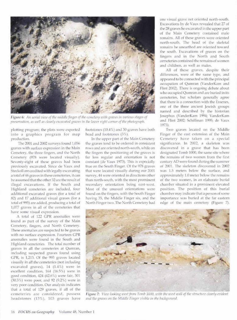
Figure b: An ucruil I'lcw of Ihc middle finder oflhc ivnivtenf unlit ^ravci^ inpyc>frvittion, (i< well (is clcnrlu cxcfivatcii ̂ ravci^ in the lower riglit corner of the
plotting proj;r.ini; the plots were exportedinto a graphics program for mapproduction.
The 20U1 and 2002 surveys found 1,056graves with surt'oce expression in the MainCemeterv', the three fingers, and the NorthCemetery (978 were located visually).Seventy-eight of these graves had beenpreviously excavated. Since de Vaux andSteckoil are credited with legally excavatinga total of 46 graves in these cemeteries, it canbe assumed that theother 32 are the result ofillegal excavations. If the South andHighland cemeteries are included, fouradditional excavated graves (for a total of82) and 17 additional visual graves (for atotal of 995) are added, producing a total of1,077 graves in all of the cemeteries thathave some visual expression.
A total of 122 GPR anomalies werefound as part of the survey of the MainCemetery, fingers, and North Cemetery.These anomalies are suspected to be graveswith no surface expression. Fourteen CPRanomalies were found in the South andHighland cemeteries. The total number ofgraves in all the cemeteries at Qumran,including suspected gra\'es found usingGPR, is 1,213. Of the 995 graves kvatedvisually in all the cemeteries (not includingexcavated graves), 14 (1.4%) were inexcellent condition, 164 (16.5%) were ingood condition, 424 (42.6"..) were fair, 301(30.3%) were poor, and 92 (9.2%) were inver\' poor condition. Our analysis indicatesthat a total of 129 graves, if all of thecemeteries are considered, possessheadstones (13%), 103 graves have
footstones (10.4%) and 30 graves have bothhead and footstones (3%).
In the upper part of the Main Cemeterythe graves tend to be ordered in consistentrows and are oriented north-south, while onthe fingers the positioning of the graves isfar less regular and orientation is notconstant (de Vaux 1973). This is especiallytrue on the South Finger. Of the 978 gravesthat were itKated visually during our 21K)1survey, 44 were oriented in directions otherthan north-south, with the mosl prominentsecondary orientation being east-west.Most of the unusual orientations werefound on the fingers, with the South Fingerhaving 35, the Middle Finger six, and theNorth Finger two. The North Cemetery had
one visual grave not oriented north-south.Excavations by de Vaux revealed that 27 ofthe 28 graves he excavated in the upper partof the Main Cemeter\' contained maleremains. All of these graves were orientednorth-south. The head of the skeletalremains he unearthed are oriented towardthe south. Excavations of graves on thefingers and in the North and Southcemeteries contained the remains of womenand children, as well as males.
All of these graves, despite theirdifferences, were of the same t\pe, andappeared to be connected with the principaloccupation of Qumran (VanderKam andFlint 2002). There is ongoing debate aboutwho occupied Qumran and are buried in itscemeteries, but scholars generally agreethat there is a connection with the Essenes,one of the three ancient Jewish groupsnamed and described by the historianjosephus (VanderKam 1994; VanderKamand Elint 2002; Schiffman 1995; de Vaux1973),
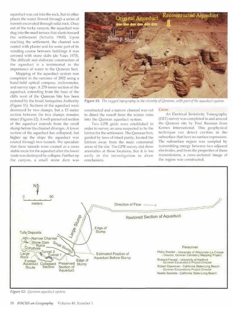
Two graves located on the MiddleFinger of the east extension of the MainCemetery have taken on a specialsignificance. In 2002, a skeleton wasdiscovered in a grave [hat has beendesignated Tomb 1000, the same site wherethe remains of two women from the firstcentury AD were found during the summerof 21)01. The skeleton discovered in 2002was 1.5 meters below the surface, andapproximately 1.0 meter below the remainsof the two women, in an elaborate burialchamber situated in a prominent elevatedposition. The position of this burialchamber may indicate that a person of someimportance was buried at the far easternedge t)f the main cemetery (Figure 7).
i
mFigure 7: Vie-ir lookiii-^ we^i from iomb 1000. with Ihc wc>i wull of the <lriictiiri' clenrh/ cviiientami the graves on tlw Miiidlc Finger visible in the backgrouihi.
16 FOCUS on Geography Volume 48, Number 1
A ceramic dated to the first century C.E. wasfound alongside the skeleton (Jacobson2002). The skeleton was found facing castand the first rays of the rising sun wouldstrike the burial chamber. This burialchamber is one of the most elaborate in a\'cry simple place (Jacobson 2002). The east-west orientation is generally thought tocoincide with Muslim burials that havetaken place in the cemetery over the lastseveral hundred years, but the presence ofthe first century pot confuses this issue.Scholars generally agree that the other cast-west burials in the cemeteries are eitherChristian or Muslim (Bcdouin)dating to theiast few centuries (Zias 2000; Eshel et al.2002), but the Tomb 1000 burial remains amystery.
Grave 978 contains the remains of azinc coffin. This grave was likely excavatedby looters, and portions of the zinc coffinwere damaged or removed. Grave 978 isoriented north-south, which is interpretedas a burial from the era of the Qumran Sect(Schitfman 1995; VanderKam 2002). Thezinc coffin may have been used to transporta hody from another location fur burial atQumran.
A Noggin GPR system mounted on acart for increased mobility was used toexplore the cemeteries at Qumran (Figure8). The system emits energy waves into theground and then collects these waves asthey reflect back from the underlyinggeologic materials. In a known cemetery,GPR can look for locations wliere thematerials had been disturbed, indicating agrave locahon with no surface expression.GPR surveys in some parts of the cemeteryindicated undisturbed flat-lying layers ofgeologic materials (Figure 9). Other placeshad obviously been disturbed (Figure 10);
Figure 8: The cart inoiiiitcd Noj^^ift •^wuiid pciictraliii;^ nular {LJPK) sy^tcui bcui^ uttttzcdin the Main Ceinelery to locate graves that had m> r^itrfacc expression.
the GPR plots for these locations indicated aV-shaped pattern indicative of a site thathad been dug and then refilled with thesame material. Suspected graves, locatedusing GPR, were identified in ail of thecemeteries at Qumran: 84 in the maincemetery, one in the Middle Finger, six inthe South Finger, 22 in the North Cemetery,five in the Soutli Cemetery, and 9 in theHigliland Cemetery,
Aqueduct System
The sectarians that occupied Qumranspent a large amount of time engaging inactivities associated with ritual purity.Ablutions (ceremonial washing) were
required before communal meals, afterrelieving oneself, and after meeting a non-member or novice (Schiffman 1995).Among the most striking features at theQumran ruins are the cisterns and baths atthe site. A growing population made itnecessary to provide a plentiful andconstant supply of water for the settlement,so an aqueduct was constructed to carrywater provided by winter rains (de Vaux1973), A narrow canyon extends from themountains west of the Qumran Site,connecting with the upper reaches of WadiQumran, Structures were created in thelower portions of the canyon to move watertoward the site, rather then down the wadiand into the Dead Sea. At some points the
Figure 9: A plot generated by the CPR s\f?tevi shaicing flat lifiiig,cd layers of geologic imtchal.
Figure 10: A CPR plot siiowing v-shaped di:>tui'bed hiyers of geologicniiUerlal, possibhi iiidicafing a burial with no :?urface expression.
Summer 2004 FOCUS on Geography 17
aqueduct was cut inlo thf rock, but in otherplaces thf Wtitir flowfd through d series oftunnels excavated through solid rock. Onceout of the rocky canyon, the aqueduct wasdug into the marl terrace that slants towardthe si'ttlement {SchuU>̂ 1960), Uponreaching the settlement, the channel wascoated with plaster and for some part of itswinding course between buildings it wascovered with stone slabs (de V.iux 1973).The difficult and elalxirate construction ofthe aqueduct is a testimonial to theimportance of water to the Qumran Sect.
Mapping of the aqueduct system wascompleted in the summer of 2002 using ahand-held optical compass, inclinometer,and sur\'ey tape. A 270 meter section of theaqueduct, extending from the base of thecliffs west of the Qumran Site has beenrestored by the Israel Antiquities Authority(Figure 11). Sections of the aqueduct weredestroyed by two slumps, but a 15 metersection between the two slumps remainsintact (Figures 12). A well-preserved sectionof the aqueduct extends from the smallslump before the channel diverges. A lowersection of the aqueduct has collapsed, buthigher up the slope the aqueduct wasrouted through two tunnels. We spi-culatethat these tunnels were created as a morestable route for the aqueduct after the lowerroute was destroyed by collapse. Further upthe canyon, a small stone dam was
Figure 11: The runted topo^niplii/ in the vuiiitti/ ofQuiuyiiii. with part of the nqtieducf f^ifst
constructed and a narrow ciiannd was cutto direct the runoff from the winter rainsinto the Qumran aqueduct system.
Two GPR grids were established inorder to survej' an area suspected to be thelatrine for the settlement. The Qumran Sect,guided by laws of ritual purity, located thelatrines away from the main communalareas of the site. The CPR survey did showanomalies at these locations, but it is tooearly in the investigation to drawconclusions.
Cai'esAn Electrical Resistivity Tomography
(ERl) survey was completed in and aroundthe Qumran site by Paul Bauman fromKomex International, This geophysicaltechnique can detect cavities in thesubsurface that have no surface expression.The subsurface region was sampled bytransmitting energy Ix-tvveen two adjacentelectrodes, and from the properties of thesetransmissions, a cross-sectional image ofthe region was constructed.
Direction of Flow
Narrow ChannelStone Dam
Ruinspothiole
Restored Section of Aqueduct
FormerAqueduct Collapsed
Route Section
Edge ofPreserved SlumpSection ofAqueduct
Estimated Position ofAqueduct Before Slump
PersonnelPhilip Reeder - University of Wisconsin-La Crosse
- Director, Qumran Cemetery Mapping Project
Richard Freund - University of Hartford- Qumran Excavations Project Director
Robert Eisenman - California State-Long Beach- Qumran Excavations Project Director
Noelle Bautist3- California State-Long Beach
Figure 12: Qiiiurmi aqueduct system.
IS FOCUS on Geography Volume 48, Number 1
The previously discovered caves thatcontained scroll nititerial are in areas ofrugged, exposed limestone cliffs, withmany of the caves adjacent fo the QumranSilc (Caves 4, 5, 6, 7, 8, 9 and 10 [see Figure21) and others {Caves 1, 2, 3, and 11) up to1,775 meters away. This limestonetopography is very common in and aroundQumran, so we assumed thai there might becollapsed caves containing artifacts. TheERT survey was completed to pinpointpossible locations for excavation. Severalsuch locations were established and theseareas were probed with an auger (a portablehand-held drilling device), but no cavitieswere found. We plan to continue researchon a future expedition fo Qumi-an.
Stnnman/ and Conclusions
The spatial distribution of the sitecomponents indicates a pattern of usageconsistent with interpretations made bySchiff'man (1995), Sukenik (1955), andVanderKani and Flint (2002) that theQumran Sect were intrinsically linked to thescrolls found in the caves. The Qumran Sectalso was linked to the cemeteries adjacent tothe site. Tomb 1000 is where they buried aperson of local and perhaps even regionalimportance. Despite differences in thepattern and orientation of some of thegraves in the Main and North cemeteries,the graves appear to be connected with theprincipal occupat ion of Qumran{VanderKam and Flint 2002). The location ofthe Highland and South cemeteries on thesouth side of Wadi Qumran, physicallyseparated from the site, may indicate thatthese burials are not directly associatedwith the Qumran Sect. Only one of twelvenon-excavated graves with visualexpression in the South Cemetery isoriented north-south, with the othersoriented east-west (seven) or northeast-southwest (four). In the HighlandCemetery, all four graves with visualexpression are oriented northeast-southwest. The graves in the South andHighland cemeteries have been interpretedas Bedouin (Zias 2000; Eshel et al. 2002),because of the topographic separation fromthe main cemeteries and the lack of north-south graves. The graves in the HighlandCemeterv were a new discovery and had
not been previously mentioned in theQumran literature.
Another new discovery was made atthe site in December 2002. Based on theresults of a GPR survey. Dr. Yitzhak Magenfrom the Israel Antiquities Authorityconducted an excavation in the area outsidethe east wall of the Qumran settlement. Hediscovered a series of buried jars, but it willtake years to fully understand tbe intricaciesof this discovery. This new information willeventually help us piece together anotherpart of the Qumran story and may providemore insight into the use of cemeteries(Freund 2002).
The 2001 and 2002 John and CarolMerrill Qumran Excavations Projects haveincreased our knowledge about theQumran Archaeological Site. Complete andaccurate maps of the cemeteries now exist.A detailed map of the aqueduct system hasbeen completed, along with a detailed mapshowing the spatial relationships betweenthe components of Qumran's culturallandscape. Ground penetrating radartechnology indicated the possible locationsof burials that have no surface expression,and pinpointed a location where eightburied jars were discovered. GPR alsoindicated an area of disturbance that may bethe location of the latrines for the city.Electrical resist ivity tomographydiscovered new cavities beneath theQumran site and provided importantinformation about the nature of thesubsurface geologic materials in the area.Working within the multidisciplinaryframework of geoarchaeology, we wereable to apply various aspects of thegeosciences to interpret past processes andevents at Qumran, providing new insightsinto Qumran's physical and culturallandscapes.
Acknozvledgments
We wish to thank the John and CarolMerrill Foundation for supporting thisresearch, as well as the Maurice CreenbergCenter for Judaic Studies at the Universityof Hartford, the University of Nebraska atOmaha, the University of Wisconsin-EauClaire, and Drew University. We also wishto acknowledge some of the otherparticipants in the project, including: Dr.
Robert Eisenman, Ron Dubay and NoelleBautista from the California StateUniversity-Long Beach; Bob Passow fromthe University of Wisconsin-Eau Claire;Paul Bauman from Komex International(Calgary, Canada); Dr. Hanan Eshel fromBar-Ilan University (Israel); and MagenBroshi, Curator Emeritus of the Shrine ofthe Book at the Israel Museum. Thisresearch would not have been possiblewithout the participation of theseindividuals. We also thank the IsraeliAntiquities Authority for granting us apermit to complete this research.
References
Butzer, K.W. 1982. A}xhaeology as HumanEcology. Cambridge: CambridgeUniversity Press,
de Vaux, R. 1973. Archaeology and the DeadSea Scrolls. London: Oxford UniversityPress.
Eshel, H., M. Broshi, R. Freund, and B.Schultz. 2002. New Data on theCemetery East of Khirbet Qumran.Dead Sea Discoveries 9:135-165.
Freund, R. 2002. New Insights on the Cetneter}/iH Qumrnn. Unpublished Manuscript,University of Hartford.
Jacobson, C. 2002. Resurrected: John theBaptist, www.theage.com/articles/2002/08/02/1028157836462.html
Rapp, H. Jr. and Hill, C. 1998.Geoarchaeology: The Earth-ScienceApproach to ArchaeologicalInterpretation. New Haven: YaleUniversity Press.
Scbiffman, L. 1995. Reclaiming the Dead SeaSchrolls. New York: Doubleday.
Schultz, S. 1960. Zeitschrift des Detits^chenPalastina-Vereins. LXXVl: 53-58.
Sukenick, E.L. 1955. Tlie Dead Sea Scrolls ofthe Hebrew University. Jerusalem:Hebrew University.
VanderKam, J. 1994. The Dead Sea ScrollsToday. Grand Rapids, Michigan:William B. Eerdmans PublishingCompany.
VanderKam, " j . and Flint, P. 2002. TheMeaning of the Dead Sea Scrolls. SanFrancisco: HarperCollins Publishers.
Zias, J.A. 2000. Tine Cemeteries of Qumranand Celibacy: Confusion Laid to Rest.Dead Sea Discoivries 7:220-253.
Summer 2004 FOCUS on Geogmphy 19