Geo-spatial Solutions for Urban Planning · Geo-spatial Solutions for Urban Planning AMRUT...
18
Geo-spatial Solutions for Urban Planning AMRUT Sub-scheme on Formulation of GIS based Master Plans for 500 AMRUT Cities Dr. Pawan Kumar, Associate TCP Town and Country Planning Organisation Ministry of Housing and Urban Affairs, Govt. of India, New Delhi Email : [email protected]
Transcript of Geo-spatial Solutions for Urban Planning · Geo-spatial Solutions for Urban Planning AMRUT...

Geo-spatial Solutions for Urban Planning AMRUT Sub-scheme on Formulation of GIS based
Master Plans for 500 AMRUT Cities
Dr. Pawan Kumar, Associate TCP Town and Country Planning Organisation
Ministry of Housing and Urban Affairs, Govt. of India, New Delhi
Email : [email protected]

Geospatial Technology
• Geo :related to location on earth
• Spatial :related to space
Geospatial data :also known as geographic information
it identifies geographic location of features (such as natural or constructed features, oceans, etc.)and boundaries on Earth.
Geospatial Technology :Technology related to collection or
processing of data that is associated with location.

Geospatial Technologies
• Remote Sensing
• Geographic Information Systems (GIS)
• Aerial Photography
• Global Positioning Systems (GPS)
• Internet Mapping Technologies such as Software programs like Google Earth and web features like Microsoft Virtual Earth, etc.

• As a follow up of the National Meet on “Promoting use of Space
Technology in Governance & Development” under the Chairmanship of Hon’ble Prime Minister Shri Narendra Modi on 7th September, 2015 at New Delhi
and
• As per the directions of the Cabinet Secretary and Ministry of
Housing and Urban Affairs (MoHUA), Govt. of India, New Delhi
AMRUT Sub-scheme on “Formulation of GIS based Master Plans for 500 Cities” under AMRUT Mission was launched in October, 2015.

LIST OF REFORMS 1. E- Governance
2. Municipal cadre
3. Double entry accounting
4. Urban Planning
5. Devolution of funds & functions
6. Review of BBL
7. Set up of financial intermediary
8a. Municipal tax & fees improvement
8b. Improvement in levy collection
9. Credit Rating
10. Energy and water audit
11. Swachh Bharat Mission

URBAN PLANNING The objective is to develop common digital geo-referenced base maps and land use maps using Geographical Information System (GIS) in each AMRUT city to enable them to make more informed strategic decisions. Formulation of
GIS-Based Master Plans
Objectives & Rationale
Use of geospatial technologies is expected to contribute to AMRUT cities in the following ways: • Formulate a master plan for decision-
making • Effective landuse management and
utilization • Enable project planning and • Urban management

URBAN PLANNING
Formulation of GIS-Based Master Plans
Deliverables
• Generation of Base Map & Thematic Maps and Urban Database Creation at the scale of 1:4000 as per Design & Standards
• Formulation of Master Plan: Formulation of Master Plan of city as per State Town & Country Planning Act on the GIS base map and sector-wise data analysis. The implementing agency is State Mission Director/ULBs.
• Capacity Building: Training Program at 3 levels
has been finalized: Implementing agency State Mission Director.
• Tier-I (Decision Making level) : 3 days duration
• Tier-II ( Middle level Officials) : 2 weeks duration.
• Tier-III (Operators level Officials): 4 weeks duration.

8
Demarcation of mapping area
Satellite Data acquisition
GPS Survey
Geo-referencing
Topology Building
Ground Truthing
Value addition from line departments
Quality check and vetting
GIS Base Map
Primary and Secondary Surveys
Attribute mapping
Thematic Map generation
Identification of issues and potentials
Projected Requirements
Policy formulation
Draft proposals
Draft Master Plan
PROCESS
State wide GIS Platform and Application Development

BUDGET
No. Components Cost
(Rs. in Crore)
1. Geospatial data creation at 1:4000 scale
for 500 AMRUT towns
115.90
2. Plan Formulation using Geospatial
database
388.25
3. Capacity Building 10.85
Grand Total 515.00
The Budget for sub scheme on “Formulations of GIS based Master Plan for AMRUT cities” is Rs. 515 crores.

Component/Town wise Fund Allocation

Coverage
Class No. of Towns Symbol
Metro 33
Class-I 422
Others 3
Total 458

Implementation Mechanism
At State Level:
• Consultancy Evaluation & Review Committee (CERC) monitors the consultation work for geo database creation & master plan formulation.
• State Level Technical Committee (SLTC) oversees the progress of the technical implementation of the Reform.
• State level High Powered Steering Committee (SHPSC) looks into overall coordination and implementation of the Reform.
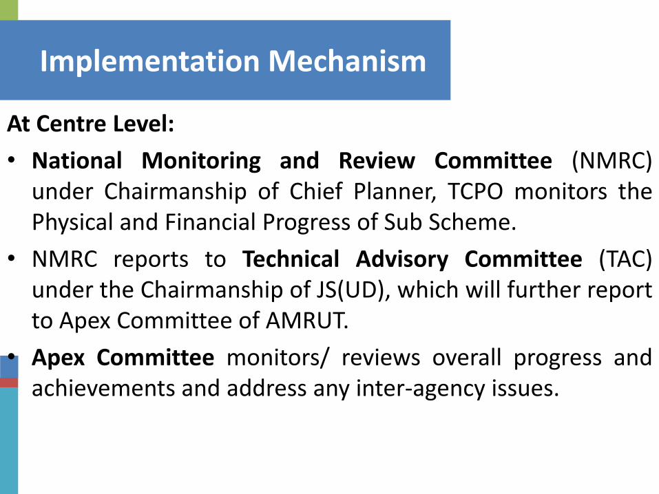
Implementation Mechanism
At Centre Level:
• National Monitoring and Review Committee (NMRC) under Chairmanship of Chief Planner, TCPO monitors the Physical and Financial Progress of Sub Scheme.
• NMRC reports to Technical Advisory Committee (TAC) under the Chairmanship of JS(UD), which will further report to Apex Committee of AMRUT.
• Apex Committee monitors/ reviews overall progress and achievements and address any inter-agency issues.

Formulation of GIS based Master Plans
Physical Progress
Steps
No. of States
No. of Towns
AoI Demarcated
28
334
Data Processed
16
168
Thematic Map Created
12
114
Draft Maps
10
110
Geo database vetted
4
94
Advt./ E.O.I. Issued
13
154
RFP Floated
17
140
Contract awarded
10
70
1. Geo-database Creation
2. Master Plan Formulation
Socio-Economic Data Collected
6
34
Socio Economic Data Analyzed
5
32
Steps
No. of States
No. of Towns
Final Maps Delivered
2
42
24
236
Satellite data Acquired
Draft Master Plan Report Submitted
3
11
3. Capacity Building
NESAC
14
105
BISAG
21
110
Institute
States
Officials
IIRS
9
41
IISM
12
115
TOTAL
371
Training Calendar
NESAC, Shillong
BISAG, Gujarat
@
IISM, Hyderabad
IIRS, Dehradun

Financial Progress
• Approved State Actin Plans (SAP) received:33 States (457 towns)
• SAP yet to be received from 1 UT :Daman & Diu
• 2 UTs have been dropped from the Sub- Scheme (Dadra & Nagar Haveli and Lakshadweep)
• Funds approved: Rs.348.23 cr.
• Funds released: Rs. 69.62 cr. Funds released to 31 States (407 Towns) as 1st installment 20% as advance)
• Funds released to NRSC: Rs. 8.07 cr
• UCs Received: Rs. 5.31 cr.

• Memorandum of Understanding (MoU) for creation of geo-
database between MoH&UA and NRSC has been signed for states agreeing to create geo-spatial database through NRSC.
• NRSC is working with 22 States covering 291 cities.
• National Monitoring & Review Committee meetings were held on 06th November 2017 and 12th January 2018
• 27 States/UTs has constituted the Consultancy Evaluation and Review Committee (CERC)/ Monitoring & Review Committee (MRC); 24 meetings of the committees have already held.

Capacity Building Calendar under Sub-Scheme
Levels of Training
NESAC (ISRO)
IISM (SoI) IIRS (ISRO) BISAG
Tier -1 Decision Makers
(3 Days)
29-31 May,
2018
04-06 Sept, 2018
2-6 July, 2018
6-10 Aug, 2018
24-28 Sept, 2018
8-12 Oct, 2018
26-30 Nov, 2018
17-21 Dec,2018
28-30 May, 2018
31 Oct - 02 Nov, 2018
Tier -2 Middle Officers
(2 Weeks)
09-20 July, 2018
11-22 June, 2018
08-18 Oct 2018
Tier-3 Junior
(Operators) (4 Weeks)
02-27 July, 2018 03-28 Dec 2018
06-31 Aug,
2018
03-28 Sept, 2018