BWINDI IMPENETRABLE NATIONAL PARK (BINP) GENERAL MANAGEMENT PLAN 2013-2023

Zion National ParkGeneral Management Plan
National Park ServiceU.S. Department of the Interior
Zion National ParkUtah


Zion National ParkGeneral Management Plan
Zion National ParkUtah
Produced by the Denver Service CenterNational Park Service
U.S. Department of the InteriorWashington, DC

“There is an eloquence totheir forms which stirs the
imagination with a singularpower and kindles in the
mind. Nothing can exceedthe wondrous beauty of
Zion . . . in the nobility andbeauty of the sculpturesthere is no comparison.”
Clarence Dutton 1880

National Park Service iii
The purpose of this plan is to describe thegeneral path the National Park Service intends tofollow in managing Zion National Park over thenext 20 years.
The plan will provide a framework for proactivedecision making on such issues as visitor use,natural and cultural resource management, andpark development, which will allow park man-agers to effectively address future problems andopportunities. In most cases, new developmentoutside the park will take place to meet visitorneeds.
Park managers will make several changes toproactively address impacts resulting fromincreased levels of visitor use. The park will bezoned to ensure that resources are protected andopportunities are provided for a range of qualityvisitor experiences. Most of the park (90%) willcontinue to be recommended for wilderness des-ignation and will be managed according to theprovisions of the Wilderness Act. In the front-country no new major visitor facilities will beprovided; however, small visitor facilities, such aspicnic sites and restrooms, may be built in sev-eral areas, including the Kolob Canyons and theeast entrance. Voluntary visitor shuttles may runalong the Zion-Mt. Carmel Highway to the eastentrance. The Zion Canyon Lodge will continueto operate as it has in the past. Part of the NorthFork of the Virgin River in the main ZionCanyon will be restored to a more natural condi-tion.
In the backcountry several management actionswill be taken. Three existing research naturalareas (21% of the park) will be deauthorized,
while new research natural areas covering 6% ofthe park will be designated. Interim group sizelimits and new interim group encounter rateswill be instituted pending the completion of thewilderness management plan. Park managersmay need to limit or reduce visitor numbers on12 trails and routes in the recommended wilder-ness, including part of the Narrows, Middle Forkof Taylor Creek, and La Verkin Creek. Onlyauthorized research and NPS-guided educa-tional groups will be allowed in 9,031 acres inremote backcountry areas (includingParunuweap Canyon) due to their designation asresearch natural areas.
The National Park Service will propose fiveBureau of Land Management (BLM) areas, total-ing approximately 950 acres, for transfer to thepark. Nine access easements, totaling about 15miles, and three conservation easements, totaling2,220 acres, will be proposed on private landsoutside the park. Congressional authorizationwill be required for all these actions.
Five drainages and their tributaries in the parkand six tributaries on BLM lands adjacent to thepark will be included in the national wild andscenic rivers system. The five drainages in thepark are: the North Fork of the Virgin Riverabove and below the Temple of Sinawava, theEast Fork of the Virgin River, North Creek, LaVerkin Creek, and Taylor Creek. The drainagespartly on BLM lands are: Kolob Creek, GooseCreek, Shunes Creek, Willis Creek, BeartrapCanyon, and the Middle Fork of Taylor Creek.Congressional authorization will be required forinclusion of these drainages in the national wildand scenic rivers system.
Summary


Contents
Foundation for the PlanPurpose of and Need for a Plan 1Purposes, Significance, and Missions Goals 5Park Policies and Practices 6Primary Planning Issues and Concerns 21Issues to be Addressed in Future Plans 25
The PlanIntroduction 28Summary of the Management Zones 32General Management Strategies 35Zoning and Related Actions 40Boundary Adjustments and Easements 50Proposals for wild, Scenic, and Recreational
River Designation 54Implementation 58
Appendixes/BibliographyAppendixes
A: Record of Decision 61B: Statement of Findings for Floodplains 67C: Definitions of the Management Zones 69D: Summary of Research Natural Areas 77E: Wild and Scenic River Evaluation 80F: Legislative Historic for Zion National Park 83G: Summary of Key Legal Mandates 84
Bibliography 86
MapsLocation 4Areas of Relative Inaccessibility 29Zoning 41Recommended Wilderness and Land Status 47Park Boundary Adjustment and Adjacent
Landownership 51Wild and Scenic Rivers 55
Tables1. Proposed Classification of Rivers 572. River Mileage and Landownership of Suitable
Rivers 82
National Park Service v


National Park Service 1
As one of 384 units in the national park system,Zion National Park is under the management ofthe National Park Service (NPS). The ParkService manages all park units in accordancewith the mandate in its 1916 Organic Act andother legislation to conserve resources unim-paired for the enjoyment of future generations.To help achieve this mandate, the National Parksand Recreation Act of 1978 and NPS
Management Policies (NPS 2001) require eachnational park unit to have a broad-scale generalmanagement plan (GMP).
The purpose of this General Management Plan isto describe the general path the National ParkService intends to follow in managing ZionNational Park over the next 20 years. The plandoes not provide specific and detailed answersto every issue or question facing Zion. However,the plan does provide a framework for proactivedecision making on such issues as visitor use,natural and cultural resource management, andpark development, which will allow park man-agers to effectively address future problems andopportunities.
Many changes have occurred in Zion NationalPark, in the surrounding area, and in park man-agement since Zion’s last master plan wasapproved in 1977. In particular, park visitationhas grown dramatically, with visitor use levelsdoubling between 1982 and 1997. This increase inuse has affected park resources and the diversityof visitor experiences offered in Zion. The ZionCanyon shuttle system also has changed thevisitor experience in the park. A new plan isessential for providing guidance to manageZion’s visitors in the 21st century, and thusensure the preservation of park resources andprovision of opportunities for visitors to havequality park experiences.
Both the National Parks and Recreation Act andNPS policies require general management plans
to address visitor carrying capacity. One of theprimary purposes of this plan is to meet thisrequirement. Carrying capacity is defined underthe visitor experience and resource protection(VERP) framework as the type and level ofvisitor use a park can accommodate while sus-taining resource and social conditions thatcomplement the purposes of the park and itsmanagement objectives. In other words, carryingcapacity is a prescription for the levels of visitoruse in relation to various natural resource andvisitor experience conditions. To set up a frame-work for addressing carrying capacity, the parkwas divided into zones that describe differingdesired resource conditions and visitor experi-ences. (Note that to fully implement the VERPframework, a follow-up implementation plan isneeded to identify key social and naturalresource indicators to be monitored in each ofthe park’s zones, set standards [minimumacceptable conditions] for each indicator, anddevelop a monitoring program.)
In addition to meeting the requirements foraddressing visitor use management, park man-agers needed this new plan to address otherissues and concerns that have arisen in the pasttwo decades. These issues include those relatedto research natural areas (RNAs) (i.e., areasadministratively designated by federal land man-agement agencies for research and educationalpurposes or to maintain biological diversity),noise, and land uses adjacent to the park. Withmost of Zion recommended for wildernessdesignation, the Park Service also needs this newplan to address how this designation will affectpark management (e.g., changes in park zoning).Finally, a new plan presents an opportunity forpark managers to explore and recommend otherchanges related to managing Zion, such as pro-posing boundary adjustments and wild andscenic river designations.
Purpose of and Need for a PlanFO
UN
DA
TIO
N F
OR
THE P
LAN

2 Zion National Park General Management Plan
Planning Assumptions
Several fundamental assumptions underpin the General Management Plan. These assumptions are con-sidered “givens” for how the park is managed in the future.
• Existing major developments in the park will remain, although their functions may change. Park staffwill continue to maintain the Zion-Mt. Carmel Highway, between the south and east entrances of thepark, which will remain opened to through (i.e., nonrecreational commuter) traffic.
• The National Park Service will not build new facilities, such as campgrounds, lodges, roads, and full-service visitor centers, within the park, aside from those associated with the transportation system. Itis assumed that the private sector will provide lodging and camping facilities outside the park.
• The National Park Service will continue to operate the Zion Canyon shuttle system, as described in the1997 Canyon Transportation System Environmental Assessment.
• Park managers will adjust staffing levels to reflect the increase in workloads.

National Park Service 3
Brief Description of the Park
Located in Washington, Iron, and Kane Counties in southwestern Utah, Zion National Park encompassessome of the most scenic canyon country in the United States (see the Location map). The park is charac-terized by high plateaus, a maze of narrow, deep, sand-stone canyons, and striking rock towers andmesas. Zion Canyon is the largest and most visited canyon in the park. The North Fork of the VirginRiver has carved a spectacular gorge here, with canyon walls in most places rising 2,000 to 3,000 feetabove the canyon floor. The southern part of the park is a lower desert area, with colorful mesas bor-dered by rocky canyons and washes. The northern sections of the park are higher plateaus covered byforests.
Zion is one of the earliest additions to the national park system. On July 31, 1909, President Taft issueda proclamation setting aside 15,200 acres as the Mukuntuweap National Monument. In 1918 anotherpresidential proclamation enlarged the monument to 76,800 acres and changed its name to ZionNational Monument. Congress established the area as a national park in 1919. A second Zion NationalMonument (now called the Kolob Canyons) was established by presidential proclamation in 1937.Congress added the Kolob Canyons to Zion National Park in 1956. The park currently encompasses148,016 acres. An additional 3,490 acres of private inholdings are present in the Kolob Terrace area, onthe west side of the park. (The inholding acreage and all of the other park acreage figures included inthis document are based on geographic information system (GIS) calculations. These figures may notcorrespond with legal description acreages.)
Zion is part of the Southwest's "Grand Circle" of national parks, monuments, historical areas, and recre-ational areas. Visitors reach the park via Interstate 15, which provides access to the Kolob Canyons area,and Utah Route 9. Zion is 158 miles northeast of Las Vegas and 320 miles southwest of Salt Lake City.The town of Springdale is less than a mile from the park's south entrance. Other nearby towns includeKanab (41 miles from the Zion Canyon Visitor Center), St. George (43 miles), and Cedar City (60 miles).

National Park Service 5
The purposes, significance, and mission goals ofZion National Park are three of the key elementsthat shaped the development of the General
Management Plan. These elements underlie howthe park is managed. The purposes tell why thepark was aside as a unit in the national parksystem. The significance of the park addresseswhat makes the area unique — why it is impor-tant enough to our natural and/or cultural her-itage to warrant national park designation andhow it differs from other parts of the country.Zion’s mission goals articulate the ideal futureconditions the National Park Service is strivingto attain. All of the management prescriptions inthis management plan are consistent with andsupport the park’s purposes, significance, andmission goals.
Based on Zion’s enabling legislation, legislativehistory, agency management policies, and theknowledge and insights of park staff, the follow-ing are the purposes, significance statements,and mission goals for Zion National Park. Thepurposes of Zion National Park are to
• preserve the dynamic natural process ofcanyon formation as an extraordinaryexample of canyon erosion
• preserve and protect the scenic beauty andunique geologic features: the labyrinth ofremarkable canyons, volcanic phenomena,fossiliferous deposits, brilliantly coloredstrata, and rare sedimentation
• preserve the archeological features thatpertain to the prehistoric races of Americaand the ancestral Indian tribes
• preserve the entire area intact for the purposeof scientific research and the enjoyment andenlightenment of the public
• provide a variety of opportunities and a rangeof experiences, from solitude to high use, toassist visitors in learning about and enjoyingpark resources without degrading thoseresources
Zion National Park is significant for the follow-ing reasons:
• Zion’s stunning scenery features towering,brilliantly colored cliffs and associated vegeta-tion highlighted by a backdrop of contrastingbright, southwestern skies.
• Zion is a geologic showcase with sheer sand-stone cliffs among the highest in the world.
• The Virgin River — one of the last mostlyfree-flowing river systems on the ColoradoPlateau — is responsible for the ongoingcarving of this deeply incised landscape.
• Because of its unique geographic location andvariety of life zones, Zion is home to a largeassemblage of plant and animal communities.
• Zion preserves evidence of human occupa-tion from prehistoric to modern times,including American Indian sites, remnants ofMormon homesteading, and engineering andarchitecture related to park establishment andearly tourism.
The mission goals of Zion National Park are to
• provide park visitors educational and recre-ational opportunities that foster an apprecia-tion of Zion and its resources
• ensure that visitor impacts do not impairresources
• maintain the resources, including plant andanimal communities, at healthy and viablelevels consistent with natural processes
• manage cultural and physical resources toensure long-term integrity
• ensure that the built environment providesfor safe visitor and staff uses in a sustainableand cost-effective manner
• ensure that the organization is responsive toemployee needs, recognizing the contribu-tions of each individual
• foster mutually supportive partnerships withprivate and public organizations and individu-als to achieve visitor use and resource protec-tion goals
Purposes, Significance, andMission Goals of Zion National Park

6 Zion National Park General Management Plan
A number of federal laws and NPS policies andpractices guide the management of ZionNational Park. Appendix G describes some ofthese key federal laws, such as the NPS OrganicAct, which underpins much of what can andcannot be permitted in national parks and whichdistinguishes national parks from other publiclands. This section focuses on park policies andstandard park practices that affect the manage-ment of Zion. These policies and practices guidethe actions taken by park staff on such topics asnatural and cultural resource management, useof recommended wilderness areas, developmentof park facilities, and visitor use management.
These policies and practices will continue toguide park managers. Park staff will continue toimplement NPS policies and goals, as identifiedin NPS Management Policies (2001); several exist-ing formal agreements; and many standard parkpractices, as described in the “Zion NationalPark Compendium” (NPS n.d.).
The ongoing management policies and practicesof Zion National Park are described below. Foreach topic discussed, there is a general statementthat describes the National Park Service’sdesired future condition or goal for Zion. Thegeneral strategies or actions taken (or that willbe taken) by park staff to achieve the desiredconditions are also discussed. Some of thestrategies described below are not currentlybeing implemented, but the strategies are consis-tent with NPS policy, are not believed to be con-troversial and require no additional analysis anddocumentation under the National Environ-mental Policy Act.
ECOSYSTEM MANAGEMENTZion National Park lies within an extensivelandscape of human, biological, and physicaldimensions. Park resources and their manage-ment are affected by natural processes andsocial circumstances, which often extendbeyond park boundaries. Park visitors, localculture and traditions, adjacent land manage-ment, and economic considerations all affectpark recreational and wilderness values, as wellas the conservation of cultural and naturalresources. For example, although the park staffmanages a small portion of the upper Virgin
River watershed, water quality in the park maydepend upon actions taken upstream of the parkon over 700,000 acres.
The park also is in a rapidly developing region ofthe United States. With the predicted populationgrowth for Washington, Iron, and KaneCounties, lands adjacent to the park will besubject to increased development — a trendalready apparent. Increased use of recreationallands and facilities, greater consumption ofwater and other resources, and fragmenting ofsensitive species habitat will likely result.Because the park is part of this greater eco-system, should this development impactresources and alter ecological processes, theability of the park to sustain natural and culturalresources may be compromised.
In the past many park units were managed in away that did not adapt to natural or socialchange, or consider influences beyond parkboundaries. Managing for a static environmentin the human or natural dimension will notprovide the means to meet the needs of futuregenerations nor accommodate the change inher-ent to, and resulting from, natural processes.
In terms of biological, geological, and hydro-logic resources, the management of ZionNational Park’s natural resources has begun tochange from custodial management to that ofallowing natural processes to shape the land-scape, while also taking restoration actions toconserve native biological communities andspecies. For example, the condition of vegeta-tion communities has declined on park andadjacent lands since the settlement period fromoveruse, weed infestations, and exclusion ofnatural fires. To reinstitute the natural fireprocess, both management-ignited and naturallyignited fire are occurring under closely managedconditions. In concert with fire management,weed control and revegetation, using nativeplants as active restoration tools, are being usedto restore natural vegetation. To be most effec-tive, application of these restoration activitiesmust be conducted in concert with adjacentland managers because vegetation communitiesdo not conform to political boundaries.
Park Policies and Practices

National Park Service 7
• Desired Conditions: The Park Servicedemonstrates leadership in resource steward-ship and conservation of ecosystem valueswithin and outside the park. Zion NationalPark is managed from an ecosystem per-spective, where internal and external factorsaffecting visitor use, environmental quality, andresource stewardship goals are considered at ascale appropriate to their impact on affectedresources. Park resources and visitors aremanaged considering the ecological and socialconditions of the park and surrounding area.Park managers adapt to changing ecologicaland social conditions within and external tothe park and continue as partners in regionalplanning and land management.
• Strategies: Park staff will continue to partici-pate in and encourage ongoing partnershipswith local, state, and federal agencies andorganizations in programs that have impor-tance within and beyond park boundaries.Partnerships important to the long-term via-bility of critical natural and cultural resourcesinclude:
(1) Interagency Conservation Agreement forthe Virgin Spinedace: provides for habitatimprovement and population protectionfor the spinedace
(2) Virgin River Resource Management andRecovery Program: provides for conser-vation of riverine resources (specificallyseven species of concern) throughout theVirgin River drainage, through habitatmanagement, improved water quality andquantity, in-stream flow, floodplain protec-tion, and other means
(3) Zion National Park Water RightsSettlement Agreement: protects streamand groundwater resources within andadjacent to the park and provides forfederal reserved water rights (pending finaladjudication) for the park
(4) Grafton Heritage Partnership Project:restores/ stabilizes the extant structuresand interpretation of the historic pioneer-era settlement of Grafton, as well as riverchannel restoration
(5) River channel and floodplain restorationof the North Fork of the Virgin River:restoration of natural floodplain and river-ine processes in stretches of the riverwithin and below the park.
Central to ecosystem management is long-termmonitoring of the change in condition of cul-tural and natural resources and related humaninfluences. Without a planned monitoring pro-gram, improvement or degradation of resourcesand visitor experience cannot be determinedwith any certainty. To protect, restore, andenhance park resources and to sustain visitoruse and enjoyment within the park and therelated landscape, park managers will
• initiate long-term monitoring of resourcesand visitor use, including use of the VERPprocess as appropriate
• promote park-sponsored research to increasethe understanding of park resources, naturalprocesses, and human interactions with theenvironment
• institute science-based decision-making,incorporating the results of resource monitor-ing and research into all aspects of park oper-ations
• identify lands external to the park where eco-logical processes, natural and culturalresources, and human use affect parkresources or are closely related to parkresource management considerations; initiatejoint management actions, agreements, orpartnerships to promote resource conserva-tion
• provide vigorous education and outreachprograms to highlight conservation and man-agement issues facing the park and relatedlands, and develop constituencies to assist intheir resolution

8 Zion National Park General Management Plan
RELATIONS WITH PRIVATE AND PUBLICORGANIZATIONS, ADJACENT LANDOWNERS,AND GOVERNMENTAL AGENCIESAs noted above, Zion National Park is not anisland — the park is part of a greater area,socially, politically, ecologically, and historically.The National Park Service must consider howits actions in Zion affect the surrounding envi-ronment and society. For instance, managementof the park influences local economies throughtourism expenditures, as well as the goods andservices purchased by the Park Service tosupport park operations.
• Desired Conditions: The National ParkService manages Zion National Park holisti-cally as part of a greater ecological, social, eco-nomic, and cultural system. Good relations aremaintained with adjacent landowners, sur-rounding communities, and private and publicgroups that affect, and are affected by, thepark. Zion is managed proactively to resolveexternal issues and concerns and ensure parkvalues are not compromised.
• Strategies: Park staff will continue to establishand foster partnerships with public and privateorganizations to achieve the purposes andmission of the park. Partnerships will besought for resource protection, research, edu-cation, and visitor enjoyment purposes.
To foster a spirit of cooperation with neigh-bors and encourage compatible adjacent landuses, park staff will keep landowners, landmanagers, local governments, and the publicinformed about park management activities.Periodic consultations will occur withlandowners and communities who are affectedby, or potentially affected by park visitors andmanagement actions. Park staff will respondpromptly to conflicts that arise over theiractivities, visitor access, and proposed activi-ties and developments on adjacent lands thatmay affect Zion. Park managers will seekagreements with landowners to encouragetheir lands to be managed in a manner com-patible with park purposes. Park staff also willseek ways to provide landowners with techni-cal and management assistance to addressissues of mutual interest.
The National Park Service will work closelywith local, state, federal agencies, and tribalgovernments whose programs affect, or areaffected by, activities in Zion. The ParkService will continue to be an active memberof the Southwest Utah Planning AuthoritiesCouncil (SUPAC). It also will continue tocoordinate with the Five County Associations
of Governments, and with other local, state,and federal agencies. In particular, park man-agers will maintain a close working relation-ship with the Bureau of Land Management,whose lands abut much of the park, to meetmutual management needs. Park managersalso will pursue cooperative regional planningwhenever possible to integrate the park intoissues of regional concern.
GOVERNMENT TO GOVERNMENT RELATIONSBETWEEN AMERICAN INDIAN TRIBES AND ZIONNATIONAL PARKSeveral Southern Paiute tribes and bands viewZion National Park as part of their traditionalhomeland. These tribes and bands include thePaiute Indian Tribe of Utah (which includes theKanosh, Shivwits, Koosharem, Indian Peaks andCedar Bands), the Kaibab Band of PaiuteIndians, the Moapa Paiute Indian Tribe, and theSan Juan Paiute Indian Tribe. The Hopi Tribeand other Puebloan groups also have expressedtheir close affiliation with Zion.
The National Park Service has developed severalpark policies based on legal mandates, such asthe National Historic Preservation Act,Archaeological Resources Protection Act, NativeAmerican Graves Protection and RepatriationAct, and the American Indian ReligiousFreedom Act. The Park Service has written aformal park policy that exempts Southern Paiutetribal members from paying fees if they enter thepark for nonrecreational activities (i.e., tradi-tional religious, ceremonial, medicinal, or othercustomary activities). The Park Service andtribal governments of the Southern Paiute havealso jointly developed a memorandum of under-standing that allows, under prescribed condi-tions, tribal members to gather plants foundwithin the park that are used for traditional andcustomary purposes.
• Desired Conditions: The National ParkService and tribes culturally affiliated withZion maintain positive, productive, govern-ment-to-government relationships. Park man-agers and staff respect the viewpoints andneeds of the tribes, continue to promptlyaddress conflicts that occur, and considerAmerican Indian values in park managementand operation.
• Strategies: The National Park Service will con-tinue to cooperate with tribes in conductingethnographic studies to better understandwhich tribes are culturally affiliated with thepark and identify culturally significantresources.

National Park Service 9
Regular consultations will occur with affiliatedtribes to continue to improve communicationsand resolve any problems or misunderstand-ings.
Park managers will continue to encourage theemployment of American Indians on park staffto improve communications and working rela-tionships, and encourage cultural diversity inthe workplace.
Culturally affiliated tribal values will be con-sidered in efforts to improve overall manage-ment and park interpretation.
A joint monitoring program will be imple-mented to monitor plant-gathering sites forpotential impacts, as called for in the memo-randum of understanding with the SouthernPaiute.
NATURAL RESOURCES (GENERAL)Protection, study, and management of the park’snatural resources and processes is essential forachieving the park’s purposes and mission. The“Resource Management Plan” (NPS 1994a) pro-vides details on the strategies and actions toaddress the park’s most important resourcemanagement problems and research needs.
• Desired Conditions: Zion retains its ecologi-cal integrity, including its natural resources andprocesses. The natural features of the park,including the natural sound environmentremain unimpaired. The park continues to be adynamic, bio-diverse environment. Park visi-tors and staff recognize and understand thevalue of the park’s natural resources. Park staffuses the best available scientific informationand technology to manage the park’s naturalresources. Park managers ensure that labora-tory facilities are available to meet the needs ofpark staff and independent scientists engagedin fundamental physical, biological, and cul-tural studies and analyses. Zion is recognizedand valued as an outstanding example ofresource stewardship, conservation, education,and public use.
• General Strategies: Park staff and other scien-tists will continue to inventory park resourcesto quantify, locate, and document biotic andabiotic resources in the park and to assess theirstatus and trends.
Park managers will encourage and supportbasic and applied research directly throughvarious partnerships and agreements to
enhance the understanding of park resourcesand processes, or to answer specific manage-ment questions.
Park staff and other scientists will continue thelong-term systematic monitoring of resourcesand processes to discern natural and anthro-pogenically induced trends, documentchanges in species or communities, evaluatethe effectiveness of management actions takento protect and restore resources, and to miti-gate impacts on resources.
The park staff will continue to expand the datamanagement system, including a geographicinformation system (GIS), a research database, and a literature data base, for analyzing,modeling, predicting, and testing trends inresource conditions.
Park staff will apply ecological principles toensure that natural resources are maintainedand not impaired. They will manage fire tomaintain and/or restore ecosystem integrityand use integrated pest management pro-cedures when necessary to control nonnativeorganisms or other pests. Habitats for threat-ened and endangered species will also be con-served and restored.
Park staff will apply mitigation techniques tominimize the impacts of construction andother activities on park resources (see the textbox on page 11). Facilities will be built in previ-ously disturbed areas or in carefully selectedsites with as small a construction footprint aspossible.
Park managers will restore disturbed lands asmuch as possible and determine on a site-by-site basis whether passive or active restorationwas necessary. Park staff will carry out activerestoration of previously or newly disturbedareas using native genetic materials to regainmaximum habitat value. Should facilities beremoved, the disturbed lands will be rehabili-tated to restore natural topography and soils,and revegetate the areas with native species.Under some circumstances, primarily in front-country developed areas, it may be appropri-ate and within policy to use nonnative plantsin restoration efforts. Additionally, certainexotic plant species may be used to controlother, more noxious and invasive exotic plantspecies. These practices are intended forshort-term use only, to achieve a long-termoverall goal of native plant communityintegrity.

10 Zion National Park General Management Plan
Park managers will continue to regularlyupdate the park’s resource management planand prioritize actions needed to protect,manage, and study park resources.
AIR QUALITYZion National Park is designated a class I areaunder the Clean Air Act. This designation allowsair quality characteristics, including visibility, tobe degraded the least, compared to other CleanAir Act designations.
• Desired Conditions: Zion’s class I air qualityis maintained or enhanced with no significantdegradation. Nearly unimpaired views of thelandscape both within and outside the park arepresent. Scenic views, which are integral to thevisitor experience and have been identified inthe park as per the Clean Air Act, are substan-tially unimpaired. For example, Mt. Trumbulland the Kaibab Plateau, both over 50 milesaway in northern Arizona, can usually be seenfrom Lava Point. Park staff carry out pre-scribed fires to replicate ecological conditionsand/or reduce dangerous fuel loading, in amanner that minimizes local effects to visibilityfrom smoke production.
• Strategies: The National Park Service will con-tinue to work with appropriate state andfederal government agencies, industries,nearby communities, land managers, theSouthwest Utah Planning Authorities Council(SUPAC), the Utah Division of Air Quality, andthe Western Regional Air Partnership to main-tain park and regional air quality.
Park staff and other scientists will inventoryand monitor air quality in the park to gainbaseline data and to measure any significantchanges (improvement or deterioration) toZion’s airshed. This will include a completeinventory of in-park emission sources, as wellas those in the immediate vicinity of the park.
The Park Service will review, comment on,and recommend actions to minimize or reduceemissions from sources being proposed within64 miles (100 kilometers) of Zion.
Park managers also will attempt to minimizethe effects of in-park pollution sources on airquality. For example, emissions from burningwood in campgrounds and residences may bereduced by establishing nonburn days or bybanning wood-burning stoves.
NIGHT SKYNPS policy recognizes that Zion’s night sky is afeature that significantly contributes to the
visitor experience. The policy further states thatthe Park Service will seek to minimize the intru-sion of artificial light into the night scene. Innatural areas, artificial outdoor lighting will belimited to meeting basic safety requirements andwill be shielded when possible.
• Desired Conditions: Excellent opportunitiesto view the night sky are available. Artificiallight sources both within and outside the parkdo not impair night sky viewing opportunities.
• Strategies: Park staff will continue to workwith local communities to encourage protec-tion of the night sky and will evaluate impactson the night sky caused by facilities withinZion National Park. To the extent possible, thestaff will work within a regional context toprotect night sky quality.
If park staff determine that light sourceswithin the park affect views of the night sky,they will study alternatives to existing lightingsources, such as shielding lights, changinglamp types, or eliminating unnecessarysources.
WATER QUANTITY AND QUALITYWater is a key resource in Zion National Park,shaping the landscape and affecting plants,animals, and visitor use. Nearby communitiesand landowners also rely on the water that flowsinto and out of the park. River flow in Zion iscurrently substantially natural and free flowing.It is protected by federal reserved water rightsrecognized under the 1996 Zion National ParkWater Rights Settlement Agreement between theUnited States, the State of Utah, the WashingtonCounty Water Conservancy District, and KaneCounty Water Conservancy District. The agree-ment identified state appropriative rights andfederal reserved water rights to help ensure thatthe National Park Service maintains groundwa-ter, stream flows, and spring discharges withinthe park. While the agreement allows for somepotential future development of water above thepark, the agreement recognizes the UnitedStates’ reserved rights to “all water underlying,originating within or flowing through ZionNational Park … that was unappropriated as ofthe dates of reservation of the lands now withinthe boundaries of the park, which waters are toremain in a free flowing condition.” [emphasisadded] The rights comprise “those waters in theVirgin River Basin,” and include all sources ofsurface and groundwater.
• Desired Conditions: The National ParkService fully complies with the Zion NationalPark Water Rights Settlement Agreement to

National Park Service 11
Natural Resource Mitigation Measures
Park staff will continue to apply the following measures to avoid or minimize the impacts on sensitivenatural resources:
• Enforce trail closures during the Mexican spotted owl breeding/nesting period (March 1 – August 31)for side canyons off the main Zion Canyon where the owls typically are found.
• Prohibit the climbing of cliff faces that support peregrine falcon aeries during breeding and nestingperiods (approximately February through July); direct air traffic away from these nesting areas.
• Limit damage or loss of vegetation and associated species (including Zion snails) in hanging gardensthrough visitor education and the use of delineated trails, barriers, and signs.
• Employ erosion control measures or place barriers to control potential impacts on rare plants fromtrail erosion or social trailing.
• Employ a variety of techniques, including visitor education programs, restrictions on visitor activities,and ranger patrols, to reduce impacts on wildlife during sensitive times.
• Use designated river access/crossing points, barriers, and closures to prevent trampling and loss ofriparian vegetation.
• Use interpretive displays and programs, ranger patrols, and regulations on use levels to minimizewater pollution.
• Where possible, new developments will be built in previously disturbed sites. New developments alsowill be built away from microbiotic soil crusts.
• Prior to any construction in areas where spotted owls are known or suspected to occur, park man-agers will evaluate the specific locations for new developments, such as picnic areas and trails, in con-sultation with the U.S. Fish and Wildlife Service. No new facilities will be built during the owl breed-ing/nesting season (March 1 – August 31).
• No new designated camping sites will be located in Mexican spotted owl territories. If survey resultsindicate that visitors are camping near nest or roost sites, restrictions will be placed on camping inthose areas.
• Park staff will survey proposed development sites for rare plants and will relocate new developmentsif rare plant populations are present. Similarly, trails and routes will be located to avoid impacts onrare plants.
• Site-specific measures, such as the placement of silt fencing, retention and replacement of topsoil,revegetation of sites, and selective scheduling of construction activities, will be taken to reducerunoff from construction sites. Workers also will be required to control dust, and all constructionmachinery will be required to meet air emission standards. Restoration efforts will be scheduled tominimize impacts on downstream water users and to avoid the Virgin spinedace spawning periods.
• Wading and hiking in streams with Virgin spinedace will be managed to minimize impacts on thefish.
• To minimize impacts of trail erosion and social trailing on microbiotic crusts in developed areas, parkstaff will place barriers, erect signs, and rehabilitate damaged areas.
• To help minimize the spread of nonnative plants, park managers will allow only the use of weed-freematerials and equipment for park operations and visitor use activities.

12 Zion National Park General Management Plan
support park resource, visitor, and administra-tive uses, and the rights of other water users.
Flows in the springs, rivers, and tributaries,including floods, are substantially natural. Allwater withdrawals and appropriations arelimited to authorized amounts. Zion’s waterquality continues to reflect natural conditionsand supports administrative and recreationaluses, and adjacent communities.
• Strategies: With regard to water flows, theNational Park Service will work cooperativelywith the Utah Department of NaturalResources, Washington County WaterConservancy District, and Kane County WaterConservancy District to implement the ZionNational Park Water Rights SettlementAgreement.
Park staff will strive to conserve water in allpark operations. Examples of actions that canbe taken include replacing irrigation ditcheswith pipes, reducing irrigated landscapes, andinstalling low flow fixtures such as toilets andshowers.
Park personnel will document and monitorcurrent water consumption in the park andmonitor stream flows. Park managers willreview all future projects for compliance withthe provisions of the water rights agreement.
Visitor interpretive and education efforts willemphasize the hazards from flash flooding thatexist in the park and appropriate responseswhen flooding occurs. Park staff will educatevisitors in techniques to prevent water pollu-tion and safely collect and treat drinking waterfrom natural sources.
Park personnel will develop a program tomanage human waste in all areas, particularlyin riparian or riverine situations. This programmay involve visitors carrying their own wastesout from certain areas.
Park managers also will work with adjacentlandowners and the Utah Department ofNatural Resources to prevent water pollutionand minimize the risk of water-borne diseasesstemming from livestock and other sources.Park managers will also participate in state ornational water quality remediation and water-shed planning programs.
A monitoring program will be established toregularly measure water quality and quantity,including physical, chemical, and biologicalproperties.
NATURAL SOUNDSNPS Management Policies require park managersto strive to preserve the natural soundscape(natural quiet) associated with the physical andbiological resources (for example, the sounds ofthe wind in the trees). The concept of naturalquiet was further defined in the Report on Effects
of Aircraft Overflights on the National Park
System (NPS 1995):
What is natural quiet?: Parks and wildernessesoffer a variety of unique, pristine sounds notfound in most urban or suburban environ-ments. They also offer a complete absence ofsounds that are found in such environments.Together, these two conditions provide a veryspecial dimension to a park experience —quiet itself. In the absence of any discerniblesource of sound (especially manmade), quiet isan important element of the feeling of soli-tude. Quiet also affords visitors an opportunityto hear faint or very distant sounds, such asanimal activity and waterfalls. Such an experi-ence provides an important perspective on thevastness of the environment in which thevisitor is located, often beyond the visualboundaries determined by trees, terrain, andthe like. In considering natural quiet as aresource, the ability to clearly hear the delicateand quieter intermittent sounds of nature, theability to experience interludes of extremequiet for their own sake, and the opportunityto do so for extended periods of time is whatnatural quiet is all about.
Aircraft flights over the park for sightseeing,photography, or filming purposes can adverselyaffect the natural soundscape. The potentialexists for increases in air tours and associatednoise impacts in the park. Land-based sources,such as motor vehicles, can also affect naturalsounds.
• Desired Conditions: Natural sounds predom-inate in Zion. Visitors have opportunitiesthroughout most of the park to experiencenatural sounds in an unimpaired condition.The sounds of civilization are generally con-fined to developed areas.
• Strategies: Park managers will continue tofollow several policies and practices to mini-mize noise both from land and air sources.
With the passage of Public Law 106-181(National Parks Air Tour Management Act of2000), the park staff will develop an air tourmanagement plan to provide guidance in man-aging this activity. The plan will conform to theabove legislation.

National Park Service 13
As provided in the legislation, the FederalAviation Administration (FAA) will grantinterim operating authority for air tour opera-tors to continue to operate as they have in thepast, pending completion of an air tour man-agement plan. If all parties, including the parksuperintendent, agree, an interim operatingauthority may be modified to further protectpark resources, values, and/or visitor experi-ences.
Park managers will work with the FAA, touroperators, and all other interested parties indeveloping the air tour management plan. Thisplan will determine if commercial air tourswill be appropriate for the park, and if so,under what conditions (e.g., if air tours areappropriate in some or all of the park, the planmay establish conditions such as routes, alti-tudes, times of day, maximum number offlights per unit of time, etc.).
The National Park Service will continue towork with the Federal Aviation Administration(FAA), tour operators, commercial businesses,and general aviation interests to minimizenoise and visual impacts of aviation to thepark. Aircraft will be encouraged to fly outsidethe park, especially for those flights where thepresence of the park is incidental to thepurpose of the flight (i.e., transit between twopoints). Actions that may be considered forencouraging pilots to fly outside park bound-aries include identifying the park on routemaps as a noise-sensitive area, educating pilotsabout the reasons for keeping a distance fromthe park, and encouraging pilots to fly in com-pliance with FAA regulations and advisoryguidance, in a manner that minimizes noiseand other impacts.
The National Park Service will work with theDepartment of Defense to develop a processto address the occasional problems that arisefrom military flights over Zion.
Park managers will follow several strategies tocontrol existing and potential land-basednoise sources:
• continue operating the shuttle system andeventually prohibit tour buses in ZionCanyon, which will reduce noise levels andeliminate the greatest source of noise in ZionCanyon
• continue to require bus tour companies inZion to comply with regulations that reducenoise levels (e.g., turning off engines whenbuses are parked)
• encourage visitors to avoid the use of genera-tors, thus reducing related noise (Electrichookups in the Watchman campgroundshould eliminate most of the need for genera-tors.)
• maintain the existing quiet hours in camp-grounds
• continue to enforce existing noise policies inthe backcountry
Park managers will minimize noise generated bypark management activities by strictly regulatingNPS and concession administrative use ofnoise-producing machinery such as aircraft andmotorized equipment. Noise will be a consider-ation when procuring and using park equip-ment. In the recommended wilderness area, theuse of motorized equipment will conform to therequirements of the Wilderness Act, “minimumrequirements procedures,” and related NPSpolicies (NPS Director’s Order 41). Park man-agers also will prepare a soundscape preserva-tion and noise management plan to provideguidance for managing all noise sources in thepark, including buses, generators, NPS equip-ment, other aircraft, and external sources.
CULTURAL RESOURCES (GENERAL)Zion’s cultural resources, including its pre-historic, historic, and ethnographic resources,are an integral part of the park landscape.Protection of these resources is essential forunderstanding peoples’ past, present, and futurerelationship with the park environment andexpressions of America’s cultural heritage. TheZion “Resource Management Plan” (NPS 1994a)provides details on the strategies and actions toaddress the park’s most important culturalresource problems and research needs.
• Desired Conditions: Zion’s cultural resourcesare protected and the integrity of the park’scultural resources is preserved unimpaired.Park visitors and employees recognize andunderstand the value of the park’s culturalresources. Zion is recognized and valued as anexample of resource stewardship, conserva-tion, education, and public use.
• General Strategies: The National Park Servicewill support basic and applied research,directly and through various partnerships andagreements, to enhance the understanding ofresources and processes or to solve specificmanagement questions.
Park staff will use the best available scientificinformation and technology for making deci-

14 Zion National Park General Management Plan
sions on and managing the park’s culturalresources.
Park staff and scientists will continue to collectinformation to fill gaps in the knowledge andunderstanding of Zion’s cultural resources, toassess their status and trends and more effec-tively protect and manage the resources.
The National Park Service also will continuelong-term monitoring of archeological sites tomeasure the deterioration from natural andhuman sources and to evaluate the effective-ness of management actions to protectresources and mitigate impacts.
To analyze, model, predict, and test trends inresource conditions, park managers will con-tinue to use and expand a data managementsystem, including a geographic informationsystem (GIS).
To provide the public and park staff withoptimum interpretive and resource manage-ment opportunities, park personnel will con-tinue to research, document, and catalogue themuseum collection. Museum objects andarchival materials will be conserved to NPSand professional standards. The park’smuseum conservation program will continueto provide for the proper preservation andprotection of the museum collection.
In accordance with the National HistoricPreservation Act, as amended, park managerswill continue to locate, identify, and evaluate
park resources to determine if they are eligiblefor listing in the National Register of HistoricPlaces.
Visitor use management and construction mit-igation techniques will continue to ensure thathuman activities are not impairing parkresources. Park managers will rely on a varietyof actions to minimize these impacts, includ-ing visitor education and interpretation, anduse of foot patrols to enforce the Archeo-logical Resources Protection Act. The park’sarcheological site disclosure policy will con-tinue to be followed (see the archeological sitedisclosure text box on page 15).
Park managers will continue to regularlyupdate the “Resource Management Plan” andprioritize actions needed to protect parkresources.
HISTORIC STRUCTURESThe National Park Service listed a total of 91 his-toric structures at Zion in the Park Service’s 1998“List of Classified Structures” (LCS). Eighty-fiveof those structures are either listed or recom-mended as eligible for listing on the NationalRegister of Historic Places. With the exceptionof a few prehistoric architectural sites, all of thehistoric structures on the LCS are used for parkoperational purposes (housing, offices), trans-portation, or recreation.
• Desired Conditions: The historic built envi-ronment, whether federally owned or conces-sion leased, is maintained in good condition.
Cultural Resource Mitigation Measures
Park staff will continue to apply the following measures to ensure that impacts on sensitive culturalresources are avoided or minimized:
• Consult a Utah state historical preservation officer and undertake an archeological survey, to deter-mine the extent and significance of archeological resources in areas that are not surveyed, for actionsthat may involve ground disturbance or affect structures and/or landscapes that are either on or eligi-ble for the National Register of Historic Places
• Where possible, site projects and facilities in previously disturbed or developed locations
• Whenever possible, modify project design features to avoid effects to national register eligible or list-ed properties
• Ensure that archeological monitors are present during all construction activities that may impact sub-surface cultural deposits
• Add signs and physical barriers to protect sites listed on the national register (or are eligible for list-ing) from visitor related impacts.
• Focus public education initiatives on class I and class II sites, as identified under the park’s archeologi-cal site disclosure policy

National Park Service 15
Whenever possible, adaptive use of historicstructures for park needs is considered beforebuilding new infrastructure.
• Strategies: The park staff will continue tomanage historic structures as “culturalresources” and will give full consideration tohistorical values that may be affected as a resultof park planning efforts.
• The park staff will continue to work closelywith and consult with the Utah State HistoricPreservation Officer and other interestedparties to identify, evaluate, and protect his-toric structures through mitigation or avoid-ance, as required by sections 106 and 110 of theNational Historic Preservation Act, asamended.
• The park staff will employ technically soundhistoric preservation practices through routinepreservation maintenance actions that areintended to slow the rate of deterioration andprotect the fabric, character, and design of thebuilding or structure.
• Park resource and maintenance staff willreceive historic preservation training and will
be made aware of the most recent preservationtechnology and applications available.
LAND PROTECTIONPrivate lands, water rights, and mineral rights arein portions of Zion National Park (shown on theRecommended Wilderness and Land Status mapon page 47). Private lands are confined to theKolob Canyons and Kolob Terrace. Private waterrights are associated with some of these landinholdings, and on federally owned lands in thenorthwest corner of the park at Camp Creek. Anapplication has been filed with the state engi-neer to relocate a private water right on ShunesCreek in the southeast part of the park to a loca-tion outside the park. The town of Springdaleand the Springdale Consolidated IrrigationCompany share a diversion with the NationalPark Service on the North Fork of the VirginRiver 0.3 miles below the junction of the ZionMount Carmel Highway and the Zion CanyonScenic Drive. Private mineral rights are confinedto two small tracts (4.39 acres) near the southentrance.
The National Park Service recognizes all privaterights in the park and respects the rights of theowners. Private vehicles will continue to access
Zion National Park’s Archeological Site Disclosure Policy
The National Park Service has devised and incorporated an archeological site disclosure policy at severalnational parks in Utah, including Zion National Park. This policy makes information about the locationof archeological sites available to the public, but only if “no harm, threat, or destruction of culturalresources will result” from disclosure of that information. In general terms, such information is onlyprovided to those sites that are regularly patrolled, monitored, stabilized, or otherwise protected fromvisitor impacts or harm. The site disclosure policy establishes three classes of sites, based on the abilityof the site to withstand visitor impacts. The following describes those classes and the managementactions that continue to be taken with regard to visitor access to sites within each class.
Class I sites are those that are highly visible in the park and generally known to visitors, like theWeeping Rock granary or the south gate petroglyph site. These sites also receive direct physical protec-tion (e.g., fencing, barriers, signs), as well as regular monitoring and condition assessment by park staffand site stewards. Some of these sites may have already been impacted by prior visitor use. TheNational Park Service provides information on these sites at the visitor center, as well as information onappropriate site etiquette and the Park Service’s archeological site protection and use policy.
Class II sites are evaluated as being more fragile and vulnerable to visitor impacts than class I sites, butare also well known to visitors. When visitors request information on a specific site, by name or sitenumber, they are directed to the visitor center and a member of the park interpretive staff. Park per-sonnel provide visitors location information on class II sites only after providing information on appro-priate site etiquette and the archeological site protection and use policy. Park staff also regularly moni-tor class II sites, which have stabilization and protective measures in place.
Class III sites comprise the majority of sites within the park. These are considered to be fragile resourcesand not appropriate for visitor uses. In accordance with the National Historic Preservation Act and theArcheological Resources Protection Act, location information on these sites is withheld from the generalpublic. The National Park Service allows access only to those holding valid Archeological ResourceProtection Act permits related to the study or management of these sites and only after they have con-sulted with the cultural resource management specialist or the park archeologist.

16 Zion National Park General Management Plan
the inholdings on existing roads, unless the landand associated roads are acquired. Use of snow-mobiles will continue to be permitted along theKolob-Terrace Road in the park and on two seg-ments of the Lava Point Road so landownerscan access their private property.
Inholdings are managed under the provisions ofthe “Zion National Park Land Protection Plan”(NPS 1984). Private landowners may conductcertain activities, defined as compatible uses,which will not damage the resources for whichZion National Park was established to protect.Some examples of compatible uses include:normal maintenance and upkeep, interiorremodeling, razing of a structure and replacing itwith one of the same size, continued diversionof water consistent with a valid water right, orgrazing by domestic animals if that use wasoccurring when the land became an inholding.Examples of incompatible uses include: con-struction of buildings on undeveloped land,subdividing or selling a portion of the inholding,developing minerals, or any action that results indamage to natural or cultural resources, wildlife,or scenery.
If incompatible uses occur, the National ParkService will contact the landowner to eliminatethis use. The National Park Service will not seekto acquire any interest in private lands withoutthe consent of the owner as long as these landsare devoted to compatible uses. However, if sig-nificant environmental impacts occur throughincompatible use, measures will be taken torectify the situation. The alternatives discussedin the “Land Protection Plan” may be employedto prevent the incompatible use. If these meas-ures fail, it may be necessary to invoke condem-nation procedures as a last resort to protect parkvalues.
• Desired Conditions: In the short run,landowners manage their lands in a mannercompatible with the purposes and mission ofthe park. Water rights are managed to mini-mize impacts to park resources. In the longrun, the National Park Service has agreementsor has acquired sufficient interests in theinholdings and water rights to achieve parkpurposes and mission goals. If and when thelands are acquired, they will be managed likethe surrounding park lands and managementzones.
• Strategies: In the short run, private propertyand water rights will continue to be recog-nized. Park staff will continue to clearly com-municate with private right owners regarding
desired management. Periodic meetings will beheld with the owners to resolve any problems.
In the long run, park staff will continue imple-menting the actions called for in the “LandProtection Plan.” Various techniques will beused to protect park values, including cooper-ative management agreements, acquisition ofconservation and access easements, landexchanges, donations, and purchase of feetitle. The management of such lands will revertto the zoning and wilderness status proposedin this plan once the land or water rights areacquired or relinquished, and nonconforminguses are removed.
PARK ACCESSIBILITYThe policy of the National Park Service is tomaximize accessibility for people (visitors andstaff) with disabilities. Guidance on this topic isprovided by federal statutes and regulations.These regulations include the ArchitecturalBarriers Act of 1968; the Rehabilitation Act of1973; the Americans with Disabilities Act of 1990;28 Code of Federal Regulations (CFR), Part 36and 43 CFR, Part 17; the Uniform FederalAccessibility Standards of 1984; the U.S. AccessBoard Draft Accessibility Guidelines forOutdoor Developed Areas of 1999; and NPS
Management Policies and Director’s Orders.
• Desired Conditions: Zion National Park’sbuildings, facilities, programs, and services areaccessible to and usable by all people, includ-ing those with disabilities. All new and reno-vated buildings and facilities, including thoseprovided by concessioners, are designed andconstructed to provide access to people withdisabilities. All services and programs, includ-ing those offered by concessioners, volunteers,cooperating associations, and interpreters, alsoare designed to be accessible by people withdisabilities. There are opportunities for allpeople to access parts of the park’s backcoun-try.
• Strategies: Park staff will work with usergroups, such as saddle stock groups and dis-abled people or their representatives, toprovide opportunities for the disabled toaccess to the front and backcountry.
Existing buildings and facilities will be evalu-ated to determine the degree to which they arecurrently accessible to and usable by peoplewith disabilities, and to identify barriers thatlimit access. Action plans will be developedidentifying how barriers will be removed.

National Park Service 17
Similarly, existing programs, activities andservices (including interpretation, telecommu-nications, media, and web pages) will be evalu-ated to determine the degree to which they arecurrently accessible to and usable by peoplewith disabilities, and to identify barriers toaccess. Action plans will be developed identi-fying how barriers will be removed.
VISITOR USE AND EXPERIENCEWith the exception of commercial guided activi-ties, visitors have had few restrictions on tradi-tional activities in Zion until the past decade orso. However, over 2.5 million people now annu-ally visit Zion and participate in a wide range ofactivities. Park managers are taking action tomanage this use, minimize or avoid resourceimpacts, and ensure that visitors continue tohave the opportunity for high quality experi-ences.
• Desired Conditions: Zion offers a variety ofactivities that are consistent with the park’spurposes and significance. The vast majority ofvisitors are satisfied with appropriate parkfacilities, services, and recreational opportuni-ties. Most visitors understand and appreciatethe basic purposes and significance of the parkand their stewardship role in preserving parkfeatures. They actively contribute to the park’spreservation through demonstrated appropri-ate use and behavior. Visitor use levels andactivities are consistent with park purposesand desired resource conditions and visitoropportunities. Resource impacts and conflictsbetween users are minimal. Visitors haveopportunities to experience the natural soundenvironment of the park in an unimpairedcondition. They understand and supportmanagement actions that are taken to diminishor avoid resource impacts.
• Strategies: If it is necessary to take action toaddress visitor impacts, park managers will usethe method that assures the most resourceprotection whenever possible. Methods thatmay be used in this regard include such tech-niques as providing ongoing visitor educationand redesigning or “hardening” facilities (e.g.,surfacing a trail or building a fence). Morerestrictive methods may include implementinga reservation system and requiring permits forcertain uses or areas, placing limits on use, andclosing areas including trails or campsites.Restrictions on visitor use will be based on adetermination by the park superintendent thatsuch measures are consistent with the park’senabling legislation and are necessary to eitherprevent the degradation of the values and pur-
poses for which the park was established, or tominimize visitor use conflicts.
Park managers will continue to use thetransportation system to manage visitor useand distribution within Zion Canyon, accord-ing to the need to protect resources andprovide quality visitor experiences. Visitor useof specific features or trails will continue to bemanaged or limited on a case-by-case basis toprotect key visitor experiences.
Park staff will periodically conduct visitorsurveys to determine visitor satisfaction withthe shuttle system and to determine if conges-tion is occurring in other parts of the park.Park managers will emphasize visitor educa-tion, including pretrip planning regarding theneed for and use of the shuttle system.
VISITOR INFORMATION, ORIENTATION,INTERPRETATION, AND ENVIRONMENTALEDUCATION The National Park Service uses a variety ofmethods to orient visitors to Zion, provideinformation about the park, and interpret thepark’s resources for visitors. The “Zion NationalPark Interpretive Plan” (NPS 1996a) describesinterpretation goals and objectives and interpre-tive themes. The interpretive plan specifies whatpark staff will do to provide visitors withinformation, orientation, and interpretation. The1996 plan also addresses interpretive media,such as wayside exhibits, bulletin boards, andsigns.
• Desired Conditions: The National ParkService makes pretrip information available toassist visitors in planning a rewarding visit tothe park. Park staff use radio announcements,web sites, mailouts and reservation systems toassist visitors with preplanning. When visitorsarrive at Zion, park staff provide informationto orient them on what to do (and what not todo), attractions to see, and how to enjoy thepark in a safe, low-impact way. Interpretiveprograms connect the visitor to the park’sresources, build a local and national con-stituency, and gain public support for protect-ing the park’s resources. Outreach programsthrough schools, organizations, and partner-ships build emotional, intellectual, and recre-ational ties with the park and its cultural andnatural heritage.
• Strategies: Park managers will continue toimplement the park’s interpretive plan, withemphasis on providing information, orienta-tion, and interpretive services in the most

18 Zion National Park General Management Plan
effective manner possible. Staff will use state-of-the-art technologies where appropriate.
Park staff will stay informed of changingvisitor demographics and desires to bettertailor programs to visitor needs and desires.They will develop interpretive media support-ive of the park purposes and significantresources.
Working with other federal agencies, the stateof Utah, and local communities, park staff willtake action to improve pretrip planning andprovide enroute information and orientationfor park visitors. Park staff will work with localcommunities and other entities to provideinformation/orientation and interpretive facili-ties outside park boundaries where appropri-ate. Park staff also will seek partnerships withother state and national parks, educationalinstitutions, and other organizations to enrichinterpretation and educational opportunitiesregionally and nationally.
The park evacuation plan and warning systemfor flash floods will remain in effect. Park staffwill continue efforts to educate the publicregarding flood hazards and place signs at allnew facilities when appropriate to warn offlash flood hazards.
MANAGEMENT OF THERECOMMENDED WILDERNESS AREAIn 1978, the president recommended toCongress that 120,620 acres within ZionNational Park be designated as wilderness andan additional 10,364 acres be identified as poten-tial wilderness. The National Park Service is cur-rently recommending that 132,615 acres (90% ofthe land under federal jurisdiction within ZionNational Park) be designated as wilderness; 4,175acres of private lands and water rights within thepark boundary remain identified as potentialwilderness additions. These adjustments to the1978 acreage figures are due to (a) the acquisi-tion of several inholdings, state surface andmineral rights, grazing rights, and water rights,(b) the use of geographic information systemdata, which more accurately delineates the origi-nal (recommended) wilderness boundary, and(c) the correction of an error regarding a preex-isting private water right on Camp Creek.
• Desired Conditions: All of the lands withinthe recommended wilderness area retain theirwilderness characteristics and values. Visitorscontinue to find opportunities for solitude andprimitive, unconfined recreation. Signs ofpeople remain substantially unnoticeable. The
area continues to be affected primarily by theforces of nature.
• Strategies: Within the next five years, parkstaff will complete a wilderness managementplan, which will include the establishment ofspecific visitor carrying capacities. Compo-nents of the wilderness management plan willaddress climbing/canyoneering, river recre-ation, and the potential for commercial guideservices. In the meantime, and in keeping withestablished NPS policies and Director’s Order
41 (“Wilderness Preservation and Manage-ment”), the park staff will continue to managethe area recommended for wilderness designa-tion as wilderness.
The park’s wilderness committee will also applya minimum requirement assessment, as definedin Director’s Order 41, to all activities affectingthe wilderness resource and character. Theminimum requirement assessment determineswhether or not a proposed management actionis appropriate or necessary for the administra-tion of the area as wilderness. If the project isdeemed appropriate or necessary, the manage-ment method selected will be that which causesthe least amount of impact to the physicalresources and experiential characteristics of thewilderness. The park staff will also continue totake appropriate action to limit visitor impactson resources to maintain wilderness values (seealso the “Visitor Use and Experience” section).
LEVELS AND TYPES OF PARK DEVELOPMENTA variety of different types of development existin Zion to transport, house, inform, and servevisitors and park staff. Most visitor and opera-tional developments are concentrated at thesouth park entrance and in Zion Canyon. Someof these developments are adequate to meetvisitor and park needs; other developments,such as some employee housing, do not meetNPS standards.
• Desired Conditions: Park development is theminimum necessary to serve visitor needs andprovide for the protection of park resources.Visitor and management facilities at Zion andits concessioners meet sustainability standards,and are harmonious with park resources, com-patible with natural processes and surroundinglandscapes, aesthetically pleasing, and func-tional. The Park Service continues to provideaccess to and use of Zion’s facilities for physi-cally and learning disabled visitors, in confor-mance with applicable laws, regulations, andNPS policies.

National Park Service 19
• General Strategies: Park staff will properlymaintain and upgrade existing developmentusing sustainability principles where necessaryto serve the park mission. They will considerand plan for flood hazards and mitigationefforts as appropriate.
Park managers will consider the availability ofexisting or planned facilities in nearby com-munities and adjacent lands when decidingwhether to construct new developments in thepark. This will ensure that any additionaldevelopment in the park is necessary, appro-priate, and cost-effective.
The National Park Service will continue tostrive to make affordable housing availablewithin commuting distance of the park (60minutes), for park staff who are nonemer-gency response personnel, seasonal em-ployees, lower graded employees, occupantsof historic quarters, and concessioner employ-ees.
The National Park Service will modify existingfacilities to meet accessibility standards asfunding allows or as facilities are replaced orrehabilitated. Park staff will periodicallyconsult with disabled persons or theirrepresentatives to increase awareness of theneeds of the disabled and to determine how tomake the park more accessible.
Entrance stations will remain on the south andeast boundaries of the park (along the Zion-Mt. Carmel Highway), and at Kolob Canyons.Entrance fees will continue to be collected atthese stations.
Park managers will work with other govern-mental, private, and nonprofit organizations tofind partners and funding sources for aresearch/environmental education facility andto explore locations within and outside thepark to establish the facility.
The National Park Service also will continueto seek opportunities to build the other man-agement facilities called for in the Development
Concept Plan, Zion Canyon Headquarters
(1994b) and the 1997 Canyon Transportation
System Environmental Assessment (NPS 1997a).
UTILITIES AND COMMUNICATIONS FACILITIESBasic utilities and related access are necessarywithin the park to support visitor services andadministrative operations and to provide forvisitor and employee safety. Occasional mainte-nance, upgrades, and minor route adjustmentsare carried out within existing corridors.
Currently, a transmission line right-of-way and aroad easement cross the park. The transmissionline provides electric power to Rockville,Springdale, and the park’s south entrance andmain Zion Canyon area. The road easement ineffect, between Interstate Highway 15 and theKolob Canyons visitor center, provides access toa water tank on private lands. This easementincludes maintenance of an existing privatelyowned water line buried in the road corridor.
• Desired Conditions: Utility and communica-tions facilities support park operations andpublic safety with a high degree of reliability,anticipate future loads and needs, minimizeimpacts on park resources, and are jointlylocated with other existing facilities and rightsof way to the greatest extent possible. Onlythose communications facilities necessary toprovide for public safety and administrativeefficiency are located in the park.
• Strategies: New or reconstructed utilities andcommunications infrastructure will be locatedin association with existing structures andalong roadways or other established corridorsin developed areas. This will allow readyaccess for repair and maintenance, therebyreducing potential visual quality impacts andresource disturbance from overland transportof vehicles and equipment.
When utilities require reconstruction orextension into developed areas not currentlyserviced, park staff will select routes that willminimize impacts on the park’s natural, cul-tural, and visual resources. Rights-of-way willcontinue in effect or be established for servicelines to existing and planned park facilities(including concessions facilities). Rights-of-way will be granted for utilities, water con-veyance, or other facilities within potential,proposed, or designated wilderness areasexcept where valid existing rights are estab-lished.
Utility lines will be placed underground to themaximum extent possible.
In the southwest corner of the park, a right-of-way exists for a powerline serving Rockville,Springdale, and the park. Due to concernsregarding the age of the infrastructure andgrowth in the communities, Utah Power andLight has proposed to reconstruct a highercapacity line between 2001 and 2003. Theexisting right-of-way for the powerline on theZoning map in this plan is shown as anadministrative zone. A separate environmentalanalysis will be conducted to evaluate routes

20 Zion National Park General Management Plan
for the proposed new powerline, includingalternatives within and/or outside the park.Park staff will work with the utility company toanalyze and select alternative techniques androuting to minimize potential impacts on thepark’s natural, cultural, and visual resources.Public involvement through the NationalEnvironmental Policy Act process will besolicited.
There is potential for natural gas service to thepark, Springdale, and Rockville, routed alongState Highway 9. If this possibility materializes,park staff will work with the service company,local communities, and the public to locate theline in a manner that minimizes the effects topark resources. A right-of-way will be estab-lished for natural gas distribution lines to NPSfacilities within the main Zion Canyon area.
Maintenance of the existing NPS radio systemwill be continued with solar-poweredrepeaters at existing sites.
Additional park communications equipment isanticipated for the operation of the ZionCanyon transportation system and providingneeded coverage along the Kolob-TerraceRoad. These are minimal facilities, which willbe located in administrative areas or co-located with existing radio facilities.
Commercial telecommunications applications(Telecommunications Act of 1996) will beprocessed in accordance with NPS policies(RM-53) and NEPA guidelines. The primarytests for the applications will be whether thereis a documented public safety need, whetheror not there are feasible alternatives, andwhether a facility will result in derogation ofthe resources, values, and purposes for whichthe park was established. For NPS and com-mercial communications needs there will beno facilities located within potential, pro-posed, or designated wilderness areas(Wilderness Act, 16 USC §1131), except asspecifically provided by law or policy.
SUSTAINABILITYSustainability can be described in this context asthe result achieved by conducting activities inways that do not compromise the environmentor its capacity to provide for present and futuregenerations. Sustainable practices minimize the
short- and long-term environmental impacts ofdevelopments and other activities throughresource conservation, recycling, waste mini-mization, and the use of energy efficient andecologically responsible materials and tech-niques.
Over the past several years, the federal govern-ment has been placing more emphasis on adopt-ing sustainable practices. In particular, ExecutiveOrder 12873 mandates federal agency recyclingand waste prevention, and Executive Order12902 mandates energy efficiency and waterconservation at federal facilities.
• Desired Conditions: All decisions regardingpark operations, facilities management, anddevelopment in Zion — from the initialconcept through design and construction —reflect principles of resource conservation.Thus, all park and park operations are sustain-able to the maximum degree possible andpractical. New developments and existingfacilities are located, built, and modifiedaccording to the Guiding Principles of
Sustainable Design (NPS 1993) or other similarguidelines. The park has state-of-the-art watersystems for conserving water, and energy con-servation technologies and renewable energysources whenever possible. Biodegradable,nontoxic, and durable materials are used in thepark whenever possible. Park personnelpromote the reduction, use, and recycling ofmaterials and avoid as much as possible mate-rials that are nondurable, environmentallydetrimental, or that require transportationfrom great distances.
• Strategies: Park staff will work with expertsboth in and outside the agency to make Zion’sfacilities and programs sustainable.
Park managers will perform value analysis andvalue engineering, including life cycle analysis,to examine the energy, environmental, andeconomic implications of proposed parkdevelopments.
Park staff will support and encourage theservice of suppliers, contractors, and conces-sioners that follow sustainable practices.
Park interpretive programs will address sus-tainable park and nonpark practices.

National Park Service 21
The planning team identified a number of keyissues and concerns facing Zion National Parkbased on discussions with park staff, interestedagencies and organizations, and the generalpublic. Many of the issues revolve around theincreasing number of visitors, the resultingimpacts on park resources, and the quality ofthe visitor experience. The General Management
Plan provides a framework or strategy foraddressing these issues. This section summarizesthe key issues and concerns of this document.
This plan will not answer specific questionsabout the operation of the shuttle system inZion Canyon, such as the number and types ofshuttles, frequency of shuttles, shuttle operatingtimes, and locations of most shuttle stops.Decisions regarding these elements were pre-sented in the Canyon Transportation System
Environmental Assessment (NPS 1997a) and thesubsequent “Finding of No Significant Impact.”
INCREASING VISITOR USEVisitation to Zion has grown dramatically overthe past two decades. The number of peoplecamping in the backcountry has risen each year,from 7,807 users in 1986, to 21,002 users in 1999.The park’s campgrounds are generally full tocapacity during the peak months from Junethrough September. Increased visitation isresulting in resource impacts and crowding ofsome backcountry trails and frontcountry areas.
While most of the park’s resources are in goodcondition, in some areas visitors are inadver-tently damaging natural and cultural resourcesby creating multiple social trails (i.e., unofficialtrails formed by visitors). The formation and useof these trails result in trampled vegetation,eroded soils, stirred up sediments in rivers andstreams, and displaced and collected surfaceartifacts.
Although most visitors rate their experiences inZion as high, they still express concern aboutsome aspects of the visit. Some visitors feel thereare too many people in some areas of the park.These visitors suggest limiting the use of thepark based on established carrying capacities orother criteria. Another segment of the publicwants Zion to continue to be available to all visi-tors and believes the way to address crowding is
not through limits, but by increasing visitor facil-ities and access, or redistributing visitors to lessused areas of the park.
About 90% of Zion is recommended for wilder-ness designation. Under NPS policy, this areamust be managed as if it were establishedwilderness. This obligation carries with it certainexpectations for visitors, such as the opportunityto experience solitude and quiet. But theseopportunities cannot always be met in someareas of the backcountry due to the behaviorand number of other visitors.
The National Park Service must determine theconditions (i.e., resource conditions, visitorexperiences) for which Zion National Parkshould be managed. If park managers allow uselevels to increase further, the potential forresource damage will increase and opportunitiesfor quality experiences, such as solitude, willlikely decline. If park managers regulate orrestrict use levels, resources can be better pro-tected, but visitors will have less freedom to gowhere and when they choose. If park managerslimit use in one area and displace visitors there,other areas within or outside the park mayreceive higher use levels and resource impacts.
FUTURE OF RESEARCH NATURAL AREAS (RNAS)Research natural areas are areas administrativelydesignated by federal land management agenciesfor research and educational purposes and/or tomaintain biological diversity. Research naturalareas typically preserve examples of ecologicalcommunities that have been little disturbed inthe past, and in which current natural processesare allowed to continue with minimal humanintervention. Uses in research natural areas arerestricted to research that samples but does notalter the existing condition, and educationalactivities that do not detract from the areas’research values. Federal land management agen-cies, including the National Park Service, haveestablished a national network of researchnatural areas.
Zion National Park currently has three areasdesignated as research natural areas: Bighorn(8,313 acres), West Rim-Phantom Valley (22,409acres), and Kolob Mesas (279 acres). Bighornand West Rim-Phantom Valley were designated
Primary Planning Issues and Concerns
Visitation to Zion has
grown dramatically
over the past two
decades.

22 Zion National Park General Management Plan
as research natural areas in 1942, while KolobMesas was designated as a research natural areain 1966. Parunuweap Canyon also has beenconsidered for designation. Park staff raisedquestions regarding the rationale for the threeexisting park research natural areas, which havenot been consistently managed with the intent ofthe designation and NPS guidelines. Althoughrecreational use is not generally allowed inresearch natural areas nationally, most of thecurrently designated Zion research natural areasare open to recreational use.
Park managers must determine whether theexisting research natural areas meet parkresource management goals or whether manage-ment of better-defined research natural areas isneeded. If these areas are managed as intendedunder NPS policy, then potential impacts onmany of the park’s natural and culturalresources will be avoided, but much of the parkwill be closed to the public. If park managersestablish a management designation that permitscertain uses in research natural areas, potentialimpacts may result, and questions concerninghow Zion’s research natural areas relate to thenational system may arise.
PUBLIC USE OF PARUNUWEAP CANYONIn 1992, park managers closed ParunuweapCanyon for recreational use, pending comple-tion of this planning effort. There are differingopinions on whether or not this area should beopened to the public. Some people want thecanyon to be opened for unlimited recreationaluse, others prefer the canyon to be opened onlyfor strictly regulated recreational use. Still otherssupport keeping the canyon permanently closed
to recreational use to prevent impacts on sensi-tive cultural and natural resources.
Park managers must determine whether or notto open Parunuweap Canyon to the public. Ifthe canyon remains closed, the special resourcesin this area will be protected, but visitors willnot be able to access this area. If this area wasopen to the public, impacts on the canyon’snatural and cultural resources will increase. Ifthe canyon was open to limited public use, parkmanagers must answer questions regarding howmany people should be allowed into the area, atwhat times, and at what points. Some peoplewho want to see the area may not be able to doso at the time of their choosing.
FUTURE OF ZION CANYON LODGEThe Zion Canyon Lodge operation has been atraditional use in Zion for more than 80 years. Ithas enabled many visitors to stay in the park byproviding overnight accommodations and foodservices. Although the lodge is the only placeoffering these visitor services within the park,other facilities and services are available inSpringdale and nearby communities. Somepeople believe the lodge should continue tooperate, arguing it is a special part of Zion’shistory, and offers a unique visitor experienceand services that add to visitors’ enjoyment ofthe park. Others argue that the lodge is inappro-priate and unnecessary in a national park, that itencourages crowding and resource impacts.These people believe the lodge should be closedor converted to another more appropriate use.
The National Park Service must determinewhether or not to continue the current opera-

National Park Service 23
tion of the Zion Canyon Lodge. If the lodgeremains open as it is now, many people will con-tinue to gain a special experience stayingovernight in the park. However, resourceimpacts also will continue in the area, and thelodge will continue to take away potential cus-tomers from businesses in Springdale. If thelodge was closed, some resource impacts willdecrease in the area and businesses inSpringdale may benefit. However, a specialvisitor experience now offered in the park willbe eliminated and adversely affect the lodgeemployees and the employer.
WILD AND SCENIC RIVER DESIGNATIONBoth the public and park staff expressed con-cerns about maintaining the free-flowing condi-tion and other outstanding values of rivers andstreams in and adjacent to Zion. Other citizensare concerned that designating drainages in andadjacent to Zion as wild and scenic rivers willimpinge on visitor activities and freedoms. TheWild and Scenic Rivers Act requires federal landmanagers to consider potential national wild,scenic, and recreational rivers in planning forwater and land resources.
The National Park Service and Bureau of LandManagement must determine whether or not torecommend that the drainages in and adjacentto Zion be designated as part of the wild andscenic rivers system. Making such a designationwill provide additional protection to the park’sdrainages and may attract additional visitors tothe park. On the other hand, if increased useoccurs, the designation may result in additionalresource impacts in the drainages.
MANAGEMENT OF THENORTH FORK OF THE VIRGIN RIVERRecreational use of the North Fork of the VirginRiver in Zion Canyon has dramatically increasedin recent years. Visitors kayak the river in thespring, and swim and wade in the river duringthe summer. Concerned citizens have raisedquestions regarding how the Park Serviceshould manage the North Fork in the future.These questions include:
• What types of recreational uses are appropri-ate for the river environment and the visitorexperience?
• Should the upper portion of the North Fork inZion Canyon continue to be channelized orshould it be restored to more natural condi-tions?
• If part of the river is restored, what effect willit have on the Zion Lodge, the road, and useof the canyon?
Park managers must determine the appropriateuses for the North Fork of the Virgin River andwhether or not to restore the river channel andits floodplain. Limiting certain uses will reduceor eliminate resource and visitor impacts, butthis will also reduce the diversity of experiencesoffered in the park.
Restoring part of the river’s floodplain will beconsistent with the park purpose to preserve thedynamic processes that formed the canyon. Theriparian forest community along channelizedreaches of the river has lost viability as evi-denced by the even-aged, decadent overstorywith no recruitment of new trees. Similar occur-rences have been documented throughout theWest where there has been a loss of connectivitybetween rivers and floodplains due to channel-ization, channel entrenchment, or control offloods downstream of reservoirs. To reproduce,most riparian tree and shrub species need thedisturbance and watering provided by floodsand channel migration. Historic photographs ofZion Canyon, and comparisons with similarriver channels elsewhere, show a much moreactive channel and greater use of the floodplain.Surveys in Zion have shown that Virginspinedace populations are much higher wherethe river has not been channelized than where ithas.
River restoration will reestablish a natural mor-phology and riverine ecology and maintain orrestore habitat for aquatic and floodplainspecies. The level of restoration will determinethe extent of impacts on the park road, foot-bridges, and lodge; the level of visitation in ZionCanyon; and the degree to which visitors facesafety hazards when the river floods.
Although the plan focuses on what types ofrecreational uses are appropriate for the riverand whether or not the river floodplain shouldbe restored, detailed questions about the man-agement of the river will not be answered. Spe-cifically, this plan will not answer questionsregarding appropriate use levels, use manage-ment techniques, and the degree of restorationof the floodplain. A future detailed rivermanagement plan will address these questions.

24 Zion National Park General Management Plan
DEVELOPMENT AND USESADJACENT TO THE PARKThe population in the region around the parkhas been rapidly growing. As more people moveinto the area, residential and second-homedevelopment has been increasing on lands adja-cent to the park. There most likely will be moredevelopment in the future, particularly near thesouth entrance, the Kolob Canyons entrance,and on land east of the park. Private develop-ments and management practices may affect thescenic views from the park, night sky, ambientsound levels, solitude, soil erosion, composition
of native plant and animal communities, andwildlife migration/ habitat corridors. Access maybe restricted or closed off to parts of the park.
Park managers must determine how to managepark resources in light of the development thatis occurring, or may occur, adjacent to the park.If no actions are taken, park resources and thevisitor experience will most likely degrade inparts of the park. Current access may berestricted or eliminated in some parts of thepark.

National Park Service 25
Several other issues are of concern to park man-agers and visitors at Zion National Park, whichare summarized below. The General Manage-
ment Plan provides some directions and lays thegroundwork for addressing these issues.However, future implementation plans willprovide specific directions and actions that dealwith these issues. Opportunities for public inputwill be provided in developing these implemen-tation plans.
CARRYING CAPACITY Within the next five years carrying capacitystudies will be completed for the park. Thesestudies will serve as components for future planssuch as the wilderness management plan. The1978 Parks and Recreation Act requires parks toaddress carrying capacity, and it is essential inorder to protect resources and provide a qualityvisitor experience. While the General
Management Plan addresses carrying capacityqualitatively, a more scientific approach isneeded to determine appropriate resource andvisitor experience conditions. A VERP processor similar one will be used to collect additionaldata on visitor experiences and resource condi-tions, establish indicators and standards for eachzone, and set up a monitoring program to deter-mine whether conditions are acceptable orunacceptable. This process will allow manage-ment to take action to ensure resources andvisitor experiences do not deteriorate to anunacceptable level. In the meantime, interimcarrying capacities for the primitive and pristinezones have been established based on currentlevels of use and resource protection needs.
WILDERNESS MANAGEMENT About 90% of the park is recommended wilder-ness and is managed as wilderness. It is essentialthat these areas be managed to protect thewilderness characteristics and values, both forthe resource value itself as well as for thevisitor’s wilderness experience. As backcountryuse is expanding dramatically, it is increasinglydifficult to protect resources and manage forsolitude and primitive recreation. A compre-hensive plan is needed to address wildernessmanagement. The park staff will complete awilderness management plan within five years.This plan will follow NPS policy, including theminimum requirement process, to determine
appropriate uses and levels of use in wilderness.In addition to carrying capacity, the wildernessmanagement plan will specifically addressclimbing/canyoneering, river recreation, and thepotential for commercial guiding (see eachdescription below).
CLIMBING AND CANYONEERINGClimbing and canyoneering are two activitiesthat have dramatically risen in popularity inrecent years. These activities have the potentialto adversely affect park resources, defacing rockfaces, disturbing cultural resources, disturbingsensitive species (e.g., peregrine falcons, spottedowls, and desert bighorn sheep), trampling vege-tation, and forming social trails. Climbing/canyoneering will be addressed as a componentof the wilderness management plan.
RIVER RECREATIONConcerns have also been expressed about theimpacts of river recreation. Visitors kayak theNorth Fork of the Virgin River in the spring, andswim, wade, and hike portions of the river in thesummer. There are concerns about the impactsof these activities on water quality (e.g.,increased sedimentation and turbidity, spread ofhuman waste), soil erosion, sensitive species,
Issues to be Addressed in Future Plans

26 Zion National Park General Management Plan
and the disturbance of other visitors, particu-larly in the Zion Narrows.
Concerns regarding the use and management ofthe North Fork will be addressed in a river man-agement plan.
NATURAL SOUNDS, NOISE, AND AIR TOURSNatural sounds (e.g., water flowing, windblowing through trees, birds calling) are aresource that contributes to the visitor experi-ence in all parts of the park. Natural sounds pre-dominate in most of Zion; however, mechanicaland other human-created sounds can be aproblem in some areas. Noise from aircraft canbe heard throughout the park. In the frontcoun-try (Zion Canyon), some visitors complain thatthe sounds of automobiles and buses, genera-tors, motorized equipment, and other people attimes interfere with the natural sounds of thepark. The intrusion of human-generated noisein the backcountry may negatively affect visitors’experiences. In particular, there is concern thatthe noise generated by an increase in low-flyingaircraft or commercial jets will impair visitors’ability to hear natural sounds and detract fromthe experience of solitude. Human-generatednoise can also affect the behavior of someanimals, depending on the type, frequency, andlevel of noise, especially during sensitive periodssuch as the breeding season.
Park managers must determine what activitiesproduce, or can produce, unacceptable noiselevels in the park consistent with managementzoning. If sources of man-made noise arelimited or prohibited, natural ambient soundlevels will be maintained, and potentially nega-tive impacts park resources on visitors’ experi-ences may be avoided. But this action also willreduce the range of scenic viewing opportuni-ties.
Questions pertaining to air tours will beaddressed in a future air tour management planwhile other noise issues will be covered in asoundscape preservation and noise managementplan.
GUIDE SERVICESCurrently, guided hiking or climbing activities inthe park are not permitted. NPS staff-led activi-ties include visitor center and evening programs,and ranger-led hikes. Some visitors and guidingorganizations have requested that guided activi-ties be allowed in Zion, believing these opera-tions will enhance many visitors’ experience,reduce potential impacts, and help prevent acci-dents. Other people believe that guided activitiesshould not be permitted, arguing that these
operations will increase use in already over-crowded areas and displace or impactnonguided users. Many questions exist regard-ing what guided services (e.g., guided hiking,bicycling, climbing) are appropriate in the park.Other questions relate to when and where theservices should take place and to what extent.
The wilderness management plan and carryingcapacity studies will determine whether or notto permit guided activities in Zion. Permittingguided services will have both positive and nega-tive impacts, as noted above.
AIR QUALITYLong-range transport of air pollutants fromindustrial sources and large urbanized areas,increased numbers of visitors, and increaseddevelopment in the region as well as near thepark boundary have the potential to adverselyaffect Zion’s air quality. Although the park’sshuttle system has helped to reduce air pollutionin Zion Canyon, increased vehicular traffic inSpringdale and other parts of the park mayincrease air pollution. Smoke from campfires inthe summer and from residences with woodstoves in the winter is sometimes evident in thecanyon in early mornings and evenings. Localtrash burns, prescribed burns, and administra-tive maintenance burns can also producetemporary reductions in air quality.
WATER QUALITY AND QUANTITYA number of water resource issues exist in Zion,including water quality and flood hazards.Impacts on water quality have occurred in partsof the park due to recreational use and livestockgrazing outside the park. Changes in waterquality and water flows can have major effectson park resources and visitors. A parkwidewater resources management plan will addressthese issues and other scientific and legalrequirements to promote understanding andmanagement of park waters.
NIGHT SKYViewing of the night sky is an important aspectof visitors’ experiences in Zion National Park.Outdoor lighting in developed areas of the parkand in surrounding communities can negativelyaffect the night sky. As neighboring communitiescontinue to grow, the potential for light pollu-tion affecting the night sky visibility willincrease. Actions and strategies will be devel-oped to mitigate or eliminate impacts of artificiallights as part of the resource management plan.
CULTURAL RESOURCESUnmanaged visitor use at archeological or his-toric period sites can impact the integrity and

National Park Service 27
scientific value of these sites. The nature andextent of these impacts can be difficult to assessbecause baseline data on site conditions areoften unavailable or incomplete. In recent years,park staff has implemented site monitoring andsite condition assessment programs to aid indeveloping long-term protective strategies forsignificant sites that may be impacted by visitors.
Park managers must maintain historic buildingson an ongoing basis (i.e., cyclic maintenance andrehabilitation) to ensure that conditions are suit-able for national register eligibility.
Cultural resources management will beaddressed in the park’s resource managementplan.

CONCEPTThe General Management Plan, which theNational Park Service will implement for ZionNational Park over the next 20 years, is intendedto safeguard the future integrity and diversity ofpark resources and provide for a range of qualityvisitor experiences within that context.Management of resources and visitors will beemphasized rather than providing new develop-ments — any proposed developments will be in-tended primarily to protect resources andsecondarily to improve visitor experiences.Visitors will have opportunities to participate ina variety of park experiences, ranging fromsocial to wilderness experiences. Park managerswill establish a framework to proactively addressimpacts that result from increased visitor uselevels. For the first time, management zones willbe applied throughout the park to identify de-sired resource and visitor experience conditionsand to set the basis for determining visitor carry-ing capacities. With prescriptions for resourceconditions and visitor experiences, managerscan take actions, including setting limits, to en-sure that Zion’s resources are unimpaired forfuture visitors to enjoy.
VISION FOR FRONTCOUNTRY AREAS The frontcountry experiences will varydramatically throughout the park. Visitors trav-eling to the Kolob Canyons area can expect toleave an intensive, high-speed feeling from travelon I-15 and be immersed almost immediately inthe scenic grandeur of the Kolob Fingers — anespecially inviting trip at sunset when the sand-stone cliffs almost glow. The natural environ-ment will be largely undisturbed, and visitorfacilities will serve to assist in the transition andserve as an information source for the trailsaccessible along the scenic drive.
An even more rural experience will be gained bytravel along the Kolob-Terrace Road, connectingthe town of Virgin to the pine-covered plateausnorth of the park. A few small visitor facilitiesalong the road and at Lava Point will continue toreflect the low intensity, remote nature of thepark.
When driving to the park’s south entrance, visi-tors will be treated to a decompression zone
after they leave I-15. They will travel throughsmall communities and then follow the sceniccorridor where the sandstone formations ofZion and nearby BLM areas are protected fromdevelopment. Visitors arrive via State Route 9 inthe town of Springdale, which is nestled onthree sides by Zion National Park. They will findthat Springdale reflects the mood and feeling ofbeing in the park. The streetscape will reflect therustic architecture found in the park, and therewill be a seamless effect provided by thetransportation system shuttle stops. The empha-sis on pedestrians will cause one to slow downmentally as well as physically. The visitor centerlocated just inside the park boundary will sim-plify this relaxation approach, encouraging visi-tors to stroll through the facility, gaining anappreciation for the park’s resources and learn-ing how best to use the transportation system.
Introduction
Definitions of PlanningTerms
The following terms are used throughout thisdocument.
Desired conditions refer to the goals or endresults park managers are striving to achieve.The NPS can set desired conditions for parkresources, visitor experiences, management activ-ities, and facilities. Desired conditions reflect thepark's purposes and mission goals, and ensurethat the NPS preserves Zion's resources and pro-vides quality experiences.
General management strategies describe thegeneral actions park managers intend to take toachieve the desired conditions. These strategiesare not tied to management zones. They mayapply parkwide (e.g., general visitor use man-agement) or to specific geographic areas or facil-ities (e.g., Zion Canyon Lodge).
Management zones identify how differentareas in the park will be managed to achieve acombination of desired conditions. Each zoneprescribes a unique combination of physical, bio-logical, social, and managerial conditions.
Zone-specific management strategiesdescribe the actions that would, or could, betaken to achieve the desired resource conditionsand visitor experiences for a given zone.
THE P
LAN

National Park Service 31
A rural atmosphere will again be provided forthose visitors entering the park from Mt. CarmelJunction along State Route 9. Opportunities forpark orientation may be developed along theway. Inside the park, the Zion-Mt. CarmelHighway will stay as is, with opportunities forscenic viewing of the cross-bedded Navajosandstone being the prime visitor experience onthe park’s eastside.
Natural processes and landscapes in the front-country will be unaltered, except within ordirectly adjacent to the limited developed sites.In these areas, alterations will blend in with thenatural landscape.
VISION FOR BACKCOUNTRY AREASAbout 90% of the park has been recommendedfor designation as wilderness. Visitors enteringthis area will expect to find quiet and solitudeand experience Zion where natural conditionsprevail. The only sounds heard here will benatural sounds. Natural processes and the land-scape will be unaltered, except for minimaldevelopments such as designated campsites,trails, and routes in some areas.
Visitors to the backcountry will be exposed tothe value of wilderness in its own right, as a part
of the American heritage. This natural environ-ment, away from social pressures, tension, andstimuli brought by civilization, will allow the vis-itors to experience the restorative and spiritualpowers of wilderness.
These backcountry areas will also allow peopleto examine ecosystems as they have evolvedoutside significant human influence. They willprovide a source of information for people tolearn about natural processes, species diversity,and the importance of physical and biologicalsystems.
In particular, land zoned pristine, primitive,research natural areas (RNA), and some por-tions of the transition zone will be managed forwilderness values. A large percentage of theseareas in the backcountry of Zion is inaccessibledue to steep topography (see Areas of RelativeInaccessibility map on page 29). Existing trailsand routes throughout the backcountry reflectthe character of wilderness and are managed tomaintain the wilderness resource. In these areasvisitor use will be managed to ensure thesevisitor experiences and resource conditionsretain their wilderness character.

32 Zion National Park General Management Plan
Zion will be divided into different zones. Thesezones identify how the different areas of thepark will be managed to achieve desiredresource and social conditions and to serverecreational needs. The zones are intended toprotect park resources and make a range ofquality activities available for visitors. The zonesgive visitors an understanding of where certainactivities are and are not allowed. They also tellpark managers where development can andcannot be added and the intensity of manage-ment that is appropriate in different parts of thepark.
The key elements of the zones are summarizedbelow. (Appendix C describes additional detailson the zones.) It is important to note that threeof the zones place interim limits on the numberof people, and one of the zones places aninterim limit on saddle stock groups in the back-country — managing group sizes and encoun-ters with other groups will affect how manypeople can go into different areas in the park.These limits will be re-examined in the carryingcapacity studies and possibly modified in thesubsequent wilderness management plan.
FRONTCOUNTRY HIGH DEVELOPMENT ZONEThis zone will provide visitors with highly struc-tured opportunities to enjoy and learn about thepark by means of motorized, primary roads. Inessence, visitors will feel that they are in apocket of civilization surrounded by the park’snatural beauty.
• Both natural processes and the natural land-scape will be highly modified.
• A wide array of visitor services and facilitieswill be available, including primary motorizedroads, visitor centers, and developed camp-grounds.
• Visitors will experience highly social condi-tions, although there will be some opportuni-ties at certain times for solitude.
• Limits will only be placed on the numbers ofpeople to address resource protection con-cerns or facility design capacities.
FRONTCOUNTRY LOW DEVELOPMENT ZONEVisitors will have a fairly structured, rural expe-rience oriented around motorized sightseeing
on secondary roads, camping, picnicking, andtaking short walks.
• Natural conditions will be unmodified inmost of the zone.
• Basic facilities and services will be provided,but they will be fewer and less concentratedthan in the frontcountry high developmentzone. Focused visitor facilities, secondaryroads, picnic areas, and less developed camp-grounds are examples of facilities that may bepresent.
• There may be opportunities to camp in camp-grounds.
• There will be few opportunities for solitude,but the social environment will remainuncrowded.
• Limits will only be placed on the numbers ofpeople to address resource protection con-cerns or facility design capacities.
TRANSITION ZONEThe main purpose of this zone will be to allowvisitors to view or directly access many of thepark’s prime resources by means of nonmotor-ized, well-developed, high use trails.
• Natural processes and landscapes may bealtered or manipulated in developed areas,but most of the landscape will be largelyundisturbed and the resources protected.
• This will be a day-use zone. Only minimalfacilities (e.g., trails) will be present. Parkmanagers will concentrate visitor use withinor near these facilities.
• During the peak season, there will be a lowexpectation of solitude due to the sights andsounds of other people. However, crowdedlevels will not keep visitors from reachingdesired destinations or viewing outstandingpark features.
• Limits will only be placed on day use toaddress resource protection concerns or facil-ity design capacities.
PRIMITIVE ZONEThis zone will provide better opportunities forvisitors to experience wildlands and solitudethan the zones described above. However, com-pared to the pristine zone, access will be easierinto this zone, there will be signs of people, andthe area will feel less remote.
Summary of the Management Zones

National Park Service 33
• The landscape will be largely undisturbed,with natural processes predominating.
• There will be very little development. Onlynarrow, unpaved trails and/or routes will bemaintained. Other facilities related to pro-tecting resources may be provided.
• Primitive camping may be permitted at largeor in designated campsites, but camping facil-ities will not be provided.
• There will be a sense of being in a naturallandscape with a moderate sense of solitude.
• Park personnel will manage the number ofpeople in this zone. Hiker group sizes for dayand overnight use will continue to be limitedto 12 or fewer individuals. A maximum of sixsaddle stock and six people will be allowedper group. Hikers will generally encounter nomore than 12 groups per day in the zone,while saddle stock groups will encounter nomore than one other group per day. (Note:All of the above limits are interim limits,which may change in the future.)
PRISTINE ZONE
The pristine zone will offer the feeling of beingentirely alone in Zion’s remote and isolatedwildlands. Visitors will have a chance to experi-ence a natural landscape.
• Natural conditions and processes will belargely undisturbed by people. Bolts onclimbing routes may be present. Culturallysignificant resources also may be maintained.
• Routes and paths may be defined and main-tained if necessary to prevent resourcedamage; no other visitor facilities will be pro-vided.
• Visitors can camp throughout the zone,although in some cases, camping sites will bedesignated to protect resources.
• Opportunities for a high degree of solitudewill be provided throughout the zone.
• Use of these areas will be limited. Saddlestock use will be prohibited. Hiker groupswill continue to be limited to no more than 12people. Visitors will usually not expect toencounter other groups in the zone. (Note:The group sizes and encounter rates areinterim limits, which may change in thefuture.)
RESEARCH NATURAL AREA ZONEA research natural area (RNA) is an administra-tive designation that federal land managementagencies use to designate field ecological areasprimarily for research and educational purposesand/or to maintain biological diversity. This zoneapplies the key conditions of research naturalareas. Conducting baseline inventories and long-term ecological observations will be emphasizedin this zone, with the primary purpose to createan ecological/environmental benchmark overtime. This zone will not be opened to recre-ational uses, but may be opened to educationaluses.
• Research natural areas will be areas with littleto no human disturbance.
• No visitor facilities will be present. Trails andtemporary research equipment may be per-mitted in limited instances.
• In general, camping will not be permitted,unless it was essential for meeting researchgoals and was consistent with other parkpolicies.
• Group sizes for research, educational, andadministrative activities will be limited to 12 orfewer individuals. (Note: The group size is aninterim limit, which may change in thefuture.)
Definitions of NPS Visitor Facilities
The following types of NPS facilities are present in the development zones.
Full-service visitor centers provide a variety of services including: restrooms, orientation, interpreta-tion (e.g., introduction to the park, themes, all manner of interpretive media), trip planning, item sales(interpretive and informational), and fee collection (e.g., as part of trip planning). Park staff will alsoissue permits at these centers but will not provide food service. Full-service visitor centers will only beallowed in the frontcountry high development zones.
Focused visitor facilities focus on only a few functions. Unlike a full-service visitor center, these facili-ties provide interpretation related to resources at-hand, and limited, if any, sale items. Restrooms maybe present. Focused visitor facilities may be indoor or outdoor, and be staffed or unstaffed, dependingon need and the services provided. They may be found in both frontcountry low development andfrontcountry high development zones.
Picnic sites have tables and may include grills, trash facilities, and restrooms. Water will be providedonly if it was already present. In the frontcountry high development zone, many picnic sites may beadded to a given area, but in the frontcountry low development zone, the number added may onlytotal a cumulative of 10 sites per area, such as at Lava Point. Picnic sites may be located in frontcountryhigh development, frontcountry low development, and transition zones.

34 Zion National Park General Management Plan
ADMINISTRATIVE ZONEThe primary purpose of this zone will be tosupport the management and administration ofthe park. General visitation will not occur,although some visitors may need to access thesefacilities/areas to obtain staff assistance or tosolve a problem.
• Natural processes and landscapes will bealtered to support park operations.
• The type and level of development and con-centration will vary as needed to provide forpark operations.
• NPS staff, concession employee, and scien-tists may be provided with housing, butvisitor camping will not be permitted.
• Park staff will not encourage public visita-tion, although there will be no limits placedon the use of this zone.

National Park Service 35
Park managers will follow all of the desired con-ditions and strategies described in “Park Policiesand Practices,” plus several additional manage-ment directions and strategies. These strategiesrelate to supplying and conserving water, man-aging visitor use and various levels and types ofpark development, and managing the NorthFork of the Virgin River.
WATER SUPPLY ANDCONSERVATION STRATEGIESIn addition to the water quality and quantitystrategies described in “Park Policies andPractices,” park managers will follow one otherstrategy to maintain Zion’s water quality andimprove water conservation in the park.
To evaluate the possibility of restoring springs inZion Canyon and to explore water conservationtechniques, the National Park Service will studywater supply and treatment alternatives. Thisstudy will examine alternative ways for theNational Park Service to obtain drinking water,including the procurement of treated waterfrom Springdale. Any changes in the watersupply system will be consistent with the ZionNational Park Water Rights SettlementAgreement.
PARK CARRYING CAPACITY ANDVISITOR USE MANAGEMENT STRATEGIESThe National Park Service has long recognizedthe need to apply the carrying capacity conceptto areas under its jurisdiction. The NationalParks and Recreation Act of 1978 (Public Law95-625) requires that general management plansestablish a visitor carrying capacity for eachnational park system unit. This plan provides abasis for and a management framework to beginto address Zion’s carrying capacity.
The visitor experience and resource protection(VERP) framework addresses carrying capacityand visitor use impacts on park resources andvisitor experiences (NPS 1997b). Under thisapproach carrying capacity is defined as thetype and level of visitor use that can be accom-modated while sustaining resource and socialconditions that complement the purposes of apark and its management objectives. In otherwords, carrying capacity is interpreted as aprescription of natural and cultural resource and
visitor experience (social) conditions. Under theVERP framework, the park staff, with publicinput, determines desired resource conditionsand visitor experiences in different areas of thepark. A monitoring program is established tomeasure changes in resource and social condi-tions. From monitoring results, managementactions are initiated to maintain desired condi-tions.
To address carrying capacity, this General
Management Plan describes desired resourceconditions and visitor experiences by manage-ment zone. The management zone prescriptionscan be seen as setting qualitative carrying capac-ities for the park — the zones prescribe theappropriate range of visitor uses, resourceconditions, developments, and management ineach area of the park. However, there are threemore integral elements (described below) in theVERP framework, which will be addressed fullyin the wilderness management plan and carryingcapacity studies to be completed within fiveyears (as described under the “Future Planningand Research Needs ” section).
• For each zone indicators and standards areselected. Indicators are specific, measurablevariables that can be monitored to determinethe quality of natural and cultural resourceconditions and visitor experiences. Standardsidentify the minimum acceptable conditionsfor each resource or social indicator — thestandards indicate when management actionsare merited.
• The next element of the framework is long-term monitoring of the indicators. The indi-cators are systematically monitored in thezones to determine the conditions ofresources and visitor experiences. Effectivemonitoring of resource and social indicatorsprovides the feedback and documentationneeded to implement meaningful manage-ment action. Monitoring documents if andwhen a management action is needed to keepconditions within the standards. (Monitoringwill be an ongoing task starting with theimplementation of this plan. Monitoringneeds will be further analyzed as part of thefuture wilderness management plan and car-rying capacity studies.)
• The final element is management action.Management action(s) are taken if resourceconditions or visitor experiences are out of
General Management Strategies
This plan provides a
basis for and a man-
agement framework to
begin to address Zion’s
carrying capacity.

36 Zion National Park General Management Plan
overnight hikers at any one time) and the LeftFork of North Creek (a maximum of 50 peopleper day). Through the operation of the shuttlesystem visitor use levels are somewhat regulatedin the main Zion Canyon. The shuttle system haseliminated much of the vehicle congestion andparking problems — one of the primary carryingcapacity problems in Zion Canyon.
Increasing visitor use levels will drive the needto set quantitative carrying capacities in thefrontcountry. Current (2000) visitor use levelsare generally consistent with the zone condi-tions. However, as use levels increase there isconcern that resource and visitor experienceimpacts will increase. To address these concerns,carrying capacity studies will establish baselineconditions and identify indicators and standardsfor the transition, frontcountry high develop-ment, and frontcountry low development zones.Monitoring will be done to identify trends inthese zones.
This plan sets interim carrying capacities,pending further research, for hikers and saddlestock groups in the primitive and pristine zones.Group sizes and encounter rates with othergroups will largely determine the carryingcapacities for these zones. In the researchnatural area zone, interim group size limits havealso been set for authorized research and educa-tional groups. As with all the other zones, addi-tional limits may be imposed in specific areas orat certain times if necessary to protectresources.
standard or monitoring indicates a down-ward trend in the condition of the resourcesor visitor experiences. (Proactive manage-ment action will be an ongoing task startingwith the implementation of this plan. See thediscussion under “Park Policies and Prac-tices” regarding methods that may be used.)
Resource indicators and standards have not yetbeen set for Zion. Although few formal studiesexist documenting resource impacts and impair-ment in much of Zion due to visitor use, impactssuch as soil compaction, erosion, and tramplingof vegetation are frequently observed. In addi-tion, other park resources, such as bighornsheep, are known to be highly susceptible todisturbance. If use levels increase, there is con-cern that additional resource impacts may occurin the park. Thus, the plan emphasizes monitor-ing in the front and backcountry to determineresource baselines and trends. The carryingcapacity and wilderness management plans willidentify which indicators should be monitoredand when and where they should be monitored.
PRELIMINARY CARRYING CAPACITIESUntil the wilderness management plan and car-rying capacity studies are completed, many ofthe existing visitor use management policies willnot change from current policies. Several carry-ing capacities already have been set for areasexhibiting resource damage and crowding, suchas in the Narrows from the northern parkboundary down through Orderville Canyon (amaximum of 80 day hikers per day and 70
Group Sizes and Encounter Rates
The current backcountry group size limit of 12, which has been in place since about 1982, will continueas an interim limit for the primitive and pristine zones until the wilderness management plan and carry-ing capacity studies are completed. While a substantial body of scientific literature exists regarding theeffects of group size on resources and visitor experiences (see Manning (1999) and Hammitt and Cole(1998)), information specific to Zion is limited. Information collected through the carrying capacity stud-ies during the development of the wilderness management plan should assist park managers in settingappropriate group size limits for the primitive and pristine zones. It may be necessary to impose strictergroup size limits than the current limit to meet the desired future conditions for the two zones asdescribed in this plan.
With regard to visitor encounters, the continued growth in backcountry use requires some proactiveaction now to ensure that resource integrity and the quality of visitor experiences are maintained.Limiting group encounters is one way to ensure that that desired conditions for the primitive and pris-tine zones are met. The encounter limits proposed in the plan are consistent with encounter rates inother wilderness areas across the country. Like the group size limits, they are labeled as interim limitsbecause additional research, specific to Zion, is needed to determine if these limits are sufficient forprotecting resources and ensuring quality visitor experiences in the primitive and pristine zones. Thefuture wilderness management plan will reexamine the encounter rates and modify them if appropri-ate.
Prior to completion of the wilderness management plan, park managers may institute other interimgroup sizes or encounter rates in specific areas to address resource damage or visitor safety concerns.

National Park Service 37
regulations, which are intended to prevent soilerosion, vegetation trampling and denudation,and to avoid impacts to sensitive resources suchas microbiotic crusts, riparian habitat, andarcheological sites.
CARRYING CAPACITY DATA NEEDSBased on an indepth study of the park’s infor-mation (Vande Kamp 1997), the following arethe highest carrying capacity social data needsfor the park:
• accurate counts of the number of visitors(and groups of visitors) who are currentlyusing specific areas in Zion’s recommendedwilderness
• the number of encounters experienced bycurrent visitors
• visitor evaluations of social conditions (suchas numbers of encounters with other visitors)
• the number of parties camped within sight orsound of current overnight campers
• information about specific sites and activitieswhere the presence of other visitors mostclearly detracts from experience quality (e.g.,“bottlenecks”)
• the characteristics of visitors found at varioussites in Zion’s recommended wilderness
• changes in visitor use patterns because of theZion Canyon shuttle system
With regard to carrying capacity, naturalresource data needs, the planning team hasidentified several potential natural resourceindicators for Zion:
• number, width, and depth of active socialtrails
• streambank profiles in riparian areas• percent groundcover• percent microbiotic soils• vegetation species composition• soil compaction• soil bacteria, nematode, and fungi community
composition
These indicators are appropriate for Zionbecause the indicators respond rapidly tohuman disturbance and they measure impactsdirectly related to human disturbance. Thewilderness management plan and carryingcapacity studies will establish a monitoringprogram and standards for some or all of theseindicators in different areas of the park.
Other indicators and standards for key naturaland cultural resources may be appropriate inZion, but additional data will be necessary todetermine if there are correlations between
Primitive Zone — Hikers. The interim hikergroup sizes for day and overnight use will belimited to 12 or fewer individuals. The interimencounter rate will be generally no more than 12groups encountered per day on any one trail inthe zone. These are consistent with the zoneprescription that calls for a moderate sense ofsolitude. Twelve encounters per day is a some-what higher limit than many wilderness areas inthe West, but it is not inconsistent with en-counter standards that have been set elsewhere(see Manning 1999). In addition, Zion’s ruggedbackcountry confines most use to existing trailsand routes. The great majority of people in therecommended wilderness area use these trails,which will be zoned as primitive. Thus, higherencounter rates will be expected than may bethe case in other wilderness areas where use isnot as confined due to topography.
Primitive Zone — Saddle Stock. Saddle stockwill continue to be permitted on designatedtrails. Off-trail use of saddle stock will continueto be permitted only in the lower Coalpits Washfrom the trailhead to the junction with ScogginsWash, Scoggins Wash itself, and Huber Washwhere the surrounding terrain confines use tothe wash bottom. Overnight camping will bepermitted only at the designated saddle stocksite in Hop Valley, with a group permitted to stayone night. Excluding the trail ride concessioner,the interim saddle stock group size limit will bea maximum of six people per group with sixsaddle stock. These numbers are consistent withcurrent park regulations. The interim encounterrate limit will be set at no more than one othersaddle stock group encountered per day. Thiswill ensure that large numbers of saddle stockwill not be present along any one trail at any onetime and will therefore avoid impacts to re-sources and other users.
Pristine Zone — Hikers. The interim hikergroup size limit for day and overnight use will be12 people. The interim encounter limit will be setat zero: visitors will usually not expect to en-counter other groups in the zone. Thesenumbers are consistent with the zone prescrip-tion, which calls for a high sense of solitude.Zero encounters is a low limit compared toother wilderness areas, but it reflects the rugged,largely inaccessible terrain comprising this zone:one would not expect to find another groupthroughout most of Zion’s rugged and remoteareas.
Pristine Zone — Saddle Stock. Saddle stockwill not be allowed within the pristine zone.With the exception of upper Coalpits Washabove the springs, this is consistent with park
Definition ofSaddle Stock
Saddle stock in Zion NationalPark are defined as horses,mules, and burros. Llamas,goats, dogs, and all other ani-mals are excluded for usewithin the park.

38 Zion National Park General Management Plan
(along the Zion-Mt. Carmel Highway), and atKolob Canyons. In addition, the NationalPark Service will study the feasibility andadvantages of establishing an entrance/feecollection station along the Kolob-TerraceRoad.
• The Park Service will work with adjacentlandowners, Kane County, and other organi-zations to locate a space outside the eastboundary of the park to provide informationto visitors.
ZION CANYON LODGE STRATEGIESPark managers will continue to work with theconcessioner to ensure that the quality of theservices appropriate to the historic experiencewas maintained. The commercial services imple-mentation plan will provide more detailed guid-ance on operation and administration of thelodge, and thus ensure that management of thelodge was consistent with desired conditions forthis area (see also the “Visitor Use Strategies”).
DESIRED CONDITIONS AND STRATEGIES FORTHE MANAGEMENT OF THE NORTH FORK OFTHE VIRGIN RIVER Restoring parts of the river will be an importantstep in preserving the dynamic processes thatformed Zion Canyon and will maintain andrestore habitat for riverine and floodplainspecies.
• Desired Conditions: The North Fork contin-ues to provide high-quality experiences for vis-itors. Visitor use levels and activities are consis-tent with park purposes — visitors enjoy theriver without impairing resources. Conflictsbetween users are minimal. The river’s waterquality and natural biological community areenhanced or maintained. Portions of thechannel of the North Fork, particularly in thevicinity of Zion Lodge, are restored to a morenatural morphologic condition, consideringsuch factors as width/depth ratios, gradients,riffle and pool structure, sinuosity, and hydro-logic connection with its floodplain. Flood-plain habitat conditions are also restoredthrough additional measures, including man-agement of exotic plants and wildlife, protec-tion and planting of native flora, and educationof visitors.
• Strategies: The National Park Service willdevelop a river management plan(s) to addressimportant water resource issues in the park,including visitor uses and the restoration ofsections of the North Fork’s floodplain.Actions will be consistent with managementzoning and with the recommended classifica-tion of the river below the Temple of Sinawava
human activity and resource conditions. Someof the possible natural resource indicatorsinclude:
• Mexican spotted owl• reactions to human activity in nesting areas• desert bighorn sheep reactions to human
activity in key habitat• a relationship between visitor river use and
Virgin spinedace and aquatic invertebrates• a relationship between visitor river use and
water quality• Peregrine falcon roosting and nesting activi-
ties in relation to rock climbing• mountain lion behavior/activity in visitor use
areas• quality of visitor experience relative to natural
and human-generated sound levels• the tolerance of Zion snails and hanging
garden plants to human activity
STRATEGIES FOR THE LEVELS ANDTYPES OF PARK DEVELOPMENTAll of the strategies described under “ParkPolicies and Practices” regarding developmentin the park will apply. The National Park Servicewill build the management facilities called for inthe 1994 Development Concept Plan, Zion
Canyon Headquarters (NPS 1994b). The ParkService will pursue several additional strategiesregarding new development in the park. Thesestrategies are intended to minimize newdevelopments within the park and encouragethe construction of visitor facilities outside thepark.
• No new camping facilities will be built inZion’s frontcountry areas, including camp-grounds, campsites, or infrastructure (e.g.,roads, utilities, tables, fire rings). This includesareas in Zion Canyon, along the KolobCanyons and Kolob-Terrace Roads, LavaPoint, and along the Zion-Mt. CarmelHighway. In addition, picnic areas will not beconverted into campgrounds.
• New picnic sites may be built but only in pre-viously disturbed areas at selected trailheadsor pullouts throughout the park and at theKolob Canyons visitor center.
• No new food service buildings will be con-structed in the park.
• No new lodging will be provided.• No new roads will be built in the park,
except possibly for short access roads to parkfacilities. The National Park Service will con-tinue to coordinate and cooperate with thecounty with regard to maintenance of theKolob-Terrace Road.
• Park workers will continue to staff collectionstations and collect associated entrance feeson the south and east boundaries of the park

National Park Service 39
Park managers also will evaluate other in-streamstructures between the Temple of Sinawava andthe southern park boundary, such as gabions,pipeline crossings, and cemented boulders, fortheir potential removal or replacement withmore biologically, hydrologically, and aestheti-cally sensitive treatments. River diversion struc-tures associated with the water rights of theNational Park Service and Springdale willremain in place. The plan will need to include anexamination of how restoration efforts canaffect visitor access to the river and its flood-plain and the potential impacts on the existingpark infrastructure.
Visitor safety will be a primary consideration inplanning any restoration of the North Fork.Since most park facilities are concentrated alongthe eastern edge of the floodplain, they can beprotected while the river is allowed to use theremainder of the floodplain. In particular, thelodge and the Zion Canyon Scenic Drive willcontinue to be protected from flooding.
as recreational under the Wild and ScenicRivers Act.
The river management plan will examine dif-ferent strategies and actions for managing riveruses (e.g., use levels, timing of use, educationalefforts) to protect riparian and riverineresources and ensure continued visitor enjoy-ment of the river. Actions considered as partof this plan may include designating riveraccess points, allowing river recreation only attimes when the potential for resource damageor safety hazards was low, and limiting thenumber of visitors.
Restoring part of the North Fork may beaddressed in the river management plan. Thisplan will
• identify objectives for any river restorationeffort (e.g., the “natural” conditions thatconstitute a restored river, given its zoningand wild and scenic river status)
• indicate information needs (e.g., identifica-tion of the locations of all park infrastructurein or near the river floodplain, analysis ofrelocation and protection costs)
• identify and assess alternative approaches forrestoring the river
• determine when, where, and how the riverwill be restored
The plan will examine the removal of levees andriverbank-protection structures (revetments)dating back to the 1920s that prevent the riverfrom using the floodplain. These structures areprimarily in place near the Zion Lodge. Parkmanagers will evaluate alternative restorationapproaches, ranging from allowing levees toslowly deteriorate over time to removing thelevees, along with their effects on flood safety,floodplain resources, visitor use, and costs.Depending on the approach selected, thedesired condition will be achieved in varyingtime spans.

40 Zion National Park General Management Plan
zones (see the “Recommended Wilderness”section ). Frontcountry high development zones,encompassing about 0.4% of the park, willinclude the south park entrance, the ZionCanyon Scenic Drive to the Temple of Sinawava,the Zion-Mt. Carmel Highway, and the entranceto the Kolob Canyons. About 0.5% of the parkwill be designated frontcountry low develop-ment zones, including the Kolob Canyons Road,Kolob-Terrace Road, Smith Mesa Road, LavaPoint, and the east entrance. Administrativezones will comprise about 0.2% of the park, pri-marily in maintenance and employee housingareas and near the entrances to the KolobCanyons and Lava Point.
The pristine, primitive, and research natural areazones will primarily lie within the recommendedwilderness area. However, several of thesezones, totaling 8,203 acres (about 5% of thepark), will lie outside the recommended andpotential wilderness areas. These areas includethe area south of the powerline corridor in theCoalpits area; an area above Lava Point, north ofthe roads to the MIA camp; an area west of theKolob-Terrace Road by the Smith Mesa Road;and several areas near the Kolob Canyons,Kolob-Terrace, and Zion-Mt. Carmel Roads.These pristine, primitive, and research naturalareas will be managed the same way as the zonesare managed in the recommended wildernessarea.
The remainder of this section describes morespecifically how different areas of the park willbe zoned and the actions that can occur. Theactions are those most likely to take place overthe next 20 years in the park, given the zonedefinitions, what already exists in the park, andthe park’s environmental constraints. Wherepossible, any proposed new development will bebuilt in already disturbed areas, and mitigationmeasures will be taken to avoid sensitive areas,such as threatened and endangered specieshabitat and archeological sites.
FRONTCOUNTRY AREASKolob Canyons Road Area. The entrance areawill be a frontcountry high development zone.Actions that may be taken in this area includeexpanding the existing Kolob Canyons visitorcenter, adding parking, and possibly developing
The Zoning map shows how the different man-agement zones will be applied throughout thepark. The map shows the zones as both largepolygons and as narrow corridors that followtrails, routes, and drainages. It should be notedthat this zoning map shows how private inhold-ings and other lands with private water andmineral rights within Zion National Park will bemanaged if they are acquired in the future. Untilthe private rights (as shown on the WildernessRecommendation and Land Status map) areacquired or relinquished, the National ParkService will recognize that the inholdings areprivate lands and respects the valid rights of thelandowners and mineral and water right owners.
Pristine zones will cover most of Zion, about81% of the park. Primitive areas will cover about11% of the park, primarily in the Taylor Creekarea, the area around Lava Point and HorsePasture Plateau, the slopes of lower ZionCanyon, and the majority of trails in Zion’sbackcountry. Although most of the park’s back-country will be primitive or pristine zones whereuse levels will be low, much of the backcountryis not accessible to most visitors due to thepark’s steep topography. These zones will beconsistent with most of the park being recom-mended as wilderness and with use levels thebackcountry is likely to receive in the future.
About 6% of the park will be research naturalareas, including Goose Creek, Parunuweap,upper Shunes Creek, Crazy Quilt, the slickrockarea adjacent to Gifford Canyon, the southeastcorner of the park, and several isolated mesatops and hanging gardens.
The transition, frontcountry, and administrativezones will be in readily accessible areas.Transition zones, covering about 1% of the park,will encompass the floor of Zion Canyon adja-cent to the scenic drive, Sand Bench trail, theWeeping Rock trail, Canyon Overlook andWatchman trails, Emerald Pools trail, Court ofthe Patriarchs trail, the Hidden Canyon trail upto the mouth of the canyon, and the West Rimtrail from the canyon floor up to Scout Lookout,and Angels Landing. The Narrows from Order-ville Canyon south to Mystery Canyon, TimberCreek Overlook trail, and Observation Pointtrail will be designated as special transition
Zoning and Related Actions

National Park Service 43
KOLOB-TERRACE ROAD AREAThe portion of the Kolob-Terrace Road corridorwithin the park will be a frontcountry lowdevelopment zone. If visitor numbers increasehere in the future, actions will be taken toensure that a rural setting was maintained (e.g.,offer a shuttle to transport visitors).
Within the limited space available, existing trail-heads can be improved (e.g., restroomsinstalled), but no new trailheads will be built.The improvements may include adding a fewpicnic sites in the already disturbed areas at theHop Valley and Wildcat Canyon trailheads.
With the agreement of the Bureau of LandManagement (BLM), the Park Service will builda focused visitor facility/ranger residence/officeand restrooms on BLM lands near the parkboundary at North Creek. The staff at this facil-ity will provide visitors with park information,visitors issue permits, possibly collect fees, andestablish a Park Service presence on this side ofthe park. (Park managers will prepare a site planand assessment of the environmental impacts ofthis facility at a later time.)
The existing Firepit Knoll administrative areaand its associated access road will be a pristinezone. The ranger residence and road are notconsistent with the desired conditions of thepristine zone. Thus, once the new focusedvisitor facility/ranger residence on the Kolob-Terrace Road was built, the Firepit Knoll rangerresidence and its access road will be removedand the area restored to natural conditions.
an outdoor exhibit area/plaza, an associatedpicnic area, and a nature trail.
The Kolob Canyons Road itself (the road corri-dor from the entrance gate to the Timber CreekOverlook) will be a frontcountry low develop-ment zone. If traffic in this area increases in thefuture, park staff will take action to ensure thatthe opportunity for visitors to have a rural expe-rience was maintained, such as by limiting thenumber of private vehicles or offering a shuttleto transport visitors. No expansion of facilitieswill occur along the road other than the possi-bility of installing restrooms. Parking spaces atthe trailheads for the Middle and South Forks ofTaylor Creek and the Lee Pass trails will have tobe reduced to reflect trail-use capacities. (Thesetrails are all zoned primitive.)
The Timber Creek Overlook trail will bemanaged as a special transition zone because itlies within the recommended wilderness area. Itwill be maintained to meet wilderness require-ments but will allow higher use levels than themajority of the recommended wilderness (seethe “Recommended Wilderness” section).
The area to the north of the entrance, whichincludes employee housing, a maintenance shed,and water collection tanks, will be an adminis-trative zone. This will allow managers to makeimprovements to support the possible increasein visitor services and facilities in this area.Particular actions that park managers can take inthis area include adding administrative officesand/or maintenance facilities.

44 Zion National Park General Management Plan
• the Watchman and Sand Bench trails• the lower, middle, and upper Emerald Pools
trails• a segment of the West Rim trail from the
canyon bottom to Scout Lookout• the trail to Angels Landing• part of the Hidden Canyon trail from the
trailhead at the parking lot to the mouth ofHidden Canyon where the designated trailends
• Weeping Rock trail• the Observation Point trail from the trailhead
at the Weeping Rock parking lot toObservation Point
• Riverside Walk• the Narrows from the southern end of the
Riverside Walk to the junction of OrdervilleCanyon
Bicycling and saddle stock use will not be per-mitted except for trails where the uses are cur-rently allowed (i.e., bicycling on the Pa’rus trail,and horseback riding on the Sand Bench trail).The portion of the river zoned transition willneed to be restored, as per the desired condi-tions/strategies discussed earlier, but the level ofrestoration can vary from simple to complex —the zoning will not require specific restorationactions. No other management actions will benecessary to ensure that these areas are consis-tent with transition zone conditions. Outside ofwilderness, park staff can upgrade trails tohigher standards to better meet zone conditions,however.
The Observation Point trail and the lowerNarrows from Orderville Canyon south toMystery Canyon will be managed as specialtransition zones since they lie within the recom-mended wilderness area. They will be main-tained to meet wilderness requirements but willallow higher use levels than the majority of therecommended wilderness (see the“Recommended Wilderness” section).
Several areas will be administrative zones,including: Sammy’s Canyon (site of the shuttlemaintenance facilities), the Watchman employeehousing area, the old waste treatment plant, theOak Creek employee housing and maintenancearea, the Pine Creek employee housing area, theBirch Creek concessioner support facilities,water collection structures at springs in ZionCanyon, and concessioner support facilitiesaround the Zion Canyon Lodge. Any futuredevelopment will be accomplished in a mannerconsistent with the zone descriptions.
Northeast of Virgin, the Park Service willremove the existing Dalton Wash/Crater Hillparking area. This area needs to be removedbecause it lies within the 1978 wilderness recom-mendation.
LAVA POINT AREAMost of this area, which includes the Lava Pointcampground and picnic area, as well as the roadto the West Rim trailhead, will be a frontcountrylow development zone. If visitor numbersincrease, actions will be taken to ensure thatopportunities for visitors to have a rural experi-ence are still available, such as by limiting thenumber of private vehicles or offering a shuttleto transport visitors.
The road east of the gate at the West Rim trail-head, including all three forks leading ontoprivate land outside the park, will be an admin-istrative zone. This zoning will allow continuedmotorized access by administrative vehicles, theprivate landowners, and their guests. The area tothe north of the entrance also will be an admin-istrative zone to support management of thispart of the park. The existing Lava Point rangerresidence will be replaced with a new structurethat meets NPS standards.
SOUTH ENTRANCE AND THEMAIN ZION CANYON AREAThis area of the park will be a mix of front-country high development, primitive, pristine,transition, and administrative zones.
The areas zoned frontcountry high developmentwill include the road corridor from the southentrance to the Temple of Sinawava, includingmuch of the Zion Canyon Lodge area (parkinglots, lodging facilities, and restrooms). Most ofthe south entrance area (including the camp-grounds, the segment of the Pa’rus trail throughthe campgrounds, the Zion Canyon visitorcenter, and the Zion Museum) will be front-country high development zones. In these areaspark staff may add picnic sites in disturbedareas.
Most of the canyon bottom on either side of theroad corridor, including the segment of theNorth Fork of the Virgin River north of thecampgrounds to the junction with OrdervilleCanyon, will be transition zones. Trails androutes that will be transition zones include:
• the segment of the Pa’rus trail extendingnorth of the campgrounds

National Park Service 45
private water rights). If and when these rightsare relinquished or acquired, the potentialwilderness will either become part of the wilder-ness recommendation or be included as desig-nated wilderness.
Recommended wilderness will primarily bezoned as pristine, primitive, or research naturalareas.
PRIMITIVE ZONESThe primitive zone will apply to 13,602 acres inthe recommended wilderness, including numer-ous trails and routes. (An additional 18 acres ofpotential wilderness will be included in thiszone.) To meet desired zone conditions, onoccasion managers may need to limit or reducevisitor numbers on the Narrows route from thenorthern park boundary to the junction withOrderville Canyon, Orderville Canyon itself, theMiddle Fork of Taylor Creek, and La VerkinCreek trail. In the future, managers may need toplace limits on visitor use elsewhere in the prim-itive zones if visitor use levels increased to thepoint where desired conditions are not beingmet.
Visitor access may be improved in a few areaswithin the primitive zones. Visitor access mayalso be improved in areas that are able to with-stand increased human use (e.g., areas wherethere are no spotted owls or other sensitivespecies habitat). The topography of the areasadjacent to Lava Point and Wildcat Canyon, andon the Horse Pasture Plateau would be mostconducive to improved access by the upgradingof existing trails and routes in these areas.Designated campsites in areas outside spottedowl protected activity centers can also be estab-lished. On the other hand, no new trails will beestablished along either side of the Zion-Mt.Carmel Highway due to the sensitivity of theresources in this area.
PRISTINE ZONESThe Park Service will apply the pristine zone to110,083 acres in the recommended wilderness,which will include a number of known routes.(An additional 4,023 acres of potential wilder-ness will be included in this zone.) In general,existing conditions already meet the undevel-oped, very low use nature of this zone.However, to ensure the probability of encoun-tering no other people, managers may need tolimit or reduce visitor numbers on sections ofthe following routes: Camp Creek, Willis Creek,Beartrap Canyon, Right Fork of North Creek,upper Coalpits Wash above the junction withthe Chinlee Trail, Dalton Wash, upper HiddenCanyon, and Mystery Canyon. In the future,
EAST ENTRANCE AND THEZION-MT. CARMEL HIGHWAY AREAThe road corridor and east entrance area will befrontcountry high development zones. No newtrails or visitor facilities will be provided alongthe road corridor, with the possible exception ofa few restrooms, picnic sites, and associatedparking spaces in disturbed areas at existingpulloffs along the road. Pulloffs along the roadthat are contributing to unacceptable resourcedamage will be removed and rehabilitated. Inaddition, depending on the recommendations ofthe carrying capacity studies and transportationplan, a voluntary shuttle system may be initiatedto better transport visitors to this area andreduce parking congestion.
The short access road to the East Rim trailheadand an area north of the east entrance will befrontcountry low development zones. The trail-head can be improved by formalizing parkingand adding picnic sites and a restroom.
The Canyon Overlook trail will be a transitionzone. Park staff will continue to prohibit bicy-cling and horses on this trail due to safety con-cerns. Actions that can be taken in this areainclude adding more interpretive signs along thetrail and improving the parking area to addresssafety concerns.
Just outside the recommended wilderness, onthe park’s eastern boundary, the East Rim trail-head will be a frontcountry low developmentzone to provide for trailhead parking.
The existing employee housing area and watercollection tank at the east entrance will be anadministrative zone.
RECOMMENDED WILDERNESS The park staff will continue to manage a total of132,615 acres (about 90% of the park) as wilder-ness (see the Recommended Wilderness andLand Status map on page 47). This is consistentwith the 1978 wilderness recommendation, witha few changes that reflect the acquisition ofinholdings, state surface ownership and mineralrights, grazing rights, and water rights since thattime. (The acreage figures also differs from the1978 figures due to the inclusion of a valid exist-ing water right on Camp Creek that had beenoverlooked in 1978, and due to the use of moreaccurate geographic information system maps.)In recognition of valid private rights, an addi-tional 4,175 acres (3% of the park) will continueto be administered as potential wilderness —lands that currently do not qualify for wilder-ness designation due to nonconforming orincompatible uses (e.g., private inholdings,
Summary ofInterim VisitorUse Limits
Visitor use limits pertaining tohikers will not be imposed inthe frontcountry high and lowdevelopment zones and thetransition zone, unlessresource or visitor safety con-ditions warrant action or car-rying capacity studies deter-mine there is a need to pro-tect resources or visitor experi-ences. (For saddle stock inter-im use limits, see the text boxon page 46.) The primitive,pristine, and research naturalarea zone conditions will limitthe number of people whocan enter these areas.
In the primitive zone, interimgroup sizes for day andovernight use will be 12 orfewer individuals. No morethan 12 groups generally willbe encountered per day in thezone.
In the pristine zone, the inter-im group size will be no morethan 12 people. Visitors willusually not expect toencounter other groups in thezone.
In the research natural areazone, the interim group sizefor authorized research andguided educational groupsizes will be limited to nomore than 12 people, andrecreational use will be pro-hibited.

46 Zion National Park General Management Plan
RESEARCH NATURAL AREASResearch natural areas are integral to manage-ment and long-term monitoring of parkresources. They serve as baseline reference areasto compare and assess the condition of moreintensively used areas of the park. In addition,research natural areas protect significant exam-ples of natural and cultural resources fromimpacts of recreational use and provide oppor-tunities for long- and short-term research withinareas mostly unaffected by human activities. Assuch, research natural areas serve as importantsources of information for broader managementdecisions affecting park resources and visitoruse.
This plan will change the research natural areasin Zion. Specifically, the three existing researchnatural areas will be deauthorized, and newresearch areas will be designated. The threeoriginal areas were poorly documented at thetime they were established and do not specifythe primary ecological components or processesto be studied and protected. Additionally, theirboundaries were rather subjective and werepoorly defined ecologically or administratively,making their management difficult. As a result,these research natural areas have mostly beenignored in park management since their desig-nation. In some areas this resulted in uses thatwere inconsistent with their research naturalarea designations.
managers may need to place limits on visitor useelsewhere in the pristine zones if visitor uselevels increase to the point where desired condi-tions are not being met.
There may be areas zoned pristine that do notmeet desired conditions. In such cases, parkmanagers will remove the evidence of humanuse and restore these areas to natural conditionswhen feasible. Bolts on climbing routes andeither national register-eligible or listedresources, including historic structures, will re-main. These areas will be restored either byletting the areas naturally recover or by takingactive measures such as planting native vegeta-tion.
TRANSITION ZONESOrdinarily, transition zones are not compatiblewith recommended wilderness. However, threeareas within the 1978 recommended wildernessarea all receive higher use levels than other trailsin the recommended wilderness: the TimberCreek Overlook trail, the Observation Pointtrail, and the Narrows from Mystery Canyon tothe mouth of Orderville Canyon. In recognitionof their higher use levels, these three areas willbe designated as special transition zones: theareas will be managed consistently with wilder-ness, but use levels will be permitted to behigher than in other zones in the recommendedwilderness area.
Summary of Saddle Stock Use Management
• Saddle stock are limited to horses, mules, and burros.
• All Zion Canyon trails from the rim down (with the exception of the Sandbench trail), Kolob Arch trail,Willis and Beartrap Canyons, the East Mesa trail below the junction with the Observation Point trail,the Taylor Creek trail, and Timber Creek Overlook trail will continue to be closed to all saddle stock.
• Saddle stock use on authorized backcountry trails in the primitive zone will continue to be prohibitedduring spring thaws, during unusually wet periods, and at other times when their use will causeundue trail damage.
• Off-trail use of saddle stock in the primitive zone will continue to be permitted only in the lowerCoalpits Wash from the trailhead to the junction with Scoggins Wash, Scoggins Wash, and HuberWash.
• In the primitive zone there will be an interim limit on group size: a maximum of six saddle stock andsix people will be permitted per group.
• In the primitive zone there will be an interim encounter rate limit: no more than one other stockgroup can be encountered per day.
• In the primitive zone, overnight camping with saddle stock will be permitted only at one designatedcampsite in Hop Valley. A group will be permitted to stay at this campsite only one night.
• In the pristine zone no saddle stock will be allowed in order to avoid impacts to sensitive natural andcultural resources and other visitors.

National Park Service 49
Because well-managed and ecologically definedresearch natural areas are essential to achievethe purposes of Zion National Park, newresearch natural areas will be designated. (Seethe text box below for an explanation of howthese areas were selected.) Several of the pro-posed research natural areas are more ecologi-cally specific areas derived from the three exist-ing research natural areas that will be deautho-rized. The new areas also are more suitable andpossess a greater variety of ecological communi-ties than the currently designated researchnatural areas. These are areas that park staff canmanage more consistently with the intent of theresearch natural area national network.
The research natural area zone will be applied tothe new research natural areas. The zone willcover 9,013 acres, which will make up about 6%of the park. Most of the research natural areas(8,893 acres) will be in the recommendedwilderness; another 134 acres of potentialwilderness will be included in this zone. Theresearch natural areas will include undisturbedwatersheds and riparian corridors (Parunuweap,Goose Creek, upper Shunes Creek), some iso-lated mesa tops (e.g., Burnt Mountain,Greatheart Mesa, Inclined Temple, Crazy Quilt),selected hanging gardens in Zion andParunuweap Canyons (e.g., near Grotto Spring,Weeping Rock, and North Menu Falls), a repre-sentative area of slick rock between the Zion-Mt. Carmel Highway and Parunuweap Canyon,and a relict piñon-juniper forest in the southeastcorner of the park. (See appendix D for a list ofall of the research natural areas that will be des-ignated along with a description of the attributesof these areas.)
The research natural areas will be open only toauthorized research and NPS-guided educa-tional trips — recreational use will be prohib-ited. Actions park managers may take in thiszone include:
• providing offsite interpretation on the valuesof these areas
• allowing minimal trail and campsite con-struction if essential to provide access totemporary research equipment (e.g., accessto a temporary water gauging station)
• installing temporary research equipment ifno practical alternative exists for achievingresearch goals and where consistent with theWilderness Act
Selection of New ResearchNatural Areas
To select areas to be designated as researchnatural areas, the process described in the NPS"Natural Resources Management Guideline"(NPS 1990) was followed, incorporating resourcedata from the park geographic informationsystem and other databases and from informa-tion provided by interested scientists and thepublic. The new research natural areas wereselected to represent and include importantphysical processes, biological species and com-munities, and cultural resources within land-scapes of applicable size to allow them to beaffected primarily by natural forces. Thereforethe new research natural areas range in sizefrom less than an acre in the case of protecting ahanging garden vegetation community to morethan 4,000 acres to study the hydrologic andgeologic processes at work in a slickrock water-shed. Landscape units were selected that containoutstanding examples of several ecological unitsand multiple resource attributes.

50 Zion National Park General Management Plan
The National Park Service will propose severalboundary adjustments and the acquisition ofaccess and conservation easements in Zion.Congressional authorization will be required forthe National Park Service to pursue the bound-ary adjustments and to acquire easements onprivate lands.
Under section 604(b)(4) of the National Parksand Recreation Act (PL 95-625), Congressspecifically directed the National Park Service toidentify proposed boundary adjustments in parkgeneral management plans. The Park Servicewill propose boundary adjustments for ZionNational Park through land transfers from theBureau of Land Management. The map on page51 shows the general locations of these boundaryadjustments. All of the proposed boundarychanges satisfy the NPS criteria for boundaryadjustments. (The evaluation of the boundaryproposals and easements is on file at park head-quarters.)
The proposed boundary adjustments also mustmeet the requirements of Public Law 101-628.Section 1216 requires an evaluation of each pro-posed addition, including an assessment of theimpact of the boundary adjustment. Section 1217requires the National Park Service to consultwith others on the proposal, to estimate the costof acquisition, and to identify the relative prior-ity for acquisition of each parcel. This plan doesnot address these legislative requirements;however, the legislative proposal and accompa-nying support materials that are submitted toCongress will address these requirements.
BLM LAND TRANSFERSThe National Park Service will propose fourBLM wilderness study areas adjacent to Zion,totaling 640 acres, to be included in the parkboundary (see the Proposed Park BoundaryAdjustments and Adjacent Landownershipmap). These areas include: Watchman (480acres); Middle Fork of Taylor Creek (40 acres);Beartrap Canyon (40 acres); and the southernpart of the Goose Creek area (80 acres).
These parcels are small, isolated areas managedby the Bureau of Land Management. Theboundary changes will bring into the park the
heads of canyons or incorporate completedrainages and other prominent features that vis-itors already associate with Zion. The changesalso will enable park staff to manage all of thesubject canyons, provide increased protectionfor other natural and cultural resources in thepark (e.g., Mexican spotted owl habitat),provide visitors with additional challenginghiking opportunities, and promote more effi-cient management of the areas. These landtransfers are consistent with the recommenda-tions in the Dixie Resource Area Resource
Management Plan (BLM 1998).
It is the intention of the National Park Service toadminister and protect the proposed BLMwilderness study area acquisitions in keepingwith NPS Management Policies and Director’s
Order 41 (Wilderness Preservation and Manage-ment). In keeping with established guidelines,the National Park Service will subsequently ini-tiate the administrative process needed to rec-ommend to Congress the addition of these unitsto the national wilderness preservation systemas either NPS “designated” or “potential”wilderness.
In addition to these areas, the Park Service pro-poses approximately 311 acres on the adjacentRockville Bench for transfer to the park. Theboundary adjustment will preserve the park’sscenic qualities, eliminate or mitigate impacts onits natural and cultural resources, and promotemore efficient management of the park. Thus,the proposal will satisfy the NPS criteria forboundary adjustments. Both the Bureau of LandManagement and the town of Rockville areamenable to this land transfer. The Park Serviceand Bureau of Land Management will enter intoan interim memorandum of agreement for thePark Service to manage the tract until the pro-posed boundary adjustment is approved.
ACQUISITION OF ACCESS EASEMENTSAn easement is an interest in property restrictingcertain uses of land or giving a right to anotherentity to make limited use of the land. An accesseasement gives the public a right to pass througha property owner’s land. All current and futureowners of the land are legally bound to followthe provisions of the easement agreement.
Boundary Adjustments and Easements
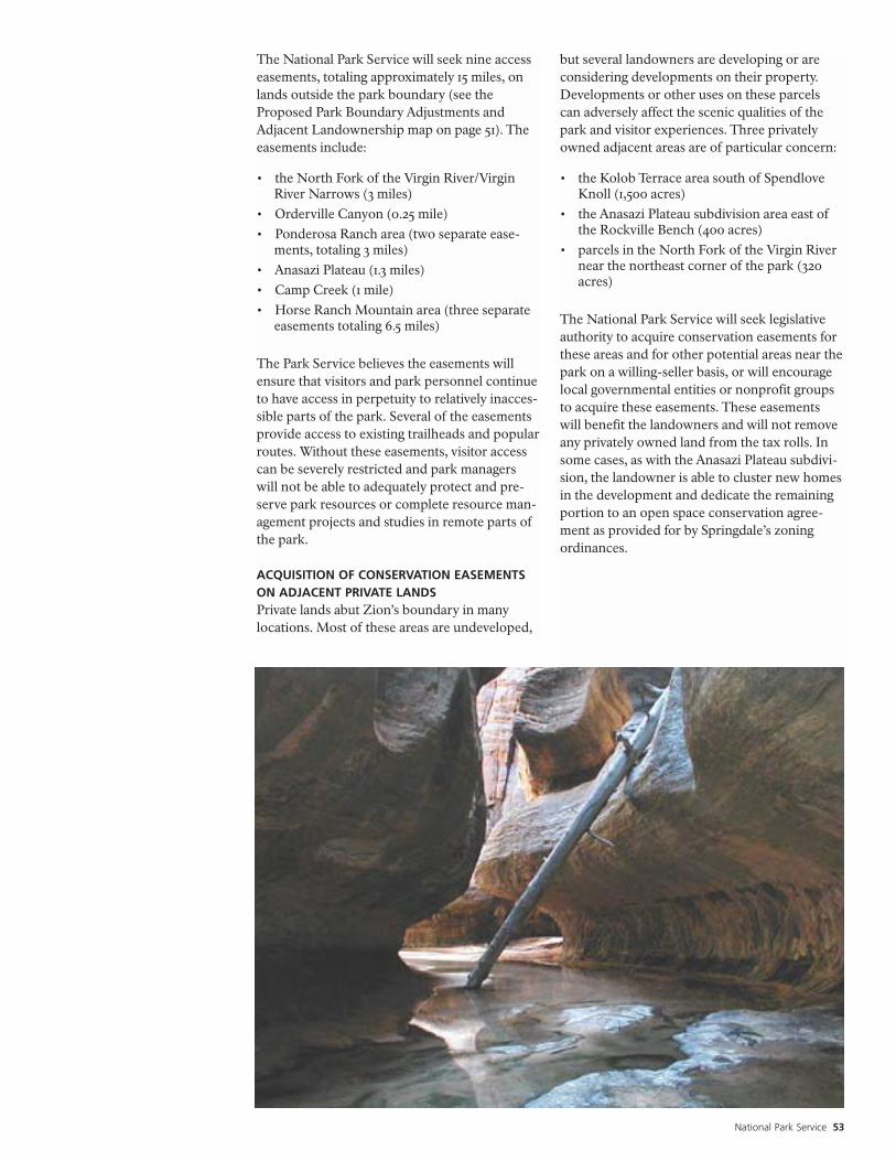
National Park Service 53
The National Park Service will seek nine accesseasements, totaling approximately 15 miles, onlands outside the park boundary (see theProposed Park Boundary Adjustments andAdjacent Landownership map on page 51). Theeasements include:
• the North Fork of the Virgin River/VirginRiver Narrows (3 miles)
• Orderville Canyon (0.25 mile)• Ponderosa Ranch area (two separate ease-
ments, totaling 3 miles)• Anasazi Plateau (1.3 miles)• Camp Creek (1 mile)• Horse Ranch Mountain area (three separate
easements totaling 6.5 miles)
The Park Service believes the easements willensure that visitors and park personnel continueto have access in perpetuity to relatively inacces-sible parts of the park. Several of the easementsprovide access to existing trailheads and popularroutes. Without these easements, visitor accesscan be severely restricted and park managerswill not be able to adequately protect and pre-serve park resources or complete resource man-agement projects and studies in remote parts ofthe park.
ACQUISITION OF CONSERVATION EASEMENTSON ADJACENT PRIVATE LANDSPrivate lands abut Zion’s boundary in manylocations. Most of these areas are undeveloped,
but several landowners are developing or areconsidering developments on their property.Developments or other uses on these parcelscan adversely affect the scenic qualities of thepark and visitor experiences. Three privatelyowned adjacent areas are of particular concern:
• the Kolob Terrace area south of SpendloveKnoll (1,500 acres)
• the Anasazi Plateau subdivision area east ofthe Rockville Bench (400 acres)
• parcels in the North Fork of the Virgin Rivernear the northeast corner of the park (320acres)
The National Park Service will seek legislativeauthority to acquire conservation easements forthese areas and for other potential areas near thepark on a willing-seller basis, or will encouragelocal governmental entities or nonprofit groupsto acquire these easements. These easementswill benefit the landowners and will not removeany privately owned land from the tax rolls. Insome cases, as with the Anasazi Plateau subdivi-sion, the landowner is able to cluster new homesin the development and dedicate the remainingportion to an open space conservation agree-ment as provided for by Springdale’s zoningordinances.

54 Zion National Park General Management Plan
As part of the planning process for Zion, a studywas conducted to determine whether any of therivers in the park and on six river segments onadjacent Bureau of Land Management landsshould be recommended for inclusion in thenational wild and scenic rivers system.
Appendix E summarizes the study process thatwas followed. (For more details on the studyprocess, see the Final Zion General Management
Plan / Environmental Impact Statement (NPS2000). Based on the evaluation, the followingfive rivers and their tributaries in the park werefound eligible and suitable for inclusion in thenational wild and scenic rivers system:
• the North Fork of the Virgin River above andbelow the Temple of Sinawava (two seg-ments)
• the East Fork of the Virgin River• North Creek• La Verkin Creek• Taylor Creek
In addition all six BLM segments evaluated werefound eligible and suitable, with the exception ofthe upstream 1.7-mile segment of Shunes Creekfrom the Kane County line to the dryfall. All ofthe above rivers and their tributaries will be pro-posed for wild, scenic, and recreational riverdesignation.
Table 1 lists the proposed classifications for therivers and their tributaries. (Tributaries are listedbeneath the main stems.) See the Wild andScenic Rivers map on page 55 for locations ofthe rivers and their tributaries.
The Zion National Park Water Rights Settle-ment Agreement provides comprehensive pro-tection of Zion National Park rivers. TheNational Park Service will support wild andscenic rivers authorizing legislation that recog-nizes this Agreement as constituting thereserved water rights for the park and that doesnot reserve more water for the park than is pro-vided for in the Agreement. In this way theNational Park Service can honor its commit-ments made in negotiating the Agreement.
Proposals for Wild, Scenic, andRecreational River Designation

National Park Service 57
River Classification
North Fork of the Virgin River, . . . . . . . . . . . . . WildAbove the Temple of Sinawava•Kolob Creek (incl. BLM segment) . . . . . . . . . . . . . Wild•Goose Creek (incl. BLM segment) . . . . . . . . . . . . . Wild•Imlay Creek . . . . . . . . . . . . . . . . . . . . . . . . . . . . . . Wild•Orderville Canyon . . . . . . . . . . . . . . . . . . . . . . . . . Wild•Deep Creek . . . . . . . . . . . . . . . . . . . . . . . . . . . . . . Wild•Mystery Canyon . . . . . . . . . . . . . . . . . . . . . . . . . . Wild
North Fork of the Virgin River . . . . . . . Recreationalbelow the Temple of Sinawava•Birch Creek Canyon . . . . . . . . . . . . . . . . . . . . . Wild•Pine Creek (excluding the segment . . . . . . . . . . . Wild
segment below the lowest switch-back west of the tunnel on Zion-Mt. Carmel Highway
•Pine Creek (below the switch- . . . . . . . . . Recreationalback to confluence with theNorth Fork Virgin
•Oak Creek (incl. BLM segment) . . . . . . . . Recreational•Heaps Canyon . . . . . . . . . . . . . . . . . . . . . . . . . . . . Wild•Behunin Canyon . . . . . . . . . . . . . . . . . . . . . . . . . . Wild•Echo Canyon . . . . . . . . . . . . . . . . . . . . . . . . . . . . . Wild•Clear Creek . . . . . . . . . . . . . . . . . . . . . . . . Recreational
East Fork of the Virgin River . . . . . . . . . . . . . . . Wild•Shunes Creek (incl. BLM segment), . . . . . . . . . . . . Wild
excluding the segment from thewater diversion to the westernpark boundary
•Shunes Creek from the western . . . . . . . . Recreationalpark boundary to the waterdiversion
River Classification
North Creek . . . . . . . . . . . . . . . . . . . . . . . . . . . . . Wild•Wildcat Canyon. . . . . . . . . . . . . . . . . . . . . . . . . . . Wild•Right Fork . . . . . . . . . . . . . . . . . . . . . . . . . . . . . . . Wild•Left Fork . . . . . . . . . . . . . . . . . . . . . . . . . . . . . . . . Wild•Grapevine Wash . . . . . . . . . . . . . . . . . . . . . . . . . Scenic•Wolf Springs Wash . . . . . . . . . . . . . . . . . . . . . . . Scenic•Pine Spring Wash . . . . . . . . . . . . . . . . . . . . . . . . Scenic•Russell Gulch . . . . . . . . . . . . . . . . . . . . . . . . . . . . . Wild•Little Creek . . . . . . . . . . . . . . . . . . . . . . . . . . . . . . Wild
LaVerkin Creek . . . . . . . . . . . . . . . . . . . . . . . . . . . Wild•Willis Creek (incl. BLM segment). . . . . . . . . . . . . . Wild•Beartrap Canyon (incl. BLM segment) . . . . . . . . . Wild•Currant Creek . . . . . . . . . . . . . . . . . . . . . . . . . . . . Wild•Cane Creek . . . . . . . . . . . . . . . . . . . . . . . . . . . . . . Wild•Timber Creek. . . . . . . . . . . . . . . . . . . . . . . . . . . . . Wild•Hop Valley Creek. . . . . . . . . . . . . . . . . . . . . . . . . . Wild
Taylor Creek . . . . . . . . . . . . . . . . . . . . . . . . . . . . . Wild•North Fork. . . . . . . . . . . . . . . . . . . . . . . . . . . . . . . Wild•Middle Fork from east of the park . . . . . . . . . . . Scenicboundary along the Kolob Canyons Road for 1 mile
•The rest of the Middle Fork . . . . . . . . . . . . . . . . . Wild(including the BLM segment) South Fork . . . . . . Wild
Table 1: Proposed Classification of Rivers in Zion National Park and on Adjacent BLM Lands

58 Zion National Park General Management Plan
PRIORITIES, COSTS, AND FUNDINGThe National Park Service will implement newdevelopments and management actions over thenext 20 years as funding becomes available. ThePark Service will establish partnerships withother agencies or groups to implement severalactions. The park’s management emphasis willshift under this plan, requiring a reallocation ofstaff among the different park programs.
Estimates regarding the general costs of imple-menting this plan are provided in the Final
General Management Plan / Environmental
Impact Statement. The actual cost of implement-ing the plan will ultimately depend on fundingby the National Park Service and Congress overthe life of the plan.
Given adequate funding, the highest priority willbe given to implement actions that serve the fol-lowing functions:
• address crucial resource protection needs• address visitor and employee safety concerns• remedy serious infrastructure concerns• accommodate immediate interpretation or
visitor use needs
FUTURE PLANNING AND RESEARCH NEEDSPark managers will prepare several “step-down”implementation plans and studies upon comple-tion of the General Management Plan. Thesemore detailed implementation plans willdescribe how the Park Service will achieve thedesired conditions outlined in the General
Management Plan by describing specific actionspark managers intend to take in Zion to ensurethat resources are protected, and visitors contin-ued to have opportunities for high qualityexperiences. The Park Service will seek publicinput in preparing all of these plans and willprepare additional environmental docu-mentation as needed to comply with theNational Environmental Policy Act.
The highest priority implementation plan will bethe wilderness management plan. Carryingcapacity studies also will be done for the frontand backcountry. (For details on the carryingcapacity studies, see page 36-38.) These studiesand plan will be completed by 2006.
The wilderness management plan will address avariety of topics, either as plan components orstand-alone plans:
• carrying capacity: appropriate uses and uselevels, including hikers and saddle stock use
• minimum requirement documentation:guidelines for the use of “minimum require-ment” that apply to all administrative deci-sions within the recommended wilderness
• resource issues: other visitor andresource impacts, reservation systems,human waste, signs, resource monitoring,and fire management
• climbing/canyoneering: locations, use levels,and resource issues
• river management: strategies for managingwater use in and from the park’s recom-mended wilderness
• commercial guiding: whether or not com-mercial guiding should be allowed in the rec-ommended wilderness, and if so how itshould be managed
In addition to these follow-up actions specific tothe park’s recommended wilderness, there areother implementation plans that will be needed.These plans will include:
• river management: detailed strategies formanaging the North Fork of the Virgin River
• water resources: parkwide water issues,including a water supply, treatment, and con-servation study
• air tour management: protection of naturalquiet and natural sounds
• soundscape management: preservation of thenatural soundscapes and mitigation of intru-sive noise from sources other than air tours
• commercial services: commercial servicesnecessary and appropriate in the park’sfrontcountry
• transportation plan: assess the need forexpanding the current shuttle system
Congressional authorization will be sought forpreparing a related lands study in the next oneto three years. The purpose of the study will beto identify key lands that are integral to main-taining ecological integrity and long- range con-servation of critical natural and culturalresources. The study will encompass public
Implementation

National Park Service 59
lands that may be considered for inclusion in thenational park, as well as public and privatelands, which may be managed cooperativelywith willing parties under easements, agree-ments or other means. The study should alsoconsider the availability of adjacent lands for
accommodating increased recreational use,include an analysis of the local economic impactof alternatives for managing the Zion NationalPark ecosystem, and determine the ecologicalboundaries necessary to ensure integrity of parkresources and natural processes.

As the nation's principal conservation agency, the Department of the Interior has responsibility for most of our nationally ownedpublic lands and natural resources. This includes fostering sound use of our land and water resources; protecting our fish, wildlife,and biological diversity; preserving the environmental and cultural values of our national parks and historical places; and providingfor the enjoyment of life through outdoor recreation. The department assesses our energy and mineral resources and works toensure that their development is in the best interests of all our people by encouraging stewardship and citizen participation in theircare. The department also has a major responsibility for American Indian reservation communities and for people who live in islandterritories under U.S. administration.
NPS D-190 / August 2001 / Printed on recycled paper

Zion National ParkSpringdale, Utah 84767-1099
E X P E R I E N C E Y O U R A M E R I C A
National Park ServiceU.S. Department of the Interior