GENERAL MANAGEMENT PLAN /ENVIRONMENTAL ASSESSMENT
324
GENERAL MANAGEMENT PLAN /ENVIRONMENTAL ASSESSMENT National Park Service U.S. Department of the Interior Montezuma Castle National Monument Tuzigoot National Monument Arizona MONTEZUMA CASTLE MONTEZUMAW ELL T UZIGOOT
Transcript of GENERAL MANAGEMENT PLAN /ENVIRONMENTAL ASSESSMENT

GENERAL MANAGEMENT PLAN /ENVIRONMENTAL ASSESSMENT
National Park ServiceU.S. Department of the Interior
Montezuma Castle National MonumentTuzigoot National MonumentArizona
MONTEZUMA CASTLE MONTEZUMAWELL TUZIGOOT


i
General Management Plan / Environmental Assessment
MONTEZUMA CASTLE NATIONAL MONUMENT AND TUZIGOOT NATIONAL MONUMENT
Yavapai County, Arizona
January 2010
As the responsible agency, the National Park Service prepared this general management plan to establish the direction of management of Montezuma Castle National Monument and Tu-zigoot National Monument for the next 15 to 20 years. The general management plan pro-vides comprehensive, integrated guidance for preserving cultural resources, perpetuating natural systems, providing opportunities for visitor enjoyment and understanding, and estab-lishing the organizational mechanism to accomplish the plan.
The previous general management plan for Montezuma Castle and Tuzigoot national mo-numents was completed in 1975. Since then, much has changed, including visitor use pat-terns, land uses in the Verde Valley outside the monuments, and area populations. These changes affect how visitors access and use the national monuments, the facilities needed to support those uses, management of resources, and how the National Park Service manages its operations. Therefore, a new plan is needed to allow the monuments to achieve desired conditions that implement goals of the National Park Service and the public for management and preservation of cultural and natural resources.
The environmental assessment that was prepared to determine the impacts of the general management plan considered three alternatives:
• Alternative A, the no-action alternative;
• Alternative B, which is the National Park Service preferred alternative and emphasizes opportunities to connect the monuments, including Montezuma Well (a detached unit of Montezuma Castle National Monument), with improved regional orientation to the Verde Valley; and
• Alternative C, which emphasizes self-discovery of the monuments’ resources.
The environmental assessment was prepared in compliance with the National Environmen-tal Policy Act to provide the decision-making framework that 1) analyzes a reasonable range of alternatives to meet objectives of the proposal, 2) evaluates potential issues and impacts to the monuments’ resources and values, and 3) identifies mitigation measures to lessen the de-gree or extent of these impacts. Resource topics included in this document because impacts may be greater than minor include cultural resources, natural resources, visitor use and expe-rience, socioeconomics, and monument operations. Other resource topics were dismissed because the plan would result in negligible or minor effects. No major effects are anticipated as a result of this plan. Public scoping was conducted to assist with the development of this document, and comments received during scoping are to a great extent reflected in the con-tent of this document and were considered in the development of the action alternatives.
U.S. Department of the Interior ● National Park Service

ii
HOW TO COMMENT ON THIS PLAN
If you wish to comment on the environmental assessment, you may post comments online at http://parkplanning.nps.gov/moca.
You may mail comments to
Montezuma Castle and Tuzigoot National Monuments General Management Plan National Park Service Denver Service Center Attn: Cynthia Nelson P.O. Box 25287 Denver, CO 80225
You may also hand deliver comments to Montezuma Castle and Tuzigoot National Monu-ment Headquarters, 527 South Main Street, Camp Verde, Arizona.
This environmental assessment will be on public review for 30 days. Before including your address, phone number, e-mail address, or other personal identifying information in your comment, you should be aware that your entire comment – including your personal identify-ing information – may be made publicly available at any time. While you can ask us in your comment to withhold your personal identifying information from public review, we cannot guarantee that we will be able to do so.

iii
SUMMARY
PURPOSE AND NEED FOR A GENERAL MANAGEMENT PLAN
The purpose of this general management plan is to establish a clear vision for the direction of management of Montezuma Castle and Tuzigoot national monuments for the next 15 to 20 years. The general management plan will provide compre-hensive and integrated guidance for pre-serving cultural resources, perpetuating natural systems, providing opportunities for visitor enjoyment and understanding, and establishing the organizational me-chanism to accomplish the plan.
Montezuma Castle National Monument was established in 1906 under the authori-ty of the Antiquities Act. Since then, Con-gress passed legislation in 1937, 1959, 1978, and 2003 expanding the boundary of the monument to better protect the natu-ral and cultural resources adjacent to the cliff dwellings.
Montezuma Well was added as a detached unit of Montezuma Castle National Mo-nument by an Act of Congress in 1943. Congress expanded the boundary of the well site in 1959 to protect resources adja-cent to the well and for administrative purposes.
Tuzigoot National Monument was estab-lished by presidential proclamation on July 25, 1939, to protect the prehistoric structures. The boundary was expanded by an Act of Congress in 1965 and again in 1978. Additional lands were conveyed through a land exchange in 2005.
The last comprehensive planning effort (general management plan) for Montezu-ma Castle and Tuzigoot national monu-ments was completed in 1975.
Since then, much has changed, including patterns and types of visitor use, land uses in the Verde Valley outside the monu-ments, and area populations. These
changes affect how visitors access and use the national monuments, the facilities needed to support those uses, manage-ment of resources, and how the National Park Service (NPS) manages its opera-tions. Therefore, a new plan is needed to:
• Set forth the basic management phi-losophy or vision for Montezuma Cas-tle and Tuzigoot national monuments and provide strategies for achieving identified management objectives (“desired future conditions”).
• Clearly define resource conditions and visitor use and experience to be achieved in the monuments.
• Identify the kinds of resource protec-tion, management, use, and develop-ment that will be appropriate in achieving and maintaining those con-ditions.
• Identify future partnerships and colla-borative planning efforts that would facilitate the realization of the monu-ments’ goals.
• Provide a framework for the monu-ments’ managers to use to make deci-sions about protecting Montezuma Castle and Tuzigoot national monu-ments’ resources, provide quality visi-tor use and experience, manage visitor use, and determine the kinds of facili-ties, if any, to develop in and near the monuments.

iv
• Ensure that the basic foundation for decision-making has been developed in consultation with interested stake-holders and adopted by the NPS lea-dership after an adequate analysis of the benefits, impacts, and economic costs of alternative courses of action.
• Investigate the potential for boundary modifications.
ALTERNATIVES AND THEIR IMPACTS
This General Management Plan and Envi-ronmental Assessment presents three alter-natives for management of Montezuma Castle and Tuzigoot national monuments. They include:
• Alternative A, the no-action alterna-tive (continue current management);
• Alternative B, the National Park Ser-vice preferred alternative, which em-phasizes opportunities to connect the three sites with improved regional orientation to the Verde Valley; and
• Alternative C, which emphasizes self-discovery of the monuments’ re-sources.
The alternatives, which are based on the monuments’ mission, purpose, and signi-ficance, present different ways to manage resources and visitor use and improve fa-cilities and infrastructure. Additional ac-tions and alternatives were considered but were dismissed for the reasons described in chapter 2.
Alternative A: The No-Action Alternative (Continue Current Management)
This alternative would continue current management direction and trends at Mon-tezuma Castle and Tuzigoot national mo-numents. It provides a baseline for com-parison in evaluating the changes and im-pacts of the action alternatives.
Natural resources would be protected by being in the monuments. Existing opera-
tions and visitor facilities would remain in place. Opportunities for close contact be-tween visitors and the natural and cultural resources at the sites would continue to be limited. The interpretive emphasis would continue to focus on the three primary sites within the monuments, with little connection among the sites in terms of interpretation.
At Montezuma Castle, resource activities would continue to focus on stabilizing the primary site, with intensive preservation treatment and regular cyclic maintenance. Visitor opportunities would continue to focus on viewing the Castle and visiting the visitor center. Existing administration facilities would remain the same.
At Montezuma Well, resource activities would continue to focus on monitoring water quantity. Visitor opportunities would continue to focus on viewing Mon-tezuma Well and visiting the well outlet. The picnic area would continue to be a major draw for local visitation.
At Tuzigoot, resource activities would continue to focus on stabilizing the prima-ry site, with intensive preservation treat-ment and regular cyclic maintenance. Visi-tor opportunities would continue to focus on exploring the pueblo and visiting the visitor center/museum.
Although the no-action alternative may not meet all goals set forth for this general management plan, it serves as the baseline against which the action alternatives are evaluated. The important impacts of con-tinuing existing management conditions and trends would include the following.
• Ongoing management actions would continue to allow current hydrological conditions to persist in Tavasci Marsh in Tuzigoot National Monument, which would have a long-term, minor to moderate, adverse impact on wet-land functions and habitat.
• Informal access to the Verde River at Tuzigoot National Monument would

Summary
v
continue, representing a long-term, minor, adverse effect on wildlife.
• Change in the Tavasci Marsh habitat exposure could have a long-term ef-fect on flycatcher habitat and the Yu-ma clapper rail, but would result in a “not likely to adversely affect” deter-mination.
• Alternative A would result in continu-ing minor, beneficial impacts resulting from the continued opportunities to view the monuments’ prime cultural resources. However, minor, adverse impacts from crowding and conges-tion during peak-use time periods would continue.
• The lack of adequate interpretive and education facilities for regular and di-verse programming would continue to have a minor, adverse impact to visi-tors.
• Long-term, minor, adverse effects on monument operations would continue because of congestion and crowding in Montezuma Castle National Mo-nument; very limited opportunities at Montezuma Well for site orientation and interpretation; facilities which limit the monument’s ability to pro-vide consistent and diverse interpre-tive programming; and the lack of effi-cient distribution of staff among the three sites and the headquarters and maintenance buildings, which are out-side the monuments.
• Actions at Montezuma Castle and Tu-zigoot national monuments would re-sult in minor benefits and would have no adverse effect on archeological re-sources, prehistoric and historic struc-tures and buildings, cultural land-scapes, and ethnographic resources of the monuments.
Alternative B, Preferred
The main emphasis of this alternative is to connect the three sites with improved re-gional orientation to the Verde Valley
area. Visitors would be introduced to all three sites and their related interpretive themes through coordinated messaging among the three sites. Visitors would tra-vel to the sites to learn firsthand about elements of the prehistoric and historic stories associated with human settlement of the Verde Valley.
The National Park Service would increase resource stabilization and monitoring ef-forts. Partnerships would improve orien-tation at the sites and other opportunities in the Verde Valley. More of the monu-ments’ cultural and natural resources would be available for visitors to explore via trails. The National Park Service would acquire 16 acres of privately owned land riparian and bluff land within Montezuma Well and most of the privately owned lands within Tuzigoot’s legislated bounda-ries except for the land owned by Freeport McMoRan Copper and Gold, Inc., which contain mine tailings; this land would be removed from the legislated boundary. The mine tailings do not contain resources related to the purpose and significance of the monument, are highly disturbed by mining activity, and are contaminated by hazardous substances. The monument is particularly interested in acquiring the relatively intact acreage on the bench northwest of the ruins, which has archeo-logical sites.
At Montezuma Castle, the existing facili-ties for visitor services would remain much as today. Some natural-surface trails with interpretive signs may be sited across the creek to provide views to the castle. A corridor along Montezuma Castle Road would accommodate regional trail activi-ties for horseback riding, hiking, and mountain biking. The equipment shed (determined eligible for listing in the Na-tional Register of Historic Places on July 13, 1994) would be rehabilitated and adap-tively reused.
At Montezuma Well, the existing facilities leading to and around the well would re-main much as today. The amount of inter-

SUMMARY
vi
pretation and interaction with resources associated with the long history of prehis-toric and historic farming in the area would increase. The area just south and west of the picnic area would include nat-ural surface trails improved on existing formal and informal trail routes. An addi-tion to the visitor contact station (shade ramada) would be constructed in the parking lot near the well.
At Tuzigoot, the areas east, north, and south of the pueblo would provide natural surface trails along the marsh and riparian area. Through collaboration with part-ners, these trails may link with trails in Dead Horse Ranch State Park and Coco-nino National Forest. The existing visitor facilities would remain much as today. There would be increased cultural dem-onstrations in and around the pueblo. Access would be provided via trails to the river. Active marsh restoration and man-agement activities would begin at the Ta-vasci Marsh. A boardwalk would be con-structed through the marsh. If assessment determines that there would be no conflict with preservation of significant cultural resources, this would be constructed along an existing old road alignment. A modest workspace and storage building with emergency visitor services would be constructed near the residential area.
The important impacts of implementing alternative B would include the following.
• Active marsh restoration activities at Tuzigoot National Monument would have a negligible to minor, long-term, beneficial effect on wetland habitat functions at Tavasci Marsh.
• Trail development would have neglig-ible to minor, short-term, adverse im-pacts on wildlife and wildlife habitat at Montezuma Castle National Monu-ment.
• The boardwalk at Tavasci Marsh in Tuzigoot National Monument would have long-term, negligible to minor, adverse impacts on wildlife species.
• Marsh restoration and ongoing ditch maintenance activities at Tuzigoot Na-tional Monument would have long-term, negligible to minor benefits on flycatcher foraging habitat and on rail habitat.
• Moderate to major, beneficial effects would result from connecting the three sites and from the increased di-versity in opportunities to view and learn about the monuments’ prime cultural resources.
• Providing more trail opportunities and cultural programs would make visits to each site more exciting, interesting, and inviting for repeat visitation.
• Long-term, minor to moderate, bene-ficial effects on monument operations would result from increased and im-proved space for monument opera-tions and from improved capability to manage visitors and resources. There would be long-term, minor, adverse impacts due to the addition of facilities that would require increased opera-tions and maintenance.
• Actions at Montezuma Castle and Tu-zigoot national monuments would re-sult in minor benefits and would have no adverse effect on archeological re-sources, prehistoric and historic struc-tures and buildings, cultural land-scapes, and ethnographic resources of the monuments.
Alternative C
The main emphasis of this alternative is to provide increased opportunities for visi-tors to self-discover the beauty and won-der of the natural and cultural resources of the monuments. Resources would still receive the highest level of protection, and visitors could interact with and explore a wider range of the resources found in the monuments.
Protection of natural resources would be reduced compared to alternative B be-cause of the larger development footprint

Summary
vii
in this alternative. More of the monu-ments’ cultural and natural resources would be available for visitors to explore via trails. Visitor stays would increase at each of the three sites. The National Park Service would acquire most of the private-ly owned lands within the legislated boundaries except for the mine tailings at Tuzigoot, which would be removed from the legislated boundary. The mine tailings do not contain resources related to the purpose and significance of the monu-ment, are highly disturbed by mining ac-tivity, and are contaminated by hazardous substances.
At Montezuma Castle, the existing visitor facilities would remain much as today. A new headquarters would be located at the beginning of the entrance road to the mo-nument. Access over the creek via a new bridge and some picnic facilities on the south bank of the creek would be pro-vided. In addition, self-guided, designated trails would follow the river corridor. To provide better views of the river valley, a small number of private vehicles would be allowed access to the plateau above the cliff dwelling. A corridor along Montezu-ma Castle Road would accommodate re-gional trail activities for horseback riding, hiking, and mountain biking.
At Montezuma Well, the existing visitor facilities would remain much as today. A new visitor center is proposed at the en-trance of the road to Montezuma Well. Designated natural-surface trails would be improved along existing disturbed align-ments to and along the riparian area of Wet Beaver Creek, and a natural-surface, designated trail would be located near the prehistoric ditch that extends from Mon-tezuma Well and along Wet Beaver Creek. A trail would also extend from the visitor center to Montezuma Well, following the road. The pit house along the entrance road would be accessible with a trail.
At Tuzigoot, most of the monument would be zoned to provide natural-surface trails. If assessment determines
that there would be no conflict with pre-servation of significant cultural resources, mountain bicycling opportunities may al-so be provided on old roadbeds in the area. The existing visitor facilities would remain much as today. The monuments would cooperate with the Arizona State Parks on the Verde River Greenway Man-agement Plan proposal for a small parking area and launch for small boats on state-owned land on the east side of the monu-ment entrance road.
The important impacts of implementing alternative C would include the following.
• Construction of a new headquarters and access and parking on the plateau at Montezuma Castle National Mo-nument would have long-term, neglig-ible to minor, adverse impacts on ve-getation and soils.
• At Tuzigoot, the adverse impacts of trail development on vegetation and soils would be negligible to minor.
• The long-term, adverse impacts of an extended trail and boardwalk at Tuzi-goot on wildlife and their habitat would be local and negligible to mi-nor.
• Marsh restoration and ongoing ditch maintenance activities at Tuzigoot Na-tional Monument would have long-term, negligible to minor benefits on flycatcher foraging habitat and on rail habitat.
• Moderate beneficial effects would re-sult from the increased diversity in opportunities to view and learn about the monuments’ prime cultural re-sources.
• Providing more trail opportunities and cultural programs would make visits to each site more exciting, interesting, and inviting for repeat visitation.
• Long-term, moderate to major, bene-ficial effects on Montezuma Castle National Monument operations would result from increased and im-

SUMMARY
viii
proved space for monument opera-tions, and improved capability to manage visitors and resources. There would be long-term, minor, adverse impacts due the addition of facilities that would require increased opera-tions and maintenance.
• Actions at Montezuma Castle and Tu-zigoot national monuments would re-sult in minor benefits and would have no adverse effect on archeological re-sources, prehistoric and historic struc-tures and buildings, cultural land-scapes, and ethnographic resources of the monuments.
• A new visitor center at Montezuma Well would improve visitor orienta-tion and interpretation services and contribute to better visitor under-standing and appreciation of the re-sources of the monuments and the re-gion, and would result in long-term, moderate, beneficial impacts on visi-tors.
THE NEXT STEPS
After the distribution of the general man-agement plan and environmental assess-ment, there will be a 30-day public review and comment period, after which the NPS planning team will evaluate comments from other federal agencies, tribes, organ-izations, businesses, and individuals re-garding the plan. The National Park Ser-vice expects that it will then be able to prepare a finding of no significant impact documenting the NPS selection of an al-ternative for implementation. After the finding has been approved by the regional director, the plan can be implemented.
IMPLEMENTATION OF THE PLAN
The approval of this plan does not guaran-tee that the funding needed to implement the plan will be forthcoming. The imple-mentation of the approved plan will de-pend on future funding, and it could also be affected by factors such as changes in NPS staffing, visitor use patterns, and un-
anticipated environmental changes. Full implementation could be many years in the future. Once the General Management Plan has been approved, additional feasi-bility studies and more detailed planning, environmental documentation, and con-sultations would be completed, as appro-priate, before certain actions in the se-lected alternative can be carried out.
Future program and implementation plans, describing specific actions that managers intend to undertake and ac-complish in the monument, will tier from the desired conditions and long-term goals set forth in this general management plan.

ix
CONTENTS
Chapter 1: Purpose of and Need for the Plan
Introduction 3
A Guide to This Document 3 Brief Description of the Monuments 4
Montezuma Castle National Monument 4 Tuzigoot National Monument 6
Purpose of the Plan 10 Need for the Plan 11 Establishment and Administration of Montezuma Castle and Tuzigoot National
Monuments 11 Montezuma Castle National Monument 11 Tuzigoot National Monument 15
Guidance for the Planning Effort 17 Mission Statement 17 Purpose and Significance 17
Purpose 17 Significance 17
Fundamental Resources and Values 18 Cultural Connectivity 18 Structures and Related Resources and Values 19 Natural Features 19 Other Important Resources and Values 19
Objectives 20 Cultural and Natural Resources 20 Visitor Use and Experience 20 Monument Operations 20 Partnerships 20
Primary Interpretive Themes 20 Special Mandates and Administrative Commitments 21 Servicewide Mandates and Policies 21 Guiding Management Principles and Strategies 22
Manage and Protect Cultural Resources 22 Manage and Protect Natural Resources 24 External Influences - Private and Public Partners, Owners of Adjacent Land,
and Government Agencies 28 Ensure Sustainability by Employing User (Carrying) Capacity 28 Provide Orientation, Interpretation, and Education 29
Implementing the Approved Plan 30 Relationship to Other Planning Efforts 31
Plans of Federal Agencies 31 U.S. Forest Service Plans 31 Park Museum Collection Storage Plan 31

CONTENTS
CONTENTS (Continued)
x
State of Arizona Plans 31 Plans by Others 31
Verde River Greenway Management Plan 31 Sinaguan Circle Tour 32 Freeport McMoRan Copper and Gold, Inc. Mine Tailings Project 32 Yavapai-Apache Nation Native American Visitor Center 32 Montezuma Castle Highway Regional Multi-Use Trail 32 Soda Springs Ranch Development 32 Expansion of the Yavapai- Apache Casino Resort 32 Verde Valley Regional Land Use Plan 32
Planning Issues and Opportunities 33 Issues and Opportunities 33 Issues not Addressed in the General Management Plan 35
Vanishing Treasures 35 Fire Management 35
Impact Topics: Resources and Values at Stake in the Planning Process 36 Impact Topics to Be Considered 36
Cultural Resources 36 Natural Resources 36 Visitor Use and Experience 37 Socioeconomics 37 Monument Operations 37
Impact Topics Dismissed from Further Consideration 37 Cultural Resources 37 Natural Resources 38 Transportation 39 Conflicts with Land Use Plans, Policies, or Concerns 39 Energy Requirements and Conservation Potential 39 Indian Trust Resources 39 Natural Sounds 40 Lightscape Management 40 Environmental Justice 41
Chapter 2: Alternatives, Including the Preferred Alternative
Introduction 45 Management Zones and Alternatives 45 Formulation of the Alternatives 46 Identification of the Preferred Alternative 46
Management Zones 47 Alternative A: No-Action Alternative 51
Concept and General Management Strategies 51 Boundary Adjustments, Land Purchases, and Easements 52
Alternative B (Preferred) 56 Concept and General Management Strategies 56 Conditions and Actions Common to All Three Sites 56

Contents
CONTENTS (Continued)
xi
Management Zones and Related Actions at Each Site 57 Montezuma Castle 57 Montezuma Well 58 Tuzigoot 58
Boundary Adjustments, Land Purchases, and Easements 59 Alternative C 64
Concept and General Management Strategies 64 Conditions and Actions Common to All Three Sites 64 Management Zones and Related Actions at Each Site 65
Montezuma Castle 65 Montezuma Well 66 Tuzigoot 66
Boundary Adjustments, Land Purchases, and Easements 67 Cost Estimates 71
Development of Cost Estimates 71 Initial One-Time Costs 71 NPS Facilities Model 71
Summary of Comparative Costs 71 User Capacity 73
Park Operations Zone 73 Interpretive Historic Zone 73 Interaction and Discovery Zone 74 Resources and Research Zone 75
Mitigation Measures Common to All Alternatives 76 Cultural Resources 76 Natural Resources 77
Air Quality 77 Nonnative and Exotic Species 77 Natural Sounds 78 Soils 78 Threatened and Endangered Species and Species of Concern 78 Vegetation 78 Water Resources 79 Wildlife 79 Wetlands 79
Visitor Safety and Experiences 79 Hazardous Materials 80 Scenic Resources 80 Socioeconomics 80 Sustainable Design and Aesthetics 80
Future Studies and Implementation Plans Needed 81 Environmentally Preferred Alternative 82 Alternatives and Actions Considered but Dismissed from Detailed Evaluation 84
Montezuma Castle 84 Castle Site 84 Well Site 84
Tuzigoot 84 Summaries 85

CONTENTS
CONTENTS (Continued)
xii
Chapter 3: Affected Environment
Introduction 103 Cultural Resources 104
Overview of Verde Valley Cultural History 105 Introduction 105 Prehistoric Period 105 Historic Period (about AD 1500 to Present) 106
Cultural Resources in the National Monuments 107 Archeological Resources 107 Montezuma Castle National Monument 108 Tuzigoot National Monument 109
Ethnographic Resources 111 Cultural Affiliation Study 111 Native American Graves Protection and Repatriation Act Inventory Information 112
Prehistoric and Historic Structures and Buildings 113 List of Classified Structures 113
Cultural Landscapes 114 Montezuma Castle National Monument 115 Tuzigoot National Monument 115
Properties Listed in the National Register of Historic Places 115 Montezuma Castle National Monument 115 Tuzigoot National Monument 117
Properties Determined Eligible for Listing in the National Register of Historic Places 118
Other Structures of Potential Historic Significance 118 Montezuma Castle Visitor Center 118 Back Cabin and Smokehouse 118
Natural Resources 119 Floodplains 119 Wetlands 120 Soils and Vegetation 120
Montezuma Castle National Monument 120 Tuzigoot National Monument 121
Wildlife 122 Threatened and Endangered Species 122
Southwestern Willow Flycatcher 123 Yuma Clapper Rail 124 Yellow-billed Cuckoo 124
Visitor Use and Experience 126 Visitor Use Characteristics for All Three Sites 126 Visitor Safety at All Three Sites 131 Montezuma Castle National Monument 131
Visitor Experience and Recreational Opportunities 131 Orientation, Information, and Interpretation 134 Access for Disabled Visitors 134

Contents
CONTENTS (Continued)
xiii
Montezuma Well 134 Visitor Experience and Recreational Opportunities 134 Orientation, Information, and Interpretation 135 Access for Disabled Visitors 136
Tuzigoot National Monument 136 Visitor Experience and Recreational Opportunities 136 Orientation, Information, and Interpretation 137 Access for Disabled Visitors 138 Regional Recreational Opportunities 138
Monument Operations 141 Socioeconomics 144
Regional Economy 145 Employment 146 Labor Force Participation 147 Unemployment 147 Personal Income 147 Commuting 149 Poverty 149
Population and Demographics 149 Population 149 Age and Average Household Size 149 Race and Hispanic Origin 149 Migration 150 Projected Long-term Population Growth 150 Housing 150 Adjacent Land Use 151
Economic Contributions of the National Monuments to the Local Economy 151 Visitor Spending 151 Monument Operations 153 Total Economic Contributions 155
Chapter 4: Environmental Consequences
Introduction 159 Cumulative Impact Analysis 159 Impairment of Montezuma Castle and Tuzigoot National Monuments Resources
160 Unacceptable Impacts 160
Methods and Assumptions for Analyzing Impacts 162 Cultural Resources 162
Cultural Resources Listed, or Eligible to Be Listed, in the National Register of Historic Places 162 Ethnographic Resources 163
Natural Resources 164 Floodplains 164 Soils 165 Vegetation 165 Wetlands 165 Wildlife 166 Threatened and Endangered Species and Special Status Species 166

CONTENTS
CONTENTS (Continued)
xiv
Visitor Use and Experience 167 Monument Operations 168 Socioeconomics 169
Impacts of Implementing Alternative A (No-Action) 170 Cultural Resources 170
Archeological Resources 170 Prehistoric and Historic Structures and Buildings 173 Cultural Landscapes 176 Ethnographic Resources and Traditional Cultural Properties 180
Natural Resources 182 Floodplains 182 Soils and Vegetation 183 Wetlands 184 Wildlife 185 Threatened and Endangered Species 186
Visitor Use and Experience 188 Visitor Experiences of Monument Resources 188 Access to Orientation, Interpretation, and Education 189 Visitor Safety 190 Cumulative Effects 190 Conclusion 191
Monument Operations 191 Montezuma Castle National Monument 191 Tuzigoot National Monument 191 All Sites 191 Cumulative Effects 192 Conclusion 192
Socioeconomics 193 Cumulative Effects 194 Conclusion 194
Impairment Conclusion For Alternative A 194 Impacts of Implementing Alternative B (Preferred) 196
Cultural Resources 196 Archeological Resources 196 Prehistoric and Historic Structures and Buildings 197 Cultural Landscapes 197 Ethnographic Resources and Traditional Cultural Properties 198
Natural Resources 199 Floodplains 199 Soils and Vegetation 201 Wetlands 204 Wildlife 205 Threatened and Endangered Species 207
Visitor Use and Experience 210 Visitor Experiences of Monument Resources 210 Access to Orientation, Interpretation, and Education 212 Visitor Safety 212 Cumulative Effects 212 Conclusion 213

Contents
CONTENTS (Continued)
xv
Monument Operations 214 Montezuma Well 214 Tuzigoot National Monument 214 All Sites 214 Cumulative Effects 215 Conclusion 215
Socioeconomics 215 All Sites 215 Montezuma Castle National Monument 215 Montezuma Well 216 Tuzigoot National Monument 216 Cumulative Effects 216 Conclusion 216
Impairment Conclusion For Alternative B 216 Impacts of Implementing Alternative C 217
Cultural Resources 217 Archeological Resources 217 Prehistoric and Historic Structures and Buildings 218 Cultural Landscapes 218 Ethnographic Resources and Traditional Cultural Properties 219
Natural Resources 220 Floodplains 220 Soils and Vegetation 222 Wetlands 227 Wildlife 228 Threatened and Endangered Species 229
Visitor Use and Experience 232 Visitor Experiences of Monument Resources 232 Access to Orientation, Interpretation, and Education 233 Visitor Safety 234 Cumulative Effects 234 Conclusion 235
Monument Operations 235 Montezuma Castle National Monument 235 Montezuma Well 236 Tuzigoot National Monument 236 All Sites 236 Cumulative Effects 237 Conclusion 237
Socioeconomics 237 Montezuma Castle National Monument 237 Montezuma Well 238 Tuzigoot National Monument 238 All Sites 238 Cumulative Effects 238 Conclusion 239
Impairment Conclusion For Alternative C 239
CONTENTS
CONTENTS (Continued)
xvi
Chapter 5: Consultation and Coordination
History of Public Involvement 243 Public and Agency Development 243 Public Meetings and Newsletters 243 Section 7 Consultation (U.S. Fish and Wildlife Service) 244 Arizona State Agency Consultation 244 Section 106 Consultation (Arizona State Historic Preservation Office) 244 Consultation with Native Americans 245 County and Local Government Consultation 246
List of Preparers 247 Core Planning Team 247
Montezuma Castle and Tuzigoot National Monuments 247 Denver Service Center 247
Consultants 248 Parsons 248 National Park Service, Southern Arizona Office 248 Western Archeological and Conservation Center 248 Western National Parks Association 248 e2M (Engineering Environmental Management) 248
List of Recipients 249 Federal Agencies 249 U.S. Senators and Representatives 249 State Agencies 249 State Officials 249 Native American Tribes Traditionally Associated with the National Monuments 249 Local and Regional Government Agencies 249 Organizations and Businesses 250
References
Bibliography 253 Index 257 Appendix A: Legal Mandates 261 Enabling Legislation 261
Antiquities Act of 1906 and Presidential Proclamation 696, December 8, 1906, Establishing Montezuma Castle National Monument 261
Presidential Proclamation 2344, July 25, 1939, Establishing Tuzigoot National Monument 266
Laws and Policies Guiding Management of Montezuma Castle and Tuzigoot National Monuments 269 Fish and Wildlife 270 Threatened and Endangered Species 270 Wetlands 271 Water Resources 271 Cultural Resources 272 Coastal Zone and Floodplains 273
Appendix B: Consultation and Correspondence 275 Appendix C: Threatened and Endangered Species 301

Contents
CONTENTS (Continued)
xvii
MAPS
Vicinity – Arizona 5 Montezuma Castle Site – Parcel Map 7 Montezuma Well Site – Parcel Map 8 Tuzigoot National Monument – Parcel Map 9 Alternative A – No Action, Montezuma Castle National Monument, Castle Site 53 Alternative A – No Action, Montezuma Castle National Monument, Well Site 54 Alternative A – No Action, Tuzigoot National Monument 55 Alternative B – Castle Site, Montezuma Castle National Monument 61 Alternative B – Well Site, Montezuma Castle National Monument 62 Alternative B – Tuzigoot National Monument 63 Alternative C – Castle Site, Montezuma Castle National Monument 68 Alternative C – Well Site, Montezuma Castle National Monument 69 Alternative C – Tuzigoot National Monument 70
FIGURES
1: Montezuma Castle National Monument Annual Visitation, 1940-2007 127 2: Montezuma Well Annual Visitation, 1992-2007 127 3: Tuzigoot National Monument Annual Visitation, 1940-2007 128 4: Visitation by Month at Montezuma Castle National Monument, 2002-2007 129 5: Visitation by Month at Montezuma Well, 2002-2007 129 6: Visitation by Month at Tuzigoot National Monument, 2002-2007 130 7: Percentages of Visitors Seeing One or More Sites 132 8: Top Five States of Residence for Visitors 132 9: Full-Time and Part-Time Employment, Yavapai County, 2002 147 10: Population Forecasts to 2030, Coconino and Yavapai Counties 150

CONTENTS
CONTENTS (Continued)
xviii
TABLES
1: Montezuma Castle and Tuzigoot National Monuments Management Zones 48
2: Cost Summary for Each Alternative 72 3: Environmentally Preferred Alternative Analysis 83 4: Summary of the Alternatives 86 5: How the Alternatives Meet the Objectives 90 6: Summary of Impacts of the Alternatives 93 7: Endangered, Candidate, and Special Status Species with the Potential to Occur at
Montezuma Castle and Tuzigoot National Monuments 124 8: Regional Parks, Monuments, and Recreational Areas 140 9: Full-Time Equivalent Employees for Montezuma Castle and Tuzigoot National
Monuments 142 10: Number of Establishments, by Industrial Sector and Community, 2003 146 11: Average Annual Unemployment Rates 147 12: Personal Income among Verde Valley Households, 1999 148 13: Annual Visitor Spending in the Verde Valley by Visitors to Montezuma Castle and
Tuzigoot National Monuments 152 14: Direct Economic Impacts of Visitor Spending in the Verde Valley, 2003 154 15: Direct Economic Impacts in the Verde Valley of the Montezuma Castle and Tuzigoot
National Monuments Operations, Fiscal Year 2004 154 16: Total Economic Impacts In the Verde Valley of the Montezuma Castle and Tuzigoot
National Monuments, 2003 154

CHAPTER 1:PURPOSE OF AND NEED FOR THE PLAN


3
INTRODUCTION
This General Management Plan and Envi-ronmental Assessment presents and ana-lyzes alternative future directions for the management and use of Montezuma Cas-tle and Tuzigoot national monuments. The two monuments, approximately 20 miles apart, are managed together. Within this plan, alternative B is preferred by the National Park Service (NPS). The poten-tial environmental impacts of the alterna-tives have been identified and assessed.
General management plans establish and articulate a management philosophy and framework for long-term (15 to 20 years) decision-making and problem solving in units of the national park system.
Actions directed by general management plans or in subsequent implementation plans are intended to be accomplished over time. Budget restrictions, require-ments for additional data or regulatory compliance, and competing NPS priorities prevent immediate implementation of many actions. Major or particularly costly actions could be implemented 10 or more years into the future. The approval of this plan does not guarantee that the funding for proposed actions will be forthcoming. The implementation of the approved plan, no matter which alternative is selected, will depend on future NPS funding levels and servicewide priorities.
A GUIDE TO THIS DOCUMENT
This document contains the general man-agement plan and an environmental as-sessment that discloses the impacts asso-ciated with each of the alternatives. It con-forms with:
• The Council on Environmental Quali-ty’s (1978) implementing regulations for the National Environmental Policy Act;
• NPS planning guidelines in chapter 2 of Management Policies 2006 (NPS 2006);
• Director’s Order 12 on conservation planning, environmental impact analy-sis, and decision-making (NPS 2001);
• Section 106 of the National Historic Preservation Act (16 United States Code 470 et seq.);
• Title 36, Code of Federal Regulations, section 800, Protection of Historic Properties; and
• Cultural resource management guide-lines in chapter 5 of Management Poli-cies 2006 and Director's Order 28 and its associated guidelines.
Chapter 1: Purpose and Need sets the framework for the entire document. It de-scribes why the plan is being prepared and what needs it must address. It gives guid-ance for the alternatives that are being considered, which are based on the Mon-tezuma Castle and Tuzigoot national mo-numents’ legislated missions, their pur-poses, the significance of their resources, special mandates and administrative commitments, and servicewide mandates and policies.
This chapter also details the planning op-portunities and issues that were raised during public scoping meetings and initial planning team efforts that served as the basis for developing the alternatives pre-sented in chapter 2. It presents the funda-mental resources and values that guide planning and decision making, the guiding management principles that shape the monuments’ management, and the rela-tionship to other plans that could affect implementation of this general manage-ment plan. This chapter concludes with the scope of the environmental impact analysis, including the identification of the impact topics that were analyzed in detail.
Chapter 2: Alternatives, including the Preferred Alternative, begins by describ-ing the management prescriptions that will be used to manage Montezuma Castle and

CHAPTER 1: PURPOSE OF AND NEED FOR THE PLAN
4
Tuzigoot national monuments in the fu-ture. Alternative A describes the continua-tion of current management and trends in Montezuma Castle and Tuzigoot national monuments. Alternative B (preferred) and alternative C, collectively called the action alternatives, provide other approaches for managing the monuments.
Mitigation measures to minimize or elimi-nate the impacts of some proposed actions are described. A discussion is also pro-vided of the alternatives considered by the National Park Service and dismissed from further analysis. The chapter concludes with summary tables of the three alterna-tive actions and the environmental conse-quences of implementing those alternative actions.
Chapter 3: Affected Environment de-scribes the areas and resources that would be affected by implementing actions under the alternatives. These include cultural resources, natural resources, visitor use and experience, and socioeconomics.
Chapter 4: Environmental Conse-quences analyzes the impacts of imple-menting the alternatives on the impact topics that were identified in chapter 1. Methods used for assessing the impacts in terms of the intensity, type, and duration of impacts are outlined at the beginning of the chapter.
Chapter 5: Consultation and Coordina-tion describes the history of public and agency coordination during the planning effort and lists agencies and organizations that will receive copies of this document.
The references at the end include the bib-liography, index, and appendixes with supporting information for the document.
BRIEF DESCRIPTION OF THE MONUMENTS
Montezuma Castle National Monument (including Montezuma Well) and Tuzigoot National Monument are NPS units in central Arizona. The monuments are within a 30-minute drive of each other and are managed collectively under a single administrative organization. The Vicinity - Arizona map shows the locations of these NPS units.
Montezuma Castle National Monument
Montezuma Castle National Monument is approximately 3 miles east of I-17 exit 289. The National Monument has a visitor cen-ter, a bookstore, and a museum that in-clude exhibits and artifacts depicting the lifestyle, history, and culture of the Sina-guan Indians, who built Montezuma Cas-tle. The Castle itself is not open to the public, but a trail below the Castle offers many panoramic viewpoints. The monu-ment also contains restrooms, a picnic area, and a parking facility for cars and recreational vehicles. Several administra-tive buildings housing ranger operations are south of the parking facility. Monte-zuma Well, about 4 miles east of I-17 exit 293, contains a picnic area, restrooms, hik-ing trails, a visitor contact station, bulletin boards displaying visitor information, a small parking area, and several administra-tive buildings east of the Back ranch area.

Mo
nte
zu
ma C
ast
le
Nati
on
al
Mo
nu
me
nt
Mo
nte
zu
ma W
ell
Tuzig
oo
t N
ati
on
al
Mo
nu
men
t
Can
yon d
e C
hel
lyN
atio
nal M
onu
men
t
Jero
me
17
179
260
Gra
nd
Can
yon
Nati
on
al Park
Petr
ifie
d F
ore
st
Nati
on
al Park
Wu
patk
i N
ati
on
al M
onu
ment
Wal
nut
Can
yon
Nati
on
al M
onu
ment
Sun
set
Cra
ter
Volc
an
oN
ati
on
al M
onu
ment
Tonto
Natio
nal M
on
um
en
t
To
nto
Na
tio
na
l Fo
rest
Co
co
nin
o N
ati
on
al
Fo
rest
Ka
iba
b N
ati
on
al
Fo
res
t
Ap
ach
e-S
itg
rea
ve
s N
ati
on
al
Fo
rest
Ka
iba
b
Na
tio
na
l F
ore
st
Pre
sco
tt
Na
tio
na
l F
ore
st
Pre
sco
tt
Na
tio
na
l F
ore
st
Ph
oen
ix
Mes
a
Scott
sdal
eG
lend
ale
Peoria
Flagst
aff
Surp
rise
New
Riv
er
Pres
cott
Good
year
Kin
gm
an
Pays
on
Avo
ndal
e
Win
slow
Foun
tain
Hill
s
Pauld
en
Cam
p V
erde
Holb
rook
Chin
o V
alle
yC
orn
ville
Springer
ville
Sedona
Cott
onw
ood
Cla
rkdal
e
Peac
h S
prings
Salt R
.
Verde R.
Litt
le C o lora
do R
.
H
avasu
Cr.
Colora
do R.
L
ake
M
ead
40
17
10
60
180
191
89
93
160
180
191
93
60
191
89
180
60
89
191
60
288
87
188
77
101
88
264
96
377
260
72
64
101
260
87
020
40
10
Mile
s
Vic
init
y -
Ari
zo
na
Mo
nte
zum
a C
ast
le a
nd
Tu
zig
oo
t N
ati
on
al M
on
um
en
tU
nited
Sta
tes
Dep
art
men
t of
the In
teri
or
/ N
atio
nal P
ark
Ser
vice
DSC
- 3
09 -
20027 -
May
2009
Inte
rsta
te
US
and S
tate
Hig
hw
ay
Stat
e and C
ounty
Hig
hw
ay
Nat
ional F
ore
st
Nat
ional P
ark
City
Are
as
Back
gro
un
d d
ata
so
urc
e:
ESR
I St
reet
Map
No
rth
Am
eric
a

CHAPTER 1: PURPOSE OF AND NEED FOR THE PLAN
6
Montezuma Castle National Monument was established in 1906 by Presidential proclamation under the authority of the Antiquities Act. This proclamation and other legal mandates relating to the monuments are provided in appendix A.
The monument preserves a prehistoric structure known as Montezuma Castle, which is a 20-room, five-story cliff dwelling of the prehistoric Sinagua culture. It is one of the best-preserved cliff dwellings in America. The legislation states it “is of the greatest ethnological value and scientific interest” (Presidential Proclamation No. 696, December 8, 1906, 34 Stat. 3265). Subsequent boundary changes are as follows:
• In February 1937, 360 acres of land adjacent to the monument were add-ed, with a subsequent addition of 90 acres, as “required for the proper care, management, and protection of the said prehistoric ruins and ancient cliff dwellings” (Presidential Proclamation No. 2226, February 23, 1937, 50 Stat. 1817).
• In 1959, the boundaries were again enlarged by 42 acres “in order to facili-tate the administration and protec-tion” of the monument by an Act of Congress (June 23, 1959, 73 Stat. 108).
• Another boundary change came in 1978 with an Act of Congress to in-corporate the adjacent fossil mammal tracks and exclude an area used as right-of-way for the freeway (Public Law 95-625, November 10, 1978, 92 Stat. 3473).
• The boundary was adjusted in De-cember 19, 2003 to further protect the riparian areas of Beaver Creek (Public Law 108-190), increasing the monu-ment area by 157 acres.
Montezuma Well was added in 1943 as a 260-acre detached unit of Montezuma Castle National Monument through an Act of Congress (October 19, 1943, 57 Stat. 572). It preserves an unusual example of a spring-fed, large, limestone sink, plus ruins and sites of prehistoric Hohokam and Sinagua periods and historic Apache sites. In 1959, 17 acres were authorized by an Act of Congress (June 23, 1959, 73 Stat. 108) “to facilitate the administration and protection” of the monument. This land has not been acquired and remains in private ownership.
Today, Montezuma Castle National Monument contains 1,004 acres within its boundary. This includes the 727-acre Castle site and the 277-acre Well site. Land ownership and key features within these sites are shown in the following maps:
• Montezuma Castle Site – Parcel Map; and
• Montezuma Well Site – Parcel Map.
Tuzigoot National Monument
Tuzigoot National Monument is approx-imately 20 miles northwest of I-17 exit 287 (Arizona Highway 260), near the town of Clarkdale, Arizona. Tuzigoot contains a visitor center and museum with a collec-tion of Sinaguan artifacts, a nature trail, restrooms, an administrative building, and a parking facility.
Tuzigoot National Monument was established by Presidential proclamation No. 2344 on July 25, 1939. This proclamation and other legal mandates relating to the monuments are provided in appendix A.

Tract Register
Montezuma Castle Site - Parcel Map
United States Department of the Interior / National Park ServiceDSC - 309 - 20022 - May 2009
Tract Boundary: National Park Service, Land Resources Division (10/3/2007)Data Sources:
Coconino National
Forest
Co
con
ino
N
atio
na
l Fo
rest
Co
con
ino
N
atio
na
l Fo
rest
Visitor Center
01-108
01-113
01-107
01-110
01-109
01-102
01-111
01-101
17
Monte
zuma C
astle
8
9
1716
0 0.250.125Miles
Tract BoundaryInterstate
State & County Hwy
Local or Rural Road
Section Boundary
Quarter-quarter Section Boundary
Federal
Private
Authorized/Legislated Boundary
Montezuma Castle National Monument
Tract Owner Date Status NPS Interest Held Acreage
01-101 National Park Service July 1973 Federal Fee Simple 2.17
01-102 National Park Service August 1973 Federal Fee Simple 40
01-107 National Park Service February 1937 Federal Fee Simple 360
01-108 National Park Service December 1906 Federal Fee Simple 161.41
01-109 National Park Service February 1937 Federal Fee Simple 90
01-110 National Park Service April 1940 Federal Fee Simple 114.15
01-111 National Park Service July 1979 Federal Fee Simple 14.84
01-113 National Park Service December 2007 Federal Fee Simple 157

Tract Register
Montezuma Well Site - Parcel Map
United States Department of the Interior / National Park ServiceDSC - 309 - 20023 - May 2009
Tract Boundary: National Park Service, Land Resources Division (10/3/2007)Data Sources:
01-105
01-104
01-103
31
36
0 0.250.125Miles
Tract BoundaryInterstate
State & County Hwy
Local or Rural Road
Section Boundary
Quarter-quarter Section Boundary
Federal
Private
Authorized/Legislated Boundary
Tract Owner Date Status NPS Interest Held Acreage
01-103 Private Ownership Private Not Aquired 16.83
01-104 National Park Service April 1947 Federal Fee Simple 77.74
01-105 National Park Service April 1947 Federal Fee Simple 183.6
T15 N
; R5E
T15 N
; R6
E
Well
Montezuma Castle National Monument

CoconinoNational
Forest
Pecks Lake
Clarkdale
Visitor Center
01-10401-108
01-104
01-101
01-105
01-102
01-107
01-103
01-106
Broadway
21 22
16 15
20
17
0 0.50.25Miles
State & County Highway
Local or Rural Road
Quarter- quarter Section Boundary
Section Boundary
Federal, Fee
Federal, Less Than Fee-Right of Way
Private
Authorized/LegislatedPark Boundary
T14N; R3E
Tract Register
Tuzigoot National Monument - Parcel MapUnited States Department of the Interior / National Park ServiceDSC - 309 - 20024 - May 2009
Tract Boundary: National Park Service, Land Resources Division (10/3/2007)Data Sources:
Tract Owner Date Status NPS Interest Held Acreage
01-101 National Park Service May 1939 Federal Fee Simple (Quite Claim from School
District No. 39, Yavapai County) 42.67
01-102 National Park Service December 1965 Federal Right-of-Way 9.35
01-103 National Park Service January 1966 Federal Right-of-Way 5.76
01-104 Phelps Dodge Corporation Private Not Aquired 383.43
01-105 State Park Board State Not Aquired 35.08
01-106 State Park Board State Not Aquired 3.92
01-107 State Park Board State Not Aquired 7.93
01-108 National Park Service 2006 Federal Fee Simple (Donation from Phelps Dodge
Corporation) 323.75

CHAPTER 1: PURPOSE OF AND NEED FOR THE PLAN
10
The establishing Presidential proclamation states that “certain Government-owned lands [43 acres] in the state of Arizona have situated thereon historic and prehistoric structures and other objects of historic or scientific interest, and … it would be in the public interest to reserve such lands as a national monument to be known as Tuzigoot National Monument.” The Tuzigoot National Monument – Parcel Map shows land ownership and key features.
A 15-acre donation easement was added to Tuzigoot National Monument in December 1965 for the entrance road. The Approach Roads Act of January 31, 1931, was the vesting power for this addition.
Public Law 95-625 (November 1978) expanded the boundary of Tuzigoot National Monument by approximately 791 acres. The legislation established an acquisition ceiling of $1,350,000 and authorized the acquisition of lands within the boundary through purchase, donation, or exchange of other lands administered by the Secretary of the Interior in Arizona.
In December 2005, 324 acres within the expanded boundary were acquired through a land exchange with Phelps Dodge Corporation (now Freeport McMoRan Copper and Gold, Inc.) as mi-tigation for a mining project. The ex-change proposal was made by Phelps Dodge in 1994 and finalized in 2005 when the Bureau of Land Management com-pleted the National Environmental Policy Act process on the mining project. This exchange results in the National Park Ser-vice controlling approximately 382 acres of the 791 acres that are within the autho-rized boundary of the monument.
PURPOSE OF THE PLAN
The approved general management plan will be the basic document for managing Montezuma Castle and Tuzigoot national monuments for the next 15 to 20 years. The purposes of this general management plan are as follows:
• Set forth the basic management phi-losophy or vision for Montezuma Cas-tle and Tuzigoot national monuments and provide strategies for achieving identified management objectives (“desired future conditions”).
• Clearly define resource conditions and visitor use and experience to be achieved in the monuments.
• Identify the kinds of resource protec-tion, management, use, and develop-ment that will be appropriate in achieving and maintaining those con-ditions.
• Identify future partnerships and colla-borative planning efforts that would facilitate the realization of the monu-ments’ goals.
• Investigate the potential for boundary modifications, establishing the foun-dation for a subsequent boundary ad-justment study.
• Provide a framework for the monu-ments’ managers to use when making decisions to protect Montezuma Cas-tle and Tuzigoot national monuments’ resources, provide quality visitor use and experience, manage visitor use, and determine the kinds of facilities, if any, to develop in and near the mo-numents.
• Ensure that the basic foundation for decision-making has been developed in consultation with interested stake-holders and adopted by the NPS lea-dership after an adequate analysis of the benefits, impacts, and economic costs of alternative courses of action.
Laws that established the National Park Service as an agency and that govern its management provide the fundamental di-rection for the administration of Monte-zuma Castle and Tuzigoot national mo-numents (and other units and programs of the National Park Service). This general management plan builds on these laws and on the legislation that established Monte-zuma Castle and Tuzigoot national mo-

Introduction
11
numents to provide a vision for the mo-numents’ future. The “Guidance for the Planning Effort” provided later in this chapter presents the topics that are impor-tant to understanding the management direction at the monuments.
NEED FOR THE PLAN
A general management plan is needed to meet the requirements of the National Parks and Recreation Act of 1978 and NPS policy, which mandate development of a general management plan for each unit in the national park system.
This general management plan for Monte-zuma Castle and Tuzigoot national mo-numents is needed because the last com-prehensive planning effort for these na-tional monuments was completed in 1975. Since this time, the population of the Verde Valley has increased substantially and continues to grow. This growth has resulted in changes in land use near the monuments. Visitation to the monuments also has increased over the past 30 years, although some declines have occurred within the past decade. Each of these changes has major implications for visitor expectations, how visitors access and use the monuments, facilities needed to sup-port visitor uses, how resources are ma-naged and protected, and how the Na-tional Park Service conducts its opera-tions.
This general management plan represents a commitment by the National Park Ser-vice to the public on how the monuments will be used and managed. As such, it is intended to confirm the mission, purpose, and significance of Montezuma Castle and Tuzigoot national monuments.
The general management planning process is used to determine the best mix of resource protection and visitor use beyond what is prescribed by law and pol-icy. This mix is based on the purpose for and significance of the monuments, the range of public expectations and con-cerns, and the natural and cultural re-
sources in the monuments. The process also considers the impacts of the alterna-tives on the natural, cultural, and socioe-conomic conditions; on visitor use and experience; and on long-term economics and costs.
The plan defines desired conditions that implement the goals of the National Park Service and the public with regard to natu-ral and cultural resource management and protection and visitor use and experience. It also defines facilities that are appropri-ate within each management prescription.
In the alternatives, the plan will determine the areas to which resource protection and desired visitor use conditions should be applied to achieve the management goals of the monuments. It also serves as the basis for later, more detailed imple-mentation plans, which will tier from the general management plan.
ESTABLISHMENT AND ADMINISTRATION OF MONTEZUMA CASTLE AND TUZIGOOT NATIONAL MONUMENTS
Increasing Euro-American use of the Verde Valley led to disturbance or de-struction of many archeological resources during the late 19th and early 20th centu-ries. Early settlers often robbed ruins for stone, built over ruins, and reused prehis-toric canals. The first building constructed in the original farming community in the valley was constructed in a Sinagua ruin. Later, ranchers, tourists, and others ob-tained relics and artifacts for private col-lections from the ruins and burial sites.
Montezuma Castle National Monument
The name of Montezuma Castle came from early settlers who marveled at the structure and mistakenly thought that it was Aztec in origin. During the late 19th century, investigators explored and stu-died Montezuma Castle. Their published findings drew increasing public attention

CHAPTER 1: PURPOSE OF AND NEED FOR THE PLAN
12
to the ruins. In 1875, William C. Manning published an article in Harper’s New Monthly Magazine that described Monte-zuma Castle, though not by name. Ladders leading to the ruins were already in place, and Manning noted 10 to 12 inches of “bat lime” on room floors from which he and his companions removed pot sherds.
From 1884 to 1886, Dr. Edgar A. Mearns, an army surgeon stationed at Fort Verde, was the first Euro-American to conduct serious study of the ruins. He collected artifacts at the site and apparently placed some objects in the collections of the American Museum of Natural History in New York. In an 1890 article in The Popu-lar Science Monthly, Mearns published a description of the Castle, including ground plans and descriptions of some rooms and features.
In 1897, the Arizona Antiquarian Associa-tion raised $150 from private sources to undertake the first repair and stabilization of some of the ruins’ walls under the lea-dership of Dr. Joshua Miller of Prescott, the association’s first president. Although no settlers occupied the land, many people visited the Castle during the late 1890s and early 1900s, and traffic through the ruins left its mark.
In 1888, William B. Back moved with his family on to what would later become known as the Montezuma Well property, irrigating crops by using the lime-coated prehistoric ditches built by the Sinagua. Back built structures on the property, in-cluding the family home, a log smoke-house, and a blacksmith shop and a pig pen in an alcove. Back’s homestead entry was patented on July 18, 1907, and by 1910 he was operating Montezuma Well as a tourist attraction. After Back died in 1929, William Back Jr. moved to the Montezuma Well property with his wife, and con-structed a stone museum to house the numerous artifacts that the family had taken from ruins surrounding Montezuma Well.
Establishment and Boundary Changes. By Presidential Proclamation 696 [34 Stat. 3265], President Theodore Roosevelt es-tablished Montezuma Castle as a national monument on December 8, 1906, as au-thorized under the Antiquities Act of June 8, 1906. The proclamation stated that the Castle, one of the best-preserved prehis-toric cliff dwellings in the United States, was “of the greatest ethnological value and scientific interest.”
On February 23, 1937, Presidential Proc-lamation 2226 (50 Stat. 1817) added 360 acres of government land to the original 160-acre national monument as “required for the proper care, management, and protection of the said prehistoric ruins and ancient cliff dwellings.”
An Act of Congress (57 Stat. 572) on Oc-tober 19, 1943, authorized purchase of the 180-acre Well site, 4.5 miles northeast of the Castle along the banks of Wet Beaver Creek (a tributary to Beaver Creek). The purpose of this action was to preserve an unusual example of a spring-fed, large, natural limestone sink as well as ruins and sites associated with the Hohokam and Sinagua cultures and historic Apache sites. The legislation established Montezuma Well as a detached unit of the Montezuma Castle National Monument and included the transfer of 77.74 additional acres from Coconino National Forest to the monu-ment to facilitate administration of the Montezuma Well site. However, funds for the purchase of the Montezuma Well property were not appropriated until pas-sage of the Interior Appropriation Bill for Fiscal Year 1947. On March 3, 1947, the property passed into federal ownership.
On June 23, 1959 (73 Stat. 108), 17 acres were added to the Montezuma Well site and 42 acres were added to the Castle site to “facilitate the administration and pro-tection” of the monument.
A land exchange between Coconino Na-tional Forest and the National Park Ser-vice on November 10, 1978 (Public Law 95-625; 92 Stat. 3473), resulted in a net

Introduction
13
increase of approximately 18 acres of land to the national monument. This included about 13 acres that contained the fossi-lized footprints of Pliocene mammals, in-cluding mammoth, three-toed tapir, cat, and camel. Approximately 5 acres were deleted for use as a right-of-way for Inter-state Highway 17.
On December 19, 2003, Public Law 108-190 expanded the national monument’s boundaries by adding 157 acres of adja-cent land to protect important riparian values along Beaver Creek and to preserve the scenic backdrop for the national mo-nument.
National Park Service Administration. In its early years, the monument was sub-ject to inconsistent supervision, inade-quate management, unanswered requests for better funding, and continued damage to the its prehistoric ruins. However, dur-ing this time, some improvements were made by Martin L. Jackson, a local settler who resided on his family’s homestead several miles from the Castle. Jackson contracted with the National Park Service to construct a lower trail, which led from the campground at the base of the Castle to the Castle itself; an upper trail, connect-ing the top of the cliff and the Castle; and a drainage ditch on the cliff above the Cas-tle. In addition, Jackson improved the two rough roads that provided access to the monument from the nearby highway.
In 1921, Jackson was appointed by the Na-tional Park Service as the national monu-ment’s first part-time custodian. Frank Pinkley, who would serve as superinten-dent of the southwestern national monu-ments from 1923 to 1939, agreed to over-see Jackson’s supervision of the site, in-cluding semiannual trips to the national monument to assist with larger ruins re-pair and stabilization projects.
During 1923 to 1925, the two men, along with a hired crew, repaired and re-plastered the front wall of the lower two-thirds of the Castle, strengthened the “ad-dition” section, stabilized parts of the cliff
ledges, repaired damaged wall and floor sections throughout the structure, res-tored doorways and lintels, rebuilt por-tions of the roof, and cleaned out the inte-riors of the front room. They also re-moved the disfiguring corrugated iron roof installed by the Arizona Antiquarian Association in 1897, and scrubbed off hundreds of names written on the Castle’s walls.
During 1926 to 1927, Martin Jackson and his son Earl (who would be hired as a sea-sonal ranger in 1928 and later was the first full-time employee of Montezuma Castle National Monument) constructed the first ranger cabin and dug the first well at the national monument. The Jacksons also built a new campground and picnic area and set up a display in the cabin for arti-facts recovered during their annual clean-ing and repair projects of the ruins. In September 1928, Martin Jackson became the full-time custodian of the monument, and he continued in that position until 1937. The Jacksons built a new structure, and fashioned the east end of the building below their residence into a concession shop. Beginning in the 1930s, the National Park Service began hiring seasonal rangers to help with the growing numbers of summer visitors to the national monu-ment.
Earl Jackson received graduate training at the University of Arizona and later be-come an NPS archeologist and replaced his father as full-time custodian of the na-tional monument. From 1937 to 1943, Earl Jackson conducted an archeological sur-vey of the middle Verde River drainage area for his master’s thesis. In 1933 and 1934, Earl, along with Sallie Pierce Van Valkenburgh, excavated Castle A in the national monument using Civil Works Administration funding. Recovered re-mains included intact vessels, pottery sherds, stone tools, textiles, and grinding slabs. Food remains included corncobs and husks, plant stems, seeds, beans, and deer and antelope bones. Artifacts of

CHAPTER 1: PURPOSE OF AND NEED FOR THE PLAN
14
wood, bone, horn, leather, shell, and tur-quoise were found, as were 28 burials.
Using funds and labor provided by New Deal public works agencies, the National Park Service implemented major im-provements at Montezuma Castle during the Great Depression, transforming it into a “first-rate monument.” New facilities were constructed to accommodate the ever-increasing number of visitors, a va-riety of interpretive and educational pro-grams were developed, and preservation activities, including expanded ruins stabi-lization and repair projects, ensured pro-tection of the monument’s cultural re-sources. Projects at the national monu-ment during 1933 and 1934 included:
• A new parking lot that left clear the “sacred area” in front of the Castle.
• A rubble revetment to protect the en-larged picnic grounds and Sycamore Trail from frequent Beaver Creek flooding.
• A cleared space for a new campground.
• Reconstruction and repair of the en-trance road.
• A flagstone trail connecting a light plant engine and a 2000-watt genera-tor to the museum and ranger’s resi-dence.
• A rustic stone garage and shed for sto-rage of a government car and monu-ment supplies.
• A septic tank and sewer line.
• An interpretive trail passing in front of the Castle cliff and Castle A ruins.
• Installation of a telephone box.
In 1939, two new rustic Pueblo-style adobe (with stucco coating) residences were constructed to provide living quar-ters for the families of the custodian and ranger, and the former custodian’s resi-dence was converted into needed office and museum space. The next few years saw the completion of other projects, in-
cluding a new campground and picnic area along Beaver Creek, a boundary fence to keep stray cattle out of the monument, a new electrical system, a raised section of revetment wall along Beaver Creek, and an improved entrance road and new roads connecting the campground and resi-dence areas.
After World War II, existing buildings on the Montezuma Well site were repaired and modernized. The former Back cabin was rehabilitated, two guest houses were adapted for storage space and a car stall, the stone museum building was rehabili-tated for new exhibits, a new well and pump were developed to provide domes-tic water, and tillable land was leased to the Montezuma Dairy Company for pro-duction of forage crops. Other structures in the Montezuma Well site, including a shed, barn, chicken coop, and privy, were torn down.
The cliff dwelling ruins were closed to the public in 1951, but increasing numbers of visitors continued to make it one of the most-visited prehistoric southwestern ruins in the United States. Thus, the Na-tional Park Service made extensive im-provements to the national monument facilities from 1957 to 1960 as part of its Mission 66 program. These projects in-cluded:
• Construction of a visitor center, in-cluding space for administrative offic-es and museum exhibits.
• Construction of a three-unit apart-ment complex adjacent to the two rus-tic adobe residential structures.
• Improvement and enlargement of the monument’s water, sewer, and elec-trical systems.
• Development of a new well and sto-rage tank.
• Improvement and development of new roads and trails, an enlarged parking area, and new landscaping.

Introduction
15
• Construction of two new residences at the Montezuma Well site.
A shelter was constructed over and around the pit house excavated by Dale Breternitz, curator of anthropology at the University of Northern Arizona, along the Montezuma Well site entrance road in 1958. In 1960, seven of the nine rooms in the Swallet Cave ruin, inside the Monte-zuma Well rim, were excavated by monu-ment archeologist Edmund J. Ladd.
Tuzigoot National Monument
Early investigators in the Verde Valley probably knew of the Tuzigoot ruins, but they were not officially recorded until 1933. In that year, the Archaeological Committee of the Yavapai County Cham-ber of Commerce at Prescott sought to provide prehistoric materials for display at the Smoki Museum in Prescott, and chose Tuzigoot as a promising site for excava-tion.
In 1933 and 1934, the site was excavated and partially stabilized by Louis R. Cay-wood and Edward Spicer under the guid-ance of Dr. Byron Cummings of the Uni-versity of Arizona using funds provided by the Federal Emergency Relief and Civil Works Administrations. The project re-sulted in the nearly complete excavation of the pueblo, including 86 ground floor rooms, three refuse areas, and 411 burials (429 individuals). In 1934, Caywood and Spicer reburied nearly all of the Tuzigoot skeletal remains in the slope below the prehistoric pueblo close to the original cemetery. Less than 10% of the osteologi-cal remains were placed in archeological storage.
Caywood and Spicer named the pueblo “Tuzigoot,” the Tonto Apache name for Peck’s Lake that means “crooked water.” After the excavation, four rooms in the Group 4 room block were reconstructed, but were later dismantled to their post-excavation condition. Caywood and Spic-er also apparently directed the excavation of portions of the Tuzigoot Extension
Ruin on the ridge across the Verde River south of Tuzigoot and the Hatalacva Pueblo west of Tuzigoot, but records of these activities, other than a few photo-graphs, have not been found.
In 1935 and 1936, the Works Progress Administration (WPA) provided funding for construction of a rustic stone Pueblo-style museum building adjacent to the ruins to house and exhibit the artifacts recovered during the excavation. A stone veneer storage tool house, pump house, and retaining wall built of local river rock were constructed as support facilities.
At the time, the museum building was on land owned by the Phelps Dodge Corpo-ration (now Freeport McMoRan Copper and Gold, Inc.). The corporation deeded the land to School District 29, which in turn transferred the land to the federal government.
President Franklin D. Roosevelt on July 25, 1939, via Presidential Proclamation No. 2344, established Tuzigoot National Monument to preserve “historic and pre-historic structures and other objects of historic or scientific interest.” The monu-ment initially included about 43 acres and was set aside to preserve the pueblo, “one of the largest in the area.” The museum, which is one of the few original national monument visitor centers still in use in the southwestern United States, was included in the parcel and was originally staffed by a custodian furnished by the Phelps Dodge Corporation.
Expansion of the national monument oc-curred in December 1965 when a 15.1-acre donation easement was added to provide a right-of-way for construction of a new approach road.
While cultural resource preservation was the primary impetus for establishing Tuzi-goot National Monument, the importance of preserving the natural setting of the monument also was recognized. To achieve that objective, Public Law 95-625 (November 10, 1978) expanded the boun-daries of the national monument to in-

CHAPTER 1: PURPOSE OF AND NEED FOR THE PLAN
16
clude approximately 791 additional acres and authorized the acquisition of lands within the expanded boundary through purchase, donation, or exchange of other lands in Arizona administered by the Sec-retary of the Interior.
In December 2005, the National Park Ser-vice acquired more than 40% of the area within the expanded boundary through a land exchange with Phelps Dodge Corpo-ration. In an action that involved these two entities and the Bureau of Land Man-agement, 324 acres within the expanded boundary were transferred to NPS owner-ship as part of the mitigation for a mining project at another location.
Freeport McMoRan Copper and Gold, Inc. continues to own about 375 acres within the expanded boundary of Tuzi-goot National Monument. The National Park Service will continue to work coope-ratively with Freeport McMoRan. to maintain the resources that caused Con-gress to include the land in the monument boundary.
A tract of 47 acres within the 1978 boun-dary expansion is owned by the state of Arizona and managed by Arizona State Parks. This parcel includes Verde River frontage and is part of the Verde River Greenway, a unit of Dead Horse Ranch State Park.
Stabilization has been ongoing at the Tu-zigoot Pueblo since the national monu-ment was established. This work has con-sisted mostly of maintenance and small stabilization jobs carried out by monu-ment staff, but it also included four major stabilization projects between 1940 and the late 1960s. Stabilization work resulted in repairs throughout the pueblo and also uncovered an occasional undisturbed burial or pot cache, indicating that undis-turbed deposits still remain.
During the Mission 66 program, the Na-tional Park Service constructed a modern triplex residence at the national monu-ment to provide employee housing.

17
GUIDANCE FOR THE PLANNING EFFORT
MISSION STATEMENT
The mission of the National Park Service is to preserve, protect, and interpret the structures, objects, and other remnants of the prehistoric cultures at Montezuma Castle and Tuzigoot national monuments, and to perpetuate the cultural and natural landscapes associated with those cultures.
PURPOSE AND SIGNIFICANCE
Purpose statements reaffirm the reasons for which the monuments were set aside as units of the national park system and provide the foundation for management and use of the monuments. The state-ments are based on the monuments’ legis-lation and legislative history and on NPS policies.
Purpose
The purposes of Montezuma Castle and Tuzigoot national monuments are to:
• Preserve and manage prehistoric and historic structures and their related re-sources within Montezuma Castle, Montezuma Well, and Tuzigoot.
• Protect and manage ecological processes and conditions related to the mix of desert and riparian habitats to maintain sustainable cultural and natural landscapes.
• Promote stewardship through educa-tion and interpretation of continuing cultural adaptations to a desert envi-ronment.
• Provide opportunities for the explora-tion of appropriate ethnological and scientific interests.
Significance
Significance statements build on the mo-nument’s purpose and clearly state why, within a national context, the monument’s resources and values are important
enough to warrant the designation as a national park unit. These statements iden-tify the resources and values central to managing the area and express the impor-tance of the area to our natural and cul-tural heritage.
The primary significance of Montezuma Castle National Monument and Tuzigoot National Monument is summarized as fol-lows:
• Montezuma Castle is the largest, most accessible, and best-preserved Sina-guan cliff dwelling in the Southwest.
• Tuzigoot is one of the largest known pueblos of Sinaguan origin and serves as a benchmark of the Tuzigoot Phase of the archeological record.
• The excavation, restoration, and de-velopment of Tuzigoot illustrate De-pression-era (Civilian Works Adminis-tration, Works Project Administration, and Civilian Conservation Corps) pioneering archeological efforts in the Southwest and were instrumental in the preservation and accessibility of this and other national monuments.
• The monuments’ archeological collec-tions constitute one of the largest arti-fact assemblages, including trade ware, of the Southern Sinagua culture of the Verde Valley.
• Montezuma Well is a unique, spring-fed, limestone sink connected to rem-nants of an extensive prehistoric irri-gation system via a natural outlet.
• Because of its unique environment, Montezuma Well has substantial scientific value and contains species not found in any other waters in the world.
• The monuments preserve a mixture of riparian and desert landscapes that sustains a diverse ecological system. This system supports life on a local,

CHAPTER 1: PURPOSE OF AND NEED FOR THE PLAN
18
national, and global scale by providing migratory routes and important habi-tat.
• The monuments represent a conti-nuum of land use from pre-Columbian cultures through the present and have enormous learning potential about the relationship between humans and their environment.
• The natural and cultural resources within the monuments are significant to native tribes, as evidenced by oral histories, the archeological record, and continuing practices and beliefs. To this day, eight tribes maintain an affiliation with the monuments.
• Montezuma Castle was among the first four national monuments created through the Antiquities Act of 1906, affording the first federal protection of archeological resources.
FUNDAMENTAL RESOURCES AND VALUES
Fundamental resources and values are monument’s attributes – its features, sys-tems, processes, experiences, stories, scenes, sounds, smells, opportunities for visitor enjoyment, or others – that are crit-ical to achieving the monument’s purpose and to maintaining its significance. Other important resources and values are the other monument attributes that are im-portant but not related to the monument’s purpose and significance. This section de-scribes the fundamental resources and values and other important resources and values of the Montezuma Castle and Tuzi-goot national monuments. The fundamen-tal resources and values warrant primary consideration during planning and man-agement or are important to monument management and planning.
The fundamental resources and values are grouped into three categories: cultural connectivity, structures and related re-sources and values, and natural features.
Cultural Connectivity
This category lists the fundamental re-sources and values that support an under-standing of the monuments’ role within larger geographic networks of explora-tion, settlement, resource development, and trade from prehistoric time to today. The fundamental resources and values in this category also support an understand-ing of continuing cultural adaptation to the desert environment.
• The vistas at the monuments that al-low visitors to experience and under-stand the line-of-sight relationships among the prehistoric pueblos that were regularly spaced, approximately 1.8 miles apart, along the major drai-nages of the Verde Valley. The vistas make it possible to see the following pueblos: Sacred Mountain (Well), Thoeny (Well), the Salt Mine Pueblo (Castle), Bridgeport Pueblo (Tuzi-goot), the Tuzigoot Extension (Tuzi-goot), and Hatalacva (Tuzigoot).
• The connection of structures within the monuments boundaries that reveal patterns in prehistoric land use and the related opportunity to contrast the similarities and differences in land use to man’s relationship with the envi-ronment from prehistoric to modern times.
• The resources and opportunities to understand the role of the Verde Val-ley as a major trading hub and an ex-porter of argillite, salt, and copper de-rivatives.
• The stories, oral histories, and re-sources revealing the role of the Verde River, Montezuma Well, Tavasci Marsh, Beaver Creek, and Wet Beaver Creek in prehistoric and historic trade, travel, exploration, and settle-ment of the area.

Guidance for the Planning Effort
19
Structures and Related Resources and Values
This category lists the fundamental re-sources and values that support preserva-tion and understanding of the prehistoric and historic structures and related re-sources and values of the monuments.
Montezuma Castle. The prehistoric Sina-gua structures and related resources of the Castle, including four cliff dwellings and five rockshelters on the limestone face of the north bank of Beaver Creek, three agricultural sites evidenced by small stone structures in the floodplain of Beaver Creek, one or two room masonry struc-tures, a bedrock mortar site southeast of the Castle in the inner channel of Beaver Creek, and two lithic scatter sites above the Castle and between the Castle’s access road and Highway 17.
The high degree of architectural integrity of the Castle cliff dwelling including the boulder/adobe-and-cobble masonry building construction, viga-and-latilla roof construction, and the three-sided alcove niche carved into the limestone cliffs shel-tering the cliff dwelling.
Montezuma Well. The prehistoric Ho-hokam and Sinagua and historic Apache structures and related resources, including 22 rockshelters sites within the inside rim of Montezuma Well and the limestone cliffs overlooking arable land or prehistor-ic irrigation ditches, two pueblos sites on the south rim of Montezuma Well, several one or two room masonry structures, agri-cultural features including well-preserved segments of a prehistoric irrigation canal system, artifact scatters, a burial ground, and a prehistoric cobble concentration at the edge of a cliff overlooking the irriga-tion canal.
Tuzigoot. The prehistoric Sinagua struc-tures and archeological evidence used to understand the sociopolitical organization of this large cluster settlement, including Tuzigoot Pueblo on the crest of Tuzigoot
Hill and the site of a two-to-five-room masonry structure on the eastern slope of Tuzigoot Hill.
Natural Features
This category lists the fundamental re-sources and values that support protection and understanding of the significant natu-ral features and ecological processes of the monuments.
• The unique hydrology and geology of the monuments, including the spring-fed, large, limestone sink of Monte-zuma Well; the spring-fed Tavasci Marsh draining onto the fields below; the limestone formations of the mo-numents; Beaver Creek; Wet Beaver Creek; and the Verde River.
• Special species at Montezuma Well, including Kinosternon sonoriense (So-noran mud turtle), Hyalella montezu-ma (Amphipod), and Erpobdella mon-tezuma (leech).
• The ecological processes and condi-tions related to the integration of des-sert and riparian landscapes.
Other Important Resources and Values
The monuments also have the following noteworthy resources and values that are less than “fundamental, but that remain important.
For cultural connectivity, these include partnerships with tribes, adjacent land owners, and local private and public agen-cies.
Additional, important structures and re-lated resources and values include the structures (museum and offices, storage tool house, pump house, and retaining wall) and pioneering archeological tech-nologies developed at Tuzigoot by the Works Progress Administration and Civi-lian Conservation Corps. They also in-clude structures and site features asso-ciated with 19th century homesteading activities, including the Back cabin, the

CHAPTER 1: PURPOSE OF AND NEED FOR THE PLAN
20
smokehouse structure, and irrigation ditch.
Additional, important natural features in-clude:
• The function of the Verde River, Beaver Creek, and Wet Beaver Creek as wildlife corridors and habitat for birds and mammals;
• Mesquite bosques found at the Mon-tezuma Well and Tuzigoot sites;
• The night sky vistas at the Montezuma Well and Castle sites; and
• Open space for recreation at Monte-zuma Well.
OBJECTIVES
Objectives are the specific, measurable goals that Montezuma Castle and Tuzi-goot national monuments will use to man-age and preserve their resources.
Cultural and Natural Resources
Implement resource management activi-ties to improve resource conditions and protect the fundamental resources and values of the monuments.
Provide monument facilities and use them in a manner that minimizes adverse im-pacts on cultural and natural resources.
Visitor Use and Experience
Provide improved connections between the three sites including information, orientation, and wayfinding.
Provide interpretive and education oppor-tunities that improve visitor understand-ing and appreciation of the purpose, signi-ficance, and fundamental resources and values of the monuments.
Monument Operations
Improve efficiency and effectiveness in all divisions and functions of monument op-erations.
Partnerships
Establish and maintain partnerships to improve visitor orientation to the sites and other opportunities adjacent to the mo-numents and elsewhere in the Verde Val-ley.
Establish and maintain effective partner-ships and collaborative planning efforts that facilitate the realization of the monu-ments’ goals.
PRIMARY INTERPRETIVE THEMES
Primary interpretive themes are the key ideas through which the monuments’ re-source values are conveyed to the public. They connect monuments’ resources and values to the purpose and significance, providing the building blocks on which the interpretive program is based. The primary interpretive themes for Monte-zuma Castle National Monument and Tu-zigoot National Monument are the fol-lowing:
• Land use patterns and human settle-ment of the Verde Valley illustrate the continuum of occupation in the Southwest and demonstrate how con-temporary cultures are linked to, and identify with, this place.
• Riparian areas of the Verde Valley support a diversity of plants and ani-mals and serve an important role in scientific discovery and species sur-vival as habitat is lost to development worldwide.
• Montezuma Castle and Tuzigoot na-tional monuments serve as bench-marks of pioneering archeological ef-forts in the Southwest and demon-strate evolving scientific inquiry, me-thods, and interpretations that help us understand past human experiences and how they inform the present.
• The experiences of people in the Verde Valley demonstrate how, through migration, travel, and trade

Guidance for the Planning Effort
21
along natural corridors, cultures influ-ence and affect one another.
• The preservation and interpretation of Montezuma Castle and Tuzigoot na-tional monuments illustrate the Na-tional Park Service mission of protect-ing exemplary sites that contribute to our national identity while providing authentic places and experiences for people to connect to their heritage.
SPECIAL MANDATES AND ADMINISTRATIVE COMMITMENTS
Special mandates and administrative commitments refer to monument-specific requirements. These formal agreements are often established concurrently with the creation of a unit of the national park system. These include the following:
• The Beaver Creek Road crosses through the Montezuma Well site of Montezuma Castle. This road is on federal land but is maintained by Ya-vapai County. The National Park Ser-vice and the county work collabora-tively to ensure that this road is main-tained for public transit.
• The National Park Service has a part-nership with Western National Parks Association to manage the sales of in-terpretation-related merchandise, such as books, at the Montezuma Cas-tle and Tuzigoot visitor centers. This partnership is governed by the laws of the state of Arizona and NPS policy. The sale of merchandise provides a service to visitors and provides funds for management of the monuments.
SERVICEWIDE MANDATES AND POLICIES
To understand the implications of an al-ternative, it is necessary to combine the alternative’s management actions with servicewide mandates and policies. This section identifies actions at Montezuma Castle and Tuzigoot national monuments
that are needed to comply with federal laws and NPS policies.
Many management directives are specified in laws and policies guiding the National Park Service and, therefore, are not sub-ject to alternative approaches. For exam-ple, there are laws about managing envi-ronmental quality (such as air quality, threatened and endangered species, and wetlands), laws governing the preserva-tion of cultural resources (such as the Na-tional Historic Preservation Act), and laws about providing public services (such as barrier-free access). A general manage-ment plan is not needed to decide, for ex-ample, that it is appropriate to protect en-dangered species, control exotic species, protect archeological sites, conserve arti-facts, and provide access to people with impaired mobility.
The NPS Organic Act (16 United States Code, section 1) provides the fundamental management direction for all units of the National Park Service. In this act, the Na-tional Park Service is charged to
Promote and regulate the use of the Federal areas known as national parks, monuments, and reserva-tions…by such means and measure as conform to the fundamental pur-pose of said parks, monuments and reservations, which purpose is to con-serve the scenery and the natural and historic objects and the wild life there-in and to provide for the enjoyment of the same in such manner and by such means as will leave them unimpaired for the enjoyment of future genera-tions.
The National Park System General Au-thorities Act (16 United States Code, sec-tion 1a-1 et seq.) affirms that while all na-tional park system units “though distinct in character, are united through their in-ter-related purposes and resources into one national park system as cumulative expressions of a single national heritage.” The act makes it clear that the NPS Organ-ic Act and other protective mandates ap-
CHAPTER 1: PURPOSE OF AND NEED FOR THE PLAN
22
ply equally to all units of the system. Fur-ther, it states that NPS management of park units “shall not be exercised in dero-gation of the values and purposes for which these various areas have been estab-lished.”
The NPS Organic Act and the General Au-thorities Act prohibit any impairment of monument resources. Therefore, chapter 4 of this general management plan in-cludes determinations of whether the ac-tions associated with the alternatives would result in impairment of the re-sources that collectively compose the mo-numents’ “scenery and the natural and historic objects and the wild life therein.”
Unless an activity is required by statute, the National Park Service cannot allow visitor uses in the monuments that would involve or result in any of the following, which are listed in section 8.2 of Manage-ment Policies 2006 (NPS 2006):
• Be inconsistent with a park’s purposes or values.
• Impede the attainment of a park’s de-sired conditions for natural and cul-tural resources as identified through the park’s planning process.
• Create an unsafe or unhealthy envi-ronment for visitors or employees.
• Diminish opportunities for current or future generations to enjoy, learn about, or be inspired by park re-sources or values.
• Unreasonably interfere with
- park programs or activities,
- an appropriate use,
- the atmosphere of peace and tran-quility, or the natural soundscape maintained in wilderness and natural, historic, or commemorative locations within the park, or
- NPS concessioner or contractor operations or services.
The National Park Service has established policies for all units under its stewardship. These are identified and explained in the guidance manual, Management Policies 2006 (NPS 2006). All of the alternatives considered in this general management plan, including the no-action alternative, incorporate and comply with the provi-sions of these mandates and policies.
GUIDING MANAGEMENT PRINCIPLES AND STRATEGIES
Guiding management principles and strat-egies shape the ways that monument staff manage the fundamental resources and values, within the limitations imposed by servicewide and special mandates, to pre-serve the monuments’ significance, fulfill the monuments’ purpose, and achieve the monuments’ mission. These principles and strategies would guide management under all three alternatives described in this document.
Some of these principles and strategies describe approaches that the monuments are currently taking; others are not cur-rently being implemented but are consis-tent with NPS policy and are not contro-versial. As appropriate, the National Park Service would provide National Environ-mental Policy Act and National Historic Preservation Act compliance documenta-tion for the implementation of actions un-der these principles and strategies and of actions taken under the selected alterna-tive.
Manage and Protect Cultural Resources
The protection of cultural resources is es-sential for understanding the past, present, and future relationship of people with the area. Montezuma Castle and Tuzigoot na-tional monuments are part of the NPS Va-nishing Treasures Initiative, which pro-vides emergency measures to protect structures in imminent danger, evaluates structures to determine treatment priority, and trains a younger workforce in the

Guidance for the Planning Effort
23
craft skills needed for archeological pre-servation. The strategies identified below will enable the National Park Service to preserve unimpaired the monuments’ cul-tural resources while encouraging visitors and employees to understand and appre-ciate their value.
Archeological, Historic Structures, Cul-tural Landscapes, and Ethnographic Resources. The strategies for managing these resources will be as follows:
• Continue to survey and document or inventory cultural resources in accor-dance with the National Historic Pre-servation Act and other applicable regulations and policies.
• Gather field data regarding archeolog-ical resources to develop a more accu-rate predictive model of prehistoric site distribution and address related research questions.
• Continue to evaluate all identified re-sources to determine their eligibility for listing in the National Register of Historic Places.
• Use avoidance techniques and other measures to prevent impacts on known significant sites from visitors and project-related disturbances.
• Continue to support research and consultation to increase the under-standing of all cultural resources.
• Consistent with Director’s Order 75A, continue to consult with and seek to improve working relations with feder-ally recognized tribes and the state his-toric preservation officer on surveys, studies, excavations, and actions that potentially could affect cultural re-sources.
• Continue the preservation and stabili-zation of prehistoric and historic structures when necessary.
Museum and Archival Collections. The strategies for managing museum and arc-hival collections will be as follows:
• Continue to maintain a diverse mu-seum collection according to NPS pol-icies. While the collection will contin-ue to contain primarily archeological artifacts and archival documents, managers should look for opportuni-ties to expand holdings of ethno-graphic, historic biological, paleonto-logical, and geological specimens.
• Continue to improve the conditions of artifact and specimen exhibits and sto-rage according to NPS museum stan-dards.
• Maintain and continue to expand op-portunities for researchers to use the artifacts, specimens, and archival ma-terials in the museum collection.
Relationships with Native Americans. The National Park Service recognizes that the monuments have long occupied a prominent position for Native Americans in the Verde Valley. NPS staff members will work to ensure that traditional Native American ties to the monuments are rec-ognized and will strive to maintain posi-tive, productive government-to-government relationships with tribes that are culturally associated with the monu-ments. The viewpoints and needs of tribes will continue to be respected, and issues that arise will be promptly addressed. Na-tive American values will be considered in the management and operation of the monuments. To enhance its relationship with the tribes, the National Park Service will carry out the following strategies and actions:
• Consult regularly and maintain gov-ernment-to-government relations with federally recognized tribes that have traditional ties to resources with-in the monuments to ensure produc-tive, collaborative working relation-ships.
• Continue to identify and deepen the understanding of the significance of the monuments’ resources and land-scapes to Native American people

CHAPTER 1: PURPOSE OF AND NEED FOR THE PLAN
24
through cooperative research and sharing.
• Once they have been identified, pro-tect and preserve the sites, resources, landscapes, and structures of signific-ance to the federally recognized tribes as required under federal laws and Management Policies 2006 (NPS 2006).
• Encourage the participation of tribes in protecting the monuments’ natural and cultural resources of interest and concern to them.
• Involve tribes in the monuments’ in-terpretation program to promote ac-curacy of information about Native American cultural values and enhance public appreciation of those values.
• Support the continuation of tradition-al Native American activities in the monuments to the extent allowed by applicable laws and regulations.
• Continue to consult and collaborate with tribes concerning issues and pro-posed actions that might affect Native Americans.
Manage and Protect Natural Resources
The protection, study, and management of the monuments’ natural resources and processes are essential for achieving the monuments’ purposes and mission goals. The following principles and strategies will help the National Park Service retain the ecological integrity of Montezuma Castle and Tuzigoot national monuments, including natural resources and processes. These actions will help ensure that the monuments’ natural features are unim-paired; the areas continue to be dynamic, biologically diverse environments; and the monuments are recognized and valued as an outstanding example of resource ste-wardship, conservation, education, and public use.
Inventory and Monitoring. Knowing the condition of natural resources in a nation-
al park unit is fundamental to the National Park Service’s ability to protect and man-age that unit. Montezuma Castle and Tu-zigoot national monuments are con-fronted with increasingly complex and challenging issues, and the National Park Service needs scientifically credible data to make management decisions. Invento-ries involve compiling existing informa-tion and collecting new information. In-ventories contribute to the accurate statement of the condition of the monu-ments’ resources, especially the natural or unimpaired state.
A long-term ecosystem monitoring pro-gram is necessary to enable managers to:
• Make better informed decisions;
• Provide early warning of changing conditions in time to develop and im-plement effective mitigating measures;
• Persuade individuals and other agen-cies to make decisions benefiting the monuments;
• Satisfy certain legal mandates;
• Provide reference data for relatively pristine sites for comparison with areas outside the monuments; and
• Evaluate the effectiveness of manage-ment actions and obtain more accu-rate assessments of progress towards management goals.
Using monitoring information will in-crease confidence in managers’ decisions and improve their ability to manage natu-ral resources.
Strategies for inventorying and monitor-ing include the following:
• Continue to develop inventories and long-term monitoring programs to address the status and health of the re-sources. Identify key indicators of re-source or ecosystem conditions and monitor them over the long term to record changes in ecosystem health.
• Conduct inventories to identify verte-brate and invertebrate animal species,

Guidance for the Planning Effort
25
vascular and nonvascular plant spe-cies, and air, water, and geologic re-sources in the monuments.
• Continue to participate in the Sonoran Desert Inventory and Monitoring Network. Work with partners and col-laborators to inventory resources and monitor vital components of the eco-system. This will make it possible to better assess the condition of monu-ments’ resources and trends and to develop databases, data analyses, and retrieval tools so that the usefulness of natural resource information can be improved.
Air Quality. Montezuma Castle and Tuzi-goot national monuments are designated class II areas under the Clean Air Act. The National Park Service has a responsibility to protect air quality under both the 1916 Organic Act and the Clean Air Act. Accor-dingly, the National Park Service will seek to achieve the best possible air quality in the monuments to (1) preserve natural resources and systems; (2) preserve cul-tural resources; and (3) sustain visitor en-joyment, human health, and scenic vistas.
Vegetation, visibility, water quality, wild-life, historic and pre-historic structures and objects, cultural landscapes, and most other elements of the monuments’ envi-ronment are sensitive to air pollution. The National Park Service will actively pro-mote and pursue measures to protect re-source from the adverse impacts of air pollution.
The National Park Service will use the fol-lowing strategies to address air quality in the monuments:
• Eliminate or reduce emissions asso-ciated with administrative and recrea-tional use of the monuments.
• Continue to participate in regional air quality planning and research, and the implementation of air quality stan-dards.
• Protect the monuments’ noteworthy night sky and scenic vistas as natural and cultural resources as an inspira-tion for visitor enjoyment.
Natural Sounds. Visitors have the oppor-tunity in portions of the monuments to experience natural sounds, and the expe-rience of reverence for cultural resources and other experiential qualities of a cul-tural monument are sensitive to intrusions of human-caused noise. It is important to protect the natural soundscape for wildlife species as well. A natural, intact soundscape is important for animal com-munication, territory establishment, courtship and mating, nurturing young, and effective use of habitat. The sounds of modern society are generally confined to the developed areas in the monuments. Guiding principles and strategies will in-clude protecting the monuments’ natural sounds as a contribution to visitor enjoy-ment and protecting natural sounds for the benefit of wildlife.
Fire Management. Prescribed and wild-land fire will be used as a tool to meet re-source management objectives. The fol-lowing strategies will ensure that wildland fire will be used effectively to protect re-sources:
• Develop and maintain a current fire management plan for the monuments.
• Cooperate with adjacent communities, groups, state and federal agencies, and tribes to manage fire in the monu-ments and the region.
• Use fire as appropriate to maintain and restore native plant species and control nonnative plant species.
Geologic Features. Montezuma Castle and Tuzigoot national monuments con-tain unique landforms. The National Park Service will implement the following poli-cies and strategies to ensure that the geo-logic features are not substantially de-graded and the scenic views remain unim-paired:

CHAPTER 1: PURPOSE OF AND NEED FOR THE PLAN
26
• Inventory, map, and monitor geologic features to assess their condition.
• Allow natural geologic processes to proceed unimpeded. Intervention in natural geologic processes will be permitted only when directed by Con-gress, when necessary in emergencies that threaten human life and property, or when there is no other way to pro-tect cultural resources or critical mo-nument facilities.
• Develop interpretive and educational programs to educate visitors and the public about geology.
• Actively seek to understand and pre-serve soil resources and prevent to the extent possible its removal or conta-mination.
• Monitor high-impact visitor use areas and take actions to reduce impacts on geologic resources.
Paleontological Resources. Montezuma Castle and Tuzigoot national monuments contain paleontological resources. The following strategies will be implemented to better understand and protect these resources:
• Expand inventorying and monitoring to ensure that these nonrenewable re-sources are not lost.
• Manage and study paleontological re-sources in their geologic context, which provides information about the ancient environment.
• Partner with federal, state, and local agencies and with academic institu-tions to conduct paleontological re-search.
• Manage fossils collected in accor-dance with the monuments’ collection management plan.
Threatened or Endangered Species. The Endangered Species Act mandates that agencies, including the National Park Ser-vice, promote the conservation of all fed-
erally listed threatened or endangered species and their critical habitats within the monuments’ boundaries. Several spe-cial-status species, including those that are listed at the federal or state levels, are known to exist in and around the monu-ments and to use habitats in the monu-ments. The following actions will be taken to protect special-status species:
• Continue to work with the United States (U.S.) Fish and Wildlife Service (USFWS) and Arizona Game and Fish to ensure that the National Park Ser-vice’s actions help special status spe-cies to recover. If any state- or federal-ly listed or proposed threatened or endangered species are found in areas that would be affected by construc-tion, visitor use, or restoration activi-ties proposed under any of the alter-natives in this plan, the National Park Service will consult with the above agencies and will then try to avoid or mitigate any potential adverse impacts.
• Cooperate with the above agencies to inventory, monitor, protect, and per-petuate the natural distribution and abundance of all special-status species and their essential habitats in Monte-zuma Castle and Tuzigoot national monuments. These species and their habitats will be specifically considered in ongoing planning and management activities.
Vegetation. Whenever possible, natural processes will be relied on to maintain na-tive plants and plant communities. Com-munities will include the diverse species, genetic variability, plant associations, and successional stages representing an eco-logically functioning system. The follow-ing actions will be taken to manage the monuments’ vegetation:
• Inventory plant communities to de-termine the species present and moni-tor communities to identify changes in their condition. Continue to inventory rare plants.

Guidance for the Planning Effort
27
• Continue efforts to control invasive plants in the monuments. Continue to work with other federal, state, and lo-cal agencies and with private lan-downers to prevent the spread of inva-sive plant species across monument boundaries.
• Restore extirpated native species where suitable habitat exists and res-toration is compatible with social, po-litical, and ecological conditions.
Wildlife and Fish. The following policies and strategies will ensure that native wild-life and fishes are protected:
• Determine the condition of native wildlife and fish through baseline in-ventories and use long-term monitor-ing to identify and evaluate changes.
• Perpetuate the native animal life as part of the natural ecosystem. Em-phasize minimizing human impacts on native animals and minimizing human influence on naturally occurring fluc-tuations of animal populations. Rely on ecological processes to control populations of native species to the greatest extent practical.
• Ensure the preservation of popula-tions and habitats of migratory spe-cies, such as birds, that use the monu-ments. Cooperate with others to en-hance the preservation of the popula-tions and habitats of migratory species outside the monuments.
• Develop educational programs to in-form visitors and the general public about wildlife issues and concerns.
• Manage populations of invasive ani-mal species whenever such species threaten monument resources or pub-lic health and when control is prudent and feasible.
• Restore extirpated native species where suitable habitat exists and res-toration is compatible with social, po-litical, and ecological conditions.
Ecosystem Management. To achieve de-sired future conditions for monument re-sources, a regional perspective must be considered, and it must be recognized that actions taken on lands outside the monu-ments directly and indirectly affect the monuments. Many of the threats to mo-nument resources, such as invasive species and water pollution, come from outside the boundaries. Therefore, an ecosystem approach is required to understand and manage the monuments’ natural re-sources, and must be based on an under-standing of the health and condition of the ecosystem.
Cooperation, coordination, and partner-ships with agencies and neighbors are cru-cial to meet or maintain the desired future conditions for the monuments. This ap-proach to ecosystem management may involve many parties and could include cooperative arrangements with federal and state agencies, tribes, or private lan-downers to address trans-boundary is-sues.
The following strategies will allow the Na-tional Park Service to lead in resource stewardship and the conservation of eco-system values within and outside the mo-numents. They also will allow the National Park Service to maintain good relations with owners of adjacent property, sur-rounding communities, and private and public groups that affect and are affected by the monuments. The strategies involve active involvement of monument staff members to resolve external issues and ensure that the monuments’ values are not compromised:
• Continue to seek agreements with the U.S. Forest Service (USFS), Arizona State Parks, Arizona Game and Fish, Native American tribes, and other owners of adjacent property to protect and enhance the ecosystem.
• Work cooperatively to manage nonna-tive species in the region.
• Continue to partner with the research community to further the knowledge

CHAPTER 1: PURPOSE OF AND NEED FOR THE PLAN
28
of ecosystem processes that affect the monuments.
• Continue to work with partners to protect species of concern and rein-troduce extirpated native species when practical.
External Influences - Private and Public Partners, Owners of Adjacent Land, and Government Agencies
The National Park Service recognizes that Montezuma Castle and Tuzigoot national monuments are part of a greater area and that actions in the monuments affect the social, political, ecological, and historical condition of the surrounding environment and society. The management of the mo-numents influences local economies through tourism expenditures and the goods and services the National Park Ser-vice purchases to support operations. To ensure that the National Park Service con-tinues to have good relations with area landowners and communities, and to en-sure that the monuments are managed ac-tively to resolve external issues and con-cerns, the following strategies will be im-plemented:
• Continue to establish partnerships with public and private organizations to achieve the purposes and missions of the monuments. Seek partnerships for resource protection, research, education, visitor enjoyment, visitor access, and management.
• Foster a spirit of cooperation with neighbors and encourage compatible uses of adjacent lands by keeping lan-downers, land managers, tribes, local governments, and the public informed about monument management activi-ties. Consult periodically with lan-downers and communities that affect or potentially are affected by the mo-numents’ visitors and management ac-tions.
• Work closely with local, state, and federal agencies and tribal govern-ments. In particular, to meet mutual
management needs, maintain a close working relationship with the federal-ly recognized tribes, U.S. Forest Ser-vice, U.S. Fish and Wildlife Service, Arizona State Parks, Arizona Game and Fish, and owners of adjacent pri-vate land.
Ensure Sustainability by Employing User (Carrying) Capacity
General management plans must identify and implement commitments for user ca-pacities for all areas of the monument. The National Park Service defines user capaci-ty as the type and level of visitor use that can be accommodated while sustaining the quality of a monument’s resources and visitor opportunities consistent with the purposes of the monument. It is not nec-essarily a set of numbers or limits, but ra-ther a process involving monitoring, eval-uation, actions (managing visitor use), and adjustments to ensure monument values are protected.
The premise behind this process is that with any use of public lands comes some level of impact that must be accepted. Therefore, the National Park Service has the responsibility to decide what level of impact is acceptable and what actions are needed to keep impacts within acceptable limits. Instead of solely tracking and con-trolling user numbers, the monument staff manages the levels, types, behaviors, and patterns of visitor use and other public uses as needed to manage the condition of the resources and quality of the visitor ex-perience. Monitoring user capacity helps test the effectiveness of management ac-tions and provides a basis for informed adaptive management of public use.
The described desired conditions related to resource protection, visitor expe-riences, and general levels of development form the foundation for user capacity de-cisions. Specific indicators and standards will be monitored to confirm that the de-sired conditions are achieved or main-tained. Actions that could be implemented if the standards are exceeded are included

Guidance for the Planning Effort
29
in either the general management plan or subsequent action plans. An indicator is used to track desired conditions to deter-mine whether they are being met. A stan-dard is basically the minimum acceptable desired condition.
User capacity decision-making, which continues indefinitely, involves monitor-ing the indicators, determining whether standards are met, and taking manage-ment actions to minimize impacts when needed. At Montezuma Castle and Tuzi-goot national monuments, managers in-itially will monitor facility-wide use levels and patterns. At the Castle, where crowded conditions that could affect sus-tainability occasionally occur, managers will apply more specific monitoring and focused management to achieve desired conditions. Adjustments in the type of monitoring at specific sites and through-out the monuments will be made as needed. Additional information on ensur-ing sustainability is provided in the “User Capacity” section in chapter 2.
Provide Orientation, Interpretation, and Education
A variety of methods are used to orient visitors at Montezuma Castle and Tuzi-goot national monuments, provide infor-mation about the monuments, and interp-ret the monuments’ resources. The Na-tional Park Service will continue to pursue strategies to ensure that information is available so that visitors can plan a re-warding visit to the monuments. Increas-ing outreach and educational programs will help connect diverse audiences to the monuments’ resources, build a local and national constituency, and gain public support for protecting the monuments’ resources. Continuing to provide interpre-tation opportunities will build emotional, intellectual, and recreational ties with the monuments and their cultural and natural heritage.
The strategies for managing orientation, interpretation, and education will be as follows:
• Continue to emphasize providing ef-fective information, orientation, and interpretive services. Use appropriate techniques and technologies to in-crease the visibility of the National Park Service and its programs and to make people aware of issues facing Montezuma Castle and Tuzigoot na-tional monuments.
• Ensure that interpretive and education programs include key resource issues, management priorities, public safety, and demonstrate standards for inter-pretive competencies identified and outlined by the NPS Interpretive De-velopment Program.
• Enhance cooperative efforts and part-nerships with local communities, pub-lic and private agencies, organizations, stakeholders, and land managers in the region so that visitors can better learn about the abundance, variety, and availability of the region’s cultural, recreational, and interpretive oppor-tunities. This will orient visitors about what to do and which attractions to see.
• Provide visitors with the tools and in-formation they need for self-management and how to enjoy the monuments in a safe, low-impact manner.
• Strengthen partnerships with state parks, national parks, educational in-stitutions, and other organizations to enrich interpretive and educational opportunities regionally and national-ly.
• Ensure accessibility of opportunities for visitors to form their own intellec-tual and emotional connections to re-source meaning for as many audiences as practical and possible by providing a variety of both personal and non-personal interpretive services.

CHAPTER 1: PURPOSE OF AND NEED FOR THE PLAN
30
IMPLEMENTING THE APPROVED PLAN
Implementation of the approved plan will depend on future funding. The approval of this general management plan does not indicate that the funding needed to im-plement all of its provisions will be imme-diately available. Full implementation of the approved plan could be many years in the future.
Other factors will also affect the imple-mentation of the approved plan. Once the
general management plan has been ap-proved, feasibility studies and more de-tailed planning and appropriate environ-mental documentation may be required before proposed actions can be carried out. These more detailed plans would tier off this plan; describing specific actions that managers intend to take to achieve desired conditions and long-term goals. Some of these implementation plans are prepared for the monuments in response to NPS policies.

31
RELATIONSHIP TO OTHER PLANNING EFFORTS
Possible interactions between the alterna-tives and county, state, tribal, or federal land use plans and policies must be consi-dered.
Montezuma Castle and Tuzigoot national monuments are in Yavapai County, Arizo-na. Properties surrounding the monu-ments include federal lands managed by the U.S. Forest Service, lands adminis-tered by Arizona State Parks, and private lands.
PLANS OF FEDERAL AGENCIES
U.S. Forest Service Plans
Near the monuments are the Coconino and Prescott National Forests, both of which have forest plans. The Prescott Na-tional Forest Plan was released in Novem-ber 1986 and the Coconino National For-est Plan is currently being updated, and the National Park Service is a partner in the process. These plans provide long-term management direction for the fo-rests’ resource conditions, recreation op-portunities, and levels of development and services.
Both forest plans include opportunities for hiking, backpacking, horseback riding, bicycling, camping, picnicking, boating, and fishing that may be appreciated by all visitors to the region. In addition, the Co-conino National Forest has trail oppor-tunities that connect with the boundary of Tuzigoot National Monument; this gener-al management plan explores trail linkag-es. The conservation of these forest lands protects the scenic viewsheds around the monuments.
Park Museum Collection Storage Plan
This collection storage plan presents a comprehensive, cost-effective, and long-term solution to the current and future challenges that the National Park Service faces with regard to museum manage-ment, maximizing protection of the col-
lections with minimal cost, and recogniz-ing and responding to park access issues. The first goal of the plan is to achieve sus-tainable and maintainable preservation of the collections (NPS 2007).
STATE OF ARIZONA PLANS
The expansion of recreational facilities and visitor opportunities at Dead Horse Ranch State Park may affect Tuzigoot Na-tional Monument because of its nearby location and the potential to draw more visitors to the monument.
PLANS BY OTHERS
Verde River Greenway Management Plan
The Verde River Greenway, along a seg-ment of the nearly 180-mile-long Verde River, crosses into Tuzigoot’s legislated boundary. The Greenway encompasses nearly 480 acres and is 6 miles long (Ari-zona State Parks, 2004). The Verde River Greenway Management Plan (Arizona State Parks, 1992) calls for Tuzigoot Na-tional Monument to be integrated into the Verde River Greenway through use of specialized signs and the expansion of in-terpretation via an interpretive corridor that would link sites, such as Tavasci Marsh and Tuzigoot National Monument.
Discussions between the National Park Service and the Verde River Greenway coordinator have been initiated and for-mal integration into the Greenway is ex-pected in 2008. The Verde River Greenway Management Plan also suggests new trail opportunities that would connect the sites. In chapter 3 of this general manage-ment plan, the “Visitor Use and Expe-rience” section provides more informa-tion on the Verde River Greenway Man-agement Plan.
CHAPTER 1: PURPOSE OF AND NEED FOR THE PLAN
32
Sinaguan Circle Tour
The Sinaguan Circle Tour was conceived by a Coconino National Forest archeolo-gist, and is supported by the Sedona Verde Valley Tourism Council. The tour would involve a partnership among the National Park Service, U.S. Forest Service, Arizona State Parks, Arizona Conservancy, and local organizations. The potential tour route would enhance opportunities for visitors to understand the regional cultural context of Montezuma Castle and Tuzi-goot national monuments. The route would include the monuments, and would provide opportunities for visitors to expe-rience and learn more about the area’s pre-historic and historic cultures. The cir-cle tour has the potential to increase visi-tation to the monuments.
Freeport McMoRan Copper and Gold, Inc. Mine Tailings Project
This project provided restoration and re-vegetation for the mine tailings owned by Freeport McMoRan Copper and Gold, Inc. (formerly Phelps Dodge Corporation) that are within the legislated boundary of Tuzigoot National Monument. The resto-ration and revegetation plan resulted in a more natural view and vegetation com-munity adjacent to the monument.
Yavapai-Apache Nation Native American Visitor Center
This proposed center would enhance education in the region and perhaps add to the potential list of cultural sites that would draw visitors to the region. The project could involve an exchange of lands
between the U.S. Forest Service and the Yavapai-Apache along Interstate 17.
Montezuma Castle Highway Regional Multi-Use Trail
This project has potential to increase the number of visitors to the area. Increased tourism could affect resources such as wildlife or threatened and endangered species that cross management bounda-ries.
Soda Springs Ranch Development
Owners of this nearby historic ranch have repaired ranch structures for private use and are attempting to trade acreage to the U.S. Forest Service or Arizona Game and Fish Department.
Expansion of the Yavapai- Apache Casino Resort
This proposal, near the intersection of In-terstate Highway 17 and the Montezuma Castle National Monument entrance road, could increase visitation to the region.
Verde Valley Regional Land Use Plan
The plan covers 714 square miles and fo-cuses on transportation, land use, open space, housing, and land management. It also identifies water issues and economics as key long-term solutions. The plan in-volves collaboration among the cities and towns, Yavapai Apache Nation, federal, state, county, and local governments, and individuals.

33
PLANNING ISSUES AND OPPORTUNITIES
The general public, NPS staff, and other agencies and organizations identified is-sues and concerns during scoping (early information gathering) for this general management plan. Consultation and cor-respondence relating to scoping and other elements of environmental assessment preparation are provided in appendix B.
An issue is an opportunity, conflict, or problem regarding the use or management of public lands. Comments were solicited at public workshops, in meetings with agencies and tribes, through planning newsletters, and on the monuments’ In-ternet sites.
The National Park Service contracted with Arizona State University to conduct a social science research project to gather information about visitors to the monu-ments. The project involved surveying adult visitors to gather data on visitation patterns, length of stay, activity participa-tion, demographics, and perceptions of visitor experiences. The information from the study was used in the development of the plan alternatives.
Comments received during scoping dem-onstrated that there is much that the pub-lic likes about the national monuments with regard to their management, use, and facilities. The issues and concerns general-ly involve determining appropriate visitor uses and identifying the types and levels of facilities, services, and activities while re-maining compatible with desired resource conditions. The general management plan alternatives provide strategies for address-ing the issues within the context of the monuments’ purpose and significance.
ISSUES AND OPPORTUNITIES
This general management plan will help the monuments determine the best mix of resource protection and visitor use beyond what is prescribed by law and pol-icy to preserve the monuments’ cultural
and natural resources while encouraging visitors and employees to understand and appreciate their value. The following is-sues and opportunities were identified for Montezuma Castle and Tuzigoot national monuments:
• The plan needs to evaluate whether additional opportunities exist to ex-pand the stories being told at the mo-numents to link the prehistoric cul-tures with contemporary people and whether to expand the areas available within the monuments for visitors to explore.
• The plan needs to evaluate how the visitors should interact with the re-sources of the monuments, including the variety and locations of monument resources that are accessible to visitors and the means of accessing resources.
• The plan needs to evaluate the charac-ter and level of development within the monuments and whether to ex-pand existing facilities or construct additional facilities at the monuments to accommodate visitors and monu-ment operations.
• The monuments’ existing headquar-ters and maintenance facilities are out-side the monument boundaries. There are two distinct General Services Ad-ministration leases on the headquar-ters and maintenance facilities. The plan should examine how best to ac-commodate these monument man-agement functions.
• The monuments are a small portion of the Verde Valley. The National Park Service needs to work in partnerships with the other land management enti-ties, local communities, tribes, and or-ganizations within the Verde Valley on resource management and visitor use issues and opportunities.
CHAPTER 1: PURPOSE OF AND NEED FOR THE PLAN
34
• There are lands within the existing legislated boundaries that have not been acquired. Some of these contain significant resources that, if acquired, would protect additional resources as-sociated with the monuments’ pur-pose. This plan will provide guidance for managing these lands if they are acquired. A boundary adjustment study is under consideration but is beyond the scope of this general man-agement plan.
• The boundary of Tuzigoot National Monument contains approximately 300 acres of mine tailings and other land disturbed by mining activities. The mine tailings do not contain re-sources related to the purpose and significance of the monument, are re-contoured and revegetated but highly disturbed by mining activity, and are contaminated by hazardous sub-stances. The plan will evaluate wheth-er the monument boundary should be adjusted to eliminate these tailings areas, while retaining remaining suita-ble lands.
• Tavasci Marsh, acquired in 2006, is in a degraded condition and actions to restore the marsh are underway. The long-term objectives for restoration need to be supported within the man-agement framework of the plan.
• Visitation at the monuments has gen-erally increased since the 1940s, peak-ing at 1.2 million visitors in the mid 1990s. Although visitation has de-clined since the early 1990s, leveling off at about 605,000 visitors annually during the past three years, the popu-lation of the surrounding region is growing rapidly, and development of tourism in the area is expected to con-tinue. Already, for its size, Montezuma Castle is among the most heavily vi-sited areas in the southwest. Of the 360 visited NPS units, Montezuma Castle ranked 100th for visitation in 2007 and Tuzigoot ranked 218; these
rankings have remained relatively sta-ble in recent years. Annual visits to Montezuma Well have averaged ap-proximately 190,000 over the past decade. The present visitor contact station is small, outdated, and limited in its ability to serve visitors. Ex-panded visitor contact could improve Montezuma Well’s ability to interpret early regional land use. Each unit is readily accessible from Camp Verde, and travel time is approximately 10 minutes to Montezuma Castle (5 miles), 20 minutes to Montezuma Well (13.1 miles), and 40 minutes to Tuzi-goot (19.6 miles). Montezuma Castle in less than five minutes or approx-imately one mile from Exit 289 on In-terstate Highway 17.
• Currently, there is limited general orientation to all three sites, resulting in a lack of connectedness of the sites and their stories. If visitor interaction with monument resources increases, cultural and natural resources could experience additional effects.
• This plan analyzes developing new onsite administrative and storage space because the current General Services Administration lease with the Yavapai Apache reservation for main-tenance space is expiring. Construc-tion of workspace and storage at the three sites would improve monument operations because it is more efficient to provide workspace and store equipment within the units that use them most frequently rather than in one central area.
• The National Park Service is consider-ing whether to acquire private land holdings within the monument boun-daries, including land owned by Free-port McMoRan Copper and Gold, Inc. (except for the mine tailings at Tuzigoot, which the monument does not wish to acquire), or working with Freeport McMoRan and other entities

Planning Issues and Opportunities
35
to protect the land for public use ra-ther than development.
• The population of and land uses with-in the Verde Valley are changing. Dur-ing the life of the general management plan, these changes could have an ef-fect on visitation and resource condi-tions of the monuments.
ISSUES NOT ADDRESSED IN THE GENERAL MANAGEMENT PLAN
Not all of the issues raised by the public are included in this general management plan. Some of the issues raised by the pub-lic were not considered because they:
• Were not feasible;
• Are already prescribed by law, regula-tion, or policy (see the “Servicewide Mandates and Policies” section);
• Would be in violation of laws, regula-tions, or policies; or
• Were at a level that was too detailed for a general management plan and are more appropriately addressed in sub-sequent planning documents.
General comments that were received from the public that fell under one or more of the categories included:
• Managing use of lands or resources outside of the monument boundaries;
• Managing the restoration of the Free-port McMoRan Copper and Gold, Inc. mine tailings; and
• Administration of the monuments by entities other than the National Park Service.
Following are two additional issues and the reasons for excluding them from this general management plan.
Vanishing Treasures
Under the guidance of Sec. 106 and 110 of the National historic Preservation Act of 1966, the Vanishing Treasures Initiative will continue under any of the alternatives being considered. The initiative seeks to eliminate cultural resource loss by ad-dressing emergency project needs. It fo-cuses on replacement of an aging work-force that often has unique craft skills, and seeks to move, over the long-term, from a posture of dealing with emergency projects and urgent personnel loss to be-come a proactive program. NPS staff members will continue to stabilize struc-tures in the monuments in accordance with established priorities. Additional guidance from the general management plan is not needed to implement this pro-gram.
Fire Management
The management of fire within the mo-numents will continue to follow the exist-ing fire management plan. The National Park Service will continue to work with other federal and state agencies to manage fire.

36
IMPACT TOPICS: RESOURCES AND VALUES AT STAKE IN THE PLANNING PROCESS
Impact topics allow comparison of the environmental consequences of imple-menting each alternative. Impact topics were identified based on federal laws and other legal requirements, NPS subject-matter expertise and knowledge of limited or easily impacted resources, NPS poli-cies, and issues or concerns expressed by other agencies or members of the public during scoping. A brief rationale for the selection of each impact topic is given be-low, and justifications are provided for dismissing other impact topics from further consideration.
IMPACT TOPICS TO BE CONSIDERED
Cultural Resources
Cultural resource subtopics include arc-heological resources, prehistoric and his-toric structures and buildings, cultural landscapes, and ethnographic resources, sacred sites, and traditional cultural prop-erties. Each of these topics has the poten-tial to be affected by components of the no-action and action alternatives.
Archeological Resources. Potential new facilities and current and increased visitor use have the possibility to affect archeo-logical resources.
Prehistoric and Historic Structures and Building. Public accessibility provided for and managed by the alternatives could affect prehistoric and historic structures and buildings.
Cultural Landscapes. Although no for-mal cultural landscape inventory work has been conducted at the monuments, some known and potential cultural landscape resources have been identified and the alternatives could affect these resources.
Ethnographic Resources and Tradi-tional Cultural Properties. Although there are no identified ethnographic re-sources or traditional cultural properties in the monuments, the alternatives would be expected to have beneficial impacts on resources if any were identified and do-cumented pursuant to ongoing consulta-tion and research.
Natural Resources
Floodplains. The proposed actions have the potential to affect floodplains along Wet Beaver Creek, Beaver Creek, and the Verde River.
Soils. The action alternatives would in-clude both short- and long-term distur-bance of soil in the monuments. The dis-turbance would be associated with trail construction and improvements or pro-posed development.
Vegetation. As described for soils, the development of trails and other actions associated with the alternatives have the potential to affect vegetation at the mo-numents.
Wetlands. Tavasci Marsh contains impor-tant wetland habitats and contributes to water quality, flood control, and wildlife support functions. Elements of the alter-natives have the potential to affect the marsh.
Wildlife. The potential increase in visita-tion and the interactive nature of some elements of the alternatives has the poten-tial to affect wildlife and their habitat at the monuments.
Threatened or Endangered Species. There are listed species that rely on the habitats at the monuments that could be affected by proposed management ac-

Impact Topics: Resources and Values at Stake in the Planning Process
37
tions. Additionally, the proposed actions have the potential to affect designated critical habitat.
Visitor Use and Experience
A major component of each of the action alternatives is an increase in the interac-tion between visitors and the resources at the monuments. These actions have the potential to increase the number and the activities of monument visitors and to change their effects on resources at the sites.
Socioeconomics
The alternatives have the potential to change the number of and activities of monument visitors, which could affect socioeconomics at the monuments and in the surrounding area.
Monument Operations
Monument operations would be affected by the actions proposed under the action alternatives.
IMPACT TOPICS DISMISSED FROM FURTHER CONSIDERATION
The following impact topics that com-monly are considered during the planning process were not relevant to the develop-ment of this general management plan for Montezuma Castle and Tuzigoot national monuments. They were dismissed either because implementing the alternatives would have negligible effects on the im-pact topic or resource, or because the re-source does not occur in the monuments.
Cultural Resources
Museum Collections. Museum collec-tions were dismissed because none of the alternatives considered in this plan affect the monuments’ collections.
The Montezuma Castle National Monu-ment museum collections primarily in-clude archeological artifacts, objects, and
materials recovered from excavating the monument’s ruins. The collections also contain thousands of documents of arc-hival materials. In addition, there are a small number of other types of objects, including ethnographic, historic, biologic, paleontologic, and geologic specimens.
The collections are either retained on site (an estimated 60% of the cataloged collec-tions, primarily archives but also archeol-ogy and ethnology) or stored and curated at the Museum Collections Repository, Western Archeological and Conservation Center in Tucson, as designated by the Park Museum Collection Storage Plan pre-pared by the NPS Museum Management Program.
Montezuma Castle has not conducted an archival survey to determine the extent of the museum archives (NPS 2008a). Items from the monument’s natural history col-lection may be transferred from the West-ern Archeological and Conservation Cen-ter to the Northern Arizona Facility fol-lowing its construction (NPS 2007).
Dedicated curatorial work and research spaces for the acquisition, accession, preparation, and study of museum collec-tions are needed (NPS 2008a). An ethno-graphic report (as discussed in the ethno-graphic resources section of chapter 3) prepared in 1994 focused on the national monument’s cultural affiliations and the items and collections that are related to the Native American Graves Protection and Repatriation Act (NAGPRA).
The Tuzigoot National Monument mu-seum collections include archeological materials that were recovered from the excavation of the Tuzigoot Pueblo ruins. The Tuzigoot collections constitute the largest artifact assemblage for the Tuzi-goot Phase. Most items were excavated during the 1930s as part of a variety of federally funded projects. About 7% of the collection, including pottery, basketry, and jewelry, are on exhibit in the monu-ment museum. The remaining 93% are

CHAPTER 1: PURPOSE OF AND NEED FOR THE PLAN
38
stored and curated at the Museum Collec-tions Repository, Western Archeological and Conservation Center, as designated by the Park Museum Collection Storage Plan. In addition to archeological objects, the collections include a small number of other types of objects, including ethno-graphic, historic, geologic, and biological specimens, plus thousands of documents of archival materials.
Tuzigoot has not conducted an archival survey to determine the extent of the mu-seum archives (NPS 2008b). Items from the monument’s natural history collection may be transferred from the Western Arc-heological and Conservation Center to the Northern Arizona Facility following its construction (NPS 2007).
Dedicated curatorial work and research spaces for the acquisition, accession, preparation, and study of museum collec-tions are needed (NPS 2008b). An ethno-graphic report (as discussed in the ethno-graphic resources section of chapter 3) was prepared in 1994 that focused on the national monument’s cultural affiliations and the items and collections that are re-lated to the Native American Graves Pro-tection and Repatriation Act.
Natural Resources
Air Quality. Air quality in the monuments meets national ambient air quality stan-dards for specified pollutants. Although actions proposed in this plan could result in short-term, negligible effects related to dust and emissions associated with con-struction and road improvements, no long-term change in air quality associated with these actions would be expected.
Geologic Hazards. There are no specific geologic hazards, such as earthquakes, volcanoes, or landslides, at the monu-ments. Although there is a potential for cliffs and other areas to collapse as part of the natural erosion process, none of the actions analyzed in this plan would affect these natural processes.
Prime and/or Unique Farmland. The Farmland Protection Policy Act (PL 97-98) (1981) was passed to minimize the ex-tent to which federal programs contribute to the unnecessary and irreversible con-version of farmland to nonagricultural uses, and to ensure that federal programs are administered in a manner that, to the extent practicable, is compatible with state, unit of local government, and pri-vate programs and policies to protect farmland. Farmland includes prime or unique land, or land of statewide or local importance for the production of food, feed, fiber, forage, or oilseed crops, as de-termined by the state or local government.
The National Park Service consulted with the Department of Agriculture’s Natural Resources Conservation Service, the agency responsible for implementation of the policy. The Natural Resource Conser-vation Service advised that there are no prime farmlands within the monuments.
Water Resources. Water resources at Montezuma Castle and Tuzigoot national monuments include Wet Beaver Creek, Beaver Creek, the Verde River, Montezu-ma Well, the outflow ditch from Monte-zuma Well, and Shea Spring (flows into Tavasci Marsh). Groundwater is vital to the wetland systems, springs, surface fluvial systems, and monument operation-al needs (potable water supply). The re-gional aquifer that support these cultural features and natural systems includes the alluvium of the Verde River, Verde For-mation, Coconino Sandstone, Supai For-mation, Naco Formation, Redwall Limes-tone, Martin Formation, and Tapeats Sandstone. These geologic units are hy-drologically connected, so regional exter-nal influences could impact monument groundwater resources and systems de-pendent on those groundwater resources.
Although actions associated with the al-ternatives and other plans and projects (for example, trail and boardwalk con-struction, invasive vegetation control, ha-bitat restoration) have some potential to

Impact Topics: Resources and Values at Stake in the Planning Process
39
affect water resources, the adverse im-pacts would be short-term and negligible at most. Sedimentation and increased tur-bidity would be the primary concerns and these potential effects would be offset with implementation of best management practices and mitigation measures to pro-tect water quality. As a result, water re-sources were not retained for full evalua-tion in the environmental assessment.
The effects of regional external influences on groundwater resources are evaluated in the cumulative impacts analysis.
Paleontological Resources. Although there are paleontological resources at the monuments, none of the alternatives would have any adverse effects on these resources. Public access to paleontological resources, currently restricted, would not change. As a result, paleontological re-sources were not retained for full evalua-tion in the environmental assessment.
Transportation
The transportation infrastructure would not change appreciably within the monu-ments with implementation of any of the alternatives in this document. There are no proposals for primary or secondary road construction in this plan that would increase the extent of the transportation system in the vicinity of the national mo-numents.
Conflicts with Land Use Plans, Policies, or Concerns
Plans and policies associated with lands adjacent to the monuments were re-viewed. It was determined that alterna-tives for management of the monuments would not affect these lands, or the poli-cies and plans of other jurisdictions. Im-provement of connections to Verde River Greenway, Dead Horse Ranch State Park, and Coconino National Forest are consis-tent with current plans and management directions, and the effects of the alterna-
tives are considered under visitor use and experience. Changes in Verde Valley pop-ulation and land use are considered in the Verde Valley Regional Land Use Plan. The alternatives do not conflict with this plan, and the effects of socioeconomic changes in the valley are considered in the Socioe-conomics section.
Energy Requirements and Conservation Potential
The alternative presented in this plan would result in negligible changes in ener-gy consumption compared to current conditions. The National Park Service would continue to pursue sustainable practices whenever possible in all deci-sions regarding national monument oper-ations, facilities management, and devel-opment. Whenever possible, the National Park Service would use energy conserva-tion technologies and renewable energy sources.
Indian Trust Resources
Secretarial Order 3175 requires that any anticipated impacts to Indian trust re-sources from a proposed project or action by the Department of Interior agencies be explicitly addressed in environmental documents. The federal Indian trust re-sponsibility is a legally enforceable fidu-ciary obligation on the part of the United States to protect tribal lands, assets, re-sources, and treaty rights, and it represents a duty to carry out the man-dates of federal law with respect to Ameri-can Indian and Alaska Native tribes.
There are no Indian trust resources at Montezuma Castle and Tuzigoot national monuments. The lands within the monu-ments are not held in trust by the Secre-tary of the Interior for the benefit of In-dians based on their status as Indians. Therefore, the project would have negligi-ble effects on Indian trust resources. Fur-ther, such negligible impacts would not result in any unacceptable impacts; the proposed actions are consistent with sec-

CHAPTER 1: PURPOSE OF AND NEED FOR THE PLAN
40
tion 1.4.7.1 of Management Policies 2006. Because these effects are minor or less in degree and would not result in any unac-ceptable impacts, this topic has been dis-missed from further analysis in this docu-ment.
Natural Sounds
In accordance with Management Policies 2006 (NPS 2006), an important part of the NPS mission is the preservation of natural soundscapes associated within national park system units. Natural soundscapes exist in the absence of human-caused sound.
No monument-specific sound measure-ments were made to determine natural ambient sound levels in the monuments for this plan. The natural soundscape in-cludes sounds produced by such sources as wind, thunder, insects, bird and animal calls, falling rocks, and creeks. Noise le-vels vary between day and night in the monuments. Because human activity mostly occurs during the day, noise levels in the monuments are higher than at night. Night provides greater opportunity to ex-perience the natural sounds with less hu-man influence.
The primary human-made sounds present in the monuments are noises associated with vehicles and monument operations. Engines are a major source of human-caused sound in the monuments. These include automobiles, motorcycles, trucks, aircraft, and generators. Other common sources of human-caused sound include electronic devices such as radios, human vocalizations, and vehicle tires on roads. Human-caused sound is typically highest in the spring and fall, corresponding with highest monument visitation during these periods.
Hauling material, operating equipment, and conducting other construction activi-ties associated with the alternatives would result in human-caused sounds. However, all construction activity would occur in the developed area of the monuments,
where the natural ambient soundscape is affected by other noise and where oppor-tunities for visitors to experience natural sound environments already are limited. Sounds associated with construction would be temporary, occurring only dur-ing the construction activity, and would negligibly impact visitor enjoyment of the monuments.
Although new facilities and increased access would occur in already developed zones, they would potentially alter the sound footprint and have the potential to create longer lasting effects. For example, a new visitor center would result in in-creased vehicle noise, visitor noise, and buildings operations noise. While these noise sources may occur in more devel-oped areas, they would also have the po-tential to impact nearby “Interaction and Discovery” and “Resources and Research” zones as a result of increased visitation in these areas.
Within the alternatives considered in this document, proposed new facilities would be in areas where roads, highways, or oth-er monument infrastructure currently ex-ists. Changes in visitor numbers would be associated largely with trends in regional population and tourism. Adverse impacts on natural sounds resulting from pro-posed new infrastructure would be ex-pected to be audible only up to short dis-tances from the noise source, at low levels, and therefore no more than negligible to minor. New trails outside of the existing developed areas would be upgraded sur-faces on existing road traces and addition-al human-caused noise associated with foot-travel would be audible only in local areas, at low levels, and therefore not re-sult in greater than negligible adverse im-pacts to natural sounds.
Lightscape Management
In accordance with Management Policies 2006 (NPS 2006), the National Park Ser-vice strives to preserve natural ambient lightscapes, which are natural resources and values that exist in the absence of hu-

Impact Topics: Resources and Values at Stake in the Planning Process
41
man-caused light. The monuments strive to limit the use of artificial outdoor light-ing to that which is necessary for basic safety requirements, ensure that all out-door lighting is shielded to the maximum extent possible, and keep light on the in-tended subject and out of the night sky. The proposed actions would not affect the existing exterior lighting at the monu-ments.
Environmental Justice
Executive Order 12898 requires federal agencies to identify and address dispro-
portionately high and adverse human health or environmental effects of federal programs and policies on minority and low-income populations and ensure that these programs and policies do not dis-criminate against people (including popu-lations) because of race, color, or national origin. None of the actions proposed in this general management plan would have disproportionate or adverse impacts on minorities or economically disadvantaged populations.


CHAPTER 2:ALTERNATIVES, INCLUDING
THE PREFERRED ALTERNATIVE


45
INTRODUCTION
Many aspects of the desired condition of Montezuma Castle National Monument (the Castle Site and Well site) and Tuzi-goot National Monument are defined in the establishing legislation, the national monuments’ purpose and significance statements, and the servicewide mandates and policies described earlier. Within these parameters, the National Park Ser-vice solicited input from the public, NPS staff, other government agencies, tribal officials, and other organizations regard-ing issues and desired conditions for the national monuments. Planning team members gathered information about ex-isting visitor use and the condition of the national monuments’ facilities and re-sources. They considered which areas of the national monuments attract visitors, and which areas have sensitive resources. Using this information, the planning team developed four management zones and alternatives to reflect the range of ideas proposed by NPS staff and the public.
This chapter describes the management zones and the alternatives for managing the national monuments for the next 15 to 20 years. It includes tables at the end of the chapter that summarize the key differ-ences between the alternatives and the impacts that are expected from imple-menting each alternative. The summary of impacts table is based on the analysis in Chapter 4: Environmental Consequences. This chapter also describes mitigation measures that would be used to lessen or avoid impacts, the future studies that would be needed, and the environmental-ly preferred alternative.
MANAGEMENT ZONES AND ALTERNATIVES
Management zones and alternatives are the building blocks for developing an ap-proved plan for managing a national park system unit. All management zones and alternatives are developed within the
scope of the unit’s purpose, significance, mandates, and legislation.
Management zones are descriptions of desired conditions for monument re-sources and visitor experiences in differ-ent areas of the monuments. The man-agement zones identify the widest range of potential appropriate resource conditions, visitor experiences, and facilities for the monuments that fall within the scope of the monuments’ purpose, significance, and special mandates. Four management zones, described in table 1, have been identified for Montezuma Castle and Tu-zigoot national monuments.
Each of the alternatives has a management concept and a description of how differ-ent areas of the national monuments would be managed (management zones and related actions). The concept for each alternative is then presented by the place-ment of each management zone type on the map of the monument. For example, management zones for Montezuma Castle and Tuzigoot national monuments include “interpretive historic” and “resources and research.” An alternative that stressed maintaining an undeveloped and natural condition would have comparatively more of the land presented as resources and re-search zone than an alternative that em-phasized education and interpretation and that had a large area within the interpre-tive historic zone.
This general management plan and envi-ronmental assessment presents three al-ternatives, including the NPS’ preferred alternative, for future management of Montezuma Castle and Tuzigoot national monuments. Alternative A, the “no-action” alternative that presents a contin-uation of existing management direction, is included as a baseline for comparing the consequences of implementing each “ac-tion” alternative. These action alternatives are alternative B (preferred) and alterna-tive C. These action alternatives present

CHAPTER 2: ALTERNATIVES, INCLUDING THE PREFERRED ALTERNATIVE
46
different ways to manage resources and visitor use and to improve facilities and infrastructure at the national monuments.
The two action alternatives embody the range of what the public and the National Park Service want to see accomplished with natural resource conditions, cultural resource conditions, and visitor use and experience at Montezuma Castle and Tu-zigoot national monuments. The configu-rations for each alternative were devel-oped by overlaying the management zones on a map of the monuments.
The National Park Service would continue to follow existing agreements and ser-vicewide mandates, laws, and policies re-gardless of the alternatives considered in this plan. These mandates and policies were described in chapter 1.
FORMULATION OF THE ALTERNATIVES
The alternatives focus on what resource conditions, visitor uses, and experiences or opportunities should be at the national monuments rather than on details of how these conditions, uses, and experiences should be achieved. Thus, the alternatives do not include many details on resource or visitor use management.
More detailed plans or studies will be re-quired before most conditions proposed in the selected alternative are achieved. The implementation of the selected alter-native also will depend on future funding and environmental compliance. This plan does not guarantee that that money will be forthcoming. The plan establishes a vision of the future that will guide day-to-day and year-to-year management of the na-
tional monuments, but full implementa-tion could take many years.
IDENTIFICATION OF THE PREFERRED ALTERNATIVE
The development of the preferred alterna-tive involved evaluating the alternatives with the use of an objective analysis process called “choosing by advantages.” Through this process, the planning team identified and compared the relative ad-vantages of each alternative according to the following factors:
• Provide opportunities for quality visi-tor experiences;
• Protect cultural resources;
• Preserve natural resources; and
• Improve NPS operational efficiency.
This comparison helped the planning team determine the elements of the alter-natives that would be most advantageous to monument resources and the public.
The costs of implementing the alternatives were also considered. For cost estimating, general assumptions were made regarding the amounts and sizes of development or restoration. These assumptions were then carried across all alternatives so that com-parable costs were considered.
The relationships between the advantages and costs of each alternative were estab-lished in the choosing by advantages anal-ysis. This information was used to evaluate the attributes of the initial alternatives and identify the preferred alternative. This al-ternative gives the National Park Service the greatest benefits for each factor listed above for the most reasonable cost.

47
MANAGEMENT ZONES
Management zones define specific re-source conditions and visitor experiences to be achieved and maintained in specified areas of the national monuments under each action alternative. Each zone in-cludes the types of activities and facilities that are appropriate in that management zone. The management zones were devel-oped as part of this planning effort and, therefore, are not applied or mapped for the no-action alternative.
In formulating the alternatives, the man-agement zones were placed in different
locations or configurations on a map of the monuments according to the intent (concept) of each alternative. That is, the alternatives represent different ways to apply the management zones to the na-tional monuments.
Table 1 presents the management zones for Montezuma Castle and Tuzigoot na-tional monuments. Resource conditions, visitor experiences, and appropriate ac-tivities and facilities are described in the table for each management zone.

CHAPTER 2: ALTERNATIVES, INCLUDING THE PREFERRED ALTERNATIVE
48
TABLE 1: MONTEZUMA CASTLE AND TUZIGOOT NATIONAL MONUMENTS MANAGEMENT ZONES
Feature Park Operations
Interpretive Historic
Interaction and Discovery
Resources and Research
Zone concept
Operations are emphasized with substantial levels of resource mod-ification and little or no visitor use.
Formal, structured education and visitor services are empha-sized with high use and resources in good condition.
Self exploration and interactive education are emphasized with moderate use and resources in good condition.
Resource protection and research are em-phasized with limited use and resources in improving or pristine condition.
Natural resource condition
Natural resources may be modified for NPS opera-tional needs.
Natural resources may be manipulated in small areas to minim-ize impacts relating to visitor use.
Natural resources may be manipulated to include features to tell the history of the area.
Management is limited to moving toward self-sustaining communi-ties and ecological systems of native plants and animals.
Cultural resource condition
Properties eligible for or listed in the National Register of Historic Places or that fit the Archeological Resources Preser-vation Act defini-tion of archeolog-ical resources are preserved. Addi-tions or modifica-tions are allowed only if they do not adversely affect resource integrity.
Stabilization and in-tensive preservation maintenance of all resource fabric asso-ciated with the Na-tional Register-eligible or -listed properties or that fit the Archeolog-ical Resources Preser-vation Act definition of archeological re-sources is a high man-agement priority. Some modifications to cultural resources to support visitor activi-ties may be appropri-ate.
Stabilization and in-tensive preservation maintenance of all resource fabric asso-ciated with National Register-eligible or -listed properties or that fit the Archeolog-ical Resources Preser-vation Act definition of archeological re-sources is a high man-agement priority.
Archeological sites and other cultural re-sources that are eligi-ble for or listed in the National Register or that fit the Archeolog-ical Resources Preser-vation Act definition of archeological re-sources are managed for their protection and research.
Hydrologic processes
Natural hydrolog-ic processes are likely to be dis-turbed to protect infrastructure, but mitigation is used to minimize off-site impacts.
Natural hydrologic processes and water features may be stabi-lized to control erosion and deposition to pro-tect cultural sites and landscapes.
Natural hydrologic processes and water features are an impor-tant component of the historic scene and, to the extent practical, are managed to reflect period conditions.
Natural hydrologic processes are primarily undisturbed except for management needed to repair past damage or protect cultural resources.
Natural sights and sounds
Natural sights and sounds may be compromised by the presence of vehicles and high levels of human activity.
A moderate noise level often occurs, including noise from vehicles and voices. Human-related sights predo-minate. Natural condi-tions are less impor-tant to the visitor ex-perience than in other zones.
Natural sounds and scenic quality are im-portant to the visitor experience and or protection of wildlife. Periodic, low-intensity noise comes from vehicles and human voices. Natural sights predominate.
Natural sounds and scenic quality are im-portant. Natural sounds and sights predominate. Intru-sions are rare, of low intensity, and mainly from outside the zone (such as vehicle noise).

Table 1: Montezuma Castle and Tuzigoot National Monuments Management Zones
49
TABLE 1: MONTEZUMA CASTLE AND TUZIGOOT NATIONAL MONUMENTS MANAGEMENT ZONES (CONTINUED)
Feature Park Operations
Interpretive Historic
Interaction and Discovery
Resources and Research
Tolerance for impacts from human use
Area has a high tolerance for re-source impacts.
Area has a moderate to-lerance relating to devel-opment and visitor use.
Area has a low toler-ance relating to devel-opment and visitor use.
Area has a very low tolerance to develop-ment and visitor use. Resource protection takes precedence.
Visitor experience
Visitor access is restricted.
Amenities and services are available to welcome and orient visitors to the mo-numents and to support day-use activities. Visitors have a formal, structured, educational experience. Most time spent in this zone is on a hardened, designated route with numerous interpretive messages highlighting monument themes.
Visitors experience resources and educa-tion opportunities that represent time periods from the Sinaguan culture to the 1860s. Contact with cultural and natural resources provides opportunities for visitor learning, mostly through self-discovery and explora-tion. Some structured learning aids may be provided, such as trails, signs, and pro-grams.
Access by visitors is highly regulated be-cause of the sensitivity of resources. Guided walks may provide limited access and an in-depth learning op-portunity.
Interpreta-tion, education, and orientation
These activities do not occur in this zone.
Formal, structured oppor-tunities are greatest in this area and could include guided programs and contact with roving inter-preters. Opportunities for all ages and abilities to learn about monument resources are a high prior-ity. All monument themes are introduced.
Opportunities primarily are self-directed with signs and brochures. Cultural demonstra-tions linking prehistor-ic to contemporary cultures could occur. To the extent permiss-ible under section 5.3.5.2.4 of Manage-ment Policies 2006, re-created land use scenes, such as prehis-toric or historic farm-ing, could be provided to illustrate the historic landscape.
Primarily, these areas would be interpreted indirectly in other areas of the monu-ments.
Use levels, density, and encounters
Visitor use does not occur in this zone.
High levels of activity pre-dominate with a very high probability of encounters with other visitors and NPS staff. Group activities are handled effectively.
Moderate levels of activity occur in this zone with a moderate probability of encoun-tering other visitors and NPS staff.
Except for a limited number of guided walks, this zone has very low levels of visi-tor use, low visitor density, and few en-counters with others.
Appropriate activities
Visitor activities do not occur in this zone.
Activities include walking, natural and cultural re-source observation, guided walks, picnicking, and photography. Special events could be allowed with a permit.
Activities include re-source education, interpretive walks, natural and cultural resource observation, and sightseeing.
Activities include guided, interpretive hikes; photography; resource observation, and research.
Level of challenge,
Visitor activities do not occur in this
This zone provides a low level of challenge and
This zone provides a moderate level of chal-
A moderate to high time commitment is

CHAPTER 2: ALTERNATIVES, INCLUDING THE PREFERRED ALTERNATIVE
50
TABLE 1: MONTEZUMA CASTLE AND TUZIGOOT NATIONAL MONUMENTS MANAGEMENT ZONES (CONTINUED)
Feature Park Operations
Interpretive Historic
Interaction and Discovery
Resources and Research
adventure, and time commit-ment
zone. adventure. A short time commitment is needed to experience this zone.
lenge and adventure, and requires a mod-erate time commit-ment.
needed to access and experience this zone. Challenge and adven-ture are not appropri-ate uses.
Degree and character of develop-ment
This zone has con-centrated areas of intensive develop-ment to support monument opera-tions.
This zone has concen-trated areas of intensive development. Noncontri-buting elements are ap-parent, but are carefully designed and placed to complement the character of adjacent zones.
This zone has mod-erate levels of devel-opment. The character is less formal than the Interpretive Historic zone.
No development for visitor use occurs in this zone.
Types of facilities
Monument admin-istration facilities in this zone include headquarters, maintenance areas, housing, and other facilities necessary for the manage-ment of the mo-numents.
This zone includes visitor centers, fee stations, com-fort stations, picnic areas, roads, parking lots, paved or hardened trails, benches, wayside exhibits, kiosks, and education facilities. Commercial visitor service and facilities could be based in this area. Regulatory and in-terpretive signs are com-mon.
Facilities in this zone include interpretive signs and natural-surface trails that re-flect historic condi-tions as much as poss-ible. Other facilities, such as farm plots, represent periods of significance. Improvements that facilitate interpretation and safety are small and blend with the environment.
This zone does not have any development for visitor use.
Visitor manage-ment
Visitor activities do not occur in this zone.
Physical controls, such as fencing and barriers, and providing tools for visitor self-management, such as prohibiting climbing, re-strict visitor access and accommodate high use while protect resources.
Providing tools for visitor self-management, such as prohibiting climbing, ensure resource pro-tection while accom-modating moderate use.
Regulatory controls on visitor access, such as allowing only guided trips or access for ap-proved research, re-sults in low use and ensures resource pro-tection.
Thresholds for trigger-ing visitor manage-ment actions
Visitor activities do not occur in this zone.
Thresholds are low for safety issues, moderate for resource protection, and moderate for visitor experience.
Thresholds are mod-erate for safety issues, low for resource pro-tection, and low for visitor experience.
Thresholds are mod-erate for safety issues, low for resource pro-tection, and high for visitor experience.
51
ALTERNATIVE A: NO-ACTION ALTERNATIVE
CONCEPT AND GENERAL MANAGEMENT STRATEGIES
This alternative continues current man-agement direction and trends at Monte-zuma Castle and Tuzigoot national mo-numents. It provides a baseline for com-parison in evaluating the changes and im-pacts of the action alternatives. The Na-tional Park Service would continue to manage the monuments as it has in the past. The last comprehensive planning effort for the national monuments was completed in 1975. At that time, manage-ment zones such as those developed and applied to alternatives B and C in this document were not used. Management direction for resource protection and visi-tor use would continue to be provided, as appropriate, by the specific direction pro-vided in the 1975 plan, and managers would continue to follow the special man-dates and administrative commitments and the servicewide mandates and policies that were described in “Guidance for the Planning Effort” in chapter 1, as staffing and budget allow.
The locations of facilities are shown on three maps, titled:
• Alternative A – No Action, Montezu-ma Castle National Monument, Castle Site;
• Alternative A – No Action, Montezu-ma Castle National Monument, Well Site; and
• Alternative A – No Action, Tuzigoot National Monument.
The emphasis under this alternative would be to continue the current management of the monuments. Specifically:
• For the most part, existing operations and visitor facilities would remain as they are today.
• Most of the areas accessible to visitors would continue to have hardened fa-
cilities with physical and regulatory barriers to manage visitor use.
• There would continue to be limited opportunities for close contact be-tween visitors and the natural and cul-tural resources at the sites.
• Water quantity monitoring at Monte-zuma Well and in Wet Beaver Creek and the Verde River would continue.
• Much of the monuments’ lands would be off-limits to visitors to protect their sensitive cultural resources.
The interpretive emphasis would continue to focus on the three primary sites (Mon-tezuma Castle, Montezuma Well, and Tu-zigoot Pueblo) within the monuments. The current low level of connection be-tween the sites in terms of interpretation and activities would continue.
Interpretation would continue to occur at the monuments’ visitor centers, through roving interpreters, and with some offsite programs. There would continue to be limited opportunities for group programs and/or cultural demonstrations.
Resource activities would continue to fo-cus on stabilizing the primary sites. The principal archeological resources, such as the Tuzigoot Pueblo and Montezuma Cas-tle, would receive intensive preservation treatment and regular cyclic maintenance. Other archeological resources would be stabilized pursuant to consultation under section 106 of the National Historic Pre-servation Act. However, despite improved techniques, more highly skilled labor, and specialized training, the lack of adequate funding and personnel has barely enabled staff to keep up with necessary routine stabilization work, much less long-term, cyclic work that should be performed in a timely manner to prevent further deteri-oration.
Natural resources would be protected by virtue of being in the monuments. How-

CHAPTER 2: ALTERNATIVES, INCLUDING THE PREFERRED ALTERNATIVE
52
ever, management of these resources would be constrained by the lack of staff and funding. Hydrologic resources, such as Beaver Creek, would continue to be managed in some areas to control erosion and deposition and to protect cultural sites and landscapes.
BOUNDARY ADJUSTMENTS, LAND PURCHASES, AND EASEMENTS
The no-action alternative would not in-clude any boundary adjustments, land purchases or easements.


56
ALTERNATIVE B (PREFERRED)
CONCEPT AND GENERAL MANAGEMENT STRATEGIES
The main emphasis of this alternative is to connect the three sites with improved re-gional orientation to the Verde Valley. Visitors would be introduced to all three sites and their related interpretive themes through coordinated messaging among the three sites. Visitors would travel to the sites to learn about the prehistoric and historic stories associated with human set-tlement of the Verde Valley.
• The Castle would highlight the archi-tecture of the structure and offer the perspective of life in a cliff dwelling. This alternative would provide specta-cular views from below the Castle along Beaver Creek.
• Montezuma Well would highlight the prehistoric and historic farming activi-ties that were possible in the area be-cause of the presence of water.
• Tuzigoot Pueblo would highlight the perspective of daily life in a hilltop pueblo, providing demonstrations and programs associated with the socioe-conomic activities of the area.
• Partnerships would be developed and enhanced with Verde Valley organiza-tions, land owners, and government agencies to ensure awareness of the significance of the monuments and the important role that regional activities and land uses can play in the protec-tion of monument resources.
Managers would continue to follow the special mandates and administrative commitments and the servicewide man-dates and policies that were described in "Guidance for the Planning Effort" in chapter 1.
CONDITIONS AND ACTIONS COMMON TO ALL THREE SITES
Features of alternative B that would apply at Montezuma Castle, Montezuma Well, and Tuzigoot include the following.
• Resource management activities would be increased through expan-sion of the monuments’ resource sta-bilization program and active partici-pation in the NPS inventory and monitoring program.
• Formal interpretive and education opportunities would be expanded.
• Orientation to the sites and other op-portunities in the Verde Valley would be improved through partnerships that focus on coordinated wayfinding, marketing, increased information dis-semination, and pre-trip planning ser-vices. Visitors would learn about pre-historic and historic human settle-ments in the Verde Valley and how each of the monument sites and other sites in the region provides opportuni-ties to experience these stories first hand.
• At each site, interpretation through signs, programs, and cultural demon-strations would highlight the major themes.
• The National Park Service would ac-quire most of the privately owned lands within the legislated boundaries through trade or purchase from will-ing sellers, except for the mine tailings at Tuzigoot, which would be removed from the legislated boundary. The mine tailings do not contain resources related to the purpose and significance of the monument, are highly disturbed by mining activity, and are contami-nated by hazardous substances. The monument is particularly interested in acquiring the relatively intact acreage

Alternative B: (Preferred)
57
on the bench northwest of the ruins, which has archeological sites.
• Operational efficiency would be im-proved through the development of workspace and storage among the three sites to replace offsite workspace and storage lost with the expiration of the General Services Administration lease with the Yavapai Apache tribe for the current maintenance facility. (The administrative headquarters un-der a different General Services Ad-ministration lease from that of the maintenance facility would remain in Camp Verde.
• Where possible, new facilities, such as trails, would be constructed in already disturbed areas or on existing path-ways, social trails, or management use trails. Trails would be clearly marked and would avoid archeological sites. Disturbance to sensitive areas, such as archeological sites or habitat for threatened or endangered species, would also be avoided whenever poss-ible or mitigated. (See the section “Mi-tigation Measures Common to All Ac-tion Alternatives.”)
MANAGEMENT ZONES AND RELATED ACTIONS AT EACH SITE
Management at each site and within each zone is described below. The application of management zones is presented on three maps:
• Alternative B – Castle Site, Montezu-ma Castle National Monument;
• Alternative B – Well Site, Montezuma Castle National Monument; and
• Alternative B, Tuzigoot National Mo-nument.
Montezuma Castle
Most of the Castle site would be in the re-sources and research zone. This zone would emphasize resource protection and research, and the predominance of natural sounds, with limited visitor use. Visitors
would not be permitted in areas within this zone unless they were participating in an NPS-led activity.
The existing facilities for visitor services, such as the entrance road, parking lot, visitor center, and loop walk near the Cas-tle, would be zoned interpretive historic and remain much as today. A small area at the junction of the monument entrance road and service road to the sewage la-goons would be zoned interpretive histor-ic to support the potential addition of parking and/or a bus drop-off area.
Through guided walks at Montezuma Castle, visitors would have opportunities to view the cliff dwelling from new van-tage points and to interact with (but not cross) the river. These opportunities may provide visitors with a better perspective of the architecture of the dwelling and what it may have been like to live in a cliff dwelling during prehistoric times. This alternative also would increase the diversi-ty of activities and settings that visitors may explore.
A portion of the river corridor just south of the Castle would be zoned as interac-tion and discovery. This would allow some natural-surface trails with interpre-tive signs and spectacular views from the river valley to the Castle. The increased opportunities for self-discovery of the riv-er would provide a better understanding of the importance of riparian and water resources to the history of the Sinagua. It may also foster an improved visitor under-standing of the continued need to protect riparian resources in the Southwest and throughout the nation.
A corridor along Montezuma Castle Road and Beaver Creek Estates Road would be zoned interaction and discovery. This area would accommodate regional trail activi-ties for horseback riding, hiking, and mountain biking.
Staff housing, the road to the sewage la-goons, the sewage lagoons, and the road to the water tanks would be in the park oper-ations zone. This zone would allow man-
CHAPTER 2: ALTERNATIVES, INCLUDING THE PREFERRED ALTERNATIVE
58
agement activities to support the monu-ment’s continued operations, and visitor use would not be permitted in these areas.
A new operations facility would be built in the administration, housing, and ware-house area. The historic maintenance building (determined eligible for listing in the National Register of Historic Places on July 13, 1994) would be rehabilitated and adaptively reused. The new facility would replace work space and storage space lost with the expiration of the GSA lease with the Yavapai Apache reservation n Camp Verde, supporting the functions of all three sites, particularly the Castle.
Montezuma Well
Most of the Montezuma Well site would be zoned resources and research. This zone would emphasize resource protec-tion and research, and the predominance of natural sounds, with limited visitor use. Visitors would not be permitted in areas within this zone unless they were partici-pating in an NPS-led activity.
The existing roads, two parking lots at Montezuma Well and picnic area, and trails leading to and around Montezuma Well would be zoned interpretive historic. All would remain much as today.
This alternative would increase the inter-pretation and interaction regarding the unique resource of Montezuma Well and its long history of affecting Native Ameri-can and Euro-American farming in the area. Similar to changes at the Castle, this alternative also would provide more di-verse activities and settings for visitors to explore.
Visitors would be encouraged to visit the resources associated with historic farming that are adjacent to the picnic area.
The area just south and west of the picnic area would be zoned interaction and dis-covery. It would provide natural-surface trails improved on existing formal and in-formal trail routes for visitors to hike and explore the land that was used for historic
farming activities. Visitors would be able to view the interaction of human history on the natural systems. They also would be able to find quiet places to enjoy the sights and sounds of the riparian system of Wet Beaver Creek, including excellent opportunities for bird watching.
Visitors would be able to drive to the parking lot at Montezuma Well and visit the well as they do today. A shade ramada would be constructed on the visitor con-tact station in the existing footprint of the parking lot near Montezuma Well. The facility would contain interpretive panels and shaded space for interaction with NPS staff and volunteers.
The current housing and maintenance area east of the Back cabin would be zoned park operations. Management ac-tivities in this zone would support the monument’s continued operations, and visitor use would not be permitted.
A modest workspace and storage building would be constructed near the residential area to replace leased space in Camp Verde. Because of Montezuma Well’s re-mote location, this building would include basic emergency services for visitors.
Tuzigoot
Most of the monument would be zoned for interaction and discovery. This would include the areas east, north, and south of the pueblo, which would provide visitors with opportunities to travel along the ripa-rian area on natural-surface trails. Through collaboration with partners, these trails may link with trails in Dead Horse Ranch State Park and the Coconino National Forest.
The area north of the tailings and south of Peck’s Lake would be zoned resources and research. This zone would emphasize resource protection and research, and the predominance of natural sounds, with li-mited visitor use. Visitors would not be permitted in areas within this zone unless they were participating in an NPS-led ac-tivity.

Alternative B: (Preferred)
59
The existing entrance road, parking lot, visitor center, trails leading to and through the pueblo, and trail to the overlook at Tavasci Marsh would be zoned interpre-tive historic. All would remain much as today.
This alternative would provide increased opportunities for visitors to learn about the activities associated with daily life in a hilltop pueblo and its association with nearby communities, including river communities and other hilltop pueblos. To support this objective, increased op-portunities for cultural demonstrations, including craftsmanship and social activi-ties, would be provided in and around the pueblo.
The area south of the pueblo that was zoned interpretive historic would provide access via trails to the river. Interpretive signs and programs in this area would fo-cus on prehistoric trade activities and farming that would have been associated with life in the pueblo.
Active wetland restoration and manage-ment activities would begin at the newly acquired Tavasci Marsh on the northeast side of the pueblo. Restoration activities would focus on maintaining existing hy-drologic functions by reducing the influ-ence of Peck’s Lake and restoring native vegetation. A boardwalk would be con-structed across the marsh, providing access to the marsh and the trail systems of adjacent public lands. If assessment de-termines that there would be no conflict with preservation of significant cultural resources, the boardwalk would be con-structed along an existing old road align-ment to avoid new resource disturbance.
The National Park Service would allow access from the main entrance road so that Arizona State Parks can implement the Verde River Greenway Management Plan proposal to build a small parking area and a launch facility for small boats. These features would be on state-owned land on the east side of the monument entrance road.
The current housing and maintenance area north of the pueblo would be zoned park operations. Management activities in this zone would support the monument’s continued operations, and visitor use would not be permitted in these areas. A modest workspace and storage building would be constructed near the residential area to replace space lost with the expira-tion of the leased work space in Camp Verde, tailored specifically for the func-tions and operations of Tuzigoot National Monument. Because of the monument’s remote location, this building would in-clude basic emergency services for visi-tors.
BOUNDARY ADJUSTMENTS, LAND PURCHASES, AND EASEMENTS
The boundary of Tuzigoot National Mo-nument was expanded by Congress in 1978. However, until 2005, when it re-ceived 324 acres in a land exchange, the National Park Service did not own any of the land in the boundary expansion.
Approximately 467 additional acres are currently owned by Freeport McMoRan Copper and Gold, Inc. mining corpora-tion. These lands are part of the viewshed from primary monument resources. About 300 acres are highly disturbed from min-ing, reclamation, and development activi-ties by Freeport McMoRan.
The Freeport McMoRan land on the bench to the northwest of the ruins is rela-tively undisturbed and contains archeo-logical sites.
Because the mine tailings area does not contain resources related to the purpose and significance of the monument, is high-ly disturbed by mining activity, and is con-taminated by hazardous substances, it would be removed from Tuzigoot Nation-al Monument’s legislated boundary.
The National Park Service would look to acquiring the other land suitable within the monument boundary, including that owned by Freeport McMoRan Copper

CHAPTER 2: ALTERNATIVES, INCLUDING THE PREFERRED ALTERNATIVE
60
and Gold, Inc. (minus the tailings), or work cooperatively with Freeport McMoRan and other entities to protect the land for public use consistent with the
general management plan zoning intent until such time as the lands are acquired by the National Park Service.

LEG
END
2000
Feet
1000
010
00 Alte
rnat
ive
B -
Cas
tle S
iteM
onte
zum
a C
astle
Nat
iona
l Mon
umen
t
DSC
309
200
17 A
ugus
t 200
8Un
ited S
tates
Dep
artme
nt of
the In
terior
/ Nati
onal
Park
Servi
ce
NO
RTH
Wat
erta
nk
Mai
nC
astle
Tra
ilCas
tle
Sew
age
Lago
ons
Desi
gnat
edTr
ails
Ove
rflo
wPa
rkin
g
Visi
tor
Cen
ter
Adm
in.
Ove
rflow
Park
ing
Coconino National ForestCoconino National Forest
Coc
onin
oN
atio
nal
Fore
st
Bea
ver
Cre
ekEs
tate
s
Interstate 17
Inte
rpre
tive
His
tori
c
Inte
ract
ion
an
d D
isco
very
Park
Op
era
tio
ns
Reso
urc
es
an
d R
ese
arc
h
Mo
nte
zum
a C
ast
le
Mana
geme
nt Zo
nes


64
ALTERNATIVE C
CONCEPT AND GENERAL MANAGEMENT STRATEGIES
The main emphasis of this alternative is to provide increased opportunities for visi-tors to self-discover the beauty and won-der of the natural and cultural resources of the monuments. In this alternative, re-sources would still receive the highest lev-el of protection, but visitors could interact with and explore a wider range of the re-sources found in the monuments. Visitor contact facilities would be located at each of the three sites.
In this alternative the monuments would be considered as part of the region’s pub-lic land resources. The National Park Ser-vice would emphasize partnerships with surrounding public lands agencies to pro-vide connections to recreational and edu-cational opportunities off site.
CONDITIONS AND ACTIONS COMMON TO ALL THREE SITES
Features of alternative C that would apply at Montezuma Castle, Montezuma Well, and Tuzigoot include the following.
• Protection of cultural resources would not change from the no-action alter-native.
• Greater emphasis would be placed on visitor services and administrative fa-cilities than in alternative B. These may be expanded in select areas such as a new headquarters at the Castle to replace administrative space in Camp Verde a new visitor center at Monte-zuma Well and new trails at all three sites. This would result in a slightly larger development footprint.
• More of the monuments’ cultural and natural resources would be available for visitors to explore via trails. This would allow more personal contact with resources, such as guided walks along the river that would allow visi-
tors to view the cliff dwellings at the Castle. Trails would be on disturbed lands or on existing pathways, social trails, or management use trails; would be clearly marked; and would avoid archeological sites.
• Trail connection opportunities with surrounding public lands would be explored with partners to increase recreation and education activities.
• Visitors could learn about the cultural resources of the monuments and could participate in other recreational and educational opportunities such as nature hikes along the water, photo-graphy, bird watching, picnicking, and group educational programs.
• The National Park Service would ac-quire most of the privately owned lands within the legislated boundaries through trade or purchase from will-ing sellers, except for the mine tailings at Tuzigoot, which would be removed from the legislated boundary. The mine tailings do not contain resources related to the purpose and significance of the monument, are highly disturbed by mining activity, and are contami-nated by hazardous substances. The monument is particularly interested in acquiring the relatively intact acreage on the bench northwest of the ruins, which has archeological sites.
• Where possible, new facilities such as trails would be constructed in already disturbed areas. Disturbance to sensi-tive areas such as archeological sites and habitats for threatened or endan-gered species would also be avoided or mitigated whenever possible. (See the section “Mitigation Measures Common to All Action Alternatives.”)
• Partnerships would be developed and enhanced with Verde Valley organiza-tions, land owners, and government agencies to ensure awareness of the

Alternative C
65
significance of the monuments and the important role that regional activities and land uses can play in the protec-tion of monument resources.
MANAGEMENT ZONES AND RELATED ACTIONS AT EACH SITE
Management at each site and within each zone is described below. The application of management zones is presented on three maps:
• Alternative C – Castle Site, Montezu-ma Castle National Monument;
• Alternative C – Well Site, Montezuma Castle National Monument; and
• Alternative C, Tuzigoot National Mo-nument.
Montezuma Castle
Most of the Castle site would be in the re-sources and research zone. This zone would emphasize resource protection and research, and the predominance of natural sounds, with limited visitor use. Visitors would not be permitted in areas within this zone unless they were participating in an NPS-led activity.
The existing facilities for visitor services, such as the entrance road, parking lot, and loop walk near the Castle, would be zoned interpretive historic and remain much as today. A small area at the junction of the monument entrance road and service road to the sewage lagoons would be zoned in-terpretive historic to support the potential addition of parking and/or a bus drop-off area.
A new headquarters building would be constructed at the beginning of the en-trance road to the monument. This facility would allow administrative activities to move on site, closer to visitor service ac-tivities.
This alternative would provide expanded opportunities to explore the riparian areas along Beaver Creek, allowing visitors to see and better understand the important
connection between humans and the wa-ter. To meet this objective, the area south of the Castle loop trail would be zoned interpretive historic, providing access to the creek and to new picnic facilities on its south bank. From this picnic location, visi-tors would be close to the water and have views across the river to the Castle. A new bridge crossing the creek would be con-structed to be resistant to flood waters. The river corridor would be zoned inte-raction and discovery, providing self-guided, designated trails along the river with some interpretation.
To provide better views of the river valley and its proximity to the cliff dwelling, access to the plateau above the cliff dwel-ling would be provided for a small number of private vehicles at one time. The road to the water tanks and a small area near the water tanks would be zoned interpretive historic to provide vehicle access and parking. The area around the road and parking would be zoned interaction and discovery, and natural-surface trails and interpretive signs would be provided.
The pit house along the entrance road would be zoned resources and research, with a small adjacent visitor access trail and interpretive signs.
A corridor along Montezuma Castle Road and Beaver Creek Estates Road would be zoned interaction and discovery. This area would accommodate regional trail activi-ties for horseback riding, hiking, and mountain biking.
Staff housing, the road to the sewage la-goons, and the sewage lagoons would be zoned park operations. If the increased diversity and amount of activities pro-posed in this alternative increases visita-tion levels and lengths of stay, the amount of area zoned park operations may in-crease to meet visitor management needs. This zone would allow management activ-ities to support the monument’s contin-ued operations, and visitor use would not be permitted in these areas.

CHAPTER 2: ALTERNATIVES, INCLUDING THE PREFERRED ALTERNATIVE
66
A new operations facility would be built in the administration, housing, and ware-house area (determined eligible for listing in the National Register of Historic Places on July 13, 1994) would be rehabilitated and adaptively reused. The new facility would replace work space and storage space lost with the expiration of the Gen-eral Services Administration lease with the Yavapai Apache reservation supporting the functions of all three sites, particularly the Castle.
Montezuma Well
Most of the Montezuma Well site would be zoned resources and research. This zone would emphasize resource protec-tion and research, and the predominance of natural sounds, with limited visitor use. Visitors would not be permitted in areas within this zone unless they were partici-pating in an NPS-led activity.
The existing roads, two parking lots at Montezuma Well and picnic area, and trails leading to and around Montezuma Well would be zoned interpretive historic. All would remain much as today.
To increase visitor opportunities, a new visitor center would be constructed at the entrance of the road to Montezuma Well. The purpose of the visitor center would be to serve as a focal point for visitor contact, to better distribute visitation within the monument, and to provide broader visitor orientation within the Verde Valley. In-terpretation would focus on early regional land use patterns and migratory routes. It would include exhibit space, restrooms, and staff office space. This would increase visitor orientation and interpretation ser-vices on site and would provide a better introduction and understanding of the resources and regional context of the Montezuma Well site. The visitor center would be no more than 4,000 square feet. It would include parking, an upgraded access road, and development of a new water supply.
This alternative would expand opportuni-ties for visitors to connect with the natural environment by providing additional trails. Some would be located to emphas-ize the long history of humans’ connection to water in the area. Visitors could explore these trails for recreation, nature observa-tion, and interpretation.
• The area in the southwest corner of the Montezuma Well site would be zoned interaction and discovery to al-low designated natural-surface trails to and along the riparian area of Wet Beaver Creek.
• A natural-surface, designated trail would be located near the prehistoric ditch that extends from Montezuma Well and along Wet Beaver Creek. This trail would also follow the rim along the north side of Montezuma Well.
• A trail would extend from the visitor center to Montezuma Well, following the road.
The areas around facilities that would be zoned as Resources and Research would be protected from visitor impacts through signing, interpretive and educational in-formation, and through appropriate facili-ty designs that would discourage visitor access to areas of sensitive resources.
The current housing and maintenance area east of the Back cabin would be zoned park operations. Management ac-tivities in this zone would support the monument’s continued operations, and visitor use would not be permitted.
Tuzigoot
Most of the monument would be zoned interaction and discovery. Visitors would find expanded opportunities to explore additional areas of the monument. In these areas, natural-surface trails may be designated. If assessment determines that there would be no conflict with preserva-tion of significant cultural resources, mountain bicycling opportunities may al-

Alternative C
67
so be provided on old roadbeds in the area. Trail connections with neighboring federal and state lands would be explored. To accomplish this objective, partnerships with Dead Horse Ranch State Park, the Verde River Greenway, and Coconino National Forest would be expanded.
The existing entrance road, parking lot, visitor center, trails leading to and through the pueblo, and trail to the overlook at Tavasci Marsh would be zoned interpre-tive historic. All would remain much as today. A boardwalk would be constructed across the marsh, providing access to the marsh and the trail systems of adjacent public lands. If assessment determines that there would be no conflict with preserva-tion of significant cultural resources, the boardwalk would be constructed along an existing old road alignment to avoid new resource disturbance.
Most of the area directly around the road, parking lot, pueblo, and administrative facilities would be zoned resources and research. This would emphasize resource protection and research, with limited visi-tor use. Visitors would not be permitted in these areas unless participating in an NPS-led activity.
The National Park Service would coope-rate with Arizona State Parks on imple-
menting the Verde River Greenway Man-agement Plan proposal to build a small parking area and a launch facility for small boats. These features would be on state-owned land on the east side of the monu-ment entrance road.
The current housing and maintenance area north of the pueblo would be zoned park operations. Management activities in this zone would support the monument’s continued operations, and visitor use would not be permitted in these areas.
BOUNDARY ADJUSTMENTS, LAND PURCHASES, AND EASEMENTS
As described in alternative B, the mine tailings area would be removed from Tu-zigoot National Monument’s legislated boundary.
The National Park Service would look to acquiring the land within the monument boundary, including that owned by the Freeport McMoRan Copper and Gold, Inc. (minus the tailings), or work coopera-tively with Freeport McMoRan and other entities to protect the land for public use consistent with the general management plan zoning intent until such time as the lands are acquired by the National Park Service.


71
COST ESTIMATES
DEVELOPMENT OF COST ESTIMATES
Class C cost estimates were developed to help determine which alternative gives the National Park Service the greatest benefits for the most reasonable cost. These are not to be used for budgetary purposes or implementation funding requests.
The cost estimates for all of the alterna-tives contain the same elements and were developed with the same general assump-tions to allow consistency and compara-bility among alternatives.
Initial One-Time Costs
One-time costs included the following:
• New development (including NPS in-frastructure costs);
• Major rehabilitation or restoration of existing facilities;
• Interpretive media, such as audiovi-sual materials, exhibits, waysides, and publication; and
• Resource management and visitor ser-vice costs, such as resource and visitor inventories, implementation planning, and compliance.
NPS Facilities Model
The National Park Service has developed a model for estimating the costs of several types of facilities, such as visitor centers and maintenance facilities, based on fac-tors unique to each national park system unit. This model was used in estimating the square footage of facilities to be con-structed.
SUMMARY OF COMPARATIVE COSTS
The National Park Service recognizes that this is a long-term plan, and in the frame-work of the plan, monument managers would take incremental steps to reach monument management goals and objec-tives. Although some of the actions can be accomplished with little or no funding, some actions would require more detailed implementation plans, site-specific com-pliance, and additional funds.
The cost figures shown here and through-out the plan are intended only to provide an estimate of the relative costs of alterna-tives. NPS and industry cost estimating guidelines were used to develop the costs (in 2008 dollars) to the extent possible, but the estimates should not be used for bud-geting purposes. Specific costs will be de-termined in subsequent, more detailed planning and design exercises, and consi-dering the design of facilities, identifica-tion of detailed resource protection needs, and changing visitor expectations. Actual costs to the National Park Service will vary depending on if and when the actions are implemented, and on contributions by partners and volunteers.
The implementation of the approved plan, no matter which alternative is selected, will depend on future NPS funding levels and servicewide priorities, and on part-nership funds, time, and effort. The ap-proval of a general management plan does not guarantee that funding and staffing needed to implement the plan will be forthcoming. Full implementation of the plan could be many years in the future.
Table 2 presents the cost summaries for the alternatives. A detailed list of cost ele-ments for each alternative is presented in appendix C.

CHAPTER 2: ALTERNATIVES, INCLUDING THE PREFERRED ALTERNATIVE
72
TABLE 2: COST SUMMARY FOR EACH ALTERNATIVE
Alternative A: No-Action
Alternative B Alternative C
Annual operating costs (ONPS) a/ $1,454,000
No additional staff.
$1,802,000
Additional staff. b
1 GS9 ranger - community outreach
1 GS9 ranger - interpretation
2 WG7 maintenance mechanics
1 GS11 biologist
$1,802,000
Additional staff. b
1 GS9 ranger - community outreach
1 GS9 ranger - interpretation
2 WG7 maintenance mechanics
1 GS11 biologist
Currently planned costs (one-time costs) c $1,034,000 $1,034,000 $1,034,000
Montezuma Castle - Castle Unit
Expand parking lot (25 cars) $0 $65,000 $0
Expand parking lot ( 35 cars) $0 $0 $90,000
Construct park headquarters $0 $0 $1,500,000
Rehabilitate historic maintenance building $0 $200,000 $200,000
Designated trails $0 $50,000 $150,000
Relocate picnic area $0 $0 $200,000
Construct vehicle access/parking on plateau $0 $0 $323,000
Operations Facility $0 $1,000,000 $1,000,000
Montezuma Castle - Well Unit
Construct visitor ramada $0 $250,000 $0
Construct visitor center c $0 0 $6,500,000
Designated trails $0 $50,000 $150,000
Construct modest work space and storage building $0 $490,000 $0
Tuzigoot
Designated trails $0 $150,000 $200,000
Construct marsh boardwalk (1000') $0 $270,000 $270,000
Construct modest work space and storage building $0 $490,000 $0
Restore and rehabilitate Tavasci Marsh $0 $953,000 $0
Total Costs d
$2,488,000 $6,804,000 $13,419,000
Total one-time costs e $1,034,000 $5,002,000 $11,617,000
Facility costs $0 $3,015,000 $10,583,000
Non-facility costs $0 $953,000 $0 a/ The base year for all estimates is 2007. Annual operating costs are the total costs per year for maintenance and operations associated with each alternative, including utilities, supplies, staff salaries and benefits, leasing, and other materials. Cost and staffing estimates assume that the alternative is fully imple-mented as described in the narrative. b/ The total number of full-time equivalents (FTE) is the number of person-years of staff required to maintain the assets of the monuments in good level, provide acceptable visitor services, protect resources, and generally support the monuments’ operations. The FTE number indicated ONPS-funded NPS staff only, not volunteer positions or positions funded by partners. FTE salaries and benefits are included in the annual operating costs. c/ The visitor center would be no more than 4,000 square feet. It would include parking, an upgraded access road, and development of a new water supply. d/ Total costs are the sum of facility costs, non-facility costs and annual operating cost. e/ Total one-time cost are sum of facility costs and non-facility costs.

73
USER CAPACITY
This section includes potential indicators, standards, and potential management ac-tions for each management zone that would be implemented as needed during the life of this plan. The recommended indicators and standards help translate the broader descriptions of desired condi-tions, which are qualitative in nature, into something measurable. The potential indi-cators have been suggested for monitoring key aspects of visitor experiences and re-sources at the monuments. As indicators are identified in the future, standards that represent the points where visitor expe-rience and resource conditions become unacceptable in each zone would be de-fined based on management goals.
Existing facilities generally provide good visitor opportunities, protect monument resources, and, based on projected trends, will continue to function well. However, high volumes of use in the peak season can cause crowding in the visitor center at Montezuma Castle and along the main trail to the Castle viewing area. If use in-creases, or the patterns or timing of use changes, crowding may get worse.
Because of the occasional problems of crowded conditions at the Castle, the in-dicator for “number of people per hour” is being developed for this general manage-ment plan. This indicator and standard will ensure that staff take appropriate ac-tion to disperse use throughout the mo-nument or during the day or season to mi-tigate crowded conditions, as needed.
The monument staff is already monitoring bus arrivals. In the future it may be appro-priate to actively disperse bus use throughout the day by requiring buses to arrive and depart at defined times and re-duce use during the mid-day, peak hours. The increases in trail opportunities and educational programming in the action alternatives should improve visitor oppor-tunities and may disperse use away from current high-use areas.
The monument staff will continue moni-toring use levels and patterns. If these change significantly in any of the zones, the staff will initiate more systematic mon-itoring of user capacity indicators to en-sure protection of desired conditions.
The potential indicators include, but are not limited to the topics of vandalism, looting, or theft of resources; crowding at attraction points; litter; user-created trails; human-caused noise; and introduction of invasive plants. Before new areas of the monuments in the interaction and discov-ery zone are opened to visitors, the staff will select key indicators to monitor like those proposed in the zone description. Since use patterns have not been estab-lished in these areas, it is important for the monument staff to monitor conditions to ensure that new use in these areas does not have unexpected or unintended con-sequences.
The selection of any indicators and stan-dards for monitoring or for implementa-tion of any management actions that affect use would comply with the National Envi-ronmental Policy Act, the National His-toric Preservation Act, and other laws, regulations, and policies as needed. The National Park Service would also inform the public of progress and proposed revi-sions to indicators and standards through regular reporting on the user capacity program.
PARK OPERATIONS ZONE
No indicators are identified for user ca-pacity because public use is not generally permitted in this zone.
INTERPRETIVE HISTORIC ZONE
This zone includes high levels of devel-opment and physical controls on visitor movement, which should substantially control visitor use impacts. Use levels and patterns would be continually monitored

CHAPTER 2: ALTERNATIVES, INCLUDING THE PREFERRED ALTERNATIVE
74
in this zone to identify trends based on data collected at the entrance gate, on traf-fic counters, and through regular observa-tions by monument staff.
The indicator and standard for the num-ber of people per hour for entry to Mon-tezuma Castle would be implemented. The indicator, related monitoring, and management actions are below. Monu-ment staff are developing the standard for this indicator.
The indicator will be the number of people per hour entering the monument. Other indicators that may be considered in this zone for future monitoring at any of the popular sites in the monuments might include:
• The number of people at a given time at other major points of attraction, such as the Castle’s visitor center, the rim overlooks at Montezuma Well, or inside or on top of the Tuzigoot Pueb-lo;
• Litter along main pathways;
• Vegetation trampling in high use areas, such as the Montezuma Well picnic area; and
• The condition of archeological re-sources close to public use, such as the walls of the Tuzigoot Pueblo or the walls of the dwelling structures at Montezuma Well.
Monument staff will periodically monitor the indicator using methods that may in-clude traffic counters, cash-register re-ceipts, and observations at select times throughout the day during both peak and off-peak season.
If monitoring indicates that the indicator is approaching the standard, future man-agement actions could include any or all of the following:
• Implement voluntary redistribution of visitor use throughout the day, week, or season. For example, this could in-clude visitor education to alert visitors to less busy times of the day, week, or
season to plan their trips; and the use of intelligent transportation system (ITS) signs in town that indicate that the Castle is full to encourage visitors to delay their arrival.
• Require mandatory redistribution of visitor use during peak times. Under this approach, visitor reservations may be required to visit the Castle during peak hours of peak days, or tour bus operators may be required to manage the arrival of their vehicles to off-peak times, days, or months.
• Restrict visitor use. This could include actions such as the closure of the park-ing lot and/or loop trail during peak hours of peak-season days.
Other potential management actions to address changes in conditions could in-clude expanding education and orienta-tion messages, restoring disturbed sites, redirecting use to less busy areas, regulat-ing visitor use (for example, reducing parking capacity), and increasing physical controls on use, such as installing fencing or other barriers.
INTERACTION AND DISCOVERY ZONE
This zone includes low levels of develop-ment and physical controls on visitor movement. Use levels and patterns will be monitored to identify trends in use through data collected as part of regular monument staff patrols. Other indicators that may be considered in this zone for future monitoring might include user-created trails, litter, human-caused noise, looting and vandalism of archeological sites near designated trails, and invasive plants. The range of potential manage-ment actions to address changes in condi-tions could include expanding education (particularly “leave no trace” messages); restoring disturbed sites; restricting use through actions such as a permit system, closure of areas, or guided only trips; and increasing enforcement patrols.

User Capacity
75
RESOURCES AND RESEARCH ZONE
This zone would have low levels of use, all of which would be managed on guided tours, so no indicators of user capacity are
proposed. However, monument staff would monitor for vandalism, looting, or theft of archeological resources.

76
MITIGATION MEASURES COMMON TO ALL ALTERNATIVES
Congress charged the National Park Ser-vice with managing the lands under its stewardship “in such manner and by such means as will leave them unimpaired for the enjoyment of future generations” (NPS Organic Act, 16 United States Code, section 1). As a result, the National Park Service routinely evaluates and imple-ments mitigation whenever conditions occur that could adversely affect the sus-tainability of national park system re-sources.
To ensure that implementation of the ac-tion alternatives protects unimpaired the natural and cultural resources and the quality of the visitor experience, a consis-tent set of mitigation measures would be applied to actions proposed in this plan.
The following mitigation measures and best management practices would avoid, minimize, or offset potential impacts from implementation of the alternatives. These measures would apply to all alternatives.
CULTURAL RESOURCES
The National Park Service would preserve and protect, to the greatest extent possi-ble, resources that reflect human occupa-tion of the monuments. Specific mitigation measures include the following:
• Subject projects to site-specific plan-ning and compliance. Make efforts to avoid adverse impacts through use of the Secretary of the Interior’s Stan-dards for Archeology and Historic Pre-servation and by using screening and/or sensitive design that would be compatible with historic resources. If adverse impacts could not be avoided, mitigate those impacts through a con-sultation process with all interested parties.
• Inventory all unsurveyed areas in the monuments for archeological, histori-cal, and ethnographic resources and for cultural and ethnographic land-
scapes. Conduct archeological surveys in unsurveyed areas where develop-ment would occur to determine the extent and significance of archeologi-cal resources in the areas.
• Document cultural and ethnographic landscapes in the monuments and identify treatments to ensure their preservation.
• Conduct additional background re-search, resource inventory, and Na-tional Register of Historic Places eval-uation where information about the location and significance of cultural resources is lacking, including devel-opment of a multiple property historic context for national register eligibility for archeology in the Verde Valley. In-corporate results of these efforts into site-specific planning and compliance documents.
• Should archeological resources be dis-covered during any construction, stop work in that location until the re-sources are properly recorded by the National Park Service and evaluated under the Archeological Resources Protection Act and the eligibility crite-ria of the National Register of Historic Places. Because stopping construction can be expensive, preconstruction re-source inventories and assessments will be conducted to minimize the probability of work stoppage. If, in consultation with the Arizona state historic preservation officer, the re-sources are determined eligible for listing, implement appropriate meas-ures either to avoid further resource impacts or to mitigate the loss or dis-turbance of the resources.
• Avoid or mitigate impacts on ethno-graphic resources. Mitigation could include identification of and assis-tance in accessing alternative resource gathering areas, continuing to provide

Mitigation Measures Common to All Alternatives
77
access to traditional use and spiritual areas, and screening new development from traditional use areas.
• Conduct additional background re-search, resource inventory, and Na-tional Register of Historic Places eval-uation where information about the location and significance of cultural resources is lacking. Incorporate the results of these efforts into site-specific planning and compliance documents.
• Mitigation measures include docu-mentation according to standards of the Historic American Buildings Sur-vey / Historic American Engineering Record (HABS/HAER) as defined in the Re-engineering Proposal (October 1, 1997). The level of this documenta-tion, which includes photography, archeological data recovery, and/or a narrative history, would depend on significance (national, state, or local) and individual attributes (such as an individually significant structure or individual elements of a cultural land-scape) and be determined in consulta-tion with the state historic preserva-tion officer. When demolition of a his-toric structure is proposed, architec-tural elements and objects may be sal-vaged for reuse in rehabilitating simi-lar structures, or they may be added to the monuments’ museum collections. In addition, the historical alteration of the human environment and reasons for that alteration would be inter-preted to monument visitors.
• Wherever possible, locate projects and facilities in previously disturbed or ex-isting developed areas. Design facili-ties to avoid known or suspected arc-heological resources.
• Whenever possible, modify project design features to avoid effects on cul-tural resources. New developments would be relatively limited and would be located on sites that blend with cul-tural landscapes and are not adjacent
to ethnographic resources. If neces-sary, use vegetative screening to mi-nimize impacts on cultural landscapes and ethnographic resources.
• Encourage visitors through interpre-tive programs to respect, and leave undisturbed, tribal offerings and arc-heological resources.
• Strictly adhere to NPS standards and guidelines on the display and care of artifacts. This would include artifacts used in exhibits in the visitor center. Irreplaceable items would be kept above the 500-year floodplain.
NATURAL RESOURCES
Air Quality
Mitigation measures to minimize, avoid, and offset adverse effects to air quality could include implementation of a dust abatement program for any construction. Standard dust abatement measures could include the following elements:
• Water or otherwise stabilize soils.
• Cover haul trucks.
• Employ speed limits on unpaved roads.
• Minimize vegetation clearing.
• Revegetate after construction.
Nonnative and Exotic Species
Implement a noxious weed abatement program. Standard measures could in-clude the following elements:
• Ensure that construction-related equipment arrives on site free of mud or seed-bearing material.
• Certify all seed and straw material as weed-free.
• Identify areas of noxious weeds prior to construction.
• Treat noxious weeds or noxious weed topsoil before construction by me-

CHAPTER 2: ALTERNATIVES, INCLUDING THE PREFERRED ALTERNATIVE
78
thods such as topsoil segregation, sto-rage, or herbicide treatment.
• Revegetate with appropriate native species.
Natural Sounds
Standard noise abatement measures that would be implemented during construc-tion to mitigate impacts to natural soundscapes could include the following elements:
• Schedule work to minimize impacts on nearby noise-sensitive uses.
• Use the best available noise control techniques wherever feasible.
• Use hydraulically or electrically po-wered impact tools when feasible.
• Locate stationary noise sources as far from sensitive uses as possible.
• Site and design facilities to minimize objectionable noise.
Soils
Mitigation measures to minimize, avoid, and offset adverse effects to soils could include the following elements:
• Build new facilities on soils suitable for development.
• Minimize soil erosion by limiting the time that soil is left exposed and by applying other erosion control meas-ures, such as erosion matting, silt fenc-ing, and sedimentation basins in con-struction areas to reduce erosion, sur-face scouring, and discharge to water bodies.
• Once work is completed, revegetate construction areas with native plants in a timely manner.
Threatened and Endangered Species and Species of Concern
Mitigation actions would occur during normal monument operations as well as before, during, and after construction to
minimize immediate and long-term im-pacts to rare, threatened, and endangered species. These actions would vary by spe-cific project and area. Many of the meas-ures listed below for vegetation and wild-life also would benefit rare, threatened, and endangered species by helping to pre-serve habitat. Mitigation actions specific to rare, threatened, and endangered spe-cies would include the following:
• Conduct surveys for rare, threatened, and endangered species as warranted.
• Design and site facilities and actions to avoid adverse effects on rare, threat-ened, and endangered species. If avoidance is infeasible, minimize and compensate adverse effects on rare, threatened, and endangered species as appropriate and in consultation with the appropriate resource agencies.
• Develop and implement restoration and/or monitoring plans as warranted. Plans should include methods for im-plementation, performance standards, monitoring criteria, and adaptive management techniques.
• Implement measures to reduce ad-verse effects of nonnative plants and wildlife on rare, threatened, and en-dangered species.
• Manage visitor use and access in rare, threatened, or endangered species’ habitats to avoid, offset, and minimize potential adverse effects to the habi-tats or species. This could include trail or area closures, temporary or season-al restrictions, or rerouting of visitor access.
Vegetation
Mitigation measures to minimize, avoid, and offset adverse effects to vegetation could include the following:
• Monitor areas used by visitors, such as trails, for signs of native vegetation disturbance. Use public education, re-vegetation of disturbed areas with na-tive plants, erosion control measures,

Mitigation Measures Common to All Alternatives
79
and barriers to control potential im-pacts on plants from trail erosion or the creation of social trails.
• Designate river access and crossing points, and use barriers and closures to prevent trampling and loss of vege-tation in other riparian areas.
• Develop revegetation plans for dis-turbed areas, including construction sites, and require the use of native spe-cies. Revegetation plans should specify such features as seed and plant sources, seed and plant mixes, and soil preparation. Use salvaged vegetation to the extent possible.
Water Resources
To prevent water pollution during con-struction, mitigation would include the following:
• Use erosion control measures.
• Minimize discharge to water bodies.
• Regularly inspect construction equipment for leaks of petroleum and other chemicals.
During ongoing operation of the monu-ments, it may be appropriate to build ru-noff filtration or sedimentation systems to minimize water pollution from larger parking areas.
Wildlife
Mitigation measures to minimize, offset, or avoid adverse effects on wildlife could include the following:
• Employ techniques to reduce impacts on wildlife, including visitor education programs, restrictions on visitor ac-tivities, and monument ranger patrols.
• Implement a natural resource protec-tion program. Standard measures would include construction schedul-ing, biological monitoring, erosion and sediment control, use of fencing or other means to protect sensitive re-sources adjacent to construction, re-
moval of all food-related items or rub-bish, topsoil salvage, and revegetation. This could include specific construc-tion monitoring by resource specialists as well as treatment and reporting procedures.
• Manage visitor use and access to avoid particularly sensitive wildlife habitats, such as nesting or foraging areas, or times when wildlife may be more sus-ceptible to disturbance, such as breed-ing or nesting seasons.
Wetlands
To avoid adverse effects on wetlands, the National Park Service would do the fol-lowing:
• Delineate wetlands and apply protec-tion measures during construction. Wetlands would be delineated by qualified NPS staff or certified wet-land specialists and clearly marked be-fore construction work.
• Design and install boardwalks for in-terpretive purposes and to minimize impacts to vegetation and wildlife.
• Perform construction activities cau-tiously to prevent damage caused by equipment, erosion, and siltation.
• Actively work to remove nonnative plants/animals and restore natural wa-ter flows.
VISITOR SAFETY AND EXPERIENCES
Visitor safety, use, and experience would be protected and enhanced with the fol-lowing:
• Implement measures to reduce ad-verse effects of construction on visitor safety and experience.
• Continue directional signs and educa-tion programs to promote under-standing among visitors.
• Implement adaptive visitor use man-agement, as outlined in the user capac-

CHAPTER 2: ALTERNATIVES, INCLUDING THE PREFERRED ALTERNATIVE
80
ity section of this plan, when resource and visitor experience conditions trend toward or violate a user capacity standard.
• Employ management strategies such as visitor education, site management, visitor use regulations, rationing or reallocation of visitor use, and en-forcement.
HAZARDOUS MATERIALS
Mitigation measures to minimize, offset, or avoid potential exposure to or adverse effects from hazardous materials would include the following:
• Implement a spill prevention and pol-lution control program for hazardous materials.
• Employ best management practices for hazardous materials storage and handling, and for spill containment, cleanup, and reporting.
• Limit refueling and other activities involving hazardous materials to upl-and or non-sensitive sites.
SCENIC RESOURCES
Mitigation measures are designed to mi-nimize visual intrusions. These include the following:
• Where appropriate, use facilities such as boardwalks and fences to route people away from sensitive natural and cultural resources while still per-mitting access to important view-points.
• Design, site, and construct facilities to avoid or minimize adverse effects on
natural and cultural resources and vis-ual intrusion into the natural viewshed and/or landscape.
• Provide vegetative screening where appropriate.
SOCIOECONOMICS
During the future planning and imple-mentation of the approved management plan for the monuments, the National Park Service would work with local com-munities and county governments to fur-ther identify potential impacts and mitiga-tion measures that would best serve the interests and concerns of both the Na-tional Park Service and the local commun-ities. Partnerships would be pursued to improve the quality and diversity of com-munity amenities and services.
SUSTAINABLE DESIGN AND AESTHETICS
Projects would avoid or minimize adverse impacts on natural and cultural resources. Development projects, such as buildings, utilities, roads, bridges, and trails, or re-construction projects, such as road im-provements, building rehabilitation, and utility upgrades, would be designed to work in harmony with the surroundings, particularly in historic districts. Projects would reduce, minimize, or eliminate air and water non-point-source pollution. Projects would be sustainable whenever practicable, by recycling and reusing ma-terials, minimizing materials, minimizing energy consumption during the construc-tion, and minimizing energy consumption throughout the lifespan of the project.

81
FUTURE STUDIES AND IMPLEMENTATION PLANS NEEDED
After this general management plan for the monuments is completed and ap-proved, other more detailed studies and plans would be needed to implement spe-cific actions. As required, additional envi-ronmental compliance (National Envi-ronmental Policy Act, National Historic Preservation Act, and other relevant laws and policies), and public involvement would be conducted, as articulated in Di-rector’s Order 75A: Civic Engagement and Public Involvement. Additional studies would include, but would not be limited to, the following:
• Boundary adjustments at Tuzigoot National Monument to remove the mine tailings.
• Comprehensive ethnographic over-views and assessments (including eth-nobotanical studies) at both national monuments.
• Historic resource studies at both na-tional monuments.
• Cultural landscape inventories at both monuments to identify specific strate-gies and determine priorities for the management and protection of these resources.
• Comprehensive interpretive plan that outlines specific interpretive pro-gramming and services at both mo-numents (currently underway).
• Restoration plan for Tavasci Marsh to outline strategies for returning it to a more naturally functioning and stable condition.
• Implementation plans, and site-specific compliance, if necessary, for specific actions within this general management plan, such as increased parking at Montezuma Castle and a visitor contact station at Montezuma Well.
• Site-specific compliance for proposed actions that could impact floodplains or wetlands or their associated values in all three sites of the monument. Compliance could include statements of findings for actions not exempt un-der Director’s Order 77-1: Wetlands Management or Director’s Order 77-2: Floodplain Management.
• Tuzigoot administrative history.
• Boundary surveys after land acquisi-tions then upgrade and post boundary fence.
• Native plants restoration and inter-pretative trails development at Mon-tezuma Well National Monument.

82
ENVIRONMENTALLY PREFERRED ALTERNATIVE
The environmentally preferred alternative is the alternative that will best promote the national environmental policy as ex-pressed in section 101(b) of the National Environmental Policy Act of 1969. It is determined by applying the criteria in the National Environmental Policy Act, guided by the Council on Environmental Quality (1978) implementing regulations. In the National Park Service, this accom-plished by (1) disclosing how each alterna-tive meets the criteria set forth in section 101(b), as listed in table 3, and (2) present-ing any inconsistencies between the alter-natives analyzed and other environmental laws and policies, as described in section 2.7.E of Director’s Order 12 (NPS 2001).
When evaluated using the section 101 cri-teria (see table 3), the preferred alternative would cause the least damage to the bio-logical and physical environment and would best protect, preserve, and enhance historic, cultural, and natural resources.
All three alternatives would protect re-sources for future generations by preserv-ing and interpreting the fundamental re-sources of the monuments. Furthermore, the alternatives would provide opportuni-ties to view and appreciate the monu-ments’ unique resources in culturally pleasing surroundings. All three also would strive to mitigate resource impacts from visitor use and surrounding land uses to the greatest extent possible. All alterna-tives meet these criteria to some degree, although the success in meeting these cri-teria would vary among the alternatives.
The preferred alternative surpasses the other alternatives in realizing the full range of the section 101 environmental policy goals. Alternative B would provide the highest levels of resource protection while increasing the diversity of visitor opportunities, including the opportunity for self-exploration of the site’s resources. Alternative B would provide increased levels of connections and partnerships
with surrounding public lands, making a more seamless connection between the monuments’ resources and regional re-sources.
The no-action alternative provides fewer opportunities to experience the monu-ments’ resources than does the preferred alternative. The preferred alternative would increase appropriate opportunities to explore and learn about the monu-ments’ unique resources, increasing the knowledge and benefit to the public. Thus, the no-action alternative does not meet as well the following national envi-ronmental policy goals:
• Attain the widest range of beneficial uses of the environment without de-gradation.
• Preserve important natural aspects and maintain an environment that supports diversity and variety of indi-vidual choice.
• Achieve a balance between population and resource use.
Alternative C provides additional visitor use opportunities and access to Monte-zuma Castle and Tuzigoot national mo-numents as well as increased levels of connections and partnerships with sur-rounding public lands, making a more seamless connection between the monu-ments’ resources and regional resources. However, there would be a higher poten-tial for impacts on archeological resources because this alternative would provide more opportunities for unsupervised access to currently closed areas of the monuments. It also presents greater threats to public health and safety than the preferred alternative. Access to the area above Montezuma Castle could expose visitors to dangers from falling. In addi-tion, access to a large area of Beaver Creek in Montezuma Castle could lead to visi-tors unfamiliar with desert environments to get lost and/or experience heat exhaus-
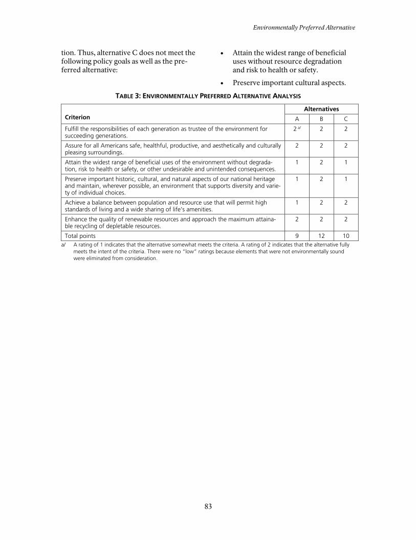
Environmentally Preferred Alternative
83
tion. Thus, alternative C does not meet the following policy goals as well as the pre-ferred alternative:
• Attain the widest range of beneficial uses without resource degradation and risk to health or safety.
• Preserve important cultural aspects.
TABLE 3: ENVIRONMENTALLY PREFERRED ALTERNATIVE ANALYSIS
Criterion
Alternatives
A B C
Fulfill the responsibilities of each generation as trustee of the environment for succeeding generations.
2 a/ 2 2
Assure for all Americans safe, healthful, productive, and aesthetically and culturally pleasing surroundings.
2 2 2
Attain the widest range of beneficial uses of the environment without degrada-tion, risk to health or safety, or other undesirable and unintended consequences.
1 2 1
Preserve important historic, cultural, and natural aspects of our national heritage and maintain, wherever possible, an environment that supports diversity and varie-ty of individual choices.
1 2 1
Achieve a balance between population and resource use that will permit high standards of living and a wide sharing of life’s amenities.
1 2 2
Enhance the quality of renewable resources and approach the maximum attaina-ble recycling of depletable resources.
2 2 2
Total points 9 12 10 a/ A rating of 1 indicates that the alternative somewhat meets the criteria. A rating of 2 indicates that the alternative fully
meets the intent of the criteria. There were no “low” ratings because elements that were not environmentally sound were eliminated from consideration.

84
ALTERNATIVES AND ACTIONS CONSIDERED BUT DISMISSED FROM DETAILED EVALUATION
MONTEZUMA CASTLE
Castle Site
Additional hiking trails were considered in the Castle site in areas that ultimately were zoned in resource and research. These hiking trails were dismissed from further consideration because these areas are un-desirable for hiking (hot and dry) and be-cause of concerns regarding protection of resources, particularly archeological sites.
Well Site
Constructing a full visitor center at or near the current contact station at the existing parking lot was considered. This was dis-missed because of the presence of sensi-tive resources (grave sites) in this area. Al-ternative C considers constructing the vis-itor center at a different location.
Also considered was construction of a paved trail that would comply with Amer-icans with Disabilities Act requirements and would provide access for people with impaired mobility to the area along the ditch that flows from Montezuma Well to the west. This was dismissed because of the impacts on the cultural and natural resources that would be required to con-struct this type of trail.
TUZIGOOT
Construction of an amphitheater was con-sidered in the creosote flat west of the administrative area. This was dismissed because the locations that would be suita-ble for this type of facility were far re-moved from the main visitor attractions (the pueblo and the visitor center). Also, through partnering with Arizona State Parks, this type of facility already is availa-ble at Dead Horse Ranch State Park.

Summaries
85
SUMMARIES
NPS guidance in Director’s Order #12 and Handbook: Conservation Planning, Envi-ronmental Impact Analysis, and Decision Making (NPS 2001) requires that envi-ronmental assessments include several summaries that will facilitate reader un-derstanding. The important features of each alternative are summarized in table 4. Detailed descriptions of the features of each alternative were provided earlier in this section.
The guidance in Director’s Order #12 and Handbook also requires a summary pre-senting the degree to which each alterna-tive meets the stated purpose, need, and objectives. This information is provided in table 5.
Another summary should present “the impacts of each alternative, including a determination of potential improvement to park resources.” Table 6 provides a brief summary of the effects of each of the alternatives on the impact topics retained for analysis. More detailed information supporting table 6 on the effects of the alternatives is provided in Chapter 4: En-vironmental Consequences.
A summary of how each alternative would achieve the requirements of section 101(b) of the National Environmental Policy Act was included in the text and table 3 under the heading “Environmentally Preferred Alternative.”

CHAPTER 2: ALTERNATIVES, INCLUDING THE PREFERRED ALTERNATIVE
86
TABLE 4: SUMMARY OF THE ALTERNATIVES
Alternative A – No-Action Alternative B – Preferred Alternative C
Concept This alternative would continue current management direction and trends at Mon-tezuma Castle and Tuzigoot national mo-numents. It provides a baseline for compari-son in evaluating the changes and impacts of the action alternatives.
The main emphasis of this alternative is to connect the three sites with improved regional orientation to the Verde Valley area. Visitors would be introduced to all three sites and their related interpretive themes through coordi-nated messaging among the three sites. Visi-tors would travel to the sites to learn firsthand about elements of the prehistoric and historic stories associated with human settlement of the Verde Valley.
The main emphasis of this alternative is to provide increased opportunities for visitors to self-discover the beauty and wonder of the natural and cultural re-sources of the monuments. Resources would still receive the highest level of protection, and visitors could interact with and explore a wider range of the resources found in the monuments.
Conditions common to all three sites
Natural resources would be protected by being in the monuments. However, man-agement of these resources would be li-mited by the lack of staff and funding. Existing operations and visitor facilities would remain in place. Most of the areas accessible to visitors would continue to have hardened facilities with physical and regulatory barriers to manage visitor use. Opportunities for close contact between visitors and the natural and cultural re-sources at the sites would continue to be limited. The interpretive emphasis would continue to focus on the three primary sites within the monuments, with little connection among the sites in terms of interpretation. Visitor stays at each site would remain short, and visitors would probably not visit more than one site.
The National Park Service would increase re-source stabilization and monitoring efforts. Partnerships would improve orientation at the sites and other opportunities in the Verde Val-ley. More of the monuments’ cultural and natural resources would be available for visitors to explore via trails. Visitor stays would increase slightly at each site. The National Park Service would acquire most of the lands within the legislated boundaries except for the mine tailings at Tuzigoot, which would be removed from the legislated boun-dary.
Greater emphasis would be placed on visitor and administrative services and facilities compared to alternative B be-cause of a larger development footprint in this alternative. More of the monuments’ cultural and natural resources would be available for visitors to explore via trails. Visitor stays would increase at each of the three sites. The National Park Service would acquire most of the lands within the legislated boundaries except for the mine tailings at Tuzigoot, which would be removed from the legislated boundary.

Table 4: Summary of the Alternatives
87
TABLE 4: SUMMARY OF THE ALTERNATIVES (CONTINUED) Alternative A – No-Action Alternative B – Preferred Alternative C
Montezuma Castle Resource activities would continue to focus on stabilizing the primary site, with intensive preservation treatment and regular cyclic maintenance. Other archeological resources would be stabilized or allowed to molder pursuant to section 106 consultation. To protect cultural sites and landscapes, Beaver Creek would continue to be ma-naged in some areas to control erosion and deposition. Visitor access to the creek would remain limited. Visitor opportunities would continue to fo-cus on viewing the Castle and visiting the visitor center. A picnic area would continue to be available next to the visitor center. Visitor stays would continue to be short (30 minutes to one hour). Existing administration facilities would re-main the same.
Most of the monument would be zoned Re-sources and Research. The existing facilities for visitor services would be zoned Interpretive Historic and would remain much as today. Additional parking may be added at the junc-tion of the monument entrance road and the service road to the sewage lagoons. Some natural-surface trails with interpretive signs may be sited across the river to provide views to the Castle. A corridor along Montezuma Castle Road and Beaver Creek Estates Road would accommo-date regional trail activities for horseback rid-ing, hiking, and mountain biking. The equipment shed (determined eligible for listing in the National Register of Historic Plac-es on July 13, 1994) would be rehabilitated and adaptively reused. A new workspace and storage building would be built near the equipment shed to support the maintenance functions of all three sites. The equipment shed would also be rehabili-tated and adaptively reused.
Most of the monument would be zoned Resources and Research. The existing visitor facilities would be zoned Interpre-tive Historic and would remain much as today. Additional parking may be added at the junction of the monument entrance road and the service road to the sewage la-goons. A new headquarters would be located at the beginning of the entrance road to the monument, replacing the current headquarters after its lease expires. Access over the creek and some picnic facilities on the south bank of the creek would be provided. A new bridge would be resistant to flood waters. In addition, self-guided, designated trails would be provided along the river corridor. To provide better views of the river val-ley, a small number of private vehicles would be allowed access to the plateau above the cliff dwelling. A corridor along Montezuma Castle Road and Beaver Creek Estates Road would accommodate regional trail activi-ties for horseback riding, hiking, and mountain biking. If the increased diversity and amount of activities proposed in this alternative increases the visitation levels and lengths of stay, the amount of area zoned Park Operations may be increased to meet visitor management needs. A modest workspace and storage build-ing would be built near the equipment

CHAPTER 2: ALTERNATIVES, INCLUDING THE PREFERRED ALTERNATIVE
88
TABLE 4: SUMMARY OF THE ALTERNATIVES (CONTINUED) Alternative A – No-Action Alternative B – Preferred Alternative C
shed to support the maintenance func-tions of all three sites. The equipment shed would also be rehabilitated and adaptively reused.
Montezuma Well Resource activities would continue to focus on monitoring water quality and providing short-term visitor experiences at Montezu-ma Well, with emphasis on the picnic area. Other archeological resources would be stabilized or allowed to molder pursuant to section 106 consultation. Visitor opportunities would continue to fo-cus on viewing Montezuma Well and visit-ing the well outlet. The picnic area would continue to be a major draw for local visita-tion. Visitor stays would be relatively short unless visitors use the picnic area. Existing administration facilities would re-main the same.
Most of the monument would be zoned re-sources and research. The existing facilities leading to and around Montezuma Well would be zoned interpretive historic and re-main much as today. The amount of interpretation and interaction with resources associated with the long history of prehistoric and historic farming in the area would increase. The area just south and west of the picnic area would include natural-surface trails improved along existing formal and informal routes. An addition to the visitor contact station (shade ramada) is proposed in the existing footprint of the parking lot near Montezuma Well.
Most of the monument would be zoned Resources and Research. The existing visitor facilities would be zoned Interpre-tive Historic and remain much as today. A new visitor center is proposed at the entrance of the road to Montezuma Well to increase visitor orientation and inter-pretation services on site. Designated natural-surface trails would be developed to and along the riparian area of Wet Beaver Creek. In addition, a natural-surface, designated trail would be located near the prehistoric ditch that extends from Montezuma Well and along Beaver Creek. This trail would also follow the rim along the north side of Montezuma Well. A trail would also extend from the visitor center to the well, following the road.
Tuzigoot Resource activities would continue to focus on stabilizing the primary site, with intensive preservation treatment and regular cyclic maintenance. Other archeological resources would be stabilized or allowed to molder pursuant to section 106 consultation. Visitor opportunities would continue to fo-cus on exploring the pueblo and visiting the visitor center/museum. Visitor stays would continue to be short (less than an hour). Existing administration facilities would re-main the same.
Most of the monument would be zoned Inte-raction and Discovery. The areas east, north, and south of the pueblo would be zoned Inte-raction and Discovery, providing natural-surface trails along the riparian area. Through collaboration with partners, these trails may link with trails in Dead Horse Ranch State Park and Coconino National Forest. The area between the tailings and Peck’s Lake would be zoned Resources and Research. The existing visitor facilities would be zoned Interpretive Historic and would remain much as today. There would be increased cultural demonstra-tions in and around the pueblo. In addition,
Most of the monument would be zoned Interaction and Discovery. In these areas, natural-surface trails may be designated. If assessment determines that there would be no conflict with preservation of significant cultural resources, moun-tain bicycling opportunities may also be provided on old road beds in the area. Trail connections via partnerships with neighboring federal and state lands would be explored. The existing visitor facilities would be zoned Interpretive Historic and would remain much as today. The pit house along the entrance road would be zoned

Table 4: Summary of the Alternatives
89
TABLE 4: SUMMARY OF THE ALTERNATIVES (CONTINUED) Alternative A – No-Action Alternative B – Preferred Alternative C
access would be provided via trails to the river. Active marsh restoration and management activities would begin at the newly acquired Tavasci Marsh. If assessment determines that there would be no conflict with preservation of significant cultural resources, a boardwalk would be constructed across the marsh along an existing old road alignment. The monuments will cooperate with the Ari-zona State Parks on the Verde River Greenway Management Plan proposal for a small parking area and launch for small boats on state-owned land on the east side of the monument entrance road. An additional workspace and storage facility would be constructed near the existing main-tenance area to provide onsite administrative space for the functions and operations of Tu-zigoot, replacing the offsite workspace and storage lost with the expiration of the General Services Administration lease with the Yavapai Apache reservation.
Resources and Research with a small visitor access trail and interpretive signs adjacent. If assessment determines that there would be no conflict with preser-vation of significant cultural resources, a boardwalk would be constructed across the Tavasci Marsh along an existing old road alignment. Most of the area directly around the road, parking lot, pueblo, and adminis-trative facilities would be zoned Re-sources and Research. The monuments will cooperate with the Arizona State Parks on the Verde River Greenway Management Plan proposal for a small parking area and launch for small boats on state-owned land on the east side of the monument entrance road.

CHAPTER 2: ALTERNATIVES, INCLUDING THE PREFERRED ALTERNATIVE
90
TABLE 5: HOW THE ALTERNATIVES MEET THE OBJECTIVES
Objective Alternative A – No-Action Alternative B – Preferred Alternative C
Cultural and natural resources
Implement resource management activities to improve resource conditions and protect the fundamental re-sources and values of the monuments.
The objective would be met to a large de-gree. Natural resources would be protected by being in the monuments. However, man-agement of these resources would be li-mited by the lack of staff and funding. Resource activities would continue to focus on stabilizing the primary sites, with inten-sive preservation treatment and regular cyclic maintenance. Other archeological resources would be stabilized or allowed to molder pursuant to section 106 consulta-tion.
The objective would be fully met. Resource management activities would be in-creased through expansion of the monuments’ resource stabilization program and active par-ticipation in the NPS inventory and monitoring program. The National Park Service would acquire most of the lands within the legislated boundaries except for the mine tailings at Tuzigoot, which would be removed from the legislated boun-dary. Active marsh restoration and management activities would begin at the newly acquired Tavasci Marsh. Effective partnerships and collaborative plan-ning efforts would be established and main-tained that would facilitate the realization of the monuments’ goals.
The objective would be met to a large degree. Resource management activities would be increased, and the National Park Service would acquire most of the lands within the legislated boundaries except for the mine tailings at Tu-zigoot, which would be removed from the legislated boundary.
Provide monument facilities and use them in a manner that mini-mizes adverse impacts on cultural and natural resources.
The objective would be fully met. There would be no change in the monu-ments’ facilities.
The objective would be fully met. Where possible, new facilities such as trails would be constructed in already disturbed areas. Disturbance to sensitive areas such as archeological sites and habitats for threatened or endangered species would also be avoided or mitigated. Trails and the marsh boardwalk would be constructed along existing old road alignments.
The objective would be met to a large degree. Alternative C would result in a larger devel-opment footprint. Where possible, new facili-ties such as trails would be constructed in al-ready disturbed areas. Disturbance to sensitive areas such as archeological sites and habitats for threatened or endangered species would also be avoided or mitigated. Trails and the marsh boardwalk would be constructed along existing old road alignments.

Table 5: How the Alternatives Meet the Objectives
91
TABLE 5: HOW THE ALTERNATIVES MEET THE OBJECTIVES (CONTINUED)
Objective Alternative A – No-Action Alternative B – Preferred Alternative C
Visitor use and experience
Provide improved con-nections between the three sites including information, orienta-tion, and way finding.
The objective would not be met. The interpretive emphasis would continue to focus on the three primary sites within the monuments, with little connection among the sites in terms of interpretation.
The objective would be fully met. Orientation to the sites and other opportunities in the Verde Valley would be improved through partnerships that focus on coordinated way finding, marketing, increased information dis-semination, and pre-trip planning services.
The objective would be fully met. The monuments would be considered as part of the region’s public land resources. The Na-tional Park Service would emphasize partner-ships with surrounding public lands agencies to provide connections to recreational and educational opportunities off site. A new visitor center would be constructed at the entrance of the road to Montezuma Well. Trail connections via partnerships with neigh-boring federal and state lands would be ex-plored.
Provide interpretive and education opportunities that improve visitor understanding and ap-preciation of the pur-pose, significance, and fundamental resources and values of the mo-numents.
The objective would not be met. Opportunities for close contact between visitors and the natural and cultural re-sources at the sites would continue to be limited. Visitor opportunities would continue to focus on viewing the Castle and visiting the visitor center. Visitor opportunities would continue to focus on viewing Montezuma Well and visiting the well outlet. Visitor opportunities would continue to focus on exploring the pueblo and visiting the visitor center/museum.
The objective would be fully met. More of the monuments’ cultural and natural resources would be available for visitors to ex-plore via trails. Some additional natural-surface trails with in-terpretive signs would be developed. The amount of interpretation and interaction with resources associated with the long history of prehistoric and historic farming in the area would be increased. Cultural demonstrations in and around the pueblo would be increased. In addition, access would be provided via trails to the river.
The objective would be fully met. The greatest amount of the monuments’ cul-tural and natural resources would be available for visitors to explore via trails, new view points, creek access and crossing. A new headquarters would be located at the beginning of the entrance road to the Castle site. A new visitor center would be constructed at the entrance of the road to Montezuma Well.
Monument operations
Improve efficiency and effectiveness in all divi-
The objective would not be met. Existing operations and visitor facilities
The objective would be met. Improvements to monument operations would
The objective would be met. Improvements to monument operations would

CHAPTER 2: ALTERNATIVES, INCLUDING THE PREFERRED ALTERNATIVE
92
TABLE 5: HOW THE ALTERNATIVES MEET THE OBJECTIVES (CONTINUED)
Objective Alternative A – No-Action Alternative B – Preferred Alternative C sions and functions of monument operations.
would remain in placeExisting administration facilities would re-main the same.
result from increased and improved space for monument operations, and improved capability to manage visitors and resources.
result from increased and improved space for monument operations, and improved capabili-ty to manage visitors and resources. A modest workspace and storage building, new head-quarters, and new visitor center would be built.
Partnerships
Establish and maintain partnerships to improve visitor orientation to the sites and other oppor-tunities adjacent to the monuments and else-where in the Verde Valley.
The objective would not be met. Partnerships opportunities would continue to be limited and form on an ad hoc basis.
The objective would be met. Partnerships would be developed and en-hanced with Verde Valley organizations, land owners, and government agencies. Partnerships would improve orientation at the sites and other opportunities in the Verde Val-ley. The corridor along Montezuma Castle Road and Beaver Creek Estates Road would accom-modate regional trail activities. Through collaboration with partners, trails would link with trails in Dead Horse Ranch State Park and Coconino National Forest.
The objective would be met. Partnerships would be developed and en-hanced with Verde Valley organizations, land owners, and government agencies. A corridor along Montezuma Castle Road and Beaver Creek Estates Road would accommo-date regional trail activities for horseback rid-ing, hiking, and mountain biking.
Establish and maintain effective partnerships and collaborative plan-ning efforts that facili-tate the realization of the monuments’ goals.
The objective would not be met. Partnerships opportunities would continue to be limited and form on an ad hoc basis.
The objective would be met. The monuments would cooperate with the Arizona State Parks on the Verde River Green-way Management Plan proposal for a small parking area and launch for small boats.
The objective would be met. The monuments would be considered as part of the region’s public land resources. The Na-tional Park Service would emphasize partner-ships with surrounding public lands agencies to provide connections to recreational and educational opportunities off site. The monu-ments would cooperate with the Arizona State Parks on the Verde River Greenway Manage-ment Plan proposal for a small parking area and small boat launch.

Table 6: Summary of Impacts of the Alternatives
93
TABLE 6: SUMMARY OF IMPACTS OF THE ALTERNATIVES
Impact Topic Alternative A – No-Action Alternative B – Preferred Alternative C
Archeological resources
Actions would have no adverse effect on arc-heological resources. The cumulative effects would be beneficial; this alternative’s contribu-tion to these effects would be small. The bene-ficial impacts would constitute a small compo-nent of cumulative impacts. There would be no impairment of archeological resources.
Actions would have no adverse effect on arc-heological resources, and expanded interpreta-tion and education could improve visitor ste-wardship. The cumulative effects would be beneficial; this alternative’s contribution to these effects would be small. There would be no impairment of archeological resources.
Actions would have no adverse effect on archeological resources, and expanded interpretation and education could improve visitor stewardship. Implementation of al-ternative C would generally have the same cumulative effects on archeological re-sources as those described for alternative B. There would be no impairment of archeo-logical resources.
Prehistoric and his-toric structures and buildings
Actions would have no adverse effect on pre-historic and historic structures and buildings. The cumulative effects would be beneficial; this alternative’s contribution to these effects would be small. There would be no impairment of prehistoric and historic structures and buildings.
Actions would have no adverse effect on pre-historic and historic structures and buildings. The cumulative effects would be beneficial; this alternative’s contribution to these effects would be small. There would be no impairment of prehistoric and historic structures and buildings.
Actions would have no adverse effect on prehistoric and historic structures and buildings. Implementation of alternative C would generally have the same cumulative effects on prehistoric and historic structures and buildings as those described for alter-native B. There would be no impairment of prehistoric and historic structures and buildings.
Cultural landscapes Actions would have no adverse effect on cul-tural landscape resources. The cumulative ef-fects would be beneficial; this alternative’s con-tribution to these effects would be small. There would be no impairment of cultural landscapes.
Actions would have no adverse effect on cul-tural landscape resources. The cumulative ef-fects would be beneficial; this alternative’s con-tribution to these effects would be small. There would be no impairment of cultural landscapes.
Actions would have no adverse effect on cultural landscape resources. The cumula-tive effects would be beneficial and the contribution would be small. There would be no impairment of cultural landscapes. There would be no impairment of cultural landscapes.

CHAPTER 2: ALTERNATIVES, INCLUDING THE PREFERRED ALTERNATIVE
94
TABLE 6: SUMMARY OF IMPACTS OF THE ALTERNATIVES (CONTINUED) Impact Topic Alternative A – No-Action Alternative B – Preferred Alternative C
Ethnographic re-sources and tradi-tional cultural prop-erties
Actions would have no adverse effect on tradi-tional cultural properties or on ethnographic resources. The cumulative effects would be beneficial; this alternative’s contribution to these effects would be small. There would be no impairment of ethnographic resources and traditional cultural properties.
Actions would have no adverse effect on tradi-tional cultural properties or on ethnographic resources. The cumulative effects would be beneficial; this alternative’s contribution to these effects would be small. There would be no impairment of ethnographic resources and traditional cultural properties.
Actions would have no adverse effect on traditional cultural properties or on ethno-graphic resources. Cumulative effects would be beneficial; this alternative’s con-tribution would be small. There would be no impairment of ethnographic resources and traditional cultural properties.
Floodplains Alternative A would result in negligible, long-term, adverse impacts on floodplains. There would be no cumulative impacts at Montezuma Castle National Monument and negligible, ad-verse, cumulative impacts to floodplains at Tu-zigoot National Monument. There would be no impairment of monument resources or values associated with floodplains.
At both monuments, the short- and long-term impacts of trails on erosion and water flow patterns in the floodplain would be negligible. At Tuzigoot, there would be beneficial cumula-tive impacts as a result of reduced social trail-ing. Construction and use of a boardwalk at Tavasci Marsh would have long-term, adverse negligible impacts on water flow and erosion in the marsh. Alternative B would have no cumu-lative impacts on floodplains at Montezuma Castle National Monument and negligible to minor, adverse, cumulative effect on flood-plains at Tuzigoot National Monument. There would be no impairment of monument re-sources or values associated with floodplains.
Short- and long-term, negligible to minor, adverse impacts from trails on floodplains would occur at Montezuma Castle. Short- and long-term, negligible, adverse impacts would occur at Tuzigoot National Monu-ment. Construction and use of a boardwalk at Tavasci Marsh would have long-term, adverse, negligible impacts on and erosion. There would be no cumulative impacts under alternative C at Montezuma Castle National Monument, and negligible, ad-verse, cumulative impacts at Tuzigoot Na-tional Monument. There would be no im-pairment of monument resources or values associated with floodplains.
Soils Alternative A would not involve actions that disturb soils, increase erosion potential, or de-crease soil productivity in either national mo-nument; impacts would be negligible, adverse, and long-term. Negligible, long-term, adverse cumulative impacts on the soils would occur at Tuzigoot National Monument by increasing the potential for soil erosion resulting from the proposed greenway trail. There would be no impairment of monument resources or values associated with soil.
Short- and long-term, adverse impacts on soils from trails would be negligible at both monu-ments. The long-term adverse impacts on soil erosion from the expansion of the visitor con-tact station at the Castle would be negligible. Soil disturbance from boardwalk construction at Tavasci Marsh would be negligible, short- and long-term, and adverse. Cumulative im-pacts from alternative B and the proposed greenway trail and other plans would result in negligible, long-term, adverse cumulative im-pacts in both monuments. There would be no impairment of monument resources or values associated with soil.
The riparian area trail at Montezuma Castle would have long-term, adverse, negligible to minor effects. The new visitor center near the Back cabin would have localized, long-term, adverse, minor impacts. There would be no cumulative impacts on soils at Montezuma Castle. Construction of the Tavasci Marsh boardwalk would result in short-and long-term, negligible, adverse impacts on soils. The cumulative impacts on soils at Tuzigoot would be negligible, long-term, and adverse. There would be no impairment of monument resources or values associated with soil.

Table 6: Summary of Impacts of the Alternatives
95
TABLE 6: SUMMARY OF IMPACTS OF THE ALTERNATIVES (CONTINUED) Impact Topic Alternative A – No-Action Alternative B – Preferred Alternative C
Vegetation Efforts to manage and control nonnative and exotic plant species continue to have long-term, minor, beneficial impacts on the native vegetation in both monuments. This alternative would result in no cumulative effects on vege-tation at Montezuma Castle National Monu-ment and negligible, long-term, adverse, cumu-lative impacts on vegetation at Tuzigoot Na-tional Monument by increasing the potential for trampling resulting from the proposed greenway trail. There would be no impairment of monument resources or values associated with vegetation.
Trail construction and use would have negligi-ble, short- and long-term, adverse impact on vegetation, including abundance and distribu-tion, in both monuments. During facility con-struction Montezuma Castle National Monu-ment, short- and long-term negligible impacts could occur on the periphery of the expansion area. The short- and long-term adverse impacts on vegetation as a result of constructing the boardwalk at Tuzigoot National Monument would be negligible. The long-term, adverse impacts of an increase in nonnative and exotic vegetation would be negligible to minor. The impacts of alternative B on vegetation in com-bination with the impacts of the proposed greenway trail, increased visitation to the mo-numents, and other plans would result in neg-ligible, long-term, adverse cumulative impacts in both monuments. There would be no im-pairment of monument resources or values associated with vegetation.
The short-and long-term adverse impacts from trail development on native vegeta-tion, including abundance and distribution, at Montezuma Castle would be negligible. The long-term adverse impacts of trail de-signation on abundance and distribution of native vegetation would be negligible. The long-term adverse impact to the vegetation would be minor to moderate following development of new trails at Montezuma Well. Construction of the new visitor center near the Back cabin at Montezuma Well would have a short-term, negligible, adverse, im-pact and long-term negligible beneficial impact on the surrounding vegetation be-cause the landscape has already been dis-turbed and the dominant plant species are nonnative and exotic grasses. Construction of a new headquarters and access and parking on the plateau at Montezuma Cas-tle National Monument would have long-term, negligible to minor, adverse impacts. There would be no contribution to cumula-tive impacts under alternative C on vegeta-tion at Montezuma Castle National Monu-ment. At Tuzigoot, the short-term adverse im-pacts of trail development on vegetation at Tuzigoot would be negligible. The long-term adverse impacts of the trail on the understory vegetation would be negligible to minor. The long-term adverse impacts of an increase in nonnative and exotic vegeta-tion along the trails would be negligible to minor. The short-and long-term adverse impacts on vegetation during Tavasci Marsh boardwalk construction would be negligible. The impacts of alternative C

CHAPTER 2: ALTERNATIVES, INCLUDING THE PREFERRED ALTERNATIVE
96
TABLE 6: SUMMARY OF IMPACTS OF THE ALTERNATIVES (CONTINUED) Impact Topic Alternative A – No-Action Alternative B – Preferred Alternative C
on soils in combination with the impacts of the proposed greenway trail at Tuzigoot National Monument would result in neglig-ible, long-term, adverse cumulative impacts to vegetation. There would be no impair-ment of monument resources or values associated with vegetation.
Wetlands Alternative A would have no new actions con-tributing to adverse impacts on wetland func-tions or wetland habitat values, resulting in long-term negligible to minor impacts. Ongoing management actions would continue to allow silt to accumulate in Tavasci Marsh in Tuzigoot National Monument, which would have a long-term, minor to moderate, adverse impact on wetland functions and habitat. Increased visita-tion or development associated with the Verde River Greenway Management Plan would have local, negligible, adverse, cumulative impacts on wetlands. There would be no impairment of monument resources or values associated with wetlands.
There would be no actions at Montezuma Cas-tle National Monument that would affect wet-lands under alternative B. Active marsh restora-tion activities at Tuzigoot National Monument would have a negligible to minor, long-term, beneficial effect on wetland habitat functions at Tavasci Marsh, although construction of new trails and a boardwalk would have negligible to minor, short- and long-term adverse impacts on the marsh wetlands. The contribution of alter-native B toward adverse cumulative impacts on wetlands would be negligible. There would be no impairment of monument resources or val-ues associated with wetlands.
There would be no actions at Montezuma Castle National Monument that would affect wetlands under alternative C. At Tavasci Marsh construction of new trails and a boardwalk would have negligible to minor short- and long-term adverse im-pacts on the marsh wetlands. The cumula-tive impacts of alternative C are the same as those described for alternative B. There would be no impairment of monument resources or values associated with wet-lands.
Wildlife There are no new actions proposed under al-ternative A that would have an adverse impact on wildlife or wildlife habitat in the monu-ments, resulting in negligible short- and long-term adverse impacts. Informal access to the Verde River at Tuzigoot National Monument would continue, representing a long-term, mi-nor, adverse effect on wildlife. The adverse impacts on wildlife of erosion caused by social trailing would be local and negligible in the long term. There would be no cumulative impacts at Mon-tezuma Castle National Monument. Alternative A would result in short-term, negligible to mi-nor, adverse, cumulative impacts on wildlife and wildlife habitat at Tuzigoot National Mo-nument as a result of trail development along
Trail development would have negligible to minor, short-term, adverse impacts on wildlife and wildlife habitat at Montezuma Castle Na-tional Monument and negligible, short-term, adverse impacts on wildlife and wildlife habitat at Tuzigoot National Monument. Use of the trails would result in negligible, short-term, adverse impacts on wildlife and wildlife habitat at both monuments. The short-term adverse impacts on wildlife from construction of the boardwalk at Tavasci Marsh in Tuzigoot Na-tional Monument would be negligible to minor. The long-term adverse impacts would be neg-ligible to minor for wildlife species that are especially sensitive to disturbance and negligi-ble for adaptable species. The long-term ad-verse impacts resulting from disturbance of
The long-term adverse impacts to sensitive wildlife from the longer riparian trail at Montezuma Castle would be minor. The new trail at Montezuma Well would have short-term, negligible to minor adverse impacts on wildlife, primarily as a result of construction effects; the long-term adverse impacts of the trail would be negligible. Cumulative impacts on wildlife at Monte-zuma Castle would be negligible. The long-term adverse impacts of an ex-tended trail and boardwalk at Tuzigoot on wildlife and their habitat would be short- and long-term, local, and negligible to mi-nor. The impacts of alternative C in combi-nation with the impacts of the proposed greenway trail would result in negligible to

Table 6: Summary of Impacts of the Alternatives
97
TABLE 6: SUMMARY OF IMPACTS OF THE ALTERNATIVES (CONTINUED) Impact Topic Alternative A – No-Action Alternative B – Preferred Alternative C
the Verde River. The long-term, adverse, cumu-lative impacts on wildlife and wildlife habitat would be negligible to minor and result from the potential for ongoing disturbance of wild-life throughout the year by visitors. There would be no impairment of wildlife or wildlife habitat in the monuments.
contaminated sediment in the marsh would be negligible to minor depending on the level of exposure to the contaminated sediment. Cumulative long-term, adverse impacts under alternative B on wildlife or wildlife habitat would be negligible at Montezuma Castle Na-tional Monument and negligible to minor at Tuzigoot National Monument. There would be no impairment of wildlife or wildlife habitat in the monuments.
minor, long-term adverse cumulative im-pacts to wildlife and wildlife habitat. There would be no impairment of wildlife or wild-life habitat in the monuments.
Threatened and endangered species
There would be no effects on southwestern willow flycatcher habitat or individual flycatch-ers foraging at Montezuma Castle National Monument. Long-term, ongoing management actions at Montezuma Castle could benefit flycatcher habitat, so adverse effects would be unlikely. Change in the Tavasci Marsh habitat at Tuzigoot National Monument could have a long-term effect on flycatcher habitat, but the presence of substantial suitable habitat in the area would result in a “not likely to adversely affect” determination. Potential cumulative effects would not be substantial or widespread enough to be considered adverse. Changes in Tavasci Marsh during migration could affect, but would not likely adversely affect, the Yuma clapper rail. There would be no cumulative effects on the Yuma clapper rail. There would be no effects on the habitat or population of the yellow-billed cuckoo in either national monument. There would be no cumu-lative effects on the yellow-billed cuckoo. There would be no impairment of these threat-ened and endangered species in the monu-ments.
Actions taken under alternative B at Montezu-ma Castle would affect southwestern flycatcher habitat, but the effects would not likely be adverse. Marsh restoration and ongoing ditch maintenance activities at Tuzigoot National Monument would have long-term, negligible to minor benefits on flycatcher foraging habitat. Visitors could potentially affect flycatcher habi-tat, but the effects would not likely be adverse. Cumulative effects at both monuments would not likely be adverse because of mitigation measures and adaptive management strategies. Development of the boardwalk at Tavasci Marsh would have a negligible effect on habi-tat in the marsh, with potential to affect the Yuma clapper rail. However, mitigation meas-ures would offset the effects, so they would not be adverse. In the long term, marsh resto-ration would provide a negligible to minor ben-efit on rail habitat. There would be no cumula-tive effects on clapper rails or their habitat un-der this alternative at Montezuma Castle, and potential cumulative effects at Tuzigoot would not be adverse. There are no proposed actions under this alter-native that would affect the yellow-billed cuck-oo habitat at Montezuma Castle National Mo-nument. Trail development and use at Tuzigoot National Monument could have a negligible
Effects on the southwestern willow fly-catcher would be similar to those described for alternative B. The potential for effects is slightly greater than alternative B, but im-pacts would not be adverse. Yuma clapper rail - alternative C would have effects similar to those described for alternative B. The potential for effects is slightly greater than alternative B, but im-pacts would not be adverse. Yellow-billed cuckoo - alternative C would have effects similar to those described for alternative B. There would be no impairment of these threatened and endangered species in the monuments.

CHAPTER 2: ALTERNATIVES, INCLUDING THE PREFERRED ALTERNATIVE
98
TABLE 6: SUMMARY OF IMPACTS OF THE ALTERNATIVES (CONTINUED) Impact Topic Alternative A – No-Action Alternative B – Preferred Alternative C
effect on the yellow-billed cuckoo, but the ef-fects are is unlikely to be adverse. Cumulative effects associated with increased visitation and interaction with the habitats used by the yel-low-billed cuckoo would be negligible at either of the monuments. There would be no impairment of these threat-ened and endangered species in the monu-ments.
Visitor use and experience
Alternative A would result in continuing minor beneficial impacts resulting from the continued opportunities to view the monuments’ prime cultural resources. However, minor adverse impacts from crowding and congestion at peak times in the parking lot, main loop trail and visitor center at Montezuma Castle would con-tinue during peak times and may get worse with increasing visitation. In addition, the lack of adequate interpretive and education facilities for regular and diverse programming will con-tinue to be a minor adverse impact to visitors. Cumulative effects for aspects of visitor expe-rience could be either beneficial or adverse and range from negligible to major.
Moderate to major, beneficial effects would result from the increased diversity in opportuni-ties to view and learn about the monuments’ prime cultural resources. Connecting the three sites in the monuments via a central orientation facility in the Verde Valley would increase expo-sure of visitors to all three sites and provide a better understanding of each site’s unique role in settlement of the Verde Valley. Providing more trail opportunities and cultural programs would make visits to each site more exciting, interesting, and inviting for repeat visitation. Cumulative effects on visitor use and expe-rience would be beneficial and moderate to major. Alternative B would contribute to mod-erate to major cumulative benefits.
Increased beneficial impacts would result from the increased diversity in opportuni-ties to view and learn about the monu-ments’ prime cultural resources. Connect-ing the three sites in the monuments via a central visitor center and orientation facility in the Verde Valley would increase expo-sure of visitors to all three sites and provide a better understanding of each site’s unique role in settlement of the Verde Val-ley. Scenic quality at the Well would be improved by removing the visitor contact station. Further, providing more trail oppor-tunities and cultural programs would make visits to each site more exciting, interesting and inviting for repeat visitation. Alterna-tive C would contribute substantially to moderate to major cumulative benefits at the monuments.
Socioeconomics The effects of the no-action alternative on so-cioeconomic conditions in the Verde Valley would be long-term, beneficial, and negligible. Cumulative effects would be long-term, minor, and beneficial, except that land use changes could result in long-term, minor to moderate, adverse impacts to groundwater resources connected to Montezuma Well.
The effects of alternative B on socioeconomic conditions in the Verde Valley would be short-term, beneficial, and minor. Cumulative effects would be short and long-term, minor, and beneficial, except that land use changes could result in long-term, minor to moderate, adverse impacts to groundwater resources connected to Montezuma Well.
Socioeconomics effects in the region would be negligible to minor, short- and long-term, and beneficial. Most cumulative im-pacts would be short- and long-term, mi-nor, and beneficial. Cumulative land use changes could result in long-term, minor to moderate, adverse impacts to groundwater connected to Montezuma Well.
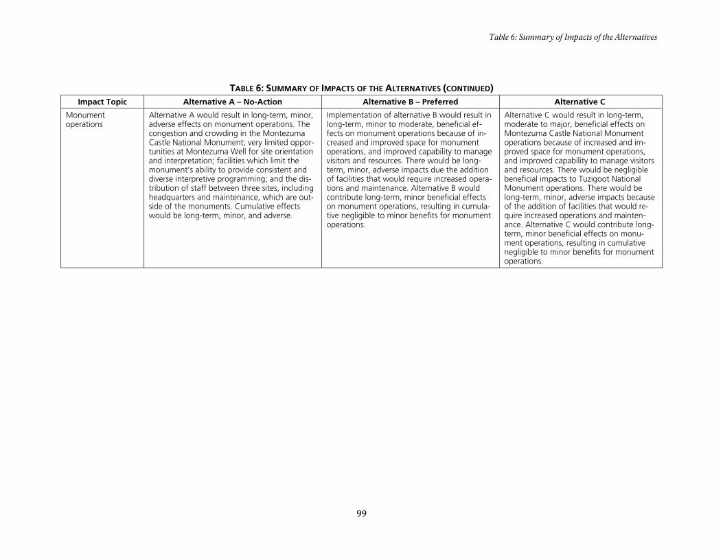
Table 6: Summary of Impacts of the Alternatives
99
TABLE 6: SUMMARY OF IMPACTS OF THE ALTERNATIVES (CONTINUED) Impact Topic Alternative A – No-Action Alternative B – Preferred Alternative C
Monument operations
Alternative A would result in long-term, minor, adverse effects on monument operations. The congestion and crowding in the Montezuma Castle National Monument; very limited oppor-tunities at Montezuma Well for site orientation and interpretation; facilities which limit the monument’s ability to provide consistent and diverse interpretive programming; and the dis-tribution of staff between three sites, including headquarters and maintenance, which are out-side of the monuments. Cumulative effects would be long-term, minor, and adverse.
Implementation of alternative B would result in long-term, minor to moderate, beneficial ef-fects on monument operations because of in-creased and improved space for monument operations, and improved capability to manage visitors and resources. There would be long-term, minor, adverse impacts due the addition of facilities that would require increased opera-tions and maintenance. Alternative B would contribute long-term, minor beneficial effects on monument operations, resulting in cumula-tive negligible to minor benefits for monument operations.
Alternative C would result in long-term, moderate to major, beneficial effects on Montezuma Castle National Monument operations because of increased and im-proved space for monument operations, and improved capability to manage visitors and resources. There would be negligible beneficial impacts to Tuzigoot National Monument operations. There would be long-term, minor, adverse impacts because of the addition of facilities that would re-quire increased operations and mainten-ance. Alternative C would contribute long-term, minor beneficial effects on monu-ment operations, resulting in cumulative negligible to minor benefits for monument operations.


CHAPTER 3:AFFECTED ENVIRONMENT


103
INTRODUCTION
This chapter describes the existing envi-ronment of Montezuma Castle National Monument and Tuzigoot National Mo-nument and the surrounding region. It focuses on the monument resources, uses, facilities, and socioeconomic characteris-tics that may be affected if any of the al-ternatives are implemented. Some fea-tures, such as floodplains and endangered species, are discussed because they pro-vide context or must be considered in an environmental assessment.
There are many sources of information on the natural, cultural, and human environ-ment of Montezuma Castle and Tuzigoot national monuments. These include the Montezuma Castle National Monument and Tuzigoot National Monument home page at http://www.nps.gov/TUZI and bibliography located on the Internet at http://www1.nature.nps.gov/nrbib/index.htm.

104
CULTURAL RESOURCES
The National Historic Preservation Act of 1966, as amended, requires that federal agencies consider the effects to cultural resources when proceeding with any un-dertaking. The agency must demonstrate an effort to eliminate, minimize, and/or mitigate any adverse effects to historic or prehistoric properties. The National His-toric Preservation Act recognizes five property types: districts, sites, buildings, structures, and objects. As called for in the act, these categories are used in the Na-tional Register of Historic Places, the preeminent reference for properties wor-thy of preservation in the United States. To focus attention on management re-quirements within these property types, Management Policies 2006 categorizes cul-tural resources as archeological resources, cultural landscapes, structures, museum objects, and ethnographic resources (tra-ditional cultural properties). (As discussed in chapter 1, museum objects have been dismissed as an impact topic for this gen-eral management plan).
Director’s Order 28: Cultural Resource Management Guideline (NPS 1998) pro-vides definitions for archeological re-sources, cultural landscapes, structures, and ethnographic resources (traditional cultural properties):
Archeological resources are the material remains or physical evidence of past hu-man life or activities that are of archeolog-ical interest, including the record of the effects of human activities on the envi-ronment. They are capable of revealing scientific or humanistic information through archeological research and have the potential to describe and explain hu-man behavior. Archeological features are typically buried but may extend above ground or lie submerged under water; they are commonly associated with pre-historic peoples – resources that predate the beginning of written records – but may be products of more contemporary socie-
ty – resources that postdate Euro-Americans.
Cultural landscapes are settings people have created in the natural world and re-veal fundamental ties between people and the land. Landscapes – geographic areas that exhibit evidence of human habitation and intertwined patterns of things both natural and constructed – constitute spe-cial places that are expressions of human manipulation and adaptation of the land. There are four general types of cultural landscapes (not mutually exclusive): his-toric site, historic designed landscape, his-toric vernacular, and ethnographic.
Structures are constructed works, usually immovable by nature or design, con-sciously created to serve some human ac-tivity. They are material assemblies that extend the limits of human capability and constitute elaborations of human produc-tive ability and artistic sensitivity. Struc-tures – prehistoric and historic – include buildings, roads, vessels, fences, and other assemblies of historical, aesthetic, or scientific importance.
Ethnographic resources are expressions of human culture and the basis of continuity of cultural systems. A cultural system en-compasses both the tangible and intangi-ble and includes traditional arts and native languages, religious beliefs, and subsis-tence activities. Ethnographic resources can include sites, structures, objects, land-scapes, or natural features that are as-signed traditional legendary, religious, subsistence, or other significance in the cultural system of a traditionally asso-ciated group. Traditional cultural proper-ties are ethnographic resources eligible for listing in the National Register of Historic Places.

Cultural Resources
105
OVERVIEW OF VERDE VALLEY CULTURAL HISTORY
Introduction
This overview provides a brief history of the Verde Valley and its inhabitants. An understanding of this history serves to set the framework for a more in-depth under-standing of the National Park Service’s mission to preserve, protect, and interpret the structures, objects, and other rem-nants of prehistoric cultures at Montezu-ma Castle and Tuzigoot national monu-ments.
Prehistoric Period
The Verde Valley is one of the most fertile river valleys in Arizona. Located between two of the major prehistoric population centers, the area was a natural contact zone between various prehistoric peoples and is rich with evidence of the prehistory of Arizona. The cultural resources of the Verde Valley are reflected in the adaptive strategies used by a variety of cultural groups that have successfully inhabited this lush environment for more than 12,000 years.
Paleoindian Period (ca. 9000 to 5500 BC). The Paleoindian Period, although poorly documented throughout the Verde River Valley and adjacent areas, represents the first documented evidence of early man in the Verde Valley. Popula-tions during this period often used big-game-hunting to exploit now-extinct fau-na in a grasslands environment over a wide area of present-day North and South America during the late Pleistocene Era. These people were nomadic, traveling in seasonal rounds, hunting large game such as mammoth, horse, bison, and camel, and gathering wild foods such as grasses and seeds.
Archaic Period (ca. 5500 BC to AD 200). Scattered evidence indicates that by ap-proximately 5500 BC, the Verde Valley was inhabited by hunter-gatherers who differed from the preceding Paleoindian
groups by their use of ground stone tools and different styles of projectile points. While hunting and gathering continued as a way of life for some time into the Ceram-ic Period’s Squaw Peak Phase, a shift to agriculture and settled village life was un-derway. Late in this period, intrusive ce-ramics appear, indicating contact with the Kayenta Anasazi to the north and the Ho-hokam (Pima for “those who have gone”) to the south. At the time of this contact, or soon thereafter, the first definite signs of agriculture appeared.
Ceramic Period: Squaw Peak Phase (ca. AD 200 to 700). The Verde Valley is part of what has been defined as the northern Hohokam periphery, which portrays the Hohokam regional system as consisting of a core area centered on the Salt River – Gila Basin along with a series of peripheral areas in the mountainous uplands and secondary river valleys that surround the basin. The core area is the origin of the Hohokam tradition and the center of its development, while the peripheries represent either territorial expansion or the effect of contact with the Hohokam on indigenous populations (Breternitz 1960, Fish and Fish 1977).
Ceramic Period: Hackberry Phase (ca. AD 700 to 800) and Cloverleaf Phase (ca. AD 800 to 900). By AD 700 to 900, generally including the Hackberry and Cloverleaf phases, a Hohokam influence expanding out of the Phoenix Basin into the Verde Valley and adjacent areas be-came obvious. Both small and large arc-heological sites dating to this period have been identified in the Middle Verde Val-ley, with upland villages tending to be small and compact, while villages along the river were larger and more open.
Ceramic Period: Camp Verde Phase (ca. AD 900 to 1125). The Camp Verde Phase represents the last and best known of the Hohokam phases in the Verde Valley. Set-tlement patterns and site layout corres-ponded to the previous phase in the Mid-dle Verde with the addition of public ar-

CHAPTER 3: AFFECTED ENVIRONMENT
106
chitecture consisting of adobe-capped mounds, ball courts, and possibly com-munal structures. Mounds and ball courts appear to both be associated with larger sites, and communal structures, defined on the basis of their large size, appear at sites of any size.
Ceramic Period: Honanki Phase (ca. AD 1125 to 1300) – Tuzigoot Phase (ca. AD 1300 to 1400/1450). Because the traits that characterize the Honanki and Tuzi-goot phases are closely related, with the Tuzigoot Phase representing the culmina-tion of the Honanki, the two phases are often considered together as the Honanki-Tuzigoot Phase. These phases span the transition from floodplain pit house vil-lages to pueblos and cliff dwellings in the Verde Valley (Wells and Anderson 1988).
Honanki Phase (ca. AD 1125 to 1300). Some time around AD 1100 to 1125, changes occurred in the Verde Valley that resulted in archeological sites and assem-blages that varied from earlier times. It has been postulated that the changes resulted from a migration of Sinagua (Spanish for “without water”) groups. The Honanki Phase witnessed population increases and consolidation with sites clustering to form communities in the Verde Valley, particu-larly around good farmlands and water sources.
Tuzigoot Phase (ca. AD 1300 to 1400/1450). The consolidation of popula-tion into fewer but larger sites culminated in the Tuzigoot Phase, the last currently recognized expression of the Southern Sinagua. The dispersed population of the Verde Valley that occupied smaller pueb-los during the Honanki Phase consolidat-ed into about 50 major pueblos – some surrounded by smaller satellite pueblos of up to six rooms, extensive farming areas, and field houses – to define substantial communities. Well-known sites such as Tuzigoot, Montezuma Castle, Montezuma Well, Sacred Mountain, and the Clear Creek Ruin are characteristic of this pe-
riod, although some of these sites may date from as early as ca. AD 1200.
Some time around AD 1425, the Verde Valley appears to have been abandoned by the Sinagua – a trend seen in many other cultural centers in the Southwest. Causes that have been suggested for this aban-donment include drought, water-logging of the soil, disease, warfare, invasion, and dissolution of trade networks.
Historic Period (about AD 1500 to Present)
Yavapai and Apache. Shortly after aban-donment of the Verde Valley by the Sina-gua, groups of foragers and hunters reap-peared. By AD 1250, the Yavapai occupied the valley, and the Tonto Apache inha-bited the mountains to the east. Thus, the Verde Valley lies within the known terri-tory of the Tonto Apache and Northeas-tern Yavapai Indians. Although the Yava-pai are an upland Yuman group and the Apache are a southern Athabascan-speaking group, both trace their origins to the Montezuma Well area in present-day Montezuma Castle National Monument. The Yavapai are considered the principal group inhabiting the region, with second-ary occupation by displaced Apache prior to the 1860s (Basso 1996; Gifford 1936; Goodwin 1942; Schroeder 1960).
Euroamericans. The Spanish began ex-ploring the present-day southwestern United States during the 1530s and en-tered Arizona during the 1540s. In 1583, a Spanish expedition led by Antonio de Es-pejo traversed the Middle Verde Valley with Hopi guides en route to the copper mines near present-day Jerome. While in that vicinity, the Spanish explorers found a group of Yavapai mining and trading green and blue pigments. In 1598, another Spanish mining expedition, led by Marcos Farfan de los Godos, visited the mines near Jerome with Hopi guides, and in 1604 Don Juan de Onate crossed the Verde River en route to the Colorado River. Al-though these Euroamerican parties spent little time in the valley, expedition mem-

Cultural Resources
107
bers wrote descriptions of the area’s inha-bitants as well as their cultural and eco-nomic systems.
The first significant Euroamerican intru-sion into central Arizona occurred in 1826, when Ewing Young (of the James Ohio Pattie party) traveled up the Verde River. Three years later, Young returned with 40 men to trap furs along the Salt and Verde rivers. The Verde Valley was visited by a succession of Euroamerican explor-ers, trappers, mountain men, government-sponsored railroad surveyors, and pros-pectors until the 1860s. Although local Native American tribes were encountered by the early Euroamericans, they were left relatively undisturbed. However, this oc-casional contact marked the beginning of the decline of the traditional way of life of the Yavapai and Apache.
Euroamerican pioneers did not begin to settle in the Verde Valley until the early 1860s. Passage of the Homestead Act in 1862, discovery of gold, silver, and copper along Big Bug Creek and near Prescott in 1863, and subsequent establishment of the new Arizona territorial capital at Prescott led to Euroamerican settlement in the fer-tile Verde Valley to provide foodstuffs and supplies for the mines as well as Prescott and Fort Whipple, an army post near the territorial capital.
Yavapai-Apache/Euroamerican Con-flict. The influx of Euroamerican settlers led to increasing conflicts with the Yava-pai and Apache. These conflicts culmi-nated in the forced march of nearly 180 miles to the San Carlos Reservation (east of present-day Globe, Arizona) over rough terrain and through difficult winter conditions – a bitter trek that resulted in the death of nearly 100 Native Americans. By 1878, more than 5,000 Native Ameri-cans, including Western Apache, and Ya-vapai, had been relocated to the San Car-los Reservation.
Although they took up farming and ranch-ing to support themselves at the San Car-los Reservation, many Yavapai and
Apache longed for their homelands, and after petitioning government officials for permission to leave San Carlos, numerous families returned to the Verde Valley dur-ing the late 1890s and early 1900s. Those who returned to the valley found that the region had been greatly altered during their absence as Euroamerican homes-teaders had claimed some of the best lands in the valley. Thus, the returning Yavapai and Apache were forced to make their new homes in desolate camps. During the early 20th century, the Bureau of Indian Affairs (BIA) became concerned about the condition of the Yavapai and Apache liv-ing in the Verde Valley and attempted to improve their situation.
Middle Verde Valley – Late 19th Cen-tury to the Present. With the cessation of hostilities, Euroamerican mining and farming operations prospered in the Verde Valley. By 1890, the civilian popula-tion of the Verde Valley exceeded 700, and by the turn of the 20th century, min-ing activity and cattle raising in the valley had expanded rapidly. The Verde Valley towns that best survived the economic changes of the post-World War II years were those that became prime ranching and farming centers, and by 1960 some 10,000 acres of valley lands were irrigated. Although ranching and farming opera-tions and some small-scale mining activi-ties made up the principal economic activ-ities in the valley through the 1960s, the recreation and tourism industries would soon become the region’s dominant eco-nomic base.
CULTURAL RESOURCES IN THE NATIONAL MONUMENTS
Archeological Resources
The National Park Service’s Western Arc-heological and Conservation Center (WACC) in Tucson, Arizona, has prepared an updated comprehensive archeological overview and assessment for Montezuma Castle and Tuzigoot national monuments (Powers et al. 2008).

CHAPTER 3: AFFECTED ENVIRONMENT
108
Montezuma Castle National Monument
National Park Service archeologists asso-ciated with the Western Archeological and Conservation Center conducted an arc-heological inventory survey of Montezu-ma Castle National Monument during April and May 1988. The survey, which covered 100% of the land within the na-tional monument’s boundaries, provided the opportunity to systematically record the monument’s archeological sites in de-tailed fashion, determine site boundaries, record new sites, and resolve problems with old site records. Of the 70 sites rec-orded in 1988, 30 were new site inventory additions. Only three sites and two sec-ondary site loci previously recorded were not relocated, and three of the 70 sites recorded were outside the Castle site but within sight of the NPS boundary fence. In addition, the survey recorded 30 isolated finds (Wells and Anderson 1988).
The archeological sites within the monu-ment are considered to be the best-documented cluster in the Middle Verde Valley and are thus significant to an un-derstanding of the valley’s prehistoric de-velopment. Monument resources are available to interpret the growth of pit house villages, the transformation to ma-sonry pueblos, development and expan-sion of pueblo community and irrigation systems, broad interregional trading net-works, and abandonment of the valley by prehistoric peoples. Montezuma Castle was part of an estimated 100-room com-munity that constituted an important component of the system of villages and population centers in the Verde Valley during the Honanki and Tuzigoot phases.
The cliff faces with caves and overhangs in the soft limestone constituted another at-traction to early inhabitants of the lands in both sites of the national monument. Rockshelters provided efficient sites for occupation. It has been asserted that de-fense was one of the reasons cliff dwel-lings and pueblos were constructed on high ridges during the Tuzigoot Phase.
This explanation does not seem to apply to shelter sites along the irrigation canal and along the creek at the Montezuma Well site. The rockshelter sites with ma-sonry walls, which constitute a cross be-tween cliff dwellings and pueblos, are built along cliff faces that do not afford much of a view because of dense riparian vegeta-tion. Even if the brush was cleared, such sites would be more of a trap than a de-fensible stronghold.
Site Descriptions. The aforementioned archeological study identified 14 site types, 12 of which are considered to con-tribute to the archeological district’s signi-ficance for listing in the National Register of Historic Places. The 12 contributing site types at the national monument include cliff dwellings, rockshelters with or with-out masonry rooms, pueblos, sites with one masonry structure, sites with two ma-sonry structures, artifact scatters, agricul-tural features, a burial ground, prehistoric cobble concentrations, bedrock mortars, and lithic scatters.
Site Conditions. The condition of the archeological sites at Montezuma Castle National Monument is generally good. Of the 63 prehistoric sites, seven have been disturbed by looting or vandalism, two possibly vandalized, four disturbed by NPS construction, and five have been tested or excavated. Except for the exca-vated/interpreted pit house, which rece-ives minor to moderate impacts as a result of unintentional vandalism, the prehistor-ic sites in the monument experience rela-tively few adverse impacts.
Land-disturbing activities undertaken be-fore establishment of the national monu-ment are not well documented. Archeo-logical sites were, however, impacted by a variety of human activities and natural causes prior to establishment of the na-tional monument, and some of these im-pacts have continued to the present. These include borrowing building stone from rockshelters, using caves as ranch and set-tlement-related structures, looting and
Cultural Resources
109
vandalism, road and utility line construc-tion, erosion caused by natural forces and human exploration, excavations and re-moval of deposits by pioneers, explorers, and investigators, surface collection by investigators and looters, historic and continuing use of prehistoric irrigation canals, and graffiti. Sewage lagoon con-struction by the National Park Service also likely impacted some archeological sites.
Tuzigoot National Monument
National Park Service archeologists asso-ciated with the Western Archeological and Conservation Center conducted an arc-heological inventory survey of Tuzigoot National Monument in March 1986. The survey’s project area covered some 512 acres, including 100% of the federally owned land within the boundaries of the national monument as well as most of pri-vately owned lands within its authorized boundaries. The survey provided the op-portunity to systematically locate, record, and evaluate all archeologically significant cultural resources within the boundary of the project area (Tagg 1986).
The archeological survey of the monu-ment and adjacent lands recorded eight archeological sites and 21 isolated finds, including two sites and two isolated finds within the federally owned lands of Tuzi-goot National Monument.
Site Descriptions. The two archeological sites within the federally owned lands at Tuzigoot National Monument include Tuzigoot Pueblo and a two- to five-room masonry room structure:
TUZI 86A-1. Tuzigoot Pueblo (estimated dates of occupation are ca. AD 1140 to 1400) is the principal prehistoric structure in the national monument and the type site for the Tuzigoot Phase of the South-ern Sinagua tradition. Tuzigoot is situated on a crest (known as Tuzigoot Hill) at the east end of a Holocene terrace along the north bank of the Verde River about 120 feet above the floodplain. This terrace, formed by an oxbow diversion of the riv-
er, likely provided arable farmland for the pueblo’s prehistoric inhabitants. The hill, sparsely vegetated by plains and desert grassland plants, overlooks the river ap-proximately 110 yards to the south and is surrounded by flat, lower terraces adja-cent to the river. Prior to excavation of the site by Caywood and Spicer in 1933 and 1934, the pueblo site had been actively looted. Since the excavation, most of the pueblo has been rebuilt and stabilized. A paved trail encircles the main roomblock, and an old road cut runs below the eas-ternmost roomblock.
The Tuzigoot Pueblo is a medium-sized pueblo with 77 ground-floor rooms and 15 possible second-story rooms in one main roomblock and four smaller conti-guous roomblocks. The second-story rooms are in the central portion of the main, and largest, roomblock. The pueblo was constructed of native river boulders (basalt, sandstone, and limestone, as well as irregular blocks of limestone from out-crops on Tuzigoot Hill) and adobe mortar. The main pueblo area, built in terrace-like fashion to conform to the contours of the hill, is approximately 165 yards long and 33 yards wide on a north/south axis. A plaza area lies between the main room-block and northern block of rooms.
Caywood and Spicer also excavated 411 burials holding the remains of 429 indi-viduals during 1933 and 1934. Nearly all of the excavated burials were reburied in the slope below the prehistoric pueblo close to the original cemetery in 1934. A vast amount of artifacts was recovered during the excavation of the site, including flaked and ground stone, ceramics, bone, shell, and some perishable items such as baske-try, textiles, and wood.
TUZI 86A-2. The site is in a flattened area on the east slope of Tuzigoot Hill, about 22 yards below the crest. The site over-looks Tavasci Marsh some 330 yards northeast of the Tuzigoot Pueblo and the flat terrace and floodplain of the Verde River to the east. This site is a 9.9-yard by

CHAPTER 3: AFFECTED ENVIRONMENT
110
3.3-yard concentration of basalt and li-mestone boulders that represents from two to five masonry rooms.
TUZI 86A-3. This is a moderate scatter of artifacts in a 38.3-yard by 36.1-yard area. The artifacts consist mainly of stone de-bris and ceramics.
TUZI 86A-4. The site lies on the southern tip of a ridge finger extending off the high mesa bordering the Tavasci Marsh and consists of a structure with two (possibly three) contiguous masonry rooms. The main structure is rectangular with a re-maining wall extending from the southeast corner of the structure that may be anoth-er room or a ramada. The walls are dry-laid basalt and limestone boulders and blocks that stand three courses high in places. Large boulders and limestone out-crops have been incorporated into the structure. Relatively dense wall fall sur-rounds the roomblock. The second pile of rock rubble is in a clear area between rock outcrops, and may e another room. A very light scatter of artifacts is in and around the rooms, but trash lies downslope to the south and west. Artifacts include flaked stone debris, ceramics, and four pieces of shell.
TUZI 86A-5. The site lies on the western tip of a ridge finger extending off the high mesa which borders the Tavasci Marsh. The roomblock has several rooms on the flat tip of the ridge, but most of the rooms are off the northwestern slope.
The site is constructed of local limestone and basalt boulders and blocks, and some portions of walls are still three courses high. Substantial wall fall indicates that the wall were higher. Many room corners are visible, and several upright slabs distin-guish one room, but individual room size is difficult to determine in the rubble. The roomblock has been built on a slope and appears terraced to conform to the con-tours. A moderate scatter of flaked stone, ceramics, and one metate fragment were seen among the rooms.
Other Sites. The other six archeological sites recorded during the survey, as well as the nearby sites at Hatalacva and the Tuzi-goot Extension Ruin, were cobble maso-nry surface structures, including one-room field houses, two-to-five-room structures, small pueblos with from 10 to 30 rooms, and large pueblos of approx-imately 100 rooms. Associated artifact scatters are moderate to heavy.
Isolated Finds. Twenty-one isolated finds were recorded in the archeological survey, two of which were in the federally owned lands of the national monument. All of these sites date to the Tuzigoot Phase or later.
Site Dates, Camp Verde Phase. Artifacts plus the lack of aboveground masonry ar-chitecture at one archeological site outside the federally owned lands of the national monument suggest a Camp Verde Phase, or perhaps earlier, occupation. Because of its location high on a mesa away from the bottomlands, the site may be a specialized-use site for hunting and gathering rather than a farmstead site.
Site Dates, Honanki and Tuzigoot Phas-es. The remainder of the sites recorded during the archeological survey can be placed in the Honanki and Tuzigoot phas-es. Excavation results from the three pu-eblos – Tuzigoot, Hatalacva, and Tuzigoot Extension Ruin – indicate early as well as later occupation periods. The early occu-pation began in the Honanki Phase, with the later, and major, occupation occurring in the Tuzigoot Phase; at Tuzigoot, ap-proximately eight rooms were occupied in the Honanki Phase and approximately 92 in the Tuzigoot Phase. Based on survey results alone, the remaining small sites could not be dated with more certainty other than to place them generally within the two phases, since many of the ceramic types and architectural styles were com-mon to both phases.
The results of the Tuzigoot archeological survey indicate a series of small sites sur-

Cultural Resources
111
rounding the Tuzigoot Pueblo that appear to be contemporaneous. Although it is un-clear whether these sites were abandoned upon completion of the large pueblo at Tuzigoot or if occupation at these sites continued, excavation at Tuzigoot and the Tuzigoot Extension Ruin both show early and later occupations, thus making it ap-pear likely that many of the smaller sites were occupied simultaneously and were related to the larger pueblos as compo-nents of internally diversified communi-ties.
Site Conditions. The condition of the archeological sites at Tuzigoot National Monument, like those at Montezuma Cas-tle, is generally good. However, archeo-logical sites within the current boundaries of the national monument and its adjacent lands, like those at Montezuma Castle, were impacted by a variety of human ac-tivities and natural causes prior to estab-lishment of the monument, and some of these impacts have continued to the present. These activities include farming, grazing, mining, camping, hiking, hunting, looting and vandalism, poaching, and off-road driving. Archeological sites have also been impacted by erosion resulting from natural forces and human exploration; excavations and removal of deposits by pioneers, explorers, and investigators; and surface collection by investigators and looters.
Increasing development on lands sur-rounding the monument continues to re-sult in direct and indirect impacts to arc-heological sites, and development in the valley has resulted in visual intrusions to the monument’s cultural and natural set-ting. Adverse impacts to these resources are caused by farming, feral animals, woodcutting, highway and road construc-tion, residential development and asso-ciated infrastructure, water demands, and pesticide and fertilizer use draining into water resources.
Arizona’s growing popularity for perma-nent and seasonal residence has resulted
in increased visitation to the national mo-nument and a corresponding decrease in the capacity of the limited staff to protect the archeological resources. Thus, human impacts include littering, trespassing (after hours entry and entry into closed areas), looting and vandalism, illegal hunting, and other unauthorized consumptive uses. Social trails and related erosion, caused by visitors leaving established trails, have im-pacted archeological resources. Stream channel alteration – down cutting or de-position of the channel, flooding, or change of flow regime – resulting from gravel mining, diversion, vegetation changes, or other human manipulation could result in adverse impacts on archeo-logical sites in the Tuzigoot vicinity in fu-ture years.
ETHNOGRAPHIC RESOURCES
Comprehensive ethnographic overviews and assessments (including ethnobotani-cal studies) for Montezuma Castle and Tuzigoot national monuments have not been prepared to date. Thus, no ethno-graphic resources, sacred sites, or tradi-tional cultural properties (ethnographic resources eligible for listing in the Nation-al Register of Historic Places) have been identified in the national monuments. However currently, for compliance pur-poses, Montezuma Well itself is treated as a traditional cultural property. These stu-dies are necessary to identify traditional uses of national monument lands by affi-liated Native American groups and to identify and define cultural and natural features that are significant to the ethnic heritage and cultural affiliation of such groups.
Cultural Affiliation Study
Under the provisions of the Native Ameri-can Graves and Repatriation Act of 1990 (Public Law 101-601), all federal govern-ment agencies and federally funded mu-seums and institutions whose archeologi-cal collections include human remains and associated funerary objects are required to

CHAPTER 3: AFFECTED ENVIRONMENT
112
engage in consultation with lineal descen-dants and culturally affiliated Native American tribes and organizations. In 1994, the National Park Service’s Western Archeological and Conservation Center contracted with the Bureau of Applied Research in Anthropology at the Universi-ty of Arizona to identify cultural affiliation at National Park Service units in Arizona, including Montezuma Castle and Tuzi-goot national monuments. Based on arc-heological, ethnographic, and ethnohis-toric research and oral history, the report identified three groups as being potential-ly affiliated with the two national monu-ments’ inventory of human remains and associated funerary objects: Yavapai, Ho-pi, and Northern Piman. The report also identified the following Native American tribes as having cultural affiliation with the two national monuments:
• Yavapai-Prescott Indian Tribe, Camp Verde Yavapai-Apache Tribe, and Fort McDowell Mohave-Apache In-dian Community, all of which have had a long relational history with the Verde Valley.
• Ethnic Hopi, who currently visit Mon-tezuma Castle and Montezuma Well to conduct rituals; the Castle structure holds supernatural significance for ethnic Hopis.
• Gila River and the Salt River Pima-Maricopa Indian Community, whose community speakers inhabited the Middle Verde River Valley in 1583 and typically view the valley as a commodity exchange route.
Native American Graves Protection and Repatriation Act Inventory Information
Pursuant to the cultural affiliation study, the Western Archeological and Conserva-tion Center prepared preliminary Native American Graves Protection and Repatr-iation Act inventory information regard-ing the Montezuma Castle and Tuzigoot national monuments’ museum collections.
Montezuma Castle National Monu-ment. The “Preliminary Native American Graves Protection and Repatriation Act Inventory Information” regarding the mu-seum collections at Montezuma Castle attributes the human remains and asso-ciated funerary objects in the collections primarily to the Southern Sinagua Honan-ki-Tuzigoot Phase, although some items could not be dated. According to the affil-iation study, the monument inventory in-cludes:
• A minimum of 121 individuals (112 inhumations and nine fragmentary remains) primarily from Montezuma Castle, Castle A, Swallet Cave, Monte-zuma Well, and other sites in the vicin-ity of Montezuma Castle. A few re-mains are from unknown locations.
• Associated funerary objects include shell and stone beads, pendants, and bracelets; ceramic bowls, a miniature jar, and sherds; fiber padding, matting, and textiles; a cradleboard; an atlatl dart and a flake; a bow and arrows; and soil samples.
Tuzigoot National Monument. The pre-liminary Native American Graves Protec-tion and Repatriation Act inventory in-formation regarding the museum collec-tions at Tuzigoot National Monument attributes the human remains and asso-ciated funerary objects in the collections from the Tuzigoot, Tuzigoot Extension Ruin, and Hatalacva pueblos primarily to the Southern Sinagua Honanki-Tuzigoot Phase. An individual recovered from the Clarkdale Smelter site was attributed to the Southern Sinagua Camp Verde Phase, and an individual from Sedona could be Yavapai or Apache. Most of the other hu-man remains are Native American, but their cultural context is not known. Ac-cording to the affiliation study, the Tuzi-goot inventory includes the following:
• Fourteen individuals and seven frag-mentary remains from Tuzigoot; one fragmentary remain from the Tuzigoot Extension Ruin; at least two individu-

Cultural Resources
113
als from Hatalacva; five individuals from four burials from the area along Sycamore Creek, about six miles north-northwest of Clarkdale; one in-dividual from the area north of Clark-dale; one individual from the Clark-dale Smelter site; four fragmentary remains from several locations along the Verde River; one individual from the Will Steel property near Sedona; one fragmentary remain from Clear Creek; one burial and fragmentary remains from at least 34 individuals recovered from unknown locations.
• Twenty-one associated funerary ob-jects, including bowls, jars, a sherd, ar-rows, a quid, a sandal, a corncob, a bracelet, a bead, awls, and soil sam-ples.
PREHISTORIC AND HISTORIC STRUCTURES AND BUILDINGS
Historic resource studies have not been prepared for Montezuma Castle and Tuzi-goot national monuments. Such studies are needed to provide a historic overview of both NPS units that would identify and evaluate their cultural resources within historic contexts and include com-pleted/updated requisite National Regis-ter of Historic Places nomination forms and historic base maps. However, Josh Protas’ A Past Preserved in Stone: A History of Montezuma Castle National Monument, an administrative history published by the Western National Parks Association in 2002, provides historic background ma-terial relating to the development and ad-ministration of Montezuma Castle. His-toric structure preservation guides are also needed to guide long-term and cyclic maintenance efforts designed to preserve the prehistoric and historic structures in the monuments.
List of Classified Structures
The list of classified structures is a compu-terized, evaluated inventory of all prehis-toric and historic structures and buildings
having historical, architectural, or engi-neering significance in which the National Park Service has or plans to acquire any legal interest. Included are structures that individually meet the criteria of the Na-tional Register of Historic Places or are contributing resources of sites and dis-tricts that meet national register evalua-tion criteria. Also included are other struc-tures – moved, reconstructed, and com-memorative structures as well as struc-tures achieving significance within the last 50 years – that are managed as cultural re-sources because of management decisions that have been made pursuant to the plan-ning process.
Montezuma Castle National Monu-ment. Although the list of classified struc-tures for Montezuma Castle National Monument requires updating, 16 struc-tures are currently listed. These include the following:
• Castle A – AZ 0:5:95 (NA 6373) (Listed in the National Register of Historic Places on October 15, 1966).
• Residence – MH5 (determined eligible for listing in the National Register of Historic Places on July 13, 1994).
• Residence – MH4 (determined eligible for listing in the National Register of Historic Places on July 13, 1994).
• Site NA 1271 (listed in the National Register of Historic Places on October 15, 1966; rockshelter with one maso-nry room inside Montezuma Well).
• Site NA 1272 A and B (listed in the Na-tional Register of Historic Places on October 15, 1966; rockshelter with two groupings of masonry rooms in-side Montezuma Well).
• Site NA 1273 (listed in the National Register of Historic Places on October 15, 1966).
• Montezuma Castle – Site NA 1278 (listed in the National Register of His-toric Places on October 15, 1966; in-cludes nearby sites and features

CHAPTER 3: AFFECTED ENVIRONMENT
114
MOCA 88A-65/NA 6384 and NA 2223-24).
• Swallet Cave – Site NA 4630 (listed in the National Register of Historic Plac-es on October 15, 1966).
• Site NA 5553 A and B (MOCA 88A-30) (listed in the National Register of His-toric Places on October 15, 1966; rockshelter consisting of two to three rooms on two levels].
• Equipment Shed (determined eligible for listing in the National Register of Historic Places on July 13, 1994).
• Prehistoric Irrigation Canals (listed in the National Register of Historic Plac-es on October 15, 1966).
• Historic Irrigation Ditch (listed in the National Register of Historic Places on October 15, 1966).
• Civilian Conservation Corps Revet-ment Wall (determined eligible for listing in the National Register of His-toric Places on July 13, 1994).
• Site AZ 0:5:69 (NA 7280), a single ma-sonry room.
• Site AZ 0:5:75 (NA 4619), a series of 19 cavates southwest of Castle A.
• Site AZ 0:5:91 (NA 1274), an 11 room pueblo on the rim of the well.
Stabilization, repair, and preservation projects have been carried out on the na-tional monument’s prehistoric structures since the late 19th century, but preserva-tion activities have improved with better techniques as a result of specialized train-ing. Although current staff members have ruins stabilization skills and continue to conduct routine maintenance of these structures, the lack of adequate funding and personnel has barely enabled them to keep up with necessary routine stabiliza-tion work, much less long-term, cyclic work that should be performed in a timely manner to prevent further deterioration.
Tuzigoot National Monument. Five structures are currently listed in the List of Classified Structures for Tuzigoot Nation-al Monument, a list that should also be updated. These include the following:
• Tuzigoot Pueblo (listed in the Nation-al Register of Historic Places on Octo-ber 15, 1966).
• Museum and Headquarters Building (determined eligible for listing in the National Register of Historic Places on July 13, 1994).
• Storage Tool House (determined eli-gible for listing in the National Regis-ter of Historic Places on July 13, 1994).
• Pump House (determined eligible for listing in the National Register of His-toric Places on July 13, 1994).
• Retaining Wall (determined eligible for listing in the National Register of Historic Places on July 13, 1994).
Stabilization, repair, and preservation projects have been carried out on the na-tional monument’s prehistoric structures since the 1930s, but preservation activities, like those at Montezuma Castle, have im-proved with better techniques, more high-ly skilled labor, and specialized training. Although current staff members have ruins stabilization skills and continue to conduct routine maintenance of these structures, the lack of adequate funding and personnel has barely enabled them to keep up with necessary routine stabiliza-tion work, much less long-term, cyclic work that should be performed in a timely manner to prevent further deterioration.
CULTURAL LANDSCAPES
According to Director’s Order 28: Cultural Resource Management Guideline, the Na-tional Park Service defines a cultural land-scape as a geographic area, including both natural and cultural resources that are as-sociated with a historic event, activity, or person. The National Park Service recog-nizes four cultural landscape categories: historic designed landscapes, historic ver-

Cultural Resources
115
nacular landscapes, historic sites, and eth-nographic landscapes. In the broadest sense, a cultural landscape is a reflection of human adaptation and use of natural resources and is often expressed in the way land is organized and divided, pat-terns of settlement, land use, systems of circulation, and the types of structures that are built. The character of a cultural landscape is defined both by physical ma-terials, such as roads, buildings, walls, and vegetation, and by use reflecting cultural values and traditions.
No formal cultural landscape inventory work has been conducted at Montezuma Castle and Tuzigoot national monuments. Although current archeological and his-toric structure inventories and studies in-clude most of the national monuments’ identified landscape features, other ele-ments of landscape patterns and systems should be included as cultural landscape resources. Examples include circulation patterns, vegetation patterns (both native and designed), historic vegetation asso-ciated with homesteading and the Civilian Conservation Corps era, relationships be-tween development and natural systems, and spatial organization. It is standard NPS practice to treat landscapes that are considered potentially eligible for listing in the National Register of Historic Places as eligible.
Montezuma Castle National Monument
Some known and potential cultural land-scape resources have been identified at Montezuma Castle National Monument at Level 0 (Park Reconnaissance Survey) of the cultural landscape inventory process. These include the following:
• Sinaguan occupation remains / Mon-tezuma Castle site cultural landscape resources, including agricultural fields.
• Hohokam occupation remains / Mon-tezuma Well site cultural landscape re-sources, including irrigation canals.
• New Deal / Civilian Conservation Corps-era historic designed landscape
resources, including rock walls, drai-nage ditches, and other structural elements, and historic vegetation in the Castle site (NPS development at Montezuma Castle).
• Homesteading/ranching cultural land-scape resources, including historic ir-rigation canals, agricultural fields, his-toric trees or other vegetation, and po-tentially the late 19th century smoke-house structure in the Montezuma Well site.
The current cultural landscape inventory database for the monument lists two iden-tified areas (“component landscapes”) in need of cultural landscape inventory: Montezuma Castle and Montezuma Well.
Tuzigoot National Monument
Some known and potential cultural land-scape resources have been identified at Level 0 of the cultural landscape inventory process at Tuzigoot National Monument. These include the following:
• New Deal / Works Progress Adminis-tration historic designed landscape re-sources, including the Visitor Center / Administrative complex area and his-toric vegetation.
• Sinaguan/Hohokam occupation re-mains cultural landscape resources.
The current cultural landscape inventory database for the monument lists one iden-tified area (“component landscape”) in need of cultural landscape inventory: Tu-zigoot National Monument landscape.
PROPERTIES LISTED IN THE NATIONAL REGISTER OF HISTORIC PLACES
Montezuma Castle National Monument
Montezuma Castle National Monument was listed in the National Register of His-toric Places as a district (District also known as Montezuma Castle and Monte-zuma Well) on October 15, 1966, pursuant to passage of the National Historic Pre-

CHAPTER 3: AFFECTED ENVIRONMENT
116
servation Act of 1966. An updated Nation-al Register of Historic Places Inventory – Nomination Form (prepared by personnel of the National Park Service’s Western Archeological Center) was approved by the Keeper of the National Register on November 20, 1978. On May 2, 1990, Western Archeological and Conservation Center personnel prepared an updated comprehensive draft National Register of Historic Places registration form for the Montezuma Castle National Monument Archeological District that incorporated the findings of the latest archeological re-search by the Western Archeological and Conservation Center at the national mo-nument (NPS 1990).
According to the 1978 national register nomination form and the updated 1990 draft national register registration form, the district and its 63 contributing archeo-logical sites have, as a group, national sig-nificance. (An additional five sites were reviewed and determined not to contri-bute to the archeological significance of the district.) The district and its contribut-ing sites are nationally significant under the following national register criteria:
• A – property that is associated with events that have made a significant contribution to the broad patterns of American history.
• C – property embodies the distinctive characteristics of a type, period, or method of construction or represents the work of a master, or possesses high artistic values, or represents a signifi-cant and distinguishable entity whose components lack individual distinc-tion.
• D – property that has yielded, or is likely to yield, information important in prehistory or history.
Criterion A. The district, along with its associated sites, is nationally significant because it contains archeological remains dating from the appearance of pre-ceramic settlements in the Southwest until
the protohistoric Apache occupation. The earliest structure known is a Squaw Peak Phase pit house, dating ca. AD 600. Fol-lowing this in time is a Camp Verde pit house, which represents the first appear-ance of the Southern Sinagua culture, ma-nifest in small hamlets of Hohokam-like pit houses along the Verde River. The primary archeological resources within the national monument are prehistoric Sinagua sites and features representing the broad pattern of community aggregation and interactive networks occurring throughout the Southwest from ca. AD 900 to 1400.
Preserved within the monument bounda-ries are 63 sites that include a significant sample of the Honanki-Tuzigoot Phase settlement system of the Middle Verde River. Montezuma Castle is important his-torically as a visitor attraction, having been first reported by Euroamericans in 1875, although undoubtedly first visited at a much earlier date. It is now one of the most heavily visited prehistoric sites in the United States and ranks with Mesa Verde National Park’s ruins as a symbol of pre-historic cultures in North America.
Montezuma Castle is also significant for its association with the historic preserva-tion movement of the United States. Be-cause it was an early visitor attraction, its preservation became a matter of concern by the late 19th century. First stabilized in 1897 by the Arizona Antiquarian Associa-tion, it was established as one of the coun-try’s first national monuments in 1906. Along with Casa Grande, Mesa Verde, and similar nationally known prehistoric ruins, its presence in the American conscious-ness undoubtedly led to passage of the Antiquities Act of 1906 and the early 20th century movement to preserve the re-mains of native cultures.
Criterion C. The archeological district and its associated sites are nationally sig-nificant in the area of prehistoric architec-ture, representing a rare survival of Hoho-kam buildings embodying distinctive cha-

Cultural Resources
117
racteristics of a type, period, and method of construction. The district contains sev-eral sites representing distinctive charac-teristics of prehistoric Southwestern cul-tures.
Although it has been the object of stabili-zation efforts, the Castle is in an excellent state of preservation. Almost all walls and roofs are original, thus preserving the original boulder/cobble-and-adobe maso-nry and viga-and-latilla roof construction found in the Verde Valley and elsewhere in the Southwest. Only floor features are missing, obscured by historic asphalt cov-ering. Its excellent condition has permit-ted detailed architectural analysis, ad-dressing building techniques, construction sequence, and room function.
Criterion D. Excavation and survey at Montezuma Castle National Monument has yielded significant information contri-buting to knowledge of the late Archaic and Sinagua inhabitants of the Verde Val-ley. This information, integrated with the survey data from adjacent private lands and Coconino National Forest, constitute a database for research on prehistoric community organization, population change, diet, land use, and interaction with other areas. The Verde River has had very little controlled archeological excava-tion. All cultural deposits were removed from Montezuma Castle by the turn of the 20th century, and the cliff dwelling has little potential for further study, other than re-examination of its architecture, historic graffiti, and perhaps C14 dates (there are no direct dates of the cliff dwel-ling).
Past archeological studies of the monu-ment have been important for the devel-opment of cultural frameworks for under-standing Southwestern prehistory. In ad-dition to providing information on a wide range of archeological problems and con-cerns, further studies in the monument may provide new information about archi-tectural styles and techniques using the unique architectural remains of the mo-
nument, specifically Montezuma Castle and Castle A, as a source of study. Monte-zuma Well is a unique geographic feature that may have ethnic significance to the general Native American public as an in-terpretive exhibit. The value of these non-renewable resources will undoubtedly be enhanced in the future as development on private land in the Verde Valley results in destruction of prehistoric sites.
Tuzigoot National Monument
Tuzigoot National Monument Archeolog-ical District was listed in the National Reg-ister of Historic Places on October 15, 1966. An updated National Register of Historic Places Inventory – Nomination Form (NPS 1987; prepared by Western Archeological and Conservation Center personnel) was approved by the Keeper of the National Register on October 23, 1987.
According to the 1987 national register nomination form, the archeological dis-trict includes two sites associated with Southern Sinagua occupation – Tuzigoot Ruin/Pueblo (AZ N:4:1) and a site consist-ing of the remnants of a contemporaneous two-to-five-room masonry structure (AZ N:4:19) approximately 330 yards north-east of the Tuzigoot Ruin.
Criterion C. The 1987 national register nomination form states that the archeo-logical district and its associated sites are nationally significant under national regis-ter criterion C in the area of prehistoric architecture. The sites associated with the district represent a rare survival of South-ern Sinagua structures embodying distinc-tive characteristics of a type, period, and method of construction.
Criterion D. The archeological district is also significant under criterion D because it has yielded, and is likely to yield, further information important in Southwestern and Verde Valley prehistory. The district is the type site for the Tuzigoot Phase of the Southern Sinagua, and the ceramics, artifacts, and burials excavated in 1933

CHAPTER 3: AFFECTED ENVIRONMENT
118
and 1934 remain the type assemblage of the Tuzigoot Phase. Previous excavation and examination, as well as future study of the district, have yielded, and are likely to yield, further information on prehistoric architecture, material culture, burials, sub-sistence and plant use, environment, set-tlement patterns, trade and external rela-tionships, and dating.
PROPERTIES DETERMINED ELIGIBLE FOR LISTING IN THE NATIONAL REGISTER OF HISTORIC PLACES
On July 13, 1994, three structures and buildings at Montezuma Castle National Monument and four structures and build-ings at Tuzigoot National Monument were determined eligible for listing in the National Register of Historic Places by the National Park Service, with concurrence by the Arizona state historic preservation officer. These structures included:
• Montezuma Castle: two residences and the equipment shed.
• Tuzigoot: museum and headquarters building, storage tool house, pump house, and retaining wall.
These structures and buildings, built in the adobe and stone Pueblo-style of rustic ar-chitecture, were constructed during the 1930s using funds provided by the Works Progress Administration and other New Deal public works agencies. The struc-tures are locally significant under national register criterion C in the fields of archi-tecture and landscape architecture be-cause they constitute quality examples of environmental design and the National Park Service’s historically significant rustic architectural concept of constructing
buildings and structures that reflect local styles, materials, and careful site location to lessen their impact on the landscape and ensure that they blend with their nat-ural surroundings.
OTHER STRUCTURES OF POTENTIAL HISTORIC SIGNIFICANCE
Montezuma Castle Visitor Center
The Montezuma Castle Visitor Center, constructed in 1960, was identified as a significant Mission 66 structure in an NPS study, Mission 66 Visitor Centers: The His-tory of a Building Type, prepared in 2000. Though a modest, small structure, the visi-tor center building is important because of its designer, Cecil Doty, and for its archi-tectural design. The structure is a compo-nent of the combined walkway, comfort station, and stone walls that together form a strong linear approach that lead national monument visitors to the Castle ruins.
Back Cabin and Smokehouse
In 1888, William B. Back moved with his family onto what would later become known as the Montezuma Well property at Montezuma Castle National Monu-ment. Back irrigated crops by using the prehistoric ditches built by the Sinagua, constructed a number of buildings on the property (his homestead entry was pa-tented on July 18, 1907), and opened Montezuma Well as a tourist attraction in 1910. Two of the buildings, including the family home (now referred to as the Back cabin) and a log smokehouse, remain ex-tant, although the latter is in deteriorated condition (Protas 2002).

119
NATURAL RESOURCES
Montezuma Castle, Montezuma Well, and Tuzigoot are all in the Verde Valley and the Upper Verde River Watershed. The Verde Valley is in central Arizona in the northeast portion of Yavapai County, about 100 miles north of Phoenix. Eleva-tions in the Verde Valley range from 3,512 feet at Clarkdale, to 3,300 feet at Cotton-wood, to 3,133 feet at Camp Verde. The Verde Valley is at the junction of the Col-orado Plateau and the Basin and Range physiographic provinces. The surround-ing mountains, including Mingus Moun-tain, Woodchute Mountain, and the near-by Mogollon Rim, rise above the valley to an elevation of 7,500 feet or greater.
The climate pattern is a distinct, bimodal climatic regime known as the Southwes-tern or Arizona climate pattern. This cli-mate is characterized by summer precipi-tation from the North America monsoon and fall drought broken by wintertime Pa-cific frontal precipitation. Precipitation varies from year to year and has ranged from less than four to more than 22 inches per year. Winter precipitation is related to the eastward movement of middle latitude storms that form in the northern Pacific Ocean. These storms can produce major floods in the Verde Valley, particularly when rains fall on snowpack at higher ele-vations along Mongollon Rim. Summer storms are typically of short duration and locally intense. These storms may produce flash flooding. Although the three sites – Montezuma Castle, Montezuma Well, and Tuzigoot – are separated by up to 20 miles, they share a common watershed.
The surrounding mountains and the Verde River itself contribute to the re-gion's moderate temperatures throughout the year. The down-gradient flow of cool air off the surrounding highlands causes a 30ºF to 40ºF decrease in nighttime tem-peratures. Temperatures during the winter months are typically 50ºF to 60ºF during the day, with evening temperatures falling
to 20ºF to 30ºF. Summer daytime temper-atures often reach 100ºF, cooling during the evening to 50ºF to 80ºF (Arizona De-partment of Commerce [ADOC] 1989).
FLOODPLAINS
Floodplains are the alluvial lands adjacent to a river or drainage that periodically ex-perience flooding. Floodplains include the floodway, floodway fringe, and those areas expected to encompass the 100- and 500-year floods. According to the Federal Emergency Management Agency (FEMA) definition, the floodway includes the channel of the river plus any additional land areas that must be kept free of en-croachment to convey the 100-year floodwaters without substantial increases in flood heights. Encroachment such as artificial fill would reduce the flood-carrying capacity of the river, increase its flood heights, and increase the flood ha-zards in areas beyond the encroachment itself (Averitt et al. 1990). Floodplains are an important consideration in any river corridor planning endeavor and are ne-cessary to accommodate overflow during flooding. Portions of all three monument sites are within the 100-year floodplain as designated by FEMA (Bond pers. comm. 2005). However all existing development in the three sites, including the wastewater lagoon at the Castle, is outside the desig-nated 100-year floodplain.
Beaver Creek, a perennial stream and tri-butary to the Verde River, flows in front of the cliff dwelling at Montezuma Castle and periodically floods, particularly fol-lowing winter and monsoon rains. The creek flow has been modified by upstream withdrawals, and there are now periods when the creek is essentially dry except for remnant deep pools (Rowlands 1999). The vegetation in the riparian corridor along the creek, including cottonwoods, velvet mesquite, and willows, requires pe-riodic flooding to stay healthy and regene-

CHAPTER 3: AFFECTED ENVIRONMENT
120
rate. Some species such as the southwest willow flycatcher prefer to nest in areas where periodic flooding occurs. Wet Beaver Creek, which flows through Mon-tezuma Well, is also a perennial stream. The flow regime has also been modified by upstream withdrawals, but Wet Beaver Creek does not have a pronounced dry period.
The Verde River, Arizona’s only wild and scenic river, flows through Prescott Na-tional Forest, Coconino National Forest, and along the boundary of Tuzigoot Na-tional Monument. The State of Arizona identified a six-mile stretch that includes the flow past the Tuzigoot boundary as a critical natural resource and designated it as the Verde River Greenway State Natu-ral Area. The cottonwoods and shrubs along the banks support coyotes, rac-coons, mule deer, beavers, and nearly 20 threatened or endangered species, includ-ing river otter and lowland leopard frogs (Sedona Verde Valley Tourism Council 2007). Additional threatened and endan-gered species include the spikedace (a na-tive minnow), razorback sucker, Colorado pikeminnow, bald eagle, and southwes-tern willow flycatcher. Resident and mi-gratory birds abound throughout the river (Forest Service 2002).
WETLANDS
Tavasci Marsh in Tuzigoot National Mo-nument is the largest wetland within the three monument sites. The hydrology of the marsh wetland is sustained by two sources, one is natural and the other is ar-tificial. Several permanent springs along the northeast edge of the marsh, including Shea Spring, are the natural water sources. The marsh also receives water from Peck’s Lake which is located up gradient from the Tavasci Marsh. Peck’s Lake is filled with natural spring water and water from Verde River. The river water is funneled from the river through Brewers tunnel in-to Peck’s Lake, which contributes most of the lake volume. Peck’s Lake discharges water into the marsh through a culvert
that flows under an old road and into an outflow channel called the Tavasci Ditch. The ditch was originally constructed to divert the flow around an agricultural field and the water was occasionally withdrawn from the ditch to irrigate the field. Over time, in the past 60 years, the ditch has been breached in several locations and all of the diverted water flows into what was once the agricultural field but is now the Tavasci Marsh.
The portion of the Tavasci Marsh area that is naturally sustained by spring water measures approximately 20 acres. The area that is artificially sustained by di-verted river flow is approximately 40 acres. The entire existing Tavasci Marsh area is approximately 60 acres.
Typically, sedges and grasses cover the upper, drier portion of the marsh, and dense stands of cattails occupy the lower, wetter sections of the marsh. The marsh provides habitat for wildlife species, in-cluding rare species. The sediment in the Tavasci Marsh contains high concentra-tions of heavy metals, and is infested with nonnative vegetation such as Russian olive and tamarisk.
SOILS AND VEGETATION
Montezuma Castle National Monument
Soils are broadly classified into two types: the riverine bottomland soils that are dominated by stream deposits and the upland rocky calcareous soils (Soil Con-servation Service [SCS] and USFS 1972). The Retriever soil series is dominant and characterized by limestone outcrops and limestone-derived soils on upland mesas, ridges, and side-slopes. The dominant ve-getation community is scrub-shrub, in-cluding creosote bush (Larrea divaricata ssp. tridentate), mariola (Parthenium inca-num), localized stands of perennial grasses, and often scattered one-seed and Utah juniper (Juniperus monosperma, J. osteosperma) and crucifixion thorn (Cano-tia holacantha) (Rowlands 1999).

Natural Resources
121
The river corridor soils at Montezuma Castle National Monument are primarily alluvial in nature, classed as riverwash and as terrace deposits. The Riverwash soils are primarily stratified sand, silt, and clay, with scattered deposits of gravel, cobbles, stones, and boulders. The terrace deposits border the wide channel of the river and may be 5 to 10 feet high. These deposits consist of a mixture of unconsolidated but finely stratified clay, silt, sand, and gravel. Both the riverwash and terrace deposits are very permeable and form a good aqui-fer (Lehner 1958).
The primary vegetation is riparian wood-land / gallery forest, with by riparian trees such as the Arizona sycamore (Platanus wrightii) and Arizona ash (Fraxinus penn-sylvanica ssp. velutina) and understory species such as the Gooding willow (Salix gooddingii) as well as grasses and flower-ing plants (Rowlands 1999). The vegeta-tion is dominated by the velvet mesquite (Prosopis velutina).
Historically, the riparian areas were im-portant for agricultural purposes, includ-ing grazing. The agricultural practices have caused soil compaction and altered the vegetation. The high number of non-native and exotic species in the riparian area is related to these historic activities.
At Montezuma Well, the dominant soil type is the Guest soil series, characterized by bottomland, clayey soil derived from flood-borne, fine sediment deposits (SCS and USFS 1972). These soils support vel-vet mesquite and cat claw acacia (Acacia greggii) and tobosa (Hilaria mutica). The second most common soil type is the Ri-verwash soil.
The gallery riparian forest alongside Wet Beaver Creek at Montezuma Well sup-ports Arizona sycamore and Arizona ash vegetation and the Fremont cottonwood (Populus fremontii), a species not found at the Castle, and a dense carpet of smooth brome (Bromus inermis), an exotic peren-nial grass. Exotic grasses are also found in great numbers in other areas of the mo-
nument, including the old pasture lands along the historic ditch and near the pic-nic grounds. Velvet mesquite is spreading into the pasture near the picnic area since active grazing was ceased in that area of the monument. Several soils within the Retriever association underlie the former pasture lands (Rowlands 1999).
The soils and vegetation in the bottom land / riparian areas of Montezuma Castle National Monument and the former pas-ture lands at Montezuma Well have been severely disturbed; the native plant com-munities and soils have been removed or displaced from their natural states. The disturbance has occurred primarily as a result of agricultural activities. This is re-flected in the high number of nonnative introduced and exotic species present at Montezuma Castle National Monument, especially the Mediterranean annual grasses. Although Beaver Creek still main-tains a natural flow regime, the amount of water flowing through the creek has changed as a result of upstream water withdrawals.
Tuzigoot National Monument
At Tuzigoot National Monument the floodplain is quite broad, the Verde River is wider and more meandering, and the stream bottom composition contains more gravel and cobble that form large bars at low flows (NPS 1992). Retriever soils are present in all areas of the monu-ment except Tavasci Marsh. The upland vegetation is dominated by velvet mes-quite, creosote bush, crucifixion thorn, tamarisk (Tamarix chinensis), and yucca (Yucca spp.). Vegetation in the riparian area is dominated by tree species, primari-ly cottonwood, willows (Salix spp.), desert willow (Chilopsis linearis), and Arizona sycamore. Peck's Lake and Tavasci Marsh possess emergent vegetation such as cat-tails and bulrush (Scirpus spp.), which grow along the edges of the water bodies and may extend several yards from the edge of the shore into the water. Numer-ous small, semi-aquatic plants typically

CHAPTER 3: AFFECTED ENVIRONMENT
122
form understories within the marsh com-munities along the banks of the Verde River (Minckley and Brown 1982).
WILDLIFE
This section addresses species found at both Montezuma Castle National Monu-ment and Tuzigoot National Monument. The riparian and upland environments in the monuments support a wide variety of wildlife. Terrestrial species include birds, large and small mammals, reptiles, ro-dents, and insects. Aquatic species include fish, amphibians, and insects.
Approximately 50 species of mammals are known to live in the monuments. These include the desert cottontail (Sylvilagus audubonii), ground squirrels (Sciuridae family), elk (Cervus canadensis), mule deer (Odocoileus hemionus), grey fox (Urocyon cinereoargenteus), bobcat (Felis rufus), coyote (Canis latrans), and rarely a moun-tain lion (Felis concolor). In the uplands, the hot climate and lack of water favors smaller mammals that have an easier time finding shelter and require less food and water. Reptiles found at the monuments include anurans, turtles, spiny lizards, col-lared lizards, and diamondback rattles-nakes. Because of the high carbon dioxide levels in the water, no fish live in Monte-zuma Well. At least five endemic species live only in Montezuma Well: a diatom, a springtail, a water scorpion, an amphipod, and a leech -- the most endemic species in any spring in the Southwestern United States.
Other water sources in the monuments support a variety of native species of trout and sucker and nonnative fish species, in-cluding carp, bass, and catfish.
The most conspicuous wildlife species in the monument are the birds. Many breed-ing species are found in the riparian areas. The uplands also provide breeding, post breeding, migrating, and wintering habitat for avian species. During the breeding sea-son, the black-throated sparrow (Amphis-piza bilineata), Bewick’s wren (Thryo-
manes bewickii), and brown-headed cow-bird (Molothrus ater) are very common. Because a variety of habitat types are present in the monuments, even the most predominant species in a given year ac-count for no more than 12% of the species observed. There are 49 avian breeding species in the monuments; this high num-ber reflects the topographic and habitat variability in the monuments as well as the presence of the riparian area. Approx-imately 75% of the avian breeding species are migrants and leave the monuments during the fall and winter.
The proposed alternatives include actions that could impact wildlife habitat in the monument. These actions include the des-ignated trails in all three sites, the board-walk at Tuzigoot National Monument, and the overlook at Montezuma Castle National Monument. Except for the over-look, birds are most likely to be affected by the proposed actions. Development of the overlook could affect small mammals.
THREATENED AND ENDANGERED SPECIES
This section addresses species that are listed on the U.S. Fish and Wildlife En-dangered Species List or are afforded pro-tection by the Arizona Game and Fish De-partment. Although special-status species could potentially occur in Yavapai Coun-ty, Arizona, informal consultation with the U.S. Fish and Wildlife Service indicated that only three listed species would be po-tentially affected by actions at Montezuma Castle or Tuzigoot national monuments. The species not fully evaluated in the envi-ronmental assessment are not expected to occur at the monuments or if they could be transitory (for example, the bald eagle), there would be no effect on the species. Table 7 lists the three species that were fully evaluated; appendix D presents all the listed species with potential to occur in Yavapai County, Arizona.

Natural Resources
123
Southwestern Willow Flycatcher
The southwestern willow flycatcher (Em-pidonax traillii extimus) is one of five subspecies of the willow flycatcher. A neo-tropical migrant, the flycatcher breeds in the southwestern United States and win-ters in Mexico, Central America, and ex-treme northern South America. The fly-catchers are found in riparian ecosystems within the 100-year floodplain or in a flood-prone area. This species uses ripa-rian habitat for feeding, sheltering, and cover while breeding and migrating. Fly-catchers prefer to nest in dense patches of willow (Salix spp.), buttonbush (Cephalan-thus occidentalis), box elder (Acer negun-do), and Baccharis spp. Flycatchers are also known to nest in nonnative vegeta-tion such as tamarisk. In almost all cases, water that is still or slowly moving or satu-rated soils are present at or near the breeding site (USFWS 2002). Nests are open cup structures typically placed in the fork of a branch from 6.5 to 23 feet above ground (USFWS 2002).
Riparian areas are dynamic, and the size and location of flycatcher habitat changes over time in response to natural distur-bances and regeneration events such as flood, fire, and drought (USFWS 2004). As a result, habitat may become unsuitable for breeding through maturation or dis-turbance but could remain suitable for migration or foraging. It is not uncommon for patches that have been disturbed to cycle back into suitability for breeding. (USFWS 2004). About 90% of the fly-catcher’s traditional habitat has been lost
or modified such that it no longer pro-vides suitable habitat.
The southwestern willow flycatcher breeds early in the season. The flycatcher does not breed in any of the monument sites but forages at both Montezuma Cas-tle and Tuzigoot national monuments. The flycatcher typically arrives in the re-gion in late May to early June and stay through August. Flycatchers are not known to use the habitats at Montezuma Well. This species prefers relatively dense vegetation to reduce predation both from mammals such as coyotes, foxes, and cowbirds. The flycatcher is shy and easily disturbed. Management considerations for the flycatcher include how to reduce potential disturbance from visitors that approach suitable habitats.
Montezuma Castle National Monu-ment. Critical habitat for the southwes-tern willow flycatcher has been designated along the Verde River. The flycatcher does not currently nest in the riparian area at Montezuma Castle National Monu-ment, but it does forage in the monument. The riparian vegetation at Montezuma Castle National Monument is not ideal for nesting because it is primarily gallery for-est, although there are some patches of preferred vegetation along Beaver Creek. Although the riparian habitat is dynamic, it is unlikely that the habitat will improve because typically the alluvial deposits along Beaver Creek have a heavy bed load as opposed to the fine sediments preferred by willows and other plant species that the flycatcher prefers for nesting.

CHAPTER 3: AFFECTED ENVIRONMENT
124
TABLE 7: ENDANGERED, CANDIDATE, AND SPECIAL STATUS SPECIES WITH THE POTENTIAL TO OCCUR AT MONTEZUMA CASTLE AND TUZIGOOT NATIONAL MONUMENTS
Common Name Scientific Name Status a/
Critical Habitat Present?
Southwestern willow flycatcher Empidonax traillii extimus FE, AWSC Yes
Yuma clapper rail Rallus longirostris yumanensis FE, AWSC No
Yellow-billed cuckoo Coccyzus americanus FC, AWSC No a/ Status: FE = federal endangered; FC = federal candidate; AWSC = Arizona wildlife of special concern.
Tuzigoot National Monument. Critical habitat for the flycatcher has been desig-nated on the Verde River just outside the monument boundary south of the access road. A breeding pair of the flycatchers has been documented in this area. The river channel south of the access road is frequently disturbed during ditch main-tenance activities. As a result, there are finer sediments in the channel that sup-ports patches of vegetation that the fly-catcher prefers for nesting. The flycatcher uses the nearby Tavasci Marsh for forag-ing.
Yuma Clapper Rail
Habitat for the Yuma clapper rail (Rallus longirostris yumanensis) in Arizona includes a variety of marsh types dominated by emergent plants, including cattail (Typha domingensis), bullwhip bulrush (Juncus californicus), and sedges (Cyperaceae family). Rail habitat requires a wet sub-strate, such as a mudflat, sandbar, or slough bottom with moderate- to high-density vegetation adjacent to shorelines. The only suitable habitat for the Yuma clapper rail at the monuments is in Tavasci Marsh near Tuzigoot National Monu-ment. The Yuma clapper rail is known to forage in the monument but has not been documented nesting in the marsh. It is likely that the Yuma clapper rail uses the marsh during migration. Sedges and grasses in Tavasci Marsh typically cover the higher-elevation, drier portion of the marsh while dense stands of cattails occu-py the lower-elevation, wetter sections of
the marsh. The preferred habitat for the rail is in the wetter sections of the marsh.
Yellow-billed Cuckoo
The western distinct population segment of the yellow-billed cuckoo (Coccyzus americanus) is a candidate for federal list-ing, but listing actions are precluded by higher-priority listings (Federal Register 71 FR 53755). This species is considered Wildlife of Special Concern by the state of Arizona (Arizona Game and Fish Depart-ment 2007). The yellow-billed cuckoo is a riparian obligate species. Suitable habitat for this species in the western United States is limited to narrow, and often widely separated, riparian cottonwood-willow galleries. Because it nests relatively late in the season when water levels are lower, the cuckoo prefers the relatively humid environment of the gallery forest. The population in Arizona is probably the largest remaining cuckoo population in states west of the Rocky Mountains, but cuckoo numbers in 1999 were substantial-ly less than some previous estimates for Arizona as a result of habitat loss and de-gradation. One hundred sixty-eight yel-low-billed cuckoo pairs and 80 single birds were identified in Arizona in 1999, based on preliminary results from a state-wide survey which covered 265 miles of river and creek bottoms. Losses of ripa-rian habitats from historic levels have been substantial in Arizona. Despite this, the cuckoo is still found in all counties in Ari-zona. Unlike the southwestern willow fly-catcher, these birds are relatively secretive,

Natural Resources
125
nest high in the canopy, and are more dif-ficult to disturb.
The loss, degradation, and fragmentation of riparian habitat have been identified as the primary factors causing yellow-billed cuckoo declines in the western United
States. There is potentially suitable nesting and foraging habitat in Montezuma Castle National Monument and near Tuzigoot National Monument along Beaver Creek and the Verde River.

126
VISITOR USE AND EXPERIENCE
The planning team identified visitor expe-rience as an important issue that could be appreciably affected under the alterna-tives. The Organic Act and Management Policies 2006 direct the National Park Ser-vice to provide visitor enjoyment oppor-tunities that are uniquely suited and ap-propriate to the resources found in the monuments. Several aspects of visitation and enjoyment were evaluated, including visitor use characteristics, visitor expe-rience and recreational opportunities, orientation information and interpreta-tion, and access for disabled visitors.
To provide the sociological data necessary to support management planning, Dave White and Randy Virden from Arizona State University conducted a visitor study (White and Virden 2004). The study, re-ferred to as the 2003-2004 visitor study, was conducted in two phases, October to November 2003 and March to May 2004, to capture information from different visi-tor use seasons. The study collected in-formation about visitor use levels, demo-graphic characteristics, management pre-ferences, and perceptions of natural, so-cial, and managerial conditions. A goal was to support the identification of addi-tional opportunities to enhance visitors’ understandings, education, and apprecia-tion of the monuments, and to improve interpretive programs and services. Data was collected from current adult visitors at Montezuma Castle, Montezuma Well, and Tuzigoot through onsite and mail sur-vey questionnaires. Three versions of each instrument (onsite and mail) were pro-duced, with identical questions on each version, but customized so that the in-strument cover and questions specified the site where the visitor was contacted.
VISITOR USE CHARACTERISTICS FOR ALL THREE SITES
Visitation at Montezuma Castle is shown in figure 1. Visitation was quite low during World War II, but then climbed steadily, peaking at about a million visitors in 1996. A decline then occurred, but for the past six years, visitation has been relatively sta-ble at more than 600,000 visitors annually.
Despite its small size, Montezuma Castle is among the most heavily visited national park units in the southwest, is one of the most visited prehistoric southwestern ruins, and is the best-known Sinaguan site. Visitation is facilitated by the monument’s location along the primary Grand Canyon tour route, its convenient access from In-terstate 17, its proximity to the Phoenix metropolitan area, and the widely known, well-preserved condition of the Castle.
Montezuma Well visitation is shown in figure 2. This site typically records about 25% to 30% of the Castle visitation. The visit to Montezuma Well can be a side trip for visitors to the Castle and other public lands in the region. However, the shaded, scenic picnic area at Montezuma Well at-tracts a relatively high amount of return, local visitation. As a result, the 2003-2004 visitor study indicated that about only about 40% of Phoenix-area residents visit-ing Montezuma Well also had visited Montezuma Castle.
Tuzigoot visitation is shown in figure 3. Visitation peaks occurred around 1970 and again in the early 1990s, when almost 140,000 people visited the site each year. Since then, numbers have stabilized at about 115, 000 visitors annually. The dis-tance of this national monument from ma-jor, regional travel routes results in visita-tion numbers that are lower than those of Montezuma Castle National Monument.

Visitor Use and Experience
127
FIGURE 1: MONTEZUMA CASTLE NATIONAL MONUMENT ANNUAL VISITATION, 1940-2007
Source: National Park Service, 2004
FIGURE 2: MONTEZUMA WELL ANNUAL VISITATION, 1992-2007
Source: National Park Service, 2004

CHAPTER 3: AFFECTED ENVIRONMENT
128
FIGURE 3: TUZIGOOT NATIONAL MONUMENT ANNUAL VISITATION, 1940-2007
Source: National Park Service, 2004
While annual visitation numbers at all three monument units are relatively stable, all have lower visitor numbers than oc-curred in the early 1990s. While the so-cioeconomics section in chapter 3 dis-cusses possible contributing factors, there is no clear consensus as to the cause of this decline. A similar decline is occurring in many national parks around the country.
Based on the surrounding region’s popu-lation growth, it is likely that visitation will increase over the next 15 to 20 years. The towns and cities in the Verde Valley are expected to grow substantially in the next two decades. Visitation is expected to in-crease because of the continuing popula-tion growth and the development of tour-ism services in this area (Verde River Cor-ridor Project Steering Committee 1991).
Visitation by month for the six years from 2002 through 2007 is shown in figure 4 for
Montezuma Castle National Monument. Similar data are provided for Montezuma Well in figure 5 and for Tuzigoot National Monument in figure 6. The figures show that peak visitation for all three monu-ment units occurs in March, with a second, smaller peak in October. During the hottest summer months, visitation de-clines to levels similar to those occurring in February and November. December and January are the months with the low-est visitation.
Regional use is more evident on weekends and holidays. Heaviest use occurs during mid-morning to early afternoon, coincid-ing with tour bus schedules and the travel time from the major destination or depar-ture points of Phoenix and the Grand Canyon.

Visitor Use and Experience
129
FIGURE 4: VISITATION BY MONTH AT MONTEZUMA CASTLE NATIONAL MONUMENT, 2002-2007
FIGURE 5: VISITATION BY MONTH AT MONTEZUMA WELL, 2002-2007

CHAPTER 3: AFFECTED ENVIRONMENT
130
FIGURE 6: VISITATION BY MONTH AT TUZIGOOT NATIONAL MONUMENT, 2002-2007
The 2003-2004 visitor study identified other visitor characteristics that are im-portant to understanding and planning for visitor use for all three areas. Highlights of relevant data on general visitor characte-ristics and use at all three sites follow.
• Respondents included slightly more women than men.
• Average age of respondents ranged from 48 to 51 years at the monuments.
• For more than nine of ten visitors, the NPS site where the visitor was con-tacted was one of multiple destina-tions away from home.
• About two thirds were traveling in groups of two to three people; groups of more than five were uncommon.
• A fifth of visitors were traveling with children under 16 years.
• Nearly all visitors (99.2%) stayed less than three hours at the monuments.
• About 40% of visitors were making their first trip to the monuments.
• About 11% had an individual with a disability, with the most common type noted as “mobility.”
• Most visitors also visit other commun-ities in the region, including Sedona, Phoenix, Flagstaff, the Grand Canyon, and Jerome.
• The most frequently visited areas for overnight visits included Sedona, Phoenix, Flagstaff, the Grand Canyon, Cottonwood, and Camp Verde.
Figure 7 shown the percentages of visitors who went to one site, two sites, or all three sites. As shown in the figure, visits to Montezuma Castle only, and visits to all three sites, each accounted for about 25 percent of visitors. Visitors were least like-ly to visit Montezuma well only (about 4 percent) or a combination of Tuzigoot National Monument and Montezuma Well (about 1 percent. Tuzigoot National Monument only, the combination of Montezuma Castle and Montezuma Well, and the combination of Montezuma Cas-tle and Tuzigoot National Monuments each was represented by 12% to 15% of visitors.

Visitor Use and Experience
131
Weekday versus weekend visits also are shown in figure 7. Weekend visitors were slightly more likely than weekday visitors to visit Montezuma Castle only, expe-rience Montezuma Castle and Montezu-ma Well on the same visit, or visit all three sites. In contrast, weekday visitors were more likely to visit Tuzigoot National Monument only, or to experience Monte-zuma Castle and Tuzigoot on the same visit. However, differences between weekday and weekend visits varied by just a few percentage points.
Figure 8 shows the top five states of resi-dence for visitors who responded to the visitor study. For all three monument units, more than 20% of visitors were Ari-zona residents, and for Montezuma Well, a third of all visitors were from Arizona. Californians made up more than 10% of visitors at all three sites. Residents from Washington, New York, and Illinois each represented from 3% to 5% of visitors.
VISITOR SAFETY AT ALL THREE SITES
The primary risks to visitor safety are par-ticipating in outdoor visitor activities in a desert environment. Visitors may also perceive risk to personal safety through contact with other visitors in a public set-ting.
The safety risk associated with visiting the monuments is low.
MONTEZUMA CASTLE NATIONAL MONUMENT
Visitor Experience and Recreational Opportunities
Most visitors to the Castle spend a short time in the monument. Visitors tend to
enter through the visitor center, wander through the exhibits briefly, and exit on to the Castle trail. During peak hours, the Castle visitor center can be very busy, with much movement and noise.
The walk to the Castle is short but stun-ning. As the visitor proceeds along the paved walk, the Castle slowly comes into view. A wide viewing area with seating is available at the base of the Castle. This area allows visitors time for reflection and contemplation. The visitors tend to be quiet and reverential when viewing the dwelling. The entire loop trail tends to be a contemplative and relaxed environment. However, during peak use times or during interpretive programs along the loop trail, the solitude and peacefulness associated with viewing the Castle may be inter-rupted for short periods of time.
Continuing on the Castle loop trail leads visitors to another Sinaguan dwelling, Cas-tle A. A viewing platform and small amount of seating is available at the base of this structure. The backside of the loop trail includes a spur trail to Beaver Creek. Visitors can view the creek from behind a rock wall. The creek allows quiet reflec-tion, wildlife viewing, photography, and catching a cool breeze. Currently, there are no facilities to encourage visitors to stop and spend time in this area or bring them close to the water. Many people noted during public scoping that they par-ticularly enjoy the serenity of the creek at the Castle as part of their visit to the mo-nument.

CHAPTER 3: AFFECTED ENVIRONMENT
132
FIGURE 7: PERCENTAGES OF VISITORS SEEING ONE OR MORE SITES
0.00%
5.00%
10.00%
15.00%
20.00%
25.00%
30.00%
MOCA only MOWE only TUZI only MOCA &MOWE
MOCA &TUZI
TUZI &MOWE
MOCA &MOWE &
TUZI
Perc
ent Weekday
WeekendTotal
FIGURE 8: TOP FIVE STATES OF RESIDENCE FOR VISITORS
0.00
5.00
10.00
15.00
20.00
25.00
30.00
35.00
AZ CA WA NY IL
Perc
ent MOCA
MOWETUZITOTAL

Visitor Use and Experience
133
During public scoping, several people noted concern over the level of develop-ment on trails and walkways at the mo-nument. These individuals suggested that the trails should be kept as primitive as possible to reflect the rawness of the pe-riod of history, while meeting the needs of disabled visitors to the greatest degree possible. Further, several people com-mented on the lack of intimacy with the resources at the Castle because of physical barriers (for example, fencing) and restric-tions (for example, signs to stay on trails).
At the end of the loop trail, near the park-ing lot, is a shaded picnic area. Visitors can use this area before or after the visit to view the Castle.
Access to the lands within the monument that surround the developed area is li-mited. Because of the sensitivity of arc-heological resources throughout the mo-nument, visitor access to these areas has been highly restricted. There is currently no visitor access to the unusual fossil area consisting of mammal footprints dating to the Pliocene Epoch. A parking area was constructed at one point, but no trail or interpretive exhibit was developed to pro-vide access. The area is currently closed to visitors.
Recreation activities available to visitors include sightseeing, wildlife watching, walking, and picnicking. Guided ranger programs are available in addition to con-tact with roving interpreters. The most common activities for visitors to Monte-zuma Castle are walking along paved trails, taking photographs, visiting archeo-logical sites, going to the visitor center, and shopping at the gift shop (White and Virden 2004). When asked to choose their primary activity, the most common res-ponses were visiting archeological sites, walking along paved trails, and taking photographs.
Learning about history, prehistoric cul-tures, and Native American traditions were important motivations for visiting the monument. Having an authentic expe-
rience and developing a connection with Native American cultures were also highly rated motives. When reflecting on the emotional aspects of their experiences, respondents felt impressed by the engi-neering achievements of the Sinaguan people and by the success of prehistoric cultures living in the desert. Respondents also felt pride at the preservation of the cultural resources and felt they had learned about human history in the Verde Valley. Most survey respondents were ex-tremely satisfied (22%) or very satisfied (57%) with their visit (White and Virden 2004).
During the period of heavy use in the early to mid 1990s (up to 1 million visitors per year), the existing vehicle parking was of-ten inadequate for the level of visitation, and some potential visitors were unable to park. Further, this level of visitation caused crowding of pedestrian traffic flow around the visitor center and along the loop trail at the Castle. Several public comments were also received during pub-lic scoping for the general management plan about the interference of the visitor experience from heavy tour bus visitation as a result of associated noise and smells.
Visitors were asked to rank other topics of concern during the 2003-2004 visitor study. The study found that visitors were most concerned with the following social and environmental conditions at the Cas-tle: theft of cultural artifacts, visual impact of the mine tailings at Tuzigoot, and poor water quality. Other social and environ-mental conditions of concern included collecting wood and rocks, defacing or destroying natural resources and loss of open space. Further, visitors were asked to evaluate the importance of and their satis-faction with certain programs and services at the Castle. Visitors ranked monument maintenance and friendliness of staff as two of the most important conditions. They did not identify any major deficien-cies in any of the monument’s programs and services. Finally, visitors were asked to evaluate the importance of and their

CHAPTER 3: AFFECTED ENVIRONMENT
134
satisfaction with certain facilities at the Castle. The topics that visitor ranked as relatively important but with relatively low satisfaction might need some improve-ment, including cleanliness of restrooms, availability of drinking water, availability of parking, and educational exhibits at the visitor center (White and Virden 2004).
Orientation, Information, and Interpretation
Visitors receive most interpretative infor-mation in the visitor center and along the loop trail at the base of the Castle. Way-side exhibits interpret the cultural and natural resources found in the area. A dio-rama and audio program depicts the inte-rior view of the cliff dwellings. Recently improved visitor center museum exhibits are informative and attractive, detailing the major interpretive themes of the mo-nument. Currently, there are no facilities for group interpretation opportunities, and several public comments were re-ceived during the scoping phase suggest-ing that an amphitheater was needed at the Castle. Further, many public com-ments, especially in response to the open-ended questions on the 2003-2004 visitor study, requested more “hands-on” activi-ties for interpretive demonstrations and programs.
Visitors are most interested in the follow-ing new programs and services: scheduled ranger-led tours of archeological sites, na-ture trails, Native American cultural dem-onstrations, and living history presenta-tions. The most highly rated topics for in-terpretive and educational programs were reasons for the successes and failures of human settlements in the desert, ties be-tween past and present Native American cultures, Native American travel and trade routes in the area, link between prehistor-ic and modern human cultures, number and variety of cultural sites in the Verde Valley, and how water is the source of life in the desert (White and Virden 2004).
Access for Disabled Visitors
The monument has been improving acces-sibility for six years. About 10% of visitor groups contacted at the Castle during the 2003-2004 visitor study included one or more individuals with a disability, with mobility being the most frequently men-tioned. The monument is therefore con-centrating on improving mobility accessi-bility first. The visitor center and the paved trail are accessible to wheelchairs. A portion of the Castle trail is too steep for wheelchairs and is marked with a sign. The picnic area is not accessible to wheel-chairs. Funding in fiscal year 2009 will al-low replacement of some sidewalk sec-tions to meet accessibility standards. While many interpretative programs in-volve visual elements such as traditional craft demonstrations and Native Ameri-can traditional dances, others include non-visual activities such as flute playing, touch tables, participation in traditional crafts, corn grinding, and agave fiber weaving. Renovations to the museum in 2002 removed physical and height bar-riers. The museum has no audio program, so no devices are needed for the hearing-impaired visitors, who can see the displays and read the text. Large fonts with arti-fact- and graphics-exhibits assist the vi-sually impaired, and rangers can read or describe exhibits to blind visitors. For those with mental disabilities, a hierarchy of exhibits from simple text and illustra-tions to complex drawings provides a wide array of information.
MONTEZUMA WELL
Visitor Experience and Recreational Opportunities
The Well is reached via a paved trail fea-turing a series of modern wayside exhibits that offer cultural and natural resource information. Visiting Montezuma Well tends to be a quieter and slower-paced experience than visiting Montezuma Cas-tle. Visitors tend to wander along the rim of Montezuma Well via the paved trail,

Visitor Use and Experience
135
taking time to watch for wildlife and view the ruins along the well’s interior walls. The Well outlet is also accessible via a paved trail. A walk down to Montezuma Well rewards visitors with a quiet, shady spot for rest and contemplation. Beaver Creek is directly below the sitting area near the outlet, surrounding visitors with the sounds of slow running water.
In addition to Montezuma Well and adja-cent ruins, visitors to the site can still see traces of ancient, lime-encrusted irrigation ditches that extend from the well’s outlet, a remnant of past farming activity.
The picnic area at Montezuma Well is shady and lush, with several picnic tables and a large green space area. It is one of the most pleasant picnic areas in the valley and receives relatively high levels of use. Beaver Creek is near the picnic area, but currently no designated trail provides access to the water. During the public scoping period for the general manage-ment plan, the public expressed a desire for trail opportunities to the creek from the picnic area.
Some informal trails are used by local res-idents to access the land around the de-veloped area in Montezuma Well. These trails are not documented or designated. As the area around Montezuma Well con-tinues to grow with residential develop-ment, demand for trail-based recreation opportunities may increase.
Recreation activities available to visitors include sightseeing, wildlife watching, walking, and picnicking. Contact with rov-ing interpreters is also possible during a visit. According to the 2003-2004 visitor study, the most common activities for visi-tors to Montezuma Well are walking along paved trails, taking photographs, and visit-ing archeological sites. When asked to choose their primary activity, the most common responses were walking along paved trails and visiting archeological sites.
For respondents to the 2003-2004 visitor study, having an authentic experience of
past cultures and learning about prehistor-ic cultures were important motivations for visiting the site. Learning about Native American traditions and developing knowledge of history were also important motivations. When reflecting on the emo-tional aspects of their experiences, res-pondents felt impressed with how prehis-toric cultures thrived in the Verde Valley and they felt proud to see the preservation of archeological resources. Most survey respondents were extremely satisfied (25%) or very satisfied (56%) with their visit.
Visitors were also asked to rank topics of concern. Visitors were most concerned with the following social and environmen-tal conditions at Montezuma Well: theft of cultural artifacts and poor water quality. When asked to evaluate the importance of and their satisfaction with certain pro-grams and services at Montezuma Well, visitors ranked monument maintenance and friendliness of staff as two of the most important conditions. They identified availability of information about monu-ment activities as one service that might need some minor improvements. Finally, visitors were asked to evaluate the impor-tance of and their satisfaction with certain facilities at Montezuma Well. The topics that visitor ranked as relatively important but with relatively low satisfaction might need some improvement, including avail-ability of drinking water and archeological displays (White and Virden 2004).
Orientation, Information, and Interpretation
Interpretive and regulatory information is provided at the contact station at Monte-zuma Well. Currently, the contact station is a prefabricated concrete building placed in the late 1990s that has space for two or three staff. Visitors get information from the staff through a sliding window in the trailer.
Personal services interpretation is handled by a roving interpreter who makes infor-mal contacts with visitors. A series of way-

CHAPTER 3: AFFECTED ENVIRONMENT
136
side exhibits provide cultural and natural resource information on the way to Mon-tezuma Well. Currently, there are no fa-cilities for group interpretation oppor-tunities, and several public comments re-ceived during the scoping phase of the general management plan suggested that an amphitheater was needed at Montezu-ma Well. Further, many public comments, especially in response to the open-ended questions on the 2003-2004 visitor study, requested more “hands on” activities for interpretive demonstrations and pro-grams.
Visitors to Montezuma Well are most in-terested in the following new programs and services: nature trails, trail access to streams, Native American cultural demon-strations, scheduled ranger-led tours of archeological sites, and living history presentations. The most highly rated top-ics for interpretive and educational pro-grams were reasons for the successes and failures of human settlements in the desert, Native American travel and trade routes in the area, number and variety of cultural sites in the Verde Valley, ties be-tween past and present Native American cultures, and rare species of plants and animals in the Verde Valley (White and Virden 2004).
Access for Disabled Visitors
Although the monument has been improv-ing accessibility for six years, providing accessibility is challenging because of li-mited space for visitor orientation. The Well relies primarily on posters for inter-pretation; plans call for an expanded con-tact station to meet visitor needs, includ-ing accessibility. About 9% of visitor groups contacted at Montezuma Well during the 2003-2004 visitor study in-cluded one or more individuals with a dis-ability, with mobility being the most fre-quently mentioned disability. Most of the paved trails are not accessible via wheel-chair. Potential new routes, which would require archeological clearance and new construction, have been identified.
TUZIGOOT NATIONAL MONUMENT
Visitor Experience and Recreational Opportunities
The approach road to Tuzigoot passes an extensive area of copper mine tailings. The tailings were covered and the area res-tored in 2007. Once visitors arrive at the monument, they enter the visitor center that displays an extensive collection of Sinaguan artifacts. Visitors leave the visi-tor center along a paved trail that ascends to the top of the pueblo at the top of the hill.
The trip through the pueblo at Tuzigoot allows visitors to come into close contact with a major surface ruin. Continuing sta-bilization of the Tuzigoot ruins helps visi-tors understand the architectural style and the size of the rooms. During public scop-ing, several comments were received from visitors who felt Tuzigoot was particularly special due the intimacy of contact be-tween visitors and the resources.
Visitors can visit the top of the pueblo and have a 360 degree view of the surrounding region.
The natural setting around the north and east sides of the pueblo highlights the integral part that the area’s natural re-sources played in the life of prehistoric and historic peoples. The early residents were attracted to the natural resource communities in the riparian and marsh areas and adjacent uplands. Experiencing the natural environment is crucial to expe-riencing the cultural setting of the hilltop pueblo.
Currently, visitors can take the Tavasci Marsh Overlook trail to view Tavasci Marsh, one of the few freshwater marshes in Arizona. The marsh provides opportun-ities for wildlife viewing, recreation op-portunities, and exploration of the Sina-guan culture.
No designated trails link to the surround-ing public lands such as Dead Horse

Visitor Use and Experience
137
Ranch State Park, the Verde River Green-way, and Coconino National Forest. Dur-ing the public scoping period, the public expressed a desire for additional trail con-nections to the monument from sur-rounding public lands. There is also li-mited visitor access to other areas within the monument’s legislated boundary, but most of this area is not owned by the Na-tional Park Service. Current access to these sites is determined by the existing property owners.
Recreation activities available to visitors include exploring a major surface ruin, sightseeing, wildlife watching, and walk-ing. Guided ranger programs are available in addition to contact with roving inter-preters. The most common activities for visitors to Tuzigoot are walking along paved trails, taking photographs, visiting archeological sites, and going to the visitor center. When asked to choose their pri-mary activity, the most common responses were visiting archeological sites and walk-ing along paved trails (White and Virden 2004).
For respondents to the 2003-2004 visitor study, learning about Native American traditions, prehistoric cultures and history were important motivations for visiting the monument. Having an authentic expe-rience of past cultures and experiencing a connection with Native American cultures were also important motivations. When reflecting on the emotional aspects of their experiences, respondents felt im-pressed with how prehistoric cultures thrived in the Verde Valley and the engi-neering achievements they made in those days. Respondents also felt pride to see the preservation of archeological re-sources. Most respondents were extreme-ly satisfied (18%) or very satisfied (54%) with their visit.
Visitors were also asked to rank topics of concern during the 2003-2004 visitor study. Visitors were most concerned with the following social and environmental conditions at Tuzigoot: theft of cultural
artifacts, poor water quality, visual impact of the mine tailings at Tuzigoot, and loss of open space. Further, visitors were asked to evaluate the importance of and their satisfaction with certain programs and services at Tuzigoot. Visitors ranked mo-nument maintenance and friendliness of staff as two of the most important condi-tions. Overall, visitors seem highly satis-fied with programs and services at Tuzi-goot. Finally, visitors were asked to eva-luate the importance of and their satisfac-tion with certain facilities at Tuzigoot. The only topic that visitor ranked as relatively important but with relatively low satisfac-tion, which therefore might need some improvement, was the availability of drinking water.
Orientation, Information, and Interpretation
The visitor center is a small museum with many artifacts from the Sinaguan people on display. It is one of the few museums interpreting ancient Sinaguan culture in Arizona. During the public scoping pe-riod, several people noted that the mu-seum at Tuzigoot should grow in size. Re-novation of the museum’s exhibits will be completed in 2008. In addition to the mu-seum, the trail loop through the pueblo includes wayside exhibits.
The 2003-2004 visitor study indicated that visitors to Tuzigoot are most interested in the following new programs and services: Native American cultural demonstrations, nature trails, scheduled ranger-led tours of archeological sites, and living history presentations. The most highly rated top-ics for interpretive and educational pro-grams were reasons for the successes and failures of human settlements in the desert, ties between past and present Na-tive American cultures, Native American travel and trade routes in the area, number and variety of cultural sites in the Verde Valley, link between prehistoric and mod-ern human cultures, and how water is the source of life in the desert.

CHAPTER 3: AFFECTED ENVIRONMENT
138
Access for Disabled Visitors
The monument has been improving acces-sibility for six years. About 13% of visitor groups contacted at Tuzigoot during the 2003-2004 visitor study included one or more individuals with a disability, with mobility being the most frequently men-tioned. The visitor center and the Tavasci Marsh Overlook trail are wheelchair ac-cessible. Most trails are not accessible via wheelchair. Wheeled vehicles, such as wheelchairs and baby strollers, are not recommended on the trail through the pueblo. Potential new routes, which would require archeological clearance and new construction, have been identified.
Planned renovations to the museum (now in the architectural and engineering design phase) will address existing accessibility issues. The museum has no audio pro-gram, so no devices are needed for hear-ing-impaired visitors, who can see the dis-plays and read the text. Large fonts with artifact- and graphics-exhibits assist the visually impaired, and rangers can read or describe exhibits to blind visitors. For those with mental disabilities, a hierarchy of exhibits from simple text and illustra-tions to complex drawings provides a wide array of information.
Regional Recreational Opportunities
The Verde Valley, lying under the specta-cular cliffs of the Mogollon Rim of Central Arizona, provides a wealth of opportunity to enjoy numerous cultural and natural resources from past to present.
Near all of the monuments are Coconino, Prescott, and Kaibab National Forests, which offer extensive opportunities for hiking, backpacking, horseback riding, bicycling, camping, picnicking, boating, and fishing.
Near Montezuma Castle and Montezuma Well are Red Rock State Park and Fort Verde State Historical Park. Red Rock State Park provides self-guided and ran-ger-led interpretive walks, video and slide programs on the natural resources in the
valley, hiking trails, and picnic facilities. Visitation to the Red Rock was 66,442 in 1995-1996 and 76,393 in 2000-2001, a 15% increase (Northern Arizona University 2002).
Fort Verde State Historical Park has the best preserved example of an Indian Wars period fort in Arizona. Three historic house museums are available to visitors, including the Commanding Officer’s Quarters, Bachelors' Quarters, and Doc-tor’s Quarters on Officer's row, all fur-nished in the 1880s period. The park has living history programs and picnic facili-ties. Visitation in 1995-96 was 31,181 and 21,450 in 2000-2001, a 31.2% decrease in visitation (Northern Arizona University 2002).
Directly adjacent to Tuzigoot is Peck’s Lake, an old oxbow lake of the Verde Riv-er just north of Tavasci Marsh. It is closed to public use but provides a scenic back-drop for the monument.
Also directly adjacent to Tuzigoot are Dead Horse Ranch State Park and the Verde River Greenway, managed as a spe-cial unit of Dead Horse Ranch State Park. Dead Horse Ranch State Park offers campgrounds, restrooms, showers, picnic sites, group use areas, fishing lagoons, riv-er access, riverfront trails, and interpretive and environmental education programs. Visitation to the state park was 74, 503 in 1995-1996 and 103,089 in 2000-2001, a 38.4% increase in visitors (Northern Ari-zona University 2002).
The Verde River Greenway, along a seg-ment of the nearly 180-mile long Verde River, crosses into Tuzigoot’s legislated boundary. The Greenway encompasses nearly 480 acres and is six miles long (Ari-zona State Parks 2004). The Verde River Greenway Management Plan calls for Tu-zigoot to be integrated in to the Verde River Greenway through use of specia-lized Verde River Greenway family of signs (Arizona State Parks 1992). The Verde River Greenway Management Plan also suggests that interpretation at the
Visitor Use and Experience
139
monument should be expanded to explain how the Verde River riparian corridor supported the development of the settle-ment at Tuzigoot. The plan also calls for an interpretive corridor that would link sites such as Tavasci Marsh and Tuzigoot National Monument. It also proposes an agricultural exhibit that would provide an area for accurately representing the types and quantities of Native American crops, tools, irrigation, and agricultural practices. The view of the site from Tuzigoot would provide an opportunity to explain the sig-nificance of the river ecosystem and the relationship to the lands surrounding Tu-zigoot.
The plan suggests a 2-mile trail system that would include natural and cultural system interpretive viewpoints and signage to link the resources. A 10-foot-wide, granular stone surfaced trail for non-motorized use traversing the length of the greenway is recommended. Loop trails off the core trail would provide access to the river, picnic areas, or interpretive sites.
Also close to Tuzigoot is Jerome State His-toric Park, which showcases the Douglas Mansion, a landmark in Jerome since 1916, when James S. Douglas built it on the hill just above his Little Daisy Mine. This former home is now a museum de-voted to history of the Jerome area and the Douglas family. The museum features ex-hibits of photographs, artifacts, and min-
erals in addition to a video presentation and a three-dimensional model of the town with its underground mines. There are more displays outside along with a picnic area offering a beautiful panoramic view of the Verde Valley. Visitation in 1995-1996 was 87,749 and 53,128 in 2000-2001, a 39.5% decrease in visitation (Northern Arizona University 2002).
A future opportunity for visitors to the Verde Valley area will be the Sinaguan Circle tour. As envisioned, the Sinaguan Circle effort would consist of a partner-ship, including the National Park Service, United States Forest Service, Arizona State Parks, Arizona Conservancy, and local organizations, to promote and encourage protection, preservation, interpretation, and linkage of significant Sinaguan sites in the Verde Valley via a coordinated auto-mobile driving tour. Interpretive media and trails would be developed at signifi-cant sites along the tour route.
Currently, several events draw people to the Verde Valley area. One of the most popular is the Verde River Days, an annual event sponsored by the local communities and businesses that features river-related activities, demonstrations, and exhibits for children and adults. NPS staff participates in the event, highlighting the resources of the monuments.
Other parks, monuments, and recreation areas in the region are identified in table 8.

CHAPTER 3: AFFECTED ENVIRONMENT
140
TABLE 8: REGIONAL PARKS, MONUMENTS, AND RECREATIONAL AREAS
Park or Recreation Area Mileage to Montezuma Castle
Wupatki National Monument 89 miles north
Sunset Crater Volcano National Monument 74 miles north
Walnut Canyon National Monument: 55 miles north
Grand Canyon National Park (South Rim) 135 miles northwest
Grand Canyon National Park (North Rim) 181 miles northwest
Petrified Forest National Park 123 miles east
Beaver Creek Recreation Area 15 miles north
Mingus Mountain Recreation Area 41 miles west
Oak Creek Canyon Natural Area 39 miles north

141
MONUMENT OPERATIONS
Montezuma Castle National Monument (including Montezuma Well) and Tuzi-goot National Monument are NPS units in central Arizona. The monuments are with-in a 30-minute drive of each other.
Montezuma Castle National Monument is approximately 3 miles east of I-17 exit 289. The Castle is not open to the public, but the trail runs below the Castle and offers many panoramic viewpoints. The Castle has a visitor center and a museum that in-clude exhibits and artifacts depicting the lifestyle, history, and culture of the Sina-guan Indians who built Montezuma Cas-tle. The visitor center also contains a bookstore operated by Western National Parks Association, a non-profit organiza-tion that partners with the National Park Service.
This site also contains restrooms and a picnic area. A parking facility for approx-imately 65 cars and three oversized ve-hicles and recreational vehicles is near the visitor center. Additional infrastructure includes a water tank in the central por-tion of the monument and a sewage treat-ment facility on the south side of the mo-nument. Several administrative buildings housing ranger operations are south of the parking facility.
Rangers provide interpretive programs at the Castle twice each day, in late morning and early afternoon. The programs cover topics ranging from the history and cul-ture of the Sinagua people to the geology and wildlife of the Verde Valley. A $5.00 entrance fee is charged for adults 16 years of age and older. Children under 16 years of age are free. The entrance fee is good for seven days. The visitor center and parts of the trail are wheelchair accessible.
Montezuma Well is approximately 4 miles east of I-17 exit 293. The Well contains a picnic area, restrooms, and hiking trails. A visitor contact station is also provided at Montezuma Well, consisting of a small
prefabricated concrete building where information is provided through a sliding window. Bulletin boards at Montezuma Well inform and orient visitors. A parking facility near the visitor contact station ac-commodates approximately 10 cars. Sev-eral administrative buildings are east of the Back Ranch area. These serve ranger operations, maintenance, and monument housing. Rangers provide interpretive programs at Montezuma Well once each day. There is no fee to enter Montezuma Well. The trail to the well is not accessible for wheelchairs.
Tuzigoot National Monument is approx-imately 20 miles northwest of I-17 exit 287. Tuzigoot contains a visitor center and museum with one of the finest collections of Sinaguan artifacts. This site also con-tains a nature trail and restrooms but no picnic facilities. An administrative building is on the site. A parking facility accommo-dates approximately 40 cars and approx-imately six buses or recreational vehicles. A $5.00 entrance fee is charged for adults 16 years of age and older. Children under 16 years of age are free. The entrance fee is good for seven days. A combination Mon-tezuma Castle / Tuzigoot pass is available for $8.00. The visitor center and museum are wheelchair accessible, but the trail to the 110-room pueblo is too steep for wheelchairs. The nature trail is also wheelchair accessible, but has some eleva-tion gain.
The monument occasionally hosts special programs or events. During 2007, the mo-nument hosted two special events during the last week of April (National Park Week). One event was a presentation on stargazing in our national parks and the other event was a craft fair in association with Junior Ranger Day. Activities asso-ciated with these special events occurred at each of the monument sites.
The NPS units are managed collectively under a single administrative organization.

CHAPTER 3: AFFECTED ENVIRONMENT
142
Currently, the monument employs 24 full time equivalent employees. Fifteen are permanent, full-time employees and nine are temporary employees. Two perma-nent, full-time employees have been re-quested in the proposed budget but not yet approved or hired. Table 9 describes the current organization of the monu-ments’ staff.
TABLE 9: FULL-TIME EQUIVALENT EMPLOYEES FOR MONTEZUMA CASTLE AND TUZIGOOT
NATIONAL MONUMENTS
Division Permanent Temporary
Administration 2 2
Facilities management
4 2
Resource man-agement
3 a/ 3
Visitor and resource protection
7 a/ 2
Total 15 9
a/ A permanent employee has been requested, but not hired.
The Administration Division includes the superintendent and support personnel, who are responsible for the operation of the monuments. The Administration Divi-sion is at monument headquarters in downtown Camp Verde, in a leased office building outside the monument bounda-ries.
The Facilities Management Division in-cludes the facility manager and mainten-ance workers, who are responsible for all maintenance activities at all monument sites. The Facilities Management Division is based on tribal-owned property approx-imately 2 miles from Montezuma Castle.
The Resources Management Division in-cludes a historical architect, who acts as division manager, and support personnel consisting of scientists and laborers. This division is responsible for protecting the historic and natural resources of the mo-numents. The Resources Management
Division is based inside the monument at Tuzigoot.
The Visitor and Resource Protection Divi-sion includes the chief ranger, a supervi-sory ranger, and rangers assigned to either law enforcement / resource protection or to interpretation. The supervisory ranger is responsible for interpretation, and the chief ranger is responsible for law en-forcement and resource protection. Cur-rently, about half of the rangers are as-signed to interpretation and half are as-signed to law enforcement / resource pro-tection. The rangers are distributed be-tween the monument sites, but the higher visitation at Montezuma Castle dictates an increased ranger presence there.
The monuments also use volunteers, pri-marily for assistance with interpretation. Currently, the monuments have approx-imately 12 to 18 volunteers on duty at any one time. During 2007, the volunteers logged approximately 3,300 hours at the monuments.
All sites of the monuments are open all days during the year except Christmas. The operating hours are from 8:00 AM to 5:00 PM, with summer hours extended to 6:00 PM between June and August.
Other federal agencies and state universi-ties regularly conduct research at the mo-numents. There are currently 18 research sites and 26 archeological sites at the mo-numents under study. Research includes such diverse topics as water resources, rattlesnakes, birds, turtles, and mountain lions.
The base operating budget at Montezuma Castle and Tuzigoot national monuments has been between $1.0 million to $1.2 mil-lion from fiscal years 2001 through 2007. An increase to $1.4 million was requested for the next fiscal year. This budget pri-marily funds employee salaries at the mo-numents. In addition, 80% of the fees col-lected at the monuments are returned to the monuments. In 2007, the approx-imately $986,000 returned to the monu-ments funded the fee collection program

Monument Operations
143
as well as interpretive, maintenance, resto-ration, and preservation projects. While most of the base operating budget is used for salaries, the National Park Service spends approximately $206,000 annually for utilities, services and travel, rental and
lease payments for the vehicle fleet, sup-plies, and small equipment items. In addi-tion, the General Services Administration pays approximately $90,000 annually for offsite leases on headquarters offices and monument maintenance facilities.

144
SOCIOECONOMICS
Montezuma Castle and Tuzigoot national monuments are in the northeastern corner of Yavapai County in central Arizona, in an area commonly known as the Verde Valley.
Private lands in the valley are bordered to the north and east by the 1.8 million acre Coconino National Forest and to the south and west by the Verde Ranger Dis-trict of the 1.2 million acre Prescott Na-tional Forest. The region hosts six desig-nated wilderness areas. Together, the many aquatic and terrestrial habitats in the region support an abundant and rich range of avian, fish, vegetative, and terre-strial species.
The Verde Valley offers outstanding scen-ic, historical, and cultural resources. Among these are red rock canyons and monolithic rock formations, the vestiges of the region’s mining history, and the area’s treasured Native American heritage and culture, extending from ancient times to the present. The Yavapai-Apache Res-ervation is in the Verde Valley, a portion of which is west of Montezuma Castle Na-tional Monument. For many years, the region’s resources were exported, either as commodities like the copper and gold produced in local mines or through pic-tures and the film-making industry. Build-ing on the world-renowned reputation of Sedona, those and other resources are now important amenities attracting new residents and tourists. The Verde Valley is experiencing an extended period of new development and of population and eco-nomic growth.
Montezuma Castle National Monument was established in 1906, predating the es-tablishment of the National Park Service. Tuzigoot National Monument was estab-lished in 1939, and Montezuma Well was added as a detached site of Montezuma Castle National Monument in 1943. Prior to the advent of commercial air travel, the seasonal winter-migration of “snowbirds”
to the south, and improved highway access, the area and these two NPS units were primarily regional attractions. An-nual visitation at Tuzigoot National Mo-nument did not exceed 25,000 until 1952. That same year, annual visitation first topped 50,000 at Montezuma Castle Na-tional Monument.
Visitation continued to increase into the 1990s, in part because of the improved highway accessibility afforded by the completion of I-17 through the region. Segments of that highway incorporated portions of previously existing U.S. high-ways and thus were carrying traffic in the late 1950s and through the 1960s. Con-struction of new segments of I-17 through the Verde Valley was completed in 1976, and the completed I-17 was opened to travel from end to end in November 1987. The construction and completion of I-17 provided an important north-south link for commercial travel, enhanced access to Grand Canyon National Park, and fac-tored into the growth and development of both the Prescott metropolitan area and the Verde Valley. Yavapai County’s popu-lation increased from 37,005 in 1970 to 107,717 in 1990, a strong 5.5% com-pounded annual growth rate.
Set against this dynamic backdrop, visita-tion at the monuments continued to climb, albeit at a modest pace, until the mid-1990s. Specific causes for the declines thereafter are not known, but likely con-tributing factors include the following:
• Institution of entrance fees at the main site of the Montezuma Castle and Tu-zigoot national monuments in 1996 under the recreational fee demonstra-tion program;
• Opening and subsequent expansion of the Cliff Castle Casino at the primary interstate interchange (Middle Verde) accessing Montezuma Castle National Monument;

Socioeconomics
145
• Development of an expanded range of convenience food and automotive ser-vices at both the Middle Verde and Camp Verde interchanges;
• Expansion of the array of private recreation and other opportunities within the valley, which compete with the national monuments for visitor’s time and attention within a time-constrained environment;
• Indirect impacts linked to declining visitation at Grand Canyon National Park, for which I-17 serves as a major access route; and
• Changing household demographics and other factors affecting people’s recreation and travel patterns.
The convergence of these factors is affect-ing the established economic and social linkages between the three sites, the local economy and the gateway communities.
REGIONAL ECONOMY
Beginning with the settlement by the Ho-hokam, agriculture has been a part of the region’s economic history. Early agricul-tural production of crops was for subsis-tence, whereas livestock ranching became more predominant in contemporary times. Around the turn of the 20th cen-tury, copper and gold mining became a driving economic force in the region, spawning development of several com-munities in the region and the Verde Can-yon Railroad. Active mining has largely disappeared from the valley, which is now well into the transition from a commodi-ty-based economy to one based heavily on trade, consumer and professional services, and construction.
Recreation and tourism provide a major source of economic stimulus to the re-
gional economy. In addition to the two national monuments, other regional recreation and tourism attractions include the following:
• Five state parks hosting 476,000 total visitors in 2003;
• Coconino and Prescott National Fo-rests offering numerous hiking and biking trails, off-highway vehicle use areas, campgrounds, and other recreation opportunities;
• Cliff Castle Casino/Lodge, consistent-ly rated as among the best casinos in Arizona, along with other traveler-oriented development on the Yavapai-Apache reservation;
• Verde Canyon Railroad/Excursion Train carrying 80,000 passengers an-nually; and
• Page Springs State Fish Hatchery and numerous other public and private cultural and heritage sites.
These opportunities combine to offer visi-tors the option to spend just a few hours or several weeks in the area. About 60% of visitors to Montezuma Castle or Tuzigoot national monuments during 2003-2004 reported spending at least one night in the area, with most reporting spending mul-tiple nights (White and Virden 2004).
A business profile of the Verde Valley re-veals the strong dominance of trade and the services in the local economy as almost three of four establishments are in those broadly defined sectors. Moreover, there are more firms in trade and the combined total of industrial firms engaged in mining, construction, manufacturing, transporta-tion, and utilities (table 10).
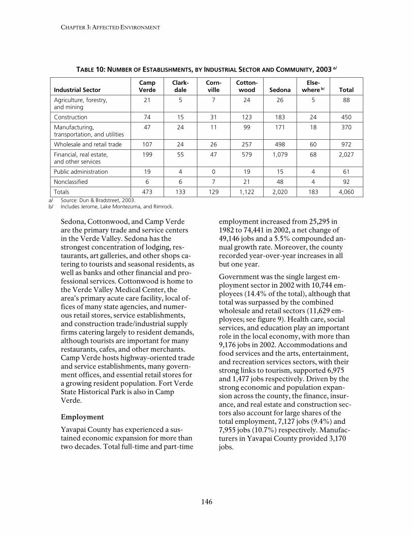
CHAPTER 3: AFFECTED ENVIRONMENT
146
TABLE 10: NUMBER OF ESTABLISHMENTS, BY INDUSTRIAL SECTOR AND COMMUNITY, 2003 a/
Industrial Sector Camp Verde
Clark-dale
Corn-ville
Cotton-wood Sedona
Else-where b/ Total
Agriculture, forestry, and mining
21 5 7 24 26 5 88
Construction 74 15 31 123 183 24 450
Manufacturing, transportation, and utilities
47 24 11 99 171 18 370
Wholesale and retail trade 107 24 26 257 498 60 972
Financial, real estate, and other services
199 55 47 579 1,079 68 2,027
Public administration 19 4 0 19 15 4 61
Nonclassified 6 6 7 21 48 4 92
Totals 473 133 129 1,122 2,020 183 4,060 a/ Source: Dun & Bradstreet, 2003. b/ Includes Jerome, Lake Montezuma, and Rimrock.
Sedona, Cottonwood, and Camp Verde are the primary trade and service centers in the Verde Valley. Sedona has the strongest concentration of lodging, res-taurants, art galleries, and other shops ca-tering to tourists and seasonal residents, as well as banks and other financial and pro-fessional services. Cottonwood is home to the Verde Valley Medical Center, the area’s primary acute care facility, local of-fices of many state agencies, and numer-ous retail stores, service establishments, and construction trade/industrial supply firms catering largely to resident demands, although tourists are important for many restaurants, cafes, and other merchants. Camp Verde hosts highway-oriented trade and service establishments, many govern-ment offices, and essential retail stores for a growing resident population. Fort Verde State Historical Park is also in Camp Verde.
Employment
Yavapai County has experienced a sus-tained economic expansion for more than two decades. Total full-time and part-time
employment increased from 25,295 in 1982 to 74,441 in 2002, a net change of 49,146 jobs and a 5.5% compounded an-nual growth rate. Moreover, the county recorded year-over-year increases in all but one year.
Government was the single largest em-ployment sector in 2002 with 10,744 em-ployees (14.4% of the total), although that total was surpassed by the combined wholesale and retail sectors (11,629 em-ployees; see figure 9). Health care, social services, and education play an important role in the local economy, with more than 9,176 jobs in 2002. Accommodations and food services and the arts, entertainment, and recreation services sectors, with their strong links to tourism, supported 6,975 and 1,477 jobs respectively. Driven by the strong economic and population expan-sion across the county, the finance, insur-ance, and real estate and construction sec-tors also account for large shares of the total employment, 7,127 jobs (9.4%) and 7,955 jobs (10.7%) respectively. Manufac-turers in Yavapai County provided 3,170 jobs.

Socioeconomics
147
FIGURE 9: FULL-TIME AND PART-TIME EMPLOYMENT, YAVAPAI COUNTY, 2002
Labor Force Participation
Labor force participation among valley residents 16 years and older are lower than the statewide and national norms. Local labor force participation averages about 54.9% in the Verde Valley, ranging from 52.5% in Camp Verde to 72.2% in Jerome, compared to 61.1% for Arizona and 60.3% for the nation. The lower local rates reflect the relatively higher number of retired residents.
Unemployment
Unemployment rates in Yavapai County have historically been below the statewide average. That trend was maintained through the recessionary period of 2000 to 2002, when unemployment rates in-creased, and more recently as unemploy-ment has declined (table 11). Unemploy-ment rates within the Verde Valley at the time of the 2000 census were comparable to the countywide average. Unemploy-ment rates within the valley tended to be slightly higher in Cottonwood and Camp Verde than in other parts of the valley.
TABLE 11: AVERAGE ANNUAL UNEMPLOYMENT RATES
Area
2000
2001
2002
2003
2004 (Aug.)
Yavapai County
2.8% 3.0% 3.7% 3.3% 2.8%
Arizona 4.0% 4.7% 6.2% 5.6% 4.9% Source: Arizona Department of Economic Security, Re-search Analysis, 2004.
The below-average labor force participa-tion rates and large number of retired res-idents are two factors that likely contri-bute to the favorable unemployment con-ditions in the local market.
Personal Income
Total personal income growth in Yavapai County has averaged 4.3% (compounded annual growth rate) since 1999, reaching $3.93 billion in 2002. Data from the 2000 census indicate that one-third of the total accrues to Verde Valley residents. Just over half of the 2002 total income was de-rived from labor earnings, including a net inflow of more than $224 million earned by residents working outside the county, primarily individuals from the Prescott area commuting to work in the Phoenix metropolitan area. Dividends, interest, and rent added another $1.17 billion and

CHAPTER 3: AFFECTED ENVIRONMENT
148
$857 million in social security, private re-tirement, and other current transfer re-ceipts.
The single largest amount and share of earnings was paid by governments at all levels: $414.3 million or 21.6%. The con-struction, retail trade, and health care and social assistance industries each recorded earnings in excess of $200 million. Profes-sional services, accommodation and food services, and manufacturing all had ap-proximately $100 million in labor earn-ings.
Per capita personal incomes among valley residents, shown in table 12, reflect the diverse range of economic, demographic, and life-stage characteristics, as well as differing community characteristics. Across the valley, per capita personal in-comes are generally below the countywide and statewide norms. At $15,072, per capi-ta income in Camp Verde was the lowest in the valley, and nearly 26% below the statewide average of $20,275. The highest per capita incomes were in Sedona ($31,350) and nearby Big Park ($30,026),
both considerably higher than the state-wide average. Median household incomes across the valley reflected similar patterns (table 12).
Income sources among residents indicate the influx of retired and semi-retired households into the valley in recent years. Except for households living in Jerome, relatively fewer households reported in-come from current employment than across the state or nation, with the corol-lary that relatively more households re-ceive social security and retirement in-come. For instance, fewer than 60% of households in the Big Park census desig-nated place had earnings from work com-pared to 78.7% of all households in Arizo-na and 80.5% of American households. Again, except for Jerome, more than 40% of local households received social securi-ty income, compared to 25.7% across the nation, and 22% to 30% of households received retirement income, compared to 8.5% across the state.
TABLE 12: PERSONAL INCOME AMONG VERDE VALLEY HOUSEHOLDS, 1999
Community
Per Capita Income
Median Household
Income
Share of Households with Income from: a/
Work Earnings
Social Security
Retirement Income
Big Park CDP b/ $ 30,026 $ 38,477 59.5% 44.4% 30.4%
Camp Verde $ 15,072 $ 31,868 71.4% 42.1% 29.0%
Clarkdale $ 18,441 $ 34,911 66.2% 42.1% 28.7%
Cottonwood $ 17,518 $ 35,075 64.9% 45.2% 22.8%
Jerome $ 19,967 $ 27,857 83.8% 18.1% 8.1%
Lake Montezuma CDP $ 17,043 $ 33,750 74.1% 37.2% 25.9%
Sedona $ 31,350 $ 44,042 69.5% 42.9% 22.6%
Yavapai County $ 19,727 $ 34,901 67.8% 40.1% 27.3%
Arizona $ 20,275 $ 40,558 78.7% 27.1% 18.5%
United States $ 17,518 $ 27,444 80.5% 25.7% 16.7% a/ Shares do not add to 100% because households can have multiple sources of income. b/ CDP is the abbreviation for census designated place, an unincorporated community that has many of the retail
and service functions of a town. Source: U.S. Census Bureau – Census 2000, 2002.

Socioeconomics
149
Commuting
Most of the valley’s residents who work do so within the valley. More than 1,700 individuals, 7% of workers 16 years and older, worked at home. Another 42% of workers reported one-way commuting of less than 15 minutes, and 37% of workers had commuting times of between 15 and 29 minutes. Nearly 4,100 resident workers reported doing so in another county. For some, this simply involved commuting from the western part of the Sedona to the eastern part or vice versa. In other cases, it involved commuting to the Phoenix or Flagstaff metropolitan areas, facilitated by I-17.
Poverty
Relatively fewer individuals are economi-cally impoverished in the Verde Valley than elsewhere in Yavapai County, Arizo-na or the nation. In 1999, approximately 6,650 individuals (11.2%) lived in poverty in the area. That compares to 13.9% of all Arizonans. However, poverty rates in Camp Verde and Cottonwood, communi-ties that are also home to many Native Americans and other non-whites, record-ed higher than average rates of poverty. Improving economic and housing condi-tions among its members, in part through use of the proceeds of the Cliff Casino, is one of the major goals for the Yavapai-Apache tribe.
POPULATION AND DEMOGRAPHICS
Population
About 59,200 year-round residents lived in the Verde Valley in 2000. This included 55,900 inhabitants in Yavapai County and 3,300 residents in and near Sedona in Co-conino County. The total represents an increase of 19,854 residents or 51% over the 1990 population of 39,307.
Population centers in the valley include the communities of Sedona (10,192), Cot-tonwood (9,197), Camp Verde (9,451), Clarkdale (3,422), and the unincorporated
communities of Cottonwood/Verde Vil-lage (10,610), Big Park (5,245) and Lake Montezuma (3,344). The historic town of Jerome, once boasting a population of 15,000, registered a population of 329. Another 16,600 residents lived in unin-corporated areas of the valley, though some of those areas have since been an-nexed to a municipality.
Age and Average Household Size
Residents of the Verde Valley are general-ly older, with many households having no children. Across the Verde Valley, 17% of residents were under 15 years of age in 1990, and nearly 23% were 65 and over. The comparable shares for Arizona were 22.5% and 13%, respectively. The median ages of residents in the valley range from 41.0 years in Cottonwood to 55.5 in the Big Park census designated place, with a median of about 45 years across the entire valley. By comparison, the median age of all Arizonans was 34.2 years in 1990.
With relatively fewer children, the average household size in the valley is smaller than across the state and nation. The average household sizes range from 1.81 persons in Jerome to 2.52 persons in Camp Verde, with an overall average of about 2.32 per-sons. Statewide, the average household size was 2.64 individuals.
Race and Hispanic Origin
The racial composition among valley resi-dents is predominately white (90%), com-pared to 77.9% white Arizona. Native Americans, mostly from the Yavapai-Apache Nation, whose reservation is near Camp Verde, account for 2.5% of local residents. Native Americans account for 5.7% of the statewide population. Indi-viduals of other single races or those re-porting two or more races account for the remaining 7.5% of the local population. People of Hispanic or Latino origin represented 11.2% of the population, less than half the statewide value of 25.3%.

CHAPTER 3: AFFECTED ENVIRONMENT
150
Migration
Another indication of the dynamic demo-graphic and social changes in the Verde Valley is that in 2000, about a third of resi-dents age 5 or older had moved there in or since 1995. Of those, about 40% had relo-cated from elsewhere in Arizona, 57% from other (mostly western) states, and 3% had previously lived in a foreign coun-try or one of the U.S. island territories.
Projected Long-term Population Growth
The Yavapai County General Plan (Yava-pai County 2003) identifies two major growth areas, including the “Verde Valley Area,” which includes both monuments. Tourism is a major factor in the Verde Valley’s economy.
The area’s recent, strong population growth is expected to continue. Popula-tion projections for Yavapai County in-clude a 59% population increase between 2000 and 2020, with a population of 240,849 projected for 2020 (Arizona De-partment of Economic Security 1997).
As shown in figure 10, the Arizona De-partment of Economic Security projects long-term growth of about 1.7% com-pounded annually in the region through 2030, with Coconino County’s population approaching 190,000 by 2030, and Yavapai County’s population reaching 278,400 ( Arizona Department of Economic Securi-ty 1990).
Strong growth is also expected in the Verde Valley, with a projected population of about 95,000 year-round residents in 2030. Most growth will occur in the Yava-pai County area because of limited land availability and development constraints around Sedona in Coconino County. Camp Verde and Sedona both have pro-jected 2030 populations of about 16,500, with more than 35,000 residents around Cottonwood / Clarkdale / Verde Village.
Housing
There were 28,683 dwelling units in the Verde Valley at the time of 2000 census. Of those, 88% were occupied, and 3,360 (12%) were vacant. Included in the latter category were nearly 1,500 units including second homes and timeshare units for sea-sonal, recreational, or occasional use.
FIGURE 10: POPULATION FORECASTS TO 2030, COCONINO AND YAVAPAI COUNTIES

Socioeconomics
151
Utilization characteristics of housing units are not available, but if as elsewhere in Arizona, they are most frequently used during the winter (that is, New Year’s to Easter). Their peak use would coincide with the peak visitation period for the na-tional monuments.
The Verde Valley is growing rapidly, and more than 5,500 dwelling units, about one in five of all homes in the valley, were built between 1995 and March 2000. Another 1,331 homes were completed in the 15 months immediately preceding the 2000 census. Residential construction was par-ticularly strong in Cottonwood, Sedona, and the Big Park area.
Except for Sedona and the Big Park area, which respectively had median home val-ues of $253,700 and $224,800 in 1999, housing was relatively affordable in the valley. Median values in Cottonwood ($106,800), Camp Verde ($129,600), and Clarkdale ($132,100) all were within 10% of the statewide average of $121,300.
The pace of new construction has contin-ued, as the county and local municipalities have issued building permits for another 4,500 units since 2000. The rapid pace of residential construction and the accom-panying commercial and industrial devel-opment, although generally removed from the immediate vicinity of the three sites, is increasingly apparent along the primary highway access roads and routes to Mon-tezuma Castle and Tuzigoot national mo-numents. The encroaching development is forever altering the sense of remoteness that visitors to these sites formerly expe-rienced, along with the appreciation and understanding of their historical setting.
Adjacent Land Use
The Verde Valley is one of the fastest growing areas in Arizona. Historically, land uses in Yavapai County were largely ranching, agriculture and mining. During the past 30 years of rapid population growth, much of the ranching and agricul-tural uses have developed into expansions
of municipalities. Residential develop-ment has also happened in many unincor-porated portions of the county near estab-lished urbanizing areas where major infra-structure, such as county highways, en-hance development. As population con-tinues to grow throughout the Verde Val-ley, demand for additional housing units will continue, with population increases of up 60% forecasted. Increasing develop-ment on lands adjacent to and surround-ing the monument continues to result in direct and indirect impacts on the monu-ments Adverse impacts to resources result from farming, feral animals, woodcutting, freeway construction, residential and sub-division construction, water demands, and pesticide and fertilizer drainage into water supplies. Development in the valley has resulted in visual intrusions on the mo-nument’s cultural and natural setting.
ECONOMIC CONTRIBUTIONS OF THE NATIONAL MONUMENTS TO THE LOCAL ECONOMY
Visitors to Montezuma Castle and Tuzi-goot national monuments gain insights into the ancient Sinaguan culture that once thrived in the area. During their time in the area, they can also learn about the more recent and contemporary endeavors of the Yavapai-Apache and about the min-ing and agricultural industries. At the same time, their spending on consumer goods and services and local expenditures asso-ciated with the operations of the national monuments support employment, spawn personal and business income in the val-ley, and generate tax revenues that help support government and public services. The economic contributions of those lin-kages are addressed in this section.
Visitor Spending
Annual visitation to Montezuma Castle and Tuzigoot national monuments totaled 752,240 in 2003. This year is used to pro-vide consistency with the available visitor spending data. As documented in the visi-tor survey, many of the visitors saw two or

CHAPTER 3: AFFECTED ENVIRONMENT
152
all three of the sites during their stay. The typical visit was relatively short, such that many of the multiple visits likely occurred during the same day. Adjustments made to eliminate double counting when estimat-ing the economic impacts, predicated on a visitor’s typical daily spending, reduced the total number of individual visitors to 600,000. Accounting for the different user segments, for instance, day visitors versus those spending the night locally, results in 149,729 visitor party-days. (Party-days are a measure of activity used to account for varying lengths of stays and differences in spending patterns among visitors. The conversion from visits to party-days is needed because expenditure data are typi-cally collected and reported on “per day” or “per trip” basis, with lodging or other overnight accommodations one of the key spending categories.)
Average spending per party-night is esti-mated at $96.85, yielding total estimated annual visitor spending associated with the Montezuma Castle and Tuzigoot na-tional monuments of $14.50 million (table 13). The bulk of the total, $8.05 million (55%), is by visitors staying overnight in area motels, bed and breakfasts, and other lodging accommodations.
Non-local day users account for the second largest share of the spending, $2.79 million (19%).
Of the total spending, $11.78 million is captured within the region, with $2.72 million leaving the region to cover the cost of goods sold. Receipts garnered by local motels, resorts, RV parks, and other over-night accommodations account for $4.48 million (38%). Restaurants, bars, coffee shops, and other such establishments gain $3.33 million in annual sales attributed to monument visitors. Retail merchants rea-lized $1.6 million, the Cliff Castle Casino $1.0 million, and other attractions and amusements $830,000 in annual receipts from visitors to Montezuma Castle and Tuzigoot national monuments.
Locally captured visitor spending includes purchases of books, maps, CDs, DVDs, tapes, and other items sold by the Western National Parks Association at gift shops in the Montezuma Castle and Tuzigoot visi-tor centers. Annual gross sales are about $570,000. About $35,000 of that total is transferred to the monument as a conces-sion/lease fee for the space used by the retail operation (Fistler pers. comm. 2005).
TABLE 13: ANNUAL VISITOR SPENDING IN THE VERDE VALLEY BY VISITORS TO MONTEZUMA CASTLE AND TUZIGOOT NATIONAL MONUMENTS
Category
USER SEGMENT
Local Day User
Non-local Day User Motels
Tour Bus Visitors Camp-Out
Visiting Friends or Relatives
Spending per party-night $41.39 $58.11 $179.12 $73.12 $93.87 $61.11
Party nights 14,040 47,960 44,929 15,444 8,673 18,683
Total spending ($000s) $581.1 $2,786.9 $8,047.7 $1,129.3 $814.2 $1,141.7
Total spending – all users ($1,000s) $14,500.9
Segment share of total 4% 19% 55% 8% 6% 8%
Source: Stynes et al. 2000 (Money Generation Model Version 2).
Socioeconomics
153
The local visitor spending associated with the national monuments supports 291 jobs across the region, generating $3.97 million in annual personal income and $6.02 mil-lion in value added within the Verde Val-ley. Included in the above are eight jobs with the Western National Parks Associa-tion (Fistler pers. comm. 2005). The sums are in addition to the NPS jobs at the two units and those jobs supported indirectly by the payroll, operating expenses, and construction contracts issued by the units.
The recirculation of money within the lo-cal economy as employees, merchants, property owners, and public sector em-ployees purchase goods and service locally amplifies the magnitude of the direct eco-nomic stimulus generated by visitors. This “multiplier” effect results in additional job creation and income generation. The sec-ondary effects of visitor spending include $3.84 million in direct sales, 51 jobs, $1.29 million in personal income, and $2.38 mil-lion in value added (table 14). The multip-liers range from 1.17 for jobs to 1.40 for direct sales.
Part of the entrance fees collected by the National Park Service from visitors ac-crues directly to the Montezuma Castle and Tuzigoot national monuments. This amount is discussed below and, to avoid double counting, is excluded from the preceding estimates of the economic im-pact of visitor spending.
Monument Operations
The annual budget for NPS operations at Montezuma Castle and Tuzigoot national monuments represents direct income to the Verde Valley economy. Spending of wage and salary income by NPS em-ployees stimulates induced effects in the region, and spending by the National Park Service on utilities, supplies, and services
support additional sales, jobs, and income. The effects of NPS operations are an addi-tion to the effect of visitor spending asso-ciated with the national monuments.
Fiscal year 2004 is the base year used for analyzing the monuments’ economic con-tribution, allowing correlation with the 2004 visitor survey. Fiscal year 2007 oper-ating budgets and staffing are presented in the Monument Operations section.
In fiscal year 2004, NPS spending, includ-ing additional amounts for projects that were part of ongoing operations, was a little more than $1.4 million.
NPS spending in fiscal year 2004 are esti-mated to have supported 38 jobs in the Verde Valley region, including full-time equivalent jobs at Montezuma Castle and Tuzigoot national monuments, and an ad-ditional 14 jobs generated by the spending of NPS employees and NPS direct local spending. NPS operations generated $1.5 million of personal income in 2004, in-cluding $1.2 million in payroll, $867,000 in direct sales, and $1.8 million in value add-ed, an amount that includes the $1.5 mil-lion in personal income just noted (table 15). These amounts are all in addition to the effect of local visitor spending asso-ciated with the national monuments.
The estimates of total economic impact in table 16 rely on assumptions about where NPS payroll is spent and where other NPS purchases are made. The assumptions come from the NPS’ Money Generation Model version two (Stynes et al. 2000). For regions generally comparable to the Verde Valley, the model assumes that the disposable share of household income is spent locally and that NPS purchases are mostly made outside the region with the exception of water service and some sup-plies and equipment.

CHAPTER 3: AFFECTED ENVIRONMENT
154
TABLE 14: DIRECT ECONOMIC IMPACTS OF VISITOR SPENDING IN THE VERDE VALLEY, 2003
CATEGORY
ECONOMIC PARAMETER
Direct Sales ($1,000s)
Local Jobs
Personal Income ($1,000s)
Value Added ($1,000s)
Direct effects $11,775 291 $3,971 $6,023
Secondary effects $3,837 51 $1,289 $2,377
Total impacts $15,612 342 $5,260 $8,400
Multipliers (total/direct) 1.33 1.17 1.32 1.40
Source: Stynes et al. 2000 (Money Generation Model Version 2).
TABLE 15: DIRECT ECONOMIC IMPACTS IN THE VERDE VALLEY OF THE MONTEZUMA CASTLE AND TUZIGOOT NATIONAL MONUMENTS OPERATIONS, FISCAL YEAR 2004
CATEGORY
ECONOMIC PARAMETER
Direct Sales ($1,000s) Local Jobs
Personal Income ($1,000s)
Value Added ($1,000s)
Direct Effects $26 a/ 24 $1,238 $1,238
Secondary Effects $842 b/ 14 $308 $521
Total Impacts $868 38 $1,546 $1,759
Multipliers (Total/Direct) NA c/ 1.58 1.25 1.41
Notes: a/ Estimated local purchases by the National Park Service for utilities, supplies, and services. b/ Includes the induced and indirect effects of monument purchases and employee spending of income. c/ NA = not applicable. A multiplier for direct sales was not calculated because the amounts in this column are not consistent
with those in the other three columns of the table because the direct effect of employee spending has not been estimated explicitly.
Source: Stynes et al. 2000 (Money Generation Model Version 2).
TABLE 16: TOTAL ECONOMIC IMPACTS IN THE VERDE VALLEY OF THE MONTEZUMA CASTLE AND TUZIGOOT NATIONAL MONUMENTS, 2003
CATEGORY
ECONOMIC PARAMETER
Direct Sales ($1,000s) Local Jobs
Personal Income ($1,000s)
Value Added ($1,000s)
Visitor spending $15,612 342 $5,260 $8,400
NPS monument operations $867 38 $1,546 $1,759
Total impacts $16,480 380 $6,806 $10,159
Source: Stynes et al. 2000 (Money Generation Model Version 2).

Socioeconomics
155
Visitor entrance fees were excluded from the analysis of visitor spending impacts. However, 80% of this type of revenue is returned to the local NPS unit under the National Park Service’s Recreation Fee Demonstration Fund program to fund re-source protection, enhancement, and cap-ital facility projects. The program has yielded about $720,000 a year (80% of $900,000) for Montezuma Castle and Tu-zigoot. A portion of these funds has been used to offset the cost of collections, with the remainder dedicated to financing completed, ongoing or planned capital improvement and resource restoration projects at the two units.
Total Economic Contributions
The total economic contribution of Mon-tezuma Castle and Tuzigoot national mo-numents is 380 jobs, nearly $16.5 million in sales, $6.8 million in personal income, and almost $10.2 million in value added (table 16).
This is a small but valuable contribution to the regional economy. The 380 jobs gen-erated by the combination of visitors and NPS employment and spending are about 0.5% of total employment in Yavapai County and a larger percentage of total employment in the Verde Valley. Similar-ly, $6.8 million in personal income is about 0.2% of total personal income in Yavapai County and is a larger share of total per-sonal income in the Verde Valley. Note that a percentage share for the Verde Val-ley cannot be quantified because employ-ment and personal income data are not available for the local region.
Montezuma Castle and Tuzigoot national monuments also contribute to total sales and value added in Yavapai County. The shares contributed by the monuments would be small in comparison to totals for Yavapai County. Again, the percentage share contributed by the monuments to total sales and value added in the county and in the local region cannot be quanti-fied from the available economic informa-tion.


CHAPTER 4:ENVIRONMENTAL CONSEQUENCES


159
INTRODUCTION
The National Environmental Policy Act (NEPA) requires that environmental doc-uments discuss the environmental impacts of a proposed federal action, feasible al-ternatives to that action, and any adverse environmental effects that cannot be avoided if a proposed action is imple-mented. In this case, the proposed federal action would be the adoption of a general management plan for Montezuma Castle and Tuzigoot National Monuments. The following portion of this document ana-lyzes the environmental impacts of im-plementing the three alternatives on cul-tural resources, natural resources, the visi-tor experience, monument operations, and socioeconomics. The analysis is the basis for comparing the beneficial and ad-verse effects of implementing the alterna-tives.
Because of the general, conceptual nature of the actions described in the alternatives, the impacts of these actions are analyzed in general, qualitative terms. Thus, this environmental assessment should be con-sidered a programmatic analysis. If and when site-specific developments or other actions are proposed for implementation subsequent to this general management plan, appropriate detailed environmental and cultural compliance documentation will be prepared in accord with the Na-tional Environmental Policy Act and Na-tional Historic Preservation Act require-ments.
This chapter begins with a description of the methods and assumptions used for each topic. Impact analysis discussions are organized by alternative and then by im-pact topic under each alternative.
Each alternative discussion also describes cumulative impacts and presents a conclu-sion. At the end of each alternative is a brief discussion of unavoidable adverse impacts, irreversible and irretrievable commitments of resources, the relation-ship of short-term uses of the environ-
ment and the maintenance and enhance-ment of long-term productivity, and ener-gy requirements and conservation poten-tial. The impacts of each alternative are briefly summarized in table 6, at the end of Chapter 2: Alternatives, Including the Pre-ferred Alternative.
CUMULATIVE IMPACT ANALYSIS
The Council on Environmental Quality’s regulation 1508.7 describes a cumulative impact as follows:
• Cumulative impacts are incremental impacts of the action when added to other past, present, and reasonably fo-reseeable future actions, regardless of what agency (federal or nonfederal) or person undertakes such other action. Cumulative impacts can result from individually minor, but collectively significant, actions taking place over a period of time.
Other projects, plans, and actions within Montezuma Castle and Tuzigoot national monuments, as well as local and regional projects, plans, and actions with potential to combine with the effects of the alterna-tives were identified to determine poten-tial cumulative impacts. Projects were identified by discussions with the monu-ments, federal land managers, and repre-sentatives of county and town govern-ments. Potential projects identified as cu-mulative actions included any planning or development activity that was currently being implemented or would be imple-mented in the reasonably foreseeable fu-ture. Impacts of past actions were also considered in the analysis.
These actions are evaluated with the im-pacts of each alternative to determine whether they have any cumulative effects on a particular natural, cultural, or socioe-conomic resource or visitor use. Because most of these cumulative actions are in the early planning stages, the qualitative eval-uation of cumulative impacts was

CHAPTER 4: ENVIRONMENTAL CONSEQUENCES
160
based on a general description of the project. See Chapter 1, Relationship to Other Planning Effort, for a description of the plans and actions considered in the analysis of the alternatives.
IMPAIRMENT OF MONTEZUMA CASTLE AND TUZIGOOT NATIONAL MONUMENTS RESOURCES
In addition to determining the environ-mental consequences of implementing the preferred and other alternatives, Man-agement Policies 2006 requires analysis of potential effects to determine whether or not proposed actions would impair mo-nument resources and values (sections 1.4.2, 1.4.4, and 1.4.5).
The fundamental purpose of the national park system, established by the Organic Act and reaffirmed by the General Au-thorities Act, as amended, begins with a mandate to conserve monument resources and values. NPS managers must always seek ways to avoid, or to minimize to the greatest degree practicable, adverse im-pacts on monument resources and values. However, the laws do give the National Park Service the management discretion to allow impacts on monument resources and values when necessary and appropri-ate to fulfill the purposes of the monu-ment, as long as the impact does not con-stitute impairment of the affected re-sources and values. Although Congress has given the National Park Service the management discretion to allow certain impacts within a monument, that discre-tion is limited by the statutory require-ment that the National Park Service must leave resources and values unimpaired unless a particular law directly and specif-ically provides otherwise.
The prohibited impairment is an impact that, in the professional judgment of the responsible NPS manager, would harm the integrity of monument resources and values, including the opportunities that otherwise would be present for the en-joyment of those resources or values
(Management Policies 2006, section 1.4.5). An impact on any monument resource or value may constitute an impairment. An impact would be more likely to constitute an impairment to the extent that it affects a resource or value whose conservation is:
• Necessary to fulfill specific purposes identified in the establishing legisla-tion or proclamation of the monu-ment;
• Key to the natural or cultural integrity of the monument or to opportunities for enjoyment of the monument; or
• Identified as a goal in the monument’s general management plan or other re-levant NPS planning documents.
Impairment may result from NPS actions in managing the monument, visitor activi-ties, or activities undertaken by conces-sioners, contractors, and others operating in the monument. A determination on im-pairment is made in the “Environmental Consequences” chapter in the conclusion section for each required impact topic re-lated to the monument’s resources and values.
In analyzing impairments in the National Environmental Policy Act analysis for this project, the National Park Service takes into account the fact that if impairment were likely to occur, such impacts would be considered to be major or significant under the Council on Environmental Quality regulations. This is because the context and intensity of the impact would be sufficient to render what would nor-mally be a minor or moderate impact to be major or significant. An evaluation of im-pairment is not required for some impact topics, including visitor experience (unless the impact is resource based), transporta-tion, NPS operations, or socioeconomics.
UNACCEPTABLE IMPACTS
The impact threshold at which impair-ment occurs is not always readily appar-ent. Therefore, the National Park Service will apply a standard that offers greater

Introduction
161
assurance that impairment will not occur by avoiding impacts that it determines to be unacceptable. These impacts fall short of impairment but are still not acceptable within a particular park’s environment. Park managers must evaluate existing or proposed uses and determine whether the associated impacts on monument re-sources and values are acceptable.
Virtually every form of human activity that takes place within a park has some degree of effect on park resources or values, but that does not mean that the impact is un-acceptable or that a particular use must be disallowed. Therefore, for these policies, unacceptable impacts are impacts that, individually or cumulatively, would
• Be inconsistent with a park’s purposes or values or
• Impede the attainment of a park’s de-sired future conditions for natural and cultural resources as identified through the park’s planning process or
• Create an unsafe or unhealthful envi-ronment for visitors or employees or
• Diminish opportunities for current or future generations to enjoy, learn about, or be inspired by park re-sources or values or
• Unreasonably interfere with
- Park programs or activities or
- An appropriate use or
- The atmosphere of peace and tranquility, or the natural soundscape maintained in wilder-ness and natural, historic, or commemorative locations within the park, or
- NPS concessioner or contractor operations or services.
In accordance with Management Policies 2006, park managers must not allow uses that would cause unacceptable impacts to park resources. To determine if unaccept-able impact could occur to the resources and values of Montezuma Castle National Monument or Tuzigoot National Monu-ment, the impacts of proposed actions in this general management plan and envi-ronmental assessment were evaluated based on the above criteria. A determina-tion on unacceptable impacts is made in the Conclusion section for each of the re-source topics carried forward in this chap-ter.

162
METHODS AND ASSUMPTIONS FOR ANALYZING IMPACTS
The planning team based the impact anal-ysis and the conclusions in this chapter largely on the review of existing literature and studies, information provided by ex-perts in the National Park Service and other agencies, and monument staff in-sights and professional judgment. The team’s method of analyzing impacts is fur-ther explained below. It is important to remember that all the impacts have been assessed assuming that mitigating meas-ures have been implemented to minimize or avoid impacts. If the mitigating meas-ures described in Chapter 2: Alternatives Including the Preferred Alternative are not applied, the potential for resource im-pacts and the magnitude of those impacts would increase.
Director’s Order 12: Conservation Plan-ning, Environmental Impact Analysis, and Decision Making presents an approach for identifying the duration (short- or long-term), type (adverse or beneficial), and intensity or magnitude (negligible, minor, moderate, or major) of the impact(s), and that approach has been used in this docu-ment. Where duration is not noted in the impact analysis, it is considered long-term. Direct and indirect effects caused by an action were considered in the analysis. Direct effects are caused by an action and occur at the same time and place as the action. Indirect effects are caused by the action and occur later in time or farther removed from the place, but are still rea-sonably foreseeable.
The impact analyses for the no-action al-ternative compare resource conditions in the year 2021 to existing conditions in 2006, assuming continuation of current management direction. The impact analy-sis for the action alternatives (the pre-ferred alternative and alternative C) com-pares the action alternatives in the year 2021 to the no-action alternative in the year 2021. Said differently, the impacts of the action alternatives describe the differ-
ence between implementing the no-action alternative and implementing the action alternatives. To understand a complete “picture” of the impacts of implementing any of the action alternatives, the reader must also take into consideration the im-pacts that would occur under the no-action alternative.
CULTURAL RESOURCES
Cultural Resources Listed, or Eligible to Be Listed, in the National Register of Historic Places
Potential impacts on cultural resources (archeological resources, prehistoric or historic structures, cultural landscapes, and traditional cultural properties) either listed in or eligible to be listed in the Na-tional Register of Historic Places were identified and evaluated in accordance with the Advisory Council on Historic Preservation’s regulations implementing section 106 of the National Historic Pre-servation Act (36 CFR 800, Protection of Historic Properties) by:
• Determining the area of potential ef-fects;
• Identifying national-register-listed or eligible cultural resources in the area of potential effects;
• Applying the criteria of adverse effect to affected resources; and
• Considering ways to avoid, minimize or mitigate adverse effects.
Under the Advisory Council’s regulations, a determination of no historic properties affected, adverse effect, or no adverse effect must be made for affected cultural re-sources that are listed in, or eligible for listing in, the National Register of Historic Places. A determination of no historic properties affected means that either no historic properties are present or historic properties are present but the undertaking will have no effect on them (36 Code of

Methods and Assumptions for Analyzing Impacts
163
Federal Regulations 800.4 [d][1]). An ad-verse effect occurs whenever an impact alters, directly or indirectly, any characte-ristic of a cultural resource that qualifies it for inclusion in the national register (for example, diminishing the integrity (or the extent to which a resource retains its his-toric appearance) of its location, design, setting, materials, workmanship, feeling, or association). Adverse effects also in-clude reasonably foreseeable effects caused by the alternatives that would oc-cur later in time, be farther removed in distance, or be cumulative (36 Code of Federal Regulations 800.5 [a] [1]). A de-termination of no adverse effect means there is an effect, but it would not meet the criteria of an adverse effect (that is, diminish the characteristics of the cultural resource that qualify it for inclusion in the national register [36 Code of Federal Regu-lations 800.5 (b)]).
The criteria for characterizing the severity or intensity of impacts to archeological resources, prehistoric and historic struc-tures and buildings, cultural landscapes, and traditional cultural properties that are listed in, or eligible for listing in, the Na-tional Register of Historic Places are the section 106 determinations of effect: no historic properties affected, adverse effect, or no adverse effect. A section 106 deter-mination of effect is included in the con-clusion section for each analysis of im-pacts to national register-listed or -eligible cultural resources.
Ethnographic Resources
Ethnographic resources that are not tradi-tional cultural properties are not subject to section 106 of the National Historic Preservation Act. Potential impacts to ethnographic resources that are not tradi-tional cultural resources are described in terms of context (Are the effects site-specific, local, or regional?), duration (Are the effects short-term [that is, lasting up to 5 years], long-term [that is, lasting 5 to 20 years], or permanent?) and intensity (Is
the degree or severity of effects negligible, minor, moderate, or major?). The defini-tions of impact intensity for ethnographic resources follow:
• Negligible. Impact(s) would be barely perceptible and would alter neither re-source conditions, such as traditional access or site preservation, nor the re-lationship between the resource and the affiliated group’s body of practices and beliefs.
• Minor. Adverse impact(s) would be slight but noticeable but would appre-ciably alter neither resource condi-tions, such as traditional access or site preservation, nor the relationship be-tween the resource and the affiliated group’s body of practices and beliefs.
Beneficial impact(s) would allow access to and/or accommodate a group’s tra-ditional practices or beliefs.
• Moderate. Adverse impact(s) would be apparent and would alter resource conditions. Something would interfere with traditional access, site preserva-tion, or the relationship between the resource and the affiliated group’s practices and beliefs, even though the group’s practices and beliefs would survive.
Beneficial impact(s) would facilitate traditional access and/or accommo-date a group’s practices or beliefs.
• Major. Adverse impact(s) would alter resource conditions. Something would block or greatly affect traditional access, site preservation, or the rela-tionship between the resource and the affiliated group’s body of practices and beliefs, to the extent that the sur-vival of a group’s practices and/or be-liefs would be jeopardized.
Beneficial impact(s) would encourage traditional access and/or accommo-date a group’s practices or beliefs.
CHAPTER 4: ENVIRONMENTAL CONSEQUENCES
164
NATURAL RESOURCES
Analysis of natural resources was based on research, knowledge of monument re-sources, and the best professional judg-ment of planners, biologists, hydrologists, and botanists who have experience with similar types of projects. Information on the monuments’ natural resources was gathered from several sources, including the U.S. Fish and Wildlife Service and spe-cific resource inventories for wetlands, wildlife, water quality, fisheries, and am-phibians. As appropriate, additional sources of data are identified under re-spective topic headings.
Where possible, map locations of sensitive resources were compared with the loca-tions of proposed developments and mod-ifications. Predictions about short-term and long-term site impacts were based on previous studies of visitor and facilities development impacts on natural re-sources. The analysis also considered so-ciological studies comparing the deterrent effects of signs versus ranger presence for reducing visitor impacts on sites.
Generally, for natural resources analysis, duration of impacts are considered short-term if the effects are likely to last one year or less and long-term if the potential im-pact would last for greater than one year.
The determination of impacts for natural resources also considered whether an ac-tion would have a beneficial or an adverse effect. Typically, beneficial effects would include those that improve the condition of a resource or enhance the environment around that resource such that its well-being was enhanced. Conversely, adverse effects on natural resources would dam-age conditions necessary for the resource to exist or function or would degrade the environment needed to support the re-source being analyzed.
The impact definitions assume that mitiga-tion measures are considered prior to fi-nalizing the analyses. For this document, the planning team generally and qualita-
tively evaluated the impact intensity for natural resources, as follows:
• Negligible. Impacts would be at the lowest levels of detection and would have no appreciable effect on re-sources, values, or processes.
• Minor. Impacts would be perceptible but slight and localized. If mitigation were needed to offset any adverse ef-fects, it would be relatively simple to implement and would likely be suc-cessful.
• Moderate. Impacts would be readily apparent and widespread, and would result in a noticeable change to re-sources, values or processes. Mitigat-ing measures would probably be ne-cessary to offset adverse effects and would likely be successful.
• Major. Impacts would be readily ap-parent and widespread, and would re-sult in a substantial alternative or loss of resources, values, or processes. Mi-tigating measures to offset adverse ef-fects would be necessary and exten-sive, and their success could not be guaranteed.
Specific impact threshold definitions were developed and used to categorize the po-tential effects of the natural resource im-pact topics.
Floodplains
The impact assessment for floodplains is focused on natural river processes and flooding potential and frequency. Direc-tor’s Order 77-2, Floodplain Management (NPS 2003) and the extent of alteration to natural river processes were used to define the intensity of impacts.
• Negligible. Impacts would occur out-side the regulatory floodplain as de-fined by the Floodplain Management Guideline (100-year or 500-year flood-plain, depending on the type of ac-tion), or no measurable or perceptible change in natural river processes or aquatic habitat would occur.

Methods and Assumptions for Analyzing Impacts
165
• Minor. Actions within the regulatory floodplain would potentially change river processes or aquatic habitat in a limited way or in a localized area.
• Moderate. Actions within the regula-tory floodplain would change river processes or aquatic habitat in a sub-stantial way or in a large area.
• Major. An action would permanently change a floodplain or significantly af-fect natural river processes or aquatic habitat.
Soils
The following impact intensities were used to evaluate the potential impacts on soils:
• Negligible. The impact on soils would not be measurable. Any effects on productivity or erosion potential would be slight or imperceptible.
• Minor. The action would change a soil’s profile in a relatively small area, but it would not appreciably increase the potential for changes to soils in the surrounding area.
• Moderate. The action would change quantity or would alter the topsoil, bi-ological productivity, or the potential for erosion to remove small quantities of additional soil. Changes to localized ecological processes would occur but be of limited extent.
• Major. The action would change the potential for erosion or would alter topsoil and biological productivity in a relatively large area. Significant eco-logical processes would be altered, and landscape-level changes would be expected.
Vegetation
Information on site-specific areas, such as the plateau above the cliff dwelling at Montezuma Castle or the riparian areas in each monument, were gleaned from gen-
eral documents such as the monuments’ resource management plan and site-specific surveys. The following impact in-tensities were used to evaluate the poten-tial impacts on vegetation:
• Negligible. The impact on vegetation (individual plants and/or communi-ties) would not be measurable. The abundance or distribution of individu-als would not be affected or would be slightly affected. Ecological processes and biological productivity would not be affected.
• Minor. The action would not neces-sarily decrease or increase the area’s biological productivity. An action would affect the abundance or distri-bution of individual plants in a loca-lized area but would not affect the via-bility of local or regional populations or communities.
• Moderate. The action would change biological productivity in a small area. An action would affect a local popula-tion sufficiently to change plant abun-dance or distribution, but it would not affect the viability of the regional pop-ulation or communities. Changes to ecological processes would be of li-mited extent.
• Major. The action would change bio-logical productivity in a relatively large area. The action would affect a region-al or local population of a species suf-ficiently to change abundance or dis-tribution to the extent that the popula-tion or communities would not be likely to return to its/their former level (adverse), or would return to a sus-tainable level (beneficial). Important ecological processes would be altered.
Wetlands
Wetland impacts were qualitatively as-sessed by evaluating the potential impacts on wetland characteristics and functions including habitat. The impacts can be ex-pressed in terms of the potential for wet-

CHAPTER 4: ENVIRONMENTAL CONSEQUENCES
166
land size or integrity, connectivity with other water sources and its ability to pro-vide habitat.
• Negligible. No measurable or per-ceptible changes in wetland integrity, connectivity to other water sources, or functions related to habitat would oc-cur.
• Minor. The impact would be measur-able or perceptible but slight. A small change in integrity or continuity could occur. However, the viability of the wetland resource would not be af-fected.
• Moderate. The impact would be suf-ficient to cause a measurable change in the size, integrity, or continuity of the wetland or would result in a small but permanent change in wetland acreage. Moderate impacts would also include measurable changes in habitat integri-ty.
• Major. The action would result in a measurable change in all three para-meters (integrity, connectivity, or abil-ity to provide habitat) and would be substantial and highly noticeable.
Wildlife
Impacts on wildlife are directly related to impacts on habitat. The evaluation consi-dered whether actions would be likely to displace or disturb some or all individuals of a species in the monuments or would result in changes to habitat conditions needed for the viability of local or regional wildlife populations. Impacts associated with wildlife might include any change in roosting or foraging areas, food supply, protective cover, or the distribution or abundance of species.
• Negligible. The impact would not be measurable on individuals, and the lo-cal populations would not be affected.
• Minor. The action would affect the abundance or distribution of individu-als in a small, localized area but would
not affect the viability of local or re-gional populations.
• Moderate. The action would affect a local population sufficiently to change a species’ abundance or distribution but would not affect the viability of the regional population.
• Major. The action would affect a re-gional or local population of a species sufficiently to change its abundance or distribution to the extent that the population would not be likely to re-turn to its former level.
Threatened and Endangered Species and Special Status Species
Through coordination with the U.S. Fish and Wildlife Service and the Arizona Game and Fish Department, federally listed species and wildlife of special con-cern (state-listed species) were identified that were generally in or near the monu-ment. Monument staff then collected more specific information, such as the ab-sence or presence of each species within the monument boundaries. For special status species, including federally listed species, the following impact intensities were used. These definitions are consis-tent with the language used to determine effects on threatened and endangered species under section 7 of the Endangered Species Act.
• Negligible (No Effect). No listed spe-cies of concern or designated critical habitats are present; or if present, there would not be any measurable or perceptible consequences to protected individuals, populations, or critical habitat. Effects on special status spe-cies would be discountable. Negligible effect equates with a U.S. Fish and Wildlife Service “no effect” determi-nation.
• Minor (May Affect, Likely / Not Likely to Adversely Affect). The al-ternative would affect an individual(s) of a listed species or its designated critical habitat, but the change would

Methods and Assumptions for Analyzing Impacts
167
be small. Minor effect would equate with a "may affect" determination in U.S. Fish and Wildlife Service terms and would be accompanied by a statement of "likely…" or "not likely to adversely affect" the species.
• Moderate (May Affect, Likely / Not Likely to Adversely Affect). An indi-vidual or population of a listed spe-cies, or its designated critical habitat, would be noticeably affected. The ef-fect would have some long-term con-sequence to the individual, popula-tion, or habitat. Moderate effect would equate with a "may affect" de-termination in U.S. Fish and Wildlife Service terms and would be accompa-nied by a statement of "likely…" or "not likely to adversely affect" the species.
• Major (May Affect, Likely/or Not Likely/ to Adversely Affect). A popu-lation of a listed species or its desig-nated critical habitat would be notice-ably affected. The alternative could change the vitality of the population such that it could affect the continued existence of the listed species within or outside the monument. Major, ad-verse effect equates with a “may af-fect/likely to adversely affect species / adversely modify critical habitat” de-termination in U.S. Fish and Wildlife Service section 7 terms and in some cases could “jeopardize the continued existence of the species or the integrity of critical habitat.” Major, beneficial effect equates with a “may affect / not likely to adversely affect” determina-tion.
VISITOR USE AND EXPERIENCE
This impact analysis considers aspects of visitor use and experience at Montezuma Castle and Tuzigoot national monuments, including the effects on visitors’ ability to experience the monuments’ primary re-sources and their natural and cultural set-tings (including vistas, natural sounds and
smells, and wildlife); visitor access to the monument; the freedom to experience the resources at one’s own pace, opportuni-ties for recreational activities, and oppor-tunities for people with disabilities. The analysis is based on how visitor use and experiences would change with the way management zones were applied in the alternatives. The analysis is primarily qua-litative rather than quantitative, based on the conceptual nature of the alternatives.
Impacts on visitor use and experience were determined considering the best available information regarding visitor use and experience. Information on visitor use and visitor opinions was taken primarily from a survey of visitors conducted in two phases from October to November 2003 and March to May 2004 (White and Vir-den, 2004). This information was supple-mented by data gathered during this plan-ning process, including opinions from monument visitors and neighbors and in-formation provided by monument staff.
Primarily, visitors expressed interest in learning more about the monuments’ nat-ural and cultural resources, including op-portunities for more hands-on activities and self exploration of the monuments. Interest was also expressed regarding re-gional recreation linkages to other nearby public lands.
Impacts were evaluated comparatively between alternatives, using the no-action alternative as a baseline for comparison with each action alternative.
For this analysis, a short-term impact would last less than one year and would affect only one season’s use by visitors. A long-term impact would last more than one year and would be more permanent in nature. Impact intensities and types for visitor experience impact topics have been defined as follows:
• Negligible. Visitors would likely be unaware of any effects associated with implementation of the alternative. Vis-itor health and safety would not be af-

CHAPTER 4: ENVIRONMENTAL CONSEQUENCES
168
fected, or effects would not be appre-ciable or measurable.
• Minor. Changes in visitor use and/or experience would be slight but detect-able, would affect few visitors, and would not appreciably limit or en-hance experiences identified as fun-damental to the monuments’ purpose and significance. Effects on visitor health and safety would be detectable but would not produce an appreciable change.
• Moderate. Some characteristics of visitor use and/or experience would change, and many visitors would likely be aware of the effects associated with implementation of the alternative; some changes to experiences identi-fied as fundamental to the monu-ments’ purpose and significance would be apparent. The effects would be readily apparent, and would result in noticeable changes in visitor health and safety. Changes in rates or severity of injury could be measured.
• Major. Multiple characteristics of visi-tor experience would change, includ-ing experiences identified as funda-mental to monument purpose and sig-nificance; most visitors would be aware of the effects associated with implementation of the alternative. The effects would be readily apparent, would result in substantial changes in visitor health and safety, and could lead to visitor mortality.
MONUMENT OPERATIONS
This impact analysis considers aspects of monument operations at Montezuma Cas-tle and Tuzigoot national monuments, in-cluding the effects of each alternative on the number of staff required to conduct operations under each alternative, modifi-cations to monument operating proce-dures, additional monument facilities re-quired to implement an alternative, the relative cost and effort to maintain addi-tional facilities, modifications to visitor
accessibility, and changes to interpretive programs and facilities. The analysis is based on the changes in monument opera-tions that would result from the modifica-tions in management zones between the alternatives. The analysis is primarily qua-litative rather than quantitative because of the conceptual nature of the alternatives.
For this analysis, a short-term impact would last less than one year. A long-term impact would last more than one year. Impact intensities and types of impacts for the monument operations impact topic were defined as follows:
Impacts were evaluated comparatively between alternatives, using the no-action alternative as a baseline for comparison with each action alternative:
• Negligible. Monument operations would not be affected, or the effect would be at or below the lower levels of detection and would not have an appreciable effect on monument op-erations.
• Minor. The effect on monument op-erations would be detectable, but would be of a magnitude that would not have an appreciable effect on mo-nument operations. If mitigation were needed to offset adverse effects, it would be relatively simple and suc-cessful.
• Moderate. The effect on monument operations would be readily apparent, and would result in a substantial change in monument operations in a manner noticeable to staff and the public. Mitigation measures would probably be necessary to offset ad-verse effects and would likely be suc-cessful.
• Major. Effects on monument opera-tions would be readily apparent, would result in a substantial change in monument operations in a manner no-ticeable to staff and the public, and would be markedly different from ex-isting operations. Mitigation measures

Methods and Assumptions for Analyzing Impacts
169
to offset adverse effects would be needed, extensive, and their success could not be guaranteed.
SOCIOECONOMICS
This impact analysis considers socioeco-nomics in the region surrounding Monte-zuma Castle and Tuzigoot national mo-numents, including the effects of each al-ternative on the population of the area and the regional economy, including em-ployment in the area. The analysis is based on the changes in regional socioeconomic conditions that would result from the modifications in management zones be-tween the alternatives. The analysis is primarily qualitative rather than quantita-tive, based on the conceptual nature of the alternatives.
Impacts were evaluated comparatively between alternatives, using the no-action alternative as a baseline for comparison with each action alternative. For this anal-ysis, a short-term impact would last less than one year. A long-term impact would last more than one year. Impact intensities and types for socioeconomic impact top-ics have been defined as follows:
• Negligible. No effects would occur or the effects to socioeconomic condi-tions would be below the level of de-tection.
• Minor. The effects on socioeconomic conditions would be detectable. Any effects would be small, and if mitiga-tion were needed to offset potential adverse effects, it would be simple and successful.
• Moderate. The effects on socioeco-nomic conditions would be readily apparent. Any effects would result in changes to socioeconomic conditions on a local scale. If mitigation is needed to offset potential adverse effects, it could be extensive, but would likely be successful.
• Major. The effects on socioeconomic conditions would be readily apparent and would cause substantial changes to socioeconomic conditions in the region. Mitigation measures to offset potential adverse effects would be ex-tensive, and their success could not be guaranteed.

170
IMPACTS OF IMPLEMENTING ALTERNATIVE A (NO-ACTION)
CULTURAL RESOURCES
Archeological Resources
Montezuma Castle National Monu-ment. Under alternative A, archeological resources would continue to be surveyed, inventoried, and evaluated under National Register of Historic Places criteria of eval-uation to determine their eligibility for listing in the national register as NPS staff-ing and funding permit. All ground-disturbing activities would be preceded by site-specific archeological surveys and, where appropriate, subsurface testing to determine the existence of archeological resources and how best to preserve them. Known archeological resources would be avoided whenever possible. Although on-going and expanded archeological site monitoring programs would be initiated and efforts would be undertaken to mi-nimize or mitigate potential impacts from human activities and natural causes, an unknown number of archeological sites in Montezuma Castle National Monument would likely continue to be impacted by such activities and processes.
Although the condition of archeological resources at the national monument would continue to be generally good un-der alternative A, some sites would likely continue to be disturbed by looting and vandalism, erosion caused by natural processes, continuing use of historic and prehistoric canals, and graffiti. With the exception of the excavated/interpreted pit house in the Montezuma Well site, which continues to be periodically impacted as a result of inadvertent visitor use, the pre-historic archeological sites in the monu-ment would continue to experience rela-tively few significant adverse impacts.
The Verde Valley is one of the fastest growing areas in Arizona. Increasing de-velopment on lands adjacent to and sur-rounding the monument would continue to result in some minor adverse impacts to
archeological resources in and near the monument as a result of farming; feral an-imals; woodcutting; freeway, residential, and subdivision construction; water de-mands; and pesticide and fertilizer drai-nage into water supplies.
Anticipated increases in monument visita-tion and visitor access could be expected to result in increasing amounts of inten-tional and inadvertent disturbance to arc-heological resources by visitors. However, the National Park Service would continue its efforts to reduce the impacts of human activities on archeological resources by keeping much of the monument’s lands off-limits to visitors, through law en-forcement activities, and by educating the general public about resource significance and values as funds and personnel permit. Thus, implementation of this alternative would generally be expected to contribute to potential beneficial effects on archeo-logical resources in the national monu-ment.
Tuzigoot National Monument. Under alternative A, archeological resources at Tuzigoot National Monument, like those at Montezuma Castle, would continue to be surveyed, inventoried, and evaluated under National Register of Historic Places criteria of evaluation to determine their eligibility for listing in the national register as NPS staffing and funding permit. All ground-disturbing activities would be pre-ceded by site-specific archeological sur-veys and, where appropriate, subsurface testing to determine the existence of arc-heological resources and how best to pre-serve them. Known archeological re-sources would be avoided whenever poss-ible. Although ongoing and expanded arc-heological site monitoring programs would be initiated and efforts would be undertaken to minimize or mitigate poten-tial impacts from human activities and natural causes, an unknown number of archeological sites in Tuzigoot National

Impacts of Implementing Alternative A (No-Action)
171
Monument would likely continue to be impacted by such activities and processes.
Although the condition of archeological resources in the national monument would continue to be generally good and prehistoric archeological sites in the mo-nument would continue to experience rel-atively few significant impacts under al-ternative A, a few archeological sites would likely continue to be disturbed by looting and vandalism, erosion caused by natural processes, and graffiti.
Increasing development on lands in the vicinity of the monument would continue to result in impacts on archeological re-sources in and near the monument from farming, feral animals, woodcutting, highway and road construction, residen-tial development and associated infra-structure, water demands, and pesticide and fertilizer use draining into water re-sources.
Arizona’s growing popularity for perma-nent and seasonal residence has resulted in increased visitation to the national mo-nument and a corresponding decrease in the capacity of the limited staff to protect the monument’s archeological resources. Thus, current human impacts, such as lit-tering, trespassing (after-hours entry and entry into closed areas), looting and van-dalism, intentional pilfering, illegal hunt-ing, rising levels of unintentional distur-bance, and other unauthorized consump-tive uses, would be expected to continue to a limited degree. Social trails and re-lated erosion caused by visitors leaving established trails would continue to im-pact archeological resources. Stream channel alteration – down cutting or de-position of the channel, flooding, or change of flow regime – resulting from mining, diversion, vegetation changes, or other human manipulation could result in adverse impacts on archeological sites in and near the monument during future years. However, continuing NPS efforts to reduce the impacts of human activities on the national monument’s archeological
resources would continue to depend on keeping much of the monument’s lands off-limits to visitors, on law enforcement activities, and on educating the public about resource significance and values as funds and personnel permit. Thus, imple-mentation of this alternative would gener-ally be expected to contribute to potential beneficial effects on archeological re-sources in the national monument.
Cumulative Effects: Montezuma Castle National Monument. Prior to establish-ment of the national monument, an un-known number of archeological resources on lands within and surrounding the present-day monument were adversely impacted by human activities and natural causes, some of which have continued to the present and would likely continue to a minor degree if alternative A were imple-mented. These include borrowing build-ing stone from rockshelters; using caves for ranch and settlement-related opera-tions; looting and vandalism; road and utility line construction; erosion caused by natural forces and human exploration; excavations, removal of deposits; surface collection by explorers, pioneers, investi-gators, and looters; historic and continu-ing use of prehistoric irrigation canals; and graffiti. Current and ongoing NPS activi-ties, such as expanded archeological site monitoring programs and continuing ef-forts to minimize or mitigate impacts on archeological resources from human ac-tivities and natural causes, would be ex-pected to have beneficial effects on the national monument’s archeological re-sources.
Current, ongoing, and reasonably foresee-able planning endeavors and development projects, such as expansion and develop-ment of a regional trails system and Yava-pai-Apache expansion of the casino resort at the nearby intersection of Interstate 17 and the monument entrance road, could potentially contribute to some negligible effects on archeological resources on lands outside, but near, the Castle site. A

CHAPTER 4: ENVIRONMENTAL CONSEQUENCES
172
pending exchange of lands along Inter-state 17 between the Yavapai-Apache and the U.S. Forest Service could potentially contribute to some negligible effects on archeological resources near the Castle site because tribal authorities are consi-dering construction of a cultural center on the land that they would obtain in the proposed exchange. Possible development of the historic Soda Springs Ranch for re-creational and/or resort purposes could also have some negligible impacts on arc-heological resources on lands bordering the Montezuma Well site. However, the effects of these aforementioned activities on archeological resources on lands bor-dering the national monument would gen-erally be at or below the lower levels of detection and thus would be almost im-possible to measure.
Actions under this alternative, when com-bined with other past, present, and rea-sonably foreseeable future undertakings in the national monument and surrounding area, would generally be expected to con-tribute to cumulative beneficial effects on any cumulative impact on archeological resources. The beneficial impacts on arc-heological resources associated with the no-action alternative, however, would constitute a relatively small component of any cumulative impact.
Cumulative Effects: Tuzigoot National Monument. Prior to establishment of the national monument, an unknown number of archeological sites on lands within and surrounding the present-day monument were adversely impacted by human activi-ties and natural causes, some of which have continued to the present and would likely continue to a minor degree if alter-native A were implemented. These include farming; grazing; mining; camping; hiking and exploration; hunting; looting and vandalism; poaching; off-road driving; ex-cavations and removal of deposits by pio-neers, explorers, and investigators; and surface collection by investigators and looters. Current and ongoing NPS activi-
ties, such as expanded archeological site monitoring programs and continuing ef-forts to minimize or mitigate impacts on archeological resources from human ac-tivities and natural causes, would be ex-pected to have beneficial effects on the national monument’s archeological re-sources.
Current, ongoing, and reasonably foresee-able planning endeavors and development projects, such as expanded development in Dead Horse Ranch State Park and de-velopment associated with the Verde Riv-er Greenway Management Plan, could potentially contribute to some negligible effects on archeological resources on lands outside, but near, Tuzigoot National Monument. However, the effects of these aforementioned activities on archeological resources on lands bordering or near the national monument would be at or below the lower levels of detection and thus would be almost impossible to measure.
Actions under this alternative, when com-bined with other past, present, and rea-sonably foreseeable future undertakings in the national monument and surrounding area, would generally be expected to con-tribute to cumulative beneficial effects on any cumulative impact on archeological resources. The beneficial impacts on arc-heological resources associated with the no-action alternative, however, would constitute a relatively small component of any cumulative impact.
Conclusion: Montezuma Castle Nation-al Monument. After applying the Advi-sory Council on Historic Preservation’s regulations implementing section 106 of the National Historic Preservation Act, the National Park Service determined that actions under this alternative would have no adverse effect on archeological re-sources in the national monument. The cumulative effects would be beneficial; this alternative’s contribution to these ef-fects would be small.
Under this alternative, there would be no adverse impacts on resources or values

Impacts of Implementing Alternative A (No-Action)
173
whose conservation is (1) necessary to ful-fill specific purposes identified in the na-tional monument’s establishing legislation, (2) key to the cultural integrity or oppor-tunities for enjoyment of the national mo-nument, or (3) identified as a goal in this general management plan or other rele-vant NPS planning documents. Conse-quently, there would be no impairment of resources or values associated with arc-heological resources. Implementation of this alternative would not result in any unacceptable impacts and is consistent with section 1.4.7.1 of Management Poli-cies 2006.
Conclusion: Tuzigoot National Monu-ment. After applying the Advisory Coun-cil on Historic Preservation’s regulations implementing section 106 of the National Historic Preservation Act, the National Park Service determined that actions un-der this alternative would have no adverse effect on archeological resources in the national monument. The cumulative ef-fects would be beneficial; this alternative’s contribution to these effects would be small.
Under this alternative, there would be no adverse impacts on resources or values whose conservation is (1) necessary to ful-fill specific purposes identified in the na-tional monument’s establishing legislation, (2) key to the cultural integrity or oppor-tunities for enjoyment of the national mo-nument, or (3) identified as a goal in this general management plan or other rele-vant NPS planning documents. Conse-quently, there would be no impairment of resources or values associated with arc-heological resources. Implementation of this alternative would not result in any unacceptable impacts and is consistent with section 1.4.7.1 of Management Poli-cies 2006.
Prehistoric and Historic Structures and Buildings
Montezuma Castle National Monu-ment. Under alternative A, prehistoric and historic structures and buildings in Montezuma Castle National Monument would continue to be surveyed, invento-ried, and evaluated under National Regis-ter of Historic Places criteria of evaluation to determine their eligibility for listing in the national register as NPS staffing and funding permit. Prehistoric and historic structures and buildings listed in, or de-termined eligible for listing in, the national register would continue to be managed to preserve their documented values in ac-cordance with the Secretary of the Inte-rior’s Standards for the Treatment of His-toric Properties (NPS 1992b) and to sup-port NPS activities or visitor use.
Public inaccessibility to Montezuma Cas-tle and some other prehistoric structures, such as rockshelters inside Montezuma Well, would continue to provide protec-tion for those structures. However, histor-ic fabric in the national monument’s pre-historic and historic structures and build-ings would continue to be impacted by erosion and deterioration as a result of climatic conditions and other natural processes. The location of some prehistor-ic structures, such as Castle A and Swallet Cave, in or near high public use areas, along with anticipated increases in visita-tion levels, would potentially continue to result in loss of some historic fabric as a result of inadvertent visitor use, graffiti, and looting and vandalism. Continuing use of prehistoric and historic irrigation canals and ditches for agricultural opera-tions, as well as continuing use of the 1930s-era residences and equipment shed, the early 20th century Back cabin, and the Mission 66-era visitor center for monu-ment residential, administrative, mainten-ance, and interpretive operations and pro-grams would also potentially result in the loss of some historic fabric to those struc-tures and buildings. Periodic high water

CHAPTER 4: ENVIRONMENTAL CONSEQUENCES
174
and flooding would potentially result in the loss of historic fabric from the Civilian Conservation Corps Revetment Wall. However, these impacts would be mini-mized to the extent possible by continued law enforcement activities and public edu-cation efforts as well as intensive preserva-tion treatment, regular cyclic mainten-ance, and stabilization of the monument’s principal prehistoric and historic struc-tures and buildings as NPS funding and personnel permit. Thus, implementation of this alternative would potentially con-tribute to beneficial effects on prehistoric and historic structures and buildings in the national monument.
Tuzigoot National Monument. As de-scribed for Montezuma Castle National Monument, under alternative A prehistor-ic and historic structures and buildings in Tuzigoot National Monument would con-tinue to be surveyed, inventoried, and eva-luated under National Register of Historic Places criteria of evaluation to determine their eligibility for listing in the national register as NPS staffing and funding per-mit. Prehistoric and historic structures and buildings listed in, or determined eli-gible for listing in, the national register would continue to be managed to preserve their documented values in accordance with the Secretary of the Interior’s Stan-dards for the Treatment of Historic Proper-ties (NPS 1992b) and to support NPS ac-tivities or visitor use.
Public accessibility to the Tuzigoot Pueb-lo, along with anticipated visitation in-creases, would continue to result in poten-tial loss of some of the structure’s historic fabric as a result of inadvertent and unin-tentional resource disturbance, graffiti, trespassing (after hours entry and entry into closed areas), social trailing and re-lated erosion caused by visitors leaving established trails, and looting and vandal-ism. Historic fabric in the pueblo would also be potentially impacted by erosion and deterioration resulting from climatic conditions and other natural processes.
Continuing use of the 1930s-era museum and headquarters building, storage tool house, pump house, and associated retain-ing wall for monument administrative, maintenance, and museum / visitor center functions would also potentially result in the loss of some historic fabric to those structures and buildings. However, these impacts would be minimized to the extent possible by continued law enforcement activities and public education efforts as well as intensive preservation treatment, regular cyclic maintenance, and stabiliza-tion of the monument’s principal prehis-toric and historic structures and buildings as NPS funding and personnel permit. Thus, implementation of this alternative would potentially contribute to beneficial effects on prehistoric and historic struc-tures and buildings in the national monu-ment.
Cumulative Effects: Montezuma Castle National Monument. Prior to establish-ment of the national monument, prehis-toric and historic structures and buildings on lands within and surrounding the present-day monument were adversely impacted by a variety of human activities and natural causes, some of which have continued to the present and would likely continue to a minor degree if alternative A were implemented. These include bor-rowing building stone from rockshelters; using caves for ranch and settlement-related operations; looting and vandalism; erosion caused by natural forces and hu-man exploration; excavations; removal of deposits; surface collection by explorers, pioneers, investigators, and looters; his-toric and continuing use of prehistoric irrigation canals; and graffiti. Stabilization and repair projects have been carried out on the national monument’s prehistoric structures since the late 19th century that have had negligible to minor, adverse im-pacts on prehistoric fabric, but over the years, preservation activities have im-proved as specialized training has resulted in the use of better techniques.

Impacts of Implementing Alternative A (No-Action)
175
Current and ongoing NPS activities, such as continued law enforcement activities, public education efforts, intensive preser-vation treatment, and regular cyclic main-tenance, would be expected to have bene-ficial effects on the national monument’s prehistoric and historic structures and buildings.
Current, ongoing, and reasonably foresee-able planning endeavors and development projects, such as expansion and develop-ment of a regional trails system, Yavapai-Apache expansion of the casino resort at the nearby intersection of Interstate 17 and the monument entrance road, and possible development of the historic Soda Springs Ranch for recreational and/or resort purposes, could have negligible im-pacts on prehistoric and historic struc-tures and buildings in the national monu-ment because these developments would be expected to increase visitation to the national monument. However, the effects on the monument’s prehistoric and histor-ic structures and buildings from the aforementioned activities and develop-ments on lands bordering or in the vicinity of the national monument would be at or below the lower levels of detection and thus would be almost impossible to meas-ure.
Actions under this alternative, when com-bined with other past, present, and rea-sonably foreseeable future undertakings in the national monument and surrounding area, would generally be expected to con-tribute to cumulative beneficial effects to any cumulative impact on prehistoric and historic structures and buildings. The beneficial impacts to such resources asso-ciated with the no-action alternative, however, would constitute a relatively small component of any cumulative im-pact.
Cumulative Effects: Tuzigoot National Monument. Prior to establishment of the national monument, prehistoric and his-toric structures and buildings on lands
within and surrounding the present-day monument were adversely impacted by human activities and natural causes, some of which have continued to the present and would likely continue to a minor de-gree if alternative A were implemented. These include farming; grazing; mining; camping; hiking; hunting; looting and vandalism; poaching; off-road driving; erosion caused by natural forces and hu-man exploration; excavations and removal of deposits by pioneers, explorers, and investigators; and surface collection by investigators and looters. Stabilization and repair projects have been carried out on the national monument’s prehistoric structures since the late 19th century that have had negligible to minor, adverse im-pacts on prehistoric fabric, but over the years, preservation activities have im-proved as specialized training has resulted in the use of better techniques.
Current and ongoing NPS activities, such as continued law enforcement activities, public education efforts, intensive preser-vation treatment, and regular cyclic main-tenance, would be expected to have bene-ficial effects on the national monument’s prehistoric and historic structures and buildings.
Current, ongoing, and reasonably foresee-able planning endeavors and development projects, such as development of Dead Horse Ranch State Park development and implementation of development proposals in the Verde River Greenway Manage-ment Plan, could have negligible impacts on prehistoric and historic structures and buildings in the national monument be-cause they would be expected to increase visitation to the national monument. However, the effects on the monument’s prehistoric and historic structures and buildings from the aforementioned plan-ning endeavors and developments would be at or below the lower levels of detec-tion and thus would be almost impossible to measure.

CHAPTER 4: ENVIRONMENTAL CONSEQUENCES
176
Actions under this alternative, when com-bined with other past, present, and rea-sonably foreseeable future undertakings in the national monument and surrounding area, would generally be expected to con-tribute to cumulative beneficial effects on any cumulative impact on prehistoric and historic structures and buildings. The beneficial impacts on such resources asso-ciated with the no-action alternative, however, would constitute a relatively small component of any cumulative im-pact.
Conclusion: Montezuma Castle Nation-al Monument. After applying the Advi-sory Council on Historic Preservation’s regulations implementing section 106 of the National Historic Preservation Act, the National Park Service determined that actions under this alternative would have no adverse effect on prehistoric and histor-ic structures and buildings in the national monument. The cumulative effects would be beneficial; this alternative’s contribu-tion to these effects would be small.
Under this alternative, there would be no adverse impacts on resources or values whose conservation is (1) necessary to ful-fill specific purposes identified in the na-tional monument’s establishing legislation, (2) key to the cultural integrity or oppor-tunities for enjoyment of the national mo-nument, or (3) identified as a goal in this general management plan or other rele-vant NPS planning documents. Conse-quently, there would be no impairment of resources or values associated with prehis-toric and historic structures and buildings. Implementation of this alternative would not result in any unacceptable impacts and is consistent with section 1.4.7.1 of Man-agement Policies 2006.
Conclusion: Tuzigoot National Monu-ment. After applying the Advisory Coun-cil on Historic Preservation’s regulations implementing section 106 of the National Historic Preservation Act, the National Park Service determined that actions un-der this alternative would have no adverse
effect on prehistoric and historic struc-tures and buildings in the national monu-ment. The cumulative effects would be beneficial; this alternative’s contribution to these effects would be small.
Under this alternative, there would be no adverse impacts on resources or values whose conservation is (1) necessary to ful-fill specific purposes identified in the na-tional monument’s establishing legislation, (2) key to the cultural integrity or oppor-tunities for enjoyment of the national mo-nument, or (3) identified as a goal in this general management plan or other rele-vant NPS planning documents. Conse-quently, there would be no impairment of resources or values associated with prehis-toric and historic structures and buildings. Implementation of this alternative would not result in any unacceptable impacts and is consistent with section 1.4.7.1 of Man-agement Policies 2006.
Cultural Landscapes
Montezuma Castle National Monu-ment. Under alternative A, cultural land-scapes in Montezuma Castle National Monument would continue to be sur-veyed, inventoried, and evaluated under National Register of Historic Places crite-ria of evaluation to determine their eligi-bility for listing in the national register as NPS staffing and funding permit. Al-though no formal cultural landscape in-ventory work has been conducted at the national monument, the following known and potential cultural landscape resources have been identified at the reconnaissance survey level of the cultural landscape in-ventory process:
• Sinaguan occupation remains / Mon-tezuma Castle site cultural landscape resources, including agricultural fields;
• Hohokam occupation remains / Mon-tezuma Well site cultural landscape re-sources, including irrigation canals;
• New Deal / Civilian Conservation Corps-era historic designed landscape

Impacts of Implementing Alternative A (No-Action)
177
resources, including rock walls, drai-nage ditches, and other structural elements, and historic vegetation in the Castle site (NPS development at Montezuma Castle); and
• Homesteading/ranching cultural land-scape resources, including historic ir-rigation canals, agricultural fields, his-toric trees or other vegetation, and po-tentially the late 19th century smoke-house structure in the Montezuma Well site.
Pending the results of further survey, in-ventory, and evaluation, the National Park Service, within the parameters of budget and personnel constraints, would (1) treat cultural landscape resources that are con-sidered potentially eligible for listing in the national register as eligible and (2) rec-ommend listing of the national monu-ment’s significant cultural landscapes in the national register. The National Park Service would implement resource man-agement policies that preserve the cultu-rally significant character defining pat-terns and features and natural resource values of the listed, or determined eligible, landscapes in accordance with the Secre-tary of the Interior’s Standards for the Treatment of Historic Properties with Guidelines for the Treatment of Cultural Landscapes (NPS 1992b).
Although the National Park Service would seek to implement the aforementioned policies and procedures to protect and preserve cultural landscape resources in the national monument, the potential for some negligible to minor, adverse impacts on cultural landscape features as a result of human activities and natural processes would likely continue to a slight degree. These activities and processes could in-clude looting and vandalism, graffiti, ero-sion resulting from natural causes and in-advertent visitor use, illegal collection by looters, and continuing use of prehistoric and historic irrigation canals for agricul-tural operations. Anticipated increases in visitation levels and visitor access to the
national monument could be expected to result in increasing amounts of intentional and inadvertent disturbance of cultural landscape resources. However, the Na-tional Park Service would continue efforts to reduce the impacts on cultural land-scape resources through law enforcement activities, public education about the im-portance and value of such resources, and implementation of the Secretary’s Stan-dards (NPS 1992b). Thus, implementation of this alternative would potentially con-tribute to beneficial effects on cultural landscape resources in the national mo-nument.
Tuzigoot National Monument. Under alternative A, cultural landscapes in Tuzi-goot National Monument would continue to be surveyed, inventoried, and evaluated under National Register of Historic Places criteria of evaluation to determine their eligibility for listing in the national register as NPS staffing and funding permit. Al-though no formal cultural landscape in-ventory work has been conducted at the national monument, the following known and potential cultural landscape resources have been identified at level 0 (park re-connaissance survey) of the cultural land-scape inventory process:
• Sinaguan/Hohokam occupation re-mains cultural landscape resources; and
• New Deal / Works Progress Adminis-tration historic designed landscape re-sources, including the Visitor Center / Administrative complex area and his-toric vegetation.
As described for Montezuma Castle Na-tional Monument, pending the results of further survey, inventory, and evaluation, the National Park Service, within the pa-rameters of budget and personnel con-straints, would (1) treat Tuzigoot National Monument cultural landscape resources that are considered potentially eligible for listing in the national register as eligible and (2) recommend listing of the monu-

CHAPTER 4: ENVIRONMENTAL CONSEQUENCES
178
ment’s significant cultural landscapes in the national register. The National Park Service would implement resource man-agement policies that preserve the cultu-rally significant character defining pat-terns and features and natural resource values of the listed, or determined eligible, landscapes in accordance with the Secre-tary of the Interior’s Standards for the Treatment of Historic Properties With Guidelines for the Treatment of Cultural Landscapes (NPS 1992b).
Although the National Park Service would seek to implement the aforementioned policies and procedures to protect and preserve cultural landscape resources in the national monument, the potential for some negligible to minor, adverse impacts on cultural landscape features as a result of human activities and natural processes would likely continue to a slight degree. These activities and processes could in-clude looting and vandalism; littering; graffiti; trespassing (after hours entry and entry into closed areas); erosion resulting from natural causes, inadvertent visitor use, and social trails; and intentional pil-fering and illegal collection by looters. An-ticipated increases in numbers of visitors and visitor access to the national monu-ment could be expected to result in in-creasing amounts of intentional and inad-vertent resource disturbance of cultural landscape resources. However, the Na-tional Park Service would continue efforts to reduce the impacts on such resources through law enforcement activities, public education about the importance and value of such resources, and implementation of the Secretary’s Standards (NPS 1992b). Thus, implementation of this alternative would potentially contribute to beneficial effects on cultural landscape resources in the national monument.
Cumulative Effects: Montezuma Castle National Monument. Prior to establish-ment of the national monument, cultural landscape resources on lands within and surrounding the present-day monument
were adversely impacted by human activi-ties and natural causes, some of which have continued to the present and would likely continue to a minor degree if alter-native A were implemented. These include borrowing building stone from rockshel-ters; looting and vandalism; excavations, removal of deposits, surface collection by explorers, pioneers, investigators, and loo-ters; historic and continuing use of prehis-toric irrigation canals; and graffiti.
Current and ongoing NPS activities, such as survey, inventory, evaluation, and pre-servation of identified culturally signifi-cant character defining patterns and fea-tures and natural resource values of listed, or determined eligible, landscapes in ac-cordance with the Secretary of the Inte-rior’s Standards, would be expected to have beneficial effects on the national monument’s cultural landscape resources and result in no adverse effect to the mo-nument’s cultural landscape resources.
Current, ongoing, and reasonably foresee-able planning endeavors and development projects, such as expansion and develop-ment of a regional trails system, Yavapai-Apache expansion of the casino resort at the nearby intersection of Interstate 17 and the monument entrance road, and possible development of the historic Soda Springs Ranch for recreational and/or resort purposes, could have negligible im-pacts on the monument’s cultural land-scape resources because they would be expected to increase visitation to the na-tional monument. However, the effects on the monument’s cultural landscape re-sources from the aforementioned activi-ties and developments would be at or be-low the lower levels of detection, and thus would be almost impossible to measure.
Actions under this alternative, when com-bined with other past, present, and rea-sonably foreseeable future undertakings in the national monument and surrounding area, would generally be expected to con-tribute to cumulative beneficial effects on any cumulative impact on cultural land-

Impacts of Implementing Alternative A (No-Action)
179
scape resources. The beneficial impacts on such resources associated with the no-action alternative, however, would consti-tute a relatively small component of any cumulative impact.
Cumulative Effects: Tuzigoot National Monument. Prior to establishment of the national monument, cultural landscape resources on lands within and surround-ing the present-day monument were ad-versely impacted by human activities and natural causes, some of which have con-tinued to the present and would likely continue to a minor degree if alternative A were implemented. These include looting and vandalism; littering; graffiti; trespass-ing (after hours entry and entry into closed areas); erosion resulting from natu-ral causes, inadvertent visitor use, and so-cial trails; and intentional pilfering and illegal collection by looters.
Current and ongoing NPS activities, such as survey, inventory, evaluation, and pre-servation of identified culturally signifi-cant character-defining patterns and fea-tures and natural resource values of listed, or determined eligible, landscapes in ac-cordance with the Secretary of the Inte-rior’s Standards, would be expected to have beneficial effects on the national monument’s cultural landscape resources.
Current, ongoing, and reasonably foresee-able planning endeavors and development projects, such as development of Dead Horse Ranch State Park and implementa-tion of development proposals in the Verde River Greenway Management Plan, could have negligible impacts on the mo-nument’s cultural landscape resources because they would be expected to in-crease visitation to the national monu-ment. However, the effects on the monu-ment’s cultural landscape resources from the aforementioned planning endeavors and developments would be at or below the lower levels of detection and thus would be almost impossible to measure. Viewshed restoration and revegetation
efforts associated with the Freeport McMoRan Tailings Project would be ex-pected to have minor, beneficial impacts on the visible cultural landscape on lands outside the national monument.
Actions under this alternative, when com-bined with other past, present, and rea-sonably foreseeable future undertakings in the national monument and surrounding area, would generally be expected to con-tribute to cumulative beneficial effects on any cumulative impact on cultural land-scape resources. The beneficial impacts on such resources associated with the no-action alternative, however, would consti-tute a relatively small component of any cumulative impact.
Conclusion: Montezuma Castle Nation-al Monument. After applying the Advi-sory Council on Historic Preservation’s regulations implementing section 106 of the National Historic Preservation Act, the National Park Service determined that actions under this alternative would have no adverse effect on cultural landscape re-sources in the national monument. The cumulative effects would be beneficial; this alternative’s contribution to these ef-fects would be small.
Under this alternative, there would be no adverse impacts on resources or values whose conservation is (1) necessary to ful-fill specific purposes identified in the na-tional monument’s establishing legislation, (2) key to the cultural integrity or oppor-tunities for enjoyment of the national mo-nument, or (3) identified as a goal in this general management plan or other rele-vant NPS planning documents. Conse-quently, there would be no impairment of resources or values associated with cultur-al landscapes. Implementation of this al-ternative would not result in any unac-ceptable impacts and is consistent with section 1.4.7.1 of Management Policies 2006.

CHAPTER 4: ENVIRONMENTAL CONSEQUENCES
180
Conclusion: Tuzigoot National Monu-ment. After applying the Advisory Coun-cil on Historic Preservation’s regulations implementing section 106 of the National Historic Preservation Act, the National Park Service determined that actions un-der this alternative would have no adverse effect on cultural landscape resources. The cumulative effects would beneficial; this alternative’s contribution to these effects would be small.
Under this alternative, there would be no adverse impacts on resources or values whose conservation is (1) necessary to ful-fill specific purposes identified in the na-tional monument’s establishing legislation, (2) key to the cultural integrity or oppor-tunities for enjoyment of the national mo-nument, or (3) identified as a goal in this general management plan or other rele-vant NPS planning documents. Conse-quently, there would be no impairment of resources or values associated with cultur-al landscapes. Implementation of this al-ternative would not result in any unac-ceptable impacts and is consistent with section 1.4.7.1 of Management Policies 2006.
Ethnographic Resources and Traditional Cultural Properties
Montezuma Castle National Monu-ment. A comprehensive ethnographic overview and assessment (including an ethnobotanical study) for Montezuma Castle National Monument has not been prepared. Thus, no ethnographic re-sources or traditional cultural properties have been identified and documented at the national monument. However, Mon-tezuma Well is treated as eligible for con-sideration as a traditional cultural proper-ty.
Under alternative A, the National Park Service would continue to consult with concerned Native American tribes to learn about sites or resources of cultural or reli-gious significance in the national monu-ment and to develop strategies for pro-
tecting and preserving sites or resources that might be identified as well as provid-ing access to areas of traditional cultural and religious importance. The National Park Service would also continue to con-sult with concerned Native American tri-bes before taking actions that might affect Native American Graves Protection and Repatriation Act issues and traditional cultural properties; encourage archeolo-gists, anthropologists, and researchers to consult with the Native American tribes regarding areas of interest that could be included in research efforts; and promote ethnographic involvement in excavations and anthropological research.
Although there are no identified ethno-graphic resources or traditional cultural properties in the national monument at present, implementation of this alternative would be expected to have beneficial im-pacts on such resources if any were identi-fied and documented pursuant to ongoing consultation and research.
Tuzigoot National Monument. As de-scribed for Montezuma Castle National Monument, a comprehensive ethnograph-ic overview and assessment (including an ethnobotanical study) of Tuzigoot Na-tional Monument has not been prepared. Thus, no ethnographic resources or tradi-tional cultural properties have been iden-tified and documented at Tuzigoot Na-tional Monument.
Under alternative A, the National Park Service would continue to conduct con-sultations with concerned Native Ameri-can tribes regarding ethnographic sites and resources and Native American Graves Protection and Repatriation Act issues as described under Montezuma Castle National Monument.
Although there are no identified ethno-graphic resources or traditional cultural properties in the national monument at present, implementation of this alternative would be expected to have beneficial im-pacts on such resources if any were identi-

Impacts of Implementing Alternative A (No-Action)
181
fied and documented pursuant to ongoing consultation and research.
Cumulative Effects: Montezuma Castle National Monument. Under alternative A, there would be no cumulative effects on ethnographic resources or traditional cul-tural properties in Montezuma Castle Na-tional Monument.
Current, ongoing, and reasonably foresee-able planning endeavors and development projects, such as implementation of the Sinaguan Circle Tour, would be expected to contribute to cumulative beneficial ef-fects on any cumulative impact on ethno-graphic resources and traditional cultural properties that might be identified and documented in the national monument and surrounding area pursuant to ongoing consultation and research.
Cumulative Effects: Tuzigoot National Monument. Under alternative A, there would be no cumulative effects on ethno-graphic resources or traditional cultural properties in Tuzigoot National Monu-ment.
Current, ongoing, and reasonably foresee-able planning endeavors and development projects, such as implementation of the Sinaguan Circle Tour, would be expected to contribute to cumulative beneficial ef-fects to any cumulative impact on ethno-graphic resources and traditional cultural properties that might be identified and documented in the national monument and surrounding area pursuant to ongoing consultation and research.
Conclusion: Montezuma Castle Nation-al Monument. After applying the Advi-sory Council on Historic Preservation’s regulations implementing section 106 of the National Historic Preservation Act, the National Park Service determined that actions under this alternative would have no adverse effect on traditional cultural properties in the national monument. There would also be no impacts on ethno-
graphic resources. The cumulative effects would be beneficial; this alternative’s con-tribution to these effects would be small.
Under this alternative, there would be no adverse impacts on resources or values whose conservation is (1) necessary to ful-fill specific purposes identified in the na-tional monument’s establishing legislation, (2) key to the cultural integrity or oppor-tunities for enjoyment of the national mo-nument, or (3) identified as a goal in this general management plan or other rele-vant NPS planning documents. Conse-quently, there would be no impairment of resources or values associated with ethno-graphic resources or traditional cultural properties. Implementation of this alter-native would not result in any unaccepta-ble impacts and is consistent with section 1.4.7.1 of Management Policies 2006.
Conclusion: Tuzigoot National Monu-ment. After applying the Advisory Coun-cil on Historic Preservation’s regulations implementing section 106 of the National Historic Preservation Act, the National Park Service determined that actions un-der this alternative would affect no historic properties in the national monument. There would also be no impacts on ethno-graphic resources. The cumulative effects would be beneficial; this alternative’s con-tribution to these effects would be small.
Under this alternative, there would be no adverse impacts on resources or values whose conservation is (1) necessary to ful-fill specific purposes identified in the na-tional monument’s establishing legislation, (2) key to the cultural integrity or oppor-tunities for enjoyment of the national mo-nument, or (3) identified as a goal in this general management plan or other rele-vant NPS planning documents. Conse-quently, there would be no impairment of ethnographic resources or traditional cul-tural properties landscapes. Implementa-tion of this alternative would not result in any unacceptable impacts and is consis-

CHAPTER 4: ENVIRONMENTAL CONSEQUENCES
182
tent with section 1.4.7.1 of Management Policies 2006.
NATURAL RESOURCES
Floodplains
Montezuma Castle National Monu-ment. None of the alternative A actions at Montezuma Castle National Monument would disturb the riparian area, limit the ability of the floodplain to convey flood-waters within the river corridor, or con-tribute to the height of a flood along Beav-er Creek. The creek would continue to periodically flood. The existing gabion would continue to be maintained to pro-tect the cliff dwelling site. Maintenance activities, including erosion control meas-ures, would continue to protect the ga-bion. These actions would have a negligi-ble, long-term, adverse impact on the floodplain.
None of the actions proposed at Monte-zuma Well under alternative A would limit the ability of the floodplain to convey floodwaters within the river corridor or contribute to the height of a flood along Wet Beaver Creek. An improved trail would continue to provide visitors an op-portunity to walk a short distance along the banks of Wet Beaver Creek. The trail is an impervious surface, and it would con-tinue to have a negligible, local, adverse impact on water flow during floods. These impacts are unlikely to result in measura-ble changes to the natural river processes and would be negligible in the long term. Management actions to maintain the trail would continue and could include some erosion control measures as necessary. Erosion control measures would reduce adverse impacts from increased turbidity in the water column. The impacts would be local and long-term, and would have a continuing, negligible, adverse effect on river processes in the floodplain.
Tuzigoot National Monument. None of the alternative A actions at Tuzigoot Na-tional Monument would limit the ability
of the floodplain to convey floodwaters within the river corridor or contribute to the height of a flood along the Verde River or in Tavasci Marsh. The Verde River flows along the boundary of the monu-ment. The access road for the monument would remain in its current location across the Verde River. There would con-tinue to be no formal access to the Verde River or to Tavasci Marsh from within the monument. Social trails along the Verde River could contribute to erosion during high water.
Cumulative Impacts. There are no past, present, or reasonably foreseeable future actions outside Montezuma Castle Na-tional Monument that would contribute to the height of a flood along the creek or adversely impact the ability of the flood-plain to convey floodwaters within the river corridor. Similarly, no actions could adversely impact aquatic habitat in the creek. Consequently, there would be no cumulative impacts on floodplains under alternative A at Montezuma Castle Na-tional Monument.
At Tuzigoot National Monument, the Verde River Greenway Master Plan (Ari-zona State Parks 2004) proposed the de-velopment of a 10-foot wide, granular stone surfaced trail for non-motorized used along the length of the greenway, including lands within the legislative boundary of the monument. The trail would not add any impervious surface to the floodplain and thus would not contri-bute to the height of a flood along the riv-er or adversely impact the ability of the floodplain to convey floodwaters within the river corridor. The presence of a for-malized trail could reduce the number of social trails along the creek. This trail would reduce the erosion potential along the entire corridor, providing a long-term benefit for aquatic habitats. Alternative A would result in negligible, adverse, cumu-lative impacts to the height of a flood along the creek and would not adversely

Impacts of Implementing Alternative A (No-Action)
183
impact the ability of the floodplain to con-vey floodwaters within the river corridor.
Conclusion. Alternative A would result in negligible, long-term, adverse impacts on floodplains in Montezuma Castle and Tu-zigoot national monuments. Maintenance activities that reduce erosion would have a local, negligible, long-term, adverse im-pact on river processes at Montezuma Castle National Monument, although re-duced erosion would represent a negligi-ble to minor benefit to the floodplain. There would be no cumulative impacts under alternative A at Montezuma Castle National Monument. Alternative A would result in negligible, adverse, cumulative impacts to floodplains at Tuzigoot Na-tional Monument. These effects would not constitute an impairment of resources or values associated with floodplains at either monument. Implementation of this alternative would not result in any unac-ceptable impacts and is consistent with section 1.4.7.1 of Management Policies 2006.
Soils and Vegetation
Montezuma Castle National Monu-ment. There are no new actions proposed under alternative A that would disturb soils, increase the erosion potential, or decrease soil productivity at Montezuma Castle National Monument. Because the existing trails are hardened, there would be no new impacts on soil from use of these trails. Ongoing management actions to control erosion along the trail would continue. The long-term, adverse impacts of these actions on soils in the monument would be negligible. Under this alterna-tive, no new actions are proposed that would change the abundance and distri-bution of individual plants or communi-ties at the monument or change ecological processes or biological productivity. Ef-forts to manage and control nonnative and exotic plant species would continue to have long-term, minor, beneficial impacts
on the native vegetation in the monument. Ongoing management actions (for exam-ple, maintenance) would have local im-pacts on native vegetation at the monu-ment. These actions would include but not be limited to trimming trees and shrubs near the existing trail from the visi-tor center to the Castle. The long-term, adverse impacts of these actions on the native vegetation at the monument would be negligible.
Tuzigoot National Monument. There are no new actions proposed under this alternative that would disturb soils, in-crease the erosion potential, or decrease soil productivity at Tuzigoot National Monument. Because the existing trails are hardened, there would be no new impacts on soil from use of these trails. Ongoing management actions to control erosion along the trail would continue. The long-term, adverse impacts of these actions on soils in the monument would be negligi-ble. Under this alternative, there are no new actions proposed that would change the abundance and distribution of indi-vidual plants or communities at Tuzigoot. There would be no change to ecological processes or biological productivity at the monument. Efforts to manage and control nonnative and exotic plant species would continue. These efforts would have long-term, minor, beneficial impacts on the na-tive vegetation at Tuzigoot.
Cumulative Impacts. There are no past, present, or reasonably foreseeable actions outside Montezuma Castle National Mo-nument that would affect soils or vegeta-tion at the monument. Consequently, there would be no cumulative impacts un-der alternative A at Montezuma Castle National Monument on soils or vegeta-tion.
At Tuzigoot National Monument, the Verde River Greenway Master Plan pro-posed the development of a 10-foot wide, granular stone surfaced trail for non-motorized used along the length of the

CHAPTER 4: ENVIRONMENTAL CONSEQUENCES
184
greenway, including lands within the legis-lative boundary of the monument (Arizo-na State Parks 2004). Development of the trail would have a local impact on the soils and vegetation, including an increase in erosion potential and the removal of some vegetation. The erosion potential could be reduced during trail development by using best management practices that could in-clude the installation of silt fencing. The short-term impacts of the trail develop-ment would be adverse but negligible. Trail maintenance activities, including best management practices, would help to minimize the potential for erosion along the trail. The long-term, adverse impacts of the trail on soil erosion would be neg-ligible.
The impacts of alternative A on soils in combination with the impacts of the pro-posed greenway trail would result in neg-ligible, long-term, adverse cumulative im-pacts on soils. Although some vegetation would be removed, the impacts would be local and not likely to change the abun-dance and distribution of individual plants or communities. If nonnative or exotic species are present, management actions may be necessary to control the spread of these species once the ground has been disturbed to minimize any adverse impacts on native plants from trail development. The long-term, adverse impacts from nonnative and exotic species would be negligible. The impacts of alternative A in combination with the impacts of the pro-posed greenway trail would result in neg-ligible, long-term, adverse, cumulative im-pacts to vegetation.
Conclusion. There are no new actions proposed under alternative A that would disturb soils, increase the erosion poten-tial, or decrease soil productivity in either Montezuma Castle or Tuzigoot National Monument. Ongoing management actions to control erosion along the existing trails would continue. The long-term, adverse impacts of these actions on soils in the monument would be negligible. Efforts to
manage and control nonnative and exotic plant species would continue at both mo-numents, as would trimming certain native trees and shrubs at Montezuma Castle. These efforts would continue to have both beneficial and adverse, long-term, negligi-ble impact on the native vegetation in Montezuma Castle National Monument and beneficial, long-term, negligible im-pact in Tuzigoot National Monument.
This alternative would result in negligible, long-term, adverse, cumulative impacts on the soils and vegetation at Tuzigoot Na-tional Monument by increasing the poten-tial for soil erosion or vegetation tram-pling resulting from the proposed green-way trail. The long-term, adverse, cumula-tive impacts from nonnative and exotic species would be negligible. These effects would not be sufficient to constitute an impairment of soil or vegetation resources or values at Montezuma Castle or Tuzi-goot national monuments. Implementa-tion of this alternative would not result in any unacceptable impacts and is consis-tent with section 1.4.7.1 of Management Policies 2006.
Wetlands
Under this alternative, current manage-ment actions would continue, and there would be no effects on wetlands at Mon-tezuma Castle National Monument, re-sulting in a continuation of the existing, long-term, negligible to minor, adverse impacts. Additionally, no new actions would be taken to restore or maintain the natural hydrologic functions in the Tavas-ci Marsh at Tuzigoot National Monu-ment. This would allow the marsh to silt in over time and result in the loss of wildlife habitat in Tuzigoot National Monument. The long-term, adverse impact on wet-lands and their natural hydrologic func-tions and wildlife habitat values in Tavasci Marsh would continue to be minor to moderate.
Cumulative Impacts. The Verde River Greenway Management Plan could devel-

Impacts of Implementing Alternative A (No-Action)
185
op trails and other infrastructure (for ex-ample, a boat ramp and parking lot) near Tavasci Marsh at Tuzigoot National Mo-nument. These actions could create addi-tional visitor opportunities that, with in-creased use, could affect wetlands. How-ever, the adverse effects of increased visi-tation or development associated with the Verde River Greenway Management Plan would likely be local and negligible, and the contribution toward adverse, cumula-tive impacts on wetlands would also be negligible.
Conclusion. There are no new actions proposed under alternative A that would have adverse impacts on wetland func-tions or wetland habitat values at Monte-zuma Castle or Tuzigoot national monu-ments, resulting in long-term, negligible to minor impacts. Ongoing management ac-tions would continue to allow silt to ac-cumulate in Tavasci Marsh, which would have a long-term, minor to moderate, ad-verse impact on wetland functions and habitat. Increased visitation or develop-ment associated with the Verde River Greenway Management Plan would have local, negligible, adverse, cumulative im-pacts on wetlands. The impacts of alterna-tive A would not be sufficient to constitute an impairment of wetland resources or values at Montezuma Castle or Tuzigoot national monuments. Implementation of this alternative would not result in any unacceptable impacts and is consistent with section 1.4.7.1 of Management Poli-cies 2006.
Wildlife
Montezuma Castle National Monu-ment. At the Castle, visitors would con-tinue to have opportunities to walk near the cliff dwelling and above Beaver Creek on the existing hardened trail. No new actions would be proposed under this al-ternative that would disturb wildlife or adversely impact wildlife habitat at the Castle.
Visitors would continue to visit Monte-zuma Well and Wet Beaver Creek on the existing hardened trail. The picnic area would continue to be accessible, but there would be no formal access to the former pasture lands. No new actions would be proposed under this alternative that would disturb wildlife or adversely impact wildlife habitat at Montezuma Well.
Tuzigoot National Monument. Visitors would continue to have formal access to the dwelling, but there would be no formal access to the marsh, river, or riparian area from within the monument. No new ac-tions would be proposed under this alter-native that would disturb wildlife or ad-versely impact wildlife habitat at Tuzigoot. Informal access to the Verde River would continue from the road into the monu-ment. The informal access could disturb wildlife, particularly birds nesting or fo-raging in the riparian area. This would represent a long-term, minor, adverse ef-fect on wildlife. Social trailing by visitors along the Verde River and the potential for erosion would continue. Erosion-borne sediment could have an adverse im-pact on aquatic habitat for some aquatic species, but assuming no increased turbid-ity over current levels, the adverse impacts would be local and negligible in the long term.
Cumulative Impacts. There are no past, present, or reasonably foreseeable actions outside the Montezuma Castle National Monument that would adversely impact wildlife or wildlife habitats. Consequently, there would be no cumulative impacts un-der alternative A on wildlife or wildlife habitat. At Tuzigoot National Monument, the Verde River Greenway Master Plan proposed the development of a 10-foot wide, granular stone surfaced trail for non motorized used along the length of the greenway, including lands within the legis-lative boundary of the monument (Arizo-na State Parks 2004). Development of the trail would have local effects on wildlife
CHAPTER 4: ENVIRONMENTAL CONSEQUENCES
186
habitat within the monument along the Verde River. These impacts would include disturbance that could limit foraging activ-ity or adversely impact nesting.
These impacts could be reduced by timing trail development to minimize the impact on breeding activity. The long-term im-pacts of the trail development would be adverse and negligible to minor but would be unlikely to affect the distribution of individuals in a local area and would not have an impact on viability of the regional population. The impacts of alternative A in combination with the impacts of the proposed greenway trail would result in negligible to minor, cumulative, long-term, adverse effects on wildlife and wild-life habitat.
Conclusion. There are no new actions proposed under alternative A that would have adverse impacts on wildlife or wild-life habitat in the monuments. Formal access within the monuments would con-tinue to limit impacts on wildlife and wild-life habitat. However, informal access to the Verde River at Tuzigoot National Mo-nument would continue from the road into the monument, representing a long-term, minor, adverse effect on wildlife. Assuming no increased turbidity over cur-rent levels, the adverse impacts on wildlife of erosion caused by social trailing would be local and negligible in the long term.
There would be no cumulative impacts under alternative A at Montezuma Castle National Monument. Alternative A would result in a short-term, negligible to minor, adverse, cumulative impacts on wildlife and wildlife habitat at Tuzigoot National Monument as a result of trail development along the Verde River. The long-term, ad-verse, cumulative impacts on wildlife and wildlife habitat would be negligible to mi-nor and result from the potential for on-going disturbance of wildlife throughout the year by visitors. The effects of alterna-tive A would not constitute an impairment of wildlife or wildlife habitat resources or values. Implementation of this alternative
would not result in any unacceptable im-pacts and is consistent with section 1.4.7.1 of Management Policies 2006.
Threatened and Endangered Species
Southwestern Willow Flycatcher. Man-agement actions at Montezuma Castle Na-tional Monument would continue to focus on maintaining habitat in the monument to support flycatcher breeding activities along the Verde River. There would be no effects on flycatcher habitat or individual flycatchers foraging at the monument un-der this alternative.
At Tuzigoot National Monument, man-agement actions at Tavasci Marsh would be minimal, and over time the marsh could silt in. This could change the riparian ha-bitat in the marsh such that it is no longer suitable for flycatcher foraging; however, this would only have an effect on a limited area. Change in the marsh habitat could have a long-term effect on flycatcher habi-tat in the monument, but the presence of substantial suitable habitat in the area would result in a “not likely to adversely affect” determination.
Cumulative Impacts. There is a docu-mented nesting site for southwestern wil-low flycatcher just outside the monument boundaries in the riparian area of the Verde River. Ditch maintenance activities in the area help maintain the conditions that the flycatcher favors when nesting. The ongoing ditch maintenance activities would have a long-term, beneficial effect on flycatcher habitat, so alternative A would not likely adversely affect the southwestern willow flycatcher.
Visitors would continue to have informal access to the Verde River from the bridge on the access road to the monument, but no formal access would be provided. Al-though the flycatcher is known to be shy, current visitation levels have not discou-raged the flycatcher from nesting near the bridge. In the long term, the informal access to the Verde River could affect, but

Impacts of Implementing Alternative A (No-Action)
187
is not likely to adversely affect, flycatcher nesting activity in this location.
As described above, the Verde River Greenway Master Plan (Arizona State Parks 2004) would affect lands within Tu-zigoot National Monument. In addition, a small parking lot and boat launch is pro-posed on state land on the east side of the monument entrance road. This develop-ment would be outside the monument boundary but would require modifica-tions to the existing roadway. The pro-posed location of the boat launch is within the designated critical habitat for the fly-catcher, and vegetation in the vicinity has been used for nesting. Increased activity could disturb the flycatcher and discou-rage continued use of the area for nesting. The National Park Service would work with Arizona State Parks to minimize the adverse impacts associated with the multi-use trail. For example, the effects of the boat launch could be reduced by shifting visitor activity on the river away from the patch of vegetation that serves as nesting habitat. In addition, any trail development should avoid creating new or longer edges along a nesting patch that could make the nests more vulnerable to predation. The proposed trail could have long-term ef-fects on the nesting habitat for the fly-catcher along the Verde River, but these effects are unlikely to be adverse. The long-term effects of alternative A in com-bination with the effects of the other ac-tions described above could cumulatively affect flycatcher habitat, although the re-sulting effects would not likely be adverse.
Conclusion. There would be no effects on flycatcher habitat or individual flycatchers foraging at Montezuma Castle National Monument under this alternative. Long-term, ongoing management actions could benefit flycatcher habitat; thus, the effects would not likely be adverse.
Change in the Tavasci Marsh habitat at Tuzigoot National Monument could have a long-term effect on flycatcher habitat in
the monument, but the presence of sub-stantial suitable habitat in the area would result in a “not likely to adversely affect” determination.
Outside the boundaries at Tuzigoot Na-tional Monument, the ongoing ditch maintenance activities could have a long-term benefit on flycatcher habitat. Infor-mal access to the Verde River could affect, but is not likely to adversely affect, fly-catcher nesting activity in this location. The proposed Verde River Greenway trail could affect flycatcher nesting habitat along the Verde River, but these effects are unlikely to be adverse. The long-term effects of alternative A in combination with the effects of the other actions de-scribed above could affect the flycatcher habitat, resulting in potential long-term, cumulative effects, although these effects are not substantial or widespread enough to be considered adverse.
Yuma Clapper Rail. No marsh restora-tion activities would be undertaken to maintain natural hydrologic functions in Tavasci Marsh at Tuzigoot National Mo-nument. As described for the southwes-tern willow flycatcher, this could change some marsh habitat, but the changes would be unlikely to affect individuals or the viability of the clapper rail population.
Under this alternative, the clapper rail would continue be exposed to low levels of selenium in the water column and po-tentially higher levels of selenium through its food supply. Long-term exposure to selenium could affect reproductive suc-cess of the clapper rail in the future; how-ever, the clapper rail is not a resident of the Tavasci Marsh, and exposure to sele-nium while migrating through the marsh could affect but is not likely to adversely affect reproductive success of the clapper rail.
Cumulative Impacts. There are no past, present, or proposed actions that would

CHAPTER 4: ENVIRONMENTAL CONSEQUENCES
188
affect the Yuma clapper rail or its habitat at Tavasci Marsh.
Conclusion. Under the no-action alterna-tive, Tavasci Marsh could silt in over time. Changes in rail habitat in Tavasci Marsh would be unlikely to affect individuals or the viability of the clapper rail population. Clapper rails migrating through the marsh would be exposed to selenium while at the marsh, which could affect, but is unlikely to adversely affect, reproductive success for these individuals or the population as a whole. There would be no cumulative ef-fects on clapper rails or their habitat under this alternative.
Yellow-billed Cuckoo. Current man-agement actions would not have an effect on the gallery forest habitat used by yel-low-billed cuckoo for nesting and forage at Montezuma Castle and Tuzigoot na-tional monuments.
Cumulative Impacts. There are no past, present, or proposed actions that would contribute to cumulative effects on the yellow-billed cuckoo or its habitat at ei-ther of the monuments.
Conclusion. There would be no effects on the habitat or population of yellow-billed cuckoo at Montezuma Castle or Tuzigoot national monuments. There would be no cumulative effects on the yellow-billed cuckoo associated with alternative A.
Alternative A would not constitute an im-pairment of resources or values associated with threatened and endangered species at Montezuma Castle or Tuzigoot National Monument. Implementation of this alter-native would not result in any unaccepta-ble impacts and is consistent with section 1.4.7.1 of Management Policies 2006.
VISITOR USE AND EXPERIENCE
Visitor Experiences of Monument Resources
Visitor experiences of the monuments’ resources would continue to be positive but relatively short, with little variety. Visi-tors would continue to have access to high-quality viewing opportunities of each of the monuments’ primary archeological resources, which is considered the most important element of most visitors’ expe-riences; therefore, continuing to provide these opportunities would result in a con-tinued long-term, major, beneficial effect for visitors.
At Montezuma Castle, the concentration of visitors on a short, paved trail to view the castle would continue to result in times of congestion and crowding as use levels remained stable or increased over the long term, resulting in a long-term, minor, adverse impact.
During peak season at Montezuma Castle, congestion in the parking lot from too many cars and buses and the related im-pacts of noise and smell from a large num-ber of vehicles would continue to have a long-term, minor, adverse impact on visi-tors’ experiences.
Visitors would continue to have minimal interaction with the Castle’s natural and cultural resources because of physical bar-riers (for example, fencing) and restric-tions (for example, signs to stay on paved trails). Several people commented on the lack of intimacy with resources at the Cas-tle because of high levels of development and lack of access to much of the monu-ment’s land base, particularly Beaver Creek. For these visitors who would be interested in more self exploration oppor-tunities, especially access to Beaver Creek and the associated riparian area, this will continue to be a long-term, moderate, ad-verse impact.
Montezuma Well would continue to offer opportunities for quiet and solitude in natural and cultural settings, including the

Impacts of Implementing Alternative A (No-Action)
189
outlet of the well, the trails around the well, and the monument’s picnic area. These experiences are very important to many Montezuma Well visitors. Continu-ing to have these opportunities available would result in an ongoing long-term, ma-jor benefit for visitors seeking these kinds of experiences.
At Tuzigoot, the opportunity to come in close contact with a major surface ruin is highly valued by most visitors. Continuing to provide this opportunity would result in a continued long-term, major, benefi-cial effect on visitor experiences.
The viewshed of Tuzigoot’s surrounding cultural landscape is partially interrupted by the mine tailings. During the 2003-2004 visitor study, one of the most highly ranked concerns for visitors to all three sites was the visual impact of the mine tail-ings at Tuzigoot (White and Virden 2004). This interruption of the viewshed will continue to be a long-term, major, adverse impact on the visitor experience. Another concern of current visitors is the lack of trail connections to the nearby state park, which limits visitors’ opportunities to ex-perience both public lands, contributing to a long-term, minor, adverse impact.
Access to Orientation, Interpretation, and Education
Currently, there is limited general orienta-tion to all three sites, resulting in a lack of connectedness of the sites and their sto-ries. This lack of connectedness limits visi-tors’ knowledge of Sinaguan history, since each site plays a unique role in telling the story. In addition, the lack of orientation limits the likelihood that visitors will visit more than one or two of the sites. This lack of general orientation will continue to be a long-term, moderate, adverse impact on visitors’ opportunities for orientation and interpretation of Sinaguan history.
Because of limited staff and site opportun-ities, there are few opportunities for “hands-on” interpretive activities at any of
the sites. The public has expressed interest in more interpretive programming and demonstrations, especially by modern-day affiliated tribes. For visitors interested in these types of interpretive opportunities, this will continue to be a long-term, mod-erate, adverse impact.
At Montezuma Castle, congestion in the visitor center is a problem at times because of the small space and high visitation dur-ing peak season. Visitors are unable to eas-ily view exhibits and visit the bookstore, resulting in a long-term, minor, adverse impact on opportunities for orientation and interpretation. In addition, there are no facilities for group interpretation op-portunities, which limits the monument’s ability to provide consistent and diverse interpretive programming. Primarily, in-terpretation is provided via waysides and a roving interpreter. For visitors seeking more consistent and diverse programs, this will remain a long-term, moderate, adverse impact.
At Montezuma Well, there are very li-mited opportunities for site orientation and interpretation. The visitor contact station is a small prefabricated concrete building with room for only two or three staff. Visitors access information from monument staff through a sliding window in the mobile trailer. In addition, there is no space for personal services and pro-grams, which limits the monument’s abili-ty to provide consistent and diverse inter-pretive programming. Interpretation is primarily provided via waysides and a rov-ing interpreter.
The limited orientation and education available at the site will continue to result in a long-term, moderate, adverse impact on visitors.
There is some confusion over the way visi-tors arrive at the site that results from poor signage and facility layout. This con-fusion leads most visitors to only visit the well and not take advantage of the picnic area, which offers quiet and shade. This

CHAPTER 4: ENVIRONMENTAL CONSEQUENCES
190
will continue to result in a long-term, mi-nor, adverse impact on visitors.
At Tuzigoot, there are no facilities for group interpretation opportunities, which limits the monument’s ability to provide consistent and diverse interpretive pro-gramming. Interpretation is primarily pro-vided via waysides and a roving interpre-ter. For visitors seeking more consistent and diverse programs, this will remain a long-term, moderate, adverse impact.
Visitor Safety
Safety information will continue to be available, although occasional crowding at Montezuma Castle’s visitor center and the limited orientation facilities at Montezu-ma Well would continue to make it diffi-cult to gain a comprehensive understand-ing of safety factors, leading to a long-term, minor, adverse impact.
Cumulative Effects
Several projects in the region may contri-bute to cumulative impacts on the visitor experience.
At Montezuma Castle, the proposed Ya-vapai-Apache Nation Native American Cultural Center will likely have long-term, moderate, beneficial impacts on interpre-tation and education opportunities related to the cultural history of the region. Cur-rently, the Castle visitor center has up-dated and modern exhibits, but the space and amount of exhibits are limited. The cultural center would complement and enhance the opportunities provided at the Castle. However, the cultural center will likely attract visitors to the area and may increase visitation to the Castle, which may contribute to the already crowded conditions that occur in the parking area, visitor center, and along the loop trail. Be-cause the no-action alternative would not alleviate current crowded conditions, visi-tation resulting from the attractions at the cultural center could increase this adverse impact at the Castle.
The regional, multi-use trail proposed along Montezuma Castle Highway would have a beneficial impact on recreation op-portunities. However, the no-action alter-native would not provide the connection of the regional trail through the monu-ment, which would result in a long-term, adverse, cumulative impact to this pro-posed recreation opportunity.
At Montezuma Well, surrounding resi-dential development projects could lead to increased visitation to Montezuma Well that may impact the contemplative set-tings at the outlet, along the trails, and in the picnic area. Also, these developments may have a negative impact on the scenic viewsheds around Montezuma Well. The no-action alternative has no proposals that would mitigate these potential ad-verse impacts.
At Tuzigoot, the camping and reservoir improvements at Dead Horse Ranch State Park would increase the desirability of the state park for day and overnight use, lead-ing to a potential increase in demand for trail connections between Tuzigoot and the state park. This increase in demand would contribute to the existing, long-term, adverse impacts resulting from the lack of trail connections between the mo-nument and the park.
The proposed recreation opportunities that would be part of the Verde River Greenway, which runs along the southern boundary of Tuzigoot, would enhance recreation opportunities for Tuzigoot visi-tors. However, the no-action alternative would not contribute to the beneficial im-pacts of the Verde River Greenway.
The restoration of the mine tailings by Freeport McMoRan, particularly the cov-ering of the tailings with topsoil to pro-mote vegetation growth, would likely have a major, beneficial, cumulative impact on visitor experiences at Tuzigoot by improv-ing the scenic viewshed.
The proposed Sinaguan Circle Tour could enhance the interpretive opportunities at all three sites by connecting all of the Si-

Impacts of Implementing Alternative A (No-Action)
191
naguan sites in the region via an interpre-tive, self-guided tour with associated re-source materials. The no-action alterna-tive would not enhance or substantially contribute to this beneficial cumulative impact.
Conclusion
Alternative A would result in continuing minor, beneficial impacts resulting from the continued opportunities to view the monuments’ prime cultural resources. However, minor, adverse impacts from crowding and congestion at peak times in the parking lot, main loop trail, and visitor center at Montezuma Castle would con-tinue during peak times and may get worse with increasing visitation. In addition, the lack of adequate interpretive and educa-tion facilities for regular and diverse pro-gramming would continue to have a mi-nor, adverse impact on visitors.
MONUMENT OPERATIONS
Alternative A consists of a continuation of current management conditions. There would be no new facilities provided at any of the sites, nor would existing monument operations be changed substantially.
Montezuma Castle National Monument
The congestion and crowding in Monte-zuma Castle National Monument would continue because of limited space and large crowds. Areas currently experienc-ing congestion during the peak tourist sea-son at Montezuma Castle include the visi-tor center, the trail to the Montezuma Castle, and the visitor parking lot. This results in visitors waiting for information, resource impacts adjacent to the trail, and parking in improper areas. Based on the assumption that crowded conditions would increase in the future, alternative A would result in long-term, minor, adverse effects on monument operations at Mon-tezuma Castle National Monument.
There are very limited opportunities at Montezuma Well for site orientation and interpretation. The visitor contact station is a small prefabricated concrete building with room for only two to three staff. Visi-tors access information from monument staff through a sliding window in the mo-bile trailer. In addition, there is no space for personal services and programs, which limits the monument’s ability to provide consistent and diverse interpretive pro-gramming. Interpretation is primarily pro-vided via wayside exhibits and a roving interpreter. The signage and facility layout is confusing to some visitors, resulting in visitors only visiting the well and missing the picnic area, which offers shade and quiet. Alternative A would result in long-term, minor, adverse effects on monument operations at Montezuma Well.
Tuzigoot National Monument
Although a visitor center is located at Tu-zigoot, there are no facilities for group in-terpretation opportunities, which limits the monument’s ability to provide consis-tent and diverse interpretive program-ming. Interpretation is primarily provided via wayside exhibits and a roving interpre-ter. Alternative A would result in long-term, minor, adverse effects on monument operations at Tuzigoot National Monu-ment.
All Sites
The limited staff is spread over three sites and an offsite headquarters. Travel time is approximately 30 minutes between Tuzi-goot and Montezuma Castle or Monte-zuma Well. It is difficult to quickly re-spond to needs or demands in another site under these conditions. There would con-tinue to be limited opportunities for close contact between visitors and natural and cultural features of the monument. Be-cause of limited staff and site opportuni-ties, there are few opportunities for “hands-on” interpretive activities at any of the sites. The public has expressed interest

CHAPTER 4: ENVIRONMENTAL CONSEQUENCES
192
in more interpretive programming and demonstrations, especially by modern-day affiliated tribes. The sites would remain autonomous with limited connectivity. There would be limited interpretation for a particular site beyond the boundaries of that site. There would be limited offsite programs and limited opportunities for group programs and/or cultural demon-strations.
Resource-related activities would contin-ue to focus on stabilizing the primary sites. Many areas in each of the sites would re-main off-limits to visitors to protect sensi-tive cultural resources. The principal arc-heological resources, such as the Tuzigoot Pueblo and Montezuma Castle, would re-ceive intensive preservation treatment and regular cyclic maintenance. Other archeo-logical resources would be stabilized or allowed to molder pursuant to section 106 consultation. Natural resource manage-ment activities would continue to be li-mited by a lack of staff and funding. Over-all, the implementation of alternative A would result in long-term, minor, adverse effects on monument operations through-out the monuments.
Cumulative Effects
Several projects in the region may contri-bute to cumulative impacts on monument operations. The proposed Yavapai-Apache Nation Native American Cultural Center would complement and enhance the opportunities already provided at Montezuma Castle. Currently, the Monte-zuma Castle visitor center has updated and modern exhibits, but the space and number of exhibits are limited. However, the cultural center would attract visitors to the region and may increase visitation to Montezuma Castle, which would result in long-term, minor, adverse conditions on monument operations, based on the cur-rent crowded conditions that occur in the parking area, visitor center, and along the loop trail.
The expansion of the casino-resort oper-ated by the Yavapai-Apache tribe near the
Montezuma Castle entrance road could increase visitation at Montezuma Castle, and possibly the other sites. This would result in long-term, minor, adverse effects on monument operations.
The possible development of the Soda Springs Ranch, expansion of recreational opportunities at Dead Horse Ranch State Park, and development associated with the Verde River Greenway Management Plan could also attract additional visitors, who could also visit the monuments. At Montezuma Well, surrounding residential development projects could lead to in-creased visitation that may affect monu-ment operations by increasing crowding.
The proposed Sinaguan Circle Tour could enhance the interpretive opportunities at all three sites by connecting all of the Si-naguan sites in the region via an interpre-tive, self-guided tour with associated re-source materials. This could increase visi-tation at all of the sites, which could create a long-term, adverse effect on monument operations because of the increased visita-tion. Expansion of the parking area at Montezuma Castle would reduce parking problems at that site but would increase maintenance responsibilities of the mo-nument. The effects of alternative A in combination with the effects of other past, present, and reasonably foreseeable future actions would result in long-term, minor, adverse, cumulative effects on monument operations.
Conclusion
Alternative A would result in long-term, minor, adverse effects on monument op-erations. The congestion and crowding in the Montezuma Castle National Monu-ment, very limited opportunities at Mon-tezuma Well for site orientation and inter-pretation, facilities that limit the monu-ment’s ability to provide consistent and diverse interpretive programming, and distribution of staff between three sites and offsite headquarters and maintenance facilities would continue. The effects of alternative A in combination with the ef-

Impacts of Implementing Alternative A (No-Action)
193
fects of other past, present, and reasona-bly foreseeable future actions would result in long-term, minor, adverse, cumulative effects on monument operations.
SOCIOECONOMICS
Alternative A consists of a continuation of current management conditions and ac-tions. At all sites, there would not be any new facilities or changes to management strategies that would result in additional visitation to the monuments. No construc-tion activity would occur at the monu-ments that would result in additional con-struction expenditures in the region. There would be no changes at the monu-ments that would result in additional mo-nument employment.
The monuments would continue to rent office space for the headquarters in Camp Verde and space for maintenance facilities on tribal lands, which contributes a small amount of money to the regional econo-my. The staff live in the region and spend money in the region, which benefits the economy. The monuments also spend money in the region for supplies. Alterna-tive A would result in a negligible, long-term, beneficial effect on socioeconomics in the region.
Under the no-action alternative, modest growth in annual recreation visitation is foreseeable, based on regional population growth and the continued popularity of Sedona as a tourism destination. However, the fundamental visitor experience would remain largely unchanged. Consequently, long-term annual visitation under the No-Action is assumed to average about 800,000 visitors. Annual visitation may vary based on influences such as fuel pric-es (high prices lead to decreased visita-tion) or a highway detour redirecting more traffic by one or both sites (increas-ing visitation).
The area’s recent population growth is expected to continue under the no-action alternative. This alternative would not al-
ter the population growth forecast for the Verde Valley or for surrounding areas in Yavapai and Coconino counties.
Changes in annual visitation to the nation-al monuments would be accompanied by corresponding effects on visitor spending in the regional economy, affecting local retail, lodging, eating and drinking, and other service establishments. Local gov-ernments would also experience impacts on local sales tax receipts. A sustained and consistent trend of increasing visitation could also result in impacts on local em-ployment as establishments add staff in response to the changes in spending.
Assuming future visitation reflects the lo-cal/non-local visitor mix, day-use/overnight stays, and typical spending profiles characterizing current visitors, annual visitor spending would increase by about $900,000 annually with the increase to 800,000 annual visitors. The added spending would support 18 new jobs and $252,000 in annual personal income in the Verde Valley. These impacts would be long-term. Impacts of comparable magni-tudes, but in the opposite direction (that is, a reduction of 18 jobs) would result should a comparable reduction in spend-ing occur, such as that which might ac-company a short-term decline in visita-tion. Increases of the magnitudes outlined above would not fundamentally alter the structure or functioning of the regional economy.
Implementation of the no-action alterna-tive would result in the estimated expendi-ture of $1.03 million in capital improve-ment spending over the life of the general management plan. Temporary job and in-come impacts could be associated with some improvement projects at the nation-al monuments paid for using fee demo funding. In many instances, the projects would be completed by the maintenance staff at the national monuments, with fee demo funding used primarily to purchase supplies, construction materials, and equipment. Contractors would be hired to

CHAPTER 4: ENVIRONMENTAL CONSEQUENCES
194
complete other projects. In either case, completion of the projects anticipated un-der the no-action alternative support the established base of contractors, construc-tion supply firms, and associated firms in the Verde Valley, but would likely result in little new hiring or alteration of the struc-ture or functioning of the economy.
No changes in NPS staffing or other oper-ations are expected under the no-action alternative. Consequently, there would be no long-term economic impacts asso-ciated with alternative A.
The no-action alternative would not affect other social and economic conditions in the Verde Valley.
Cumulative Effects
Several projects in the region may contri-bute to cumulative impacts on socioeco-nomics. The expansion of the casino-resort operated by the Yavapai-Apache tribe near the Montezuma Castle entrance road and the proposed Yavapai-Apache Nation Native American Cultural Center would attract tourists and visitors, who would spend money in the region for food and lodging. The possible development and expansion of recreational opportuni-ties at Soda Springs Ranch and Dead Horse Ranch State Park, and development associated with the Verde River Greenway Management Plan, could attract addition-al visitors, who would spend additional money on food and lodging. The pro-posed Sinaguan Circle Tour could attract additional visitors who would spend mon-ey on food and lodging. The Freeport McMoRan Tailing Project could lead to additional regional spending, which could help boost the regional economy.
The residential development projects and other land uses surrounding monuments could lead to additional population in the area, which could also lead to additional jobs and additional spending, which would boost the regional economy. As population continues to grow, increasing development on lands adjacent to and sur-
rounding the monuments could result in impacts on surface and groundwater re-sources that could result in long-term, mi-nor to moderate, adverse, cumulative ef-fects. The discharge of groundwater from Shea Spring and Montezuma Well may be affected by groundwater withdrawals in specific areas around two water sources. These have not yet been definitively de-termined. NPS has initiated two studies to determine the vulnerability of the two wa-ter sources to groundwater withdrawals.
Changing land uses and population growth could affect water use and Verde River water-right adjudication.
There are some water quality issues at Tu-zigoot related to external influences. The Tavasci Marsh is supported by two sources of hydrologic input. One source is Shea Spring and other small seeps. The Verde River, via Pecks Lake, provides the other source of water. Peck’s Lake was placed on the Water Quality Limited List (303d List) in 1998 for violations in the state’s dissolved oxygen and pH stan-dards. Peck’s Lake water quality condi-tions may have been influenced by a golf course adjacent to the lake and a dairy just below the lake outlet. Phelps Dodge Cor-poration owns the land around Peck’s Lake and has plans to develop approx-imately 550 acres, including a golf course, residential housing, and commercial infra-structure.
Conclusion
The effects of the no-action alternative on socioeconomic conditions in the Verde Valley would be long-term and beneficial, but negligible.
IMPAIRMENT CONCLUSION FOR ALTERNATIVE A
Under this alternative, there would be no adverse impacts on resources or values whose conservation is (1) necessary to ful-fill specific purposes identified in the na-tional monument’s establishing legislation, (2) key to the cultural integrity or oppor-

Impacts of Implementing Alternative A (No-Action)
195
tunities for enjoyment of the national mo-numents, or (3) identified as a goal in this general management plan or other rele-vant NPS planning documents. Conse-quently, there would be no impairment of
resources or values. Implementation of this alternative would not result in any unacceptable impacts and is consistent with section 1.4.7.1 of Management Poli-cies 2006.

196
IMPACTS OF IMPLEMENTING ALTERNATIVE B (PREFERRED)
CULTURAL RESOURCES
Archeological Resources
Montezuma Castle National Monu-ment. Implementation of alternative B would generally have the same impacts on archeological resources in Montezuma Castle National Monument as those de-scribed under alternative A. Where possi-ble, new facilities, such as trails, would be constructed in already disturbed areas, and all ground-disturbing activities would be preceded by site-specific archeological surveys. However, actions under this al-ternative, such as placing the river corri-dor just south of the castle and the corri-dor along Montezuma Castle and Beaver Creek Estates Roads in the Interaction and Discovery zone to accommodate nat-ural surface trails, interpretive signage, and regional trail activities (for example, horseback riding, hiking, and mountain biking), could result in some additional negligible impacts to archeological re-sources from inadvertent visitor use or looting and vandalism.
Tuzigoot National Monument. Imple-mentation of this alternative would gener-ally have the same impacts on archeologi-cal resources in Tuzigoot National Mo-nument as those described under alterna-tive A. Where possible, new facilities, such as trails, parking facilities, and boat launches, would be constructed in already disturbed areas, and all ground-disturbing activities would be preceded by site-specific archeological surveys. However, actions under this alternative, such as placing areas to the east, north, and south of the Pueblo in the Interaction and Dis-covery zone to accommodate natural sur-face trails and regional trail connections, and construction of a proposed small parking area and boat launch on the east side of the entrance road at the Verde Riv-er, could result in some additional negligi-
ble impacts to archeological resources from inadvertent visitor use or looting and vandalism.
Cumulative Effects: Montezuma Castle National Monument. Implementation of alternative B would generally have the same cumulative effects on archeological resources as those listed under alternative A, although expanded interpretation and education could improve visitor steward-ship.
Cumulative Effects: Tuzigoot National Monument. Implementation of alterna-tive B would generally have the same cu-mulative effects on archeological re-sources as those listed under alternative A, although expanded interpretation and education could improve visitor steward-ship.
Conclusion: Montezuma Castle Nation-al Monument. After applying the Advi-sory Council on Historic Preservation’s regulations implementing section 106 of the National Historic Preservation Act, the National Park Service determined that actions under this alternative would have no adverse effect on archeological re-sources in the national monument. The cumulative effects would be beneficial; this alternative’s contribution to these ef-fects would be small.
Under this alternative, there would be no impairment of resources or values asso-ciated with archeological resources. Im-plementation of this alternative would not result in any unacceptable impacts and is consistent with section 1.4.7.1 of Man-agement Policies 2006.
Conclusion: Tuzigoot National Monu-ment. After applying the Advisory Coun-cil on Historic Preservation’s regulations implementing section 106 of the National Historic Preservation Act, the National Park Service determined that actions un-

Impacts of Implementing Alternative B (Preferred)
197
der this alternative would have no adverse effect on archeological resources in the national monument. The cumulative ef-fects would be beneficial; this alternative’s contribution to these effects would be small.
Under this alternative, there would be no impairment of resources or values asso-ciated with archeological resources. Im-plementation of this alternative would not result in any unacceptable impacts and is consistent with section 1.4.7.1 of Man-agement Policies 2006.
Prehistoric and Historic Structures and Buildings
Montezuma Castle National Monu-ment. Implementation of this alternative would generally have the same impacts on prehistoric and historic structures and buildings in the national monument as those described under alternative A.
Tuzigoot National Monument. Imple-mentation of this alternative would gener-ally have the same impacts on prehistoric and historic structures and buildings in the national monument as those described under alternative A.
Cumulative Effects: Montezuma Castle National Monument. Implementation of alternative B would generally have the same cumulative effects on prehistoric and historic structures and buildings as those listed under alternative A.
Cumulative Effects: Tuzigoot National Monument. Implementation of alterna-tive B would generally have the same cu-mulative effects on prehistoric and histor-ic structures and buildings as those listed under alternative A.
Conclusion: Montezuma Castle Nation-al Monument. After applying the Advi-sory Council on Historic Preservation’s regulations implementing section 106 of the National Historic Preservation Act,
the National Park Service determined that actions under this alternative would have no adverse effect on prehistoric and his-toric structures and buildings in the na-tional monument. The cumulative effects would be beneficial; this alternative’s con-tribution to these effects would be small.
Under this alternative, there would be no impairment of resources or values asso-ciated with prehistoric and historic struc-tures and buildings. Implementation of this alternative would not result in any unacceptable impacts and is consistent with section 1.4.7.1 of Management Poli-cies 2006.
Conclusion: Tuzigoot National Monu-ment. After applying the Advisory Coun-cil on Historic Preservation’s regulations implementing section 106 of the National Historic Preservation Act, the National Park Service determined that actions un-der this alternative would have no adverse effect on prehistoric and historic struc-tures and buildings in the national monu-ment. The cumulative effects would be beneficial; this alternative’s contribution to these effects would be small.
Under this alternative, there would be no impairment of resources or values asso-ciated with prehistoric and historic struc-tures and buildings. Implementation of this alternative would not result in any unacceptable impacts and is consistent with section 1.4.7.1 of Management Poli-cies 2006.
Cultural Landscapes
Montezuma Castle National Monu-ment. Implementation of alternative B would generally have the same impacts on cultural landscape resources in the na-tional monument as those described un-der alternative A.
Tuzigoot National Monument. Imple-mentation of alternative B would generally have the same impacts on cultural land-

CHAPTER 4: ENVIRONMENTAL CONSEQUENCES
198
scape resources in the national monument as those described under alternative A.
Cumulative Effects: Montezuma Castle National Monument. Implementation of alternative B would generally have the same cumulative effects on cultural land-scape resources as those listed under al-ternative A.
Cumulative Effects: Tuzigoot National Monument. Implementation of alterna-tive B would generally have the same cu-mulative effects on cultural landscape re-sources as those listed under alternative A.
Conclusion: Montezuma Castle Nation-al Monument. After applying the Advi-sory Council on Historic Preservation’s regulations implementing section 106 of the National Historic Preservation Act, the National Park Service determined that actions under this alternative would have no adverse effect on cultural landscape resources in the national monument. The cumulative effects would be beneficial; this alternative’s contribution to these ef-fects would be small.
Under this alternative, there would be no impairment of resources or values asso-ciated with cultural landscapes. Imple-mentation of this alternative would not result in any unacceptable impacts and is consistent with section 1.4.7.1 of Man-agement Policies 2006.
Conclusion: Tuzigoot National Monu-ment. After applying the Advisory Coun-cil on Historic Preservation’s regulations implementing section 106 of the National Historic Preservation Act, the National Park Service determined that actions un-der this alternative would have no adverse effect on cultural landscape resources in the national monument. The cumulative effects would be beneficial; this alterna-tive’s contribution to these effects would be small.
Under this alternative, there would be no impairment of resources or values asso-
ciated with cultural landscapes. Imple-mentation of this alternative would not result in any unacceptable impacts and is consistent with section 1.4.7.1 of Man-agement Policies 2006.
Ethnographic Resources and Traditional Cultural Properties
Montezuma Castle National Monu-ment. Alternative B would generally have the same impacts on ethnographic re-sources and traditional cultural properties in the national monument as those de-scribed under alternative A.
Tuzigoot National Monument. Imple-mentation of alternative B would generally have the same impacts on ethnographic resources and traditional cultural proper-ties in the national monument as those described under alternative A.
Cumulative Effects: Montezuma Castle National Monument. Implementation of alternative B would generally have the same cumulative effects on ethnographic resources and traditional cultural proper-ties as those described under alternative A.
Cumulative Effects: Tuzigoot National Monument. Implementation of alterna-tive B would generally have the same cu-mulative effects on ethnographic re-sources and traditional cultural properties as those described under alternative A.
Conclusion: Montezuma Castle Nation-al Monument. After applying the Advi-sory Council on Historic Preservation’s regulations implementing section 106 of the National Historic Preservation Act, the National Park Service determined that actions under this alternative would affect no historic properties in the monument. There would also be no impacts on ethno-graphic resources. The cumulative effects would be beneficial; this alternative’s con-tribution to these effects would be small.
Under this alternative, there would be no impairment of resources or values asso-

Impacts of Implementing Alternative B (Preferred)
199
ciated with ethnographic resources or tra-ditional cultural properties. Implementa-tion of this alternative would not result in any unacceptable impacts and is consis-tent with section 1.4.7.1 of Management Policies 2006.
Conclusion: Tuzigoot National Monu-ment. After applying the Advisory Coun-cil on Historic Preservation’s regulations implementing section 106 of the National Historic Preservation Act, the National Park Service determined that actions un-der this alternative would affect no historic properties in the national monument. There would also be no impacts on ethno-graphic resources. The cumulative effects would be beneficial; this alternative’s con-tribution to these effects would be small.
Under this alternative, there would be no impairment of resources or values asso-ciated with ethnographic resources or tra-ditional cultural properties. Implementa-tion of this alternative would not result in any unacceptable impacts and is consis-tent with section 1.4.7.1 of Management Policies 2006.
NATURAL RESOURCES
Floodplains
Montezuma Castle National Monu-ment. Under the preferred alternative, there would be greater impacts than for alternative A on the floodplain. Visitors would have the opportunity to explore the riparian area on the side of Beaver Creek opposite from Montezuma Castle. Visitors would be able to cross Beaver Creek dur-ing dry periods. This crossing would not be available during periods of normal to high flow in the creek. A route across the creek would be marked, but there would be no modification to the riverbed that would alter the water flow in the creek or increase erosion. There would also be no change in the water-carrying capacity of the floodplain, nor would alternative B raise the height of flood waters. The po-
tential long-term, adverse impacts on the floodplain as a result of the designated route across the creek would be negligible.
Under this alternative, an unimproved trail would be designated south of the cliff dwelling. Design of the trail would require some selective removal of tree limbs or brushy material to mark the trail. The un-derstory of the riparian area is primarily nonnative grasses. The understory vegeta-tion would not be removed from the trail, so there would be no increase in the area not covered by vegetation. Potential ad-verse impacts could be reduced by design-ing the trail to avoid areas where the un-derstory vegetation is sparse or more sus-ceptible to disturbance and to avoid areas of uneven or unstable terrain. Because no understory vegetation would be removed for the trail, the potential for short-term, adverse impacts on water flow through the riparian area would be negligible.
There could be some adverse impact to understory vegetation from visitor use of the trail. Potential impacts include a de-crease in the amount of understory vege-tation along the trail, which could change water flow through the area, causing local scouring along the trail and increased ero-sion. The understory vegetation is quite hardy and adapted to disturbance. Visitor use would be local and not continuous, thereby reducing the potential impacts to the understory. Visitor use levels are an-ticipated to be modest, so some vegetation loss could occur here, but only during the dry season. The vegetation would be ex-pected to recover in the wet season when the trail is closed. Consequently, any loss in vegetation would be local and tempo-rary. The long-term, adverse impacts from a potential increase in erosion associated with a decrease in vegetative cover would be negligible. The long-term impacts of the trail on erosion and water flow pat-terns in the floodplain would also be neg-ligible.
The preferred alternative does not include any additional management actions in the

CHAPTER 4: ENVIRONMENTAL CONSEQUENCES
200
floodplains of Wet Beaver Creek at Mon-tezuma Well. There would be no short- or long-term impacts on the floodplain at the well from actions proposed in this alterna-tive. The impacts of alternative B on the floodplain processes at Wet Beaver Creek would continue to be adverse but negligi-ble in the long term (same as alternative A).
Tuzigoot National Monument. Actions proposed under this alternative include of improvement of trails along the riparian area near the Verde River and Tavasci Marsh, providing visitors the opportunity to experience both these resources. Trail improvement would require some selec-tive removal of tree limbs or brushy ma-terial to mark the trail. The understory vegetation would not be removed and, as now, ground vegetation would be mowed along existing alignments, so there would be no increase in erosion potential in the floodplain. Potential adverse impacts could be reduced by designing the trail to avoid areas where the understory vegeta-tion is sparse or more susceptible to dis-turbance and to avoid areas of uneven or unstable terrain. Because trail design would not involve clearing vegetation, the short-term, adverse impacts of the trails on the erosion potential in the floodplain or the capability of the floodplain to con-vey flood waters would be negligible.
The impacts of visitor use of the trail on the Tuzigoot National Monument flood-plain would be similar to those described at Montezuma Castle National Monu-ment. The short- and long-term adverse impacts on erosion potential in the flood-plain would be negligible.
A boardwalk into the Tavasci Marsh would provide visitors an opportunity to experience the marsh as well as to provide education and interpretation of the marsh resource under this alternative. The boardwalk would extend into the marsh on pilings and, if assessment determines that there would be no conflict with pre-servation of significant cultural resources,
would be aligned along an old road bed. The pilings would be spaced such that they would not act as a barrier to water flow in the marsh nor would they change existing flow patterns. The construction and use of the boardwalk would not in-crease erosion in the floodplain or de-crease the capability of the floodplain to convey flood waters. The potential for short- and long-term adverse impacts from development of a boardwalk in the marsh on water flow, erosion, or the ca-pacity of the floodplain to convey flood waters would be negligible.
Cumulative Impacts. There are no past, present, or reasonably foreseeable future actions outside Montezuma Castle Na-tional Monument that would contribute to the height of a flood along the creek or adversely impact the ability of the flood-plain to convey floodwaters within the river corridor. Consequently, there would be no cumulative impacts on floodplains under alternative B at Montezuma Castle National Monument.
At Tuzigoot National Monument, the Verde River Greenway Master Plan, as described under alternative A, would not add any impervious surface to the flood-plain. This action would not contribute to the height of a flood along the river or ad-versely impact the ability of the floodplain to convey floodwaters within the river corridor. The presence of a formalized trail could reduce the number of social trails along the creek. This trail would re-duce the erosion potential along the entire corridor, providing a long-term benefit.
The trail proposed along the riparian area at Tuzigoot National Monument could link to the trail proposed in the Verde River Greenway Master Plan. Visitor use could increase along the trail in the mo-nument once the trails are connected. In-creased use of the trail in the monument could result in greater potential for ero-sion along the trail because of vegetation loss. Vegetation loss could be reduced through best management practices dur-

Impacts of Implementing Alternative B (Preferred)
201
ing trail maintenance, thus decreasing the erosion potential. The long-term, adverse, cumulative impact of the linked trails on erosion resulting from vegetation loss would be negligible to minor. There would also be beneficial, cumulative im-pacts as a result of reduced social trailing. Overall, alternative B would have a neglig-ible to minor, adverse, cumulative effect on floodplains at Tuzigoot National Mo-nument.
Conclusion. Alternative B would not con-tribute to the height of a flood along the creek or adversely impact the ability of the floodplain to convey floodwaters within the river corridor for all three sites of the monument. Visitor use of trails could in-crease the potential for erosion because of the associated loss of vegetative cover. The long-term, adverse, cumulative im-pact of a new trail system on erosion re-sulting from vegetation loss would be neg-ligible to minor.
Construction and use of a boardwalk at Tavasci Marsh in Tuzigoot National Mo-nument would have long-term, adverse, negligible impacts on water flow and ero-sion in the marsh. There would be no cu-mulative impacts under alternative B at Montezuma Castle National Monument. At Tuzigoot National Monument, alterna-tive B would have a negligible to minor, adverse, cumulative effect on floodplains.
These effects would not constitute an im-pairment of floodplain resources or val-ues. Implementation of this alternative would not result in any unacceptable im-pacts and is consistent with section 1.4.7.1 of Management Policies 2006.
Soils and Vegetation
Montezuma Castle National Monu-ment. Under this alternative, an existing trail would be improved within the ripa-rian area across Beaver Creek from Mon-tezuma Castle. The vegetation in the ripa-rian area is characterized by scattered
trees and shrubs with a dense understory of grasses and flowering plants. Trail im-provement would require some selective removal of tree limbs or brushy material to mark the trail. These actions would have a negligible, short-term, adverse impact on the distribution or abundance of vegeta-tion in the riparian area. There could be some adverse impacts to the understory vegetation from visitor use of the trail. However, because the understory vegeta-tion is dense and composed of hardy spe-cies, the long-term, adverse impacts on vegetation from use of the trail would be negligible. The Riverwash soils that under-lie the riparian area were compacted as a result of agricultural uses, particularly grazing. Use of the trail is unlikely to have any additional adverse impacts on soil productivity because the existing vegeta-tive cover would remain in place. With the vegetation in place, it is unlikely that the Riverwash soil would be further com-pacted during low-intensity, seasonal use of the trail. The long-term, adverse im-pacts on soils from the trail would be neg-ligible.
While it is unlikely that the trail would substantially alter the abundance and dis-tribution of plant species in the riparian area, additional long-term measures to control the nonnative and exotic species would be necessary to maintain a diverse plant community and the desirability of the habitat for wildlife. Disturbances caused by visitor use of the trail could en-courage growth of nonnative and exotic species and over time could reduce the abundance and distribution of native spe-cies along the trail. In the short term, ad-verse impacts to native vegetation could be reduced by designing a route that mi-nimizes disturbances that could encourage the growth of nonnative and exotic spe-cies to the extent practicable. The short-term, adverse impacts of the trail on the abundance and distribution of native ve-getation would be negligible. Ongoing trail maintenance and management of the nonnative and exotic species would re-

CHAPTER 4: ENVIRONMENTAL CONSEQUENCES
202
duce the long-term, adverse impacts of the trail on native plants. The long-term, ad-verse impacts of the trail designation on abundance and distribution of native ve-getation would be negligible.
There would be a designated trail into the area that was formerly used as pasture land southwest of the picnic area at Mon-tezuma Well. The soil type in the former pasture is unlikely to limit trail designa-tion. Nonnative and exotic species are dominant in the old pasture, and the Na-tional Park Service has not undertaken an effort to return this area to native vegeta-tion. Therefore, trail construction activi-ties would have a negligible effect on na-tive plants.
The current visitor contact station would be expanded and would include a shaded area with interpretive materials about Montezuma Well, and new work space and storage would be constructed under this alternative. The expansion of facilities would occur into areas that have already been disturbed and/or are currently cov-ered by asphalt. There would be no addi-tional loss of soil productivity under this alternative. There could be an increase in erosion potential if the existing asphalt surface is modified during the expansion activities. The erosion potential could be mitigated through best management prac-tices such that the short-term adverse im-pact is negligible. Once development ac-tivities are completed, the long-term ero-sion potential associated with the ex-panded facilities would be comparable to existing conditions. The long-term, ad-verse impacts on soil erosion from the ex-pansion of facilities would be negligible.
There would be no additional impacts on vegetation at the monument from the proposed expansion of the visitor contact station. The proposed development activi-ties would occur in an area that is already covered by an impervious surface. During construction, some minimal impacts could occur to vegetation on the periphery of the expansion area. These impacts would
be short-term, adverse, and negligible. Any long-term, adverse impacts to vegeta-tion would be negligible.
Tuzigoot National Monument. Under this alternative, there would be designated trails around Tavasci Marsh and through the Verde River riparian area. Trail devel-opment would require some selective re-moval of tree limbs or brushy material to mark the trail, but the understory vegeta-tion would not be removed. The short-term, adverse impacts of trail development on vegetation at Tuzigoot National Mo-nument would be negligible because any change in the distribution or abundance of individual plants or communities would not be measurable. Similarly, because no clearing would occur, the short-term, ad-verse impacts on soil from increased ero-sion would be negligible.
The understory vegetation would be sub-ject to disturbance from visitor use; the disturbance is expected to be year round but modest and local. Visitor use could reduce the amount of understory vegeta-tion on the trail, which would increase the potential for soil erosion along the trail. The trail design could reduce potential adverse impacts on vegetation and soil by avoiding areas where the understory vege-tation is sparse or more susceptible to dis-turbance and by avoiding areas of uneven or unstable terrain. Best management practices during trail maintenance could reduce losses to the understory vegetation and decrease soil erosion. The long-term impacts of the trail on the understory ve-getation would be negligible, as would the long-term, adverse impacts of soil erosion.
Trail use by visitors, even with best man-agement practices, disturbs the vegetation and encourages the growth of nonnative and exotic species. Over time, these spe-cies could change the abundance and dis-tribution of native species, resulting in changes to biological productivity in the monument. There are ongoing manage-ment actions to control nonnative and ex-otic species within the monument. The

Impacts of Implementing Alternative B (Preferred)
203
long-term, adverse impacts of an increase in nonnative and exotic vegetation would be negligible to minor.
A boardwalk into the Tavasci Marsh is proposed to provide visitors an opportu-nity to experience the marsh as well as to provide education and interpretation of the marsh resource. Soils would be dis-turbed during boardwalk construction, but the erosion potential would not in-crease and soil productivity would not be affected. Soil productivity would be im-pacted, but the effects would be local. The short- and long-term impact on soils would be adverse but negligible.
Impacts to marsh vegetation could be re-duced during boardwalk construction by avoiding vegetation to the extent practica-ble. The short- and long-term adverse im-pacts on vegetation as a result of con-structing the boardwalk would be negligi-ble.
Cumulative Impacts. Increasing trends in visitor use and development associated with alternative B and other plans and projects would contribute negligible, long-term, adverse, cumulative effects on soils and vegetation.
At Tuzigoot National Monument, the Verde River Greenway Master Plan, as described previously, would have local impacts on soils and vegetation. These impacts would include an increase in ero-sion potential and the removal of some vegetation. The erosion potential could be reduced during trail development using best management practices that could in-clude but not be limited to soil fencing. The short-term impacts of the trail devel-opment would be adverse but negligible. Trail maintenance activities, including the use of best management practices, would minimize the potential for erosion along the trail. The long-term, adverse impacts of the trail on soil erosion would be neg-ligible. The impacts of alternative B on soils in combination with the impacts of the proposed greenway trail would result
in negligible, long-term, adverse, cumula-tive impacts on soils.
Although some vegetation would be re-moved, the impacts would be local and not likely to change the abundance and distribution of individual plants or com-munities. Therefore, the long-term, ad-verse impacts on vegetation from trail de-velopment would be negligible. If nonna-tive or exotic species are present, man-agement actions may be necessary to con-trol the spread of these species once the ground has been disturbed to minimize any adverse impacts on native plants from trail development. The long-term, adverse impacts from nonnative and exotic species would be negligible. The impacts of alter-native B in combination with the impacts of the proposed greenway trail would re-sult in negligible, long-term, adverse, cu-mulative impacts on vegetation.
Conclusion: Montezuma Castle Nation-al Monument. The long-term, adverse impacts on soils from the trail would be negligible. Trail improvement would have a negligible, short-term, adverse impact on the distribution or abundance of vegeta-tion in the riparian area.
The long-term, adverse impacts on soil erosion from the expansion of facilities would be negligible. During construction, some minimal impacts could occur to ve-getation on the periphery of the expansion area. These impacts would be short-term, adverse, and negligible. Any long-term, adverse impacts on vegetation would be negligible.
Increasing trends in visitor use and devel-opment associated with alternative B and other plans and projects would contribute negligible, long-term, adverse, cumulative effects on soils and vegetation.
Alternative B would not constitute an im-pairment of resources or values associated with soil or vegetation at Montezuma Cas-tle National Monument. Implementation of this alternative would not result in any

CHAPTER 4: ENVIRONMENTAL CONSEQUENCES
204
unacceptable impacts and is consistent with section 1.4.7.1 of Management Poli-cies 2006.
Conclusion: Tuzigoot National Monu-ment. The short-term, adverse impacts of trail development on vegetation at Tuzi-goot National Monument would be neg-ligible because any change the distribution or abundance of individual plants or communities would not be measurable. Similarly, because no clearing would oc-cur, the short-term adverse impacts on soil from increased erosion would be neg-ligible. The long-term, adverse impacts of an increase in nonnative and exotic vege-tation would be negligible to minor.
Soils would be disturbed during board-walk construction, but the erosion poten-tial would not increase, and soil produc-tivity would not be affected. Soil produc-tivity would be impacted, but the effects would be local. The short- and long-term impacts on soils would be adverse but negligible. The short- and long-term ad-verse impacts on vegetation as a result of constructing the boardwalk would be neg-ligible.
The impacts of alternative B on soils and vegetation, in combination with the im-pacts of the proposed greenway trail and increased visitation, would result in neg-ligible, long-term, adverse, cumulative im-pacts on soils and vegetation.
Alternative B would not constitute an im-pairment of resources or values associated with soil or vegetation at Tuzigoot Na-tional Monument. Implementation of this alternative would not result in any unac-ceptable impacts and is consistent with section 1.4.7.1 of Management Policies 2006.
Wetlands
There would be no actions at Montezuma Castle National Monument that would affect wetlands under alternative B.
Alternative B would include active marsh restoration activities to maintain existing
hydrologic functions in Tavasci Marsh at Tuzigoot National Monument. This would have a negligible to minor, long-term, beneficial effect on wetland habitat functions. Because no vegetation would be removed and there would be no change in volume and density of vegetation, the po-tential increase in sedimentation from soil erosion would be slight, and the short-term impacts from trail development on the marsh would be negligible. Over time, if vegetation is lost, the trails could in-crease sedimentation in the marsh. The impacts from such sedimentation could be mitigated using best management practic-es during long-term maintenance. The long-term impacts of the increased sedi-mentation on the marsh would be negligi-ble.
A boardwalk into the Tavasci Marsh is proposed to provide visitors an opportu-nity to experience the marsh and to pro-vide education and interpretation of the marsh resource. The boardwalk could have both short- and long-term impacts on habitat in the marsh. During construc-tion, the potential adverse impacts on the marsh include wetland habitat distur-bance. If assessment determines that there would be no conflict with preservation of significant cultural resources, the impacts from habitat disturbance could be re-duced by siting the boardwalk along an existing road bed and where there is the least impact on areas used by species that frequent the marsh and to avoid shading the surrounding vegetation. With mitiga-tion, the short- and long-term impacts on the marsh wetlands would be minor.
Cumulative Impacts. There are no past, present, or reasonably foreseeable actions outside Montezuma Castle National Mo-nument that would adversely impact wet-land functions or habitat there.
The Verde River Greenway Management Plan could develop trails and other infra-structure (for example, a boat ramp and parking lot), near Tavasci Marsh at Tuzi-goot National Monument. These actions

Impacts of Implementing Alternative B (Preferred)
205
would create additional visitor opportuni-ties that, with increased use, could affect wetlands. However, the adverse effects of increased visitation or development asso-ciated with the Verde River Greenway Management Plan would likely be local and negligible, and the contribution of alternative B toward adverse, cumulative impacts on wetlands would also be neglig-ible.
Conclusion. There would be no actions at Montezuma Castle National Monument that would affect wetlands under alterna-tive B.
Active marsh restoration activities would have a negligible to minor, long-term, beneficial effect on wetland habitat func-tions at Tavasci Marsh. Trail improve-ments around the marsh could increase sedimentation in the marsh. The long-term impacts of the increased sedimenta-tion on the marsh would be negligible be-cause of the abundance of grass coverage. Construction of the boardwalk could im-pact wetland habitat quality in the marsh. With mitigation, the short- and long-term impacts on the marsh wetlands would be negligible to minor. There would be no cumulative impacts on wetlands of alter-native B at Montezuma Castle or Tuzigoot national monuments under this alterna-tive.
The impacts of alternative B would not constitute an impairment of wetland re-sources or values at Montezuma Castle or Tuzigoot national monuments. Implemen-tation of this alternative would not result in any unacceptable impacts and is consis-tent with section 1.4.7.1 of Management Policies 2006.
Wildlife
Montezuma Castle National Monu-ment. There would be designated trails within the riparian area across Beaver Creek from the cliff dwelling. The trail would only be accessible during low flow
on Beaver Creek; typically between mid-summer and early winter. Wildlife breed-ing activities occur during the spring and summer, and foraging activity occurs year round.
Development of the trail could disturb some wildlife species and increase the po-tential for predation on species nesting in the riparian area by increasing predator access. The short-term, adverse impacts of trail development could be minimized by timing trail work to avoid high concentra-tions of wildlife in the riparian area to the extent practicable. The trail could also be designed to take advantage of naturally occurring open spaces and to avoid dense patches in the vegetation, thus minimizing alterations. These actions can minimize the creation of additional open spaces that could allow increased predation. Trail de-velopment would have a negligible to mi-nor impact on wildlife and wildlife habitat. Some species would still be disturbed in the long term by visitors in the riparian area. The trail would be confined to a rela-tively small area, and the number of visi-tors on the trail is expected to be modest. Species would have ample undisturbed habitat remaining in the monument. Therefore, the long-term, adverse impacts of trail use on wildlife and their habitat would be negligible.
At Montezuma Well, a trail is proposed into the former pasture. Currently, the vegetation in the pasture is nonnative and exotic grasses with an increasing number of velvet mesquite. The primary residents of the old pasture are small mammals, some reptiles, and birds that over-winter at the monument. The designated trail would have the greatest impact on smaller mammals and reptiles. The trail route could be chosen to avoid any obvious ground dwellings as well as potential habi-tat for birds; the short-term impact of trail development would be negligible. Al-though some individuals could be im-pacted by the trail, the long-term, adverse impact would be negligible because it

CHAPTER 4: ENVIRONMENTAL CONSEQUENCES
206
would not reduce the abundance or dis-tribution of any species within the pasture.
Tuzigoot National Monument. A boardwalk into Tavasci Marsh would be developed under this alternative. The boardwalk has the potential to disturb ha-bitat for water birds and other species. The adverse impacts on wildlife could be minimized by choosing a location, such as along the existing old road bed (if assess-ment determines that there would be no conflict with preservation of significant cultural resources), with the least impact on habitat and by timing construction to minimize impacts on breeding and rear-ing. The short-term, adverse impacts on wildlife from construction of the board-walk would be negligible to minor. Some species could be disturbed by the board-walk and the presence of visitors. The ad-verse impacts on these species would be minimized by assuring that sufficient suit-able habitat remains for these species within the marsh away from the board-walk. The long-term, adverse impacts on wildlife species that are especially sensitive to disturbance would be negligible to mi-nor, while for the more common adapta-ble species, the effects would be negligible.
Boardwalk construction activities would increase the amount of contaminated se-diment in the water column. The conta-minants can accumulate in the tissues of the wildlife that live in the marsh. Over time, wildlife exposed to these contami-nants can have reduced reproductive suc-cess. To limit the amount of contaminated sediment in the water column, the con-struction of the boardwalk could be timed such that the water level is relatively low. Sediment fences could be installed to keep the disturbed sediment from spreading over a wider area. The long-term, adverse impacts on the habitat characteristics of the marsh would be negligible to minor, depending on the level of exposure to the contaminated sediment.
Although the presence of visitors could disturb some species, the trail would be
designated along the edge of the riparian area, rather than through it; thus, the trail would be unlikely to increase opportuni-ties for predators. The trail would be con-fined to a relatively small area, and the number of visitors on the trail is expected to be modest. Species that are easily dis-turbed would have ample undisturbed ha-bitat remaining in the monument. There-fore, the long-term, adverse impacts on wildlife and their habitat would be neglig-ible.
Cumulative Impacts. Past, present, or reasonably foreseeable actions at Monte-zuma Castle National Monument, includ-ing alternative B, would have a negligible effect on wildlife or wildlife habitats at the monument. The effects would be asso-ciated with increased visitation and visitor interaction with wildlife habitats. As a re-sult, cumulative adverse impacts under alternative B on wildlife or wildlife habitat would be negligible.
At Tuzigoot National Monument, the Verde River Greenway Master Plan, as described previously, would have local impacts on wildlife habitat within the mo-nument along the Verde River. Although these impacts would include disturbance that could limit foraging activity or ad-versely impact nesting, they could be re-duced by timing trail development to avoid the breeding season. The long-term impacts of the trail development would be adverse and negligible to minor but would be unlikely to affect wildlife individuals or populations to any substantial degree. The impacts of alternative B in combination with the impacts of the proposed green-way trail would result in negligible to mi-nor, long-term, adverse, cumulative im-pacts on wildlife and wildlife habitat.
Conclusion. Trail construction would have a negligible to minor, short-term im-pact on wildlife and wildlife habitat. Spe-cies would have ample undisturbed habi-tat remaining in the monument. There-fore, the long-term, adverse impacts of

Impacts of Implementing Alternative B (Preferred)
207
trail use on wildlife and their habitat would be negligible.
Although some individuals could be im-pacted by the proposed trail at Montezu-ma Well, the long-term, adverse impacts on wildlife would be negligible.
The short-term, adverse impacts on wild-life from construction of the boardwalk at Tavasci Marsh in Tuzigoot National Mo-nument would be negligible. The long-term, adverse impacts to wildlife species that are especially sensitive to disturbance would be negligible to minor, while for most adaptable species, the effects would be negligible. The long-term, adverse im-pacts on the habitat characteristics of the marsh resulting from disturbance of con-taminated sediment in the marsh would be negligible to minor, depending on the lev-el of exposure to the contaminated sedi-ment.
The trail at Tavasci Marsh would be con-fined to a relatively small area, and the number of visitors on the trail is expected to be modest. Species that are easily dis-turbed would have ample undisturbed ha-bitat remaining in the monument. There-fore, the long-term, adverse impacts on wildlife and their habitat would be neglig-ible.
Cumulative adverse impacts under alter-native B on wildlife or wildlife habitat would be negligible at Montezuma Castle National Monument. The impacts of al-ternative B in combination with the im-pacts of the proposed greenway trail would result in negligible to minor, long-term, adverse, cumulative impacts on wildlife and wildlife habitat at Tuzigoot National Monument.
The actions proposed under alternative B would not constitute an impairment of wildlife or wildlife habitat resources or values. Implementation of this alternative would not result in any unacceptable im-pacts and is consistent with section 1.4.7.1 of Management Policies 2006.
Threatened and Endangered Species
Southwestern Willow Flycatcher. There could be greater impacts on southwestern willow flycatcher habitat at Montezuma Castle and Tuzigoot national monuments under alternative B than under alternative A. The increased potential for impacts re-sults in part from designated trails that would be established at each site. The trail routes have not yet been determined. The designated trail routes would be designed to have the least effect on suitable fly-catcher habitat. In addition, the National Park Service would consider use restric-tions for some trails to minimize habitat disturbances. These restrictions could in-clude limited access during breeding sea-son or during periods of key activity such as migration. Prior to initiating actions that would affect the southwestern willow flycatcher or its habitat, the National Park Service would complete additional envi-ronmental compliance activities and con-sult with the U.S. Fish and Wildlife Service as appropriate.
Montezuma Castle National Monument. Under alternative B, the management ef-forts to maintain suitable foraging habitat for the flycatcher in the monument would continue. These actions would affect fly-catcher habitat, but the effects are not likely to be adverse.
Because flycatchers are migratory, devel-opment of the trail in the riparian area across Beaver Creek could occur when flycatchers are not at the monument. Trail development could involve trimming ve-getation, but no vegetation would be cleared. The trail route would be chosen to minimize impacts on preferred fly-catcher habitat in the riparian area to the extent practicable. There would be no short- or long-term effects on flycatcher habitat in the riparian area from trail de-velopment.
Because flycatchers are shy, visitor use of the trail could discourage the flycatchers

CHAPTER 4: ENVIRONMENTAL CONSEQUENCES
208
from foraging around the trail while visi-tors are present. Because the proposed trail would be relatively short, the adverse effects of visitors on the trail would be lo-cal, leaving most of the riparian area in the monument undisturbed. Additional man-agement actions could be taken to further reduce the long-term adverse effects of trail use, including but not limited to use restrictions during breeding season. Long-term trail use could affect flycatcher forag-ing activity at Montezuma Castle National Monument, but the effect is unlikely to be adverse.
Tuzigoot National Monument. Active marsh restoration activities are proposed to maintain natural hydrologic functions in Tavasci Marsh under alternative B. These actions would support maintenance of existing vegetation in the marsh and the surrounding riparian area. Flycatchers use these areas to forage. Marsh restoration activities would have long-term benefits on flycatcher foraging habitat; thus, no adverse effects would occur.
Trails would be developed to and around the riparian areas, and a boardwalk would be developed into Tavasci Marsh under this alternative. The short-term effects of trail development at Tuzigoot National Monument would be the same as for the trail at Montezuma Castle; that is, no ef-fects on habitat in the riparian area in the short or long term. If trail use would have an adverse impact on foraging behavior, management actions could be imple-mented to reduce these effects, including limiting access on the trail during certain times of year or during periods of key ac-tivity. Visitor use of the trails and the boardwalk could have long-term effects on flycatcher foraging habitat, but the ef-fects are not likely to be adverse.
Cumulative Impacts. There is a docu-mented nesting site for southwestern wil-low flycatcher just outside the monument boundaries in the riparian area of the Verde River. Ditch maintenance activities in the area help maintain the conditions
that the flycatcher favors when nesting. The ongoing ditch maintenance activities would continue to benefit flycatcher habi-tat in a negligible to minor way.
At Tuzigoot National Monument, the Verde River Greenway Master Plan, as described previously, would contribute to cumulative effects. In addition, a small parking lot and boat launch is proposed by Arizona State Parks on the east side of the monument entrance road. This develop-ment would be outside the monument boundary but would require modifica-tions to the existing roadway. The pro-posed location of the boat launch is within designated critical habitat for the flycatch-er, and vegetation in the vicinity has been used for nesting. Increased activity could disturb the flycatcher and discourage con-tinued use of the area for nesting.
The National Park Service would work with Arizona State Parks to minimize po-tential adverse impacts associated with the Greenway Master Plan trail. The effects of the boat launch could be reduced by shift-ing visitor activity on the river away from the patch of vegetation that serves as nest-ing habitat. In addition, any trail develop-ment would avoid creating new or longer edges along a nesting patch that could make the nests more vulnerable to preda-tion. The proposed trail could have long-term effects on the nesting habitat for the flycatcher along the Verde River, but these effects are unlikely to be adverse. The ef-fects of alternative B in combination with the effects of the other actions described above could affect flycatcher habitat; however, the cumulative effects would not likely be adverse as a result of mitigation measures and adaptive management strat-egies.
Conclusion. There could be greater im-pacts on southwestern willow flycatcher habitat at Montezuma Castle and Tuzi-goot national monuments under alterna-tive B than under alternative A. Manage-ment efforts to maintain suitable foraging habitat for the flycatcher in Montezuma

Impacts of Implementing Alternative B (Preferred)
209
Castle and Tuzigoot national monuments would continue. These actions would af-fect flycatcher habitat, but the effects would not likely be adverse.
The trail route would be chosen to minim-ize impacts on preferred flycatcher habitat in the riparian area to the extent practica-ble. There would be no short- or long-term effects on flycatcher habitat in the riparian area from trail development.
Additional management actions could be taken to further reduce the long-term, ad-verse effects of trail use. These actions in-clude but would not be limited to use re-strictions during breeding season. Long-term trail use could affect flycatcher forag-ing activity at Montezuma Castle National Monument, but the effect would likely not be adverse.
Marsh restoration activities at Tuzigoot National Monument would have long-term, negligible to minor benefits on fly-catcher foraging habitat.
If trail use has an adverse impact on forag-ing behavior, management actions could be implemented to reduce these effects, including limiting access on the trail dur-ing certain times of year or during periods of key activity. Visitor use of the trails and the boardwalk could have long-term ef-fects on flycatcher foraging habitat, but the effects are not likely to be adverse.
The ongoing ditch maintenance activities would continue to provide negligible to minor, cumulative benefits on flycatcher habitat.
The effects of alternative B in combination with the effects of the other actions at Tu-zigoot National Monument could affect flycatcher habitat; however, the cumula-tive effects would not likely be adverse as a result of mitigation measures and adap-tive management strategies.
Yuma Clapper Rail. Active marsh resto-ration activities are proposed to maintain natural hydrologic functions in Tavasci
Marsh under alternative B. This would maintain the current wet conditions in the lower sections of the marsh. Marsh resto-ration activities would have a long-term, negligible to minor benefit on rail habitat.
Development of a boardwalk could affect clapper rail habitat and increase the short-term potential for exposure to selenium by disturbing sediment and thus increasing selenium concentrations. The effects of the boardwalk on rail habitat would be reduced by choosing a site that meets the interpretation objectives of the monument with the least impact on the lower portion of the marsh. The effects could be further reduced by timing construction so that the clapper rail is absent following migration. This timing would reduce the potential for direct exposure to selenium but not indi-rect exposure through food. Additional mitigation measures could include actions to prevent movement of the sediment away from the construction area and to reduce the quantity of sediment in the wa-ter column during construction. These measures would reduce the potential for exposure to selenium by organisms in the marsh and ultimately the clapper rail. De-velopment of the boardwalk would have a short-term effect on water quality and ha-bitat in the marsh, and the effects are un-likely to be adverse. Exposure to selenium in the marsh could affect, but is not likely to adversely affect, the long-term repro-ductive success of the clapper rails that use the marsh to forage during migration.
Cumulative Impacts. There are no past, present, or proposed monument actions other than alternative B that would affect the Yuma clapper rail or its habitat at Montezuma Castle National Monument.
The Verde River Greenway Management Plan could develop trails and other infra-structure (for example, a boat ramp and parking lot), near Tavasci Marsh at Tuzi-goot National Monument. These actions would create additional visitor opportuni-ties that with increased use could affect

CHAPTER 4: ENVIRONMENTAL CONSEQUENCES
210
the Yuma clapper rail. However, the ad-verse effects of increased visitation or de-velopment associated with the Verde Riv-er Greenway Management Plan would likely be local and negligible contributors to adverse, cumulative impacts on the rail.
Conclusion. Marsh restoration activities would affect rail habitat, but the effect would not be adverse because of mitiga-tion to minimize the effects. In the long-term, marsh restoration would provide a negligible to minor benefit on rail habitat.
Development of the boardwalk would have negligible effect on habitat in the marsh with potential to affect the clapper rail. However, mitigation measures would offset the effects so they would not be ad-verse. The long-term effects on the clap-per rail from exposure to selenium can be reduced by timing construction to avoid times when rails are present. With these mitigation measures, the development of the boardwalk would affect the clapper rail, but the effects would not likely be ad-verse. There would be no cumulative ef-fects on clapper rails or their habitat under this alternative at Montezuma Castle, and although there could be cumulative effects at Tuzigoot, the effects on the Yuma clap-per rail would not be adverse.
Yellow-billed Cuckoo. There are no proposed actions under this alternative that would affect the gallery riparian forest at Montezuma Castle National Monu-ment. Because this species is difficult to disturb, the trail development activities and use could affect, but are unlikely to adversely affect, the cuckoo.
The effects of alternative B on cuckoo ha-bitat at Montezuma Well are the same as for alternative A: not likely to be adverse. Current management of the gallery ripa-rian forest would continue. These actions would not have an effect on the habitat used by the yellow-billed cuckoo for nest-ing and forage.
At Tuzigoot National Monument, unim-proved trails are proposed along the edge
of the riparian area. Cottonwood trees are present in the riparian area. Trail devel-opment could be managed to avoid the cottonwood trees used by yellow-billed cuckoo for forage. The presence of visi-tors is unlikely to disturb foraging activity because these birds are not easily dis-turbed. Trail development and use at Tu-zigoot National Monument could affect, but is unlikely to adversely affect, yellow-billed cuckoo foraging behavior.
Cumulative Impacts. Cumulative effects associated with increased visitation and visitor interaction with the habitats used by the yellow-billed cuckoo would be neg-ligible at either of the monuments. The yellow-billed cuckoo is relatively tolerant of disturbance, and management of visi-tors and their activities would offset any potential adverse impacts.
Conclusion. Implementation of alternative B would have no effect on the yellow-billed cuckoo habitat in the monument. Trail development and use at Montezuma Castle and Tuzigoot could affect the cuckoo, but is unlikely to adversely affect yellow-billed cuckoo habitat or popula-tions. Cumulative effects associated with this alternative would be negligible at each of the monuments.
The actions associated with alternative B would not constitute an impairment of threatened and endangered species re-sources or values at Montezuma Castle or Tuzigoot national monuments. Implemen-tation of this alternative would not result in any unacceptable impacts and is consis-tent with section 1.4.7.1 of Management Policies 2006.
VISITOR USE AND EXPERIENCE
Visitor Experiences of Monument Resources
In alternative B, the three sites in the mo-numents would be connected with coor-dinated orientation and marketing via partnerships in the Verde Valley. This

Impacts of Implementing Alternative B (Preferred)
211
coordinated orientation would encourage visitors to visit all three sites in the monu-ments as well as other sites in the region to get better acquainted with the resources and how they each tell, first-hand, a unique element of the prehistoric and his-toric stories associated with human set-tlement of the Verde Valley. The in-creased exposure of visitors to all three sites in the monuments would be a long-term, moderate, beneficial effect on the visitor experience.
This alternative also emphasizes increased access to water and related riparian areas to showcase the connections of human settlement of the Verde Valley to the natu-ral environment. At each site, trails would make the riparian areas accessible to visi-tors. Visitors at Montezuma Castle would be able to cross Beaver Creek and gain views back to the castle with the creek in the foreground. Natural surface trails along the south side of the creek would provide a different hiking experience for visitors, including opportunities for self-exploration, providing better understand-ing of the importance of riparian and wa-ter resources to the history of the Sinagua. This opportunity was highly desired by the public during the general management plan scoping process as well as by visitors that responded to the visitor survey; there-fore, trail opportunities to and along Beaver Creek would be considered a long-term, major, beneficial impact.
Also at the Castle, additional parking is proposed to alleviate some of the conges-tion from peak use by automobiles and tour buses. During peak season, when im-pacts from high volumes of vehicles are greatest, this increased supply of parking would be a long-term, moderate, benefi-cial effect.
Finally, a regional multi-use trail is pro-posed along Montezuma Castle Highway at the north end of the monument. Local trail groups desired this trail to connect a regional trail that extends through the Verde Valley, providing a long-term, ma-
jor benefit to local and regional residents interested in regional trail opportunities.
Visitors at Montezuma Well would be able to take a trail across historic farming land to access Beaver Creek. This area is known for its outstanding birding oppor-tunities and shaded river banks, providing a cool and quiet escape for visitors. Trail opportunities to Beaver Creek were also highly desired by the public and visitor survey respondents, making this a long-term, major, beneficial effect on the visitor experience.
At Tuzigoot, trails would connect the mo-nument to Dead Horse Ranch State Park, the Verde River Greenway, and Coconino National Forest via a boardwalk and trail system in Tavasci Marsh. The marsh is known for its outstanding birding oppor-tunities and shaded marshlands, providing a cool and quiet escape for visitors. Trail opportunities to Tavasci Marsh and sur-rounding public lands were also desired by the public and survey respondents, making this a long-term, major, beneficial impact.
Also, in partnership with Arizona State Parks, the National Park Service would provide a Verde River access point in the Verde River Greenway, increasing recreation opportunities and access to the highly desirable Verde River. This would be a long-term, moderate, beneficial effect for visitors to Tuzigoot National Monu-ment and Dead Horse Ranch State Park, as well as residents of the surrounding community.
This alternative would also provide in-creased opportunities for cultural demon-strations of craftsmanship and social activ-ities in and around the Tuzigoot Pueblo. Paved trails south of the pueblo would provide access to the river. Signage and programs in this area would interpret pre-historic trade activities and farming that would have been associated with life in the pueblo. The visitor survey identified a strong interest for more “hands-on” activ-

CHAPTER 4: ENVIRONMENTAL CONSEQUENCES
212
ities, including demonstrations by modern affiliated tribes; therefore, this increase in interpretive programs and services would be considered a long-term, moderate ben-efit for visitors interested in these types of programs.
Finally, this alternative includes a moni-toring and management program for user capacity. At all three sites, the monument staff would focus on specific monitoring and management of areas where action is most likely needed to achieve desired conditions. This program would help con-trol impacts related to crowding, user con-flict, human-caused noise, and resource damage, leading to a long-term, moderate, beneficial impact on visitor experiences.
Access to Orientation, Interpretation, and Education
In alternative B, the three sites in the mo-numents would be connected via coordi-nated orientation efforts throughout the Verde Valley. Partnerships for improved wayfinding, information dissemination, and marketing would connect the re-sources at all sites in the Verde Valley, re-sulting in a long-term, major, beneficial effect on interpretation and orientation opportunities.
This alternative calls for increased cultural demonstrations and programs at all three sites, which are highly desired by the pub-lic, resulting in a long-term, moderate benefit for those visitors seeking more education opportunities.
This alternative also includes new inter-pretive opportunities based out of the Back cabin at Montezuma Well. The in-terpretive programs would emphasize prehistoric and historic farming activities. More formalized and consistent interpre-tive opportunities were desired by the public as well as visitors who responded to the visitor survey; therefore, the new op-portunities at the Back cabin are consi-dered a long-term, moderate benefit for visitors.
Also at Montezuma Well, a visitor contact ramada with interpretive panels and staff would be provided. Currently, orientation and interpretation at Montezuma Well is minimal because of a lack of facilities and staff resources. The visitor contact ramada would provide more information for self-guided opportunities as well as a location for focused attention by monument staff. The ramada would also provide a shady spot for rest during the hot months. More orientation and interpretive information is considered a long-term, major benefit for all visitors.
Visitor Safety
Safety information would continue to be available at all three sites. At the Castle, additional parking would minimize the crowded conditions that sometimes occur during peak hours, increasing both per-ceived and actual visitor safety during visi-tors’ arrival. At Montezuma Well, the ex-panded visitor contact station would im-prove dissemination of orientation infor-mation on safety factors, which may re-duce unsafe incidents. Finally, at Tuzi-goot, designating trails in areas that are currently being explored by visitors may reduce safety hazards. These improve-ments would result in a long-term, minor, beneficial impact on visitor safety.
Cumulative Effects
Several projects in the region may contri-bute to cumulative impacts on the visitor experience at all three sites related to al-ternative B. First, at Montezuma Castle, the proposed Yavapai-Apache Nation Na-tive American Cultural Center would like-ly have a long-term, moderate, beneficial effect on interpretation and education opportunities related to the cultural histo-ry of the region. In this alternative, the coordinated orientation in the Verde Val-ley and the Castle’s existing visitor center would complement the new education and interpretive opportunities provided at the cultural center, enhancing the long-term, beneficial impacts. The cultural cen-

Impacts of Implementing Alternative B (Preferred)
213
ter would also likely attract visitors to the area and may increase visitation to the Castle. Alternative B includes an expan-sion of the parking area at the Castle, which would help mitigate crowded con-ditions. Furthermore, this alternative in-cludes monitoring visitor use, particularly crowded conditions in the parking area, visitor center, and along the loop trail, which would allow the monument to work cooperatively with the tribe to man-age the distribution of use between the cultural center and Castle. Finally, the re-gional multi-use trail proposed along Montezuma Castle Highway would represent a moderate, cumulative, benefi-cial effect on recreation opportunities in the region. This alternative would connect the regional trail through the monument, which would result in a long-term, benefi-cial effect on this proposed recreation op-portunity.
At Montezuma Well, surrounding devel-opment projects could have an adverse impact on visitor experiences by increas-ing visitation to Montezuma Well, with a minor to moderate, adverse effect on the contemplative experiences at the outlet, along the trails, and in the picnic area. Al-so, these developments may have a minor, adverse impact on the scenic viewsheds of Montezuma Well. Alternative B includes more trail opportunities in Montezuma Well, which may help distribute use and improve recreation opportunities. In addi-tion, this alternative includes a monitoring program of use levels and visitor expe-riences, so if increasing use results in ad-verse impacts on the quiet and contempla-tive settings, the monument would take actions to better manage and distribute use to mitigate these impacts. There are no proposals in alternative B that would miti-gate the potential impacts to the view-sheds from these surrounding develop-ments.
At Tuzigoot, the camping and reservoir improvements at Dead Horse Ranch State Park would likely increase the desirability
of the state park for day and overnight use. As more people visit the state park, there would likely be an increased demand for trail connections to Tuzigoot. This alter-native proposes trail connections between the monument and the park, leading to a long-term, moderate, cumulative, benefi-cial impact. Further, the proposed recreation opportunities of the Verde Riv-er Greenway, which runs along the south-ern boundary of Tuzigoot, would enhance recreation opportunities for Tuzigoot visi-tors. Alternative B contributes to the mod-erate cumulative benefits of the Verde River Greenway by providing a Verde River access point in the Verde River Greenway, increasing recreation oppor-tunities and access to the highly desirable Verde River. Finally, the restoration of the mine tailings by Freeport McMoRan Copper and Gold, Inc., particularly cover-ing of the tailings with topsoil to promote vegetation growth, would likely have a major beneficial impact on visitor expe-riences at Tuzigoot by improving the scen-ic viewshed.
Finally, the proposed Sinaguan Circle Tour could enhance the interpretive op-portunities at all three sites by connecting all of the Sinaguan sites in the region via an interpretive, self-guided tour with asso-ciated resource materials. Alternative B would contribute to this moderate to ma-jor, beneficial impact by providing in-creased diversity in opportunities to view and learn about the monuments’ prime cultural resources, and through enhanced interpretation of the Sinaguan story at the central orientation center.
Conclusion
Alternative B would result in moderate to major, beneficial effects resulting from the increased diversity in opportunities to view and learn about the monuments’ prime cultural resources. Particularly, connecting the three sites in the monu-ments via a central orientation facility in the Verde Valley would increase exposure

CHAPTER 4: ENVIRONMENTAL CONSEQUENCES
214
of visitors to all three sites and provide a better understanding of each site’s unique role in settlement of the Verde Valley. Further, providing more trail opportuni-ties and cultural programs would make visits to each site more exciting, interest-ing, and inviting for repeat visitation. Cu-mulative effects on visitor use and expe-rience would be beneficial and moderate to major.
MONUMENT OPERATIONS
The primary emphasis of alternative B would be to connect the three sites (Mon-tezuma Castle, Montezuma Well, and Tu-zigoot) with improved regional orienta-tion to the Verde Valley area.
Montezuma Well
The area just south and west of the picnic area at Montezuma Well would be zoned Interaction and Discovery, providing nat-ural surface trails for visitors to hike and explore the land that was used for historic farming activities. A shade ramada by the visitor contact station is proposed in the existing footprint of the parking lot near Montezuma Well. The facility would be a covered porch that contains interpretive panels and shaded space for interaction with NPS staff and volunteers. Interpreta-tion and visitor contact would be im-proved with alternative B. Alternative B would result in a long-term, minor to moderate, beneficial effect on monument operations through the provision of addi-tional onsite space for operations. Addi-tional facilities would result in long-term, minor, adverse effects by increasing oper-ation and maintenance demands.
Tuzigoot National Monument
Marsh rehabilitation and management efforts would be expanded at Tuzigoot. A new wayside would be added to the south of the tailings, and the tailings area would be outside the monument’s legislated boundary. A marsh boardwalk would be added that connects the visitor center with the Tavasci Marsh. Trails would be
improved in the area east of the pueblo. Tuzigoot would have increased cultural demonstrations of craftsmanship and so-cial activities in and around the pueblo. The area south of the Tuzigoot Pueblo would include trails to the river. A new workspace and storage facility would be constructed near the existing maintenance area to provide administrative space for the functions and operations of Tuzigoot, replacing offsite workspace and storage lost with the expiration of the General Services Administration lease with the Ya-vapai Apache reservation. While interpre-tation would be improved at Tuzigoot, there would still be no area designated there for group interpretation. The actions associated with alternative B would result in long-term, negligible to minor, benefi-cial effects on monument operations through improved management of visitors and improved operations space. Addition-al facilities would result in long-term, mi-nor, adverse effects by increasing opera-tion and maintenance demands.
All Sites
The main emphasis of alternative B is to connect the three sites with improved re-gional orientation to the Verde Valley area. Visitors would be introduced to all three sites and their related interpretive themes through coordinated messaging among the three sites. Visitors would tra-vel to the sites to learn firsthand about elements of the prehistoric and historic stories associated with human settlement of the Verde Valley. Each site would main-tain a visitor center that would provide interpretation through signs, programs, and cultural demonstrations highlighting the major themes associated with the par-ticular site. This could result in the need for additional personnel to provide this level of interpretation. Formal interpretive and education opportunities would be expanded. Partnerships that focus on coordinated wayfinding, marketing, in-creased information dissemination, and pre-trip planning services would increase
Impacts of Implementing Alternative B (Preferred)
215
to provide orientation to the sites and oth-er opportunities in the Verde Valley. Visi-tation could also increase because of greater awareness of the monuments.
Resource management activities would be increased through expansion of the mo-numents’ resource stabilization program and active participation in the NPS inven-tory and monitoring program. The Na-tional Park Service would acquire most of the lands within the legislated boundaries except for the mine tailings in Tuzigoot. Operational efficiency would be improved through the development of workspace and storage among the three sites. Part-ners would be sought to support rehabili-tation activities and programming/visitor services. Maintenance would become more efficient, although the improve-ments would require additional mainten-ance. The monument headquarters would remain in leased office space in Camp Verde.
Assuming that the workforce increases to accommodate the increased interpretive and maintenance responsibilities, alterna-tive B would result in long-term, minor to moderate, beneficial effects on monument operations.
Cumulative Effects
Several projects in the region may contri-bute to cumulative impacts on monument operations. The other plans, projects, and actions in the region and nearby would have effects similar to those described for alternative A: long-term, minor, adverse, cumulative effects on monument opera-tions, primarily the result of increased visi-tation and demand for associated support services. However, alternative B would contribute long-term, minor, beneficial effects on monument operations, resulting in cumulative, negligible to minor benefits for monument operations.
Conclusion
Implementation of alternative B would result in long-term, minor to moderate, beneficial effects on monument opera-tions because it would provide increased, improved space for monument opera-tions, and improved capability to manage visitors and resources. There would be long-term, minor, adverse impacts due the addition of facilities that would require increased operations and maintenance. Alternative B would contribute long-term, minor beneficial effects on monument op-erations, resulting in cumulative, negligi-ble to minor benefits for monument oper-ations.
SOCIOECONOMICS
All Sites
The main emphasis of this alternative is to connect the three sites with improved re-gional orientation to the Verde Valley area. Visitors would be introduced to all three sites and their related interpretive themes through coordinated messaging among the three sites. Each site would maintain a visitor center that would pro-vide interpretation through signs, pro-grams, and cultural demonstrations hig-hlighting the major themes associated with the particular site. The National Park Ser-vice would acquire most of the lands with-in the legislated boundaries except for the mine tailings in Tuzigoot. This would in-clude approximately 800 acres of land that would be withdrawn from the local tax rolls, which would reduce the property taxes collected by the local governments, resulting in a negligible, adverse impact on local socioeconomics.
Overall, alternative B would result in short-term, negligible to minor, beneficial effects on socioeconomics.
Montezuma Castle National Monument
New trails would be constructed on the site. A new viewing area that provides visi-

CHAPTER 4: ENVIRONMENTAL CONSEQUENCES
216
tors with views of the cliff dwellings would be constructed along with a park-ing facility. The remainder of the facilities at Montezuma Castle would remain the same as alternative A. This construction activity associated with alternative B at Montezuma Castle would result in short-term, negligible to minor, beneficial effects on socioeconomics.
Montezuma Well
The Back cabin at Montezuma Well would be used for interpretation purposes. Trails would be constructed in the area just south and west of the picnic area at Mon-tezuma Well and a shade ramada that con-tains interpretive panels and shaded space for interaction with NPS staff and volun-teers would be constructed in the existing footprint of the parking lot near Monte-zuma Well. This construction activity as-sociated with alternative B at Montezuma Well would result in short-term, negligi-ble, beneficial effects on socioeconomics.
Tuzigoot National Monument
A marsh boardwalk would be added that connects the visitor center with the Tavas-ci Marsh and additional trails would be constructed in the area east of the pueblo. A workspace and storage facility would be constructed near the existing maintenance area to provide more administrative space for the functions and operations of Tuzi-goot, replacing offsite workspace and sto-rage lost with the expiration of the Gener-al Services Administration lease with the Yavapai Apache reservation. This con-struction activity associated with alterna-tive B would result in short-term, negligi-ble, beneficial effects on socioeconomics at Tuzigoot National Monument.
Cumulative Effects
Several projects in the region may contri-bute to cumulative impacts on socioeco-nomics in the region. The effects of these projects would be the same as described for alternative A. The effects of alternative
B (negligible to minor benefits) in combi-nation with the effects of other past, present, and reasonably foreseeable future actions would result in short- and long-term, minor, beneficial, cumulative effects on socioeconomics. Adjacent and sur-rounding land use changes could result in long-term, minor to moderate, adverse impacts to groundwater resources con-nected to Montezuma Well.
Conclusion
When the effects of each of the sites of the monument are added, alternative B would result in a minor, short-term, beneficial effect on socioeconomics in the region. The effects of alternative B in combination with the effects of other past, present, and reasonably foreseeable future actions would result in short- and long-term, mi-nor, beneficial cumulative effects on so-cioeconomics. Adjacent and surrounding land use changes could result in long-term, minor to moderate, adverse impacts to groundwater resources connected to Montezuma Well.
IMPAIRMENT CONCLUSION FOR ALTERNATIVE B
Under this alternative, there would be no adverse impacts on resources or values whose conservation is (1) necessary to ful-fill specific purposes identified in the na-tional monument’s establishing legislation, (2) key to the cultural integrity or oppor-tunities for enjoyment of the national mo-numents, or (3) identified as a goal in this general management plan or other rele-vant NPS planning documents. Consequently, there would be no im-pairment of resources or values. Imple-mentation of this alternative would not result in any unacceptable impacts and is consistent with section 1.4.7.1 of Man-agement Policies 2006.

217
IMPACTS OF IMPLEMENTING ALTERNATIVE C
CULTURAL RESOURCES
Archeological Resources
Montezuma Castle National Monu-ment. Implementation of alternative C would generally have the same impacts on archeological resources in Montezuma Castle National Monument as those de-scribed under alternative A. Where possi-ble, new facilities, such as trails, a head-quarters building, and visitor contact facil-ities, would be constructed in already dis-turbed areas, and all ground-disturbing activities would be preceded by site-specific archeological surveys. However, actions under this alternative would gen-erally expand opportunities for visitors to connect with the natural and cultural en-vironment of the monument by providing new and enhanced self-guided, designated trails and visitor facilities. Thus, construc-tion of new parking lots, headquarters and visitor contact facilities, and designated natural surface trails (for example, to and along the riparian area of Beaver Creek, the prehistoric ditch extending from Montezuma Well and along Beaver Creek, along the north side of Montezuma Well’s rim, and along the road from the visitor contact facility to Montezuma Well) could result in negligible impacts to an unknown number of archeological resources from inadvertent use or looting and vandalism.
Tuzigoot National Monument. Imple-mentation of this alternative would gener-ally have the same impacts on archeologi-cal resources at Tuzigoot National Mo-nument as those described under alterna-tive A, although some additional negligible impacts on archeological resources from inadvertent visitor use and from looting and vandalism could be anticipated as a result of developing trail connections with nearby state and federal lands and con-struction of new facilities such as a pro-posed small parking area and boat launch
on the east side of the entrance road at the Verde River.
Cumulative Effects: Montezuma Castle National Monument. Implementation of alternative C would generally have the same cumulative effects on archeological resources as those listed under alternative A, although expanded interpretation and education could improve visitor steward-ship.
Cumulative Effects: Tuzigoot National Monument. Implementation of alterna-tive C would generally have the same cu-mulative effects on archeological re-sources as those listed under alternative A, although expanded interpretation and education could improve visitor steward-ship.
Conclusion: Montezuma Castle Nation-al Monument. After applying the Advi-sory Council on Historic Preservation’s regulations implementing section 106 of the National Historic Preservation Act, the National Park Service determined that actions under this alternative would have no adverse effect on archeological re-sources in the national monument. The cumulative effects would be beneficial; this alternative’s contribution to these ef-fects would be small.
Under this alternative, there would be no impairment of resources or values asso-ciated with archeological resources. Im-plementation of this alternative would not result in any unacceptable impacts and is consistent with section 1.4.7.1 of Man-agement Policies 2006.
Conclusion: Tuzigoot National Monu-ment. After applying the Advisory Coun-cil on Historic Preservation’s regulations implementing section 106 of the National Historic Preservation Act, the National Park Service determined that actions un-der this alternative would have no adverse

CHAPTER 4: ENVIRONMENTAL CONSEQUENCES
218
effect on archeological resources in the national monument. The cumulative ef-fects would be beneficial; this alternative’s contribution to these effects would be small.
Under this alternative, there would be no impairment of resources or values asso-ciated with archeological resources. Im-plementation of this alternative would not result in any unacceptable impacts and is consistent with section 1.4.7.1 of Man-agement Policies 2006.
Prehistoric and Historic Structures and Buildings
Montezuma Castle National Monu-ment. Implementation of this alternative would generally have the same impacts on prehistoric and historic structures and buildings in Montezuma Castle National Monument as those described under al-ternative A.
Tuzigoot National Monument. Imple-mentation of this alternative would gener-ally have the same impacts on prehistoric and historic structures and buildings in Tuzigoot National Monument as those described under alternative A.
Cumulative Effects: Montezuma Castle National Monument. Implementation of this alternative would generally have the same cumulative effects on prehistoric and historic structures and buildings as those described under alternative A.
Cumulative Effects: Tuzigoot National Monument. Implementation of this alter-native would generally have the same cu-mulative effects on prehistoric and histor-ic structures and buildings as those de-scribed under alternative A.
Conclusion: Montezuma Castle Nation-al Monument. After applying the Advi-sory Council on Historic Preservation’s regulations implementing section 106 of the National Historic Preservation Act, the National Park Service determined that
actions under this alternative would have no adverse effect on prehistoric and histor-ic structures and buildings in the national monument. The cumulative effects would be beneficial; this alternative’s contribu-tion to these effects would be small.
Under this alternative, there would be no impairment of resources or values asso-ciated with prehistoric and historic struc-tures and buildings. Implementation of this alternative would not result in any unacceptable impacts and is consistent with section 1.4.7.1 of Management Poli-cies 2006.
Conclusion: Tuzigoot National Monu-ment. After applying the Advisory Coun-cil on Historic Preservation’s regulations implementing section 106 of the National Historic Preservation Act, the National Park Service determined that actions un-der this alternative would have no adverse effect on prehistoric and historic struc-tures and buildings in the national monu-ment. The cumulative effects would be beneficial; this alternative’s contribution to these effects would be small.
Under this alternative, there would be no impairment of resources or values asso-ciated with prehistoric and historic struc-tures and buildings. Implementation of this alternative would not result in any unacceptable impacts and is consistent with section 1.4.7.1 of Management Poli-cies 2006.
Cultural Landscapes
Montezuma Castle National Monu-ment. Implementation of this alternative would generally have the same impacts on cultural landscape resources in Montezu-ma Castle National Monument as those described under alternative A.
Tuzigoot National Monument. Imple-mentation of this alternative would gener-ally have the same impacts on cultural landscape resources in Tuzigoot National

Impacts of Implementing Alternative C
219
Monument as those described under al-ternative A.
Cumulative Effects: Montezuma Castle National Monument. Implementation of this alternative would generally have the same cumulative effects on cultural land-scape resources as those described under alternative A.
Cumulative Effects: Tuzigoot National Monument. Implementation of this alter-native would generally have the same cu-mulative effects on cultural landscape re-sources as those described under alterna-tive A.
Conclusion: Montezuma Castle Nation-al Monument. After applying the Advi-sory Council on Historic Preservation’s regulations implementing section 106 of the National Historic Preservation Act, the National Park Service determined that actions under this alternative would have no adverse effect on cultural landscape re-sources in the national monument. The cumulative effects would be beneficial; this alternative’s contribution to these ef-fects would be small.
Under this alternative, there would be no impairment of resources or values asso-ciated with cultural landscapes. Imple-mentation of this alternative would not result in any unacceptable impacts and is consistent with section 1.4.7.1 of Man-agement Policies 2006.
Conclusion: Tuzigoot National Monu-ment. After applying the Advisory Coun-cil on Historic Preservation’s regulations implementing section 106 of the National Historic Preservation Act, the National Park Service determined that actions un-der this alternative would have no adverse effect on cultural landscape resources in the national monument. The cumulative effects would be beneficial; this alterna-tive’s contribution to these effects would be small.
Under this alternative, there would be no impairment of resources or values asso-ciated with cultural landscapes. Imple-mentation of this alternative would not result in any unacceptable impacts and is consistent with section 1.4.7.1 of Man-agement Policies 2006.
Ethnographic Resources and Traditional Cultural Properties
Montezuma Castle National Monu-ment. Implementation of alternative C would generally have the same impacts on ethnographic resources and traditional cultural properties in Montezuma Castle National Monument as those described under alternative A.
Tuzigoot National Monument. Imple-mentation of alternative C would general-ly have the same impacts on ethnographic resources and traditional cultural proper-ties in Tuzigoot National Monument as those described for alternative A.
Cumulative Effects: Montezuma Castle National Monument. Implementation of alternative C would generally have the same cumulative effects on ethnographic resources and traditional cultural proper-ties as those described under alternative A.
Cumulative Effects: Tuzigoot National Monument. Implementation of alterna-tive C would generally have the same cu-mulative effects on ethnographic re-sources and traditional cultural properties as those described under alternative A.
Conclusion: Montezuma Castle Nation-al Monument. After applying the Advi-sory Council on Historic Preservation’s regulations implementing section 106 of the National Historic Preservation Act, the National Park Service determined that actions under this alternative would affect no historic properties in the national mo-nument. There would also be no impacts on ethnographic resources. The cumula-tive effects would be beneficial; this alter-

CHAPTER 4: ENVIRONMENTAL CONSEQUENCES
220
native’s contribution to these effects would be small.
Under this alternative, there would be no impairment of resources or values asso-ciated with ethnographic resources or tra-ditional cultural properties. Implementa-tion of this alternative would not result in any unacceptable impacts and is consis-tent with section 1.4.7.1 of Management Policies 2006.
Conclusion: Tuzigoot National Monu-ment. After applying the Advisory Coun-cil on Historic Preservation’s regulations implementing section 106 of the National Historic Preservation Act, the National Park Service determined that actions un-der this alternative would affect no historic properties in the national monument. There also would be no impacts on ethno-graphic resources. The cumulative effects would be beneficial; this alternative’s con-tribution to these effects would be small.
Under this alternative, there would be no impairment of resources or values asso-ciated with ethnographic resources or tra-ditional cultural properties. Implementa-tion of this alternative would not result in any unacceptable impacts and is consis-tent with section 1.4.7.1 of Management Policies 2006.
NATURAL RESOURCES
Floodplains
Montezuma Castle National Monu-ment. The impacts on the floodplain would be greater for this alternative than under alternative B. The greater impacts are associated with the development of a footbridge to convey visitors across Beav-er Creek and a designated trail through the riparian area along the entire length of Beaver Creek within the monument boundaries.
The footings of the footbridge could change the local water flow characteris-tics, increasing sand deposition in some areas and causing erosion in others. The
footings would have a local impact on the contours of the creek bed. The bridge would be designed to minimize changes to water flow and erosion to mitigate these long-term impacts. Mitigation measures could include development of silt guards to encourage the flow of water and sedi-ment around the footing of the bridge. The long-term adverse impacts of the footbridge on water flow characteristics and the contours of the creek bed would be minor. Aside from the impacts of the footings, the bridge would have minimal impacts on the floodplain. The structure would not impede the flow of water un-derneath it and so would not limit the abil-ity of the floodplain to convey floodwaters nor would it cause an increase in flood height. Additional environmental com-pliance would be completed as necessary prior to development of the proposed bridge.
The type of impacts associated with trail development in the riparian area of Beaver Creek would be the same as for alternative B. The potential adverse impacts to the floodplain from erosion or changes in wa-ter flow patterns would be greater under this alternative because the proposed trail would run the length of Beaver Creek within the monument. The potential ad-verse impacts associated with the trail would no longer be localized and would require greater effort to reduce potential impacts, particularly in the long term. In the short term, the erosion potential could be reduced by designing the trail to avoid areas where the understory vegetation is sparse or more susceptible to disturbance and areas with uneven or unstable terrain. The potential erosion of the trail could be reduced in the long term by using best management practices during trail main-tenance. These actions would also reduce the potential for changes in water flow patterns in the riparian area. The short-term adverse impacts of the trail on ero-sion and water flow patterns in the flood-plain would be negligible to minor. The long-term impacts of the trail on erosion

Impacts of Implementing Alternative C
221
and water flow patterns in the floodplain would also be negligible to minor.
Additional trails are proposed that include sections within the floodplain at Monte-zuma Well under alternative C. These trails would provide visitors with the op-portunity to hike to and along the riparian area and from near the historic ditch to Montezuma Well and along Wet Beaver Creek. The trail segments along the ripa-rian area and the creek would be in the floodplain, but these trails would not in-troduce an impervious surface. Hence, the actions would not raise the height of floodwaters in the floodplain, and the presence of the trail would not impede the ability of the floodplain to convey flood-waters within the river corridor.
There could be an increase in the erosion potential along the trails. In the short term, the erosion potential could be re-duced by routing the trail away from slopes to the extent practicable and incor-porating best management practices for trails as appropriate. In the long term, the erosion potential could be reduced using best management practices during trail maintenance activities. With these meas-ures, the short- and long-term adverse im-pacts of erosion on the proposed trails in the floodplain would be negligible.
Tuzigoot National Monument. Actions proposed under this alternative are the same as those described for alternative B and would also include two additional trails that would use the existing roadbeds near the marsh if assessment determines that there would be no conflict with pre-servation of significant cultural resources. Under this alternative, trails would be de-veloped along the riparian area near the Verde River and Tavasci Marsh. Trail de-velopment would require some selective removal of tree limbs or brushy material to mark the trail. The understory vegetation would not be removed from the trail, so the only change in vegetative cover would be a result of visitor use. Trail use is ex-pected to be low, with minimal loss of ve-
getation. Potential adverse impacts, such as increased erosion potential, could be reduced by designing the trail to avoid areas where the understory vegetation is sparse or more susceptible to disturbance and by avoiding areas of uneven or unsta-ble terrain. Because trail development would not involve clearing vegetation, the short-term, adverse impacts of the trails on the erosion potential in the floodplain or the capability of the floodplain to con-vey flood waters would be negligible. Un-der this alternative, the two existing road-beds that originate near the Visitor Center would be converted to trails. Both trails would allow the use of mountain bikes. The impact of using the existing roadbeds for trails would be negligible in the short term because no actions would be re-quired to create the trail. In the long term, implementation of best management prac-tices during maintenance would reduce the erosion potential associated from trail use. The long-term, adverse impacts on the floodplain from erosion associated with these new trails would be negligible.
There could be some adverse impacts on understory vegetation from visitor use of the trail. Potential impacts include a de-crease in the amount of understory vege-tation, which could increase the potential for erosion along the trail. The understory vegetation is quite hardy and adapted to disturbance. Visitor use would be modest and localized, reducing the potential im-pacts on the vegetation. Vegetation loss could be reduced through best manage-ment practices during trail maintenance, thus decreasing the erosion potential along the trail. The short- and long-term adverse impacts of the trail on erosion in the floodplain would be negligible.
A boardwalk into the Tavasci Marsh would provide visitors with an opportuni-ty to experience the marsh and would provide education and interpretation of the marsh resource. The boardwalk would extend into the marsh on pilings spaced such that they would neither act as a bar-rier to water flow in the marsh nor change

CHAPTER 4: ENVIRONMENTAL CONSEQUENCES
222
existing flow patterns. The construction and use of the boardwalk would not in-crease erosion in the floodplain or de-crease the capability of the floodplain to convey flood waters. The potential for short- and long-term adverse impacts from development of a boardwalk in the marsh on water flow, erosion, or the ca-pacity of the floodplain to convey flood waters would be negligible.
Cumulative Impacts. There are no past, present, or reasonably foreseeable future actions outside the Montezuma Castle National Monument that would contri-bute to the height of a flood along the creek or adversely impact the ability of the floodplain to convey floodwaters within the river corridor. Consequently, there would be no cumulative impacts on floodplains under alternative C at Monte-zuma Castle National Monument.
At Tuzigoot National Monument, the Verde River Greenway Master Plan (Ari-zona State Parks 2004), as previously de-scribed, would not add any impervious surface to the floodplain and so would not contribute to the height of a flood along the river or adversely impact the ability of the floodplain to convey floodwaters within the river corridor. The presence of a formalized trail could reduce the num-ber of social trails along the creek. This would reduce the erosion potential along the entire corridor and provide long-term benefits. The trail proposed along the ri-parian area at Tuzigoot could link to the trail proposed in the Verde River Green-way Master Plan. Visitor use could in-crease along the trail in the monument once the trails are connected. Increased use of the trail in the monument could re-sult in greater potential for erosion along the trail because of vegetation loss, which could be reduced using best management practices during trail maintenance, de-creasing the erosion potential along the trail in the monument. The long-term im-pact of the linked trails on erosion would be negligible to minor. Cumulatively, al-
ternative C would result in negligible, ad-verse impacts on the height of a flood along the creek, and the long-term erosion potential on the trail could increase to negligible to minor.
Conclusion. The impacts on the flood-plain would be greater under alternative C, but implementation of the proposed actions would not contribute to the height of a flood along the creek or adversely im-pact the ability of the floodplain to convey floodwaters within the river corridor for all three sites of the monument. Visitor use of new trails designated at the Castle and Tuzigoot could increase the potential for erosion because of the associated loss of vegetative cover. With mitigation, the long-term adverse impacts would be neg-ligible to minor at Montezuma Castle and negligible at Tuzigoot national monu-ments. Use of the existing roadbeds as trails in Tuzigoot National Monument would have a long-term adverse impact on the floodplain because of the potential for increased erosion of the trails, although the impact would be negligible. Construc-tion and use of a boardwalk at Tavasci Marsh would have long-term adverse neg-ligible impacts on water flow and erosion in the marsh. There would be no cumula-tive impacts under alternative C at Monte-zuma Castle National Monument. Alter-native C would result in negligible adverse cumulative impacts at Tuzigoot National Monument. The erosion potential on the trail along the riparian area would mini-mally increase and be negligible to minor. Alternative C would not constitute an im-pairment of floodplain resources or values at Montezuma Castle and Tuzigoot na-tional monuments. Implementation of this alternative would not result in any unac-ceptable impacts and is consistent with section 1.4.7.1 of Management Policies 2006.
Soils and Vegetation
Montezuma Castle National Monu-ment. There would be greater impacts to

Impacts of Implementing Alternative C
223
both soils and vegetation under this alter-native than under alternative B. The short-term impacts of trail development would be the same: adverse but negligible. How-ever, because the trail in the riparian area would be substantially longer than the trail proposed under alternative B, the poten-tial impacts to soils and vegetation could also be greater. Because visitor use of the trail is expected to be low and seasonal, the long-term, adverse impacts on the soil and vegetation would be negligible to mi-nor.
Disturbances caused by visitor use of the trail could encourage growth of nonnative and exotic species and over time could reduce the abundance and distribution of native species around the trail. A reduc-tion in native plant species could locally reduce habitat suitability for residents of the riparian area such as birds, insects, and amphibians. Because the trail would be substantially longer under this alternative, the impacts would be greater than under alternative B. In the short term, adverse impacts on native vegetation could be re-duced by designating a route that avoids native vegetation and minimizes to the extent practicable disturbances that could encourage the growth of nonnative and exotic species. The short-term, adverse impacts from trail development on native vegetation would be negligible. Mainten-ance and management of nonnative and exotic species would reduce the long-term, adverse impacts of trail development on native plants. The long-term, adverse impacts of trail designation on abundance and distribution of native vegetation would be negligible.
This alternative includes two development projects: a new headquarters facility with-in the monument boundary and a paved road across the plateau above the cliff dwelling. The new headquarters building would be across from the overflow park-ing at the beginning of the entrance road.
The proposed location for the new head-quarters building has been previously dis-
turbed. Construction of the new building would result in a local loss of soil produc-tivity as well as an increase in soil erosion and clearing of vegetation. The loss in soil productivity cannot be mitigated, but the long-term adverse impacts would be mi-nor because the effects would be limited to the developed area. The erosion poten-tial can be mitigated using best manage-ment practices such that the short-term, adverse impacts would be negligible. With ongoing maintenance activities and reve-getation, the long-term, adverse impacts from soil erosion around the new building would be negligible.
Development of the roadbed would re-quire clearing a substantial area of all ve-getation while creating a long edge of dis-turbed soil that nonnative or exotic spe-cies of plants could rapidly colonize. The short-term impacts of the road construc-tion include increased erosion and changes in the flow of water over the land surface that would adversely impact soil productivity over a larger area.
Erosion could be controlled using best management practices during construc-tion such that the short-term, adverse im-pacts would be negligible. Once the road is completed, changes to the soil productivi-ty could extend beyond the roadbed be-cause of changes in the flow of water over the landscape. Typically, water flows over the landscape as sheet flow. Once the road is complete, the sheet flow would change to channel flow along the edge of the roadbed. Without mitigation, the long-term potential for soil erosion would in-crease. Mitigation measures could de-crease soil erosion but would not reduce the adverse impacts of runoff on soil productivity. Runoff from the roadway would spread hydrocarbons across the plateau. Over time, the buildup of hydro-carbons in the soil could decrease the di-versity of plant species on the plateau and could possibly favor the more invasive or weedy species. Even with mitigation, the long-term adverse impacts on soil produc-

CHAPTER 4: ENVIRONMENTAL CONSEQUENCES
224
tivity and vegetation would be minor and local.
A smaller area of the old pasture at Mon-tezuma Well would have designated un-improved trails under this alternative than under alternative B. In addition, an unim-proved trail would be developed to and along the riparian area of Wet Beaver Creek and along the prehistoric ditch that extends from Montezuma Well to the creek. As with alternative B, the develop-ment of the unimproved trails would have short-term, negligible, adverse impacts on soil erosion, assuming mitigation measures were used. The greater impacts would be to the vegetative communities at Monte-zuma Well.
Because the area around Montezuma Well has historically been used for grazing, there are many nonnative and exotic spe-cies, particularly grasses. Development of the new trails would disturb a substantial amount of soil, which could contribute to the spread of nonnative grasses. Without mitigation, the trails could contribute to a decrease in the native plant species and composition of the plant communities at Montezuma Well. Management of the nonnative species would be required to control the spread of the nonnative spe-cies across a larger area. With mitigation, the long-term, adverse impacts on the ve-getation at Montezuma Well could be mi-nor to moderate.
A visitor center would be constructed near the Back cabin under this alternative. The proposed location has been heavily dis-turbed, and the dominant vegetation is nonnative grasses. Construction of the new building would result in localized loss of soil productivity as well as increased soil erosion. The loss in soil productivity cannot be mitigated, but the long-term adverse impacts would be minor because the effects would be limited to the devel-oped area. The erosion potential can be mitigated using best management practic-es to keep the short-term adverse impact negligible. There could also be an increase
in nonnative and exotic vegetation be-cause of the disturbance caused by the construction. This would cause a short-term, adverse, negligible impact on the surrounding vegetation because the land-scape has already been disturbed and the dominant plant species are nonnative and exotic grasses.
Once construction is complete, the poten-tial for soil erosion can be mitigated using best management practices and revegeta-tion of the surrounding landscape. The long-term, adverse impacts on soil around the new visitor center from erosion would be negligible. Plant species used to revege-tate around the new visitor center would be native. The long-term impacts of using native plant materials would be beneficial, local, and negligible.
Tuzigoot National Monument. A larger area of the monument would be zoned Interaction and Discovery than under al-ternative B. The expanded area allows for a greater number of designated but unim-proved trails in the monument. The short-term, adverse impacts of trail development on vegetation at Tuzigoot would be neg-ligible because any change in the distribu-tion or abundance of individual plants or communities would not likely be measur-able. Similarly, because no clearing would occur, the short-term, adverse impacts on soil from increased erosion would be neg-ligible.
The long-term impacts would be greater under this alternative because of the greater area that would be impacted by the trail use. Visitor use could reduce the amount of understory vegetation on the trail, which would also increase the poten-tial for soil erosion along the trail. Poten-tial adverse impacts on vegetation and soil could be reduced by designing the trail to avoid areas where the understory vegeta-tion is sparse or more susceptible to dis-turbance and to avoid areas of uneven or unstable terrain. Best management prac-tices used during trail maintenance could reduce losses to the understory vegetation

Impacts of Implementing Alternative C
225
and decrease soil erosion. The long-term, adverse impacts of the trail on the unders-tory vegetation would be negligible to mi-nor, as would the long-term, adverse im-pacts from soil erosion.
Trail use by visitors, even with best man-agement practices, would disturb vegeta-tion and encourage the growth of nonna-tive and exotic species. Over time, these species could change the abundance and distribution of native species, resulting in changes to biological productivity in the monument. There are ongoing manage-ment actions to control nonnative and ex-otic species within the monument. The long-term, adverse impacts of an increase in nonnative and exotic vegetation would be negligible to minor.
The Tavasci Marsh boardwalk would ex-tend into the marsh on pilings. Soils would be disturbed during construction, but the erosion potential would not increase, and soil productivity would not be affected. The short-term impact on soils would be adverse but local and negligible. Once completed, the boardwalk would have a negligible, long-term, adverse impact on soil because the soil would not be dis-turbed and the erosion potential would not increase. Soil productivity would be adversely impacted, but the effects would be local and negligible.
Impacts on marsh vegetation could be re-duced during boardwalk construction by avoiding vegetation to the extent practica-ble. The short-term, adverse impacts on vegetation during boardwalk construction would be negligible. The long-term, ad-verse impacts on vegetation could be re-duced by designing the boardwalk to mi-nimize shading of the surrounding vegeta-tion. The long-term, adverse impacts on vegetation from the boardwalk would be negligible.
Cumulative Impacts. There are no past, present, or reasonably foreseeable actions outside Montezuma Castle National Mo-nument that would impact soils or vegeta-tion at the monuments. Consequently,
there would be no cumulative impacts un-der alternative C on soils or vegetation.
At Tuzigoot National Monument, the Verde River Greenway Master Plan (Ari-zona State Parks 2004), as previously de-scribed, would have local impacts on the soils and vegetation. These impacts would include an increase in erosion potential and the removal of some vegetation. The erosion potential could be reduced during trail development using best management practices that could include but would not be limited to silt fencing. The short-term, cumulative impacts of the trail develop-ment would be adverse but local and neg-ligible. Trail maintenance activities, in-cluding best management practices, would help minimize the potential for erosion along the trail. The long-term, adverse im-pacts of the trail on soil erosion would be negligible. The impacts of alternative C on soils in combination with the impacts of the proposed greenway trail would result in negligible, long-term, adverse, cumula-tive impacts on soils.
Although some vegetation would be re-moved, the impacts would be local and not likely to change the abundance and distribution of individual plants or com-munities in the monument. Therefore, the long-term, adverse impacts on the vegeta-tion from trail development would be neg-ligible. If nonnative or exotic species are present, management actions may be ne-cessary to control the spread of these spe-cies once the ground has been disturbed to minimize any adverse impacts on native plants from trail development. The long-term, adverse impacts from nonnative and exotic species would be negligible. The impacts of alternative C in combination with the impacts of the proposed green-way trail would result in negligible, long-term, adverse, cumulative impacts on ve-getation.
Conclusion. There would be greater im-pacts on both soils and vegetation in the monuments under alternative C than un-der alternative B. The designated trail in

CHAPTER 4: ENVIRONMENTAL CONSEQUENCES
226
the riparian area at Montezuma Castle National Monument would be longer un-der this alternative; thus, the long-term, adverse impacts on the soil would be neg-ligible to minor.
The short-term, adverse impacts from trail development on native vegetation would be negligible. Maintenance and manage-ment of nonnative and exotic species would reduce the long-term, adverse im-pacts of trail development on native plants. The long-term, adverse impacts of trail designation on abundance and distri-bution of native vegetation would be neg-ligible.
Construction of the new building would result in a local loss of soil productivity as well as an increase in soil erosion and clearing of vegetation. The loss in soil productivity cannot be mitigated, but the long-term, adverse impacts would be mi-nor because the effects would be limited to the developed area. With ongoing maintenance activities and revegetation, the long-term, adverse impacts from soil erosion around the new building would be negligible.
The short-term impacts of the road con-struction include increased erosion as well as changes in the flow of water over the land surface that would adversely impact soil productivity over a larger area. With mitigation, the long-term, adverse impacts on soil productivity and vegetation would be minor and local.
As with alternative B, the development of the unimproved trails would have short-term, negligible, adverse impacts on soil erosion, assuming mitigation measures were used.
Management of nonnative species would be required to control the spread of the nonnative species across a larger area at Montezuma Well following development of new trails. With mitigation, the long-term, adverse impact on the vegetation at the well could be minor to moderate.
Construction of the new visitor center near the Back cabin would result in a loca-lized loss of soil productivity and an in-crease in soil erosion. The loss in soil productivity cannot be mitigated, but the long-term, adverse impacts would be mi-nor because the effects would be limited to the developed area. This would be a short-term, adverse, negligible impact on the surrounding vegetation because the landscape has already been disturbed and the dominant plant species are nonnative and exotic grasses. The long-term, adverse impacts on soils around the new visitor center from erosion would be negligible. Plant species used to revegetate around the new visitor center would be native. The long-term impacts of using native plant materials would be beneficial, local, and negligible.
The short-term adverse impacts of trail development on vegetation at Tuzigoot would be negligible because any change in the distribution or abundance of individu-al plants or communities would not likely be measurable. Similarly, because no clearing would occur, the short-term, ad-verse impacts on soil from increased ero-sion would be negligible.
The long-term, adverse impacts of the trail on the understory vegetation would be negligible to minor, as would the long-term, adverse impacts from soil erosion. The long-term, adverse impacts of an in-crease in nonnative and exotic vegetation along the trails would be negligible to mi-nor.
Construction of the Tavasci Marsh boardwalk would disturb soils, but the erosion potential would not increase, and soil productivity would not be affected. The short-term impact on soils would be adverse but local and negligible. Once completed, the boardwalk would have a negligible, long-term, adverse impact on soil because the soil would not be dis-turbed, and the erosion potential would not increase. Soil productivity would be adversely impacted, but the effects would

Impacts of Implementing Alternative C
227
be local and negligible. The short-term, adverse impacts on vegetation during boardwalk construction would be negligi-ble. The long-term, adverse impacts on vegetation could be reduced by designing the boardwalk to minimize shading of the surrounding vegetation. The long-term, adverse impacts on vegetation from the boardwalk would be negligible.
There would be no cumulative impacts under alternative C on soils or vegetation at Montezuma Castle National Monu-ment.
The impacts of alternative C on soils in combination with the impacts of the pro-posed greenway trail at Tuzigoot National Monument would result in negligible, long-term, adverse, cumulative impacts on soils and vegetation.
Alternative C would not constitute an im-pairment of soil or vegetation resources or values at Montezuma Castle or Tuzigoot national monuments. Implementation of this alternative would not result in any unacceptable impacts and is consistent with section 1.4.7.1 of Management Poli-cies 2006.
Wetlands
A boardwalk into the Tavasci Marsh is proposed to provide visitors with an op-portunity to experience the marsh as well as to provide education and interpretation of the marsh resource. The boardwalk could have both short- and long-term im-pacts on habitat in the marsh. During con-struction, the potential adverse impacts on the marsh include habitat disturbance. The impacts from habitat disturbance could be reduced by siting the boardwalk where there is the least impact on areas used by species that frequent the marsh and by designing to avoid shading the sur-rounding vegetation. With mitigation, the short-term impacts on the habitat charac-teristics of the marsh could be negligible to minor.
Construction activities would increase the amount of contaminated sediment in the
water column. The contaminants accumu-late in the tissues of the wildlife that live in the marsh. Over time, wildlife exposed to these contaminants can experience ad-verse impacts on reproductive success. To limit the amount of contaminated sedi-ment in the water column, the construc-tion of the boardwalk could be timed such that the water level is relatively low. Sedi-ment fences could be installed to keep the disturbed sediment from spreading over a wider area. The long-term, adverse im-pacts on the habitat characteristics of the marsh would be negligible to minor, de-pending on the level of exposure to the contaminated sediment.
Cumulative Impacts. The cumulative im-pacts of alternative C are the same as those described for alternative B.
Conclusion. There would be no actions at Montezuma Castle National Monument that would affect wetlands under alterna-tive C.
Active marsh restoration activities would have a negligible to minor, long-term, beneficial effect on wetland habitat func-tions at Tavasci Marsh. Trail development around the marsh could increase sedimen-tation in the marsh. The long-term im-pacts of the increased sedimentation on the marsh would be negligible. Construc-tion of the boardwalk could impact wet-land habitat quality in the marsh. With mitigation, the short- and long-term im-pacts on the marsh wetlands would be negligible to minor. There would be no cumulative impacts on wetlands of alter-native C at Montezuma Castle or Tuzigoot national monuments under this alterna-tive.
The impacts of alternative C would not constitute an impairment of wetland re-sources or values at Montezuma Castle or Tuzigoot national monuments. Implemen-tation of this alternative would not result in any unacceptable impacts and is consis-tent with section 1.4.7.1 of Management Policies 2006.

CHAPTER 4: ENVIRONMENTAL CONSEQUENCES
228
Wildlife
Montezuma Castle National Monu-ment. The impacts on wildlife and wildlife habitat from the proposed trail in the ripa-rian area under alternative C would be greater than the impacts under alternative B because the trail would run the length of the riparian area in the monument. The habitat available within the monument for species sensitive to disturbance would be less because the trail is longer. Potential adverse impacts from erosion associated with the trail include negligible, local ef-fects on aquatic species’ habitats if sedi-ments accumulate in the creek. Manage-ment actions could include closure of the trail during breeding season to minimize the impacts. The long-term, adverse im-pacts on sensitive wildlife would be minor to moderate because erosion could impact the local population enough to change abundance or distribution of a species within the monument.
At Montezuma Well, in addition to the trail in the former pasture, an additional trail would be developed from the pasture to the riparian area. This would increase the wildlife species, and types of habitat that could be disturbed. The adverse im-pacts of the trail to the riparian area would be minimized by route design to minimize the creation of additional edges within the riparian area that would reduce the size of suitable habitat and increase opportunities for predators. The short-term, adverse impacts from the trail on the riparian area would be negligible to minor. Although some individuals could be impacted by the trail, the long-term, adverse impacts would be negligible because the trail would not reduce the abundance or dis-tribution of a species at Montezuma Well.
Tuzigoot National Monument. A boardwalk into the marsh would be de-veloped as described for alternative B, and the impacts would be the same: the short-term, adverse impacts on wildlife from construction of the boardwalk would be negligible, and the long-term, adverse im-
pacts on wildlife species sensitive to dis-turbance would be negligible to minor, while for the more common adaptable species, the effects would be negligible.
The impacts of trail development under alternative C would be greater than the impacts under alternative B because the trails in the monument would be longer and would impact a broader range of habi-tats. Development of the trail could dis-turb some wildlife species, resulting in temporary displacement. The short-term, adverse impacts of trail development could be minimized by timing trail work to the extent practicable to avoid seasons when there is an especially high concen-tration of wildlife in the riparian area or in Tavasci Marsh. The short-term, adverse impacts of trail development would be negligible. Although the trail would be un-likely to increase opportunities for preda-tors, visitors could be present across a greater area of the monument. Species that are easily disturbed would have less suita-ble habitat within the monument. This could impact the abundance and distribu-tion of some species within the monu-ment. Therefore, the long-term, adverse impacts on wildlife and their habitat would be minor.
Cumulative Impacts. Increased devel-opment (for example, trails) and visitation at Montezuma Castle National Monument would have minimal impact wildlife or wildlife habitats at the monument. Alter-native C’s contribution to the negligible, cumulative effects on wildlife would be small.
At Tuzigoot, the Verde River Greenway Master Plan (Arizona State Parks 2004), as previously described, would have local impacts on wildlife habitat within the mo-nument along the Verde River. These im-pacts would include disturbance that could limit foraging activity or adversely impact nesting. These impacts could be reduced by timing trail development to minimize the impact on breeding activity. The long-term impacts of the trail devel-

Impacts of Implementing Alternative C
229
opment would be adverse and negligible to minor but would be unlikely to affect the distribution of individuals outside the local area and would not have an impact on viability of regional wildlife popula-tions. The impacts of alternative C in combination with the impacts of the pro-posed greenway trail would result in neg-ligible to minor, long-term, adverse, cu-mulative impacts on wildlife and wildlife habitat.
Conclusion. This alternative includes ac-tions that would have the greatest adverse impacts on wildlife and wildlife habitat when compared to the other alternatives. In particular, proposed trails in each mo-nument are longer and would impact more habitat within each site. Those spe-cies that are easily disturbed are of par-ticular concern. The long-term, adverse impacts on sensitive species from the in-creased length of the trails would be mi-nor to moderate at Montezuma Castle Na-tional Monument. The long-term, adverse impacts on wildlife and habitat at Monte-zuma Well would be local and negligible.
At Tuzigoot National Monument, the trail along the riparian area and the marsh would be unlikely to increase opportuni-ties for predators, but visitors could have a greater presence. Species that are easily disturbed would have a less suitable habi-tat within the monument. This could im-pact the abundance and distribution of some species locally within the monu-ment. Therefore, the long-term, adverse impacts on wildlife and their habitat would be local and negligible to minor. The impacts of alternative C in combina-tion with the impacts of the proposed greenway trail would result in negligible to minor, long-term, adverse, cumulative im-pacts on wildlife and wildlife habitat.
Alternative C would not constitute an im-pairment of wildlife or wildlife habitat re-sources or values at Montezuma Castle or Tuzigoot national monuments. Implemen-tation of this alternative would not result in any unacceptable impacts and is consis-
tent with section 1.4.7.1 of Management Policies 2006.
Threatened and Endangered Species
Southwestern Willow Flycatcher. There could be greater effects on southwestern willow flycatcher habitat in Montezuma Castle or Tuzigoot national monuments under alternative C than under alternative A. These impacts would result in part from trails that would be established at each site. The trail routes have not yet been de-termined but would be designed to have the least effect on flycatcher habitat. In addition, the National Park Service would consider use restrictions for some trails to minimize habitat disturbances. These re-strictions could include limited access during breeding season or during periods of key activity such as foraging. Prior to initiating actions that would affect the southwestern willow flycatcher or its ha-bitat, the National Park Service would complete additional environmental com-pliance activities and consult with the U.S. Fish and Wildlife Service as appropriate.
Montezuma Castle National Monument. As described for alternative B, trail develop-ment could be managed such that there would be no short-term, adverse effects on flycatcher habitat in the riparian area from trail designation.
Visitor use of the trail could discourage flycatcher foraging around the trail while visitors are present because flycatchers are shy. The proposed trail would run the length of the riparian area within the mo-nument. Additional management actions could be necessary to reduce the long-term effects of trail use on foraging beha-vior. These actions include, but would not be limited to, use restrictions during breeding season. Long-term trail use could affect flycatcher foraging activity at Montezuma Castle National Monument, but the effect would not likely be adverse.
Tuzigoot National Monument. In addition to actions proposed under alternative B,

CHAPTER 4: ENVIRONMENTAL CONSEQUENCES
230
there would be additional unimproved trails around the marsh and connecting to Peck’s Lake. Trail alignments in the mo-nument and connections to existing trails have not been identified. The short-term effects of trails at Tuzigoot National Mo-nument would be the same as for the trail at Montezuma Castle National Monu-ment. The trails and the boardwalk would bring visitors near more areas where the flycatchers forage. The adverse impacts of the trails and the boardwalk could be re-duced by avoiding preferred forage habi-tat to the extent practicable. If trail use is found to have an adverse impact on forag-ing behavior, management actions would be implemented to reduce these effects, including limiting access on the trail dur-ing certain times of year or during periods of key activity. Visitor use of the trails and the boardwalk could have a long-term ef-fect on flycatcher foraging habitat, but the effects would not likely be adverse.
Cumulative Impacts. There is a docu-mented nesting site for southwestern wil-low flycatcher just outside the Tuzigoot National Monument boundary in the Verde River riparian area. Ditch mainten-ance activities in the area help maintain the conditions that the flycatcher favors when nesting. The ongoing ditch main-tenance activities would continue to have a beneficial effect on flycatcher habitat.
At Tuzigoot National Monument, the Verde River Greenway Master Plan, as described previously, would contribute to cumulative effects. In addition, Arizona State Parks has proposed a small parking lot and boat launch on the east side of the monument entrance road outside the mo-nument boundary; this would require modifications to the existing roadway. The proposed location of the boat launch is within the designated critical habitat for the flycatcher, and vegetation in the vicini-ty has been used for nesting. Increased activity could disturb the flycatcher and discourage continued use of the area for nesting. The National Park Service would
work with Arizona State Parks to minim-ize potential adverse impacts associated with the Greenway Master Plan trail. The effects of the boat launch could be re-duced by shifting visitor activity on the river away from the patch of vegetation that serves as nesting habitat. In addition, any trail development would avoid creat-ing new or longer edges along a nesting patch that could make the nests more vul-nerable to predation. The proposed trail could have a long-term effect on the nest-ing habitat for the flycatcher along the Verde River, but these effects are unlikely to be adverse. The effects of alternative C in combination with the effects of the oth-er actions described above could affect flycatcher habitat; however, the cumula-tive effects would not likely be adverse as a result of mitigation measures and adap-tive management strategies.
Conclusion. Disturbance of flycatcher ha-bitat would be greater than under alterna-tive C and would require additional miti-gation measures to offset the potential ef-fects on habitat and foraging behavior and to avoid adverse effects. In the short term, trail development would affect, but is not likely to adversely affect, flycatcher forag-ing activity. Visitor use of the proposed trails could have long-term effects on fly-catcher foraging behavior. These effects on flycatcher habitat could be offset using targeted and adapted management strate-gies to avoid adverse effects. Because the proposed trails would affect a larger area at both monuments, access to the trails could be more limited than under alterna-tive B to ensure that the effects from trail use would not be adverse. The marsh res-toration activities would affect flycatcher foraging habitat, but the effects would likely be beneficial.
Outside the boundaries at Tuzigoot Na-tional Monument, the ongoing ditch maintenance activities could have a long-term, negligible to minor, beneficial effect on flycatcher habitat. The effects of alter-native C in combination with the effects of

Impacts of Implementing Alternative C
231
the other actions described above could affect flycatcher habitat; however, the cu-mulative effects would not likely be ad-verse because of mitigation measures and adaptive management strategies.
Yuma Clapper Rail. The effects of alter-native C on habitat of the Yuma clapper rail in Tavasci Marsh would be the same as for alternative B. Marsh restoration activi-ties would affect rail habitat in the short term, but the effect would be offset by adaptive management strategies and would be beneficial in the long term as the rail’s preferred habitat would be im-proved. Development of the boardwalk would have a short-term effect on water quality and habitat in the marsh, although the long-term effects are unlikely to be adverse. Exposure to selenium in the marsh could affect, but is not likely to ad-versely affect, the long-term reproductive success of the clapper rails that primarily use the marsh to forage during migration stopovers.
Cumulative Impacts. There are no past, present, or proposed actions in addition to alternative C that would affect the Yu-ma clapper rail or its habitat at Tavasci Marsh.
Conclusion. The effects of alternative C on the Yuma clapper rail and its habitat at Tavasci Marsh would be the same as the effects described for alternative B. The development of a boardwalk in the marsh would have short-term effects on water quality and habitat. These effects could be mitigated such that the impact is not ad-verse. Exposure to selenium in the marsh could affect, but is not likely to adversely affect, the long-term reproductive success of the clapper rails that use the marsh to forage during migration stopovers. There are no cumulative effects on the rail asso-ciated with this alternative.
Yellow-billed Cuckoo. Although there is more proposed development under alter-native C, the effects of alternative C on the
yellow-billed cuckoo and its habitat in the monument are similar to the effects of al-ternative B. A footbridge across Beaver Creek is proposed at Montezuma Castle National Monument to provide visitor access to the trails in the riparian area. Additionally, the trail in the riparian area runs the entire length of the creek within the monument. Potential adverse effects of the footbridge would be offset by avoiding impacts on the large trees (for example, the Arizona sycamore and the cottonwoods) that are important for both foraging and breeding activities. Devel-opment of the footbridge could affect yel-low-billed cuckoo habitat, but the effects are unlikely to be adverse.
Alternative C includes a proposal to de-velop an unimproved trail from the picnic area to Wet Beaver Creek at Montezuma Well. Effects on cuckoo habitat at Monte-zuma Well include potential removal of tree species that play in an important role in nesting and foraging activities. Potential adverse effects would be offset by siting the trail to minimize tree loss. Because this species is tolerant of disturbance, the long-term effects associated with visitor use of the trail could affect, but are unlike-ly to adversely affect, the yellow-billed cuckoo or its habitat.
The extent of the trail network across the monument and along the edge of the ripa-rian area would increase at Tuzigoot Na-tional Monument. Cottonwood trees are present in the riparian area. The trail route would be designed to avoid the cotton-wood trees used by yellow-billed cuckoos for forage. Again, the cuckoo is relatively tolerant of disturbance, thus the presence of visitors is unlikely to disturb foraging activity. Trail development and use at Tu-zigoot could affect, but is unlikely to ad-versely affect, yellow-billed cuckoo forag-ing behavior.
Cumulative Impacts. There are no past, present, or proposed actions outside the alternative C proposed action that would

CHAPTER 4: ENVIRONMENTAL CONSEQUENCES
232
affect the yellow-billed cuckoo or its habi-tat at the monuments.
Conclusion. Development of the foot-bridge at Montezuma Castle National Monument, the trail to the creek at Mon-tezuma Well, and the trail along the ripa-rian area at Tuzigoot National Monument could affect, but are not likely to adversely affect, yellow-billed cuckoo habitat. Po-tential adverse effects would be mitigated by avoiding impacts to the large trees that are important to cuckoo habitat. Visitor use of the trail could affect, but is unlikely to adversely affect, the cuckoo or its habi-tat. There are no cumulative effects asso-ciated with this alternative.
The actions associated with alternative C would not constitute an impairment of threatened and endangered species re-sources or values at Montezuma Castle or Tuzigoot national monuments. Implemen-tation of this alternative would not result in any unacceptable impacts and is consis-tent with section 1.4.7.1 of Management Policies 2006.
VISITOR USE AND EXPERIENCE
Visitor Experiences of Monument Resources
In alternative C, the three sites in the mo-numents would be connected with coor-dinated orientation and marketing via partnerships in the Verde Valley. This coordinated orientation would encourage visitors to visit all three sites in the monu-ments as well as other sites in the region to get better acquainted with the resources and how they each tell, first hand, a unique element of the prehistoric and his-toric stories associated with human set-tlement of the Verde Valley. The in-creased exposure of visitors to all three sites in the monuments would have a long-term, moderate, beneficial effect on the visitor experience.
This alternative also emphasizes increased access to water and related riparian areas to showcase the connections of human
settlement of the Verde Valley to the natu-ral environment. At each site, trails would make the riparian areas accessible to visi-tors. Visitors at Montezuma Castle would be able to cross Beaver Creek and gain views back to the castle with the creek in the foreground. Natural surface trails along the south side of the creek would provide a different hiking experience for visitors, including opportunities for self-exploration and a better understanding of the importance of riparian and water re-sources to the history of the Sinagua. This opportunity was highly desired by the public during the general management plan scoping process and by visitors that responded to the visitor survey; therefore, trail opportunities to and along Beaver Creek would be considered a long-term, major, beneficial impact.
Also at the Castle, additional parking would alleviate some of the congestion from peak use by automobiles and tour buses. During peak season, when impacts from high volumes of vehicles are highest, this increased supply of parking would have a long-term, moderate, beneficial effect.
Finally, a regional multi-use trail is pro-posed along Montezuma Castle Highway at the north end of the monument. This trail was desired by local trail groups to connect a regional trail that extends through the Verde Valley, providing a long-term, major, benefit for local and re-gional residents interested in regional trail opportunities.
Visitors at Montezuma Well would be able to take a trail across prehistoric and his-toric farming land to access Beaver Creek. This area is known for its outstanding birding opportunities and shaded river banks, providing a cool and quiet escape for visitors. Trail opportunities to Beaver Creek were also highly desired by the pub-lic and visitor survey respondents, making this a long-term, major, beneficial effect on the visitor experience.
Impacts of Implementing Alternative C
233
At Tuzigoot, trails would connect the mo-nument to Dead Horse Ranch State Park, the Verde River Greenway, and Coconino National Forest via a boardwalk and trail system in Tavasci Marsh. The marsh is known for its outstanding birding oppor-tunities and shaded marshlands, providing a cool and quiet escape for visitors. Trail opportunities to Tavasci Marsh and sur-rounding public lands were also desired by the public and survey respondents, making this a long-term, major, beneficial impact.
Also, in partnership with Arizona State Parks, the National Park Service would provide a Verde River access point in the Verde River Greenway, increasing recreation opportunities, and access to the highly desirable Verde River. This would be a long-term, moderate, benefit for visi-tors to Tuzigoot and Dead Horse Ranch State Park and for residents of the sur-rounding community.
This alternative would also increase op-portunities for cultural demonstrations of craftsmanship and social activities in and around the Tuzigoot Pueblo. Paved trails south of the pueblo would provide access to the river. Signage and programs in this area would interpret prehistoric trade ac-tivities and farming that would have been associated with life in the pueblo. The visi-tor survey identified a strong interest by visitors for more “hands-on” activities, including demonstrations by modern affi-liated tribes; therefore, this increase in in-terpretive programs and services would be considered a long-term, moderate benefit for visitors interested in these types of programs.
Finally, this alternative includes a moni-toring and management program for user capacity. At all three sites, monument staff would monitor and manage areas where action is most likely needed to achieve de-sired conditions. This program would help control impacts related to crowding, user conflict, human-caused noise, and resource damage, leading to long-term,
moderate, beneficial impacts on visitor experiences.
Access to Orientation, Interpretation, and Education
Under alternative C, the three sites in the monuments would be connected via coordinated orientation efforts through-out the Verde Valley. Partnerships for im-proved wayfinding, information dissemi-nation, and marketing would connect the resources at all sites in the Verde Valley, resulting in a long-term, major, beneficial effect on interpretation and orientation opportunities.
This alternative calls for increased cultural demonstrations and programs at all three sites, which are highly desired by the pub-lic, resulting in a long-term, moderate benefit for those visitors seeking more education opportunities.
This alternative also includes new inter-pretive opportunities based out of the Back cabin at Montezuma Well. The in-terpretive programs would emphasize prehistoric and historic farming activities. More formalized and consistent interpre-tive opportunities were desired by the public and by visitors who responded to the visitor survey; therefore, the new op-portunities at the Back cabin are consi-dered a long-term, moderate, benefit for visitors.
The new visitor center at Montezuma Well would serve as a focal point for visi-tor contact to improve visitor understand-ing of regional opportunities and to gain a more comprehensive understanding of settlement, land use, and migration in the Verde Valley. It would also enable im-proved distribution of visitors among the three sites. Improved visitor orientation and interpretation services would contri-bute to better visitor understanding and appreciation of the resources of the mo-numents and the region, and would result in long-term, moderate, beneficial impacts on visitors. Removal of the existing visitor contact station at the Well would result in

CHAPTER 4: ENVIRONMENTAL CONSEQUENCES
234
long-term, minor beneficial impacts by improving scenic quality.
Visitor Safety
Safety information would continue to be available at all three sites. At the Castle, additional parking would minimize the crowded conditions that sometimes occur during peak hours, increasing both per-ceived and actual visitor safety during visi-tors’ arrival. At Montezuma Well, the ex-panded visitor contact station would im-prove dissemination of orientation infor-mation on safety factors, which may re-duce unsafe incidents. Finally, at Tuzi-goot, designating trails in areas that are currently being explored by visitors may reduce safety hazards. These improve-ments would result in long-term, minor, beneficial impacts on visitor safety.
Cumulative Effects
Several projects in the region may contri-bute to cumulative impacts on the visitor experience at all three sites. First, at Mon-tezuma Castle, the proposed Yavapai-Apache Nation Native American Cultural Center would likely have long-term, mod-erate, beneficial impacts on interpretation and education opportunities related to the cultural history of the region. In this alter-native, the coordinated orientation in the Verde Valley and the Castle’s existing visi-tor center would complement the new education and interpretive opportunities provided at the cultural center, enhancing the long-term beneficial impacts. The cul-tural center would also likely attract visi-tors to the area and may increase visitation to the Castle. Alternative C includes an expansion of the parking area at the Cas-tle, which would help mitigate crowded conditions. Further, this alternative would monitor visitor use, particularly crowded conditions in the parking area, visitor cen-ter, and along the loop trail, which would allow the monument to work cooperative-ly with the tribe to manage the distribution of use between the cultural center and Castle. Finally, the regional multi-use trail
proposed along Montezuma Castle High-way would have a beneficial impact on recreation opportunities in the region. This alternative would connect the re-gional trail through the monument, which would result in a long-term, beneficial im-pact on this proposed recreation oppor-tunity.
At Montezuma Well, surrounding devel-opment projects could have adverse im-pacts on visitor experiences by increasing visitation to Montezuma Well and thereby impacting the contemplative experiences at the outlet, along the trails, and in the picnic area. Also, these developments may have negative impacts on the scenic view-sheds of Montezuma Well. Alternative C includes more trail opportunities in Mon-tezuma Well, which may help distribute use and improve recreation opportunities. In addition, this alternative includes a monitoring program of use levels and visi-tor experiences, so if increasing use results in negative impacts on the quiet and con-templative settings, the monument would take actions to better manage and distri-bute use to mitigate these impacts. There are no proposals in alternative C that would mitigate the potential impacts to the viewsheds from surrounding devel-opments.
At Tuzigoot, the camping and reservoir improvements at Dead Horse Ranch State Park would likely increase the desirability of the state park for day and overnight use. As more people visit the state park, de-mand for trail connections to Tuzigoot would likely increase. This alternative proposes trail connections between the monument and the park, a long-term, moderate, beneficial impact. Further, the proposed recreation opportunities that would be part of the Verde River Green-way, which runs along the southern boundary of Tuzigoot, would enhance recreation opportunities for Tuzigoot visi-tors. Alternative C contributes to the beneficial impacts of the Verde River Greenway by providing a Verde River access point in the Verde River Greenway,

Impacts of Implementing Alternative C
235
increasing recreation opportunities and access to the highly desirable Verde River. The restoration of the mine tailings by Freeport McMoRan, particularly covering the tailings with topsoil to promote vege-tation growth, would likely have a major, beneficial impact on visitor experiences at Tuzigoot by improving the scenic viewshed.
Finally, the proposed Sinaguan Circle Tour could enhance the interpretive op-portunities at all three sites by connecting the Sinaguan sites in the region via an in-terpretive, self-guided tour with asso-ciated resource materials. Alternative C would contribute to this beneficial impact by providing more diverse opportunities to view and learn about the monuments’ prime cultural resources and by providing enhanced interpretation of the Sinaguan story at the central orientation center.
Conclusion
Alternative C would result in increased beneficial impacts resulting from the in-creased diversity in opportunities to view and learn about the monuments’ prime cultural resources. Particularly, connect-ing the three sites in the monuments via a central visitor center and orientation facil-ity in the Verde Valley would increase ex-posure of visitors to all three sites and provide a better understanding of each site’s unique role in settlement of the Verde Valley. Further, providing more trail opportunities and cultural programs would make visits to each site more excit-ing, interesting and inviting for repeat visi-tation.
MONUMENT OPERATIONS
The main emphasis of this alternative would be to provide increased opportuni-ties for visitors to self-discover the beauty and wonder of the natural and cultural resources of the monuments.
Montezuma Castle National Monument
The monument headquarters would be relocated from Camp Verde to Montezu-ma Castle National Monument near the entrance at the intersection of Montezu-ma Castle Road and Montezuma Castle Highway. This facility would allow admin-istrative activities to be moved on site and closer to visitor service activities. This would allow monument maintenance op-erations to be conducted more effectively, while replacing offsite workspace and sto-rage lost with the expiration of the Gener-al Services Administration lease.
The road to the water tanks would be opened to the public, and a parking facility would be built near the water tanks to provide better views of the river valley and its proximity to the Montezuma Castle. An overlook would be constructed near the water tank, providing a unique view of Montezuma Castle. A new picnic area would be constructed west of the existing administration buildings to replace the old picnic area. A new system of trails would traverse the monument from north to south. Additional parking and/or a bus drop-off could be constructed at the junc-tion of the Montezuma Castle entrance road and the service road to the sewage lagoons. The area south of the Montezu-ma Castle loop trail would include access over the creek and some picnic facilities on the south bank of the creek. From this picnic location, visitors would have views across the river to Montezuma Castle. In-terpretive signs would be installed along the river near Montezuma Castle for self-guided tours. These improvements would reduce congestion in the visitor center, parking facilities, and on the trail to the Castle. The actions described above asso-ciated with alternative C would result in long-term, moderate to major, beneficial effects on monument operations because of increased. improved space for monu-ment operations, and improved capability to manage visitors and resources. There would be long-term, minor, adverse im-pacts due the addition of facilities that

CHAPTER 4: ENVIRONMENTAL CONSEQUENCES
236
would require increased operations and maintenance. This would include the ad-verse impacts on operations from poten-tial washouts during floods of a new foot-bridge across Beaver Creek. With the road to the water tanks open to the public, any increased potential for vandalism would be mitigated through increased staff pres-ence, signage, or other security measures.
Montezuma Well
A new visitor center would be constructed along Beaver Creek Road near the en-trance to Montezuma Well to increase vis-itor orientation and interpretation services on site. A trail would be constructed paral-lel to the road leading from the new visitor center to Montezuma Well, and, if assess-ment determines that there would be no conflict with preservation of significant cultural resources, another trail would be constructed surrounding the well and near the south boundary of the monument from Montezuma Well to the existing pic-nic area near Beaver Creek Road. The size of the administration area would be re-duced in this alternative. A corridor along Beaver Creek Road would be designated to accommodate horseback riding, hiking and mountain biking. Additional trails would be provided at Montezuma Well for visitors to connect with the natural environment.
These improvements would enhance in-terpretive opportunities at Montezuma Well and would also encourage visitors to walk around and see more of the site. Maintenance operations would also be-come more efficient at Montezuma Well because of onsite maintenance facilities. The actions to be implemented at Monte-zuma Well under alternative C would re-sult in long-term, moderate to major, beneficial effects on monument opera-tions because of increased and improved onsite space for monument operations, and improved capability to manage visi-tors and resources. There would be long-term, minor, adverse impacts due the ad-
dition of facilities that would require in-creased operations and maintenance.
Tuzigoot National Monument
The mine tailings at Tuzigoot would be removed from the legislated boundary. A new wayside would be added to the south of the tailings. A paved trail would be add-ed that connects the visitor center with the Tavasci Marsh. Additional trails would be constructed in the area east of the pueblo. A hiking trail to Peck’s Lake would be constructed. The hiking trails would con-nect to the trails in the Coconino National Forest north of the monument. Several mountain bike trails would be added west of the visitor center. At Tuzigoot, if as-sessment determines that there would be no conflict with preservation of significant cultural resources, mountain bicycling opportunities may also be provided on old roadbeds in the area. Trail connections with neighboring federal and state lands would be explored.
While interpretation would be improved at Tuzigoot, there would still be no area designated at Tuzigoot for group interpre-tation. Maintenance responsibilities would increase because of the additional recreational facilities. Alternative C would result in long-term, negligible, beneficial effects on monument operations because of the improved capability to manage visi-tors and resources.
All Sites
Visitor contact facilities would be located at each of the three sites. The monument would depend on partnerships with sur-rounding public lands agencies to provide connections to recreational and educa-tional opportunities off site. Protection of cultural resources would not change from the no-action alternative. Protection of natural resources would be reduced from alternative B. Visitor services and adminis-trative facilities may be expanded in select areas (for example, new headquarters at the Castle, new visitor center at Monte-zuma Well, new trails at all three sites),

Impacts of Implementing Alternative C
237
leaving a slightly larger development foot-print. Trail connection opportunities with surrounding public lands would be ex-plored with partners to increase recreation and education activities. The visitor stay would be extended at each of the three sites. The monuments could be-come the primary destination for a larger number of visitors, especially for local and regional residents.
The National Park Service would acquire most of the lands within the legislated boundaries, except for the mine tailings at Tuzigoot, which would be removed from the legislated boundary. Maintenance re-sponsibilities would increase with alterna-tive C because of the additional onsite fa-cilities, but would be more efficient be-cause of increased maintenance facilities in each of the sites. Interpretation would be improved. Visitation could increase, based on a larger number of visitors and a longer average stay. Assuming that the workforce increases to accommodate the increased interpretive and maintenance responsibilities, alternative C would result in long-term, minor to moderate, benefi-cial effects on monument operations.
Cumulative Effects
Several projects in the region may contri-bute to cumulative impacts on monument operations. The other plans, projects, and actions in the region and nearby would have effects similar to those described for alternative A; namely long-term, minor, adverse, cumulative effects on monument operations, primarily the result of in-creased visitation and demand for asso-ciated support services. However, alterna-tive C would have long-term, moderate, beneficial effects on monument opera-tions, resulting in a cumulative, minor benefit for monument operations.
Conclusion
The beneficial effects of the alternative C actions on monument operations would span a range from negligible to major, al-though most of the benefits would be mi-
nor to moderate. Adverse impacts on mo-nument operations would be minor. The effects of alternative C in combination with the effects of other past, present, and reasonably foreseeable future actions would result in a long-term, minor, bene-ficial effect on monument operations.
SOCIOECONOMICS
The main emphasis of this alternative would be to provide increased opportuni-ties for visitors to self-discover the beauty and wonder of the natural and cultural resources of the monuments.
Montezuma Castle National Monument
The monument headquarters would be relocated from Camp Verde to Montezu-ma Castle National Monument near the entrance at the intersection of Montezu-ma Castle Road and Montezuma Castle Highway. This facility would allow admin-istrative activities to be moved on site, closer to visitor service activities.
New trails would be constructed on the site. The road to the water tanks would be opened to the public, and a parking facility would be built near the water tanks to provide better views of the river valley and its proximity to Montezuma Castle. An overlook would be constructed near the water tank providing a unique view of the Castle. A new picnic area would be con-structed west of the existing administra-tion buildings that would replace the old picnic area. A new system of trails would traverse the monument from north to south. Additional parking and/or a bus drop-off could be constructed at the junc-ture of the Castle entrance road and the service road to the sewage lagoons. The area south of the Castle loop trail would include access over the creek and some picnic facilities on the south bank of the creek. Although this alternative would eliminate NPS spending on the rental of an offsite monument headquarters in Camp Verde, the construction activity as-sociated with alternative C would result in

CHAPTER 4: ENVIRONMENTAL CONSEQUENCES
238
short-term, minor, beneficial effects on local socioeconomics.
Montezuma Well
A new visitor center would be constructed along Beaver Creek Road near the en-trance to Montezuma Well to increase vis-itor orientation and interpretation services on site. A trail would be constructed paral-lel to the road leading from the new visitor center to Montezuma Well, and another trail would be constructed surrounding Montezuma Well. This trail would con-nect with another trail near the south boundary of the monument to the existing picnic area near Beaver Creek Road. A corridor along Beaver Creek Road would be designated to accommodate horseback riding, hiking, and mountain biking. Addi-tional trails would be provided at Monte-zuma Well for visitors to connect with the natural environment. This construction activity associated with alternative C would result in short-term, minor, benefi-cial effects on local socioeconomics.
Tuzigoot National Monument
A marsh boardwalk would connect the visitor center with the Tavasci Marsh. Ad-ditional trails would be constructed in the area to the east of the pueblo. An addi-tional workspace and storage facility near the existing maintenance area would pro-vide onsite space for the functions and operations of Tuzigoot, replacing offsite workspace and storage lost with the expi-ration of the General Services Administra-tion lease with the Yavapai Apache reser-vation. This construction activity asso-ciated with alternative C would result in short-term, negligible, beneficial effects on local socioeconomics.
All Sites
Visitor contact facilities would be located at each of the three sites, encouraging visi-tors to spend more time at the current site and also visit the other sites. Interpretive opportunities would increase at each site. The monument would depend on part-
nerships with surrounding public lands agencies to provide connections to recrea-tional and educational opportunities off site. Visitor services and administrative facilities may be expanded in select areas (for example, new headquarters at Mon-tezuma Castle, new visitor center at Mon-tezuma Well, new trails at all three sites), leaving a slightly larger development foot-print and more attractions for visitors. Trail connection opportunities with sur-rounding public lands would be explored with partners to increase recreation and education activities.
The monuments could become the prima-ry destination for a larger number of visi-tors, especially for local and regional resi-dents. Visitation could increase, based on a larger number of visitors and a longer average stay. Additional staffing could be required to accommodate this visitation. The National Park Service would acquire most of the lands within the legislated boundaries except for the mine tailings at Tuzigoot, which would be removed from the legislated boundary. This would re-move approximately 600 acres from the property tax rolls of the local government, resulting in a local, negligible, adverse so-cioeconomic effect. Maintenance respon-sibilities would increase with alternative C because of the additional onsite facilities. Considering the construction activity and assuming that the workforce is increased to accommodate the increased interpre-tive and maintenance responsibilities, al-ternative C would result in long-term, negligible, beneficial effects on socioeco-nomics.
Cumulative Effects
Several projects in the region may contri-bute to cumulative impacts on socioeco-nomics in the region. The effects of these projects on socioeconomics would be as described for alternative A. The effects of alternative C (minor benefits) in combina-tion with the effects of other past, present, and reasonably foreseeable future actions would result in short- and long-term, mi-

Impacts of Implementing Alternative C
239
nor, beneficial, cumulative effects on so-cioeconomics. Adjacent and surrounding land use changes could result in long-term, minor to moderate, adverse impacts to groundwater resources connected to Montezuma Well.
Conclusion
When the effects of each of the sites of the monuments are added, alternative C would result in negligible to minor, short- and long-term, beneficial effects on so-cioeconomics in the region. The effects of alternative C in combination with the ef-fects of other past, present, and reasona-bly foreseeable future actions would result in short- and long-term, minor, beneficial, cumulative effects on socioeconomics. Adjacent and surrounding land use changes could result in long-term, minor to moderate, adverse impacts to ground-
water resources connected to Montezuma Well.
IMPAIRMENT CONCLUSION FOR ALTERNATIVE C
Under this alternative, there would be no adverse impacts on resources or values whose conservation is (1) necessary to ful-fill specific purposes identified in the na-tional monuments’ establishing legislation, (2) key to the cultural integrity or oppor-tunities for enjoyment of the national mo-numents, or (3) identified as a goal in this general management plan or other rele-vant NPS planning documents. Conse-quently, there would be no impairment of resources or values. Implementation of this alternative would not result in any unacceptable impacts and is consistent with section 1.4.7.1 of Management Poli-cies 2006.


CHAPTER 5:CONSULTATION AND COORDINATION


243
HISTORY OF PUBLIC INVOLVEMENT
PUBLIC AND AGENCY DEVELOPMENT
The general management plan and envi-ronmental assessment for Montezuma Castle and Tuzigoot national monuments represents thoughts of the National Park Service / national monuments’ staff, Na-tive American groups, and the public. Consultation and coordination among the agencies and the public were vitally im-portant throughout the planning process. The public had three primary avenues by which it participated during the develop-ment of the plan: participation in public meetings, responses to newsletters, and comments on the national monuments’ websites.
PUBLIC MEETINGS AND NEWSLETTERS
Public meetings and newsletters were used to keep the public informed and involved in the planning process for Montezuma Castle and Tuzigoot national monuments. A mailing list was compiled that consisted of members of government agencies, or-ganizations, businesses, legislators, local governments, and interested citizens.
The notice of intent to prepare an envi-ronmental impact statement was pub-lished in the Federal Register on May 29, 2003. Following additional review, the National Park Service determined that the actions anticipated in the plan would like-ly not result in significant environmental impacts nor was public controversy likely; therefore, an environmental assessment was appropriate rather than an environ-mental impact statement.
The first newsletter issued in August 2003 described the planning effort. Public meetings were held in Camp Verde on September 24, 2003, and Clarkdale on September 25, 2003, and were each at-
tended by fewer than 20 people. People attending these meetings informed the National Park Service concerning the is-sues (opportunities, problems, or con-cerns) that it should address in the general management plan.
The National Park Service also met with representatives of local, state, and other federal agencies to obtain input regarding the future of the national monuments. These meetings were held at key points throughout the planning process. The Na-tional Park Service contacted eight Native American tribes to discuss the future of the national monuments and has met with six at their request. In addition, the Na-tional Park Service partnered with Arizona State University to conduct a visitor use survey and gather data on visitor characte-ristics and preferences.
The following issues and concerns were raised in response to the first newsletter, in public meetings, and in meetings with other government agencies and organiza-tions:
• Lands within the existing legislated boundaries and adjacent to the na-tional monuments should be re-viewed. These areas should be eva-luated for possible boundary adjust-ments.
• The national monuments should be evaluated to determine if additional opportunities exist to expand the sto-ry being told at the monuments, link the prehistoric cultures with contem-porary peoples, and increase the areas that are available with the monuments for visitors to explore.
• Interaction of the visitors with the re-sources in the national monuments should be evaluated.
• The character and level of develop-ment within the national monuments

CHAPTER 5: CONSULTATION AND COORDINATION
244
should be evaluated. Questions as to whether existing facilities should be expanded or additional facilities are needed at the monuments to accom-modate visitors and operations should also be evaluated.
• Since the national monuments’ exist-ing headquarters and maintenance fa-cilities are outside the national mo-numents, the plan should examine how best to accommodate these man-agement functions.
• Because the national monuments con-stitute only a small portion of the Verde Valley, the National Park Ser-vice should partner with other land management agencies, local communi-ties, Native American tribes, and local organizations in the valley to deal with resource management and visitor use issues and opportunities.
These concerns were considered and in-corporated into the issues for the general management plan.
A second newsletter, distributed in August 2004, described the management prescrip-tions and alternative concepts for manag-ing the national monuments. Public meet-ings were held in Cottonwood and Camp Verde on September 7 and 8, 2004, respec-tively, and were attended by fewer than 20 people.
SECTION 7 CONSULTATION (U.S. FISH AND WILDLIFE SERVICE)
During the preparation of this document, National Park Service staff has coordi-nated informally with the U.S. Fish and Wildlife Service, Arizona Ecological Ser-vices Field Office. In October 2003 the planning team initiated informal consulta-tion with the Fish and Wildlife Service to determine the presence of federally listed threatened and endangered species in Montezuma Castle and Tuzigoot national monuments. Telephone conversations were conducted with the Fish and Wildlife Service to discuss the project and obtain
input from the agency on the alternatives and their potential impacts. The list of threatened and endangered species (see appendix D) was compiled using lists and information received from the Fish and Wildlife Service.
In accordance with the Endangered Spe-cies Act and relevant regulations in 50 CFR Part 402, the National Park Service determined that the management plan is not likely to adversely affect any federally threatened or endangered species. In in-formal consultation, the U.S. Fish and Wildlife Service concluded that imple-mentation of the management plan is not likely to adversely affect listed species or critical habitat.
In addition, the National Park Service has committed to consult on future actions conducted under the framework de-scribed in this management plan to ensure that such actions are not likely to adverse-ly affect threatened or endangered spe-cies.
ARIZONA STATE AGENCY CONSULTATION
In October 2003 a letter was sent to the Arizona Game and Fish Department re-questing a list of threatened and endan-gered species.
Consultation was also initiated with Ari-zona State Parks because lands under its administration -- Dead Horse Ranch State Park and the Verde River Greenway – are adjacent to the national monuments.
SECTION 106 CONSULTATION (ARIZONA STATE HISTORIC PRESERVATION OFFICE)
Agencies that have direct or indirect juris-diction over historic properties are re-quired by section 106 of the National His-toric Preservation Act of 1966, as amended (16 USC 270, et. seq.) to take into account the effect of any undertaking on properties listed or eligible for listing in the National Register of Historic Places.

History of Public Involvement
245
To meet the requirements of 36 CFR 800, the National Park Service sent letters to the Arizona State Historic Preservation Officer (SHPO) and the Advisory Council on Historic Preservation on September 25, 2003 inviting their participation in the planning process.
The general management plan represents plan-level compliance in accordance with the 1995 programmatic agreement among the National Park Service, the Advisory Council on Historic Preservation, and un-der the terms of stipulation VI. E. The Na-tional Park Service, in consultation with the SHPO, will make a determination about which are programmatic exclusions under IV. A and B, and for all other under-takings, whether there is sufficient infor-mation about resources and potential ef-fects on those resources to seek review and comment under 36 CFR 800.4-6 dur-ing the plan review process.
CONSULTATION WITH NATIVE AMERICANS
Letters were sent to the following Native American groups in September 2003 at the outset of this general management plan-ning process to invite their participation in the planning process:
• Yavapai Apache Nation;
• Yavapai-Prescott Indian Tribe;
• Zuni Pueblo;
• The Hopi Tribe;
• Salt River Pima-Maricopa Indian Community;
• Gila River Indian Community;
• Ak-Chin Indian Community; and
• Tohono O’Odham Nation.
On November 15, 2003, Superintendent Kathy M. Davis and Archeologist Kevin Harper from the Southern Arizona Office visited the Hopi Cultural Preservation Of-fice (HCPO) in response to the National Park Service notification letter. Davis and Harper met with Leigh Kuwanwisiwma,
Hopi Cultural Preservation Office Direc-tor, and Clay Hamilton, Hopi Cultural Preservation Office Research Assistant, to present the plan’s goals and schedule and to provide an overview of the general management planning process. Kuwanwi-siwma recommended that a memorandum of agreement be developed between the tribes and the national monuments to cover topics of mutual concern, including compliance, Archeological Resources Pro-tection Act and the Native American Graves Protection and Repatriation Act issues, cultural demonstrations, and pre-servation.
On August 27, 2004, Davis and Harper, along with Archeologist John Schroeder and Student Conservation Association intern Amy Frost returned to the Hopi Cultural Preservation Office to meet with Director Kuwanwisiwma and employees Lee Wayne Lomayestewa, Terry Morgart, and Lanell Poseyesva. During the meeting, a draft memorandum of agreement was completed. After further review, the final version of the agreement was sent in Janu-ary 2005 to representatives of the eight affiliated tribes for their consideration.
Superintendent Davis presented the gen-eral management plan process to the “Four Southern Tribes Cultural Resources Working Group Meeting, Salt River Pima-Maricopa Indian Community” on March 26, 2004, at the Salt River Senior Center. In attendance: representatives of the To-hono O’Odham Nation, Pascua Yaqui Tribe of Arizona, Ak-Chin Indian Com-munity, Gila River Indian Community, and Salt River Pima-Maricopa Indian Community.
Superintendent Davis also met with the four southern tribes – Ak-Chin, Gila River Pima-Maricopa, Salt River Pima-Maricopa, and Tohono O’Odham – at Montezuma Castle and Tuzigoot national monuments on November 15 and 16, 2004.
The tribes will have an opportunity to re-view and comment on this plan.

CHAPTER 5: CONSULTATION AND COORDINATION
246
The National Park Service will continue to consult with concerned Native American tribes to learn about sites or resources of cultural or religious significance and to develop strategies for protecting and pre-serving the sites and resources that might be identified as well as providing access to areas of traditional cultural and religious importance. The National Park Service will also continue to consult with con-cerned Native American tribes before tak-ing actions that might affect traditional cultural properties; encourage archeolo-gists, anthropologists, and researchers to consult with the Native American tribes
regarding areas of interest that could be included in research efforts; and promote ethnographic involvement in excavations and anthropological research.
COUNTY AND LOCAL GOVERNMENT CONSULTATION
The National Park Service consulted with Yavapai County and the towns of Camp Verde, Sedona, and Cottonwood during the planning process via partnership meet-ings and newsletters.

247
LIST OF PREPARERS
CORE PLANNING TEAM
Montezuma Castle and Tuzigoot National Monuments
Kathy M. Davis Superintendent, responsible for review and development of the general manage-ment plan, 31 years of NPS experience, masters degree, forestry
Sherry Wood Administrative officer, provided scoping input, 28 years of NPS experience
Leonard Ontiveros Facility manager (acting), responsible for monument operations affected environ-ment and contribution to scoping issues, 34 years of NPS experience
Karen Hughes Supervisory park ranger, responsible for input to monument operations, resource protection, interpretation, and visitor use and experience, 22 years of federal gov-ernment experience, bachelor of science degree
Ed Cummins Chief, Division of Resource Protection and Visitor Services, responsible for input to monument operations, interpretation, and visitor use and experience, 27 years of NPS experience, bachelors degree, recreation and park management
Randall Skeirik Chief, Division of Resources Manage-ment, responsible for input to monument operations and resources management affected environment, 18 years of expe-rience as a licensed architect, 4 years with NPS, masters degree, architecture
John Schroeder Archeologist, responsible for cultural re-sources affected environment and scoping issues, 15 years of experience in archeolo-gy, master degree, archeology (pending)
Dennis Casper Biologist, responsible for input to re-sources management affected environ-ment, 7 years of experience in natural re-source management, bachelors degree, ecology, graduate study underway
Matthew Guebard Archeologist, responsible for cultural re-sources affected environment, 3.5 years of NPS experience, masters degree, anthro-pology
Denver Service Center
Patrick Kenney Project manager (former), responsible for project management and oversight, 19 years of NPS experience, bachelors de-gree, zoology
Cynthia Nelson Project manager, responsible for project management and oversight, 14 years of experience with the Federal Aviation Ad-ministration and 2 years of NPS expe-rience, masters degree, public administra-tion
Kerri Cahill Community planner, responsible for user carrying capacity and visitor use and expe-rience affected environment and impacts, 15 years of experience in natural resource and recreation planning, Ph.D., natural resource recreation management
Erin Flanagan Natural resource specialist, responsible for natural resource affected environment and impacts, 15 years of experience in re-source planning, masters degree, re-sources law and urban and regional plan-ning
Jane Sikoryak Cultural resource specialist, responsible for cultural resources affected environ-ment and impacts, 22 years of NPS expe-rience, bachelors degree, history

CHAPTER 5: CONSULTATION AND COORDINATION
248
Harlan Unrau Cultural resource specialist, responsible for cultural resources affected environ-ment and impacts, 35 years of experience in history, masters degree, history
Ruth Eitel, graphics specialist
Christy Fischer, writer-editor
CONSULTANTS
Parsons
John Hoesterey Project manager, responsible for project management and oversight, 35 years of experience in natural resource and recreation planning, masters degree, geo-graphy
John Martin Community planner, responsible for mo-nument operations and socioeconomic impacts, 37 years of experience in com-munity and transportation planning, mas-ters degree, city and regional planning
Don Kellett Natural resource specialist, responsible for natural resources affected environ-ment and impacts, 16 years of experience
in biology, bachelors degree, wildlife biol-ogy
Janet Snyder, Senior writer-editor, 34 years of expe-rience, bachelors degree, zoology
Scott Lowry Writer-editor, 16 years of experience, Ph.D., English
National Park Service, Southern Arizona Office
Kevin Harper, Archeologist
Larry Laing, Natural resources
Western Archeological and Conservation Center
Sue Wells, Archeologist
Western National Parks Association
Jon Fistler, Field manager
e2M (Engineering Environmental Management)
Ron Dutton, Sammons Dutton, LLC

249
LIST OF RECIPIENTS
FEDERAL AGENCIES
Advisory Council on Historic Preserva-tion Coconino National Forest Chiricahua National Monument Natural Resources Conservation Service Petrified Forest National Park Pipe Springs National Monument Saguaro National Park Tumacacori National Historic Park U.S. Environmental Protection Agency U.S. Fish and Wildlife Service U.S. Forest Service U.S. Geological Survey
U.S. SENATORS AND REPRESENTATIVES
U.S. Senator Jon Kyle U.S. Senator John McCain U.S. Representative Rick Renzi U.S. Representative Bob Stump
STATE AGENCIES
Arizona Game and Fish Arizona Office of Tourism Arizona State Parks Dead Horse Ranch State Park Fort Verde State Park Jerome State Historical Park State Historic Preservation Office Red Rock State Park Slide Rock State Park
STATE OFFICIALS
Office of the Governor State Senator Ken Bennett State Senator John Vercamp State Representative Henry Camarot State Representative Tom O’Halleran
NATIVE AMERICAN TRIBES TRADITIONALLY ASSOCIATED WITH THE NATIONAL MONUMENTS
Yavapai Apache Nation Yavapai-Prescott Indian Tribe Zuni Pueblo The Hopi Tribe Salt River Pima-Maricopa Indian Com-munity Gila River Indian Community Ak-Chin Indian Community Tohono O’Odham Nation
LOCAL AND REGIONAL GOVERNMENT AGENCIES
Camp Verde Fire Department Camp Verde Marshall’s’ Office Camp Verde Schools City of Cottonwood City of Sedona Clarkdale Fire Department Cottonwood Fire Department Cottonwood Police Department Mingus Union High School District Montezuma-Rimrock Fire Department Prescott Department of Public Safety Sedona/Oak Creek School District Sedona Parks and Recreation Town of Camp Verde Town of Clarkdale Town of Jerome Verde Greenway Verde Valley Fire Department Yavapai County Yavapai County Development Services Yavapai County Sheriff’s Office

CHAPTER 5: CONSULTATION AND COORDINATION
250
ORGANIZATIONS AND BUSINESSES
Camp Verde Historical Society Camp Verde Journal Central Arizona Land Trust Clarkdale Chamber of Commerce Cottonwood Chamber of Commerce Glen Canyon Institute Glen Canyon Trust Jerome Chamber of Commerce Jerome Historical Society Keep Sedona Beautiful Northern Arizona Audubon Society Northern Arizona University Department of Biological Sciences Freeport McMoRan Copper and Gold, Inc. (formerly Phelps-Dodge Company) Plateau Group Radio Station KAZM Radio Station KNAU Sedona Academy
Sedona Historical Society Sedona-Oak Creek Chamber of Com-merce Sedona Red Rock News Shumway Family Living Trust Sierra Club Southwest Expedition Institute, Inc. The Nature Conservancy Trust for Public Lands United Christian School of Camp Verde Verde Independent/Camp Verde Bugle Verde River Citizens Alliance Verde Valley Archeological Society Verde Valley Open Space Committee Verde Watershed Association Walmart Western Archeological and Conservation Center Western National Parks Association Yavapai Broadcasting Yavapai College, Verde Valley Campus

REFERENCES


253
BIBLIOGRAPHY
Arizona Department of Commerce (ADOC)
1989 Community Profiles. Camp Verde (April), Clarkdale (April), Cotton-wood (May), and Jerome (April). Phoenix.
Arizona Department of Economic Security
1990 Arizona Revised Population Esti-mates, 1981-1989 and Population Projections, 1989-2040. Arizona Department of Economic Security, Research Administration, Popula-tion Statistics Unit. May.
1997 Arizona County Population Pro-jections, July 1, 1997 to July 1, 2050. Research Administration, Population Statistics Unit.
Arizona Game and Fish Department (AGFD)
2007 Arizona's Natural Heritage Pro-gram: Heritage Data Management System (HDMS). Accessed via the internet, July 2007, at http://www.azgfd.gov/w_c/edits/species_concern.shtml.
Arizona State Parks
1992 Verde River Greenway Manage-ment Plan. Prepared by Design Workshop, Inc. for Arizona State Parks.
2004 Dead Horse Ranch State Park and Verde River Greenway Informa-tion Page. http://www.pr.state.az.us/Parks/parkhtml/deadhorse.html.
Averitt, E., C. Bodeker, V. Coltman, G. DelMonte, J. Duvall, D. Gelfand, and T. Toliver.
1990 Verde River Corridor Clarkdale, An Ecological Inventory and Analysis. Department of Planning, College of Architecture and Envi-ronmental Design. Arizona State
University. December. Tempe, Arizona.
Basso, K.H.
1983 “Western Apache.” In Handbook of North American Indians: Vol. 10, Southwest 462-88. Washing-ton, DC: Smithsonian Institution.
Bond, B.
1996 Wisdom sits in places: Landscape and language among the Western Apache. Albuquerque: University of New Mexico Press.
2005 Personal communication with Brian Bond, Federal Emergency Management Agency. September 27.
Breternitz, D.A.
1960 Excavation at Three Sites in the Verde Valley, Arizona, Museum of N. Arizona Bulletin Number 34, Flagstaff, Arizona.
Bureau of Land Management, U.S. De-partment of the Interior
1999 Tavasci Marsh Supplemental Sampling Report. Prepared by URS Greiner Woodward Clyde, Denver, Colorado. September.
Council on Environmental Quality
1978 “Regulations for Implementing the Procedural Provisions of the Na-tional Environmental Policy Act.” Code of Federal Regulations, Title 40, Parts 1500-1508.
Federal Register
2006 71 FR 53755, September 12. En-dangered and Threatened Wildlife and Plants; Review of Native Spe-cies That Are Candidates or Pro-posed for Listing as Endangered or Threatened; Annual Notice of Findings on Resubmitted Peti-tions; Annual Description of Progress on Listing Actions. U.S. Fish and Wildlife Service.
REFERENCES
254
Fish, P.R. and S.K. Fish
1977 Verde Valley Archeology; Review and Perspective, Museum of Northern Arizona Research Paper 8, Flagstaff, Arizona.
Fistler, J.
2005 Personal communication with Jon Fistler, manager, Western Nation-al Parks Association.
Forest Service, U.S. Department of Agri-culture
2002 Fishing Verde River. Accessed on the Internet August 2008 at http://www.fs.fed.us/r3/prescott/fishing/fishing_verde.htm
Gifford, E.W.
1936 Northeastern and Western Yava-pai. Univ. of California Publica-tions in American Archaeology and Ethnology, vol. 34.
Grenville, G. and J.T. Goodwin, ed.
1942 The social organization of the Western Apache. The University of Chicago publications in anthro-pology: Ethnological series. Chi-cago: The University of Chicago Press. [reprinted 1969 by Tucson: University of Arizona Press].
Lehner, R.E.
1958 Geology of the Clarkdale Qua-drangle, Arizona. U.S. Geological Survey Bulletin. Washington, D.C.
Minckley, W.L. and D.E. Brown
1982 "Wetlands." Desert Plants 4(1-4), special issue part 6. Tucson: Uni-versity of Arizona.
National Park Service (NPS), U.S. De-partment of the Interior
1987 Tuzigoot National Monument Archeological District. National Register of Historic Places Inven-tory – Nomination Form. Pre-pared by Susan J. Wells, Archeolo-gist, Western Archeological and
Conservation Center. September 24.
1990 Montezuma Castle National Mo-nument Archeological District. Draft National Register of Historic Places Registration Form. Pre-pared by Ron Beckwith, Archeol-ogist, and Keith Anderson, Re-gional Research Archeologist, Western Archeological and Con-servation Center. May 2.
1992a Water Resources Management Plan: Montezuma Castle and Tu-zigoot National Monuments.
1992b Secretary of the Interior’s Stan-dards for the Treatment of Histor-ic Properties. National Park Ser-vice, Washington D.C.
1998 Director's Order #28: Cultural Re-source Management. Washington, DC.
2001 Director’s Order #12 and Hand-book: Conservation Planning, En-vironmental Impact Analysis, and Decision Making. Washington, D.C.
2003 Director’s Order 77-2: Floodplain Management. Washington D.C.
2006 Management Policies: The Guide to Managing the National Park System. Washington, D.C.: NPS Office of Policy.
2007 Park Museum Collection Storage Plan. Accessed via the Internet August 2008 at http://www.nps.gov/history/ mu-seum/parkmuseum collectionsto-rageplan.html.
2008a Collection Management Plan: Montezuma Castle National Mo-nument. Prepared by the Western Archeological and Conservation Center. June.
2008b Collection Management Plan: Tu-zigoot National Monument. Pre-pared by the Western Archeologi-cal and Conservation Center. June.

Bibliography
255
Northern Arizona University
2002 The Economic Impact of Arizona State Parks. The Arizona Hospital-ity Research and Resource Center, School of Hotel and Restaurant Management, Northern Arizona University.
Protas, J.
2002 A Past Preserved in Stone: A His-tory of Montezuma Castle Na-tional Monument. Western Na-tional Parks Association, Tucson, Arizona.
Powers, Robert P. and Nancy E. Pearson
2008 An Overview and Assessment of Middle Verde Valley Archeology. Western Archeological and Con-servation Center, Publications in Anthropology No. 99. National Park Service, Tucson.
Rowlands, P.G.
1999 Vegetation Survey of Montezuma Castle National Monument. April 20.
Schroeder, A. H.
1960 A Study of Yavapai History, NPS Publication. Santa Fe, NM.
Sedona Verde Valley Tourism Council
2007 Enjoying an Arizona Treasure: The Verde Valley Greenway. Ac-cessed via the Internet August 2008 at http://www.sedona-verdevalley.com/ ar-ticles/Greenway.htm.
Soil Conservation Service and U.S. Forest Service (SCS and USFS), U.S. Department of Agriculture
1972 Soil Survey of Yavapai County, Arizona. Wendt, G. E. and Rich-ardson (Eds.). Washington, D. C.
Stynes, D.J., D.B. Propst, W.H. Chang, and Y. Sun
2000 Money Generation Model Ver-sion 2 (MGM2): Estimating re-gional economic impacts of park visitor spending. East Lansing, MI: Department of Park, Recreation and Tourism Resources, Michigan State University.
Tagg, M.D.
1986 The Tuzigoot Survey and Three Small Verde Valley Projects, Western Archeological and Con-servation Center, Publication in Anthropology Number 40, Tuc-son, Arizona.
U.S. Bureau of the Census
2000 U.S. Census of the Population. U.S. Department of Commerce.
U.S. Fish and Wildlife Service, U.S. De-partment of the Interior
2004 Southwestern Willow Flycatcher. Available at http://www.fws.gov. January.
Verde River Corridor Project Steering Committee
1991 Verde River Corridor Project: Fi-nal Report and Plan of Action. June. Verde Valley, Arizona.
Wells, S.J. and K.M. Anderson
1988 Archeological Survey and Archi-tectural Study of Montezuma Cas-tle National Monument, Western Archeological and Conservation Center, Publications in Anthro-pology Number 50, Tucson, Ari-zona.
White, D. and R. Virden
2004 Visitor Study Final Technical Re-port: Montezuma Castle and Tuzi-goot National Monuments. Arizo-na State University.
Yavapai County, Arizona.
2003 The Yavapai County General Plan 2003.


257
INDEX
Alternative A, i, iv, v, x, xiv, xvii, xviii, 4, 45, 51, 53, 54, 55, 72, 83, 86, 87, 90, 91, 93, 94, 96, 98, 99, 170, 171, 172, 173, 174, 175, 176, 177, 178, 179, 180, 181, 182, 183, 184, 185, 186, 187, 188, 191, 192, 193, 194, 196, 197, 198, 199, 200, 207, 209, 210, 215, 216, 218, 219, 220, 230, 238, 239
Alternative B, i, iv, v, vi, x, xiv, xv, xvii, 3, 4, 45, 56, 57, 61, 62, 63, 64, 67, 72, 82, 86, 87, 90, 91, 93, 94, 95, 96, 97, 98, 99, 196, 197, 198, 199, 200, 201, 203, 204, 205, 206, 207, 208, 209, 210, 211, 212, 213, 214, 215, 216, 221, 222, 224, 225, 227, 228, 229, 230, 231, 232, 237
Alternative C, i, iv, vi, vii, xi, xv, xvii, 4, 45, 64, 65, 68, 69, 70, 72, 82, 83, 84, 86, 87, 90, 91, 93, 94, 95, 96, 97, 98, 99, 162, 218, 220, 222, 223, 226, 228, 229, 230, 231, 232, 233, 234, 235, 236, 237, 238, 239, 240
American Indians (see Native Americans), 39, 253, 300
Back cabin, 14, 19, 58, 66, 94, 95, 118, 173, 212, 216, 225, 227, 234
Beaver Creek, vii, 6, 12, 13, 14, 18, 19, 20, 21, 36, 38, 51, 52, 56, 57, 58, 65, 66, 82, 87, 88, 92, 119, 121, 123, 125, 131, 135, 140, 182, 185, 188, 196, 199, 200, 201, 205, 207, 211, 218, 221, 222, 225, 232, 233, 237, 239
Campgrounds, 13, 14, 138, 145
Camping, 31, 111, 138, 172, 175, 190, 213, 235
Carrying Capacity, 119, 199, 247
Coconino National Forest, vi, 12, 31, 32, 39, 58, 67, 88, 92, 117, 120, 137, 144, 211, 234, 237, 249
Consultation, iv, 10, 23, 24, 26, 36, 51, 76, 77, 78, 87, 88, 90, 112, 122, 180, 181, 192, 207, 230, 244, 245, 246, 269
Cottonwood, 119, 130, 146, 147, 148, 149, 150, 151, 210, 232, 244, 246, 249, 250, 253
Cultural resources, i, iii, iv, v, vi, vii, 4, 11, 14, 15, 18, 21, 22, 23, 24, 25, 26, 35, 46, 48, 49, 51, 59, 64, 66, 67, 76, 77, 80, 86, 88, 91, 98, 104, 105, 109, 113, 114, 133, 144, 159, 161, 162, 163, 167, 188, 191, 192, 200, 204, 206, 213, 214, 222, 236, 237, 238, 247, 248, 267, 270
Dead Horse Ranch State Park, vi, 16, 31, 39, 58, 67, 84, 88, 92, 136, 138, 172, 175, 179, 190, 192, 194, 211, 213, 234, 235, 244, 249, 253
Desired future conditions, iii, 10, 27, 161
Erosion, 38, 48, 52, 78, 79, 87, 94, 96, 109, 111, 165, 170, 171, 173, 174, 175, 177, 178, 179, 182, 183, 184, 185, 186, 199, 200, 201, 202, 203, 204, 221, 222, 223, 224, 225, 226, 227, 229
Ethnographic resources, v, vi, viii, 36, 37, 38, 76, 77, 94, 104, 111, 163, 180, 181, 198, 199, 220, 221
Fire, x, 25, 35, 123, 249
Flooding, 14, 36, 65, 87, 111, 119, 121, 123, 164, 171, 174, 182, 199, 200, 201, 221, 222, 223, 237, 271
Floodplain, 19, 77, 94, 106, 109, 119, 121, 123, 164, 165, 182, 183, 199, 200, 201, 221, 222, 223, 271
Hiking, v, vii, 4, 31, 57, 58, 65, 84, 87, 92, 111, 138, 141, 145, 172, 175, 196, 211, 214, 222, 233, 237, 239
Interaction and Discovery Zone, xi, 196
Interpretation and orientation, i, iv, v, vi, viii, ix, xii, xiii, xiv, xv, 17, 20, 21, 24, 29, 31, 34, 45, 49, 50, 51, 56, 58, 65, 66, 72, 74, 86, 88, 91, 92, 93, 98, 99, 126, 134, 135, 136, 137, 138, 139, 142, 189, 190, 191, 192, 196, 200, 203, 204, 209, 211, 212, 213, 214, 215, 216,218, 222, 228, 233, 234, 235, 236, 237, 238, 239, 247
Invasive species, 27
REFERENCES
258
Mine tailings, v, vii, x, 32, 34, 35, 56, 58, 59, 60, 64, 67, 81, 86, 88, 90, 133, 136, 137, 179, 189, 190, 213, 214, 215, 236, 237, 238, 239
Montezuma Castle, i, ii, iii, iv, v, vi, vii, viii, ix, x, xi, xii, xiii, xiv, xv, xvi, xvii, xviii, 3, 4, 5, 6, 7, 10, 11, 12, 13, 14, 17, 18, 19, 20, 21, 22, 24, 25, 26, 28, 29, 31, 32, 33, 34, 37, 38, 39, 45, 46, 47, 48, 49, 51, 53, 54, 56, 57, 61, 62, 64, 65, 68, 69, 72, 73, 74, 81, 82, 84, 86, 87, 92, 94, 95, 96, 97, 98, 99, 103, 105, 106, 107, 108, 111, 112, 113, 114, 115, 116, 117, 118, 119, 120, 121, 122, 123, 124, 125, 126, 127, 128, 129, 130, 131, 133, 134, 138, 140, 141, 142, 144, 145, 151, 152, 153, 154, 155, 159, 160, 161, 165, 167, 168, 169, 170, 171, 172, 173, 174, 176, 177, 178, 179, 180, 181, 182, 183, 184, 185, 186, 187, 188, 189, 190, 191, 192, 194, 196, 197, 198, 199, 200, 201, 203, 204, 205, 206, 207, 208, 209, 210, 211, 212, 214, 216, 218, 219, 220, 221, 223, 226, 227, 228, 229, 230, 231, 232, 233, 235, 236, 238, 239, 243, 244, 245, 247, 254, 255, 259, 267, 299
Montezuma Well, i, iii, iv, v, vii, viii, xi, xiii, xv, xvii, 4, 6, 8, 12, 14, 15, 17, 18, 19, 20, 21, 34, 38, 51, 56, 58, 64, 66, 74, 81, 84, 88, 91, 95, 96, 98, 99, 106, 108, 111, 112, 113, 115, 117, 118, 119, 120, 121, 122, 123, 126, 127, 128, 129, 130, 131, 134, 135, 136, 138, 141, 144, 170, 172, 173, 176, 177, 180, 182, 185, 188, 189, 190, 191, 192, 194, 200, 202, 205, 207, 210, 211, 212, 213, 214, 216, 218, 222, 225, 227, 229, 230, 232, 233, 234, 235, 237, 239, 240, 259
National Environmental Policy Act, i, 3, 10, 22, 73, 81, 82, 85, 159, 160, 253, 267, 270, 271
National Historic Preservation Act, 3, 21, 22, 23, 51, 73, 81, 104, 116, 159, 162, 163, 172, 173, 176, 179, 180, 181, 196, 197, 198, 199, 218, 219, 220, 221, 244, 270
National Register of Historic Places, v, xii, xiii, 23, 48, 58, 66, 76, 77, 87, 104, 108, 111, 113, 114, 115, 117, 118, 162, 163, 170, 173, 174, 176, 177, 244, 254, 270
Native American (see American Indians), x, xii, xvi, 23, 24, 27, 32, 37, 38, 58, 107, 111, 112, 117, 133, 134, 135, 136, 137, 139, 144, 149, 180, 190, 192, 194, 212, 235, 243, 244, 245, 246, 249, 270
Native Americans, 39, 253, 300
Natural resources, i, iv, v, vi, 4, 20, 24, 25, 27, 33, 34, 40, 46, 48, 49, 51, 64, 79, 82, 84, 86, 90, 91, 115, 120, 133, 134, 136, 138, 142, 159, 164, 177, 178, 179, 237, 247, 248, 267, 268, 271, 300
Park Operations Zone, xi, 73
Parking, vi, vii, 4, 6, 14, 50, 57, 58, 59, 65, 66, 67, 72, 74, 79, 81, 84, 87, 88, 92, 95, 98, 133, 134, 141, 185, 187, 188, 190, 191, 192, 196, 205, 208, 210, 211, 212, 213, 214, 216, 218, 224, 231, 233, 235, 236, 238
Pit houses, vii, 15, 65, 88, 106, 108, 116, 170
Pueblos, iv, vi, 14, 15, 16, 17, 18, 19, 37, 51, 56, 58, 59, 67, 74, 84, 88, 91, 106, 108, 109, 110, 111, 112, 114, 117, 118, 136, 137, 138, 141, 174, 192, 196, 212, 214, 216, 234, 237, 239, 245, 249
Religious significance, 180, 246
Section 106, xvi, 3, 244
Sedona, 32, 112, 113, 120, 130, 144, 146, 148, 149, 150, 151, 193, 246, 249, 250, 255
Sinaguan culture, x, 4, 6, 11, 12, 17, 19, 32, 49, 57, 106, 109, 112, 115, 116, 117, 118, 126, 131, 133, 136, 137, 139, 141, 151, 176, 177, 181, 189, 190, 192, 194, 211, 213, 233, 236
Soils, vii, 26, 36, 77, 78, 79, 94, 95, 106, 112, 113, 120, 121, 123, 165, 183, 184, 201, 202, 203, 204, 224, 225, 226, 227, 228
Southwestern willow flycatcher, 97, 120, 123, 124, 186, 187, 207, 208, 209, 230, 231
Tavasci Marsh, vi, 34, 36, 59, 67, 72, 88, 90, 94, 96, 97, 120, 121, 124, 136, 184, 185, 186, 187, 188, 200, 201, 203, 204, 205, 206, 207, 208, 209, 210, 211, 214, 216,

Index
259
222, 223, 226, 228, 229, 230, 231, 232, 234, 239
Threatened and endangered species, 21, 26, 32, 57, 64, 78, 90, 97, 103, 120, 166, 188, 210, 233, 244
Traffic, 12, 74, 133, 144, 193
Trails, v, vi, vii, 4, 6, 13, 14, 31, 36, 38, 40, 49, 50, 57, 58, 59, 64, 65, 66, 67, 72, 73, 74, 78, 80, 81, 84, 86, 87, 88, 90, 91, 92, 94, 95, 96, 98, 109, 111, 122, 131, 133, 134, 135, 136, 137, 138, 139, 141, 145, 171, 174, 175, 178, 179, 182, 183, 184, 185, 186, 187, 188, 189, 190, 191, 192, 196, 199, 200, 201, 202, 203, 204, 205, 206, 207, 208, 209, 210, 211, 212, 213, 214, 216, 218, 221, 222, 223, 224, 225, 226, 227, 228, 229, 230, 231, 232, 233, 234, 235, 236, 237, 238, 239
Tuzigoot, i, ii, iii, iv, v, vi, vii, viii, ix, xi, xii, xiii, xiv, xv, xvi, xvii, xviii, 3, 4, 5, 6, 9, 10, 11, 15, 16, 17, 18, 19, 20, 21, 22, 24, 25, 26, 28, 29, 31, 32, 33, 34, 37, 38, 39, 45, 46, 47, 48, 49, 51, 55, 56, 57, 58, 59, 63, 64, 65, 66, 67, 70, 72,"74, 81, 82, 84, 86, 88, 90, 94, 95, 96, 97, 99, 103, 105, 106, 107, 108, 109, 110, 111, 112, 113, 114, 115, 116, 117, 118, 119, 120, 121, 122, 123, 124, 125, 126, 128, 130, 131, 133, 136, 137, 138, 139, 141, 142, 144, 145, 151, 152, 153, 154, 155, 159, 160, 161, 167, 168, 169, 170, 172, 173, 174, 175, 176, 177, 179, 180, 181, 182, 183, 184, 185, 186, 187, 188, 189, 190, 191, 192, 194, 196, 197, 198, 199, 200, 201, 202, 203, 204, 205, 206, 207, 208, 209, 210, 211, 212, 213, 214, 215, 216, 218, 219, 220, 221, 222, 223, 225, 226, 227, 228, 229, 230, 231, 232, 233, 234, 235, 237, 238, 239, 243, 244, 245, 247, 254, 255, 264, 267, 299
Vegetation, vii, 26, 32, 36, 38, 59, 77, 78, 79, 95, 108, 111, 115, 119, 120, 121, 123, 124, 165, 171, 177, 183, 184, 187, 190, 199, 200, 201, 202, 203, 204, 205, 207, 208, 213, 221, 222, 223, 224, 225, 226, 227, 228, 231, 236
Vehicles, vii, 4, 40, 48, 65, 72, 74, 87, 133, 138, 141, 143, 145, 188, 211, 233
Verde River, iv, vii, x, 13, 15, 16, 18, 19, 20, 31, 36, 38, 39, 51, 59, 67, 88, 92, 96, 105, 106, 107, 109, 112, 113, 116, 117, 119, 120, 121, 123, 124, 125, 128, 136, 138, 139, 172, 175, 179, 182, 183, 185, 186, 187, 190, 192, 194, 196, 200, 202, 203, 204, 206, 208, 210, 211, 213, 218, 222, 223, 226, 229, 231, 234, 235, 244, 250, 253, 254, 255
Verde River Greenway, vii, x, 16, 31, 39, 59, 67, 88, 92, 96, 120, 137, 138, 172, 175, 179, 182, 183, 185, 187, 190, 192, 194, 200, 203, 204, 206, 208, 210, 211, 213, 223, 226, 229, 231, 234, 235, 244, 253
Verde Valley, i, iii, iv, v, x, xii, xviii, 11, 15, 17, 18, 20, 23, 32, 33, 35, 39, 56, 64, 66, 76, 86, 91, 92, 98, 105, 106, 107, 108, 112, 117, 119, 120, 128, 133, 134, 135, 136, 137, 138, 139, 141, 144, 145, 146, 147, 148, 149, 150, 151, 152, 153, 154, 155, 170, 193, 194, 211, 212, 213, 214, 215, 233, 234, 235, 236, 244, 249, 250, 253, 254, 255
Viewshed, 59, 80, 189, 190, 213, 236
Visitor center, iv, vii, viii, 4, 6, 14, 15, 21, 40, 50, 51, 57, 59, 64, 66, 67, 71, 72, 73, 74, 77, 84, 87, 88, 91, 94, 95, 98, 118, 131, 133, 134, 136, 137, 138, 141, 152, 173, 174, 183, 189, 190, 191, 192, 213, 214, 215, 216, 225, 227, 234, 235, 236, 237, 239
Visitor experience, 28, 33, 45, 46, 47, 48, 50, 73, 76, 80, 88, 98, 126, 133, 159, 160, 167, 168, 189, 190, 193, 211, 212, 213, 233, 234, 235, 236
Visual intrusion, 80, 111, 151
Water quality, 25, 36, 39, 88, 133, 135, 137, 164, 194, 209, 232, 269
Water quantity, iv
Wetlands, 21, 79, 81, 96, 164, 184, 185, 204, 205, 228, 269, 271
Wildlife, v, vi, vii, 20, 25, 27, 32, 36, 48, 78, 79, 96, 120, 122, 124, 131, 133, 135, 136, 137, 141, 164, 166, 167, 184, 185, 186, 201, 205, 206, 207, 228, 229, 230, 248, 267, 269, 271, 299, 300

REFERENCES
260
Yavapai County, i, xvii, 15, 21, 31, 119, 122, 144, 146, 147, 148, 149, 150, 151, 155, 246, 249, 255, 299
Yavapai-Apache Tribe, x, 32, 107, 112, 144, 145, 149, 151, 171, 175, 178, 190, 192, 194, 212, 235
Yellow-billed cuckoo, 97, 124, 125, 188, 210, 232, 233
Yuma clapper rail, v, 97, 124, 188, 209, 210, 232, 299

261
APPENDIX A: LEGAL MANDATES
Appendix A includes summaries and descriptions of the application of federal laws, regula-tions, executive orders, policies, and guidelines that are applicable to the National Park Ser-vice’s management of resources in the natural and human environment.
ENABLING LEGISLATION
ANTIQUITIES ACT OF 1906 AND PRESIDENTIAL PROCLAMATION 696, DECEMBER 8, 1906, ESTABLISHING MONTEZUMA CASTLE NATIONAL MONUMENT
Montezuma Castle National Monument was founded by virtue of Presidential Proclamation 696, under the authority granted the president by the Antiquities Act of 1906 (16 United States Code 431-433). President Theodore Roosevelt issued the proclamation on December 8, 1906. The Antiquities Act and the subsequent proclamation form the foundation for all the rules, regulations, laws, and policies of the monument. Montezuma Well was added in 1943 as a detached unit of the monument with an act of Congress (October 19, 1943, 57 Stat. 572).

REFERENCES
262

Appendix A: Legal Mandates
263

REFERENCES
264

Appendix A: Legal Mandates
265

REFERENCES
266
PRESIDENTIAL PROCLAMATION 2344, JULY 25, 1939, ESTABLISHING TUZIGOOT NATIONAL MONUMENT
Tuzigoot National Monument was established by President Franklin D. Roosevelt with the signing of Presidential Proclamation 2344, on July 25, 1939. The proclamation and the Antiq-uities Act of 1906 form the foundation for all the rules, regulations, laws, and policies of the monument.

Appendix A: Legal Mandates
267
REFERENCES
268

269
LAWS AND POLICIES GUIDING MANAGEMENT OF MONTEZUMA CASTLE AND TUZIGOOT NATIONAL MONUMENTS
Three overarching environmental protection laws and policies guide the actions of the Na-tional Park Service in the management of parks and their resources: the NPS Organic Act of 1916, the National Environmental Policy Act and its implementing regulations, and the Omni-bus Management Act. For an in-depth discussion of guiding regulations, refer to the section “Servicewide Mandates and Policies” in the “Purpose of and Need for Action” chapter. These guiding regulations are briefly described below.
• The Organic Act of 1916 (16 United States Code [USC] 1) commits the National Park Ser-vice to making informed decisions that perpetuate the conservation and protection of park resources unimpaired for the benefit and enjoyment of future generations.
• The National Environmental Policy Act of 1969 is implemented through CEQ regulations (40 Code of Federal Regulations [CFR] 1500-1508). The National Park Service has, in turn, adopted procedures to comply with NEPA and CEQ regulations, as found in Director’s Order 12: Conservation Planning, Environmental Impact Analysis, and Decision Making (NPS 2001) and Handbook.
• The Omnibus Management Act (16 USC 5901 et seq.) underscores NEPA in that both are fundamental to park management decisions. Both acts provide direction for connecting resource management decisions to the analysis of impacts, and communicating the im-pacts of these decisions for the public, using appropriate technical and scientific informa-tion. Both acts also recognize that such data may not be readily available, and they pro-vide options for resource impact analysis should this be the case.
Management Policies 2006 states that the “fundamental purpose” of the national park system is to conserve park resources and values and to provide for the public enjoyment of the parks resources and values to the extent that the resources will be left unimpaired for future gener-ations. Native wildlife is identified as a park resource. Management Policies 2006 provides general principles for the maintenance of natural resources in the park by:
“preserving and restoring the natural abundances, diversities, dynamics, distribu-tions, habitats, and behaviors of native plant and animal populations and the com-munities and ecosystems in which they occur.”
Because many forms of recreation can take place outside a national park setting, the National Park Service will therefore seek to:
• Provide opportunities for forms of enjoyment that are uniquely suited and appropriate to the superlative natural and cultural resources found in a particular unit; and
• Defer to local, state, and other federal agencies; private industry; and non-governmental organizations to meet the broader spectrum of recreational needs and demands that are not dependent on a national park setting.

REFERENCES
270
Any closures or restrictions, other than those imposed by law, must be consistent with appli-cable laws, regulations, and policies, and (except in emergency situations) require a written determination by the superintendent that such measures are needed to:
• Protect public health and safety;
• Prevent unacceptable impacts on park resources or values;
• Carry out scientific research;
• Minimize visitor use conflicts; or
• Otherwise implement management responsibilities.
Section 4.5 of Director’s Order 12 adds to this guidance by stating, “when it is not possible to modify alternatives to eliminate an activity with unknown or uncertain potential impacts, and such information is essential to making a well-reasoned decision, the National Park Service will follow the provisions of the CEQ regulations (40 CFR 1502.22).” In summary, the Na-tional Park Service must state in an environmental assessment or impact statement (1) whether such information is incomplete or unavailable; (2) the relevance of the incomplete or unavailable information to evaluating reasonably foreseeable significant adverse impacts on the human environment; (3) a summary of existing credible scientific adverse impacts that is relevant to evaluating the reasonably foreseeable significant adverse impacts; and (4) an evaluation of such impacts based on theoretical approaches or research methods generally accepted in the scientific community.
Collectively, these guiding regulations provide a framework and process for evaluating the impacts of the alternatives proposed in this general management plan and environmental as-sessment.
FISH AND WILDLIFE
The Migratory Bird Treaty Act of 1918, as amended, prohibits the taking, killing, possession, transportation, and importation of migratory birds, their eggs, parts, and nests except as au-thorized under a valid permit (50 CFR 21.11). Additionally, the act authorizes and directs the Secretary of the Interior to determine if, and by what means, the take of migratory birds should be allowed and to adopt suitable regulations permitting and governing take (for ex-ample, hunting seasons for ducks and geese). “Take” includes pursue, shoot, shoot at, poi-son, wound, kill, capture, trap, collect, molest or disturb.
The Marine Mammal Protection Act prohibits, with certain exceptions, the take of marine mammals in U.S. waters and by U.S. citizens on the high seas, and the importation of marine mammals and marine mammal products into the U.S. See http://www.fws.gov/laws/lawsdigest/marmam.html for more information.
The Magnuson-Stevens Fishery Management and Conservation Act (particularly the 1996 amendments) requires regional fishery management councils with the assistance of NMFS to delineate Essential Fish Habitat for all managed species, for the purpose of maintaining sus-tainable fisheries. See http://swr.nmfs.noaa.gov/hcd/efhprim.htm for more information.
THREATENED AND ENDANGERED SPECIES
Management Policies 2006 and Natural Resources Management Guidelines (Director’s Order 77) direct the National Park Service to “encourage productive and enjoyable harmony be-tween man and his environment; to promote efforts which will prevent or eliminate damage to the environment and biosphere and stimulate the health and welfare of man and to enrich the understanding of the ecological systems and natural resources important to the Na-

Appendix A: Legal Mandates
271
tion…” Policies and guidelines for natural resources direct that the park must (1) identify and complete the inventories of natural resources for baseline information; (2) minimize im-pacts of human activities, developments, and uses on marine and terrestrial resources; (3) continue to close areas to protect nests; and (4) manage endangered, threatened, and candi-date species.
The Endangered Species Act of 1973 provides strict legal protection for endangered and threatened species, as well as those special concern species that may be in jeopardy of extinc-tion, and for which special protection under federal and state law is afforded. The federal list of plants and animals is published in 50 CFR 17.11-12, and is administered by the U.S. Fish and Wildlife Service (USFWS). Special status species of plants and wildlife are included in this section. If the National Park Service determines that an action may adversely affect a federally listed species, consultation with the U.S. Fish and Wildlife Service (USFWS) is re-quired to ensure that the action would not jeopardize the species’ continued existence or re-sult in the destruction or adverse modification of critical habitat.
The Bald and Golden Eagle Protection Act of 1940, as amended, provides for the protection of the bald eagle and the golden eagle (as amended in 1962) by prohibiting the take, possession, sale, purchase, barter, offer to sell, purchase or barter, transport, export or import, of any bald or golden eagle, alive or dead, including any part, nest, or egg, unless allowed by permit. “Take” includes pursue, shoot, shoot at, poison, wound, kill, capture, trap, collect, molest or disturb.
WETLANDS
Under section 404 of the Clean Water Act, the U.S. Army Corps of Engineers regulate the discharge of dredged or fill material resulting from water resources projects (such as dams or levees) into the waters of the U.S. through a permit program. The section 404(b)(1) guidelines are the substantive criteria by which proposed dredged material discharge actions are evaluated. The U.S. EPA also maintains general environmental oversight, including section 404(c) permit veto authority, if there will be an "unacceptable adverse effect." The basic premise of the program is that no discharge of dredged or fill material can be permitted if a practicable alternative exists that is less damaging to the aquatic environment or if the nation's waters would be significantly degraded.
Executive Order 11990: Protection of Wetlands requires federal agencies to minimize destruc-tion, loss, or degradation of wetlands and to preserve and enhance natural and beneficial val-ues of wetlands in carrying out the agency’s responsibilities. Also, each agency must consider factors relevant to effects on the survival and quality of wetlands when proposing an action.
WATER RESOURCES
The objective of the Clean Water Act (CWA), or Federal Water Pollution Control Act of 1972, and its amendments is to “restore and maintain the chemical, physical and biological integrity of the nation’s waters.” The goal of the Clean Water Act is to produce waters of the United States that are “fishable and swimmable.” A primary means for evaluating and protecting water quality is the establishment and enforcement of water quality standards. Under the Clean Water Act, the federal government delegated responsibility for establishing water quality criteria to each state, subject to approval by the EPA. Water quality standards consist of three parts: 1) designated beneficial uses of water [e.g., drinking, recreation, aquatic life]; 2) numeric criteria for physical and chemical characteristics for each type of designated use; and 3) an “antidegradation” provision to protect uses and water quality.

REFERENCES
272
Management Policies 2006 states that the National Park Service “will determine the quality of park surface and groundwater resources and avoid, whenever possible, the pollution of park waters by human activities occurring within and outside the parks.” Management Policies 2006 also state that the National Park Service will “take all necessary actions to maintain or restore the quality of surface waters and groundwaters within the parks consistent with the Clean Water Act and all other applicable federal, state, and local laws and regulations.”
CULTURAL RESOURCES
The National Historic Preservation Act (NHPA), as amended, requires in §106 that federal agencies with direct or indirect jurisdiction over undertakings take into account the effect of those undertakings on properties that are listed on, or eligible for listing on, the National Register of Historic Places. This act and its implementing regulations provide guidance for deciding whether cultural resources are of sufficient importance to be determined eligible for listing on the National Register of Historic Places. The NHPA uses the term “historic proper-ties,” to mean all prehistoric and historic sites, buildings, structures, and objects included in, or eligible for inclusion in, the National Register of Historic Places. Regulations that guide the implementation of NHPA are contained in 36 CFR, Part 800 (36 CFR 800).
The management and protection of cultural resources are guided by a variety of laws and policies, including:
• National Historic Preservation Act of 1966, as amended, and its implementing regula-tions at 36 CFR 800;
• Antiquities Act of 1906;
• NPS Organic Act of 1916;
• Historic Sites Act of 1935;
• Archeological and Historic Preservation Act of 1974;
• Archeological Resources Protection Act of 1979;
• General Authorities Act of 1976;
• Management of Museum Properties Act of 1955, as amended;
• National Environmental Policy Act of 1969;
• Executive Order 11593;
• Secretary of the Interior’s Standards and Guidelines for Archeology and Historic Preserva-tion;
• Secretary of the Interior’s Standards and Guidelines for Archeology and Historic Preserva-tion with Guidelines for the Treatment of Cultural Landscapes;
• Departmental Manual 411 DM 1-3, Managing Museum Property;
• Departmental Manual 519 DM 1, Protection of the Cultural Environment; Departmental Manual 519 DM 2, Preservation of American Antiquities and Treatment and Disposition of Native American Cultural Items;
• Programmatic Agreement among the National Park Service, Advisory Council on Histor-ic Preservation, and the National Council of State Historic Preservation Officers (1995);
• Management Policies 2006;
• Director’s Order 28, Cultural Resource Management;

Appendix A: Legal Mandates
273
• Director’s Order 28A, Archeology; and
• Director’s Order 24, NPS Museum Collections Management.
COASTAL ZONE AND FLOODPLAINS
In recognition of the increasing pressures of development on the nation's coastal resources, Congress enacted the Coastal Zone Management Act (CZMA) in 1972 and has amended it sev-eral times (16 United States Code 1450 et seq.). The CZMA encourages states to preserve, pro-tect, develop, and, where possible, restore or enhance valuable natural coastal resources such as wetlands, floodplains, estuaries, beaches, dunes, barrier islands, and coral reefs, as well as the fish and wildlife using those habitats.
The CZMA specifies that coastal states may protect coastal resources and manage coastal development. A state with an OCRM-approved program can deny or restrict any develop-ment that is inconsistent with its coastal zone management program.
Management Policies 2006 states that the National Park Service, in managing floodplains on park lands, “will (1) manage for the preservation of floodplain values; (2) minimize potential-ly hazardous conditions associated with flooding; and (3) comply with the NPS Organic Act and all other federal laws and executive orders related to the management of activities in flood-prone areas, including Executive Order 11988 (Floodplain Management), the National Environmental Policy Act, applicable provisions of the Clean Water Act, and the Rivers and Harbors Appropriation Act of 1899.” Specifically, the National Park Service will “protect, preserve, and restore the natural resources and functions of floodplains.”
Executive Order 11988, Floodplain Management, which in part addresses coastal areas, man-dates all federal agencies to develop agency-specific guidance, provide leadership, and take action to:
• Reduce the risk of flood loss;
• Minimize the impact of floods on human safety, health, and welfare; and
• Restore and preserve the natural and beneficial values served by floodplains.


275
APPENDIX B: CONSULTATION AND CORRESPONDENCE

REFERENCES
276

Appendix B: Consultation and Correspondence
277

REFERENCES
278

Appendix B: Consultation and Correspondence
279

REFERENCES
280

Appendix B: Consultation and Correspondence
281

REFERENCES
282

Appendix B: Consultation and Correspondence
283

REFERENCES
284

Appendix B: Consultation and Correspondence
285

REFERENCES
286

Appendix B: Consultation and Correspondence
287

REFERENCES
288
Appendix B: Consultation and Correspondence
289

REFERENCES
290

Appendix B: Consultation and Correspondence
291

REFERENCES
292
Appendix B: Consultation and Correspondence
293
REFERENCES
294
Appendix B: Consultation and Correspondence
295

REFERENCES
296

Appendix B: Consultation and Correspondence
297

REFERENCES
298

Appendix B: Consultation and Correspondence
299

REFERENCES
300

301
APPENDIX C: THREATENED AND ENDANGERED SPECIES
Table C.1 presents the species listed by the U.S. Fish and Wildlife Service as endangered, threat-ened, proposed, or candidates for listing and having potential to occur in Yavapai County, Arizo-na. The Arizona Game and Fish Department does not make any distinctions with regard to status such as threatened or endangered; all state special status species are classified as Wildlife of Spe-cial Concern. The Arizona Game and Fish Department Heritage Data Management System pro-vided lists of the state special status species that may be found within five miles of Montezuma Castle or Tuzigoot national monuments.
TABLE C.1: ENDANGERED, THREATENED, CANDIDATE, AND SPECIAL STATUS SPECIES WITH POTENTIAL TO OCCUR IN YAVAPAI COUNTY, ARIZONA
Common Name Scientific Name Status a/
Plant
Arizona cliffrose Purshia subintegra FE, AWSC
Invertebrate
Page springsnail Pyrgulopsis morrisoni FC, AWSC
Reptile
Northern Mexican garter snake Thamnophis eques megalops AWSC
Amphibians
Chiricahua leopard frog Rana chiricahuensis FT, AWSC
Lowland leopard frog Rana yavapaiensis AWSC
Fish
Colorado pikeminnow Ptychocheilus lucius FE, AWSC
Desert pupfish Cyprinodon macularius FE, AWSC
Gila chub Gila intermedia FE, AWSC
Gila topminnow Poeciliopsis occidentalis FE, AWSC
Headwater chub Gila nigra FC, AWSC
Razorback sucker Xyrauchen texanus FE, AWSC
Roundtail chub Gila robusta AWSC
Spikedace Meda fulgida FT, AWSC
Birds
Bald eagle Haliaeetus leucocephalus FT b/, AWSC
Belted kingfisher Ceryle alcyon AWSC
California brown pelican Pelecanus occidentalis californicus FE, AWSC
Common black hawk Buteogallus anthracinus AWSC
Mexican spotted owl Strix occidentalis lucida FT, AWSC
Southwestern willow flycatcher Empidonax traillii extimus FE, AWSC
Yellow-billed cuckoo Coccyzus americanus FC, AWSC
Yuma clapper rail Rallus longirostris yumanensis FE, AWSC
Mammal
Western red bat Lasiurus blossevillii AWSC a/ FE = federal endangered; FT = federal threatened; FC = federal candidate; AWSC = Arizona wildlife of special concern b/ The bald eagle was recently delisted (June 28, 2007), although the delisting is not administratively complete.


As the nation’s principal conservation agency, the Department of the Interior has the responsibility for most of our nationally owned public lands and natural resources. This includes fostering sound use of our land and water resources; protecting our fish, wildlife, and biological diversity; preserving the environmental and cultural values of our national parks and historical places; and providing for the enjoyment of life through outdoor recreation. The department assesses our energy and mineral resources and works to ensure that their development is in the best interests of all our people by en-couraging stewardship and citizen participation in their care. The department also has a major re-sponsibility for American Indian reservation communities and for people who live in island territories under U.S. administration. NPS 309/100861 / January 2010

MONTEZUMA CASTLE NATIONAL MONUMENT • TUZIGOOT NATIONAL MONUMENT
GENERAL MANAGEMENT PLAN/ENVIRONMENTAL ASSESSMENT
NATIONAL PARK SER VICE • U.S. DEPARTMENT OF THE INTERIOR