Geikie Slide and Hebridean Slope Assessment against...
18
Geikie Slide and Hebridean Slope MPA - Application Against the MPA Selection Guidelines v5.0 July 2014 Scottish MPA Project Assessment against the MPA Selection Guidelines GEIKIE SLIDE AND HEBRIDEAN SLOPE NATURE CONSERVATION MPA JULY 2014 The following documents provide further information about the Geikie Slide and Hebridean Slope Marine Protected Area (MPA): Site Summary Document Data Confidence Assessment Management Options Paper The documents are all available at www.jncc.defra.gov.uk/page-6481
Transcript of Geikie Slide and Hebridean Slope Assessment against...
Geikie Slide and Hebridean Slope MPA - Application Against the MPA Selection Guidelines v5.0 July 2014
Scottish MPA Project
Assessment against the MPA Selection Guidelines
GEIKIE SLIDE AND HEBRIDEAN SLOPE NATURE CONSERVATION MPA
JULY 2014
The following documents provide further information about the Geikie Slide and Hebridean Slope Marine Protected Area (MPA):
Site Summary Document
Data Confidence Assessment
Management Options Paper
The documents are all available at www.jncc.defra.gov.uk/page-6481
Geikie Slide and Hebridean Slope MPA - Application Against the MPA Selection Guidelines v5.0 July 2014
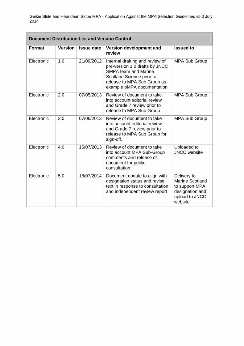
Document Distribution List and Version Control
Format Version Issue date Version development and review
Issued to
Electronic 1.0 21/09/2012 Internal drafting and review of pre-version 1.0 drafts by JNCC SMPA team and Marine Scotland Science prior to release to MPA Sub Group as example pMPA documentation
MPA Sub Group
Electronic 2.0 07/05/2013 Review of document to take into account editorial review and Grade 7 review prior to release to MPA Sub Group
MPA Sub Group
Electronic 3.0 07/06/2013 Review of document to take into account editorial review and Grade 7 review prior to release to MPA Sub Group for sign-off.
MPA Sub Group
Electronic 4.0 15/07/2013 Review of document to take into account MPA Sub-Group comments and release of document for public consultation.
Uploaded to JNCC website
Electronic 5.0 18/07/2014 Document update to align with designation status and revise text in response to consultation and independent review report
Delivery to Marine Scotland to support MPA designation and upload to JNCC website

Geikie Slide and Hebridean Slope MPA - Application Against the MPA Selection Guidelines v5.0 July 2014
Background
This document provides details of JNCC’s assessment of the Geikie Slide and Hebridean Slope Nature Conservation MPA (herein referred to as ‘MPA’) against the Scottish MPA Selection Guidelines. It presents an assessment for each of the protected features. We have used the terminology set out in the Selection Guidelines to describe the five main stages in the assessment process from the identification of MPA search locations through to an MPA.
The main terms used are described below.
MPA search feature - specified marine habitats, species and large-scale features which underpin the selection of Nature Conservation MPAs.
Geodiversity features - specified geodiversity interests of the Scottish seabed categorised under themed ‘blocks’ that are analogous to the MPA search features for biodiversity.
Protected feature - any feature (habitats, species, large-scale features and/or geodiversity features) which are specified in the MPA Designation Order.
MPA search location - this describes a location identified at stage 1 [of the Selection Guidelines] until it passes the assessment against stage 4.
Potential area for an MPA - if an MPA search location passes assessment against stage 4 it goes on to be considered at stage 5 as a potential area for an MPA.
Nature Conservation MPA – a location that has been approved by Ministers for designation.
Details of evidence supporting the designation of the Geikie Slide and Hebridean Slope MPA are provided in the Data Confidence Assessment document.
Geikie Slide and Hebridean Slope MPA - Application Against the MPA Selection Guidelines v5.0 July 2014
1
GEIKIE SLIDE AND HEBRIDEAN SLOPE MPA - APPLICATION OF THE MPA SELECTION GUIDELINES
Stage 1 - Identifying search locations that would address any significant gaps in the conservation of MPA search features
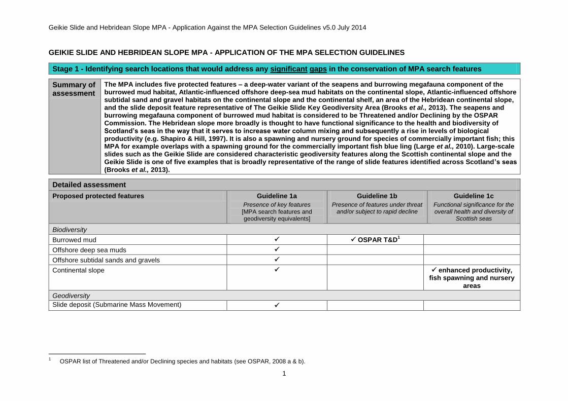
Summary of assessment
The MPA includes five protected features – a deep-water variant of the seapens and burrowing megafauna component of the burrowed mud habitat, Atlantic-influenced offshore deep-sea mud habitats on the continental slope, Atlantic-influenced offshore subtidal sand and gravel habitats on the continental slope and the continental shelf, an area of the Hebridean continental slope, and the slide deposit feature representative of The Geikie Slide Key Geodiversity Area (Brooks et al., 2013). The seapens and burrowing megafauna component of burrowed mud habitat is considered to be Threatened and/or Declining by the OSPAR Commission. The Hebridean slope more broadly is thought to have functional significance to the health and biodiversity of Scotland’s seas in the way that it serves to increase water column mixing and subsequently a rise in levels of biological productivity (e.g. Shapiro & Hill, 1997). It is also a spawning and nursery ground for species of commercially important fish; this MPA for example overlaps with a spawning ground for the commercially important fish blue ling (Large et al., 2010). Large-scale slides such as the Geikie Slide are considered characteristic geodiversity features along the Scottish continental slope and the Geikie Slide is one of five examples that is broadly representative of the range of slide features identified across Scotland’s seas (Brooks et al., 2013).
Detailed assessment
Proposed protected features Guideline 1a
Presence of key features [MPA search features and geodiversity equivalents]
Guideline 1b
Presence of features under threat and/or subject to rapid decline
Guideline 1c
Functional significance for the overall health and diversity of
Scottish seas
Biodiversity
Burrowed mud OSPAR T&D1
Offshore deep sea muds
Offshore subtidal sands and gravels
Continental slope enhanced productivity, fish spawning and nursery
areas
Geodiversity
Slide deposit (Submarine Mass Movement) v
1 OSPAR list of Threatened and/or Declining species and habitats (see OSPAR, 2008 a & b).
Geikie Slide and Hebridean Slope MPA - Application Against the MPA Selection Guidelines v5.0 July 2014
2
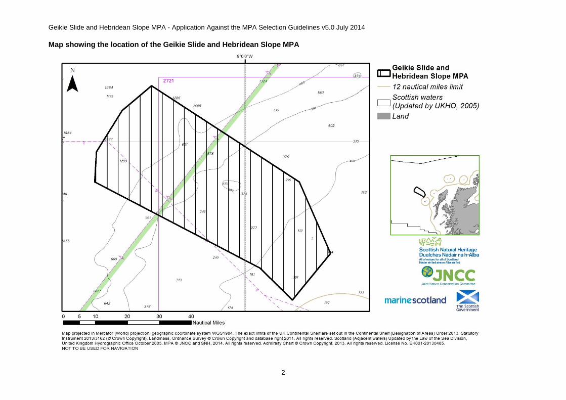
Map showing the location of the Geikie Slide and Hebridean Slope MPA
Geikie Slide and Hebridean Slope MPA - Application Against the MPA Selection Guidelines v5.0 July 2014
3
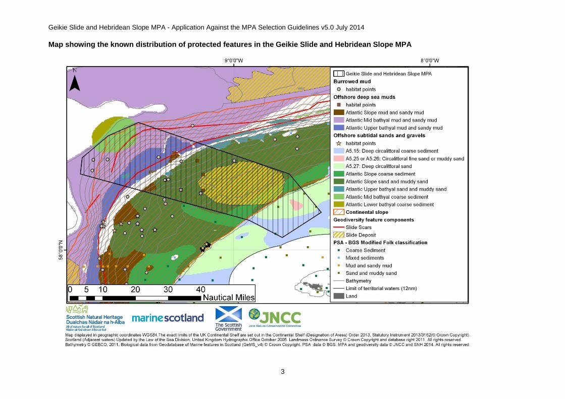
Map showing the known distribution of protected features in the Geikie Slide and Hebridean Slope MPA

Geikie Slide and Hebridean Slope MPA - Application Against the MPA Selection Guidelines v5.0 July 2014
4
Map of Geikie Slide and Hebridean Slope MPA showing the distribution of biological community depth-zones as defined by Hughes et al. (2014)

Geikie Slide and Hebridean Slope MPA - Application Against the MPA Selection Guidelines v5.0 July 2014
5
Stage 2 - Prioritisation of search locations according to the qualities of the MPA search features they contain
Summary of assessment
The MPA contains combinations of protected features, and there is evidence to support functional linkages between the Hebridean Slope and the habitats and species present in the MPA. For instance, there are depth-related trends in habitat type and megafaunal distribution (Hughes et al., 2014). Areas of reduced hydrographic influence with depth are characterised by finer-grained sediments, and vice versa. As well as functional linkages between the protected features of the MPA, there is evidence to support the role of the Hebridean Slope more generally supporting the health and biodiversity of Scotland’s seas. Topographic relief and water-current patterns enhance productivity (e.g. Shapiro & Hill, 1997). Commercially important fish species are known to spawn along the slope with evidence that this spawn occurs within the MPA (e.g. blue ling – Large et al., 2010).
There is limited information available to undertake a detailed assessment of the stage 2b guideline for burrowed mud, offshore deep-sea muds and offshore subtidal sands and gravels because of a lack of information on characterising species; but all three seabed habitats are likely to be coherent within the MPA based on the proposed biological zones along the Hebridean slope as defined by Hughes et al. (2014). There is limited or no information on the condition of the protected features but information on their sensitivity to pressures associated with activities to which they are exposed suggest the biodiversity protected features may have been modified by human activity.
Within the wider MPA Region2, JNCC consider there is a medium risk of damage by human activity to burrowed mud habitat. This
judgement is based on the sensitivity of burrowed mud to pressures associated with activities to which the habitat is exposed. For offshore subtidal sand and gravel habitats and offshore deep-sea mud habitats the risk of damage by human activity varies, reflecting the range in sensitivity of different sub-types of these habitats to pressures associated with activities to which they are exposed. Slide deposits are considered to be at low risk of damage across Scotland’s seas.
Three of the five parts of the stage 2 guidelines (2a, 2c & 2e) are met. There is a limited evidence to support making a conclusive assessment against the stage 2b guideline for all protected features. The stage 2d guideline has not been met for the biodiversity protected features.
Detailed assessment
Guideline 2a The search location contains combinations of features, rather than single isolated features, especially if those features are functionally linked
There are combinations of protected features present within the MPA, with evidence of functional linkage between the Hebridean slope and the habitats and species present. There are depth-related trends in habitat type and megafaunal distribution down the Hebridean slope. Areas of reduced hydrographic influence with depth are characterised by finer-grained sediments and biological features associated with the sediment type. Zones of biological variance coincide with the bathymetric extent of the slope-current flowing northwards along the Scottish continental margin, known as the ‘mud-line’. Transport of organic particles in the northwards-flowing slope current may play an important role in sustaining the high benthic biomass seen in this ‘mud-line’ (Hughes et al., 2014). Further to functional linkages between the protected features of the MPA, there is evidence to support the role of the Hebridean slope more generally supporting the health and biodiversity of Scotland’s seas. Topographic relief and current patterns enhance productivity (e.g. Shapiro & Hill, 1997). Commercially important fish species are known to spawn along the slope, with evidence for blue ling present in the MPA (Large et al., 2010).
2 Far West MPA Region as described in the Scottish MPA Selection Guidelines

Geikie Slide and Hebridean Slope MPA - Application Against the MPA Selection Guidelines v5.0 July 2014
6
Guideline 2b The search location contains example(s) of features with a high natural biological diversity (for habitats only)
Burrowed mud Marine Scotland Science by-catch records from 2008 and 2009 identify that the species present in the MPA are indicative of deep-water burrowed mud. These data provide recent confirmation of the presence of deep-water seapens (Umbellula sp. and Kophobelemnon sp.) at every sampling location (consisting of seven records distributed across four clusters of data points). Further confirmation of the burrowed mud feature presence in this MPA comes from the analysis of underwater video footage from three MSS stock assessment survey stations (2004 and 2009) (Allen et al., 2014a & b). The majority of these records intersect with the Decapod burrowing zone and the Ophiocten gracialis zone defined by Hughes et al. (2014), which are largely characterised by fine sand, muddy sand or sandy mud substrates. However, a small number of other records intersect the biological zone identified by Hughes et al (2014) as the upper slope, which is more frequently characterised by coarser sediments. In addition the predictive seabed habitat mapping project EU SeaMap
3 suggest the majority of records are located in the area of offshore deep-sea muds
(mud and sandy mud), but others are located in an area of offshore subtidal sands and gravels (sand and muddy sand). Overall, JNCC consider that there is evidence to support the presence of deep-water burrowed mud within the MPA, but a lack of data on associated species diversity means we are not able to undertake a detailed assessment of the stage 2b guideline.
Offshore deep-sea muds
On the slope in OSPAR Region V, EUSeaMap predicts one type of offshore deep-sea mud to occur (Atlantic slope mud and sandy mud) and the MPA encompasses an example of this feature. Its presence is confirmed from the analysis of underwater video footage from five MSS Nephrops stock assessment survey stations that were assigned to the habitat offshore deep-sea mud (Allen et al., 2014a & b). A further Marine Scotland Science video-tow station from 2009 also confirms the presence of offshore deep-sea mud habitats (defined in this instance as Atlantic upper slope mud) within the MPA (Axelsson et al., 2014). The extent of this feature is uncertain as the survey records do not coincide with the extent of the feature predicted by EU SeaMap. Although we are certain that this feature is present within the MPA there is limited information available with which to undertake a detailed assessment of the stage 2b guideline because of a lack of information on the species present.
Offshore subtidal sands and gravels
Within a given depth range, the underlying substrate characteristics are likely to be a strong determinant of the types of species present (Eleftheriou & Basford, 1989). Therefore, biodiversity might be expected to be highest within a given area that contains a range of different physical types of sand and gravel habitats. With this in mind, the MPA boundary was developed to include as wide a range as possible of the offshore subtidal sand and gravel habitats thought to occur in the area.
On the continental slope in OSPAR Region V, EU SeaMap predicts three different types of offshore subtidal sand and gravel habitats occur: Atlantic slope coarse sediment; Atlantic slope mixed sediment, and Atlantic slope sand and muddy sand. The MPA includes examples of two of these types of habitats, representing coarse to muddy sediments.
On the continental shelf in OSPAR Region III, EU SeaMap predicts eight types of EUNIS Level 4 offshore subtidal sand and gravel habitats are likely to be present. The MPA represents examples of three of these types of EUNIS Level 4 offshore subtidal sand and gravel habitats to be present representing coarse to fine sediments:
A5.15 deep circalittoral coarse sediment
3 This project modelled a combination of physical data describing the marine environment with information from biological sampling to refine ecologically-relevant thresholds to
produce a broad-scale predictive map of seabed habitats across Europe. Further information is available online at http://jncc.defra.gov.uk/EUSeaMap

Geikie Slide and Hebridean Slope MPA - Application Against the MPA Selection Guidelines v5.0 July 2014
7
Guideline 2b The search location contains example(s) of features with a high natural biological diversity (for habitats only)
A5.25 circalittoral fine sand or A5.26 circalittoral muddy sand
A5.27 deep circalittoral sand
The presence of offshore subtidal sand and gravel habitats on the continental slope and shelf is confirmed by British Geological Survey Particle Size Analysis (PSA) sample points. A Marine Scotland Science deep-water video tow also verifies the presence of gravelly sand on the slope, but no information on the biological communities present is available (Allen et al., 2014a & b). The work undertaken by Hughes et al. (2014) to define biological zones on the Hebridean slope suggests there are examples of areas present that are characterised by coarser sediments – notably the outer shelf and shelf break and the upper slope biological zones. Overall, we consider there is limited information available with which to undertake a detailed assessment of the stage 2b guideline because of a lack of information on the range and diversity of species present within the predicted habitats.
Geikie Slide and Hebridean Slope MPA - Application Against the MPA Selection Guidelines v5.0 July 2014
8
Guideline 2c The search location contains coherent examples of features, rather than smaller, potentially more fragmented ones
Burrowed mud The EU SeaMap habitat modelling project predicts offshore deep-sea muds and offshore subtidal sands and gravels to be present on the continental slope, extending into the bathyal region of the Rockall Trough within the MPA, with the offshore subtidal sands and gravels extending onto the continental shelf break.
Hughes et al. (2014) characterised the biological diversity on the Hebridean slope based on archive stills data from 1988-1998. The findings indicate five distinct biological zones with associated communities that change with depth on the slope:
Outer shelf and shelf break zone (135-227m) – characterised by coarse sediments ranging from strongly rippled sand and gravel plains to dense fields of cobbles and small boulders. Visible fauna is sparse in this zone and predominantly comprises echinoderms such as the pencil urchin Cidaris cidaris and sea stars.
Upper slope zone (279-470m) – generally characterised by coarser sediments with sand and gravel patches and predominantly includes echinoderms as visible fauna.
Ophiocten gracialis zone (600-1020m) – a biological zone dominated by large numbers of the small brittlestar Ophiocten gracialis on fine sandy, muddy sand or sandy mud, with some areas of gravel or cobbles.
Xenophyophore zone (1088-1180m) – a biological zone characterised by the Xenophyophore Syringammina fragilissima in rippled muddy sand or sandy mud.
Decapod burrowing zone (1293-1595m) – a biological zone characterised by the burrows of large decapods such as Munida tenuimania in fine muds.
The MPA includes examples of all five biological zones that characterise the Hebridean slope including the outer shelf and shelf break zone that predominantly occur on the continental shelf itself. As such, we consider that the three seabed habitats on the continental slope included as protected features of the MPA are coherent examples of these habitats, forming only part of a much greater extent of the biological communities that extend both northward and southward of the MPA boundary.
Offshore deep-sea muds
Offshore subtidal sands and gravels
Continental slope In general, the Hebridean slope is regarded as a productive environment with nutrient-rich, cooler waters being drawn up the slope as a consequence of topographic relief. These buoyancy-driven cold-water cascades (Shapiro & Hill, 1997) serve to increase levels of primary biological productivity. The Hebridean slope may provide enhanced feeding conditions for a number of species occurring in the area including cetaceans and deep-water sharks, although there is no direct evidence available to support this assertion within the MPA. Large et al. (2010) report that blue ling are known to aggregate for spawning on the Hebridean slope and at peak depths of
between 730m and 1100m within the MPA.
Geikie Slide and Hebridean Slope MPA - Application Against the MPA Selection Guidelines v5.0 July 2014
9
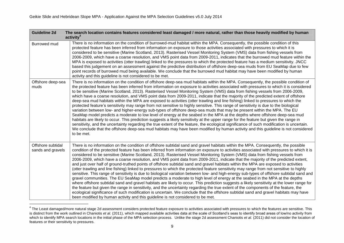
Guideline 2d The search location contains features considered least damaged / more natural, rather than those heavily modified by human activity
4
Burrowed mud
There is no information on the condition of burrowed-mud habitat within the MPA. Consequently, the possible condition of this protected feature has been inferred from information on exposure to those activities associated with pressures to which it is considered to be sensitive (Marine Scotland, 2013). Rasterised Vessel Monitoring System (VMS) data from fishing vessels from 2006-2009, which have a coarse resolution, and VMS point data from 2009-2011, indicates that the burrowed mud feature within the MPA is exposed to activities (otter trawling) linked to the pressures to which the protected feature has a medium sensitivity. JNCC based this judgement on an assessment against the predictive distribution of offshore deep-sea muds from EU SeaMap due to few point records of burrowed mud being available. We conclude that the burrowed mud habitat may have been modified by human activity and this guideline is not considered to be met.
Offshore deep-sea muds
There is no information on the condition of offshore deep-sea mud habitats within the MPA. Consequently, the possible condition of the protected feature has been inferred from information on exposure to activities associated with pressures to which it is considered to be sensitive (Marine Scotland, 2013). Rasterised Vessel Monitoring System (VMS) data from fishing vessels from 2006-2009, which have a coarse resolution, and VMS point data from 2009-2011, indicate that the majority of the predicted extent of offshore deep-sea mud habitats within the MPA are exposed to activities (otter trawling and line fishing) linked to pressures to which the protected feature’s sensitivity may range from not sensitive to highly sensitive. This range of sensitivity is due to the biological variation between low- and higher-energy sub-types of offshore deep-sea muds that may be present within the MPA. The EU SeaMap model predicts a moderate to low level of energy at the seabed in the MPA at the depths where offshore deep-sea mud habitats are likely to occur. This prediction suggests a likely sensitivity at the upper range for the feature but given the range in sensitivity, and the uncertainty regarding the true extent of the feature, the ecological significance of such modification is uncertain. We conclude that the offshore deep-sea mud habitats may have been modified by human activity and this guideline is not considered to be met.
Offshore subtidal sands and gravels
There is no information on the condition of offshore subtidal sand and gravel habitats within the MPA. Consequently, the possible condition of the protected feature has been inferred from information on exposure to activities associated with pressures to which it is considered to be sensitive (Marine Scotland, 2013). Rasterised Vessel Monitoring System (VMS) data from fishing vessels from 2006-2009, which have a coarse resolution, and VMS point data from 2009-2011, indicate that the majority of the predicted extent, and just over half of ground-truthed points of offshore subtidal sand and gravel habitats within the MPA are exposed to activities (otter trawling and line fishing) linked to pressures to which the protected feature sensitivity may range from not sensitive to highly sensitive. This range of sensitivity is due to biological variation between low- and high-energy sub-types of offshore subtidal sand and gravel communities. The EU SeaMap model predicts a moderate to high level of energy at the seabed in the MPA at the depths where offshore subtidal sand and gravel habitats are likely to occur. This prediction suggests a likely sensitivity at the lower range for the feature but given the range in sensitivity, and the uncertainty regarding the true extent of the components of the feature, the ecological significance of such modification is uncertain. We conclude that the offshore subtidal sand and gravel habitats may have been modified by human activity and this guideline is not considered to be met.
4 The Least damaged/more natural stage 2d assessment considers protected feature exposure to activities associated with pressures to which the features are sensitive. This
is distinct from the work outlined in Chaniotis et al. (2011), which mapped available activities data at the scale of Scotland’s seas to identify broad areas of low/no activity from which to identify MPA search locations in the initial phase of the MPA selection process. Unlike the stage 2d assessment Chaniotis et al. (2011) did not consider the location of features or their sensitivity to pressures.
Geikie Slide and Hebridean Slope MPA - Application Against the MPA Selection Guidelines v5.0 July 2014
10
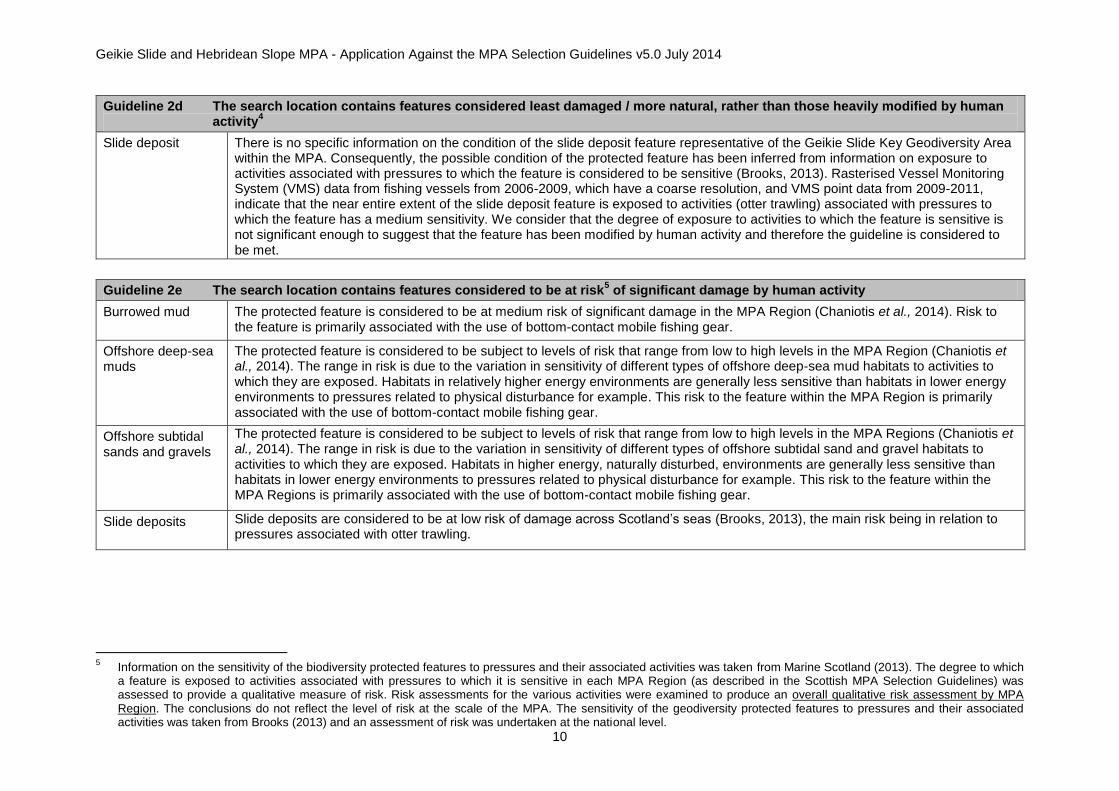
Guideline 2d The search location contains features considered least damaged / more natural, rather than those heavily modified by human activity
4
Slide deposit There is no specific information on the condition of the slide deposit feature representative of the Geikie Slide Key Geodiversity Area within the MPA. Consequently, the possible condition of the protected feature has been inferred from information on exposure to activities associated with pressures to which the feature is considered to be sensitive (Brooks, 2013). Rasterised Vessel Monitoring System (VMS) data from fishing vessels from 2006-2009, which have a coarse resolution, and VMS point data from 2009-2011, indicate that the near entire extent of the slide deposit feature is exposed to activities (otter trawling) associated with pressures to which the feature has a medium sensitivity. We consider that the degree of exposure to activities to which the feature is sensitive is not significant enough to suggest that the feature has been modified by human activity and therefore the guideline is considered to be met.
Guideline 2e The search location contains features considered to be at risk5 of significant damage by human activity
Burrowed mud The protected feature is considered to be at medium risk of significant damage in the MPA Region (Chaniotis et al., 2014). Risk to the feature is primarily associated with the use of bottom-contact mobile fishing gear.
Offshore deep-sea muds
The protected feature is considered to be subject to levels of risk that range from low to high levels in the MPA Region (Chaniotis et al., 2014). The range in risk is due to the variation in sensitivity of different types of offshore deep-sea mud habitats to activities to which they are exposed. Habitats in relatively higher energy environments are generally less sensitive than habitats in lower energy environments to pressures related to physical disturbance for example. This risk to the feature within the MPA Region is primarily associated with the use of bottom-contact mobile fishing gear.
Offshore subtidal sands and gravels
The protected feature is considered to be subject to levels of risk that range from low to high levels in the MPA Regions (Chaniotis et al., 2014). The range in risk is due to the variation in sensitivity of different types of offshore subtidal sand and gravel habitats to activities to which they are exposed. Habitats in higher energy, naturally disturbed, environments are generally less sensitive than habitats in lower energy environments to pressures related to physical disturbance for example. This risk to the feature within the MPA Regions is primarily associated with the use of bottom-contact mobile fishing gear.
Slide deposits Slide deposits are considered to be at low risk of damage across Scotland’s seas (Brooks, 2013), the main risk being in relation to pressures associated with otter trawling.
5 Information on the sensitivity of the biodiversity protected features to pressures and their associated activities was taken from Marine Scotland (2013). The degree to which
a feature is exposed to activities associated with pressures to which it is sensitive in each MPA Region (as described in the Scottish MPA Selection Guidelines) was assessed to provide a qualitative measure of risk. Risk assessments for the various activities were examined to produce an overall qualitative risk assessment by MPA Region. The conclusions do not reflect the level of risk at the scale of the MPA. The sensitivity of the geodiversity protected features to pressures and their associated activities was taken from Brooks (2013) and an assessment of risk was undertaken at the national level.

Geikie Slide and Hebridean Slope MPA - Application Against the MPA Selection Guidelines v5.0 July 2014
11
Stage 3 - Assessment of the appropriate scale of the search location in relation to the search features it contains
Summary of assessment
The MPA boundary captures the full range of sedimentary communities as they change with depth down the continental slope in OSPAR Region V, as well as the shelf break communities present in OSPAR Region III. It also encompasses the slide deposit geodiversity feature representative of the Geikie Slide Key Geodiversity Area (Brooks et al., 2013).
Detailed assessment
The size of the search location should be adapted where necessary to ensure it is suitable for maintaining the integrity of the features for which the MPA is being considered. Account should also be taken where relevant of the need for effective management of relevant activities
Burrowed mud The MPA boundary encompasses all records of burrows in the area based on data from Marine Scotland Science deep-water towed video surveys, and sample locations of seapens recorded as by-catch from Marine Scotland Science trawl surveys.
Offshore deep-sea muds
Offshore subtidal sands and gravels
The MPA boundary comprises a corridor down the slope that captures examples of the different biological zones that characterise the Hebridean slope as defined by Hughes et al. (2014). For offshore subtidal sand and gravel habitats, the MPA boundary was further extended onto the shelf in OSPAR Region III to capture viable areas of this habitat based on maps from the habitat modelling data from EU SeaMap and survey data. This extension was deemed necessary to meet the adequacy recommendations for the feature in that part of the Scottish network in OSPAR Region III.
Geodiversity features
The MPA boundary encompasses the full extent of the slide deposit feature representative of the Geikie Slide Key Geodiversity Area (Brooks et al., 2013).
Geikie Slide and Hebridean Slope MPA - Application Against the MPA Selection Guidelines v5.0 July 2014
12
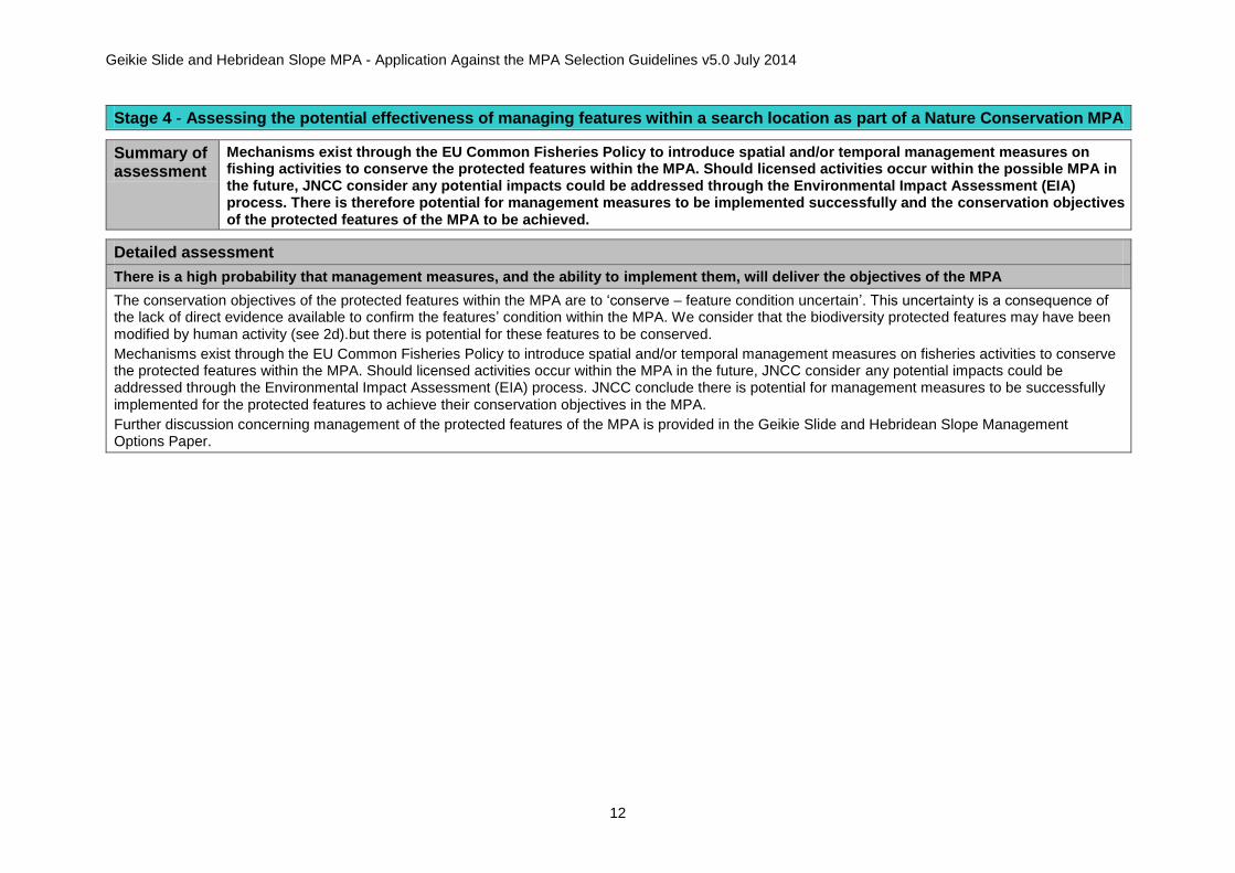
Stage 4 - Assessing the potential effectiveness of managing features within a search location as part of a Nature Conservation MPA
Summary of assessment
Mechanisms exist through the EU Common Fisheries Policy to introduce spatial and/or temporal management measures on fishing activities to conserve the protected features within the MPA. Should licensed activities occur within the possible MPA in the future, JNCC consider any potential impacts could be addressed through the Environmental Impact Assessment (EIA) process. There is therefore potential for management measures to be implemented successfully and the conservation objectives of the protected features of the MPA to be achieved.
Detailed assessment
There is a high probability that management measures, and the ability to implement them, will deliver the objectives of the MPA
The conservation objectives of the protected features within the MPA are to ‘conserve – feature condition uncertain’. This uncertainty is a consequence of the lack of direct evidence available to confirm the features’ condition within the MPA. We consider that the biodiversity protected features may have been modified by human activity (see 2d).but there is potential for these features to be conserved.
Mechanisms exist through the EU Common Fisheries Policy to introduce spatial and/or temporal management measures on fisheries activities to conserve the protected features within the MPA. Should licensed activities occur within the MPA in the future, JNCC consider any potential impacts could be addressed through the Environmental Impact Assessment (EIA) process. JNCC conclude there is potential for management measures to be successfully implemented for the protected features to achieve their conservation objectives in the MPA.
Further discussion concerning management of the protected features of the MPA is provided in the Geikie Slide and Hebridean Slope Management Options Paper.

Geikie Slide and Hebridean Slope MPA - Application Against the MPA Selection Guidelines v5.0 July 2014
13
Stage 5 - Assessment of the contribution of the potential area to the MPA network
Summary of assessment
The MPA makes a contribution to the MPA network by representing deep-water burrowed-mud in OSPAR Region V, and a range of different types of offshore subtidal sand and gravel and offshore deep-sea mud habitats at the northern extent of the Hebridean slope. It also includes an area of the Hebridean Continental Slope, which evidence suggests may be of functional significance. The Geikie Slide and Hebridean Slope MPA also includes features representative of the Geikie Slide Key Geodiversity Area. Large-scale slides such as the Geikie Slide are considered characteristic geodiversity features along the Scottish continental slope and the Geikie Slide is one of five examples that are broadly representative of the range of slide features identified across Scotland’s seas (Brooks et al., 2013).
Detailed assessment
The potential area contributes significantly to the coherence of the MPA network in the seas around Scotland
Assessment of biodiversity features
Feature Summary
Burrowed mud The MPA provides representation for burrowed mud in OSPAR Region V at the north-eastern extent of its geographical range. As an OSPAR Threatened and/or Declining habitat, it is considered important to have greater replication for the feature on the grounds of increased resilience. Further information is provided in the burrowed mud habitat adequacy assessment (SNH and JNCC, 2014).
Offshore deep-sea muds
The MPA provides representation for Atlantic-influenced offshore deep-sea mud habitats on the continental slope in OSPAR Region V. It represents one of two examples of slope Atlantic-influenced offshore deep-sea mud habitats recommended for protection in OSPAR Region V. Further information is provided in the offshore deep-sea muds habitat adequacy assessment (SNH and JNCC, 2014).
Offshore subtidal sands and gravels
The MPA provides representation for Atlantic-influenced offshore subtidal sand and gravel habitats predominantly on the continental slope in OSPAR Region V, but also to a small extent on the shelf in OSPAR Region III. It represents one of two examples of both shelf and slope Atlantic-influenced offshore subtidal sand and gravel habitats recommended for protection in OSPAR Regions III and V respectively. Further information is provided in the offshore subtidal sand and gravel habitats adequacy assessment (SNH and JNCC, 2014).
Continental slope
The MPA provides representation for one of two recommended areas of the Hebridean continental slope to be included within the MPA network. The Hebridean Slope is considered ecologically and hydrographically distinct to the Faroe-Shetland Channel slope and so the recommendation is for at least two examples of each area of the slope to be included. Further information is provided in the continental slope adequacy assessment (SNH and JNCC, 2014).

Geikie Slide and Hebridean Slope MPA - Application Against the MPA Selection Guidelines v5.0 July 2014
14
Assessment of geodiversity features
Geodiversity
features6
The MPA includes features representative of the Geikie Slide Key Geodiversity Area. Large-scale slides are a characteristic feature along the Scottish continental slope and a number of mass-failure events have now been recognised. However, these slides vary in terms of both age and morphology: most of the older (pre-Holocene) slide deposits have been partially or completely buried within the sedimentary column whilst other (predominantly Holocene age) slides have retained clear seabed expression. Geikie slide is one of five examples of large-scale slide events that have been identified. Geikie slide is suggested to be broadly representative of the range of slides found in offshore Scottish waters (Brooks et al., 2013).
6 For geodiversity the stage 5 assessment primarily considers the contribution of the MPAs to the principal ‘networks’ of marine geodiversity interests present in Scottish
waters (representation). The MPA Selection Guidelines propose that there should be minimal duplication of geodiversity features at a national level.

Geikie Slide and Hebridean Slope MPA - Application Against the MPA Selection Guidelines v5.0 July 2014
15
Data sources and bibliography
Allen, C., Dewey, S. and Axelsson, M. (2014a). Biotope analysis of Marine Scotland Science underwater footage from the Hebridean Slope. A report by Seastar Survey Ltd. for the Joint Nature Conservation Committee. JNCC Report 511.
Allen, C., Dewey, S., and Axelsson, M., (2014b). Biotope analysis of Marine Scotland Science underwater footage from the Hebridean Slope. A report by Seastar Survey Ltd. For the Joint Nature Conservation Committee. JNCC Report 511 Addendum.
Axelsson, M., Dewey, S. and Allen, C. (2014). Analysis of seabed imagery from the 2011 survey of the Firth of Forth banks complex, the 2011 IBTS Q4 survey and additional deep-water sites from Marine Scotland Science surveys. A report by Seastar Survey Ltd. for the Joint Nature Conservation Committee, JNCC Report 471.
Brooks, A.J., Kenyon, N.H., Leslie, A., Long., D. and Gordon, J.E. (2013). Characterising Scotland’s marine environment to define search locations for new Marine Protected Areas. Part 2: The identification of Key Geodiversity Areas in Scottish waters. Scottish Natural Heritage Commissioned Report No. 432.
Brooks, A.J., (2013). Assessing the sensitivity of geodiversity features in Scotland’s seas to pressures associated with human activities. Scottish Natural Heritage Commissioned Report No. 590.
Chaniotis, P.D., Crawford-Avis, O.T., Cunningham, S., Gillham, K., Tobin, D., Linwood, M. (2011). Identifying locations considered to be least damaged/more natural in Scotland’s seas. Report produced by the Joint Nature Conservation Committee, Scottish Natural Heritage and Marine Scotland for the Scottish Marine Protected Areas Project.
Chaniotis, P.D., Cunningham, S., Gillham, K., Epstein, G. (2014). Assessing risk to Scottish MPA search features at the MPA regional scale. Final report produced by the Joint Nature Conservation Committee, Scottish Natural Heritage and Marine Scotland for the Scottish Marine Protected Areas Project.
Eleftheriou, A. and Basford, D.J. (1989). The macrobenthic infauna of the offshore northern North Sea. Journal of the Marine Biological Association of the U.K. 69: 123-43.
Hughes, D.J., Nickell, T. and Gontarek, S. (2014). Biotope analysis of archived stills from the SEA7 region of Scotland’s seas (2011). JNCC Report 502.
Marine Scotland (2013). Features, Activities, Sensitivities Tool (FEAST) online resource. Available online from: www.marine.scotland.gov.uk/FEAST/. Version 1.0 (August 2013).
OSPAR Commission. (2008a). List of Threatened and/or Declining Species and Habitats. Reference Number: 2008-6. <http://www.ospar.org/documents/DBASE/DECRECS/Agreements/08-06e_OSPAR%20List%20species%20and%20habitats.doc>
OSPAR Commission. (2008b). Case Reports for the OSPAR List of Threatened and/or Declining Species and Habitats. OSPAR Commission. Biodiversity Series. <http://qsr2010.ospar.org/media/assessments/p00358_case_reports_species_and_habitats_2008.pdf>
Shapiro, G.I. and Hill, A.E. (1997). Dynamics of dense water cascades at the shelf edge. Journal of Physical Oceanography, 27: 2381–94.
SNH & JNCC (2014). Assessment of the adequacy of the Scottish MPA network for MPA search features: summary of the application of the stage 5 selection guidelines. Final report produced by Scottish Natural Heritage, the Joint Nature Conservation Committee and Marine Scotland for the Scottish Marine Protected Areas Project.