

GDI-Grid Spatial Data Infrastructure Grid Christian Kiehle Andreas Krüger Christopher Kunz OGF22...
64
GDI-Grid Spatial Data Infrastructure Grid Christian Kiehle Andreas Krüger Christopher Kunz OGF22 Feb 26, 2008
-
Upload
blaise-bridges -
Category
Documents
-
view
222 -
download
1
Transcript of GDI-Grid Spatial Data Infrastructure Grid Christian Kiehle Andreas Krüger Christopher Kunz OGF22...

GDI-GridSpatial Data Infrastructure Grid
Christian KiehleAndreas KrügerChristopher Kunz
OGF22Feb 26, 2008

GDI-Grid - Spatial Data Infrastructure Grid
Agenda
1. Introduction to the German Grid initiative
2. Introduction to the GDI-Grid – Spatial Data Infrastructure Grid (GDI-Grid) Project
3. Grid-enabling Open Source OGC Webservices
4. Gridification of OGC Webservice Chains
5. Security and Scheduling Challenges
6. Discussion
Christopher Kunz | February 26th, 2008 | Slide 2
GDI-Grid - Spatial Data Infrastructure Grid
Motivation of this session
Project just started
One of the first new community projects in D-Grid
Unsolved challenges ahead
Presenting work in progress
Looking for ideas
Your input is highly appreciated!
Christopher Kunz | February 26th, 2008 | Slide 3

GDI-Grid - Spatial Data Infrastructure Grid
The D-Grid
The German Grid initiative
Long-term strategic initiative started in 2005
D-Grid Call 1 (2005 – 2008) Infrastructure development and testing Use by first scientific organizations
D-Grid Call 2 (2007 – 2010) inclusion of several new scientific disciplines
Funding by German Federal Ministry of Education and Research
Christopher Kunz | February 26th, 2008 | Slide 2

GDI-Grid - Spatial Data Infrastructure Grid
D-Grid – timeline
Christopher Kunz | February 26th, 2008 | Slide 5
2003: first working groups
09/2005: D-Grid 1 – early adopters > 100 organizations > 200 researchers
07/2007: D-Grid 2 – new communities > 200 organizations > 400 researchers
2008: D-Grid 3 Goal: sustainable production grid No more funding – feasible business model Integration of new communities

GDI-Grid - Spatial Data Infrastructure Grid
D-Grid integration structure
Christopher Kunz | February 26th, 2008 | Slide 6
Te
xt-G
rid
Me
di-
Gri
d
D-Grid Integration Project
As
tro
-Gri
d
C3
-Gri
d
HE
P-G
rid
GD
I-G
rid
WIS
EN
T
. . . Communities . . .
Access Layer, Portals
Generic Grid Middleware and Grid Services

GDI-Grid - Spatial Data Infrastructure Grid
D-Grid Integration Project
Goal: Establish standardized Grid Infrastructure in Germany
Requirement: support for three Grid middlewares Globus Toolkit gLite UNICORE
Reference installation for all three middlewares Comprehensive documentation Specified product and middleware versions Unified environment that‘s proven to work
Christopher Kunz | February 26th, 2008 | Slide 7
GDI-Grid - Spatial Data Infrastructure Grid
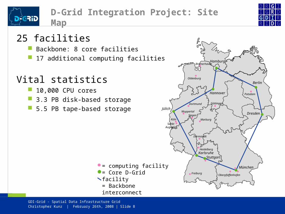
D-Grid Integration Project: Site Map
25 facilities Backbone: 8 core facilities 17 additional computing facilities
Vital statistics 10,000 CPU cores 3.3 PB disk-based storage 5.5 PB tape-based storage
Christopher Kunz | February 26th, 2008 | Slide 8
Hannover
Bremerhaven
Oldenburg
Göttingen
Potsdam
OberpfaffenhofenFreiburg
Heidelberg
Darmstadt
Marburg
Dortmund
Wuppertal
Köln
Siegen
SanktAugustin
München
Hamburg
Berlin
Dresden
StuttgartKarlsruhe
Jülich
= computing facility= Core D-Grid facility= Backbone interconnect

GDI-Grid - Spatial Data Infrastructure Grid
GDI-Grid
„Geodaten-Infrastruktur-Grid“ - „Spatial Data Infrastructure Grid“
Project funded by German Federal Ministry of Education and Research
funded from 2007/07 until 2010/06
Strong focus on sustainable development Public-private partnership 12 principal partners
8 scientific institutions 4 industry partners
Biggest community project within D-Grid 2 3M € budget, 15 funded researchers
Christopher Kunz | February 26th, 2008 | Slide 9
GDI-Grid - Spatial Data Infrastructure Grid
GDI-Grid – Project Goals
Optimization of SDI and GIS applications to… Satisfy rapidly increasing demand for computing power Improve accessibility of decentralized storage and compute resources Integrate basis technologies of both application fields …especially GT4 and OGC
Enable grid resources to seamlessly process geospatial data
Development of generic services for… Integration Fusion Management Processing
…of geospatial data on the D-Grid infrastructure
Christopher Kunz | February 26th, 2008 | Slide 10

GDI-Grid - Spatial Data Infrastructure Grid
Christopher Kunz | February 26th, 2008 | Slide 9
GDI-Grid – Project Partners
GDI-Grid - Spatial Data Infrastructure Grid
GDI-Grid – Scenarios and Proof of Concept
Proof of Concept with three distinct scenarios Highly relevant for practical use Large range of GIS applications covered High need for processing power Need for high responsivity Conventional GIS applications already available
Scenarios mandated by EU directives
Christopher Kunz | February 26th, 2008 | Slide 12

GDI-Grid - Spatial Data Infrastructure Grid
GDI-Grid - Scenarios
Flood simulation Based on sensor data / empirical evidence Flood prediction Creation of flood maps
Noise propagation Simulation of noise propagation in cities Large-scale simulation in regular intervals Highly detailed simulation setting Relevant for city planning
Emergency routing Routing for disaster emergency services Alternative routes (road blocks, traffic jam) High responsivity and adaptivity Utilization of sensor data in routing process
Christopher Kunz | February 26th, 2008 | Slide 13

GDI-Grid - Spatial Data Infrastructure Grid
Dr. C. Kiehle | February 26th 2008 | Slide 15
Agenda
• deegree – Open Source Framework for Spatial Data Infrastructures (SDI)
• Challenges for Grid-enablement
• User Requirements
• Conclusions and Outlook

GDI-Grid - Spatial Data Infrastructure Grid
Dr. C. Kiehle | February 26th 2008 | Slide 16
www.deegree.org
• .org Joint-Project:
University of Bonn, Department of Geography, Working Group Geo Information Systems (GIS), Germany.
lat/lon GmbH, Bonn, Germany. Free Software based on GNU Lesser Public License
• .aim Interoperability Spatial Data Management Spatial Data Infrastructure (SDI) Management
• .how ISO/TC211 models & Open Geospatial Consortium (OGC) interfaces Encapsulation of data sources / Abstraction About 1800 Java classes (core library) + various client technologies
• .now Most comprehensive implementation of OGC specifications OGC Reference implementation for WMS, WCS.

GDI-Grid - Spatial Data Infrastructure Grid
Dr. C. Kiehle | February 26th 2008 | Slide 17
Feature Portrayal Model
Aus: Kiehle, C. Lokales abstrakt - Geodaten standardisiert integrieren. IX 12/2006.

GDI-Grid - Spatial Data Infrastructure Grid
Dr. C. Kiehle | February 26th 2008 | Slide 18
OpenGIS® Web Services
• Standardized Interfaces for Storage Metadata Visualization Processing

GDI-Grid - Spatial Data Infrastructure Grid
Dr. C. Kiehle | February 26th 2008 | Slide 19
Web Processing Service
• Interface for Processes Description Execution
• OGC compliant (in contrast to SOAP / WSDL)
• Generic approach• Three interfaces:
GetCapabilities DescribeProcess (processIdentifier) Execute (request)
• Basis for service chaining / orchestration

GDI-Grid - Spatial Data Infrastructure Grid
Dr. C. Kiehle | February 26th 2008 | Slide 20
Spatial Webservices provide...
Aus Kiehle, C. (2006): Business Logic for Geoprocessing of Distributed Geodata. Computers & Geosciences 32(10): 1746-1757.
doi:10.1016/j.cageo.2006.04.002
• ...capabilities to build Spatial Data Infrastructures
Decision Support Early Warning Systems Spatial - / Environmental Information
Systems Homeland Security ...
• ... a “common sense solution”
Interfaces Data Models Application Profiles Best Practices

GDI-Grid - Spatial Data Infrastructure Grid
Dr. C. Kiehle | February 26th 2008 | Slide 21
Agenda
• deegree – Open Source Framework for Spatial Data Infrastructures (SDI)
• Challenges for Grid-enablement
• User Requirements
• Conclusions and Outlook

GDI-Grid - Spatial Data Infrastructure Grid
Dr. C. Kiehle | February 26th 2008 | Slide 22
Grid-enablement of OGC WS
• Why Grid-enablement? Large-scale data bases (e.g. country
wide elevation models) Processing of datasets Processing of 3D-/4D data Virtualization Accounting & Billing
• Challenges Adopt technology, keep standards as
they are Hide complexity from end-users /
system integrators The Grid is (just another) computing
environment. --> Should not require a new paradigm for spatial data processing
WSRF not (yet) supported by OGC
• OGC paradigm provides a model of real-world phenomena
Translate model into Grid-compatible communication schemes
OGC Service may be clients on top of grid services
• Possible solutions Encapsulate Grid-middleware Encapsulate grid processes inside
OGC WPS Integrate WSRF into OGC
GDI-Grid - Spatial Data Infrastructure Grid
Dr. C. Kiehle | February 26th 2008 | Slide 23
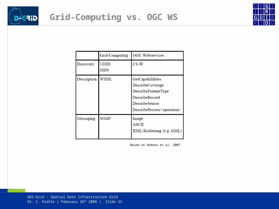
Grid-Computing vs. OGC WS
Based on Hobona et al. 2007

GDI-Grid - Spatial Data Infrastructure Grid
Dr. C. Kiehle | February 26th 2008 | Slide 24
Architectural Challenges

GDI-Grid - Spatial Data Infrastructure Grid
Dr. C. Kiehle | February 26th 2008 | Slide 25
Architectural Challenges II
• Define Translator Services• OGC WS as Grid-frontend

GDI-Grid - Spatial Data Infrastructure Grid
Dr. C. Kiehle | February 26th 2008 | Slide 26
Agenda
• deegree – Open Source Framework for Spatial Data Infrastructures (SDI)
• Challenges for Grid-enablement
• User Requirements
• Conclusions and Outlook

GDI-Grid - Spatial Data Infrastructure Grid
Dr. C. Kiehle | February 26th 2008 | Slide 27
User requirements
• Who is interested in Grid-enabled OGC WS? Customers with (very) large scaled data sets Environmental Scientists End Users?
• Survey by project partner ESRI / conterra
• Resulting requirements Processing capabilities Externalize data storage Virtual Organizations

GDI-Grid - Spatial Data Infrastructure Grid
Dr. C. Kiehle | February 26th 2008 | Slide 28
Agenda
• deegree – Open Source Framework for Spatial Data Infrastructures (SDI)
• Challenges for Grid-enablement
• User Requirements
• Conclusions and Outlook

GDI-Grid - Spatial Data Infrastructure Grid
Dr. C. Kiehle | February 26th 2008 | Slide 29
Conclusions & Outlook
© Heier, C.; Kiehle, C. 2007

GDI-Grid - Spatial Data Infrastructure Grid
Dr. C. Kiehle | February 26th 2008 | Slide 30
Questions?
Dr. Christian [email protected]
http://www.lat-lon.de/
GDI-Grid
Grid-enabling Open Source OGC Webservice

Gridification of OGC Webservice Chains
Andreas KrügerProf. Dr. Thomas H. Kolbe
Institute for Geodesy and Geoinformation Science Technische Universität Berlin{krueger,kolbe}@igg.tu-berlin.de
GDI-Grid - Spatial Data Infrastructure Grid
Agenda
Scenario Noise Pollution Simulation
Gridification in Context of Spatial Data
Infrastructure
Categories of Gridification
Orchestration of Services
32

GDI-Grid - Spatial Data Infrastructure Grid
33
Scenario – Noise Pollution Simulation
Noise PollutionSimulation
Noise PollutionSimulation
Requirements on data:
• as input a 3D block model of buildings with 3D Digital Terrain Model
• enrichment with noise emission levels, traffic frequency, …
Problem:
• normally available heterogeneous data sources:
2D area-wide geobasis data 2,5D raster data noise emission data
Required services:
• WCS, WFS for data delivery
• WPS for 3D model generation
• WPS for Noise Pollution Simulation
• WMS for delivery of Noise Pollution Maps

GDI-Grid - Spatial Data Infrastructure Grid
34
Noise Pollution Simulation – OGC Webservices
WPS3D Geodata Generation
WPS3D Geodata Generation
WFS2D Geobasis Data
(e.g. National Cadastre Data)
WFS2D Geobasis Data
(e.g. National Cadastre Data)
WMSNoise
Pollution Map
WMSNoise
Pollution Map
WPSNoise Pollution
Simulation
WPSNoise Pollution
Simulation
WCS2,5D Raster DataLaserscan Data /
Digital Terrain Model
WCS2,5D Raster DataLaserscan Data /
Digital Terrain Model
Chain of OGC compliant Webservices
Spatial Data Infrastructure
WFS
Noise Emission Data
WFS
Noise Emission Data
Grid
Gridification

GDI-Grid - Spatial Data Infrastructure Grid
35
Agenda
Scenario Noise Pollution Simulation
Gridification in Context of Spatial Data
Infrastructure
Categories of Gridification
Orchestration of Services

GDI-Grid - Spatial Data Infrastructure Grid
36
• Gridification:
Adaptation of existing applications and services to requirements of a grid environment.
• Goals of gridified Spatial Data Infrastructure applications:
Possibility of combination with other grid services Potential of access from / to non-gridified OGC Webservice High performance for processing large amounts of spatial data
• Requirements:
Adaptation to grid technology
Stateful services
WSDL
Security (Certificates, public / private key)
Maintain interfaces and functionality of OGC Webservice
Maximized utilisation of grid resources
Optimised distribution of data / services for processing spatial data
Harmonised interconnection of services
Gridification in Context of Spatial Data Infrastructure
Grid-Service
OGSI-Interfaces
OGC web service functionality

GDI-Grid - Spatial Data Infrastructure Grid
37
Parallelisation
• Scenario Noise Pollution Simulation:
A good choice: Tiling
Each service of the scenario works on continuous spatial data of wide areas
Each service has object-oriented models as input and output
Problem for harmonised parallelisation between services:
Adjustment calculation at a data join needs calculation of overlapping borders of tiles
Needs on additional overlapping border size differs between several services
Parallelisation of object types
Parallelisation of operations
Tiling
Height() Width() Extrude() Height() Width() Extrude()

GDI-Grid - Spatial Data Infrastructure Grid
38
• Pros: Realisable harmonised
parallelisation between services Allows full utilisation of grid
resources
• Cons: How works the connection
between grid and Spatial Data Infrastructure ?
Non-transparent mapping of OGC Webservice chains in grid environment
No combination of gridified and non-gridified services
Cooperation between services only by using OGSI
• Pros: Realisable harmonised
parallelisation between services Allows for full utilisation of grid
resources OGC compliant service chains
at the Spatial Data Infrastructure side
cooperation between grid and Spatial Data Infrastructure
Enables chains of gridified and non-gridified services
• Cons: Complex realisation of this
solution
• Pros: Orchestration still at OGC
Webservice level in the Spatial Data Infrastructure
For an user same handling of services, since communication only by OGC Webservice interfaces at Spatial Data Infrastructure side
Enables chains of gridified and non-gridified services
• Cons: Autonomous kind of
gridification at each OGC Webservice
Non-harmonised parallelisation of more than one OGC Webservice
OWS1
OWS2
OWS3
OWS1‘
OWS2‘
OWS3‘
Spatial Data Infrastructure and Grid
Spatial Data Infrastructure
GridWith Parallelisation
OWS2
OWS1
OWS3
2
3
1
2
3
1
2
3
1

GDI-Grid - Spatial Data Infrastructure Grid
39
Agenda
Scenario Noise Pollution Simulation
Gridification in Context of Spatial Data
Infrastructure
Categories of Gridification
Orchestration of Services

GDI-Grid - Spatial Data Infrastructure Grid
40
Categories of Gridification and Notation
OGC Webservice realised as one grid service Parallelisation by redundant execution of same service in
grid environment
OGC Webservice stays a Spatial Data Infrastructure service Calculation processes / handling of datasets distributed on
several instances mapped as grid services After processing distributed dataset joined at each OGC
webservice
OGC Webservice stays a Spatial Data Infrastructure service
Calculation processes / handling of datasets distributed on several instances mapped as grid services
Each instance transfers its part of dataset directly to an instance of another service
• 3) Transcendent Gridification:
OWSn
OWSG
Grid
OWS1
Grid OWSg
• 2) Encapsulated Gridification:
• 1) Gridification by Embedding into a Grid Service:
GSOWS
Grid

GDI-Grid - Spatial Data Infrastructure Grid
41
Agenda
Scenario Noise Pollution Simulation
Gridification in Context of Spatial Data
Infrastructure
Categories of Gridification
Orchestration of Services

GDI-Grid - Spatial Data Infrastructure Grid
42
Orchestration of Grid Services
• Set of services with different parallelisation
• Set of known workflows for a scenario
Workflow-Engine
WFS
OWSg
OWSG
OWSG
OWSg OWSg
OWSg
OWSG OWSG
OWSGOWSg OWSg
OWSG
OWSG OWSG
OWSG
Spatial Data Infrastructure Grid
WFS
WPS
WCS
WCS

GDI-Grid - Spatial Data Infrastructure Grid
43
Questions / Contact
Thank you for your attention.
Andreas KrügerInstitute for Geodesy and Geoinformation Science
Technische Universität [email protected]: +49 (30) 314 24409
Thomas H. KolbeInstitute for Geodesy and Geoinformation Science
Technische Universität [email protected]
Phone: +49 (30) 314 23274
Contact:

GDI-Grid - Spatial Data Infrastructure Grid
44
Problem:
• High data traffic at centralised Spatial Data Infrastructure services Bottlenecks
• Additional costs because of Split and Join at each OGC Webservice
Grid
GridGrid
Encapsulated Gridification
• OGC Webservice stays a Spatial Data Infrastructure service
• Each service instance is an separate grid service
• 3D Geodata Generation works internally on separate data tiles at the service instances
• Data transfer between two OGC Webservices centralised as one collected dataset inside the Spatial Data Infrastructure
WPSg
3D GeodataGeneration
WFSg
2D Geoobjects
……
WCSg
Laserscan DTM

GDI-Grid - Spatial Data Infrastructure Grid
45
Transcendent Gridification
…
WCSG
DTM 2,5D
Grid
Distributedconsistent 3D-Model
• Data distribution one time at the beginning and handed over the whole service chain
• Geoobjects provided on distributed interfaces as tiles on several grid nodes
• Every instance gets a single tile, proceeds the calculatons and provides the resulting tile by an own interface
• Data split only one time at the beginning, and merging one time at the end of the chain
Bottlenecks and needless data distribution/data merging can be omitted
But: A well harmonised parallelisation exists not in every situation
WCS2WCS2WCS1WCS1…WFS2WFS2WFS1WFS1
WFSG
Geoobjects 2D
WFSnWFSn WCSnWCSn
…WPS2WPS2WPS1WPS1 WPSnWPSn
WPSG
3D Geodata Generation

GDI-Grid - Spatial Data Infrastructure Grid
46
Transcendent Gridification – Noise Pollution Simulation
Spatial Data Infrastructure
Grid
WPS1G
3D Geodata Generation
WFS2D Geobasis
Data
WFS2D Geobasis
Data
WCS2,5D Raster
Data
WCS2,5D Raster
Data
WMSNoise Pollution Maps
WMSNoise Pollution Maps
WPS2G
Noise Pollution Simulation
WPS2‘
WPS2‘
WPS2‘
WPS1‘
WPS1‘
WPS1‘only possible if
input
parallelisation
signature
WPS2
=
output
parallelisation
signature
WPS1

GDI-Grid - Spatial Data Infrastructure Grid
47
Transcendent Gridification – Noise Pollution Simulation
• Additional Capabilities:
Input / Output signature of parallelisation for orchestration
Access to service endpoints of grid instances
• OGC compliant Publish-find-bind concept
…
Grid
WPS2WPS2WPS1WPS1 WPSnWPSn
…WPS2WPS2WPS1WPS1 WPSnWPSn
WPSG
3D Geodata Generation
WPSG
Noise Pollution Simulation
CapabilitiesCapabilities
CapabilitiesCapabilities
find(getCapabilities)bind bind bind
publish
publish
Input / Output signature
Input / Output signature

Spatial Data Infrastructure GridSecurity and Scheduling Challenges
Christopher Kunz<[email protected]>
OGF22Feb 25, 2008
GDI-Grid - Spatial Data Infrastructure Grid
Christopher Kunz | February 26th, 2008 | Slide 49
Agenda
Security Challenges GSI vs. traditional models Current situation and concepts in D-Grid Feasibility and scalability of PKI-based AuthN in SDI environments Data storage and handling Possible alternatives
Scheduling and architecture Current situation and concepts in D-Grid Architectural concepts for GDI-Grid Necessary redundancies Where to scale What to scale Compatibility challenges
Discussion

GDI-Grid - Spatial Data Infrastructure Grid
Security – current context in D-Grid
D-Grid supports 3 middlewares: Globus Toolkit 4 gLite 3 UNICORE 5
GDI-Grid will focus on Globus Toolkit 4
Mandatory use of Grid Security Infrastructure (GSI) Single Sign On Delegation of Rights Certificate based authentication, proxy credentials GSI chain must not be broken by any component Credentials must not be transferred over the wire
Christopher Kunz | February 26th, 2008 | Slide 50

GDI-Grid - Spatial Data Infrastructure Grid
Security – current situation in SDI
Very heterogenous structure
Proprietary authentication and authorization mechanisms
Data providers are geo scientists, not IT people
Different products require different access mechanisms
No cross-product cross-vendor single sign on
No delegation of rights
Christopher Kunz | February 26th, 2008 | Slide 51
GDI-Grid - Spatial Data Infrastructure Grid
Making ends meet…
These contrary architectures need to converge
GSI must be implemented in or in front of GIS services
Paradigm shift in Grid infrastructure?
Paradigm shift in SDI / GIS world?
Christopher Kunz | February 26th, 2008 | Slide 52

GDI-Grid - Spatial Data Infrastructure Grid
Authentication / Authorization
At the user entry point, GSI is necessary
SDI / GIS applications do not implement GSI
Is GSI implementation for end user apps feasible?
Different approach: web-based UI GridSphere portal GSI implemented, workflow management possible
Christopher Kunz | February 26th, 2008 | Slide 53

GDI-Grid - Spatial Data Infrastructure Grid
Certificate Infrastructure Challenges
Certificates for Grid use are regulated CA has to be conformant to GridPMA (in our case, EuGridPMA) regulations Resource providers must only accept PMA-compliant CAs Subsequently, only certificates issued by those CAs are allowed in the Grid
Commercial CAs are not GridPMA compliant Grid resource providers cannot accept certificates issued by them Little or no interest in GridPMA compliance Certificates issued by commercial vendors are not usable in Grid infrastructures
CAs will issue certificate only to „known“ entities Generally, one CA per country, local Regional Authorities (RA) In our context, DFN (German Science Network) and GridKA operate CAs Both supply certificates to member organizations only
Christopher Kunz | February 26th, 2008 | Slide 54

GDI-Grid - Spatial Data Infrastructure Grid
PKI Scalability issues
D-Grid project is urged to develop sustainable business model
SDI / GIS products have large user base Thousands of users Heterogeneous user groups: Commercial, academic, private, institutional
Certificate Authority needs to issue a certificate to each end user
Are academic CAs ready for this amount of certifications? Who pays for this?
Christopher Kunz | February 26th, 2008 | Slide 55

GDI-Grid - Spatial Data Infrastructure Grid
GSI implementation
Christopher Kunz | February 26th, 2008 | Slide 56
All components need to implement GSI
At the very least: transport-level security
Acceptance of proxy credentials as an authentication token
For other components: connectors / adaptors needed
MAGE toolkit offers easy integration of GSI
Creates Globus container services

GDI-Grid - Spatial Data Infrastructure Grid
GDI-Grid and data
Christopher Kunz | February 26th, 2008 | Slide 57
Geospatial data is integral part of GIS / SDI
Very costly to collect and maintain Data is nearly always proprietary and non-free Highly valuable asset
Data is essential for geoprocessing Input for computation jobs Input for illustrative tasks (maps, 3D scenes)
Data management important challenge for GDI-Grid

GDI-Grid - Spatial Data Infrastructure Grid
GDI-Grid: Data management
Typical situation in Grid environments Data stored on Storage Resource prior to job submission or (limited) Input data submitted together with job
In both cases: Input data is duplicated Commercial vendors do not permit this Contractual problem No technical solution (yet)
Many different license models / enforcement
Different data types / storage containers
Is a technical solution possible?
Christopher Kunz | February 26th, 2008 | Slide 58

GDI-Grid - Spatial Data Infrastructure Grid
GDI-Grid and D-Grid: The big picture
Christopher Kunz | February 26th, 2008 | Slide 59
Two distinct Grid infrastructures GDI-Grid contains community specific
infrastructure D-Grid acts as service provider for
computation
Scheduling in both Grids necessary
Different scheduling approaches
User interface: different possibilities
Only GDI-Grid infrastructure is under project control

GDI-Grid - Spatial Data Infrastructure Grid
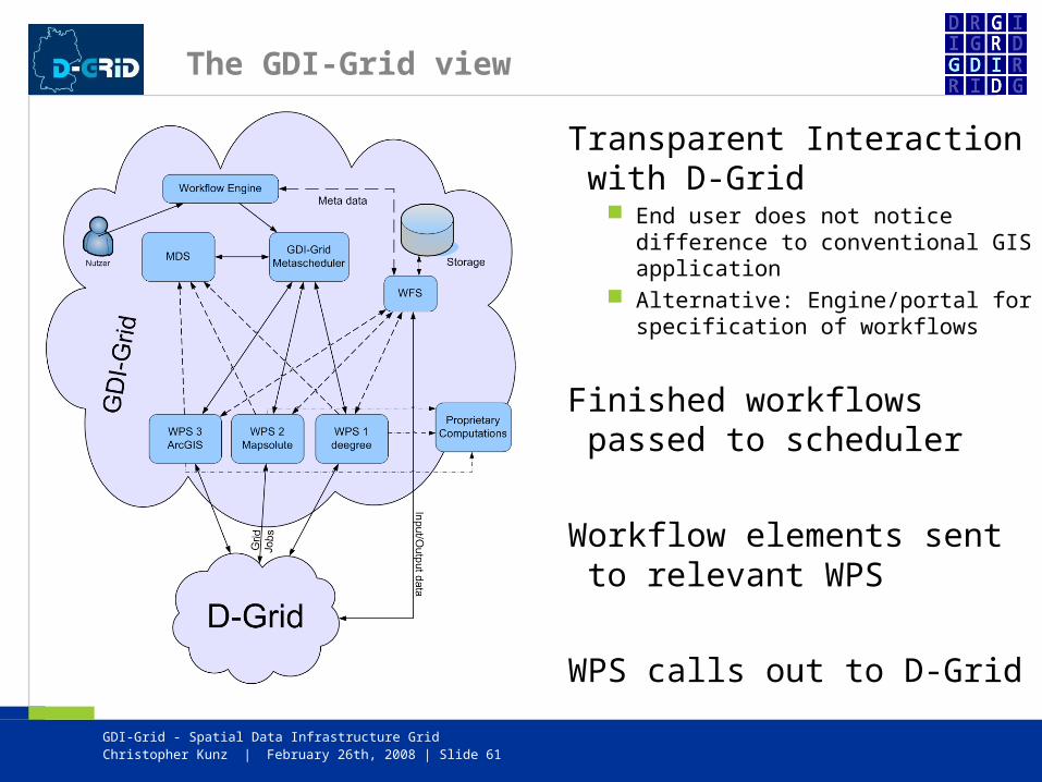
The D-Grid view
Christopher Kunz | February 26th, 2008 | Slide 60
D-Grid receives job callouts from GDI-Grid
Well-defined entry point necessary
D-Grid metascheduler deploys jobs to clusters
Cluster nodes pull relevant input data from GDI-Grid storage
Result data is pushed back to GDI-Grid storage
GDI-Grid - Spatial Data Infrastructure Grid
The GDI-Grid view
Transparent Interaction with D-Grid
End user does not notice difference to conventional GIS application
Alternative: Engine/portal for specification of workflows
Finished workflows passed to scheduler
Workflow elements sent to relevant WPS
WPS calls out to D-Grid
Christopher Kunz | February 26th, 2008 | Slide 61

GDI-Grid - Spatial Data Infrastructure Grid
Scalability
Where to scale? SDI processing should profit from Grid integration Thus, processing tasks should be segmented/paralellized Scaling as late as possible Ideally after WPS
What to scale? Part of the GDI-Grid project For suitable data: tiling and computation of 1/Nth For other data: parallel computation of different Levels of Detail (LoD) Computation of different layers in parallel
How to scale? Current situation:
processing tools distributed as part of Grid job standardized software already available on Grid nodes
Adaptation to GDI-Grid situation necessary
Christopher Kunz | February 26th, 2008 | Slide 62

GDI-Grid - Spatial Data Infrastructure Grid
Scalability and Heterogenity
SDI applications are very heterogenous Conventional Windows/Unix GUI interactive applications Non-GUI interactive applications (command-line etc.) Increasingly web-based end-user applications OGC web services
D-Grid is very homogenous Standardized architecture Unix only No GUI applications No interactive applications Limited possibility for custom libraries/environments
How do we converge? Many questions – technical and organizational Virtualization might be key
Christopher Kunz | February 26th, 2008 | Slide 63

GDI-Grid - Spatial Data Infrastructure Grid
Discussion
Thank you!
More information http://www.d-grid.de/ - D-Grid web site http://www.gdi-grid.de/ - GDI-Grid web site
Contact information Christian Kiehle <[email protected]> Andreas Krüger <[email protected]> Christopher Kunz <[email protected]> General information <[email protected]>
Christopher Kunz | February 26th, 2008 | Slide 64


![Grid Computing의다양한적용사례 · 2004-09-10 · World Wide Grid is Growing [4] Part I : the Grid 1. “Grid is Global Infrastructure” Grid Computing은분산된컴퓨터,](https://static.fdocuments.net/doc/165x107/5ea7406767f1675ce51910f3/grid-computingeoee-2004-09-10-world-wide-grid-is-growing-4.jpg)


![Hanko Rubach Dr. Christian Kiehle Judit Mays [rubach|kiehle|mays]@ l at- l on.de](https://static.fdocuments.net/doc/165x107/568156de550346895dc4859e/hanko-rubach-dr-christian-kiehle-judit-mays-rubachkiehlemays-l-at-l.jpg)


![[Smart Grid Market Research] The Optimized Grid - Zpryme Smart Grid Insights](https://static.fdocuments.net/doc/165x107/541402188d7f7294698b47d2/smart-grid-market-research-the-optimized-grid-zpryme-smart-grid-insights.jpg)
