GATE7 SWBTE TXT.qxd:Layout 1
10
©Carole Marsh/Gallopade International • www.gallopade.com • Page 7 ~ This book is not reproducible. ~ S S e e c c t t i i o o n n 1 1 AFRICA Georgia Experience • 7th Grade Teacher’s Edition • This book is not reproducible. • ©Carole Marsh/Gallopade International • www.gallopade.com page 7
Transcript of GATE7 SWBTE TXT.qxd:Layout 1

©Carole Marsh/Gallopade International • www.gallopade.com • Page 7
~ This book is not reproducible. ~
SSeeccttiioonn 11
AFRICA
Georgia Experience • 7th Grade Teacher’s Edition • This book is not reproducible. • ©Carole Marsh/Gallopade International • www.gallopade.com
page 7

Chapter 1
Physical Features of AfricaThe vast continent of Africa has a variety of landforms. Keep reading to learn about some of the
physical features that make Africa such an interesting place!
• The Sahara is the world’s largest hot desert, covering most of Northern Africa. Itstretches from the Red Sea to the outskirts of the Atlantic Ocean. In the south, itstretches to the Sahel.
• The Sahel is the transition zone south of the Sahara and north of the equator that separates the Saharafrom tropical rain forests. It has become more of a desert in recent years. Djenne and Timbuktu arepart of the Sahel.
• The savanna is the picture of Africa you see in the movies, with rolling grassland andscattered trees and shrubs. The most famous savanna is the Serengeti, straddling theborders of Kenya and Tanzania. There are 4.5 million square miles of savannas in Africa.
• The central African tropical rainforest in the Democratic Republic of the Congo is thesecond largest rainforest in the world. About 90 percent of the African rainforests have been deforested because of logging, road building, and poor farming.
• Flowing through west central Africa, the Congo River is the second longest river in Africa,and the fifth longest river in the world. It crosses the equator twice and is surrounded byrain forest.
©Carole Marsh/Gallopade International • www.gallopade.com • Page 8
~ This book is not reproducible. ~
GeographicalUnderstandings
SS7G1 The student will locate selected features of Africa.
a. Locate on a world and regional political-physical map: the Sahara, Sahel, savanna, tropicalrainforest, Congo River, Niger River, Nile River, , Lake Tanganyika, Lake Victoria, Atlas Mountains,and Kalahari Desert.
b. Locate on a world and regional political-physical map the countries of Democratic Republic ofthe Congo (Zaire), Egypt, Kenya, Nigeria, South Africa, Sudan, and South Sudan.
Georgia Experience • 7th Grade Teacher’s Edition • This book is not reproducible. • ©Carole Marsh/Gallopade International • www.gallopade.com
DEFINE IT!CRCT VOCABULARY BOOKS:
rainforest
SHARE IT!ENRICHMENT PACK: page 3
READ IT!Explore Africa!Africa has some amazing landscapes, from mountains anddeserts to tropical rainforests. Here are some brief descriptions ofwhat your students would find on a tour across Africa.
Sahara Desert: This is the world’s largest desert and is almost asbig as the entire United States. It gets less than three inches ofrain per year and reaches temperatures of 136 degreesFahrenheit!
Savanna: This is where you would take that safari! The Savannahas lots of flat grassland and is home to many animals like thelion, zebra, and wildebeest.
Nile River: The Nile is the longest river in the world. It flows fromthe mountains in the south to the Mediterranean Sea in thenorth. Egypt is built along the Nile and the river has beenessential to Egypt’s farming, transportation, and survival forcenturies.
Lake Victoria: This is the largest lake in Africa and the second-largest freshwater lake in the world. Lake Victoria has a smallriver branching off of it that makes up one half of the water inthe Nile River.
page 8
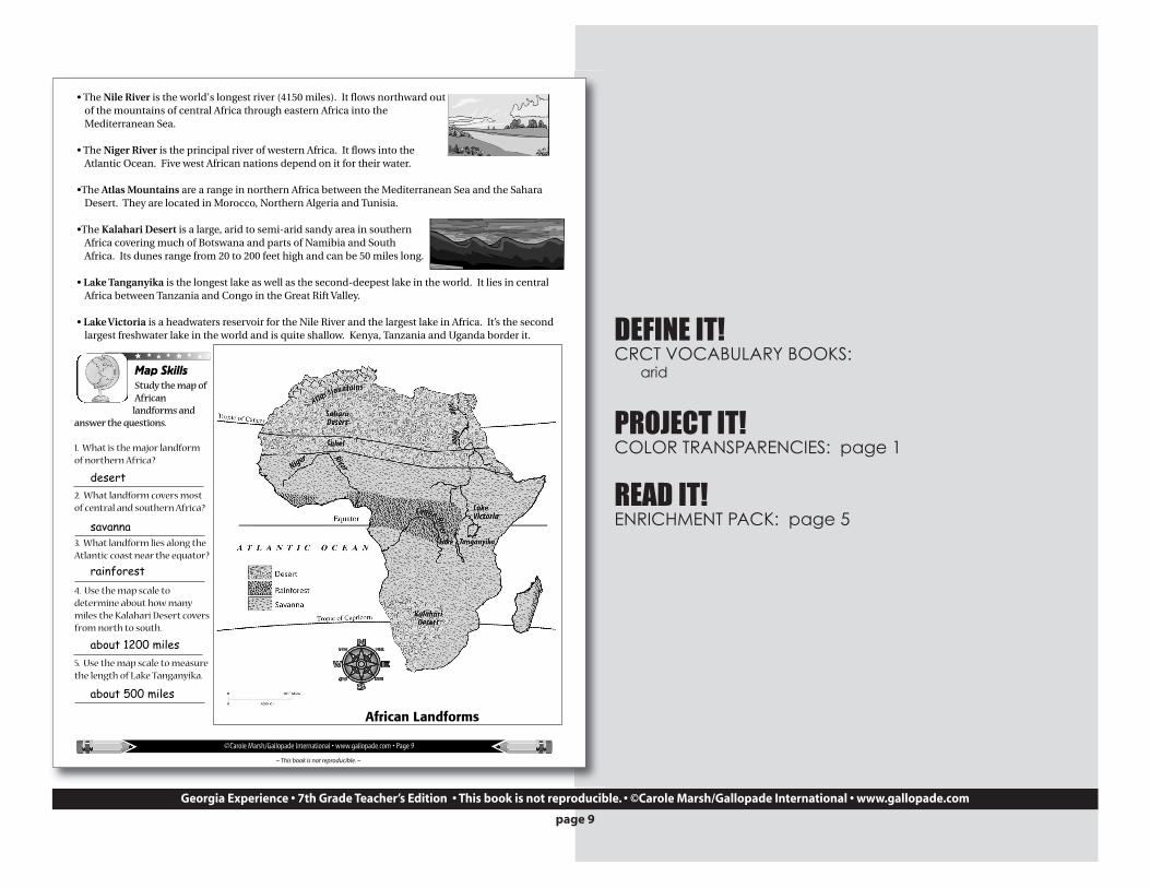
• The Nile River is the world's longest river (4150 miles). It flows northward outof the mountains of central Africa through eastern Africa into theMediterranean Sea.
• The Niger River is the principal river of western Africa. It flows into theAtlantic Ocean. Five west African nations depend on it for their water.
•The Atlas Mountains are a range in northern Africa between the Mediterranean Sea and the SaharaDesert. They are located in Morocco, Northern Algeria and Tunisia.
•The Kalahari Desert is a large, arid to semi-arid sandy area in southernAfrica covering much of Botswana and parts of Namibia and SouthAfrica. Its dunes range from 20 to 200 feet high and can be 50 miles long.
• Lake Tanganyika is the longest lake as well as the second-deepest lake in the world. It lies in centralAfrica between Tanzania and Congo in the Great Rift Valley.
• Lake Victoria is a headwaters reservoir for the Nile River and the largest lake in Africa. It’s the secondlargest freshwater lake in the world and is quite shallow. Kenya, Tanzania and Uganda border it.
Map SkillsStudy the map ofAfrican
landforms andanswer the questions.
1. What is the major landformof northern Africa?
2. What landform covers mostof central and southern Africa?
3. What landform lies along theAtlantic coast near the equator?
4. Use the map scale todetermine about how manymiles the Kalahari Desert coversfrom north to south.
5. Use the map scale to measurethe length of Lake Tanganyika.
©Carole Marsh/Gallopade International • www.gallopade.com • Page 9
~ This book is not reproducible. ~
African Landforms
desert
savanna
rainforest
about 1200 miles
about 500 miles
Georgia Experience • 7th Grade Teacher’s Edition • This book is not reproducible. • ©Carole Marsh/Gallopade International • www.gallopade.com
DEFINE IT!CRCT VOCABULARY BOOKS:
arid
PROJECT IT!COLOR TRANSPARENCIES: page 1
READ IT!ENRICHMENT PACK: page 5
page 9

Map SkillsLook at the map of Africa with the major physical features identified. Follow the directions below.
1. Draw a brown box around the Sahara Desert and make brown dots for sand.2. Draw an orange box around the Sahel. 3. Draw a green box around the savanna.4. Draw both green and red boxes around the tropical rainforest.5. Trace the Congo River in blue.6. Trace the Nile River in blue.7. Trace the Niger River in blue. 8. Draw purple peaks for the Atlas Mountains.9. Draw a brown box around the Kalahari Desert and make brown dots for sand.
10. Color Lake Tanganyika blue.11. Color Lake Victoria blue.
©Carole Marsh/Gallopade International • www.gallopade.com • Page 10
~ This book is not reproducible. ~
SaharaDesert
Sahel
Niger Rive
r Niger River
NileRiver
Congo River
Lake Victoria
Lake Tanganyika
KalahariDesert
Atlas Mountains
savanna
savanna
savanna
savannatropicalrainforest
rainforest
savanna
tropicalrainforest
SaharaDesert
Sahel
Niger Rive
r Niger River
NileRiver
Congo River
Lake Victoria
Lake Tanganyika
KalahariDesert
Atlas MountainsΔΔΔΔ
ΔΔΔ
savanna
savanna
savanna
savannatropicalrainforest
rainforest
savanna
tropicalrainforest
Georgia Experience • 7th Grade Teacher’s Edition • This book is not reproducible. • ©Carole Marsh/Gallopade International • www.gallopade.com
page 10

©Carole Marsh/Gallopade International • www.gallopade.com • Page 11
~ This book is not reproducible. ~
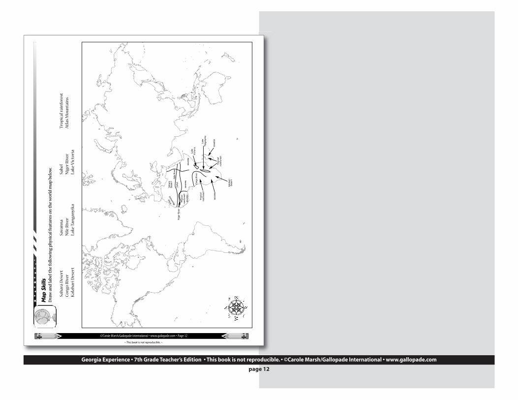
Map SkillsDraw and label the following physical features on the map of Africa below.
Sahara Desert Sahel savanna tropical rainforestCongo River Nile River Niger River Atlas MountainsKalahari Desert Lake Tanganyika Lake Victoria
Sahel
Atlas
Mountains
SaharaDesert
KalahariDesert
LakeVictoria
LakeTanganyika
Niger River
Nile River
Congo River
savanna
savanna
savanna
savanna
tropicalrainforest
rainforest
savanna
tropicalrainforest
Georgia Experience • 7th Grade Teacher’s Edition • This book is not reproducible. • ©Carole Marsh/Gallopade International • www.gallopade.com
page 11
©Carole Marsh/Gallopade International • www.gallopade.com • Page 12
~ This book is not reproducible. ~
Map
Ski
llsD
raw
an
d la
bel
th
e fo
llow
ing
ph
ysic
al fe
atu
res
on t
he
wor
ld m
ap b
elow
.
Sah
ara
Des
ert
Sava
nn
aSa
hel
Tro
pic
al r
ain
fore
stC
ongo
Riv
erN
ile R
iver
Nig
er R
iver
Atl
as M
oun
tain
sK
alah
ari D
eser
tLa
ke T
anga
nyi
kaLa
ke V
icto
ria
Sahe
l
sava
nna
sava
nna
sava
nna
sava
nna
sava
nna
trop
ical
rain
fore
st
trop
ical
rain
fore
st
trop
ical
rain
fore
st
Atlas
Mou
ntain
sSa
hara
Des
ert
Kala
hari
Des
ert
Lake
Vict
oria
Lake
Tang
anyi
ka
Nig
er R
iver
Nile
Riv
er
Cong
o Ri
ver
Georgia Experience • 7th Grade Teacher’s Edition • This book is not reproducible. • ©Carole Marsh/Gallopade International • www.gallopade.com
page 12
©Carole Marsh/Gallopade International • www.gallopade.com • Page 13
~ This book is not reproducible. ~
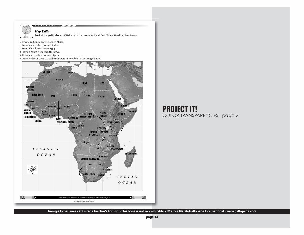
Map SkillsLook at the political map of Africa with the countries identified. Follow the directions below.
1. Draw a red circle around South Africa.2. Draw a purple box around Sudan.3. Draw a black box around Egypt.4. Draw a green circle around Kenya.5. Draw a brown box around Nigeria.6. Draw a blue circle around the Democratic Republic of the Congo (Zaire).
KENYAKENYA
ETHIOPIAETHIOPIA
ERITREAERITREASUDANSUDAN
EGYPTEGYPT
NIGERNIGERMAURITANIAMAURITANIA MALIMALI
NIGERIANIGERIA
SOMALIASOMALIA
NAMIBIANAMIBIA
LIBYALIBYA
CHADCHAD
SOUTH AFRICASOUTH AFRICA
TANZANIATANZANIA
ANGOLAANGOLA
ALGERIAALGERIA
MADAGASCARMADAGASCAR
MOZAMBIQUEMOZAMBIQUE
BOTSWANABOTSWANA
ZAMBIAZAMBIA
GABONGABON
CENTRAL CENTRAL AFRICAN REPUBLICAFRICAN REPUBLIC
TUNISIATUNISIAMOROCCOMOROCCO
UGANDAUGANDA
SWAZILANDSWAZILAND
LESOTHOLESOTHO
MALAWIMALAWI
BURUNDIBURUNDIRWANDARWANDA
TOGOTOGO
BENINBENIN
GHANAGHANAIVORYIVORYCOASTCOAST
LIBERIALIBERIASIERRA LEONESIERRA LEONE
GUINEAGUINEABURKINABURKINA
GAMBIAGAMBIA
CAMEROONCAMEROON
ZIMBABWEZIMBABWE
CONGOCONGO
DEM.REP.DEM.REP.OF CONGOOF CONGO
EQUATORIAL GUINEAEQUATORIAL GUINEA
WESTERNWESTERNSAHARASAHARA
DJIBOUTIDJIBOUTI
SENEGALSENEGAL
GUINEA GUINEA BISSAUBISSAU SOUTH SOUTH
SUDANSUDAN
A T L A N T I C
O C E A N
I N D I A N
O C E A N
Georgia Experience • 7th Grade Teacher’s Edition • This book is not reproducible. • ©Carole Marsh/Gallopade International • www.gallopade.com
PROJECT IT!COLOR TRANSPARENCIES: page 2
page 13
©Carole Marsh/Gallopade International • www.gallopade.com • Page 14
~ This book is not reproducible. ~
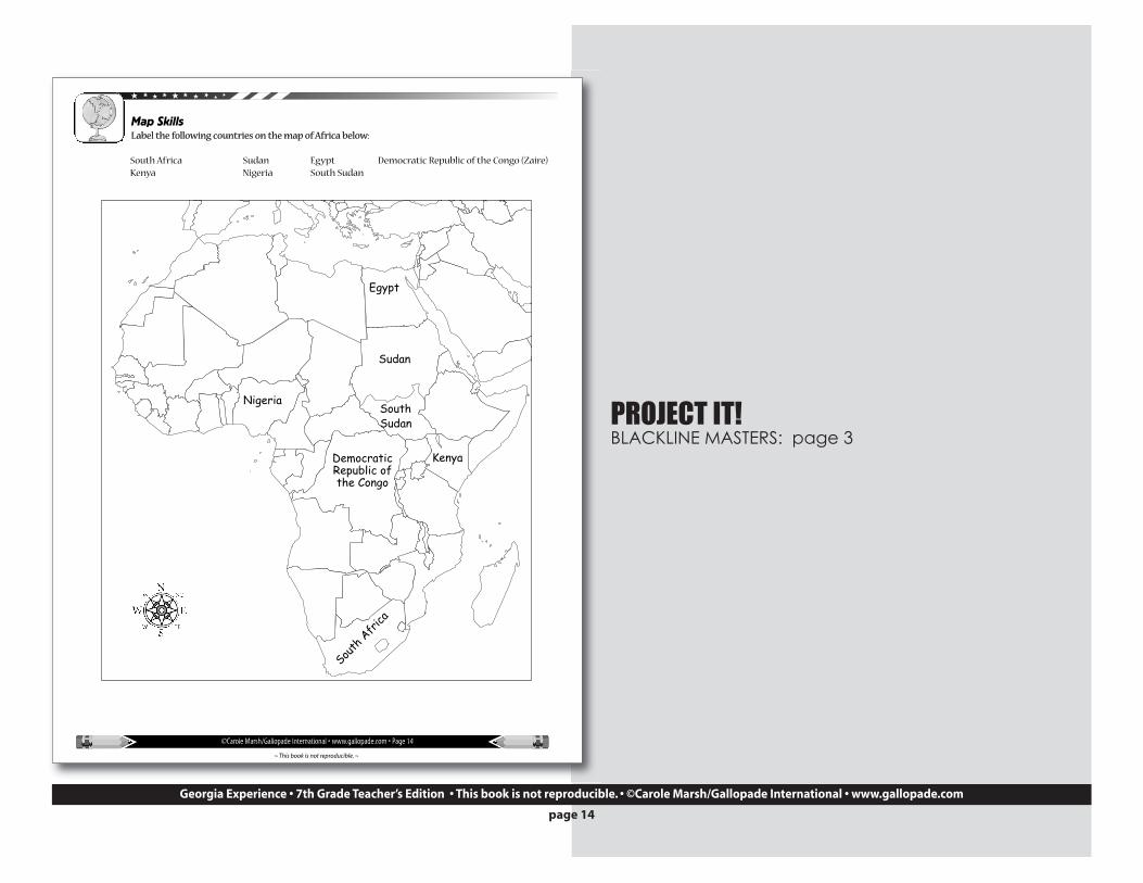
Map SkillsLabel the following countries on the map of Africa below:
South Africa Sudan Egypt Democratic Republic of the Congo (Zaire)Kenya Nigeria South Sudan
Egypt
Sudan
Nigeria
KenyaDemocraticRepublic ofthe Congo
South
Afr
ica
SouthSudan
Georgia Experience • 7th Grade Teacher’s Edition • This book is not reproducible. • ©Carole Marsh/Gallopade International • www.gallopade.com
PROJECT IT!BLACKLINE MASTERS: page 3
page 14
©Carole Marsh/Gallopade International • www.gallopade.com • Page 15
~ This book is not reproducible. ~
Map
Ski
llsLa
bel
th
e fo
llow
ing
cou
ntr
ies
on t
he
wor
ld m
ap b
elow
.Eg
ypt
Nig
eria
Sud
anSo
uth
Su
dan
Ken
yaSo
uth
Afr
ica
Dem
ocra
tic
Rep
ub
lic o
f th
e C
ongo
Egyp
tSu
dan
Nig
eria
Keny
aD
emoc
rati
cRe
publ
ic o
fth
e Co
ngo
Sout
h A
fric
a
Georgia Experience • 7th Grade Teacher’s Edition • This book is not reproducible. • ©Carole Marsh/Gallopade International • www.gallopade.com
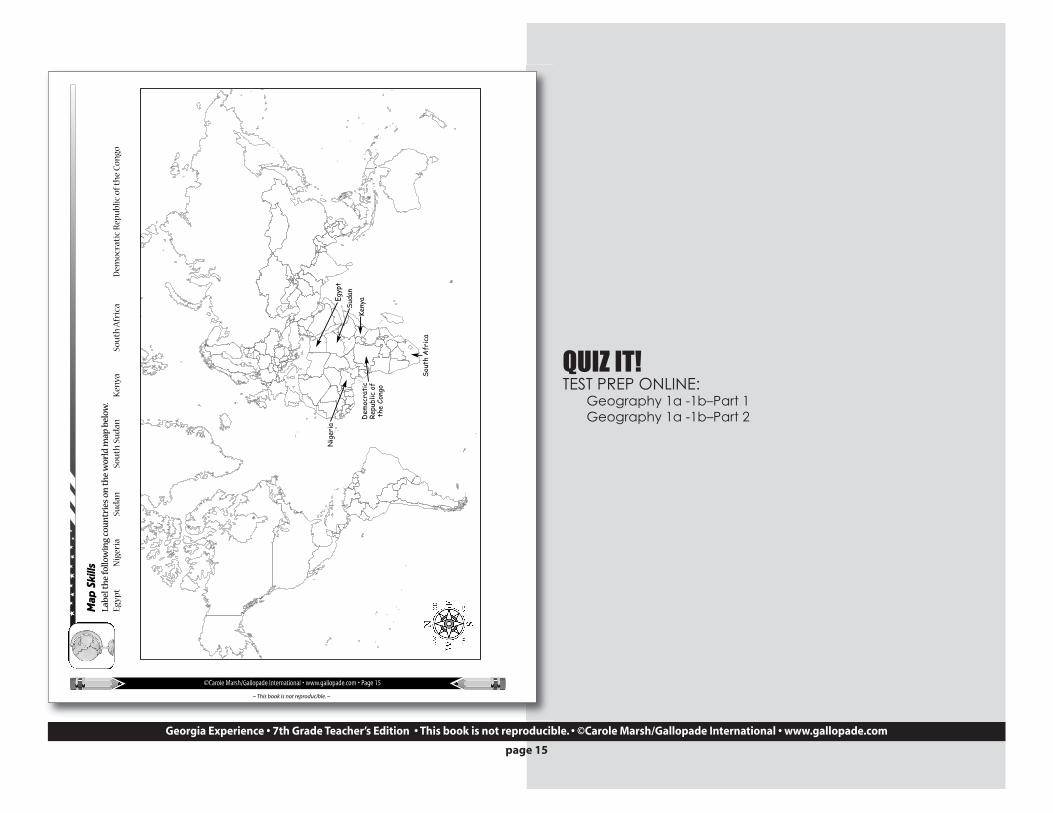
QUIZ IT!TEST PREP ONLINE:
Geography 1a -1b–Part 1Geography 1a -1b–Part 2
page 15
©Carole Marsh/Gallopade International • www.gallopade.com • Page 16
~ This book is not reproducible. ~
Quick Review Now see how much you’ve learned about African geography. Write the letter for the correct answer onthe line beside the question.
1. What is the southernmost country in Africa?A. Botswana B. South Africa C. Rwanda
2. What is the world’s largest hot desert?A. Kalahari B. Sahara C. Mohave
3. What African lake is the longest and second-deepest in the world? A. Lake Victoria B. Lake Chad C. Lake Tanganyika
4. The world’s longest river is:A. Niger River B. Nile River C. Congo River
Chapter 2
Polluted Water—Unfit to DrinkPesticides, fertilizers, human waste, storm water runoff,
mining, and manufacturing byproducts all contribute towater pollution in Africa. Fully half of the patients inhospital beds are there because of unclean drinking water,impacting the economy by reducing the workforce. In ruralareas, an estimated one million children die each year fromcontaminated water. Many humanitarian organizationsprovide clean water and help rebuild the infrastructure tomaintain a clean water supply. However, as the population grows in some countries, the amount ofclean water is actually decreasing.
Polluted water directly harms the fishing industry by either killing the fish or making them unfit toeat. On average, there are two oil spills a day in Nigeria. This affects trade by ruining the land for
SS7G2 The student will discuss environmental issues across the continent ofAfrica.
a. Explain how water pollution and the unequal distribution of water impact irrigation, trade,industry, and drinking water.
b. Explain the relationship between poor soil and deforestation in Sub-Saharan Africa.
c. Explain the impact of desertification on the environment of Africa from the Sahel to therainforest.
Word Definitioninfrastructure: the basicphysical systems of a
country's population, includinghealthcare, roads, utilities, water, andsewage landlocked: enclosed, or nearlyenclosed by land
B
B
C
B
Georgia Experience • 7th Grade Teacher’s Edition • This book is not reproducible. • ©Carole Marsh/Gallopade International • www.gallopade.com
DEFINE IT!CRCT VOCABULARY BOOKS:
contaminatedhumanitarianconservation
page 16


![[XLS] · Web view1 1 1 2 3 1 1 2 2 1 1 1 1 1 1 2 1 1 1 1 1 1 2 1 1 1 1 2 2 3 5 1 1 1 1 34 1 1 1 1 1 1 1 1 1 1 240 2 1 1 1 1 1 2 1 3 1 1 2 1 2 5 1 1 1 1 8 1 1 2 1 1 1 1 2 2 1 1 1 1](https://static.fdocuments.net/doc/165x107/5ad1d2817f8b9a05208bfb6d/xls-view1-1-1-2-3-1-1-2-2-1-1-1-1-1-1-2-1-1-1-1-1-1-2-1-1-1-1-2-2-3-5-1-1-1-1.jpg)

![1 $SU VW (G +LWDFKL +HDOWKFDUH %XVLQHVV 8QLW 1 X ñ 1 … · 2020. 5. 26. · 1 1 1 1 1 x 1 1 , x _ y ] 1 1 1 1 1 1 ¢ 1 1 1 1 1 1 1 1 1 1 1 1 1 1 1 1 1 1 1 1 1 1 1 1 1 1 1 1 1 1](https://static.fdocuments.net/doc/165x107/5fbfc0fcc822f24c4706936b/1-su-vw-g-lwdfkl-hdowkfduh-xvlqhvv-8qlw-1-x-1-2020-5-26-1-1-1-1-1-x.jpg)