garfield.utah.govgarfield.utah.gov/.../07/3.2-Livestock-Grazing.docx · Web viewCreation of the...
67
3.2 LIVESTOCK GRAZING Introduction In managing livestock grazing on public and private lands, Garfield County’s overall objective is to promote health, safety and welfare by ensuring the long-term health and productivity of a) public and private lands, b) the County’s watersheds, c) the livestock industry, d) multiple social and environmental benefits that result from the custom, culture and heritage associated with the livestock industry, and e) cultural resources, ethnographic resources, and traditional uses associated with the livestock industry. Grazing is administered on public lands in accordance with the Taylor Grazing Act of 1934, and in so doing provides livestock-based economic opportunities in rural communities while contributing to the West’s and America’s social fabric and identity. Together, the County’s public lands and private ranches maintain open spaces, provide habitat for wildlife, offer a myriad of recreational opportunities for public land users, and help preserve the custom, culture, heritage and character of the rural West. Livestock Grazing in Garfield County has been designated a resource of cultural and historic significance. Livestock Grazing is protected by Garfield County’s Protection of Cultural Resources Ordinance and is on the County Register of Cultural Resources. In some instances Livestock Grazing may also be suitable for protection as an Area of Critical Environmental Concern (ACEC). A Brief History of Public Lands Grazing Although the Spanish brought livestock into the American southwest in the 1500’s, domestic animals were first introduced into portions of Garfield County in the late 1700's. Herds of cattle were utilized as a source of meat on the long journeys into the Glen Canyon area; and other domestic livestock, like mules and burros, were used to pack additional supplies. Parts of the Old Spanish Trail was first utilized by the Dominquez- Escalante expedition in 1776, as the group crossed the Colorado River at a point subsequently called the "Crossing of the Fathers," which is now below the waters of Lake Powell, at Padre Bay. This historic crossing was the first of many with historical 1
Transcript of garfield.utah.govgarfield.utah.gov/.../07/3.2-Livestock-Grazing.docx · Web viewCreation of the...
3.2 LIVESTOCK GRAZING
IntroductionIn managing livestock grazing on public and private lands, Garfield County’s overall objective is to promote health, safety and welfare by ensuring the long-term health and productivity of a) public and private lands, b) the County’s watersheds, c) the livestock industry, d) multiple social and environmental benefits that result from the custom, culture and heritage associated with the livestock industry, and e) cultural resources, ethnographic resources, and traditional uses associated with the livestock industry. Grazing is administered on public lands in accordance with the Taylor Grazing Act of 1934, and in so doing provides livestock-based economic opportunities in rural communities while contributing to the West’s and America’s social fabric and identity. Together, the County’s public lands and private ranches maintain open spaces, provide habitat for wildlife, offer a myriad of recreational opportunities for public land users, and help preserve the custom, culture, heritage and character of the rural West. Livestock Grazing in Garfield County has been designated a resource of cultural and historic significance. Livestock Grazing is protected by Garfield County’s Protection of Cultural Resources Ordinance and is on the County Register of Cultural Resources. In some instances Livestock Grazing may also be suitable for protection as an Area of Critical Environmental Concern (ACEC).
A Brief History of Public Lands GrazingAlthough the Spanish brought livestock into the American southwest in the 1500’s, domestic animals were first introduced into portions of Garfield County in the late 1700's. Herds of cattle were utilized as a source of meat on the long journeys into the Glen Canyon area; and other domestic livestock, like mules and burros, were used to pack additional supplies. Parts of the Old Spanish Trail was first utilized by the Dominquez-Escalante expedition in 1776, as the group crossed the Colorado River at a point subsequently called the "Crossing of the Fathers," which is now below the waters of Lake Powell, at Padre Bay. This historic crossing was the first of many with historical documentation indicating that ensuing drives could have had cattle herds that numbered in the thousands.
There was no serious attempt to utilize the range resources until the early 1860's. Settlers brought small numbers of livestock to the area known today as the "Escalante-Fifty Mile Mountain" area in the early 1870's. During subsequent expansion into southeastern Utah, in 1879-1880, settlers created the famous Hole-in-the-Rock trail as they moved from Escalante into present day San Juan County, accompanied by some 1,800 cattle.
In 1886, large numbers of cattle were driven into the area from central and northern Utah via Hanksville and Halls Crossing. The following years were dry, and livestock numbers decreased due to drought and overuse of the range. Livestock numbers continued to decline during the late1890's, and the trend continued until the start of World War I. Livestock numbers then increased with the wartime economy. However, the trend peaked at the close of the World War I, and by the 1920's numbers were once again near the average. Statistics from the early 1900’s indicate sheep replaced cattle during the hard economic times, but by 1974 the trend had returned to favor cattle.
1
During the era of homesteading, federal lands were often grazed because of national policies designed to promote the settlement of the West and the desire to provide food and fiber for the nation. Grazing was largely unregulated and some problems occurred, but a significant understanding was gained regarding livestock grazing in arid ecosystems. In response to requests from Western ranchers, Congress passed the Taylor Grazing Act of 1934, which led to the creation of grazing districts in which grazing use was apportioned and regulated. The Division of Grazing was created within the Interior Department to administer the grazing districts; this division later became the U.S. Grazing Service and was headquartered in Salt Lake City. In 1946 the Grazing Service was merged with the General Land Office to become the Bureau of Land Management.
Unregulated grazing that took place before enactment of the Taylor Grazing Act resulted in unintended damage to soil, plants, streams, and springs. As a result, grazing management was initially designed to increase productivity and reduce soil erosion by controlling grazing through fencing and water projects and by conducting forage surveys to balance forage demands with the land’s productivity/carrying capacity. These initial improvements in livestock management arrested the degradation of public rangelands while improving watersheds, and were successful in restoring acceptable conditions.
But by the 1960s and 1970s, regulation of public lands and unrealistic expectations for their management through restrictive federal policies rose to a new level, as made clear by congressional passage of such laws as the National Environmental Policy Act of 1969, the Endangered Species Act of 1973, the National Forest Management Act of 1976, and the Federal Land Policy and Management Act of 1976. Consequently, federal agencies moved away from managing natural resources, vegetation and grazing and toward lengthy studies, litigation and altered fire regimes that have resulted in proliferation of invasive species, loss of wildlife and a morass of bureaucratic delay. In general, regulations were intended to provide better management or protection of specific rangeland resources, such as riparian areas, threatened and endangered species, sensitive plant species, and cultural or historical objects. However, a backlog of litigation, environmental studies and regulation has hampered land management activities aimed at production and healthy ecosystems. Consistent with this enhanced regulatory role, federal agencies developed or modified the terms and conditions of grazing permits and leases and implemented new policies which have delayed range improvement projects which address specific resource issues and which have prevented continued improvement of public rangeland conditions.
Current setting:Today federal agencies and permittees manage livestock grazing in a manner aimed at achieving and maintaining health of the land and sustaining resources. To achieve desired conditions, the agencies use forest and rangeland health standards and guidelines, which were generally developed in the 1990s with input from citizen-based Resource Advisory Councils across the West. Standards describe specific conditions needed for long term sustainability, such as the presence of stream bank vegetation and adequate canopy and ground cover. Guidelines are the management techniques designed to achieve or maintain healthy public lands, as defined by the standards. These techniques include such methods as seed dissemination, periodic rest or deferment from grazing in specific allotments during critical growth periods, water development,
2
and land treatments aimed at making the land more productive.
Currently, grazing on public lands is relatively stable. Except for a few isolated locations, problems from the early 1900s have been largely corrected as designed by the Taylor Grazing Act. Forest and rangeland health has improved over the past few decades, and there is continual effort on the part of federal agencies and permittees to maintain healthy conditions.
Livestock grazing on federal lands has been declared an activity of historic and cultural significance in Garfield County and has been placed on the County’s register of cultural resources. In addition, the State of Utah has passed legislation recognizing the value of the livestock industry and outlining basic concepts to preserve its vigor. The American cowboy has been recognized by the Congress and the President of the United States for his role in settling the West; and President Clinton recognized the rich human history of the area in the Grand Staircase-Escalante National Monument Proclamation. Livestock grazing is the last human endeavor of the American West that is shaped by nature. Livestock grazing continues to play a vital role in the health, welfare, safety, custom, culture and heritage of Garfield County.
In spite of ongoing improvements in livestock management and federal, state and local recognition of its importance, inflexible federal regulations, altered fire regimes, encroachment of undesirable vegetation ( tamarisk, Russian Olive, Pinyon/Juniper, rabbitbrush, etc.), and private citizen efforts to eliminate public land grazing put the industry at significant risk.
Grazing, one of the earliest and longest uses of public lands, continues to be an important activity for those same lands today. Livestock grazing now competes with more uses than it did in the past, as other industries and the general public look to the public lands as sources of both conventional and renewable energy and as places for outdoor recreation, including primitive and motorized use. Among the key issues that face land managers today are drought, severe wildfires, invasive plants, and dramatic increases in recreation.
Modern, well-managed grazing provides numerous environmental benefits. For example, well-managed grazing can be used to control undesirable vegetation. Intensively managed “targeted” grazing can control some invasive plant species or reduce the fuels that contribute to severe wildfires. Besides providing such traditional products as meat and fiber, well-managed rangelands support healthy watersheds, carbon sequestration, recreational opportunities, and wildlife habitat. Livestock grazing on public lands helps maintain the private ranches that, in turn, preserve the open spaces that have helped write Garfield County’s history and will continue to shape this region’s character in the years to come.
Need for Management Change:Various conditions exist that create a need for changes in management related to grazing including but not limited to:
1. Designation of grazing as an object of historic and cultural significance to Garfield County and placement of grazing on the Garfield County Register of Cultural Resources;
2. Creation of the Escalante Historic/Cultural Grazing Region by Garfield County and the
3
Escalante Grazing Region Zone by the State of Utah;
3. Recognition of the ongoing threat to the health, safety, welfare, custom, culture, heritage and values of Garfield County resulting from reductions in grazing or harm to the livestock industry;
4. Neglect of natural resources (failure to maintain water developments and desirable vegetation; uncontrolled expansion of tamarisk, Russian Olive, Pinyon/Juniper, rabbitbrush, and noxious weeds, etc.) resulting from failure to aggressively manage the land for optimum forest/rangeland health and potential.
5. Failure to allow for maintenance and enhancement of grazing related infrastructure including but not limited to roads, corrals, seedings, water developments, vegetative resources, desirable ecologic site conditions, etc.
6. Creation of the Grand Staircase-Escalante National Monument and subsequent management actions diminishing land health and forage production. Protections offered by the Monument Proclamation have not been adhered to.
7. Failure of federal agencies to create, update and modify land management plans to optimize multiple use/sustained yield principles and to comply with coordination and consistency requirements mandated by law.
8. Ongoing threats by private groups to eliminate livestock grazing on public lands in Garfield County.
9. Lack of flexibility in managing livestock related resources and permitted activities.
10. Threats to livestock and wildlife resulting from loss of desirable ecologic site conditions and failure to control invasive confers, tamarisk, Russian Olive, rabbitbrush, noxious weeds, and other undesirable vegetation.
11. Increased recreationist created conflicts, especially in areas that are not the focal point of visitation and where water is appropriated for stockwatering.
12. Ongoing threats to forest and rangeland health by limiting vegetation to only native species.
Desired Conditions:Garfield County Desires:
a) Land management agencies recognize state and local designation of the significant historic role of livestock grazing and its value as a cultural resource
b) Land managers recognize Garfield County's Register of Cultural Resources and the County’s Resource Management Plan and comply, to the maximum extent allowed by law, with Garfield County's stated goals, plans, desires, and needs.
4
c) Federal agencies manage lands to maximize sustained yield, including optimization of available forage for livestock grazing.
d) Federal agencies restore forests and rangelands to a condition that supports the full number of permitted livestock and increases forage available for livestock grazing over time.
e) Prior to FY 2050 federal agencies enhance forests and rangelands to a condition that supports an additional 30% of forage over what is necessary to accommodate the full number of livestock and wildlife permitted at present.
f) Federal agencies restore Pinyon/Juniper stands to desired conditions, eliminate Tamarisk and Russian Olive, eradicate noxious weeds, and replace rabbit brush and other unproductive species with vegetation that will optimize sustained yield and benefit to wildlife, livestock, recreation and other multiple uses.
g) Water generated from Pinyon/Juniper, Tamarisk and Russian Olive removal be conserved, developed and enhanced to be used: 1) for livestock on lands that are not designated as the focal point for visitors or that have water rights allocated to livestock; 2) for recreation on lands designated as the focal point for visitors and that have water rights allocated to culinary/domestic uses; 3) for livestock on lands designated by Garfield County or the State of Utah where grazing is the highest and best use; and 4) for multiple use/sustained yield purposes in compliance with Utah State Water Law on lands that are undesignated.
h) New water be developed: 1) for livestock and wildlife on lands that are not designated as the focal point for visitors or that have water rights allocated to livestock and wildlife; 2) for recreation on lands designated as the focal point for visitors and that have water rights allocated to culinary/domestic uses; 3) for livestock on lands designated by Garfield County or the State of Utah where grazing is the highest and best use; and 4) for multiple use/sustained yield purposes in compliance with Utah State Water Law on lands that are undesignated.
i) The full number of permitted livestock be restored and expanded at the earliest possible time in a phased approach as the conditions of paragraph d) are achieved. j) Desired ecological site conditions identified by the Natural Resources Conservation Service be achieved
Findings, Policies, Goals, Objectives, and Criteria
Goal: Preserve the history, culture, custom, and values of the grazing industry within the County. Maximize efficient and responsible preservation, enhancement, and development of grazing resources, practices and affected natural, historical, and cultural activities within Garfield County.
5
Goal: On SITLA, Forest Service and BLM lands, manage livestock grazing to provide for multiple uses while maintaining healthy ecosystems and protecting biological and cultural resources consistent with federal law. On NPS lands, manage livestock grazing while maintaining healthy ecosystems and protecting biological and cultural resources and the values and purposes of NPS units consistent with their enabling legislation.
Policy & Objective: On SITLA, Forest Service and BLM lands, manage vegetative resources to become as productive as feasible for livestock grazing, with a goal of restoring suspended and under-utilized AUMs, while maintaining a thriving, ecological balance and multiple-use relationships.
Policy & Objective: On NPS lands, manage vegetative resources to become as productive as feasible to maintain healthy ecosystems and to protect biological and cultural resources and the values and purposes of the specific NPS unit consistent with its enabling legislation. Where authorized, maximize livestock grazing consistent with federal law.
Goal: Garfield County’s goals regarding livestock grazing are threefold: 1) Maintain and enhance land health and productivity; 2) Actively manage land to optimize resource use including livestock grazing; and 3) Ensure a healthy, stable and economically viable livestock grazing program to preserve and enhance this important cultural and historic activity. For information purposes, livestock grazing provides year round income of approximately $100 per AUM. (See Appendix XXX for details)
Policy: Grazing on private and State lands in Garfield County is managed under the requirements of the Garfield County, Utah Zoning Ordinance, November 3, 1986 as amended. Grazing on federal lands in Garfield County is managed under the requirements of Garfield County’s Resource Management Plan, 2007 and the 2017 revision, as amended.
Finding & Policy: Livestock grazing shall continue to be implemented and managed based on Utah’s Standards for Healthy Rangelands and Guidelines for Grazing. Management systems that are based on arbitrary departure standards from selected reference conditions fail to consider natural variability and the complex relationship between ecologic variables. Livestock management systems that are based on departure standards and reference conditions are deemed arbitrary, capricious, scientifically unsubstantiated, statistically unsupported, and inconsistent with Garfield County’s Resource Management Plan.
Policy: In strict compliance with 40 CFR 1502.22, land managers considering any grazing management alternative that includes reference areas and/or departure standards shall include in any environmental analysis all information relevant to reasonably foreseeable and/or significant impacts. If the information relevant to reasonably foreseeable and/or significant impacts cannot be obtained, the agency shall include within the environmental document: a) A statement that such information is incomplete or unavailable; b) a statement of the relevance of the incomplete or unavailable information to evaluating reasonably foreseeable significant adverse impacts on the human environment; c) a summary of existing credible scientific evidence which is relevant to evaluating the reasonably foreseeable significant adverse impacts on the human environment, and d) the agency's evaluation of such impacts based upon theoretical approaches or research
6
methods generally accepted in the scientific community. For the purposes of this policy, “reasonably foreseeable” includes impacts which have catastrophic consequences, even if their probability of occurrence is low, provided that the analysis of the impacts is supported by credible scientific evidence, is not based on pure conjecture, and is within the rule of reason.
Goal: Manage livestock grazing in accordance with applicable federal, state and local laws, regulations, standards and guidelines.
Goal: Manage livestock grazing, including use of adaptive management principles, to meet or make progress toward meeting Utah Forest and Rangeland Health Standards where livestock grazing is a causal factor.
Criteria: Garfield County has adopted the BLM Utah Rangeland Health Standards for public lands and has adopted the U.S. Department of Agriculture Natural Resource Conservation Service’s Greater Sage Grouse Habitat Evaluation Method for Greater Sage-Grouse habitats.
Policy: Meet or make progress toward meeting BLM Utah Rangeland Health Standard 2 and Standard 4. Land managers shall comply with water quality standards established by the State of Utah and Garfield County under the federal Clean Water and Safe Drinking Water Acts. Activities on federal and state lands will fully support the designated beneficial uses described in applicable water quality standards.
Finding: Livestock grazing is a cultural resource, an ethnographic resource, part of the County’s heritage, and a traditional activity of significance. It is protected under Garfield County’s Protection of Cultural Resources Ordinance, the Grand Staircase – Escalante National Monument Proclamation, FLPMA, NFMA, and other applicable law.
Finding: Failure to control Tamarisk, Russian Olive and Pinyon/Juniper, and noxious weeds beyond desired levels is a detriment to the health, safety and welfare of Garfield County, is inconsistent with the County’s plan, program and policy, and is a violation of local law. (Draft ordinance requiring land owners with more than 5000 contiguous acres to control tamarisk, Russian Olive and to restore p/j levels to pre-settlement conditions.)
Finding: Tamarisk and Russian Olive are not native and constitute evidence/presence of man on the environment. Land bases that contain Tamarisk and/or Russian Olive are trammeled by man and contain permanent evidence of man’s impact. Until Tamarisk and Russian Olive are eradicated a land area is not eligible for wilderness designation due to man’s longstanding / permanent impact on the land.
Finding: Grazing commodity zones are necessary for the health, safety, welfare, custom, culture and heritage of Garfield County and following Grazing Commodity Zones have been established:
Panguitch Lake Panguitch ValleyEast Fork Kingston Canyon
7
Boulder Mountain Escalante Historic/Cultural Grazing RegionHenry Mountains Glen Canyon
Finding: For more than 100 years the areas designated as the Grazing Commodity Zones listed above have provided and continue to provide a significant contribution to the history, custom, culture, heritage, economy, welfare and other values of Garfield County. Properly managed, abundant natural and vegetative resources exist within the commodity zones to support and expand current livestock grazing activities and wildlife habitat.
Policy: Livestock grazing activities in the commodity zones constitute historic resources, ongoing human history, places where nature shapes human endeavors in the American West, a variety of cultural resources, landmarks, structures, and other objects of historic or scientific interest that are worthy of recognition, preservation, protection, and expansion.
Finding: The highest management priority for lands within the above-mentioned commodity zones is a preservation, restoration, and enhancement of watershed, forest and rangeland health conditions to sustain and expand forage production for livestock grazing and wildlife habitat. Other multiple uses (mining, timber harvest, oil & gas extraction, recreation, commodity development, etc.) are compatible with rangeland health when properly managed.
Finding: Managing Garfield County Grazing Commodity Zones for livestock grazing and wildlife habitat does not preclude or restrict other multiple use / sustained yield activities including but not limited to mining, timber harvest, oil & gas extraction, and recreation.
Finding: There are numerous National Parks, State Parks and other sites in and near Garfield County that provide outstanding opportunities for recreation where livestock grazing is not allowed.
Policy: Within Grazing Commodity Zones, minimal, site specific infrastructure may be installed on a case by case basis to enhance resources significantly impacted by livestock and wildlife grazing. However, livestock grazing shall not be diminished to reduce conflicts created by recreationists that choose to visit Grazing Commodity Zones when and where livestock grazing is allowed.
Finding: Vegetative treatments that restore lands to desired ecological site condition and existing seedings are substantially unnoticeable in Recreation Ia and Recreation Ib management zones.
Finding: The existence of Pinyon/Juniper woodlands inconsistent with desired and/or historical sagebrush and grassland ecological site descriptions or the existence of Tamarisk, Russian Olive, noxious weeds, or cheatgrass are evidence of man’s presence and constitute a trammeling by man.
Policy: The existence of Pinyon/Juniper woodlands inconsistent with desired and/or historical sagebrush and grassland ecological site descriptions or the existence of Tamarisk, Russian Olive, noxious weeds, or cheatgrass are not natural conditions, and land occupied by such species are
8
impaired by man until such time as a natural condition where the land retains its primeval character and influence is restored.
Policy: Lands occupied by Pinyon/Juniper woodlands inconsistent with desired and/or historical sagebrush and grassland ecological site descriptions or by Tamarisk, Russian Olive, noxious weeds, or cheatgrass are not suitable for management as wilderness, Recreation Ia or Recreation Ib until a primeval character and influence is restored and such management is approved by the Garfield County Commission.
Finding: The historic levels of livestock grazing activity and other values identified in each commodity zone have greatly diminished, or are under other serious threat, due to: (a) unreasonable, arbitrary, and unlawfully restrictive federal management policies, including: de facto management for primitive recreation in non-wilderness areas and non-WSAs; (b) abandonment of Taylor Grazing Act designations applicable to each of these zones; (c) arbitrary administrative reductions in animal unit months and available forage; (d) inflexible federal grazing practices that disallow grazing at different times each year; (e) encroachment of pinyon, juniper, cheatgrass, invasive species, and woody vegetation that compromise watershed and rangeland health, reduce desirable forage, degrade habitat, limit wildlife populations, reduce water yield, and heighten the risk of catastrophic wildfire; and f) more than 100 years of fire suppression that has promoted invasion of forb/grassland habitats with undesirable species including but not limited to decadent sagebrush, pinyon, juniper, rabbitbrush, cheatgrass, etc.
Policy: Lands designated by Garfield County as Forestry, Forage, Multiple Use Sustained Yield, and Commercial Product Development are targeted areas for Livestock Grazing improvement projects including but not limited to seedings, seeding maintenance, conifer removal, invasive removal, water development, and re-vegetation projects.
Policy: Lands designated by Garfield County as Recreation Ia and Recreation Ib shall be available for Livestock Grazing to the maximum extent allowed by law.
Policy: Lands designated by Garfield County as Recreation II and Recreation III shall be available for Livestock Grazing; and Livestock Grazing related resources shall be improved to the maximum extent allowed by law.
Finding: Restrictive federal regulation has resulted in the loss of a natural/pre-settlement fire regime, the invasive encroachment of conifers in former semi-desert/sagebrush ecosystems, the proliferation of undesirable species including but not limited to Tamarisk, Russian Olive, cheatgrass, and a reduction in available forage for livestock and wildlife grazing.
Policy: Federal land managers shall refrain from implementing policies and programs that reduce livestock grazing on lands in Garfield County’s Grazing Commodity Zones. Prior to any reduction in AUMs in Garfield County Grazing
9
Commodity Zones, federal land managers shall coordinate with Garfield County and shall implement all reasonable actions to provide necessary forage to accommodate permitted levels of livestock grazing.
Policy: Federal land managers shall refrain from implementing utilization standards less than 50%, unless: a) implementing a standard of less than 50% utilization on a temporary basis is necessary to resolve site-specific concerns; and b) the federal agency consults, coordinates, and cooperates fully with Garfield County and affected local governments.
Policy: For the purposes of livestock grazing related analysis the following shall apply:
1. Immediate impact is defined as impact which lasts less than one year. Immediate impacts do not need to be mitigated, if desired conditions are achieved within the one year period.
2. Short term impact is defined as impact which lasts longer than one year but less than five years. Short term impacts do not need to be mitigated, if desired conditions are achieved within the five year period.
3. Long term ground impact is defined as impact which lasts more than five years but less than twenty years. Long term impacts do not need to be mitigated, if desired conditions are phased and achieved within a five year period of phased disturbance.
4. Permanent ground disturbance is defined as any ground disturbing activity which lasts longer than twenty years. Permanent disturbances need to be mitigated or offset by other enhancements initiated within five years.
Finding: Federal land managers have a) failed to accurately map general habitat and critical habitat for special status species, b) incorrectly designated special status species habitat where the species is not present, and c) ignored site specific conditions and special status species life cycle requirements to adopt generalized habitat polygons that are not consistent with objective science.
Finding: Federal land managers have a) failed to accurately map Greater Sage-Grouse habitat, b) incorrectly designated pinyon/juniper woodlands as Greater Sage-Grouse habitat, and c) ignored the two greatest impacts on Greater Sage-Grouse in Garfield County: invasive conifer encroachment and predation (primarily from corvids and canids).
Finding: Garfield County finds that sage-grouse populations and habitats are compatible with livestock and grazing management which conforms to Garfield County’s Resource Management Plan. Practices, such as rotational grazing systems can enhance plant community vigor, suppress noxious weeds, and sustain diverse plant communities with forb components that benefit sage-grouse habitat.
Policy: Prior to implementing livestock grazing restrictions for the purposes of conserving sage-grouse, federal agencies shall:
10
1. Implement effective vegetative manipulation to achieve sage-grouse habitat objectives and maintain or improve vegetation conditions or trends.
2. Design and implement grazing management systems that maintain or enhance herbaceous understory cover, height, and species diversity that occurs during the spring nesting season, consistent with ecological site characteristics and potential.
3. Maintain residual herbaceous vegetation at the end of the livestock grazing season to contribute to nesting and brood-rearing habitat during the coming nesting season. Amounts of herbaceous vegetation will be determined on a site specific basis in Coordination with Garfield County.
4. In priority sage-grouse management areas, minimize livestock and wildlife grazing within the lesser of 0.6 mile or direct line of sight of occupied leks during the lekking periods.
5. Minimize wildlife grazing effects on the cover and height of primary forage species in occupied habitat during the nesting season.
6. Manage wildlife grazing of riparian areas, meadows, springs, and seeps in a manner that promotes vegetation structure and composition appropriate to the site.
7. Place salt and mineral supplements to optimize benefits to sage-grouse breeding habitat and to improve management of livestock for the benefit of sage-grouse and livestock.
8. Minimize constructing new fences within 0.6 mile of occupied leks, near winter-use areas, movement corridors, and other important seasonal habitats.
9) Install fence markers or remove fences where sage-grouse mortality due to collision with fences is documented or likely to occur due to new fence placement.
10) Design new spring developments in priority sage-grouse habitat to maintain or enhance springs and wet meadows. Retrofit existing water developments during normal maintenance activities. Costs should be borne by the land managing agency unless other agreeable arrangements are made with livestock producers
11) Ensure that new and existing livestock troughs and open water storage tanks are fitted with ramps to facilitate the use of and escape from troughs by sage-grouse and other wildlife.
12) Avoid placing new water developments into higher quality native breeding/early brood habitats that have not had significant prior grazing use.
Finding & Policy: Livestock grazing decisions that are not consistent/compliant with this RMP need to be revisited by the managing agency within 5 years or at the next amendment/revision process whichever occurs first.
11
Goal: Create sustainable rangelands and forests that are resilient and resistant to fire with diverse vegetation and wildlife and which supports optimal levels of livestock grazing.
Policy: All allotments are open and available for livestock use to the maximum extent allowed by law and consistent with land health. Where allotments are unavailable for livestock grazing or otherwise restricted, management shall be consistent with Garfield County’s resource plan or approved by the Garfield County Commisson.
Policy: Garfield County requires forage enhancement on all allotments which are suitable for livestock grazing to the maximum extent practical.
Policy: In areas available for livestock grazing, livestock water shall be available at distances of not more than 3 miles. Where livestock water is not available within the 3 mile distance, land managers shall, to the maximum extent practical, take appropriate action to develop additional water resources to meet the 3 mile requiremet.
Policy: Land managers shall maintain rangelands in stable or improving conditions by increasing forage and water resources. Active and aggressive management shall be implemented to comply with this policy.
Policy: Class I pinyon/juniper stands impacting land health, species diversity or desired vegetative conditions should be eradicated in the most feasible and cost effective manner possible at a rate of 10% annually. Class II & III P/J stands must be reduced to less than 1,000 acres of contiguous trees in a mosaic pattern and 2% must be treated annually based on a rolling 5 year average. Alternatively, land managers may implement vegetative treatments that convert 25% of Class II & III pinyon/juniper woodlands to desirable vegetative communities based on a rolling 10 year average.
Policy: Decadent sagebrush stands of over 1,000 acres must have 2% treated annually.Policy: Land managers shall increase diversity in vegetation through optimization of native and non-native species to the maximum extent available by law. Limiting vegetative communities to “native species only” shall only be implemented when a) required by federal or state law, b) scientifically proven to optimize land health and/or desirable forage production, c) consistent with Garfield County’s Resource Management Plan, or d) approved by the County Commission.
Policy: Wildlife populations in excess of population objectives must be corrected within one year. If livestock grazing is being restricted due to lack of forage or drought, restrictions shall occur as follows: First, wildlife that is over objective; Second proportional decreases in wildlife meeting objectives and livestock.
Policy: Adaptive management must be implemented. The conditions of forage may vary each year which may lead to changes in a specific grazing plan. Livestock numbers, on/off dates, days available for grazing should be managed based on conditions rather than a calendar.
12

Policy: Prior to closure or reductions of livestock AUMs on allotments in Garfield County, NEPA analysis shall be conducted, and Garfield County shall be offered cooperating agency status.
GARFIELD COUNTY GRAZING AGRICULTRUAL COMMODITY ZONES
IntroductionThe Panguitch Lake Region Grazing Zone is established in U.C.A. 63J-8-105.8(2)(l) to preserve and protect the agricultural livestock industry from ongoing threats; to preserve and protect the history, culture, custom, and economic value of the agricultural livestock industry from ongoing threats; and to maximize efficient and responsible restoration, reclamation, preservation, enhancement, and development of forage and water resources for grazing, wildlife practices and affected natural, historical, and cultural activities. Located in Garfield and Kane Counties, the livestock grazing zone covers approximately 243,755 total acres as depicted below.
Panguitch Lake Grazing Zone
Allotments Total AcresAcres in PLGZ
# of head
# of Days
AUM's Permit
Haycock Creek 11,826 10,633 200 121 807 Sheep Dry Lake-Bunker Hatch Mtn. 25,972 19,755 130 106 459 Cattle Sage Valley - Horse Valley 13,084 1,127 270 113 1,017 Sheep Butler Creek 9,577 9,259 100 103 343 Cattle Haycock Mtn - Brian Head 15,676 11,679 200 121 807 Sheep Panguitch Lake 11,379 11,379 181 121 730 Cattle Little Valleys 25,574 16,665 303 136 1,374 Cattle Warren Bunker-Castle Valley 14,006 3,394 180 76 456 Sheep Black Mountain Ikes Valley 40,721 25,159 200 115 767 Sheep Asay Bench 15,613 5,973 266 106 940 Cattle Red Desert 5,587 972 174 76 441 Cattle Red Creek 54,741 2,082 696 121 2,807 Cattle
Total 243,756 118,077 2,900 1,315 10,948
Current SettingGarfield County’s Panguitch Lake Region Grazing Zone (PLGZ) is comprised mainly of Forest Service and private lands and is bounded on the south at the Kane and Garfield County line, west on the Iron/Garfield County line, north along Highway 20, and east along the BLM/Forest Service Boundary. The Panguitch Lake Region Grazing Zone is typically high elevation and higher precipitation range grounds which lends itself to highly productive grazing pastures. The PLGZ also contains of the head waters of the major tributaries of the Sevier River including: Asay Creek, Mammoth Creek, Bunker Creek and Panguitch Creek. Garfield County's portion of
13
the Panguitch Lake Grazing Zone contains all or part of 12 Forest Service allotments that accommodate approximately 11,000 AUM’s. The Panguitch Lake Grazing Zone contains approximately 131,122 acres with conditions as described below.
The PLGZ is managed for forage production, wildlife habitat and watershed improvement and is currently meeting rangeland and forest health standards in most areas. However, productivity and land health can be improved, especially on a site specific basis in a few allotments. All of 12 allotments in the Panguitch Lake Zone are available/permitted for livestock use.
Given the current level of livestock and wildlife numbers in the area, there is not a great demand for increases in authorized AUM’s. The amount of forage is adequate for current grazing levels; however, additional production is available through improved vegetation management. Future requests for increased AUMs for livestock or wildlife would be dependent on available forage resources.
Invasive and noxious weed species are present at various locations in the PLGZ and are concentrated in areas near Panguitch Lake. Pinyon-Juniper, musk thistle, rabbit brush, Dalmation Toadflax, Whitetop, and Russian Knapweed are the most common invasive weeds in the grazing zone. Many of these weeds are listed by the State and County as noxious weeds and have been the target of control efforts. In the PLGZ, invasive weeds are being managed varying levels of effectiveness. However, existing control efforts are minimal in comparison to areas of potential treatment, and significant improvement is available.
Livestock grazing in the PLGZ is significantly impacted by big game herd management on the Panguitch Lake wildlife management unit. Deer and elk habitat in the Panguitch Lake Management Unit is stable throughout most of the range. Panguitch Lake deer and elk winter herd size objectives are 10,000 and 1,100 respectively. Historically, the Panguitch Lake has been managed as a limited entry, trophy mule deer herd, and elk populations have been managed by control hunts. The Panguitch Lake wildlife management unit is currently meeting objectives for deer and elk. This is particularly true where management hunts have experienced low success due to limited access, thick vegetation and rugged terrain.
An ongoing issue, specifically during the hunting season, is irresponsible recreation activities occurring on the grazing allotments. Gates are routinely left open, despite signs asking for gates to be closed; and fences are cut for more immediate access to desirable hunting areas. Both of these situations create hardship for the permittee’s as livestock become scattered across the allotment and result in permit compliance issues for the permittee and the Forest Service.
Need for Management Change1. For approximately 100 years, federal agencies have suppressed wildfires which has allowed an unhealthy increase in stand density. This overabundance of woody species has been exacerbated by failure to conduct appropriate timber harvests at reasonable levels. Conifers have replaced aspen. Pinyon/Juniper have expanded into and replaced sagebrush stands and desirable grasslands. Sagebrush sites have become decadent and increased in cover which has crowded out forbs and grasses. Increased woody vegetation, particularly in Class II and Class III Pinyon/Juniper woodlands, has lowered forage production, reduced watershed health, increased
14
erosion, degraded water quality, reduced optimal habitat for wildlife and increased the potential for catastrophic wildfire. Federal agencies need to greatly expand vegetative treatments particularly regarding conifer encroachment into aspen habitat, pinyon / juniper areas beyond historical limits, rabbit brush, noxious weeds, and decadent sagebrush.
2. Land managers need to restore appropriate timber harvest to improve forest and rangeland health.
3. Land managers need to implement adaptive management to provide greater flexibility to optimize rangeland / forest health, forage production and livestock/wildlife productivity.
4. Big game populations need to be maintained within established population objectives and management plans. Structural and non-structural range improvements need to be repaired where they are damaged by wildlife, particularly elk. Forage production needs to be improved for the benefit of land health, wildlife and livestock.
5. Recreation and livestock grazing have been compatible in the PLGZ since European settlement. During the last few decades, special interests opposed to livestock grazing have fabricated conflicts between recreation and livestock activities. Where recreationists have generalized conflicts with livestock, recreationists need to be directed to areas where livestock grazing is not present. Where site specific conflicts between livestock grazing and recreation occur, structural and non-structural solutions need to be implemented to restore the historic compatibility between recreation and livestock grazing.
6. Wildlife objectives need to be viewed as maximum populations and managed at or below objectives that existed in January 2015.
Desired ConditionsGarfield County desires:
a) Healthy, productive and resilient watersheds which provide multiple goods and services for the health, safety and welfare of Garfield County residents and visitors. b) Greater adaptive management and flexibility in managing forage resources, especially in terms of number of livestock, on/off dates and length of season.
c) Healthy populations of wildlife amenably coexisting with livestock grazing and management.
d) Increased treatments of woody vegetation, particularly pinyon/juniper, conifer and decadent sagebrush and rehabilitation with a diversity of native and non-native species.
e) Increased vegetation diversity and forage production.
f) All allotments be permitted for grazing;
15
g) Additional water resources be developed on all allotments. If an area is currently closed to livestock grazing, water developments could be used by wildlife until livestock grazing is reintroduced.
Findings, Policies, Goals & Objectives
Finding: Recreation are compatible activities in the Panguitch Lake Agricultural Commodity Zone.
Policy: Where recreationists have generalized conflicts with livestock, recreationists need to be directed to areas where livestock grazing is not present. Where site specific conflicts between livestock grazing and recreation occur, structural and non-structural solutions shall be implemented to restore the historic compatibility between recreation and livestock grazing.
Policy: The Panguitch Lake Agricultural Commodity Zone will benefit from greater adaptive management and flexibility in managing forage resources, especially in terms of number of livestock, on/off dates and length of season.
h) Finding: Active management, aggressive conversion of Pinyon/Juniper woodlands to desirable vegetative communities, restoration of active timber harvests, and water development are key elements in developing a fire resilient and resistant forest and are compatible with livestock grazing in the Panguitch Lake Agricultural Commodity Zone.
Panguitch Valley Grazing Agricultural Commodity ZoneIntroductionThe Panguitch Valley Grazing Agricultural Commodity Zone is established in U.C.A. 63J-8-105.8(2)(???) to preserve and protect the agricultural livestock industry from ongoing threats; to preserve and protect the history, culture, custom, and economic value of the agricultural livestock industry from ongoing threats; and to maximize efficient and responsible restoration, reclamation, preservation, enhancement, and development of forage and water resources for grazing, wildlife practices and affected natural, historical, and cultural activities. Located in Garfield County, the livestock grazing zone covers approximately XXX,XXX acres and is depicted on Map XX.
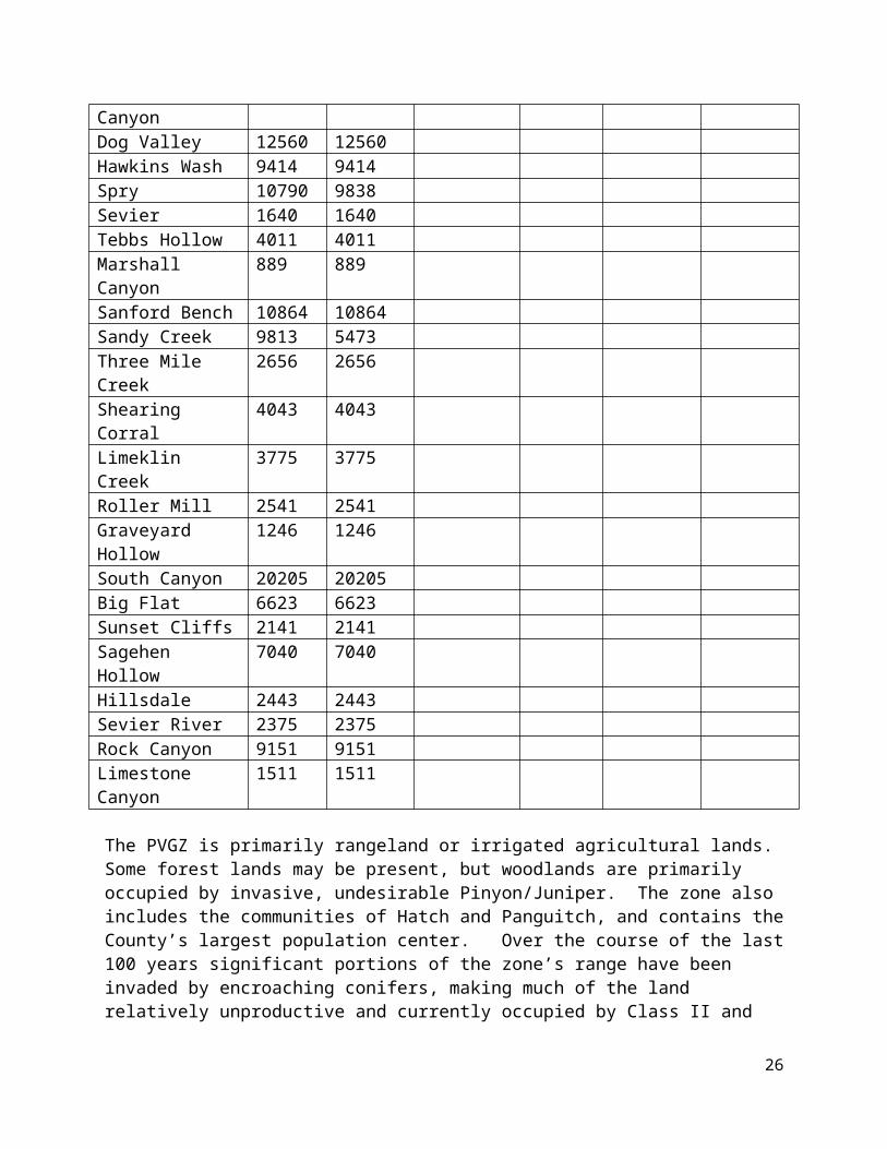
Current SettingThe Panguitch Valley Grazing Zone (PVGZ) is located in the western portion of Garfield County and consists almost entirely of BLM, private and SITLA lands. Parts of the Beaver, Dutton, and Panguitch Lake management areas are within the Panguitch Valley Grazing Zone. Garfield County's portion of the Panguitch Valley Grazing Zone contains all or part of 24 BLM allotments that accommodate approximately X AUM’s.
Panguitch Valley Grazing Zone AllotmentsAllotment Total Acres in # of head Days AUM’s Permit
16
Acres PVGZCove 13970 13970Rocky Ford 12599 4121Circleville Canyon 4609 4609Dog Valley 12560 12560Hawkins Wash 9414 9414Spry 10790 9838Sevier 1640 1640Tebbs Hollow 4011 4011Marshall Canyon 889 889Sanford Bench 10864 10864Sandy Creek 9813 5473Three Mile Creek 2656 2656Shearing Corral 4043 4043Limeklin Creek 3775 3775Roller Mill 2541 2541Graveyard Hollow 1246 1246South Canyon 20205 20205Big Flat 6623 6623Sunset Cliffs 2141 2141Sagehen Hollow 7040 7040Hillsdale 2443 2443Sevier River 2375 2375Rock Canyon 9151 9151Limestone Canyon 1511 1511
The PVGZ is primarily rangeland or irrigated agricultural lands. Some forest lands may be present, but woodlands are primarily occupied by invasive, undesirable Pinyon/Juniper. The zone also includes the communities of Hatch and Panguitch, and contains the County’s largest population center. Over the course of the last 100 years significant portions of the zone’s range have been invaded by encroaching conifers, making much of the land relatively unproductive and currently occupied by Class II and Class III Pinyon/Juniper woodlands. The PVGZ is currently meeting rangeland and forest health standards. However, productivity and land health can be improved in the many allotments. There are a total of 24 allotments in the Pangutich Valley Grazing Zone, X of which are not permitted.
Varying degrees of invasive and noxious weed species are present in the PVGZ. Pinyon-Juniper, musk thistle, rabbit brush, and Russian Knapweed are the most common invasive weeds in the grazing zone, with isolated infestations of Whitetop, Canada Thistle and Scotch Thistle. Some of these weeds are listed by the State and County as noxious weeds and have received control efforts administered by the participants of the Color County Cooperative Weed Management Association.
Livestock grazing in the PVGZ is significantly impacted by big game herd management in the Beaver, Panguitch Lake and Mt. Dutton wildlife management units. Historically, these units have been managed as a limited entry, trophy mule deer herd, and elk populations have been
17
managed by control hunts. The Dutton wildlife management unit is currently meeting objectives for deer (2,700), but has historically failed to manage elk below the authorized maximum objective of 1,500. This is particularly true where management hunts have experienced low success due to limited access, thick vegetation and rugged terrain. Deer utilize almost all private range and agricultural lands at least some time during the year, while elk are more migratory and occupy a much smaller percentage of the private lands
Federal, state, local, and private entities have cooperated to initiate various vegetation treatments to improve vegetation, most recently in response to Greater Sage Grouse conservation concerns. The largest of these initiatives focused on conversion of invasive Pinyon/Juniper woodlands to desirable sagebrush/semi-desert grassland communities. In some areas vegetative production increased as much as 100 fold. Increases in soil retention, natural springs and presence of wildlife were also observed.
Need for Management Change1. Land managers need to expand their efforts to convert Pinyon/Juniper woodlands to desirable vegetative communities. There is an associated need to conduct landscape level environmental analysis to prepare for and facilitate future vegetative restoration projects.
2. Cooperative efforts to control invasive and noxious weeds need to be expanded. Cooperating agencies need to continue to expand the use of the latest technology and integrated weed management techniques to optimize weed control.
3. Land managers need to implement adaptive management to provide greater flexibility to optimize rangeland / forest health, forage production and livestock/wildlife productivity.
4. Big game populations need to be maintained within established population objectives and management plans. Structural and non-structural range improvements need to be repaired where they are damaged by wildlife, particularly elk. Forage production needs to be improved for the benefit of land health, wildlife and livestock. On private lands, UDWR needs to continue cooperating with land owners to mitigate wildlife impacts.
5. Additional water needs to be strategically developed to improve distribution of livestock and for the benefit of wildlife.
Desired ConditionsGarfield County desires:
a) A significant reduction in the lands occupied by Class II and Class III Pinyon/Juniper woodlands and an associated increase in desirable plant communities with a diversity of native and non-native species
b) Greater adaptive management and flexibility in managing forage resources, especially in terms of number of livestock and length of season.
c) Healthy populations of wildlife amenably coexisting with livestock grazing and management.
18
d) Increased vegetation diversity and forage production.
e) All allotments be permitted for grazing; The Hillsdale allotment should be combined with adjacent allotments and fenced as needed. The Pole Canyon allotment should be combined with the Hatch allotment and made available for livestock grazing.
f) Additional water resources be developed on all allotments. If an area is currently closed to livestock grazing, water developments could be used by wildlife until livestock grazing is reintroduced. Solar water pumps and wells could be an asset to several allotments in this grazing region. Findings, Policies, Goals & Objectives
Finding: Conversion of Class II and Class III Pinyon/Juniper woodlands to desirable vegetative communities in the Panguitch Valley Grazing Agricultural Commodity Zone has proven to improve rangeland health and benefit a wide variety of species, especially sage grouse.
Finding: Livestock grazing is compatible with conservation of sage grouse and Utah prairie dog populations. Vegetative and water improvements that benefit one species are not detrimental to the other species.
Policy: Garfield County requires forage enhancement on all allotments which are suitable for livestock grazing.
Policy: Additional water shall be developed in the Panguitch Valley Grazing Agricultural Commodity Zone to benefit livestock and wildlife.
East Fork Grazing Agricultural Commodity ZoneIntroductionThe East Fork Grazing Agricultural Commodity Zone is established in U.C.A. 63J-8-105.8(2)(m) to preserve and protect the agricultural livestock industry from ongoing threats; to preserve and protect the history, culture, custom, and economic value of the agricultural livestock industry from ongoing threats; and to maximize efficient and responsible restoration, reclamation, preservation, enhancement, and development of forage and water resources for grazing, wildlife practices and affected natural, historical, and cultural activities. Located in Garfield and Kane Counties, the livestock grazing zone covers approximately 419,857 acres and is depicted on Map XX.
Current SettingThe East Fork Grazing Zone (EFGZ) is located in Powell District of the Dixie National Forest and extends from Mount Dutton on the north and into Kane County on the south. It is comprised the Tom Best, Flake Mountain, Dave’s Hollow and Paunsaugunt sub regions and includes the East Fork of the Sevier River as it flows from its head waters through Tropic Reservoir to Johns Valley. Garfield County's portion of the East Fork Grazing Zone contains all or part of 19 Forest Service allotments that accommodate approximately 11,000 AUM’s. There are a total of
19

19allotments in the East Fork Zone, four of which are not permitted. The East Fork Grazing Zone contains approximately 289,000 acres with the following livestock conditions:
Entity Acres Allotments AUMsForest Service 136,976BLM land 10,507 acresPrivate 14,699 acres N/A N/ASITLA 38,427 acres
East Fork Grazing Region – Powell District Grazing Allotments and Acres
Allotment Acres # of head Days AUM’s Permit
Blue Fly 20486 193 121 778Clark Mountain 29424 93 131 406Deer Creek 58014 933 116 722Don Spring 454 15 60 30East Fork/Robinson 45117 443 111 1639East Pines 19658 266 131 1162Hatch 9828 45 91 137Heward 1667 0 Not PermittedHillsdale 5991 0 Not PermittedHunt Creek/Cottonwood 50810 930 73 453 Sheep
AllotmentJones Corral 15255 208 131 908Pines 28252 464 131 2026Pole Canyon 5111 464 0 0 Not PermittedRobinson/Lower Blubber 6792 88 111 326
Sheep Creek 2795 40 121 161 Smith Canyon 13655 40 0 0 Not PermittedUpper Blubber 6917 33 121 133 Widstoe 13013 339 131 1480 Willow Springs 20848 162 131 707 Total 354087 4756 1711 11068
As with other areas in Garfield County, invasive weed species are present in site specific locations of the EFGZ. Pinyon-Juniper, musk thistle, rabbit brush, and Russian Knapweed are the most common invasive weeds in the grazing zone. Each of the weed species is under various levels of control.
20

Livestock grazing in the EFGZ is significantly impacted by big game herd management in the Paunsaugunt and Mt. Dutton wildlife management units. Deer and elk habitat in the Paunsaugunt Wild Management Unit is stable throughout most of the range. Paunsaugunt deer and elk winter herd size objectives are 5,200 and 140 respectively. Historically, the Paunsaugunt has been managed as a limited entry, trophy mule deer herd, and elk populations have been managed by control hunts. The Dutton wildlife management unit is currently meeting objectives for deer (2,700), but has historically failed to manage elk below the authorized maximum objective of 1,500. This is particularly true where management hunts have experienced low success due to limited access, thick vegetation and rugged terrain.
State and federal agencies have initiated various vegetation treatments to improve wildlife habitat, most recently in response to greater sage grouse conservation concerns. However, the most significant wildlife habitat improvement during the last several years came as a result of the Sanford fire in 2002. The fire affected a variety of habitats including big game winter and summer range and birthing areas. The Sanford Fire impacted approximately 78,000 acres with half of the area burned and the other half left unaffected. Heavy fuel loadings and decadent vegetation was removed in the burned portions, and there was a corresponding increase in vegetation diversity and forage productivity.
Need for Management Change1. Land managers need to expand their efforts to convert Pinyon/Juniper woodlands to desirable vegetative communities. There is an associated need to conduct landscape level environmental analysis to prepare for and facilitate future vegetative restoration projects.
2. Land managers need to implement adaptive management techniques for areas impacted by the Sanford fire. Additional forage is available, and managers need to consider experimental projects where AUMs are temporarily increased by 10% or more in specific allotments in order to evaluate carrying capacity.
3. Failure to control elk populations within established wildlife objectives negatively impacts forest and rangeland health and livestock grazing resources. Wildlife managers need to manage elk at or below population objectives established prior to January 2015.
4. Damage to structural and non-structural range improvements by wildlife needs to be repaired and mitigated.
5. Insufficient water is being produced by the pipe system in the Pines Allotment. Improvements to the water system, including a solar powered pump need to be implemented.
6. All allotments need to be made available for livestock grazing. Where appropriate currently unavailable allotments may be fenced and/or combined with adjacent allotments to make them suitable for livestock grazing.
Desired ConditionsGarfield County desires:
21
a) Expanded efforts to conduct landscape level NEPA analysis and conduct associated vegetation improvement projects to convert Pinyon/Juniper woodlands to desirable vegetative communities.
b) Greater adaptive management and flexibility including consideration of experimental projects where AUMs are temporarily (3 to 5 years) increased by 10% or more in specific allotments in order to evaluate carrying capacity.
c) Control of wildlife populations below population objectives established prior to January 2015.
d) Repair of structural and non-structural range improvements that have been damaged by wildlife, especially elk that are over population objectives. Repairs should be conducted or paid for by the appropriate wildlife or land management authority.
e) Additional AUMs where appropriate in allotments impacted by the Sanford Fire.
f) Repair of the water system in the Pines Allotment, and increased water development in other areas, including solar powered wells, where appropriate.
g) All allotments are available for livestock grazing. Where appropriate, currently unavailable allotments may be fenced and/or combined with adjacent allotments to make them suitable for livestock grazing.
Findings, Policies, Goals & Objectives
Finding: Grazing and vegetative resources in the East Fork Grazing Agricultural Commodity Zone have not been developed to optimize rangeland/forest health and use by livestock and wildlife.
Goal: Create sustainable, resilient, productive rangeland with diverse vegetation and wildlife which supports optimal levels of livestock grazing through conversion of Class II and Class III Pinyon/Juniper woodlands to desirable vegetative communities in the East Fork Grazing Agricultural Commodity Zone.
Finding: Livestock grazing is compatible with conservation of sage grouse and Utah prairie dog populations. Vegetative and water improvements that benefit one species are not detrimental to the other species.
Policy: Forage enhancements are suitable on all allotments in the East Fork Grazing Agricultural Commodity Zone.
Policy: Additional water shall be developed in the East Fork Grazing Agricultural Commodity Zone to benefit livestock and wildlife. Specifically, water systems shall be improved in the Pines Allotment. Garfield County supports the development of additional water resources, including but not limited to the use of solar powered wells.
22

Policy: Damage to structural and non-structural range improvements shall be completed. Where damaged is attributable to wildlife, repairs should be conducted or paid for by the appropriate wildlife or land management authority.
Policy: Wildlife shall be managed at or below population objectives in place in January 2015. No additional population increases shall be authorized without coordination and concurrence with Garfield County.
Policy: All allotments shall be made available for livestock grazing. Where appropriate, currently unavailable allotments may be fenced and/or combined with adjacent allotments to make them suitable for livestock grazing.
Kingston Canyon Grazing Agricultural Commodity ZoneIntroductionThe Kingston Canyon Grazing Agricultural Commodity Zone is established in U.C.A. 63J-8-105.8(2)(o) to preserve and protect the agricultural livestock industry from ongoing threats; to preserve and protect the history, culture, custom, and economic value of the agricultural livestock industry from ongoing threats; and to maximize efficient and responsible restoration, reclamation, preservation, enhancement, and development of forage and water resources for grazing, wildlife practices and affected natural, historical, and cultural activities. Located in Garfield and Piute Counties, the livestock grazing zone covers approximately 49,026 acres and is depicted on Map XX.
Current SettingThe Kingston Canyon Grazing Zone (KCGZ) is located in the north central area of Garfield County and the southern part of Piute County. Garfield County's portion of the Kingston Canyon Grazing Zone contains all or part of 10 BLM allotments that accommodate approximately X AUM’s. The Kingston Canyon Grazing Zone contains approximately 49,000 acres with the following livestock conditions:
Kingston Canyon Zone BLM
AllotmentTotal Acres
Acres in KCGZ
# of head Days AUM’s Permit
Hunter Spring 3550.37 1948Antimony Ranch 841 841Dry Wash 5658.64 2604Antimony Creek 3992 3992Pole Canyon 6988 6988Sevier River 50.1 50Poison Creek 5222 5222Pine Creek Antimony 13333 13333Johns Valley 5729 5729Center Creek 4546 4546
23
Need for Management Change
No separate management changes have been identified for the Kingston Canyon Agricultural Grazing Commodity Zone. Needs for Management Change for this zone are described in the general livestock grazing section included above.
Desired Conditions
No separate desired conditions have been identified for the Kingston Canyon Agricultural Grazing Commodity Zone. Desired Conditions for this zone are described in the general livestock grazing section included above.
Findings, Policies, Goals & Objectives
No separate findings, policies, goals or objectives have been identified for the Kingston Canyon Agricultural Grazing Commodity Zone. Findings, policies, goals or objectives for this zone are described in the general livestock grazing section included above.
Boulder Mountain Grazing Agricultural Commodity ZoneIntroductionThe Boulder Mountain Grazing Agricultural Commodity Zone is established in U.C.A. 63J-8-105.8(2)(r) to preserve and protect the agricultural livestock industry from ongoing threats; to preserve and protect the history, culture, custom, and economic value of the agricultural livestock industry from ongoing threats; and to maximize efficient and responsible restoration, reclamation, preservation, enhancement, and development of forage and water resources for grazing, wildlife practices and affected natural, historical, and cultural activities. Located in Garfield and Wayne Counties, the livestock grazing zone covers approximately 621,184 acres and is depicted on Map XX.
Current SettingThe Boulder Mountain Agricultural Grazing Commodity Zone (BMGZ) consists primarily of Forest Service administered property with a few inholdings of private and BLM property. The BMGZ border follows the GSENM/BLM boundary on the south and south-east to Capitol Reef National Park, Piute and Wayne Counties on the north and BLM/Private/State property in Johns Valley on the west. The BMGZ is unique due to its many natural lakes spread out across its landscape. BMGZ is a high elevation, high precipitation region and lends itself to productive grazing pastures. Garfield County's portion of the Boulder Mountain Grazing Zone contains all or part of 15 Forest Service allotments that accommodate approximately 11,000 AUM’s. The Boulder Mountain Grazing Zone contains approximately 621,184 acres with the following livestock conditions:
Entity Acres Allotments AUMsForest Service X 15 X
24
BLM land X X XPrivate X X XSITLA X X X
Boulder Grazing Region
AllotmentsTotal Acres
Acres in BMGZ
# of head On Date
Off Date
# of Days AUM's Permit
Boulder 41052 41052 813 16-Jun 15-Oct 121 3279Cameron - Wash 14211 14211 267 11-Jun 10-Oct 121 1077Canaan Mountain 7137 7137Coyote Hollow 74717 74716 1228 16-Jun 15-Oct 121 4953Horse Creek 24325 24325 254 16-Jun 30-Sep 106 898North Creek 70254 70254 734 16-Jun 30-Sep 106 2594Pine Creek 50050 50050 647 16-Jun 30-Sep 106 2286Pine Lake 13987 13987 54 11-Jun 10-Oct 121 218Sand Creek 48046 48046 754 16-Jun 10-Oct 116 2916Sweetwater/ Griffin Top 21172 21172 200 6-Jun 30-Sep 116 773Upper Valley East 17132 17132 366 16-Jun 30-Sep 106 1293Upper Valley West 16425 16419 215 16-Jun 30-Sep 121 867West Deer Creek 30 30 7 1-Jun 10-Oct 131 31
Livestock grazing in the Boulder Mountain Agricultural Grazing Commodity Zone is significantly impacted by big game herd management in the Boulder Unit. Elk in the area are migratory in nature and are significantly over designated population objectives. Elk utilize important forage resources and damage structural and non-structural range improvements. Elk also impact forage and livestock grazing resources on private property. Management hunts have failed to keep population objectives in check.
Need for Management Change1) Land managers need to expand their efforts to convert Pinyon/Juniper woodlands to desirable vegetative communities. There is an associated need to conduct landscape level environmental analysis to prepare for and facilitate future vegetative restoration projects.
2) Failure to control elk populations within established wildlife objectives negatively impacts forest and rangeland health and livestock grazing resources. Wildlife managers need to manage elk at or below population objectives established prior to January 2015.
3) Damage to structural and non-structural range improvements by wildlife needs to be repaired and mitigated.
25
Desired ConditionsGarfield County desires:
a) Expanded efforts to conduct landscape level NEPA analysis and conduct associated vegetation improvement projects to convert Pinyon/Juniper woodlands to desirable vegetative communities.
b) Greater adaptive management and flexibility including consideration of experimental projects where AUMs are temporarily (3 to 5 years) increased by 10% or more in specific allotments in order to evaluate carrying capacity.
c) Control of wildlife populations below population objectives established prior to January 2015.
d) Repair of structural and non-structural range improvements that have been damaged by wildlife, especially elk that are over population objectives. Repairs should be conducted or paid for by the appropriate wildlife or land management authority.
Findings, Policies, Goals & Objectives
Finding: Grazing and vegetative resources in the Boulder Mountain Grazing Agricultural Commodity Zone have not been developed to optimize rangeland/forest health and use by livestock and wildlife.
Goal: Create sustainable, resilient, productive rangeland with diverse vegetation and wildlife which supports optimal levels of livestock grazing through conversion of Class II and Class III Pinyon/Juniper woodlands to desirable vegetative communities in the Boulder Mountain Grazing Agricultural Commodity Zone.
Policy: Forage enhancements are suitable on all allotments in the Boulder Mountain Grazing Agricultural Commodity Zone.
Policy: Damage to structural and non-structural range improvements shall be completed. Where damaged is attributable to wildlife, repairs should be conducted or paid for by the appropriate wildlife or land management authority.
Policy: Wildlife shall be managed at or below population objectives in place in January 2015. No additional population increases shall be authorized without coordination and concurrence with Garfield County.
Policy: All allotments shall be made available for livestock grazing. Where appropriate, currently unavailable allotments may be fenced and/or combined with adjacent allotments to make them suitable for livestock grazing.
Escalante Grazing Region Zone / Escalante Historic - Cultural Grazing RegionIntroduction
26
The Escalante Grazing Region Zone was the first grazing commodity zone designated by the state legislature and is established in U.C.A. 63J-8-105.8(2)(a) to preserve and protect the agricultural livestock industry from ongoing threats; to preserve and protect the history, culture, custom, and economic value of the agricultural livestock industry from ongoing threats; and to maximize efficient and responsible restoration, reclamation, preservation, enhancement, and development of forage and water resources for grazing, wildlife practices and affected natural, historical, and cultural activities. Located in Garfield and Kane Counties, the livestock grazing zone covers approximately 832,385 acres and is depicted on Map XX.
In addition to the Utah State legislative recognition, the designated area has been recognized by the Garfield County Commission as cultural resource of historic and cultural significance and has been designated the Escalante Historic-Cultural Grazing Region. The County has placed the region on its register of cultural resources and has adopted an ordinance governing its management. Grazing activities conducted in the region are cultural resources and ethnographic resources protected by the County’s Protection of Cultural Resources Ordinance and other state and federal law. Federal agencies managing lands in the designated region are required to be consistent with the County’s plan, program and policies to the maximum extent allowed by law.
Current setting:Perhaps more than any other grazing commodity zone in Utah, the Escalante Historic/Cultural Grazing Zone EGZ has been recognized by federal, state and local governments as a historic center for livestock grazing on public land. Livestock grazing is authorized under BLM’s normal multiple use mandate. Additionally, livestock grazing in the Grand Staircase-Escalante National Monument is also recognized and protected by the proclamation issued by President William J. Clinton in September 1996. The importance of livestock grazing was recognized by the President when he indicated “The monument has a long and dignified human history: it is a place where one can see how nature shapes human endeavors in the American West, where distance and aridity have been pitted against our dreams and courage.” Cowboy line camps are specifically identified as objects for which the Monument was designated. In exercising his discretion under the Antiquities Act, President Clinton exempted livestock grazing from laws governing objects in the Monument and protected livestock grazing under existing laws other than the proclamation by the following language, “Nothing in this proclamation shall be deemed to affect existing permits or leases for, or levels of, livestock grazing on Federal lands within the monument; existing grazing uses shall continue to be governed by applicable laws and regulations other than this proclamation.”
Rangeland is the dominant and most important land base resource in this zone. Perennial grasses, forbs, shrubs, and pinyon and juniper trees are the dominant vegetation. These rangelands have been and continue to be grazed by cattle throughout the year. During the winter months, cattle graze on the lower elevations in the southeastern part of the area. Although on a more limited basis, cattle graze during the summer months on the higher elevations in the northern part; and during the fall and spring they graze the southwestern, eastern and central parts.
Generally, water for livestock is supplied through spring developments, wells, catchponds, and a few streams. Almost all water rights in the grazing zone are allocated for livestock. Although these rangelands are known for recreation, analysis indicates less than 10% of the area is
27
managed for recreation, and visitation is extremely limited to non-existent over the vast majority of the grazing zone. The word “recreation” is completely omitted from the 1996 proclamation and was not a designated purpose for Monument creation.
Many of the soils has very productive capabilities. However, the current vegetative resources show the effects of passive management and the lack of natural fires in the ecosystem; therefore, some historical grasslands are covered by decadent sagebrush, rabbitbrush, and large areas of invading pinyon and juniper woodlands. Vegetative capability within the Monument is currently far below potential. The Soil Survey of Grand Staircase- Escalante National Monument produced by the Natural Resources Conservation Services indicates “herbaceous ground cover and grazeable forage may be as little as one-fourth of what it should be, resulting in accelerated erosion. Ground cover and wildlife and livestock forage can be improved using management practices … Some conditions may require accelerated range practices such as brush management, prescribed burning, and/or reseeding with herbaceous plant species.”
Dominant Class II (33% to 66% canopy cover) and Class III (greater than 66% canopy cover) pinyon and juniper are widespread throughout much the grazing zone. Historically, P/J woodlands occur on stony or shallow slopes or in shallow topsoil on mesas and benches. However in this grazing zone pinyon and juniper have invaded deep soils in response to a lack of fire in the ecosystem and poor vegetative cover. These invading stands are usually even-aged and less than 150 years old. Pinyon and juniper woodlands are choking out understory vegetation and causing watershed problems in the area. The woodlands produce substantial runoff and sediment, reducing water quality and magnifying natural erosion. Portions of the grazing zone are also impacted by Tamarisk and Russian Olive. These invasive species dominate limited water supplies, outcompete desirable vegetation and degrade valuable riparian area values.
Biological soil crusts composed of lichens, cyanobacteria, mosses, liverworts and microorganisms, are present in many areas of this grazing commodity zone. Although not completely understood, biological soil crusts are widely believed to contribute to ecosystem stability by means of soil stabilization, nitrogen fixation, and improved growth and establishment of vascular plant species. Biological crusts and vascular plants interact on many levels. The nature and consequences of these interactions vary with crust and plant characteristics and environmental conditions and also vary throughout the plants’ life cycle. However, the relationship between biologic crusts and vascular plants in the EGZ is generally symbiotic and successional rather than competitive.
Need for Management Change
1) Land managers need to provide greater flexibility to optimize rangeland / forest health, forage production and general productivity.
2) Forage production needs to needs to be improved for the benefit of land health, wildlife and livestock.
28
3) In management zones designated by Garfield County as Forage, recreation needs to be managed in a manner that preserves or enhances livestock grazing activities.
4) Resolution of perceived conflicts between recreation and livestock grazing need to be resolved with deference to livestock grazing in areas that are: a) not designated as a focal point for visitor use, b) acreages that receive an average annual visitation less than 25 visitors per day, or c) designated as Forage in Garfield County’s Land Use Management Zones.
5) Where perceived conflicts between recreation and livestock grazing are resolved with deference to recreation, they need to be limited to a) the smallest area possible, b) the least impact on the livestock grazing industry as practical; or c) acreages that receive an average annual visitation greater than 25 visitors per day.
6) Class II and Class III pinyon/juniper woodlands need to be reduced by 25% based on a rolling 10 year average and maintained as desirable sagebrush semi-desert grasslands communities thereafter.
7) Invading Class I conifers in sagebrush semi-desert grassland communities need to be removed and prevented from expanding to Class II status.
8) The symbiotic and successional relationship between biologic crusts and vascular plants needs to be recognized.
9) Consistent with ecologic site descriptions, lands need to be managed for optimum desirable vascular plant production.
10) Biologic soil crusts need to be managed to optimize their contribution to ecosystem stability by means of soil stabilization, nitrogen fixation, and improved growth and establishment of vascular plant species rather than for their potential to exist as a stand-alone, climax resource.
11) Prior to 2026 rangeland conditions need to be improved to accommodate permitted livestock grazing levels (including restoration of suspended AUMs, estimated at 106,000 AUMs) that existed at the time President Clinton protected livestock grazing with the Grand Staircase-Escalante National Monument Proclamation.
12) Livestock grazing in the Escalante Grazing Region Zone needs to be recognized as an activity of cultural and historic significance in accordance with the Monument Proclamation, Utah State law and Garfield County’s Cultural Resource Protection Ordinance.
13) Livestock grazing in the Escalante Grazing Region Zone needs to be recognized as the primary activity that qualifies the areas as a) a frontier, b) a place with a long and dignified human history, c) a place where one can see how nature shapes human endeavors in the American West, and d) a place where distance and aridity have been pitted against our dreams and courage.
29
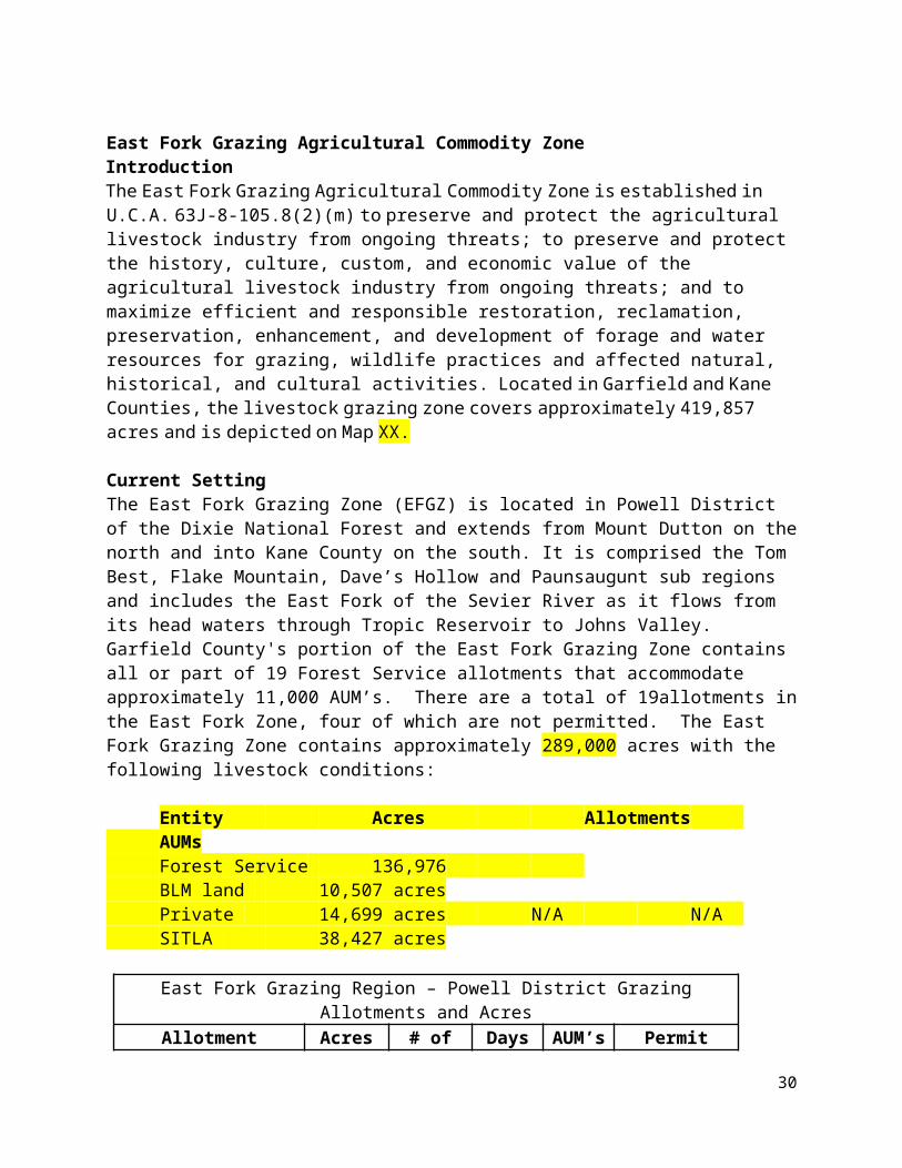
14) Livestock grazing in the Escalante Grazing Region Zone needs to be recognized as a critical element in the County’s custom, culture and heritage.
15) In order to preserve and enhance rangeland health, and consistent with ecologic site condition, land managers need to comply with Garfield County’s plans, policies, programs and ordinances. Specifically, land managers need to take a more active role in optimizing vegetative resources for the benefit of land health, wildlife and livestock.
Desired ConditionsGarfield County desires:
a) Land managers provide greater flexibility to optimize rangeland / forest health, forage production and general productivity.
b) Forage production be improved for the benefit of land health, wildlife and livestock to the level that the goals, plans, policies, programs, and ordinances of Garfield County can be obtained.
c) In management zones designated as Forage by Garfield County, recreation is managed in a manner that preserves or enhances livestock grazing activities.
d) Resolution of perceived conflicts between recreation and livestock grazing are resolved with deference to livestock grazing in areas that are: 1) not designated as a focal point for visitor use, 2) acreages that receive an average annual visitation less than 25 visitors per day, or 3) designated as Forage in Garfield County’s Land Use Management Zones.
e) Where perceived conflicts between recreation and livestock grazing are resolved with deference to recreation, they need to be limited to 1) the smallest area possible, 2) the least impact on the livestock grazing industry as practical; or 3) acreages that receive an average annual visitation greater than 25 visitors per day.
f) Class II and Class III pinyon/juniper woodlands are reduced by 25% based on a rolling 10 year average and maintained as desirable sagebrush semi-desert grasslands communities thereafter.
g) Invading Class I conifers in sagebrush semi-desert grassland communities are removed and prevented from expanding to Class II status.
h) The symbiotic and successional relationship between biologic crusts and vascular plants is recognized.
i) Consistent with ecologic site descriptions, lands are managed for optimum desirable vascular plant production.
30
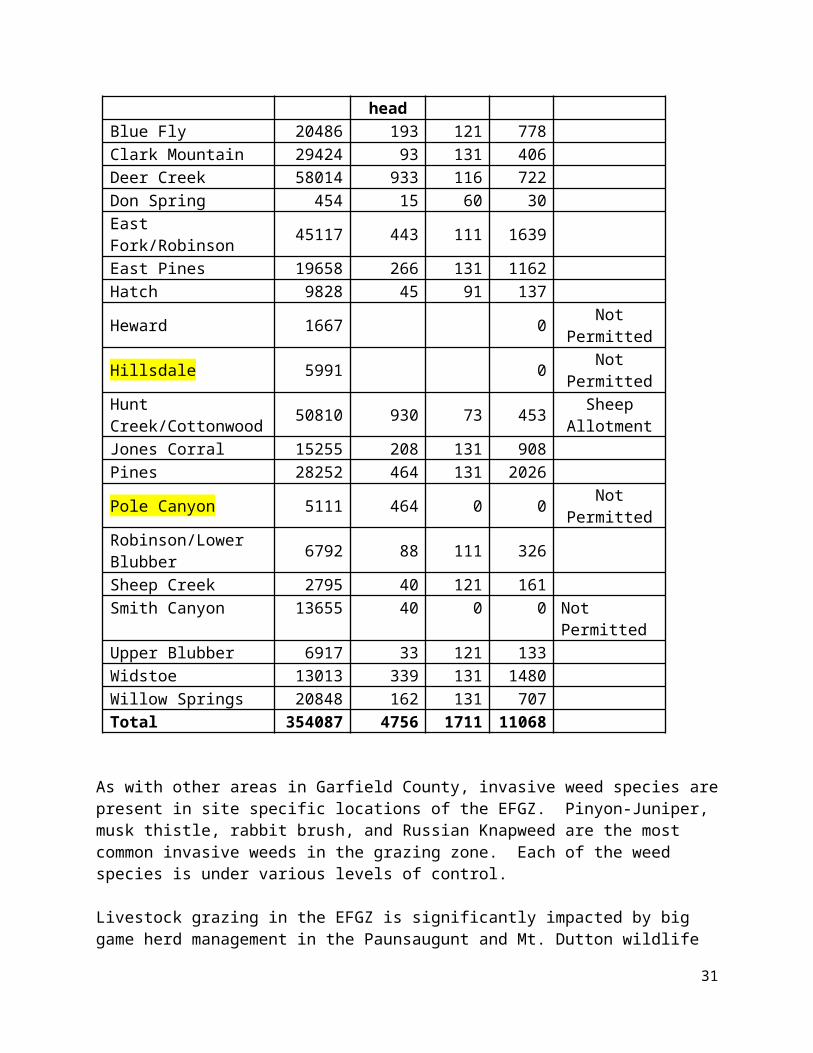
j) Biologic soil crusts are managed to optimize their contribution to ecosystem stability by means of soil stabilization, nitrogen fixation, and improved growth and establishment of vascular plant species rather than for their potential to exist as a stand-alone, climax resource.
k) Prior to 2026 rangeland conditions are improved to accommodate permitted livestock grazing levels (including restoration of suspended AUMs, estimated at 106,000 AUMs) that existed at the time President Clinton protected livestock grazing with the Grand Staircase-Escalante National Monument Proclamation.
l) Livestock grazing in the Escalante Grazing Region Zone is recognized as an activity of cultural and historic significance in accordance with the Monument Proclamation, Utah State law and Garfield County’s Cultural Resource Protection Ordinance.
m) Livestock grazing in the Escalante Grazing Region Zone is recognized as the primary activity that qualifies the areas as 1) a frontier, 2) a place with a long and dignified human history, 3) a place where one can see how nature shapes human endeavors in the American West, and 4) a place where distance and aridity have been pitted against our dreams and courage.
n) Livestock grazing in the Escalante Grazing Region Zone is recognized as a critical element in the County’s custom, culture and heritage.
o) In order to preserve and enhance rangeland health, and consistent with ecologic site condition, land managers comply with Garfield County’s plans, policies, programs and ordinances. Specifically, Garfield County desires land managers take a more active role in optimizing vegetative resources for the benefit of land health, wildlife and livestock.
Findings, Policies, Goals & Objectives
Policy: Garfield County recognizes that certain NPS lands have restrictions that prohibit full implementation of the policies goals and objectives outlined below. Garfield County encourages park service units to cooperate and coordinate with Garfield County to implement favorable grazing policies to the maximum extent permitted by their enabling legislation.
Policy: Grazing in Grand Staircase-Escalante National Monument is governed by BLM’s applicable grazing laws and regulations, independent of protection of objects offered by Proclamation 6920, September 18, 1996.
Finding: Garfield County accepts a plain reading of the Proclamation establishing the Grand Staircase-Escalante National Monument and declares: Nothing in [the] proclamation shall be deemed to affect existing permits or leases for, or levels of, livestock grazing on Federal lands within the monument; existing grazing uses shall continue to be governed by applicable laws and regulations other than [the] proclamation.
Finding: In accordance with NRCS soils reports for the Grand Staircase-Escalante National Monument, Garfield County finds soils are producing less than 25% of their capacity.
31
Finding: Permitted AUMs at the time of Monument designation were approximately 106,000.
Policy: Taking a plain reading of the Monument Proclamation, the minimum annual AUMs in the Grand Staircase-Escalante National Monument are 106,000.
Policy: Failure to improve vegetative resources to provide for 106,000 annual AUMs violates the Monument Proclamation, is inconsistent with state law, is inconsistent with Garfield County’s plan program and policy, and violates Garfield County’s cultural resource ordinance protecting grazing resources in the Escalante Region Grazing Zone.
Finding: Vascular plants and biologic soil crusts have a symbiotic relationship that is not completely understood. Managing for optimal desirable vascular plant health, vigor and diversity is the best method for protecting and promoting the health of biologic soil crusts.
Policy: Until all aspects of the relationship between vascular plants and biologic soils are understood and proven by objective science, management actions that promote the health, vigor and diversity of desirable native and non-native vascular plants is deemed to symbiotically protect and enhance the health of biologic soils.
Finding: Ungrazed reference areas have not been scientifically proven to provide optimal forest and rangeland health and have not been shown to ensure and maximize the quality, objectivity, utility, and integrity of scientific data required by the Data Quality Act. Ungrazed reference areas have not been proven to provide the statistical reliability required by federal law.
Policy: Unless mandated by federal or state law, ungrazed reference areas shall not exceed 0.5% of any allotment or 80 acres, whichever is greater. Data obtained from ungrazed reference areas shall be used only as preliminary indicators and shall not be used as a basis for management actions.
Policy: Land managers shall provide greater flexibility to optimize rangeland / forest health, forage production and general productivity, to the greatest extent allowed by law.
Policy & Goal: Forage production shall be improved for the benefit of land health, wildlife and livestock to the level that the goals, plans, policies, programs, and ordinances of Garfield County can be obtained.
Policy: In management zones designated as Forage by Garfield County, recreation shall be managed in a manner that preserves or enhances livestock grazing activities, unless otherwise approved by the Garfield County Commission.
Policy: Resolution of perceived conflicts between recreation and livestock grazing shall be resolved with deference to livestock grazing in areas that are: 1) not designated as a focal point for visitor use, 2) acreages that receive an average annual visitation less than 25 visitors per day, or 3) designated as Forage in Garfield County’s Land Use Management Zones.
32
Policy: Where perceived conflicts between recreation and livestock grazing shall be resolved with deference to recreation, they need to be limited to 1) the smallest area possible, 2) the least impact on the livestock grazing industry as practical; or 3) acreages that receive an average annual visitation greater than 25 visitors per day.
Policy & Goal: Class II and Class III pinyon/juniper woodlands shall be reduced by 25% based on a rolling 10 year average and maintained as desirable sagebrush semi-desert grasslands communities thereafter.
Policy & Goal Invading Class I conifers in sagebrush semi-desert grassland communities are removed and prevented from expanding to Class II status.
Finding, Policy & Goal: The symbiotic and successional relationship between biologic crusts and vascular plants shall be recognized.
Policy & Goal: Consistent with ecologic site descriptions, lands are managed for optimum desirable vascular plant production.
Policy & Goal: Biologic soil crusts shall be managed to optimize their contribution to ecosystem stability by means of soil stabilization, nitrogen fixation, and improved growth and establishment of vascular plant species rather than for their potential to exist as a stand-alone, climax resource.
Policy, Goal & Objective: Prior to 2026 rangeland conditions shall be improved to accommodate permitted livestock grazing levels (including restoration of suspended AUMs, estimated at 106,000) that existed at the time President Clinton protected livestock grazing with the Grand Staircase-Escalante National Monument Proclamation.
Finding & Policy: Livestock grazing in the Escalante Grazing Region Zone is an activity of cultural and historic significance in accordance with the Monument Proclamation, Utah State law and Garfield County’s Cultural Resource Protection Ordinance.
Finding & Policy: Livestock grazing in the Escalante Grazing Region Zone is the primary activity that qualifies the areas as 1) a frontier, 2) a place with a long and dignified human history, 3) a place where one can see how nature shapes human endeavors in the American West, and 4) a place where distance and aridity have been pitted against our dreams and courage.
Finding & Policy: Livestock grazing in the Escalante Grazing Region Zone is a critical element in the County’s custom, culture and heritage.
Finding & Policy: In order to preserve and enhance rangeland health, and consistent with ecologic site condition, land managers shall comply with Garfield County’s plans, policies, programs and ordinances. Specifically, Garfield County requires land managers take a more active role in optimizing vegetative resources for the benefit of land health, wildlife and livestock.
33
Finding: Livestock grazing decisions that are not consistent/compliant with this RMP needs to be revisited by the managing agency within 5 years or at the next amendment/revision process whichever occurs first.
Goal: Create sustainable, resilient, productive rangeland with diverse vegetation and wildlife which supports optimal levels of livestock grazing.
Henry Mountains Grazing Agricultural Commodity ZoneIntroductionThe Henry Mountains Grazing Agricultural Commodity Zone is established in U.C.A. 63J-8-105.8(2)(ll) to preserve and protect the agricultural livestock industry from ongoing threats; to preserve and protect the history, culture, custom, and economic value of the agricultural livestock industry from ongoing threats; and to maximize efficient and responsible restoration, reclamation, preservation, enhancement, and development of forage and water resources for grazing, wildlife practices and affected natural, historical, and cultural activities. Located entirely in Garfield County, the livestock grazing zone covers approximately XXX,XXX acres and is depicted on Map XX.
Current SettingThe Henry Mountains Grazing Zone (HMGZ) is located is the eastern part of Garfield County, just north of Lake Powell. Within this area, almost 2 million acres of public land are administered by the Bureau of Land Management. There is a wide variety of multiple uses including mining, recreation, and grazing. This area of Garfield County is one of the driest and least productive from a vegetative standpoint. Some of Capitol Reef National Park is located within the Henry Mountain Grazing Zone.
Henry Mountains Zone
AllotmentTotal Acres Acres in HMGZ # of head Days
AUM’s
Permit
Nasty Flat 17776 17776Steel Butte 82625.86 73168
Blue Bench111701.3
1 2176Crescent Creek 9893.16 9893Trachyte 58723.37 58723Pennell 63307.23 63307Bull Frog 93407.56 93408Waterpocket 72870.25 62915Rockies 172961Cedar Point 59604.12 59350Burr Point 72701.09 21308
34
Sandy #1 30094.14 6Sandy #2 56015.69 55175Sandy #3 6177.3 6177Hankville 96279.82 1
As with most areas in the County, vegetation is a basic resource component for grazing in the HMGZ. The area’s four major vegetation communities are pinyon/juniper, saltbush, grassland, and blackbrush. Specific areas of concern include riparian areas, poisonous and noxious plants, and site specific areas defined as being ecologically unique.
Little forage is produced in the pinyon/juniper zone for livestock and large wildlife species. Tree roots deplete the soil of available moisture and nutrients. As a result, understory forage species are often scarce or altogether absent. These areas are also prone to erosion and soil loss as a result of precipitation events.
Generally, the saltbush zone produces a mixture of browse and grass species for livestock grazing. Species that are most common are four-wing saltbrush, shadscale, Mormon tea, galleta, blue gramma, and Indian ricegrass. Although most saltbrush areas are accessible to livestock, use is limited or precluded to some degree by the lack of stock water. Reservoirs are the main source of water but are often dry during the spring and winter months.
Blackbrush communities support stands of forage species, such as Mormon tea, Indian ricegrass, and galleta, which are useful for livestock grazing in fall, spring, and winter. In general, cattle do not use blackbrush if other forage is available.
Riparian areas are generally accessible to livestock and are heavily used because of their relatively lush vegetation, availability of water, and shade. Riparian areas constitute less than 1 percent of vegetation in the grazing zone.
Poisonous and undesirable vegetation, including noxious and invasive plants, are present throughout the grazing zone, but generally do not occur in concentrations sufficient to pose a significant threat to livestock. Additionally, site specific locations and isolated mesa tops are scattered throughout the area and some may contain vegetation types that are ecologically unique. Some of these sites be considered relict areas because inaccessibility limits or prevents livestock and wildlife grazing. These areas are extremely limited in size and only occur sporadically. Their inaccessibility provides some degree of natural protection from resource damage.
Water is scarce over most of the grazing zone and is often a limiting factor for livestock. Snow provides some water to wintering animals, however, if there is insufficient snow, permittees must haul water. Although there are numerous reservoirs, they are generally not very dependable. Most of the water supplied for these reservoirs comes as relatively unpredictable runoff in summer and fall. The soil is permeable, and water that collects in these reservoirs often seeps out or has evaporated by the time livestock enter the area. Wells, pipelines, and springs are more
35
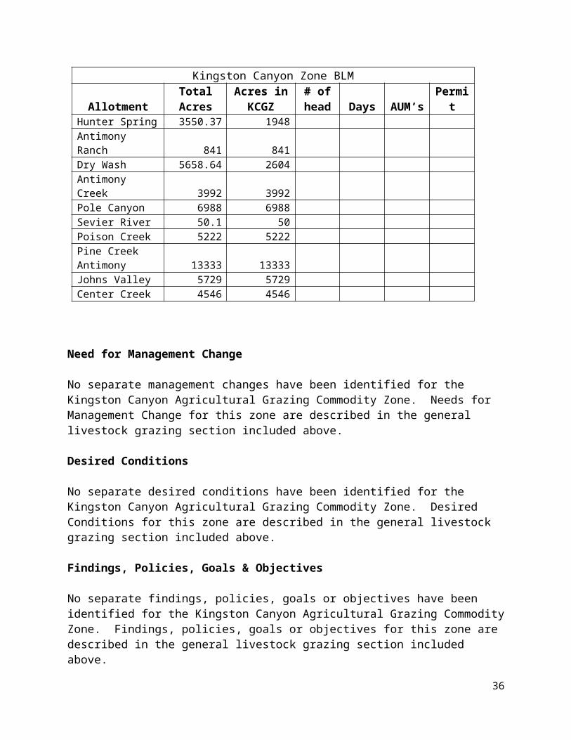
reliable, but they are difficult or infeasible in many areas. Guzzlers are to some degree more successful than reservoirs because they have a smaller area of water surface exposed to evaporation and they can be more easily sealed to prevent leakage.
Need for Management Change
1) Land managers need to continue implementing Utah’s Standards for Healthy Rangelands and Guidelines for Grazing, but do so in a more aggressive and active approach.
2) Increased adaptive management needs to be implemented, including consideration of localized or well-timed precipitation events that may result in adequate forage for specific areas in spite of long term or regional drought conditions.
3) Action needs to be taken to significantly improve desirable forage. Particular attention needs to be paid to conversion of pinyon/juniper communities to more desirable and beneficial vegetation and increased ground cover.
4) Aggressive action needs to be taken to significantly improve water resources in the area, including development of wells, retention of stormwater and maintenance of ponds and other water related range improvements.
5) Flexibility needs to be added to optimize on / off dates, timing, duration, intensity and other aspects of livestock grazing. Operations need to be governed by resource conditions rather than calendar dates.
6) Forage allocation needs to be continually updated to optimize use of livestock grazing related resources, including relinquished allotments, changes from realty actions, improved forage, newly developed water resources, changes in season of use or livestock class, or other pertinent factors.
7) Land managers need to efficiently address relinquishment of livestock grazing privileges and requests to reallocate available forage. Preference needs to be given to livestock grazing activities wherever possible.
8) Forage allocation needs to be addressed on allotments with no forage licensed for livestock use.
9) Access for maintaining range improvements needs to be acknowledged and maintained. Where access uses the County’s transportation network, County asserted roads, paths, ways, and trails need to be recognized and considered public facilities under County jurisdiction.
10) Where increasing recreation results in increased conflicts with livestock grazing, land managers need to mitigate the conflicts limiting livestock grazing restrictions to the smallest
36
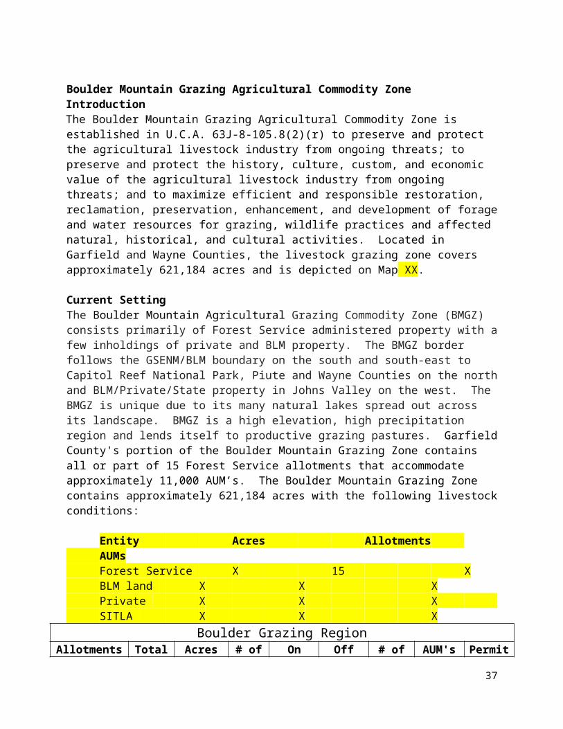
acreage and impact possible. Unless mandated by federal or state law, or approved by the Garfield County Commission, preference shall be given to livestock grazing activities.
11) Riparian areas need to be managed to optimize use of resources by livestock grazing activities while protecting and enhancing riparian conditions. Riparian resources need to be managed on a site specific basis where mutual benefit to the resource and livestock grazing are achieved.
Desired ConditionsGarfield County desires:
a) Continued implementation of Utah’s Standards for Healthy Rangelands and Guidelines for Grazing.
b) Increased adaptive management including consideration of localized or well-timed precipitation events that may result in adequate forage for specific areas in spite of long term or regional drought.
c) Action is taken to significantly improve desirable forage. The County desires particular attention be given to conversion of pinyon/juniper communities to more desirable and beneficial vegetation and increased ground cover.
d) Vastly improved water resources including but not limited to development of wells, retention of stormwater and maintenance of ponds and other water related range improvements.
e) Added flexibility to optimize on / off dates, timing, duration, intensity and other aspects of livestock grazing. The County desires livestock operations be governed by resource conditions rather than calendar dates.
f) Forage allocations are continually updated to optimize use of livestock grazing related resources, including relinquished allotments, changes from realty actions, improved forage, development of new water resources, changes in season of use or livestock class, or other pertinent factors.
g) Land managers efficiently address relinquishment of livestock grazing privileges and requests to reallocate available forage. Desired conditions include preference is given to livestock grazing activities wherever possible.
h) Forage allocation are addressed on allotments with no forage licensed for livestock use and consideration be given to making lands available for livestock grazing.
i) Access for maintaining range improvements is acknowledged and maintained. Where access uses the County’s transportation network, County asserted roads, paths, ways, and trails are recognized and considered public facilities under County jurisdiction.
37

j) Where increasing recreation results in increased conflicts with livestock grazing, land managers mitigate the conflicts limiting livestock grazing restrictions to the smallest acreage and impact possible. Unless mandated by federal or state law, or approved by the Garfield County Commission, preference is given to livestock grazing activities.
k) Riparian areas are managed to optimize use of resources by livestock grazing activities while protecting and enhancing riparian conditions. Riparian resources are managed on a site specific basis where mutual benefit to the resource, land health and livestock grazing are achieved.
Findings, Policies, Goals & Objectives
Policy: Garfield County recognizes that certain NPS lands have restrictions that prohibit full implementation of the policies, goals and objectives outlined herein. Garfield County encourages park service units to cooperate and coordinate with Garfield County to implement policies to the maximum extent permitted by their enabling legislation.
Policy & Goal: Increase adaptive management including consideration of localized or well-timed precipitation events that may result in adequate forage for specific areas in spite of long term or regional drought.
Policy & Goal: Significantly improve desirable forage. The County desires particular attention be given to conversion of pinyon/juniper communities to more desirable and beneficial vegetation and increased ground cover.
Policy & Goal: Vastly improve water resources including but not limited to development of wells, retention of stormwater and maintenance of ponds and other water related range improvements.
Policy: Land managers shall increase flexibility to optimize on / off dates, timing, duration, intensity and other aspects of livestock grazing. The County desires livestock operations be governed by resource conditions rather than calendar dates.
Policy: Forage allocations shall be continually updated to optimize use of livestock grazing related resources, including relinquished allotments, changes from realty actions, improved forage, development of new water resources, changes in season of use or livestock class, or other pertinent factors.
Policy & Goal: Land managers shall efficiently address relinquishment of livestock grazing permits and requests to reallocate available forage. Desired conditions include preference is given to livestock grazing activities wherever possible. Relinquished permits shall be reallocated within 1 year whenever possible.
Policy: Forage allocations shall be addressed on allotments with no forage permitted for livestock use and consideration be given to making lands available for livestock grazing prior to .
38
Policy: Access for maintaining range improvements shall be acknowledged and maintenance authorized prior to 2020. Where access uses the County’s transportation network, County asserted roads, paths, ways, and trails shall recognized and considered public facilities under County jurisdiction.
Policy: Where increasing recreation results in increased conflicts with livestock grazing, land managers shall mitigate the conflicts limiting livestock grazing restrictions to the smallest acreage and impact possible. Unless mandated by federal or state law, or approved by the Garfield County Commission, preference shall be given to livestock grazing activities.
Finding & Policy: Riparian resources are extremely limited in the grazing zone. Riparian areas shall be managed to optimize use of resources by livestock grazing activities while protecting and enhancing riparian conditions. Riparian resources shall be managed on a site specific basis where mutual benefit to the resource, land health and livestock grazing are achieved.
Glen Canyon Grazing Agricultural Commodity ZoneIntroductionThe Glen Canyon Grazing Agricultural Commodity Zone is established in U.C.A. 63J-8-105.8(2)(mm) to preserve and protect the agricultural livestock industry from ongoing threats; to preserve and protect the history, culture, custom, and economic value of the agricultural livestock industry from ongoing threats; and to maximize efficient and responsible restoration, reclamation, preservation, enhancement, and development of forage and water resources for grazing, wildlife practices and affected natural, historical, and cultural activities. Located entirely in Garfield County, the livestock grazing zone covers approximately 561,113 acres and is depicted on Map XX.
The Glen Canyon area was the first portion of Garfield County to be used for domestic livestock grazing. The first domestic animals were likely brought into Garfield County as part of the Dominquez-Escalante expedition which traversed the region and led cattle across the Colorado River in 1776. The first serious attempts at using the range were in the 1860s, when the introduction of sheep in the region began. John Atlantic Burr constructed what is now the Burr Trail Road switchbacks to facilitate moving his sheep from summer to winter range east of Capitol Reef National Park. Settlers brought small numbers of livestock to the area in the early 1870s as Escalante and Boulder were settled. During the early part of the 20th century, the Glen Canyon Grazing Zone was historically grazed by sheep, though there are no domestic sheep in the area at this time. When the Glen Canyon National Recreation area was designated in 1972, the enabling legislation authorized grazing, which had occurred in the area for about 100 years.
Glen Canyon BLMAllotment Total Acres Acres in GCGZ # of head Days AUM’s1 Permit
Cedar Point 59604.12 59350Burr Point 72701.09 21308Sewing Machine 131530.55 131529 1,599Rockies 172961.38 172960
39
5,228Waterpocket 72870.25 62915 3,007Trachyte 58723.37 58723Robbers Roost 204324.95 514
Current setting:Under the provisions of its enabling legislation Glen Canyon NRA is managed by the National Park Service (NPS), which mandates the protection of the natural, cultural, and historic resources of the area. Grazing is managed jointly by the NPS and Bureau of Land Management (BLM), which administers grazing permits and implements a grazing program which integrates NPS stewardship responsibilities that protect the values and purposes of Glen Canyon NRA. Glen Canyon NRA values the vegetation, soil, water quality, wildlife, cultural, paleontological, scenic, and recreational resources that make up the scenic, scientific, and historic features which define the outdoor recreational use and enjoyment of Glen Canyon NRA.
A Grazing Management Plan was developed to help managers make informed decisions and manage threats to resources. This plan encourages sound grazing practices to minimize or avoid impacts to area resources. Four BLM resource areas administer 34 grazing allotments that partially or entirely occur within Glen Canyon NRA. Grazing is permitted on 28 of those allotments. The BLM generally issues ten-year grazing permits and monitors the land. When permits are renewed, grazing practices are evaluated and alterations can be made if necessary. The BLM works closely with Glen Canyon staff to ensure that Glen Canyon resource conditions are not impaired. About 882,678 of Glen Canyon NRA’s 1.2 million acres are in allotments, 85% of this area was subject to grazing use in 1998.
The rangeland in Glen Canyon NRA is arid to semi-arid with annual rainfall that varies from 4 – 12 inches year to year. Winters are cold, summers are hot. Vegetation includes primarily shrublands and grasslands, and about 8% pinyon-juniper woodlands. Perennial grasslands are relatively rare, but provide much of the available forage for cattle. Animal Unit Months (AUMs) help determine use on allotments of this rangeland. Total acres for AUMs are frequently suspended or altered due to conditions of drought, availability of forage, and other considerations. In the 1990s, AUMs and numbers of livestock fluctuated by allotment as a result of economic changes and drought. In Glen Canyon NRA the total acres per AUM varies from 17 acres in Upper Cattle Allotment to 193 acres in Rock Creek-Mudholes Allotment. Because portions of most allotments have cliffs, slick rock, and other areas which cannot be grazed, the grazable acres per AUM are generally lower than the reported acres. Most grazing in Glen Canyon NRA occurs between November and May during the cool winter months.
Grazing continues a 100+ year history of ranching in the Glen Canyon area, but must be managed to protect the purposes and values of Glen Canyon NRA established by its enabling legislation. Cooperative management by the NPS and BLM that integrates those values and purposes will support continued sound grazing practices in Glen Canyon NRA.
Need for Management Change
40
1) Increased adaptive management needs to be implemented, including consideration of localized or well-timed precipitation events that may result in adequate forage for specific areas in spite of long term or regional drought conditions.
2) Action needs to be taken to significantly improve desirable forage for land health and to meet the purposes of Glen Canyon NRA. Particular attention needs to be paid to conversion of pinyon/juniper communities to more desirable and beneficial vegetation and increased ground cover. As forage is improved, livestock grazing needs to be adjusted accordingly.
3) Aggressive action needs to be taken to significantly improve water resources in the area, including development of wells, retention of stormwater and maintenance of ponds and other water related range improvements. Improved water resources benefit a variety of public uses, including recreation and purposes outlined in Glen Canyon National Recreation Area’s enabling legislation.
4) Flexibility needs to be added to optimize on / off dates, timing, duration, intensity and other aspects of livestock grazing. Operations need to be governed by resource conditions rather than calendar dates.
5) Forage allocation needs to be continually updated to optimize use of livestock grazing related resources, including relinquished allotments, changes from realty actions, improved forage, newly developed water resources, changes in season of use or livestock class, or other pertinent factors.
6) Land managers need to efficiently address relinquishment of livestock grazing privileges and requests to reallocate available forage. Preference needs to be given to livestock grazing activities wherever possible while considering the special conditions in the National Recreation Area.
7) Forage allocation needs to be addressed on allotments with no forage licensed for livestock use.
8) Access for maintaining range improvements needs to be acknowledged and maintained. Where access uses the County’s transportation network, County asserted roads, paths, ways, and trails need to be recognized and considered public facilities under County jurisdiction.
9) Where increasing recreation results in increased conflicts with livestock grazing, land managers need to mitigate the conflicts limiting livestock grazing restrictions to the smallest acreage and impact possible. Unless mandated by federal law, Glen Canyon NRA enabling legislation, state law, or approved by the Garfield County Commission, to livestock grazing activities shall be accommodated to the maximum extent possible.
41
10) Riparian areas need to be managed to optimize resource protection while accommodating livestock grazing activities. Riparian resources need to be managed on a site specific basis where mutual benefit to the resource, recreation and livestock grazing are achieved.
Desired ConditionsGarfield County desires:
a) Increased adaptive management including consideration of localized or well-timed precipitation events that may result in adequate forage for specific areas in spite of long term or regional drought.
b) Action is taken to significantly improve desirable vegetative ground cover. The County desires particular attention be given to conversion of pinyon/juniper communities to more desirable and beneficial vegetation and increased ground cover for improved land health.
c) Vastly improved water resources including but not limited to development of wells, retention of stormwater and maintenance of ponds and other water related range improvements. Water development benefits all land uses.
d) Added flexibility to optimize on / off dates, timing, duration, intensity and other aspects of livestock grazing. The County desires livestock operations be governed by resource conditions rather than calendar dates.
e) Forage allocations are continually updated to optimize use of livestock grazing related resources, including relinquished allotments, changes from realty actions, improved forage, development of new water resources, changes in season of use or livestock class, or other pertinent factors.
f) Land managers efficiently address relinquishment of livestock grazing privileges and requests to reallocate available forage. Desired conditions include preference is given to livestock grazing activities wherever possible.
g) Forage allocation are addressed on allotments with no forage licensed for livestock use and consideration be given to making lands available for livestock grazing.
h) Access for maintaining range improvements is acknowledged and maintained. Where access uses the County’s transportation network, County asserted roads, paths, ways, and trails are recognized and considered public facilities under County jurisdiction.
i) Where increasing recreation results in increased conflicts with livestock grazing, land managers mitigate the conflicts limiting livestock grazing restrictions to the smallest acreage and impact possible. Unless mandated by federal or state law, or approved by the Garfield County Commission, it is desired that accommodations are is given to livestock grazing activities.
42
j) Riparian areas are managed to optimize use of resources by livestock grazing activities while protecting and enhancing riparian conditions. Riparian resources are managed on a site specific basis where mutual benefit to the resource, land health, recreation, and livestock grazing are achieved.
Findings, Policies, Goals & Objectives
Policy: Garfield County recognizes that certain NPS lands have restrictions that prohibit full implementation of the policies, goals and objectives outlined herein. Garfield County encourages park service units to cooperate and coordinate with Garfield County to implement policies to the maximum extent permitted by their enabling legislation.
Policy & Goal: Increase adaptive management including consideration of localized or well-timed precipitation events that may result in adequate forage for specific areas in spite of long term or regional drought.
Policy & Goal: Significantly improve desirable forage. The County desires particular attention be given to conversion of pinyon/juniper communities to more desirable and beneficial vegetation and increased ground cover.
Policy & Goal: Vastly improve water resources including but not limited to development of wells, retention of stormwater and maintenance of ponds and other water related range improvements.
Policy: Land managers shall increase flexibility to optimize on / off dates, timing, duration, intensity and other aspects of livestock grazing. The County desires livestock operations be governed by resource conditions rather than calendar dates.
Policy: Forage allocations shall be continually updated to optimize use of livestock grazing related resources, including relinquished allotments, changes from realty actions, improved forage, development of new water resources, changes in season of use or livestock class, or other pertinent factors.
Policy & Goal: Land managers shall efficiently address relinquishment of livestock grazing permits and requests to reallocate available forage. Desired conditions include preference is given to livestock grazing activities wherever possible. Relinquished permits shall be reallocated within 1 year whenever possible.
Policy: Forage allocations shall be addressed on allotments with no forage permitted for livestock use and consideration be given to making lands available for livestock grazing prior to .
Policy: Access for maintaining range improvements shall be acknowledged and maintenance authorized prior to 2020. Where access uses the County’s transportation network, County asserted roads, paths, ways, and trails shall recognized and considered public facilities under County jurisdiction.
43
Policy: Where increasing recreation results in increased conflicts with livestock grazing, land managers shall mitigate the conflicts limiting livestock grazing restrictions to the smallest acreage and impact possible. Unless mandated by federal or state law, or approved by the Garfield County Commission, preference shall be given to livestock grazing activities.
Finding & Policy: Riparian resources are extremely limited in the grazing zone. Riparian areas shall be managed to optimize use of resources by livestock grazing activities while protecting and enhancing riparian conditions. Riparian resources shall be managed on a site specific basis where mutual benefit to the resource, land health and livestock grazing are achieved.
References:Utah BLM Rangeland Health Standards
Chapter 4 Pinyon/Juniper Woodlands, USDA Forest Service Gen. Tech. Rep. RMRS-GTR-202. 2007
https://www.fs.usda.gov/Internet/FSE_DOCUMENTS/stelprdb5434337.pdf, January 19, 2017, Pinyon-Juniper Natural Range of Variation
Presidential Proclamation 6920, September 18, 1996
44