Galway Untreated Agglomerations Study · Galway Untreated Agglomerations Study Roundstone Pumping...
51
Galway Untreated Agglomerations Study Roundstone Pumping Stations Site Selection Report 01 November 2019 Irish Water
Transcript of Galway Untreated Agglomerations Study · Galway Untreated Agglomerations Study Roundstone Pumping...

Galway Untreated Agglomerations Study
Roundstone Pumping Stations Site Selection Report
01 November 2019
Irish Water


386624-MMD-Ro-00-RP-1401 Mott MacDonald
Mott MacDonald 5 Eastgate Avenue Eastgate Little Island Co Cork T45 EE72 Ireland T +353 (0)21 480 9800
mottmac.com
Irish Water Colvill House, 24 - 26 Talbot Street Dublin 1, Ireland
Galway Untreated Agglomerations Study
Roundstone Pumping Stations Site Selection Report
01 November 2019
Directors: J T Murphy BE HDipMM CEng FIEI FConsEI FIAE (Managing), D Herlihy BE MSc CEng, R Jefferson BSC MSCS MRICS MCIArb DipConLaw, J Shinkwin BE DipMechEng CEng MIEI, K Howells BSc MBA CEng MICE MCIWEM (British) Innealtoirí Comhairleach (Consulting Engineers) Company Secretary: Ian Kilty BA (Hons) ACA Registered in Ireland no. 53280. Mott MacDonald Ireland Limited is a member of the Mott MacDonald Group
Irish Water


Mott MacDonald | Galway Untreated Agglomerations Study Roundstone Pumping Stations Site Selection Report
386624-MMD-Ro-00-RP-1401 | 01 November 2019
Issue and Revision Record
Revision Date Originator Checker Approver Description
A 28 Aug
2019
C Healy
P Forde
J Barnard J Barnard Draft for Client Review
B 09 Sept
2019
P Forde D Duggan J Barnard Updated following Client Review
C 24 Oct
2019
P Forde D Duggan J Barnard Updated following Client
Comments
D 01 Nov
2019 P Forde D Duggan J Barnard Final Issue
Document reference: 386624-MMD-Ro-00-RP-1401
Information class: Standard
This document is issued for the party which commissioned it and for specific purposes connected with the above-
captioned project only. It should not be relied upon by any other party or used for any other purpose.
We accept no responsibility for the consequences of this document being relied upon by any other party, or being
used for any other purpose, or containing any error or omission which is due to an error or omission in data supplied
to us by other parties.
This document contains confidential information and proprietary intellectual property. It should not be shown to other
parties without consent from us and from the party which commissioned it.
This Re por t has be en p rep are d solely for use by t he p arty w hich c om mission ed it (the 'Client') i n co nnecti on wit h the cap tione d p roject . It s hould not be used for any oth er p urp ose. N o p erso n ot her tha n th e Client or any party who has expr essly a gre ed t er ms of relia nce wit h us (the 'Recipie nt(s )') m ay r ely on the cont ent, info rma tion or any view s exp ress ed in the R epo rt. This R epo rt is co nfide ntial and c ont ains p rop riet ary in tellect ual p rop erty and we ac cept no duty of ca re, resp onsibility or li ability t o any oth er recipi ent o f this R epo rt. N o re pre sent ation , wa rran ty o r un dert aking , exp ress or i mplie d, is made an d no res ponsi bility or liability is acce pted by us to any p arty oth er t han the Cli ent or a ny Reci pient (s), as t o the accu racy or c om plete ness of th e info rm ation cont aine d in t his Rep ort. Fo r t he av oida nce o f do ubt t his Re port do es no t in any way pu rpo rt to includ e a ny leg al, ins ura nce or fin ancial advic e or opini on.
We disclaim all a nd a ny liability whet her arisi ng in tort , con trac t or oth erwise which w e mi ght o the rwise h ave to a ny p arty othe r th an t he Clie nt o r th e Recipi ent (s), i n res pect of t his Rep ort, or any i nfor mati on c ontai ned i n it. We acce pt n o re spo nsibility fo r a ny e rro r o r o mission i n th e Rep ort w hich is due to a n e rro r or omis sion in dat a, inf or matio n o r stat em ents s upplie d to us by oth er parti es incl uding the Client (th e 'Data') . We h ave not i ndep end ently v erifi ed th e Dat a o r ot herwis e exa mine d it t o de ter mine the accu racy, com plete ness, sufficie ncy f or a ny p ur pose or f easibility for any partic ular outc om e inclu ding fi nanci al.
For ecasts pre sent ed in this d ocu ment wer e p repa red usin g th e Dat a an d th e Rep ort is de pend ent or base d on the Data. Ine vitably, som e of the assu mptio ns us ed t o de velop the for ecasts will not be realis ed a nd u nan ticipat ed ev ents and circu msta nces may occu r. Co nseq uently , we do n ot g uar ante e o r war ran t th e con clusions con taine d in t he R epo rt as the re a re lik ely to be di ffer ences betw een the for ecasts an d the actu al r esults and thos e diff ere nces may be mate rial. W hile we c onsid er t hat t he i nfor mati on a nd o pinio ns give n in this Re port ar e so und a ll partie s mu st r ely on thei r own skill an d jud gem ent w hen maki ng u se of it.
Infor mati on a nd o pinio ns ar e cu rre nt o nly as of t he d ate of th e Re port and we a ccept no resp onsibility for up datin g suc h info rm ation or opinio n. It sho uld, t her efo re, n ot b e ass ume d th at a ny suc h inf orm ation or opini on co ntin ues t o be accu rate subs equ ent t o th e d ate of th e Rep ort. Und er no cir cums tanc es m ay this R epo rt o r a ny ext ract or s um mar y the re of be use d in c onn ection with a ny p ublic o r p rivate secu rities offe ring i ncludin g a ny r elate d me mo ran dum or pro spect us fo r a ny sec urities off ering or stock exch ange listing or ann ounc eme nt.
By accept ance of t his Rep ort you agr ee t o be bou nd by this disclai mer. This disclai mer and any is sues, disp utes or clai ms a rising out of o r in c onn ection with it (whe the r co ntrac tual or non -cont ract ual in nat ure such as clai ms in tort , fr om b re ach o f stat ute or reg ulatio n or oth erwise ) sh all be gove rne d by , an d con stru ed in acco rda nce wit h, t he laws of En gland an d Wales to t he excl usion of all conflict of law s pri nciples and rul es. All disp utes or cl aims arising out of or r elatin g to this di sclaim er sh all be subj ect to the exclusiv e juris dictio n of t he En glish a nd W elsh co urts t o whic h th e pa rties i rrev ocably sub mit.

Mott MacDonald | Galway Untreated Agglomerations Study Roundstone Pumping Stations Site Selection Report
386624-MMD-Ro-00-RP-1401 | 01 November 2019
Contents
1 Introduction 1
1.1 Strategic Overview 1
1.2 Project Overview 1
1.3 Roundstone 2
1.4 Project Need 3
1.5 Purpose of this Site Selection Report 5
1.6 Site Selection Process 5
1.6.1 Stage 1 – Project Need and Scope 5
1.6.2 Stage 2: Identification of Site Options 5
1.6.3 Stage 3: Site Assessment 5
2 Stage 1: Project Need and Scope 7
2.1 Proposed Infrastructure 7
2.2 Technical Scope - Pumping Stations and Rising Mains 7
2.2.1 Terminal Pumping Station at Network 1 Outfall 7
2.2.2 PS No.2 at Network 2 Outfall 7
2.2.3 PS No.3 at Network 3 Outfall 8
3 Stage 2: Identification of Site Options 9
3.1 Introduction 9
3.2 Study Area 9
3.3 Planning Policy Context 9
3.3.1 Galway County Development Plan 2015-2021 9
3.3.2 Study Area Constraints 11
3.3.3 Land Use 12
3.3.4 Ecology 12
3.3.5 Archaeology and Heritage 12
3.3.6 Landscape 13
3.3.7 Odour, Noise and Vibration 14
3.3.8 Water and Flooding 14
3.4 Suitable Sites for the Proposed Pumping Stations 15
3.4.1 Terminal PS 15
3.4.2 Pumping Station No. 2 16
3.4.3 Pumping Station No. 3 16
4 Stage 3: Site Assessment 18
4.1 Site Assessment 18
4.2 Description of Scoring Criteria 18

Mott MacDonald | Galway Untreated Agglomerations Study Roundstone Pumping Stations Site Selection Report
386624-MMD-Ro-00-RP-1401 | 01 November 2019
4.2.1 Planning Assessment 18
4.2.2 Environmental Assessment Criteria 18
4.2.3 Technical Assessment Criteria 20
4.2.4 Financial Assessment Criteria 21
4.3 Site Scoring 22
4.3.1 Terminal Pumping Station – Site A 22
4.3.2 Terminal Pumping Station – Site B 23
4.3.3 Terminal Pumping Station – Site C 25
4.3.4 Pumping Station No.3 – Site A 26
4.3.5 Pumping Station No.3 – Site B 27
4.3.6 Pumping Station No.3 – Site C 28
4.3.7 Pumping Station No.3 – Site D 29
4.3.8 Pumping Station No.3 – Site E 30
5 Recommendations 1
5.1 Terminal Pumping Station – Network No.1 1
5.2 Pumping Station No.2 - Network No.2 1
5.3 Pumping Station No.3 – Network No.3 1
A. Constraints Map 2
B. Photographs of Potential Pumping Station Sites 3

Mott MacDonald | Galway Untreated Agglomerations Study 1
Roundstone Pumping Stations Site Selection Report
386624-MMD-Ro-00-RP-1401 | 01 November 2019
1 Introduction
As of 14th January 2014, Irish Water assumed responsibility from local authorities for water
services functions nationally. A key element of the infrastructure challenge for Irish Water is to
meet the demands of decades of underinvestment in wastewater infrastructure. Between 2016
and 2021, the remaining period of the Irish Water Business Plan, Irish Water is ramping up
investment to spend an average of €326m per year on wastewater infrastructure.
Irish Water is a regulated water services utility. The Environmental Protection Agency (EPA) is
the technical and environmental regulator and issues and enforces authorisations for wastewater
discharges. The Commission for Regulation of Utilities (CRU) is the financial regulator and aims
to ensure water services are delivered in a safe, secure and sustainable manner and that Irish
Water operates in an efficient manner. One of the key ways in which the CRU does this is through
the revenue control process.
The objective of wastewater treatment is to collect the wastewater generated within our
communities, remove the polluting material, and then release the treated water safely back to the
environment. Without such treatment, the wastewater, also referred to as sewage, can be
contaminated with harmful bacteria and viruses which put human health at risk and can pose a
threat to aquatic ecosystems and the amenity value of our waters.
The ‘Urban Waste Water Treatment Directive and Regulations’, 2007 as amended, (UWWTD) set
standards to be met in the collection and treatment of wastewater, as well as the monitoring
requirements for wastewater discharges from urban areas. Compliance with this directive is
monitored by the EPA. Compliance with these requirements has driven, and will continue to drive,
investment in waster services infrastructure. The EU also has a monitoring function and can
pursue legal cases against Member States for failure to comply with the requirements or the dates
by which compliance is to be achieved as specified within the Directive.
1.1 Strategic Overview
The EPA in their Report – ‘Focus on Wastewater Treatment in Ireland’, 2013, listed 44
agglomerations in Ireland where untreated sewage is discharged directly to receiving waters,
either directly from sewer network outfalls, or via septic or holding tanks where the level of
treatment provided is negligible.
In response to this situation, Irish Water initiated the implementation of a number of schemes to
bring these agglomerations into compliance with the UWWTD. These schemes, known as
Untreated Agglomeration Studies (UTAS) are being collectively advanced on a county-by-county
basis.
The role of Irish Water in the implementation of the UTAS programmes is to design, construct and
deliver wastewater infrastructure.
1.2 Project Overview
The Roundstone agglomeration is listed as an untreated agglomeration in the above referenced
EPA report and forms part of the UTAS bundle for County Galway.
At present, wastewater is collected and released back into the environment without treatment into
Roundstone Bay. This current practice is unsustainable and unacceptable, and it is the objective
of Irish Water to deliver wastewater treatment at Roundstone to ensure that the water quality
Mott MacDonald | Galway Untreated Agglomerations Study 2
Roundstone Pumping Stations Site Selection Report
386624-MMD-Ro-00-RP-1401 | 01 November 2019
standards set down by regulatory bodies will be achieved, as outlined within European and
national legislation. Furthermore, the provision of cleaner water will enhance the amenity value
and act as a platform for socio-economic development within Roundstone.
Delivering a solution for Roundstone, within a complex statutory and regulatory process, involves
defining the project scope, site selection, site purchase, planning permission, and construction,
while optimising value for money. It is expected that a planning application will be submitted to
the Local Authority in 2021. Subject to statutory approval, it is envisaged that the construction
phase will be completed by 2024.
1.3 Roundstone
Roundstone is a rural coastal village in Connemara, situated approximately 76km to the west of
Galway City, and approximately 20km south east of Clifden via the R341. The village is within a
rural setting and is situated on the coast of Roundstone Bay which is to the east of the village.
Figure 1 below shows the location of the village in the context of its rural coastal setting.
The village is formed of a small cluster of linear development, with the main commercial and
administrative areas of the village situated along High Street (R341). Much of the remaining linear
development is predominantly residential in nature and is situated along the other roads which
form part of the village.
At present, wastewater in Roundstone is collected in three separate gravity-fed sewer networks
and discharged to Roundstone Bay without any form of treatment.

Mott MacDonald | Galway Untreated Agglomerations Study 3
Roundstone Pumping Stations Site Selection Report
386624-MMD-Ro-00-RP-1401 | 01 November 2019
Figure 1: Location of Roundstone
Source: OpenStreetMap.org
1.4 Project Need
The prevailing topography in Roundstone has dictated the historic placement of the existing
outfalls which are annotated in Figure 2. The existing discharges to Roundstone Bay from the
agglomeration has a Wastewater Certificate of Authorisation (CoA) (Reg. No. A0115-01), which
was issued by the EPA on 10th May 2011. Condition 3.4 of the CoA requires appropriate
improvements, including the construction of a wastewater treatment plant (WWTP), which are
necessary to ensure all discharges from the agglomeration contribute to achieving at least good
status in accordance with the Surface Water Regulations. The agglomeration is currently non-
compliant with its CoA.
It is the objective of Irish Water to intercept the sewage prior to discharge into the sea and pump
it through three pumping stations (PSs) towards a new modern WWTP. The placement of the
proposed pumping stations is constrained by the existing wastewater network and outfalls.
Collectively, the Roundstone Sewerage Scheme will be designed to ensure that the water quality
standards set down by regulatory bodies will be achieved, as outlined within European and
national legislation. Furthermore, cleaner coastal waters will enhance the amenity value of
Roundstone, while the investment in the sewage system will promote and facilitate socio-
economic development.
© Openstreetmap Contributors

Mott MacDonald | Galway Untreated Agglomerations Study 4
Roundstone Pumping Stations Site Selection Report
386624-MMD-Ro-00-RP-1401 | 01 November 2019
The aim of the Project is therefore to bring the Roundstone agglomeration into compliance with
the EU Urban Waste Water Treatment Directive (91/271/EEC), national regulations (including
EPA stipulations) and to ensure the continued sustainable development of Roundstone.
Figure 2: Location of Existing Networks and Outfalls
Source: OpenStreetMap.org

Mott MacDonald | Galway Untreated Agglomerations Study 5
Roundstone Pumping Stations Site Selection Report
386624-MMD-Ro-00-RP-1401 | 01 November 2019
1.5 Purpose of this Site Selection Report
This report deals exclusively with the selection of preferred sites for the placement of the three
PSs and links with the previous site selection report prepared for the proposed WWTP entitled
“Roundstone Site Selection Report, Revision D, dated 22 March 2019”.
The purpose of this report is to identify options in relation to the proposed PSs for the provision
of wastewater infrastructure in support of the overall aim of eliminating untreated wastewater from
being discharged to Roundstone Bay.
The assessment sets out the justification for selecting sites to accommodate three new PSs and
considers planning policy, environmental constraints, technical, and economic considerations.
1.6 Site Selection Process
Irish Water’s general approach to site selection includes three stages.
1.6.1 Stage 1 – Project Need and Scope
Stage 1 provides a contextualisation of the project need at a local level. This includes describing
existing and proposed wastewater infrastructure and the connectivity requirements. This section
sets out the technical scope and critical requirements needed to facilitate the development.
1.6.2 Stage 2: Identification of Site Options
Stage 2 defines the study area for the proposed wastewater infrastructure and provides a detailed
analysis of the project history (where relevant) including the planning policy context. Once this
context is established, the baseline constraints are identified, i.e. environmental, archaeological,
buffer distances, etc. Based on a review of these constraints, Stage 2 then identifies site options
for wastewater infrastructure.
1.6.3 Stage 3: Site Assessment
The site options identified in Stage 2 are then progressed to Stage 3 where each option is
subjected to a detailed qualitative site assessment and scoring assessment. It should be noted
that this assessment provides a more direct qualitative assessment of the options than the
broader study area ‘baseline’ which is established in the previous section. These assessments
are based on planning, environmental, technical, and financial considerations. The various
considerations are outlined in the following sub-sections:
1.6.3.1 Planning Considerations
● Zoning, and
● Planning Policy and Objectives
1.6.3.2 Environmental Considerations
● Landscape and Visual,
● Archaeology, Architectural and Cultural Heritage;
● Odour, Noise & Vibration,
● Land Use;
● Ecology;
● Flooding.

Mott MacDonald | Galway Untreated Agglomerations Study 6
Roundstone Pumping Stations Site Selection Report
386624-MMD-Ro-00-RP-1401 | 01 November 2019
1.6.3.3 Pumping Station Technical Considerations
● PSs should generally be situated at a low point in the overall drainage area so that they are
gravity-fed;
● The integrity of the wastewater collection network upstream and the land; boundary/catchment
to be served (for meeting existing and future demand);
● The potential to reuse existing assets such as outfalls, existing structures, overflows, etc.;
● The site space available to accommodate new or upgraded works;
● Proximity to residential/ commercial premises;
● The level of access required to the pumping station site to accommodate construction, and
also operation and maintenance activities thereafter;
● Provision for drainage away from the pumping station to prevent flooding and consideration
must be given to overflow of the wet well in the event of failure of all plant or the power supply;
● Whether the PS has an associated storm water overflow, emergency overflow or a pumped
overflow; and
● Hydraulic design should be given paramount consideration for hydraulic efficiency.
1.6.3.4 Water and Wastewater Network Technical Considerations
● Availability of existing or proposed service or utility corridors;
● Land availability required to accommodate new or upgraded works;
● Public spaces (e.g. roads, foot/cycle paths, parks) are the preferred location for pipelines by
Irish Water for ease of access for maintenance during the operational phase;
● Hydraulic design shall be given paramount consideration for hydraulic efficiency; and
● Level of access required to accommodate construction, and also operation and maintenance
activities thereafter.
1.6.3.5 Financial Considerations
● Construction/ capital costs;
● Operational costs.

Mott MacDonald | Galway Untreated Agglomerations Study 7
Roundstone Pumping Stations Site Selection Report
386624-MMD-Ro-00-RP-1401 | 01 November 2019
2 Stage 1: Project Need and Scope
2.1 Proposed Infrastructure
Section 1.4 of this report provides an overview of the Project Need.
The current population equivalent (PE) served by the existing sewer networks has been assessed
based on the summer loading, and the projected 30-year design horizon PE was determined to
be 1,000. This informed the required capacity for the proposed upgrade to the existing wastewater
infrastructure.
A key aim of the project is to tie in and integrate the three existing sewer networks into one system
and to construct a new WWTP to serve the integrated system. This integrated solution is
constrained by the topography of Roundstone, which has historically dictated the locations of
drainage runs and sea outfalls at low-points along the foreshore. The integrated solution therefore
requires the existing outfall sewers to be intercepted and redirected towards the proposed WWTP
through the provision of three sewage PSs. Of the new PSs, two will act as intermediate stations
to connect the Network No.2 and Network No.3 outfalls to the main gravity network, which
gravitates in a northerly direction along High Street towards the Network No. 1 outfall. The third
PS, proposed at this outfall due to the prevailing topography, will act as a terminal PS to connect
the integrated network to the proposed new WWTP site.
The existing Network No. 1 outfall at Seal Rock will be maintained as the treated effluent
discharge point from the new WWTP. The other two bypassed outfalls (Networks No. 2 and 3)
will be maintained as emergency overflows for the associated new PSs.
2.2 Technical Scope - Pumping Stations and Rising Mains
2.2.1 Terminal Pumping Station at Network 1 Outfall
Initial calculations have indicated that a new PS with an incoming flow rate of approximately 7.4
l/s will be required to accommodate all flows arriving at the existing outfall at Network No.1, which
are to be forwarded to the new WWTP.
The proposed PS will be required to have a 2 hour emergency storage capacity for the 7.4 l/s flow
rate. This leads to a required land take for the PS which is estimated at 153m2.
A proposed rising main will connect this PS to the proposed WWTP at Roundstone, the preferred
site for which has been identified in the WWTP Site Selection Report referenced under Section
1.5.
2.2.2 PS No.2 at Network 2 Outfall
Initial calculations have indicated that a new PS with an incoming flow rate of approximately 0.28
l/s will be required to transfer flows from the existing outfall at Network 2 to the main network, i.e.
Network No.1.
The proposed PS will be required to have a 2 hour emergency storage capacity for the 0.28 l/s
flow rate. This leads to a required land take for the PS which is estimated at 20m2.
A proposed rising main will connect the Network No.2 PS to the Network No.1 gravity main.

Mott MacDonald | Galway Untreated Agglomerations Study 8
Roundstone Pumping Stations Site Selection Report
386624-MMD-Ro-00-RP-1401 | 01 November 2019
2.2.3 PS No.3 at Network 3 Outfall
Initial calculations have indicated that a new PS with an incoming flow rate of approximately 2.1
l/s will be required to transfer flows from the existing outfall at Network 3 to the main network, i.e.
Network No.1.
The proposed PS will be required to have a 2 hour emergency storage capacity for the 2.1 l/s flow
rate. This leads to a required land take for the PS which is estimated at 81m2.
A proposed rising main will connect the Network No.3 PS to the Network No.1 gravity main.

Mott MacDonald | Galway Untreated Agglomerations Study 9
Roundstone Pumping Stations Site Selection Report
386624-MMD-Ro-00-RP-1401 | 01 November 2019
3 Stage 2: Identification of Site Options
3.1 Introduction
This section of the report defines the study area for the proposed wastewater infrastructure and
provides a detailed analysis of the planning policy context. Once this context is established, Stage
2 identifies the baseline constraints such as environmental, archaeological, buffer distances etc.
3.2 Study Area
The study area can be defined as the land which encompasses the village of Roundstone as
described above. However, for completeness, the area outlined in Figure 2 is taken to be the
study area, not least in terms of the positioning of the proposed PSs.
3.3 Planning Policy Context
The site is designated within Galway County Council which is the Local Authority for the site.
3.3.1 Galway County Development Plan 2015-2021
Roundstone is identified in the Galway County Development Plan 2015-2021 as a “Small
Settlement and the Countryside/Rural Area” in its Settlement Strategy. Such areas are described
In the County Development Plan as:
“… considered predominantly rural in nature. They provide an important, albeit limited service to
the local community through their existing facilities such as national schools or a post office and
it is important to support the growth and development of these small centres to facilitate the needs
of local communities.”
These rural areas are divided into two categories:
1. Rural Areas Under Strong Urban Influence: These areas exhibit characteristics such as
proximity to the immediate environs or close commuting catchment of Galway City, rising
population, evidence of considerable planning pressure for development of housing due to
proximity to such urban areas or to major transport corridors with ready access to the urban
area, and pressures on infrastructure such as the local road network.
2. Structurally Weaker Rural Areas: These areas exhibit characteristics such as persistent and
significant population decline as well as a weaker economic structure based on indices of
income, employment and economic growth.
The Core Strategy set out in the Galway County Development Plan 2015-2021 does not allocate
specific growth targets for Roundstone during the lifetime of the Development Plan.
The planning Vision for County Galway, as set out in the CDP, aims to:
“Enhance the quality of life of the people of Galway and maintain the County as a uniquely
attractive place in which to live, work, invest and visit, harnessing the potential of the County’s
competitive advantages in a sustainable and environmentally sensitive manner.”
Chapter 2 of the CDP outlines the “Development Strategy Objectives” and notes the following:
● Objective DS 12 – Service Led Development: “Development shall only be permitted where
there is satisfactory water and wastewater provision to service same…”.

Mott MacDonald | Galway Untreated Agglomerations Study 10
Roundstone Pumping Stations Site Selection Report
386624-MMD-Ro-00-RP-1401 | 01 November 2019
In relation to “Economic Development and Tourism Policies and Objectives” the CDP notes the
following:
● Objective EDT 14 – Tourism Infrastructure and Services: “Provide where feasible, and support
the provision of tourism infrastructure and services including greenway amenity and water
based tourism infrastructure throughout the County in appropriate locations”.
The CDP also establishes a number of Strategic Aims for realising the vision for County Galway.
These include:
● Strategic Aim 9 – Infrastructural Projects: “Facilitate the development of infrastructural
projects, which will underpin sustainable development throughout the County and region
during the plan period”.
In relation to “Water, Wastewater, Waste Management & Extractive Industry” the CDP notes that
the sustainable growth of County Galway is dependent on the satisfactory provision of services
infrastructure and utilities; specifically, to protect, preserve and conserve the County’s water
resources whilst facilitating the provision of necessary water and waste water infrastructure. The
CDP outlines a wide range of water policies/objectives designed to address these opportunities
and challenges. The key policies/objectives which are considered relevant to the proposed
wastewater PSs are identified below:
● Policy WS 1 – Irish Water: Galway County Council will work in close co-operation with Irish
Water in its new role as the lead authority for water services.
● Policy WS2 – Irish Water and Rural Towns and Villages: Galway County Council will work with
Irish Water to provide appropriate water and waste water facilities in rural towns and villages;
● Policy WS 5 – Water Quality: Promote public awareness of water quality issues and the
measures required to protect all waters including all surface water and groundwater bodies.
● Policy WW 1 – Collaborative Provision of Wastewater Collection and Treatment Systems: Co-
operate with Irish Water in the delivery of the Proposed Capital Investment Plan 2014-2016
(or updated plan) and to increase capacity to service settlements, to jointly investigate
proposals for future upgrades of treatment plants; and participate in the provision of a long-
term solution for waste water treatment in the West Region;
● Objective WW1 – EU Policies and Directives: Ensure that all waste water generated is
collected, treated and discharged after treatment in a safe and sustainable manner, having
regard to the standards and requirements set out in EU and national legislation and guidance
and subject to compliance with the provisions and objectives of the EU Water Framework
Directive, relevant River Basin Management Plans, Urban Waste Water Directive and the EU
Habitats Directive;
● Objective WW 2 – Provision of Wastewater Collection and Treatment Systems: Support, in
conjunction with Irish Water, during the lifetime of the plan the provision, extension and
upgrading of waste water collection and treatment systems in all towns and villages of the
County to serve existing and planned future populations, including Clarinbridge, Corofin and
Lackagh;
● Objective WW6 - Adherence to Environmental Standards: Promote the provision of safe and
secure waste water infrastructure to ensure that the public is protected and that permitted

Mott MacDonald | Galway Untreated Agglomerations Study 11
Roundstone Pumping Stations Site Selection Report
386624-MMD-Ro-00-RP-1401 | 01 November 2019
development, is within the environmental carrying capacity and does not negatively impact on
habitat quality or species diversity.
The CDP demonstrates a clear strategic aim in its policies and objectives to facilitate sustainable
development and growth of County Galway through the provision of wastewater infrastructure
whilst ensuring compliance with the provisions and objectives of the EU Urban Waste Water
Directive.
There is a clear need to provide wastewater treatment in Roundstone and there is general
planning policy support for such development in the Galway County Development Plan 2015-
2021. Neither a specific treatment process nor potential sites have been identified in Galway’s
planning policy documentation.
3.3.2 Study Area Constraints
An assessment of potential areas to locate the proposed foul PSs was undertaken by firstly
identifying areas which are removed from sensitive receptors. Due to the layout of the existing
sewer network within Roundstone this assessment proved challenging due to the proximity of
sensitive receptors in relation to the sewer network.
The Irish Water “Code of Practice for Wastewater Infrastructure” states that a ‘buffer’ distance
shall be maintained between PSs and property boundaries. The specified ‘buffer’ distance is
related to the size of the PS and is required to minimise any risk of odour, noise, or vibration
nuisances. These recommended buffer distances were considered in the first instance as a
critical constraint in terms of site selection and is addressed further under Section 3.3.7.
The potential areas were further refined by identifying and mapping the following constraints:
● Designated European Sites i.e. SACs, SPAs etc.
● Sites of archaeological significance i.e. National Monuments Service, National Inventory of
Architectural Heritage, Protected Structures etc.
● Proximity to existing sewer network and outfall locations
● Existing topography and contours, which requires consideration in terms of the constructability
of the Terminal PS and rising main to the future WWTP site, avoiding excessive pumping
heads and associated lifetime operational costs.
● Technical considerations
Therefore, sites which are located outside of any designated European sites, which meet the
buffer distances referred to in Table 1, which do not contain sites of archaeological significance,
which are in proximity to the existing sewer network and outfall locations are considered as
potentially suitable for the proposed PSs.
Figure 3 maps the application of the above criteria, and identifies the constraints, in the
identification of the proposed sites, which will be advanced for further assessment. A full-size
copy of the constraints map is included in Appendix A.

Mott MacDonald | Galway Untreated Agglomerations Study 12
Roundstone Pumping Stations Site Selection Report
386624-MMD-Ro-00-RP-1401 | 01 November 2019
Figure 3: Constraints Map (Sketch No. 386624-MMD-XX-03-SK-C-0033)
Source: Mott MacDonald Ltd
3.3.3 Land Use
In terms of land use, there are a mix of uses within the village, however much of the study area
is in residential use. There are some commercial uses linked to the location of the village on the
coast and a number of commercial uses linked to the tourism industry within the village, as well
as community uses such as the church and community centre.
3.3.4 Ecology
Sites that are outside and removed from any identified European and Nationally protected Natura
2000 sites (SACs and SPAs) are preferred locations. The location of the European Sites in
relation to Roundstone is shown in Figure 3.
3.3.5 Archaeology and Heritage
There are a number of registered structures within the study area. From a planning policy context,
the County Development Plan (CDP) includes a number of key policies and objectives in relation
to archaeology and cultural heritage, however in general terms the following policies are
applicable:
● Policy GH 1 – Conserve, protect and enhance the special character of the County as defined
by its natural heritage and biodiversity, its built environment, landscape and cultural, social
and sporting heritage.
● Policy GH 2 – Ensure that heritage protection is an integral part of coherent policies on
economic and social development and of urban and rural planning.
● Policy GH 3 – Implement the legislative provisions of the Planning and Development Act, 2000
(as amended), which offers protection to the architectural, archaeological and natural heritage.
● Policy GH 4 – Engage with all relevant stakeholders (and in particular local communities) in
matters relating to the protection of natural, built and cultural heritage.

Mott MacDonald | Galway Untreated Agglomerations Study 13
Roundstone Pumping Stations Site Selection Report
386624-MMD-Ro-00-RP-1401 | 01 November 2019
In terms of Archaeology the following polices are relevant:
● Policy ARC 1 – Legislative Context: It is the policy of Galway County Council to support and
promote the conservation and appropriate management and enhancement of the County’s
archaeological heritage within the plan area. Galway County Council will ensure the
implementation of the legislative, statutory and policy provisions relevant to the conservation
of the archaeological heritage.
● Policy ARC 2 – Archaeological Sites: Seek to promote awareness of and access to
archaeological sites in the County where appropriate.
● Policy ARC 3 – Consultation: Consult with the National Monuments Service of the Department
of Arts, Heritage and the Gaeltacht in relation to proposed developments adjoining
archaeological sites.
● Policy ARC 4 – Management of Archaeological Sites and Monuments: Support the
preservation, conservation and management of archaeological sites and monuments, together
with the settings of these monuments.
● Policy ARC 5 – Archaeological Heritage: Ensure the protection and sympathetic enhancement
of archaeological heritage in the plan area, in particular by implementing the relevant
provisions of the Planning and Development Act, 2000 (as amended), The National
Monuments Act, 1930 (as amended), and The National Policy on Town Defences, 2008
(Department of the Environment, Heritage and Local Government).
● Policy ARC 6 – Archaeological Landscapes: To facilitate where possible the identification of
important archaeological landscapes in the County.
The CDP also includes several Architectural Heritage policies which are relevant within the
context of PS site selection. Some of these are extracted below:
● Objective AH 1 – Legislative Context: Ensure the protection of the architectural heritage of
County Galway which is a unique and special resource, in particular by implementing the
legislative provisions of the Planning and Development Act, 2000 (as amended) in relation to
architectural heritage and the policy guidance contained in the Architectural Heritage
Protection Guidelines 2011 (and any updated/superseding document).
● Objective AH 2 – Protected Structures: Ensure the protection and sympathetic enhancement
of structures included and proposed for inclusion in the Record of Protected Structures (RPS)
that are of special architectural, historical, archaeological, artistic, cultural, scientific, social or
technical interest, together with the integrity of their character and setting.
3.3.6 Landscape
The existing landscape of the study area generally has a low density profile. A maximum of two
storeys in height is the predominant scale within the village, apart from the religious buildings,
notably, St Marys Church and Our Lady Star of the Sea which are situated to the west and south
west of the High Street respectively.
More widely the character of the surrounding landscape is dominated by the coastal and rural
setting of the village.
The CDP includes a general policy to preserve existing Landscape Character, which according
to Policy LCM 1 advises that the Local Authority will:
● Preserve and enhance the character of the landscape where, and to the extent that, in the
opinion of the Planning Authority, the proper planning and sustainable development of the

Mott MacDonald | Galway Untreated Agglomerations Study 14
Roundstone Pumping Stations Site Selection Report
386624-MMD-Ro-00-RP-1401 | 01 November 2019
area requires it, including the preservation and enhancement, where possible of views and
prospects and the amenities of places and features of natural beauty or interest.
3.3.7 Odour, Noise and Vibration
The buffer distances referenced in the Irish Water “Code of Practice for Wastewater
Infrastructure” (as referred to in Section 3.3.2) in relation to potential odour, noise, and vibration
nuisance are outlined in Table 1.
Table 1: Required ‘Buffer’ Distances for Foul PSs
Classification Peak Design Flow Distance to Property Boundary
Type 1: Small < 0.25 l/s 5m
Type 2: Mid-Range 0.25 l/s to 1 l/s 10m
Type 3: Medium > 1 l/s 15m
Source: Irish Water Code of Practice for Wastewater Infrastructure
Initial calculations have categorised the proposed network PSs as follows:
● Terminal PS – Type 3
● Network 2: Pumping Station – Type 2
● Network 1: Pumping Station – Type 3
3.3.8 Water and Flooding
The study area was reviewed against the OPW Flood Maps and Flood Plans (available at:
www.floodinfo.ie). These maps outline the flood risk for a range of flood event scenarios and
include for climate change. Roundstone is located adjacent to Roundstone Bay and according to
the OPW Flood Maps the area is susceptible to tidal flooding. A Flood Risk Management Plan
(FRMP) has been developed by the OPW for the Galway Bay North River Basin. Below are some
notable details outlined within the FRMP.
● Source(s) of flood risk – Tidal
● There are no surface watercourses within the study area
● No surface watercourses drain through or into the study area
● There have been historic flood events within the study area due to high tides
Figure 4 below shows the coastal flood extents for “high”, “medium”, and “low” probability flood
events in Roundstone. In accordance with Section 5.5 of the Irish Water Wastewater Code of
Practice, sites that are susceptible to flooding at a frequency of more than 1:30 year recurrence
are not considered, with the finished slab level of the pumping stations required to be above the
1:100-year flow level (0.1% AEP). Sites where these criteria can be met are preferred locations
for the proposed pumping stations.

Mott MacDonald | Galway Untreated Agglomerations Study 15
Roundstone Pumping Stations Site Selection Report
386624-MMD-Ro-00-RP-1401 | 01 November 2019
Figure 4: Flood Maps for Roundstone
Source: FloodMaps. Available at: www.floodinfo.ie
3.4 Suitable Sites for the Proposed Pumping Stations
3.4.1 Terminal PS
Following the above constraints-based identification criteria, a total of three potential sites were
identified for the Terminal PS and are included within Stage 3 for further assessment. These sites
are identified as follows:
● Site A: Site on reclaimed land on the foreshore at the location of the existing outfall from
Network No.1;
● Site B: Site inside the boundary wall of the rectory located to the west of the existing outfall
from Network No.1;
● Site C: Site located on land beside the existing pier.

Mott MacDonald | Galway Untreated Agglomerations Study 16
Roundstone Pumping Stations Site Selection Report
386624-MMD-Ro-00-RP-1401 | 01 November 2019
3.4.2 Pumping Station No. 2
Network No. 2 is significantly smaller than the other networks and initial calculations suggest that
the associated PS No.2 would only contribute approx. 3.8% of the total flow to the Terminal PS.
Due to the topography of the study area and the location of the existing outfalls and networks,
only one site is considered feasible for the location of PS No.2. This is located at the end of the
pier at the existing outfall from Network 2. As this is the only viable location, PS No.2 is not
considered within Stage 3.
3.4.3 Pumping Station No. 3
A total of five potential sites were identified for PS No.3 following the constraints-based
assessment and are included within Stage 3 for further assessment. The sites are identified as
follows:
● Site A: Site located on the foreshore adjacent to the existing ruins;
● Site B: Site located on the existing pier adjacent to the old store;
● Site C: Site located within verge adjacent to the wall of the old store;
● Site D: Site within private lands to the west of the old store;
● Site E: Site within the boundary of primary school.
Figure 5 provides an overview of the potential sites assessed for the various PS.
Photographs of the potential sites for the PSs are included in Appendix B.

Mott MacDonald | Galway Untreated Agglomerations Study 17
Roundstone Pumping Stations Site Selection Report
386624-MMD-Ro-00-RP-1401 | 01 November 2019
Figure 5: Potential Locations for Proposed Pumping Stations
Source: OpenStreetMap.org

Mott MacDonald | Galway Untreated Agglomerations Study 18
Roundstone Pumping Stations Site Selection Report
386624-MMD-Ro-00-RP-1401 | 01 November 2019
4 Stage 3: Site Assessment
4.1 Site Assessment
The site and route assessment methodology involved assessing potential sites and routes under
multiple planning, environmental, technical and financial criteria.
A scoring matrix was developed for the purposes of assessing the suitability of each potential site.
The matrix is based on the factors which have been identified as having the greatest relevance
to the selection of the most appropriate sites.
Each factor is given a score of between 1 and 5, with 1 representing the most favourable option
or an option with no adverse impact. If the factor is considered as having some impact, then a
score of 2 to 4 is assigned. If the factor is considered to be a major difficulty in progressing site
development, then the worst score of 5 is assigned.
4.2 Description of Scoring Criteria
4.2.1 Planning Assessment
The Galway County Development Plan does not have any land zonings (with the exception of
those for the purpose of the County Galway Wind Energy Strategy). Settlements with a population
of more than 1,500 persons are required to have a Local Area Plan in place. However, as
Roundstone has a population of less than 1,500, there is no specific Local Area Plan in place.
Areas such as these are sometimes referred to as "white lands" or un-zoned lands as there are
no specific land use zoning objectives for these rural areas. Therefore, planning assessment
has not been scored as part of this report.
4.2.2 Environmental Assessment Criteria
4.2.2.1 Landscape and Visual
Roundstone is a coastal village located in the heart of Connemara. Landscape protection is an
important criteria and policy objective of Galway County Council.
The landscape and visual impact assessment for each site was informed by an evaluation of the
visual impact on surrounding land uses. Views from the surrounding areas into the pumping
station sites were assessed using aerial imagery, Google Streetview, and photos from site visits.
The visual impact was evaluated upon the level of existing screening, screening which may be
retained following construction of the pumping station and setback distances from public roads.
The following scoring system will be applied:
● Sites with a high level of existing screening will receive a score of 1,
● Sites with a moderate level of existing screening will receive a score of 3,
● Sites with a low level of existing screening will receive a score of 5
4.2.2.2 Archaeology, Architectural, and Cultural Heritage
The discovery of archaeological finds can add significant cost implications and time delays to a
Project. Numerous NIAH sites, National Monuments sites and sites listed on the Record of

Mott MacDonald | Galway Untreated Agglomerations Study 19
Roundstone Pumping Stations Site Selection Report
386624-MMD-Ro-00-RP-1401 | 01 November 2019
Protected Structures have been identified adjacent to the routes of proposed pipelines and
proximity to these known features increases the risk of encountering unknown features.
This assessment was informed by a review of National Monuments Service map viewer
(http://webgis.archaeology.ie/historicenvironment). A review of the Record of Monuments and
Places (RMP), National Inventory of Architectural Heritage listed structures and Galway County
Council’s Record of Protected Structures (RPS). The evaluation of each site was based upon its
proximity to archaeological or cultural heritage features, and the following scoring system will be
applied to each site:
● Sites with no obvious potential for archaeological finds and not adjacent to any listed feature
or structure will receive a score of 1.
● Sites within 50 – 100m of a listed feature or structure will receive a score of 3.
● Sites or required pipelines situated immediately adjacent to, or within the boundary of, a listed
feature or structure will receive a score of 5.
4.2.2.3 Odour, Noise, and Vibration
Site options for the pumping stations were assessed based on the distance from the nearest
residential dwelling.
The Irish Water Code of Practice for Wastewater Infrastructure states that Type 2 and Type 3
pumping stations should be located no closer than 10m, and 15m respectively from a property
boundary. Therefore, the following scoring will be applied to each site:
● Sites which are greater than 15m from the nearest existing (or planned) residential
development will receive a score of 1,
● Sites which are less than 15m from the nearest existing (or planned) residential development
will receive a score of 5.
4.2.2.4 Land Use
This assessment considers the land use for the construction, maintenance and operation of the
proposed development.
● Sites located outside of private lands and which have no specific use will receive a score of 1,
● Sites located outside of private lands and which have a specific use will receive a score of 3,
● Sites within private lands and which have no specific land use will receive a score of 4,
● Sites within private lands and which have a specific land use will receive a score of 5.
4.2.2.5 Ecology
This assessment was informed by Environmental Protection Agency maps
(https://gis.epa.ie/EPAMaps/AAGeoTool), National Biodiversity Data Centre maps
(https://maps.biodiversityireland.ie/Map), and available aerial imagery.
The evaluation of each site is based upon its ecological value, potential for protected species to
be present and predicted habitat loss. Higher levels of biodiversity loss are less favourable
options.
● Sites with no habitat loss will receive a score of 1,
● Sites with a moderate level of habitat loss will receive a score of 3,
● Sites with a high level of habitat loss will receive a score of 5.

Mott MacDonald | Galway Untreated Agglomerations Study 20
Roundstone Pumping Stations Site Selection Report
386624-MMD-Ro-00-RP-1401 | 01 November 2019
4.2.2.6 Flooding
Flood risk was characterised having regard to coastal flooding in the Catchment Flood Risk
Assessment and Management (CFRAM) mapping. The following scoring will be applied to each
site:
● Sites located outside of the flood extents will receive a score of 1,
● Sites located within the 0.5% AEP extents will receive a score of 3,
● Sites located within the 10% AEP extents will receive a score of 5.
4.2.3 Technical Assessment Criteria
4.2.3.1 Availability of Electrical Supply
This assessment reviews if the sites are serviced by existing services or utilities. As the proposed
sites are generally located within the village centre, the availability of electricity is not considered
to be a significant factor when determining the preferred sites. Therefore, sites will be assessed
as either having existing services or not, with no intermediate scoring. The following scoring
system will be used:
● Sites which have an existing three phase power supply less than 10m from the proposed
development will receive a score of 1.
● Sites which do not currently have a power supply within 10m of the proposed development will
receive a score of 5.
4.2.3.2 Existing Assets and Connections
This assessment considers the potential to reuse existing assets and maintain existing
connections. This can be achieved by locating the proposed PSs at existing low points. Sites that
have the potential to maximise the use of existing assets are considered to be more favourable.
● Sites which will allow for inter-connection with existing outfalls under gravity will receive a
score of 1,
● Sites which will require a new overflow outfall pipe from the pumping station will receive a
score of 5.
4.2.3.3 Traffic and Road Disruption
This assessment reviews the extent of traffic and road disruption associated with construction at
the proposed sites. Sites which would result in undue disruption to traffic in general, but in
particular to school and/or access to the IDA lands, are assessed less favourably.
● Sites which will not cause undue traffic or road disruptions during construction will receive a
score of 1,
● Sites which will cause traffic or road disruptions during construction will receive a score of 5.
4.2.3.4 Constructability
This assessment reviews the constructability of the proposed developments at the various sites.
Sites were scored less favourably if significant temporary works or ancillary works are required to
facilitate construction of the proposed development. Such works include cofferdams, sheet piling,
significant amounts of imported fill, tree felling, support/ removal of adjacent structures etc.
● Sites which require minimal temporary works or ancillary works will receive a score of 1,

Mott MacDonald | Galway Untreated Agglomerations Study 21
Roundstone Pumping Stations Site Selection Report
386624-MMD-Ro-00-RP-1401 | 01 November 2019
● Sites which require significant temporary works or ancillary works to facilitate construction will
receive a score of 5.
4.2.3.5 Land and Space Availability
This assessment considers the land and space availability at each of the proposed sites. The
following scoring system will be applied:
● Sites which are deemed to have available space for construction of the proposed pumping
station will receive a score of 1,
● Sites which are deemed to require additional works to create the necessary land/ space for
the construction of the proposed development will receive a score of 3,
● Sites which are deemed to require significant additional works to create the necessary land/
space for the construction of the proposed development will receive a score of 5.
4.2.3.6 Access to the Proposed Sites
This assessment considers the level of access required to accommodate construction, operation
and maintenance activities. The following scoring system will be applied:
● Sites with good access from a public road receive a score of 1,
● Sites with restricted access receive a score of 3,
● Sites which have no direct access, or which require consent to access will receive a score of
5.
4.2.4 Financial Assessment Criteria
Irish Water is regulated by the CRU and thus is obliged to be efficient with both capital and
operational costs.
4.2.4.1 Construction Capital Cost
Preliminary cost estimates have been undertaken for the potential sites which are based on costs
from the Irish Water Project Costing Tool. Non-contract costs such as those associated with
attaining licences (e.g. foreshore) are also included in the cost estimates, along with the
associated costs for a new outfall where required. The following scoring system was applied:
● Sites with the lowest combined capital costs will receive a score of 1,
● Sites with a cost of between 5 and 10% greater than the site with the lowest combined capital
costs will receive a score of 2,
● Sites with a cost of between 11 and 15% greater than the site with the lowest combined capital
costs will receive a score of 3,
● Sites with a cost of between 16 and 20% greater than the site with the lowest combined capital
costs will receive a score of 4,
● Sites with a cost of more than 20% greater than the site with the lowest combined capital costs
will receive a score of 5.
4.2.4.2 Operational Costs
Preliminary cost estimates have been undertaken for the potential sites for an operational period
over 30 years. The following scoring system was applied:
● Sites with the lowest operational costs receive a score of 1.

Mott MacDonald | Galway Untreated Agglomerations Study 22
Roundstone Pumping Stations Site Selection Report
386624-MMD-Ro-00-RP-1401 | 01 November 2019
● Sites with a cost of less than 5% greater than the site with the lowest operational costs receive
a score of 2,
● Sites with a cost of between 5 and 10% greater than the site with the lowest operational costs
receive a score of 3,
● Sites with a cost of between 10 and 20% greater than the site with the lowest operational costs
receive a score of 4,
● Sites with a cost of more than 20% greater than the site with the lowest operational costs
receive a score of 5.
4.3 Site Scoring
The following sub-sections outline the scoring assessment for each of the proposed site options
for the Terminal PS and PS No. 3. Each criterion is assigned a weighting to reflect the relative
importance. The weighting is multiplied by the score to provide the weighted score. Overall site
ranking is based on the total weighted score, with the lowest score being the most favourable.
The following are some relevant comments on each site.
4.3.1 Terminal Pumping Station – Site A
4.3.1.1 Planning and Environmental Considerations
Table 2: Unweighted Planning and Environmental Scores – Site A
Landscape & Visual
Archaeology, Architectural and Cultural Heritage
Odour, Noise & Vibration
Land Use
Ecology Flooding
Site A 3 3 1 1 3 3
The proposed site is not considered to contravene the overall objectives of the Galway County
Development Plan.
Development at this site will have a visual impact as it is located adjacent to the main road into
and out of Roundstone. However, this impact is considered to be moderate as the proposed kiosk
would be clad in stone of a similar nature to the existing wall.
The site is removed from known archaeological, architectural, or cultural heritage sites.
The footprint of this site is marginally located within the 15m buffer zone of the nearest dwelling
located to the south west. However, no infrastructure would be located within this portion of the
site, thus all elements of the proposed development which could contribute to noise, odour, or
vibration nuisance would be greater than 15m from the nearest dwelling. The site is located within
15m of the Rectory boundary wall but is over 70m away from the Rectory dwelling.
The proposed site is located within the foreshore and will require the reclamation of land to allow
for the development.
The risk of coastal flooding will be mitigated by raising the PS levels to tie in with the coastal road.

Mott MacDonald | Galway Untreated Agglomerations Study 23
Roundstone Pumping Stations Site Selection Report
386624-MMD-Ro-00-RP-1401 | 01 November 2019
4.3.1.2 Technical Considerations
Table 3: Unweighted Technical Scores – Site A
Availability of Electrical Supply
Assets & Connections
Road Disruption
Constructability Land & Space
Access
Site A 5 1 5 5 5 3
The nearest existing power supply is approximately 40m away.
This site allows for the re-use of the existing outfall from Network No.1 and allows for connection
by gravity.
This site will require works to be undertaken within the public road to facilitate the construction of
the required diversion/connecting pipework.
The construction of the pumping station at this site will require significant temporary works in the
form of a cofferdam.
The proposed site will consist of reclaimed land from the foreshore, which will require
considerable infill works to raise the level of the ground in that area to match the existing road
level.
In order to facilitate construction, a section of the existing wall adjacent to the pier will have to be
removed in order to allow construction vehicles access to the foreshore. Once the construction is
completed the area will be reinstated to it’s original condition and the pumping station will be
accessed directly off the R341.
4.3.1.3 Financial Considerations
Table 4: Unweighted Financial Scores – Site A
Construction/ Capital Costs Operational Costs
Site A 5 1
This site ranked second out of three in relation to construction and capital costs.
Due to the minimal difference in operating costs between each of the proposed sites (approx.
€100 per year), each option received a score of 1 in relation to operation costs.
4.3.2 Terminal Pumping Station – Site B
4.3.2.1 Planning and Environmental Considerations
Table 5: Unweighted Planning and Environmental Scores – Site B
Landscape & Visual
Archaeology, Architectural and Cultural Heritage
Odour, Noise, & Vibration
Land Use
Ecology Flooding
Site B 1 5 5 5 5 3
The site is screened by the existing rectory boundary wall, therefore reducing the overall potential
for visual impacts.
The proposed site is located on private lands within the boundary wall of the existing Rectory and
is considered to contravene the Architectural Heritage Objectives of the Galway County
Development Plan, as development at this site will impact on the boundary wall of the Ballagh

Mott MacDonald | Galway Untreated Agglomerations Study 24
Roundstone Pumping Stations Site Selection Report
386624-MMD-Ro-00-RP-1401 | 01 November 2019
House protected structure (Reg No. 650). Objective AH2 of the Galway County Development Plan
states:
“Ensure the protection and sympathetic enhancement of structures included and proposed for
inclusion in the Record of Protected Structures (RPS)…”
This site is partially within the 15m buffer from the boundary of the nearest residential dwelling.
The site is located within private lands which is in use as a garden to the Rectory.
Tree felling would be required at this site to facilitate access and construction, thus impacting on
the ecology in the area.
The site is situated at approximately the same level as the coastal road which is at risk of coastal
flooding.
4.3.2.2 Technical Considerations
Table 6: Unweighted Technical Scores - Site B
Availability of Electrical Supply
Assets & Connections
Road Disruption
Constructability Land & Space
Access
Site B 5 1 5 5 3 5
Existing power supply is located approx. 30m to the south of the site.
The site is close to the existing outfall location, therefore allowing reuse of this existing asset.
This site will require works to be undertaken within the public road to facilitate the construction of
the required diversion/connecting pipework.
To facilitate construction of the proposed development at this site, a significant section of the
Rectory boundary wall would need to be removed. Additionally, the site is accessed via an existing
narrow gateway with protected stone piers on either side which would be at risk of damage.
Construction at this site would require a significant amount of ancillary works and temporary works
to facilitate construction (i.e. tree felling, demolition and reinstatement of Rectory wall).
As mentioned, this site is within private lands, thus once constructed permission would be
required to access the site.
4.3.2.3 Financial Considerations
Table 7: Unweighted Financial Scores – Site B
Construction/ Capital Costs Operational Costs
Site B 1 1
This site ranked first out of three in relation to construction and capital costs.
Due to the minimal difference in operating costs between each of the proposed sites (approx.
€100per year), each option received a score of 1 in relation to operation costs.

Mott MacDonald | Galway Untreated Agglomerations Study 25
Roundstone Pumping Stations Site Selection Report
386624-MMD-Ro-00-RP-1401 | 01 November 2019
4.3.3 Terminal Pumping Station – Site C
4.3.3.1 Planning and Environmental Considerations
Table 8: Unweighted Planning and Environmental Scores – Site C
Landscape & Visual
Archaeology, Architectural and Cultural Heritage
Odour, Noise, and Vibration
Land Use
Ecology Flooding
Site C 3 3 5 5 1 3
This site is located on an existing reclaimed area of land adjacent to the foreshore and the existing
pier which is vegetated with grass. The potential visual impact on the views across the bay from
the adjacent dwellings from this pumping station is not considered high as the majority of the
pumping station will be screened by the adjacent stone boundary walls.
This site is within 100m of the boundary of the Rectory wall.
Contrary to Irish Water requirements there are existing dwellings less than 15m to the west of the
proposed site.
The site is located outside the R341 road boundary wall, adjacent to the existing pier. This pier is
an amenity area and is used frequently for launching boats.
This site consists of a currently grassed area, however it is considered that there will be no loss
of habitat.
This site is within the 0.5% AEP extents for coastal flooding.
4.3.3.2 Technical Considerations
Table 9: Unweighted Technical Scores – Site C
Availability of Electrical
Supply
Assets & Connections
Road Disruption
Constructability Land & Space
Access
Site C 5 5 5 5 3 3
Existing power supply is located approx. 20m to the south of the site.
Development at this site would require construction of a new length of pipeline to allow for reuse
of the existing outfall pipe. The site is located upstream of the existing outfall and service
connections from properties towards the low point would not be intercepted.
This site will require works to be undertaken within the public road to facilitate the construction of
the required diversion/connecting pipework.
Construction at this site would require significant temporary works.
The site is deemed to require additional works to ensure the required land/ space is available for
the proposed development.
Access to the site is considered to be restricted as it would share the same access to the pier and
parking.

Mott MacDonald | Galway Untreated Agglomerations Study 26
Roundstone Pumping Stations Site Selection Report
386624-MMD-Ro-00-RP-1401 | 01 November 2019
4.3.3.3 Financial Considerations
Table 10: Unweighted Financial Scores – Site C
Construction/ Capital Costs Operational Costs
Site C 5 1
This site ranked third out of three in relation to construction and capital costs.
Due to the minimal difference in operating costs between each of the proposed sites (approx.
€100 per year), each option received a score of 1 in relation to operation costs.
4.3.4 Pumping Station No.3 – Site A
4.3.4.1 Planning and Environmental Considerations
Table 11: Unweighted Planning and Environmental Scores – Site A
Landscape & Visual
Archaeology, Architectural and Cultural Heritage
Odour, Noise, and Vibration
Land Use
Ecology Flooding
Site A 5 5 1 4 3 5
There is no existing screening at the site and development would have a negative impact on views
of Roundstone Bay.
The site is located adjacent to a feature (ruins) which is not listed but may be of archaeological
interest.
This site is greater than 15m from the nearest residential dwelling.
The proposed site is located within a vacant site adjacent to the foreshore and is within private
lands.
This site is currently well vegetated, and it is considered that there would be moderate level of
habitat loss associated with the location of a pumping station at this site.
This site is located within the 10% AEP extents for coastal flooding.
4.3.4.2 Technical Considerations
Table 12: Unweighted Technical Scores – Site A
Availability of Electrical Supply
Assets & Connections
Road Disruption
Constructability Land & Space
Access
Site A 5 1 5 5 1 5
There is no existing electrical supply at the site and the nearest power supply is greater than 10m
from the site.
Significant temporary works and ancillary works would be required to facilitate construction at this
site.
The site is located adjacent to the existing outfall and would allow for the reuse of this asset as
an emergency overflow from the pumping station.

Mott MacDonald | Galway Untreated Agglomerations Study 27
Roundstone Pumping Stations Site Selection Report
386624-MMD-Ro-00-RP-1401 | 01 November 2019
This site will require works to be undertaken within the public road to facilitate the construction of
the required diversion/connecting pipework.
This site would require considerable temporary works to facilitate the construction of the pumping
station at this location, i.e. cofferdam.
There is sufficient available space at this location for the construction of the proposed pumping
station.
There is currently no direct access to the site and future access would be restricted as it would
be via the community centre car park.
4.3.4.3 Financial Considerations
Table 13: Unweighted Financial Scores – Site A
Construction/ Capital Costs Operational Costs
Site A 2 1
This site ranked second out of five in relation to construction and capital costs.
Due to the minimal difference in operating costs between each of the proposed sites (approx.
€500 per year), each option received a score of 1 in relation to operation costs.
4.3.5 Pumping Station No.3 – Site B
4.3.5.1 Planning and Environmental Considerations
Table 14: Unweighted Planning and Environmental Scores – Site B
Landscape & Visual
Archaeology, Architectural and Cultural Heritage
Odour, Noise, & Vibration
Land Use
Ecology Flooding
Site B 5 5 5 5 1 5
The site is located at the end of an old pier and development at this site would negatively impact
on views of Roundstone Bay.
The pier is of local cultural importance and the site is within close proximity of an inscribed stone
feature which is due for inclusion in the next revision of the Record of Monuments and Places.
Contrary to the Irish Water requirements, the site is located within 15m of an existing residential
dwelling.
The site is within private lands and is used for temporary mooring of small private boats.
The site consists of an old pier and is considered that there will no no/minimal habitat loss.
This site is located within the 10% AEP coastal flood extents.

Mott MacDonald | Galway Untreated Agglomerations Study 28
Roundstone Pumping Stations Site Selection Report
386624-MMD-Ro-00-RP-1401 | 01 November 2019
4.3.5.2 Technical Considerations
Table 15: Unweighted Technical Scores – Site B
Availability of Electrical
Supply
Assets & Connections
Road Disruption
Constructability Land & Space
Access
Site B 5 5 5 5 1 3
There is no existing power supply at the site, the nearest supply is greater than 10m from the site.
The site is removed from the existing Foul Network No.3 and does not allow for the reuse of the
existing outfall pipeline as an overflow from the proposed pumping station.
This site will require works to be undertaken within the public road to facilitate the construction of
the required diversion/connecting pipework.
The site would require significant temporary works to facilitate the construction of the proposed
pumping station, i.e. stabilisation of the pier.
There is sufficient space available for the construction of the proposed pumping station.
Access to the site is restricted as it is via a narrow road.
4.3.5.3 Financial Considerations
Table 16: Unweighted Financial Scores – Site B
Construction/ Capital Costs Operational Costs
Site B 5 1
This site ranked fifth out of five in relation to construction and capital costs.
Due to the minimal difference in operating costs between each of the proposed sites (approx.
€500 per year), each option received a score of 1 in relation to operation costs.
4.3.6 Pumping Station No.3 – Site C
4.3.6.1 Planning and Environmental Considerations
Table 17: Unweighted Planning and Environmental Scores – Site C
Landscape & Visual
Archaeology, Architectural and Cultural Heritage
Odour, Noise & Vibration
Land Use
Ecology Flooding
Site C 3 3 5 1 1 1
The site is located on a small section of grass verge adjacent to the wall of the Old Store. Due to
the built-up environment it is considered that there is a moderate level of existing screening.
The site is greater than 50m from the nearest listed feature or structure.
Contrary to Irish Water requirements, the site is located within 15m of an existing residential
dwelling.
There is currently no specific use of the proposed site.

Mott MacDonald | Galway Untreated Agglomerations Study 29
Roundstone Pumping Stations Site Selection Report
386624-MMD-Ro-00-RP-1401 | 01 November 2019
It is not considered that the proposed construction will result in habitat loss.
The site is located outside of the flood extents.
4.3.6.2 Technical Considerations
Table 18: Unweighted Technical Scores – Site C
Availability of Electrical
Supply
Assets & Connections
Road Disruption
Constructability Land & Space
Access
Site C 1 1 5 1 3 3
There is an existing power supply located less than 10m from the proposed site.
The site is located near the existing outfall, thus allowing for reuse of this asset.
This site will require works to be undertaken within the public road to facilitate the construction of
the required diversion/connecting pipework.
Construction at this site would not require significant temporary works or ancillary works.
There are space constraints at this site as it is a verge located adjacent to an existing roadway.
Access to the site is via a narrow roadway.
4.3.6.3 Financial Considerations
Table 19: Unweighted Financial Scores – Site C
Construction/ Capital Costs Operational Costs
Site C 1 1
This site ranked first out of five in relation to construction and capital costs.
Due to the minimal difference in operating costs between each of the proposed sites (approx.
€500 per year), each option received a score of 1 in relation to operation costs.
4.3.7 Pumping Station No.3 – Site D
4.3.7.1 Planning and Environmental Considerations
Table 20: Unweighted Planning and Environmental Scores – Site D
Landscape & Visual
Archaeology, Architectural and Cultural Heritage
Odour, Noise &Vibration
Land Use Ecology Flooding
Site D 1 1 1 4 1 1
Due to the topography of the field in which the site is to be located, and the presence of existing
vegetation and hedgerows, there is a high level of screening provided.
The site is removed from archaeological sites in the area and there is no obvious potential for
archaeological finds.
This site is greater than 15m from the nearest residential dwellings.
Mott MacDonald | Galway Untreated Agglomerations Study 30
Roundstone Pumping Stations Site Selection Report
386624-MMD-Ro-00-RP-1401 | 01 November 2019
The land is within private lands and is a greenfield site.
It is not considered that this site will result in habitat loss.
The site is located outside of the flood extents.
4.3.7.2 Technical Considerations
Table 21: Unweighted Technical Scores – Site D
Availability of Electrical
Supply
Assets & Connections
Road Disruption
Constructability Land & Space
Access
Site D 1 1 5 1 1 3
There is an existing power supply at the site.
The site is also located near the existing outfall thus allowing for reuse of this asset.
This site will require works to be undertaken within the public road to facilitate the construction of
the required diversion/connecting pipework.
Temporary works required for development at this site are considered to be minimal.
The proposed development location is on a greenfield site and there is significant space to
facilitate construction of the proposed pumping station.
Access to the site is via a narrow roadway.
4.3.7.3 Financial Considerations
Table 22: Unweighted Financial Scores – Site D
Construction/ Capital Costs Operational Costs
Site D 2 1
This site ranked third out of five in relation to construction and capital costs.
Due to the minimal difference in operating costs between each of the proposed sites (approx.
€500 per year), each option received a score of 1 in relation to operation costs.
4.3.8 Pumping Station No.3 – Site E
4.3.8.1 Planning and Environmental Considerations
Table 23: Unweighted Planning and Environmental Scores – Site E
Landscape & Visual
Archaeology, Architectural and Cultural Heritage
Odour, Noise, & Vibration
Land Use
Ecology Flooding
Site E 5 5 5 5 3 1
It is considered that this location will have a visual impact on the immediate surrounding area as
there is no existing screening.
The construction of a new rising main would pass close to a protected structure (Seaview House
– Reg. No. 30328018).
This site is within the boundary of the national school, thus is within the 15m buffer zone.

Mott MacDonald | Galway Untreated Agglomerations Study 31
Roundstone Pumping Stations Site Selection Report
386624-MMD-Ro-00-RP-1401 | 01 November 2019
The site is within private lands used for educational purposes.
The site may require the felling of trees and thus is considered to contribute to a moderate level
of habitat loss.
This site is located outside of the coastal flood extents.
4.3.8.2 Technical Considerations
Table 24: Unweighted Technical Scores – Site E
Availability of Electrical
Supply
Assets & Connections
Road Disruption
Constructability Land & Space
Access
Site E 1 5 5 1 1 1
There is an existing electrical supply at the site.
Development at this site would not allow for reuse of the existing outfall pipe would require a
significant length of additional connecting sewer.
This site will require works to be undertaken within the public road to facilitate the construction of
the required diversion/connecting pipework.
No significant temporary works would be required for construction at this site.
There is sufficient space available to facilitate construction of the proposed pumping station.
There is good access to the site via Monastery Road.
4.3.8.3 Financial Considerations
Table 25: Unweighted Financial Scores – Site E
Construction/ Capital Costs Operational Costs
Site E 4 1
This site ranked fourth out of five in relation to construction and capital costs.
Due to the minimal difference in operating costs between each of the proposed sites (approx.
€500 per year), each option received a score of 1 in relation to operation costs.

Mott MacDonald | Galway Untreated Agglomerations Study 32
Roundstone Pumping Stations Site Selection Report
386624-MMD-Ro-00-RP-1401 | 01 November 2019
Table 26: Overall Site Scoring
Terminal Pumping Station Pumping Station No. 3
Criterion Comment Weighting Site A Site B Site C Site A Site B Site C Site D Site E
Planning and Environmental Considerations
Landscape & Visual
Sites which do not impact protected views, and which have screening, are more suitable.
10 30 10 30 50 50 30 10 50
Archaeology The less potential for encountering/ disturbing archaeology, the more suitable the site.
10 30 50 30 50 50 30 10 50
Odour, Noise & Vibration
The further the site is removed from residential dwellings the more suitable the site.
20 20 100 100 20 100 100 20 100
Land Use Sites outside of private ownership with no specific use are more suitable. 5 5 25 25 25 25 5 20 25
Ecology Sites with lesser habitat loss are more suitable. 10 30 50 10 30 10 10 10 30
Flooding Sites located outside of the flood extents are more suitable. 15 45 45 45 75 75 15 15 15
Total for Planning and Environmental 160 280 240 250 310 190 85 270
Technical Considerations
Services Sites with existing services are more suitable. 10 50 50 50 50 50 10 10 10
Assets & Connections
Sites which allow the reuse of existing assets and connections are more suitable.
15 15 15 75 15 75 15 15 75
Road Disruption Site which will cause the least road disruption are more suitable. 5 25 25 25 25 25 25 25 25
Constructability Sites which require the least amount of temporary works and ancillary works are more suitable.
10 50 50 50 50 50 10 10 10
Land & Space Sites which have most available space are more suitable. 10 50 30 30 10 10 30 10 10
Access Sites which have access required to accommodate construction, operation and maintenance activities are more suitable.
10 30 50 30 50 30 30 30 10
Total for Technical 220 220 260 200 240 120 100 140
Financial Considerations
Construction/ Capital Costs
15 75 15 75 30 75 15 30 60
Operational Costs 20 20 20 20 20 20 20 20 20
Total for Financial 95 35 95 50 95 35 50 80
Overall Total 475 535 595 500 645 345 235 490

Mott MacDonald | Galway Untreated Agglomerations Study 1 Roundstone Pumping Stations Site Selection Report
386624-MMD-Ro-00-RP-1401 | 01 November 2019
5 Recommendations
Having completed a review of the existing wastewater networks (network 1, 2, and 3), a
constraints and land suitability appraisal of the Roundstone area was carried out to compile a
short list of potential sites for the three Foul PS sites.
A range of technical, planning, and environmental screening criteria were applied for each of
these sites. The preferred site for each pumping station is outlined below.
5.1 Terminal Pumping Station – Network No.1
Based on the evaluation in Table 26, Site A is considered the preferred site for the following
reasons:
● The site is removed from adjacent properties and can achieve the recommended buffer of 15m
as outlined in the Irish Water Code of Practice.
● The site allows for gravity flow to the pumping station as it is located at the existing outfall
location.
● The site allows for the reuse of existing assets and connections as the final effluent outfall
location will remain the same.
● The site is removed from archaeological sites.
5.2 Pumping Station No.2 - Network No.2
Network No. 2 is significantly smaller than the other networks and initial calculations suggest that
the associated pumping station (Pumping Station No. 2) would only contribute approx. 3.8% of
the total flow to the terminal pumping station. Due to the topography of the study area and the
location of the existing outfalls and networks, only one site is considered feasible for the location
of Pumping Station No.2. This is located at the end of the pier at the existing outfall from network
2.
Therefore, it is recommended to utilise this site for the proposed pumping station.
5.3 Pumping Station No.3 – Network No.3
Based on the evaluation in Table 26, Site D is considered the preferred site for the following
reasons:
● The site is removed from adjacent properties and can achieve the recommended buffer of 15m
as outlined in the Irish Water Code of Practice.
● The site is located outside the flood extents, is near the existing outfall, and would allow a
gravity overflow via the existing outfall pipe.
● The site is a greenfield site and provides space allowing ease of construction.
● The site allows for the reuse of the existing outfall pipeline and suggests the shortest required
length for the new rising main.
● The site is removed from the archaeological site to the east of the Old Store Building.
It is considered that there are no demonstrably more suitable sites for the proposed PSs than
those outlined above, and it is recommended that these are selected for the PS infrastructure at
Roundstone.

Mott MacDonald | Galway Untreated Agglomerations Study 2 Roundstone Pumping Stations Site Selection Report
386624-MMD-Ro-00-RP-1401 | 01 November 2019
A. Constraints Map

H
W
M
Loch na gCreag Dubh
R
3
4
1
15.0
20.1
13.6
11.0
11.7
11.8
25.6
Well
Reservoir
Reservoir
1
0
K
v
Tk
Roundstone
Séipéal Naomh Mathias
(fothracha)
Illaunnaguroge
Sand
Sand
Roundstone
Sand
Sand
Sand
Sand
Green Islands
Sand
Gaineamh & Scaineagáin
Sand
Sand
Sand &
Shingle
Sand &
Shingle
Sand
Sand &
Shingle
Gaineamh & Scaineagáin
Gaineamh & Scaineagáin
H
W
M
H
W
M
H
W
M
H
W
M
H
W
M
H
W
M
H
W
M
H
W
M
HWM
H
W
M
H
W
M
H
W
M
H
W
M
H
W
M
H
W
M
H
W
M
H
W
M
H
W
M
H
W
M
H
W
M
H
W
M
H
W
M
H
W
M
Rick's Lough
U
N
D
U
N
D
U
N
D
U
N
D
C
F
U
N
D
U
N
D
U
N
D
C
D
UN
D
U
N
D
U
N
D
Reilig
Inis Ní
Monument
Presbyterian
Meeting House
(in ruins)
Monastery
(site of)
Well
Well
Tobar
Well
Tobar
Carraig Chomhréidh
Flat Rock
Flat Rock
Carraig Chomhréidh
Carraig Chomhréidh
Flat Rock
Flat Rock
Flat Rock
Carraig Chomhréidh
H
W
M
HW
M
H
W
M
H
W
M
H
W
M
H
W
M
HW
M
H
W
M
H
W
M
Sand &
Shingle
Gaineamh & Scaineagáin
Caladh
Heifer Island
Sand &
Shingle
Carricknaberty
Caladh
Gaineamh & Scaineagáin
Piara
(as úsáid)
3.5
18.5
3.5
15.9
8.4
4.9
3.1
9.5
10.7
18.7
19.3
11.8
6.9
3.9
6.7
22.2
19.9
8.8
20.5
7.0
4.4
3.2
17.3
24.1
6.0
5.8
17.3
2.9
23.1
3.6
3.1
7.1
3.6
9.9
2.8
20.2
23.4
22.0
13.7
3.0
8.4
R
3
4
1
Grave Yard
Grave Yard
Grave Yard
Grave
Yard
1
0
K
v
1
0
K
v
Roundstone Bay
Roundstone
Tennis
Court
Quay
Ancaireacht agus Múráil
Slip
Pier
Fair
Green
Láib
Pier
Quay
Ancaireacht agus Múráil
Pier
Láib
Area under construction
Quay
Quay
Church
(Cath)
Church
GS Sta.
Rectory
PO
Library
School
PO
1
17
4
16
24
11
1
7
9
160
160
160
190
220
90
70
80
130
180
50
100
240
240
170
170
140
140
30
30
20
20
20
20
20
110
60
40
10
10
10
10
10
10
10
RevStatus
Scale at A3
Drawing Number
Checked
Approved
Drawn TitleApp’dCh’k’dDescriptionDrawnDateRevClient
Security
C:\pwlocal\pims01\obr79839\d0283027\MMD-386624-C-SK-03-XX-0033.dwg Sep 9, 2019 - 12:43PM OBR79839
T
F
W
©
Galway Untreated Agglomeration Study
Roundstone
Constraints Map for Pumping Station
Locations
-
-
-
1:1,000
SK386624-MMD-XX-03-SK-C-0033 P1STD
5 Eastgate Avenue
Eastgate
Little Island
Cork
Ireland
+353 (0)21 480 9800
+353 (0)21 480 9801
mottmac.com
This document is issued for the party which commissioned it and for specific purposes connected with the captioned project only. It should not be relied upon by any other party or used for any other purpose.
We accept no responsibility for the consequences of this document being relied upon by any other party, or being used for any other purpose, or containing any error or omission which is due to an error or omission in data supplied to us by other parties.
Mott MacDonald
P1 XX/XX/XX -- -- -- --
Legend NIAH_Sites
SPA_ITM_2018_09
SMRZONE SAC_ITM_2018_08
OSI_10M_Contour
NHA_ITM_2018_08
Buffer Zone_15m
Existing Sewer Network

Mott MacDonald | Galway Untreated Agglomerations Study 3 Roundstone Pumping Stations Site Selection Report
386624-MMD-Ro-00-RP-1401 | 01 November 2019
B. Photographs of Potential Pumping
Station Sites

Mott MacDonald | Galway Untreated Agglomerations Study 4 Roundstone Pumping Stations Site Selection Report
386624-MMD-Ro-00-RP-1401 | 01 November 2019
Figure B1: Proposed Pumping Station No. 1 Site A – On Foreshore at Location of Existing
Outfall from Network No. 1
Source: Mott MacDonald Ireland Ltd
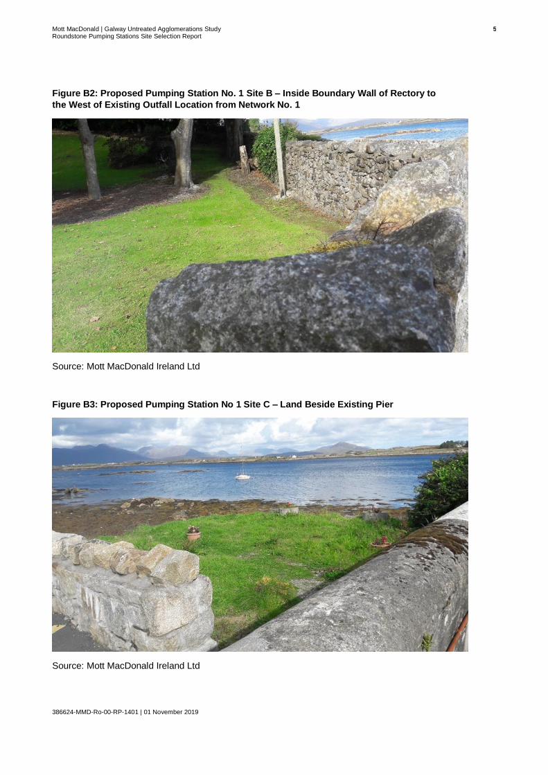
Mott MacDonald | Galway Untreated Agglomerations Study 5 Roundstone Pumping Stations Site Selection Report
386624-MMD-Ro-00-RP-1401 | 01 November 2019
Figure B2: Proposed Pumping Station No. 1 Site B – Inside Boundary Wall of Rectory to
the West of Existing Outfall Location from Network No. 1
Source: Mott MacDonald Ireland Ltd
Figure B3: Proposed Pumping Station No 1 Site C – Land Beside Existing Pier
Source: Mott MacDonald Ireland Ltd

Mott MacDonald | Galway Untreated Agglomerations Study 6 Roundstone Pumping Stations Site Selection Report
386624-MMD-Ro-00-RP-1401 | 01 November 2019
Figure B4: Proposed Pumping Station No. 3 Site A – On Foreshore Adjacent to Existing
Ruins
Source: Mott MacDonald Ireland Ltd

Mott MacDonald | Galway Untreated Agglomerations Study 7 Roundstone Pumping Stations Site Selection Report
386624-MMD-Ro-00-RP-1401 | 01 November 2019
Figure B5: Proposed Pumping Station No. 3 Site B – On Existing Pier Adjacent to the Old
Store Building
Source: Mott MacDonald Ireland Ltd

Mott MacDonald | Galway Untreated Agglomerations Study 8 Roundstone Pumping Stations Site Selection Report
386624-MMD-Ro-00-RP-1401 | 01 November 2019
Figure B6: Proposed Pumping Station No. 3 Site C – On Verge Adjacent to the Wall of the
Old Store Building
Source: Mott MacDonald Ireland Ltd

Mott MacDonald | Galway Untreated Agglomerations Study 9 Roundstone Pumping Stations Site Selection Report
386624-MMD-Ro-00-RP-1401 | 01 November 2019
Figure B7: Proposed Pumping Station No. 3 Site D – Within Private Lands to the West of
the Old Store Building
Source: Mott MacDonald Ireland Ltd

Mott MacDonald | Galway Untreated Agglomerations Study 10 Roundstone Pumping Stations Site Selection Report
386624-MMD-Ro-00-RP-1401 | 01 November 2019
Figure B8: Proposed Pumping Station No. 3 Site E – Within Boundary of Primary School
Source: Google Earth Street View

Mott MacDonald | Galway Untreated Agglomerations Study 11 Roundstone Pumping Stations Site Selection Report
386624-MMD-Ro-00-RP-1401 | 01 November 2019
mottmac.com