G.9 Assessment of Land and Groundwater … · Sector 1 – Te Atatu Interchange ... Material...
111
Assessment of Land and Groundwater Contamination
Transcript of G.9 Assessment of Land and Groundwater … · Sector 1 – Te Atatu Interchange ... Material...
Assessment of Land and Groundwater Contamination

Waterview Connection
This report has been prepared for the benefit of the NZ Transport Agency (NZTA). No liability is accepted by
this company or any employee or sub-consultant of this company with respect to its use by any other person.
This disclaimer shall apply notwithstanding that the report may be made available to other persons for an
application for permission or approval or to fulfil a legal requirement.
Quality Assurance Statement
Prepared by: Emily Sadlier,
Environmental Scientist, Beca
and Genevieve Smith, Senior
Environmental Scientist, Beca
Reviewed by: Terry Widdowson,
Contaminated Land Team
Leader, Beca
Approved for Issue by: Amelia
Linzey, Technical Director, Beca

Waterview Connection
Status Final ii July 2010Document Reference No. 20.1.11-3-R-EN-403 G.9 Assessment of Land and Groundwater Contamination
ASSESSMENT OF LAND AND GROUNDWATER CONTAMINATION.ASSESSMENT OF LAND AND GROUNDWATER CONTAMINATION.ASSESSMENT OF LAND AND GROUNDWATER CONTAMINATION.ASSESSMENT OF LAND AND GROUNDWATER CONTAMINATION.
ContentsContentsContentsContents
List of Appendices .......................................................................................................................................... vi
List of Tables.................................................................................................................................................. vi
Glossary of Abbreviations .............................................................................................................................. viii
Glossary of Terms ........................................................................................................................................... x
Summary Statement ........................................................................................................................................ 1
1. Introduction .......................................................................................................................................... 5
1.1 Purpose ....................................................................................................................................... 5
1.2 Report Structure .......................................................................................................................... 6
2. Description of Project ............................................................................................................................ 7
3. Existing Environment ............................................................................................................................. 8
3.1 Geology ....................................................................................................................................... 8
3.2 Hydrogeology .............................................................................................................................. 9
3.3 Resource Consents .................................................................................................................... 10
4. Assessment Criteria ............................................................................................................................. 11
4.1 Introduction .............................................................................................................................. 11
4.2 Assessment of Resource Consent Requirements ......................................................................... 11
4.3 Assessment of Groundwater Quality ........................................................................................... 13
4.4 Assessment of Human Health Risk ............................................................................................. 14
4.5 Assessment of Soils for Reuse or Disposal .................................................................................. 14
5. Investigation Activities ......................................................................................................................... 17
5.1 Methodology ............................................................................................................................. 17
5.2 Test Pit Excavation ..................................................................................................................... 17
5.3 Borehole Drilling ........................................................................................................................ 18
Waterview Connection
Status Final iii July 2010Document Reference No. 20.1.11-3-R-EN-403 G.9 Assessment of Land and Groundwater Contamination
5.4 Machine Augers and Hand Augers .............................................................................................. 18
5.5 Sampling and Monitoring ........................................................................................................... 19
6. Sector 1 – Te Atatu Interchange ........................................................................................................... 22
6.1 Sector Description ..................................................................................................................... 22
6.2 Investigation Activities and Methodology .................................................................................... 23
6.3 Investigation Findings ................................................................................................................ 24
6.4 Discussion ................................................................................................................................. 25
6.5 Assessment of Environmental Effects ......................................................................................... 26
6.6 Conclusions ............................................................................................................................... 26
7. Sector 2 – Whau River .......................................................................................................................... 28
7.1 Sector Description ..................................................................................................................... 28
7.2 Investigation Activities and Methodology .................................................................................... 29
7.3 Investigation Findings ................................................................................................................ 30
7.4 Discussion ................................................................................................................................. 30
7.5 Assessment of Environmental Effects ......................................................................................... 31
7.6 Conclusions ............................................................................................................................... 32
8. Sector 3 – Rosebank: Terrestrial ........................................................................................................... 33
8.1 Sector Description ..................................................................................................................... 33
8.2 Investigation Activities and Methodology .................................................................................... 34
8.3 Investigation Findings ................................................................................................................ 36
8.4 Discussion ................................................................................................................................. 37
8.5 Assessment of Environmental Effects ......................................................................................... 38
8.6 Conclusions ............................................................................................................................... 38
9. Sector 4 - Reclamation ........................................................................................................................ 39
9.1 Sector Description ..................................................................................................................... 39

Waterview Connection
Status Final iv July 2010Document Reference No. 20.1.11-3-R-EN-403 G.9 Assessment of Land and Groundwater Contamination
9.2 Investigation Activities and Methodology .................................................................................... 40
9.3 Investigation Findings ................................................................................................................ 41
9.4 Discussion ................................................................................................................................. 42
9.5 Assessment of Environmental Effects ......................................................................................... 42
9.6 Conclusions ............................................................................................................................... 43
10. Sector 5 – Great North Road Interchange .............................................................................................. 44
10.1 Sector Description ..................................................................................................................... 44
10.2 Investigation Activities and Methodology .................................................................................... 45
10.3 Investigation Findings ................................................................................................................ 49
10.4 Discussion ................................................................................................................................. 52
10.5 Assessment of Environmental Effects ......................................................................................... 54
10.6 Conclusions ............................................................................................................................... 54
11. Sector 6 – SH16 to St Lukes Interchange ............................................................................................... 56
11.1 Sector Description ..................................................................................................................... 56
11.2 Investigation Activities and Methodology .................................................................................... 57
11.3 Investigation Findings ................................................................................................................ 58
11.4 Discussion ................................................................................................................................. 60
11.5 Assessment of Environmental Effects ......................................................................................... 61
11.6 Conclusions ............................................................................................................................... 62
12. Sector 7 – Great North Road Underpass ................................................................................................ 63
12.1 Sector Description ..................................................................................................................... 63
12.2 Investigation Activities and Methodology .................................................................................... 64
13. Sector 8 – Avondale Heights Tunnel ..................................................................................................... 65
13.1 Sector Description ..................................................................................................................... 65
13.2 Investigation Activities and Methodology .................................................................................... 66
Waterview Connection
Status Final v July 2010Document Reference No. 20.1.11-3-R-EN-403 G.9 Assessment of Land and Groundwater Contamination
13.3 Investigation Findings ................................................................................................................ 68
13.4 Discussion ................................................................................................................................. 69
13.5 Assessment of Environmental Effects ......................................................................................... 71
13.6 Conclusions ............................................................................................................................... 72
14. Sector 8 – Avondale Heights Tunnel: Phyllis Street and Harbutt Reserves .............................................. 73
14.1 Sector Description ..................................................................................................................... 73
14.2 Investigation Activities and Methodology .................................................................................... 74
14.3 Investigation Findings ................................................................................................................ 75
14.4 Discussion ................................................................................................................................. 76
14.5 Assessment of Environmental Effects ......................................................................................... 78
14.6 Conclusions ............................................................................................................................... 78
15. Sector 9 – Alan Wood Reserve .............................................................................................................. 80
15.1 Sector Description ..................................................................................................................... 80
15.2 Investigation Activities and Methodology .................................................................................... 81
15.3 Investigation Findings ................................................................................................................ 83
15.4 Discussion ................................................................................................................................. 85
15.5 Assessment of Environmental Effects ......................................................................................... 86
15.6 Conclusions ............................................................................................................................... 87
16. Summary of Proposed Mitigation Measures .......................................................................................... 88
17. Summary Conclusions ......................................................................................................................... 89
17.1 Introduction .............................................................................................................................. 89
17.2 Investigation Summary ............................................................................................................... 89
17.3 Soils ....................................................................................................................................... 89
17.4 Groundwater.............................................................................................................................. 91
17.5 Assessment of Environmental Effects and Mitigation .................................................................. 92
Waterview Connection
Status Final vi July 2010Document Reference No. 20.1.11-3-R-EN-403 G.9 Assessment of Land and Groundwater Contamination
Bibliography .................................................................................................................................................. 94
List of Appendices
Appendix A – Waterview Connection Sector Plan
Appendix B – Phase 1 Portal Desk Study
Appendix C – Regulatory Framework
Appendix D – Investigation Location Plans
Appendix E – Sector 1: Data Summary Sheets, Logs and Investigation Summary
Appendix F – Sector 2: Data Summary Sheets, Logs and Investigation Summary
Appendix G – Sector 3: Data Summary Sheets, Logs and Investigation Summary
Appendix H – Sector 4: Data Summary Sheets, Logs and Investigation Summary
Appendix I – Sector 5: Data Summary Sheets, Logs and Investigation Summary
Appendix J – Sector 6: Data Summary Sheets, Logs and Investigation Summary
Appendix K – Sector 8: Data Summary Sheets, Logs and Investigation Summary
Appendix L – Sector 9: Data Summary Sheets, Logs and Investigation Summary
Appendix M – Maps of Contaminants Exceeding Assessment Criteria
Appendix N – Maps of Soil Classifications
Appendix O – Contaminated Soils Management Plan (CSMP)
Appendix P – Maps of Areas of Potentially Hazardous Materials
Appendix Q – Maps of Areas Not Assessed
Appendix R – Hills Laboratory Results
Appendix S – Chain of Custody Forms
List of Tables
Table 4.1: Hierarchy for Assessment of Consent Requirements ............................................................................ 12 Table 4.2: Comparison of Human Health Guideline Values .................................................................................... 13 Table 4.3: Hierarchy for Assessment of Groundwater Quality ............................................................................... 13 Table 4.4: Assessment of Human Health Risks ....................................................................................................... 14 Table 5.1: Summary of Groundwater Sampling Activities: All Sectors ................................................................... 20 Table 6.1: Summary of Investigation Activities in Sector 1 .................................................................................... 23 Table 6.2: Contaminants Exceeding Assessment Criteria in Sector 1 .................................................................... 25 Table 6.3: Sector 1: Material Classification ............................................................................................................. 26 Table 6.4: Sector 1: Assessment of Environmental Effects ..................................................................................... 26 Table 7.1: Summary of Investigation Activities in Sector 2 .................................................................................... 29
Waterview Connection
Status Final vii July 2010Document Reference No. 20.1.11-3-R-EN-403 G.9 Assessment of Land and Groundwater Contamination
Table 7.2: Contaminants Exceeding Assessment Criteria in Sector 2 .................................................................... 30 Table 7.3: Sector 2: Material Classification ............................................................................................................. 31 Table 7.4: Sector 2: Assessment of Environmental Effects ..................................................................................... 31 Table 8.1: Summary of Investigation Activities in Sector 3 .................................................................................... 34 Table 8.2: Contaminants Exceeding Assessment Criteria along SH16 Alignment ................................................ 36 Table 8.3: Contaminants Exceeding Assessment Criteria in the Area of Potential Fill.......................................... 37 Table 8.4: Sector 3: Material Classification ............................................................................................................. 37 Table 8.5: Sector 3: Assessment of Environmental Effects ..................................................................................... 38 Table 9.1: Summary of Investigation Activities in Sector 4 .................................................................................... 40 Table 9.2: Contaminants Exceeding Assessment Criteria in Sector 4 .................................................................... 41 Table 9.3: Sector 4: Material Classification ............................................................................................................. 42 Table 9.4: Sector 4: Assessment of Environmental Effects ..................................................................................... 43 Table 10.1: Investigation Summary Sector 5 ........................................................................................................... 46 Table 10.2: Contaminants Exceeding Assessment Criteria at Great North Road Interchange .............................. 50 Table 10.3: Contaminants with Laboratory Limit of Detection above Permitted Activity Criteria ........................ 51 Table 10.4: Sector 5: Material Classification ........................................................................................................... 54 Table 10.5: Sector 5: Assessment of Environmental Effects ................................................................................... 54 Table 11.1: Investigation Summary Sector 6 ........................................................................................................... 57 Table 11.2: Contaminants Exceeding Assessment Criteria along SH16 Alignment .............................................. 59 Table 11.3: Contaminants Exceeding Assessment Criteria at Meola Stormwater Pond Area ............................... 60 Table 11.4: Sector 6: Material Classification ........................................................................................................... 61 Table 11.5: Sector 6: Assessment of Environmental Effects ................................................................................... 61 Table 12.1: Proposed Investigations Sector 7 ......................................................................................................... 64 Table 13.1: Summary of Groundwater Sampling ..................................................................................................... 67 Table 13.2: Groundwater Analysis Results Exceeding Assessment Criteria .......................................................... 69 Table 13.3: Sector 8: Assessment of Environmental Effects ................................................................................... 71 Table 14.1: Summary of Investigation Activities: Phyllis Street Reserve ................................................................ 74 Table 14.2: Soil Analysis Results Exceeding Assessment Criteria .......................................................................... 76 Table 14.3: Groundwater Analysis Results Exceeding Assessment Criteria .......................................................... 76 Table 15.1: Summary of Investigative Activities in Sector 9 ................................................................................... 82 Table 15.2: Contaminants with Laboratory Limit of Detection above Consent Criteria ........................................ 84 Table 15.3: Contaminants Exceeding Assessment Criteria at Maioro Street Interchange .................................... 85 Table 15.4: Sector 9: Material Classification ........................................................................................................... 86 Table 15.5: Sector 9: Assessment of Environmental Effects ................................................................................... 86 Table 17.1: Investigation Findings - Contamination, Waste, Resource Consent and Human Health .................... 90 Table 17.2: Investigation Findings: Soil Classification ............................................................................................ 91 Table 17.3: Potential Environmental Effects from Construction ............................................................................. 92

Waterview Connection
Status Final viii July 2010Document Reference No. 20.1.11-3-R-EN-403 G.9 Assessment of Land and Groundwater Contamination
Glossary of Abbreviations
Term Definition
ACC Auckland City Council
AEE Assessment of Environmental Effects
ANZECC Australian and New Zealand Environment Conservation Council
ARC Auckland Regional Council
ALWP Proposed Auckland Regional Plan: Air, Land and Water
BaP Benzo(a)pyrene
bgl Below ground level
CBD Central Business District
CCME Canadian Council of Ministers for the Environment
CEMP Construction Environmental Management Plan
CHSP Contractor Health and Safety Plan
CMA Coastal Marine Area
CMP Construction Management Plan
CSMP Contaminated Soils Management Plan
ECBF East Coast Bays Formation
EMP Environmental Management Plan
EPA Environmental Protection Authority
HM Heavy metals
MfE Ministry for the Environment
mg/kg Milligrams per kilogram

Waterview Connection
Status Final ix July 2010Document Reference No. 20.1.11-3-R-EN-403 G.9 Assessment of Land and Groundwater Contamination
mg/l Milligrams per litre
NES National Environmental Standards
NOR(s) Notice of Requirement(s)
NZTA NZ Transport Agency
OCP Organochlorine pesticides
OP/ON Organophosphorus/organonitrogen
PAH Polycyclic aromatic hydrocarbons
RMA Resource Management Act 1991
RoNS Road of National Significance
SH16 State Highway 16
SH18 State Highway 18
SH20 State Highway 20
SVOC Semi volatile organic compounds
TPH Total petroleum hydrocarbons
TSS Total suspended solids
TP153 ARC Technical Publication Number 153: Background concentrations of
inorganic in soils from the Auckland Region, 2001
VOC Volatile organic compounds
WCC Waitakere City Council
WRR Western Ring Route
Waterview Connection
Status Final x July 2010Document Reference No. 20.1.11-3-R-EN-403 G.9 Assessment of Land and Groundwater Contamination
Glossary of Terms
Term Definition
Alan Wood Reserve
A reserve of approximately 9ha in Auckland City adjacent to Hendon
Avenue. It is noted that community reference to this area also commonly
includes land designated and owned by the Crown for Railway purposes
(this area is not included in the 9ha of reserve).
Alignment The route or position of an existing or proposed motorway.
Archaeological Site
Defined in Part 2 of the Historic Places Act 1993 as any place in New
Zealand that -
(a) Either-
• Was associated with human activity that occurred before 1900; or
• Is the site of the wreck of any vessel where that wreck occurred before 1900; and
(b) Is or may be able through investigation by archaeological methods to provide evidence relating to the history of New Zealand.
Chamberlain Park The public golf course located in Auckland City adjacent to SH16 and St
Lukes Road.
Causeway Bridges The Bridges located along the State Highway 16 Causeway (Identified in
NZTA Highway Information as the Rosebank Bridges).
Coastal Marine Area
Defined in Section 2 of the RMA. The foreshore, seabed, and coastal water, and the air space above the water-
(a) of which the seaward boundary is the outer limits of the territorial sea:
(b) of which the landward boundary is the line of mean high water springs, except that where that line crosses a river, the landward boundary at that point shall be whichever is the lesser of—
(i) 1 kilometre upstream from the mouth of the river; or
(ii) the point upstream that is calculated by multiplying the width of the river mouth by 5.
Cut and Cover Tunnelling A method of construction for tunnels where a trench is excavated and
roofed over.
Discharge An activity that results in a contaminant being emitted deposited or
allowed to escape.
Waterview Connection
Status Final xi July 2010Document Reference No. 20.1.11-3-R-EN-403 G.9 Assessment of Land and Groundwater Contamination
Effect
Defined in Section 3 of the RMA. The term effect includes:
• Any positive or adverse effect; and
• Any temporary or permanent effect; and
• Any past, present, or future effect; and
• Any cumulative effect which arises over time or in combination with other effects
regardless of the scale, intensity, duration, or frequency of the effect,
and also includes-
• Any potential effect of high probability; and
• Any potential effect of low probability which has a high potential impact.
Grade Separated Interchange The lay out of roads (or rail) where one road crosses over/under the
other at a different height.
Great North Road Interchange An existing grade separated interchange between Great North Road and
SH16 in the vicinity of Waterview / Point Chevalier, Auckland.
Great North Road Underpass
From the Great North Road Interchange, the alignment will be two cut-
cover tunnels (some 2.5m apart) beneath Great North Road to connect to
the deep tunnel at Sector 8.
Groundwater Natural water contained within soil and rock formations below the
surface of the ground.
Harbutt Reserve An Auckland City Council reserve approximately 6ha in size located on
Harbutt Avenue.
Hendon Park A 1.6ha area of reserve land adjacent to Hendon Road. The southern
boundary adjoins the Avondale Southdown Rail Designation.
Industrial Area – Richardson Rd A Mixed use zoned area along Richardson Road currently occupied by a
range of light industrial activities.
Industrial Area – Rosebank Road One of the large Industrial/Commercial areas in West Auckland located
on the Rosebank Peninsula.
Jack Colvin Park A 4ha Recreation Reserve adjacent to the Te Atatu Roundabout and
occupied by the Te Atatu Rugby League Club.
Land Disturbing Activity Any disturbance to the ground surface that may result in soil erosion
through the action of wind or water.
Leachate Liquid that has infiltrated through or emerged from solid waste and that
contains dissolved and/or suspended chemical liquids and/or solids
Waterview Connection
Status Final xii July 2010Document Reference No. 20.1.11-3-R-EN-403 G.9 Assessment of Land and Groundwater Contamination
and/or gases.
Maioro Street Interchange A diamond interchange proposed for the SH20 Motorway connection at
Maioro Street in New Windsor.
Meola Creek
A meandering creek running from St Lukes to Point Chevalier via Great
North Road, SH16 and Chamberlain Park and discharges to the
Waitemata Harbour near Meola Road in Point Chevalier.
Motorway
Motorway means a motorway declared as such by the Governor-General
in Council under section 138 of the PWA or under section 71 of the
Government Roading Powers Act 1989.
Northwestern Motorway That section of State Highway 16 which is declared motorway extending
from Central Motorway Junction to its connection with State Highway 18.
Oakley Creek
A meandering stream that runs from Mt Albert to Waterview via
Underwood Reserve, Alan Wood Reserve, and Oakley Creek Reserve.
Oakley Creek discharges to the Coastal Marine area near SH16 at the
Great North Road interchange.
Phyllis Reserve
A recreation reserve in Auckland City of approximately 7ha. The reserve
is dominated by sports fields and is leased and occupied by the Metro Mt
Alberts) Sports Club (amongst others).
Pollen Island An estuarine shellbank Island to the north of the Rosebank Peninsula and
within the Motu Manawa Marine Reserve.
Portal The entrance way to a tunnel starting where the road is completely
uncovered to where it is completely covered.
Reclamation
As defined in the Auckland Regional Plan: Coastal. Any permanent filling
of an area previously inundated by coastal water either at or above mean
high water spring mark, whether or not it is contiguous with the land, so
that the filled surface is raised above the natural level of MHWS, and thus
creates dry land, removed from the ebb and flow of the tide.
Rosebank Interchange
A grade separated interchange providing a connection from Rosebank
Road east to Auckland City and from west Auckland to Rosebank Road
from SH16.
Sector 1
That part of the project that extends from the eastern abutments of the
Henderson Creek Bridge to western abutment of the Whau Creek Bridge
including the Te Atatu Interchange.
Waterview Connection
Status Final xiii July 2010Document Reference No. 20.1.11-3-R-EN-403 G.9 Assessment of Land and Groundwater Contamination
Sector 2 That part of the project that includes work and structures over and within
the Whau River.
Sector 3
That part of the project that includes the landward (southern) component
of the Rosebank Peninsula including Patiki Road and the Rosebank Park
Domain.
Sector 4
That part of the project that requires reclamation including along the
Rosebank Peninsula and the causeway between Rosebank Peninsula and
Waterview. This sector includes parts of Traherne Island.
Sector 5 That part of the project occupied by the SH16/SH20 Interchange
Sector 6
That part of the project that includes the additional lanes on the existing
Northwestern Motorway, between the Waterview Interchange and St
Lukes Interchange (the SH16 section of the project).
Sector 7
That part of the project that refers to the 'cut and cover' section of tunnel
from the northern portal at (Waterview Park), crossing beneath Great
North Road to connect with the deep tunnel (Sector 8).
Sector 8
That part of the project that refers to the section of the project from the
Alan Wood Reserve (southern portal) beneath ‘Avondale Heights’ (the
‘deep tunnel’ section of the project).
Sector 9
That part of the project that refers to the construction of the Maioro
Street Interchange north facing ramps and the motorway from the
existing termination of SH20 under Richardson Road Bridge through
Allan Wood Reserve to the southern tunnel portal as a surface motorway.
Settlement The gradual sinking of the ground surface as a result of the compression
of underlying material.
Star Mill/Tannery The Star Mill/Garrett Brothers Tannery archaeological site, identified by
the New Zealand Archaeological Association site number R11/2191.
Strata Layer of rock or soil with internally consistent characteristics that
distinguishes it from contiguous layers.
Te Atatu Interchange Grade separation intersection at Te Atatu that provides a connection
between the state highway and the local roads using a series of ramps.
Tunnel Portal Locations
The general location of the northern portal is at the southern end of
Waterview Reserve. The general location of the southern portal is within
Alan Wood Reserve.
Waterview Connection
Status Final xiv July 2010Document Reference No. 20.1.11-3-R-EN-403 G.9 Assessment of Land and Groundwater Contamination
Traherne Island A small waterlogged Island to the east of the Rosebank Peninsula and
bisected by the Northwestern Motorway.
Western Ring Route (WWR)
A strategic highway route which provides an alternative to SH1 as a
regional route for traffic crossing greater Auckland. The WWR requires
the completion of missing links and new lanes to combine the
Southwestern (SH20), Northwestern (SH16) and Upper Harbour (SH18)
highways into a continuous 48km motorway. The WWR will link the North
Shore, Waitakere, Auckland and Manukau cities.
Waterview Reserve
A 4ha Auckland City Reserve located at the mouth of the Whau River with
frontage to Cowley and Herdman Streets. Waterview Reserve is also
known as Waterview Park and Oakley Park.
Whau River Bridges Two bridges over the Whau River with a dedicated cyclist/pedestrian
bridge alongside heading west.
Waterview Connection
Status Final 1 July 2010Document Reference No. 20.1.11-3-R-EN-403 G.9 Assessment of Land and Groundwater Contamination
Summary Statement
Introduction
The Waterview Connection Project includes works previously investigated and developed as two separate
projects; the State highway 16 (SH16) Causeway Project and the State highway 20 (SH20) Waterview
Connection. The Waterview Connection Project (the Project) is to be lodged with the Environmental Protection
Agency (EPA) as a Proposal of National Significance.
The objective of this contamination assessment is to establish the baseline quality of both soil and
groundwater within the construction footprint of the Project and to determine the likely environmental effects
of the Project. This has involved the assessment of soil and groundwater contamination, assessment of human
health risk, soil classification for reuse or disposal, and assessment of resource consent requirements.
The Project has been divided into nine sectors which broadly define the different construction requirements of
the Project.
The general geological sequence beneath the Project area is fill or basalt or Recent marine muds overlying
Tauranga Group alluvial sands and silts overlying Waitemata Group sandstone and siltstone. There are two
distinct aquifers; the basalt lava flows (shallow perched unconfined aquifer) and the Waitemata Group (deeper
regional confined aquifer). The aquifers are separated by relatively impermeable Tauranga Group alluvium
and/or weathered soils from the Waitemata Group bedrock. Groundwater is also present within fill deposits.
Criteria have been adopted for assessment of resource consent requirements, groundwater quality, human
health risks and soil classification. Contaminated discharges are prohibited under Section 15(1) of the
Resource Management Act 1991 (RMA) unless authorised by, amongst other things, a resource consent. In the
Auckland Region, discharge of contaminants is controlled by the Auckland Regional Council (ARC) Proposed
Auckland Regional Plan: Air, Land and Water (ALWP), 2008. For groundwater quality assessment, the Ministry
for the Environment (MfE) hierarchy of guidelines has been used. For human health risk assessment, Auckland
City Council (ACC) soil screening criteria have been used. For soil classification, MfE and regional guidance has
been used.
A wide range of intrusive investigations have been carried out comprising test pits, boreholes, and
machine/hand augers. Soils and groundwater have been sampled for chemical laboratory analyses for a broad
suite of organic and inorganic determinands.
Sector 1
This sector extends from Henderson Creek to the Whau River. Construction activities are to comprise vertical
and horizontal realignment of the existing SH16 motorway, modifications to the Te Atatu Interchange, a
contractors’ yard and a stormwater wetland.
The intrusive investigation findings for Sector 1 reveal that fill, where identified, consisted of reworked natural
materials (silts, clays and gravel), no waste materials were identified.
Waterview Connection
Status Final 2 July 2010Document Reference No. 20.1.11-3-R-EN-403 G.9 Assessment of Land and Groundwater Contamination
Results of chemical laboratory analyses of soils indicate that land disturbance activities would be a Permitted
Activity under Rule 5.5.41 of the ALWP and resource (discharge) consent would not be required. Human health
criteria were exceeded and excavation of soils should be carried out in accordance with the Contaminated Soils
Management Plan (CSMP) and Contractor Health and Safety Plan (CHSP).
The potential environmental effects within Sector 1 relate to construction workers and risks from exposure to
contaminated soils. These can be mitigated by adherence to a CSMP and CHSP.
Sector 2
This sector comprises the enlargement of the existing SH16 Whau River Bridge to accommodate additional
lanes.
The intrusive investigation findings for Sector 2 reveal that fill, where identified, consisted of reworked natural
materials (silts, clays and gravel), no waste materials were identified.
Results of chemical laboratory analyses of soils indicate that land disturbance activities would require resource
consent under Rule 5.5.44 of the ALWP. Human health criteria were not exceeded but excavation of soils
should be carried out in accordance with the CSMP and CHSP to protect against any unidentified
contamination.
The potential environmental effects within Sector 2 relate to discharge of contaminants during earthworks.
These can be mitigated by excavation and off site disposal of soils and adherence to a CSMP.
Sector 3
This sector extends from the Whau River to the eastern edge of the Rosebank peninsular. It incorporates the
terrestrial portion of the existing SH16 alignment adjacent to the westbound carriageway of SH16.
The intrusive investigation findings for Sector 3 reveal that fill, where identified, consisted generally of
reworked natural materials (silts, clays and gravel). Some fragments of brick and concrete were identified.
Results of chemical laboratory analyses of soils indicate that land disturbance activities would require resource
consent under Rule 5.5.44 of the ALWP. Human health criteria were not exceeded but excavation of soils
should be carried out in accordance with the CSMP and CHSP to protect against any unidentified
contamination.
The potential environmental effects within Sector 3 relate to discharge of contaminants during earthworks.
These can be mitigated by excavation and off site disposal of soils and adherence to the CSMP.
Sector 4
This sector extends from the Whau River, crossing Traherne Island to the Great North Road Interchange. It
incorporates the northern portion of the causeway opposite Sector 3 and the remainder of the causeway
eastward to the Great North Road Interchange.
The intrusive investigation findings for Sector 4 reveal that fill, where identified, consisted generally of
reworked natural materials (silts, clays and gravel). Minor fragments of brick and concrete were identified.

Waterview Connection
Status Final 3 July 2010Document Reference No. 20.1.11-3-R-EN-403 G.9 Assessment of Land and Groundwater Contamination
Results of chemical laboratory analyses of soils indicate that land disturbance activities would require resource
consent under Rule 5.5.44 of the ALWP. Human health criteria were not exceeded but excavation of soils
should be carried out in accordance with the CSMP and CHSP to protect against any unidentified
contamination.
The potential environmental effects within Sector 4 relate to discharge of contaminants during earthworks.
These can be mitigated by excavation and off site disposal of soils and adherence to a CSMP.
Sector 5
This sector extends north from the Waterview Reserve area and incorporates the ramps and alignment
associated with the connection of SH20 to SH16 (the Great North Road Interchange). In addition, the area
within the loop of the SH16 eastbound on ramp is to become a contractors’ working area.
The intrusive investigation findings for Sector 5 reveal that fill, where identified, consisted of reworked natural
materials (silts, clays and gravel) and waste materials (plastic, wood, metal, brick, concrete, asbestos and
glass).
Results of chemical laboratory analyses of soils indicate that land disturbance activities would require resource
consent under Rule 5.5.44 of the ALWP. Human health criteria were exceeded and excavation of soils should
be carried out in accordance with the CSMP and CHSP.
The potential environmental effects within Sector 5 relate to discharge of contaminants during earthworks and
construction worker exposure to contaminants in soil. These can be mitigated by excavation and off site
disposal of soils and adherence to a CSMP and CHSP.
Sector 6
This sector extends from the Great North Road Interchange to St Lukes Interchange. Construction activities
include the widening of the existing SH16 motorway and a stormwater pond.
The intrusive investigation findings for Sector 6 reveal that fill, where identified, consisted of reworked natural
materials (silts, clays and gravel) with brick fragments.
Results of chemical laboratory analyses of soils indicate that land disturbance activities would require resource
consent under Rule 5.5.44 of the ALWP. Human health criteria were exceeded and excavation of soils should
be carried out in accordance with the CSMP and CHSP.
The potential environmental effects within Sector 6 relate to discharge of contaminants during earthworks and
construction worker exposure to contaminants in soil. These can be mitigated by excavation and off site
disposal of soils and adherence to a CSMP and CHSP.
Sector 7
This sector incorporates the cut and cover section of tunnel from the connection with the deep tunnels at
Waterview Downs to the northern tunnel portal at Waterview Reserve. A contractors’ working area is also
proposed adjacent to Great North Road.

Waterview Connection
Status Final 4 July 2010Document Reference No. 20.1.11-3-R-EN-403 G.9 Assessment of Land and Groundwater Contamination
For logistical and accessibility reasons, intrusive environmental investigations were not carried out in this
sector. Investigations are to be carried out in the future.
Sector 8
This sector incorporates the whole length of the two deep tunnels from the northern portal at Waterview
Reserve to the southern portal in Alan Wood Reserve. The tunnels traverse beneath Phyllis Street and Harbutt
Reserve landfills.
There will be no surface expression of the tunnels and there are no major surface construction activities within
Sector 8.
Fill comprising construction waste and household waste has been identified in Phyllis Street and Harbutt
Reserves and results of soil analyses did exceed the Permitted Activity criteria. However, as there will be no
surface land disturbance of these areas attributable to the Project, resource consent would not be required.
A resource consent already exists for Phyllis Reserve, held by the ACC. The conditions of its issue are not
expected to be affected by the Project.
Results of groundwater analyses from the Waitemata aquifer reveal that there is no exceedance of water quality
guidelines and resource consent for discharge of groundwater into the tunnels will not be required.
Results of groundwater analyses from within Phyllis Street and Harbutt Reserves reveal that some contaminants
exceed their water quality guidelines. 2D groundwater modelling of the Phyllis Street Reserve has predicted
that the potential for contaminants from the Reserve to reach the tunnels during construction is very low.
Sector 9
This sector extends from the southern portal of the deep tunnels in Alan Wood Reserve to the Maioro Street
Interchange. It will comprise a six lane surface motorway. In addition three contactors’ working areas and a
number of stormwater ponds will be constructed.
The intrusive investigation findings for Sector 9 reveal that fill, where identified, consisted of reworked natural
materials (silts, clays and gravel) and waste materials (plastic, wood, metal, brick, concrete, asbestos and
glass). Although not actually identified during the investigation, household waste is also known to be present.
Results of chemical laboratory analyses of soils indicate that land disturbance activities would require resource
consent under Rule 5.5.44 of the ALWP. Human health criteria were not exceeded but excavation of soils
should be carried out in accordance with the CSMP and CHSP to protect against any unidentified
contamination.
The potential environmental effects within Sector 9 relate to discharge of contaminants during earthworks and
construction worker exposure to potentially hazardous waste materials. These can be mitigated by excavation
and off site disposal of soils and waste and adherence to a CSMP and CHSP.
Waterview Connection
Status Final 5 July 2010Document Reference No. 20.1.11-3-R-EN-403 G.9 Assessment of Land and Groundwater Contamination
1. Introduction
In 2009 the NZ Transport Agency (NZTA) confirmed its intention that the ‘Waterview Connection Project’ (the
Project) would be lodged with the Environmental Protection Authority (EPA) as a Proposal of National
Significance. The Project includes works previously investigated and developed as two separate projects: being
the State highway 16 (SH16) Causeway Project and the State highway (SH20) Waterview Connection. The key
elements of the Waterview Connection Project are:
• Completing the Western Ring Route (which extends from Manukau to Albany via Waitakere);
• Improving resilience of the SH16 causeway between the Great North Road and Rosebank Interchanges to
correct historical subsidence and “future proof” it against sea level rise;
• Providing increased capacity on the SH16 corridor (between the St Lukes and Te Atatu Interchanges);
• Providing a new section of SH20 (through a combination of surface and tunnelled road) between the Great
North Road and Maioro Street Interchanges; and
• Providing a cycleway throughout the surface road elements of the Waterview Connection Project corridor.
1.1 Purpose
The purpose of this contamination assessment is to establish the baseline quality of both soil and groundwater
within the construction footprint of the Project. This allows the likely environmental effects of the Project to be
determined together with any regulatory controls and mitigation measures.
In more detail, this has involved the assessment of:
• The presence and distribution of contaminants in soils within the Project footprint;
• The quality of groundwater within the zone of influence of the Project;
• The potential impacts of any identified contamination on human health (site workers and the public);
• The occurrence, quality and distribution of leachate within closed landfills within the Project footprint;
• The requirements and options for remediation, management or monitoring of contaminated soils and
groundwater, including the potential for re-use of excavated materials within the Project footprint and
evaluation of off-site disposal options; and
• The requirements for resource consents under the Resource Management Act 1991 (RMA), the details of
which are set out in the Proposed Auckland Regional Plan: Air, Land and Water (ALWP), in relation to any
identified discharge of contamination to land or water.
The assessment has been prepared as a Site Investigation Report as defined within Schedule 13 of the ALWP.
Waterview Connection
Status Final 6 July 2010Document Reference No. 20.1.11-3-R-EN-403 G.9 Assessment of Land and Groundwater Contamination
1.2 Report Structure
The Project has been divided into nine sectors (see Figure 2.1 and Appendix A) which broadly define the
different construction requirements of the Project.
The main body of this report (Sections 6-15) is structured around the nine sectors, with each sector having its
own section. The sector specific sections are intended to be relatively ‘stand alone’ and each contains the
following standard information:
• Introduction - location, existing environment, land use, potential contamination.
• Investigation activities and methodology - what investigations were carried out and why.
• Investigation findings – description of soils, occurrence of fill, detection of soil and/or groundwater
contamination, identifying the baseline quality of soils and groundwater and comparison against guideline
criteria.
• Discussion – interpretation of results, nature of materials, resource consent and human health impact
assessment and material classification.
• Assessment of environmental effects.
• Conclusions – summary of key findings and relevance for the construction phase of the Project.
Sections 2 to 5 provide general information and discussion of the Project, the existing environment, the
adoption of assessment criteria and investigation methodology.
The appendices to this report are also structured by sector and each sector appendix contains all the factual
information relevant to that sector (such as investigation logs, data summary sheets, field data etc.).
Waterview Connection
Status Final 7 July 2010Document Reference No. 20.1.11-3-R-EN-403 G.9 Assessment of Land and Groundwater Contamination
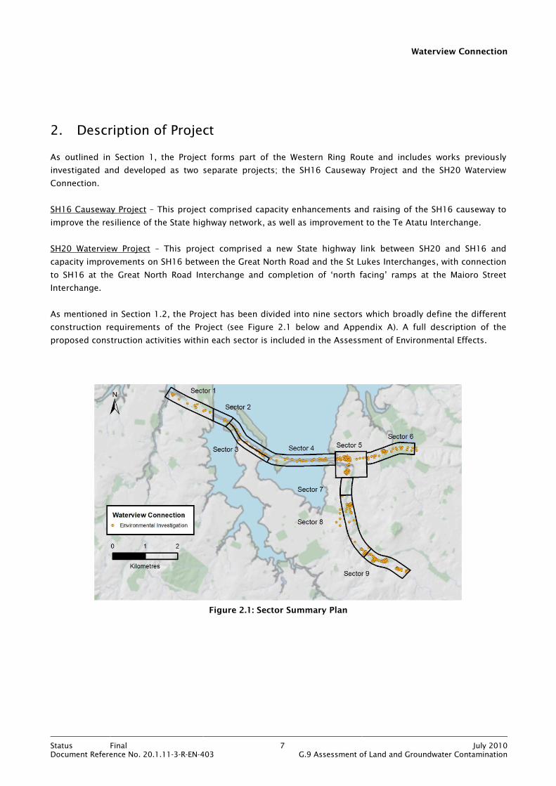
2. Description of Project
As outlined in Section 1, the Project forms part of the Western Ring Route and includes works previously
investigated and developed as two separate projects; the SH16 Causeway Project and the SH20 Waterview
Connection.
SH16 Causeway Project – This project comprised capacity enhancements and raising of the SH16 causeway to
improve the resilience of the State highway network, as well as improvement to the Te Atatu Interchange.
SH20 Waterview Project – This project comprised a new State highway link between SH20 and SH16 and
capacity improvements on SH16 between the Great North Road and the St Lukes Interchanges, with connection
to SH16 at the Great North Road Interchange and completion of ‘north facing’ ramps at the Maioro Street
Interchange.
As mentioned in Section 1.2, the Project has been divided into nine sectors which broadly define the different
construction requirements of the Project (see Figure 2.1 below and Appendix A). A full description of the
proposed construction activities within each sector is included in the Assessment of Environmental Effects.
Figure 2.1: Sector Summary Plan

Waterview Connection
Status Final 8 July 2010Document Reference No. 20.1.11-3-R-EN-403 G.9 Assessment of Land and Groundwater Contamination
3. Existing Environment
3.1 Geology
The geological sequence beneath the Project area is described in the geological map Sheet R11 Geology of the
Auckland Urban Area 1:50,000 (Geological and Nuclear Sciences, 1992) and confirmed by several ground
investigations and geophysical surveys. Full details of the geology in the context of the finalised alignment and
the construction envelope can be found in Technical Report No. G24 Geotechnical Interpretive Report. Details
of the local geology within each sector are provided in later sections of this report. However, a summary of the
general regional geology is given below.
3.1.1 SH16 (Sectors 1 to 4)
The general vertical sequence is fill or Recent marine muds overlying the Tauranga Group sands and silts
which in turn rest on the Waitemata Group sandstone and siltstone. This sequence is described in more detail
below.
Fill and Recent Marine Muds
The areas of fill are variable in both nature and thickness. The fill is comprised predominantly of reworked
natural materials including gravels, sands and silts. The average fill thickness is approximately 3.5m. Recent
marine deposits comprising sands and muds with shells lie within the Waitemata Harbour.
Tauranga Group
The Puketoka Formation of the Tauranga Group underlies the fill or Recent marine deposits. The formation
comprises alluvial deposits (pumiceous silt, sands and gravels with lenses of peat and clay) with a thickness
between 10m and 20m.
Waitemata Group
The East Coast Bays Formation (ECBF) of the Waitemata Group, comprising interbedded sandstone and
siltstone forms the bedrock unit throughout the study area and directly underlies the Tauranga Group.
Waitemata Group rocks contain an upper weathered zone of clays, silts and sands that can be up to 10m thick.

Waterview Connection
Status Final 9 July 2010Document Reference No. 20.1.11-3-R-EN-403 G.9 Assessment of Land and Groundwater Contamination
3.1.2 SH20/SH16 (Sectors 5 to 9)
The general vertical sequence is fill or basalt overlying Tauranga Group sands and silts, in turn overlying
Waitemata Group sandstone and siltstone. This sequence is described in more detail below.
Fill
The areas of fill are variable in both nature and thickness, particularly beneath the parks and sport fields
adjacent to Oakley Creek. The fill composition ranges from reworked natural materials (gravels, sands and
silts) to construction waste and household refuse. The fill often occurs in voids created by quarrying of the
basalt.
Auckland Volcanic Field
Basalt lava flows from the Mt Albert volcano lie to the east of Oakley Creek and range in thickness from 1m to
20m, though are typically 5m to 9m. The variation in thickness results from infilling of the paleo-topography.
Tauranga Group
The Puketoka Formation of the Tauranga Group underlies the basalt (though not continuously). The formation
comprises alluvial deposits (pumiceous silt, sands and gravels with lenses of peat and clay) with a thickness
between 5m and 20m.
Waitemata Group
The ECBF of the Waitemata Group, comprising interbedded sandstone and siltstone, forms the bedrock unit
throughout the study area and directly underlies the Tauranga Group and/or basalt lava flows (where the
Tauranga Group is absent). Waitemata Group rocks contain an upper weathered zone of clays, silts and sands
that can be up to 10m thick.
A significant thickness (up to 25m) of Parnell Grit, also of the Waitemata Group, underlies Phyllis Street Reserve
on the eastern side of Oakley Creek. The Parnell Grit is a volcanically derived debris flow deposit consisting of
sand to boulder sized breccia-conglomerate of andesite and limestone.
3.2 Hydrogeology
Detailed discussion of the hydrogeological characteristics of the study area is beyond the scope of this report.
However, certain key aspects of the hydrogeological regime beneath the Project footprint are significant in the
context of this assessment, particularly for the tunnel section within Sector 8, and these are discussed below.
Data gathered from parallel hydrogeological investigations has indicated that the area below Sector 8 is
underlain by two distinct aquifers; the basalt lava flows which constitute a shallow (perched) unconfined
aquifer and the Waitemata Group rocks which form a more regional deeper confined aquifer. The two aquifers
are hydraulically separated by relatively impermeable Tauranga Group alluvium and/or soils produced by
weathering of the Waitemata Group bedrock. In addition, groundwater has been identified at varying depths
within the fill deposits though it is likely to be discontinuous and ephemeral.
Waterview Connection
Status Final 10 July 2010Document Reference No. 20.1.11-3-R-EN-403 G.9 Assessment of Land and Groundwater Contamination
Groundwater beneath the SH20 element of the Project is generally flowing in a northerly direction with a local
component towards Oakley Creek. The basalt is the most permeable aquifer, whilst the Parnell Grit is more
permeable than the ECBF.
Groundwater beneath the SH16 element of the Project is generally confined within the Waitemata Group
aquifer. Perched groundwater is expected within the Tauranga Group and fill deposits. Groundwater flow
directions will be heavily influenced by the topography and layout of the Waitemata Harbour and they could
vary over relatively short distances.
3.3 Resource Consents
A resource consent is held by the ACC to discharge minor contaminants to natural waters from Phyllis Street
Reserve. This is relevant to the assessment of effects in Sector 8 and is discussed in more detail in Section 14.
Waterview Connection
Status Final 11 July 2010Document Reference No. 20.1.11-3-R-EN-403 G.9 Assessment of Land and Groundwater Contamination
4. Assessment Criteria
4.1 Introduction
The following sub sections discuss the rationale used in the selection of appropriate criteria for the
assessment of resource consent requirements, groundwater quality, human health risks and soil classification
for reuse or disposal.
4.2 Assessment of Resource Consent Requirements
The provisions for the control of discharges of contaminants into water, or onto or into land are set out in
Section 15 of the RMA. The presumption in Section 15(1) is that a discharge is prohibited unless expressly
authorised by resource consent, by a rule in a regional plan, or by national standards or regulations.
The control of discharges of contaminants within the Auckland Region is achieved via the contaminated land
rules of the ALWP, 2008.1 These rules define the requirements for resource consent as described below.
Rule 5.5.41 establishes the Permitted Activity threshold for discharge of contaminants to land or water. Where
contaminants are below the Permitted Activity threshold as defined in the hierarchy of reference documents in
Table 4.1, resource consent is not required. Where contaminants are above the Permitted Activity threshold,
resource consent is required as a Controlled Activity under either Rule 5.5.43 (passive discharge where no land
disturbance is taking place) or Rule 5.5.44 (discharge due to land disturbance activities). The resource
(discharge) consent may contain conditions which require certain management or mitigation measures to be
carried out in relation to the identified contamination. The ALWP rules relevant to this assessment are re-
produced in Appendix C.
Table 4.1 details the hierarchy of the reference documents containing guideline values used in establishing
consent requirements (in descending order of applicability). The hierarchy works by comparing the
concentrations of the identified contaminants of concern against the guideline values defined in the reference
documents in Table 4.1 (in the order tabulated). If the contaminants being assessed are not included in the
first reference document then the next document in the list is referred to and so on.
1 Elements of the ALWP are under appeal but the appeals pertaining to rules which deal with contaminated land have been
resolved, this effectively renders that part of the ALWP operative.
Waterview Connection
Status Final 12 July 2010Document Reference No. 20.1.11-3-R-EN-403 G.9 Assessment of Land and Groundwater Contamination
Table 4.1: Hierarchy for Assessment of Consent Requirements
Reference Document and Hierarchy
1 The greater of the values in:
• Schedule 10 of ALWP.
• Background concentrations of inorganic elements in soils from the Auckland Region, TP153, October 2001.
2 Guidelines for Assessing and Managing Petroleum Hydrocarbon Contaminated Sites in New Zealand, MfE, 1999.
3 Canadian Environmental Quality Guidelines, Canadian Council of Ministers of the Environment, 2007.
4 Where dieldrin and lindane are observed, Identifying, Investigating and Managing Risks Associated with Former Sheep-dip Sites: A guide for local authorities, MfE 2006.
In some instances the guideline documents provide a range of values for a particular contaminant based on
land use and/or soil type. Within the footprint of the Project, there are a variety of land uses. In addition, a
wide range of soil types have been identified. Given the wide range of both land use and soil type, it is not
proposed to discuss their adoption here. Rather, and where appropriate, the justification for the choice of land
use and soil type in selecting guideline values is detailed within each of the sector specific discussions. They
are also indicated on the relevant data summary sheets in Appendices E to L.
Within the TP153 document the background concentrations are given for volcanic soils and non-volcanic soils
to reflect the presence of the Auckland Volcanic Field. As described in Section 3.1, part of the Project is within
the volcanic field (Sectors 5 to 9) with the remainder (Sectors 1 to 4) being outside the field. The background
concentrations have therefore been selected to reflect this sub-division. In addition, the background
concentrations for volcanic soils exhibit a wide range of values as a consequence of the variation in
geochemistry between samples from the different eruption centres and associated lava flows. Standard
practice is to select the volcanic soil background concentration from the sampling location (within the TP153
data set) that is closest to the location of the area being assessed. For Sectors 5 to 9 this location is Mt Albert
(site 107 within the TP153 document).
In Schedule 10 of the ALWP, some contaminants, namely arsenic, benzo(a)pyrene equivalent, cadmium and
total DDT have two guideline values; one value for discharge and one (more stringent value) for protection of
human health. The circumstances where the ARC will apply the human health values are defined in Rule 5.5.41
of the ALWP as follows:
“The human health values in Schedule 10 apply unless the effects of land use on human health have been
expressly authorised either through District Plan rules or a resource consent granted by a territorial
authority.”
For this contamination assessment, the Schedule 10 discharge values have been selected. The justification for
their selection is given below:
• A parallel assessment of risks to human health has been carried out within this report alongside the
assessment of resource (discharge) consent requirements. The human health risk assessment has adopted
guidelines used by the ACC. It is therefore considered that selecting the more stringent human health
values (within Schedule 10) for assessment of discharge consent requirements is overly cautious, and not
necessary.

Waterview Connection
Status Final 13 July 2010Document Reference No. 20.1.11-3-R-EN-403 G.9 Assessment of Land and Groundwater Contamination
• The human health values in Schedule 10 are, with the exception of total DDT, the same as those used by
the ACC for assessment of human health risk in residential/high sensitivity land use areas. The sensitivity
is based on the possibility of uptake of contaminants from consumption of home grown produce. However,
for the majority of sectors, the most sensitive land use scenario selected within this assessment of human
health risk is parkland/recreation which is a less sensitive land use than residential. A residential land use
has been selected for assessment of human health risk in Sectors 1 and 6.
• The Ministry for the Environment (MfE) has recently published proposed National Environmental Standards
(NES) as set out in the document Proposed National Environmental Standard for Assessing and Managing
Contaminants in Soil: Discussion Document (2010). The document contains soil guideline values for
selected contaminants for assessment of human health risk based on specific land use scenarios. For
comparison, the NES for the contaminants being discussed here are listed in Table 4.2 along with the
values from Schedule 10 and ACC Guidelines.
It is apparent that the Schedule 10 human health values are considerably more stringent than the human
health values recommended by the ACC and the proposed NES. It is therefore considered inappropriate to
use values which are protective of human health to establish discharge consent requirements, especially
when they are more stringent than the values used for an actual human health risk assessment.
Table 4.2: Comparison of Human Health Guideline Values
Contaminant Schedule 10 - ALWP (Human Health)
ACC Human Health Assessment Criteria (Parkland/Recreation)
Proposed NES (Recreation)
Arsenic (mg/kg) 30 100 100
BaP equivalent (mg/kg) 0.27 2 No standard proposed
Cadmium (mg/kg) 1 40 1100
DDT (mg/kg) 8.4 400 750
The bullet points above are considered to provide sufficient justification for the use of ‘discharge’ values
within Schedule 10 for the assessment of resource consent requirements for arsenic, benzo(a)pyrene
equivalent, cadmium and total DDT.
4.3 Assessment of Groundwater Quality
Groundwater quality guidelines have been selected in accordance with the hierarchy defined in the MfE
document Contaminated Land Management Guidelines No. 2 - Hierarchy and Application in New Zealand of
Environmental Guideline Values, 2003. This document outlines the hierarchy of documents to be used to
determine the appropriate guideline values for surface water, groundwater and sediment on the basis of
protection of human health, ecosystems, agriculture/recreational use or sediment.
Table 4.3 details the hierarchy of the guideline values (in descending order of applicability).
Table 4.3: Hierarchy for Assessment of Groundwater Quality
Reference Document and Hierarchy
1 Australian and New Zealand Guidelines for Fresh and Marine Water Quality (ANZECC, 2000)
2 Canadian Environmental Quality Guidelines, Canadian Council of Ministers of the Environment, 2007.
Waterview Connection
Status Final 14 July 2010Document Reference No. 20.1.11-3-R-EN-403 G.9 Assessment of Land and Groundwater Contamination
For the Project, groundwater is being assessed on the basis of ecosystem protection, as groundwater within
the zone of influence of the Project is discharging into surface waters (fresh and marine). This is considered
appropriate as there are no human (drinking water abstractions) or agricultural (irrigation) based receptors. In
selecting an appropriate level of species protection within the ANZECC guidelines, a level of protection for 80%
species has been adopted. This is consistent with the level of species protection defined in Rule 5.5.43 of the
ALWP for assessing discharges of contaminants to groundwater.
4.4 Assessment of Human Health Risk
The soil guideline values adopted for human health risk assessment are those used by ACC, see Table 4.4.
These guidelines are derived from the MfE hierarchy of guideline values referenced in Section 4.3 above.
Table 4.4: Assessment of Human Health Risks
Reference Document
1 Auckland City Council Soil Screening Criteria - Human Health, 2007.
The ACC guidelines are land use specific, being relevant to residential, parkland/recreation or
commercial/industrial. The land uses selected are discussed within the sector specific sections of the report.
The assessment of human health risks from contaminated soils needs to consider potential effects on workers
within the construction footprint and the wider public outside the construction footprint. The contaminant
exposure pathway and duration of exposure are subtly different between the two. However, by adopting the
chronic exposure values as used in the ACC and MfE guidelines, a greater level of protection is afforded to
construction workers whose risk profile would be based on acute exposure. The human health assessment
carried out within this report is not intended to replace any contaminant specific occupational exposure
assessment that may be deemed necessary as part of any Health and Safety Plan.
Sector 1 is within the Waitakere City Council (WCC) district and therefore ACC policies and rules do not apply.
However, it is understood that WCC do not have their own guidelines for assessing risk to human health from
soil contamination, and that they defer to the MfE guidelines on such matters. Therefore, in the interests of
consistency the assessment of human health risk in Sector 1 is based on the document detailed in Table 4.4.
4.5 Assessment of Soils for Reuse or Disposal
The assessment (classification) of soils for reuse or disposal is based on:
• Observations of soils recovered during ground investigations (hand augers, test pits and boreholes).
• Results of chemical laboratory analyses of soil samples collected during the ground investigations.
These observations and results were obtained from discrete locations based on systematic grid sampling,
targeted random sampling and linear spaced sampling. The actual characteristics of the subsurface materials,
particularly in areas of fill, may vary between adjacent sampling locations. In addition, subsurface conditions,
including perched groundwater levels and contaminant concentrations can vary over short distances. This
should be remembered when considering the preliminary classification of soils provided within this report.
Waterview Connection
Status Final 15 July 2010Document Reference No. 20.1.11-3-R-EN-403 G.9 Assessment of Land and Groundwater Contamination
4.5.1 Soil Classification
The assessment of soils for reuse within the construction footprint or disposal to a licensed facility is based
around the standard classification of soils into cleanfill, managed fill or contaminated fill. A brief definition of
these classifications is given below:
Contaminated fill
Contaminated fill in the context of this assessment constitutes:
• Hazardous materials in the form of household and industrial waste, organic waste or asbestos containing
material.
Managed fill
Managed fill comprises:
• Soil containing metal contaminants above their Auckland Region background concentrations.
• Soil containing detectable hydrocarbon compounds.
• Soil that does not contain hazardous substances or materials in the form of household and industrial
waste, organic waste or asbestos containing material.
Cleanfill
Cleanfill is defined in Rule 5.5.48(a) of the ALWP by reference to the MfE document A Guide to the Management
of Cleanfills, 2002 as:
“..material that when buried will have no adverse effect on people or the environment; and includes virgin
materials such as clay, soil and rock, and other inert materials such as concrete or brick that are free of:
• Combustible, putrescible, degradable or leachable components
• Hazardous substances
• Products or materials derived from hazardous waste treatment, hazardous waste stabilization or
hazardous waste disposal practices
• Materials that may present a risk to human health
• Liquid waste.”
In simple terms, cleanfill includes materials such as uncontaminated soils, cured asphalt, bricks, unreinforced
concrete, fibre cement building products (excluding asbestos) and glass. Non cleanfill materials would include
soils with analytical results showing detectable hydrocarbon compounds and/or exceedance of Auckland
Region background concentrations of metals, asbestos containing materials, asphalt (new), green waste and
household refuse.
Waterview Connection
Status Final 16 July 2010Document Reference No. 20.1.11-3-R-EN-403 G.9 Assessment of Land and Groundwater Contamination
4.5.2 Reuse or Disposal Options
Soils classified as cleanfill – These soils can be disposed of to a cleanfill facility or operation or they can be re-
used within the Project footprint, subject to obtaining necessary approvals from the city and/or regional
council. Disposal or re-use of cleanfill must also comply with Rule 5.5.48 of the ALWP (see Appendix C) which
stipulates guidance that should be followed and ecological and topographic locations that must be avoided.
Soils classified as managed fill – These soils can either be disposed of to a managed fill only site or be
disposed of as managed fill to a conventional landfill site. Each managed fill and landfill site within the
Auckland Region is consented by the ARC and has site specific acceptance criteria which dictate what materials
can be accepted and will include maximum concentrations for certain contaminants. The acceptance criteria
for some managed fill sites within the Auckland Region are detailed in the waste acceptance criteria
spreadsheets in Appendices E to L.
Soils classified as contaminated fill - These soils must be disposed of to a licensed hazardous waste landfill.
The classification of soils based on the results of the Project contamination assessment is discussed within the
section for each sector.

Waterview Connection
Status Final 17 July 2010Document Reference No. 20.1.11-3-R-EN-403 G.9 Assessment of Land and Groundwater Contamination
5. Investigation Activities
5.1 Methodology
As outlined in Section 1.1, the purpose of this contamination assessment is to establish the baseline quality of
both soil and groundwater within the construction footprint of the Project.
The intrusive investigations associated with the contamination assessment utilised a wide range of
drilling/excavation methods and field sampling/testing techniques. The intrusive contamination investigations
for the whole Project comprised the excavation of test pits, the drilling of boreholes and the completion of
auger holes. In addition, samples of soil and groundwater were collected for chemical laboratory analysis. Field
testing of groundwater and monitoring of landfill gas was also carried out. Intrusive investigations and
sampling were carried out in general accordance with Contaminated Land Management Guidelines No. 5 - Site
Investigation and Analysis of Soils, MfE, 2004.
The investigations were carried out in stages between 14 September 2009 and 14 April 2010. Full details of
the intrusive investigations including logs, sampling and monitoring details, and laboratory analysis suites and
results are provided on a sector specific basis in Appendices E to L.
Several boreholes drilled as part of the parallel geotechnical and hydrogeological investigations were utilised
for soil and groundwater sampling. Relevant information on these boreholes (logs, monitoring installation
details, location etc) is provided as appropriate in the sections below and in the appendices.
The various methods of intrusive investigation used during the assessment are detailed below in Sections 5.2
to 5.5. All investigation locations are shown on Figures 1 to 14 in Appendix D.
5.2 Test Pit Excavation
Test pits were excavated in Sectors 5, 6, 8 and 9 by Abernethy Civil Ltd using a Hitachi 9T tracked excavator.
Test pits were excavated to a maximum depth of 3m below ground level (bgl). Soils encountered were logged
and sampled and test pits were backfilled with the excavated arisings and the ground reinstated to its original
condition.
Test pits within ACC parks and reserves were excavated and reinstated in accordance with a methodology
agreed with ACC. This included stripping and setting aside turf and topsoil, placing all excavated materials on
tarpaulin, replacing soils and compacting in layers and replacing topsoil and turf.
All test pit locations were surveyed so that any identified contamination could be further delineated or
remediated as appropriate.

Waterview Connection
Status Final 18 July 2010Document Reference No. 20.1.11-3-R-EN-403 G.9 Assessment of Land and Groundwater Contamination
5.3 Borehole Drilling
Boreholes were drilled in Sectors 1 to 4 using a combination of window sampling, mini percussive drilling and
rotary coring. Window sampling using a hand held percussive hammer and mini percussive drilling using a
Terrier Rig were carried out by Geotechnics Ltd. The rotary coring, some of which involved marine drilling in
the Waitemata Harbour, was carried out by Boart Longyear NZ Ltd.
Boreholes were drilled in Sector 8 by Pro-Drill (Auck) Ltd using the Kubota Tractor Mounted Rig for cored
boreholes within landfill areas and the Gemco HP7 Trailer Mounted Rig for wash drilled boreholes elsewhere.
Rotary cored boreholes used water as drilling fluid. Recovered core was logged and sampled. The majority of
boreholes were fitted with standpipe piezometers to facilitate groundwater sampling and monitoring. Borehole
standpipe piezometers within landfill areas were fitted with a cap to facilitate landfill gas monitoring.
The following construction materials were used for all monitoring installations:
• 50mm diameter screw fitted blank PVC pipe, incorporating 0.5mm machine slotted holes for screened
intervals.
• Filter pack comprised of washed medium gravel.
• Bentonite pellets.
• Push on well caps with flush-mounted, lockable, alloy “Toby” boxes set in concrete.
Boreholes which were not fitted with standpipe piezometers were filled to ground level with cement bentonite
grout. For boreholes drilled within landfill areas, the drilling and subsequent ground or landfill cap
reinstatement was in accordance with a methodology agreed with ACC.
Some of the borehole monitoring installations utilised from the parallel geotechnical and hydrogeological
investigations were constructed using 32mm diameter push fitted PVC pipe. A solvent-based glue was used
where lengths of pipe were fit together to reduce the potential for lengths to come apart during installation.
5.4 Machine Augers and Hand Augers
Machine augers were drilled in Sectors 5 and 8 by Abernethy Civil Ltd utilising a 300mm diameter auger
attachment to a tracked excavator. Soils encountered were logged and sampled and auger holes were either
backfilled with the excavated arisings or, if located within landfill areas, filled with cement bentonite grout. For
augers drilled with landfill areas, the drilling and subsequent ground or landfill cap reinstatement was in
accordance with a methodology agreed with ACC.
Hand augers were drilled in Sector 5 using a 40mm diameter auger and soils encountered were logged and
sampled. All hand auger holes were backfilled with the excavated arisings.

Waterview Connection
Status Final 19 July 2010Document Reference No. 20.1.11-3-R-EN-403 G.9 Assessment of Land and Groundwater Contamination
5.5 Sampling and Monitoring
5.5.1 Soil Sampling
The methodology for collecting soil samples was tailored to the method of investigation as follows:
• Test Pits – samples collected from soil placed at the side of the pit during excavation.
• Augers – samples collected from the auger flight.
• Boreholes – samples collected from recovered core.
For all soil sampling, nitrile gloves were worn (a clean pair for each new sample) and samples were collected
directly by hand or by using a stainless steel trowel or spatula. Samples were placed in plastic or glass jars as
provided by the analytical laboratory and chilled.
All samples scheduled for chemical testing were dispatched to the laboratory generally within 24 hours of
collection. Field sampling and relevant sample management was carried out in general accordance with the MfE
Guidelines for Assessing and Managing Petroleum Hydrocarbon Contaminated Sites in New Zealand (1999),
and MfE Contaminated Land Management Guidelines (2004).
5.5.2 Groundwater Sampling
Following the installation of standpipe piezometers within boreholes, the residual drilling water within the
standpipe was removed via lifting with compressed air. The borehole was then allowed to stabilise for
approximately one week before groundwater sampling was carried out. Groundwater samples were collected
using the methods described below. Unless stated otherwise (see Table 5.1 below), prior to sample collection,
each borehole was purged and allowed to stabilise for a minimum period of 24 hours. Purging was carried out
using dedicated bailers for each borehole or using a 12v mini typhoon submersible pump or a 12v peristaltic
pump. Purged volumes were at least three times the volume of groundwater within the standpipe piezometer.
• Bailers – groundwater samples were collected using dedicated Teflon coated polyethylene bailers (one per
borehole sampled) and dispensed to glass or plastic jars as provided by the analytical laboratory. Sample
jars were then placed in a cool box until they could be transferred to a refrigerator. Sample jars for organic
analysis were filled to the brim to leave minimum headspace.
• Pump – groundwater samples were collected using a 12v peristaltic pump or a 12v typhoon pump. The
groundwater was pumped directly from the water column into the glass or plastic sample jars provided by
the analytical laboratory. Sample jars were then placed in a cool box until they could be transferred to a
refrigerator. Sample jars for organic analysis were filled to the brim to leave minimum headspace.
• Low Flow Sampling - groundwater samples were collected using a low flow sampling technique. This
utilised either a submersible bladder pump powered by a compressor or a 12v peristaltic pump to ‘lift’
groundwater to surface where it passed through a sealed flow cell. During passage through the flow cell,
key chemical parameters (electrical conductivity, temperature and pH) were monitored until they had
stabilised (three consecutive readings within approximately 5%). Once stabilisation had occurred, the flow
cell was by-passed and groundwater collected in glass or plastic sampling jars as provided by the analytical
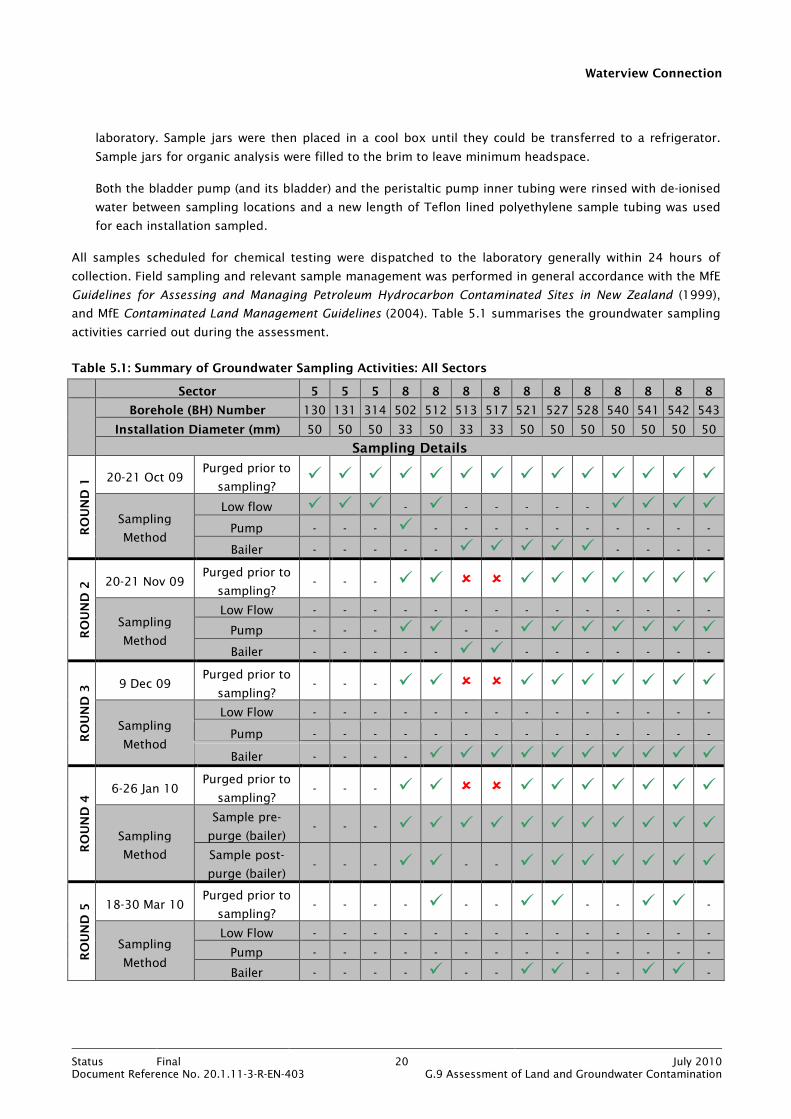
Waterview Connection
Status Final 20 July 2010Document Reference No. 20.1.11-3-R-EN-403 G.9 Assessment of Land and Groundwater Contamination
laboratory. Sample jars were then placed in a cool box until they could be transferred to a refrigerator.
Sample jars for organic analysis were filled to the brim to leave minimum headspace.
Both the bladder pump (and its bladder) and the peristaltic pump inner tubing were rinsed with de-ionised
water between sampling locations and a new length of Teflon lined polyethylene sample tubing was used
for each installation sampled.
All samples scheduled for chemical testing were dispatched to the laboratory generally within 24 hours of
collection. Field sampling and relevant sample management was performed in general accordance with the MfE
Guidelines for Assessing and Managing Petroleum Hydrocarbon Contaminated Sites in New Zealand (1999),
and MfE Contaminated Land Management Guidelines (2004). Table 5.1 summarises the groundwater sampling
activities carried out during the assessment.
Table 5.1: Summary of Groundwater Sampling Activities: All Sectors
Sector 5 5 5 8 8 8 8 8 8 8 8 8 8 8
Borehole (BH) Number 130 131 314 502 512 513 517 521 527 528 540 541 542 543
Installation Diameter (mm) 50 50 50 33 50 33 33 50 50 50 50 50 50 50
Sampling Details
ROUND 1 20-21 Oct 09
Purged prior to
sampling? � � � � � � � � � � � � � �
Sampling
Method
Low flow � � � - � - - - - - � � � �
Pump - - - � - - - - - - - - - -
Bailer - - - - - � � � � � - - - -
ROUND 2 20-21 Nov 09
Purged prior to
sampling? - - - � � � � � � � � � � �
Sampling
Method
Low Flow - - - - - - - - - - - - - -
Pump - - - � � - - � � � � � � �
Bailer - - - - - � � - - - - - - -
ROUND 3 9 Dec 09
Purged prior to
sampling? - - - � � � � � � � � � � �
Sampling
Method
Low Flow - - - - - - - - - - - - - -
Pump - - - - - - - - - - - - - -
Bailer - - - - � � � � � � � � � �
ROUND 4 6-26 Jan 10
Purged prior to
sampling? - - - � � � � � � � � � � �
Sampling
Method
Sample pre-
purge (bailer) - - - � � � � � � � � � � �
Sample post-
purge (bailer) - - - � � - - � � � � � � �
ROUND 5 18-30 Mar 10
Purged prior to
sampling? - - - - � - - � � - - � � -
Sampling
Method
Low Flow - - - - - - - - - - - - - -
Pump - - - - - - - - - - - - - -
Bailer - - - - � - - � � - - � � -
Waterview Connection
Status Final 21 July 2010Document Reference No. 20.1.11-3-R-EN-403 G.9 Assessment of Land and Groundwater Contamination
5.5.3 Gas Monitoring
Landfill gas monitoring was undertaken using a GA 2000 portable gas analyser with flow pod attachment. The
monitoring was carried out via gas caps fitted onto the standpipe piezometers. Measurements were taken for
up to five minutes at each location with stabilised peak concentrations for methane, carbon dioxide and
oxygen recorded. Atmospheric pressure and gas flow rate were also recorded.
5.5.4 Laboratory Analyses
All chemical laboratory analyses were performed by R J Hill Laboratories Ltd (Hill Laboratories). A full set of Hill
Laboratories results can be found in Appendix R. The analysis suites were tailored to reflect the likely
contaminants associated with historical and current land use activities. The full range of analyses across the
whole Project comprised the following:
Soils
• Heavy metals (HM) – arsenic, cadmium, chromium, copper, lead, nickel, zinc and mercury.
• pH.
• Semi volatile organic compounds (SVOC) – including polycyclic aromatic hydrocarbons (PAH).
• Volatile organic compounds (VOC).
• Total petroleum hydrocarbons (TPH).
• Organophosphorus and organonitrogen (OP/ON) pesticides.
• Organochlorine pesticides (OCP).
• Asbestos identification.
Groundwater
• Dissolved and total HM, SVOC, VOC, TPH, total suspended solids (TSS), anion/cation profile, dissolved iron,
ammoniacal nitrogen and dissolved manganese.
• Samples for dissolved metals analysis were field filtered where possible.
All samples submitted to Hill Laboratories for testing were accompanied by Chain of Custody forms, which
outline the required handling instructions. Chain of Custody forms can be found in Appendix S.
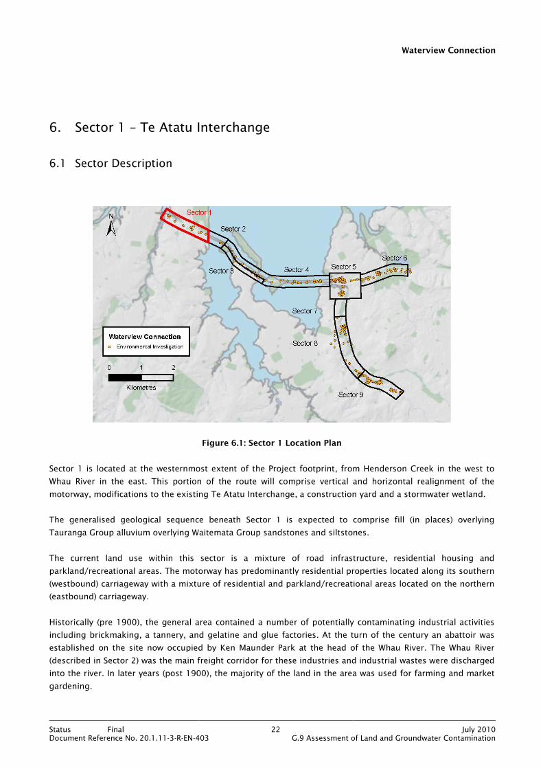
Waterview Connection
Status Final 22 July 2010Document Reference No. 20.1.11-3-R-EN-403 G.9 Assessment of Land and Groundwater Contamination
6. Sector 1 – Te Atatu Interchange
6.1 Sector Description
Figure 6.1: Sector 1 Location Plan
Sector 1 is located at the westernmost extent of the Project footprint, from Henderson Creek in the west to
Whau River in the east. This portion of the route will comprise vertical and horizontal realignment of the
motorway, modifications to the existing Te Atatu Interchange, a construction yard and a stormwater wetland.
The generalised geological sequence beneath Sector 1 is expected to comprise fill (in places) overlying
Tauranga Group alluvium overlying Waitemata Group sandstones and siltstones.
The current land use within this sector is a mixture of road infrastructure, residential housing and
parkland/recreational areas. The motorway has predominantly residential properties located along its southern
(westbound) carriageway with a mixture of residential and parkland/recreational areas located on the northern
(eastbound) carriageway.
Historically (pre 1900), the general area contained a number of potentially contaminating industrial activities
including brickmaking, a tannery, and gelatine and glue factories. At the turn of the century an abattoir was
established on the site now occupied by Ken Maunder Park at the head of the Whau River. The Whau River
(described in Sector 2) was the main freight corridor for these industries and industrial wastes were discharged
into the river. In later years (post 1900), the majority of the land in the area was used for farming and market
gardening.
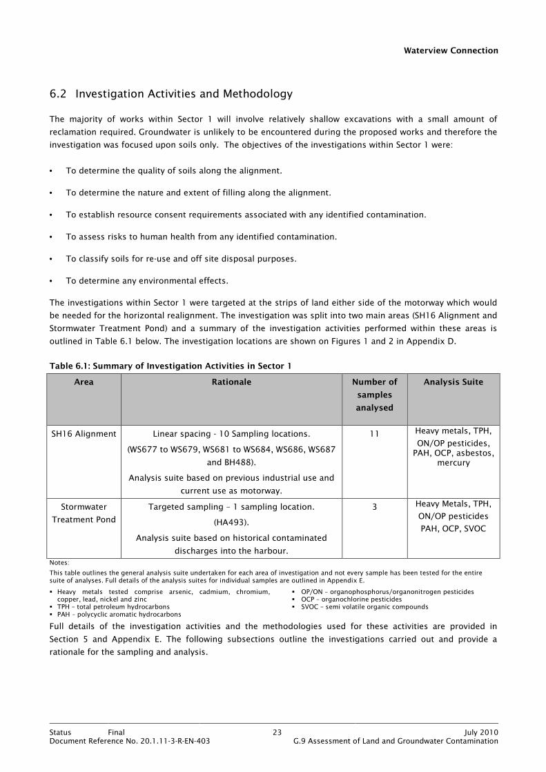
Waterview Connection
Status Final 23 July 2010Document Reference No. 20.1.11-3-R-EN-403 G.9 Assessment of Land and Groundwater Contamination
6.2 Investigation Activities and Methodology
The majority of works within Sector 1 will involve relatively shallow excavations with a small amount of
reclamation required. Groundwater is unlikely to be encountered during the proposed works and therefore the
investigation was focused upon soils only. The objectives of the investigations within Sector 1 were:
• To determine the quality of soils along the alignment.
• To determine the nature and extent of filling along the alignment.
• To establish resource consent requirements associated with any identified contamination.
• To assess risks to human health from any identified contamination.
• To classify soils for re-use and off site disposal purposes.
• To determine any environmental effects.
The investigations within Sector 1 were targeted at the strips of land either side of the motorway which would
be needed for the horizontal realignment. The investigation was split into two main areas (SH16 Alignment and
Stormwater Treatment Pond) and a summary of the investigation activities performed within these areas is
outlined in Table 6.1 below. The investigation locations are shown on Figures 1 and 2 in Appendix D.
Table 6.1: Summary of Investigation Activities in Sector 1
Area Rationale Number of
samples
analysed
Analysis Suite
SH16 Alignment Linear spacing - 10 Sampling locations.
(WS677 to WS679, WS681 to WS684, WS686, WS687
and BH488).
Analysis suite based on previous industrial use and
current use as motorway.
11 Heavy metals, TPH,
ON/OP pesticides, PAH, OCP, asbestos,
mercury
Stormwater
Treatment Pond
Targeted sampling – 1 sampling location.
(HA493).
Analysis suite based on historical contaminated
discharges into the harbour.
3 Heavy Metals, TPH,
ON/OP pesticides
PAH, OCP, SVOC
Notes:
This table outlines the general analysis suite undertaken for each area of investigation and not every sample has been tested for the entire suite of analyses. Full details of the analysis suites for individual samples are outlined in Appendix E.
� Heavy metals tested comprise arsenic, cadmium, chromium, copper, lead, nickel and zinc
� TPH – total petroleum hydrocarbons � PAH – polycyclic aromatic hydrocarbons
� OP/ON – organophosphorus/organonitrogen pesticides � OCP – organochlorine pesticides � SVOC – semi volatile organic compounds
Full details of the investigation activities and the methodologies used for these activities are provided in
Section 5 and Appendix E. The following subsections outline the investigations carried out and provide a
rationale for the sampling and analysis.

Waterview Connection
Status Final 24 July 2010Document Reference No. 20.1.11-3-R-EN-403 G.9 Assessment of Land and Groundwater Contamination
6.2.1 SH16 Alignment
A linear spacing of approximately 250m was used to cover the length of SH16 within Sector 1. Sampling
locations were sited on both sides of the motorway corridor, though sampling locations adjacent to the
eastbound carriageway were limited due to access issues caused by a large embankment alongside Jack Colvin
Park (see Figure 43 in Appendix Q). The presence of services constrained the setting out of some sampling
locations adjacent to the westbound carriageway of the motorway. The 10 sampling locations comprised nine
window sampling boreholes and one conventional borehole, from which 11 soil samples were collected to a
maximum depth of 4.5m bgl.
Linear spacing was considered the most appropriate sampling strategy to investigate the linear construction
footprint of a motorway widening scheme. It was also considered that potential contamination was likely to be
from stormwater contaminants and pesticide use along the alignment, with the possibility of some
contamination from the historical industrial activities.
Eleven samples were scheduled for chemical laboratory analysis and the analysis suite is summarised in Table
6.1 and detailed in Appendix E.
6.2.2 Stormwater Treatment Pond
An area to the north-west of Jack Colvin Park has been identified as a potential site for a stormwater treatment
pond. This location will encroach upon the upper reaches of a tidally influenced tributary of Henderson Creek.
In order to construct a treatment pond in this location, a retaining wall will have to be constructed and
unsuitable materials (i.e. sediments) excavated and managed. The area currently acts as a settling zone for
urban stormwater runoff and has the potential to contain elevated concentrations of contaminants. A hand
auger was used to collect three sediment samples to a depth of 1.6m bgl. These were scheduled for chemical
laboratory analysis and the analysis suite is summarised in Table 6.1 and detailed in Appendix E.
6.3 Investigation Findings
6.3.1 SH16 Alignment
Review of the borehole and window sampling logs has confirmed the expected geology beneath the alignment
as Tauranga Group alluvium (predominantly silty clay with some sand and gravel and organic layers) with fill
present in approximately half of the investigation locations. The fill comprised reworked natural materials,
mainly silts and clays. There was no evidence of waste materials and no visible or olfactory (odourous)
indications for contamination within any of the sampling locations.
Groundwater was not noted during the investigation.
The following land uses were considered most appropriate when selecting assessment criteria:
• Consent Requirements – residential.
• Human Health – residential.

Waterview Connection
Status Final 25 July 2010Document Reference No. 20.1.11-3-R-EN-403 G.9 Assessment of Land and Groundwater Contamination
The chemical analysis results revealed that no contaminants have exceeded their Permitted Activity criteria.
However, there was an isolated exceedance of the human health criteria for benzo(a)pyrene equivalent (BaP eq)
as detailed in Table 6.2 below (see Appendix E for full results).
Table 6.2: Contaminants Exceeding Assessment Criteria in Sector 1
Location Contaminant Depth (m) Concentration (mg/kg) Human Health Criterion
(mg/kg)
WS677 Benzo(a)pyrene
equivalent
0.1 0.75 0.27
6.3.2 Stormwater Treatment Pond
Review of the hand auger log indicated the geology in the area of the proposed treatment pond to be Tauranga
Group alluvium, underlain by Waitemata Group. There was no visible or olfactory evidence of contamination
during sampling.
Groundwater was not noted during the investigation.
The following land uses were considered most appropriate when selecting assessment criteria:
• Consent Requirements – residential.
• Human Health – residential.
The chemical analysis results revealed that no contaminants have exceeded their Permitted Activity or human
health criteria (see Appendix E for full results). However, it is noted that the laboratory detection limits for
some OCP were very high; an order of magnitude above the Permitted Activity criteria for total DDD/DDE/DDT
of 0.7 mg/kg. It is proposed that soils in the affected area are re-sampled and tested prior to the construction
of the stormwater pond.
6.4 Discussion
6.4.1 Nature of materials
The investigations in Sector 1 have shown the geology to comprise fill (in places) overlying Tauranga Group
(silts and clays) overlying Waitemata Group. The fill consists of reworked natural materials (silts and clays with
some gravel). No waste materials were identified during the investigation.
6.4.2 Resource Consent Assessment and Human Health Risk
The results of all soil analyses within Sector 1 have revealed that no contaminants exceeded their Permitted
Activity criteria under Rule 5.5.41 of the ALWP (see comments on OCP in Section 6.3.2). One sample (WS677)
had a BaP eq concentration above its human health criterion (see Figure 15 in Appendix M for location).

Waterview Connection
Status Final 26 July 2010Document Reference No. 20.1.11-3-R-EN-403 G.9 Assessment of Land and Groundwater Contamination
Land disturbance activities along the motorway alignment will not require a discharge consent but excavation
of soils should be carried out and managed in accordance with the CSMP (see Appendix O) and CHSP.
Adherence to such plans will control the off site migration of contaminants and minimise the exposure of
construction workers to contaminated soils. The CSMP is a sub-plan to the Construction Environmental
Management Plan (CEMP) (see Bibliography).
6.4.3 Material Classification
Soil has been classified as cleanfill, managed fill or contaminated fill (as set out in Section 4.5.1). The results of
the classification are best appreciated spatially and they are therefore presented on Figures 21 and 22 in
Appendix N.
Within Sector 1, the SH16 alignment has approximately 45% cleanfill and 55% managed fill, whilst the
stormwater treatment pond is 100% managed fill. However, it should be noted that only one investigation
location was used for the treatment pond assessment. The classification is summarised in Table 6.3.
Estimated percentages of material types are based on the material type at each investigation location as a
percentage of the total number of investigation locations within that area.
Table 6.3: Sector 1: Material Classification
Area Cleanfill (%) Managed Fill (%) Contaminated Fill (%)
SH16 Alignment 45 55 -
Stormwater Treatment Pond - 100 -
It should be noted that this soil classification is generic and erring on conservative. It is intended to give an
overview of the distribution of broad soil/material types within a depth range of approximately 3m bgl. Further
assessment would be required to provide a more definitive classification.
6.5 Assessment of Environmental Effects
Based on the findings of the investigation for this sector, the potential effects on the environment are
identified in the table below, along with appropriate mitigation measures:
Table 6.4: Sector 1: Assessment of Environmental Effects
Area Effect Mitigation
SH16 Alignment Construction worker exposure to contaminants in soil.
Adherence to CSMP and CHSP.
The mitigation measures to address potential construction worker exposure to contaminated soils, are detailed
within the CSMP and CHSP. The key measures are summarised in Section 16.
6.6 Conclusions
The shallow geology beneath Sector 1 comprises fill (reworked silts and clays) and Tauranga Group alluvium.
Waste materials were not identified at any investigation locations.
Waterview Connection
Status Final 27 July 2010Document Reference No. 20.1.11-3-R-EN-403 G.9 Assessment of Land and Groundwater Contamination
Results of soil analyses have shown that Permitted Activity criteria were not exceeded within any of the soil
samples analysed. Land disturbance activities in Sector 1 will therefore not require discharge consent. A human
health criterion was exceeded for BaP eq in a sample from location WS677. Excavation of soils should therefore
be carried out and managed in accordance with the CSMP (see Appendix O) and CHSP.
Classification of soils has estimated the percentages of soils for re-use or disposal purposes to be cleanfill 45%
and managed fill 55%.
Potential environmental effects relate to construction workers and risks from contaminated soils. These can be
mitigated by adherence to the CSMP and CHSP.

Waterview Connection
Status Final 28 July 2010Document Reference No. 20.1.11-3-R-EN-403 G.9 Assessment of Land and Groundwater Contamination
7. Sector 2 – Whau River
7.1 Sector Description
Figure 7.1: Sector 2 Location Plan
Sector 2 of the Project includes the enlargement of the existing Whau River Bridge to accommodate additional
lanes. A separate dedicated cycle/pedestrian bridge is also to be constructed alongside the enlarged Whau
River Bridge.
The generalised geological sequence beneath Sector 2 is expected to comprise marine mud (Tauranga Group).
The mud is commonly vegetated with mangroves and could be several metres thick.
The existing land use within this sector is road infrastructure in the form of the SH16 Whau bridge over the
Whau River. The Whau River is a tidal arm of the south western Waitemata Harbour.
Historically, there is evidence (WCC website 2010a) that the Whau River has received a wide range of
potentially contaminated waste water discharges from industrial activities located along the Te Atatu Peninsula.
In addition, there is anecdotal evidence of a chemical spill into the river in the late 1980s. However, further
information regarding the spill could not be found.
The deposition of urban contaminants including heavy metals would be expected in this low energy mangrove
environment.
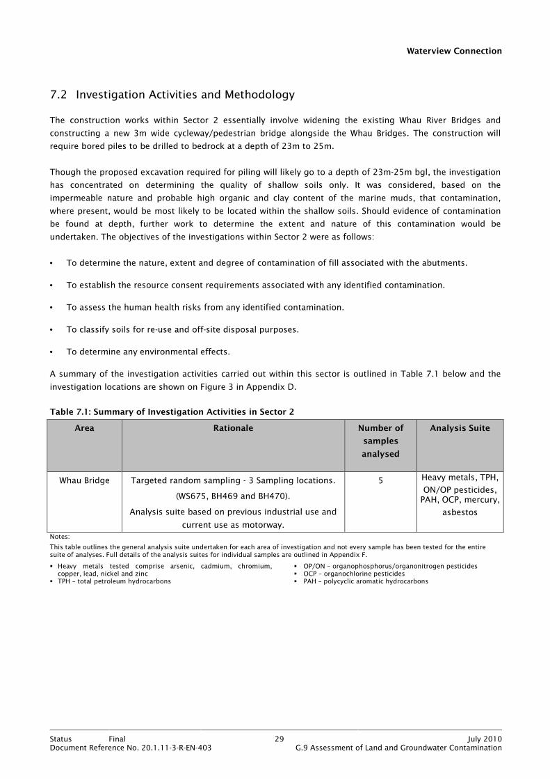
Waterview Connection
Status Final 29 July 2010Document Reference No. 20.1.11-3-R-EN-403 G.9 Assessment of Land and Groundwater Contamination
7.2 Investigation Activities and Methodology
The construction works within Sector 2 essentially involve widening the existing Whau River Bridges and
constructing a new 3m wide cycleway/pedestrian bridge alongside the Whau Bridges. The construction will
require bored piles to be drilled to bedrock at a depth of 23m to 25m.
Though the proposed excavation required for piling will likely go to a depth of 23m-25m bgl, the investigation
has concentrated on determining the quality of shallow soils only. It was considered, based on the
impermeable nature and probable high organic and clay content of the marine muds, that contamination,
where present, would be most likely to be located within the shallow soils. Should evidence of contamination
be found at depth, further work to determine the extent and nature of this contamination would be
undertaken. The objectives of the investigations within Sector 2 were as follows:
• To determine the nature, extent and degree of contamination of fill associated with the abutments.
• To establish the resource consent requirements associated with any identified contamination.
• To assess the human health risks from any identified contamination.
• To classify soils for re-use and off-site disposal purposes.
• To determine any environmental effects.
A summary of the investigation activities carried out within this sector is outlined in Table 7.1 below and the
investigation locations are shown on Figure 3 in Appendix D.
Table 7.1: Summary of Investigation Activities in Sector 2
Area Rationale Number of
samples
analysed
Analysis Suite
Whau Bridge Targeted random sampling - 3 Sampling locations.
(WS675, BH469 and BH470).
Analysis suite based on previous industrial use and
current use as motorway.
5 Heavy metals, TPH,
ON/OP pesticides, PAH, OCP, mercury,
asbestos
Notes:
This table outlines the general analysis suite undertaken for each area of investigation and not every sample has been tested for the entire suite of analyses. Full details of the analysis suites for individual samples are outlined in Appendix F.
� Heavy metals tested comprise arsenic, cadmium, chromium, copper, lead, nickel and zinc
� TPH – total petroleum hydrocarbons
� OP/ON – organophosphorus/organonitrogen pesticides � OCP – organochlorine pesticides � PAH – polycyclic aromatic hydrocarbons
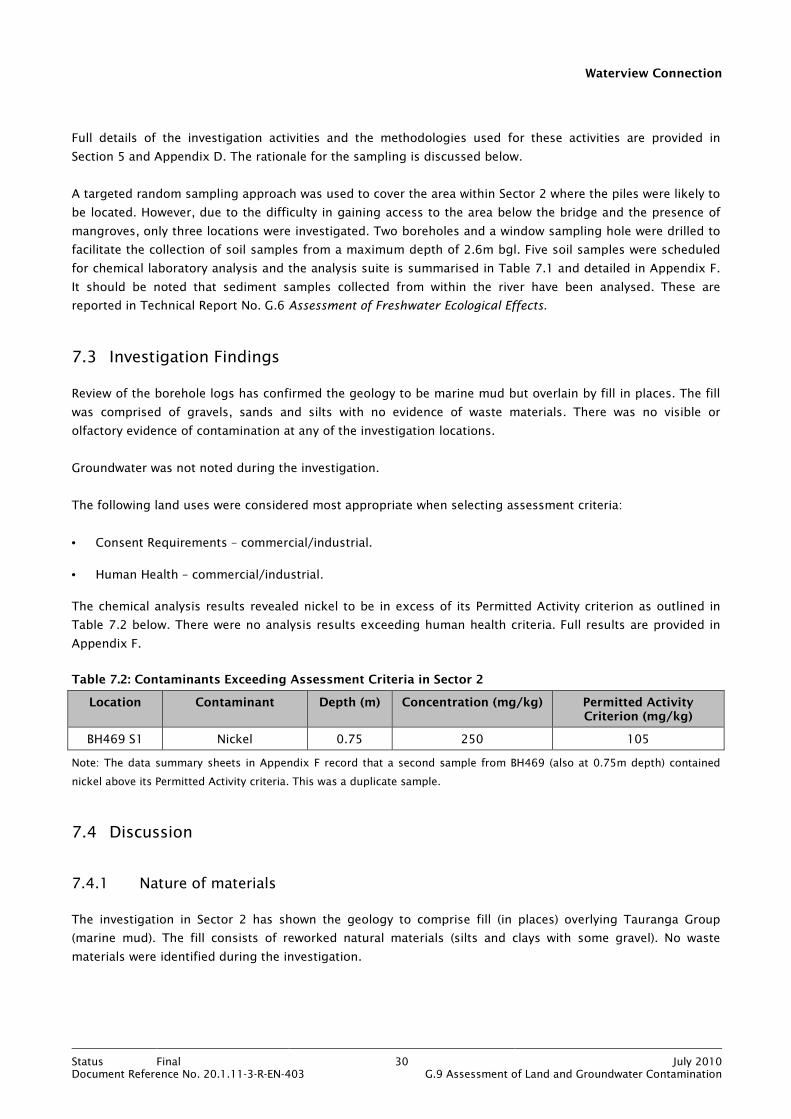
Waterview Connection
Status Final 30 July 2010Document Reference No. 20.1.11-3-R-EN-403 G.9 Assessment of Land and Groundwater Contamination
Full details of the investigation activities and the methodologies used for these activities are provided in
Section 5 and Appendix D. The rationale for the sampling is discussed below.
A targeted random sampling approach was used to cover the area within Sector 2 where the piles were likely to
be located. However, due to the difficulty in gaining access to the area below the bridge and the presence of
mangroves, only three locations were investigated. Two boreholes and a window sampling hole were drilled to
facilitate the collection of soil samples from a maximum depth of 2.6m bgl. Five soil samples were scheduled
for chemical laboratory analysis and the analysis suite is summarised in Table 7.1 and detailed in Appendix F.
It should be noted that sediment samples collected from within the river have been analysed. These are
reported in Technical Report No. G.6 Assessment of Freshwater Ecological Effects.
7.3 Investigation Findings
Review of the borehole logs has confirmed the geology to be marine mud but overlain by fill in places. The fill
was comprised of gravels, sands and silts with no evidence of waste materials. There was no visible or
olfactory evidence of contamination at any of the investigation locations.
Groundwater was not noted during the investigation.
The following land uses were considered most appropriate when selecting assessment criteria:
• Consent Requirements – commercial/industrial.
• Human Health – commercial/industrial.
The chemical analysis results revealed nickel to be in excess of its Permitted Activity criterion as outlined in
Table 7.2 below. There were no analysis results exceeding human health criteria. Full results are provided in
Appendix F.
Table 7.2: Contaminants Exceeding Assessment Criteria in Sector 2
Location Contaminant Depth (m) Concentration (mg/kg) Permitted Activity Criterion (mg/kg)
BH469 S1 Nickel 0.75 250 105
Note: The data summary sheets in Appendix F record that a second sample from BH469 (also at 0.75m depth) contained
nickel above its Permitted Activity criteria. This was a duplicate sample.
7.4 Discussion
7.4.1 Nature of materials
The investigation in Sector 2 has shown the geology to comprise fill (in places) overlying Tauranga Group
(marine mud). The fill consists of reworked natural materials (silts and clays with some gravel). No waste
materials were identified during the investigation.

Waterview Connection
Status Final 31 July 2010Document Reference No. 20.1.11-3-R-EN-403 G.9 Assessment of Land and Groundwater Contamination
7.4.2 Resource Consent Assessment and Human Health Risk
The results of soil analyses within Sector 2 have revealed that nickel (BH469) exceeded its Permitted Activity
criterion. This is shown on Figure 15 in Appendix M. On the basis of this result, land disturbance activities
within the vicinity of that location will require discharge consent under Rule 5.5.44 of the ALWP.
There were no contaminants in excess of their human health criteria. Therefore land disturbance activities
along the motorway alignment will not require any special management practices to protect against the risks
from soil contamination. However, all excavations should be carried out and managed in accordance with the
CSMP (see Appendix O) and CHSP. Adherence to such plans will control the off site migration of any, as yet,
unidentified contaminants and minimise the exposure of construction workers to potentially contaminated
soils. The CSMP is a sub-plan to the CEMP (see Bibliography).
7.4.3 Material Classification
Soil has been classified as cleanfill, managed fill or contaminated fill (as set out in Section 4.5.1). The results of
the classification are best appreciated spatially and they are therefore presented on Figure 23 in Appendix N.
Sector 2 has two thirds managed fill and one third cleanfill. The classification is summarised in Table 7.3.
Estimated percentages of material types are based on the material type at each investigation location as a
percentage of the total number of investigation locations within that area.
Table 7.3: Sector 2: Material Classification
Area Cleanfill (%) Managed Fill (%) Contaminated Fill (%)
Whau Bridge 33 67 -
It should be noted that this soil classification is generic and erring on conservative. It is intended to give an
overview of the distribution of broad soil/material types within a depth range of approximately 3m bgl. Further
assessment would be required to provide a more definitive classification.
7.5 Assessment of Environmental Effects
Based on the findings of the investigation for this sector, the potential effects on the environment are
identified in the table below, along with the mitigation measures:
Table 7.4: Sector 2: Assessment of Environmental Effects
Area Effect Mitigation
Whau Bridge Potential for discharge of soil contaminants during earthworks.
• Excavation and disposal off-site of
contaminated soils.
• Compliance with Resource Consent
conditions and adherence to the CSMP.
The mitigation measures to address the potential for the discharge of soil contaminants are detailed within the
CSMP. The key measures are summarised in Section 16.
Waterview Connection
Status Final 32 July 2010Document Reference No. 20.1.11-3-R-EN-403 G.9 Assessment of Land and Groundwater Contamination
7.6 Conclusions
The investigation in Sector 2 has shown that soils comprise fill (reworked silts and clays) and Tauranga Group
alluvium. Waste materials were not identified at any investigation locations.
The results of soil analyses have shown that the Permitted Activity criterion for nickel was exceeded at one
location, but human health criteria were not exceeded within any of the soil samples analysed. Land
disturbance activities in Sector 2 will require discharge consent under Rule 5.5.44 of the ALWP.
Classification of soils has estimated the percentages of soils for re-use or disposal purposes to be cleanfill 33%
and managed fill 67%.
Potential environmental effects relate to discharge of soil contaminants during earthworks. These can be
mitigated by excavation and disposal off-site of contaminated soils and adherence to the CSMP.
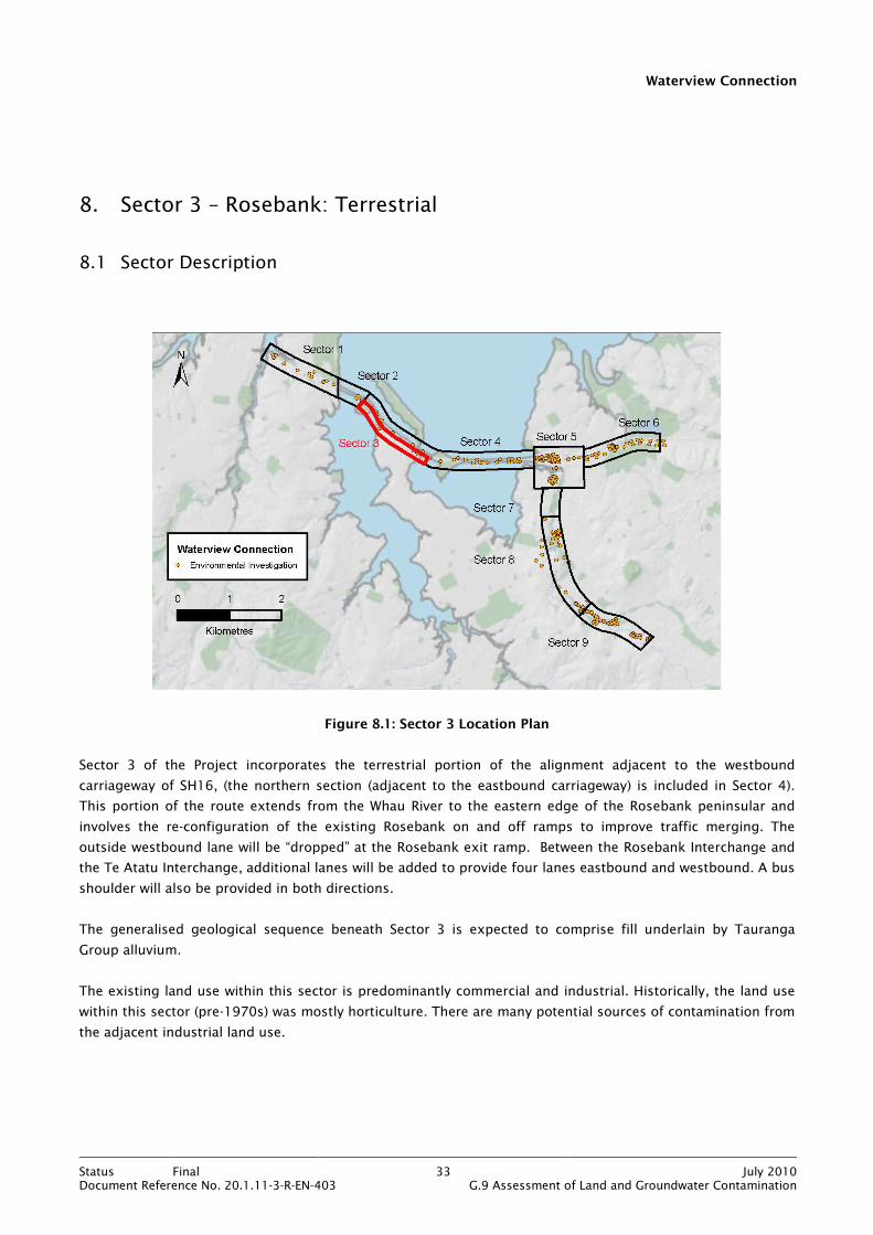
Waterview Connection
Status Final 33 July 2010Document Reference No. 20.1.11-3-R-EN-403 G.9 Assessment of Land and Groundwater Contamination
8. Sector 3 – Rosebank: Terrestrial
8.1 Sector Description
Figure 8.1: Sector 3 Location Plan
Sector 3 of the Project incorporates the terrestrial portion of the alignment adjacent to the westbound
carriageway of SH16, (the northern section (adjacent to the eastbound carriageway) is included in Sector 4).
This portion of the route extends from the Whau River to the eastern edge of the Rosebank peninsular and
involves the re-configuration of the existing Rosebank on and off ramps to improve traffic merging. The
outside westbound lane will be “dropped” at the Rosebank exit ramp. Between the Rosebank Interchange and
the Te Atatu Interchange, additional lanes will be added to provide four lanes eastbound and westbound. A bus
shoulder will also be provided in both directions.
The generalised geological sequence beneath Sector 3 is expected to comprise fill underlain by Tauranga
Group alluvium.
The existing land use within this sector is predominantly commercial and industrial. Historically, the land use
within this sector (pre-1970s) was mostly horticulture. There are many potential sources of contamination from
the adjacent industrial land use.
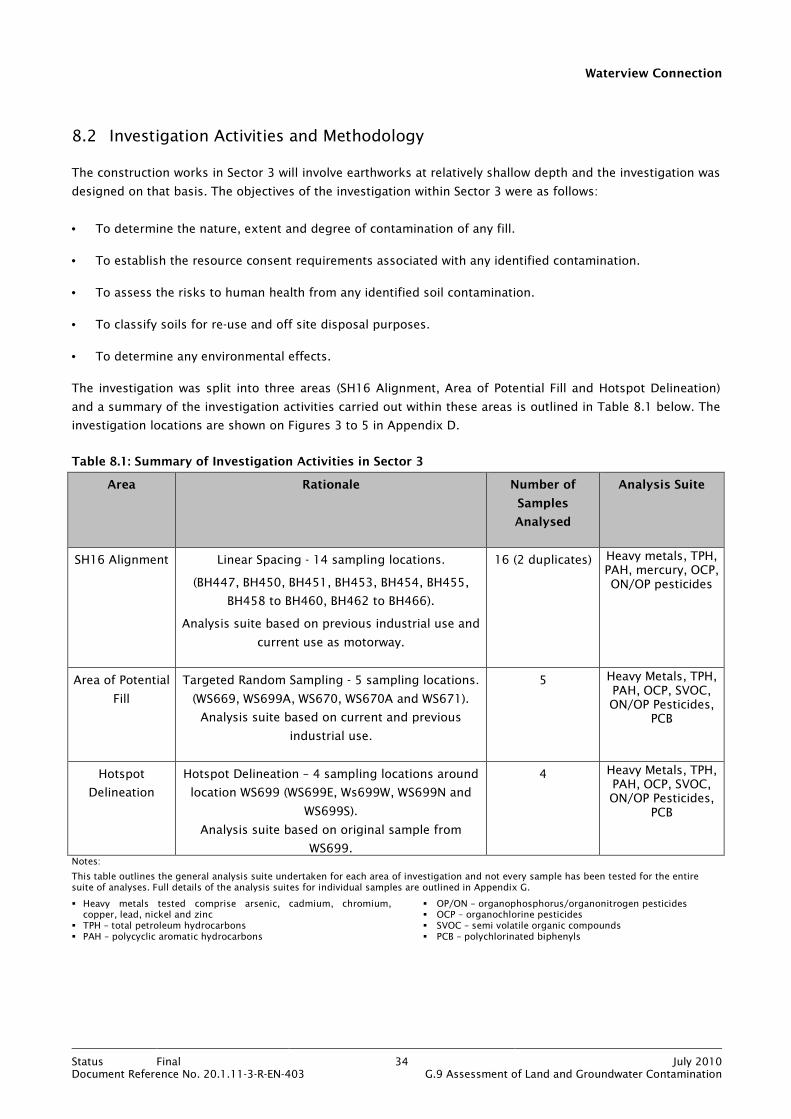
Waterview Connection
Status Final 34 July 2010Document Reference No. 20.1.11-3-R-EN-403 G.9 Assessment of Land and Groundwater Contamination
8.2 Investigation Activities and Methodology
The construction works in Sector 3 will involve earthworks at relatively shallow depth and the investigation was
designed on that basis. The objectives of the investigation within Sector 3 were as follows:
• To determine the nature, extent and degree of contamination of any fill.
• To establish the resource consent requirements associated with any identified contamination.
• To assess the risks to human health from any identified soil contamination.
• To classify soils for re-use and off site disposal purposes.
• To determine any environmental effects.
The investigation was split into three areas (SH16 Alignment, Area of Potential Fill and Hotspot Delineation)
and a summary of the investigation activities carried out within these areas is outlined in Table 8.1 below. The
investigation locations are shown on Figures 3 to 5 in Appendix D.
Table 8.1: Summary of Investigation Activities in Sector 3
Area Rationale Number of
Samples
Analysed
Analysis Suite
SH16 Alignment Linear Spacing - 14 sampling locations.
(BH447, BH450, BH451, BH453, BH454, BH455,
BH458 to BH460, BH462 to BH466).
Analysis suite based on previous industrial use and
current use as motorway.
16 (2 duplicates) Heavy metals, TPH, PAH, mercury, OCP, ON/OP pesticides
Area of Potential
Fill
Targeted Random Sampling - 5 sampling locations.
(WS669, WS699A, WS670, WS670A and WS671).
Analysis suite based on current and previous
industrial use.
5 Heavy Metals, TPH, PAH, OCP, SVOC, ON/OP Pesticides,
PCB
Hotspot
Delineation
Hotspot Delineation – 4 sampling locations around
location WS699 (WS699E, Ws699W, WS699N and
WS699S).
Analysis suite based on original sample from
WS699.
4 Heavy Metals, TPH, PAH, OCP, SVOC, ON/OP Pesticides,
PCB
Notes:
This table outlines the general analysis suite undertaken for each area of investigation and not every sample has been tested for the entire suite of analyses. Full details of the analysis suites for individual samples are outlined in Appendix G.
� Heavy metals tested comprise arsenic, cadmium, chromium, copper, lead, nickel and zinc
� TPH – total petroleum hydrocarbons � PAH – polycyclic aromatic hydrocarbons
� OP/ON – organophosphorus/organonitrogen pesticides � OCP – organochlorine pesticides � SVOC – semi volatile organic compounds � PCB – polychlorinated biphenyls

Waterview Connection
Status Final 35 July 2010Document Reference No. 20.1.11-3-R-EN-403 G.9 Assessment of Land and Groundwater Contamination
Full details of the investigation activities and the methodologies used for these activities are provided in
Section 5 and Appendix G. The rationale for the sampling is discussed below.
8.2.1 SH16 Alignment
A linear spacing of approximately 50m to 100m was used to cover the length of SH16 within Sector 3. The
spacing reflected the industrial nature of the land use. The spacing was not equidistant due to various
obstructions and buried services. Sample spacing was increased in the central portion of the sector where the
topography would cause surface contaminants to flow away from the alignment.
Linear spacing was considered the most appropriate sampling strategy to investigate the linear construction
footprint of a motorway widening scheme. It was considered that potential contamination was likely to be from
stormwater contaminants and pesticide use along the alignment, together with some contamination from the
adjacent industrial activities.
Fourteen boreholes were drilled, from which 16 samples were collected to maximum depth of 3.2m bgl. These
samples were scheduled for chemical laboratory analysis and the analysis suite is summarised in Table 8.1 and
detailed in Appendix G.
8.2.2 Area of Potential Fill and Hotspot Delineation
The area of land just to the west of the Rosebank Road Interchange was a potential area of concern. This area
was marked on the geological map as “refuse”, suggesting the area could contain waste materials of unknown
origin or composition.
On this basis, the area was targeted for investigation and this comprised the drilling of five window sampling
holes and the collection of six soil samples to a maximum depth of 0.7m bgl. These samples were scheduled
for chemical laboratory analysis and the analysis suite is summarised in Table 8.1 and detailed in Appendix G.
Upon receipt of the chemical analysis results, the sample from location WS669 was found to contain an
elevated concentration of zinc (1200 mg/kg). Further soil sampling was carried out to delineate the extent of
this contamination (see Figure 5 in Appendix D for sampling locations). Four additional samples were collected
by hand auger to a depth of 0.35m to delineate the extent of the hotspot as defined within “Hotspot
Delineation” in Table 8.1. These samples were scheduled for chemical laboratory analysis and the analysis
suite is summarised in Table 8.1 and detailed in Appendix G.
It should be noted that the depths of sampling were constrained by the high groundwater levels (see below)
encountered beneath the investigation area, which precluded the collection of representative samples below
the water table.

Waterview Connection
Status Final 36 July 2010Document Reference No. 20.1.11-3-R-EN-403 G.9 Assessment of Land and Groundwater Contamination
8.3 Investigation Findings
8.3.1 SH16 Alignment
Review of the borehole logs has confirmed the geology to be fill overlying Tauranga Group silty clays. The fill
thickness ranged from 0.3m-3.6m, with an average thickness of 1.6m. The fill was generally comprised of
gravels or reworked natural materials, with some fragments of brick and concrete identified at location
BH466B. There was no visible or olfactory evidence for contamination at any of the investigation locations.
Groundwater was encountered at 3m bgl at location BH462.
The following land uses were considered most appropriate when selecting assessment criteria:
• Consent Requirements – commercial/industrial.
• Human Health – commercial/industrial.
The chemical analysis results revealed nickel to be in excess of its Permitted Activity criterion as outlined in
Table 8.2 below. There were no analysis results exceeding human health criteria. Full results are provided in
Appendix G.
Table 8.2: Contaminants Exceeding Assessment Criteria along SH16 Alignment
Location Contaminant Depth (m) Concentration (mg/kg) Permitted Activity Criterion (mg/kg)
BH447 Nickel 0.3 130 105
8.3.2 Area of Potential Fill and Hotspot Delineation
Review of the window sampling logs has revealed the shallow geology to comprise Recent alluvial silts with a
high proportion of decaying organic matter. The investigation targeted soils to depths of 1m and fill was not
encountered. There was no visible or olfactory evidence for contamination during the investigation.
Groundwater was encountered at 0.3m bgl at location WS669.
The following land uses were considered most appropriate when selecting assessment criteria:
• Consent Requirements – commercial/industrial.
• Human Health – commercial/industrial.
The chemical analysis results revealed zinc to be in excess of its Permitted Activity criterion as outlined in
Table 8.3 below. There were no analysis results exceeding human health criteria. During the delineation
exercise for the elevated zinc at location WS669, no other contaminants were identified above their assessment
criteria. Full results are provided in Appendix G.
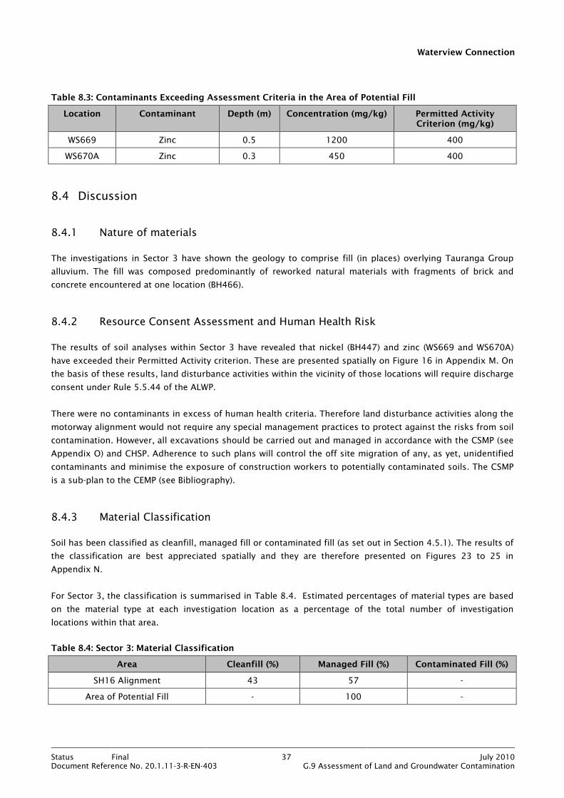
Waterview Connection
Status Final 37 July 2010Document Reference No. 20.1.11-3-R-EN-403 G.9 Assessment of Land and Groundwater Contamination
Table 8.3: Contaminants Exceeding Assessment Criteria in the Area of Potential Fill
Location Contaminant Depth (m) Concentration (mg/kg) Permitted Activity Criterion (mg/kg)
WS669 Zinc 0.5 1200 400
WS670A Zinc 0.3 450 400
8.4 Discussion
8.4.1 Nature of materials
The investigations in Sector 3 have shown the geology to comprise fill (in places) overlying Tauranga Group
alluvium. The fill was composed predominantly of reworked natural materials with fragments of brick and
concrete encountered at one location (BH466).
8.4.2 Resource Consent Assessment and Human Health Risk
The results of soil analyses within Sector 3 have revealed that nickel (BH447) and zinc (WS669 and WS670A)
have exceeded their Permitted Activity criterion. These are presented spatially on Figure 16 in Appendix M. On
the basis of these results, land disturbance activities within the vicinity of those locations will require discharge
consent under Rule 5.5.44 of the ALWP.
There were no contaminants in excess of human health criteria. Therefore land disturbance activities along the
motorway alignment would not require any special management practices to protect against the risks from soil
contamination. However, all excavations should be carried out and managed in accordance with the CSMP (see
Appendix O) and CHSP. Adherence to such plans will control the off site migration of any, as yet, unidentified
contaminants and minimise the exposure of construction workers to potentially contaminated soils. The CSMP
is a sub-plan to the CEMP (see Bibliography).
8.4.3 Material Classification
Soil has been classified as cleanfill, managed fill or contaminated fill (as set out in Section 4.5.1). The results of
the classification are best appreciated spatially and they are therefore presented on Figures 23 to 25 in
Appendix N.
For Sector 3, the classification is summarised in Table 8.4. Estimated percentages of material types are based
on the material type at each investigation location as a percentage of the total number of investigation
locations within that area.
Table 8.4: Sector 3: Material Classification
Area Cleanfill (%) Managed Fill (%) Contaminated Fill (%)
SH16 Alignment 43 57 -
Area of Potential Fill - 100 -

Waterview Connection
Status Final 38 July 2010Document Reference No. 20.1.11-3-R-EN-403 G.9 Assessment of Land and Groundwater Contamination
It should be noted that this soil classification is generic and erring on conservative. It is intended to give an
overview of the distribution of broad soil/material types within a depth range of approximately 3m bgl. Further
assessment would be required to provide a more definitive classification.
8.5 Assessment of Environmental Effects
Based on the findings of the investigation for this sector, the potential effects on the environment are
identified in the table below, along with appropriate mitigation measures:
Table 8.5: Sector 3: Assessment of Environmental Effects
Area Effect Mitigation
SH16 Alignment Potential for discharge of soil contaminants during earthworks.
• Excavation and disposal off-site of
contaminated soils.
• Compliance with Resource Consent conditions
and adherence to the CSMP.
The mitigation measures to address the potential for the discharge of soil contaminants are detailed within the
CSMP. The key measures are summarised in Section 16.
8.6 Conclusions
The investigations in Sector 3 have shown that soils comprise fill (mainly reworked silts and clays) and
Tauranga Group alluvium. Minor waste materials (brick and concrete) were identified at one location.
Results of soil analyses have shown that Permitted Activity criteria were exceeded for nickel at one location and
zinc at two locations. Land disturbance activities in the vicinity of the elevated nickel and zinc will therefore
require discharge consent under Rule 5.5.44 of the ALWP. Human health criteria were not exceeded within any
of the soil samples analysed.
Classification of soils has estimated the percentages of soils for re-use or disposal purposes to be cleanfill 43%
and managed fill 57%.
Potential environmental effects relate to discharge of soil contaminants during earthworks. These can be
mitigated by excavation and disposal off-site of contaminated soils and adherence to the CSMP.
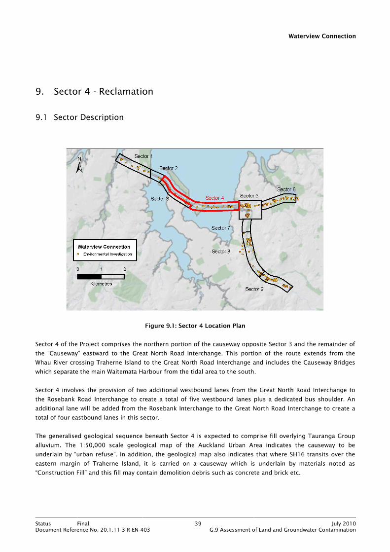
Waterview Connection
Status Final 39 July 2010Document Reference No. 20.1.11-3-R-EN-403 G.9 Assessment of Land and Groundwater Contamination
9. Sector 4 - Reclamation
9.1 Sector Description
Figure 9.1: Sector 4 Location Plan
Sector 4 of the Project comprises the northern portion of the causeway opposite Sector 3 and the remainder of
the “Causeway” eastward to the Great North Road Interchange. This portion of the route extends from the
Whau River crossing Traherne Island to the Great North Road Interchange and includes the Causeway Bridges
which separate the main Waitemata Harbour from the tidal area to the south.
Sector 4 involves the provision of two additional westbound lanes from the Great North Road Interchange to
the Rosebank Road Interchange to create a total of five westbound lanes plus a dedicated bus shoulder. An
additional lane will be added from the Rosebank Interchange to the Great North Road Interchange to create a
total of four eastbound lanes in this sector.
The generalised geological sequence beneath Sector 4 is expected to comprise fill overlying Tauranga Group
alluvium. The 1:50,000 scale geological map of the Auckland Urban Area indicates the causeway to be
underlain by “urban refuse”. In addition, the geological map also indicates that where SH16 transits over the
eastern margin of Traherne Island, it is carried on a causeway which is underlain by materials noted as
“Construction Fill” and this fill may contain demolition debris such as concrete and brick etc.
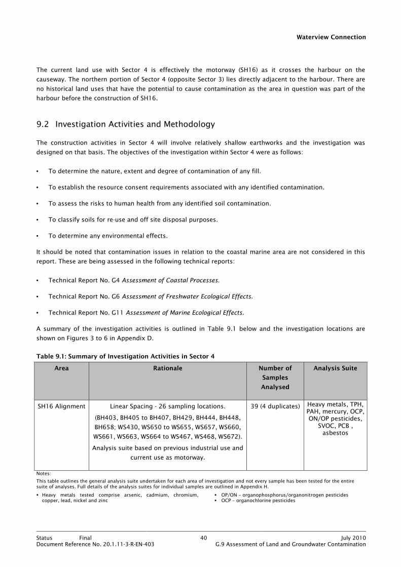
Waterview Connection
Status Final 40 July 2010Document Reference No. 20.1.11-3-R-EN-403 G.9 Assessment of Land and Groundwater Contamination
The current land use with Sector 4 is effectively the motorway (SH16) as it crosses the harbour on the
causeway. The northern portion of Sector 4 (opposite Sector 3) lies directly adjacent to the harbour. There are
no historical land uses that have the potential to cause contamination as the area in question was part of the
harbour before the construction of SH16.
9.2 Investigation Activities and Methodology
The construction activities in Sector 4 will involve relatively shallow earthworks and the investigation was
designed on that basis. The objectives of the investigation within Sector 4 were as follows:
• To determine the nature, extent and degree of contamination of any fill.
• To establish the resource consent requirements associated with any identified contamination.
• To assess the risks to human health from any identified soil contamination.
• To classify soils for re-use and off site disposal purposes.
• To determine any environmental effects.
It should be noted that contamination issues in relation to the coastal marine area are not considered in this
report. These are being assessed in the following technical reports:
• Technical Report No. G4 Assessment of Coastal Processes.
• Technical Report No. G6 Assessment of Freshwater Ecological Effects.
• Technical Report No. G11 Assessment of Marine Ecological Effects.
A summary of the investigation activities is outlined in Table 9.1 below and the investigation locations are
shown on Figures 3 to 6 in Appendix D.
Table 9.1: Summary of Investigation Activities in Sector 4
Area Rationale Number of
Samples
Analysed
Analysis Suite
SH16 Alignment Linear Spacing - 26 sampling locations.
(BH403, BH405 to BH407, BH429, BH444, BH448,
BH658; WS430, WS650 to WS655, WS657, WS660,
WS661, WS663, WS664 to WS467, WS468, WS672).
Analysis suite based on previous industrial use and
current use as motorway.
39 (4 duplicates) Heavy metals, TPH, PAH, mercury, OCP, ON/OP pesticides,
SVOC, PCB , asbestos
Notes:
This table outlines the general analysis suite undertaken for each area of investigation and not every sample has been tested for the entire suite of analyses. Full details of the analysis suites for individual samples are outlined in Appendix H.
� Heavy metals tested comprise arsenic, cadmium, chromium, copper, lead, nickel and zinc
� OP/ON – organophosphorus/organonitrogen pesticides � OCP – organochlorine pesticides

Waterview Connection
Status Final 41 July 2010Document Reference No. 20.1.11-3-R-EN-403 G.9 Assessment of Land and Groundwater Contamination
� TPH – total petroleum hydrocarbons � PAH – polycyclic aromatic hydrocarbons
� SVOC – semi volatile organic compounds � PCB – polychlorinated biphenyls
Full details of the investigation activities and the methodologies used for these activities are provided in
Section 5 and Appendix H. The rationale for the sampling is discussed below.
A linear spacing of approximately 200m was used to cover the length of SH16 within Sector 4. This was
considered appropriate for assessing the presence of fill along the causeway and areas adjacent to the
harbour. The spacing was staggered on either side of the motorway (access permitting), except for the section
to the north of Sector 3. The spacing was not equidistant due to various obstructions and heavily vegetated
embankments.
A total of 24 boreholes and window samples holes were drilled, from which 35 samples were collected to a
maximum depth of 5m bgl. These samples were scheduled for chemical laboratory analysis and the analysis
suite is summarised in Table 9.1 and detailed in Appendix H.
9.3 Investigation Findings
Review of the borehole and window sampling logs revealed the geology to comprise fill overlying Tauranga
Group alluvium (basalt was encountered at two locations). The fill thickness ranged from approximately 1m to
3m, with an average thickness of 1.8m. The fill generally comprised gravels or reworked natural materials with
only minor proportions of waste materials. There was no visible or olfactory evidence of contamination at any
of the investigation locations.
Groundwater was encountered at 7m bgl at location BH405.
The following land uses were considered most appropriate when selecting assessment criteria:
• Consent Requirements – commercial/industrial.
• Human Health – commercial/industrial.
The chemical analysis results revealed nickel to be in excess of its Permitted Activity criterion, as detailed in
Table 9.2 below. There were no analysis results exceeding human health criteria. Full results are provided in
Appendix H.
Table 9.2: Contaminants Exceeding Assessment Criteria in Sector 4
Location Contaminant Depth (m) Concentration (mg/kg) Permitted Activity Criterion (mg/kg)
WS467 Nickel 0.6 – 0.7 110 105
The detection limits of some individual PAH compounds and phenolic compounds exceeded their respective
assessment criteria. This may be a result of laboratory procedural issues or the limit of detection being
mistakenly scheduled as screen level when it should have been scheduled at trace level. The detection limits
can be seen in the Hills laboratories data sheets in Appendix R. However, given the nature of the existing land
use and the context of the proposed construction, these results are not considered to be significant.
Waterview Connection
Status Final 42 July 2010Document Reference No. 20.1.11-3-R-EN-403 G.9 Assessment of Land and Groundwater Contamination
9.4 Discussion
9.4.1 Nature of materials
The investigations in Sector 4 have shown the geology to comprise fill overlying Tauranga Group alluvium. The
fill was composed predominantly of reworked natural materials with minor amounts of waste materials.
9.4.2 Resource Consent Assessment and Human Health Risk
The results of soil analyses within Sector 4 have revealed that nickel (WS467) has exceeded its Permitted
Activity criterion. This is presented on Figure 16 in Appendix M. On the basis of this result, land disturbance
activities within the vicinity of that location will require discharge consent under Rule 5.5.44 of the ALWP.
There were no contaminants in excess of their human health criteria. Therefore land disturbance activities
along the motorway alignment will not require any special management practices to protect against the risks
from soil contamination. However, land disturbance activities should be carried out and managed in
accordance with the CSMP (see Appendix O) and CHSP. Adherence to such plans will control the off site
migration of any, as yet, unidentified contaminants and minimise the exposure of construction workers to
potentially contaminated soils. The CSMP is a sub-plan to the CEMP (see Bibliography).
9.4.3 Material Classification
Soil has been classified as cleanfill, managed fill or contaminated fill (as set out in Section 4.5.1). The results of
the classification are best appreciated spatially and they are therefore presented on Figures 23 to 26 in
Appendix N.
For Sector 4, the classification is summarised in Table 9.3. Estimated percentages of material types are based
on the material type at each investigation location as a percentage of the total number of investigation
locations within that area.
Table 9.3: Sector 4: Material Classification
Area Cleanfill (%) Managed Fill (%) Contaminated Fill (%)
SH16 Alignment 58 42 -
It should be noted that this soil classification is generic and erring on conservative. It is intended to give an
overview of the distribution of broad soil/material types within a depth range of approximately 3m bgl. Further
assessment would be required to provide a more definitive classification.
9.5 Assessment of Environmental Effects
Based on the findings of the investigation for this sector, the potential effects on the environment are
identified in the table below, along with appropriate mitigation measures:
Waterview Connection
Status Final 43 July 2010Document Reference No. 20.1.11-3-R-EN-403 G.9 Assessment of Land and Groundwater Contamination
Table 9.4: Sector 4: Assessment of Environmental Effects
Area Effect Mitigation
SH16 Alignment Potential for discharge of soil contaminants during earthworks.
• Excavation and disposal off-site of
contaminated soils.
• Compliance with Resource Consent conditions
and adherence to the CSMP.
The mitigation measures to address the potential for the discharge of soil contaminants are detailed within the
CSMP. The key measures are summarised in Section 16.
9.6 Conclusions
The investigation in Sector 4 has shown that soils comprise fill (mainly reworked silts and clays) and Tauranga
Group alluvium. Minor waste materials were identified at some locations.
Results of soil analyses have shown that the Permitted Activity criterion for nickel was exceeded at one
location. Land disturbance activities within the vicinity of the elevated nickel will therefore require discharge
consent under Rule 5.5.44 of the ALWP. Human health criteria were not exceeded within any of the soil
samples analysed.
Classification of soils has estimated the percentages of soils for re-use or disposal purposes to be cleanfill 58%
and managed fill 42%.
Potential environmental effects relate to discharge of soil contaminants during earthworks. These can be
mitigated by excavation and disposal offsite of contaminated soils and adherence to the CSMP.
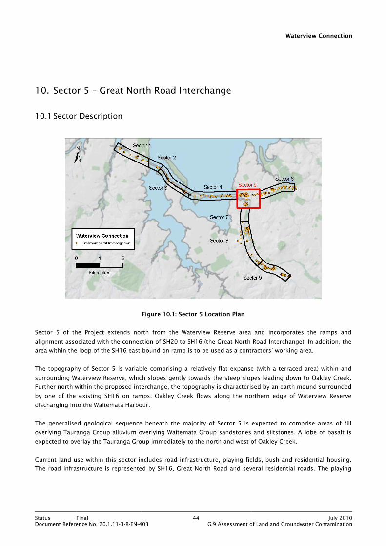
Waterview Connection
Status Final 44 July 2010Document Reference No. 20.1.11-3-R-EN-403 G.9 Assessment of Land and Groundwater Contamination
10. Sector 5 – Great North Road Interchange
10.1 Sector Description
Figure 10.1: Sector 5 Location Plan
Sector 5 of the Project extends north from the Waterview Reserve area and incorporates the ramps and
alignment associated with the connection of SH20 to SH16 (the Great North Road Interchange). In addition, the
area within the loop of the SH16 east bound on ramp is to be used as a contractors’ working area.
The topography of Sector 5 is variable comprising a relatively flat expanse (with a terraced area) within and
surrounding Waterview Reserve, which slopes gently towards the steep slopes leading down to Oakley Creek.
Further north within the proposed interchange, the topography is characterised by an earth mound surrounded
by one of the existing SH16 on ramps. Oakley Creek flows along the northern edge of Waterview Reserve
discharging into the Waitemata Harbour.
The generalised geological sequence beneath the majority of Sector 5 is expected to comprise areas of fill
overlying Tauranga Group alluvium overlying Waitemata Group sandstones and siltstones. A lobe of basalt is
expected to overlay the Tauranga Group immediately to the north and west of Oakley Creek.
Current land use within this sector includes road infrastructure, playing fields, bush and residential housing.
The road infrastructure is represented by SH16, Great North Road and several residential roads. The playing
Waterview Connection
Status Final 45 July 2010Document Reference No. 20.1.11-3-R-EN-403 G.9 Assessment of Land and Groundwater Contamination
fields occupy Waterview Reserve and an area of bush predominates on the northern bank of Oakley Creek.
Waterview Reserve is surrounded by housing with gardens.
There is evidence from the previous Phase 1 desk study Addendum Report. SH20 – Waterview Connection: Site
Contamination Investigation Report, 2008 (included as Appendix B) for historical earthworks within Waterview
Reserve. Aerial photographs show a natural marshy depression being infilled during the surrounding
residential development. The extent of the earthworks is visible today, where a terrace has been formed
around the main sports pitch leading to a landscaped profile which gently slopes towards the steeper slopes of
Oakley Creek. A tannery historically occupied both banks of Oakley Creek and archaeological remains are still
present. There is also evidence of a small basalt quarry within the area of bush on the north bank of Oakley
Creek, together with Maori settlement features.
In addition, it is suspected that the earth mound within the central portion of the Great North Road Interchange
is not a natural feature but is associated with the construction of SH16.
From the historical activities described above, those with the most significant potential for contamination are
listed below:
• Tannery and mill along the banks of Oakley Creek.
• Basalt quarry to the north of Oakley Creek.
• Historical earthworks and infilling of natural depressions within Waterview Reserve and within the central
portion of the Great North Road Interchange.
10.2 Investigation Activities and Methodology
The objectives of the investigations within Sector 5 were as follows:
• To identify any contamination of soils associated with historical filling and industrial activities.
• To assess the risks to human health from any soil contamination.
• To establish the resource consent requirements in relation to contaminated soils and project construction
activities.
• To classify soils for re-use and off site disposal purposes.
• To determine any environmental effects.

Waterview Connection
Status Final 46 July 2010Document Reference No. 20.1.11-3-R-EN-403 G.9 Assessment of Land and Groundwater Contamination
The following subsections summarise the investigations carried out and provide a rationale for the sampling
and testing. The investigations were grouped into four main areas of interest established from the findings of
the previous Phase 1 desk study (see Appendix B) in conjunction with the proposed locations of construction
activities. These areas were:
• Waterview Reserve
• Former tannery and basalt quarry
• Central portion of the Great North Road Interchange
• SH16 alignment.
Table 10.1 provides a summary of the investigations for Sector 5.
Table 10.1: Investigation Summary Sector 5
Area Rationale Number of
Samples
Analysed
Analysis Suite
Waterview Reserve (soils)
Systematic grid sampling – 14 sampling locations (TP331 to TP340 and MA341 to MA344).
Analysis suite based on unknown composition of fill and use of pesticides (for weed control) within park.
23 Heavy metals, TPH, SVOC, OP/ON pesticides
Former tannery and basalt quarry
(soils)
Targeted random sampling – 4 sampling locations (HA346 to HA349).
Analysis suite based on historical tannery. Basalt quarry inspected and found to contain no fill.
7 Heavy metals, pH, SVOC
Great North Road Interchange (soils)
Systematic grid sampling – 30 sampling locations (TP361 to TP390).
Analysis suite based on potential fill and its unknown composition.
41 Heavy metals, TPH, SVOC
SH16 alignment (soils)
Linear spacing – 5 sampling locations (WS727, WS729, WS731, WS733 & WS735).
Analysis suite based on a broad suite of contaminants considered likely to be present in stormwater runoff.
8 Heavy metals, TPH, OP/ON pesticides, OCP, asbestos
Waterview Reserve (groundwater)
Waitemata Group aquifer (BH130, BH131 & BH314).
Analysis suite based on general baseline quality assessment.
3 Heavy metals, TPH, SVOC, VOC,
anion/cation profile
Notes:
This table outlines the general analysis suite undertaken for each area of investigation and not every sample has been tested for the entire suite of analyses. Full details of the analysis suites for individual samples are outlined in Appendix I.
� Heavy metals tested comprise arsenic, cadmium, chromium, copper, lead, nickel and zinc
� TPH – total petroleum hydrocarbons � SVOC – semi volatile organic compounds
� OP/ON – organophosphorus/organonitrogen pesticides � OCP – organochlorine pesticides � VOC – volatile organic compounds
Full details of the investigation activities and the methodologies used for these activities are provided in
Section 5 and Appendix I. The rationale for sampling is discussed below.
Waterview Connection
Status Final 47 July 2010Document Reference No. 20.1.11-3-R-EN-403 G.9 Assessment of Land and Groundwater Contamination
10.2.1 Waterview Reserve
In order to give statistically representative coverage of the area within Waterview Reserve (estimated to be 2.5
hectares), a systematic grid system was used based on the MfE document Contaminated Land Management
Guidelines No. 5, Site Investigation and Analysis of Soils (2004). The number of sampling locations has been
calculated based on the following equations taken from the MfE document:
2G
AN
0.59
RG
=
=
where:
G = grid size of the sampling pattern, in metres
R = radius of the smallest hot spot that the sampling intends to detect, in metres
0.59 = factor derived from 95% detection probability assuming circular hot spots
N = number of sampling points
A = size of the sampling area, in square metres.
The hot spot radius (R) was chosen as 25m and this resulted in the need for 14 sampling locations. The choice
of hot spot radius of 25m was considered appropriate taking into account the absence of any obvious
indicators of contamination at surface which could be targeted and the long standing historical use as playing
fields/opens space.
The 14 sampling locations comprised 10 test pits and four machine augers (see Figure 7 in Appendix D for
investigation locations). The maximum depth of investigation was 3m below ground level (bgl) which was
considered appropriate for identifying any contamination associated with potential filling activities and
pesticide spraying. A total of 23 soil samples were scheduled for chemical laboratory analysis and the analysis
suite is summarised in Table 10.1 and detailed in Appendix I.
Three groundwater samples were collected from existing boreholes within the reserve as part of the overall
assessment of baseline groundwater quality within the Waitemata Group aquifer. The analysis suite is detailed
in Table 10.1.
10.2.2 Former Tannery and Basalt Quarry
A targeted random sampling approach was used for the former tannery and basalt quarry. This was partly
based on the ability to target locations where there was evidence for the historical activities, but also on the
access constraints for a machine excavator and the presence of historical Maori settlement features which
precluded a more widespread investigation. That part of the former tannery which occupied the south bank of
Oakley Creek has not been investigated as this land is within the garden of a privately owned residence and
access for the purposes of intrusive investigation was not granted (see Figure 35 in Appendix Q).
Waterview Connection
Status Final 48 July 2010Document Reference No. 20.1.11-3-R-EN-403 G.9 Assessment of Land and Groundwater Contamination
Four locations were investigated within the area of the former tannery and the basalt quarry on the north bank
of Oakley Creek (see Figure 7 in Appendix D for investigation locations). Seven soil samples were collected
from hand augers progressed to a maximum depth of 1.2m bgl at these locations. This was considered
sufficient to identify any historical contamination. The analysis suite for the seven samples analysed is
summarised in Table 10.1 and detailed in Appendix I.
10.2.3 Great North Road Interchange
At the time of the investigation, the area within the proposed interchange was being utilised for stockpiling of
materials and spoil from motorway maintenance activities.
In order to give statistically representative coverage of the area within the proposed interchange (estimated to
be 3.5 hectares), a systematic grid system was used as described above in Section 10.2.1. Adopting a hot spot
radius of 40m gave 32 sampling locations (though two locations were abandoned due to shallow obstructions
– tree roots). The choice of hot spot radius of 40m was considered appropriate taking into account the general
absence of any obvious indicators of contamination at surface which could be targeted (the stockpiles were
targeted) and the long standing historical use as open space surrounded by a motorway on ramp.
The sampling locations comprised test pits which were excavated in two discrete areas as defined by the
proposed location of the contractors’ working areas (see Figure 7 in Appendix D for investigation locations).
The test pits were excavated to a maximum depth of 3m bgl, which is considered appropriate for identification
of contaminants associated with storage of materials and to assess the presence of fill. A total of 41 samples
were scheduled for chemical laboratory analysis and the analysis suite is summarised in Table 10.1 and
detailed in Appendix I.
10.2.4 SH16 Alignment
A linear spacing of approximately 100m was used to cover the length of SH16 within Sector 5 (see Figure 7 in
Appendix D for investigation locations). Window sampling was used to collect eight soil samples from five
locations to a maximum depth of 3m bgl. This was considered to be appropriate given that the construction
activities along this section of the SH16 alignment comprise widening of the existing motorway. Eight samples
underwent chemical laboratory analysis and the analysis suite is summarised in Table 10.1 and detailed in
Appendix I.
10.2.5 Waterview Reserve Groundwater
Three groundwater samples were collected from existing boreholes screened within the Waitemata Group
aquifer (see Figure 7 in Appendix D for borehole locations). This was carried out as part of the general baseline
groundwater quality assessment for the SH20 element of the Project. The analysis suite is summarised in Table
10.1 and detailed in Appendix I.
Waterview Connection
Status Final 49 July 2010Document Reference No. 20.1.11-3-R-EN-403 G.9 Assessment of Land and Groundwater Contamination
10.3 Investigation Findings
10.3.1 Waterview Reserve
Review of the test pit logs (and borehole logs from the parallel geotechnical investigations) has confirmed the
geology beneath the park to be fill or Tauranga Group alluvium (predominantly silty clay with some sand and
gravel and organic layers) overlaying Waitemata Group sandstone and siltstone. The historical infilling of
natural depressions and the presence of more recent earthworks, suggested by the previous Phase 1
assessment (see Appendix B), was confirmed during the investigation. Whilst the investigation did not identify
any waste materials associated with the earthworked areas, reworked natural materials (organic silty clays)
were observed generally beneath the reserve. There was no visible or olfactory evidence for contamination
within any of the test pits.
Groundwater as a seepage was encountered in three test pits (TP333, TP337 and TP338) at depths between
1.4m and 2m bgl.
The following land uses were considered most appropriate when selecting assessment criteria:
• Consent Requirements – residential/parkland.
• Human Health – parkland/recreation.
The chemical analysis results revealed that no samples contained contaminants that exceeded their Permitted
Activity or human health criteria (see Appendix I for full results). However, in a sample from one location
(TP338), the laboratory detection limit for DDD, DDE and DDT was not sufficiently low to rule out the
requirement for resource consent. This is discussed in more detail in Section 10.3.6.
10.3.2 Former Tannery and Basalt Quarry
Review of the hand auger logs indicates the shallow geology beneath the area of the former tannery and basalt
quarry to comprise a silty clay with organics. Though observations during the investigation indicated that
uncontrolled dumping of waste (litter and possible materials and equipment from quarrying activities) had
occurred within the former basalt quarry, significant volumes of waste were not identified at any of the
investigation locations. There was no visible or olfactory evidence for contamination within any of the hand
augers.
Groundwater was not encountered at any of the hand auger locations.
The following land uses were considered most appropriate when selecting assessment criteria:
• Consent Requirements – residential/parkland.
• Human Health – parkland/recreation.
The chemical analyses results revealed that no samples contained contaminants that exceeded their Permitted
Activity or human health criteria (see Appendix I for full results). However, in all seven samples analysed, the

Waterview Connection
Status Final 50 July 2010Document Reference No. 20.1.11-3-R-EN-403 G.9 Assessment of Land and Groundwater Contamination
laboratory detection limit for DDD, DDE and DDT and some individual PAH compounds was not sufficiently low
to rule out the requirement for resource consent. This is discussed in more detail in Section 10.3.6.
10.3.3 Great North Road Interchange
Review of the test pit logs indicates the geology beneath the interchange to comprise fill. Where the fill was
fully penetrated, it was underlain by organic rich marine sediments. The observed fill was predominantly a
sandy silt with gravel and inclusions of waste materials comprising plastic, brick, concrete, metal, wire, glass
and wood. Waste materials were identified at locations TP362 to TP364, TP366, TP367, TP372, TP374, TP375,
TP379, TP380, TP382, and TP383. In addition, a fragment of suspected cement bound asbestos was identified
in TP383. There was no olfactory evidence for contamination within any of the test pits.
Groundwater was not encountered within any of the test pits.
The following land uses were considered most appropriate when selecting assessment criteria:
• Consent Requirements – residential/parkland.
• Human Health – parkland/recreation.
Of the 41 samples analysed, the samples from the locations listed in
Table 10.2 contained at least one contaminant in excess of its Permitted Activity and/or human health criteria
(see Appendix I for full results). In some samples, the detection limit for DDD, DDE and DDT and some
individual phenolic compounds was not sufficiently low to rule out the requirement for consent. This is
discussed in more detail in Section 10.3.6.
Table 10.2: Contaminants Exceeding Assessment Criteria at Great North Road Interchange
Location Contaminant Concentration (mg/kg) Human Health Criteria
(mg/kg)
Permitted Activity
Criteria
(mg/kg)
TP363 Lead 370 600 250
TP363 Multiple PAH Various, see data summary table in Appendix I.
TP363 BaP equivalent 3.2 2.0 2.15
TP366 Lead 690 600 250
TP369 4-Nitrophenol 1.3 - 1
TP378 Multiple PAH Various, see data summary table in Appendix I.
TP378 BaP equivalent 3.04 2.0 2.15
TP386 Nickel 153 600 105
TP390 Nickel 108 600 105
10.3.4 SH16 Alignment
A review of the window sampling logs indicates the geology beneath the interchange to comprise fill (silty sand
or gravel) underlain by Tauranga Group (silty clay). The fill was predominantly reworked natural material with
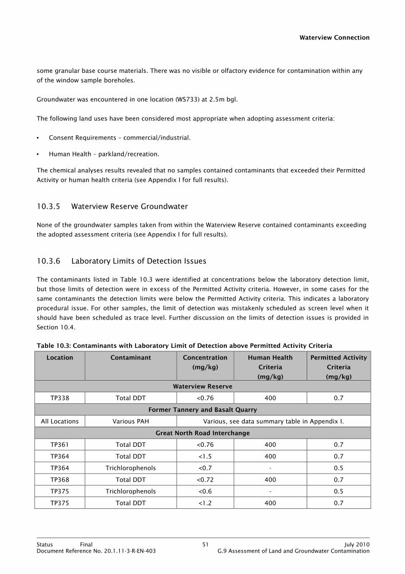
Waterview Connection
Status Final 51 July 2010Document Reference No. 20.1.11-3-R-EN-403 G.9 Assessment of Land and Groundwater Contamination
some granular base course materials. There was no visible or olfactory evidence for contamination within any
of the window sample boreholes.
Groundwater was encountered in one location (WS733) at 2.5m bgl.
The following land uses have been considered most appropriate when adopting assessment criteria:
• Consent Requirements – commercial/industrial.
• Human Health – parkland/recreation.
The chemical analyses results revealed that no samples contained contaminants that exceeded their Permitted
Activity or human health criteria (see Appendix I for full results).
10.3.5 Waterview Reserve Groundwater
None of the groundwater samples taken from within the Waterview Reserve contained contaminants exceeding
the adopted assessment criteria (see Appendix I for full results).
10.3.6 Laboratory Limits of Detection Issues
The contaminants listed in Table 10.3 were identified at concentrations below the laboratory detection limit,
but those limits of detection were in excess of the Permitted Activity criteria. However, in some cases for the
same contaminants the detection limits were below the Permitted Activity criteria. This indicates a laboratory
procedural issue. For other samples, the limit of detection was mistakenly scheduled as screen level when it
should have been scheduled as trace level. Further discussion on the limits of detection issues is provided in
Section 10.4.
Table 10.3: Contaminants with Laboratory Limit of Detection above Permitted Activity Criteria
Location Contaminant Concentration
(mg/kg)
Human Health
Criteria
(mg/kg)
Permitted Activity
Criteria
(mg/kg)
Waterview Reserve
TP338 Total DDT <0.76 400 0.7
Former Tannery and Basalt Quarry
All Locations Various PAH Various, see data summary table in Appendix I.
Great North Road Interchange
TP361 Total DDT <0.76 400 0.7
TP364 Total DDT <1.5 400 0.7
TP364 Trichlorophenols <0.7 - 0.5
TP368 Total DDT <0.72 400 0.7
TP375 Trichlorophenols <0.6 - 0.5
TP375 Total DDT <1.2 400 0.7

Waterview Connection
Status Final 52 July 2010Document Reference No. 20.1.11-3-R-EN-403 G.9 Assessment of Land and Groundwater Contamination
TP376 Total DDT <1.2 400 0.7
TP381 Total DDT <0.72 400 0.7
TP384 Total DDT <0.78 400 0.7
All Locations 2-Methyl-4,6-dinitrophenol <2 to <7 - 1
10.4 Discussion
10.4.1 Nature of materials
The investigations within Sector 5 have shown that soils at shallow depth comprise fill (mainly reworked
natural soils with some localised demolition materials) or Tauranga Group alluvial silts and clays. Whilst basalt
is known to occur on the northern bank of Oakley Creek (the former basalt quarry), it was not identified during
this investigation. The only areas where non-natural materials have been identified were as follows:
• Former basalt quarry – general litter and possible remnants from quarrying activities such as random
pieces of rusting metal.
• Great North Road Interchange - plastic, brick, concrete, metal, wire, glass, wood and suspected cement
bound asbestos at 12 locations (see contaminated fill locations in Figure 27 in Appendix N).
The results of the soil analyses are discussed below under the separate headings of consent requirements,
human health risk and material classification. As a precursor to those discussions, a brief assessment of the
implications of the laboratory limits of detection issues described in Section 10.3.6 is given below.
With reference to Table 10.3 above, for the majority of contaminants the limits of detection are only marginally
in excess of the relevant Permitted Activity criteria. In addition, for the assessment of PAH and phenolic
compounds, a land use of parkland/recreation (the current land use) has been adopted. This is conservative
considering that the end land use will be a motorway. For the total DDT analyses, some limits of detection
were more than or close to double the Permitted Activity criterion of 0.7 mg/kg. However, this represents only
8 samples from a total analysed of 82 within Sector 5. Given that DDT and several other organochlorine
pesticides have not been identified above their detection limit (or guideline value as appropriate) in the 74
remaining soil samples, it is considered that DDT does not pose a quantifiable discharge risk for the Project.
The limit of detection issues are not considered relevant to the remainder of this discussion. However,
additional soil sampling and analysis can be carried out to confirm the expected absence of DDT above the
Permitted Activity criterion within Sector 5.
The results of groundwater analyses within the Waitemata Group aquifer below Waterview Reserve have not
revealed any contaminants to be in excess of their ANZECC water quality guidelines.

Waterview Connection
Status Final 53 July 2010Document Reference No. 20.1.11-3-R-EN-403 G.9 Assessment of Land and Groundwater Contamination
10.4.2 Consent Requirements
For the Waterview Reserve, the SH16 alignment, and the former tannery and basalt quarry, the results of soil
analyses revealed that there were no exceedances of Permitted Activity criteria under Rule 5.5.41 of the ALWP.
Land disturbance activities within these areas will therefore not require a discharge consent.
For the Great North Road Interchange (as detailed in Table 10.2 in Section 10.3.3), there were exceedances of
Permitted Activity criteria in soil samples from locations TP363, TP366, TP369, TP378, TP386 and TP390 (these
are represented spatially on Figure 17 in Appendix M). The contaminants in question are lead, nickel, various
individual PAH compounds, benzo(a)pyrene equivalent and 4-nitrophenol. On the basis of these results, land
disturbance activities within the vicinity of those locations will require a discharge consent under Rule 5.5.44
of the ALWP.
10.4.3 Human Health Risk
For the Waterview Reserve, the SH16 alignment, and the former tannery and basalt quarry, the results of soil
analyses revealed that there was no exceedance of human health criteria. Land disturbance activities therefore
do not require any special management with respect to protection of human health from soil contamination.
However, all excavations should be carried out and managed in accordance with the CSMP (see Appendix O)
and CHSP. Adherence to such plans will control the off site migration of any, as yet, unidentified contaminants
and minimise the exposure of construction workers to potentially contaminated soils. The CSMP is a sub-plan
to the CEMP (see Bibliography).
For the Great North Road Interchange (as detailed in Table 10.2 in Section 10.3.3), there was exceedance of
human health assessment criteria in soil samples from locations TP363, TP366 and TP378 (these are
represented spatially on Figure 17 in Appendix M). The contaminants in question are benzo(a)pyrene
equivalent and lead. On the basis of these results, land disturbance activities should be carried out and
managed in accordance with the CSMP (see Appendix O) and CHSP. Adherence to such plans will control the off
site migration of any, as yet, unidentified contaminants and minimise the exposure of construction workers to
potentially contaminated soils. The CSMP is a sub-plan to the CEMP (see Bibliography).
Excavating soils/materials which are known to contain asbestos should take into account any specific
requirements as detailed in the Health and Safety in Employment (Asbestos) Regulations 1998 and the
Department of Labour Guidelines for the Management and Removal of Asbestos (revised) 1999.
10.4.4 Material Classification
Soil has been classified as cleanfill, managed fill or contaminated fill (as set out in Section 4.5.1). The results of
the classification are best appreciated spatially and they are therefore presented on Figure 27 in Appendix N.
Within Sector 5 there is a definite split between Waterview Reserve/SH16 alignment and the remainder of the
sector. The Waterview Reserve and SH16 alignment are underlain predominantly by cleanfill whereas the
tannery and former basalt quarry and the Great North Road Interchange contain mainly managed fill and
contaminated fill. This is summarised in Table 10.4. Estimated percentages of material types are based on the
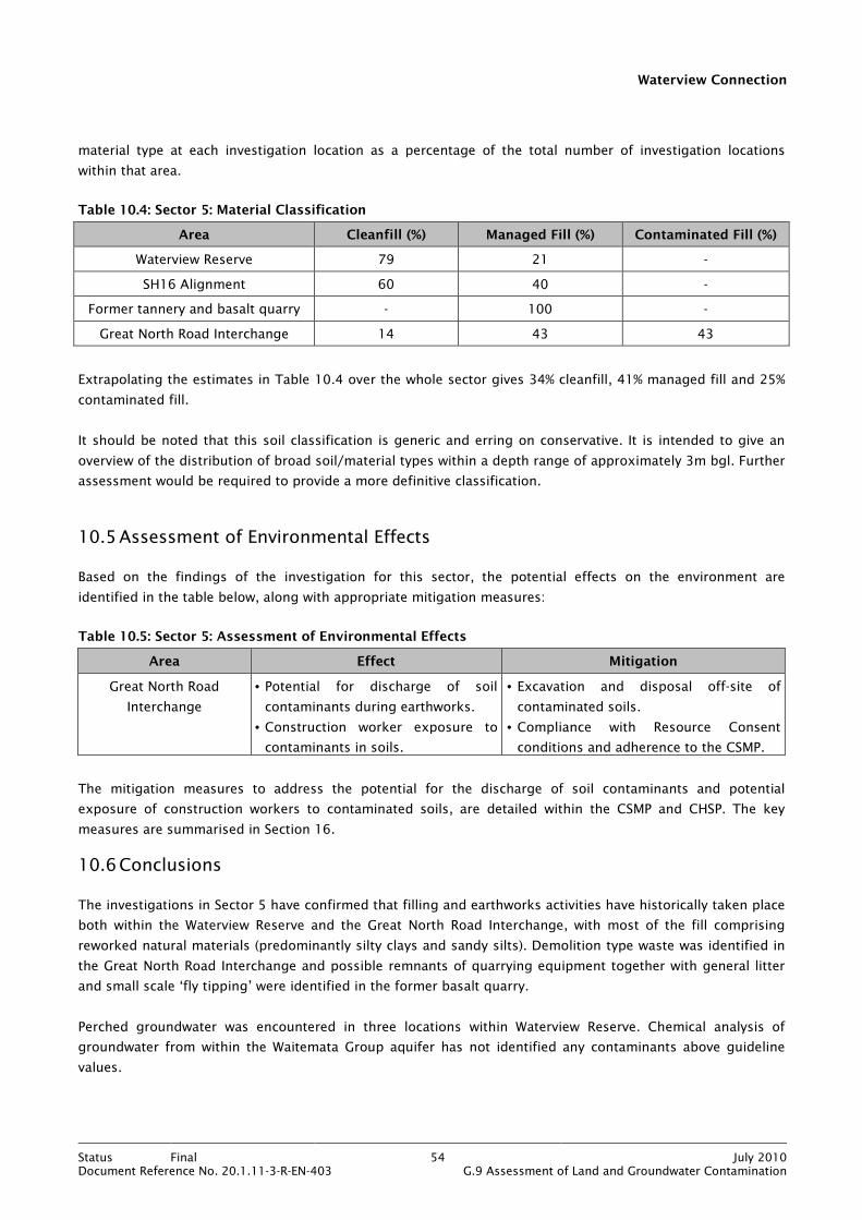
Waterview Connection
Status Final 54 July 2010Document Reference No. 20.1.11-3-R-EN-403 G.9 Assessment of Land and Groundwater Contamination
material type at each investigation location as a percentage of the total number of investigation locations
within that area.
Table 10.4: Sector 5: Material Classification
Area Cleanfill (%) Managed Fill (%) Contaminated Fill (%)
Waterview Reserve 79 21 -
SH16 Alignment 60 40 -
Former tannery and basalt quarry - 100 -
Great North Road Interchange 14 43 43
Extrapolating the estimates in Table 10.4 over the whole sector gives 34% cleanfill, 41% managed fill and 25%
contaminated fill.
It should be noted that this soil classification is generic and erring on conservative. It is intended to give an
overview of the distribution of broad soil/material types within a depth range of approximately 3m bgl. Further
assessment would be required to provide a more definitive classification.
10.5 Assessment of Environmental Effects
Based on the findings of the investigation for this sector, the potential effects on the environment are
identified in the table below, along with appropriate mitigation measures:
Table 10.5: Sector 5: Assessment of Environmental Effects
Area Effect Mitigation
Great North Road
Interchange
• Potential for discharge of soil
contaminants during earthworks.
• Construction worker exposure to
contaminants in soils.
• Excavation and disposal off-site of
contaminated soils.
• Compliance with Resource Consent
conditions and adherence to the CSMP.
The mitigation measures to address the potential for the discharge of soil contaminants and potential
exposure of construction workers to contaminated soils, are detailed within the CSMP and CHSP. The key
measures are summarised in Section 16.
10.6 Conclusions
The investigations in Sector 5 have confirmed that filling and earthworks activities have historically taken place
both within the Waterview Reserve and the Great North Road Interchange, with most of the fill comprising
reworked natural materials (predominantly silty clays and sandy silts). Demolition type waste was identified in
the Great North Road Interchange and possible remnants of quarrying equipment together with general litter
and small scale ‘fly tipping’ were identified in the former basalt quarry.
Perched groundwater was encountered in three locations within Waterview Reserve. Chemical analysis of
groundwater from within the Waitemata Group aquifer has not identified any contaminants above guideline
values.
Waterview Connection
Status Final 55 July 2010Document Reference No. 20.1.11-3-R-EN-403 G.9 Assessment of Land and Groundwater Contamination
Results of soil analyses show that Permitted Activity criteria were exceeded for lead, nickel, various individual
PAH compounds, benzo(a)pyrene equivalent and 4-nitrophenol at isolated locations within Great North Road
Interchange. Land disturbance activities at those locations will therefore require a discharge consent under
Rule 5.5.44 of the ALWP. Land disturbance within all other areas of Sector 5 will be a Permitted Activity under
Rule 5.5.41 of the ALWP.
Human health assessment criteria were exceeded at isolated locations within the Great North Road
Interchange. Management and mitigation of risks to construction workers and the general public from soil
contamination should be via compliance with the CSMP (see Appendix O) and Contractor Health and Safety
Plan.
Excavating soils/materials which are known to contain asbestos should be in accordance with the Health and
Safety in Employment (Asbestos) Regulations 1998 and the Department of Labour Guidelines for the
Management and Removal of Asbestos (revised) 1999.
Classification of soils has estimated the percentages of soils for re-use or disposal purposes to be cleanfill
34%, managed fill 41% and contaminated fill 25%.
Potential environmental effects relate to discharge of soil contaminants during earthworks and construction
worker exposure to contaminants in soils. These can be mitigated by excavation and disposal off-site of
contaminated soils and adherence to the CSMP and CHSP.

Waterview Connection
Status Final 56 July 2010Document Reference No. 20.1.11-3-R-EN-403 G.9 Assessment of Land and Groundwater Contamination
11. Sector 6 – SH16 to St Lukes Interchange
11.1 Sector Description
Figure 11.1: Sector 6 Location Plan
Sector 6 of the Project includes the additional lanes on SH16, between the Great North Road Interchange and St
Lukes Interchange. The purpose of the construction works is to improve the capacity of SH16 by widening the
motorway by one lane in each direction. A stormwater pond is proposed within the residential area adjacent to
the eastbound carriageway.
The generalised geological sequence beneath Sector 6 is expected to be fill (in places) overlying Tauranga
Group alluvium or basalt overlying Waitemata Group.
The existing land use within the sector is primarily road infrastructure in the form of the existing SH16 which
is bounded by a mix of residential and parkland/recreation land. The western portion of the sector is mainly
residential whilst the eastern portion is predominantly parkland/recreation, with Western Springs located to the
north, and Chamberlain Park Golf Course located to the south. Meola Creek passes through the sector and
discharges into the Waitemata Harbour to the north.

Waterview Connection
Status Final 57 July 2010Document Reference No. 20.1.11-3-R-EN-403 G.9 Assessment of Land and Groundwater Contamination
11.2 Investigation Activities and Methodology
The construction works in Sector 6 will involve earthworks at relatively shallow depth and the investigation was
designed on that basis. The objectives of the investigation within Sector 6 were as follows:
• To determine the nature, extent and degree of contamination of any fill.
• To establish the resource consent requirements associated with any identified contamination.
• To assess the risks to human health from any identified contamination.
• To classify soils for re-use and off site disposal purposes.
• To determine any environmental effects.
The investigation was split into two areas (SH16 Alignment and Meola Stormwater Pond) and a summary of the
investigation activities carried out within these areas is outlined in Table 11.1 below and the investigation
locations are shown on Figure 8 and 9 in Appendix D.
Table 11.1: Investigation Summary Sector 6
Area Rationale Number of
samples analysed
Analysis Suite
SH16 Alignment Linear Sampling – 23 locations.
(WS701 to WS721, WS723 and WS725)
Broad analysis suite based on current use
as a motorway, contaminants present in
stormwater runoff and potential pesticide
use.
32 (2 duplicates) Heavy metals, TPH, PAH,
OCP, ON/OP pesticides
and Asbestos.
Meola
Stormwater Pond
Systematic Grid Sampling – 10 Locations.
(TP401 to TP410)
Broad analysis suite based on observed
waste materials on site.
20 samples (2 per
location)
Heavy Metals, TPH, VOCs,
SVOCs
Notes:
This table outlines the general analysis suite undertaken for each area of investigation and not every sample has been tested for the entire suite of analyses. Full details of the analysis suites for individual samples are outlined in Appendix J.
� Heavy metals tested comprise arsenic, cadmium, chromium, copper, lead, nickel and zinc
� TPH – total petroleum hydrocarbons � SVOC – semi volatile organic compounds
� OP/ON – organophosphorus/organonitrogen pesticides � OCP – organochlorine pesticides � VOC – volatile organic compounds � PAH – polycyclic aromatic hydrocarbons
Full details of the investigation activities and the methodologies used for these activities are provided in
Section 5 and Appendix J. The rationale for the sampling is discussed below.
Waterview Connection
Status Final 58 July 2010Document Reference No. 20.1.11-3-R-EN-403 G.9 Assessment of Land and Groundwater Contamination
11.2.1 SH16 Alignment
A linear spacing of between 50 and 200m was used to cover the length of SH16 within Sector 6. The spacing of
investigation locations differed between the eastbound and westbound carriageways. A 50m spacing was used
for the eastbound carriageway (mainly residential with some commercial and light industrial) and a 200m
spacing was used for the majority of the westbound carriageway (mainly parkland/recreation). This reflected
the variations in land use (and therefore contamination potential and sensitivity of receptors) on the different
sides of the motorway.
Linear spacing was considered the most appropriate sampling strategy to investigate the linear construction
footprint of a motorway widening scheme. It was considered that potential contamination was likely to be
stormwater contaminants and pesticide use along the motorway.
Twenty three boreholes were drilled from which 30 samples were collected to a maximum depth of 2.6m bgl.
These samples were scheduled for chemical laboratory analysis and the analysis suite is summarised in Table
11.1 and detailed in Appendix J.
11.2.2 Meola Stormwater Pond Area
A systematic grid system was used as described in section 10.2.1. The number of sampling locations was
selected as per Table A1 in the MfE document Contaminated Land Management Guidelines No. 5, Site
Investigation and Analysis of Soils (2004), in which the recommended number of sampling points for a site
area of 4000m2 (the area of the Meola site) is given as 11. However, the site was underlain by several
stormwater and sewer pipes and this resulted in a fairly uneven grid and only 10 locations were sited.
Ten test pits were excavated to a maximum depth of 3m bgl and 20 soil samples were collected. The samples
were scheduled for chemical analysis and the analysis suite is summarised in Table 11.1 and detailed in
Appendix J.
11.3 Investigation Findings
11.3.1 SH16 Alignment
Review of the borehole logs has confirmed the geology to be fill overlying Tauranga Group silty clays to the
west of Meola Creek (WS716 to WS721, WS723 and WS725), with fill overlying basalt to the east of the creek
(WS701 to WS715).
A layer of fill was identified at most sampling locations with a maximum thickness of
3m (average 0.75m). The fill predominantly comprised reworked natural materials, though brick fragments
were noted in two sampling locations (WS711 and WS713). There was no visible or olfactory evidence of
contamination at any of the investigation locations.
Groundwater was not encountered during the investigation.

Waterview Connection
Status Final 59 July 2010Document Reference No. 20.1.11-3-R-EN-403 G.9 Assessment of Land and Groundwater Contamination
The following land uses were considered most appropriate when selecting assessment criteria:
• Consent Requirements – residential.
• Human Health – parkland/recreational (WS701 to WS712); residential for all other sampling locations.
The chemical analysis results revealed a range of metal contaminants to be in excess of their Permitted Activity
criteria in a sample from one location (WS711). This sample also had a concentration of lead in excess of the
human health criterion. Three other samples (WS708, WS709 and WS710) had a concentration of nickel in
excess of its Permitted Activity criterion. These exceedences are summarised in Table 11.2 below. There were
no other analysis results in excess of assessment criteria. The full results are provided in Appendix J.
Table 11.2: Contaminants Exceeding Assessment Criteria along SH16 Alignment
Location Contaminant Depth (m) Concentration (mg/kg)
Human Health Criteria (mg/kg)
Permitted Activity Criteria (mg/kg)
WS711 Cadmium 0.05 8.3 40 7.5
WS711 Chromium 0.05 1,300 24,000 400
WS711 Copper 0.05 630 2,000 325
WS711 Lead 0.05 670 600 250
WS711 Nickel 0.05 210 600 105
WS711 Zinc 0.05 1,900 14,000 400
WS708 Nickel 0.1 110 600 105
WS709 Nickel 0.65 150 600 105
WS710 Nickel 1.0 140 600 105
11.3.2 Meola Stormwater Pond Area
Review of the test pit logs revealed the geology to comprise fill to a maximum depth of 2.5m bgl overlying
Tauranga Group alluvium (silty clays). A layer of peat was observed in one location. The fill comprised
boulders, glass, wire, wood, ceramics and brick in a silty sandy matrix. Household waste was not observed.
There was no olfactory evidence of contamination at any of the investigation locations.
The following land uses were considered most appropriate when selecting assessment criteria:
• Consent Requirements – residential.
• Human Health – residential.
The chemical analysis results revealed a number of contaminants to be in excess of either their Permitted
Activity criteria or their human health criteria. These contaminants are detailed in Table 11.3 below. Full results
are provided in Appendix J.
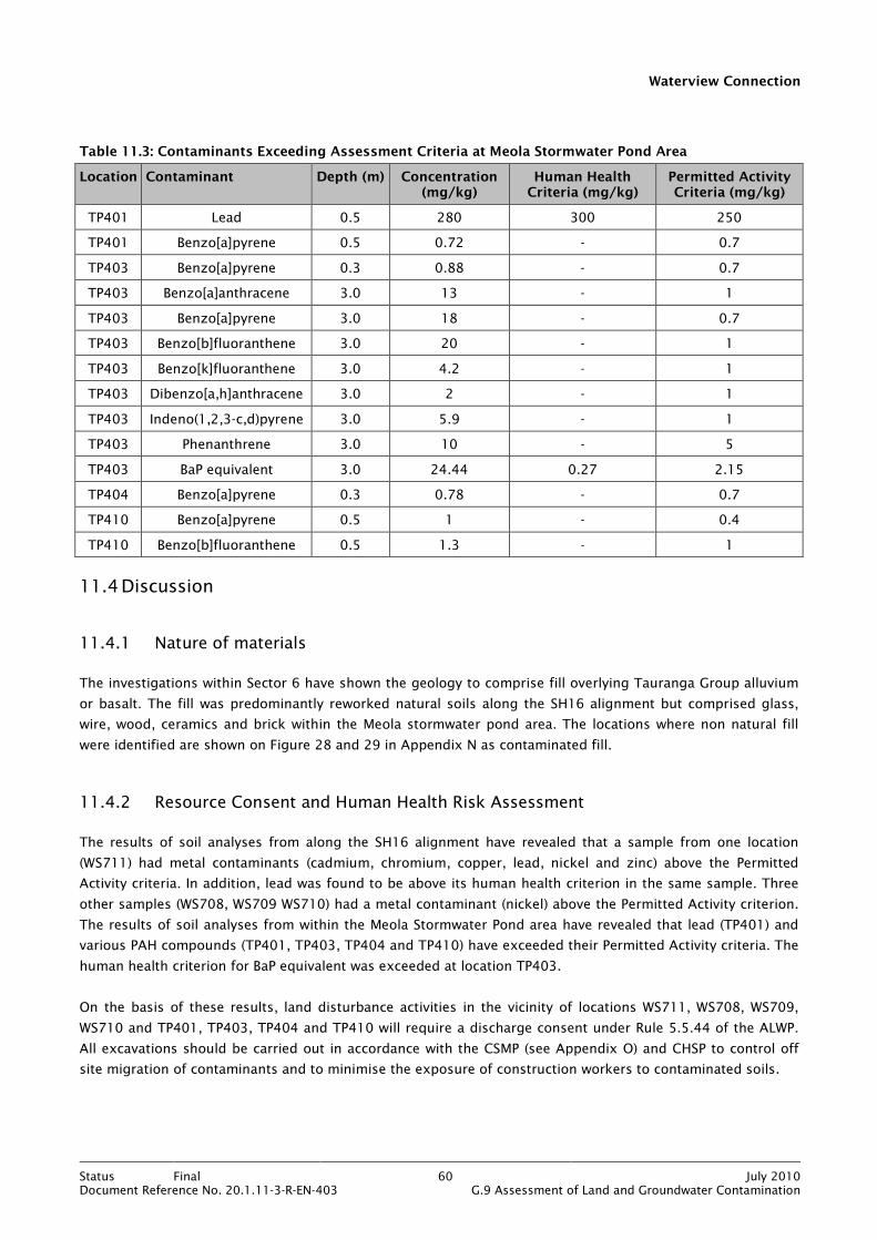
Waterview Connection
Status Final 60 July 2010Document Reference No. 20.1.11-3-R-EN-403 G.9 Assessment of Land and Groundwater Contamination
Table 11.3: Contaminants Exceeding Assessment Criteria at Meola Stormwater Pond Area
Location Contaminant Depth (m) Concentration (mg/kg)
Human Health Criteria (mg/kg)
Permitted Activity Criteria (mg/kg)
TP401 Lead 0.5 280 300 250
TP401 Benzo[a]pyrene 0.5 0.72 - 0.7
TP403 Benzo[a]pyrene 0.3 0.88 - 0.7
TP403 Benzo[a]anthracene 3.0 13 - 1
TP403 Benzo[a]pyrene 3.0 18 - 0.7
TP403 Benzo[b]fluoranthene 3.0 20 - 1
TP403 Benzo[k]fluoranthene 3.0 4.2 - 1
TP403 Dibenzo[a,h]anthracene 3.0 2 - 1
TP403 Indeno(1,2,3-c,d)pyrene 3.0 5.9 - 1
TP403 Phenanthrene 3.0 10 - 5
TP403 BaP equivalent 3.0 24.44 0.27 2.15
TP404 Benzo[a]pyrene 0.3 0.78 - 0.7
TP410 Benzo[a]pyrene 0.5 1 - 0.4
TP410 Benzo[b]fluoranthene 0.5 1.3 - 1
11.4 Discussion
11.4.1 Nature of materials
The investigations within Sector 6 have shown the geology to comprise fill overlying Tauranga Group alluvium
or basalt. The fill was predominantly reworked natural soils along the SH16 alignment but comprised glass,
wire, wood, ceramics and brick within the Meola stormwater pond area. The locations where non natural fill
were identified are shown on Figure 28 and 29 in Appendix N as contaminated fill.
11.4.2 Resource Consent and Human Health Risk Assessment
The results of soil analyses from along the SH16 alignment have revealed that a sample from one location
(WS711) had metal contaminants (cadmium, chromium, copper, lead, nickel and zinc) above the Permitted
Activity criteria. In addition, lead was found to be above its human health criterion in the same sample. Three
other samples (WS708, WS709 WS710) had a metal contaminant (nickel) above the Permitted Activity criterion.
The results of soil analyses from within the Meola Stormwater Pond area have revealed that lead (TP401) and
various PAH compounds (TP401, TP403, TP404 and TP410) have exceeded their Permitted Activity criteria. The
human health criterion for BaP equivalent was exceeded at location TP403.
On the basis of these results, land disturbance activities in the vicinity of locations WS711, WS708, WS709,
WS710 and TP401, TP403, TP404 and TP410 will require a discharge consent under Rule 5.5.44 of the ALWP.
All excavations should be carried out in accordance with the CSMP (see Appendix O) and CHSP to control off
site migration of contaminants and to minimise the exposure of construction workers to contaminated soils.
Waterview Connection
Status Final 61 July 2010Document Reference No. 20.1.11-3-R-EN-403 G.9 Assessment of Land and Groundwater Contamination
The locations where assessment criteria have been exceeded within Sector 6 are shown spatially on Figure 18
in Appendix M.
11.4.3 Material Classification
Soil has been classified as cleanfill, managed fill or contaminated fill (as set out in Section 4.5.1). The results of
the classification are best appreciated spatially and they are therefore presented on Figures 28 and 29 in
Appendix N.
For Sector 6, the classification is summarised in Table 11.4 with estimated percentages of material types based
on the material type at each investigation location as a percentage of the total number of investigation
locations within that area.
Table 11.4: Sector 6: Material Classification
Area Cleanfill (%) Managed Fill (%) Contaminated Fill (%)
SH16 Alignment 70 26 4
Meola Stormwater Pond Area - 70 30
Extrapolating the estimates in Table 11.4 over the whole sector gives 49% cleanfill, 27% managed fill and 24%
contaminated fill.
It should be noted that this soil classification is generic and erring on conservative. It is intended to give an
overview of the distribution of broad soil/material types within a depth range of approximately 3m bgl. Further
assessment would be required to provide a more definitive classification.
11.5 Assessment of Environmental Effects
Based on the findings of the investigation for this sector, the potential effects on the environment are
identified in the table below, along with appropriate mitigation measures:
Table 11.5: Sector 6: Assessment of Environmental Effects
Area Effect Mitigation
Meola Stormwater
Pond
• Potential for discharge of soil
contaminants during earthworks.
• Construction worker exposure to
contaminants in soil.
• Excavation and disposal off-site of
contaminated soils.
• Compliance with Resource Consent
conditions and adherence to the CSMP.
SH16 Alignment Potential for discharge of soil
contaminants during earthworks.
• Excavation and disposal off-site of
contaminated soils.
• Compliance with Resource Consent
conditions and adherence to the CSMP.
The mitigation measures to address the potential for the discharge of soil contaminants and potential
exposure of construction workers to contaminated soils, are detailed within the CSMP and CHSP. The key
measures are summarised in Section 16.

Waterview Connection
Status Final 62 July 2010Document Reference No. 20.1.11-3-R-EN-403 G.9 Assessment of Land and Groundwater Contamination
11.6 Conclusions
The investigations in Sector 6 have shown that soils comprise fill overlying Tauranga Group alluvium or basalt.
The fill comprised reworked natural materials (silty sandy clay) and waste materials (glass, wire, wood,
ceramics and brick).
Results of soil analyses have shown that the Permitted Activity criteria for various metals and individual PAH
compounds were exceeded at four locations (WS708 to WS711) along the SH16 alignment and four locations
(TP401, TP403, TP404 and TP410) within the Meola stormwater pond area. Human health criteria for lead
(WS711) and BaP equivalent. (TP403) were also exceeded. Land disturbance activities within the vicinity of
those locations where Permitted Activity criteria were exceeded will require discharge consent under Rule
5.5.44 of the ALWP.
All excavations should be carried out and managed in accordance with the CSMP (see Appendix O) and CHSP.
Classification of soils has estimated the percentages of soils for re-use or disposal purposes to be cleanfill
49%, managed fill 27% and contaminated fill 24%.
Potential environmental effects relate to discharge of soil contaminants during earthworks and construction
worker exposure to contaminants in soil. These can be mitigated by excavation and disposal off-site of
contaminated soils and adherence to the CSMP and CHSP.
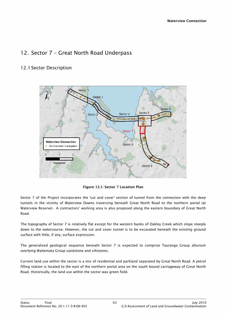
Waterview Connection
Status Final 63 July 2010Document Reference No. 20.1.11-3-R-EN-403 G.9 Assessment of Land and Groundwater Contamination
12. Sector 7 – Great North Road Underpass
12.1 Sector Description
Figure 12.1: Sector 7 Location Plan
Sector 7 of the Project incorporates the 'cut and cover' section of tunnel from the connection with the deep
tunnels in the vicinity of Waterview Downs traversing beneath Great North Road to the northern portal (at
Waterview Reserve). A contractors’ working area is also proposed along the eastern boundary of Great North
Road.
The topography of Sector 7 is relatively flat except for the western banks of Oakley Creek which slope steeply
down to the watercourse. However, the cut and cover tunnel is to be excavated beneath the existing ground
surface with little, if any, surface expression.
The generalised geological sequence beneath Sector 7 is expected to comprise Tauranga Group alluvium
overlying Waitemata Group sandstone and siltstones.
Current land use within the sector is a mix of residential and parkland separated by Great North Road. A petrol
filling station is located to the east of the northern portal area on the south bound carriageway of Great North
Road. Historically, the land use within the sector was green field.

Waterview Connection
Status Final 64 July 2010Document Reference No. 20.1.11-3-R-EN-403 G.9 Assessment of Land and Groundwater Contamination
12.2 Investigation Activities and Methodology
The previous Phase 1 desk study (see Appendix B) did not identify any significant potentially contaminating
activities within the area occupied by Sector 7.
Review of the logs from a number of boreholes drilled during the parallel geotechnical investigations has not
revealed any evidence for contamination of soils and none of the boreholes have encountered any non natural
fill.
Collecting soil and groundwater samples from below the footprint of Great North Road would have caused
significant disruption on this very busy commuter route and therefore it was not carried out. However, soil and
groundwater quality will be assessed prior to and during the construction phase of the cut and cover tunnel. A
brief description of the proposed sampling and testing is given below, and the investigation area is shown on
Figure 36 in Appendix Q):
Table 12.1: Proposed Investigations Sector 7
Area Rationale Number of
samples analysed
Analysis Suite
Great North
Road Cut and
Cover Tunnel
Volumetric sampling - assuming that
excavated materials are to be stockpiled
within the construction footprint (frequency
of sampling to be determined at detailed
scoping stage).
Linear spacing - if excavated materials are
not being stockpiled (number of sampling
locations to be determined at detailed
scoping stage).
To be determined
at detailed scoping
stage.
To be determined at
detailed scoping stage
(likely to include: heavy
metals, PAH, TPH).
Contractors’
Working Area
Systematic Grid Sampling – grid size to be
determined at detailed scoping stage.
To be determined
at detailed scoping
stage.
To be determined at
detailed scoping stage
(likely to include: heavy
metals, PAH, TPH).
Groundwater Sampling of Tauranga Group perched
groundwater and main Waitemata Group
aquifer.
Location and
number of samples
to be determined
at detailed scoping
stage.
To be determined at
detailed scoping stage
(likely to include: heavy
metals, PAH, TPH).
The details of the requirements for mitigation of environmental effects are provided in the CSMP.

Waterview Connection
Status Final 65 July 2010Document Reference No. 20.1.11-3-R-EN-403 G.9 Assessment of Land and Groundwater Contamination
13. Sector 8 – Avondale Heights Tunnel
13.1 Sector Description
Figure 13.1: Sector 8 Location Plan
Sector 8 of the Project incorporates the whole length of the two deep tunnels. The northern portal of the
tunnels would start at the southernmost end of the cut and cover tunnel, close to the Waterview Reserve and
then moving south, the tunnels would pass beneath Phyllis Street and Harbutt Reserves resurfacing at the
southern portal within Alan Wood Reserve. At their deepest point, the top of the tunnels will be some 50m
below the existing ground surface.
It should be noted that there will be no surface expression of the deep tunnels and there are no major surface
construction activities proposed within Sector 8. The assessment of effects from potential contamination is
therefore restricted to the effects from tunnel construction. A summary of the geology, land use and potential
contamination issues is provided below in the context of excavating the deep tunnels.
The geological sequence beneath Sector 8 comprises fill or basalt overlying Tauranga Group alluvium overlying
Waitemata Group sandstone and siltstone. The fill has been identified within Harbutt and Phyllis Street
Reserves, where it occupies voids created by quarrying of the basalt. In addition, a significant thickness (up to
25m) of Parnell Grit (Waitemata Group) has been identified beneath Phyllis Street Reserve. The Parnell Grit is a
volcanically derived debris flow deposit consisting of sand to boulder sized breccia-conglomerate of andesite
and limestone.
Waterview Connection
Status Final 66 July 2010Document Reference No. 20.1.11-3-R-EN-403 G.9 Assessment of Land and Groundwater Contamination
There are two hydraulically separate aquifers within the area of the proposed tunnels. These comprise the
basalt lava flows which constitute a shallow (perched) unconfined aquifer and the Waitemata Group rocks
which form a more regional, deeper, confined aquifer. The two aquifers are separated by relatively
impermeable Tauranga Group alluvium or soils produced by the weathering of the Waitemata Group bedrock.
Groundwater within the fill is expected to be perched, discontinuous and, in some cases, ephemeral.
The existing land use within Sector 8 is residential and parkland (reserves) with some roading infrastructure
comprising residential and trunk roads. Oakley Creek flows through and around the reserves along the entire
length of the sector. Historical landfilling activities have taken place within Phyllis Street and Harbutt Reserves.
More details are provided in Section 14.
The areas within Sector 8 with the greatest potential to cause land contamination are the locations of the
historical filling activities within Harbutt Reserve and, more particularly, Phyllis Street Reserve.
13.2 Investigation Activities and Methodology
The objectives of the investigations within Sector 8 were as follows:
• To establish the baseline quality of groundwater within the Waitemata Group aquifer (the tunnels will be
constructed within this aquifer, with only the portal sections intersecting the shallower geology as the
tunnels descend from and rise back to the surface).
• To determine the nature, extent and degree of contamination of the fill and any associated leachate within
Harbutt and Phyllis Street Reserves (the tunnels will pass beneath these reserves).
The Waitemata Group rocks are not expected to be contaminated given that they are overlain by relatively
impermeable alluvium and weathered Waitemata sandstone and siltstone. Any contamination would be
expected to be within the groundwater only.
The remainder of Section 13 relates to the baseline groundwater quality assessment. The investigations
associated with the historical filling activities in Harbutt and Phyllis Street Reserves are discussed in Section 14.
Groundwater sampling within the Waitemata Group aquifer was carried out at an approximate linear spacing of
200m along the length of Sector 8 (see Figures 10 to 13 in Appendix D for borehole locations). Boreholes
drilled as part of this assessment and from the parallel geotechnical and hydrogeological investigations were
used to obtain groundwater samples. In total, five separate rounds of groundwater sampling were carried out
between October 2009 and March 2010. Full details of the methodology used to collect the groundwater
samples are provided in Section 5. A summary of the individual sampling events is given in Table 13.1 which
includes a rationale for the variation in analyses between events.
Waterview Connection
Status Final 67 July 2010Document Reference No. 20.1.11-3-R-EN-403 G.9 Assessment of Land and Groundwater Contamination
Table 13.1: Summary of Groundwater Sampling
Sampling
Event
Rationale Number of Boreholes
Sampled
Analysis Suite
Round 1
(20/21 Oct 09)
Broad suite of contaminants and major
ion suite for general baseline quality
assessment
11: (BH502, BH512, BH513,
BH517, BH521, BH527,
BH528, BH540-BH543)
Heavy metals, TPH,
SVOC, VOC and
anion/cation profile
Round 2
(20/21 Nov 09)
Analysis suite targeted at those
contaminant groups exceeding detection
limits and/or guideline values
11: (BH502, BH512, BH513,
BH517, BH521, BH527,
BH528, BH540-BH543)
Heavy metals and
VOC
Round 3
(09 Dec 09)
Analysis suite targeted at those
contaminant groups exceeding detection
limits and/or guideline values
10: (BH512, BH513, BH517,
BH521, BH527, BH528,
BH540-BH543)
Heavy metals
Round 4
(6-26 Jan 10)
Analysis suite targeted at those
contaminant groups exceeding detection
limits and/or guideline values
11: (BH502, BH512, BH513,
BH517, BH521, BH527,
BH528, BH540-BH543)
Heavy metals
Round 5
(18-30 Mar 10)
Sampling targeted at those locations
where hydrocarbons identified in rounds
1 & 2. Done to confirm that TPH and
VOC compounds no longer detectable.
5: (BH512, BH521, BH527,
BH541, BH542)
Heavy metals, TPH
and VOC
Boreholes 502, 513 and 517 were fitted with 33mm diameter standpipe piezometers, all other boreholes were
fitted with 50mm diameter standpipe piezometers. Details of the monitoring installations within each borehole
are included in Appendix K. Comments pertinent to each sampling round are detailed below.
13.2.1 Groundwater Sampling Round 1
The first round of groundwater sampling took place on 20 and 21 October 2009. Groundwater samples were
collected from 11 boreholes and analysed for a broad suite of contaminants to ascertain the baseline quality.
Sampling was carried out soon after the completion of newly drilled boreholes and all of the standpipe
piezometers were airlifted by the drilling contractor prior to sampling. Groundwater samples from boreholes
512 and 540 to 543 were collected using the low flow micropurging technique. However, equipment
malfunction resulted in the samples from the remaining boreholes being collected by dedicated bailers or
submersible pump.
13.2.2 Groundwater Sampling Round 2
The second round of groundwater sampling was carried out on 20 and 21 November 2009. The aim of this
round of sampling was to focus on those contaminants that were identified above their detection limit and/or
their guideline value during round 1. Samples were collected using a submersible pump or dedicated bailers.
With the exception of boreholes 513 and 517, all standpipe piezometers were purged prior to sampling.
Boreholes 513 and 517 were fitted with a 33mm diameter standpipe piezometer. Equipment incompatibility, in
conjunction with relatively deep groundwater levels (11m to 14m bgl respectively), meant that purging became
very onerous and time consuming. For these reasons purging was not carried out within these boreholes. Not
purging the standpipe piezometers for boreholes 513 and 517 means that the results may not be truly
representative of aquifer water quality. It is considered that there is significant uncertainty in the results for

Waterview Connection
Status Final 68 July 2010Document Reference No. 20.1.11-3-R-EN-403 G.9 Assessment of Land and Groundwater Contamination
these two boreholes and, whilst samples were collected in the subsequent rounds, they are not considered
further within this report.
13.2.3 Groundwater Sampling Round 3
The third round of groundwater sampling was carried out on 9 December 2009. This round focused on heavy
metals, as the hydrocarbons identified in rounds 1 and 2 were no longer being detected. All standpipe
piezometers were purged prior to sampling and samples were collected using dedicated bailers due to
malfunction of the submersible pump. Borehole 502 was sampled but the sample was compromised before
dispatch to the laboratory and was therefore not analysed.
13.2.4 Groundwater Sampling Round 4
The fourth round of groundwater sampling took place between 6 and 26 January 2010 and all 11 boreholes
were sampled. This round focused on heavy metals, and in an attempt to define the source of elevated lead
concentrations, sampling was carried out both before and after purging of the standpipe piezometers. It was
considered that this strategy may indicate whether the elevated lead was being sourced from the aquifer itself
or from materials used in the construction of the standpipe piezometers. Groundwater samples were collected
using dedicated bailers.
13.2.5 Groundwater Sampling Round 5
The fifth and final round of groundwater sampling was carried out between 18 and 30 March 2010 and only
five boreholes were sampled. The purpose of the final round of sampling was to confirm that hydrocarbons
identified in rounds 1 and 2 were no longer present in the groundwater at detectable concentrations. The
heavy metals were analysed to verify the results of round 4. All standpipe piezometers were purged prior to
sampling and samples were collected using dedicated bailers.
13.3 Investigation Findings
All the results of the groundwater sampling are provided in Appendix K. Those contaminants that were
identified in excess of their assessment criteria are detailed in Table 13.2. Some hydrocarbon compounds
(namely 3&4-methylphenol, 2-methylphenol, TPH (C7 to C19), MEK, acetone, bromodichloromethane, and
dibromochloromethane) were identified above their detection limit but they do not have assessment criteria.
These compounds are detailed in Appendix K.
For sampling rounds 3 and 5, none of the analysis results for heavy metals were in excess of their guideline
value and hydrocarbons (round 5) were not detected.
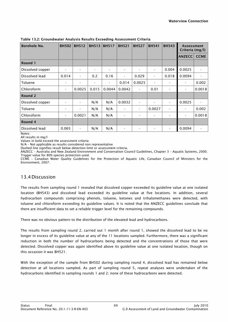
Waterview Connection
Status Final 69 July 2010Document Reference No. 20.1.11-3-R-EN-403 G.9 Assessment of Land and Groundwater Contamination
Table 13.2: Groundwater Analysis Results Exceeding Assessment Criteria
Borehole No. BH502 BH512 BH513 BH517 BH521 BH527 BH541 BH543 Assessment Criteria (mg/l)
ANZECC CCME
Round 1
Dissolved copper - - - - - - - 0.004 0.0025 -
Dissolved lead 0.014 - 0.2 0.16 - 0.029 - 0.018 0.0094 -
Toluene - - - - 0.014 0.0025 - - - 0.002
Chloroform - 0.0025 0.015 0.0044 0.0042 - 0.01 - - 0.0018
Round 2
Dissolved copper - - N/A N/A 0.0032 - - - 0.0025 -
Toluene - - N/A N/A - - 0.0027 - - 0.002
Chloroform - 0.0021 N/A N/A - - - - - 0.0018
Round 4
Dissolved lead 0.065 - N/A N/A - - - - 0.0094 -
Notes: All results in mg/l Values in bold exceed the assessment criteria N/A – Not applicable as results considered non representative Dashed line signifies result below detection limit or assessment criteria. ANZECC – Australia and New Zealand Environment and Conservation Council Guidelines, Chapter 3 – Aquatic Systems, 2000. Trigger value for 80% species protection used. CCME – Canadian Water Quality Guidelines for the Protection of Aquatic Life, Canadian Council of Ministers for the Environment, 2007.
13.4 Discussion
The results from sampling round 1 revealed that dissolved copper exceeded its guideline value at one isolated
location (BH543) and dissolved lead exceeded its guideline value at five locations. In addition, several
hydrocarbon compounds comprising phenols, toluene, ketones and trihalomethanes were detected, with
toluene and chloroform exceeding its guideline values. It is noted that the ANZECC guidelines conclude that
there are insufficient data to set a reliable trigger level for the remaining compounds.
There was no obvious pattern to the distribution of the elevated lead and hydrocarbons.
The results from sampling round 2, carried out 1 month after round 1, showed the dissolved lead to be no
longer in excess of its guideline value at any of the 11 locations sampled. Furthermore, there was a significant
reduction in both the number of hydrocarbons being detected and the concentrations of those that were
detected. Dissolved copper was again identified above its guideline value at one isolated location, though on
this occasion it was BH521.
With the exception of the sample from BH502 during sampling round 4, dissolved lead has remained below
detection at all locations sampled. As part of sampling round 5, repeat analyses were undertaken of the
hydrocarbons identified in sampling rounds 1 and 2; none of these hydrocarbons were detected.

Waterview Connection
Status Final 70 July 2010Document Reference No. 20.1.11-3-R-EN-403 G.9 Assessment of Land and Groundwater Contamination
Whilst both the dissolved lead and the hydrocarbons appear to have dissipated from the locations previously
identified, and are therefore not having any negative impact on groundwater quality, it is considered prudent
to discuss the possible sources of these contaminants.
In considering the source of the hydrocarbons, two facts are prominent. Firstly, the hydrocarbons were all
volatile in nature and several are common solvents. Secondly, they had significantly reduced in concentration
after only one month from initial detection, implying a depleting source. Given the widespread distribution (six
locations) of the hydrocarbons when first detected, it is considered unlikely that each location represented an
individual source zone within the Waitemata Group aquifer. It is considered much more likely that the source
of the hydrocarbons was the standpipe piezometer installations within each borehole. Confirmation of this
prognosis was provided when it was learned that a solvent-based glue was used to seal the 3m lengths of PVC
tubing used to construct the standpipe piezometers. It is not known how many of the piezometers were
constructed using glue.
In postulating a source for the dissolved lead, there are only two possible scenarios. The lead is either natural,
originating from the Waitemata Group aquifer; or it is anthropogenic, coming from the monitoring installation
or some extraneous source. Whilst not included or discussed in depth in this report, the laboratory analyses of
groundwater samples for metals comprised both dissolved and total fractions (results are provided on the
summary sheets within Appendix K). It is considered to be no coincidence that for the vast majority of
locations, dissolved and total fractions of lead have reduced concomitantly, suggesting, as for the
hydrocarbons, a depleting source. It is also noted that there was a marked reduction in total lead
concentrations between the pre-purge and post-purge analyses undertaken for sampling round 4. This implies
that the lead is likely sourced from the monitoring installations. It is possible that the lead may have been used
as a plasticiser and this could have leached from the PVC standpipe used in the installations. However, given
that the dissolved lead is now below its water quality guideline value, the question is somewhat moot.
During construction of the tunnels, shotcrete will be used to seal the tunnel walls to provide stability and
reduce groundwater ingress to the tunnels. However, this process is likely to raise the pH of any groundwater
coming into contact with the shotcrete due to its high alkalinity. In addition, groundwater removed from the
tunnels during dewatering is likely to have a high suspended solids content as a consequence of the tunnel
boring machines pulverising the siltstone/sandstone bedrock.
A trilinear plot has been produced displaying the chemical character of groundwater sampled and tested within
Sector 8 (see Figure 13.2). This was done in order to assess whether the groundwater samples taken at
multiple locations across Sector 8 were representative of groundwater within the tunnel alignment, despite the
distance between sample locations. Interpretation of these results shows that the groundwater data plots
generally fall within one distinct area of the central diamond and can be classified as being calcium
carbonate/sodium carbonate type. The data plots from two boreholes that plot along the edge of the central
diamond (BH527 and BH512) have low calcium ion levels. The proximity of data plots to one another implies
that the groundwater samples share a common origin. Samples which have a calcium carbonate type are
generally from relatively young waters derived from recent recharge events. For data used see Appendix K.

Waterview Connection
Status Final 71 July 2010Document Reference No. 20.1.11-3-R-EN-403 G.9 Assessment of Land and Groundwater Contamination
Figure 13.2: Trilinear Plot of Sector 8 Groundwater Ion Results
13.5 Assessment of Environmental Effects
Based on the findings of the investigation for this sector, the potential effects on the environment are
identified in the table below, along with appropriate mitigation measures:
Table 13.3: Sector 8: Assessment of Environmental Effects
Sector Area Effect Mitigation
Sector 8 Groundwater • Tunnel construction affecting pH
of local groundwater.
• Groundwater containing high
suspended solids.
• pH adjustment at surface according to the
Erosion and Sediment Control Plan (ESCP).
• Chemical flocculation treatment for
suspended solids.
The mitigation measures to address the effects on groundwater of pH and suspended solids from tunnel
construction are detailed within the Groundwater Management Plan contained within Appendix H of Technical
Report No G.7 Assessment of Groundwater Effects.

Waterview Connection
Status Final 72 July 2010Document Reference No. 20.1.11-3-R-EN-403 G.9 Assessment of Land and Groundwater Contamination
13.6 Conclusions
The groundwater analyses carried out within Sector 8 over a five month period have established the baseline
quality of groundwater within the Waitemata Group aquifer. Initial exceedance of assessment criteria for
dissolved lead and copper and volatile hydrocarbons have not been repeated throughout the sampling period
and all contaminants analysed are now either below their guideline values or below laboratory detection limits.
It is therefore concluded that groundwater, sourced from the Waitemata Group aquifer, entering the tunnels
during construction will not be contaminated and will not require a discharge consent.
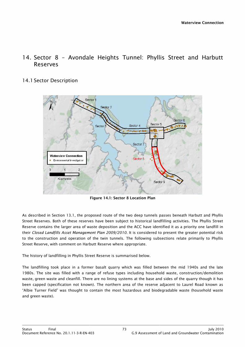
Waterview Connection
Status Final 73 July 2010Document Reference No. 20.1.11-3-R-EN-403 G.9 Assessment of Land and Groundwater Contamination
14. Sector 8 – Avondale Heights Tunnel: Phyllis Street and Harbutt Reserves
14.1 Sector Description
Figure 14.1: Sector 8 Location Plan
As described in Section 13.1, the proposed route of the two deep tunnels passes beneath Harbutt and Phyllis
Street Reserves. Both of these reserves have been subject to historical landfilling activities. The Phyllis Street
Reserve contains the larger area of waste deposition and the ACC have identified it as a priority one landfill in
their Closed Landfills Asset Management Plan 2009/2010. It is considered to present the greater potential risk
to the construction and operation of the twin tunnels. The following subsections relate primarily to Phyllis
Street Reserve, with comment on Harbutt Reserve where appropriate.
The history of landfilling in Phyllis Street Reserve is summarised below.
The landfilling took place in a former basalt quarry which was filled between the mid 1940s and the late
1980s. The site was filled with a range of refuse types including household waste, construction/demolition
waste, green waste and cleanfill. There are no lining systems at the base and sides of the quarry though it has
been capped (specification not known). The northern area of the reserve adjacent to Laurel Road known as
“Albie Turner Field” was thought to contain the most hazardous and biodegradable waste (household waste
and green waste).

Waterview Connection
Status Final 74 July 2010Document Reference No. 20.1.11-3-R-EN-403 G.9 Assessment of Land and Groundwater Contamination
Information from ACC indicates that between 1993 and 1994, the fill within Albie Turner Field was discharging
mature leachate to groundwater and Oakley Creek. Remedial works were undertaken between November 1999
and April 2000 to stabilise the western boundary of the fill adjacent to Oakley Creek. Monitoring undertaken
during 2006 and 2007 identified continued discharges of leachate and contaminated groundwater in the
vicinity of the fill. The ARC has granted resource consent to ACC to allow minor discharges from the reserve to
natural water.
Landfill gas monitoring carried out by others on behalf of ACC has identified elevated concentrations of
methane in one of four monitoring wells located in the northern portion of the reserve.
14.2 Investigation Activities and Methodology
As noted in Section 13.1, the construction of the twin tunnels will not disturb the surface of the reserve and
therefore the investigation was focused purely on assessing the potential impacts of leachate and
contaminated groundwater on tunnel construction.
Ten soil samples were collected from boreholes and machine auger holes at various depths from within the
body of the fill in Albie Turner Field. Some of the boreholes were drilled as part of the parallel geotechnical
investigation. In addition, seven groundwater samples were collected. Full details of the investigation activities
and the methodologies used for these activities are provided in Section 5 and Appendix K. A summary of the
investigations is given in Table 14.1 and the investigation locations are shown on Figures 10 to 12 in
Appendix D.
Table 14.1: Summary of Investigation Activities: Phyllis Street Reserve
Activity Rationale Number of Samples
Analysed
Analysis Suite
Borehole
Drilling
Drilling of 8 boreholes (BH720 to BH727) to
establish waste thickness, collect soil samples,
fit groundwater monitoring installations and
monitor landfill gas.
5 (3 samples from
geotechnical
boreholes)
Heavy metals, TPH,
SVOC, VOC and pH
Machine
Augers
Drilling of 6 machine augers (MA350 to MA355)
to collect soil samples.
5 Heavy metals, TPH,
SVOC, VOC and pH
Groundwater
Sampling
Establish groundwater quality and presence of
leachate within the fill.
5 (two additional
samples were
collected from
Harbutt Reserve –
BH726 & BH727)
Heavy metals, TPH,
SVOC, VOC,
anion/cation profile and
ammoniacal nitrogen
It should be noted that investigation locations TP201 to TP204 and TP301 to TP308 are within Sector 8 but as
they are part of the assessment for Alan Wood Reserve they are discussed in Section 15 (Sector 9).
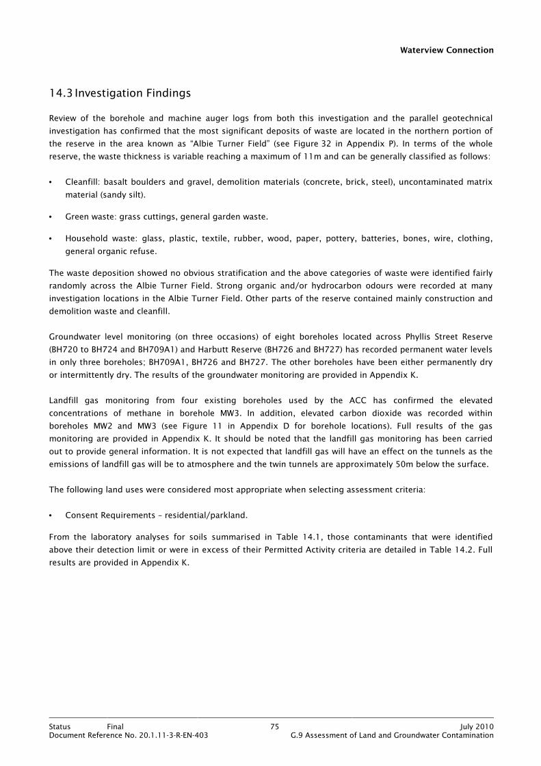
Waterview Connection
Status Final 75 July 2010Document Reference No. 20.1.11-3-R-EN-403 G.9 Assessment of Land and Groundwater Contamination
14.3 Investigation Findings
Review of the borehole and machine auger logs from both this investigation and the parallel geotechnical
investigation has confirmed that the most significant deposits of waste are located in the northern portion of
the reserve in the area known as “Albie Turner Field” (see Figure 32 in Appendix P). In terms of the whole
reserve, the waste thickness is variable reaching a maximum of 11m and can be generally classified as follows:
• Cleanfill: basalt boulders and gravel, demolition materials (concrete, brick, steel), uncontaminated matrix
material (sandy silt).
• Green waste: grass cuttings, general garden waste.
• Household waste: glass, plastic, textile, rubber, wood, paper, pottery, batteries, bones, wire, clothing,
general organic refuse.
The waste deposition showed no obvious stratification and the above categories of waste were identified fairly
randomly across the Albie Turner Field. Strong organic and/or hydrocarbon odours were recorded at many
investigation locations in the Albie Turner Field. Other parts of the reserve contained mainly construction and
demolition waste and cleanfill.
Groundwater level monitoring (on three occasions) of eight boreholes located across Phyllis Street Reserve
(BH720 to BH724 and BH709A1) and Harbutt Reserve (BH726 and BH727) has recorded permanent water levels
in only three boreholes; BH709A1, BH726 and BH727. The other boreholes have been either permanently dry
or intermittently dry. The results of the groundwater monitoring are provided in Appendix K.
Landfill gas monitoring from four existing boreholes used by the ACC has confirmed the elevated
concentrations of methane in borehole MW3. In addition, elevated carbon dioxide was recorded within
boreholes MW2 and MW3 (see Figure 11 in Appendix D for borehole locations). Full results of the gas
monitoring are provided in Appendix K. It should be noted that the landfill gas monitoring has been carried
out to provide general information. It is not expected that landfill gas will have an effect on the tunnels as the
emissions of landfill gas will be to atmosphere and the twin tunnels are approximately 50m below the surface.
The following land uses were considered most appropriate when selecting assessment criteria:
• Consent Requirements – residential/parkland.
From the laboratory analyses for soils summarised in Table 14.1, those contaminants that were identified
above their detection limit or were in excess of their Permitted Activity criteria are detailed in Table 14.2. Full
results are provided in Appendix K.
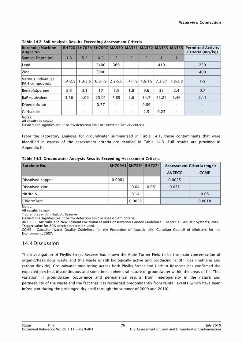
Waterview Connection
Status Final 76 July 2010Document Reference No. 20.1.11-3-R-EN-403 G.9 Assessment of Land and Groundwater Contamination
Table 14.2: Soil Analysis Results Exceeding Assessment Criteria
Borehole/Machine Auger No.
BH720 BH707A BH709C MA350 MA351 MA352 MA353 MA355 Permitted Activity Criteria (mg/kg)
Sample Depth (m) 1.3 5.5 4.5 2 2 2 1 1
Lead - - 2400 360 - - 410 - 250
Zinc - - 2000 - - - - - 400
Various individual PAH compounds
1.4-2.5 1.3-3.5 6.8-19 2.2-5.6 1.4-1.9 4.8-15 7.3-37 1.2-2.8 1-5
Benzo(a)pyrene 2.5 3.1 17 5.5 1.8 9.6 33 2.4 0.7
BaP equivalent 3.56 4.09 25.01 7.89 2.6 14.7 43.24 3.46 2.15
Dibenzofuran - - 0.77 - - 0.89 - - -
Carbazole - - - - - 2.5 0.25 - -
Notes: All results in mg/kg Dashed line signifies result below detection limit or Permitted Activity criteria.
From the laboratory analyses for groundwater summarised in Table 14.1, those contaminants that were
identified in excess of the assessment criteria are detailed in Table 14.3. Full results are provided in
Appendix K.
Table 14.3: Groundwater Analysis Results Exceeding Assessment Criteria
Borehole No. BH709A1 BH726* BH727* Assessment Criteria (mg/l)
ANZECC CCME
Dissolved copper 0.0061 - - 0.0025 -
Dissolved zinc - 0.04 0.051 0.031 -
Nitrite-N - 0.14 - - 0.06
Chloroform - 0.0055 - - 0.0018
Notes: All results in mg/l * Boreholes within Harbutt Reserve Dashed line signifies result below detection limit or assessment criteria. ANZECC – Australia and New Zealand Environment and Conservation Council Guidelines, Chapter 3 – Aquatic Systems, 2000. Trigger value for 80% species protection used. CCME – Canadian Water Quality Guidelines for the Protection of Aquatic Life, Canadian Council of Ministers for the Environment, 2007.
14.4 Discussion
The investigation of Phyllis Street Reserve has shown the Albie Turner Field to be the main concentration of
organic/hazardous waste and this waste is still biologically active and producing landfill gas (methane and
carbon dioxide). Groundwater monitoring across both Phyllis Street and Harbutt Reserves has confirmed the
expected perched, discontinuous and sometimes ephemeral nature of groundwater within the areas of fill. This
variation in groundwater occurrence and permanence results from heterogeneity in the nature and
permeability of the waste and the fact that it is recharged predominantly from rainfall events (which have been
infrequent during the prolonged dry spell through the summer of 2009 and 2010).
Waterview Connection
Status Final 77 July 2010Document Reference No. 20.1.11-3-R-EN-403 G.9 Assessment of Land and Groundwater Contamination
The assessment of soil and groundwater contamination within Phyllis Street Reserve is aimed at establishing
whether there is evidence for ongoing discharge of contaminants to groundwater and, if so, whether the
contaminants could then migrate to the tunnels during construction. In doing this, the requirement for
resource consent is also addressed. As the areas of fill in both Phyllis Street and Harbutt Reserves are not
being disturbed during tunnel construction, assessment of human health risks has not been undertaken.
14.4.1 Groundwater Quality and Tunnel Construction
The results of groundwater analyses from Phyllis Street Reserve have shown that only copper exceeds its
assessment criterion (this is represented visually on Figure 19 in Appendix M). However, given that several
groundwater monitoring installations within the fill were dry throughout the investigation, due to a prolonged
dry period, it was considered appropriate to undertake some numerical modelling. The modelling was carried
out using the 2D groundwater seepage program SEEP/W (2007) Version 7.16 as part of the parallel
hydrogeological investigation. A brief summary of the results is given below and full details are provided in the
Technical Report No. G7 Assessment of Groundwater Effects.
The section of Phyllis Street Reserve modelled was at approximate chainage 3400. This chainage was selected
on the basis that at this location the tunnels will be constructed through the Parnell Grit which, as stated in
Section 3.2, is the most permeable unit within the Waitemata Group deposits. It was also considered that this
was the most likely location for groundwater drawdown effects to be most significant, whereby contaminants
within groundwater at the base of the fill could potentially be ‘drawn down’ into the tunnels during the
construction dewatering process.
The results of the modelling suggest that the largest effect on the water level in the fill will occur during the
construction phase, when there is potential for up to 3.2m of drawdown at the base of the fill prior to the
lining of the tunnels. However, monitoring of water levels in boreholes screened within the fill through the
summer of 2009 and 2010 suggests that there is very little groundwater residing within the fill at approximate
chainage 3400. Notwithstanding the general paucity of groundwater within the area being modelled and
assuming (conservatively) that some drawdown of groundwater from the fill would take place, the modelling
predicts the following scenario.
During the tunnel construction phase there is a significant increase in the vertical flow of groundwater through
the overlying geology, potentially allowing for some vertical migration of mobile contaminants (though none
have been identified). However, a 7m to 21m thick layer of low permeability residual soil derived from the
weathering of the Parnell Grit separates the fill from the unweathered Parnell Grit. This material will behave as
an aquitard, essentially resisting the flow of groundwater and thereby reducing the risk of contaminants
reaching the tunnel excavation. The modelling has shown that the vertical velocity of groundwater within the
geology underlying the fill is likely to be in the order of 0.02 m/d during the periods of maximum drawdown.
Groundwater travelling at this velocity would take a minimum of 650 days (1.8 years) to reach the base of the
weathered Parnell Grit, with the average travel time being more like 1800 days (4.9 years). As the average
travel time of groundwater from the base of the fill to the depth of the tunnels is greater than the period for
the construction and lining of the tunnels, the potential for contaminated inflows to the tunnels is considered
to be very low.
Waterview Connection
Status Final 78 July 2010Document Reference No. 20.1.11-3-R-EN-403 G.9 Assessment of Land and Groundwater Contamination
14.4.2 Resource Consent Assessment
The results of the soil analyses from within Phyllis Street Reserve have revealed lead, isolated zinc and various
PAH compounds to be above their Permitted Activity criteria (these are represented visually on Figure 19 in
Appendix M). Though dibenzofuran and carbazole do not have Permitted Activity criteria, they are included in
Table 14.2 because they were detected in some soil samples. On the basis of the exceedance of Permitted
Activity criteria, a passive discharge consent would be required for Phyllis Street Reserve under Rule 5.5.43 of
the ALWP. However, it is understood that the ACC already hold a resource consent to discharge minor
contaminants to natural waters from Phyllis Street Reserve. It is considered that the Project will have negligible
impacts on the conditions of this existing ACC resource consent. Furthermore, it is also considered that
resource consent is not required in relation to any Project activities within the vicinity of Phyllis Street Reserve.
The results of the groundwater analyses from Phyllis Street and Harbutt Reserves have revealed copper (Phyllis)
and zinc (Harbutt) to be in excess of their ANZECC guideline value for resource consent evaluation under Rule
5.5.43 of the ALWP. It is likely that the elevated copper is already consented by the ARC as described above.
The elevated zinc in Harbutt Reserve is evidence of a discharge to water from land and a consent would be
required to authorise this discharge and define any appropriate remediation or management. However, as
discussed in previous sections, the land within Harbutt Reserve is not being disturbed at surface by the tunnel
construction. In addition, there is low probability (on the basis of investigation and numerical modelling) that
there will be any measurable impact on contamination within Harbutt Reserve from tunnel construction or vice
versa. It is therefore considered that resource consent is not required in relation to any Project activities within
the vicinity of Harbutt Reserve.
14.5 Assessment of Environmental Effects
Based on the findings of the investigation for this sector, there are no adverse environmental effects associated
with construction of the tunnels beneath Phyllis Street and Harbutt Reserves.
14.6 Conclusions
The investigation of Phyllis Street Reserve has confirmed that there is evidence of deposition of organic and
household waste and this waste is still producing landfill gas. Perched groundwater is present within the waste
but it is discontinuous and in some cases, ephemeral. Assessment (investigation and numerical modelling) of
the potential for contaminated groundwater to enter the twin tunnels during construction has shown the
likelihood of such an event to be small.
Results of soil analyses show that Permitted Activity criteria are exceeded for lead, zinc and PAH compounds.
Results of groundwater analyses show copper to be above the ANZECC guideline value. ACC already hold a
discharge consent for Phyllis Street Reserve and it is considered that the Project will have negligible effects on
the existing discharges, and negligible impacts on the conditions of the existing ACC resource consent.
The investigation of Harbutt Reserve Landfill has confirmed the presence of predominantly construction and
demolition waste. Perched groundwater has been consistently recorded in Harbutt Reserve and results of
groundwater analyses show zinc to be present above its ANZECC guideline value. This is evidence of an
existing contaminated discharge to groundwater, but as land within Harbutt Reserve is not being disturbed at

Waterview Connection
Status Final 79 July 2010Document Reference No. 20.1.11-3-R-EN-403 G.9 Assessment of Land and Groundwater Contamination
surface by the Project tunnel construction, it is unlikely that there will be any measurable impact on
contamination within Harbutt Reserve from tunnel construction or vice versa.
There are accordingly no environmental effects associated with construction of the tunnels beneath Phyllis
Street and Harbutt Reserves.
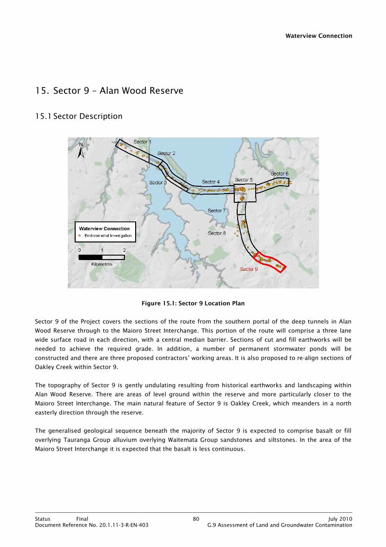
Waterview Connection
Status Final 80 July 2010Document Reference No. 20.1.11-3-R-EN-403 G.9 Assessment of Land and Groundwater Contamination
15. Sector 9 – Alan Wood Reserve
15.1 Sector Description
Figure 15.1: Sector 9 Location Plan
Sector 9 of the Project covers the sections of the route from the southern portal of the deep tunnels in Alan
Wood Reserve through to the Maioro Street Interchange. This portion of the route will comprise a three lane
wide surface road in each direction, with a central median barrier. Sections of cut and fill earthworks will be
needed to achieve the required grade. In addition, a number of permanent stormwater ponds will be
constructed and there are three proposed contractors’ working areas. It is also proposed to re-align sections of
Oakley Creek within Sector 9.
The topography of Sector 9 is gently undulating resulting from historical earthworks and landscaping within
Alan Wood Reserve. There are areas of level ground within the reserve and more particularly closer to the
Maioro Street Interchange. The main natural feature of Sector 9 is Oakley Creek, which meanders in a north
easterly direction through the reserve.
The generalised geological sequence beneath the majority of Sector 9 is expected to comprise basalt or fill
overlying Tauranga Group alluvium overlying Waitemata Group sandstones and siltstones. In the area of the
Maioro Street Interchange it is expected that the basalt is less continuous.
Waterview Connection
Status Final 81 July 2010Document Reference No. 20.1.11-3-R-EN-403 G.9 Assessment of Land and Groundwater Contamination
The existing land use within this sector comprises parkland (open space and playing fields) within Alan Wood
Reserve which is surrounded by residential housing. Where Alan Wood Reserve ends, close to Richardson Road,
the land use changes to commercial and light industrial up to the Maioro Street Interchange.
Historically, Alan Wood Reserve has been subject to land filling activities and the reserve is listed in the ACC
Closed Landfills Asset Management Plan 2009/2010 as a Priority 2 landfill. According to the document, a
“Priority 2 landfill” is considered to “..present a minor actual risk and/or significant potential risk to human
health and/or the environment.”
Information received from ACC suggests that deposition of fill took place between the 1940s and 1970s and
was fairly widespread throughout the reserve, with fill composed of construction waste and cleanfill. However,
the information also indicated that an area of more concentrated filling comprising household waste occurred
in an area close to Oakley Creek adjacent to the caravan park. This is discussed in more detail in
Section 15.3.1.
15.2 Investigation Activities and Methodology
Given that the majority of construction earthworks within Sector 9 are at relatively shallow depth and are not
expected to intercept groundwater, the investigation has focused on soils only. Incidental groundwater
sampling was undertaken where perched groundwater was encountered during the investigations. The
objectives of the investigations within Sector 9 were as follows:
• To determine the nature, extent and degree of contamination of the fill within Alan Wood Reserve and of
soils within the vicinity of the Maioro Street Interchange.
• To establish the resource consent requirements associated with any identified contamination.
• To assess risks to human health from any identified soil contamination.
• To classify soils for re-use and off site disposal purposes.
• To determine any environmental effects.
The investigations within Sector 9 were focused on the alignment of the motorway through the reserve, two of
the three contractors’ working areas and the northern section of the Maioro Street Interchange. Contractors’
working area 7 was not investigated as it was occupied by housing and the Hendon stormwater pond was not
investigated due to access constraints, see Figure 37 in Appendix Q. A summary of the investigations is given
in Table 15.1 and the investigation locations are shown on Figures 13 and 14 in Appendix D.
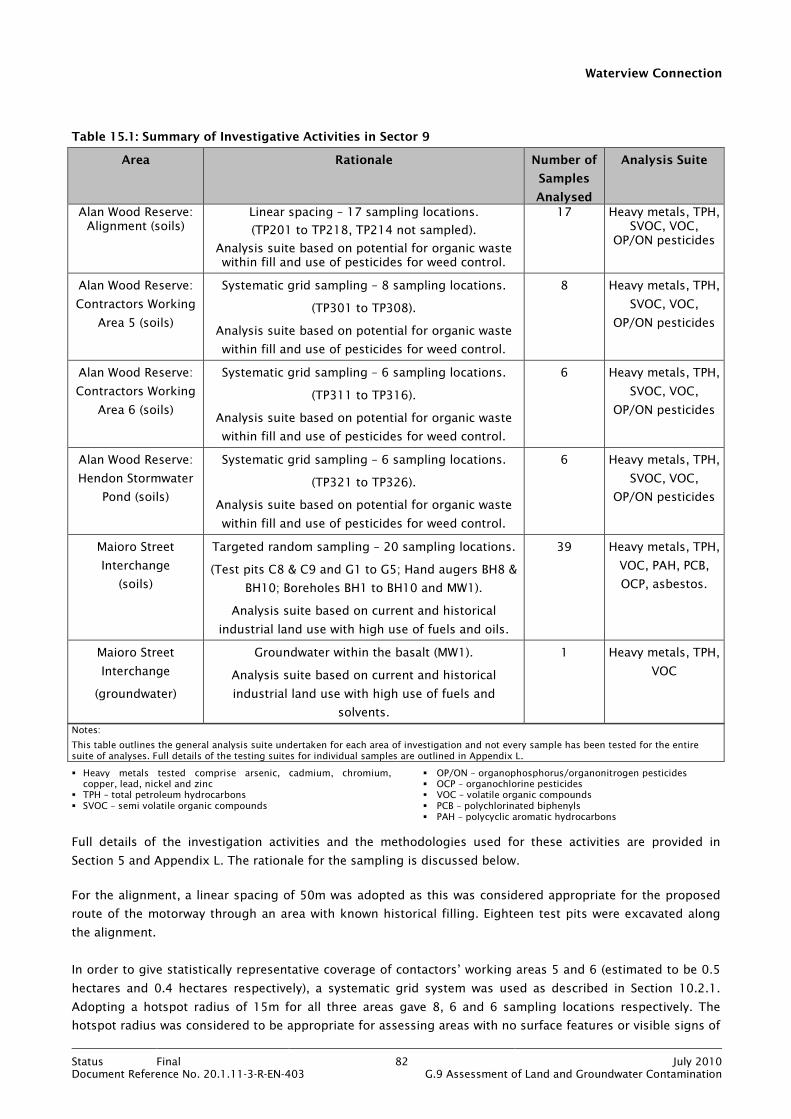
Waterview Connection
Status Final 82 July 2010Document Reference No. 20.1.11-3-R-EN-403 G.9 Assessment of Land and Groundwater Contamination
Table 15.1: Summary of Investigative Activities in Sector 9
Area Rationale Number of
Samples
Analysed
Analysis Suite
Alan Wood Reserve: Alignment (soils)
Linear spacing – 17 sampling locations.
(TP201 to TP218, TP214 not sampled).
Analysis suite based on potential for organic waste within fill and use of pesticides for weed control.
17 Heavy metals, TPH, SVOC, VOC,
OP/ON pesticides
Alan Wood Reserve:
Contractors Working
Area 5 (soils)
Systematic grid sampling – 8 sampling locations.
(TP301 to TP308).
Analysis suite based on potential for organic waste
within fill and use of pesticides for weed control.
8 Heavy metals, TPH,
SVOC, VOC,
OP/ON pesticides
Alan Wood Reserve:
Contractors Working
Area 6 (soils)
Systematic grid sampling – 6 sampling locations.
(TP311 to TP316).
Analysis suite based on potential for organic waste
within fill and use of pesticides for weed control.
6 Heavy metals, TPH,
SVOC, VOC,
OP/ON pesticides
Alan Wood Reserve:
Hendon Stormwater
Pond (soils)
Systematic grid sampling – 6 sampling locations.
(TP321 to TP326).
Analysis suite based on potential for organic waste
within fill and use of pesticides for weed control.
6 Heavy metals, TPH,
SVOC, VOC,
OP/ON pesticides
Maioro Street
Interchange
(soils)
Targeted random sampling – 20 sampling locations.
(Test pits C8 & C9 and G1 to G5; Hand augers BH8 &
BH10; Boreholes BH1 to BH10 and MW1).
Analysis suite based on current and historical
industrial land use with high use of fuels and oils.
39 Heavy metals, TPH,
VOC, PAH, PCB,
OCP, asbestos.
Maioro Street
Interchange
(groundwater)
Groundwater within the basalt (MW1).
Analysis suite based on current and historical
industrial land use with high use of fuels and
solvents.
1 Heavy metals, TPH,
VOC
Notes:
This table outlines the general analysis suite undertaken for each area of investigation and not every sample has been tested for the entire suite of analyses. Full details of the testing suites for individual samples are outlined in Appendix L.
� Heavy metals tested comprise arsenic, cadmium, chromium, copper, lead, nickel and zinc
� TPH – total petroleum hydrocarbons � SVOC – semi volatile organic compounds
� OP/ON – organophosphorus/organonitrogen pesticides � OCP – organochlorine pesticides � VOC – volatile organic compounds � PCB – polychlorinated biphenyls � PAH – polycyclic aromatic hydrocarbons
Full details of the investigation activities and the methodologies used for these activities are provided in
Section 5 and Appendix L. The rationale for the sampling is discussed below.
For the alignment, a linear spacing of 50m was adopted as this was considered appropriate for the proposed
route of the motorway through an area with known historical filling. Eighteen test pits were excavated along
the alignment.
In order to give statistically representative coverage of contactors’ working areas 5 and 6 (estimated to be 0.5
hectares and 0.4 hectares respectively), a systematic grid system was used as described in Section 10.2.1.
Adopting a hotspot radius of 15m for all three areas gave 8, 6 and 6 sampling locations respectively. The
hotspot radius was considered to be appropriate for assessing areas with no surface features or visible signs of
Waterview Connection
Status Final 83 July 2010Document Reference No. 20.1.11-3-R-EN-403 G.9 Assessment of Land and Groundwater Contamination
contamination and which have historically been subject to filling. A total of 37 soil samples were scheduled for
chemical laboratory analysis and the analysis suite is summarised in Table 15.1 and detailed in Appendix L.
For the Maioro Street Interchange, a targeted random sampling approach was taken to focus on the locations
of historically or currently known potentially contaminating activities. A combination of seven test pits, two
hand augers and 11 boreholes were used to facilitate the collection of soil samples. A total of 39 soil samples
were scheduled for chemical laboratory analysis and the analysis suite is summarised in Table 15.1 and
detailed in Appendix L. A groundwater sample was also collected from the interchange.
The maximum depths of investigation in all areas was 3m bgl which was considered appropriate for identifying
any contamination associated with potential filling activities and pesticide spraying (Alan Wood Reserve) and
current and historical activities (Maioro Street Interchange).
Investigation locations TP201 to TP204 and TP301 to TP308 are within Sector 8 but as they are part of the
assessment for Alan Wood Reserve they have been discussed within Sector 9.
15.3 Investigation Findings
15.3.1 Alan Wood Reserve
Review of the test pit logs for the areas investigated within Alan Wood Reserve has confirmed the expected
geology of fill or basalt overlying Tauranga Group alluvium. Much of the fill comprised reworked natural soils
(silt and clay) though at some locations, waste materials were encountered. The waste materials were
encountered at locations TP202, TP203, TP209, TP213 to 215, TP302, TP311, TP313 to TP315 and comprised
plastic bags, glass, basalt boulders, reinforced and unreinforced concrete, fibre board, metal, brick and timber
in a sandy silty matrix. The maximum thickness of waste penetrated was 2.4m. In addition, fragments of
possible cement bound asbestos were identified at locations TP214 and TP215. There was no olfactory
evidence for contamination within any of the test pits.
A subsequent asbestos delineation investigation has been carried out and the area affected by cement bound
asbestos is depicted on Figure 33 in Appendix P. It should be noted that the delineation investigation did not
encroach south of the footpath as shown on the plan. As at the time of the investigation that area was in
private ownership and permission had not been granted to access the land.
Groundwater was encountered as slow inflow between 0.5m and 2.2m bgl at five locations (TP213, TP215,
TP217, TP311, TP321 and TP325).
As mentioned in Section 15.1, information received from ACC (following completion of the investigations in
Alan Wood Reserve) provided evidence for the filling of a gravel pit between 1964 and 1972 (shown on
Figure 33 in Appendix P). This information comprised a report of an intrusive investigation (commissioned by
ACC) which estimated that some 5000m3 of fill was deposited over an area of approximately 1450m2. The fill
was estimated to comprise approximately 50% household waste with the remainder a mixture of cleanfill and
demolition waste. The ACC investigation also identified landfill gas emanating from within the former gravel
pit. Associated groundwater monitoring failed to identify any significant contamination of groundwater.
The following land uses were considered most appropriate when selecting assessment criteria:
• Consent Requirements – Residential/parkland.
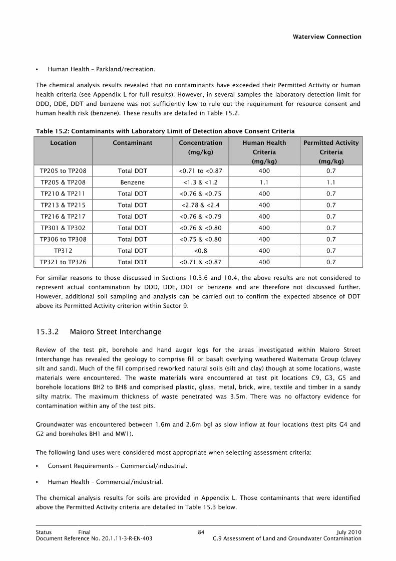
Waterview Connection
Status Final 84 July 2010Document Reference No. 20.1.11-3-R-EN-403 G.9 Assessment of Land and Groundwater Contamination
• Human Health – Parkland/recreation.
The chemical analysis results revealed that no contaminants have exceeded their Permitted Activity or human
health criteria (see Appendix L for full results). However, in several samples the laboratory detection limit for
DDD, DDE, DDT and benzene was not sufficiently low to rule out the requirement for resource consent and
human health risk (benzene). These results are detailed in Table 15.2.
Table 15.2: Contaminants with Laboratory Limit of Detection above Consent Criteria
Location Contaminant Concentration
(mg/kg)
Human Health
Criteria
(mg/kg)
Permitted Activity
Criteria
(mg/kg)
TP205 to TP208 Total DDT <0.71 to <0.87 400 0.7
TP205 & TP208 Benzene <1.3 & <1.2 1.1 1.1
TP210 & TP211 Total DDT <0.76 & <0.75 400 0.7
TP213 & TP215 Total DDT <2.78 & <2.4 400 0.7
TP216 & TP217 Total DDT <0.76 & <0.79 400 0.7
TP301 & TP302 Total DDT <0.76 & <0.80 400 0.7
TP306 to TP308 Total DDT <0.75 & <0.80 400 0.7
TP312 Total DDT <0.8 400 0.7
TP321 to TP326 Total DDT <0.71 & <0.87 400 0.7
For similar reasons to those discussed in Sections 10.3.6 and 10.4, the above results are not considered to
represent actual contamination by DDD, DDE, DDT or benzene and are therefore not discussed further.
However, additional soil sampling and analysis can be carried out to confirm the expected absence of DDT
above its Permitted Activity criterion within Sector 9.
15.3.2 Maioro Street Interchange
Review of the test pit, borehole and hand auger logs for the areas investigated within Maioro Street
Interchange has revealed the geology to comprise fill or basalt overlying weathered Waitemata Group (clayey
silt and sand). Much of the fill comprised reworked natural soils (silt and clay) though at some locations, waste
materials were encountered. The waste materials were encountered at test pit locations C9, G3, G5 and
borehole locations BH2 to BH8 and comprised plastic, glass, metal, brick, wire, textile and timber in a sandy
silty matrix. The maximum thickness of waste penetrated was 3.5m. There was no olfactory evidence for
contamination within any of the test pits.
Groundwater was encountered between 1.6m and 2.6m bgl as slow inflow at four locations (test pits G4 and
G2 and boreholes BH1 and MW1).
The following land uses were considered most appropriate when selecting assessment criteria:
• Consent Requirements – Commercial/industrial.
• Human Health – Commercial/industrial.
The chemical analysis results for soils are provided in Appendix L. Those contaminants that were identified
above the Permitted Activity criteria are detailed in Table 15.3 below.
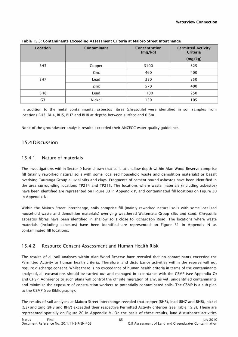
Waterview Connection
Status Final 85 July 2010Document Reference No. 20.1.11-3-R-EN-403 G.9 Assessment of Land and Groundwater Contamination
Table 15.3: Contaminants Exceeding Assessment Criteria at Maioro Street Interchange
Location Contaminant Concentration (mg/kg)
Permitted Activity Criteria
(mg/kg)
BH3 Copper 3100 325
Zinc 460 400
BH7 Lead 350 250
Zinc 570 400
BH8 Lead 1100 250
G3 Nickel 150 105
In addition to the metal contaminants, asbestos fibres (chrysotile) were identified in soil samples from
locations BH3, BH4, BH5, BH7 and BH8 at depths between surface and 0.6m.
None of the groundwater analysis results exceeded their ANZECC water quality guidelines.
15.4 Discussion
15.4.1 Nature of materials
The investigations within Sector 9 have shown that soils at shallow depth within Alan Wood Reserve comprise
fill (mainly reworked natural soils with some localised household waste and demolition materials) or basalt
overlying Tauranga Group alluvial silts and clays. Fragments of cement bound asbestos have been identified in
the area surrounding locations TP214 and TP215. The locations where waste materials (including asbestos)
have been identified are represented on Figure 33 in Appendix P, and contaminated fill locations on Figure 30
in Appendix N.
Within the Maioro Street Interchange, soils comprise fill (mainly reworked natural soils with some localised
household waste and demolition materials) overlying weathered Waitemata Group silts and sand. Chrysotile
asbestos fibres have been identified in shallow soils close to Richardson Road. The locations where waste
materials (including asbestos) have been identified are represented on Figure 31 in Appendix N as
contaminated fill locations.
15.4.2 Resource Consent Assessment and Human Health Risk
The results of all soil analyses within Alan Wood Reserve have revealed that no contaminants exceeded the
Permitted Activity or human health criteria. Therefore land disturbance activities within the reserve will not
require discharge consent. Whilst there is no exceedance of human health criteria in terms of the contaminants
analysed, all excavations should be carried out and managed in accordance with the CSMP (see Appendix O)
and CHSP. Adherence to such plans will control the off site migration of any, as yet, unidentified contaminants
and minimise the exposure of construction workers to potentially contaminated soils. The CSMP is a sub-plan
to the CEMP (see Bibliography).
The results of soil analyses at Maioro Street Interchange revealed that copper (BH3), lead (BH7 and BH8), nickel
(G3) and zinc (BH3 and BH7) exceeded their respective Permitted Activity criterion (see Table 15.3). These are
represented spatially on Figure 20 in Appendix M. On the basis of these results, land disturbance activities
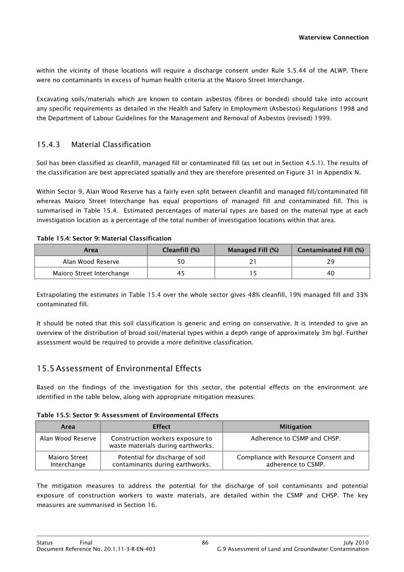
Waterview Connection
Status Final 86 July 2010Document Reference No. 20.1.11-3-R-EN-403 G.9 Assessment of Land and Groundwater Contamination
within the vicinity of those locations will require a discharge consent under Rule 5.5.44 of the ALWP. There
were no contaminants in excess of human health criteria at the Maioro Street Interchange.
Excavating soils/materials which are known to contain asbestos (fibres or bonded) should take into account
any specific requirements as detailed in the Health and Safety in Employment (Asbestos) Regulations 1998 and
the Department of Labour Guidelines for the Management and Removal of Asbestos (revised) 1999.
15.4.3 Material Classification
Soil has been classified as cleanfill, managed fill or contaminated fill (as set out in Section 4.5.1). The results of
the classification are best appreciated spatially and they are therefore presented on Figure 31 in Appendix N.
Within Sector 9, Alan Wood Reserve has a fairly even split between cleanfill and managed fill/contaminated fill
whereas Maioro Street Interchange has equal proportions of managed fill and contaminated fill. This is
summarised in Table 15.4. Estimated percentages of material types are based on the material type at each
investigation location as a percentage of the total number of investigation locations within that area.
Table 15.4: Sector 9: Material Classification
Area Cleanfill (%) Managed Fill (%) Contaminated Fill (%)
Alan Wood Reserve 50 21 29
Maioro Street Interchange 45 15 40
Extrapolating the estimates in Table 15.4 over the whole sector gives 48% cleanfill, 19% managed fill and 33%
contaminated fill.
It should be noted that this soil classification is generic and erring on conservative. It is intended to give an
overview of the distribution of broad soil/material types within a depth range of approximately 3m bgl. Further
assessment would be required to provide a more definitive classification.
15.5 Assessment of Environmental Effects
Based on the findings of the investigation for this sector, the potential effects on the environment are
identified in the table below, along with appropriate mitigation measures:
Table 15.5: Sector 9: Assessment of Environmental Effects
Area Effect Mitigation
Alan Wood Reserve Construction workers exposure to waste materials during earthworks.
Adherence to CSMP and CHSP.
Maioro Street Interchange
Potential for discharge of soil contaminants during earthworks.
Compliance with Resource Consent and adherence to CSMP.
The mitigation measures to address the potential for the discharge of soil contaminants and potential
exposure of construction workers to waste materials, are detailed within the CSMP and CHSP. The key
measures are summarised in Section 16.

Waterview Connection
Status Final 87 July 2010Document Reference No. 20.1.11-3-R-EN-403 G.9 Assessment of Land and Groundwater Contamination
15.6 Conclusions
The investigations in Sector 9 have shown that soils comprise fill (mainly reworked natural silts and clays) with
isolated areas of household and construction waste. Asbestos, as fibres and in bonded form, has also been
identified within the sector.
Perched groundwater was encountered at several locations within Sector 9 and chemical analysis of
groundwater beneath the Maioro Street Interchange has not identified any contaminants above guideline
values.
Results of soil analyses show that Permitted Activity criteria were exceed for copper, zinc, nickel and lead at
isolated locations within the Maioro Street Interchange. Land disturbance activities within the vicinity of those
locations will require a discharge consent under Rule 5.5.44 of the ALWP. There was no exceedance of
Permitted Activity criteria for soils from Alan Wood Reserve and human health criteria were not exceeded for
any soil samples from Sector 9.
All excavations should be carried out and managed in accordance with the CSMP (see Appendix O) and CHSP.
Excavating soils/materials which are known to contain asbestos should be in accordance with the Health and
Safety in Employment (Asbestos) Regulations 1998 and the Department of Labour Guidelines for the
Management and Removal of Asbestos (revised) 1999.
Classification of soils has estimated the percentages of soils for re-use or disposal purposes to be cleanfill
48%, managed fill 19% and contaminated fill 33%.
Potential environmental effects relate to discharge of soil contaminants during earthworks and construction
worker exposure to contaminants in soil. These can be mitigated by excavation and disposal off site of
contaminated soils and adherence to CSMP and CHSP.

Waterview Connection
Status Final 88 July 2010Document Reference No. 20.1.11-3-R-EN-403 G.9 Assessment of Land and Groundwater Contamination
16. Summary of Proposed Mitigation Measures
The proposed mitigation measures for contaminants identified in the soils within the Project footprint are
detailed in the CSMP. The CSMP addresses the potential adverse environmental effects of the Project in relation
to contaminated soils. The key mitigation measures are summarised below:
General Mitigation Measures
• Appointment of a Contaminated Land Specialist (CLS) during the construction phase of the Project. The CLS
will be available on site during all excavation works, and has responsibility for:
• Co-ordinating contaminated land assessments and testing;
• Advising on classification of excavated materials for reuse and disposal;
• Co-ordinating groundwater management and disposal; and
• Training staff in contaminated land identification and control procedures.
• A CHSP to detail mitigation of risks to construction workers and the general public in relation to the
excavation of contaminated soils.
• Excavation and off-site disposal of soils containing contaminants or hazardous materials.
• Management procedures for the excavation of contaminated soils, including:
• Handling and storage requirements (stockpiling to be limited to confirmed cleanfill materials,
contaminated materials to be loaded directly onto trucks or loaded into covered bins);
• Measures to prevent the spread of contamination to other media (dust suppression and earthworks
erosion and sediment controls); and
• Disposal of contaminated soils to appropriately licensed landfill (including preparing records of
excavations of contaminated soils and retaining landfill documentation).
• Procedures for identifying and managing unexpected contaminated soils.
• Soil testing, including:
• Verification testing: confirmation of lateral and vertical extent of areas of contamination.
• Validation testing: testing of materials left in situ following excavation of an area of contamination.
• Discovery testing: testing of unexpected or unknown contamination.
• Submission of a Site Validation Report at the completion of the construction works, detailing the actions
taken to manage the contamination within the project footprint.
Waterview Connection
Status Final 89 July 2010Document Reference No. 20.1.11-3-R-EN-403 G.9 Assessment of Land and Groundwater Contamination
17. Summary Conclusions
17.1 Introduction
This contamination assessment has established the baseline quality of soil and groundwater within the Project
footprint, together with soil classification for re-use or off site disposal purposes. In addition, the likely
environmental effects due to construction of the Project have been determined along with the necessary
regulatory controls and mitigation. These are discussed in detail within the sector specific sections of this
report and summarised below.
17.2 Investigation Summary
The contamination assessment comprised a range of investigations which have been detailed and discussed in
the preceding sector specific sections of this report. The main findings of the assessment are summarised in
the following sub sections which broadly define the following:
• Where contaminated soils or groundwater have been identified.
• Where waste materials have been encountered.
• Where a requirement for resource consent is triggered due to exceedance of Permitted Activity criteria.
• Where human health criteria have been exceeded.
• The environmental effects of the Project based on the investigation findings.
• The mitigation required for the identified environmental effects.
17.3 Soils
The proposed works associated with the Project will involve land disturbance within Sectors 1 to 6 and 9.
Permitted Activity criteria for soils have been exceeded in Sectors 2 to 6 and 9 thereby triggering the
requirement for resource (discharge) consent under Rule 5.5.44 of the ALWP (see Table 17.1).
Human Health assessment criteria have been exceeded in Sectors 1, 5 and 6. Notwithstanding the exceedance
of human health assessment criteria, the human health risks from contaminated soils can be mitigated by
adherence to the CSMP and CHSP. This will control the off site migration of identified and any, as yet,
unidentified contaminants and minimise the exposure of construction workers to actually or potentially
contaminated soils (see Table 17.1).
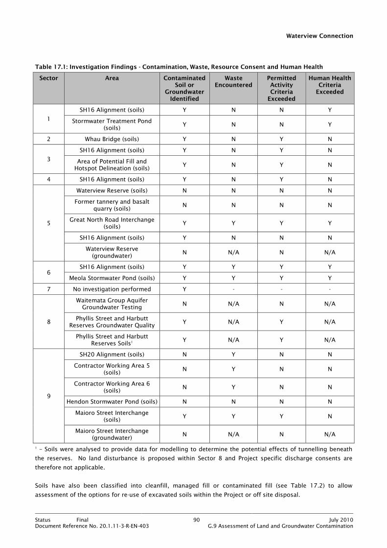
Waterview Connection
Status Final 90 July 2010Document Reference No. 20.1.11-3-R-EN-403 G.9 Assessment of Land and Groundwater Contamination
Table 17.1: Investigation Findings - Contamination, Waste, Resource Consent and Human Health
Sector Area Contaminated Soil or
Groundwater Identified
Waste Encountered
Permitted Activity Criteria Exceeded
Human Health Criteria Exceeded
1
SH16 Alignment (soils) Y N N Y
Stormwater Treatment Pond (soils)
Y N N Y
2 Whau Bridge (soils) Y N Y N
3
SH16 Alignment (soils) Y N Y N
Area of Potential Fill and Hotspot Delineation (soils)
Y N Y N
4 SH16 Alignment (soils) Y N Y N
5
Waterview Reserve (soils) N N N N
Former tannery and basalt quarry (soils)
N N N N
Great North Road Interchange (soils)
Y Y Y Y
SH16 Alignment (soils) Y N N N
Waterview Reserve (groundwater)
N N/A N N/A
6 SH16 Alignment (soils) Y Y Y Y
Meola Stormwater Pond (soils) Y Y Y Y
7 No investigation performed Y - - -
8
Waitemata Group Aquifer Groundwater Testing
N N/A N N/A
Phyllis Street and Harbutt Reserves Groundwater Quality
Y N/A Y N/A
Phyllis Street and Harbutt Reserves Soils1
Y N/A Y N/A
9
SH20 Alignment (soils) N Y N N
Contractor Working Area 5 (soils)
N Y N N
Contractor Working Area 6 (soils)
N Y N N
Hendon Stormwater Pond (soils) N N N N
Maioro Street Interchange (soils)
Y Y Y N
Maioro Street Interchange (groundwater)
N N/A N N/A
1 – Soils were analysed to provide data for modelling to determine the potential effects of tunnelling beneath
the reserves. No land disturbance is proposed within Sector 8 and Project specific discharge consents are
therefore not applicable.
Soils have also been classified into cleanfill, managed fill or contaminated fill (see Table 17.2) to allow
assessment of the options for re-use of excavated soils within the Project or off site disposal.

Waterview Connection
Status Final 91 July 2010Document Reference No. 20.1.11-3-R-EN-403 G.9 Assessment of Land and Groundwater Contamination
Table 17.2: Investigation Findings: Soil Classification
Sector Area Material Classification %
Cleanfill Managed Fill Contaminated Fill
1 SH16 Alignment 45 55 -
Stormwater Treatment Pond - 100 -
2 Whau Bridge 33 67 -
3 SH16 Alignment 43 57 -
Area of Potential Fill and Hotspot Delineation
- 100 -
4 SH16 Alignment 58 42 -
5 Waterview Reserve 79 21 -
Former tannery and basalt quarry
60 40 -
Great North Road Interchange
- 100 -
SH16 Alignment 14 43 43
6 SH16 Alignment 70 26 4
Meola Stormwater Pond - 90 10
7 No investigation performed - - -
8 Phyllis Street and Harbutt Reserves Soils1
N/A N/A N/A
9 SH20 Alignment
50 21 29 Contractor Working Area 5
Contractor Working Area 6
Hendon Stormwater Pond
Maioro Street Interchange 45 15 40
Management and Mitigation Cleanfill Managed FIll Contaminated Fill
Can be reused on site, providing there is
compliance with ALWP Rule 5.5.48.
May remain on site, or may need to be
removed from site. Mitigation measures are detailed in the CSMP
(Appendix O).
Will need to be removed from site. Mitigation measures are detailed in the CSMP (Appendix O).
17.4 Groundwater
The groundwater investigations have comprised the assessment of:
• Waitemata Group Aquifer baseline water quality
• Presence and quality of groundwater and leachate within Phyllis Street and Harbutt Reserves
• Incidental perched groundwater quality where encountered.
On the basis of the chemical analyses undertaken only groundwater within Phyllis Street and Harbutt Reserves
contained contaminants in excess of their water quality criteria.
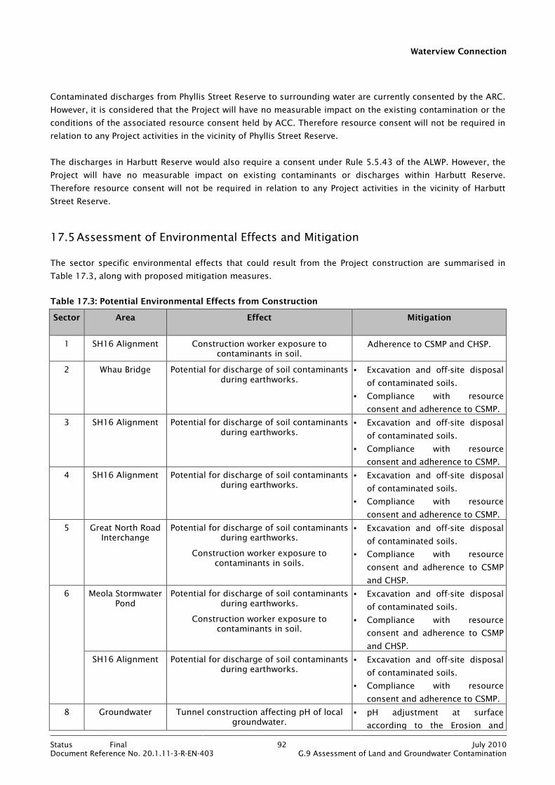
Waterview Connection
Status Final 92 July 2010Document Reference No. 20.1.11-3-R-EN-403 G.9 Assessment of Land and Groundwater Contamination
Contaminated discharges from Phyllis Street Reserve to surrounding water are currently consented by the ARC.
However, it is considered that the Project will have no measurable impact on the existing contamination or the
conditions of the associated resource consent held by ACC. Therefore resource consent will not be required in
relation to any Project activities in the vicinity of Phyllis Street Reserve.
The discharges in Harbutt Reserve would also require a consent under Rule 5.5.43 of the ALWP. However, the
Project will have no measurable impact on existing contaminants or discharges within Harbutt Reserve.
Therefore resource consent will not be required in relation to any Project activities in the vicinity of Harbutt
Street Reserve.
17.5 Assessment of Environmental Effects and Mitigation
The sector specific environmental effects that could result from the Project construction are summarised in
Table 17.3, along with proposed mitigation measures.
Table 17.3: Potential Environmental Effects from Construction
Sector Area Effect Mitigation
1 SH16 Alignment Construction worker exposure to contaminants in soil.
Adherence to CSMP and CHSP.
2 Whau Bridge Potential for discharge of soil contaminants during earthworks.
• Excavation and off-site disposal
of contaminated soils.
• Compliance with resource
consent and adherence to CSMP.
3 SH16 Alignment Potential for discharge of soil contaminants during earthworks.
• Excavation and off-site disposal
of contaminated soils.
• Compliance with resource
consent and adherence to CSMP.
4 SH16 Alignment Potential for discharge of soil contaminants during earthworks.
• Excavation and off-site disposal
of contaminated soils.
• Compliance with resource
consent and adherence to CSMP.
5 Great North Road Interchange
Potential for discharge of soil contaminants during earthworks.
Construction worker exposure to contaminants in soils.
• Excavation and off-site disposal
of contaminated soils.
• Compliance with resource
consent and adherence to CSMP
and CHSP.
6 Meola Stormwater Pond
Potential for discharge of soil contaminants during earthworks.
Construction worker exposure to contaminants in soil.
• Excavation and off-site disposal
of contaminated soils.
• Compliance with resource
consent and adherence to CSMP
and CHSP.
SH16 Alignment Potential for discharge of soil contaminants during earthworks.
• Excavation and off-site disposal
of contaminated soils.
• Compliance with resource
consent and adherence to CSMP.
8 Groundwater Tunnel construction affecting pH of local groundwater.
• pH adjustment at surface
according to the Erosion and

Waterview Connection
Status Final 93 July 2010Document Reference No. 20.1.11-3-R-EN-403 G.9 Assessment of Land and Groundwater Contamination
Groundwater containing high suspended solids.
Sediment Control Plan (ESCP).
• Chemical flocculation treatment
for suspended solids.
Landfills No adverse effects. None required.
9 Alan Wood Reserve
Construction workers exposure to waste materials during earthworks.
• Excavation and off-site disposal
of waste materials.
• Adherence to CSMP and CHSP.
Maioro Street Interchange
Potential for discharge of soil contaminants during earthworks.
Compliance with resource consent
and adherence to CSMP.
This assessment has identified contaminated soils and potentially hazardous materials within the Project
footprint. However, these occur in relatively localised areas as defined in the tables above. The environmental
effects of the Project relate to discharge of soil contaminants during earthworks and construction worker
exposure to soil contaminants. These effects can be mitigated by compliance with resource consents,
excavation of contaminated soils and disposal off-site, and adherence to CSMP and CHSP.
It is considered that implementation of the proposed mitigation detailed above will render the effects of the
Project less than minor.

Waterview Connection
Status Final 94 July 2010Document Reference No. 20.1.11-3-R-EN-403 G.9 Assessment of Land and Groundwater Contamination
Bibliography
Australian and New Zealand Environment and Conservation Council (ANZECC). 2000: Australian and New
Zealand Guidelines for Fresh and Marine Water Quality. Published by The Australian and New Zealand
Environment and Conservation Council, 2000.
Auckland City Council (ACC). 2007: Auckland City Council Soil Screening Criteria – Human Health, 2007.
Adopted in 2006 by Auckland City Environments (Auckland City Council).
ACC. 2009: Auckland City Council Closed Landfills Asset Management Plan 2009/2010.
Auckland Regional Council (ARC). 2001: Background concentrations of inorganic elements in solids from the
Auckland Region. Auckland Regional Council Technical Publication No. 153. 68 p.
ARC. 2008: Schedule 10 – Proposed Auckland Regional Plan: Air, Land and Water – Updated May 2008.
Auckland Regional Council, Auckland.
ARC. 2008: Schedule 10 – Permitted Activity Criteria in Proposed Auckland Regional Plan: Air, Land and Water
– Updated May 2008.
Canadian Council of Ministers of the Environment (CCME). 2007: A Protocol for the Derivation of Water Quality
Guidelines for the Protection of Aquatic Life, 2007. CCME: Winnipeg.
Kermode, L.O. 1992: Geology of the Auckland urban area. Scale 1: 50,000. Institute of Geological and Nuclear
Sciences Geological Map 2. 1 sheet + 63 p. Institute of Geological and Nuclear Sciences Ltd., Lower Hutt.
New Zealand. Ministry for the Environment (MfE), 1999: Guidelines for Assessing and Managing Petroleum
Hydrocarbon Contaminated Sites in New Zealand. Ministry for the Environment, Wellington.
New Zealand. MfE 2002: A Guide to the Management of Cleanfills. Ministry for the Environment, Wellington.
65 p.
New Zealand. MfE 2004: Contaminated Land Management Guidelines No. 1, Reporting on Contaminated Sites in
New Zealand. Ministry for the Environment, Wellington. 25 p.
New Zealand. MfE 2004: Contaminated Land Management Guidelines No. 3, Risk Screening Criteria. Ministry
for the Environment, Wellington. 35 p.
New Zealand. MfE 2004: Contaminated Land Management Guidelines No. 5, Site Investigation and Analysis of
Soils. Ministry for the Environment, Wellington. 85 p.
New Zealand. MfE, 2006: Identifying, Investigating and Managing Risks Associated with Former Sheep-dip Sites:
A guide for local authorities. Ministry for the Environment: Wellington. 100 p.
New Zealand. MfE 2010: Proposed National Environmental Standard for Assessing and Managing Contaminants
in Soil: Discussion Document. Ministry for the Environment, Wellington. 85 p.

Waterview Connection