Future Trends in Global Oil and Gas Exploration Dr. Michael C · PDF file3 exploration of the...
25
1 Future Trends in Global Oil and Gas Exploration Dr. Michael C. Daly Executive Vice President Exploration, BP plc Imperial College 23 September Thank you for the invitation to speak at your conference celebrating the centenary of Oil Technology at Imperial College. It is an honour and great pleasure to be here. I have been asked to discuss the future trends of global oil and gas exploration, a subject I am deeply passionate about and have lived with for over 30 years now. Of course many factors will influence the future of exploration. However, the fundamentals of resource quality, technology and
-
Upload
nguyenkhanh -
Category
Documents
-
view
213 -
download
1
Transcript of Future Trends in Global Oil and Gas Exploration Dr. Michael C · PDF file3 exploration of the...

1
Future Trends in Global Oil and Gas Exploration
Dr. Michael C. Daly
Executive Vice President Exploration, BP plc
Imperial College
23 September
Thank you for the invitation to speak at your conference celebrating the
centenary of Oil Technology at Imperial College. It is an honour and
great pleasure to be here. I have been asked to discuss the future
trends of global oil and gas exploration, a subject I am deeply passionate
about and have lived with for over 30 years now.
Of course many factors will influence the future of exploration.
However, the fundamentals of resource quality, technology and

2
geopolitics seem paramount to me. Today I will largely confine my
remarks to the first of these, resource quality, which I believe to be the
fundamental driver.
Exploration trends will follow the industry’s perception of the “next best
resource base” to explore and develop, which incorporates both the
scale and quality of resource and the cost of its development.
Today we are some 40 years into the deepwater era. And although we
are perhaps half way through it in finding terms, deepwater exploration
is a trend that will be with us for some time yet.
Deepwater will likely be followed by two very different trends, both of
which are beginning to emerge. Firstly, a move to the unexplored arctic
frontier of ice bound continental shelves; and secondly to a re-

3
exploration of the onshore and shallow waters of the world with new
images, new technology and occasionally new ideas.
But before getting into this in detail, we need to understand the context
of what there is to find, where it might be, and what it will take to find it.
This chart shows the cumulative global finding curve of 4.5tnboe and a
global yet-to-find (YTF) estimate of approximately 1tnboe shown as a
series of bricks: deepwater, arctic sub-ice, onshore and continental
shelf.
To understand the trends around these resources, an understanding of
the past is important to allow forecasts about what future discovery
profiles could look like.

4
The chart shows annual discoveries since 1990, split out into onshore,
shallow water and deepwater. It demonstrates the global deepwater
story of a growing contribution over the past 25 years to being 30-50%
of annual discoveries today. The inset chart shows the continued strong
rise in the deepwater discovery curve with no hint of a plateau today.
The main chart also projects to 2050 how the 1tnboe YTF outlined
earlier may play out. It forecasts:
(a) decline in deepwater discoveries over the next two decades
(b) rise and then fall of arctic ice-bound discoveries
(c) sustained exploration delivery from onshore basins as the
continents are re-explored.
These are the three themes I intend to develop.

5
Starting with deepwater, the chart plays out our deepwater YTF and
shows a declining contribution from the next decade to 2050. This is an
uncertain model underpinned by the increasing maturity of deepwater
whilst still being a substantial volume of accessible oil and gas with a
relatively low barrier to entry today.
Let us now look at the recent trends in deepwater to understand what
might underpin this forecast.
The material (i.e. >3bnboe) new plays discovered over the last decade
are shown here in geographic and volumetric terms. They all happen to
be in deepwater and, with the exception of East India, they are all in
basins where discoveries had previously been made, either in shallower
reservoirs, or of uneconomic scale as in East Africa.

6
The exploration themes underlying these new plays are clear and give
us a steer of where deepwater exploration is headed:
a) The largest, the Brazilian pre-salt play and the Paleogene play of
the Gulf of Mexico, were both a result of going deeper in
established basins, below salt, towards the lowest known source
rock. Industry is now taking this thesis to explore the Angolan
conjugate margin of Brazil and seeing early success.
b) The Rovuma delta gas discoveries of East Africa; the Krishna
Godavari gas of East India; the Congo fan oil discoveries of West
Africa; and the greater Nile fan gas discoveries all result from
exploring the medial and distal parts of large, young delta systems
where traditional source rocks remain uncertain, and where
biogenic processes have resulted in large gas finds in at least two
of these: Israel and India.
So what does this tell us about the future exploration trends?
- Go deeper, exploring down to the source rock
- Deltas are still delivering surprises
In conclusion, deepwater exploration has legs yet. Underpinning it will
be ever improved and cheaper seismic data: seeing beneath shallow
gas, salt and basalt, and allowing the mapping and de-risking through
porosity and fluid indicators. However, with the elevated activity levels
of the past few years, a decline in success rates is inevitable, and the
discovery of new plays ever more difficult.
So where will industry go? Not west….but North
The ice-bound continental shelf and slope of the artic remains largely
unexplored. Yet 10% (19) of the world’s rivers discharge into the arctic
and some have formed huge Tertiary delta systems, well known in front
of the Canadian Mackenzie, Russian Lena and other rivers. But even

7
more importantly the prolific West Siberian and Timan Pechora basins
plunge northwards below the ice and water of the Kara Sea.
This latter point, together with the fact that 60% of the arctic continental
margin is in Russian waters, explains the dominance of Russia in terms
of estimates of YTF. The bubbles here are United States Geological
Survey figures, and show the dominance of the Kara Sea and Barents
areas, but also predicted large volumes offshore Alaska in the USA.
Russia has recently licenced much of its frontiers at favourable terms
with drilling scheduled to commence next year – so it seems that arctic
exploration is going to be a Russian-led exercise.
Here, perhaps, the most important exploration question is not about
volume, but petroleum phase. More stranded arctic gas will likely not be
economic success for anyone.

8
Nevertheless putting aside the uncertainties, what does the arctic offer
from a resource perspective?
The obvious opportunity of the Kara Sea aside, the arctic possibility is
significant. This slide shows two untested basins, the Lapdev Sea in
Russia and the deepwater Beaufort in Canada.
The Lapdev Sea basin is a completely unexplored, up to 10-km deep, rift
basin, well illuminated by seismic reflection data. Its age is uncertain but
regionally, prolific Mesozoic source rocks are well known. The potential
is clear as is the challenge – the area where this line was acquired is
covered in multi-year ice 9-10 months a year. This basin should be
tested towards the end of this decade by the Rosneft and Exxon
partnership.

9
The lower two images are from the deepwater Beaufort Sea offshore
northern Canada. Here, single year ice covers this area for 9 months a
year and I believe our 3D seismic coverage remains the northern-most
survey yet acquired.
The images show the first structure of the Mackenzie delta wedge as
one comes from the arctic basin. The image is good and the amplitudes
appear to respond well, showing a good amplitude conformance with
structure on the map and a cross-cutting reflector suggesting a possible
hydrocarbon-water contact.
The geology seems favourable, even outside of the Kara Sea,
responding well to modern seismic and with some big unknowns to be
explored.
So what of the issues to be solved?
From an engineering perspective the issue is clearly the ice, and the
temperature and to a lesser degree the lack of daylight for half of the
year. To access these great, partially ice-bound prospects will not be
easy, cheap or fast.

10
The two photos are from the 2004 expedition to the Lomonosov Ridge
very close to the North Pole. The inset photo shows three vessels; the
Swedish Oden icebreaker in the foreground, the Vidar Viking drilling
vessel in the middle distance, and the Russian nuclear icebreaker,
Sovetskiy Soyuz, in the background.
This was a scientific shallow-coring expedition, not hydrocarbon
drilling. Two Polar Class icebreakers have been used to protect the
drilling vessel. The larger Russian vessel is working the furthest updrift
from the drilling vessel while the Swedish Oden is providing further ice
management and acting as a second line of defense.
What you can observe is that there are large blocks of ice to the right
top and bottom, but that the icebreakers are doing an effective job at

11
making sure no large ice blocks reach the drilling vessel. This type of
operation requires significant levels of coordination and teamwork.
This is clearly a big issue, but perhaps not the biggest for large
international companies.
Far more difficult and uncertain is the public response to arctic
exploration and their response to companies that work there.
The Arctic is perceived as the last pristine part of our planet. It has
specific technical challenges to overcome. In particular, the industry
should seek to assure proper oil spill response capability in ice-bound
marine environments.
Yet many of the owners of the arctic waters and the communities along
the arctic littoral want investment and development.

12
It is widely acknowledged that the arctic is a sensitive natural
environment upon which some communities depend for subsistence
and cultural heritage. Therefore, an open and transparent dialogue is
required, based on good science and knowledge transfer, between all
stakeholders.
Whilst the arctic debate plays out, the trend in the rest of the world will
likely be to re-explore onshore and shallow-water areas – “going back to
where we have gone before.” To be successful this will require doing
something new geographically, or with new technology or, even more
difficult, having a truly new idea.
A good example of new geography is the sub-Saharan basins of
Congo/Angola/Namibia. This ‘Depth to Basement’ image of Africa (from
Purdy’s atlas, the Exploration Fabric of Africa), shows the major basins
of Africa. I have annotated Saharan and sub-Saharan Cratonic basins of
similar age and scale. The histogram shows the disparity in their
resources, 75bnboe v 0bnboe. Is this simply an understandable
exploration maturity issue or a profound geological shortcoming?

13
In the 1.2 million km2
of the Congo basin there are 2900km of old 2D
seismic and four exploratory wells, two of which touch 4km in depth. In
contrast, in Algeria alone, there are thousands of wells and hundreds of
thousands of line kms and sq kms of 3D seismic – there is just no
comparison.
This is an example of a montage of five of the Congo seismic lines
showing a 350km geoseismic cross section through the basin. Acquired
largely along rivers, and existing tracks through the equatorial jungle, it
shows the essence of the basin. A central structured zone inverted
periodically in the Palaeozoic, with buried structures today, and two
source rocks described above the major structuring.

14
The blue stratigraphic interval is an evaporate/carbonate interval of
Vendian age. It is mildly deformed then buried by the green onlapping
clastic interval. Both are deformed in the Late Cambrian Pan-African
deformation creating a major unconformity. This is overlain by the
Paleozoic to Tertiary section with two known source rocks, one always
immature, and one that is above the structure and apparently focussed
to the basin margins.
No source rocks are known from the deeper deformed section where a
simple structural play may be developed.
However, looking at analogues, the section is broadly time and
depositionally equivalent to Oman’s productive Infracambrian salt
basins. These basins have three source intervals in a Vendian

15
carbonate/evaporate section that have resources of about 20bnboe, of
which 5bnboe has been produced.
The image shows the depositional environments as they might have
been 540 million years ago. The Congo basins formed as an internal
seaway between emergent Pan-African mountain chains and Oman is
shown to have been in a similar shallow-marine setting.
So, we have a huge unexplored basin, with buried fold belt structure,
and with the potential for source rocks that have produced ~20bnboe
approximately 3000 miles away in Oman. From such thinking oil
provinces may emerge.
Of course, the Congo and the interior of Angola are not easy territories
to explore, but I cannot help but feel their time is coming. And there are

16
many other continental basins with large unexplored and little
understood rock volumes.
Taking this concept of ‘re-exploration’ down a scale, there is a large
unexplored rock volume in many of our established basins – avoided for
reasons of pressure ramps, poor imaging and apparent play limitations
such as tight rock.
These two maps show a large part of East Texas. The one on the left
shows all the wells drilled – the black area comprises a mass of wells –
and the depth contours to the Jurassic source rock. In contrast, the map
on the right shows only those wells that penetrate beyond 14000’,
clearly a small subset.
The Jurassic source rock lies well below 14000’ over at least half of the
map: the contours show the Jurassic at 10 to >30,000’ and deepening

17
southwards. Similarly the small grey areas show 3D seismic coverage is
sparse, perhaps 20% of the areas inside the red depth contour.
This implies that we have a huge area of unexplored rock volume, not
imaged by 3D seismic, in one of the world’s prolific basins.
This is not unique. Many established land provinces remain under-shot
with modern seismic and consequently under-explored. In part because
of the prohibitive cost of land imaging, which has lagged behind marine
data, and partly because of above ground issues. The former is
improving rapidly, the latter is probably getting more difficult
everywhere except in the USA.
The challenge here then is for high quality 3D seismic, shot at minimal
environmental impact, to be acquired in existing onshore basins to
illuminate their ultimate potential. And deep drilling to test the resultant
ideas.
Conceivably we could see a repeat of what happened offshore where
areas such as the Gulf of Mexico deepened their area of investigation on
the basis of a ‘source rock-up’ exploration philosophy. This led to the
recognition of the potential of sub-salt reservoirs – a previously
unexplored rock volume.
Continuing the theme of re-exploring established areas with new
technology and perspective, the reserves growth revolution that has hit
the USA’s traditional producing areas is unprecedented. Led by US
independents employing hydraulic fracturing technology in horizontal
wells and a ‘learning-by-doing’ philosophy, the industry has reversed the
decline in US oil production.
The Bakken Formation of the Williston basin of N Dakota is the poster
child. The Williston first produced oil in the 1920s, with the Bakken
contribution starting in the 1950s from the Antelope Field. The first
horizontal well in the Bakken was drilled in 1987. Since then, multiple
stage, hydraulic fracturing in horizontal wells has transformed the

18
permeability (Kh) of previously tight, non-productive reservoirs and led to
the tight oil revolution over the last 10 years.
This slide is taken from Continental Oil’s web page. It shows a 60%
increase in OIP achieved just by the recognition that the traditional
Bakken target of dolomites encased in shale, shown in red, has now
expanded to include the Three Forks Sandstone Formation that is also
oil bearing, apparently charged by the associated Bakken shales, and
responds well to hydraulic fracturing.
A more complex example but one that is perhaps more relevant to the
UK and North Sea is the Pennsylvanian, conglomeratic, fan delta play in
the Anadarko basin, known parochially as the Granite Wash. These
coarse clastics were derived from the Wichita Mountain uplift.
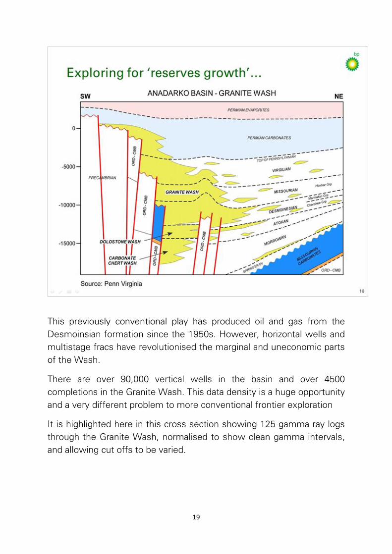
19
This previously conventional play has produced oil and gas from the
Desmoinsian formation since the 1950s. However, horizontal wells and
multistage fracs have revolutionised the marginal and uneconomic parts
of the Wash.
There are over 90,000 vertical wells in the basin and over 4500
completions in the Granite Wash. This data density is a huge opportunity
and a very different problem to more conventional frontier exploration
It is highlighted here in this cross section showing 125 gamma ray logs
through the Granite Wash, normalised to show clean gamma intervals,
and allowing cut offs to be varied.

20
The 2km thick section is flattened on the traditional DesMoineisian
conventional play, targeted in the early vertical wells due to good
porosity and permeability and able to achieve commercial rates. The red
bars represent completions in the IHS database.
This type of visualisation has enabled detailed stratigraphic framework
to be worked out, depositional facies to be attributed and the horizontal
exploration of individual sands. This has expanded hugely the number of
horizontal wells and fracturing to the whole section shown here and has
increased reserves by an order of magnitude.
Consequently the Granite Wash has been transformed from a mediocre
play into one of the USA’s new star producing play fairways. IHS
estimate some 500tcf and 20bnbbl of liquids. And such is the recent

21
activity level, that >50% of Granite Wash wells have been drilled since
2005.
These two examples of “revolutionary reserves growth” from two old
producing areas give an indication of the potential that exists in large
fields globally. Searching for these opportunities, and then exploring
them at the scale of the sand body, is going to be a significant part of
onshore and shallow water exploration in the future.
The tight oil revolution was born out of the shale gas revolution. We
know where the world’s great shales are distributed, they usually have
prolific petroleum provinces associated with them.
Again, this is not about exploring for shales, but it is about identifying
the right shales and then the sweet spots within these shales.

22
To date this has largely been done empirically through the drill bit, as
demonstrated in North America, but as we move to explore for shale
gas internationally, prediction of sweet spots will become ever more
important. The first step to this is an understanding of what a sweet
spot actually is, beyond an enhanced well. The fundamental science
here is key and poorly understood.
The image on the slide shows a cliff of the type area of the Eagleford
formation in West Texas. You can see the drilling rig on top of the
escarpment. BP drilled and electric-logged this outcrop to characterise
the Eagleford formation at this location and draw a detailed comparison
with the outcrop that we can see, measure and analyse.
Combined with high resolution seismic we can start to move to
characterise shale ahead of the drill bit. The objective being to use
geological and mechanical properties to understand the impact of
stimulation technology and the potential to improve reservoir
deliverability.
These examples of exploring for tight oil in old giant fields, and exploring
shales for the sweet spots where stimulation will be productive will
likely lead exploration back into the world’s great petroleum provinces.
The Lower 48 of the USA, where it all started; Russia, where it is
beginning to happen in the Achimov/Bazenov of West Siberia and the
Domanik shales of the Volga Urals; and the Middle East where the
variety and concentration of plays and carbonate rocks promises an
immense and long-term ‘tight oil’ and ‘shale’ future.
Estimates are that there is over 1200 bnb hydrocarbons in place (HCIP)
in the carbonate reservoirs of the Middle East, and 25% of that figure in
the rest of the world. In this, is likely a huge tight oil YTF or Enhanced
Oil Recovery (EOR) potential.

23
That OIP is a target to be explored with techniques similar but different
from conventional exploration. An understanding of regional geology and
play systems will be a basis. However, exploration will be guided by the
physical and mechanical attributes of rock and clay content, as well as
traditional depositional understanding.
This will demand new, data-rich, exploration work flows, still
underpinned by the image, but informed by a far more complex and
varied mechanical data set than traditionally. However, for every 2% of
improved recovery from these reservoirs, we produce one year’s
exploration delivery. So here, exploration and EOR converge with a final,
significant prize potential.

24
In summary, the future trends of exploration are diverse and will
demand a wide variety of skills, many new to explorers, new data and
new technology development.
The Frontiers of deepwater basins and deltas remain to be explored.
The arctic has significant potential, but the licence to operate remains
uncertain outside of Russia.
And onshore, three exploration trends will dominate as the industry re-
explores the onshore and shallow water regions of the world.
- Exploration of frontier basins like the Congo.
- Exploration of the unexplored rock volume of existing basins with a
“source rock upwards” philosophy.
- Exploration for missed and tight pay in and around the world’s giant
fields and source rocks, and convergence with EOR.

25
The pace at which these trends play out is, of course, uncertain and will
vary globally. And there will be other, disruptive trends.
However, a decline in material success rate in deep water is likely to be
around the corner – but when will that corner be reached?
And Russia will lead in arctic offshore exploration, but it is unclear how
fast the rest of the world will follow?
Onshore, the remaining frontiers and ‘deep-land’ - will follow with low
cost, low impact, high quality seismic being key.
And Tight Oil and shale exploration enabled by hydraulic fracturing will
converge with EOR, progressively, to the end of the Hydrocarbon Age.
* * *