FUTURE DEVELOPMENT - Winchester
13
chapter 9 FUTURE DEVELOPMENT
Transcript of FUTURE DEVELOPMENT - Winchester

chapter 9
FUTURE DEVELOPMENT

In previous comprehensive plans for Winchester, a future land use chapter outlined recommended changes to designated use of land
which could be implemented by amendments to the official zoning map. That The traditional approach relied heavily upon use designation
to move the City’s growth in a desired direction. This plan takes a different approach focused on New Urbanism and Traditional
Neighborhood Design.
Rather than view the zoning ordinance as the primary solution to citywide problems, this plan focuses on the vitality of interconnected
neighborhoods. It holds in mind the vision of sustainable communities and identifies the narrowly tailored needs of each neighborhood. It
supports the City Council’s stated goal for land use: Guide the physical development of the City in a sustainable manner that preserves
vibrant, livable neighborhoods and also encourages compact mixed use development to meet the needs of a changing population.
CITYWIDE LAND USE OBJ ECTIVES
As noted in Chapter Three, City Council also stated seven ten objectives in support of the land use goal:
1) Facilitate development, zoning changes, and growth of the City in accordance with the City Character Map .
2) Incentivize the construction of compact, new mixed use projects as a viable reuse of obsolete strip commercial and industrial properties.
3) Provide the citizens of the community with a healthy, attractive and safe physical environment which includes convenient access for all modes
of transportation.
4) Facilitate the rehabilitation of existing substandard housing units and the construction of new housing units in order to attract higher income
residents so that Winchester residents are provided with a decent home in a suitable living environment while maintaining and preserving the
existing character of vibrant residential areas designated in this plan.
5) Provide a range of commercial facilities which incorporate a mix of retail, service and office facilities, properly served by access through the
transportation system, and offer selection of consumer goods, and viable growth potential.
6) Retain and expand upon a diversified, sustainable light industrial base at compatible and appropriate locations which are accessible to
transportation facilities, convenient to the workforce, and in harmony with other community development and which attract higher income
workers that contribute to the general betterment of the community.
7) Locate public land uses in locations that enhance the livability of the City and facilitate the placement of institutional uses in locations that
support the social, spiritual, and health needs of the community.
8) Reduce the conversion of taxable property to non-taxable land uses.
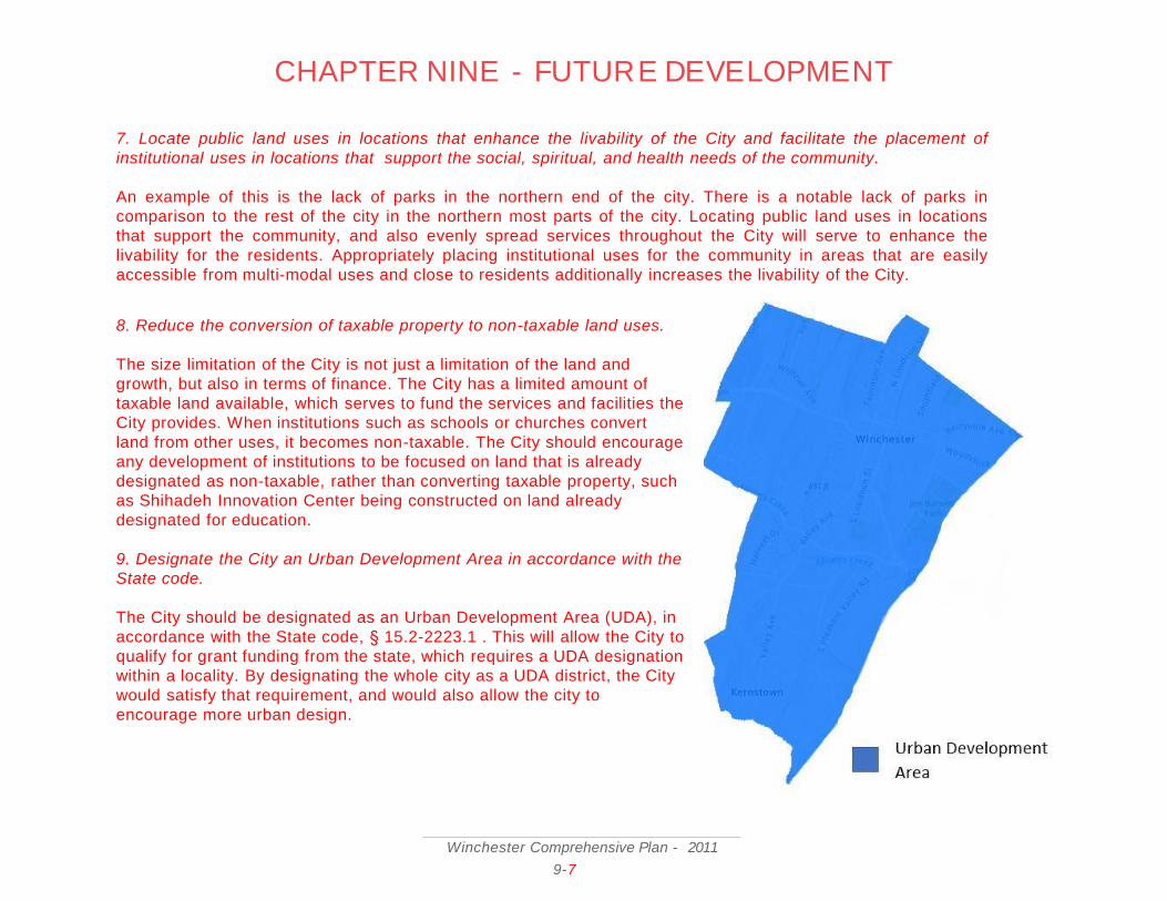
9) Designate the City as an Urban Development Area in accordance with the State code.
10) Work with Frederick County to create complementary development strategies and maintain a strong working relationship.
CHAPTER NINE – FUTURE DEVELOPMENT
Winchester Comprehensive P lan - 2011
9-1

CHAPTER NINE - FUTURE DEVELOPMENTTo show how these objectives will be met, this chapter presents and discusses a Character Map of Winchester’s neighborhoods. It shows
the desired changes in different neighborhoods, which must be achieved by a mix of methods. This map replaces the future land use map
as the chief tool for planning. Zoning rules are only one of many tools for New Urbanism, so this map gives them less emphasis. Chapter
Eleven presents detailed treatments for illustrative sites within each of the ten geographic planning areas.
This chapter also examines planning decisions in Frederick County, particularly with respect to Frederick County’s Urban Development
Area (UDA) and policies for future development as spelled out in the recent update of the County’s Comprehensive Plan.
FUTURE DEVELOPMENT NEEDS
Planning for future development begins with a vision of the future and maintains that vision in mind. After that, a key question is what to
change and what to preserve. A good plan uses the right tools to make change occur where it is needed. But those tools should be used
carefully to avoid spillover where no change is desired. Other tools are used for preservation, but they, too, must be carefully used to
avoid obstructing change where needed or desired. In the past, the land use regulations contained in the zoning ordinance were the
planner’s primary tools for guiding change or preservation. This plan notes the limitations of Euclidean zoning and embraces a broader set
of options with a character map.
The City Council’s stated objectives guide future land use needs. Winchester’s land should be used to improve residents’ quality of life by
developing a more livable, sustainable, welcoming, and prosperous city. Previous chapters have discussed specific goals and objectives
related to mobility, housing, business, and other topics. Land use has an effect on those topics, but so many other kinds of policy change
1. Facilitate development, zoning changes, and growth of the city in accordance with the City Character Map
THE CHARACTER MAP
Current land usage in the City has increased significantly over the past years, as seen below in the charts comparing land us age sizes from
now compared to 1982. To facilitate proper and effective growth of the City, the following Character Map was developed, to ch art the overall
design of the community fabric in the City.
The next page shows the character map which will guide Winchester’s growth. It has eight elements.
Winchester Comprehensive P lan - 2011
9-2

CHAPTER NINE - FUTURE DEVELOPMENT
Winchester Comprehensive P lan - 2011
9-3
See appendix for large-scale version of the Character Map
Elements of the Character Map
A. Neighborhood Stabilization Areas
Stable, healthy neighborhoods are the essence of a city. This
area covers the largest part of the character map. It represents places where
households live, socialize, and raise families in relative quiet. Here, city
planning aims to keep things the same, not bring dramatic change. But that is
not the same as doing nothing. Sound city policy can actively protect these
stable communities from improper development and help preserve what
makes them special.
B. Neighborhood Revitalization/Infill Areas
In these areas, residents said quality of life was not what it should be.
Problems of vacancy, blight, crime, and isolation hurt a neighborhood’s
prospects and pride. So, the vision for Winchester in these areas focuses on
the opportunities created by vacant buildings and low property values.
Redeveloping parcels and infilling with higher residential densities and mixed
uses costs less in these areas. A new park or other community hub is
important. Revitalization means making neighborhoods more attractive both
to new residents and to those who have called them home for many years. It
means bringing back to life.
C. Commerce Centers/Corridors
Today, most of the Winchester’s business occurs in these areas. That should
continue. As the stable neighborhoods provide housing, these stable areas
provide jobs and income. City plans strive to sustain a friendly business
environment where it already exists. This designation also recognizes that
New Urbanism does not mean burdening successful firms with rules. No
radical change should come to the City’s major retail and industrial areas,
except where they have been identified as redevelopment or revitalization
areas.

CHAPTER NINE - FUTURE DEVELOPMENT
E. Civic, Institutional, and Park Areas
These places knit a community together and help make it unique. Public areas form hubs where people can meet, socialize, play, or rest.
They serve public needs and host interesting activities. Sometimes they are cultural or artistic centers. While the benefits of these diverse
places may not be easy to quantify, unhealthy neighborhoods with no civic or social hub tend to suffer from social isolation and
alienation, greater crime, lower property values, and weaker public health. The vision of Winchester includes a network of civic areas
within walking distance of most residents. The Green Circle Trail is the signature effort in this regard as it connects the park hubs of
several neighborhoods.
F. Redevelopment Sites
These areas consist of properties that are the keys to reinvigorating a neighborhood. In early input meetings, groups of citizens agreed with
professional analysts that these sites, in their current underused or blighted forms, hold neighborhoods back. They may be underutilized,
ugly, unsafe, or just wrong for the community. But because of their size, location, or infrastructure, they have great potential. These sites
may be among the first to realize New Urbanist principles. Given new investment, they can become neighborhood hubs and build a new
sense of community while attracting jobs and new residents. The vision of Winchester uses a range of city policy tools to nudge
investment into these critical points.
G. Redevelopment Scenarios
City Planning, Zoning, and Economic Development staff, working together with consultant planners and engineers, designed some
concepts for selected redevelopment sites in each of the ten Planning Areas. The drawings show New Urbanist principles and Traditional
Neighborhood Design in action: compact mixed uses, traditional neighborhood architecture, greenery, and pedestrian features. Actual
partnerships and construction on the parcels will look different, but these concepts signal the kind of project which will be favored for
Winchester Comprehensive P lan - 2011
9-4
D. Commerce Area Revitalization/Infill
The Character Map calls for change in these areas. While zoned for commercial use, there are vacant or blighted properties, and many
others contributing little to the community. Creative partnerships between the City and investors should target these areas. Bringing new
kinds of business to the City, building new infrastructure, or offering new or better are public services may create new jo bs and attract new
customers from far afield. Revitalization and infill means attracting new and stronger companies, increasing property value s, and
promoting businesses that contribute to the
sustainability of the community.

CHAPTER NINE - FUTURE DEVELOPMENT
Winchester Comprehensive P lan - 2011
9-5
2. Incentivize the construction of compact, new mixed use projects as a viable reuse of obsolete strip commercial and industrial properties.
There are a number of properties in the City which have been constructed in strip malls and several industrial sites. These p roperties were
designed during a time where these developments were quite popular and successful. Since that time, as areas become less car -centric, these
properties have been rendered obsolete. Additionally, a number of industrial sites have become obsolete. Unlike the viable in dustries in the
Winchester Industrial Park or O’Sullivan, several industries are not viable and would be better suited being reused for other projects. Some of
these locations, most notably the Federal Mogul site, have significant environmental clean-up required, which hampers the ability to reuse the
site. Other locations include Virginia Apple Storage and Winchester Cold Storage. Additional sites are highlighted in section 4 of the Character
Map.
These properties can be reused for other developments and projects, promoting mixed-use and the compact design that this plan promotes.
The City should take measures to incentivize the construction of these properties, turning them into mixed -use projects (see Chapter 11).
3. Provide the citizens of the community with a healthy, attractive and safe physical environment which includes convenient access for all
modes of transportation.
Connecting the citizens of the City with a healthy environment relies heavily on the ability to access the different portions of that environment.
This makes multi-modal transportation crucial in this objective. Chapter 6 looks at accessibility and transportation in-depth, focusing heavily on
the current characteristics and needs of transportation in the City. A number of objectives in Chapter 6 overlap specifically with this goal and
goal 5. These are goals 14, 11, 7, and 5(see Mobility Chapter 6 for more information). The City should continue to pursue these goals to ensure
accessibility within the urban environment.
redevelopment sites.
H. Old Town Revitalization Area
The oldest part of Winchester has unique character, assets, and needs of its own. This special designation recognizes Old Town’s place as the
City’s center and its potential for mixed use growth. Key growth demographics may be attracted downtown, but special city policies will be
needed for parking, flood control, architecture, and many other issues. However, too much regulation may prove a barrier to new investment.
Government must strike a careful balance to foster growth here.
4. Facilitate the rehabilitation of existing substandard housing units and the construction of new housing units in order to attract
higher income residents so that Winchester residents are provided with a decent home in a suitable living environment while
maintaining and preserving the existing character of vibrant residential areas designated in this plan.
Redesigning the housing units in the City is necessary to accommodate the future growth of the City. In Chapter 7, strategies are
outlined which promote this design. Goals 8, 6, 5, 4, and 3 outline rehabilitating existing housing stock that is substandard,
developing affordable housing, increasing home ownership, and creating higher quality and more affordable housing stock. Similar to
goal 3, the City should pursue all aspects of Chapter 7’s goals to achieve this goal. The Character map identifies infill and
revitalization locations in section 2.
5. Provide a range of commercial facilities which incorporate a mix of retail, service and office facilities, properly served by access
through the transportation system, and offer selection of consumer goods, and viable growth potential.
Currently, in the City, there is demand for commercial facilities to be better accessible. There is also a significant limit on land in the
City that is available for development. Because of these factors, the solution to providing more diverse commercial facilities is to
create more mixed-use development sites. A number of sites for these developments were identified in the Character Map, under
sections 1,2, and 8. By following along the outline of the Character Map, the City can work towards this objective.
6. Retain and expand upon a diversified, sustainable light industrial base at compatible and appropriate locations which are
accessible to transportation facilities, convenient to the workforce, and in harmony with other community development and which
attract higher income workers that contribute to the general betterment of the community.
Industrial jobs have had a long-standing position in the City, providing well-paying jobs to those who have not attained a college
degree. In recent years, those jobs have been declining. This results in significant unemployment in workforces that are trained for
other careers. Over-industrialization, however, can create numerous environmental and health problems. The City should avoid
expanding intensive industrial uses, and seek to preserve and grow the light industrial uses in the city. The City should seek to not
convert existing M1, Limited Industrial District, into other zoning types. The City should also make efforts to increase the industrial
base at appropriate locations, namely the industrial park in the southern end of the City. Public land uses within the City should be
developed to enhance the livability of the City, particularly in areas that are underserved. The Character Map outlines locations for
reutilization at section 6 of the Comp Plan.
Winchester Comprehensive P lan - 2011
9-6
CHAPTER NINE - FUTURE DEVELOPMENT
7. Locate public land uses in locations that enhance the livability of the City and facilitate the placement of
institutional uses in locations that support the social, spiritual, and health needs of the community.
An example of this is the lack of parks in the northern end of the city. There is a notable lack of parks in
comparison to the rest of the city in the northern most parts of the city. Locating public land uses in locations
that support the community, and also evenly spread services throughout the City will serve to enhance the
livability for the residents. Appropriately placing institutional uses for the community in areas that are easily
accessible from multi-modal uses and close to residents additionally increases the livability of the City.
Winchester Comprehensive P lan - 2011
9-7
CHAPTER NINE - FUTURE DEVELOPMENT
8. Reduce the conversion of taxable property to non-taxable land uses.
The size limitation of the City is not just a limitation of the land and
growth, but also in terms of finance. The City has a limited amount of
taxable land available, which serves to fund the services and facilities the
City provides. When institutions such as schools or churches convert
land from other uses, it becomes non-taxable. The City should encourage
any development of institutions to be focused on land that is already
designated as non-taxable, rather than converting taxable property, such
as Shihadeh Innovation Center being constructed on land already
designated for education.
9. Designate the City an Urban Development Area in accordance with the
State code.
The City should be designated as an Urban Development Area (UDA), in
accordance with the State code, § 15.2-2223.1 . This will allow the City to
qualify for grant funding from the state, which requires a UDA designation
within a locality. By designating the whole city as a UDA district, the City
would satisfy that requirement, and would also allow the city to
encourage more urban design.

CHAPTER NINE - FUTURE DEVELOPMENTCHANGES TO THE ZONING ORDINANCE
Winchester’s Zoning Ordinance guides what kind of structures can be built in different parts of the City and how they can be used. It is an
important tool for shaping the character of the City’s neighborhoods, though not the only one. The current zoning ordinance does not
align with the Character Map, so changes are needed.
The fundamental philosophy of the current Zoning Ordinance is exclusivity: uses and occupancies which are not defined or provided for
within the Ordinance are excluded from the City. Each zone has a separate list of tolerated uses. This strategy lags behind societal and
technological change, requiring a reactive effort in bringing the Ordinance up-to-date through text amendment proposals. Form-based
codes and New Urbanistic principles often place a much lower priority on the types of uses and instead employ strategies to create a more
sustainable and harmonious building development within a particular area. The progressive result of such strategies generally amounts to
less reliance on the automobile as the sole means of transportation, promotes mixed-use opportunities, and creates an environment more
suitable for public transportation and walking.
As previously cited, the current Zoning Ordinance segregates uses and occupancies, often requiring dependency upon the personal
automobile as a means of transportation between live, work, and play destinations. The character map shows an attempt to create a sense
of community within various geographic regions of the City. The historic downtown core retains its character and opportunities for other
core areas are identified, the benefits to which include: ease of transportation; sustainability; neighborhood identity, autonomy, and self-
preservation; and, direct community input for the future development and desired character of the area. But this concept conflicts with
the rules in today’s Zoning Ordinance.
One way to address these discrepancies is to establish an alternative means for future development through a comprehensive revision of
the Zoning Ordinance, based more in form-based zoning rather than traditional land use zoning. Form based codes are codes that are based
in the design and structure of developments, rather than specific land uses. Using these codes will encourage mixed-use that shares a cohesive
design, while also encouraging the development of the City in line with the Character Map. Form-based codes don’t completely eliminate land uses
though, but rather just define broad categories, unlike specific uses. It may not be necessary to re-write the entire Ordinance; however, it is
essential that certain guidelines be included so as to provide a mechanism for form codes and New Urbanism consistent with the
Comprehensive Plan. By implementing form-based codes that emphasize design, rather than traditional land-use codes, the City would be able to
promote the ability for the design to be more in tune with the character map. The end result may resemble a hybrid document which will serve to
protect certain areas of the City from inappropriate infill development while generating opportunities for careful and considerate
redevelopment and place-making.
THE FREDERICK COUNTY LAND USE PLAN
Many sections of the City’s Comprehensive Plan document the close relationship between Winchester and Frederick County. Despite two
separate governments, their histories are intertwined, and their economic, environmental, and social connections only increase over time.
Planning the future of Winchester’s neighborhoods requires attention to the County’s direction.
Winchester Comprehensive P lan - 2011
9–8 5

CHAPTER NINE - FUTURE DEVELOPMENT
The County’s land use vision entails continued economic growth and development while
preserving natural and agricultural areas. It seeks a compromise between traditional character
and dynamic new prosperity. Three trends of the County’s land use plan include:
1. . Increase density in the Urban Development Area (UDA).
The Virginia Employment Commission projects Frederick County’s population to increase
from about 86,000 in 2017 77,000 in 2010 to over 114,000 by 2030. County planning aims
to concentrate new housing in the existing Urban Development Area, shown outlined in
purple in the following graphic. Farms and forests in the west should not turn into suburbs.
The contrast between the more urban eastern area and the more rural western part of the
County should become sharper.
Current land use plans easily allow for 7,500 new dwellings in the UDA at a suburban
density level of three units per acre. Density outside the UDA is slated to remain in the
range of one unit per five to ten gross acres. In the urbanizing areas, townhouses and
multistory apartments will become more common. Preservation of agricultural and forestal
resources is called for outside of the UDA. As has occurred in Fauquier and Loudoun
counties, wealthy immigrants may still be inclined to build new homes on large parcels in
the rural area.
2. Promote New Urbanist hubs and villages.
County plans intend to promote New Urbanist concepts to maintain a distinctive sense of
place and avoid generic suburban sprawl. In the County’s early history, villages like Gore,
Brucetown, and Marlboro served as business and social hubs for rural residents far from
Winchester. The densest commercial and residential growth should occur in and near
these historic crossroads and hamlets as concentric walkable communities rather than
auto-oriented strips.
Accordingly, the County’s plans frame development in the context of Neighborhood
Villages and Urban Centers which cluster dense housing within half a mile of life’s needs:
work, shopping, and entertainment. The villages also incorporate social and recreational
hubs like parks, schools, and historic sites. Thousands of new residents will live in the 16
communities, which display the compact mixed use principles of New Urbanism.
Winchester Comprehensive P lan - 2011
9-96
Urban Development Area in
Frederick County
An update to Frederick County’s Comprehensive Policy Plan was underway at the same time that this update to the City’s
plan was underway. The most recently adopted version of the County plan (adopted in 2017) (updated in 2007) contains
a detailed chapter on land use.

CHAPTER NINE - FUTURE DEVELOPMENT
A quick review of the two graphics on the previous page depict how the future center of the population base is shifting and will
continue to shift south and east of the City. Although the County UDA includes all of the area in the northeast portion of the County,
there are developmentally sensitive areas – civil war battlefield sites and wetlands – that limit opportunities for new urban centers in
those areas. Other than Sunnyside immediately to the northwest of the City and the Snowden Bridge urban center depicted to the
northeast of the City, all of the other potential urban villages are concentrated to the south and east.
3. Use rules and partnerships to preserve nature, farming, and history.
Outside the UDA, the County plans seek to maintain green space and agriculture or other low-impact development. Zoning standards
will limit the density of residential growth and concentrate it in existing communities. Historic rural villages like Gore and Gainesboro
may accommodate denser development, and planned subdivisions like Lake Holiday may be accommodated with greater densities and
mixed uses.
Transferable development rights will be a critical tool. Under this system, a rural landowner places a parcel –of say, 50 acres
– under conservation easement so it may never be built upon. A builder buys the development rights to the five or ten houses which
could have been built there and builds to extra density in the UDA, perhaps a compact mixed use facility with 20 townhouses and
apartments on a smaller parcel. Transfer of Development Rights (TDR) uses no public funds even as it preserves green spaces. Rural
landowners get a lump sum of money, and builders get a more valuable project.
County policies will aim to preserve rural character in a number of ways. Form regulations will locate residential concentrations out of
sight from main roads by using hills or forests as buffers. Construction will consider soil types. Zoning, tax, and educational
incentives will support innovative agriculture. In general, County planners recognize that rural character is a public good which must
be carefully tended, as it cannot be replaced once lost.
Frederick County’s plan to adopt some New Urbanist elements and concentrate residential growth in more compact and walkable
communities will benefit Winchester in important ways. City residents may enjoy better air quality, less traffic congestion, and less
strain on social services. However, the mixed use communities of the City and County may compete for residents and businesses. It
remains to be seen whether such competition will be mutually beneficial. However, it is preferable to current trends of unsustainable
auto-oriented suburban sprawl in the County.
Winchester Comprehensive P lan - 2011
9–10 7

CHAPTER NINE - FUTURE DEVELOPMENT
1. . Transferable development rights (TDR).
The TDR program described as part of Frederick County’s land use plan could be used to
benefit the City of Winchester through partnerships. For example, a large condominium
and apartment complex which might normally violate the Zoning Ordinance’s density
limits could be allowed if the developer agreed to preserve a hundred acres of prime
farmland in the County. Such an agreement would revitalize a neighborhood in Winchester,
attract new residents to the City, and prevent suburban sprawl in the county. TDR may
work better in the City where public transportation and public services are concentrated.
2. Consolidated social services.
While multiple studies have rejected the unification of City and County governments, they
have also recommended consolidation of certain agencies or services. The social services
departments, which function much like a state agency, seem prime for partnerships or
consolidation. Users of social services are often transient and move between the City and
County frequently. Consolidating the two departments would improve the quality of
service and cut costs. Chapters Seven and Eight have more detail on social services in
Winchester.
3. Coordinating parks and trails.
Many County residents come into Winchester to play or swim at J im Barnett Park, and
many City residents go into the County to play soccer, tour a battlefield, or ride a bike. The
City and County parks and recreation departments may benefit from consolidation. They
should cooperate closely when planning new facilities and programs at parks.
Both the City and County plan to build more multi-use trails. Often paralleling roads, paved
trails offer safe paths to walk, run, or ride a bike for recreation or commuting purposes.
City and County trails should connect together, and planners should cooperate when
building them. Chapter Six discusses trails in more detail.
Winchester Comprehensive P lan - 2011
9-11 8
PARTNERSHIPS WITH FREDERICK COUNTY
The trends and policy changes noted in this and previous chapters lend themselves to partnership with Frederick County.
Cooperation will help both governments get better results at lower cost to taxpayers. Four possible partnerships include:
Transfer of Development Rights Map

CHAPTER NINE - FUTURE DEVELOPMENT
4. Gateway corridor overlay zoning
Winchester uses Corridor Enhancement zoning districts to promote a more welcoming urban form where main roads enter the City
and lead to the core historic area. The overlay districts, detailed in Chapter Ten, create additional rules and guidelines for structures
along Valley Avenue, East Cork Street, Cedar Creek Grade, and other roads of entry.
On the main corridors, development continues beyond the City limits. As visitors come to Winchester for business or pleasure, they
first pass through urbanized areas of the County. As such, County construction affects first impressions of the City. At the same time,
the County benefits from corridor enhancements just as much as the City. Cooperating on corridor enhancement standards would
help both localities.
The next chapter takes a closer look at urban design and, where advocated, historic preservation. It begins to focus on New Urbanism
as the preferred approach to future development. As the City becomes less focused on the array of land uses and more focused on
design, the importance of newer methods of development review, including form-based code, are addressed.
Winchester Comprehensive P lan - 2011
9–12 9