FURTHER OUTSTANDING DRILL RESULTS INCLUDE THICK, HIGH ... · • Results include a new peak value...
15
6 May 2019 FURTHER OUTSTANDING DRILL RESULTS INCLUDE THICK, HIGH-GRADE LITHIUM INTERSECTED AT SHALLOW DEPTH HIGHLIGHTS • Further outstanding results have been received from Hawkstone’s 37-hole Phase 2 diamond drill program at its Big Sandy Lithium-Clay Project, located in Arizona USA. • Results include a new peak value of 4,250 ppm Li, with drilling continuing to intersect thick, high-grade Lithium mineralisation at shallow depth, best intersections include: •DHQ10 44.0m @ 2,040 ppm Li from 12m to 56.0m •DHQ11 26.0m @ 2,205 ppm Li from 15.0m to 41.0m 14.0m @ 2,085 ppm Li from 42.0m to 56.0m and 8.0m @ 1,526 ppm Li from 59.0m to 67.0m •DHQ12 21.0m @ 2,203 ppm Li from 10.0m to 31.0m 13.0m @ 2,395 ppm Li from 36.0m to 49.0m and 13.0m @ 1,756 ppm Li from 51.0m to 64.0m •DHQ13 22.0m @ 1,668 ppm Li from 7.0m to 29.0m 4.0m @ 1,250 ppm Li from 42.0m to 46.0m • The Company has now released results from 10 of the planned drill holes in the Northern Mineralised Zone. • The recent appointment of highly respected lithium industry specialist Dr. David Deak 1 (formerly TSX:LAC and NASDAQ:TSLA), demonstrates the potential of sediment-hosted lithium projects and the Company’s commitment to progressing its Big Sandy Project. Managing Director Paul Lloyd commented; “The results received to date are very promising as they confirm the extension of the mineralisation over 400 metres to the north with very consistent and predictable geology. The thickness and grade of the drilling results are very favourable compared to other lithium clay projects in the USA. We look forward to assays from drill holes another 200 metres further north.” 1 ASX Announcement - APPOINTMENT OF ADVISOR https://www.asx.com.au/asxpdf/20190501/pdf/444qvr4gcpy1mn.pdf For personal use only
Transcript of FURTHER OUTSTANDING DRILL RESULTS INCLUDE THICK, HIGH ... · • Results include a new peak value...
6 May 2019
FURTHER OUTSTANDING DRILL RESULTS INCLUDE THICK, HIGH-GRADE LITHIUM INTERSECTED
AT SHALLOW DEPTH
HIGHLIGHTS
• Further outstanding results have been received from Hawkstone’s 37-hole Phase 2 diamond drill program at its Big Sandy Lithium-Clay Project, located in Arizona USA.
• Results include a new peak value of 4,250 ppm Li, with drilling continuing to intersect thick, high-grade Lithium mineralisation at shallow depth, best intersections include:
• DHQ10 44.0m @ 2,040 ppm Li from 12m to 56.0m
• DHQ11 26.0m @ 2,205 ppm Li from 15.0m to 41.0m 14.0m @ 2,085 ppm Li from 42.0m to 56.0m and
8.0m @ 1,526 ppm Li from 59.0m to 67.0m
• DHQ12 21.0m @ 2,203 ppm Li from 10.0m to 31.0m 13.0m @ 2,395 ppm Li from 36.0m to 49.0m and 13.0m @ 1,756 ppm Li from 51.0m to 64.0m
• DHQ13 22.0m @ 1,668 ppm Li from 7.0m to 29.0m 4.0m @ 1,250 ppm Li from 42.0m to 46.0m
• The Company has now released results from 10 of the planned drill holes in the Northern Mineralised Zone.
• The recent appointment of highly respected lithium industry specialist Dr. David Deak1 (formerly TSX:LAC and NASDAQ:TSLA), demonstrates the potential of sediment-hosted lithium projects and the Company’s commitment to progressing its Big Sandy Project.
Managing Director Paul Lloyd commented;
“The results received to date are very promising as they confirm the extension of the mineralisation over 400 metres to the north with very consistent and predictable geology. The thickness and grade of the drilling results are very favourable compared to other lithium clay projects in the USA. We look forward to assays from drill holes another 200 metres further north.”
1 ASX Announcement - APPOINTMENT OF ADVISOR https://www.asx.com.au/asxpdf/20190501/pdf/444qvr4gcpy1mn.pdf
For
per
sona
l use
onl
y
6 May 2019
Hawkstone Mining Limited (ASX:HWK) (Hawkstone or Company) is pleased to announce further results from its Big Sandy Lithium 37-hole drill program (drilling ongoing) with the purpose of enabling the estimation of a JORC compliant resource on the Big Sandy lithium clay project (Big Sandy), located in Arizona USA (Figure 3).
The Phase 2 program of diamond drilling currently underway over the Northern Mineralised Zone is targeting a previously reported 11km-long lithium horizon. With 14 of the planned 37 holes completed, the drilling forms part of the Company’s current 2019 exploration program, designed to enable the estimation of a JORC compliant resource.
PHASE 2 DRILLING PROGRAM
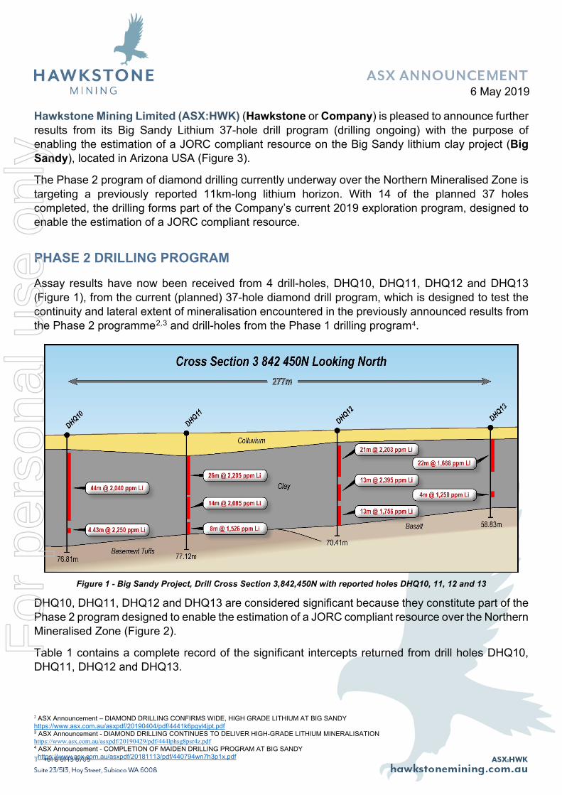
Assay results have now been received from 4 drill-holes, DHQ10, DHQ11, DHQ12 and DHQ13 (Figure 1), from the current (planned) 37-hole diamond drill program, which is designed to test the continuity and lateral extent of mineralisation encountered in the previously announced results from the Phase 2 programme2,3 and drill-holes from the Phase 1 drilling program4.
Figure 1 - Big Sandy Project, Drill Cross Section 3,842,450N with reported holes DHQ10, 11, 12 and 13
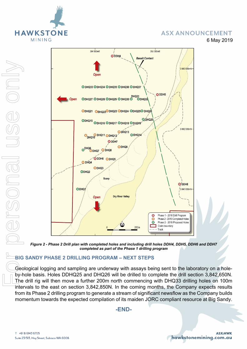
DHQ10, DHQ11, DHQ12 and DHQ13 are considered significant because they constitute part of the Phase 2 program designed to enable the estimation of a JORC compliant resource over the Northern Mineralised Zone (Figure 2).
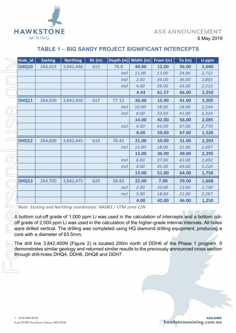
Table 1 contains a complete record of the significant intercepts returned from drill holes DHQ10, DHQ11, DHQ12 and DHQ13.
2 ASX Announcement – DIAMOND DRILLING CONFIRMS WIDE, HIGH GRADE LITHIUM AT BIG SANDY https://www.asx.com.au/asxpdf/20190404/pdf/4441k6pgyl4jpt.pdf 3 ASX Announcement - DIAMOND DRILLING CONTINUES TO DELIVER HIGH-GRADE LITHIUM MINERALISATION https://www.asx.com.au/asxpdf/20190429/pdf/444lphsg8psr4z.pdf 4 ASX Announcement - COMPLETION OF MAIDEN DRILLING PROGRAM AT BIG SANDY https://www.asx.com.au/asxpdf/20181113/pdf/440794wn7h3p1x.pdf
For
per
sona
l use
onl
y
6 May 2019
TABLE 1 – BIG SANDY PROJECT SIGNIFICANT INTERCEPTS
Hole_id Easting Northing RL (m) Depth (m) Width (m) From (m) To (m) Li ppmDHQ10 264,423 3,842,446 615 76.8 44.00 12.00 56.00 2,040
incl 11.00 13.00 24.00 2,732incl 2.00 34.00 36.00 2,865incl 4.00 39.00 43.00 2,515
4.43 61.57 66.00 2,250
DHQ11 264,500 3,842,450 617 77.12 26.00 15.00 41.00 2,205incl 10.00 18.00 28.00 2,544incl 8.00 33.00 41.00 2,324
14.00 42.00 56.00 2,085incl 4.00 43.00 47.00 2,770
8.00 59.00 67.00 1,526
DHQ12 264,600 3,842,445 619 70.41 21.00 10.00 31.00 2,203incl 13.00 18.00 31.00 2,497
13.00 36.00 49.00 2,395incl 6.00 37.00 43.00 2,492incl 4.00 45.00 49.00 3,220
13.00 51.00 64.00 1,756
DHQ13 264,700 3,842,475 620 58.83 22.00 7.00 29.00 1,668incl 2.00 10.00 12.00 2,730incl 3.00 18.00 21.00 2,267
4.00 42.00 46.00 1,250Note: Easting and Northing coordinates: NAD83 / UTM zone 12N
A bottom cut-off grade of 1,000 ppm Li was used in the calculation of intercepts and a bottom cut-off grade of 2,000 ppm Li was used in the calculation of the higher-grade internal intervals. All holes were drilled vertical. The drilling was completed using HQ diamond drilling equipment, producing a core with a diameter of 63.5mm.
The drill line 3,842,450N (Figure 2) is located 200m north of DDH6 of the Phase 1 program. It demonstrates similar geology and returned similar results to the previously announced cross section through drill-holes DHQ4, DDH6, DHQ8 and DDH7.
For
per
sona
l use
onl
y
6 May 2019
Figure 2 - Phase 2 Drill plan with completed holes and including drill holes DDH4, DDH5, DDH6 and DDH7
completed as part of the Phase 1 drilling program
BIG SANDY PHASE 2 DRILLING PROGRAM – NEXT STEPS
Geological logging and sampling are underway with assays being sent to the laboratory on a hole-by-hole basis. Holes DDHQ25 and DHQ26 will be drilled to complete the drill section 3,842,650N. The drill rig will then move a further 200m north commencing with DHQ33 drilling holes on 100m intervals to the east on section 3,842,850N. In the coming months, the Company expects results from its Phase 2 drilling program to generate a stream of significant newsflow as the Company builds momentum towards the expected compilation of its maiden JORC compliant resource at Big Sandy.
-END-
For
per
sona
l use
onl
y
6 May 2019
FOR FURTHER INFORMATION PLEASE CONTACT:
MR. PAUL LLOYD Managing Director Hawkstone Mining Limited Tel. +61 419 945 395 [email protected] www.hawkstonemining.com.au/
ABOUT HAWKSTONE
Hawkstone Mining is an ASX listed exploration company with clay and brine-hosted lithium projects located in the states of Arizona and New Mexico, United States of America. The Company’s focus is its highly prospective lithium projects covering 53.85km2 within some of the world’s most highly attractive mining localities. The Company has a corporate office located in Perth, Australia and an expert technical team with extensive experience in exploration and discovery led by Chief Technical Officer Greg Smith, a geologist with 40 years of experience and Managing Director Paul Lloyd who has been responsible for numerous capital raisings and initial public offerings in the resources and oil and gas industries over the past decade.
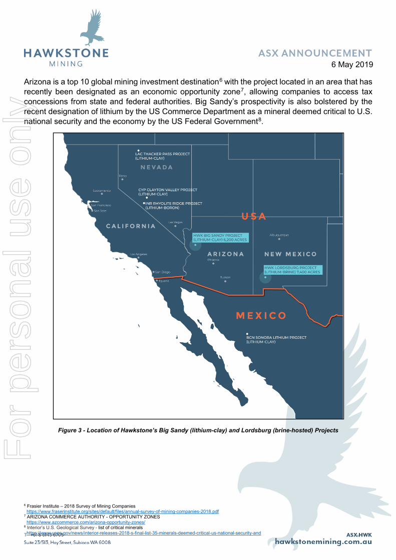
Hawkstone’s 100% owned Big Sandy and Lordsburg Projects (Figure 4) are located within the United States Battery Corridor, which includes Tesla Motors (NASDAQ:TSLA) Gigafactory 1, a lithium-ion battery and electric vehicle subassembly factory near Reno, Nevada.
Big Sandy’s 25.2km2 project area contains an 11km-long lithium horizon with simple geology, lithium mineralisation from surface to a depth of 90m and a current Exploration Target of 242.1Mt - 417.6Mt at 1,000 - >2,000ppm Li.5 Note that the potential quantity and grade of the Exploration Target is conceptual in nature. There has been insufficient exploration to estimate a mineral resource and it is uncertain whether future exploration will result in the definition of a mineral resource.
The Big Sandy project is located some 2.5 hours’ drive northwest of the state capital, Phoenix, with access to world-class infrastructure including rail, road and grid power. The project is connected through the Interstate Highway System (I40) and cross-country Route 66, which both pass through the town of Kingman 87km northeast of Big Sandy.
Kingman is located on the Southern Transcon route of the BNSF Railway, the main transcontinental route between Los Angeles and Chicago which carries 100 to 150 freight trains per day.
5 ASX Announcement - BIG SANDY PROJECT – LITHIUM EXPLORATION TARGET https://www.asx.com.au/asxpdf/20190328/pdf/443tym6c5wl88s.pdf
For
per
sona
l use
onl
y
6 May 2019
Arizona is a top 10 global mining investment destination6 with the project located in an area that has recently been designated as an economic opportunity zone7, allowing companies to access tax concessions from state and federal authorities. Big Sandy’s prospectivity is also bolstered by the recent designation of lithium by the US Commerce Department as a mineral deemed critical to U.S. national security and the economy by the US Federal Government8.
Figure 3 - Location of Hawkstone’s Big Sandy (lithium-clay) and Lordsburg (brine-hosted) Projects
6 Frasier Institute – 2018 Survey of Mining Companies https://www.fraserinstitute.org/sites/default/files/annual-survey-of-mining-companies-2018.pdf 7 ARIZONA COMMERCE AUTHORITY - OPPORTUNITY ZONES https://www.azcommerce.com/arizona-opportunity-zones/ 8 Interior’s U.S. Geological Survey - list of critical minerals https://www.usgs.gov/news/interior-releases-2018-s-final-list-35-minerals-deemed-critical-us-national-security-and
For
per
sona
l use
onl
y
6 May 2019
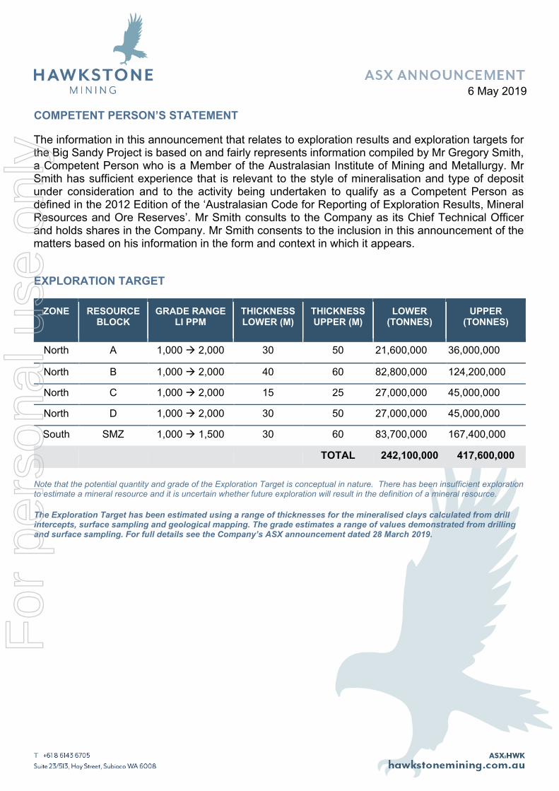
COMPETENT PERSON’S STATEMENT
The information in this announcement that relates to exploration results and exploration targets for the Big Sandy Project is based on and fairly represents information compiled by Mr Gregory Smith, a Competent Person who is a Member of the Australasian Institute of Mining and Metallurgy. Mr Smith has sufficient experience that is relevant to the style of mineralisation and type of deposit under consideration and to the activity being undertaken to qualify as a Competent Person as defined in the 2012 Edition of the ‘Australasian Code for Reporting of Exploration Results, Mineral Resources and Ore Reserves’. Mr Smith consults to the Company as its Chief Technical Officer and holds shares in the Company. Mr Smith consents to the inclusion in this announcement of the matters based on his information in the form and context in which it appears.
EXPLORATION TARGET
ZONE
RESOURCE BLOCK
GRADE RANGE LI PPM
THICKNESS LOWER (M)
THICKNESS UPPER (M)
LOWER (TONNES)
UPPER (TONNES)
North A 1,000 2,000 30 50 21,600,000 36,000,000
North B 1,000 2,000 40 60 82,800,000 124,200,000
North C 1,000 2,000 15 25 27,000,000 45,000,000
North D 1,000 2,000 30 50 27,000,000 45,000,000
South SMZ 1,000 1,500 30 60 83,700,000 167,400,000
TOTAL 242,100,000 417,600,000
Note that the potential quantity and grade of the Exploration Target is conceptual in nature. There has been insufficient exploration to estimate a mineral resource and it is uncertain whether future exploration will result in the definition of a mineral resource.
The Exploration Target has been estimated using a range of thicknesses for the mineralised clays calculated from drill intercepts, surface sampling and geological mapping. The grade estimates a range of values demonstrated from drilling and surface sampling. For full details see the Company’s ASX announcement dated 28 March 2019.
For
per
sona
l use
onl
y
6 May 2019
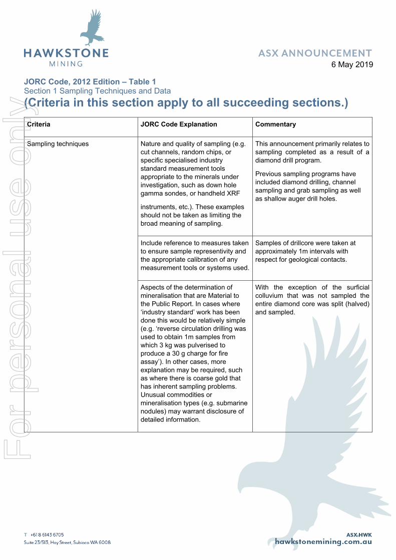
JORC Code, 2012 Edition – Table 1 Section 1 Sampling Techniques and Data (Criteria in this section apply to all succeeding sections.) Criteria JORC Code Explanation Commentary
Sampling techniques Nature and quality of sampling (e.g. cut channels, random chips, or specific specialised industry standard measurement tools appropriate to the minerals under investigation, such as down hole gamma sondes, or handheld XRF
instruments, etc.). These examples should not be taken as limiting the broad meaning of sampling.
This announcement primarily relates to sampling completed as a result of a diamond drill program.
Previous sampling programs have included diamond drilling, channel sampling and grab sampling as well as shallow auger drill holes.
Include reference to measures taken to ensure sample representivity and the appropriate calibration of any measurement tools or systems used.
Samples of drillcore were taken at approximately 1m intervals with respect for geological contacts.
Aspects of the determination of mineralisation that are Material to the Public Report. In cases where ‘industry standard’ work has been done this would be relatively simple (e.g. ‘reverse circulation drilling was used to obtain 1m samples from which 3 kg was pulverised to produce a 30 g charge for fire assay’). In other cases, more explanation may be required, such as where there is coarse gold that has inherent sampling problems. Unusual commodities or mineralisation types (e.g. submarine nodules) may warrant disclosure of detailed information.
With the exception of the surficial colluvium that was not sampled the entire diamond core was split (halved) and sampled.
For
per
sona
l use
onl
y
6 May 2019
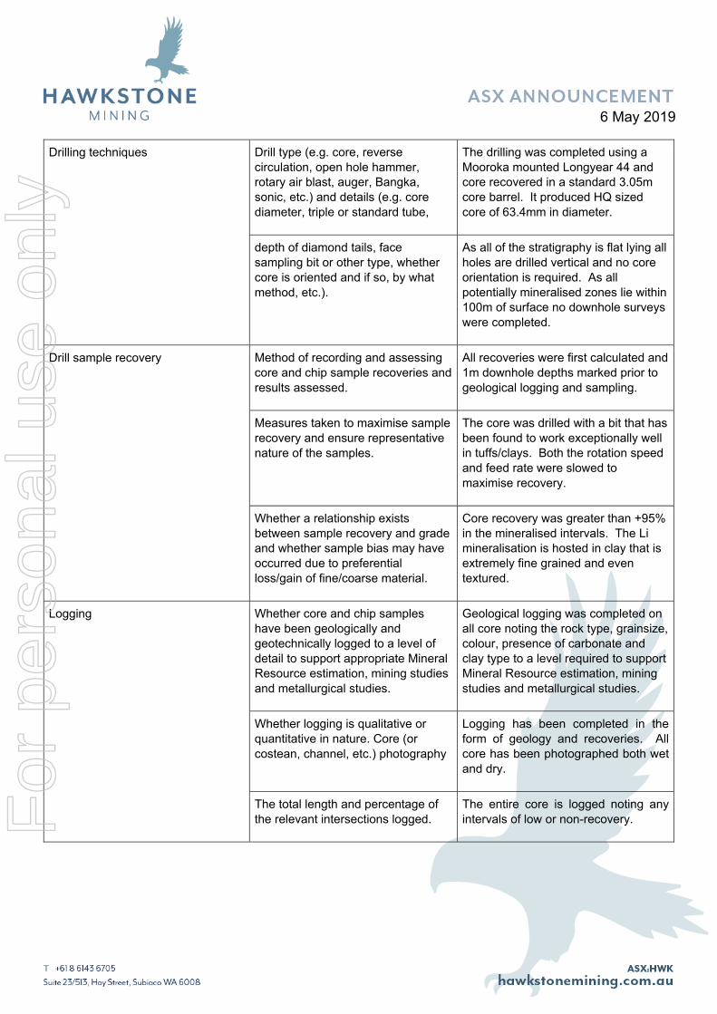
Drilling techniques Drill type (e.g. core, reverse circulation, open hole hammer, rotary air blast, auger, Bangka, sonic, etc.) and details (e.g. core diameter, triple or standard tube,
The drilling was completed using a Mooroka mounted Longyear 44 and core recovered in a standard 3.05m core barrel. It produced HQ sized core of 63.4mm in diameter.
depth of diamond tails, face sampling bit or other type, whether core is oriented and if so, by what method, etc.).
As all of the stratigraphy is flat lying all holes are drilled vertical and no core orientation is required. As all potentially mineralised zones lie within 100m of surface no downhole surveys were completed.
Drill sample recovery Method of recording and assessing core and chip sample recoveries and results assessed.
All recoveries were first calculated and 1m downhole depths marked prior to geological logging and sampling.
Measures taken to maximise sample recovery and ensure representative nature of the samples.
The core was drilled with a bit that has been found to work exceptionally well in tuffs/clays. Both the rotation speed and feed rate were slowed to maximise recovery.
Whether a relationship exists between sample recovery and grade and whether sample bias may have occurred due to preferential loss/gain of fine/coarse material.
Core recovery was greater than +95% in the mineralised intervals. The Li mineralisation is hosted in clay that is extremely fine grained and even textured.
Logging Whether core and chip samples have been geologically and geotechnically logged to a level of detail to support appropriate Mineral Resource estimation, mining studies and metallurgical studies.
Geological logging was completed on all core noting the rock type, grainsize, colour, presence of carbonate and clay type to a level required to support Mineral Resource estimation, mining studies and metallurgical studies.
Whether logging is qualitative or quantitative in nature. Core (or costean, channel, etc.) photography
Logging has been completed in the form of geology and recoveries. All core has been photographed both wet and dry.
The total length and percentage of the relevant intersections logged.
The entire core is logged noting any intervals of low or non-recovery.
For
per
sona
l use
onl
y
6 May 2019
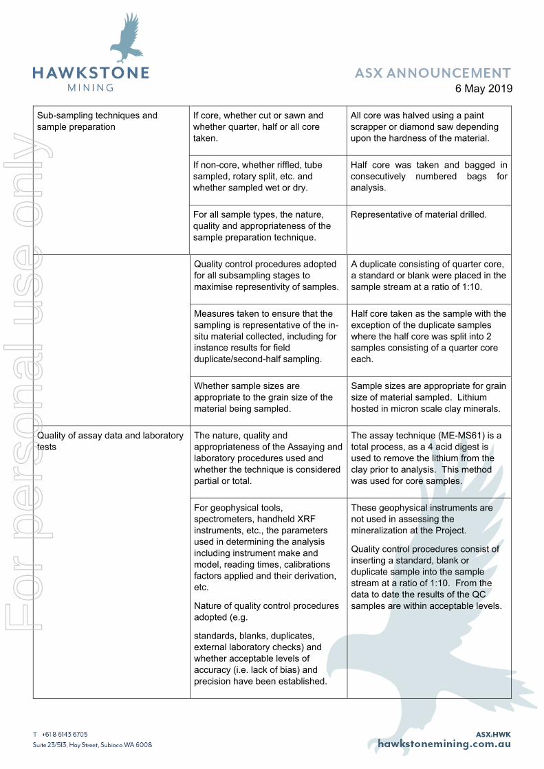
Sub-sampling techniques and sample preparation
If core, whether cut or sawn and whether quarter, half or all core taken.
All core was halved using a paint scrapper or diamond saw depending upon the hardness of the material.
If non-core, whether riffled, tube sampled, rotary split, etc. and whether sampled wet or dry.
Half core was taken and bagged in consecutively numbered bags for analysis.
For all sample types, the nature, quality and appropriateness of the sample preparation technique.
Representative of material drilled.
Quality control procedures adopted for all subsampling stages to maximise representivity of samples.
A duplicate consisting of quarter core, a standard or blank were placed in the sample stream at a ratio of 1:10.
Measures taken to ensure that the sampling is representative of the in-situ material collected, including for instance results for field duplicate/second-half sampling.
Half core taken as the sample with the exception of the duplicate samples where the half core was split into 2 samples consisting of a quarter core each.
Whether sample sizes are appropriate to the grain size of the material being sampled.
Sample sizes are appropriate for grain size of material sampled. Lithium hosted in micron scale clay minerals.
Quality of assay data and laboratory tests
The nature, quality and appropriateness of the Assaying and laboratory procedures used and whether the technique is considered partial or total.
The assay technique (ME-MS61) is a total process, as a 4 acid digest is used to remove the lithium from the clay prior to analysis. This method was used for core samples.
For geophysical tools, spectrometers, handheld XRF instruments, etc., the parameters used in determining the analysis including instrument make and model, reading times, calibrations factors applied and their derivation, etc.
Nature of quality control procedures adopted (e.g.
standards, blanks, duplicates, external laboratory checks) and whether acceptable levels of accuracy (i.e. lack of bias) and precision have been established.
These geophysical instruments are not used in assessing the mineralization at the Project.
Quality control procedures consist of inserting a standard, blank or duplicate sample into the sample stream at a ratio of 1:10. From the data to date the results of the QC samples are within acceptable levels. F
or p
erso
nal u
se o
nly
6 May 2019
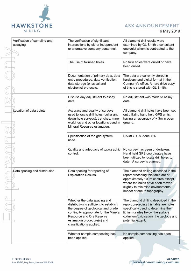
Verification of sampling and assaying
The verification of significant intersections by either independent or alternative company personnel.
All diamond drill results were examined by GL Smith a consultant geologist whom is contracted to the company.
The use of twinned holes. No twin holes were drilled or have been drilled.
Documentation of primary data, data entry procedures, data verification, data storage (physical and electronic) protocols.
The data are currently stored in hardcopy and digital format in the Company’s office. A hard drive copy of this is stored with GL Smith.
Discuss any adjustment to assay data.
No adjustment was made to assay data.
Location of data points Accuracy and quality of surveys used to locate drill holes (collar and down-hole surveys), trenches, mine workings and other locations used in Mineral Resource estimation.
All diamond drill holes have been set out utilizing hand held GPS units, having an accuracy of + 3m in open ground.
Specification of the grid system used.
NAD83 UTM Zone 12N
Quality and adequacy of topographic control.
No survey has been undertaken. Hand held GPS coordinates have been utilized to locate drill holes to date. A survey is planned.
Data spacing and distribution Data spacing for reporting of Exploration Results.
The diamond drilling described in the report preceding this table are at approximately 100m centres except where the holes have been moved slightly to minimise environmental impact or due to topography.
Whether the data spacing and distribution is sufficient to establish the degree of geological and grade continuity appropriate for the Mineral Resource and Ore Reserve estimation procedure(s) and classifications applied.
The diamond drilling described in the report preceding this table are holes specifically used to determine the lithium grades below the surface colluvium/oxidisation, the geology and potential extent.
Whether sample compositing has been applied.
No sample compositing has been applied.
For
per
sona
l use
onl
y
6 May 2019
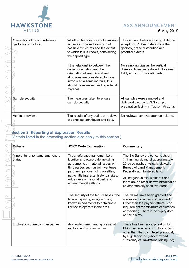
Orientation of data in relation to geological structure
Whether the orientation of sampling achieves unbiased sampling of possible structures and the extent to which this is known, considering the deposit type.
The diamond holes are being drilled to a depth of ~100m to determine the geology, grade distribution and potential extents.
If the relationship between the drilling orientation and the orientation of key mineralised structures are considered to have introduced a sampling bias, this should be assessed and reported if material.
No sampling bias as the vertical diamond holes were drilled into a near flat lying lacustrine sediments.
Sample security The measures taken to ensure sample security.
All samples were sampled and delivered directly to ALS sample preparation facility in Tucson, Arizona.
Audits or reviews The results of any audits or reviews of sampling techniques and data.
No reviews have yet been completed.
Section 2: Reporting of Exploration Results (Criteria listed in the preceding section also apply to this section.)
Criteria JORC Code Explanation Commentary
Mineral tenement and land tenure status
Type, reference name/number, location and ownership including agreements or material issues with third parties such as joint ventures, partnerships, overriding royalties, native title interests, historical sites, wilderness or national park and environmental settings.
The Big Sandy project consists of 311 mining claims of approximately 20 acres each, physically staked on Bureau of Land Management, Federally administered land.
All indigenous title is cleared and there are no other known historical or environmentally sensitive areas.
The security of the tenure held at the time of reporting along with any known impediments to obtaining a licence to operate in the area.
The claims have been granted and are subject to an annual payment. Other than the payment there is no requirement for minimum exploration or reporting. There is no expiry date on the claims.
Exploration done by other parties Acknowledgment and appraisal of exploration by other parties.
There has been no exploration for lithium mineralisation on this project other than that completed previously by Big Sandy Inc (wholly owned subsidiary of Hawkstone Mining Ltd).
For
per
sona
l use
onl
y
6 May 2019
Drill hole Information A summary of all information material to the understanding of the exploration results including a tabulation of the following information for all Material drill holes:
easting and northing of
the drill hole collar
elevation or RL (Reduced Level – elevation above sea level in metres) of the drill hole collar
dip and azimuth of the hole
down hole length and interception depth
hole length.
All information as listed is provided in the preceding tables.
If the exclusion of this information is justified on the basis that the information is not Material and this exclusion does not detract from the understanding of the report, the Competent Person should clearly explain why this is the case.
This information has not been excluded.
Data aggregation methods In reporting Exploration Results, weighting averaging techniques,
maximum and/or minimum grade
truncations (e.g. cutting of high grades) and cut-off grades are usually Material and should be stated.
Composite drill results at the Big Sandy Project are simple weighted averages with no upper or lower grade truncations. However significant intercepts generally include material grading >1,000 ppm Li.
Where aggregate intercepts incorporate short lengths of high grade results and longer lengths of low grade results, the procedure used for such aggregation should be stated and some typical examples of such aggregations should be shown in detail.
As all samples are 1m or near 1m intervals dependent on geology. Aggregate intercepts are the average of that interval.
The assumptions used for any reporting of metal equivalent values should be clearly stated.
No metal equivalent values are stated.
These relationships are particularly important in the reporting of
Where thicknesses are stated from the drilling the intercepts reflect the
For
per
sona
l use
onl
y
6 May 2019
Relationship between mineralization widths and intercept lengths
Exploration Results. If the geometry of the
mineralization with respect to the drill hole angle is known, its nature should be reported.
true thickness as the lacustrine sediments are flat lying.
If it is not known and only the down hole lengths are reported, there should be a clear statement to this effect (e.g. ‘down hole length, true width not known’).
As above.
Diagrams Appropriate maps and sections (with scales) and tabulations of intercepts should be included for any significant discovery being reported. These should include, but not be limited to a plan view of drill hole collar locations and appropriate sectional views.
Appropriate maps are included.
Balanced reporting Where comprehensive reporting of all Exploration Results is not practicable, representative reporting of both low and high grades and/or widths should be practiced to avoid misleading reporting of Exploration Results.
This release includes results to date from the drilling.
Other substantive exploration data Other exploration data, if meaningful and material, should be reported including (but not
limited to): geological
observations; geophysical survey results; geochemical survey results; bulk samples – size and
method of treatment; metallurgical test results; bulk
density, groundwater, geotechnical and rock characteristics; potential deleterious or contaminating substances.
The geology of the deposit is simple consisting of flat lying clays within an intermontain lacustrine basin. These clays are interpreted to have been tuffaceous sediments that have undergone alteration due to circulating groundwaters, evaporative pumping or hot springs. These processes have potentially contributed to the enhanced levels of lithium.
No bulk sampling has been completed. Initial metallurgical test work shows the lithium to be acid leachable.
No water table has been identified in drilling to date.
For
per
sona
l use
onl
y
6 May 2019
Further work The nature and scale of planned further work (e.g. tests for lateral extensions or depth extensions or large-scale step-out drilling).
Ongoing diamond drill testing the lacustrine sediments will continue.
Diagrams clearly highlighting the areas of possible extensions, including the main geological interpretations and future drilling areas, provided this information is not commercially sensitive.
The diagrams in the attached release show the zone of proposed future drilling as well as the areas of possible extensions.
For
per
sona
l use
onl
y


![Induction of Proliferation of Growth-Inhibited ...maged skin including color, texture, and wrinkling [1—5]. Histologic changes include epidermal thick- ening, increased keratinocyte](https://static.fdocuments.net/doc/165x107/603adccba5c7bb76295205e8/induction-of-proliferation-of-growth-inhibited-maged-skin-including-color-texture.jpg)