Functional linkage: How areas that are functionally linked ...
73
Natural England Commissioned Report NECR207 Functional linkage: How areas that are functionally linked to European sites have been considered when they may be affected by plans and projects - a review of authoritative decisions www.gov.uk/natural-england First published 29 February 2016
Transcript of Functional linkage: How areas that are functionally linked ...
Natural England Commissioned Report NECR207
Functional linkage: How areas that are functionally linked to European sites have been considered when they may be affected by plans and projects - a review of authoritative decisions
www.gov.uk/natural-england
First published 29 February 2016


Foreword Natural England commission a range of reports from external contractors to provide evidence and advice to assist us in delivering our duties. The views in this report are those of the authors and do not necessarily represent those of Natural England.
Background The implementation of a wide range of plans or projects can affect species or habitats on sites which have been designated for their nature conservation importance as European Protected Areas.
Areas of land or sea outside of the boundary of a European site may be important ecologically in supporting the populations for which the site has been designated or classified. Occasionally impacts to such habitats can have a significant effect upon the species interest of such sites, where these habitats are considered to be functionally linked to the site.
Natural England advisers need to judge whether the impacts on habitats that are functionally linked to a site, may adversely affect its integrity and whether the effects are significant in light of the conservation objectives for the site.
This report aims to provide an analysis of authoritative decisions that have considered functional linkages in cases assessed under the Habitats Directive and Regulations. It will be used as a referencing tool for Natural England and other decision makers, in particular Natural England advisers involved in casework.
This report should be cited as:
CHAPMAN, C. & TYLDESLEY, D. 2016. Functional linkage: How areas that are functionally linked to European sites have been considered when they may be affected by plans and projects - a review of authoritative decisions. Natural England Commissioned Reports, Number207.
Natural England Project Manager - Elizabeth Bailey, Marine Advisor, Natural England, Mail Hub, County Hall, Spetchley Road, Worcester, WR5 2NP [email protected]
Contractor - Dr Caroline Chapman, David Tyldesley and Associates, Sherwood House, 144 Annesley Road, Hucknall, Nottinghamshire NG15 7DD
Keywords - habitats regulations, authoritative decisions, functional linkage, likely significant effect, site integrity
Further information This report can be downloaded from the Natural England website: www.gov.uk/government/organisations/natural-england. For information on Natural England publications contact the Natural England Enquiry Service on 0845 600 3078 or e-mail [email protected].
This report is published by Natural England under the Open Government Licence - OGLv3.0 for public sector information. You are encouraged to use, and reuse, information subject to certain conditions. For details of the
licence visit Copyright. Natural England photographs are only available for non commercial purposes. If any other information such as maps or data cannot be used commercially this will be made clear within the report.
ISBN 978-1-78354-273-4 © Natural England and other parties 2016


TABLE OF CONTENTS A Background to this research .................................................................................... 1
A.1 Status of this report ................................................................................................. 1
A.2 Who the report is for ................................................................................................ 1
A.3 Aims of this report ................................................................................................... 1
A.4 The importance of case law to the decision making process ................................... 2
A.5 The meaning of ‘authoritative decision’ .................................................................... 2
A.6 Decisions of the European Courts ........................................................................... 3
A.7 Decisions of the UK Courts ..................................................................................... 4
A.8 Decisions of the Secretary of State / Scottish or Welsh Ministers ............................ 4
A.9 Decisions of Planning Inspectors and Reporters ..................................................... 4
A.10 Article 6(4) Opinions of the European Commission ................................................. 6
A.11 A note of caution ..................................................................................................... 6
B Why ‘functional links’ to European sites are important to decision making ............... 8
B.1 What is meant by ‘functional linkage’ ....................................................................... 8
B.2 How functional linkage relates to the Habitats Regulations Assessment process .. 10
B.3 How functional linkage might influence the stage 1 and 2 conclusions .................. 13
C The Case Studies .................................................................................................. 15
C.1 Selection ............................................................................................................... 15
C.2 The summary table ................................................................................................ 16
D Discussion and conclusions .................................................................................. 19
D.1 Cases concerning effects on bats .......................................................................... 19
D.2 Cases concerning effects on bird species.............................................................. 20
D.3 Cases concerning effects on Atlantic salmon ........................................................ 24
D.4 Cases concerning harbour porpoise and seals ...................................................... 24
D.5 Evidence requirements .......................................................................................... 25
E Appendix - Case Summaries ................................................................................. 29
E.1 Abbotskerswell Parish Council v Teignbridge DC .................................................. 29
E.2 RSPB and Lydd Airport Action Group v Secretary of State and London Ashford Airport ................................................................................................................... 30
E.3 Forest of Dean FoE v Forest of Dean District Council ........................................... 31
E.4 Buckinghamshire County Council and others v Secretary of State and HS2 Ltd .... 32
E.5 Forest of Dean FoE v Forest of Dean District Council ........................................... 33
E.6 Shadwell Estates v Breckland District Council ....................................................... 34
E.7 Hargreaves v Secretary of State and Wyre Borough Council................................. 36
E.8 Sandale Developments Ltd ................................................................................... 37

E.9 Boggis and Eastern Bavents Conservation v Natural England and Waveney D.C. 39
E.10 Hornsea Project One offshore wind farm ............................................................... 41
E.11 Walney Extension off shore wind farm ................................................................... 43
E.12 Burbo Bank offshore wind farm ............................................................................. 44
E.13 North Killingholme power station ........................................................................... 45
E.14 Rampion offshore wind farm .................................................................................. 45
E.15 East Anglia One offshore wind farm ...................................................................... 47
E.16 Able Marine Energy Park ....................................................................................... 48
E.17 Triton Knoll ............................................................................................................ 49
E.18 Galloper offshore wind farm .................................................................................. 50
E.19 Preesall Saltfield underground gas storage ........................................................... 52
E.20 Heysham to M6 link road ....................................................................................... 53
E.21 Hinkley Point C nuclear power station ................................................................... 54
E.22 Frodsham onshore wind farm ................................................................................ 55
E.23 Portsmouth Stadium .............................................................................................. 57
E.24 Lemonford Caravan Park ...................................................................................... 58
E.25 Parkhead Farm ..................................................................................................... 60

Acknowledgements The authors would like to thank Elizabeth Bailey, the Natural England project manager, Rhiannon Pipkin for coordinating responses to the draft report, and all the Natural England officers who responded to the request to submit candidate cases for consideration in the research and who commented on the draft.

Summary Introduction This report aims to provide an analysis of authoritative decisions which considered effects from projects being considered for authorisation on areas of land or sea that were considered to be functionally linked to a European site, but which lay outside the boundaries of the site. It is intended to serve as a referencing tool for use by Natural England to inform a review of its approach to casework in light of interpretations of the Habitats Directive and Regulations. In the context of this report, the term ‘functional linkage’ refers to the role or ‘function’ that land or sea beyond the boundary of a European site might fulfil in terms of ecologically supporting the populations for which the site was designated or classified. Such land is therefore ‘linked’ to the European site in question because it provides an important role in maintaining or restoring the population of qualifying species at favourable conservation status. This report only looks at areas which are functionally linked for species rather than qualifying habitats. An ‘authoritative decision’ is a decision which has been subject to sufficient scrutiny, at an appropriate level, to impart a degree of authority. In this report, ‘authoritative decisions’ used are those relating to domestic court judgments, and Secretary of State and certain Planning Inspector decisions in respect of a proposed plan or project. It may be necessary to consider the date of a decision or the extent to which a particular case is consistent with previous judgments or practice before relying upon it in a decision-making process. It is the responsibility of the reader to interpret and apply the findings in this report appropriately. The findings and conclusions of the report should be considered fairly, as a whole, and not quoted, used or applied selectively, in order to support a pre-determined or preferred conclusion. In Habitats Regulations Assessment the concept of functional linkage is relevant to both the stage 1 ‘screening decision’ and the stage 2 ‘integrity test’. If effects on functionally linked land or sea are likely to have a significant effect on the population of species for which a European site was designated or classified, those effects must be considered fully in a Habitats Regulations Assessment. Methodology The researchers compiled a list of potentially relevant cases drawn from:
i. their own library of decisions, and their empirical knowledge of case work; ii. a further web-based search of European Court judgments and opinions; iii. a web-based search for decisions relating to nationally significant infrastructure
projects and projects consented under the Electricity and Pipeline Acts in England and Wales and their territorial and UK offshore waters; and

iv. suggestions made by officers in Natural England following an e-mail enquiry of case officers by the research project manager.
Over 180 cases were originally identified as being relevant to the assessment of plans and projects affecting European sites. Following an initial screening exercise, twenty five of these decisions were subject to detailed examination in this review as being relevant to the consideration of functional linkage. One Court of Appeal case is included only to contribute to the discussion on evidence requirements. Of the twenty four cases subject to further analysis, 19 referred to effects on birds, 4 were related to effects on bats, and two referred to effects on Atlantic salmon. One of the 19 SPA cases also identified potential effects in respect of marine mammals. Discussion and conclusions Bats The issues in the four cases relating to bats examined the potential loss, interruption, or diminution of the ecological value of the routes (flyways) used by the bats from the SAC to reach their foraging grounds, which were spread around the countryside beyond the SAC boundary. Hence the bats would be indirectly affected by way of loss of habitat, or by the interruption or severance of the flyways or by the introduction of deterrent effects in the flyways and/or in the foraging areas. Reduction in ecological value of the foraging areas and/or impediments to the bats reaching their foraging areas could undermine achievement of the conservation objectives of the SACs and therefore affect the conservation status of the bats in the SACs. The failure of the developer in one case to carry out the surveys reasonably required to establish the importance of an area reasonably likely to be part of a critical flyway, led to the refusal of the application and dismissal of the appeal. This was because an appropriate assessment could not be properly completed without it. In all cases the risk to the population of bats, for which the SAC had been designated, arising out of effects which could occur beyond the boundary of the SAC was accepted by the decision maker. Birds Twelve SPA cases related to terrestrial or coastal habitats involving a range of waterfowl. Seven related to the marine environment and sea birds. In all cases the decision maker recognised the potential importance of functionally linked land or sea and that it should be treated as part of the Habitats Regulations Assessment. In the terrestrial or coastal environments, three points became clear from the research:
a) the scope for SPA bird species to use land, whether in close proximity or further away from the SPA, is often limited by urban development, land use patterns, noisy or other disturbing activities or operations, barriers and of course suitability of the habitat, even where there is open land or water;
b) there are often good quality, pre-existing records, such as Wetland Bird Census data, to indicate the use of specifically defined areas outside the SPA by birds;

c) surveys of use, or potential use, of land or water bodies by relevant SPA species is usually reasonably obtainable even if surveys are required over a period of time.
In the terrestrial or coastal environments, the functionally linked land was identified by surveys of actual or probable use, rather than mere assumption that birds from the local SPA might use the area because it might be suitable. Consequently, in the terrestrial and coastal environments, the possibility of the presence of functionally linked land is more readily identifiable, and the land areas more easily defined as relatively discrete areas, than in the marine environment discussed below. Where pre-existing records were not available, but an area affected by a development appeared likely to be used as functionally linked land, new survey work was undertaken to establish the level of use in order to inform a Habitats Regulations Assessment, screening or appropriate assessment, as the case may have been. Even where good data about levels of use were available, survey effort was continued in some cases to improve understanding. By contrast, the seven sea bird SPA cases, relating to offshore wind farms, had to approach the potential of functionally linked sea areas differently. All new proposals involved surveys to establish the use of the proposed wind farm areas by all species of birds. It was then necessary to consider whether the birds that were recorded in these offshore areas may reasonably be assumed to be individuals associated with an SPA. This depended in part on the proportion of that species which bred in SPAs, and the distance that the area lay from SPAs for the relevant species. The critical distance was usually the species-specific, maximum recorded foraging distance, or in some cases the known flight paths, which varied considerably from one species to another. No standard cut off distance from an SPA could be used as a surrogate for the risk of a significant effect. All of this was relevant before the ornithological analyses attempted to calculate collision risk or displacement for the birds that were recorded as using the development area. On the scientific evidence in the Habitats Regulations Assessments accompanying the decision in each of these cases, the calculations of displacement and collision risk modelling related to bird populations which could reasonably be assumed to be those relating to an SPA; in all cases the SPAs potentially affected were specifically identified. Atlantic salmon One case concerned effects on individuals of Atlantic salmon, when they would be upstream of the SAC boundary. With the project being located upstream of the designated SAC, the functional linkage between the population for which the SAC had been designated and the individuals potentially affected by the proposed development was clear, because they would all have had to migrate through the SAC to reach the upstream stretches. These risks had not been adequately assessed when the original permission had been granted. In the other case it was the risk to migrating smolt caused by the deterrent effect of noise from piling operations that had the potential to prevent Atlantic salmon from making their seaward migration from the SAC out into the Irish Sea. The risk was avoided by a seasonal restriction on the driving of the piles.

Harbour porpoise and seals In this case the functional linkage of a wind farm site to 26 pSCIs around the North Sea (most in the territorial seas of other member states), which had been designated for harbour porpoise and two for grey seals and harbour (common) seals was necessarily based on certain assumptions. For each species, the long distances from the European sites and the extensive range over which the species were known to forage led to the conclusion that displacement was not considered to represent a threat to the integrity of any of the sites potentially affected. Evidence requirements The ‘Boggis’ case helps to establish some principles about the requirement for at least credible evidence that there is a functional link between an area that may be affected by development and a European site. In 15 of the 24 other cases examined in detail the researchers considered that there was a good level of survey or other evidence demonstrating a relatively clear (or even obvious) link to the SAC/SPA and its species. Other cases, in the marine environment, had to be based on reasonable scientific assumptions. But these cases should not be regarded as having a weak evidence base for the links. In the precautionary approach of the Habitats Regulations sufficient evidence pointed to a possibility or a risk of an effect on SPA or SAC populations. In respect of two cases, the evidence base was considered to be ‘poor’ with links not well established. In one of these cases a legal challenge to a plan consequently failed. In the other case, referred to under bats above, the developer declined to carry out surveys that could have demonstrated how important the functional link was and how effective mitigation measures might have been, so the application of the precautionary principle led to the refusal of the application and dismissal of the appeal. In essence, the research shows, amongst other things, that:
a) The identification of an area as functionally linked land in the terrestrial or coastal environment is generally relatively straightforward and readily recognised, but may sometimes not be apparent and may require some initial survey and analysis or collation of pre-existing data, to establish the link;
b) The identification of an area as functionally linked sea is more challenging and has to be approached differently for marine developments; nevertheless an approach in respect of sea birds and marine mammals appears to be developing and although necessarily relying to a greater extent on assumptions, it provides a robust approach which is suitably precautionary without being onerous;
c) Once identified as functionally linked land or sea, the evidence required by decision makers in stages 1 and 2 of the Habitats Regulations Assessment process are no different to those that might reasonably be expected in relation to direct or on-site effects on the European site. The precautionary principle applies equally to functionally linked land and sea. Where effects might be significant and there is insufficient information to ascertain that there would not be an adverse effect on the integrity of a site, in terms of the population of the species for which the site has been

classified or designated, authorisation has been denied; consistently with the provisions of the Regulations. However, in the majority of cases sufficient evidence was available for the decision-maker to conclude that there would be no significant effect, or no adverse effect on site integrity, if the project was authorised.

A Background to this research
A.1 Status of this report This report sits within a series reviewing the findings of ‘authoritative decisions’. It is concerned with how areas of land or sea that are functionally linked to a European site have been considered by authoritative decision makers when projects may affect them. At the time of writing, two other reports are available regarding ‘small scale effects’ and ‘longevity of effects’.
A.2 Who the report is for The research was commissioned by Natural England “for the production of a report which can act as a referencing tool for use by Natural England to inform a review of its approach to casework in light of recent interpretations of the Habitats Directive and Regulations”. Whilst the report has primarily been drafted for Natural England, it will be of interest to all practitioners and advisers working in the assessment of plans and projects under the ‘Habitats Regulations’1.
A.3 Aims of this report Natural England advisers in casework frequently issue advice on the potential effects that proposed plans or projects might have on European sites. For the purpose of this report the term ‘European site’ includes:
• Special Protection Areas (SPAs) classified under the EU Birds Directive2; • Special Areas of Conservation (SACs) designated under the EU Habitats Directive3; • Ramsar Sites listed under the Ramsar Convention4.
Cases involving proposed SPAs or SACs could also be relevant because of European Court rulings as to how member states should secure the protection of such sites before they are fully designated or classified. Later in this report there are references to ‘Sites of Community Importance’ or ‘SCI’, because this is a term widely used in respect of European sites by the European Court and the European Commission. Advice is given by Natural England based on the best available information in light of the characteristics and specific environmental conditions at the site concerned5. However, it can be difficult to ascertain what is acceptable under the specific tests set out in the assessment provisions of the Habitats Regulations (regulation 61), commonly referred to as a ‘Habitats Regulations Assessment’ or ‘HRA’.
1 The Conservation of Habitats and Species Regulations 2010 SI 490 2 Council Directive of 30th November 2009 on the conservation of wild birds (2009/147/EC) 3 Council Directive of 21/5/92 on the conservation of natural habitats and of wild fauna and flora (92/43/EEC) 4 Convention on wetlands of international importance especially as waterfowl habitat, Ramsar, Iran 2/2/71 as amended by the Paris protocol 3/12/92 and the Regina amendments 3/6/87. 5 Refer paragraph 48 Case C-127/02 Waddenzee
1

This report aims to provide an analysis of authoritative decisions which considered potential effects on land or sea outside a European site, but which provided supporting habitat, or other ecological function, linked to the designated area or its qualifying features, which can serve as a source of reference for advisers and decision makers.
A.4 The importance of case law to the decision making process Case law is a vital source of information regarding how legislation should be correctly interpreted and applied. The Habitats Regulations transpose the requirements of the EU Wild Birds Directive and the EU Habitats Directive into domestic legislation. They set out a suite of legal obligations and responsibilities for a broad range of statutory agencies and decision making bodies (known as ‘competent authorities’). As with all statutory instruments of this nature, there is scope for inconsistency in how the statutory provisions are interpreted and applied. Too strict an interpretation might lead to plans or projects being delayed, subject to unnecessary restrictions, or ultimately refused under circumstances which were not intended to be incompatible with the underlying Directives. This can result in increased costs to, and frustration for, project proposers, which might have been avoidable, or unnecessary impediments to economic growth and development. Too lenient an interpretation carries different risks. Plans or projects might go ahead without sufficient consideration of the potential harm to the sensitive habitats and species for which the sites have been designated. This in turn might lead to the deterioration of protected habitats and species, or a legal challenge through either the domestic or the European Courts regarding a failure to comply with the Regulations or the Directives. Case law is therefore important in establishing a common understanding of how the tests involved in the assessment of plans and projects under the Habitats Regulations should be applied. There are credibility risks for decision makers, and those advising them, if a decision taken in respect of one proposed plan or project is not taken on the same basis as another plan or project, whether by the same or different competent authorities. Decision makers should strive to be consistent to ensure that the effects on the habitats and species protected under the Habitats Regulations are weighed appropriately and consistently in comparison with the benefits of proposals for change.
A.5 The meaning of ‘authoritative decision’ Applying a ‘plain English’ interpretation, an ‘authoritative decision’ is a decision which has been subject to sufficient scrutiny, at an appropriate level, to impart a degree of authority. In the context of this series of reports, ‘authoritative decisions’ are limited to those of the European and domestic (UK wide) court judgments and rulings (see A.6 and A.7 below), Secretary of State, or the Scottish or Welsh Ministers and certain Planning Inspector (in Scotland Reporter) decisions in respect of a proposed plan or project (see A.8 and A.9 respectively), and certain legally enforceable management measures such as a bye-law or statutory order (included in Secretary of State decisions in A.8). Article 6(4) ‘opinions’ from
2

the European Commission are also regarded as sufficiently authoritative to be included (A.10). However, in this report all of the decisions referred to were made by the UK domestic courts, a Secretary of State, or an Inspector so, whilst the authority of decisions of the European Courts and ‘Opinions’ of the European Commission are introduced in A.6 and A.10 respectively, to provide relevant context, they are not considered further. All these authoritative decisions are explained in the following sub sections so that they can be better understood in respect of:
a) how they should be read in relation to each other (some authoritative decisions carry greater weight than, or may supersede, other decisions); and
b) how they should be read in relation to a case which might currently be under consideration (where the reader is seeking guidance from this report as to a decision to be made).
A.6 Decisions of the European Courts The relevant European court was the European Court of Justice until 1st December 2009, when the provisions of the Lisbon Treaty came into force and the court became known as the Court of Justice of the European Union. For the purpose of this report, all cases are referred to simply as those of the ‘European Court’. The European Court has two principal functions. Firstly, deciding cases of dispute between, on the one hand, the European Commission (EC), seeking to enforce the terms of the Directives; and, on the other hand, member states, who may be accused by the EC of failure to comply with the Directives. In these cases the European Court issues ‘judgments’ following consideration of written material and oral hearings. A judgment issued in the case of such a dispute is referred to in the documentation in terms of an ‘action’ of the court, because the decision reached by the court carries direct consequences for the parties involved. The European Court also provides ‘preliminary rulings’. These are not intended to resolve a dispute in the European court itself, but to answer questions submitted to the European Court by a court of a member state. Questions will almost invariably relate to how the domestic court of the member state should properly interpret the Directives when making a judgment in their own court. These decisions are also included in the term ‘judgments’. The documentation relates to the ‘reference’ or ‘request’ made to the court rather than an ‘action’ related judgment in the case of a dispute. This report uses the generic term ‘judgment’ in respect of European Court decisions, unless it is important to distinguish that a particular case was a ‘ruling’. All judgments of the European Court carry the greatest weight because they are binding on member states in terms of both decision making and domestic court proceedings. Importantly, all judgments of the European Court are accompanied by an ‘opinion’ from an Advocate General of the Court. The Advocate General’s opinion is published in order to inform the Court’s judgment. The relevant opinion exerts considerable influence over the
3

respective judgment. Opinions are also helpful because they often include more information concerning the details of the case concerned. The Advocate General’s opinion carries less weight than the final judgment and the opinions are not binding on member states. However, they are so influential and carry such weight in European Court judgments and rulings that they are regarded as ‘authoritative decisions’ in the context of this research. European Court decisions are binding on member states. They must therefore be given due weight by competent authorities and the courts of member states. They provide the definitive interpretation of how the Directives should be interpreted. However, not all areas of potential uncertainty have been the subject of a case in the European Court. In the absence of a judgment from the European Courts, the UK Courts may need to make decisions based upon their own interpretation.
A.7 Decisions of the UK Courts Decisions taken in the UK Courts, which are of relevance to the application of the Habitats Regulations arise from judgments in the “High Court”, the “Court of Appeal”, and the “Supreme Court”. Relevant legal proceedings will start in the High Court, and if the High Court judgment is not referred to the Court of Appeal it will stand. However, if a High Court judgment is referred to the Court of Appeal the latter judgment will prevail and the legal principles established are binding on subsequent High Court judgments. Similarly, if a Court of Appeal judgment is referred to the Supreme Court the latter judgment will prevail and the legal principles established are binding on all lower courts including the Court of Appeal. In Scotland, the Outer House of the Court of Session is equivalent to the High Court and the Inner House of the Court of Session is equivalent to the Court of Appeal.
A.8 Decisions of the Secretary of State / Scottish or Welsh Ministers A decision taken by a Secretary of State, or an equivalent decision made by the Scottish or Welsh Ministers (the Ministers) is regarded as authoritative because it has been considered by a Government Department and signed off at a Ministerial level. It will usually (for example in the case of orders for development consent) be accompanied by or contain a detailed record of the related Habitats Regulations Assessment. Relevant decisions made by a Secretary of State or the Ministers relate to one of the following:
• an application for an ‘Order for Development Consent’ under the provisions of The Planning Act 2008 for a ‘Nationally Significant Infrastructure Project’; or
• a consent required by a Secretary of State under primary legislation, for example, under the Electricity or Pipeline Acts; or
• in respect of a ‘call-in’ application, or a ‘recovered’ appeal under the provisions of the Town and Country Planning Act 1990 and related legislation (see further below), or
• the confirmation of a bye-law or other kind of statutory Order.
A decision made by a Secretary of State or the Ministers stands unless revoked or modified by them, or it is quashed by a Court because it has been challenged and found by the Court
4

to be unlawful. The grounds for such a challenge are limited and do not relate simply to the planning merits of the decision. The Secretary of State and the Ministers also have powers to require a local planning authority to refer an application to them for their own determination, referred to as a ‘call in’ of a planning application. An Inspector (in Scotland a Reporter) will be appointed to conduct a local public inquiry and to report and make recommendations to the Secretary of State or the Ministers as the case may be. The Secretary of State and the Ministers follow established policies as to when they consider it to be appropriate to ‘call-in’ a planning application, but they are likely to do so if, for example, a local planning authority was minded to grant a planning permission that could have a significant adverse effect on a European site, against the advice of the statutory nature conservation body and in the face of national policy. Where an applicant is aggrieved by a decision of a local planning authority to refuse permission for a development, or to grant it only subject to conditions that the applicant finds unacceptable, they have the right to appeal against the decision. The appeals are normally determined by a Planning Inspector or Reporter, (see A.9 below) but certain types of appeal can be ‘recovered’ for decision by the Secretary of State or the Ministers. Again the Inspector or Reporter will normally proceed to conduct a local public inquiry and report with recommendations to the Secretary of State or the Ministers. In both ‘call-in’ and ‘recovered’ cases the Secretary of State and the Ministers are not bound to accept the Inspector’s or Reporter’s recommendations.
A.9 Decisions of Planning Inspectors and Reporters Planning Inspectors (and in Scotland planning Reporters) are the decision maker (the competent authority in the terms of the Habitats Regulations) in their own right in respect of all delegated appeals against the decisions of local planning authorities, which are not ‘recovered’ by the Secretary of State. Appeals are considered by way of an exchange of written representations (the majority of cases); or by way of an exchange of written material followed by a public ‘hearing’, or in a small proportion of cases, considered by a prior exchange of written material followed by the calling and examination of evidence at a local public inquiry, conducted by the Inspector making the decision. In the context of this report, the most authoritative decisions of Planning Inspectors / Reporters are regarded to be those which have followed a public inquiry, because in these cases the evidence has been subject to particularly intense scrutiny and the parties will have had the opportunity to make legal and other submissions to the Inspector or Reporter, however ‘hearing’ cases may also be regarded as sufficiently authoritative where evidence has been subject to particular scrutiny. Planning Inspectors also conduct the ‘examination’ of local development plan documents submitted to the Secretary of State, in order to test them for ‘soundness’ before they can be adopted. The Inspector’s report to the local planning authority is binding, but it is the authority who adopts the plan, having made any changes required by the Inspector’s report.
5

A.10 Article 6(4) Opinions of the European Commission Under the provisions of Article 6(4) of the Habitats Directive, it is open to a member state to seek an opinion from the European Commission (EC) as to whether the justification for authorising a particular plan or project would amount to ‘imperative reasons of overriding public interest’. These are cases where the competent national authority cannot ascertain that there would not be an adverse effect on a European site, because a priority habitat or species may be adversely affected. This would normally rule out the consideration of economic or social reasons to authorise the project, but the option is available to seek an opinion as to the merits of the case from the EC. If the EC agree that the plan or project can proceed, they will examine compensatory measures and advise the member state accordingly. These are regarded as ‘authoritative decisions’ in the context of this research, because they have been scrutinised by the EC and the Commission’s opinion is published. These opinions are also helpful because in making the case as fully as possible, the member state must set out the details of the effects of the project on the qualifying features and must explain in detail its proposed compensatory measures.
A.11 A note of caution Given the large number of cases investigated, and the large volume of documents in relation to each case that had to be read, it was beyond the capacity of the researchers to undertake any investigations as to the accuracy of data, or to test the outputs of predictive models, or to undertake any other corroborative or verification work, as part of this research. All figures and factual information in this report are drawn directly from the documents which were read during the research. They are taken at face value. No assurance can therefore be given as to the accuracy or otherwise of information that was presented in the reports and decisions in the cases examined. For the purposes of this research it was sufficient to assume that all data recorded in the case reports and decisions were accurate and correct. Having set out the basis on which this research considers a decision to be sufficiently ‘authoritative’ to be given weight in considering other decisions, it is worth bearing in mind that judgments stand unless superseded by a judgment in a higher court. Decisions made by the Secretary of State or an Inspector stand unless quashed by a Court, after having been challenged and found to be unlawful. Some decisions, and indeed, occasionally some domestic judgments, may not appear to be entirely consistent with established legal principles (for example those set by the European Court), or established approaches to decision making in terms of policy or scientific practice, but they nevertheless stand unless challenged or superseded. A judgment or a decision can only be made on the facts of the case as known at the time. If the evidence or arguments presented are incomplete or misleading the outcome may be affected. The application of case law evolves over time. Some judgments (or decisions taken in light of judgments at the time) may have been made before an important legal principle was established by a subsequent judgment. For example, the Briels ruling in 2014 required a modification to the approach previously taken in respect of distinguishing mitigation and compensatory measures. Decisions made prior to this ruling did not have the benefit of that interpretation by the European court but were lawful and compliant at the time they were made.
6

Furthermore, no two cases are the same. What may initially appear to be inconsistency might, on closer examination, be a proper response to differences between the particulars of two cases which otherwise appear, at face value, to be equivalent. It may be necessary, therefore, to consider the date of a decision or the extent to which a particular case is consistent with previous judgments or practice before relying upon it in a decision-making process. It is the responsibility of the reader therefore to interpret and apply the findings in this report appropriately. The findings and conclusions of the report should be considered fairly, as a whole, and not quoted, used or applied selectively, in order to support a pre-determined or preferred conclusion.
7

B Why ‘functional links’ to European sites are important to decision making
B.1 What is meant by ‘functional linkage’ In the context of this report, the term ‘functional linkage’ refers to the role or ‘function’ that land or sea beyond the boundary of a European site might fulfil in terms of supporting the populations for which the site was designated or classified. Such an area of land or sea is therefore ‘linked’ to the site in question because it provides a (potentially important) role in maintaining or restoring a protected population at favourable conservation status. Whilst areas beyond a site boundary might serve a function in respect of a designated habitat type, for example by being linked hydrologically to the qualifying habitat, in the context of this report ‘functional linkage’ refers only to land or sea which is linked to a qualifying species (whether an Annex II species for which a SAC has been designated, or a bird species for which a SPA has been classified). Whilst the boundary of a European site will usually be drawn to include key supporting habitat for a qualifying species, this cannot always be the case where the population for which a site is designated or classified is particularly mobile. Individuals of the population will not necessarily remain in the site all the time. Sometimes, the mobility of qualifying species is considerable and may extend so far from the key habitat that forms the SAC or SPA that it would be entirely impractical to attempt to designate or classify all of the land or sea that may conceivably be used by the species. Thus, for some sea birds the SPA may be confined to the cliffs where the sea birds breed, and will not extend to their feeding areas, which may be many kilometres away, or to the routes used by the birds either to reach their feeding grounds, or on migration, or during the winter. In respect of bats, for example, the SAC may need to be confined to the key roost sites used for hibernation, resting or breeding. The majority and, in many cases, the whole of the foraging areas of the bats in that roost, and the ‘commuting’ routes (flyways) between the foraging areas and the roosts, cannot practically be included in the SAC. This approach to the definition of boundaries for SACs, where a qualifying species is mobile, is reflected in Article 4(1) of the Habitats Directive which states: “...For animal species ranging over wide areas these sites shall correspond to the places within the natural range of such species which present the physical or biological factors essential to their life and reproduction. For aquatic species which range over wide areas, such sites will be proposed only where there is a clearly identifiable area representing the physical and biological factors essential for their life and reproduction...” In practical terms, if the boundaries of a designated site were drawn to include all land or sea which might serve some function, at some point in time, in terms of the population for which the site had been designated or classified, the strict protection afforded by Article 6 would be applied more extensively than would be necessary to meet the objectives of the Directives. This could potentially place unnecessary restrictions on plans and projects which might not otherwise be required. By way of example, sites designated for harbour porpoise would need to potentially include vast areas of sea, if the boundaries were drawn to include all the areas
8

which might possibly provide some degree of support, at some point in time, for a given population. Regulatory procedures would be imposed on plans and projects simply on the basis that a harbour porpoise might occasionally feed or travel through the area affected by them. The concept of ‘functional linkage’ is best explained in the context of the protection afforded to species under the Directives. EC guidance6 on the strict protection of animal species of community interest refers to the Habitats Directive laying down two main ‘pillars’ which aim to meet the Directive’s broad objectives. The first is linked to the protection afforded through designation of SACs (Articles 4-6 of the Directive) and the second is the protection of individuals of the ‘European protected species’ throughout a Member State’s territory under Article 12. In summary: “In order to achieve its objectives, the Habitats Directive provides for two main instruments: the Natura 2000 network of protected sites and the species protection provisions. The provisions for species protection apply to the whole of a Member State’s territory and concern the physical protection of specimens as well as their breeding sites and resting places. Both regimes allow for exceptions under certain conditions. Both instruments are complementary and jointly aim to ensure a favourable conservation status for all species of Community interest.” The favourable conservation status of a given species is not therefore limited to how the species fares within the defined boundary of designated SACs. The guidance states at paragraph 17 that: “Assessing and evaluating the conservation status of habitats and species within the Natura 2000 network is therefore not always enough, especially when the occurrences of habitats or species are only partly covered by the network, maybe even in some cases only to a relatively small extent.” Likewise, the Birds Directive refers not only to the protection of species within special protection areas, with reference to the network of SPAs, Article 4(4) provides: “...Outside these protection areas, Member States shall also strive to avoid pollution or deterioration of habitats”. In practice, therefore, in respect of protected species, three potential situations arise as set out below. This report is relevant to the second of these three situations:
1. Land or sea within the boundary of a SAC or SPA which supports a qualifying species is strictly protected by the assessment approach set out in Article 6 (commonly referred to in the UK as a ‘Habitats Regulations Assessment’);
2. Supporting habitat in areas beyond the boundary of a SAC or SPA which are connected with or ‘functionally linked’ to the life and reproduction of a population for which a site has been designated or classified should be taken into account in a
6 Guidance document on the strict protection of animal species of Community interest under the Habitats Directive 92/43/EEC, February 2007.
9

Habitats Regulations Assessment. However, that assessment will need to determine how critical the area may be to the population of the qualifying species and whether the area is necessary to maintain or restore the favourable conservation status of the species. Effects which would not be acceptable within the boundary of a European site may or may not be acceptable if they occur on functionally linked land or sea;
3. Individuals of a protected species, whether or not they are part of a population for which a European site has been designated or classified, are in any event afforded protection under the Directives, including in most cases their breeding and resting places, wherever they may be, inside or outside of the designated area. Species listed under Annex IV of the Habitats Directive are protected under the provisions of Article 12 as a ‘European protected species’. Wild birds are similarly protected under the provisions of the Birds Directive.
The provisions of Article 6(3) and 6(4) of the Habitats Directive, as applied through a Habitats Regulations Assessment, do not apply to individuals of European protected species or individuals of species of birds which are not part of a population for which a European site has been designated or classified.
B.2 How functional linkage relates to the Habitats Regulations Assessment process
The concept of functional linkage is therefore an important consideration in decision making under the Habitats Regulations because the tests arising from Article 6(3) and 6(4) will need to be applied in respect of plans or projects which may significantly affect such supporting habitat and its contribution to the favourable conservation status of the relevant species. Figure B.1 on the next page, provides an outline of the four stage process of Habitats Regulations Assessment. The key question which this report is looking to address is how decision-makers have applied the Habitats Regulations Assessment (HRA) process where effects on species relate to functionally linked land or sea (situation 2 above) rather than the area within the boundaries of the relevant European site (situation 1 above). Few plans or projects will progress to stages 3 and 4 so the majority of the authoritative decisions referred to in this report concern the stage 1 ‘screening’ test and the stage 2 ‘appropriate assessment’ and ‘integrity test’. These initial stages are briefly introduced below, but the relevance of functionally linked land (FLL) to the Habitats Regulations Assessment process is encapsulated in the following quote from paragraph 27 of the High Court judgment in RSPB and others v Secretary of State and London Ashford Airport Ltd [2014 EWHC 1523 Admin]:- “There is no authority on the significance of the non-statutory status of the FLL. However, the fact that the FLL was not within a protected site does not mean that the effect which a deterioration in its quality or function could have on a protected site is to be ignored. The indirect effect was still protected. Although the question of its legal status was mooted, I am satisfied …. that while no particular legal status attaches to FLL, the fact that land is functionally linked to protected land means that the indirectly adverse effects on a protected site, produced by effects on FLL, are scrutinised in the same legal framework just as are the direct effects of acts carried out on the protected site itself. That is the only sensible and purposive approach where a species or effect is not confined by a line on a map or boundary
10

fence. This is particularly important where the boundaries of designated sites are drawn tightly as may be the UK practice”.
Figure B.1: Outline of the four stage approach to a Habitats Regulations Assessment Stage 1: the ‘screening’ test If it is not directly connected with or necessary to site management the decision-maker must determine whether a proposed plan or project is likely to have a significant effect7 on the site. The decision on whether an appropriate assessment is necessary should be made on a precautionary basis. This is in line with the European Court’s ruling in Case C-127/02 hereafter referred to as the Waddenzee judgment8, which states that: “any plan or project not directly connected with or necessary to the management of the site is to be subject to an appropriate assessment of its implications for the site in view of the site’s conservation objectives if it cannot be excluded, on the basis of objective information, that it will have a significant effect on that site, either individually or in combination with other plans or projects.” Taking account of advice from the statutory nature conservation body, they should consider whether the effect of the proposal on the site, either individually or in combination with other
7 Regulation 61(1)(a) 8 Landelijke Verenigning tot Behoud Van de Waddenzee, Nederlandse v Vereniging tot Bescherming von Vogels v Straatssecretaris Van Landbouw, Natuurbeheer en Visserij (C-127/02: [2005] Env. LR14 [ECJ])
11

proposals9, is likely to be significant in terms of the ecological objectives for which the site was designated, classified or listed. The statutory nature conservation body in England and its territorial waters out to 12 nautical miles (nm) is Natural England. Beyond that, in offshore waters, it is usually the Joint Nature Conservation Committee (JNCC), but arrangements have been made in some cases for Natural England to be the single consultee for both jurisdictions for projects, such as offshore wind farms, which may straddle the 12nm limit. If a plan or project would not be likely to have a significant effect on the site alone, it should nevertheless be considered in combination with other plans and projects to establish whether there may be a significant effect arising from their combined impacts. Stage 2: The ‘appropriate assessment’ and ‘integrity test’ If the decision-maker concludes that a proposed plan or project not directly connected with or necessary for site management is likely to significantly affect a European site, they must make an ‘appropriate assessment’ of the implications of the proposal for the site in view of the site’s conservation objectives10. These relate to each of the qualifying features for which the site was designated, classified or listed and will be provided by the statutory nature conservation body. The scope and content of an appropriate assessment will depend on the nature, location, duration, frequency, timing and scale of the proposed project and its effects, and the qualifying features of the relevant site. It is important that an appropriate assessment is made in respect of each qualifying feature for which a likely significant effect has been identified, and for each designation where a site is designated, classified or listed under more than one international obligation. In the Waddenzee judgment, the European Court ruled that an appropriate assessment implies that all the aspects of a plan or project which can, by themselves or in combination with other plans or projects, affect the site’s conservation objectives must be identified in the light of the best scientific knowledge in the field. In the light of the conclusions of the appropriate assessment, the decision-maker must determine whether it can ascertain that the proposal will not adversely affect the integrity of the site(s)11. This test incorporates the precautionary principle. It is not for the decision-maker to show that the proposal would harm the site, in order to refuse the proposal. It is for the decision-maker to consider the likely and reasonably foreseeable effects and to ascertain that the proposal will not have an adverse effect on the integrity of the site before it may grant permission. If the proposal would adversely affect integrity, or the effects on integrity are uncertain but could be significant12, the decision-maker should not grant permission, subject to the provisions of regulations 62 and 66, which relate to alternative solutions, imperative reasons of overriding public interest and compensatory measures. These are not discussed further in this report because they are not relevant to the research.
9 Regulation 61(1)(a) 10 Regulation 61(1) 11 Regulation 61(5) 12See ADT Auctions Ltd v Secretary of State Environment, Transport and the Regions and Hart District Council (2000) JPL 1155 at p. 1171 where it was held to be implicit in the wording of reg 61(5) that the adverse effect on the integrity of the site had to be a significant adverse effect.
12

In the Waddenzee judgment, the European Court also ruled that a plan or project may be authorised only if a decision maker has made “certain” that the plan or project will not adversely affect the integrity of the site. “That is the case where no reasonable scientific doubt remains as to the absence of such effects.” Decision-makers must be “convinced” that there will not be an adverse effect and where doubt remains as to the absence of adverse effects, the plan or project must not be authorised, subject to the derogation procedure outlined in Article 6(4) of the Habitats Directive13. The integrity of a site is the coherence of its ecological structure and function, across its whole area, which enables it to sustain the habitat, complex of habitats and/or the levels of populations of the species for which it was classified, designated or listed14. In determining the effect on site integrity, the advice of the statutory nature conservation body, the conservation objectives and any additional representations will need to be carefully considered. The UK courts have held that considerable weight should be given to the representations of the statutory nature conservation body and their advice should be adopted unless there are cogent and compelling reasons not to do so15. As part of the judgement on integrity, the decision-maker must consider the way in which it is proposed to carry out the project and whether conditions or other restrictions would enable it to ascertain that site integrity will not be adversely affected16. The decision-maker should consider whether a consent could be issued in accordance with regulation 61 subject to conditions. In practice, this means that it should identify the potential risks so far as they may be reasonably foreseeable in light of such information as can reasonably be obtained, and put in place a legally enforceable framework with a view to preventing the risks from materialising17.
B.3 How functional linkage might influence the stage 1 and 2 conclusions
The concept of functional linkage is relevant to both the stage 1 screening decision and the stage 2 integrity test. In terms of the screening decision the extent to which an effect might ‘undermine the conservation objectives’ where it occurs beyond the boundary of the European site will be influenced by the role or function that the area serves and its importance to the maintenance of the population for which the site has been designated, classified or listed. An effect over a very small area of functionally linked land or sea, which is rarely used, might not undermine the conservation objectives, whilst the same effect over an area which provides prime feeding ground would be of more concern. A point will be reached where, in spite of an effect occurring while the species is beyond the boundary of a
13 Regulation 62 14 Habitats Regulations Assessment draft guidance from Defra July 2013, and formerly in Government Circular: Biodiversity and Geological Conservation – Statutory Obligations and their Impact within the Planning System. ODPM Circular 06/2005 15 R (Akester and Anor) v DEFRA and Wightlink Ferries [2010] EWHC 232 (Admin) 16 Regulation 61(6) 17 See WWF-UK Ltd and RSPB – v – Secretary of State for Scotland et al [1999]1 C.M.L.R. 1021 [1999] Env. L.R. 632 opinion of Lord Nimmo-Smith
13

European site, the nature of the effect would be considered to undermine the conservation objectives for the qualifying species and an appropriate assessment would be required. Turning to the stage 2 integrity test, in light of the accepted definition of integrity quoted in B.2 above, a site’s integrity is inextricably linked to the concept of sustaining the population of a species for which the site has been designated, classified or listed. Where functionally linked land is necessary for that population to be so sustained then it must be linked to the site’s integrity.
14

C The Case Studies
C.1 Selection The researchers compiled a list of potentially relevant cases drawn from:
i. their own library of decisions, and their empirical knowledge of case work; ii. a further web-based search of European Court judgments and opinions; iii. a web-based search for decisions relating to nationally significant infrastructure
projects and projects consented under the Electricity and Pipeline Acts in England and Wales and their territorial and UK offshore waters; and
iv. suggestions made by officers in Natural England following an e-mail enquiry of case officers by the research project manager.
The researchers were aware of many cases in the terrestrial environment across the UK, where decision-makers considering onshore wind farm proposals had taken account of land that may be functionally linked to SPAs or SACs, for example as a flight path or as a feeding area for birds or bats. Cases have been determined in all administrative jurisdictions, including decisions by Secretaries of State, Scottish Ministers, planning Inspectors and Reporters, under the provisions of the Town and Country Planning and Electricity Acts. The cases go back over 15 years, when the first examples arose, in Islay and the Mull of Kintyre, where wind farm proposals were refused by the then Secretary of State for Scotland, because of the potential collision risk of geese as they flew between their roost in an SPA and their feeding grounds in the countryside beyond. It was clearly impractical to attempt to identify, summarise and analyse all such onshore wind farm cases which involved consideration of functionally linked land. Consequently, this report selects one of the most recent Electricity Act cases (E.22 Frodsham), a planning Inspector decision under the planning acts (E.25 Parkhead Farm) and a High Court case (E.7 Hargreaves) as representative of these many cases. These three adequately illustrate the issues and, along with the other cases in the report, help to answer the brief’s particular emphasis in respect of the level of evidence required. These cases therefore represent many others in terms of a well-established principle that offsite habitat loss, or offsite displacement, disturbance or collision risk of SPA birds, triggers the application of the Habitats Regulations Assessment process. This is the case irrespective of the location of the project. On the other hand, the recent range of issues arising in case work relating to the offsite effects of offshore wind farms, bear more detailed consideration. So all of the offshore wind farms which were nationally significant infrastructure projects, determined between 2013 and when the research was undertaken in January / February 2015, are considered in detail because they raise different issues and require different approaches to those now established in the onshore wind farm case work. In light of the above, in the research for all three reports in January and February 2015, over 180 cases were identified as being relevant to the assessment of plans and projects affecting European sites. Following an initial screening exercise, twenty five of these
15
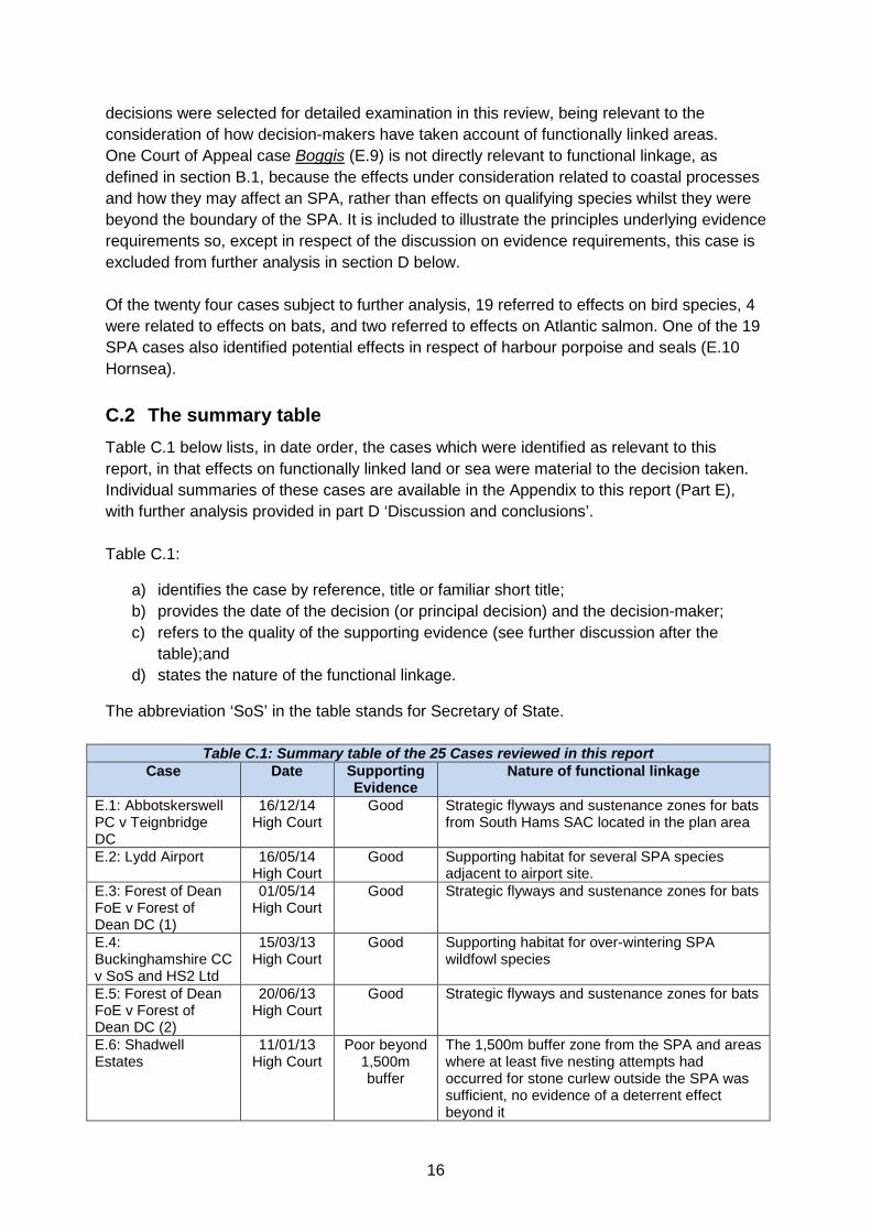
decisions were selected for detailed examination in this review, being relevant to the consideration of how decision-makers have taken account of functionally linked areas. One Court of Appeal case Boggis (E.9) is not directly relevant to functional linkage, as defined in section B.1, because the effects under consideration related to coastal processes and how they may affect an SPA, rather than effects on qualifying species whilst they were beyond the boundary of the SPA. It is included to illustrate the principles underlying evidence requirements so, except in respect of the discussion on evidence requirements, this case is excluded from further analysis in section D below. Of the twenty four cases subject to further analysis, 19 referred to effects on bird species, 4 were related to effects on bats, and two referred to effects on Atlantic salmon. One of the 19 SPA cases also identified potential effects in respect of harbour porpoise and seals (E.10 Hornsea).
C.2 The summary table Table C.1 below lists, in date order, the cases which were identified as relevant to this report, in that effects on functionally linked land or sea were material to the decision taken. Individual summaries of these cases are available in the Appendix to this report (Part E), with further analysis provided in part D ‘Discussion and conclusions’. Table C.1:
a) identifies the case by reference, title or familiar short title; b) provides the date of the decision (or principal decision) and the decision-maker; c) refers to the quality of the supporting evidence (see further discussion after the
table);and d) states the nature of the functional linkage.
The abbreviation ‘SoS’ in the table stands for Secretary of State.
Table C.1: Summary table of the 25 Cases reviewed in this report Case Date Supporting
Evidence Nature of functional linkage
E.1: Abbotskerswell PC v Teignbridge DC
16/12/14 High Court
Good Strategic flyways and sustenance zones for bats from South Hams SAC located in the plan area
E.2: Lydd Airport 16/05/14 High Court
Good Supporting habitat for several SPA species adjacent to airport site.
E.3: Forest of Dean FoE v Forest of Dean DC (1)
01/05/14 High Court
Good Strategic flyways and sustenance zones for bats
E.4: Buckinghamshire CC v SoS and HS2 Ltd
15/03/13 High Court
Good Supporting habitat for over-wintering SPA wildfowl species
E.5: Forest of Dean FoE v Forest of Dean DC (2)
20/06/13 High Court
Good Strategic flyways and sustenance zones for bats
E.6: Shadwell Estates
11/01/13 High Court
Poor beyond 1,500m buffer
The 1,500m buffer zone from the SPA and areas where at least five nesting attempts had occurred for stone curlew outside the SPA was sufficient, no evidence of a deterrent effect beyond it
16

Table C.1: Summary table of the 25 Cases reviewed in this report Case Date Supporting
Evidence Nature of functional linkage
E.7: Hargreaves v SoS
02/08/11 High Court
Good Supporting habitat for over-wintering pink-footed geese
E.8: Sandale Developments
31/03/10 High Court
Good Supporting in-river habitat for Atlantic salmon
E.9: Boggis 20/10/09 Court of Appeal
Poor Asserted that sea defence scheme would affect coastal processes within SAC/SPA along coastline.
E.10: Hornsea Project One offshore wind farm
10/12/14 SoS
Based on assumptions about flight distances
Collision risk assessed for two SPAs (each more than 100km away). Also potential effects on harbour porpoise individuals which might be part of populations for which 26 pSCIs/SCIs designated (closest 44km, furthest 512km). Also on grey seal and harbour seal from two pSCIs at 44km and 64km respectively
E.11: Walney Extension offshore wind farm
07/11/14 SoS
As above Collision risk assessed for 6 SPAs ranging from 20 - 287km from windfarm
E.12: Burbo Bank Extension offshore wind farm
26/09/14 SoS
As above Collision risk assessed for 5 SPAs ranging from 6 - 55km from windfarm
E.13: North Killingholme power station project
11/09/14 SoS
Good Supporting habitat for SPA species close to the SPA
E.14: Rampion offshore wind farm
16/07/14 SoS
Based on assumptions about flight distances
Collision risk assessed for SPA up to 490km distance
E.15: East Anglia 1 offshore wind farm
17/06/14 SoS
As above Collision risk assessed for 3 SPAs; one at 54km, the other two at 259km
E.16: Able Marine energy park
28/08/13 SoS
Good Function of important black-tailed godwit roost would be lost with loss of intertidal feeding areas
E.17: Triton Knoll offshore wind farm
11/07/13 SoS
Based on assumptions about flight distances
Collision risk assessed for SPA 83km away
E.18: Galloper offshore wind farm
24/05/13 SoS
As above Collision risk assessed for SPA population from site 26.9km away.
E.19: Preesall Saltfield under-ground gas storage
09/04/13 SoS
Good Supporting habitat used by pink-footed geese
E.20: Heysham to M6 Link Road
19/03/13 SoS
Good Some birds known to feed and nest in affected fields but NE considered intensity of use was low and no particular fields favoured, with alternative sites nearby
E.21: Hinkley Point C nuclear power station
19/03/13 SoS
Good Six large fields used for roosting by SPA populations
E.22: Frodsham onshore wind farm
19/10/12 SoS
Good Site was a dredging disposal ground which hosted notably high numbers of over-wintering and passage waders from SPA immediately adjacent
E.23: Portsmouth Stadium
15/06/95 SoS
Good Prime winter feeding ground for Brent geese from nearby SPA
E.24: Lemonford Caravan Park
06/03/14 Inspector
Poor Strategic flyway for greater horseshoe bats
17

Table C.1: Summary table of the 25 Cases reviewed in this report Case Date Supporting
Evidence Nature of functional linkage
E.25: Parkhead Farm
11/05/09 Inspector
Good Collision risk to geese from SPA located 5km away
The assessment of the quality of the supporting evidence is a professional judgment by the researchers based on the evidence available. It relates to how well it was demonstrated that there was, or probably was, a functional linkage between the area of land or sea affected and the population of the species for which a site had been classified or designated. Where this is assigned as ‘good’ it indicates actual survey or other evidence and relatively clear (or even obvious) links to the SAC/SPA. As described in section D below, other cases, in the marine environment, had to be based on reasonable scientific assumptions. This is because assumptions had to be made about where the birds in the development area might breed and about recorded foraging distances. Nevertheless, these cases should not be regarded as having a weak evidence base for the links. In the precautionary approach of the Habitats Regulations sufficient evidence pointed to a possibility or a risk of an effect on SPA populations. In the case of E.20, there was good evidence that SPA bird species used the affected area for nesting and feeding, but there was agreement that the use of the area was so low that the proposed link road would not have a significant effect. There was a functional link, but not an important one, emphasising that the two decisions are different: Is there a functional link? Is there a significant effect on the European site? In respect of three cases, the evidence base was considered to be ‘poor’ with links not well established. The first of these was Boggis, already discussed above. The second was in Breckland (E.6) where the court found there was no convincing evidence that birds would be deterred from breeding by housing located beyond the 1,500m buffer zone agreed in the adopted local plan. In the other case (E.24) the developer declined to carry out surveys that could have demonstrated the functional link that the Inspector and the planning authority clearly considered to be likely.
18

D Discussion and conclusions
D.1 Cases concerning effects on bats Four cases reviewed (E.1, E.3, E.5 and E.24) concerned effects on bat SACs. An analysis of the cases confirms the following points. The qualifying features of the bat SACs were the population of the bats using the SAC as a roost. Each individual of the relevant species is protected in its own right as a European protected species, so too are its breeding and resting places, whether it or the places are in the SAC or anywhere outside it. However, there is additional protection for the animals through designation of their key roost areas as SACs. Furthermore, if the bats in the SAC rely on habitat outside the SAC, the loss or reduction (in area or ecological value) of which could have a significant effect on the population of the SAC bats, then that supporting habitat should be treated in a Habitats Regulations Assessment in the same way as the habitat in the SAC. In short, whilst the European protected species legislation protects the bats and their breeding and resting places, it is the effect of the designation of the SAC that protects, through the Habitats Regulations Assessment process, the habitat of the bats outside the SAC. The issues in the four cases examined related to the potential loss, interruption, or diminution of the ecological value of the routes (flyways) used by the bats from the SAC to reach their foraging grounds, which were widely spread around the countryside beyond the SAC boundary. Hence the bats would be indirectly affected by way of loss of habitat, or by the interruption or severance of the flyways or by the introduction of deterrent effects in the flyways and/or in the foraging areas. Reduction in ecological value of the foraging areas and/or impediments to the bats reaching their foraging areas could undermine achievement of the conservation objectives of the SACs and therefore affect the conservation status of the bats in the SACs. In all cases the risk to the population of bats, for which the SAC had been designated, arising out of effects which could occur beyond the boundary of the SAC was accepted. In the case of Forest of Dean FoE v Forest of Dean DC (2) (E.5) the judgment stated: “Although the Northern United compound has not been designated a SAC, the designation of an area as a SAC protects the population of the species using the site and not just the site itself”. In the Lemonford case (E.24) the Inspector noted: “the South Hams SAC is self-evidently an important area in biodiversity terms and its functionality in terms of the strategic flyways is clearly fundamental to its integrity as habitat” In three of the four cases the approach to functional linkage was underpinned by substantive survey work showing a reasonable likelihood that the area that would be affected was functionally linked to the relevant SAC bat population. But in the case of the Lemonford appeal (E.24), it was the uncertainty that arose from the inadequacy of the survey work that led to the dismissal of the appeal. The appellant had been reluctant to undertake the survey work recommended by the planning authority’s ecological adviser and Natural England. If
19

carried out, this survey could have established the relative importance of the area of offsite habitat that would have been affected and the likely efficacy of mitigation measures. The Inspector recognised that regulation 61 of the Habitats Regulations must be applied in respect of the potential changes that the development would make to the ecological function of the flyway for the bats from the SAC. The information requested by the planning authority in this case was not regarded as onerous. The applicant / appellant had declined to submit it so the Inspector concluded: “Appropriate assessment cannot, in my view, be adequately undertaken on the basis of the information to hand”. On the precautionary basis of the regulations he dismissed the appeal for this and other reasons.
D.2 Cases concerning effects on bird species Twelve of the 19 cases involving SPAs related to terrestrial or coastal habitats involving a range of waterfowl species, mainly geese, ducks and waders. Seven related to the marine environment and sea birds. Terrestrial and coastal SPAs In all twelve cases involving terrestrial or coastal SPAs the decision maker recognised the potential importance of functionally linked land and that it should be treated as part of the Habitats Regulations Assessment. Table D.1 below summarises the 12 cases. It indicates the case reference number in section E, the type of development proposed, the distance of the development from the SPA, the key issue and whether the decision concluded no likely significant effect (LSE) or an adverse effect on integrity (AEOI) of the SPA.
Table D.1: Cases involving effects on birds associated with terrestrial or coastal SPAs Development Distance Issue LSE /
AEOI E.2 Airport expansion
<1km Disturbance and displacement of several species of feeding and roosting birds on fields located varying distances from the SPA by aircraft noise and operational activity
No LSE
E.4 High speed rail
8km Disturbance and displacement by construction and operational noise of railway c.400m from a water body used by wildfowl from an SPA 8km away. Subject to further research LSE unlikely
No LSE
E.6 Residential
1.5km buffer
Disturbance and displacement of breeding stone curlew as a result of residential development near to nesting sites. Plan included a buffer ensuring no new residential development within 1.5km of the SPA boundary or areas outside SPA of suitable habitat and where at least 5 nesting attempts had been recorded since 1995
No LSE beyond buffer
E.7 Wind turbines (2)
5km Pink-footed geese roosted in the SPA and fed on fields adjacent to the development 5km from the SPA. Without mitigation collision mortality risk was up to 50 geese per year. Mitigation measures accepted as sufficient to avoid a significant effect
No LSE
20
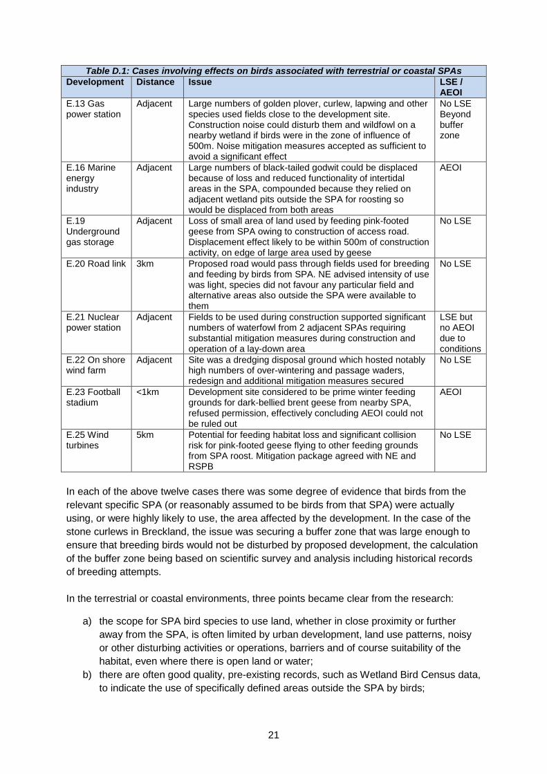
Table D.1: Cases involving effects on birds associated with terrestrial or coastal SPAs Development Distance Issue LSE /
AEOI E.13 Gas power station
Adjacent Large numbers of golden plover, curlew, lapwing and other species used fields close to the development site. Construction noise could disturb them and wildfowl on a nearby wetland if birds were in the zone of influence of 500m. Noise mitigation measures accepted as sufficient to avoid a significant effect
No LSE Beyond buffer zone
E.16 Marine energy industry
Adjacent Large numbers of black-tailed godwit could be displaced because of loss and reduced functionality of intertidal areas in the SPA, compounded because they relied on adjacent wetland pits outside the SPA for roosting so would be displaced from both areas
AEOI
E.19 Underground gas storage
Adjacent Loss of small area of land used by feeding pink-footed geese from SPA owing to construction of access road. Displacement effect likely to be within 500m of construction activity, on edge of large area used by geese
No LSE
E.20 Road link 3km Proposed road would pass through fields used for breeding and feeding by birds from SPA. NE advised intensity of use was light, species did not favour any particular field and alternative areas also outside the SPA were available to them
No LSE
E.21 Nuclear power station
Adjacent Fields to be used during construction supported significant numbers of waterfowl from 2 adjacent SPAs requiring substantial mitigation measures during construction and operation of a lay-down area
LSE but no AEOI due to conditions
E.22 On shore wind farm
Adjacent Site was a dredging disposal ground which hosted notably high numbers of over-wintering and passage waders, redesign and additional mitigation measures secured
No LSE
E.23 Football stadium
<1km Development site considered to be prime winter feeding grounds for dark-bellied brent geese from nearby SPA, refused permission, effectively concluding AEOI could not be ruled out
AEOI
E.25 Wind turbines
5km Potential for feeding habitat loss and significant collision risk for pink-footed geese flying to other feeding grounds from SPA roost. Mitigation package agreed with NE and RSPB
No LSE
In each of the above twelve cases there was some degree of evidence that birds from the relevant specific SPA (or reasonably assumed to be birds from that SPA) were actually using, or were highly likely to use, the area affected by the development. In the case of the stone curlews in Breckland, the issue was securing a buffer zone that was large enough to ensure that breeding birds would not be disturbed by proposed development, the calculation of the buffer zone being based on scientific survey and analysis including historical records of breeding attempts. In the terrestrial or coastal environments, three points became clear from the research:
a) the scope for SPA bird species to use land, whether in close proximity or further away from the SPA, is often limited by urban development, land use patterns, noisy or other disturbing activities or operations, barriers and of course suitability of the habitat, even where there is open land or water;
b) there are often good quality, pre-existing records, such as Wetland Bird Census data, to indicate the use of specifically defined areas outside the SPA by birds;
21

c) surveys of use, or potential use, of land or water bodies by relevant SPA species is usually reasonably obtainable even if surveys are required over a period of time.
Consequently, in the terrestrial and coastal environments, the possibility of the presence of functionally linked land is more readily identifiable, and the land areas more easily defined as relatively discrete areas, than in the marine environment discussed below. Where pre-existing records were not available, but an area affected by a development appeared likely to be used as functionally linked land, new survey work was undertaken to establish the level of use in order to inform a Habitats Regulations Assessment, screening or appropriate assessment, as the case may have been. Even where good data about levels of use were available, survey effort was continued to improve understanding, case E.22 Frodsham onshore wind farm, being a case in point. Sea bird SPAs In contrast, the seven sea bird SPA cases relating to offshore wind farms had to approach the potential of functionally linked areas of sea differently. Pre-existing survey information that was location specific to the development sites was scarce. All new proposals involved surveys to establish the use of the proposed wind farm areas by all species of birds. It was then necessary to consider whether the birds that were recorded in these offshore areas may reasonably be assumed to be individuals associated with an SPA. In some cases individual breeding birds such as gulls, were tagged in the SPA and tracked to see if they ventured into the development area. In other cases, however, such tracking studies would have been impractical. So the likelihood of an area being functionally linked to an SPA was established by considering the likelihood of the birds having come from an SPA. This depended in part on the proportion of that species which bred in SPAs, and the distance that the area lay from SPAs for the relevant species, compared to the known recorded foraging distance or migratory behaviour of the species. For example, if all pairs of a species which was recorded feeding in, or otherwise using, a wind farm area, bred in an SPA, and one or more SPA for that species was located within the known maximum recorded foraging distance from the wind farm site, it could reasonably be assumed that the birds that could be affected in the breeding season were linked to one or more such SPA; and the wind farm area was functionally linked. Whilst in respect of kittiwakes some assessments considered their seasonal migration routes, the critical distance was usually the known maximum breeding season recorded foraging distance, or in some cases the known breeding season flight paths, which varied considerably from one species to another. No standard cut off distance from an SPA could be used as a surrogate for the risk of a significant effect. All of this was relevant before the ornithological analyses attempted to calculate collision risk or displacement for the birds that were recorded as using the development area. In Habitats Regulations Assessment terms it was first necessary to establish the likelihood of the birds potentially affected being qualifying features of an SPA somewhere. Inevitably this involved some assumptions. Some of the distances involved, between a particular wind farm and an SPA potentially significantly affected, may appear to be considerable, and were sometimes considered by applicants to be over-precautionary. However, on the scientific evidence in the Habitats
22

Regulations Assessments accompanying the Secretary of State’s decision in each of these cases, the calculations of displacement and collision risk modelling relate to bird populations which can reasonably be assumed to be those relating to an SPA. In all cases the SPA(s) potentially affected was specifically identified. Relevant to this discussion, Table D.2 below indicates the proportion of the British population of the relevant species of sea bird which breed in a UK SPA.
Table D.2: Relative percentage of GB breeding population of seabird species which are associated with the UK SPA network
Seabird species % of GB population breeding in UK SPA suite Gannet Morus bassanus 98% Kittiwake Rissa tridactyla 78%
Manx Shearwater Puffinus puffinus 100% Lesser black-backed gull Larus fuscus 100%
Sandwich tern Sterna sandvicensis 72% In the case of effects upon gannet, manx shearwater and lesser black-backed gull therefore, where site surveys identify individuals within the project area, it is reasonable to assume that they are from a population for which an SPA has been classified. The uncertainty may sometimes relate to which SPA they were associated with. In the case of sandwich tern, where 72% of the breeding population are within the SPA network, it might be considered reasonable (on a precautionary basis) to assume that at least a proportion of individuals within a project area would be likely to be associated with an SPA. However, in the case of the Triton Knoll offshore wind farm (E.17) the development was thought to be located at the upper limit of the tern’s foraging range and, although sandwich terns were recorded in the area, the prospect of the SPA terns reaching the area was considered to be low. Table D.3 attempts to encapsulate the evidence about sea areas considered to be functionally linked in these seven cases. It indicates, for each of the main sea bird species, their maximum recorded foraging distance, and then the case reference number in section E, the name of the development and the distance of the development from the SPA, with an indication as to whether the decision-maker concluded a likely significant effect (LSE) or an adverse effect on integrity (AEOI) of the SPA.
Table D.3 Maximum foraging distances of sea birds and location of offshore wind farm case studies
Species Maximum foraging
Cases / distance from SPA(s)
Gannet Morus bassanus
c.590km E.14 Rampion 490km LSE in combination no AEOI
E.15 East Anglia One 259km LSE in combination no AEOI
E.17 Triton Knoll 83km LSE in combination no AEOI
Kittiwake* Rissa tridactyla
c.60km / c.120km
E.14 Rampion 490km no LSE alone or in combination
E.15 East Anglia One 259km no LSE alone or in combination
E.17 Triton Knoll 83km no LSE alone or in combination
Manx Shearwater Puffinus puffinus
330km E.11 Walney Extension 120km, 147km, 287km LSE in combination no AEOI
23

Table D.3 Maximum foraging distances of sea birds and location of offshore wind farm case studies
Species Maximum foraging
Cases / distance from SPA(s)
Lesser black-backed gull Larus fuscus
c.140km E.12 Burbo Bank 6km, 6km, 42km, 55km LSE no AEOI
E.15 East Anglia One 54km LSE no AEOI
E.18 Galloper 27km (surveys tracked one bird 159km from the SPA)
Sandwich tern Sterna sandvicensis
Uncertain E.17 Triton Knoll 47km thought to be upper limit of likely range, species recorded in the area no LSE
*as mentioned in the text, possible effects on kittiwakes during seasonal migration were considered but also concluded not to be a likely significant effect.
D.3 Cases concerning effects on Atlantic salmon The Sandale case (E.8) concerned effects on individuals of Atlantic salmon, when they would be upstream of the SAC boundary. With the project being located upstream of the designated SAC, the functional linkage between the population for which the SAC had been designated and the individuals potentially affected by the proposed development is clear, because all salmon in the upper reaches must be salmon who had migrated through the SAC. In the case of Sandale, the risk to the SAC from effects on individuals while they were within the Camowen River was considered to be sufficient to require further investigation. These risks had not been adequately assessed when the original permission had been granted. The evidence regarding the presence of Atlantic salmon was from a desktop study supported by ‘reports’ of individuals being observed. In the case of Burbo Bank the location of the project site meant that the noise from piling activity had the potential to prevent Atlantic salmon from making their seaward migration from the SAC out into the Irish Sea. The risk to the smolt migration could, however, be avoided through a proposed timing restriction on the driving of the piles. This enabled a conclusion of no adverse effect on the integrity of the site. Whilst the SAC was located 32km away from the project area, the mouth of the estuary through which the individuals had to migrate to reach the Irish Sea was only 8km from the project area.
D.4 Cases concerning harbour porpoise and seals Only one case subject to review, Hornsea (E.10), considered functional linkage in the context of marine mammals. The effects considered related only to displacement, rather than displacement and mortality as in the case of the sea birds. Hornsea identified potential effects on the populations of harbour porpoise for which 26 pSCIs/SCIs mostly in the territorial waters of other member states, had been proposed or designated and the populations of grey seals and harbour (common) seals from which two pSCIs had been proposed by the Netherlands. Whilst on-site surveys revealed that individuals of the species were present within the project area, the links to populations for which a SAC had been designated were necessarily based on assumptions. The distance from the European sites, and the range over which the
24

species were known to forage for food being so extensive, particularly in the case of harbour porpoise, meant that risks from displacement were not considered to represent a threat to the integrity of any of the sites affected, for any of the species for the reasons indicated in the following quotations (emphasis added). “it is unlikely that harbour porpoise from these European sites are solely using the Hornsea area to feed in. This is particularly unlikely given the highly mobile and wide foraging nature of harbour porpoises and their ability to feed on a range of prey sources. “Given the relatively small maximum displacement rate (1.7 km from piling work) predicted for harbour seals relative to their typical foraging range (40-50 km), it is unlikely that even if all the offshore wind farms in the North Sea are undertaking concurrent or sequential piling activity that harbour seals from Doggersbank pSCI, and the Klaverbank pSCI will be without sufficient foraging habitat given their diverse diet preferences and foraging range.
D.5 Evidence requirements Extending the discussion on evidence requirements in D.1 and D.2, as to the initial identification of an area that may be functionally linked, this section examines the evidence requirements for the assessment of the effects on the species. The case of Boggis (E.9) established some important principles with regard to the evidence in respect of a perceived risk to a European site (emphasis added). “a claimant who alleges that there was a risk which should have been considered by the authorising authority so that it could decide whether that risk could be "excluded on the basis of objective information", must produce credible evidence that there was a real, rather than a hypothetical, risk which should have been considered”. The level of supporting evidence relating to risks concerning functional linkage varies across the cases reviewed. In the cases of terrestrial plans and projects affecting SPA bird species, survey information was available and the use of affected areas by the populations for which the SPA had been classified was plainly established. Of relevance to the outcome of the decisions was the level of use of the functionally linked land affected and its importance to the maintenance of the populations for which the site had been classified. In the case of the North Killingholme Power Project (E.13), whilst the applicant’s Environmental Statement found that the area adjacent to the project was important for SPA bird species, with findings of up to 10,000 golden plover on land to the north of the development representing 2.5% of the British wintering population (and exceeding the threshold for SPA classification in its own right), the maximum area over which the birds were likely to be affected by the proposed visual and noise disturbance effects was small (within 500m). With reference to this ‘zone of influence’ “The SoS is satisfied that there would be no adverse effect on SPA/ Ramsar birds outside the designated site boundary from construction disturbance as only a small population of birds are recorded in close proximity and disturbance effects will be mitigated by using hoarding and barriers to screen operations.”
25

Likewise, in the case of the Heysham to the M6 link road (E.20), although birds from the SPA were known to utilise the fields alongside the proposed route, Natural England did not consider functional linkage effects merited appropriate assessment on the basis that “the intensity of use by these species was light and species do not favour any particular field with suitable alternatives available nearby”. In contrast, in the case of Hinkley power station (E.21), surveys revealed that more than 1% of the Severn Estuary SPA populations and approximately 25% of the Somerset Levels and Moors SPA population of golden plover were affected while on functionally linked land. The land was clearly important to the maintenance of the SPA populations and (emphasis added): “The Secretary of State has considered the potential disturbance and displacement effects on birds that are features of the Severn Estuary SPA and Ramsar. In view of the numbers of birds close to the foreshore and the sensitivity of those species, most notably Shelduck, he considers it necessary to impose a range of mitigation measures during construction and operation to reduce disturbance due to noise, artificial light, vessel movements and the presence of personnel and machinery on site. “ ...The Secretary of State has considered the potential impacts on bird species and the assemblage of birds that are the feature of the Somerset Levels and Moors SPA/Ramsar. For the same reasons that apply to the Severn Estuary SPA/Ramsar (covered in chapter 7 of this document), he concludes that, with the relevant DCO and EA Environmental Permit requirements in place, the impacts from HPC alone and in combination would not have an adverse effect on site integrity.” Case E.22, Frodsham onshore wind farm, is also a notable example of the high level of confidence in the data obtained about the use of functionally linked land. Although the immediate proximity of the site to the SPA and the locally well-known ornithological value of the application site would always have indicated a high probability of a functional link, this case is characterised by a considerable survey effort and extensive analysis in order to fully understand the use of the site by birds and its links to the SPA. Furthermore, the proposal was redesigned and resubmitted in a variation to the application, as a result of this detailed work assessing the ecological functionality of the site. As a result of this effort and redesign, together with the mitigation package, Natural England withdrew its objection and the Secretary of State concluded that, despite the high levels of use of the site by SPA populations and the immediate proximity to the SPA, there would be no likely significant effect on the SPA or the Ramsar site either alone or in combination with other plans or projects. The adequacy of the assessment undertaken in respect of functional linkage is also influential. A perceived threat or risk from effects occurring beyond the boundary of the site was identified in the cases of Shadwell (E.6), Sandale developments (E.8) and Lemonford caravan park (E.23). The first case concerned birds, the second Atlantic salmon and the third bats. But all cases considered a ‘risk’ related to functional linkage and the extent to which that risk had been adequately addressed.
26

In the case of Shadwell, the approach adopted by the Council had been to create a buffer zone of 1,500m from the SPA boundary and likely offsite breeding areas for the stone curlew. In court it was argued that an allocation beyond 1,500m and in an area where the birds had been observed to breed in the past ought not to have been included in the plan. But the court gave considerable weight to the extensive survey work, analysis and expert opinions expressed by Natural England and the RSPB. The challenge centred on how the underlying reports had been interpreted and applied and further risk (beyond that already addressed in the agreed approach) based on anecdotal reports. With reference to the risk identified in this challenge, the court ruled that “The evidence... is nowhere near providing the ‘cogent and compelling’ reasons that are needed in order to depart from the views of a statutory consultee.... No new evidence has been produced which undermines the validity of the 1,500 metre distance”. And then making a reference to Boggis (E.9) “In order to succeed on ground 3, Shadwell has to produce credible evidence of a real risk to the integrity of the SPA”. In other words the court was satisfied that the competent authority, in consultation with the statutory nature conservation body, had correctly identified the risks from effects on functionally linked land and had undertaken the necessary assessment work and developed an agreed approach based on the evidence obtained. The risk raised by the claimants lacked evidence of equivalent credibility. In both Sandale Developments and Lemonford Caravan Park a credible risk was identified to the qualifying features of the European site from effects on functionally linked areas but, in both cases, there was insufficient evidence that these risks had been adequately assessed. A precautionary approach was thereby taken. In the absence of evidence upon which the credible risks could be excluded by obtaining relevant information and making an assessment of the significance of the effects on the qualifying features (salmon and bats), the Sandale decision was found not to satisfy the requirements of the Regulations and the Lemonford appeal was dismissed for want of adequate information to make an appropriate assessment. “the underlying lack of specific information about the manner in which the site is actually used by the Greater Horseshoe Bat militates against the robustness of conclusion that is in this instance required.” “Appropriate assessment cannot, in my view, be adequately undertaken on the basis of the information to hand.” (Lemonford (emphasis added)) “In light of the applicant's evidence about protected salmon above the watercourse in the Camowen River the potential impact is clear and must be excluded” “More particularly, the information that has now emerged does indicate that the risk exists that the proposed development will have significant effects on the SAC, in that the salmon may be affected by discharges into the watercourse. The precautionary principle dictates that the risk exists because it cannot be excluded on the present state of knowledge” (Sandale (emphasis added)).
27

In essence, the analyses in D.1 to D.5 show that, amongst other things:
a) The identification of an area as functionally linked land in the terrestrial or coastal environment is generally relatively straightforward and readily recognised, but may sometimes not be apparent and may require some initial survey and analysis or collation of pre-existing data, to establish the link;
b) The identification of an area as functionally linked sea is more challenging and has to be approached differently for marine developments; nevertheless an approach in respect of sea birds and marine mammals appears to be developing and although necessarily relying to a greater extent on assumptions, it provides a robust approach which is suitably precautionary without being onerous;
c) Once identified as functionally linked land or sea, the evidence required by decision makers in stages 1 and 2 of the Habitats Regulations Assessment process are no different to those that might reasonably be expected in relation to direct or on-site effects on the European site. The precautionary principle applies equally to functionally linked land and sea. Where effects might be significant and there is insufficient information to ascertain that there would not be an adverse effect on the integrity of a site, in terms of the population of the species for which the site has been classified or designated, authorisation has been denied; consistently with the provisions of the Regulations. However in the majority of cases sufficient evidence was available for the decision-maker to conclude that there would be no significant effect, or no adverse effect on site integrity, if the project was authorised.
28

E Appendix - Case Summaries
Decisions of the UK Courts
The decisions reviewed below in respect of decisions taken by the UK Courts (E.1 to E.9) can be found on the British and Irish Legal Information Institute (BAILII) website: http://www.bailii.org/
E.1 Abbotskerswell Parish Council v Teignbridge DC E.1.1 Description of case An application to quash the adopted Teignbridge District Council Local Plan. The Claimant alleged that the plan failed to ensure strategic level protection for the South Hams SAC which hosted approximately 31% of the UK’s population of greater horseshoe bats. E.1.2 Location The Local Plan covers the district of Teignbridge to the south west of Exeter in Devon. E.1.3 Date of decision 16th December 2014. E.1.4 Decision maker The High Court: Abbotskerswell Parish Council v Teignbridge DC [2014] EWHC 4166 (Admin). E.1.5 Designated site and nature of functional linkage The South Hams SAC comprised a series of caves which hosted a significant proportion (31%) of the UK population of greater horseshoe bats (GHB). The SAC included five component SSSIs and the bats used the wider countryside of South Devon for commuting, foraging, roosting and mating. In May 2010 Natural England had produced a document known as the Consultation Zone Planning Guidance for the South Hams SAC which identified the sustenance zones and strategic flyways used by the bats. The Council’s assessment under the Habitats Regulations identified the need for a number of policies in respect of the potential effects on the SAC, importantly it added a specific requirement: “A bespoke GHB mitigation plan … must be submitted to and approved before planning permission will be granted. The plan must demonstrate how the site will be developed in order to sustain an adequate area of non-developed land as a functional part of the local foraging area and as part of a strategic flyway used by commuting GHBs associated with the South Hams SAC. The plan must demonstrate that there will be no adverse effect on the SAC alone or in combination with other plans or projects.” The Habitats Regulations Assessment of the plan also recommended (paragraph 55) that: “the Council should prepare and publish, a GHB Mitigation Strategy, in collaboration with the other planning authorities with responsibility for the South Hams SAC, as a supplementary planning document. It would identify the requirements and measures necessary to mitigate the likely effects of all types of developments (both alone and in-combination with other projects) in all areas where there could be an adverse effect on the
29

integrity of the South Hams SAC. This Strategy would eventually replace the guidance published by Natural England in 2010” E.1.6 Decision Having considered the arguments the Court concluded in paragraphs 83-84, that the Planning Inspector had been entitled to conclude that the Local Plan met the statutory requirements in terms of the Habitats Regulations. It was implicitly accepted throughout the judgment that the population of bats for which South Hams SAC had been designated was relevant to the decision even when individuals were beyond the boundaries of the SAC. The case against the Council was dismissed.
E.2 RSPB and Lydd Airport Action Group v Secretary of State and London Ashford Airport
E.2.1 Description of case Two separate applications under s288 of the Town and Country Planning Act 1990, each challenging the decision of 10 April 2013 by the Secretary of State for Communities and Local Government and the Secretary of State for Transport to grant permission for the extension of the north/south runway at London Ashford Airport, with a limit by condition on annual aeroplane movements of 40,000, and for a passenger terminal with a capacity limited by condition to handling 500,000 passengers per annum. The RSPB challenge related primarily to disturbance effects on birds on the adjacent Dungeness to Pett Level SPA. The Inspector had concluded that the proposed expansion would have no likely significant effect upon the SPA and RSPB asserted that the factual conclusions and state of knowledge of the effects of the project should have led to an “appropriate assessment”. E.2.2 Location The London Ashford Airport is located at Lydd, in Kent. E.2.3 Date of decision 16th May 2014. E.2.4 Decision maker The High Court: RSPB and Lydd Airport Action Group v Secretary of State and London Ashford Lydd Airport [2014] EWHC 1523 (Admin). E.2.5 Designated site and nature of functional linkage The Dungeness to Pett Level SPA was located approximately 750m east and 500m south of the existing runway. The case considered the effects of the proposal within the site boundary and also with reference to '“functionally linked land” beyond the boundary which was used by the SPA populations for feeding or roosting. E.2.6 Level of evidence concerning functional linkage There was strong evidence to support how land beyond the boundary of the SPA and immediately adjacent to the existing airport was used by individuals of several bird species for which the SPA had been classified. Paragraphs 15-16 of the judgment state: “15. There is a further area of land of some considerable extent, but never defined on a map at the Inquiry, known to the Inquiry, at least, as Functionally Linked Land, FLL. The Inspector
30

described it in this way at paragraph 14.6.4 IR, accepting the evidence of Natural England and the RSPB: “The SPA and pSPA consist largely of waterbodies used for roosting and so land outside, but functionally linked to, the designated sites is also important. Arable and grassland fields adjacent to the Airport, to the north-west, west and south-west of it, and to the west and north-west of Lydd provide feeding areas for concentrations of designated species. Without this land outside the designated sites the range of species and assemblages for which the sites are designated might not be there”. “16. As the RSPB’s case evolved before me, it was the effect on the FLL from measures taken within the airport site, and thus indirectly the effect on the protected sites, their bird population and its wellbeing, which lay at the heart of the dispute about the effect of bird control measures. The RSPB was also concerned about off-site measures, which could also take place in the FLL” E.2.7 Decision The importance of functionally linked land was explicitly accepted in paragraph 27 which read as follows (emphasis added): “There is no authority on the significance of the non-statutory status of the FLL. However, the fact that the FLL was not within a protected site does not mean that the effect which a deterioration in its quality or function could have on a protected site is to be ignored. The indirect effect was still protected. Although the question of its legal status was mooted, I am satisfied, as was the case at the Inquiry, that while no particular legal status attaches to FLL, the fact that land is functionally linked to protected land means that the indirectly adverse effects on a protected site, produced by effects on FLL, are scrutinised in the same legal framework just as are the direct effects of acts carried out on the protected site itself. That is the only sensible and purposive approach where a species or effect is not confined by a line on a map or boundary fence. This is particularly important where the boundaries of designated sites are drawn tightly as may be the UK practice.” In respect of this functionally linked land, the court accepted the view of the Inspector that “although the use of some functionally linked land might change, there is nothing to suggest that it would be ‘sterilized’.” The Court concluded that there was no likely significant effect upon the SPA from the proposed runway extension; this decision considered effects both within the SPA and those associated with the functionally linked land. The challenge by the RSPB was dismissed.
E.3 Forest of Dean FoE v Forest of Dean District Council E.3.1 Description of case An application for Judicial Review against the grant of outline planning permission for two sites on the grounds of a failure to carry out a sufficient ‘in-combination’ assessment with regard to an associated spine road (which had not been applied for at the time). E.3.2 Location The two sites which were the subject of the challenge were located in the Cinderford area of the Forest of Dean in Gloucestershire. E.3.3 Date of decision 1st May 2014.
31

E.3.4 Decision maker The High Court: Forest of Dean Friends of the Earth v Forest of Dean District Council [2014] EWHC 1353 (Admin). E.3.5 Designated site and nature of functional linkage The site considered the potential effects on the lesser horseshoe bat population for which the Forest of Dean and Wye Valley SAC had been designated. It was claimed that the spine road, when built, would disrupt the bats’ flyways meaning that potential adverse effects could not be ruled out. E.3.6 Level of evidence concerning functional linkage There was strong evidence from surveys regarding the route of the flyways used by the bats. E.3.7 Decision This case was primarily concerned with an alleged failure to undertake a sufficient ‘in-combination’ appropriate assessment. It implicitly accepted that the spine road would disrupt bat flyways (noted in correspondence from Natural England). The Court therefore recognised that there was a functional linkage between the area of the flyways and the SAC with its population of bats for which it had been designated.
E.4 Buckinghamshire County Council and others v Secretary of State and HS2 Ltd
E.4.1 Description of case This case concerned High Speed Two (HS2), the proposed new high speed rail network, and a challenge as to whether a ‘Decision and Next Steps’ document associated with the early stages of the decision making process should be subject to assessment under the Habitats Regulations. E.4.2 Location The proposed new rail line would connect London to Birmingham, and then on to Leeds and Manchester. E.4.3 Date of decision 15th March 2013. E.4.4 Decision maker The High Court: Buckinghamshire County Council and others v Secretary of State and HS2 Ltd [2013] EWHC 481 (Admin). E.4.5 Designated site and nature of functional linkage With reference to the ‘Decision and Next Steps’document the case considered the potential for effects on the South-West London Waterbodies (SWLW) SPA through disturbance of gadwall and shoveler at Broadwater Lake, some 8km from the SPA. E.4.6 Level of evidence concerning functional linkage Only limited information is available, but reading the documentation it can be assumed that there was evidence from survey work that some of the individuals on Broadwater Lake would make up a proportion of the populations for which the SPA had been classified. E.4.7 Decision The concept of the importance of functionally linked land was accepted by the Court in principle at paragraphs 207-208 which state:
32

“The concern was that the operation and construction of HS2 which would cross the Mid-Colne Valley SSSI, about 400m from Broadwater Lake, would disturb the gadwall and other wildfowl there, which might be part of the internationally important numbers of over-wintering gadwall and shovelers which used the SWLW SPA, some 8 kilometres away, and which gave rise to its SPA designation. If the construction or operation of the viaduct disturbed the SSSI, and the SSSI provided supporting habitat for the SPA population, disturbance of the SSSI could affect the integrity of the SPA. “The screening assessment, paragraph 6.1.8, expressed the view that the distance from the viaduct to the SPA made significant adverse effects on the SPA unlikely, but that “further research would be required to establish the current size and importance of the population of gadwall at Colne Valley SSSI and likely adverse effects on the SPA arising from impacts on the SSSI”.
E.5 Forest of Dean FoE v Forest of Dean District Council E.5.1 Description of case A challenge to the adoption of two development plan documents; the Forest of Dean Core Strategy and the Cinderford Northern Quarter Area Action Plan. E.5.2 Location Cinderford is located in the Forest of Dean in Gloucestershire. E.5.3 Date of decision 20th June 2013. E.5.4 Decision maker The High Court: Forest of Dean Friends of the Earth v Forest of Dean District Council [2013] EWHC 1567 (Admin). E.5.5 Designated site and nature of functional linkage The Wye Valley and Forest of Dean Bat Sites SAC comprised 10 sites within a 12-15 mile radius of the small town of Cinderford. The SAC was designated for its population of lesser horseshoe bats (LHB). Paragraph 21 of the judgment summarises the functional linkage effects: “...the LHB which roost in some of the buildings on the Northern United site had flight paths, or flyways, to and from their roosts which ran across the forest road. LHB fly slowly and, generally, fly low - typically less than 1.5 m above the ground - so that they could be vulnerable to impact from vehicles if crossing a road. Usually the bats prefer to cross an obstacle such as a road by flying through the canopies of roadside trees, if there are any, and then dropping back down to ground level after crossing the obstacle. The problem, from the bats’ point of view, is that their relatively low speed of flight makes them vulnerable to predators, such as owls, unless they have the protection of cover such as trees or hedges. They detest light and will not leave the roost until light levels are sufficiently low for them to feel safe. Thus an additional problem presented by an adjacent road is the high level of ambient light, not only from street lighting but also from the headlights of cars.” E.5.6 Level of evidence concerning functional linkage There was evidence regarding the use of the flyways by the bats following survey work which was referred to in paragraph 24 as follows: “The bat survey that was subsequently carried out between June and September 2011 showed (or confirmed) that LHB roosted in two of the buildings on the Northern United site:
33

the old Office Building and the former Bath House. When leaving these, the bats flew due east via one of three key flyways across the forest road. The survey showed also that there were two further key flyways in this area. One crossed the forest road to the north of the other flyways at a point shortly before it met the A4136, and this was used principally by bats flying to and from an artificial roost which had been built to the east of the Northern United site. A further key flyway crossed the A4136 more or less due north of the artificial roost, and this was again used by LHB. This last flyway was not affected by the construction of the spine road.” E.5.7 Decision The concept of ‘functional linkage’ and the potential importance of land beyond the SAC boundary was accepted by the Court at paragraph 7 emphasis added:
“Although the Northern United compound has not been designated a SAC, the designation of an area as a SAC protects the population of the species using the site and not just the site itself. It is said by the Claimants, and not I think disputed, that the presence of the Northern United colony is of importance to the well-being and survival of the bats in the nearby SACs.” The potential effects which were considered as part of the assessment were listed at paragraph 52 and included: “1) Potential disturbance directly from construction and operation activities, indirectly through the interruption of flight lines and fragmentation of the population and through increased visitor pressure to Wye Valley and Forest of Dean Bat Sites and the Wye Valley Woodlands via effects to the Northern United roosts which may be necessary to the integrity of the SACs and including consideration of in-combination effects; 2) Potential effects from habitat loss to Wye Valley and Forest of Dean Bat Sites and the Wye Valley Woodland from loss of woodland edge habitats for the Northern United bat roosts which may be necessary to the integrity of the SACs and including consideration of in-combination effects;” The challenge was dismissed but all parties accepted the importance of the flyways to the population for which the SAC had been designated.
E.6 Shadwell Estates v Breckland District Council E.6.1 Description of case A challenge to the adoption of the Thetford Area Action Plan (the TAAP) in respect of the allocation for 5,000 houses in the 'Kilverstone Estate' and in particular the treatment of evidence concerning stone curlew from the Brecklands SPA. E.6.2 Location The Kilverstone Estate is located near Thetford in Norfolk. E.6.3 Date of decision 11th January 2013. E.6.4 Decision maker The High Court: Shadwell Estates v Breckland District Council [2013] EWHC 12 (Admin). E.6.5 Designated site and nature of functional linkage The Breckland SPA was located to the south east of Thetford and was classified, amongst other things, for its breeding population of stone curlew. The standard data form refers to
34

115 breeding pairs. The Kilverstone estate was not within the SPA. None of the allocations in the plan were within 1,500m of the SPA boundary but some were within 2,500m. Relevant policies in the plan included a buffer zone of 1,500m from the SPA boundary, where any new residential development had to be subject to appropriate assessment and demonstrate that there would be no adverse effect on the integrity of the SPA. Beyond the 1,500m buffer, no appropriate assessment was necessary because it was considered that there would be no likely significant effect on the stone curlew. Paragraph 3.72 of the Core Strategy stated "in order to ensure that there are no significant effects on European habitats and species, new development will only be permitted within 1,500m of SPAs that are suitable for stone-curlews if it can be demonstrated, through an appropriate assessment under the Habitats Regulations, that there will be no adverse impact on the qualifying features". Beyond this buffer zone (referred to as the ‘orange zone’) lay a ‘blue zone’ where development restrictions applied to land suitable for stone curlews or where they had been recorded. Restrictions applied on land which was within 1,500m of locations where there had been five or more stone curlew nesting attempts since 1995, and where other conditions were suitable for the stone curlew. Paragraph 43 of the judgment summarised the situation as follows: “The “orange” and “blue” buffer zones are thus areas in which additional tests for planning permission will be applied in order to protect the SPA”. E.6.6 Level of evidence concerning functional linkage Paragraphs 27-29 of the judgment referred to two independent reports which used “comprehensive bird data acquired under licence from the Royal Society for the Protection of Birds. The data covered the period 1988 to 2006, excluding 2001, when the occurrence of foot and mouth disease resulted in an incomplete data set.” Paragraph 35 referred to this data and clarified that “Natural England stated that it was satisfied with ‘the data set of bird distribution in Breckland which has been analysed’ and ‘the quality of the interpretation of this data set by Footprint Ecology’”. RSPB also supported the proposed buffer zones. The evidence regarding the functional linkage of nesting sites beyond the boundary of the SPA to the maintenance of the population for which the SPA had been classified was therefore accepted. The case concerned a challenge that the proposed approach did not adequately consider the potential use of land beyond both the SPA boundary and the buffer zones, because there had been anecdotal reports of stone curlew nesting on sites in the Kilverstone estate. This anecdotal evidence referred to by the applicants was set out at paragraphs 50-51 as follows: 50. “Mr Kennard stated that, although the Council would probably claim the evidence is only
"anecdotal", it was more than that and had been corroborated. He was referring to information, in particular from Malcolm Kemp, a tenant farmer on the Kilverstone estate, and Darryl Broom, who, between 2000 and 2008, had been employed as a gamekeeper on Kilverstone estate. Their accounts are now contained in statutory declarations respectively dated 20 and 29 February 2012. Mr Broom stated that he was aware of stone-curlew nesting sites on areas identified on a map, and witnessed fledgling chicks in multiple locations close to Maiden's Walk, confirming that there must have been more than one nest site in the area in each of the years. Mr Kemp, who has worked on the estate for 35 years, stated that, in the years prior to 2000, he was aware of regular nesting in the locations referred to by Mr Broom, but was unable to be specific as to exact areas or incidence.
35

51. Mr Kennard's evidence (first statement, paragraph 19) is that, at a meeting with the Council about this evidence on 21 January 2010, Council officials declined to consider it. His evidence also refers to stone-curlews being identified on the Kilverstone estate in the summer of 2011, and that, in 2011, the Leader of the Council told him that Lady Fisher of the Kilverstone estate had told him that she had seen stone-curlews on her land, and that on one occasion Lady Fisher had confirmed this to him (Mr Kennard).”
E.6.7 Decision The support for the approach taken by the Council, from both Natural England and the RSPB, was significant to the findings of the court. With reference to the further ‘anecdotal’ evidence. Paragraph 83 states (emphasis added): “...the Council's approach has the strong support of Natural England, a statutory consultee whose views must (see [72]) be given "considerable weight", and of the RSPB, an important and expert interest group. Shadwell's case on this ground involves inviting the Court to say that it was Wednesbury unreasonable for the Inspector to have found the sustainability appraisal and the TAAP to be "sound" solely on the basis of the treatment of the evidence about Kilverstone and despite the support for those documents and the Council's approach by Natural England and the RSPB. The evidence about Kilverstone, however, is nowhere near providing the "cogent and compelling" reasons that are needed in order to depart from the views of a statutory consultee.” With regard to the specific challenge against a breach of regulation 61 of the Habitats Regulations the court ruled (emphasis added): 90. “In order to succeed on ground 3, Shadwell has to produce credible evidence of a real
risk to the integrity of the SPA (see R (Boggis) and another v Natural England 2009 EWCA Civ 1061 at [37]) as a result of the TAAP. Shadwell relied upon six matters in support of its contention that the Council breached the Habitats Regulations 2010. The first two relate to Footprint Ecology and the Council not taking account of the evidence in Footprint Ecology's reports that development could adversely affect the nesting density of stone-curlews up to a distance of 2,500 metres. Shadwell contended that, in the light of this, the assessment of Kilverstone's position could not be based on the fact that Kilverstone was more than 1,500 metres from the SPA and the land in the blue buffer zone.
91. The difficulty with this contention is that the 1,500 metre distance was not challenged
when the Core Strategy was being considered. No one then argued that a more precautionary approach was necessary. Indeed Shadwell's position at that time was that a less precautionary approach would suffice. The 1,500 metre distance was endorsed by Natural England and the RSPB. It was adopted in the Core Strategy, and the Core Strategy is no longer challengeable. No new evidence has been produced which undermines the validity of the 1,500 metre distance.”
The challenge was dismissed.
E.7 Hargreaves v Secretary of State and Wyre Borough Council E.7.1 Description of case A challenge against a decision to allow an appeal against refusal of planning permission to erect two wind turbines on Eagland Hill.
36

E.7.2 Location Eagland Hill is located in the Borough of Wyre, approximately 5km from the Morecambe Bay SPA. E.7.3 Date of decision 2nd August 2011. E.7.4 Decision maker The High Court: Hargreaves v Secretary of State and Wyre Borough Council [2011] EWHC 1999 (Admin). E.7.5 Designated site and nature of functional linkage Morecambe Bay SPA hosts a range of bird species including pink-footed geese. It was common ground that the geese travelled inland for up to 10km from their roosting sites in the SPA to feed on grain and winter crops, and that geese from the SPA fed on fields adjacent to the proposed development site. It was also accepted that, without mitigation measures, up to 50 geese a year may collide with the wind turbines. E.7.6 Decision In light of the collision risk to the pink-footed geese, a comprehensive mitigation plan was an integral part of the proposal and enabled a conclusion of no likely significant effect. The specifics of the case concerned how the proposed mitigation measures had been taken into account. However, with reference to this research it was agreed by all parties that mitigation was required to enable compliance with the Regulations even though the effects upon the birds occurred when they were beyond the boundary of the European site. Paragraph 51 states: “If a proposal is made that will have a likely significant effect, and in respect of which no adequate mitigatory proposals are made, then there will have to be an Appropriate Assessment. If such an assessment concludes that the proposal will adversely affect the site concerned then it will be permitted to proceed only provided that Article 6(4) and Regulation 62 are satisfied. If the proposal is not likely to have an adverse effect on a relevant site because it incorporates appropriate mitigatory measures at the screening stage, then there is no need to embark upon an Appropriate Assessment and, subject to planning permission being granted, there will be no need to satisfy Article 6(4) and Regulation 62.” The challenge was dismissed.
E.8 Sandale Developments Ltd E.8.1 Description of case This was an application for a Judicial Review of a decision to grant planning permission for a new secondary school, and associated development. The site was bounded to the north and east by a stream which was a tributary of the Camowen River. This flowed into the River Foyle SAC. The case alleged the failure of a competent authority to adequately take account of the functional linkage of an area upstream of the Foyle River SAC to support the Atlantic salmon population for which the SAC had been designated. E.8.2 Location The development site is located at Carrickmore, Omagh, County Tyrone, Northern Ireland. E.8.3 Date of decision 31st March 2010.
37

E.8.4 Decision maker High Court, Northern Ireland Sandale Developments Ltd Application for Judicial Review [2010] NIQB 43. E.8.5 Designated site and nature of functional linkage Paragraph 33 gave the total measured distance from the watercourse adjacent to the development site to the nearest boundary of the River Foyle SAC as 30km. In the original planning decision, the risk from the proposed development through increased sedimentation entering the watercourse was considered not likely to have a significant effect on the SAC. The River Foyle SAC was designated, amongst other things, for the presence of Atlantic salmon. There were reports of young salmon being observed upstream of the SAC boundary and downstream of the point where the boundary stream joined the Camowen River only 800m away. It was therefore the risks to the salmon when they were upstream of the boundary of the SAC, within the Camowen River, with which the case was concerned. E.8.6 Level of evidence concerning functional linkage An independent desk top study revealed that the Camowen River was an important fisheries river and primary fish species within the Camowen River included Atlantic salmon (paragraph 31). There were reports of young salmon being observed upstream and downstream of the point where the boundary stream joined the Camowen River. This supported a view that salmon from the Foyle catchment were breeding and migrating within the Camowen catchment area and could therefore potentially be affected by pollution from the proposed development site. E.8.7 Decision The approach to the risk from the proposed development was considered in paragraphs 38-39 of the judgment. It was asserted that, in deciding that the proposed development did not require an assessment under the environmental impact assessment regulations, and that there was no likely significant effect upon the River Foyle SAC, the potential impacts upon salmon beyond the boundary of the SAC had not been considered. Paragraph 39 of the judgment states (emphasis added): “The 'EA Determination Sheet', as completed, stated the likely environmental effects of the project to be visual, air/dust pollution, traffic and noise. There was no reference to ecology, habitats or wildlife, although Mr McDermott states that he considered the Habitats Directive. Mr McDermott was aware of the watercourse and noted that it was not to be diverted and that there appeared to be no likely significant impact. He does not appear to have been aware of Atlantic salmon in the Camowen River 800 metres along the watercourse. I repeat the ECJ approach to the Habitats obligations - the triggering of the environmental protection mechanism follows from the mere probability that such an effect attaches to the plan or project, a probability or a risk that the plan or project will have significant effects on the site concerned. In the light, in particular, of the precautionary principle, such a risk exists if it cannot be excluded on the basis of the objective information that the plan or project will have significant effects on the site concerned.” Paragraph 42 goes on to state (emphasis added): “Given the particulars furnished on behalf of the applicant in relation to the Atlantic salmon connection of the watercourse with the River Foyle SAC and the presence of domestic and European protected species, the absence of any reference to ecology, habitats or wildlife is striking. More particularly, the information that has now emerged does indicate that the risk
38

exists that the proposed development will have significant effects on the SAC, in that the salmon may be affected by discharges into the watercourse. The precautionary principle dictates that the risk exists because it cannot be excluded on the present state of knowledge”. Paragraph 47: “The watercourse was not considered to be at risk because it was not being diverted and could not affect Foyle SAC. The former is correct and on the applicant's case the latter is mistaken. In light of the applicant's evidence about protected salmon above the watercourse in the Camowen River the potential impact is clear and must be excluded.” The determination that the proposed development was not ‘EIA development’ (so did not require an Environmental Statement) and would not have a significant effect on the SAC were wrong. The grant of planning permission was quashed.
E.9 Boggis and Eastern Bavents Conservation v Natural England and Waveney D.C.
E.9.1 Description of development An appeal against the quashing of Natural England’s confirmation of a SSSI insofar as it related to areas to the east and west of Eastern Bavents cliffs as that order had left a thin strip of land comprising the Eastern Bavents cliffs within the SSSI and the list of operations likely to damage the SSSI interest features would prevent the claimant from maintaining illegal sea defences. E.9.2 Location The illegal sea defences were located at Eastern Bavents on the Suffolk coast within Waveney District Council. E.9.3 Date of decision 20th October 2009. E.9.4 Decision maker The Court of Appeal: Boggis and Eastern Bavents Conservation v Natural England and Waveney D.C. [2009] EWCA Civ 1061. E.9.5 Designated site and nature of functional linkage The illegal sea defences were located about 500m along the coastline from the southernmost tip of the Benacre to Eastern Bavents SPA and the Benacre to Eastern Bavents Lagoons SAC.
E.9.6 Level of evidence concerning functional linkage The appellant cited a report by an independent engineering geomorphologist to advise on the predicted physical effects of maintaining the sea defences. Natural England prepared a Joint Report by a Senior Specialist in their Marine Ecology Team and a member of the East Suffolk Land and Sea Management Team. Natural England’s report considered the implications of the physical effects identified in the geomorphologist’s report for the SPA’s conservation objectives and found that there would be no significant effect (paragraph 32). A further report was produced by a physical oceanographer to advise ‘whether it was possible that not maintaining the sea defences and permitting the erosion of the cliffs could
39

result in significant likely physical effects on the SPA’. Extracts from this report are quoted at paragraph 33 and state: "I do not comment on the implications for nature conservation interests of significant physical effects on Easton Broad, as this is not within my area of expertise." The report concluded: "the risk of significant likely physical effects on the barrier beach in front of Easton Broad, part of the SPA and SAC, by 2050 cannot be discounted." Paragraph 34 continued and stated that the views expressed by the authors of the Joint report prepared by Natural England “remain unchanged”. E.9.7 Decision With reference to the evidence required in respect of a functional linkage between the coastal processes where the illegal sea defences were located and the SPA, paragraph 36 acknowledges the precautionary nature of the screening decision under the Habitats Regulations and states: “the precondition before there can be a requirement to carry out an appropriate assessment is not that significant effects are probable, a risk is sufficient.” Nevertheless, the court concluded at paragraphs 37-38 (emphasis added): 37. ... a breach of Article 6.3 is not established merely because, some time after the "plan or
project" has been authorised, a third party alleges that there was a risk that it would have a significant effect on the site which should have been considered, and since that risk was not considered at all it cannot have been "excluded on the basis of objective information that the plan or project will have significant effects on the site concerned"... a claimant who alleges that there was a risk which should have been considered by the authorising authority so that it could decide whether that risk could be "excluded on the basis of objective information", must produce credible evidence that there was a real, rather than a hypothetical, risk which should have been considered.
38. In the present case there was no such evidence prior to confirmation. It simply did not
occur to anyone, including the Respondents, that there was a risk to the SPA which required an assessment under Article 6.3. Nor was there such evidence after confirmation. The question was not whether there might be physical effects on Easton Broad if the Respondents' sea defences to the south were not maintained, but whether such physical effects were "likely to undermine the conservation objectives" of the SPA" (see paragraphs.47 and 48 of Waddenzee, which must be read together with the approach to likelihood in paragraphs.43 and 44 of the judgment). Professor Vincent very properly disclaimed any expertise in nature conservation. It follows that, even if the notification/confirmation of the SSSI was a plan or project for the purposes of Article 6.3, there was no breach of that Article.
In summary, the evidence supporting the significance of the asserted ‘functional linkage’ was insufficient to justify any breach of the Regulations.
40
Decisions of the Secretary of State
All the documentation referred to in the Secretary of State decisions for the Nationally Significant Infrastructure Projects reviewed below (cases E.10 – E.22) can be found on the National Infrastructure Planning Portal webpage: http://infrastructure.planningportal.gov.uk/projects/ The Frodsham decision can be found at https://www.og.decc.gov.uk/EIP/pages/recent.htm
E.10 Hornsea Project One offshore wind farm E.10.1 Description of development 1,200MW offshore wind farm comprising either two generating stations of 600MW or three of 400MW, with up to 240 turbines. E.10.2 Location North Sea approximately 103km from the East Riding of Yorkshire coast entirely in UK offshore waters (except for cable connections). E.10.3 Date of decision 10th December 2014. E.10.4 Decision maker Secretary of State DECC. E.10.5 Designated site and nature of functional linkage The Secretary of State identified likely significant effects for 2 European sites in respect of off-site collision risk to birds. These were Flamborough Head and Bempton Cliffs SPA and Flamborough and Filey Coast pSPA. The possibility of effects was also identified for 26 pSCIs/SCIs in respect of harbour porpoise. The sites ranged from between 44km and 517km from the proposed windfarm, with 22 of the sites being located more than 200km away. The closest European sites with harbour porpoise as a qualifying feature were the Klaverbank pSCI (the Netherlands) 44km and Doggersbank (Netherlands) pSCI some 64km away. Both of these sites were also proposed for designation for grey seal and harbour (common) seal. E.10.6 Level of evidence concerning functional linkage The report on small scale effects research18 published concurrently with this report, presents an examination of the off-site collision risks for the birds associated with the pSPA and the SPA, which are equally relevant to this research. Consequently, this report concentrates on the effects on marine mammals. Paragraph 11.9 noted that harbour porpoises are the most abundant cetacean in UK waters with their population being estimated at 247,631 individuals. Survey information over a two year period (24 surveys) recorded 3,443 sightings within the boundary of the development site. This represented an average density of 1.683 individuals per km2.
18 Chapman, C., & Tyldesley, D. 2015. Small scale effects: how the scale of effects has been considered in respect of plans and projects affecting European sites – a review of authoritative decisions Natural England Research Report
41

The same survey work recorded 64 harbour seals (0.02 individuals per km2) and 92 grey seals (0.04 individuals per km2) and noted in both cases the possibility that seals from the populations for which the Doggersbank and Klaverbank pSCIs may be designated may occur within the Hornsea project area. E.10.7 Decision The worst case displacement scenario from the piling works could affect approximately 7,100 harbour porpoises (2.83% of the North Sea population). In combination with the piling work for Hornsea 2 this might increase to 10,687 individuals (4.28% of the North Sea population). Paragraphs 11.19-11.21 of the HRA concluded: “11.19... Given that most of the European sites identified in table 14 are several hundred kilometres away from the Hornsea project, it is unlikely that harbour porpoise from these European sites are solely using the Hornsea area to feed in. This is particularly unlikely given the highly mobile and wide foraging nature of harbour porpoises and their ability to feed on a range of prey sources. 11.20 The SoS is also satisfied that the conditions...are sufficient mitigation measures to protect any harbour porpoises that are using the immediate area when piling works commence. 11.21 Whilst there are 2 European sites which are significantly closer to the Hornsea project (Doggersbank pSCI, 64 km, and the Klaverbank pSCI, 44 km), the SoS considers that for the reasons identified in 11.19 the impacts of the Hornsea project (both alone and in combination with other plans and projects) will not result in an adverse effect upon the integrity of these sites.” With reference to the effects upon the harbour seals and grey seals the HRA concluded as follows: “11.31 Given the relatively small maximum displacement rate (1.7 km from piling work) predicted for harbour seals relative to their typical foraging range (40-50 km), it is unlikely that even if all the offshore wind farms in the North Sea are undertaking concurrent or sequential piling activity that harbour seals from Dogger bank pSCI, and the Klaverbank pSCI will be without sufficient foraging habitat given their diverse diet preferences and foraging range. “11.32 The SoS is satisfied that the conditions (13(2)) within the DMLs are sufficient mitigation measures to protect any harbour seals that are using the immediate area when piling works commence. The SoS is also satisfied that the potential displacement effects of the piling works will not have an adverse effect upon site integrity given the highly mobile and wide foraging nature of harbour seals and their ability to feed on a wide range of prey sources.” The same conclusion and justification were recorded in respect of grey seals (paragraphs 11.43-11.44). The above paragraphs would imply that the Secretary of State had undertaken an appropriate assessment because, like the examining authority and the Report on the Implications for European Sites (the RIES) he had concluded that the possibility of significant effects on the porpoise could not be excluded on the basis of the evidence. Indeed in paragraph 11.5 the Habitats Regulations Assessment stated: “The SoS, noting the recommendation by the ExA, believes it is important to fully consider the impacts upon transboundary sites. The RIES identified a total of 26 transboundary
42

European sites for which a LSE could not be excluded; the SoS considers the impacts upon those sites in the following paragraphs.” The paragraphs are those referred to above relating to the aforementioned pSCIs. However, in section 4 of the Habitats Regulations Assessment for this project this approach appears to be contradicted. “4.22 On the basis of the information supplied by the RIES and the responses to that document, the ExA concludes that the Hornsea project is likely to have a significant effect upon the sites (and features) listed in table 1.” All the sites in Table 1 were UK sites including the aforementioned SPA and pSPA. “4.23 …. Having given due consideration to the information and analysis presented to him, the SoS is in agreement with the ExA and considers that it is these sites and features for which LSE could not be excluded that are relevant to his AA. “4.24 The SoS agrees with the ExA that there are no other LSEs on any of the other interest features of the 35 sites listed in Annex A as a result of the Development, either alone or in combination with other plans or projects.” However, the 35 sites in Annex A included the Doggersbank pSCI and the Klaverbank pSCI. Thus, whilst there is confusion as to whether the Secretary of State considered the potential effects on the marine mammals to be likely significant effects warranting an appropriate assessment, he clearly did treat the marine mammals as qualifying features of the pSCIs who could be affected when outside the designated areas, whilst foraging. The application site area was clearly treated as habitat functionally linked to at least these two pSCIs.
E.11 Walney Extension off shore wind farm E.11.1 Description of development 750MW, offshore wind farm extending to approximately 149 square kilometres with 207 turbines up to 222m to blade tip. E.11.2 Location The Irish Sea, north-west of the existing Walney I and II wind farms, 19km west of the Cumbrian coast and 31km south-east of the Isle of Man, mainly located in UK offshore waters. The proposal including ancillary development including a cable run to shore which would cross Middleton Sands, in Morecambe Bay. E.11.3 Date of decision 7th November 2014. E.11.4 Decision maker Secretary of State DECC. E.11.5 Designated site and nature of functional linkage A likely significant effect was recorded in the accompanying Habitats Regulations Assessment on the basis of potential mortality as a result of collision with the turbine blades of Walney extension, in combination with other projects, for the species of birds which were qualifying features of the following SPAs:
• lesser black-backed gulls from Bowland Fells SPA (55km), Ribble & Alt Estuaries SPA (45km), Morecombe Bay SPA (20km);
43

• Manx shearwater from Aberdaron Coast and Bardsey Island SPA (147km), Copeland Islands SPA (120km) and Skokholm and Skomer SPA (287km).
E.11.6 Level of evidence concerning functional linkage The evidence concerning the presence of individual species of bird within the project site was based on boat surveys and aerial surveys. The functional linkage of the project site to specific SPAs was assessed on the basis of the known foraging range of species for which the SPAs had been classified. E.11.7 Decision Following appropriate assessments the Secretary of State concluded (paragraph 6.1) that there would not be an adverse effect on the integrity of any of the SPAs, either alone or in combination with other projects, having regard to proposed mitigation measures.
E.12 Burbo Bank offshore wind farm E.12.1 Description of development 259MW, offshore wind farm extending to approximately 40 square kilometres with 69 turbines up to 223m to blade tip. E.12.2 Location Liverpool Bay, some 12km offshore from Point of Ayr (Wales), 7 – 11km from the north coast of the Wirrall and 8.5km from Crosby (Merseyside). E.12.3 Date of decision 26th September 2014. E.12.4 Decision maker Secretary of State DECC. E.12.5 Designated site and nature of functional linkage A likely significant effect was identified in respect of collision risk to SPA populations of lesser black-backed gulls from four European sites Bowland Fells SPA (55km), Mersey Narrows and North Wirral Foreshore SPA/Ramsar (6km), Morecambe Bay SPA/Ramsar (42km) and Ribble and Alt Estuaries SPA/Ramsar (6km). A likely significant effect was also identified in respect of migration barrier effects to Atlantic salmon at River Dee and Bala Lake SAC (32km). E.12.6 Level of evidence concerning functional linkage In respect of the collision risk to SPA species, the evidence concerning the presence of individual species of bird within the project site was based on surveys. The functional linkage of the project site to specific SPAs was assessed on the basis of the known foraging range of species for which the SPAs had been classified. With regard to the migration barrier effects on Atlantic salmon, the location of the project site meant that the noise from piling activity had the potential to prevent Atlantic salmon from undertaking their migration from the sea to the SAC breeding grounds. E.12.7 Decision The Secretary of State concluded, after appropriate assessments, at paragraph 12.4, that the project would not have an adverse effect on the integrity of any of the European sites for which likely significant effects had been identified at the preliminary screening stage.
44

E.13 North Killingholme power station E.13.1 Description of development 470MW thermal (gas powered) electricity generating station. E.13.2 Location North Killingholme, North Lincolnshire. E.13.3 Date of decision 11th September 2014. E.13.4 Decision maker Secretary of State DECC. E.13.5 Designated site and nature of functional linkage The case concerns potential effects on the bird populations for which the Humber Estuary SPA had been classified and the potential for effects on land beyond the SPA boundary which provided supporting habitat for the SPA populations. E.13.6 Level of evidence concerning functional linkage Potential impacts on SPA populations whilst beyond the SPA boundary were raised by Natural England as a concern. The potential for visual disturbance had been assessed by the applicant for both the construction and operation of the development, for the Humber Estuary SAC/SPA itself and relevant areas outside of the designated site that supported qualifying features of the designated site. The applicant’s Environmental Statement found that the area adjacent to the project was important for SPA bird species. These areas included land to the north of the project as well as North Killingholme Haven Pits to the immediate south. Natural England highlighted the findings of up to 10,000 golden plover on land to the north of the development represented 2.5% of the GB wintering population, and exceeded the threshold for SPA classification in its own right. Also counts of curlew and lapwing represented significant proportions of SPA populations. North Killingholme Haven Pits was a significant roosting and feeding ground for waterfowl which occurred in internationally important numbers in the Humber Estuary in winter. E.13.7 Decision Paragraph 7.40 of the Habitats Regulations Assessment accompanying the decision letter stated that the maximum area within which birds were likely to be affected by visual or noise disturbance, either during the construction or operational phase, was considered to be 500m. With reference to this ‘zone of influence’ the Secretary of State decision in respect of disturbance on functionally linked land is found at paragraph 7.55 of the HRA which states: “The SoS is satisfied that there would be no adverse effect on SPA/ Ramsar birds outside the designated site boundary from construction disturbance as only a small population of birds are recorded in close proximity and disturbance effects will be mitigated by using hoarding and barriers to screen operations. The mitigation is contained within requirements 30 and 49 of the DCO.” E.14 Rampion offshore wind farm E.14.1 Description of development 700MW, offshore wind farm of up to 175 turbines up to 200m to blade tip.
45

E.14.2 Location The English Channel 13km to 24km off the Sussex coast (the majority within UK territorial waters). E.14.3 Date of decision 16th July 2014. E.14.4 Decision maker Secretary of State DECC. E.14.5 Designated site and nature of functional linkage A likely significant effect was identified in respect of collision risk to populations of kittiwake and gannet for which the Flamborough Head and Bempton Cliffs SPA had been classified. Paragraph 6.1 of the Habitats Regulations Assessment accompanying the decision letter stated that “The seabirds feed and raft in the waters around the cliffs, outside the SPA, as well as feeding more widely in the North Sea”. Flamborough Head and Bempton Cliffs SPA was located 490km from the project area. E.14.6 Level of evidence concerning functional linkage In respect of the collision risk to SPA species, the evidence of the presence of individual of species of bird within the project site was based on surveys. The functional linkage of the project site to specific SPAs was assessed on the basis of the known foraging range of species for which the SPAs had been classified. In terms of gannet, the maximum foraging range was 590km, paragraph 6.7 concluded “there is therefore the potential for gannets from this SPA to forage within the Development site and within other OWFs, particularly those in the North Sea”. RSPB tracking studies of post-breeding gannets from the SPA showed activity in the southern and central North Sea soon after dispersal. On site surveys revealed a mean density of gannet within the project boundary of 0.687 birds/km2 which represented an estimated peak population of gannets using the development site of 1,087 individuals. In terms of kittiwake, the maximum foraging range was 120km, paragraph 6.33 concluded “this means that it is unlikely that kittiwakes from this SPA are foraging within the development area”. However the potential for effects from the windfarm during the kittiwakes’ annual migration was identified. On site surveys revealed a mean density of kittiwake within the project boundary of 0.298 birds/km2 which represented an estimated peak population of kittiwakes using the development site of 173 individuals. E.14.7 Decision In terms of the gannet, the Secretary of State concluded at paragraph 6.28 of the Habitats Regulations Assessment accompanying the decision letter that (with explanation added): “On the basis of the amount of headroom left in the PBR [potential biological removal] analysis when using a 99% AR [avoidance rate in the collision risk model] and considering all projects in tiers 1, 2 and 3 [a systematic approach to in-combination assessments] and the EA One OWF [East Anglia One offshore wind farm], the SoS concludes that the Development, in combination with other plans and projects, will not have an adverse effect on the integrity of the gannet interest features of the Flamborough Head and Bempton Cliffs SPA.” In terms of kittiwake the Secretary of State acknowledged at paragraph 6.41 that “In the context of the Development alone, it is clear that impacts from the collision risk are in itself small”. He concluded at paragraph 6.47:
46

“On the basis of the amount of headroom left in the PBR analysis when using a 98% AR and considering all projects in tiers 1, 2 and 3 and the EA One OWF, the SoS concludes that the Development, in combination with other plans and projects, will not have an adverse effect on the integrity upon the kittiwake interest features of the Flamborough Head and Bempton Cliffs SPA.”
E.15 East Anglia One offshore wind farm E.15.1 Description of development 1,200MW, offshore wind farm extending to approximately 300 square kilometres with 325 turbines up to 200m to blade tip. E.15.2 Location The North Sea, 43.4km from the Suffolk coast predominantly in UK offshore waters. E.15.3 Date of decision 17th June 2014. E.15.4 Decision maker Secretary of State DECC. E.15.5 Designated site and nature of functional linkage A likely significant effect was identified in respect of collision risk to the population of lesser black-backed gulls for which the Alde Ore Estuary SPA/Ramsar had been classified. Paragraph 5.2 of the of the Habitats Regulations Assessment accompanying the decision letter notes that “during the breeding season, gulls and terns feed substantially outside the SPA/Ramsar site”. The Alde-Ore Estuary SPA/Ramsar is located 54km from the project site. A likely significant effect was also identified in respect of the population of kittiwake and gannet for which the Flamborough Head and Bempton Cliffs SPA had been classified. Paragraph 6.1 stated that “The seabirds feed and raft in the waters around the cliffs, outside the SPA, as well as feeding more widely in the North Sea”. Flamborough Head and Bempton Cliffs SPA was located 259km from the project area. The maximum foraging range for kittiwake is 120km; paragraph 6.8 concluded “there is no risk of LSE for the breeding kittiwake feature of the site”. However the potential for effects from the windfarm during the kittiwakes’ annual migration was identified. With regard to the gannet feature, the maximum foraging range is 590km and paragraph 6.31 acknowledged that “the project is well within the maximum foraging range of the species. E.15.6 Level of evidence concerning functional linkage A BTO study indicated that birds from the Alde-Ore Estuary SPA/Ramsar breeding colony would forage within the East Anglia Round 3 development zone as a whole but the data was unclear to what extent these individuals actually flew into the East Anglia One project area. This data therefore suggested that the population of lesser black-backed gulls (LBBG) within the project area included some individuals from the SPA/Ramsar as well as other regional colonies.
Data from 24 individuals tagged at Orfordness (within the SPA) revealed that the overall percentage of the LBBG recorded within the windfarm attributable to the SPA was less than 2%. However both the RSPB and Natural England commented on the small sample size of the tagged data; Natural England suggested that the collisions during the breeding season could be in the range of 3-7 birds per annum.
47

For the kittiwakes, the evidence regarding the functional linkage to the Flamborough Head and Bempton Cliffs SPA was derived from apportionment and modelling estimates, with associated inherent uncertainties. In terms of the gannet, RSPB tracking studies of post breeding individuals from the SPA showed activity in the southern and central North Sea soon after dispersal. Site surveys suggested generally low numbers of gannet, apart from during the autumn migration. Paragraph 6.32 noted “Given the large foraging range of gannets and the low densities observed during the baseline surveys within the project it is reasonable to conclude that the proposed windfarm array site is not of regular importance for birds foraging from the colony”. E.15.7 Decision In relation to the Alde-Ore Estuary SPA/Ramsar the Secretary of State concluded at paragraph 8.4 of the Habitats Regulations Assessment accompanying the decision letter: “...the Project will not have an adverse impact on the site either alone or in combination with other plans and projects. He places weight on the wider factors affecting the gull populations, such as food availability and threats at the SPA breeding colony that are currently being addressed by the SCNBs and partners, such as the RSPB and Suffolk Wildlife Trust.” In relation to the Flamborough Head and Bempton Cliffs SPA the Secretary of State concluded no adverse effect on the integrity of the site in respect of both kittiwake and gannet.
E.16 Able Marine Energy Park E.16.1 Description of development A marine energy park and compensatory habitat scheme. E.16.2 Location South bank of the Humber estuary at Killingholme in North Lincolnshire. E.16.3 Date of decision 18th December 2013. E.16.4 Decision maker Secretary of State for Transport. E.16.5 Designated site and nature of functional linkage The Humber Estuary SPA and effects upon fields and wetland pits outside of the European site which were used for roosting and feeding by the populations for which the SPA had been classified.
The Habitats Regulations Assessment accompanying the decision letter stated “The Secretary of State agrees with the Panel that the AMEP development is likely to have a significant adverse effect on the Humber Estuary SPA and Ramsar site, having regard to the core purpose of their designations, namely the protection of habitats of importance for migratory birds. He notes that construction of the new quay will lead to a reduction in the extent and distribution of estuarine and inter-tidal habitat, including the loss of food supply from 31.5 hectares of inter-tidal mudflat; and that an additional 11.6 hectares of mudflats is likely to have reduced functionality as a result of disturbance. “The Secretary of State recognises that the impacts of this on the internationally important population of Black Tailed Godwit (BTG) are of particular concern given that during the period of the autumn moult they make use of the inter-tidal mudflats at North Killingholme
48

Marshes in their thousands (the peak count of 2,566 representing 66% of the SPA population). During this period even higher numbers of BTG use the nearby North Killingholme Haven Pits as a secure roost, which are likely to be lost if the associated feeding areas are lost. The Secretary of State therefore agrees that the compensatory measures necessary to satisfy the requirements of the Habitats Regulations must include the provision of suitable nutritional resource for BTG and a roost site in proximity to that nutritional resource.” It can be taken from this statement that the Secretary of State concluded an adverse effect on the integrity of the SPA as a result not only of habitat loss and displacement in the SPA but also through the loss of the adjacent roost site outside the SPA at the pits. The functional link was further emphasised by the Secretary of State realising that not only must the lost feeding habitat be compensated for, but compensation was required that included a roosting site in close proximity to it. E.16.6 Level of evidence concerning functional linkage Site surveys provided evidence of the importance of the functionally linked land to the SPA populations. E.16.7 Decision The Order for development consent was made. Having concluded that the new quay would have an adverse effect on the integrity of the SPA / Ramsar site, the order had to be granted as a derogation under the provisions of regulation 62 of the Habitats Regulations, including the provision of compensatory habitat pursuant to the requirements of regulation 66. The decision has been subject to various legal challenges not relevant to this research.
E.17 Triton Knoll E.17.1 Description of development 1,200 MW offshore wind farm covering an area of approximately 135km2 comprising up to 288 x 3.8MW turbines up to 160m to blade tip, or 150 x 8MW turbines up to 220m to blade tip. E.17.2 Location The North Sea 33km off the Lincolnshire coast and 48km off the Norfolk coast and lying in UK offshore waters. The project is located in the vicinity of the Triton Knoll sandbank. E.17.3 Date of decision 11th July 2013. E.17.4 Decision maker Secretary of State DECC. E.17.5 Designated site and nature of functional linkage A likely significant effect was identified in respect of collision risk to the population of sandwich terns for which the North Norfolk Coast SPA and Ramsar site had been classified. Paragraph 6.3 of the Habitats Regulations Assessment accompanying the decision letter noted “Breeding terns, particularly sandwich terns and wintering sea-ducks regularly feed outside the SPA in adjacent coastal waters”. The North Norfolk Coast SPA and Ramsar was located 47km from the project site. A likely significant effect was also identified in respect of the population of kittiwake and gannet for which the Flamborough Head and Bempton Cliffs SPA had been classified. Flamborough Head and Bempton Cliffs SPA was located 83km from the project area. The maximum foraging range for kittiwake was identified as 120km. The report concluded that
49

there would be no risk of a significant effect for the breeding kittiwake feature of the site but the potential for effects from the windfarm during the kittiwakes’ annual migration was noted. E.17.6 Level of evidence concerning functional linkage There was some uncertainty regarding the precise foraging range of sandwich terns but it was accepted that the project site lay within the upper limits of the likely range. Boat based surveys identified sandwich terns within the project site (paragraph 6.21 of HRA), with a maximum estimate of sandwich tern density of 0.95 individuals per km2. The Secretary of State agreed however that the prospect of breeding colonies from the SPA reaching the project site was low. E.17.7 Decision In respect of effects upon the North Norfolk Coast SPA and Ramsar site The Secretary of State concluded at paragraph 6.103: “The Secretary of State concludes that no adverse effects on the integrity of the breeding Sandwich tern population feature of the North Norfolk Coast SPA and Ramsar are expected to arise from the Project in-combination with other plans and projects as a result of impacts during construction, operation or decommissioning.” In relation to Flamborough Head and Bempton Cliffs SPA, the HRA noted at paragraph 5.16 that the Secretary of State was “satisfied that the birds are unlikely to be disturbed by the presence of the wind farm due to their flexible habitat use and the fact that impacts from increased vessel movements will be minimal. Indirect effects are also unlikely in relation to prey species as both gannet and kittiwake show flexibility in their foraging areas and diet.” The Secretary of State concluded at paragraph 5.17: “The Secretary of State agrees with the Panel’s conclusion that no adverse effects on the integrity of the breeding Kittiwake and Gannet populations of the Flamborough Head and Bempton Cliffs SPA are expected to arise from the Project either alone or in-combination with other plans and projects, subject to mitigation measures secured in the DML that will be adopted to minimise effects. These mitigation measures comprise an ornithological monitoring programme and post-construction surveys.”
E.18 Galloper offshore wind farm E.18.1 Description of development 504MW, offshore wind farm in three parts in total extending to approximately 183 square kilometres, with 207 turbines with a blade tip height of up to 195m. E.18.2 Location The southern North Sea approximately 27km off the Suffolk coast mostly in UK offshore waters. E.18.3 Date of decision 24th May 2013. E.18.4 Decision maker Secretary of State DECC. E.18.5 Designated site and nature of functional linkage The Alde-Ore Estuary SPA and Ramsar site is 2,417 hectares and lies approximately 27 km from the wind farm. The assessment focussed on the threats to the integrity of the SPA as a result of collision risk to the population of lesser black-backed gull (LBBG). Critical to the
50

assessment of the impacts on the lesser LBBG population, was the background population growth and decline of this species in the SPA. The fluctuations and trends in the background population levels of LBBG breeding at the SPA were significant when trying to predict the likely impact of additional mortality as a result of the proposal. This is because the background population had seen a sharp increase followed by a sharp decrease. As well as site-specific factors relating to the breeding colony, there had also been UK-wide changes to the population in response to environmental factors, such as food availability. The population peaked at nearly 25,000 breeding pairs in 2000, followed by a severe decline the following year from which the population had not recovered. The population levels appeared to have stabilised, but only at levels of around, or just under, 2,000 pairs. The 2012 population comprised some 1,811 breeding pairs. The conservation status of the LBBG was considered to be ‘unfavourable declining’. The conservation objectives of the site included restoring the LBBG population to 14,074 pairs, subject to natural change, reduced from 21,700 pairs or 12% of the biogeographic population. Natural England advised that it was this revised population target and the ‘unfavourable declining’ conservation status of LBBG against which the impacts of the proposed development should be assessed. E.18.6 Level of evidence concerning functional linkage Paragraph 4:30 of the accompanying Habitats Regulations Assessment stated:
“LBBGs are typically regarded as a highly migratory species, with British breeding birds moving south along the west coasts of Europe to coastal France, Iberia and further. However, more recently, it is reported that many birds have become less migratory in nature and can now be found within much of their breeding range throughout the year, with sightings of birds at sea around Britain and Ireland in all months of the year (Lack, 1986; Stone et al. 1995, Rock, 2002, Mitchell et al. 2004). According to Cramp and Simmons (2004) winter recoveries of British LBBGs suggests that up to 80% spend the entire winter in Britain.” Information on the foraging patterns of the LBBGs is provided at paragraphs 4.42 – 4.45 and refers to a maximum foraging range of approximately 140km. Tracking studies on 10 tagged birds from the SPA revealed a maximum distance travelled from the colony of 159km. Site surveys commonly observed large flocks of 50-100 birds within the project area, with 15% of sightings being ‘actively associated’ with fishing vessels. E.18.7 Decision Whilst the applicant’s information for Habitats Regulations Assessment predicted an annual 44 mortalities as a result of collisions, the Secretary of State could not rule out the possibility, on a suitably precautionary basis, that additional mortality could be in the order of 119 birds per annum as a result of the project alone, based on a 98% avoidance rate. 119 birds would be 3.3% of the 2012 population of 1,811 breeding pairs or 0.4% of the conservation objective target of 14,074 pairs. The Secretary of State agreed with Natural England that all predicted collision mortalities had to be mitigated in order to confidently reach a conclusion of no adverse impacts on the SPA, given the unfavourable declining status of LBBG breeding colonies at the SPA. The Secretary of State included what he considered to be robust requirements in the development consent order and was confident that the unilateral undertaking by the applicant to deliver the required SPA site-based mitigation would be delivered.
51
Given the extensive foraging range of LBBG birds from the Alde-Ore Estuary SPA / Ramsar were likely to be at risk of collision with an additional 23 offshore wind farms as far away as Belgium and the Netherlands. The applicant predicted that this could result in an in-combination mortality of around 135 SPA birds per annum, based on a 99% avoidance rate. Natural England advised that a figure of 357 is more likely using a 98% avoidance rate. The Secretary of State supported the principle put forward by the examining authority of a dual approach to mitigation that comprised measures related to the project itself and measures to be carried out in the SPA. This would be on top of statutory measures required to be undertaken by Natural England to restore the site to favourable conservation status. These additional measures, such as predator control and breeding habitat improvements, would ensure that, as a minimum, an additional 101 adult birds would be ‘generated’ at the SPA per annum during the 25-year operational life of the project. This would make an 84.8% contribution to mitigating the 119 collision casualties (101/119). A corresponding 15.2% (18 bird) mitigation would, therefore, be required from project-based measures (i.e. post-consent refinements to turbine specifications and numbers). This was twice the amount of project mitigation than had been recommended by the examining authority (7.6%/9 birds). The Secretary of State considered this necessary on the basis of evidence submitted during the examination on current and likely future chick productivity and survival at Orfordness and LBBG avoidance rates of wind farms. He was also mindful of the fact that the PVA models are more influenced by adult survival than by chick productivity and of evidence demonstrating that LBBG productivity levels, in general, showed significant annual variability for reasons that were not fully understood. The predicted effects on the LBBG would occur when the birds were outside the SPA.
E.19 Preesall Saltfield underground gas storage E.19.1 Description of development The proposed development involved the creation of underground gas storage caverns by solution mining of the Presall Halite deposit in Lancashire to provide a working capacity of 600 million cubic metres, together with associated works including wellhead compound areas, a gas compressor compound, a booster pump station, a seawater pump station, a brine outfall pipe and a gas pipeline connecting to the national grid. E.19.2 Location Paragraph 3.2 of the Examining Authority’s report described the project location in the following manner: “The main part of the proposed development at Preesall, including the surface wellheads to the UGS caverns, the booster pump station and the gas compressor compound (GCC), would cover an extensive irregularly shaped area comprising the Wyre Estuary, open agricultural land with associated hedged field boundaries and salt marsh to the east of the Wyre Estuary. To the north is Hackensall Sewage Treatment Works (STW), Cote Walls Farm and Knott End golf course, beyond which is the settlement of Knott End; to the north east is Preesall, to the east Stalmine, and to the south Staynall with Hambleton beyond.” E.19.3 Date of decision 9th April 2013. E.19.4 Decision maker Secretary of State DECC.
52

E.19.5 Designated site and nature of functional linkage The creation of the new access road would result in the loss of a small area of functionally-linked land used by pink-footed geese from the nearby Morecambe Bay SPA (adjacent to the proposed development site). This loss would be permanent from Year 1 of the Project. However, given the relatively small footprint of the access road, its position at the northern extremity of a large area used by pink-footed geese, its proximity to an existing road, and the amount of alternative suitable habitat available to feeding and roosting pink-footed geese in the surrounding area, no significant effects (in terms of habitat loss) on feeding pink-footed geese were anticipated as a result of the construction of the new access road. E.19.6 Level of evidence concerning functional linkage Surveys provided evidence regarding the importance of the fields to the pink-footed geese population for which the SPA had been classified. E.19.7 Decision The effects of disturbance and displacement from functionally linked land was anticipated to last up to 8 years to a distance of 500m from the works activities. Up to 4,000 geese were reported to be using the fields. Mitigation measures were proposed and incorporated into the project which would ensure sufficient replacement foraging areas. The agreed mitigation measures enabled a conclusion of no likely significant effect, agreed by Natural England and accepted by Secretary of State.
E.20 Heysham to M6 link road E.20.1 Description of development The proposed road scheme identified four main objectives referred to in paragraph 11 of the Secretary of State’s decision letter. Firstly to improve communications between Morecambe and Heysham and the M6 motorway (including access to Heysham Port); secondly to remove significant volumes of traffic from the River Lune bridges in Lancaster; thirdly to create opportunities to enhance sustainable transport modes and fourthly to facilitate industrial and commercial regeneration. E.20.2 Location The proposed development would involve a new 4.8km long dual carriageway between the junction of the A683 and A589 in the vicinity of Lancaster and junction 34 of the M6. It included a new bridge over the River Lune. E.20.3 Date of decision 19th March 2013. E.20.4 Decision maker Secretary of State for Transport. E.20.5 Designated site and nature of functional linkage With regard to the populations for which the Morecambe Bay SPA was classified, paragraph 176 of the Examining Authority’s report identified that “some bird species notified as significant in the [SPA] do feed and nest in affected fields along the DCO route north of Lancaster as noted in the shadow HRA, suggesting that the position with regard to likely significant effects as between northern and western routes is not as clear-cut as argued”. Precise figures are not given but the SPA is located within 3km of the proposed route. E.20.6 Level of evidence concerning functional linkage However, paragraph 176 continued to note that Natural England specifically commented that “they did not consider this issue material as the intensity of use by these species was light
53

and species do not favour any particular field with suitable alternatives available nearby. Moreover these fields are separated from the [SPA] by built-up areas of Morecambe, Lancaster or adjoining settlements.” E.20.7 Decision Whilst land adjacent to the development site was potentially in use by individuals from the SPA populations, the level of use was low. In view of the advice from Natural England the Secretary of State concluded that the project would have no likely significant effect upon the Morecambe Bay SPA and Ramsar site.
E.21 Hinkley Point C nuclear power station E.21.1 Description of development 3,260MW European pressurised reactor nuclear power station. E.21.2 Location Hinkley Point, Somerset. E.21.3 Date of decision 19th March 2013. E.21.4 Decision maker Secretary of State DECC. E.21.5 Designated site and nature of functional linkage The proposed development site was immediately adjacent to the Severn Estuary SAC, SPA and Ramsar site. Potential effects upon functionally linked land were identified in respect of both the Severn Estuary SPA and also for the Somerset Moors and Levels SPA. Combwich Wharf was to be refurbished with an adjacent laydown facility built to service abnormal indivisible loads (AILs) arriving during construction that would be too big to be transported directly to the site. “The laydown facility will cover 6 large fields that are outside SPA/Ramsar boundaries, but are used for roosting by some SPA birds [associated with the Somerset Levels and Moors SPA and the Severn Estuary SPA]. There will be disturbance to SPA birds during the wharf refurbishment period of approximately 12 months, with the laydown facility becoming operational some 12 months later.” Paragraph 7.30 of the Habitats Regulations Assessment (HRA) accompanying the decision letter noted the importance of considering ‘off-site’ effects within functionally linked land and stated “In addition, Combwich Brickpits County Wildlife Site (CWS), which is adjacent to Combwich Wharf, contains further significant numbers of SPA birds. Whilst the CWS is situated outside the SPA, the EA consider it should still be treated as an ‘off-site’ impact as it comprises functional habitat that is regularly used by SPA birds.” E.21.6 Level of evidence concerning functional linkage Surveys revealed that “more than 1% of the Severn Estuary SPA populations of Gadwall, Redshank, Wigeon and Mallard were observed within 250m of Combwich Wharf” (paragraph 7.29 of the HRA). The functionally linked land around Combwich was more significant for the populations for which the Somerset Levels and Moors SPA had been classified. Paragraph 8.5 stated that peak numbers of Golden Plover recorded at Combwich (775 birds) represented approximately 25% of the SPA population for this Annex I species and are of significance. Large numbers of Golden Plover were also recorded to the north of Combwich, with a peak of 1,350 birds.
54

E.21.7 Decision In respect of the effects upon the Severn Estuary SPA paragraph 7.32 concluded: 7.45 The Secretary of State has considered the potential disturbance and displacement effects on birds that are features of the Severn Estuary SPA and Ramsar. In view of the numbers of birds close to the foreshore and the sensitivity of those species, most notably Shelduck, he considers it necessary to impose a range of mitigation measures during construction and operation to reduce disturbance due to noise, artificial light, vessel movements and the presence of personnel and machinery on site. 7.46 On the basis of the assessment work presented, he concludes that, with the relevant DCO requirements in place, the disturbance and displacement impacts from HPC alone and in combination would not have an adverse effect on site integrity. Likewise in respect of the Somerset Levels and Moors SPA and Ramsar site the Secretary of State concluded at paragraph 8.7: “The Secretary of State has considered the potential impacts on bird species and the assemblage of birds that are the feature of the Somerset Levels and Moors SPA/Ramsar. For the same reasons that apply to the Severn Estuary SPA/Ramsar (covered in chapter 7 of this document), he concludes that, with the relevant DCO and EA Environmental Permit requirements in place, the impacts from HPC alone and in combination would not have an adverse effect on site integrity.”
E.22 Frodsham onshore wind farm E.22.1 Description of development 57MW on shore wind farm comprising 19 turbines up to 125m high to blade tip, in two separated groups across an area of 337.5ha, with ancillary development and infrastructure. E.22.2 Location The proposed development site was located on the Frodsham Canal Deposit Grounds (dredgings from the Manchester Ship Canal), near Frodsham, Cheshire, on the south bank of the Mersey estuary immediately adjacent to the boundary of the Mersey Estuary SPA and Ramsar site. E.22.3 Date of decision 19th October 2012. E.22.4 Decision maker Secretary of State DECC. E.22.5 Designated site and nature of functional linkage The Mersey Estuary SPA and Ramsar site was immediately adjacent. The applicants and the Secretary of State recognised the functional link and applied the Habitats Regulations. The assessment was detailed and well informed by intensive survey effort and historical records. Direct habitat loss, barriers to movement, disturbance or displacement of breeding birds in the SPA, were ruled out because they were considered not to be significant. The assessment concentrated on:
a) collision risk on the lagoons on the deposit grounds for SPA qualifying species, notably overwintering European golden plover and northern lapwing; and
b) displacement and disturbance effects in the SPA, and also on the deposit grounds outside the SPA, of SPA qualifying species that winter on or in the vicinity of the site or visit on passage, notably European golden plover, Eurasian curlew, dunlin and
55
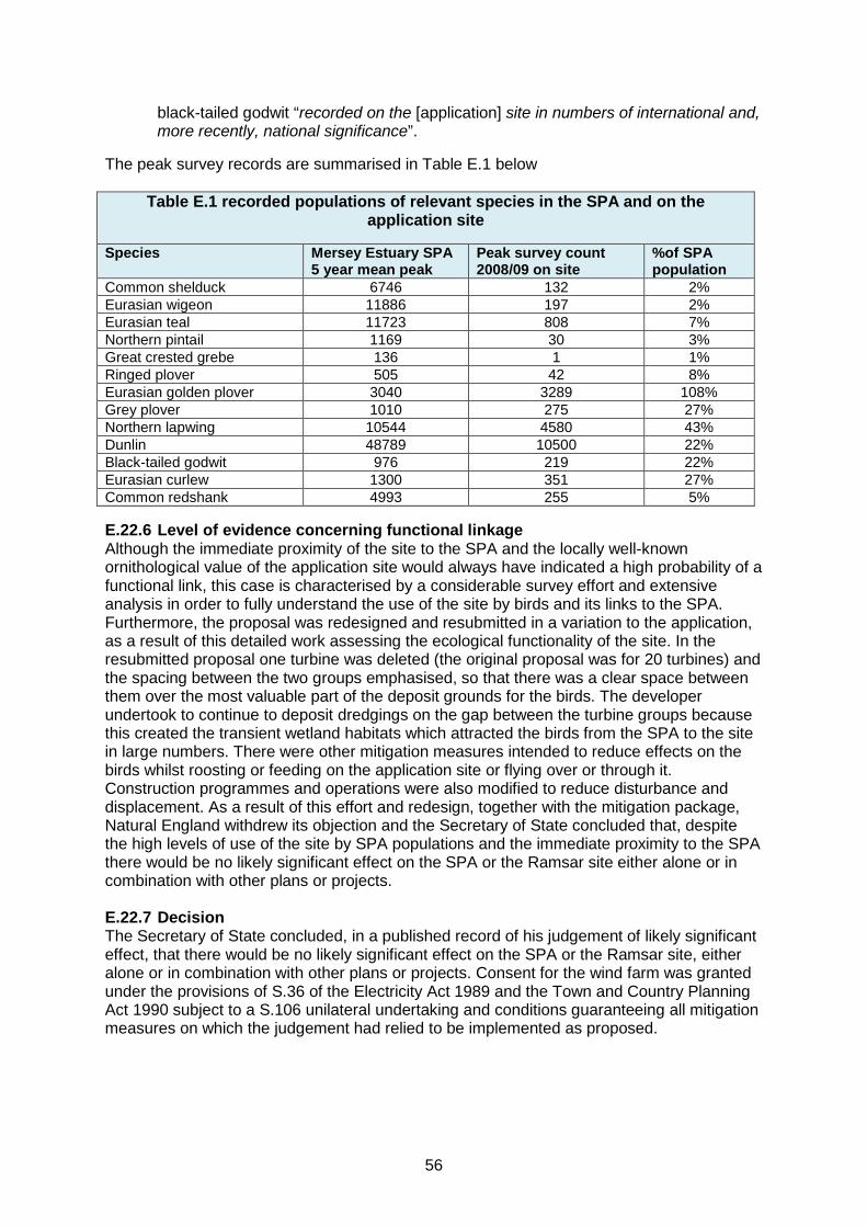
black-tailed godwit “recorded on the [application] site in numbers of international and, more recently, national significance”.
The peak survey records are summarised in Table E.1 below
Table E.1 recorded populations of relevant species in the SPA and on the application site
Species Mersey Estuary SPA 5 year mean peak
Peak survey count 2008/09 on site
%of SPA population
Common shelduck 6746 132 2% Eurasian wigeon 11886 197 2% Eurasian teal 11723 808 7% Northern pintail 1169 30 3% Great crested grebe 136 1 1% Ringed plover 505 42 8% Eurasian golden plover 3040 3289 108% Grey plover 1010 275 27% Northern lapwing 10544 4580 43% Dunlin 48789 10500 22% Black-tailed godwit 976 219 22% Eurasian curlew 1300 351 27% Common redshank 4993 255 5%
E.22.6 Level of evidence concerning functional linkage Although the immediate proximity of the site to the SPA and the locally well-known ornithological value of the application site would always have indicated a high probability of a functional link, this case is characterised by a considerable survey effort and extensive analysis in order to fully understand the use of the site by birds and its links to the SPA. Furthermore, the proposal was redesigned and resubmitted in a variation to the application, as a result of this detailed work assessing the ecological functionality of the site. In the resubmitted proposal one turbine was deleted (the original proposal was for 20 turbines) and the spacing between the two groups emphasised, so that there was a clear space between them over the most valuable part of the deposit grounds for the birds. The developer undertook to continue to deposit dredgings on the gap between the turbine groups because this created the transient wetland habitats which attracted the birds from the SPA to the site in large numbers. There were other mitigation measures intended to reduce effects on the birds whilst roosting or feeding on the application site or flying over or through it. Construction programmes and operations were also modified to reduce disturbance and displacement. As a result of this effort and redesign, together with the mitigation package, Natural England withdrew its objection and the Secretary of State concluded that, despite the high levels of use of the site by SPA populations and the immediate proximity to the SPA there would be no likely significant effect on the SPA or the Ramsar site either alone or in combination with other plans or projects. E.22.7 Decision The Secretary of State concluded, in a published record of his judgement of likely significant effect, that there would be no likely significant effect on the SPA or the Ramsar site, either alone or in combination with other plans or projects. Consent for the wind farm was granted under the provisions of S.36 of the Electricity Act 1989 and the Town and Country Planning Act 1990 subject to a S.106 unilateral undertaking and conditions guaranteeing all mitigation measures on which the judgement had relied to be implemented as proposed.
56

E.23 Portsmouth Stadium E.23.1 Description of development The proposed development of a football stadium with associated retail and leisure facilities and railway station. E.23.2 Location The proposed development site was on land off Eastern Road in Farlington, Portsmouth. E.23.3 Date of decision 14th December 1994. E.23.4 Decision maker Secretary of State for Environment (decision issued by Government Office for the South East) - planning permission that had been called in was refused. E.23.5 Designated site and nature of functional linkage The proposed development site was located in close proximity (within 1km) to the Chichester and Langstone Harbours SPA and Ramsar site. Paragraph 5 of the decision letter stated: “Regarding nature conservation interests, the Minister of State notes, in particular, that the site is a prime winter feeding ground for nationally and occasionally internationally important numbers of birds, which roost in the Langstone Harbours SPA. He further notes the Inspector’s concern that other existing or potential feeding grounds would not compensate for the loss of habitat due to the proposed development, and agrees that, although the site is outside the Special Protection Area, this raises questions about compliance with international obligations...” E.23.6 Level of evidence concerning functional linkage The documentation available in respect of this decision is limited and there is little reference to the evidence concerning the functional linkage. However, it was accepted that the site is a ‘prime winter feeding ground’ and it is assumed that this was therefore supported by some supporting survey evidence. For example, paragraph 12.4 of the Inspector’s Report stated that the development site was prime winter feeding ground for over a tenth of the dark-bellied brent geese for which the site was classified. With reference to the functionally linked land, the Inspector’s report went on to note that “the development would entail a destruction of part of this habitat, reducing its capacity by at least half”. E.23.7 Decision With reference to the effects of the development on the SPA, the Inspector’s report concluded at paragraph 12.18 that “I still regard the loss of prime winter feeding ground for over a tenth of the brent geese which roost in the internationally important protected area as a matter of grave importance”. The Secretary of State decision letter accepted the Inspector’s conclusions and recommendations and refused planning permission (paragraph 14 Secretary of State decision letter).
57

Decisions by a Planning Inspector
E.24 Lemonford Caravan Park E.24.1 Description of development An appeal against a refusal to grant planning permission for up to 25 dwellings at Lemonford Caravan Park in Bickington, Newton Abbot, Devon. E.24.2 Location The site is on land sloping towards the River Lemon which formed part of an existing holiday caravan and camping site. It lay to the west of a cluster of dwellings enclosed by the settlement limit for Bickington. E.24.3 Date of decision 6th March 2014. E.24.4 Decision maker A Planning Inspector Appeal reference APP/P1133/A/13/2209715. E.24.5 Designated site and nature of functional linkage The appeal decision states at paragraph 23 that “The appeal site is within a strategic flyway for the Greater Horseshoe Bat population, the existence of which is the special interest addressed by the designation of the South Hams SAC. Moreover, on the face of it, the location, where flyways between the roosts at Chudleigh, the Haytor and Smallacombe mines and Buckfastleigh coincide appears, potentially, to be a de facto ‘pinch point’ in the network; in other words a situation where the network is significantly restricted by limited opportunities to commute due to urban encroachment or other habitat limiting reason”. E.24.6 Level of evidence concerning functional linkage Paragraph 23 of the appeal decision continues “The habits of this species are complex and seasonally varied according to the availability of their particular prey and the mating and maternity cycle. The bats require a more than usually dark environment and linear features in the landscape to move through it between roosts and foraging areas and the three hours after sunset are, according to the relevant guidance, hours of peak activity. They are therefore especially susceptible to the impact of artificial lighting and are dependent, moreover, on linear features such as vegetated water courses, exemplified at the appeal site by the tree lined banks of the River Lemon”. Paragraph 24 identified the need for a “series of bat surveys to be conducted” but the appellant had argued that an assessment of existing and likely GHB habitat by a suitably qualified ecologist, as referred to in relevant guidance relating to minor proposed developments should suffice in this instance. A further ecological report was submitted by the appellant but the Inspector regarded this report as mainly promoting “the view that surveys of the type advocated by Natural England are not necessary as a number of mitigation measures could be secured by condition and linear features, including not only the River Lemon and its associated vegetation but also hedgerow boundaries to the overall site would remain undisturbed”. It is clear from paragraph 25 of the appeal decision that there was disagreement between the approach to be taken regarding the bats; the appellant’s consultant ecologist suggested that a series of mitigating measures, including setback from the river beyond the area currently used for tents and touring caravans, together with a general lack of destruction of other linear features such as hedgerows would provide the necessary reassurance. The
58

Council’s adviser had advocated a more cautious approach in line with reservations which had been expressed by Natural England. E.24.7 Decision The Inspector’s conclusions on the matter provide helpful insight into the level of evidence required, once a credible risk had been established. Paragraphs 26 – 29 are provided in full below with added emphasis. “26. I have considered the matter carefully, both from a statutory and a practical point of view, taking account of the differing expert opinion presented. It seems to me that Appropriate Assessment under the Habitats Regulations, which are engaged by the presence of a European site and potentially harmful impacts upon it, demands, as a general principle, adequate survey information relevant to the species and habitat potentially threatened. In this case the species is an inevitably mysterious creature whose habits, requirements and sensitivities are generally understood but whose presence within and habitual use of a putative flyway, such as that within which the appeal site is situated, cannot be well understood, or robustly addressed in terms of mitigation in the absence of specialised survey information. The relevant guidance attempts to balance the need for adequate information, both as to existing baseline conditions and likely future conditions after mitigation, to avoid excessively onerous survey requirements, notably by classifying certain developments as minor. However, in view of the various ‘tests’ set out in the relevant guidance I am not persuaded that, in principle, no specialised surveys are required. Within the context of the flyways, the development proposed is clearly significant with the potential to be harmfully disruptive. 27. In practical terms it seems an easy assumption that the removal of camping and caravanning activities from alongside what would appear to be the obvious commuting route for the bats and its dedication to open space use would actually improve matters and that alternative routes including hedgerow boundaries could be used also if left intact. However, in practical terms the use of the appeal site as a whole would be changed from essentially an open field with camping and caravanning pitches (which of course have the potential for some light disturbance of varying significance as different occupiers utilise the pitches) to a permanent form of built development with the potential that introduces for artificial light from windows in addition to external lighting, both of public and private spaces. While external lighting could be largely controlled by planning condition the impact of window light, which, on a cumulative basis, can be significant and persistent in housing areas, would rely primarily on design and positioning of individual dwellings. Any scheme of details for approval would need to be informed not only by the possibility of significant use of the River Lemon corridor, but also by the possibility that the species might, as an alternative, utilise other linear features impinging on the site. 28. Bearing such considerations in mind I am inclined to the view that the approach advocated by the appellant in this instance is essentially informed guesswork. In many situations that would arguably be sufficient in that the balance of probability may inform decision taking. However, the South Hams SAC is self-evidently an important area in biodiversity terms and its functionality in terms of the strategic flyways is clearly fundamental to its integrity as habitat, as evidenced by the specific initiative of Natural England in creating the relevant guidance. Once it is compromised, notwithstanding nature’s inherent adaptability, the resultant harm to the habitat would be effectively permanent. The best safeguard is adequately detailed information about the interaction of the species with any particular site proposed for development and in this case that information is simply not available. In all the circumstances I therefore prefer the cautious approach advocated by Natural England and the Council to the simpler stance of the appellant. Although this is based on professional assumptions which, at face value, seem reasonable, the underlying lack of specific information about the manner in which the site is actually used by the Greater
59

Horseshoe Bat militates against the robustness of conclusion that is in this instance required. 29. All in all I cannot conclude with certainty that the interests of biodiversity would not be unacceptably harmed or that the mooted mitigation measures would in practice be sufficiently effective, and this must clearly weigh heavily against the proposal as currently presented. Appropriate assessment cannot, in my view, be adequately undertaken on the basis of the information to hand.” In essence therefore, having set out a thorough and considered view of the evidence available at the time of the appeal, the Inspector:
a) correctly identified that the proposed development is ‘significant’ with the potential to be ‘harmfully disruptive’;
b) clearly accepted the functionality of the flyways as being fundamental to the integrity of the SAC; and
c) concluded that the lack of specific information regarding the use of the appeal site prevented a conclusion that the interests of the SAC would not be harmed or that the mitigation measures would be sufficiently effective in practice.
Of relevance to this case, there is nothing in the decision to suggest that the development would have been unacceptable if there had been further detailed survey work available. It was the lack of sufficient survey information upon which to make an informed assessment of the potential effects upon the SAC which was at issue.
E.25 Parkhead Farm E.25.1 Description of development An appeal against the refusal of planning permission for the erection of four wind turbines and associated infrastructure and services including site roads, crane pads, substation control building and a temporary construction compound. E.25.2 Location The proposed development site covered approximately 76 hectares of land at Parkhead Farm, approximately 3km south east of Silloth within the Borough of Allerdale. E.25.3 Date of decision 11th May 2009. E.25.4 Decision maker A Planning Inspector Appeal reference APP/G0908/A/08/2073524. E.25.5 Designated site and nature of functional linkage This site is included by way of contrast with case E.22 (Frodsham on shore wind farm), because here only one species was at issue and the mitigation measures took a different form involving land both outside the SPA and outside the area of the development. Natural England and the RSPB initially raised objections on the basis of concerns over the potential effects upon the Upper Solway Flats and Marshes SPA and specifically the impact on pink-footed geese through the risk of collision and loss of feeding habitat. The proposed windfarm was located approximately 5km from the area of the SPA used by the birds. E.25.6 Level of evidence concerning functional linkage Surveys had revealed a mean rate of 43.7 geese per hour flying through the windfarm area during the autumn migration, with 38% of flocks being at rotor height.
60

Following negotiations between the appellant, Natural England and the RSPB, agreement was reached regarding appropriate mitigation measures and a S.106 unilateral undertaking was produced which “makes provision for a refuge for pink-footed geese, and its future management, in the event that planning permission is granted” (paragraph 70 of the appeal decision). This included an alternative, improved feeding source nearby, also outside the SPA, in effect creating or enhancing an additional functionally linked area of land for the SPA population. In a letter to the Planning Inspector dated 30th January 2009, Natural England provided further details regarding the proposed mitigation and noted that the “establishment of a reserve and the implementation of the appropriate management will take place before the construction of the windfarm commences”, the letter continues: “The consequence of these provisions will be a reduction in the risk posed by the development to the pink-footed geese population, such that it no longer constitutes a risk to the designated site. Accordingly, our advice can be revised. With the adoption of the s106 agreement Natural England are of the opinion that the development no longer poses a likely significant threat to the integrity of the Upper Solway Flats and Marshes SPA. Consequently, there is no need for ‘Appropriate Assessment’ in accordance with the Habitats Regulations.” E.25.7 Decision Natural England and the RSPB withdrew their objections to the proposal shortly before the Inquiry. The Inspector concluded at paragraph 71 that “The UU is sufficient to ameliorate any harm to pink-footed geese that might result from the proposal”. Planning permission was granted by the Inspector following a local public inquiry, but neither Natural England nor the RSPB were objectors at the Inquiry.
61