Freshwater Key Biodiversity Areas in CanadaFreshwater Key Biodiversity Areas in Canada Marcelo F....
52
Freshwater Key Biodiversity Areas in Canada Marcelo F. Tognelli, Laura Máiz-Tomé, Dan Kraus, Dwayne Lepitzki, Gerry Mackie, Todd Morris, Joseph Carney, Noel Alfonso, Bill Tonn, Neil A. Cox, Kevin G. Smith Informing species conservation and development planning in freshwater ecosystems Internationial Union for Conservation of Nature
Transcript of Freshwater Key Biodiversity Areas in CanadaFreshwater Key Biodiversity Areas in Canada Marcelo F....

Freshwater Key Biodiversity Areas in Canada
Marcelo F. Tognelli, Laura Máiz-Tomé, Dan Kraus, Dwayne Lepitzki, Gerry Mackie, Todd Morris, Joseph Carney, Noel Alfonso, Bill Tonn, Neil A. Cox, Kevin G. Smith
Informing species conservation and development planning in freshwater ecosystems
Internationial Union for Conservation of Nature


Freshwater Key Biodiversity Areas in Canada
Marcelo F. Tognelli, Laura Máiz-Tomé, Dan Kraus, Dwayne Lepitzki, Gerry Mackie, Todd Morris, Joseph Carney, Noel Alfonso, Bill Tonn, Neil A. Cox, Kevin G. Smith
Informing species conservation and development planning in freshwater ecosystems

The designation of geographical entities in this book and the presentation of the material, do not imply the expression of any opinion whatsoever on the part of IUCN or other participating organizations concerning the legal status of any country, territory or area, or its authorities, or concerning the delimitation of its frontiers or boundaries.
The views expressed in this report do not necessarily reflect those of IUCN, or other participating organizations.
Published by: IUCN, Gland Switzerland, Cambridge, UK and Arlington, USA.
Copyright: © 2017 International Union for Conservation of Nature and Natural Resources
Reproduction of this publication for educational and other non-commercial purposes is authorized without prior written permission from the copyright holder provided the sources are fully acknowledged.
Reproduction of this publication for resale or other commercial purposes is prohibited without prior written permission of the copyright holder.
Citation: Tognelli, M.F., Máiz-Tomé, L., Kraus, D., Lepitzki, D., Mackie, G., Morris, T., Carney, J., Alfonso, N., Tonn, B., Cox, N.A. and Smith, K.A. (2017) Freshwater Key Biodiversity Areas in Canada. Informing species conservation and development planning in freshwater ecosystems. Gland, Switzerland, Cambridge, UK and Arlington, USA: IUCN. vi + 42pp.
Edited by: Marcelo Tognelli IUCN-CI Biodiversity Assessment Unit, U.S.A. Laura Maíz-Tomé IUCN Global Species Programme, United Kingdom Dan Kraus Nature Conservancy of Canada, Canada Dwayne Lepitzki Committee on the Status of Endangered Wildlife in Canada Gerry Mackie University of Guelph, Canada Todd Morris Fisheries and Oceans Canada, Canada Joseph Carney Lakehead University, Canada Noel Alfonso Canadian Museum of Nature, Canada Bill Tonn University of Alberta, Canada Neil Cox IUCN-CI Biodiversity Assessment Unit, U.S.A. Kevin Smith IUCN Global Species Programme, United Kingdom
Reviewers: Ian Harrison Conservation International, U.S.A. Justina Ray Wildlife Conservation Society, Canada
ISBN: 978-2-8317-1870-5 (print) 978-2-8317-1871-2 (PDF)
DOI: https://doi.org/10.2305/IUCN.CH.2017.16.en
Cover photo: Northern riffleshell Epioblasma torulosa rangiana. © Todd Morris
All the photographs used in this publication remain the property of the original copyright holder (see individual captions for details). Photographs should not be reproduced or used in other contexts without written permission from the copyright holder.
Layout: Chadi Abi Faraj ([email protected])
Printed by: Harris Plus (www.harrisplus.com)
Available from: IUCN (International Union for Conservation of Nature) Rue Mauverney 28 1196 Gland, Switzerland Tel +41 22 999 0000 www.iucn.org/resources/publications

iiiiii
Table of ContentsAcknowledgements ..........................................................................................................................................
Executive summary ..........................................................................................................................................
Background ......................................................................................................................................................
The state of freshwater biodiversity in Canada ...................................................................................
A new KBA global standard .................................................................................................................
Project objectives ................................................................................................................................
Methodology ....................................................................................................................................................
KBA criteria and thresholds .................................................................................................................
The freshwater KBA delineation process ............................................................................................
Preliminary desk analysis .................................................................................................................................
Freshwater KBA trigger species ..........................................................................................................
Stakeholder consultation workshop results .....................................................................................................
Freshwater KBAs overview .................................................................................................................
Existing KBAs/Protected Areas adopted as Freshwater KBAs ....................................................
Newly delineated KBAs ................................................................................................................
Site champions ............................................................................................................................
Conclusions and recommendations .................................................................................................................
Next steps ...........................................................................................................................................
References .......................................................................................................................................................
Annex I. Site champions ..................................................................................................................................
Annex II. Summary of the KBA criteria and thresholds ....................................................................................
iv
v
1
1
3
3
5
5
5
9
9
10
11
11
15
30
31
32
33
38
40
iviv
Freshwater Key Biodiversity Areas in Canada
AcknowledgementsIdentifying Key Biodiversity Areas in Canada relies on the willingness of dedicated experts to contribute and pool their collective knowledge. Without their enthusiastic commitment to biodiversity conservation, this work would not be possible. We would therefore like to acknowledge the committed work of the experts who participated in the KBA workshop held in Toronto, in July 2015, including: Dwayne Lepitzki, Gerry Mackie, Joseph Carney, Todd Morris, Fred Schueler, Aleta Karstad, Josef Ackerman, Dan Kraus, Joyce Gould, Bill Tonn, and Noel Alfonso. Thanks to our partners from NatureServe, Margaret Ormes for her work in the compilation of species and Shara Howie for her support during the KBA workshop. Thanks to our colleagues from IUCN Kevin Smith, Megan Glenn and Ariadne Angulo for helping with the organization and facilitation of the workshop.
We are also grateful to Ian Harrison (SSC Freshwater Conservation Subcommittee; SSC Freshwater Fish Specialist Group; WCPA Freshwater Specialist Group;
Conservation International) for assisting in the initial stages of fundraising for this project, and for providing helpful comments and edits on a draft of the final report. Many thanks also to Justina Ray (Wildlife Conservation Society Canada) for reviewing a draft of the final report and providing insightful comments and edits.
Support for this project was provided by the Mitsubishi Corporation Foundation for the Americas, which supports biodiversity conservation, sustainable development, environmental education and environmental justice throughout the Americas. This work was also partially funded by The Betty and Gordon Moore Center for Science of Conservation International to whom we are indebted.

vv
Executive SummaryWith almost 60% of all freshwater lakes in the world, Canada is a country with a great abundance of freshwater habitats. In addition to lakes and rivers, Canada also has an abundance of wetlands. These wetlands are very diverse and range from vast forested peatlands in the boreal zone to marshes and deltas in freshwater lakes to vernal pools. Canada has approximately 25% of the world’s wetlands by area. Despite an abundance of freshwater habitats, the diversity of aquatic species is lower compared to southern nations due to repeated glaciation events. Canada has 215 species and 12 subspecies of freshwater fishes, 54 species and four subspecies of freshwater mussels, over 125 species or subspecies of freshwater snails, and 819 obligate wetland plants. Overall, the highest concentration of freshwater species is in Ontario and British Columbia, as are also the highest number of threatened species, all of which are in southern part of the country.
Key Biodiversity Areas (KBAs) are areas contributing significantly to the global persistence of biodiversity. Based on published information on species conservation status and distributions (source IUCN Red List of Threatened Species), 9.4% of the 28,226 river/lake sub-catchments considered were found likely to meet the criteria qualifying them as freshwater KBAs. Subsequent evaluation of these proposed KBAs for Canada was conducted through one workshop involving 13 experts. Based on this validation workshop, 13 KBAs were confirmed by the regional experts for freshwater fishes, molluscs and aquatic plants, covering 17,707 km2. KBAs were identified by selecting the sub-catchments containing the highest number of validated trigger species. The KBAs validated through this project support 15 globally threatened species (Critically Endangered, Endangered or Vulnerable) and six geographically restricted range species. Around 78% of the total area of these freshwater KBAs was found to lie within the boundaries of pre-existing protected areas or terrestrial KBAs. However, most of these existing management units have been delineated primarily for
terrestrial species and often fail to cover and manage adequately the distribution of restricted range and threatened species living in freshwater habitats.
The primary threats to freshwater species identified across Canada, as described by the experts at the KBA workshop, are i) hydrological alterations following construction of dams; ii) water pollution from agriculture and urbanization; iii) over-abstraction of surface and ground waters; and iv) competition with invasive species. The impacts of these threats tend to spread rapidly throughout catchments, such that localized conservation actions restricted to limited parts of a catchment will often fail to provide effective solutions.
Specific recommendations for conservation actions are mainly focused on improving management of the hydrology of these KBAs, many of which are currently or potentially impacted by hydrological alteration, over-abstraction and diversion of water, and construction of dams. KBAs need to be managed to ensure environmental flows are sufficient to support these fragile freshwater ecosystems and they should be implemented as part of catchment-wide Integrated River Basin Management planning which takes account of the wide range of uses of water across all sectors. Control and/or eradication of invasive species is also crucial to reduce their impacts on the native freshwater taxa and wetland ecosystems. Periodic updates of Red List assessments and monitoring of sites will allow the production of a Red List Index to track trends in the projected overall extinction risk of freshwater species so potentially helping to inform managers on the effectiveness of any management interventions.
It is expected that the information and data provided in this report will help guide conservation actions and management, development of policies and make informed decisions regarding development activities that may impact freshwater ecosystems in Canada.

vivi
Freshwater Key Biodiversity Areas in Canada

11
Background
The state of freshwater biodiversity in Canada
Canada is a country with a great abundance of freshwater habitats, containing 60% of all freshwater lakes in the world (Messager et al. 2016). These include a large portion of the Laurentian Great Lakes, and 563 lakes larger than 100 km2 (Environment and Climate Change Canada 2013). Canada also has thousands of rivers that span forest, prairie, mountain and arctic landscapes. Many of Canada’s northern rivers are within intact watersheds and have unaltered hydrological regimes and connectivity. In total, there are approximately 2 million lakes and 2.6 million rivers mapped in Canada (Natural Resources Canada 2016), covering approximately 9% of the country (Federal, Provincial and Territorial Governments of Canada 2010) (Figure 1).
In addition to lakes and rivers, Canada also has an abundance of other inundated areas (marshes, deltas and other wetlands). A total of 37 ‘wetland’ sites (i.e. including rivers, lakes, coastal wetlands following Ramsar’s broad definition that includes rivers, lakes, inundated areas etc.) have been designated as Wetlands of International Importance (Ramsar Sites),
covering an area of 130,867 km2 (http://www.ramsar.org/wetland/canada). These wetlands are very diverse and range from vast forested peatlands in boreal ecosystems to marshes and deltas in freshwater lakes to vernal pools. Canada has approximately 25% of the world’s wetlands by area, and wetland ecosystems cover approximately 1.5 million square kilometres (equivalent to over twice the area of France) representing 16% of Canada’s total area (Federal, Provincial and Territorial Governments of Canada 2010) (Figure 1). Recently, however, wetlands have become an increasingly scarce resource in the most densely settled areas of the country. Throughout southern Canada in particular, wetlands have been adversely affected by land use practices that have resulted in vegetation destruction, nutrient and toxic loading, sedimentation, and altered flow regimes. For example, in southern Ontario, 68% of the original wetlands have been converted from their natural state to support alternative uses such as agriculture and housing. Only in the North, do most of the wetlands remain intact (Environment and Climate Change Canada 2016b).
Canada has 215 species and 12 subspecies of freshwater fishes, and 54 species and four subspecies of freshwater mussels (Rainer et al. 2017). Sixteen
Figure 1. Map depicting the main freshwater rivers and lakes in Canada.

22
Freshwater Key Biodiversity Areas in Canada
species and subspecies of freshwater fishes are nationally endemic (Rainer et al. 2017). Freshwater fishes and mussels are found throughout Canada, but species richness is generally highest in the east, a pattern that occurs across North America. The high diversity of freshwater mussels and fishes in southern Ontario, particularly in the Lake St. Clair and western Lake Erie watersheds, are a result of patterns of recolonization since the last period of glaciation and the warmer climate of southern Ontario compared to the rest of Canada, often associated with higher species diversity. Despite an abundance of freshwater habitats, the diversity of aquatic species is lower compared to southern nations due to climatic characteristics (Currie et al. 2004) and repeated glaciation events.
Other freshwater bivalves in Canada are the Sphaeriidae (Fingernail and Pill Clams). Of the 37 species of sphaeriids that occur in Canada, all belong to three genera, Sphaerium (eight species), Musculium (four species), and Pisidium (25 species). Of the 37 species, four have been introduced. The area around the Laurentian Great Lakes supports the greatest diversity, with 36 species occurring in Ontario (Mackie 2007).
A total of over 125 species or subspecies of freshwater snails are known from Canada (Lepitzki unpubl. data compiled for 2015 General Status programme): only six are found in every province and territory; with the most diversity (~81 species/subspecies) being in Ontario followed by British Columbia. The smallest province, Prince Edward Island, only has around 20 species. There are at least six known endemic snail species, found only in Canada. However, some of these are known only from their historical original descriptions and taxonomic work is required on many of these as well as the six potentially endemic snail subspecies. According to the American Fisheries Society’s Endangered Species Gastropod Subcommittee, of all the freshwater groups of animals in Canada and the United States, the freshwater snails have the largest percentage of species at risk - 74% - which exceeds the at-risk levels for fishes (39%) and crayfishes (48%) but is similar to the mussels (72%) (Johnson et al. 2013).
There are at least 819 obligate wetland plants native to Canada (including aquatic species) (USDA, NRCS 2017), representing approximately 21% of all native vascular plants (Environment and Climate Change Canada 2017). Less than one percent of these wetland obligate plants are nationally endemic.
Most of Canada’s freshwater habitats in southern Canada have been heavily modified where most (90%) of the Canadian population lives and has the most intensive agricultural land use (and longest history of land use change). It is also the region with the greatest richness of freshwater species (Chu et al. 2015). Changes to the stresses in watersheds across Canada over the past decades include an increase in crop production, petroleum manufacturers, waste facilities, dwellings, while forestry operations and discharge sites have decreased. Trends influencing freshwater biodiversity include changes in magnitude of stream flows, increases in river and lake temperatures, and habitat loss and fragmentation (Federal, Provincial and Territorial Governments of Canada 2010). There are at least 12,000 dams in the Great Lakes region alone (Canada and the US) (Great Lakes Environmental Assessment and Mapping Project n.d.), that have significantly impacted aquatic connectivity. There are also many large dams and reservoirs that have been built in northern Canada for hydro-electric power generation. A recent report on biodiversity in Canada estimated that up to 98% of the wetlands near urban centres have been lost or degraded (Federal Provincial and Territorial Governments of Canada 2010). Much of this loss has been in the southern Great Lakes/ St. Lawrence region, prairies and parts of southern British Columbia.
Changes to freshwater habitats and historic overfishing have affected many freshwater species. Canada has 12 freshwater fishes, seven mussels and five gastropods assessed as threatened (VU, EN or CR) under the IUCN Red List of Threatened Species (IUCN 2017). These fishes include five species of Coregonus that occur in the Laurentian Great Lakes and other large lakes. The dwarf wedgemussel (Alasmidonta heterodon) is now extirpated from Canada. Two freshwater plant species are on the IUCN Red List of Threatened Species (both Vulnerable): Eaton’s beggarticks (Bidens eatonii) and Ogden’s pondweed (Potamogeton ogdenii). Eight other species have been assessed as Near Threatened.
Approximately 15% of Canadian freshwater fishes and mussels are globally imperilled (Rainer et al. 2017). Six freshwater fish species and infraspecies are now extinct, half of these were nationally endemic (Rainer et al. 2017).
There are 94 taxa of freshwater fishes that have been assessed as nationally at risk that represent 62 species, 19 species of freshwater mussels and three aquatic snails (Government of Canada 2017). The number of

333
nationally at-risk species in Canada is highest in the provinces of Ontario and British Columbia.
A new KBA global standard
Over the last four decades, a range of organisations have invested in compiling information on the location of sites that are significant for biodiversity. Since the late 1970s, Birdlife International has maintained criteria for the identification of Important Bird Areas and more than 12,000 sites have been identified worldwide (Dudley et al. 2014). Building on this success, other approaches have been developed, including Important Plant Areas; Alliance for Zero Extinction (AZE) sites; Prime Butterfly Areas and KBAs identified for multiple taxonomic groups in freshwater, terrestrial and marine environments (IUCN 2014). These approaches generally focus on one group of species or one biome, and use diverse assessment criteria, which has led to some confusion among decision-makers as well as duplication of conservation efforts.
As a consequence, during the World Conservation Congress held in Bangkok (Thailand) in 2004, IUCN Members requested IUCN “to convene a worldwide consultative process to agree a methodology to enable countries to identify Key Biodiversity Areas” (IUCN 2004). In response to this Resolution (WCC 3.013; https://portals.iucn.org/library/node/44299), the IUCN Species Survival Commission and the IUCN World Commission on Protected Areas established a Joint Task Force on Biodiversity and Protected Areas which, since 2012, has mobilized expert input from IUCN Commissions, Members, Secretariat staff, conservation organizations, academics, decision-makers, donors, and the private sector to consolidate globally-agreed scientific criteria and harmonize work for identifying KBAs (IUCN 2014).
All these efforts have culminated in “A Global Standard for the Identification of KBAs”, approved by the IUCN Council during its 88th Meeting on April, 11-13, 2016 and that can be applied across taxonomic groups and all elements of biodiversity. The new standard and the data generated can support the strategic expansion of protected area networks by governments and civil society working towards the achievement of the Aichi Biodiversity Targets (in particular Targets 11 and 12), as established by the Convention on Biological Diversity; serve to inform the description or identification of sites under international conventions (such as wetlands of international importance designated under the Ramsar Convention, natural World Heritage Sites, Ecologically and Biologically Significant Areas as described under the CBD); contribute to the development of other effective area-based conservation measures (Jonas et al. 2014); inform private sector safeguard policies, environmental standards, and certification schemes; support conservation planning and priority-setting at national and regional levels; and provide local and indigenous communities with opportunities for employment, recognition, economic investment and societal mobilization (IUCN 2016).
Project objectives
The project aimed to identify freshwater Key Biodiversity Areas (KBAs) for Canada. The process leading to the identification and delineation of freshwater KBAs included: (i) collating data on the distribution, abundance, ecology, and utilization by humans, for several groups of species that are considered reliable indicators of the biological structure and functioning of freshwater ecosystems (fishes, molluscs and aquatic plants); (ii) identifying those river/lake sub-catchments holding species that appear to meet the KBA criteria; (iii) validating (through stakeholder consultations)
Key Biodiversity Areas are “sites of importance for the global persistence of biodiversity. However, this does not carry with it the requirement for specific conservation action, such as protected area designation. Such management decisions should be based on conservation priority-setting exercises, which combine data on biodiversity importance with the available information on site vulnerability and the management actions needed to safeguard the biodiversity for which the site is important. It is often desirable to incorporate other data into priority-setting, such as conservation cost, opportunity for action, importance for conserving evolutionary history and connectivity. KBAs thus do not necessarily equate to conservation priorities but are invaluable for informing systematic conservation planning and priority-setting, recognising that conservation priority actions may also be outside of KBAs” (IUCN 2016).

44
Freshwater Key Biodiversity Areas in Canada
KBAs within those sub-catchments that support sites that meet the criteria, always taking into account the hydrological connectivity of the watershed where the KBA resides and; (iv) compiling a set of additional information about each KBA to support management
of the biodiversity elements triggering the criteria; site-scale monitoring; national conservation planning and priority-setting; and global and regional analyses of KBA status.

55
MethodologyThe methodology for the identification and delineation of global freshwater KBAs in Canada followed the draft Consultation document on a Global standard for the identification of Key Biodiversity Areas (Draft 1 October 2014). While the KBA criteria and thresholds set out in the consultation document were not yet finalised, the criteria and thresholds used to identify freshwater KBAs (Holland et al. 2012) used at the KBA delineation workshop are directly transferable to the new system and, and were later verified to meet the new KBA standard.
KBA criteria and thresholds
The new global KBA criteria provide quantitative thresholds for identifying sites that contribute significantly to the global persistence of: A) Threatened biodiversity; B) Geographically restricted biodiversity; C) Ecological integrity; D) Biological processes and; E) Biodiversity through comprehensive quantitative analysis of irreplaceability (IUCN 2016; Appendix III).
Although the KBA criteria incorporate elements of biodiversity across genetic, species and ecosystem levels, in this report we focused on species. Thus, not all the criteria are applicable or relevant for the freshwater taxonomic groups considered at the workshop (e.g., not all taxonomic groups have species that aggregate), meeting any one of the criteria (or sub-criteria) is enough for a site to be considered for qualification as a KBA. Species meeting the KBA thresholds and criteria are defined as KBA trigger species. Given our focus on species, criteria C (ecological integrity) and E (irreplaceability through quantitative analysis) were not considered in the analysis. The criteria and thresholds employed in this project are summarized in Table 1.
The freshwater KBA delineation process
The identification and delineation of freshwater KBAs in Canada followed a two-step process:
A1: Threatened Biodiversity
(b) Site regularly holds ≥0.5% of the global population AND ≥5 functional reproductive units of a globally Crit-ically Endangered (CR) or Endangered (EN) taxon; OR
(c) Site regularly holds ≥1% of the global population AND ≥10 functional reproductive units of a globally Vul-nerable (VU) taxon.
B1: Individually Geographically restricted species.
A site regularly holds ≥10% of the global population size/extent of any species.
B2: Co-occurring geographically restricted species.
A site regularly holds ≥1% of the global population/extent of two or more ‘restricted range’ species; OR
0.02% of total number of species in a taxonomic group, whichever is larger.
B3: Geographically restricted assemblages.
>5 ecoregion-restricted species; OR
10% of the species restricted to the ecoregion, whichever is larger.
D1: Demographic Aggregations.
� Species aggregation during one or more key stages of its life cycle (% global pop. Size ≥1%).
Table 1. Selected KBA criteria considered for the delineation of Freshwater KBAs in Canada based on data availability and suitability for freshwater taxonomic groups (IUCN 2016).

66
Freshwater Key Biodiversity Areas in Canada
Stage 1. Desk-based activities in preparation for a stakeholder KBA validation workshop:The first step of the process was a primarily desktop analysis of data collated through IUCN Red List assessments for the following freshwater taxonomic groups: i) fishes, ii) molluscs; and iii) aquatic plants. The dragonflies and damselflies were not included in the analysis because there were no trigger species. The data sets collected include the required information on species distributions (digital shape files) and their IUCN Red List Categories of extinction risk as published on the IUCN Red List (http://www.iucnredlist.org).
a. Assemble spatial data sets of:i. Freshwater biodiversity Red List
distribution maps of fishes, molluscs and aquatic plants;
ii. Existing KBAs, Ramsar sites and Protected Areas.
KBA delineation is an iterative process that makes use of better and more recent data as they become available (IUCN 2016). In this way, data are traceable to a reliable source and sufficiently recent (and updated) to give confidence that the biodiversity elements are still present at the site.
b. Derive proposed site boundaries based on biological data
Using the species distribution maps assembled in Stage 1a above all river/lake sub-catchments
in Canada that contain KBA trigger species were identified. River/lake sub-catchments were delineated according to the spatial data layer called HydroBASINS (Lehner and Grill 2013). HydroBASINS (http://hydrosheds.org/page/hydrobasins) is a global standardized hydrological framework that delineates catchments at 12 resolutions and includes information on network hydrological connectivity. This global catchment delineation was customized for IUCN as a modification of the existing HydroSHEDS data (Lehner et al. 2008) (http://hydrosheds.org) to include lake polygons from the Global Lakes and Wetlands Database (GLWD; Lehner and Doll 2004).
The resolution used for selecting the sub-catchments holding KBA trigger species was HydroBASINS Level 8, which in North America have an average surface area of 616 km2. In this way, maps were created to show all sub-catchments containing trigger species, showing the numbers of potential trigger species per sub-catchment. Lists of potential trigger species thought to be present in each sub-catchment were also compiled. This process was achieved through a screening of all sub-catchments against the full complement of species maps using “R” scripts, a free software for statistical computing and data analysis (Venables et al. 2017), to identify the trigger species present and the criteria triggered for each sub-catchment.
During the analysis those sites that potentially qualified as Alliance for Zero Extinction (AZE) sites were also identified. AZEs sites are places that contain the last
Expert participants at the Freshwater KBA workshop, July 2015 –Toronto, Canada. © Megan Glenn

77
or only populations of globally Critically Endangered or Endangered species almost entirely restricted to that single remaining site (Ricketts et al. 2005). http://www.zeroextinction.org
Stage 2. Stakeholder validation and delineation workshop.A stakeholder KBA validation and delineation workshop was held in Toronto in July 2015 in collaboration with the relevant species experts, Conservation NGOs and Government representatives from Canada. The aim of the KBA delineation workshop was to derive site boundaries that are biologically relevant yet practical for management (IUCN 2016). Workshop participants were asked to confirm the presence of the trigger species within those sub-catchments identified through Stage 1 (desk analysis) and delineate KBA boundaries according to the following procedures:
a. Delineation with respect to existing sites of importance for biodiversity.
Wherever possible, identification and delineation of KBAs for new biodiversity elements should take into consideration the boundaries of existing terrestrial KBAs, IBAs, IPAs or AZE sites, because many have national recognition, active conservation and monitoring initiatives, and/or are linked to international, national, regional legislative and policy processes (IUCN 2016). Thus, where freshwater trigger species are present in sub-catchments overlapping existing sites the boundary of the existing site should be adopted if:
� The site contains enough of the new element (KBA trigger species in this case) to meet the threshold of significance; and
� The boundary is ecologically relevant for the freshwater species.
When the freshwater trigger species partially overlap an existing site (IBA, KBA, IPA, etc.), there are generally three options: i) disregard the area of overlap (if trivial); ii) adopt the site boundary if the KBA is found fully within the existing site; or iii) delineate a second KBA covering the portion of the biodiversity element outside the site area, assuming both areas meet the thresholds of significance, and recommend an extension to the existing site boundary
a. Delineation with respect to protected areas
Many protected areas are recognized management units with the goal of safeguarding the biodiversity
contained within them, and the additional recognition of the site as a KBA, using the existing boundaries, helps to consolidate the importance of these management units. Therefore, when a freshwater trigger species falls within a sub-catchment overlapping an existing Protected Area it is often advisable to use the protected area boundary to delineate the KBA if:
� The Protected Area contains enough of the new element (KBA trigger species in this case) to meet the threshold of significance; and
� The boundary is ecologically relevant for the freshwater species.
It is important to highlight however, that regional-scale assessments of the coverage and effectiveness of protected areas have shown that protected areas are largely ineffective for conserving freshwater habitats and species (Leadley et al. 2014). For example, rivers have often been used to delineate the borders of protected areas rather than being the targets of conservation themselves (Abell et al. 2007). When freshwater KBAs are covered by protected areas, these often lack target management actions for freshwater biodiversity and fail in dealing with pressures expanding from outside the protected area boundaries. Therefore, when the freshwater trigger species partially overlap an existing site there are generally three options: i) disregard the area of overlap (if trivial); ii) adopt the PA boundary if the KBA is found fully within the PA; or iii) delineate a second KBA covering the portion of the biodiversity element outside the protected area, assuming both areas meet the thresholds of significance, and recommend an extension to the PA boundary. The appropriate option will typically depend on how much of an overlap there is and the feasibility of modifying an existing PA boundary.
b. Delineation of new KBAs based on species Focal Areas
When there is no spatial overlap between the proposed freshwater KBA and existing KBAs or Protected Areas, freshwater KBA boundaries should be based on the distribution of focal areas identified for trigger species (if the focal area meets the KBA thresholds and criteria). Focal Areas are distinct sites (e.g. headwaters, lakes, springs, etc.) of particular importance for the long-term survival of freshwater biodiversity (e.g. sites containing species spawning areas, feeding areas, or the majority of the population of a species etc.) (See Abell et al. 2007; Holland et al. 2012). It is recommended where possible, to

88
Freshwater Key Biodiversity Areas in Canada
delineate Focal Areas using HydroBasins Level 12 sub-catchments (highest resolution).
The new KBA standard acknowledges that when delineating sites that fall outside existing KBAs and protected areas, it is often necessary to incorporate other data on land/water management and catchments boundaries to derive practical site boundaries (IUCN 2016). In the case of freshwater KBAs, using sub-catchments to delineate site boundaries provides clear benefits as they represent well defined and ecologically meaningful units that are manageable, they facilitate ease of data storage, search and management (tabular format), account for hydrological connectivity, facilitate input to conservation planning software such as Marxan, and can be flexibly applied at 12 different grain sizes, the smallest being approximately 10 km2.
For some species, the inherent connectivity of aquatic systems presents challenges for site delineation. Many aquatic species are highly mobile and widespread across the catchment (e.g., migratory fish species such as sturgeons) and may not occur at identifiable sites in globally significant populations. For many, the threats to freshwater stem from the land, and the freshwater system is part of a broader ecosystem. These types of species may not benefit from a KBA delineation and site scale conservation but from a wider integrated catchment management approach.
c. Complete minimum documentation requirements for each KBA
At the workshop, participants were also asked to complete some minimum documentation requirements for each associated KBA including a site description, the list of validated trigger species, current and potential threats, habitat types, ecosystem services, potential site champions and conservation actions in place and recommended. This information supports and justifies the identification of a site as a KBA and guides management of the biodiversity elements triggering the criteria; site-scale monitoring; national conservation planning and priority-setting; and global and regional analyses of KBA status. Information on the associated larger sub-catchments within which the KBAs are located was also retained as a separate shape file layer named ‘Catchment Management Zones’ (CMZs) to provide important additional information on the wider hydrological context and the integrated basin-management requirements for the sub-catchments within which the KBAs reside. It is intended that the KBA and its associated CMZ be used in conjunction in order to better inform implementation of suitable management actions that ensure conservation of the species in the KBAs while taking into account hydrological connectivity and the rapid and far reaching spread of threats from beyond the KBA itself.
99
Preliminary desk analysis
Freshwater KBA trigger species
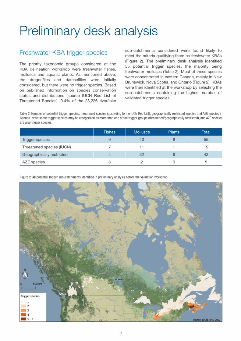
The priority taxonomic groups considered at the KBA delineation workshop were freshwater fishes, molluscs and aquatic plants. As mentioned above, the dragonflies and damselflies were initially considered, but there were no trigger species. Based on published information on species conservation status and distributions (source IUCN Red List of Threatened Species), 9.4% of the 28,226 river/lake
sub-catchments considered were found likely to meet the criteria qualifying them as freshwater KBAs (Figure 2). The preliminary desk analysis identified 55 potential trigger species, the majority being freshwater molluscs (Table 2). Most of these species were concentrated in eastern Canada, mainly in New Brunswick, Nova Scotia, and Ontario (Figure 2). KBAs were then identified at the workshop by selecting the sub-catchments containing the highest number of validated trigger species.
Table 2. Number of potential trigger species, threatened species (according to the IUCN Red List), geographically restricted species and AZE species in Canada. Note: some trigger species may be categorized as more than one of the trigger groups (threatened/geographically restricted), and AZE species are also trigger species.
Figure 2. All potential trigger sub-catchments identified in preliminary analysis before the validation workshop.
Fishes Molluscs Plants Total
Trigger species 9 40 6 55
Threatened species (IUCN) 7 11 1 19
Geographically restricted 4 32 6 42
AZE species 3 2 0 5

1010
Freshwater Key Biodiversity Areas in Canada
Stakeholder consultation workshop resultsOf all potential trigger species identified in the preliminary analysis, only 16 species were validated by the experts during the workshop, meaning that their presence was confirmed within the sub-catchments of interest, at thresholds that met the KBA criteria (Table 3). For the freshwater mussel Alasmidonta varicosa (VU), which was preliminary identified as a trigger species, there is not enough information regarding its population, distribution and relative abundance
(Akaishi F. pers. comm. 2016) to identify and delineate a KBA. However, a management plan is under way for this species and, if population data become available, KBA identification might be revisited for this species.The 13 KBAs delineated and validated at the workshop cover approximately 0.18% of the country’s area and support 15 globally threatened species (Critically Endangered, Endangered or Vulnerable), and six geographically restricted range species(Table 3).
Table 3. Validated trigger species and qualifying KBA criteria. (*) Freshwater KBAs having no spatial overlap with existing PAs/Terrestrial KBAs. CMZ = Catchment Management Zone name. KBA = Freshwater Key Biodiversity Area name. Trigger Species = Freshwater species meeting the KBA Criteria. RL Cat = Red List Category. A1a = Globally Threatened Species (Critically Endangered, Endangered) with ≥ 0.5% global population. A1b = Globally Threatened Species (Vulnerable) with ≥ 1% global population. A1e = Globally Threatened Species (Critically Endangered, Endangered) with entire global population. B1 = Individually geographically restricted species.
CMZ KBA Trigger Species
Group RL Cat
A1a A1b A1e B1
Ausable River *Ausable River Epioblasma torulosa
Molluscs CR Yes No No No
Ausable River *Ausable River Epioblasma triquetra
Molluscs EN Yes No No No
Banff National Park Banff Hot Springs
Physella johnsoni
Molluscs CR Yes No Yes Yes
Annapolis River, Digby Bay catchment and Digby Neck and Brier Island
*Brier Island Geum peckii Plants NA No No No Yes
Sydenham River *East Sydenham River
Epioblasma torulosa
Molluscs CR Yes No No No
Sydenham River *East Sydenham River
Epioblasma triquetra
Molluscs EN Yes No No No
Sydenham River *East Sydenham River
Obovaria subrotunda
Molluscs EN Yes No No No
Sydenham River *East Sydenham River
Simpsonaias ambigua
Molluscs VU No Yes No No
Sydenham River *East Sydenham River
Villosa fabalis Molluscs EN Yes No No No
Eastern Lake St Clair Eastern Lake St Clair
Ligumia nasuta
Molluscs VU No Yes No No
Eastern Lake St Clair Eastern Lake St Clair
Obovaria subrotunda
Molluscs EN Yes No No No

1111
CMZ KBA Trigger Species
Group RL Cat
A1a A1b A1e B1
Petite Rivière *Hebb, Milipsigate and Minamkeak Lakes
Coregonus huntsmani
Fishes CR Yes No Yes No
Lake Superior Lake Superior Marine Conservation Area
Coregonus kiyi
Fishes VU No Yes No No
Cowichan River *Lakes Cowichan and Mesachie
Entosphenus macrostoma
Fishes EN Yes No Yes Yes
Liard River Hot Springs
Liard River Hot Springs
Physella wrighti
Molluscs CR Yes No Yes Yes
St John River Lower Saint John
Lampsilis cariosa
Molluscs VU No Yes No No
Lower Saint Lawrence River
*Lower Saint Lawrence River
Bidens eatonii
Plants VU No Yes No Yes
Okanagan Lake *Okanagan Lake Gonidea angulata
Molluscs VU No Yes No No
Middle Saint Lawrence River
*Richelieu River Moxostoma hubbsi
Fishes EN Yes No No No
Freshwater KBAs overview
Existing KBAs/Protected Areas adopted as Freshwater KBAsThe following Freshwater KBAs have been delineated, adopting the boundaries of existing Protected Areas or terrestrial KBAs, based on the presence of freshwater KBA trigger species:
Lake Superior Marine Conservation Area, Ontario Lake Superior is the largest, deep oligotrophic lake of North America with a surface area of 82,103 km2. The lake is surrounded by forested areas and fed by numerous rivers and tributaries. The existing Lake Superior Marine Conservation Area, established in 2015 on the north shore of the lake in the Province of Ontario, is one of the largest freshwater protected areas in the world and its boundary has been adopted as a Key Biodiversity Area for the vulnerable fish kiyi (Coregonus kiyi) (Figure 3).
The kiyi is a deepwater cisco, a whitefish of the family Salmonidae. This species, was formerly widespread in the Great Lakes region, but is now restricted to Lake Superior where it dwells at depths of about 100-180 meters (Fisheries and Oceans Canada
2016c). The species has been classed as Vulnerable by NatureServe (2011) and designated as species of Special Concern by the Committee on the Status of Endangered Wildlife in Canada (COSEWIC) based on its loss from Lake Huron and Lake Michigan in the U.S., which has limited its range to the Lake Superior only.
It is estimated that the existing Conservation Area supports more than 10% of the global population size of this threatened species. The site extends from Thunder Cape at the tip of Sleeping Giant Provincial Park in the west, to Bottle Point just east of Terrace Bay, and out to the Canada-US border. It includes the waters of Black Bay and Nipigon Bay, and encompasses over 10,000 km2 of lakebed and overlying waters, as well as islands, shoals and some mainland (Parks Canada 2017).
The main threats to this freshwater whitefish are posed by commercial fishing and competition and predation from exotic invasive species such as the alewife (Alosa pseudoharengus) and the smelt (Osmerus mordax). Water pollution and nutrient loading caused by urban developments, farming, mining and logging activities also contribute to the decline of this species through

1212
Freshwater Key Biodiversity Areas in Canada
habitat loss and degradation (Fisheries and Oceans Canada 2016c). Climate change is also expected to have significant effects on the aquatic communities through processes such as rising water temperature, falling water levels, shifts in predator-prey dynamics, and emergence of diseases (Jones et al. 2006).
A management plan for the kiyi in the Upper Great Lakes in Canada was developed in 2016 by Fisheries and Oceans Canada under the Species at Risk Act (SARA) in cooperation and consultation with all relevant stakeholders. The plan includes monitoring and assessment to better understand the species population dynamics and ecology; collaborative management; site protection; restoration activities; outreach and communication (Fisheries and Oceans Canada 2016c). In addition, continuing regulation of the fisheries activities and invasive species management are recommended to contribute to the long-term persistence of this vulnerable KBA trigger species.
Lower Saint John, New BrunswickThe Saint John River is the largest watershed east of the Mississippi and the St. Lawrence River. It has been
designated as a Canadian Heritage River System for its cultural value as an historic transportation route that provided European explorers with a gateway into Eastern and Upper Canada (http://chrs.ca). The central Saint John valley supports the remaining one percent of the Appalachian Hardwood Forest, typically formed by basswood and butternut trees. The river flows down the western edge of New Brunswick along the border with Quebec, discharging into the Bay of Fundy at the industrial city of Saint John. This area is under tidal influence and extensive spring flooding. The landscape is characterized by marshy islands, backwaters, creeks and marshes that extend 2 to 5 km beyond the main riverbanks.
The existing IBA Lower Saint John River (Sheffield/Jemseg) located in south-central New Brunswick has been adopted as a freshwater Key Biodiversity Area for the vulnerable yellow lampmussel (Lampsilis cariosa) (Figure 4). It is estimated that this site supports more than 1% of the global population size of this threatened freshwater bivalve usually found on level, sand and gravel bottoms of rivers, lakes and reservoirs with sparse vegetation (Sabine et al. 2004). A management plan for maintaining the existing
Figure 3. Map showing the location of the Lake Superior National Marine Conservation Area KBA and the Lake Superior Catchment Management Zone (CMZ).

1313
population of the yellow lampmussel in Canada has been developed by the Ministry of Fisheries and Oceans to reduce direct threats, maintain habitat quality, improve the understanding of the species populations in New Brunswick and Nova Scotia, maintain host fish populations and increase public awareness and involvement in conservation efforts (Fisheries and Oceans Canada 2010b).
The Lower Saint John River is also a freshwater KBA for the shortnose sturgeon (Acipenser brevirostrum) supporting aggregations representing more than 1% of the global population size of the species below the Mactaquac dam and its tributaries, where the species is suspected to spawn (COSEWIC 2015). This species is of historical, Aboriginal, commercial and ecological significance and it has been listed as Special Concern under the Species at Risk Act (SARA). A management plan for the shortnose sturgeon was developed in 2016 with the overall objective of maintaining sustainable population levels and the current distribution of the species. To achieve this objective conservation measures are outlined under three broad strategies: 1) research, monitoring and assessment; 2) protection
and management; 3) stewardship, communication and outreach (Fisheries and Oceans Canada 2015).
The main threats to these two KBA trigger species (yellow lampmussel, Lampsilis cariosa; shortnose sturgeon, Acipenser brevirostrum) are posed by water pollution and siltation caused by deforestation for intensive cranberry agriculture production, eutrophication, competition with invasive species, and habitat fragmentation by dams, which have also changed seasonal flooding and water drainage patterns (Fisheries and Oceans Canada 2010b; Fisheries and Oceans Canada 2015). Fracking is also a potential threat. The impacts of these types of threat tend to spread rapidly throughout catchments such that localized conservation actions restricted to limited parts of a catchment (i.e. lower reaches) will often fail to address these impacts. For this reason, integrated catchment management for the whole Saint John River system is recommended to account for hydrological connectivity. Habitat restoration including access to upstream stretches with construction of eel passages is also recommended.
Figure 4. Map showing the location of the Lower Saint John River (Sheffield/Jemseg) Key Biodiversity Area (KBA) and the Saint John River Catchment Management Zone (CMZ).

1414
Freshwater Key Biodiversity Areas in Canada
Eastern Lake St. Clair, OntarioLake St. Clair is a shallow mesotrophic lake located in south-western Ontario and is part of the Great Lakes system, connecting, along with the St. Clair and Detroit rivers, Lake Huron (to the north) with Lake Erie (to the south). The shoreline of the lake was an extensive belt of marsh and tall grass prairie before the European settlement in the 1800s, but as much as 90% of the coastal and inland marshes have been converted to agriculture and residential development (Environment and Climate Change Canada 2016c).
Eastern Lake St. Clair has been designated as a Wetland of International Importance (Ramsar Site 319) and a globally significant Important Bird Area (Birdlife 2017) for migratory waterbirds (Cheskey and Wilson 2001). The Eastern Lake St. Clair IBA encompasses the eastern shore, marshlands and agricultural fields from the Sydenham River at Wallaceburg to the mouth of the Thames River and the open waters of Lake St. Clair, south of the St.Clair River delta under Canadian jurisdiction (IBA Canada 2017). The boundary of the existing IBA Eastern Lake St. Clair has been adopted as the freshwater KBA boundary for two species of threatened mussels, Ligumia nasuta (VU) and Obovaria subrotunda (EN) (Figure 5) because it
contains over 1% and ≥ 0.5% of the population of the species, respectively. Historically, Ligumia nasuta was common and widely distributed in nearshore and coastal areas of the Great Lakes region, low gradient tributaries and some inland lakes (Scott et al. 2016). However, the introduction of dreissenid mussels in the late 1980s and early 1990s led to the decline of the species (Scott et al. 2016). Recent surveys have found the species at considerable abundances in coastal areas of Lake St. Clair in what may represent native mussel refuge areas (Zanatta et al. 2015). Obovaria subrotunda was historically known from western Lake Erie, Lake St. Clair and the Welland, Grand, Thames, Sydenham, and Detroit rivers (COSEWIC 2003). However, since 1996, live specimens have only been reported from the East Sydenham River and the St. Clair River delta (Fisheries and Oceans Canada 2013).
Although portions of the IBA are managed as protected areas (e.g., St. Clair and Bear Creek National Wildlife Areas, Tremblay Beach; Ruscom Shores Conservation Areas), there is still on-going loss and degradation of marsh habitat as a result of land use change (IBA Canada 2017). The main threats to freshwater
Figure 5. Map showing the location of the Eastern Lake St. Clair Key Biodiversity Area (KBA) and the Lake St. Clair Catchment Management Zone (CMZ).

1515
biodiversity include competition with invasive species, low head dams potentially threatening the tributary rivers’ flow regime and pollution by agricultural and forestry effluents (pesticides; herbicides; nutrient loading and sedimentation).
There are species specific recovery plans for both KBA trigger species (Ligumia nasuta and Obovaria subrotunda) that include the KBA (Fisheries and Oceans Canada 2013, Fisheries and Oceans Canada 2016d), and a draft recovery strategy for Walpole Island (Bowles 2005), which is part of the KBA. The main recommendations for this site include habitat protection, monitoring and management of introduced species, finalizing critical habitat designation for target species, and development of a management plan for multiple species. A conservation plan has been prepared for the site (Cheskey and Wilson 2001), but it is mostly focused on bird species.
Newly delineated KBAs
Brier Island, Nova ScotiaBrier Island is located in the Bay of Fundy at the extreme western end of Nova Scotia. The island is mostly forested with bogs and ponds in the
lower areas and its coastline supports rich marine environments with cliffs and rocky shores. Westport is the only village on the island with a local economy driven by commercial fisheries and seasonal tourism largely focused on whale watching tours.
A new freshwater Key Biodiversity Area named Brier Island has been delineated including Digby Neck and the Annapolis River in the north of the island, based on the focal area of the restricted range plant species eastern mountain avens (Geum peckii) (Figure 6). The KBA regularly supports more than 10% of the global population size of this rhizomatous perennial arctic-alpine forb, which occurs near sea-level in bog, sandy shorelines and in nearby sphagnum depressions along the sea coast where competition is low (Environment Canada 2016). The species is classed as globally ‘Imperiled’ by NatureServe (2017) while the populations in Canada are classed as ‘Critically Imperiled’. The Canadian Endangered Species Conservation Council (CESCC) also class the species as ‘At risk’ (for Canada only).
The existing Brier Island and Offshore Waters IBA (CA230), one of the most important bird areas in the Maritimes, partially overlaps with the new freshwater
Figure 6. Map showing the location of the Brier Island Key Biodiversity Area and the Annapolis River Digby Bay Catchment Management Zone (CMZ).

1616
Freshwater Key Biodiversity Areas in Canada
KBA but its boundary has not been adopted because it was considered not be ecologically relevant since it is mostly marine and it does not cover the focal area of the eastern mountain avens in the north.
The main threats to this KBA trigger species are posed by eutrophication, destruction of critical habitats and lowering of the water table as a result of agricultural drainage and construction of ditches for irrigation. Gull nesting has increased the nutrient levels on the island and caused a proliferation of fast-growing herbs which compete with the eastern mountain avens, as well as invasive species such as the Japanese rose (Rosa rugosa) and the Asian knotweed (Fallopia japonica) (NatureServe 2016).
The eastern mountain avens is listed under the Canadian federal Species at Risk Act (SARA) and a recovery strategy for the species in Canada has been implemented between 2010-2015 in cooperation with the relevant jurisdictions and stakeholders responsible for the species (Environment Canada
2010). In 2016 a new Action Plan for the species was developed to complement the Recovery Strategy. The recovery measures aim to maintain and improve eastern mountain avens populations at occupied sites will be achieved through research, monitoring, management and education activities (Environment and Climate Change Canada 2016a). In addition, as part of the KBA workshop invasive species control and management is recommended.
Hebb, Milipsigate and Minamkeak Lakes, Nova Scotia The Hebb, Milipsigate and Minamkeak are three interconnected lakes located near Bridgewater town in Nova Scotia within the Petite Rivière watershed. The lakes are surrounded by forests and fed by numerous rivers and creeks. The watershed also includes other smaller lakes, tributaries, and many swamps and bogs, and it has been designated as a Protected Water Area in 2006 under the Environment Act, to preserve the quality of the surface water and the groundwater supply to the town of Bridgewater.
Eastern Mountain Avens (Geum peckii). © Gary Tompkins (Flickr)

1717
The three lakes which collectively cover a surface area of barely more than 16 km2 have been delineated as a new freshwater Key Biodiversity Area for the Critically Endangered (AZE species) Atlantic whitefish (Coregonus huntsmani) (Figure 7). This species is endemic to Nova Scotia where it was historically found also in the Tusket River but has since been extirpated and entirely restricted to these three small semi-natural lakes in the upper Petite Rivière catchment. The Atlantic whitefish is a member of the Salmonidae family and an anadromous species, meaning that it spends part of its life in the ocean but returns to freshwater rivers and lakes to spawn, however, the remaining Petite Rivière population is believed to be land-locked by dams and therefore unable to travel to sea (Fisheries and Oceans Canada 2016b).
Anthropogenic activities have significantly altered the physical habitat, hydrography and water chemistry of the Petite Rivière watershed. The main threats to this freshwater KBA trigger species are posed therefore, by water pollution and acidification caused by leaching of domestic waste and habitat degradation caused by poor land use practices resulting in siltation and eutrophication. Competition with introduced species
such as smallmouth bass (Micropterus dolomieu) and chain pickerel (Esox niger) also contribute to the critical state of the Atlantic whitefish as well as the barriers to fish passage like the Lake Hebb dam (COSEWIC 2010a).
A recovery strategy was developed by the Fisheries and Oceans Department (2007-2015) under the federal Species at Risk Act (SARA) in collaboration with the Atlantic Whitefish Conservation Recovery Team. The plan included broad strategies to conserve, protect and manage the species habitat; increase the number and range of viable populations; address knowledge gaps and increase public awareness. In 2016 an amendment to the strategy was proposed, to restate the overall goal to “Achieve stability in the current population of Atlantic whitefish in Nova Scotia, reestablishment of the anadromous form, and expansion beyond its current range” and update the strategy with new available information on the species’ ecology and threats (Fisheries and Oceans Canada 2016b).
As part of the freshwater KBA identification and delineation workshop, integrated catchment
Figure 7. Map showing the location of the Hebb, Milipsigate and Mianamkeak Lakes Key Biodiversity Area (KBA) and the Petite Rivière Catchment Management Zone (CMZ).

1818
Freshwater Key Biodiversity Areas in Canada
management for the lakes was recommended. This management process can ensure effective protection of freshwater species from upstream and downstream threats originating outside the KBA boundaries. It will also maintain the quality, quantity and timing of water flows required to sustain freshwater ecosystems and the human livelihoods that depend on them.
Lakes Cowichan and Mesachie, Vancouver Island, BCThe Cowichan River watershed, which includes the Cowichan Lake and the smaller Mesachie Lake in southern Vancouver Island, is one of three rivers in British Columbia designated a Canadian Heritage River based on its outstanding natural, cultural, and recreational values (http://chrs.ca). The lakes are surrounded by the Pacific Northwest temperate coniferous rainforest, characterized by some of the largest, tallest and oldest trees in North America, covered by mosses and lichens and with abundant herbs and ferns on the forest floor. The two lakes are adjacent and connected via the Robertson River. There are several communities living along their shores but in general the landscape is largely undeveloped because of the extensive logging by timber companies holding the land surrounding the lakes.
A new freshwater Key Biodiversity Area has been delineated covering the lake’s catchment area for the critically endangered Vancouver lamprey (Entosphenus macrostomus), which is also a AZE species (Figure 8). The existing KBA Mountains of South East Vancouver Island (for the Vancouver marmot) overlaps the new freshwater KBA, however, it has not been adopted since its boundary was not considered to be ecologically relevant for the
freshwater biodiversity in the watershed. A more accurate boundary has been delineated accounting for hydrological connectivity and the critical habitat for the Vancouver lamprey. This species is an extreme endemic reported only from these two interconnected oligotrophic lakes. Lampreys play a key ecological role in freshwater ecosystems as they are external parasites and as such contribute to maintaining healthy populations of other fish species like the coho salmon (Oncorhynchus kisutch) and coastal cutthroat trout (O. clarki clarki) by limiting their abundance (Fisheries and Oceans Canada 2016e). Additionally, lamprey ammocoetes can have an important role in nutrient cycling in rivers and streams (COSEWIC 2010c).
Given its restricted distribution, the Vancouver lamprey can be considered especially susceptible to a variety of local threats including siltation caused by logging operations, water pollution by forestry effluents, and incidental catch by recreational anglers targeting salmonids. Climate change, which will modify precipitation patterns, water flow and temperature, may consequently affect the species’ abundance and distribution (Fisheries and Oceans Canada 2016e). Historically, there have been five mines within the upper Cowichan Lake watershed that have produced copper, gold, silver, lead, zinc, molybdenum, manganese, and rhodonite. If mining operations restart, these would be a potential threat which could further impact water quality in the watershed (Epps 2001).
A recovery strategy has been developed by the minister of Fisheries and Oceans under the Species at Risk Act (SARA) in 2007 with the objectives to
Atlantic whitefish (Coregonus huntsmani). Drawing by P.D. Brammall. © Canadian Museum of Nature

1919
Figure 8. Map showing the location of the Cowichan and Mesachie Lakes Key Biodiversity Area (KBA) and the Cowichan River Catchment Management Zone (CMZ).
Richelieu River. © abdallahh (Flickr)

2020
Freshwater Key Biodiversity Areas in Canada
maintain a self-sustaining population within the lakes and where possible enhance the ecological integrity of its critical habitat. The plan also aimed to increase scientific understanding about the species and foster public awareness and local involvement in stewardship and habitat protection (Vancouver Lamprey Recovery Team 2007). Progress has been recently reported towards these objectives (Fisheries and Oceans Canada 2016e), but site protection, fishing regulation and integrated catchment management for the lakes are still recommended to ensure the long-term viability of this KBA trigger species within its natural range.
Richelieu River, QuébecThe Richelieu River has its source in Lake Champlain, from where it flows north in the province of Québec, joining the St. Lawrence River in its middle course. The valley of the Richelieu River is based on sedimentary rocks and the riverbed consists of shale clay and sandstone. Nearly half of the river banks are still kept in natural state. There are some hills and forested areas with maples, elms, ash, and oak trees along the river but most of the land is used for agriculture. Historically, the Richelieu was a key route of water transport for cross-border trade between Canada and
the United States, until the arrival of the railway in the mid-19th century. In its middle course, the Chambly Canal allows boats navigation and nautical activities.
The Richelieu river supports a rich diversity of fish species including the Endangered (AZE species) copper redhorse (Moxostoma hubbsi), a large-scaled catostomid fish endemic to Canada. Currently, the Richelieu is the only river in which reproductive activity has been confirmed, effectively supporting the entire population of the species (COSEWIC 2014). A new freshwater Key Biodiversity Area has been delineated based on the species migratory route and main spawning grounds in the Chambly rapids archipelago and in the channel downstream from the Saint-Ours, where the species occurs in shallow grass beds around river islands feeding almost exclusively on small molluscs (Fisheries and Oceans Canada 2012) (Figure 9).
The copper redhorse populations are threatened by habitat degradation and fragmentation caused by the construction of dams, and water pollution caused by deforestation, urbanization and agriculture activities, with the least of these also leading to sedimentation,
Figure 9. Map showing the location of the Richelieu River Key Biodiversity Area (KBA) and the Middle Saint Lawrence River Catchment Management Zone (CMZ).

2121
siltation and eutrophication of watercourses. The recent introduction of exotic species (and the rapid increase in range of some of these exotics that were introduced elsewhere less recently), such as the tench (Tinca tinca), round goby (Neogobius melanostomus), and zebra mussel (Dreissena polymorpha) are potential threats, which may further affect the populations of copper redhorse in the Richelieu as well as habitat quality. Disturbance of spawning sites by recreational activities and incidental catch by sport and commercial fishermen are also factors contributing to the species decline. Moreover, several characteristics of the species’ biology and ecology such as a specialized diet and late sexual maturity also increase its vulnerability (COSEWIC 2014).
The copper redhorse is classed as ‘Endangered’ by the Committee on the Status of Endangered Wildlife in Canada and a recovery plan has been proposed under the Species at Risk Act (SARA) to improve habitat conditions, support the population through stocking until natural reproduction ensures the long-term stability of the species, reduce impacts from anthropogenic pressures and promote further research and monitoring of the populations (Fisheries and
Oceans Canada 2012). Integrated river management, site protection, construction of fish passages and invasive species control are also recommended.
Lower St Lawrence River, QuébecThe Saint Lawrence is one of the largest rivers of North America, connecting the Great Lakes with the Atlantic Ocean. The river flows across the Canadian provinces of Quebec and Ontario, forming the border with the United States. The river has a considerable flow and good water quality. Over the course of the river, the vegetation varies from deciduous, mixed and coniferous forest to taiga. There are sandbank grasses in the freshwater course, and seaweed and other saltwater plants in the middle and coastal estuary.
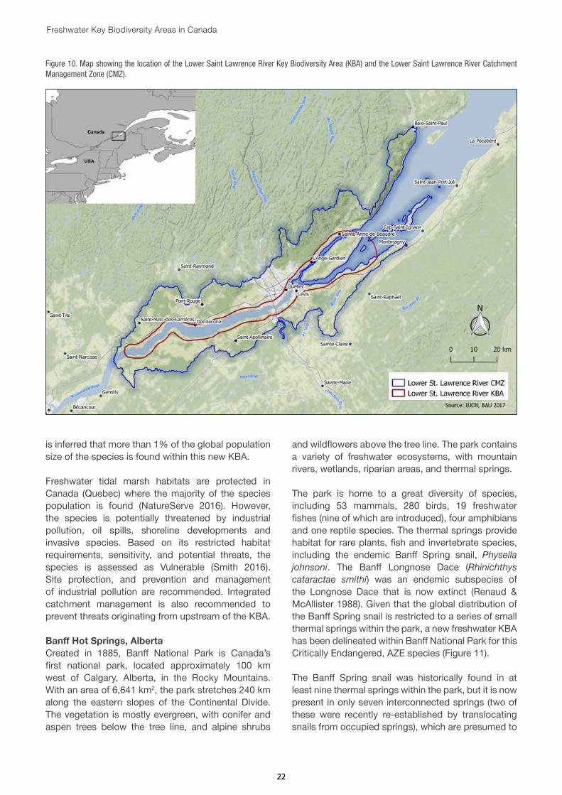
The lower part of the Saint Lawrence in Quebec including Orleans Island has been delineated as a new freshwater Key Biodiversity Area for the vulnerable plant species Eaton’s beggarticks (Bidens eatonii) (Figure 10). This plant is a habitat specialist found only in the narrow area of freshwater tidal marshes on tidal river mudflats near the inland limit of saltwater influence. Based on the extent of suitable habitat and the species’ estimated area of occupancy (500 km2), it
Saint Lawrence River at Quebec. © abdallahh (Flickr)
2222
Freshwater Key Biodiversity Areas in Canada
is inferred that more than 1% of the global population size of the species is found within this new KBA.
Freshwater tidal marsh habitats are protected in Canada (Quebec) where the majority of the species population is found (NatureServe 2016). However, the species is potentially threatened by industrial pollution, oil spills, shoreline developments and invasive species. Based on its restricted habitat requirements, sensitivity, and potential threats, the species is assessed as Vulnerable (Smith 2016). Site protection, and prevention and management of industrial pollution are recommended. Integrated catchment management is also recommended to prevent threats originating from upstream of the KBA.
Banff Hot Springs, AlbertaCreated in 1885, Banff National Park is Canada’s first national park, located approximately 100 km west of Calgary, Alberta, in the Rocky Mountains. With an area of 6,641 km2, the park stretches 240 km along the eastern slopes of the Continental Divide. The vegetation is mostly evergreen, with conifer and aspen trees below the tree line, and alpine shrubs
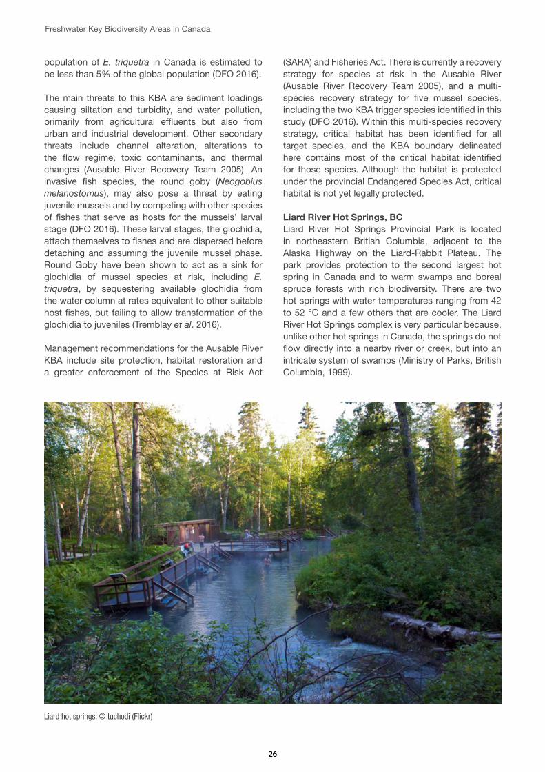
and wildflowers above the tree line. The park contains a variety of freshwater ecosystems, with mountain rivers, wetlands, riparian areas, and thermal springs.
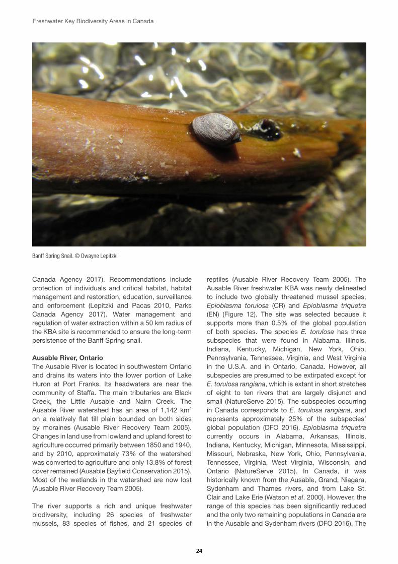
The park is home to a great diversity of species, including 53 mammals, 280 birds, 19 freshwater fishes (nine of which are introduced), four amphibians and one reptile species. The thermal springs provide habitat for rare plants, fish and invertebrate species, including the endemic Banff Spring snail, Physella johnsoni. The Banff Longnose Dace (Rhinichthys cataractae smithi) was an endemic subspecies of the Longnose Dace that is now extinct (Renaud & McAllister 1988). Given that the global distribution of the Banff Spring snail is restricted to a series of small thermal springs within the park, a new freshwater KBA has been delineated within Banff National Park for this Critically Endangered, AZE species (Figure 11).
The Banff Spring snail was historically found in at least nine thermal springs within the park, but it is now present in only seven interconnected springs (two of these were recently re-established by translocating snails from occupied springs), which are presumed to
Figure 10. Map showing the location of the Lower Saint Lawrence River Key Biodiversity Area (KBA) and the Lower Saint Lawrence River Catchment Management Zone (CMZ).

2323
be fed by the same groundwater source (Grasby and Lepitzki 2002, Lepitzki and Pacas 2010). Populations of the species are known to fluctuate widely, both seasonally and annually (Lepitzki and Pacas 2010). Over the past 21 years of monitoring individual spring populations, not including the two re-established ones, minima of 30 (August 1997) and 22 (August 2012) were observed with lows at the other three being 396 (August 2012), 162 (May 1996), and 147 (August 2005) (D. Lepitzki pers. comm. 2017). Usually, populations are at their minimum during the summer, just when the park experiences its major influx of visitors.
The main threats to the snail are fluctuations in thermal water flow, including reduced or even complete cessation of flow (Lepitzki and Pacas 2010). Whereas flow rates normally decrease during late winter and early spring due to depletion of underground water reservoirs, there is evidence that incidences of complete cessation of water flow are increasing (Lepitzki and Pacas 2010). In springs where water stoppages have been recorded, populations of the snail have been extirpated (Lepitzki and Pacas 2010). Natural seasonal reductions in water flow
may also threaten snail populations, but this may be variable depending on the magnitude of seasonal fluctuations (Lepitzki and Pacas 2010). Larger than normal and unprecedented rain events have lead to serious flooding in the Bow River watershed in recent years, including the floods in Calgary in 2013. These events have been reflected in extremely low snail subpopulations because the rain affects the microbial community, the food source of the snail. Other threats to the snail include limited or low-quality habitat and tourist visitor activities, such as soaking and swimming and trampling (Lepitzki and Pacas 2010).
A research and recovery program for Physella johnsoni was initiated in 1996, and population monitoring and measurement of physicochemical parameters have been completed regularly since then (Lepitzki and Pacas 2010). It is listed as Endangered under the Canadian Species at Risk Act since 2003. The species has also been included in a multi-species action plan for Banff National Park (Parks Canada Agency 2017). The objectives are to maintain self-sustaining populations of the snail within its historic range and mitigate human-related threats (Parks
Figure 11. Map showing the location of the Banff Hot Springs Key Biodiversity Area (KBA), the Banff Catchment Management Zone (CMZ), and the boundary of Banff National Park.
2424
Freshwater Key Biodiversity Areas in Canada
Canada Agency 2017). Recommendations include protection of individuals and critical habitat, habitat management and restoration, education, surveillance and enforcement (Lepitzki and Pacas 2010, Parks Canada Agency 2017). Water management and regulation of water extraction within a 50 km radius of the KBA site is recommended to ensure the long-term persistence of the Banff Spring snail.
Ausable River, OntarioThe Ausable River is located in southwestern Ontario and drains its waters into the lower portion of Lake Huron at Port Franks. Its headwaters are near the community of Staffa. The main tributaries are Black Creek, the Little Ausable and Nairn Creek. The Ausable River watershed has an area of 1,142 km2 on a relatively flat till plain bounded on both sides by moraines (Ausable River Recovery Team 2005). Changes in land use from lowland and upland forest to agriculture occurred primarily between 1850 and 1940, and by 2010, approximately 73% of the watershed was converted to agriculture and only 13.8% of forest cover remained (Ausable Bayfield Conservation 2015). Most of the wetlands in the watershed are now lost (Ausable River Recovery Team 2005).
The river supports a rich and unique freshwater biodiversity, including 26 species of freshwater mussels, 83 species of fishes, and 21 species of
reptiles (Ausable River Recovery Team 2005). The Ausable River freshwater KBA was newly delineated to include two globally threatened mussel species, Epioblasma torulosa (CR) and Epioblasma triquetra (EN) (Figure 12). The site was selected because it supports more than 0.5% of the global population of both species. The species E. torulosa has three subspecies that were found in Alabama, Illinois, Indiana, Kentucky, Michigan, New York, Ohio, Pennsylvania, Tennessee, Virginia, and West Virginia in the U.S.A. and in Ontario, Canada. However, all subspecies are presumed to be extirpated except for E. torulosa rangiana, which is extant in short stretches of eight to ten rivers that are largely disjunct and small (NatureServe 2015). The subspecies occurring in Canada corresponds to E. torulosa rangiana, and represents approximately 25% of the subspecies’ global population (DFO 2016). Epioblasma triquetra currently occurs in Alabama, Arkansas, Illinois, Indiana, Kentucky, Michigan, Minnesota, Mississippi, Missouri, Nebraska, New York, Ohio, Pennsylvania, Tennessee, Virginia, West Virginia, Wisconsin, and Ontario (NatureServe 2015). In Canada, it was historically known from the Ausable, Grand, Niagara, Sydenham and Thames rivers, and from Lake St. Clair and Lake Erie (Watson et al. 2000). However, the range of this species has been significantly reduced and the only two remaining populations in Canada are in the Ausable and Sydenham rivers (DFO 2016). The
Banff Spring Snail. © Dwayne Lepitzki

2525
Re-establishment site for the Banff Spring Snail in the Upper Middle Springs, Banff National Park. © Dwayne Lepitzki
Figure 12. Map showing the location of the Ausable River Key Biodiversity Area (KBA) and Ausable River Catchment Management Zone (CMZ).
2626
Freshwater Key Biodiversity Areas in Canada
population of E. triquetra in Canada is estimated to be less than 5% of the global population (DFO 2016).
The main threats to this KBA are sediment loadings causing siltation and turbidity, and water pollution, primarily from agricultural effluents but also from urban and industrial development. Other secondary threats include channel alteration, alterations to the flow regime, toxic contaminants, and thermal changes (Ausable River Recovery Team 2005). An invasive fish species, the round goby (Neogobius melanostomus), may also pose a threat by eating juvenile mussels and by competing with other species of fishes that serve as hosts for the mussels’ larval stage (DFO 2016). These larval stages, the glochidia, attach themselves to fishes and are dispersed before detaching and assuming the juvenile mussel phase. Round Goby have been shown to act as a sink for glochidia of mussel species at risk, including E. triquetra, by sequestering available glochidia from the water column at rates equivalent to other suitable host fishes, but failing to allow transformation of the glochidia to juveniles (Tremblay et al. 2016).
Management recommendations for the Ausable River KBA include site protection, habitat restoration and a greater enforcement of the Species at Risk Act
(SARA) and Fisheries Act. There is currently a recovery strategy for species at risk in the Ausable River (Ausable River Recovery Team 2005), and a multi-species recovery strategy for five mussel species, including the two KBA trigger species identified in this study (DFO 2016). Within this multi-species recovery strategy, critical habitat has been identified for all target species, and the KBA boundary delineated here contains most of the critical habitat identified for those species. Although the habitat is protected under the provincial Endangered Species Act, critical habitat is not yet legally protected.
Liard River Hot Springs, BCLiard River Hot Springs Provincial Park is located in northeastern British Columbia, adjacent to the Alaska Highway on the Liard-Rabbit Plateau. The park provides protection to the second largest hot spring in Canada and to warm swamps and boreal spruce forests with rich biodiversity. There are two hot springs with water temperatures ranging from 42 to 52 °C and a few others that are cooler. The Liard River Hot Springs complex is very particular because, unlike other hot springs in Canada, the springs do not flow directly into a nearby river or creek, but into an intricate system of swamps (Ministry of Parks, British Columbia, 1999).
Liard hot springs. © tuchodi (Flickr)

2727
A new freshwater Key Biodiversity Area, Liard River Hot Springs, has been delineated around the hot springs complex for the Critically Endangered (AZE species) snail, the hotwater physa (Physella wrightii) (Figure 13). This small snail is an extreme endemic, restricted to the habitat around the margins of two pools, an outlet stream of one of the pools, and the warm water swamp (DFO 2010). The species is a habitat specialist, requiring geothermally regulated water and substrates near the water/air interface in areas of no current (Fisheries and Oceans Canada 2016f). The population of this short-lived snail (~1-year lifespan) is small, with less than 10,000 individuals, and is believed to fluctuate by an order of magnitude (Fisheries and Oceans Canada 2016f).
Given its very restricted distribution, the hotwater physa is extremely vulnerable to any perturbation of its habitat. The main threats to the species are posed by alterations of the water flow regime as a result of human activities, modification of the spring habitat, water pollution caused by tourism (large amounts of soaps and oils may accumulate on the surface of slow-moving areas of the stream and on vegetation) and introduced turtle species.
The hotwater physa is listed as Endangered under the Species at Risk Act (SARA) in 2003. Critical habitat has been identified for the species and a recovery strategy and an action plan have been developed for (Fisheries and Oceans Canada 2016f, 2017). Their main goal is to protect the population of hotwater physa within its natural geographic range and within its current variation of abundance at the hot spring complex (Fisheries and Oceans Canada 2017). The broad strategies identified include achieving the population and distribution objectives, population and distribution monitoring, protection, threats monitoring, filling knowledge gaps, park education, and ensuring the required population size and extent of distribution are attained (Fisheries and Oceans Canada 2017).
Okanagan Lake, BCOkanagan Lake is a large, deep natural lake in the Okanagan Valley, a very arid region in south central British Columbia. At the south end of the Valley there are terraces, which were formed as the lowering of postglacial lake levels were repeatedly arrested, and have been used extensively for horticulture, principally fruit trees and grape growing.
Figure 13. Map showing the location of Liard River Hot Springs Key Biodiversity Area (KBA), Liard Hot Springs Catchment Management Zone (CMZ) and the boundary of Liard Hot Springs Provincial Park.

2828
Freshwater Key Biodiversity Areas in Canada
A new freshwater KBA has been delineated for the Vulnerable Rocky Mountain ridge mussel (Gonidea angulata), including the lake and southern portion of the Okanagan River, up to the Osoyoos Lake (Figure 14). The KBA regularly supports more than 1% of the global population size of this mussel species and more than ten reproductive units. The historical distribution extended from the Okanagan Valley in British Columbia to southern California, and eastward into Idaho and Nevada (DFO 2011). However, it is now considered extirpated from much its former range (Jepsen et al. 2010). The main threats to the Rocky Mountain ridge mussel’s habitat include channelization of the Okanagan River; dams and weirs; development of the shoreline and littoral zone; pollutants; and the potential threat of invasive dreissenid mussels and other introduced species (DFO 2011).
The Rocky Mountain ridge mussel is listed as a species of special concern under the Species at Risk Act (SARA), and designated as Endangered by COSEWIC in Canada (DFO 2011). A management plan and a recovery assessment potential have been developed for the species (Fisheries and Oceans Canada 2010a, DFO 2011). The management goal
for the Rocky Mountain ridged mussel is to maintain viable, self-sustaining, ecologically functioning and broadly distributed populations within suitable habitats in its current distribution (Fisheries and Oceans Canada 2010a). Recommendations include filling knowledge gaps about the life history, threats for the species, monitoring and maintenance of water quality, invasive species management, and control of urban expansion.
East Sydenham River, OntarioThe Sydenham River is located in southwestern Ontario flowing southwest from the Lucan moraine near Ilderton to the Chenal Ecarte, and emptying into Lake St. Clair. It is a large river with a watershed draining approximately 2,725 km2. The river has two main branches, the North Sydenham and the East Sydenham, that converge in Wallaceburg (Fisheries and Oceans Canada 2016a). The watershed is of low relief, with very gradual slope streams and shallow valleys (Dextrase et al. 2003). Historically, land cover in the watershed was 70% forest and 30% swamp, but it has been converted to agriculture and now almost 85% of the basin is given over to row cropping, and wetlands have been reduced to <1% (Fisheries and Oceans Canada 2016a).
Vineyards by the Okanagan Lake. © Kyle Pearce (Flickr)

2929
The Sydenham River harbors a great diversity of freshwater species, including 34 species of mussels and 80 species of fishes (Fisheries and Oceans Canada 2016a). Many of these species are rare and are protected under the federal Species at Risk Act (SARA). The East Sydenham River KBA has been delineated to include five globally threatened mussel species: Epioblasma triquetra (EN), E. torulosa (CR), Simpsonaias ambigua (VU), Obovaria subrotunda (EN), and Villosa fabalis (EN). The KBA boundary includes most of the East Sydenham branch, from just north of the town of Alvinston to Dresden (Figure 15). The only known extant populations of Epioblasma triquetra and E. torulosa (subspecies rangiana) in Canada are in the Ausable and Sydenham river basins. The population of E. triquetra in Canada is estimated to be less than 5% of the global population, whereas the Canadian population of E. torulosa rangiana represents approximately 25% of the subspecies’ global population (DFO 2016). The only known population of Simpsonaias ambigua in Canada occurs in the East Sydenham River and represents less than 5% of the global distribution. Obovaria subrotunda was known in Canada from western Lake Erie, Lake St. Clair and the Welland, Grand, Thames, Sydenham and Detroit
rivers. However, since 1996, live specimens have only been reported from the East Sydenham River and the St. Clair River Delta (Fisheries and Oceans Canada 2013). It is estimated that approximately 1% of the global distribution of the species is in Canada (Fisheries and Oceans Canada 2013). Villosa fabalis was known in Canada from western Lake Erie and the Detroit, East Sydenham and Thames rivers. However, the current distribution is limited to the East Sydenham River and short stretch of the Thames River (DFO 2016). It is estimated that less than 10% of the species’ global distribution occurs in Canada (DFO 2016).
The main threats to the trigger species in the East Sydenham River KBA are sedimentation, mainly from agricultural activities; reduced flow and downstream erosion from dams; nutrient loading from agriculture and urban runoff; and introduced species, particularly zebra and quagga mussels, common carp (Cyprinus carpio), and round goby (Fisheries and Oceans Canada 2016). Other secondary threats include toxic contaminants, alterations to the flow regime, and thermal changes (Fisheries and Oceans Canada 2016a).
Figure 14. Map showing the location of the Okanagan Lake Key Biodiversity Area (KBA) and the Okanagan Lake Catchment Management Zone (CMZ).

3030
Freshwater Key Biodiversity Areas in Canada
Management recommendations for the East Sydenham River KBA include site protection, integrated catchment management, species monitoring, and invasive species management. There is currently an ecosystem-based action plan for the Sydenham River
(Fisheries and Oceans Canada 2016a), and a multi-species recovery strategy for five mussel species, including four of the KBA trigger species identified in this study (DFO 2016). In addition, a recovery strategy has been developed for the other mussel species (Fisheries and Oceans Canada 2013). Within these multi-species recovery strategies, critical habitat has been identified for all target species, and the KBA boundary delineated here contains most of the critical habitat identified for those species.
Site champions
A total of 46 potential Site champions and stakeholders were identified for the 13 freshwater KBAs (see Annex I). Site champions are people and organisations considered best placed to rise awareness of the existence of these freshwater KBAs and take the lead to implement the recommended actions for safeguarding KBAs on the ground.
Figure 15. Map showing the location of the East Sydenham River Key Biodiversity Area (KBA) and the Sydenham River Catchment Management Zone (CMZ).
Shell of Epioblasma triquetra. © Tim Lane (Flickr)

3131
Conclusions and recommendationsBased on the IUCN Red List assessments data, 13 KBAs were confirmed by the regional experts for freshwater fishes, molluscs and aquatic plants, covering a total area of 17,707 km2 (almost 0.18% of the country area). The KBAs validated through this project support 15 globally threatened species (Critically Endangered, Endangered or Vulnerable) and six geographically restricted range species. Of these, five also meet the criteria for the Alliance for Zero Extinction (AZE) sites. For most of these species recovery strategies and management plans are already in place, but the identification of these sites as global freshwater KBAs provides an added value of international recognition and helps to consolidate the importance of implementing effective conservation actions and environmental safeguards for freshwater biodiversity in Canada.
Around 78% of the total area of these freshwater KBAs (13,768 km2) was found to lie within the boundaries of pre-existing protected areas or terrestrial KBAs. However, most of these existing management units have been delineated primarily for terrestrial species and often fail to cover and manage adequately the distribution of restricted range and threatened species living in freshwater habitats. Therefore, it is now most important to ensure site management practices include a focus on these freshwater species not previously recognised as management targets. The remaining 22% of the freshwater KBAs area found to lie outside of any existing protected areas or KBAs should be considered to inform any future strategies for improving the representation of freshwater biodiversity within the national protected areas network or as targets for habitat restoration efforts. Building awareness of the existence of these priority freshwater sites and the need for conservation actions and their future protection will be addressed through encouraging the identified site champions (see Annex I).
The identification and delineation of KBAs is necessarily a fluid and ongoing process responding to the provision of new information and a constantly changing environment and thus, it is expected that this current freshwater KBA dataset for Canada will continue to be refined and updated. The identification of KBAs derived from different datasets developed by existing approaches (IBAs, AZEs, freshwater KBAs, etc.) must be led at the national level according to the new KBA global standard. The work presented above
represents the first steps in taking this process forward, and it provides the baseline data set to inform future KBA designations. It is also important to acknowledge the data limitations of this study, particularly data on ecosystems. Future use of criterion C on ecological integrity will certainly encompass other freshwater areas of Canada (J. Ray, pers. comm.).
The primary threats to freshwater species identified across Canada, as described by the experts at the workshop, are i) hydrological alterations following construction of dams; ii) water pollution from agriculture and urbanization; iii) over-abstraction of surface and ground waters; and iv) competition with invasive species. The impacts of these types of threat tend to spread rapidly throughout catchments such that localized conservation actions restricted to limited parts of a catchment will often fail to provide effective solutions. This means that it is necessary to look at the catchment where the KBA resides from its headwaters to the estuarine and coastal environments, including its wetlands, floodplains and associated ground waters, taking into account lateral and longitudinal hydrological connectivity.
Integrated River Basin Management (IRBM, or a similar strategy) is recommended for most freshwater KBAs identified to ensure effective protection of freshwater species from both upstream and downstream threats often originating outside of the KBA boundaries. This approach is fundamental to better coordinate conservation, management and development planning of water, land and related resources across sectors, and to maximise the economic and social benefits derived from water resources in an equitable manner while preserving and, where necessary, restoring freshwater ecosystems.
The implementation of Environmental Flows (E-Flows) assessment methodologies is also important to the future conservation and management of freshwater KBAs. The main objective of E-Flows is to maintain the quality, quantity and timing of water flows required to sustain freshwater ecosystems and the human livelihoods that depend on them (Dyson et al. 2003). As a first priority E-Flows should be determined, where appropriate, for all freshwater AZE sites involving riverine systems, such as the Hebb, Milipsigate and Minamkeak Lakes in Nova Scotia.

3232
Freshwater Key Biodiversity Areas in Canada
Invasive alien species are one of the major threats identified to freshwater biodiversity in Canada, and increased efforts are required to prevent their introduction, and to manage or, where feasible, eradicate them. Information on the distribution of invasive alien species, their impacts, pathways of invasion and management recommendations can be found in the Global Invasive Species Database (http://www.iucngisd.org/gisd). Information collated through the KBA delineation and validation process could feed into the GISD, which is also linked to the IUCN Red List. Periodic updates of IUCN Red List assessments of species and monitoring of KBA sites will enable the production of a Red List Index for all freshwater species assessed in order to track trends in the projected overall extinction risk of freshwater species so potentially helping to inform managers on the effectiveness of any management interventions.
The freshwater KBAs identified in this project can also help support the implementation of Multilateral Environmental Agreements in Canada such as the Ramsar Convention, guiding conservation planning and priority-setting at national level to: i) identify new and potential Wetlands of International Importance (Ramsar Sites) under Criteria 2 to 9; ii) update existing Ramsar site management to focus on the new freshwater trigger species found within their boundaries (e.g. Eastern Lake Saint Claire); and iii) identify existing Ramsar sites meeting the KBA criteria that are undergoing adverse changes in their ecological character and that might be eligible for inclusion on the Montreux Record.
Freshwater KBAs can also help Canada working towards the achievement of the Aichi Biodiversity Targets (in particular Targets 11 and 12) and support
the programme of work on biological diversity of inland water ecosystems as established by the Convention on Biological Diversity (CBD). In addition, freshwater KBAs can help identify freshwater ecosystem priorities for the UN Sustainable Development Goals and provide a better metric for measurement of Sustainable Development target 6.5, focused on implement integrated water resources management at all levels; target 6.6, focused on protecting and restoring water-related ecosystems; and target 15.1 focused on the conservation, restoration and sustainable use of terrestrial and inland freshwater ecosystems and their services (United Nations 2016). Finally, it is expected that the list of freshwater KBAs presented in this report will also help to guide conservation investment priorities and inform performance Standards and Environmental Safeguard policies of financial institutions and the private sector to minimise the impacts of their operations in and around these critical sites for freshwater biodiversity in Canada.
Next steps
� The report and related policy briefs will be circulated to all Site Champions and cross-sectorial Government departments.
� Information on the sites will be made available through the World Database on Key Biodiversity Areas (WDKBA) http://www.keybiodiversityareas.org/home managed by Birdlife International and through the Integrated Biodiversity Assessment Tool (IBAT) https://www.ibatforbusiness.org/ – a tool that is already well known amongst the private sector and donor community.

3333
ReferencesAbell, R., Allan, J.D. and Lehner, B. 2007. Unlocking
the potential of protected areas for freshwaters. Biological Conservation, 134:48-63. https://doi.org/10.1016/j.biocon.2006.08.017
Ausable Bayfield Conservation. 2015. Watershed management strategy. Ausable Bayfield Conservation Authority. Exeter, Ontario, 33 p.
Ausable River Recovery Team. 2005. Recovery strategy for species at risk in the Ausable River: An ecosystem approach, 2005-2010. Draft Recovery Strategy submitted to RENEW Secretariat.
BirdLife International (2016) Important Bird and Biodiversity Area factsheet: Brier Island and Offshore Waters. Downloaded from http://www.birdlife.org on 02/09/2016.
BirdLife International (2017) Important Bird Areas factsheet: Eastern Lake St. Clair. Downloaded from http://www.birdlife.org on 07/06/2017.
Bowles, J.M. 2005. Walpole Island Ecosystem Recovery Strategy (Draft 8). Prepared for the Walpole Island Heritage Centre, Environment Canada, and The Walpole Island Recovery Team: 45 pp.
Canadian Heritage Rivers System (2017) St. John River Factsheet. Website: http://chrs.ca/the-rivers/st-john/. Accessed on 15 May 2017.
Cheskey E.D. and Wilson, W.G. 2001. Eastern Lake St. Clair Important Bird Area Conservation Plan. Can. Nature Fed., Bird Studies Can., Fed. of Ont. Naturalists. 50pp.
Chu, C., Minns, C. K., Lester, N. P. and Mandrak, N. E. 2015. An updated assessment of human activities, the environment, and freshwater fish biodiversity in Canada. Canadian Journal of Fisheries and Aquatic Sciences, 72(1): 135-148. https://doi.org/10.1139/cjfas-2013-0609
COSEWIC 2003. COSEWIC assessment and update status on the round hickorynut Obovaria subrotunda in Canada. Committee on the Status of Endangered Wildlife in Canada. Ottawa. vi + 31 pp.
COSEWIC. 2010a. COSEWIC assessment and status report on the Atlantic Whitefish Coregonus huntsmani in Canada. Committee on the Status of Endangered Wildlife in Canada, Ottawa.
COSEWIC. 2010b. COSEWIC assessment and status report on the Eastern Mountain Avens Geum peckii in Canada. Committee on the Status of Endangered Wildlife in Canada. Ottawa. x + 33 pp.
COSEWIC. 2010c. COSEWIC assessment and statusreport on the Western Brook Lamprey Lampetra richardsoni, Morrison Creek Population,in Canada. Committee on the Status of Endangered Wildlife in Canada. Ottawa. x + 27 pp.
COSEWIC. 2014. COSEWIC assessment and status report on the Copper Redhorse (Moxostoma hubbsi) in Canada. Committee on the Status of Endangered Wildlife in Canada. Ottawa. xiii + 80 pp.
COSEWIC. 2015. COSEWIC Assessment and status report on the Shortnose Sturgeon (Acipenser brevirostrum) in Canada. Committee on the Status of Endangered Wildlife in Canada. Ottawa. xii + 48 pp.
Currie, D.J., Mittelbach, G.G., Cornell, H.V., Field, R., Guégan, J.F., Hawkins, B.A., Kaufman, D.M., Kerr, J.T., Oberdorff, T., O’Brien, E. and Turner, J.R.G., 2004. Predictions and tests of climate‐based hypotheses of broad‐scale variation in taxonomic richness. Ecology letters, 7(12): 1121-1134. https://doi.org/10.1111/j.1461-0248.2004.00671.x
Dextrase, A.J., Staton, S.K. and Metcalfe-Smith, J.L. 2003. National recovery strategy for species at risk in the Sydenham River: An ecosystem approach. National Recovery Plan No. 25. Recovery of Nationally Endangered Wildlife (RENEW), Ottawa, Ontario, 73 pp.
DFO. 2010. Recovery potential assessment for hotwater physa (Physella wrighti). DFO Can. Sci. Advis. Sec. Sci. Advis. Rep. 2009/072.
DFO. 2011. Recovery Potential Assessment for Rocky Mountain ridged mussel (Gonidea angulata) in British Columbia. DFO Can. Sci. Advis. Sec. Sci. Advis. Rep. 2011/053.
DFO. 2016. Recovery Strategy For Northern Riffleshell, Snuffbox, Round Pigtoe, Salamander Mussel, and Rayed Bean in Canada [Proposed]. In Species at Risk Act Recovery Strategy Series. Ottawa: Fisheries and Oceans Canada. x + 95 pp.
Dudley, N., Boucher, J.L., Cuttelod, A., Brooks, T.M. and Langhammer, P.F. Eds. 2014. Applications of Key Biodiversity Areas: end-user consultations. Cambridge, UK and Gland, Switzerland: IUCN.
Dyson, M., Bergkamp, G. and Scanlon, J. 2003. Flow: The Essentials of Environmental Flows. IUCN, Gland, Switzerland and Cambridge, UK. xiv + 118 pp.

3434
Freshwater Key Biodiversity Areas in Canada
Environment Canada. 1991. The federal policy on wetland conservation, Ottawa: Minister of Supply and Services.
Environment Canada. 2010. Recovery Strategy for the Eastern Mountain Avens (Geum peckii) in Canada. Species at Risk Act Recovery Strategy Series. Environment Canada, Ottawa. vii + 17 pp. + Appendices.
Environment and Climate Change Canada. 2013. Lakes. [Online] Available at: https://www.ec.gc.ca/eau-water/default.asp?lang=En&n=448F99F0-1 [Accessed 5 May 2017].
Environment and Climate Change Canada. 2016a. Action Plan for the Eastern Mountain Avens (Geum peckii) in Canada [Proposed]. Species at Risk Act Action Plan Series. Environment and Climate Change Canada, Ottawa. v + 23 pp.
Environment and Climate Change Canada. 2016b. Canadian Environmental Sustainability Indicators: Extent of Canada’s Wetlands. Consulted on 08/06/2017.
Environment and Climate Change Canada. 2016c. St. Clair National Wildlife Area Management Plan (Proposed). Environment and Climate Change Canada, Canadian Wildlife Service, Ontario Region, 76 p.
Environment and Climate Change Canada. 2017. General Status of Species in Canada. [Online] Available at: https://www.ec.gc.ca/indicateurs-indicators/default.asp?lang=En&n=37DB2E44-1 [Accessed 10 May 2017].
Epps, D. 2011. Water Quality Assessment and Objectives for Cowichan Lake: Overview Report. Environmental Protection Division, Ministry of Environment, Canada.
Federal, Provincial and Territorial Governments of Canada. 2010. Canadian Biodiversity: Ecosystem Status and Trends 2010, Ottawa, Ontario: Canadian Councils of Resource Ministers.
Fisheries and Oceans Canada. 2010a. Management Plan for the Rocky Mountain Ridged Mussel (Gonidea angulata) in Canada [Final]. Species at Risk Act Management Plan Series. Fisheries and Oceans Canada, Vancouver. iv + 52 pp.
Fisheries and Oceans Canada (DFO). 2010b. Management Plan for the Yellow Lampmussel (Lampsilis cariosa) in Canada [Final]. Species at Risk Act Management Plan Series. Fisheries and Oceans Canada. Ottawa. iv + 44 pp.
Fisheries and Oceans Canada (DFO). 2012. Recovery Strategy for the Copper Redhorse (Moxostoma hubbsi) in Canada [Proposed]. Species at Risk Act Recovery Strategy Series. Fisheries and Oceans Canada, Ottawa. Xi +60 pp.
Fisheries and Oceans Canada. 2013. Recovery Strategy for the Round Hickorynut (Obovaria subrotunda) and the Kidneyshell (Ptychobranchus fasciolaris) in Canada. Species at Risk Act Recovery Strategy Series. Fisheries and Oceans Canada. Ottawa. vi + 70 pp.
Fisheries and Oceans Canada (DFO). 2015. Management Plan for the Shortnose turgeon (Acipenser brevirostrum) in Canada [Proposed]. Species at Risk Act Management Plan Series. Fisheries and Oceans Canada, Ottawa.v+ 55pp.
Fisheries and Oceans Canada. 2016a. Action Plan for the Sydenham River in Canada: An Ecosystem Approach [Proposed]. Species at Risk Act Action Plan Series. Fisheries and Oceans Canada, Ottawa. iv + 37 pp.
Fisheries and Oceans Canada (DFO). 2016b. Amended Recovery Strategy for the Atlantic Whitefish (Coregonus huntsmani) in Canada [Proposed]. Species at Risk Act Recovery Strategy Series. Fisheries and Oceans Canada, Ottawa. Xiii + 60 pp.
Fisheries and Oceans Canada (DFO). 2016c. Management plan for Kiyi, Upper Great Lakes (Coregonus kiyi kiyi) in Canada. Species at Risk Act Management Plan Series. Fisheries and Oceans Canada, Ottawa. vii + 27 pp.
Fisheries and Oceans Canada. 2016d. Recovery strategy and action plan for the Eastern Pondmussel (Ligumia nasuta) in Canada [Proposed]. Species at Risk Act Recovery Strategy Series. Fisheries and Oceans Canada, Ottawa. vi + 64 pp.
Fisheries and Oceans Canada. 2016e. Report on the progress of recovery strategy implementation for Cowichan Lake Lamprey (Entosphenus macrostomus) in Canada for the period 2007 – 2015. Species at Risk Act Recovery Strategy Report Series. Fisheries and Oceans Canada, Ottawa. v + 13 pp.
Fisheries and Oceans Canada. 2016f. Report on the Progress of Recovery Strategy Implementation for the Hotwater Physa (Physella wrighti) in Canada for the Period 2007 – 2015. Species at Risk Act Recovery Strategy Report Series. Fisheries and Oceans Canada, Ottawa. iii + 14 pp.
Fisheries and Oceans Canada. 2017. Action Plan for the Hotwater Physa (Physella wrighti) in Canada [Proposed]. Species at Risk Act Action Plan Series. Fisheries and Oceans Canada, Ottawa. iv + 22 pp.
Gimenez Dixon, M. 1996. Coregonus kiyi. The IUCN Red List of Threatened Species 1996:
3535
e.T5368A11123963. http://dx.doi.org/10.2305/IUCN.UK.1996.RLTS.T5368A11123963.en. Downloaded on 28 April 2017.
Global Lakes and Wetlands Database (GLWD): http://www.worldwildlife.org/pages/global-lakes-and-wetlands-database
Government of Canada. 2017. Species at Risk Public Registry. [Online] Available at: http://www.sararegistry.gc.ca/ [Accessed 20 May 2017].
Grasby, S.E. and Lepitzki, D.A.W. 2002. Physical and chemical properties of the Sulphur Mountain thermal springs, Banff National Park, and implications for endangered snails. Canadian Journal of Earth Sciences 39: 1349-1361. https://doi.org/10.1139/e02-056
Great Lakes Environmental Assessment and Mapping Project, n.d. Tributary Dams. [Online] Available at: http://www.greatlakesmapping.org/great_lake_stressors/6/tributary-dams [Accessed 5 May 2017].
Hebb, Milipsigate and Minamkeak Lake Watershed Protected Water Area Regulations, NS Reg 113/2006, http://canlii.ca/t/lczh. Retrieved on 2017-05-16.
Holland, R.A., Darwall, W.R.T. and Smith, K.G. 2012. Conservation priorities for freshwater biodiversity: the Key Biodiversity Area approach refined and tested for continental Africa. Biological Conservation. 148(1):167-179. https://doi.org/10.1016/j.biocon.2012.01.016
IBA Canada 2017. Eastern Lake St. Clair, Southwestern Ontario, Ontario ON012. Available at: http://www.ibacanada.com/site.jsp?siteID=ON012 [Accessed 7 May 2017].
IUCN. 2004. Resolution (WCC 3.013) World Conservation Congress, Bangok, Thailand 17-25 November 2004. Available at: https://cmsdata.iucn.org/downloads/wcc_res_rec_eng.pdf
IUCN. 2014. Consultation Document on an IUCN Standard for the Identification of Key Biodiversity Areas. Available at: http://www.kbaconsultation.org/#!executive-summary/c109f
IUCN. 2016. A Global Standard for the Identification of Key Biodiversity Areas, Version 1.0. First edition. Gland, Switzerland: IUCN.
IUCN, 2017. The IUCN Red List of Threatened Species. [Online] Available at: www.iucnredlist.org [Accessed 7 May 2017].
Jepsen, S., LaBar, C. and Zarnoch, J. 2010. Species profile: Western Ridged Mussel (Gonidea angulata). The Xerces Society. http://www.xerces.org/western-freshwater-mussels. Accessed May, 2017.
Johnson, P.D., Bogan, A.E., Brown, K.M., Burkhead, N.M., Cordeiro, J.R., Garner, J.T., Hartfield, P.D.,
Lepitzki, D.A., Mackie, G.L., Pip, E. and Tarpley, T.A. 2013. Conservation status of freshwater gastropods of Canada and the United States. Fisheries, 38(6): 247-282.
Jonas, H.D., Barbuto, V., Jonas, H.C., Kothari, A. and Nelson, F. 2014. New Steps of Change: Looking Beyond Protected Areas to Consider Other Effective Area-Based Conservation Measures. Parks 20.2: 111-128. https://doi.org/10.2305/IUCN.CH.2014.PARKS-20-2.HDJ.en
Jones, M.L., Shuter, B.J., Zhao, Y. and Stockwell, J.D. 2006. Forecasting effects of climate change on Great Lakes fisheries: models that link habitat supply to population dynamics can help. Canadian Journal of Fisheries and Aquatic Sciences, 63:457-468. https://doi.org/10.1139/f05-239
Leadley, P.W., Krug, C.B., Alkemade, R., Pereira, H.M., Sumaila, U.R., Walpole, M., Marques, A., Newbold, T., Teh, L.S., van Kolck, J. and Bellard, C. 2014. Progress towards the Aichi Biodiversity Targets: An assessment of biodiversity trends, policy scenarios and key actions. Secretariat of the Convention on Biological Diversity, Montreal, Canada. Technical Series 78. https://www.cbd.int/doc/publications/cbd-ts-78-en.pdf
Lehner, B. and Döll, P. 2004. Development and validation of a global database of lakes, reservoirs and wetlands. Journal of Hydrology, 296(1-4): 1-22. Data available at h t t p : / / w w w. w w f u s . o rg / s c i e n c e / d a t a /globallakes.cfm. https://doi.org/10.1016/j.jhydrol.2004.03.028
Lehner, B. and Grill G. 2013. Global river hydrography and network routing: baseline data and new approaches to study the world’s large river systems. Hydrological Processes, 27(15): 2171–2186. Data is available at www.hydrosheds.org https://doi.org/10.1002/hyp.9740
Lehner, B., Verdin, K. and Jarvis, A. .2008. New Global Hydrography Derived From Spaceborne Elevation Data, Eos Trans. AGU, 89(10), 93–94. https://doi.org/10.1029/2008EO100001
Lepitzki, D.A.W. and Pacas, C. 2010. Recovery Strategy and Action Plan for the Banff Springs Snail (Physella johnsoni), in Canada. Species at Risk Act Recovery Strategy Series. Parks Canada Agency, Ottawa. vii + 63 pp.
Mackie, G. L. 2007. Biology of freshwater corbiculid and sphaeriid clams of North America. Ohio Biological Survey, Columbus, OH. 438 + ix p. ISBN13 978-0-86727-158-4
Messager, M.L., Lehner, B., Grill, G., Nedeva, I. and Schmitt, O. 2016. Estimating the volume and age of water stored in global lakes using a geo-

3636
Freshwater Key Biodiversity Areas in Canada
statistical approach. Nature Communications, 7, 13603. https://doi.org/10.1038/ncomms13603
Ministry of Parks, British Columbia. 1990. Liard River Hot Springs Provincial Park. Management plan. Available http://www.env.gov.bc.ca/bcparks/p lanning/mgmtplns/ l ia rd/ l ia rd_mp.pdf?v=1495215907615 (Accessed: May 18, 2017).
Natural Resources Canada. 2016. Lakes and rivers in Canada - CanVec – Hydro Features. [Online] Available at: http://geogratis.gc.ca/api/en/nrcan-rncan/ess-sst/93b9a6e6-1264-47f6-ad55-c60f842c550d.html [Accessed 5 May 2017].
NatureServe. 2015. NatureServe Explorer: An online encyclopedia of life [web application]. Version 7.1. NatureServe, Arlington, Virginia. Available http://explorer.natureserve.org. (Accessed: March 28, 2017).
NatureServe. 2016. NatureServe Explorer: An Online Encyclopedia of Life. Arlington, Virginia. Available at: http://explorer.natureserve.org Accessed on 18 May 2017.
NatureServe. 2017. NatureServe Explorer: An online encyclopedia of life [web application]. Version 7.1. NatureServe, Arlington, Virginia. Available http://explorer.natureserve.org. (Accessed: June 12, 2017).
Parks Canada. 2017. Lake Superior National Marine Conservation Area. Website: http://www.pc.gc.ca/en/amnc-nmca/on/super. Accessed on 15 May 2017.
Parks Canada Agency. 2017. Multi-species Action Plan for Banff National Park of Canada [Proposed]. Species at Risk Act Action Plan Series. Parks Canada Agency, Ottawa. iv + 30 pp.
Rainer, R., Bennett, B., Blaney, S., Enns, A., Henry, P., Lofroth, E. and Mackenzie, J. 2017. On Guard for Them: Species of Global Conservation Concern in Canada. NatureServe Canada: Ottawa, ON.
Renaud, C.B. and McAllister, D.E. 1988. Taxonomic status of the extinct Banff longnose dace, Rhinichthys cataractae smithi, of Banff National Park, Alberta. Environmental Biology of Fishes, 23(1): 95-114. h t t p s : / / d o i . o rg / 1 0 . 1 0 0 7 / B F 0 0 0 0 0 7 4 0 https://doi.org/10.1007/978-94-009-3115-2_8
Ricketts, T.H., Dinerstein, E., Boucher, T., Brooks, T.M., Butchart, S.H.M., Hoffmann, M., Lamoreux, J.F., Morrison, J., Parr, M., Pilgrim, J.D., Rodrigues, A.S.L., Sechrest, W., Wallace, G.E., Berlin, K., Bielby, J., Burgess, N.D., Church, D.R., Cox, N., Knox, D., Loucks, C., Luck, G.W., Master, L.L., Moore, R., Naidoo, R., Ridgely, R., Schatz, G.E., Shire, G., Strand, H., Wettengel, W. and Wikramanayake, E. 2005. Pinpointing and
preventing imminent extinctions. Proceedings of the National Academy of Sciences of the United States of America, 102: 18497–501. https://doi.org/10.1073/pnas.0509060102
Sabine, D.L., S. Makepeace, and D.F. McAlpine. 2004. The yellow lampmussel (Lampsilis cariosa) in New Brunswick: a population of significant conservation value. Northeastern Naturalist, 11(4): 407-420. https://doi.org/10.1656/1092-6194(2004)011[0407:TYLLCI]2.0.CO;2
Scott, M.W., Hoffman, J.R., Hewitt, T.L., Beasley, R.R., Lance, S.L., Jones, K.L., Morris, T.J. and Zanatta, D.T. 2016. Development and characterization of 29 microsatellite markers for Ligumia nasuta (Bivalvia: Unionidae) using an Illumina sequencing approach. Biochemical Systematics and Ecology, 66: 239-242. https://doi.org/10.1016/j.bse.2016.04.010
Secretariat of the Convention on Biological Diversity (2014) Global Biodiversity Outlook 4. Montréal, 155 pages.
Smith, K. 2016. Bidens eatonii. The IUCN Red List of Threatened Species 2016: e.T64264329A67728563. http://dx.doi.o r g / 1 0 . 2 3 0 5 / I U C N . U K . 2 0 1 6 - 1 . R LT S .T64264329A67728563.en. Downloaded on 18 May 2017.
St. Claire Ramsar Site Information Sheet (2001) Canada. Accessed online on the 25/05/2017 https://rsis.ramsar.org/ris/319
Tremblay, M.E.M., Morris, T.J. and Ackerman, J.D. 2016. Loss of reproductive output caused by an invasive species. R. Soc. Open Sci., 3: 150481. http://dx.doi.org/10.1098/rsos.150481
United Nations 2016. The Sustainable Development Goals Report 2016. (www.un.org.lb/Library/Assets/The-Sustainable-Development-Goals-Report-2016-Global.pdf)
USDA, NRCS. 2017. The PLANTS Database, Greensboro, NC: National Plant Data Team.
Vancouver Lamprey Recovery Team. 2007. Recovery Strategy for the Vancouver Lamprey (Lampetra macrostoma) in Canada. Species at Risk Act Recovery Strategy Series, Fisheries and Oceans Canada, Ottawa, ix + 21 pp.
Venables, W.N., Smith, D.M. and the R Core Team. 2017. An Introduction to R. Notes on R: A Programming Environment for Data Analysis and Graphics. Version 3.4.1 (2017 -06-03). The R Manuals. Available at: https://cran.r-project.org/doc/manuals/r-release/R-intro.pdf
Watson, E.T., Metcalfe-Smith, J.L. and Di Maio, J. 2000. Status of the Snuffbox, Epioblasma triquetra, in Canada. COSEWIC Status Report, Ottawa, Ontario, 51 pp.

3737
Zanatta, D.T., Bossenbroek, J.M., Burlakova, L.E., Crail, T.D., Szalay, F.D., Griffith, T.A., Kapusinski, D., Karatayev, A.Y., Krebs, R.A., Meyer, E.S. and Paterson, W.L. 2015. Distribution of native mussel (Unionidae) assemblages in coastal
areas of Lake Erie, Lake St. Clair, and connecting channels, twenty-five years after a dreissenid invasion. Northeastern Naturalist, 22(1): 223-235. https://doi.org/10.1656/045.022.0115

3838
Freshwater Key Biodiversity Areas in Canada
Annex I. Potential site championsOrganizations or individuals to be considered as potential ‘Site Champions’ for each KBA (i.e. those who can undertake conservation actions or raise the
KBA profile) or those who have an interest in, or are impacting, the CMZ or KBA site.
KBA Potential Site Champions
Ausable River Ausable-Bayfield Conservation Authority Ontario Freshwater Mussel Recovery Team Shawn Staton Fisheries and Oceans Canada/Pêches et Océans Canada Great Lakes Ausable River Recovery Team
Banff Hot Springs Bow Valley NaturalistsParks Canada - Banff Visitor Centre
Brier Island The Nature Conservancy of Canada– Nova Scotia (Brier Island)Annapolis River Guardians Clean Annapolis River Project
East Sydenham River Ontario Freshwater Mussel Recovery Team Fisheries and Oceans Canada/Pêches et Océans CanadaSydenham River Recovery Team Walpole Island First Nation
Eastern Lake St Clair Ontario Freshwater Mussel Recovery Team Fisheries and Oceans Canada/Pêches et Océans CanadaSydenham River Recovery Team Walpole Island First NationRamsar National Focal Point
Hebb, Milipsigate and Minamkeak Lakes
Atlantic Whitefish Conservation and Recovery TeamNova Scotia Museum of Natural HistoryDepartment of Biology Life Science Centre, Dalhousie UniversityEnvironment Canada; Atlantic Whitefish Recovery Project CoordinatorBluenose Coastal Action FoundationPetite Rivière Watershed Advisory GroupWalpole Island First Nation
Lake Superior Marine Conservation Area
University of TorontoOntario Ministry of Natural Resources
Lakes Cowichan and Mesachie
Fisheries and Oceans Canada Pacific Biological StationUniversity of ManitobaUBC Fisheries CentreCochiwan Lake Salmonid Enhacement SocietyVancouver Lamprey Recovery TeamDepartment of Zoology University of British ColumbiaBeaty Biodiversity Museum
Liard River Hot Springs
British Columbia Parks
Lower Saint John New Brunswick MuseumMount Allison UniversityHugh John Flemming Forestry Centre

3939
KBA Potential Site Champions
Lower Saint Lawrence River
Quebec Department of Wildlife and Parks Department of Biological Sciences University of MontrealMarie-Victorin Herbarium
Okanagan Lake Aquatic Ecosystems Science Section at Provincial Government of British Colombia Fisheries Management BC Ministry of the EnvironmentSyilx Okanagan Nation Alliance (Group of First Nations)
Richelieu River The Nature Conservancy of Canada Ministère du Développement durable du Quebec

4040
Freshwater Key Biodiversity Areas in Canada
Annex II. Summary of the KBA criteria and thresholds (IUCN, 2016)
A. Threatened Biodiversity Biodiversity element at site % global pop.
size/extent RU1
A1. Threatened species (a) CR or EN species ≥0.5% ≥5
(b) VU species ≥1% ≥10
(c) CR or EN species Threatened only due to population size reduction in the past or present
≥0.1% ≥5
(d) VU species Threatened only due to population size reduction in the past or present
≥0.2% ≥10
(e) CR or EN species Entire global population
size
A2: Threatened ecosystem types
(a) CR or EN ecosystem type ≥5%
(b) VU ecosystem type ≥10%
B. Geographically restricted biodiversity Biodiversity element at site % global pop.
size/extent RU
B1: Individually geographically restricted species
Any species ≥10% ≥10
B2: Co-occurring geographically restricted species
Restricted-range species: ≥2 species OR 0.02% of total number of species in taxonomic group, whichever is larger
≥1%
B3: Geographically re-stricted assemblages
(a) ≥5 ecoregion-restricted species2 OR 10% of the species restricted to the ecoregion, whichever is larger
≥0.5%
(b) ≥5 bioregion-restricted species2 OR 30% of the bioregion-restricted species known from the country, whichever is larger
(c) Part of the globally most important 5% of occupied habitat of each of ≥5 species within a taxonomic group
B4: Geographically re-stricted ecosystem types
Any ecosystem type ≥20%

4141
C. Ecological integrity Biodiversity element at site
Wholly intact ecological communities ≤2 sites per ecoregion
D. Biological processes Biodiversity element at site % global pop. size
D1: Demographic aggre-gations
(a) Species aggregation during one or more key stages of its life cycle
(b) Among the largest 10 aggregations known for the species
≥1%
D2: Ecological refugia Species aggregations during periods of past, current or future environmental stress
≥10%
D3: Recruitment sources Propagules, larvae or juveniles main-taining high proportion of global popula-tion size
≥10%3
E: Irreplaceability through quantitative analysis
Biodiversity element at site Irrepl. score RU
Site has high irreplaceability measured by quantitative spatial analysis
≥0.90 on
0–1 scale
≥10 (or ≥5 for EN/
CR sp)1RU=reproductive units; 2wtihin a taxonomic group; 3refers to global population size rather than immature individuals produced.


INTERNATIONAL UNIONFOR CONSERVATION OF NATURE
WORLD HEADQUARTERSRue Mauverney 281196 Gland, SwitzerlandTel: +41 22 999 0000Fax: +41 22 999 0002www.iucn.org